Seaside Park Master Plan (2008)
149
-
Upload
simply-chemistry -
Category
Documents
-
view
217 -
download
0
description
Master Plan submission for Seaside Park (2008)
Transcript of Seaside Park Master Plan (2008)


MASTER PLAN BOROUGH OF SEASIDE PARK
PLANNING BOARD
JOHN VANNA, CHAIRMAN ROBERT BELLANTONI, VICE CHAIRMAN JOSEPH STACK FAITH LIGUORI ANTHONY DICARO KATHLEEN HUGHES JOHN KLEVA, ALTERNATE CHARLES APPLEBY, ALTERNATE
THOMAS E. CONNORS, MAYOR EDWARD DICKSON, POLICE CHIEF
KENNETH B. FITZSIMMONS, ESQ., BOARD ATTORNEY
BRUCE CONNELL, P.E., P.P., BOARD ENGINEER
KAREN BARNA, BOARD SECRETARY
MASTER PLAN ADVISORY COMMITTEE
JOHN VANNA ROBERT BELLANTONI JOHN KLEVA ANTHONY DICARO
♦ DREW SBORDONE
BOROUGH COUNCIL THOMAS E. CONNORS, MAYOR
DR. FRIITZ MCHUGH EDWARD GALLAGHER NANCY KOURY NORMA SPICE JIM JABLONSKI SHARON PRATICO/BUCCI

Borough of Seaside Park 2008 Master Plan
Table of Contents
SECTION PAGE 1. Executive Summary 1 Background 2 Seaside Park Vision and Goals 2 Land Use Plan Element 2 Housing Plan Element 3 Circulation Plan Element 3 Municipal Facilities and Services Plan 3 Recreation Plan Element 4 Historic Preservation Plan 4 Economic Plan Element 4 Recycling Plan Element 5 Contiguous Municipalities Relationships 5 Reexamination Report 5 Implementation Plan 6 2. Borough of Seaside Park: A Brief History 7 3. Vision Statement 9 4. Goals, Objectives & Principles 11 A. Land Use and Density 13 B. Circulation 14 C. Municipal Facilities and Services 15 D. Natural Resources/Environmental Protection 16 E. Economic Development 17 F. Housing 17 G. Parks, Recreation, and Open Space 17 H. Character and Design 18 I. Recycling 18 5. Land Use Plan Introduction 20 Land Use Goals 21 Existing Land Use 21

Borough of Seaside Park 2008 Master Plan
Table of Contents SECTION PAGE 5. Land Use Plan (Continued) Future Land Use 23 Single-Family Residential Use 24 Mixed Use 25 Boardwalk 26 Public Use 27 Marina Use 27 Parks and Recreation Use 27 Conservation Use 27 Church/Charitable 27 Relationship to the Zone Plan 27 Stormwater Management 28 Recommendations 28 Tables LU-1: Existing Land Use - 2008 23 Figures LU-1: Existing Land Use 29 LU-1A: FEMA Flood Hazard Zone 30 LU-2: Future Land Use 31 LU-3: Existing Zoning 32 LU-4: Proposed Zoning 33 6. Housing Plan Introduction 35 Mandatory Contents of the Housing Element 36 Background to the Borough Housing Plan Element 37 An Analysis of Demographic, Housing, and Employment Characteristics 37 Seaside Park’s Demographics 37 Existing Household Characteristics 41 Seaside Park’s Housing Stock and Housing Projections 43 Seaside Park’s Employment Characteristics and Employment Projections 48 Borough Fair Share Plan 48

Borough of Seaside Park 2008 Master Plan
Table of Contents SECTION PAGE 6. Housing Plan (Continued) Rehabilitation 48 Prior Round Obligation 1987 – 1999 49 Growth Share 50 Growth Share Obligation 50 Summary of Compliance with the Affordable Housing Obligation 51 Housing Recommendations 52 Tables HO-1: Population 1940 - 2006 38 HO-2: Population Distribution 1990 & 2000 39 HO-3: Persons by Race and Sex, 1990 & 2000 40 HO-4: Household Size, 2000 41 HO-5: Household Size 1990 & 2000 42 HO-6: Median Household Income 1989 & 1999 42 HO-7: Housing Data, 2000 44 HO-7A: Single Unit Equivalent Rental Permits 1997 – 2008 45 HO-8: Indicators of Housing Conditions, 2000 46 HO-9: Housing Values, 2000 47 HO-10: Cumulative Affordable Housing Obligation 1987-2018 52 7. Circulation Plan Introduction 54 Inventory of Circulation and Transportation Elements 54 Functional Classification 54 County Jurisdiction 55 NJ State Highway Route 35 (Central Avenue) 56 Route 35 Circulation Improvements 57 Recommendations – Route 35 58 Accident Records 59 Parking 59 Recommendations – Parking 59 Commercial Traffic 60

Borough of Seaside Park 2008 Master Plan
Table of Contents SECTION PAGE 7. Circulation Plan (Continued) Recommendations – Commercial Traffic 61 Recommendations – Pedestrian Enhancements 61 Recommendations – Bike Path 61 Other Recommendations 62 Tables CI-1: Accidents – 10 Year History 63 Figures CI-1: Existing Traffic Circulation 64 CI-2: Roadway Functional Class 65 CI-3: Proposed Traffic Circulation 66 8. Municipal Facilities and Services Introduction 68 Community Facilities 69 Inventory of Municipal Facilities 69 Assessment and Recommendation for Municipal Facilities and Services 71 Administration 71 Police Department 72 Volunteer Fire Department 74 Emergency Services Squad 75 Education 77 Seaside Park Elementary School 77 Central Regional Schools 79 Public Marina 79 Department of Public Works 81 Beach Areas 82 Ocean Beaches 82 Barnegat Bay Beaches 83 Water and Sewer Utility 84 Stormwater Management 85

Borough of Seaside Park 2008 Master Plan
Table of Contents
SECTION PAGE 8. Municipal Facilities and Services (Continued) Tables MU-1: Emergency Services – Tri-Boro Rescue Squad 76 MU-2: Student Population Grid 1999/2000 to 2008/2009 78 Figures MU-1: Community Features 88 9. Recreation Plan Introduction 90 Inventory of Recreation Facilities 90 Open Space Database 91 Recreation Facility Needs 93 Recommendations 94 Tables RP-1: Seaside Park NJ Green Acres Program Open Space Database 92 10. Historic Preservation Plan Introduction 96 Preservation Standards and Guidelines 96 Landmark Designation 99 Landmark Designation Recommendations 99 Recommendations 100 Figures HI-1: Historic Sites 102 11. Economic Plan Introduction 104 Current Status – Business 104 Economic Contribution 105 Current Business Environment 106 Tourism 106 Conclusions – Business 108 Conclusions – Tourism 108

Borough of Seaside Park 2008 Master Plan
Table of Contents
SECTION PAGE 11. Economic Plan (Continued) Conclusions – Residential 109 Recommendations 110 Economic Development Schedules ED-1: Mercantile Licenses 111 ED-2: 2008 Assessed Property Values 112 ED-3: 2008 Municipal Property Taxes 113 ED-4: Borough Statistics Revenue 114 ED-5: Beach/Ramp Annual Sales Report 115 ED-6: Seaside Park Parking Spaces 116 ED-7: 2008 Assessed Property Values by Land Use Zone 117 12. Recycling Plan Introduction 119 Current Status of Waste Management Program 119 Recommendations 120 13. Contiguous Municipalities Relationships Introduction 123 Relationship to Adjoining Municipalities 123 Relationship to the Ocean County Plan 123 Relationship to the State Development and Redevelopment Plan 124 14. Reexamination Report Introduction 127 Content of the Reexamination Report 127 The Major Problems and Objectives Relating to Land Development in Seaside Park Municipality At the Time of the Adoption of the 2007 Reexamination 128 The Extent to Which Such Problems and Objectives have been Reduced or have Increased Subsequent to Such Date 129 The Extent to Which There have been Significant Changes in the Assumptions, Policies, And Objectives Forming the Basis for the Master Plan or Regulations as Last Revised 130 The Specific Changes Recommended for the Master Plan or Development Regulations 131

Borough of Seaside Park 2008 Master Plan
Table of Contents
SECTION PAGE 14. Reexamination Report (Continued) The Recommendations of the Planning Board Concerning the Incorporation of Redevelopment Plans Adopted Pursuant to the Local Redevelopment and Housing Law 133 Summary Recommendations 133 15. Implementation Plan Land Use Plan Element 137 Housing Plan Element 137 Circulation Plan Element 137 Municipal Facilities and Services 138 Recreation Plan Element 139 Economic Plan Element 140 Recycling 140 Master Plan General Recommendations 140

Master Plan Executive Summary Borough of Seaside Park
1
EXECUTIVE SUMMARY

Master Plan Executive Summary Borough of Seaside Park
2
BACKGROUND
The Borough Planning Board has prepared the 2008 Borough of Seaside Park Master Plan to guide the future development, redevelopment, and conservation of land within the Borough. The Master Plan establishes a vision and goals for the future of the Borough. The Master Plan offers direction for the future management of land use, housing, circulation, municipal facilities and services, recreation, historic preservation, economic development, and recycling within Seaside Park. The component elements of the Master Plan are summarized below.
SEASIDE PARK VISION AND GOALS
Seaside Park is a small, barrier island residential community that is bordered on the east by the Atlantic Ocean and on the west by Barnegat Bay. Less than one square mile, this shore community boasts a clean, attractive and safe environment that welcomes residents and visitors alike. The Borough is committed to protecting the environment, supporting its business community, encouraging family-friendly neighborhoods and enhancing the quality of life for its residents. The principles, goals, and objectives of the Borough Master Plan are based upon the purposes of sound planning as embodied in the New Jersey Municipal Land Use Law.
LAND USE PLAN ELEMENT
The Borough is a developed community. Future land use within the Borough will largely be limited to tear downs and reconstruction, infill development, adaptive reuse of existing buildings and sites, changes of use, and building expansions and alterations. The Master Plan Land Use Plan Element recommends that Seaside Park manage future land use changes to protect and reinforce the desired single-family residential character of the community and to provide opportunities for mixed-use development to meet future needs. Future land use within the Borough will include single-family residential; mixed-use commercial/residential; conservation lands that include the beach and dune area; public uses for municipal facilities, parks and recreation use; places of worship and charitable uses; marina use; public parking areas; and utilities. To regulate future land use, the land use plan recommends adoption of a new zone plan for single-family residential land use, mixed-use commercial/residential development, public land uses, and the boardwalk. Much of the Borough is planned for single-family residential land use on lots that are at least 5,000 square

Master Plan Executive Summary Borough of Seaside Park
3
feet. Proposed changes to the bulk requirements are also proposed. Mixed use is planned along Central Avenue (Route 35) and at the northern end of Ocean Avenue.
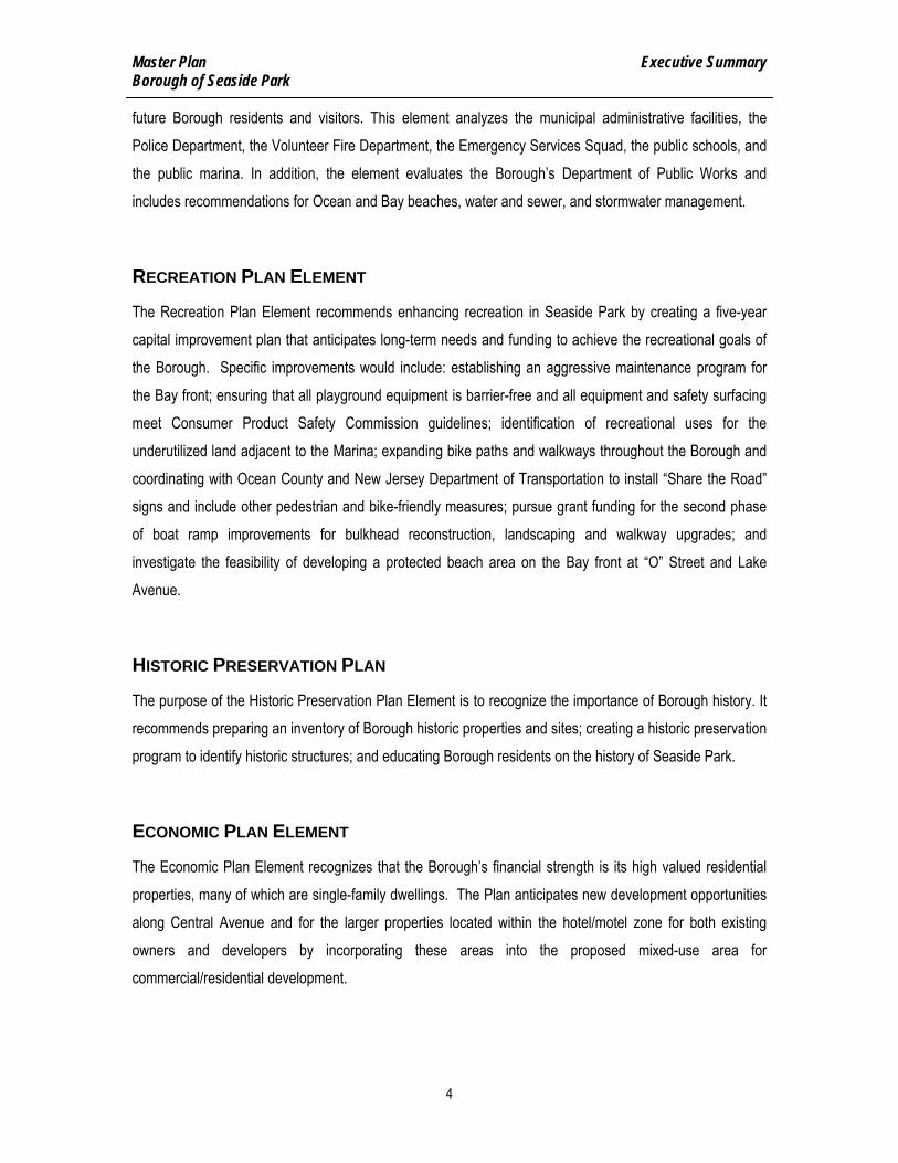
HOUSING PLAN ELEMENT
The Borough of Seaside Park provides recommendations for the future development, rehabilitation, and improvement of housing within the community and addresses the need for affordable housing. The Housing Plan Element recommends a minimum lot size of 5,000 square feet for single-family residential lots. The mixed-use area will allow two-family, and multi-family dwellings in addition to commercial use. The housing plan recommends that consideration be given to establishing a local affordable housing program for housing rehabilitation, accessory apartments, and affordable housing in the mixed-use areas proposed for the Borough.
CIRCULATION PLAN ELEMENT
The Circulation Plan Element seeks to improve transportation through the Circulation Plan. This includes vehicular traffic, pedestrian access, traffic controls, and public transportation and bike paths. Seasonal traffic is a particular concern in beach communities, and Seaside Park is no exception. Summertime visitors and pass-through traffic increase congestion on the roads, impose greater parking demands, require a larger police presence and increase the likelihood of vehicular accidents. These issues are further exacerbated by the considerable amount of traffic accessing Island Beach State Park and the spillover traffic from activities in neighboring Seaside Heights. The Circulation Plan includes recommendations for traffic safety designs at “J” Street and the Boulevard; parking recommendations including expanding metered parking during the summer months; improving commercial traffic circulation in the Borough including limiting commercial traffic to Central Avenue except for local deliveries on other streets; pedestrian and bike path enhancements; and gateway signage at both the northern and southern borders of the Borough.
MUNICIPAL FACILITIES AND SERVICES PLAN
The Municipal Facilities and Services Plan Element considers the government services and related facilities necessary to meet the safety, health, educational, cultural, and general welfare needs of the present and
Master Plan Executive Summary Borough of Seaside Park
4
future Borough residents and visitors. This element analyzes the municipal administrative facilities, the Police Department, the Volunteer Fire Department, the Emergency Services Squad, the public schools, and the public marina. In addition, the element evaluates the Borough’s Department of Public Works and includes recommendations for Ocean and Bay beaches, water and sewer, and stormwater management.
RECREATION PLAN ELEMENT
The Recreation Plan Element recommends enhancing recreation in Seaside Park by creating a five-year capital improvement plan that anticipates long-term needs and funding to achieve the recreational goals of the Borough. Specific improvements would include: establishing an aggressive maintenance program for the Bay front; ensuring that all playground equipment is barrier-free and all equipment and safety surfacing meet Consumer Product Safety Commission guidelines; identification of recreational uses for the underutilized land adjacent to the Marina; expanding bike paths and walkways throughout the Borough and coordinating with Ocean County and New Jersey Department of Transportation to install “Share the Road” signs and include other pedestrian and bike-friendly measures; pursue grant funding for the second phase of boat ramp improvements for bulkhead reconstruction, landscaping and walkway upgrades; and investigate the feasibility of developing a protected beach area on the Bay front at “O” Street and Lake Avenue.
HISTORIC PRESERVATION PLAN
The purpose of the Historic Preservation Plan Element is to recognize the importance of Borough history. It recommends preparing an inventory of Borough historic properties and sites; creating a historic preservation program to identify historic structures; and educating Borough residents on the history of Seaside Park.
ECONOMIC PLAN ELEMENT
The Economic Plan Element recognizes that the Borough’s financial strength is its high valued residential properties, many of which are single-family dwellings. The Plan anticipates new development opportunities along Central Avenue and for the larger properties located within the hotel/motel zone for both existing owners and developers by incorporating these areas into the proposed mixed-use area for commercial/residential development.

Master Plan Executive Summary Borough of Seaside Park
5
RECYCLING PLAN ELEMENT
The Recycling Plan Element encourages recycling in Seaside Park and recommends that the Borough identify the actual costs of the recycling program since the long-term future of the recycling program is dependent upon the additional funding that is provided by NJDEP. The Plan further recommends increasing the awareness among Borough residents, renters and visitors of the benefits of recycling to improve the amount and the rate of recycling. Programs at the elementary school should also be encouraged. The Borough development regulations should ensure that site plans include details and information on the storage and disposal of recyclable materials.
CONTIGUOUS MUNICIPALITIES RELATIONSHIPS
The New Jersey Municipal Land Use Law (MLUL) requires that the Borough state the relationship of its Master Plan to the plans of adjacent communities, the Ocean County plan, the State Development and Redevelopment Plan (SDRP). The Borough is bordered by Seaside Heights to the north and Berkeley Township (South Seaside Park) to the south. The policy of the Borough is to work with neighboring municipalities, the County, the State, and to advance sound planning and develop compatible plans. The SDRP places Seaside Park within the Environmentally Sensitive (PA5B) planning area as designated by the State Plan.
RE-EXAMINATION REPORT
As part of the planning process, the Seaside Park Planning Board has prepared a Master Plan Reexamination Report which reviews the past problems and objectives related to land development within the Borough, and the specific changes recommended for the Borough Master Plan and development regulations. The Reexamination Report notes that the Borough Master Plan was adopted in 1985 more than twenty years ago. The Planning Board recommends adopting the 2008 Master Plan to replace the old plan. The Reexamination Report further recommends that the Borough zoning and development regulations be revised to implement the 2008 Master Plan.

Master Plan Executive Summary Borough of Seaside Park
6
IMPLEMENTATION PLAN
As part of the planning process, Seaside Park has prepared an Implementation Plan that identifies the actions that the Borough should take to implement the 2008 Master Plan recommendations. The Implementation Plan identifies the municipal agencies and officials that will need to take action to ensure that the Master Plan recommendations are realized. Follow-up action will be needed from the Borough Council working with Borough officials and Borough departments. An Implementation Committee based in the Planning Board, but including representation from outside the Board, should be established to take the lead in making detailed recommendations for changes to the Borough zoning and development regulations.

Master Plan A Brief History Borough of Seaside Park
7
A BRIEF HISTORY

Master Plan A Brief History Borough of Seaside Park
8
Centuries ago, ocean currents washed sand away from the mainland and developed undersea ridges. Over a long period of time, the ridges developed into a peninsula parallel to the mainland and vegetation began to grow. The first inhabitants of the barrier island were American Indians of the Lenni-Lenape tribe. When European settlers arrived, Henry Hudson named the waterway “Barning Gat” that became Barnegat Bay. The Dutch and Swedes were the first European settlers, but in 1664 English Armies gained control. There was an East and West Jersey created that was reunited in 1702 by Queen Anne as a single colony named New Jersey. The island where Seaside Park is located was purchased by James Alexander in 1741 and left to his son James Alexander who became the Earl of Stirling. His land was sold to William Chadwick at a Sheriff’s sale on March 25, 1793. The northern lot that includes Seaside Park was owned by Elihu Chadwick. The properties changed hands several times and the earliest records indicate that Isaac Jennings built the first house in Seaside Park in 1867. In 1872, a Coast Guard Station was established and what later became known as May’s Corner at Decatur Avenue and the Boulevard. The bulk of the property was part of the Baptist Sea Side Park Association that later was purchased by Thomas Kennedy of Philadelphia after the sale by Clearance Kennedy became the Sea Side Park Company in 1896. Seaside Park was a section of Dover Township (now known as Toms River Township) until the creation of Berkeley Township in 1875. The area then became known as the “Sea Side Park” section of Berkeley Township. On March 3, 1898, New Jersey Senate President Foster M. Voorhees, the acting Governor of New Jersey, signed a bill incorporating “Sea Side Park” as an independent borough, created from portions of Berkeley Township. Originally, the town ran from 14th Avenue to North Avenue, about half its present size. An area known as the Berkeley Tract, north of the original area of the borough, was annexed on or about May 12, 1900. As the community grew, the name of the borough lost a space. In 1914, a newly-appointed municipal clerk wrote the name of the town as “Seaside Park” in the council minutes. This practice continues to this day. Seaside Park held a Centennial Event in 1998 that catalogued the history of the Borough: Seaside Park: The First Hundred Years 1898-1998 prepared by the Seaside Park Historical Society and Seaside Park Memories and Remembrances by Andrew J. Anderson and D. Gail Anderson.

Master Plan Vision Statement Borough of Seaside Park
9
VISION STATEMENT

Master Plan Vision Statement Borough of Seaside Park
10
Seaside Park is a small, barrier island residential community that is bordered on the east by the Atlantic Ocean and on the west by Barnegat Bay. Less than one square mile, this shore community boasts a clean, attractive and safe environment that welcomes residents and visitors alike. The Borough will continue to be committed to protecting the environment, supporting its business community, encouraging family friendly neighborhoods and enhancing the quality of life for its residents. That enhancement is, in part, achieved by maintaining residential areas at existing or reduced densities and fostering, through the Master Plan, attractive residences. Through effective environmental practices the Borough will continue to contribute towards keeping the Ocean, Bay waters and beaches clean, healthy and environmentally sound. By maintaining the Borough-owned portion of the boardwalk without any further commercial development it will further contribute towards a safe, clean and quiet environment that encourages residents, employees and visitors to be respectful, friendly and courteous. The Borough’s active coordination with the state, county and public utility companies, combined with its aggressive pursuit of grants and other forms of third party financing, enables the Borough to successfully maintain and improve its infrastructure. Supporting the family oriented focus of the community, the Borough coordinates with the Board of Education to meet the needs of Seaside Park’s children while also providing a multitude of recreational areas that offer diverse activities not only for its children but also for the adult residents and visitors.

Master Plan Goals, Objectives, and Principles Borough of Seaside Park
11
GOALS, OBJECTIVES, AND PRINCIPLES

Master Plan Goals, Objectives, and Principles Borough of Seaside Park
12
The goals, objectives, and principles of the Borough Master Plan are the purposes of sound planning as embodied in the New Jersey Municipal Land Use Law and set forth below:
♦ To encourage Borough action to guide the appropriate use or development of all lands in a manner which will promote the public health, safety, general welfare and quality of life;
♦ To secure safety from fire, flood, panic and other natural and man-made disasters; ♦ To provide adequate light, air, and open space;
♦ To ensure that the development of the Borough does not conflict with the development and general welfare of neighboring municipalities, the County, and the State as a whole;
♦ To promote the establishment of appropriate population densities and lot coverage that will contribute to the well being of persons, neighborhoods, and preservation of the environment;
♦ To provide sufficient space in appropriate locations for a variety of residential, recreational, commercial uses, and open space, both public and private, according to their respective environmental requirements;
♦ To encourage the location and design of transportation routes which will promote the free flow of traffic while discouraging location of such facilities and routes which result in congestion or blight;
♦ To promote the conservation of open space, energy resources and valuable natural resources in the State and to prevent urban sprawl and degradation of the environment through improper use of land;
♦ To encourage coordination of the various public and private sector procedures and activities shaping land development with a view of lessening the cost of such development and to the more efficient use of land;
♦ To promote utilization of renewable energy resources; and
♦ To promote the maximum practicable recovery and recycling of recyclable materials from municipal solid waste through the use of planning practices designed to incorporate the State Recycling Plan goals and to complement municipal recycling programs.

Master Plan Goals, Objectives, and Principles Borough of Seaside Park
13
A. LAND USE AND DENSITY
1. Provide for the future use of the Boardwalk area to achieve the Community Vision for a safe, clean, and quiet environment.
♦ Consider commercial alternatives, within the private sector of the boardwalk, that are compatible with the adjacent residential areas and contribute to the economic well being of the Borough.
♦ Reduce the conflicts between the businesses in the area and the adjacent residential area to address the long term quality-of-life issues in accordance with the Borough Vision Statement.
♦ Establish the public sector of the boardwalk as a commercial free area.
2. Manage the Route 35 corridor as the Main Street of the Borough and the unifying element of the four quarters of the Borough.
♦ Provide a land use plan that recognizes that properties along Route 35 should cohesively link the Borough’s various activities and its neighborhoods.
♦ Establish a zone plan that promotes a successful business area that transitions to and balances recreational uses on the Oceanfront and Bay with the use of residential properties.
♦ Improve and maintain a pedestrian friendly approach along the Route 35 corridor and encourage public activity consistent with the human scale and family-friendly environment that Seaside Park encourages.
3. Direct residential development and infill to respect the existing scale and character of the
Borough and maintain light, air, and open space within the community.
♦ Protect and improve quality of life within the Borough, reduce pollution, minimize new infrastructure demands, and protect the environment.

Master Plan Goals, Objectives, and Principles Borough of Seaside Park
14
♦ Minimize the traffic impact on the neighborhoods within the borough.
♦ Provide for development and redevelopment to achieve the Borough Vision Statement
♦ Encourage residential development and construction that is consistent with the surrounding neighborhood.
4. Maintain or increase pervious coverage to address storm water runoff issues.
B. CIRCULATION
1. Provide for an improved circulation system within the Borough.
♦ Maintain and upgrade the sidewalks, curbs, and handicap accessibility for increasing pedestrian activity.
♦ Encourage improvements to the Borough’s road network to increase safety and to promote the free flow of traffic.
♦ Maintain and upgrade bicycle facilities and paths for increased bicycle activity.
♦ Limit commercial through traffic to Route 35 and remove it from Bay and Ocean Avenues.
♦ Consider traffic calming techniques and changing some narrow streets to only one way where appropriate.
♦ Create loading zones within the Borough to improve both vehicle and pedestrian safety.
♦ Provide for improved street and boardwalk lighting.
♦ Ensure that all traffic and parking regulations are enforced.
♦ Review the opportunities of expanding paid parking spaces along South Ocean Avenue and providing seasonal residential parking permits.

Master Plan Goals, Objectives, and Principles Borough of Seaside Park
15
C. MUNICIPAL FACILITIES AND SERVICES
1. Provide for improved community facilities and services to meet the needs of Borough residents in an efficient and effective manner.
♦ Provide a quality education for the resident children in a thorough and efficient manner. Consider alternatives to the present method to maximize efficiency and control educational spending.
♦ Provide effective public safety services through the Police Department, Fire Department, First Aid Squad, and Office of Emergency Services.
♦ Create effective management procedures to ensure that all municipal activities are
performed in an efficient and effective manner.
♦ Provide the resources necessary to effectively support the administrative functions of the municipality.
♦ Control storm water flow in cooperation with the state and county and consider requiring a storm water management plan as part of all new construction applications.
♦ Improve the current street cleaning operations to maximize the benefits of reducing Barnegat Bay water pollution and storm drain silting as well as insuring compliance with state regulations regarding storm water runoff.
♦ Ensure the water and sewer infrastructure is monitored and maintained to minimize infiltration and prevent system failure.
♦ Ensure the preservation and satisfactory maintenance of the recreational areas (beaches, dunes, marinas, boardwalks, playgrounds, ball fields, and piers) to serve the present and future needs of the Borough.
♦ Provide for compliance with the Americans with Disabilities Act for all public areas.

Master Plan Goals, Objectives, and Principles Borough of Seaside Park
16
♦ Aggressively pursue every opportunity to obtain grant funding for both current and long term municipal projects.
♦ Establish a knowledgeable working committee to oversee and direct municipal efforts to identify, develop and implement beneficial shared services agreements with neighboring communities.
D. NATURAL RESOURCES/ ENVIRONMENTAL PROTECTION
1. Protect the natural resources and barrier island environment of the Borough.
♦ Preserve environmentally sensitive areas along the Bay and Ocean fronts.
♦ Continue to explore alternative solutions to minimize flooding along the Bay front
♦ Encourage efforts to reduce stormwater runoff and flooding.
♦ Promote building design principles that minimize the creation of “wind tunnels.”
♦ Promote the use of renewable energy sources.
♦ Promote the recovery and recycling of materials from solid waste.
♦ Ensure effective programs are implemented and monitored to safeguard water quality.
♦ Enforce compliance with flood hazard regulations.
♦ Comply with Stormwater Management requirements.

Master Plan Goals, Objectives, and Principles Borough of Seaside Park
17
E. ECONOMIC DEVELOPMENT
1. Provide for the beneficial economic development of the Borough.
♦ Encourage a pedestrian friendly shopping area along Route 35.
♦ Promote improvements of building façades in the business areas.
♦ Encourage desirable visual design of new and upgraded businesses.
♦ Attract economic development appropriate to the Borough vision.
F. HOUSING
1. Provide for housing that is appropriate to the desired character of the neighborhood.
♦ Stop conversions of seasonal accessory residences to year-round residency.
♦ Maintain the quality of the housing stock by enforcing construction and property maintenance ordinances and code regulations.
♦ Revise setbacks as needed to ensure light, air, open space, and privacy within Borough neighborhoods.
♦ Ensure effective inspection of all code regulations
G. PARKS, RECREATION, AND OPEN SPACE
1. Provide for and maintain a park, recreation, and open space system that meets the needs of the community.
♦ Protect and improve existing recreation facilities, parks and open space.
♦ Increase recreational opportunities for walking and biking.
♦ Preserve additional open space in appropriate locations.

Master Plan Goals, Objectives, and Principles Borough of Seaside Park
18
♦ Maintain, as commercial free, the publicly owned portion of the boardwalk.
♦ Implement an effective dune management program that controls height and width without diminishing primary safety objectives or adversely affecting the recreational beach areas.
H. CHARACTER AND DESIGN
1. Promote a desirable visual environment.
♦ Establish a design continuity for all public facilities that supports the vision statement and contributes to a unifying image of the community.
♦ Consider establishing an architectural design review committee.
♦ Limit the location of cell towers, signage and lighting to ensure that the Borough is an attractive seashore community.
I. RECYCLING
1. Continue to provide the facilities and services that have made the Borough one of the leading recycling municipalities in Ocean County.

Master Plan Land Use Plan Borough of Seaside Park
19
LAND USE PLAN

Master Plan Land Use Plan Borough of Seaside Park
20
INTRODUCTION The Borough of Seaside Park is an established barrier island community that is primarily residential in character. It is the desire of the community to preserve and protect the beneficial characteristics of neighborhoods in the Borough and to encourage a compatible relationship between new or expanded houses and neighboring structures that reflect the best of the local character, particularly in terms of scale, siting, design features, and orientation on the site. To meet the need for the orderly growth and development and redevelopment of the Borough of Seaside Park, and to provide balanced land uses that include housing, community facilities, and economic development as well as the conservation of natural resources, the Borough Planning Board has prepared this land use plan element in accordance with the New Jersey Municipal Land Use Law (New Jersey Statute Annotated (N.J.S.A.) 40:55D-28.b(2)). The land use plan is based upon the principles, goals, and objectives of the Borough Master Plan and takes into consideration all the other elements of the Master Plan. The New Jersey Municipal Land Use Law (MLUL) requires that the Borough Master Plan include a land use plan element. The purpose of the plan is to guide the use of lands within the Borough to protect the public health, safety, and welfare. The MLUL further requires that the Borough may only adopt a zoning ordinance to regulate land use and the location of buildings and structures after the adoption of the land use plan element. The provisions of the Borough zoning ordinance, or any amendment to the zoning ordinance, must either be substantially consistent with the land use plan element or designed to effectuate it.1 This land use plan is based upon the Borough vision for the future of Seaside Park. It presents a future land use plan for the types of land use and the Borough standards for density and development intensity recommended for the Borough consistent with the principles, goals and objectives of the Master Plan. It also includes the proposed zone plan for the regulation of land use within the Borough consistent with the recommendations of the land use plan.
1 N.J.S.A. 40:55D-62.a.

Master Plan Land Use Plan Borough of Seaside Park
21
LAND USE GOALS The Borough Planning Board has identified the following goals of the land use plan.
♦ Maintaining the desirable features of the Borough as a single-family residential community by limiting and reducing density and proposing more effective lot area and bulk standards of the zone plan.
♦ Protecting residential neighborhoods from commercial encroachments and the adverse impacts of nonresidential land use.
♦ Controlling the impact of development and residential density on parking, traffic, community facilities, and infrastructure.
♦ Ensuring that new development is compatible with the desirable scale of the residential community.
♦ Encouraging residential and business uses to upgrade and enhance their properties consistent with the vision for Seaside Park and ensuring that there is no substantial adverse impact on adjoining properties and the Master Plan for the Borough.
♦ Ensuring that the Borough development standards provide a level of light, air and open space consistent with the vision for the future of Seaside Park.
♦ Promoting the values of conservation and sustainability to ensure that valuable natural resources are not depleted or impaired.
EXISTING LAND USE Seaside Park contains 435.27 acres of land. Of the total acreage, there are only 1.76 acres of vacant developable land located on 20 parcels (See Table LU-1). Information was obtained from Ocean County and the mapping was reviewed by the Borough Code Enforcement Officer. Further data was acquired from the Borough Tax Assessor to calculate the Existing Land Use. The largest land area of the Borough is in public use. Approximately 50 percent of the Borough land area is in public street rights-of-way, public parking areas, the beach and dune area, and public buildings and grounds that include parks, the school, and municipal buildings. The second largest land use of the Borough is residential land use. Nearly 43 percent of the Borough land area is residentially developed. Most of this is single family residential (67% of all the residential property area). The Existing Land Use map indicates the extent of residential uses and other land use throughout the Borough (See Figure LU-1). Individual parcels on the map are coded to identify the residential use as a single family, two-family, 3 and 4 units, or apartment (5 or more units). The Borough’s overall residential density is 16.7 units per residential acre. Because of its location on a coastal barrier island, low elevation, and flat topography, the Borough is located within a flood hazard area and is vulnerable to flooding from coastal storms. The Borough is almost wholly

Master Plan Land Use Plan Borough of Seaside Park
22
located within the 100 year flood hazard area mapped by the Federal Emergency Management Agency (FEMA) and identified on Figure LU-1A. The area of Borough adjacent to the Atlantic Ocean, from Ocean Avenue eastward, is located within the flood hazard velocity zone mapped by FEMA for destructive wave action from coastal storms. The beach and dune system of the Borough is essential for protecting the Borough and mitigating flood damage from coastal wave action and storm surges. The Borough is a participating community in the National Flood Insurance Program and FEMA has recently updated the flood hazard mapping in the Borough. Construction within the Borough requires special construction techniques in accordance with the flood insurance program and FEMA mapping in order to reduce the potential damage from coastal flooding. Northwest of J Street by Barnegat Bay, the predominant land uses are residential and public uses that include a portion of the Borough of Seaside Park Marina. The residential density is 22.5 units per acre. Northeast of J Street and by the Atlantic Ocean, the predominant uses are residential and public uses that include the beach, the Borough Hall, the Beach Pavilion, and public parking lots. The residential density is 29.9 units per acre. Southeast of J Street and East of Central Avenue (Route 35) to the Atlantic Ocean, the predominant land use is residential and public uses that include the beach and conservation area. The residential density is 11.6 units per acre. Southwest of J Street and West to the Barnegat Bay is predominantly residential and public land uses. At the southern end of the Borough are the Public Works building, water tower and wells, ball fields, and public bathrooms. Also, on the Bay side is a beach, boating area with a public launch, fishing piers, a Yacht Club, and a portion of the Borough of Seaside Park Marina. The area contains the Seaside Elementary School on the West side of Central Avenue two blocks north of the Police Station. The residential density is 12.6 units per acre. Community features, such as municipal facilities, recreation areas, the marina, the elementary school, and other important elements of the Borough are identified on Figure MU-1 (Community Features).

Master Plan Land Use Plan Borough of Seaside Park
23
Table LU-1 Existing Land Use – 2008
Land Use Category Dwelling
Units 2008 Acres Percent
Percent of Residential Area
Vacant Land 1.76 0.40% Single Family Residential 1521** 125.66 28.87% 67.33% Two-Family 950** 45.99 10.57% 24.64% 3 and 4 Units 485** 12.34 2.84% 6.61% Apartment (5+ Units) 144** 2.63 0.60% 1.41% Commercial 13.75 3.16% Public School 1.02 0.23% Public Property 16.36 3.76% Beach/Boardwalk* 56.83 13.06% Church/Charitable 2.08 0.48% Other Exempt 0.68 0.16% Marina 6.91 1.59% Utility 0.15 0.03% Public Parking* 3.40 0.78% Private Parking* 1.13 0.26% Right-of-Way 144.57 33.21% TOTAL 435.27 100.00% * Contains areas modified from existing tax parcels ** Dwelling units as opposed to tax lots in Economic Development element
SOURCE: Ocean County, Borough Code Enforcement Officer, Borough Tax Assessor, 2008 and
Compiled by T&M Associates
FUTURE LAND USE In general, because the Borough is fully developed, future development will largely be limited to tear downs and reconstruction of existing sites, infill development, adaptive reuse of existing buildings and sites, changes of use, and building expansions and alterations. With the recent trends in residential development, it is an appropriate use to reduce the permitted residential density. Reducing density will help maintain the quality of life for residents of Seaside Park, reduce traffic generation, and limit the number of dwellings that would be subject to damage from coastal flooding.
The Future Land Use map shows the planned future land use within the Borough (See Figure LU-2). Future development and redevelopment within the Borough should be compatible with planned future land use.

Master Plan Land Use Plan Borough of Seaside Park
24
The future land use of the Borough is organized into the following categories: Single-Family Residential Use, Mixed Use, Public Use, Boardwalk Use, Conservation Use, Parks and Recreation Use, Church/Charitable Use, Marina Use, Utility Use, and Roads. Future land use is organized largely based on the existing pattern of development and it reinforces the single-family residential character of the Borough.
SINGLE-FAMILY RESIDENTIAL USE The Planning Board recommends that the land use plan establish one single-family residential land use designation to provide uniformity within the community in terms of lot size and building type. The single-family residential area would allow single-family detached dwellings on lots of 5,000 square feet or greater. The conversion of single-family homes to duplexes is an undesirable change to the preference for single-family residential development and a reduced density pattern for the Borough. The land use plan recommends changing the Borough zone plan to eliminate the R-2 district which permits single-family homes and two-family homes on 5,000 square foot lots and eliminate the R-3 district which permits single-family homes on 2,500 square foot lots and, as a conditional use, two-family homes on 5,000 square foot lots. The quality of life issue is important to the community as a whole and the proposed changes discussed in this element will encourage the consolidation and merger of small lots with narrow frontages to help improve the residential character of the Borough. The Planning Board has evaluated the existing Borough zone plan for the purpose of recommending standards to ensure that the bulk and scale of new building development and building alterations and expansions are reasonable and appropriate to the desired character and visual environment of the Borough and its neighborhoods. Based on the Board’s review, changes are recommended to the residential lot standards due to concerns over the increased frequency of street flooding, parking demands, quality of life issues, and impacts of increasing building size on the light, air, and open space within residential neighborhoods. Setbacks The Land Use Code currently allows four (4) foot side yard setbacks (each side) in the residential areas. With the larger houses being constructed, the eight feet between residences is no longer sufficient. Maximizing building coverage and lot coverage to the 4-foot setback crowds the lot and creates a congested

Master Plan Land Use Plan Borough of Seaside Park
25
condition along the public street. In order to maintain air and light and open space between buildings, it is recommended that a total minimum of both side yards be fifteen (15) feet with no side less than five (5) feet. This will result in a minimum of ten (10) feet between residences on two adjacent properties and will enable the property owner on a 50-foot lot to position the building to have a driveway that can access the rear of the property, if desired. Concurrent with the increase in side yard setbacks, it is recommended to modify the rear yard setback. Instead of the twenty (20) foot minimum, this standard should be modified to fifteen (15) feet to allow flexibility to extend the building in the rear of the property. The trade-off of increased side yards and reduced rear yards allows the building footprint to be approximately the same square footage. The corner lot setbacks should be reviewed to provide flexibility on development of adjoining properties. The current preferred minimum setback of twenty (20) feet from each corner based on sight triangle requirements should be reviewed. The existing standard provides a wider cone of vision for traffic and pedestrians. The Borough should consider some flexibility on one street side yard for the corner lots by taking into account the adjacent property front yard setback if it is less than twenty (20) feet and allowing a minimum of not less than fifteen (15) feet while maintaining an adequate amount of space to preserve light, air, and open space to meet the needs of the community and the needed visibility at street intersections. Building Height The Borough limits building height to permit maximum building heights from twenty-five (25) feet to thirty-five (35) feet depending on lot size. The Master Plan recommends that no part of the building structure, including roof railings, exceed the maximum permitted building height, with the exception of the chimney. Parking Additional on-site parking (above the current two spaces) should be required for any residential unit with four or more bedrooms in an effort to meet the seasonal parking demands that overwhelm the Borough and its residents.
MIXED USE The land use plan recommends that the Borough change its planning strategy and take a fundamentally different approach to commercial land use and to residential development for two-family, multifamily, attached housing, and affordable housing.

Master Plan Land Use Plan Borough of Seaside Park
26
Because of the Borough’s character as a seasonal residential community and its small size, it is difficult for commercial enterprise to be sustained year round within the Borough. To allow more flexibility for non-residential development, the Borough should consider mixed-use development. Central Avenue will be planned as a new mixed-use corridor that extends from the northern boundary of the Borough and Seaside Heights to the southern boundary with South Seaside Park (Berkeley Township). This new land use designation will also apply to an area currently zoned hotel/motel, located from Stockton Avenue to L Street. This new mixed use area will allow commercial as well as single-family, duplex, multifamily housing, and hotel/motel use. The mixed use will allow greater flexibility for the Borough to provide for commercial uses, professional offices, and mixed uses, such as residential and commercial within a structure. The Planning Board recommends that a committee be created to develop specific recommendations for the mixed use zone regarding property size, density, height limits, parking, and other planning issues. The existing land area within the mixed use area includes residential, commercial, hotel/motel, and church uses. Design guidelines for the mixed-use area should be prepared to encourage creative and interesting architecture. Lastly, the Borough should work to create a pedestrian-friendly, vibrant and attractive streetscape for the mixed-use area and a sense of place through sidewalk use, creative and interesting façade treatments, sidewalk and street improvements, lighting, sufficient parking and enhancements for pedestrians.
BOARDWALK The Boardwalk district, situated in the northeast corner of the Borough, is seasonal in nature and includes a mixture of the retail uses, amusements rides, and games. Alternative uses within the Boardwalk area should be considered to maintain its economic vitality and address the leisure needs of the seasonal population. The Planning Board recommends that the commercial Boardwalk land use district retain the present boundaries. However, if the Boardwalk area or some portion of it becomes available for acquisition, the Borough should consider acquiring lands within this land use category to add to the Public properties along the Beachfront. Funding to support such acquisition, such as the State Green Acres and/or Blue Acres programs, should be pursued by the Borough.

Master Plan Land Use Plan Borough of Seaside Park
27
PUBLIC USE The Public Property land use designation includes the public facilities and the public utilities which serve the residents and visitors of Seaside Park. This category includes the Borough Hall on Ocean Avenue, the Police and Fire Department facilities on Central Avenue, the Elementary School on Central Avenue between Third and Fourth Avenues, and the Department of Public Works facilities on Twelfth and Thirteenth Avenues. The land use plan recommends that the Elementary School be retained in public ownership and, if it becomes available, that the Borough consider purchasing one lot which currently splits the school frontage on Central Avenue between Third and Fourth Avenues.
MARINA USE The Marina land use designation provides for the existing marinas in the Borough. This category includes the Seaside Park Yacht Club and the public marina, both situated on the bayside of the Borough.
PARKS AND RECREATION USE The Parks and Recreation land use category includes the municipal recreation areas, public Bay front land, and the municipal ball fields.
CONSERVATION USE The Conservation land use designation includes the unique natural resources of the oceanfront beach area and the bay front public park in the northwest corner of the Borough. All lands are municipally-owned.
CHURCH /CHARITABLE The church and charitable land use category includes St. Catherine’s Catholic Church on Central Avenue between E and F Streets and the Seaside Park Union Church on Central Avenue between Fourth and Fifth Avenues.
RELATIONSHIP TO THE ZONE PLAN The existing land use (Figure LU-1) and future land use plan (Figure LU-2) illustrate the current conditions and future plans as developed by the Planning Board. The existing zone plan is shown on Figure LU-3 (Land Use Classifications with Zoning). The proposed zone plan is shown as Figure LU-4 (Proposed Zoning). The Master Plan recommends simplifying the existing zone plan from nine zones to four zones.

Master Plan Land Use Plan Borough of Seaside Park
28
This includes a consolidation of three residential zones into one single-family residential zone (R-1) and the creation of a new mixed-use zone (MXD). The Boardwalk zone (Boardwalk) will stay the same. The future land uses of conservation, public, utilities, and marina are to be consolidated as one public (P) zone. The development ordinances should be revised to incorporate the changes in the Master Plan.
STORMWATER MANAGEMENT The Borough needs to improve stormwater run-off with a multi-faceted approach, so that there is a reduction in run-off, flooding, and pollution. Such an approach could include using more pervious materials in construction, placing pervious or natural perimeters around dwellings to absorb water, and directing leader and gutter discharge to areas where water can infiltrate. The recommended modifications to residential density will in the long term assist in minimizing this problem. Other techniques that can be done to improve stormwater management and that are environmentally compatible should be identified and encouraged.
RECOMMENDATIONS ♦ Establish an Implementation Committee to make specific recommendations to the Borough Council for
a revised zoning ordinance. The Committee should be within the Planning Board and include representatives from the Governing Body, Zoning Board of Adjustment, the Planning Board, Code Enforcement Office and the Planning Board Engineer.
♦ Direct the Implementation Committee to include the complete review and revision of the Borough’s Development Regulations (Chapter 25) as may be needed to implement the Master Plan.
♦ Implement a new Stormwater management policy that would require all new development proposals to contain a stormwater plan and also consider requiring such properties to retain all stormwater runoff on site.
♦ Apply for all grant funds that may be available for the improved management of land use including but not limited to stormwater management, conservation, zoning regulations, and other land use categories.

At
la
nt
ic
O
ce
an
B a r n e g a t Ba y
B E R K E L E Y T W PB E R K E L E Y T W P
S E A S I D E H E I G H T S B O R OS E A S I D E H E I G H T S B O R O
OCEA
N AV
E (C
R 53
)
CENT
RAL A
VE (N
J 35)
K ST
H ST
F ST
G ST
E ST
D ST
C ST
CENT
RAL A
VE (N
J 35 S
ECON
DARY
)
S BAY
VIEW AV
E
J ST
13TH AVE
12TH AVE
L ST
N ST
O ST
11TH AVE
BOUL
EVAR
D
M ST
9TH AVE
I ST
10TH AVE
8TH AVE
7TH AVE
LAKE
AVE
2ND AVE
1ST AVE
K CT
BARN
EGAT
AVE
ISLAND AVE
NORTH AVE
3RD AVE
4TH AVE
5TH AVE
BRIGHTON AVE
DECATUR AVE
LAFAYETTE AVE
14TH AVE
6TH AVE
NJ 37 SECONDARY
N CE
NTRA
L AVE
N BA
YVIEW
AVE
STOCKTON AVE
BERK
ELEY
LN
FARRAGUT AVEFARRAGUT AVE
K ST
I ST
M ST
5TH AVE
3RD AVE
STOCKTON AVE
BERK
ELEY
LN
J ST
LAFAYETTE AVE
O ST
L ST
14TH AVE
O ST
N ST
14TH AVE
4TH AVE
DECATUR AVE
6TH AVE
N ST
N BAYVIEW AVE
Figure LU-1: Existing Land UseBorough of Seaside Park
Ocean County, New JerseyPrepared by: STK, November 10, 2008Source: Ocean County GIS Department - Tax Parcels, Rights-of-Way, Municipal Boundary; NJDOT - 2005 RoadsFile Path: H:\SSPB\00010\GIS\Projects\Final\sspb10_FigureLU-1LandUse.mxd
NOTE: This map was developed using New Jersey Department of Environmental Protection Geographic Information System digital data, but this secondary product has not been verified by NJDEP and is not State-authorized.
11 Tindall RoadMiddletown, NJ 07748-2792Phone: 732-671-6400Fax: 732-671-7365
Vacant Land (1)Single FamilyTwo-Family3 and 4 Unit
Apartment (4C)Commercial (4A)Public School Property (15A)Public Property (15C)
Beach/Boardwalk AreaChurch/Charitable (15D)Other Exempt (15F)Marina
UtilityPublic ParkingPrivate Parking
RoadsOpen WaterMunicipal Boundary
0 300 600150 Feet

At
la
nt
ic
O
ce
an
Barn
egat
Bay
B E R K E L E Y T W PB E R K E L E Y T W P
S E A S I D E H E I G H T S B O R OS E A S I D E H E I G H T S B O R O
OCEA
N AV
E (C
R 53
)
CENT
RAL
AVE
(NJ 3
5)
K ST
H ST
F ST
G ST
E ST
D ST
CENT
RAL
AVE
(NJ 3
5 SEC
ONDA
RY)
C ST
S BAY
VIEW A
VE
13TH AVE
J ST
12TH AVE
L ST
N ST
11TH AVE
O ST
BOUL
EVAR
D
M ST
9TH AVE
10TH AVE
I ST
8TH AVE
7TH AVE
LAKE
AVE
2ND AVE
1ST AVE
BARN
EGAT
AVE
K CT
ISLAND AVE
NORTH AVE
3RD AVE
4TH AVE
5TH AVE
BRIGHTON AVE
DECATUR A VE
LAFAYETTE AVE
14TH AVE
6TH AVE
NJ 37 SECONDARY
N CE
NTRA
L AV
E
N BA
YVIE
W A
VE
STOCKTON AVE
BERK
ELEY
LN
FARRAGUT A VEFARRAGUT A VE
K ST
I ST
M ST
5TH AVE
3RD AVE
STOCKTON AVE
J ST
O ST
L ST
14TH AVE
O ST
N ST
14TH AVE
4TH AVE
6TH AVE
N ST
N BAYVIEW AVE
BERK
ELEY
LN
Figure LU-1A: FEMA Flood Hazard AreaBorough of Seaside Park
Ocean County, New JerseyPrepared by: STK, November 10, 2008Source: Ocean County GIS Department - Tax Parcels, Rights-of-Way, Municipal Boundary; NJDOT - 2005 Roads; FEMA - 2006 Flood Hazard AreasFile Path: H:\SSPB\00010\GIS\Projects\sspb10_FloodHazardTabloid.mxd
NOTE: This map was developed using New Jersey Department of Environmental Protection Geographic Information System digital data, but this secondary product has not been verified by NJDEP and is not State-authorized.
11 Tindall RoadMiddletown, NJ 07748-2792Phone: 732-671-6400Fax: 732-671-7365
100 Year Flood Hazard500 Year Flood HazardVelocity HazardTax ParcelsOpen WaterRoadsMunicipal Boundary
0 700 1,400350 Feet

At
la
nt
ic
O
ce
an
B a r n e g a t Ba y
B E R K E L E Y T W PB E R K E L E Y T W P
S E A S I D E H E I G H T S B O R OS E A S I D E H E I G H T S B O R O
OCEA
N AV
E (C
R 53
)
CENT
RAL A
VE (N
J 35)
K ST
H ST
F ST
G ST
E ST
D ST
C ST
CENT
RAL A
VE (N
J 35 S
ECON
DARY
)
S BAY
VIEW AV
E
J ST
13TH AVE
12TH AVE
L ST
N ST
O ST
11TH AVE
BOUL
EVAR
D
M ST
9TH AVE
I ST
10TH AVE
8TH AVE
7TH AVE
LAKE
AVE
2ND AVE
1ST AVE
K CT
BARN
EGAT
AVE
ISLAND AVE
NORTH AVE
3RD AVE
4TH AVE
5TH AVE
BRIGHTON AVE
DECATUR AVE
LAFAYETTE AVE
14TH AVE
6TH AVE
NJ 37 SECONDARY
N CE
NTRA
L AVE
N BA
YVIEW
AVE
STOCKTON AVE
BERK
ELEY
LN
FARRAGUT AVEFARRAGUT AVE
K ST
I ST
M ST
5TH AVE
3RD AVE
STOCKTON AVE
BERK
ELEY
LN
J ST
LAFAYETTE AVE
O ST
L ST
14TH AVE
O ST
N ST
14TH AVE
4TH AVE
DECATUR AVE
6TH AVE
N ST
N BAYVIEW AVE
Figure LU-2: Future Land UseBorough of Seaside Park
Ocean County, New JerseyPrepared by: STK, November 10, 2008Source: Ocean County GIS Department - Tax Parcels, Rights-of-Way, Municipal Boundary; NJDOT - 2005 RoadsFile Path: H:\SSPB\00010\GIS\Projects\Final\sspb10_FigureLU-2FutureLandUse.mxd
NOTE: This map was developed using New Jersey Department of Environmental Protection Geographic Information System digital data, but this secondary product has not been verified by NJDEP and is not State-authorized.
11 Tindall RoadMiddletown, NJ 07748-2792Phone: 732-671-6400Fax: 732-671-7365
Single Family ResidentialMixed Use
Public Property
BoardwalkConservation
Parks and Recreation
Church/CharitableMarina
Parking
RoadsOpen Water
Municipal Boundary
0 300 600150 Feet

At
la
nt
ic
O
ce
an
B a r n e g a t Ba y
R-3
R-1
C
R-1
R-2
R-3
C
R-3
R-2
R-1
P
CONS
ERVA
TION
P
C
B
C
H
P
P
C
M
P
H
P
P
C
R-1
PC
CONS
ERVA
TION
B E R K E L E Y T W PB E R K E L E Y T W P
S E A S I D E H E I G H T S B O R OS E A S I D E H E I G H T S B O R O
OCEA
N AV
E (C
R 53
)
CENT
RAL A
VE (N
J 35)
K ST
H ST
F ST
G ST
E ST
D ST
C ST
CENT
RAL A
VE (N
J 35 S
ECON
DARY
)
S BAY
VIEW AV
E
J ST
13TH AVE
12TH AVE
L ST
N ST
O ST
11TH AVE
BOUL
EVAR
D
M ST
9TH AVE
I ST
10TH AVE
8TH AVE
7TH AVE
LAKE
AVE
2ND AVE
1ST AVE
K CT
BARN
EGAT
AVE
ISLAND AVE
NORTH AVE
3RD AVE
4TH AVE
5TH AVE
BRIGHTON AVE
DECATUR AVE
LAFAYETTE AVE
14TH AVE
6TH AVE
NJ 37 SECONDARY
N CE
NTRA
L AVE
N BA
YVIEW
AVE
STOCKTON AVE
BERK
ELEY
LN
FARRAGUT AVEFARRAGUT AVE
K ST
I ST
M ST
5TH AVE
3RD AVE
STOCKTON AVE
BERK
ELEY
LN
J ST
LAFAYETTE AVE
O ST
L ST
14TH AVE
O ST
N ST
14TH AVE
4TH AVE
DECATUR AVE
6TH AVE
N ST
N BAYVIEW AVE
Figure LU-3: Existing ZoningBorough of Seaside Park
Ocean County, New JerseyPrepared by: STK, November 10, 2008Source: Ocean County GIS Department - Tax Parcels, Rights-of-Way, Municipal Boundary; NJDOT - 2005 Roads; Borough of Seaside Park Zoning MapFile Path: H:\SSPB\00010\GIS\Projects\Final\sspb10_FigureLU-3Zoning.mxd
NOTE: This map was developed using New Jersey Department of Environmental Protection Geographic Information System digital data, but this secondary product has not been verified by NJDEP and is not State-authorized.
11 Tindall RoadMiddletown, NJ 07748-2792Phone: 732-671-6400Fax: 732-671-7365
Zone BoundaryTax Parcel
Roads
Open Water
Municipal Boundary0 300 600150 Feet
SYMBOL DESCRIPTIONB BoardwalkC CommercialCONSERVATION ConservationH HotelM MarinaP PublicR-1 Low Density ResidentialR-2 Medium Density ResidentialR-3 High Density Residential

At
la
nt
ic
O
ce
an
B a r n e g a t Ba y
R-1
MXD
R-1
R-1
MXD
MXD
R-1R-1
P
R-1
P
R-1
OCEA
N AV
E (C
R 53
)
CENT
RAL A
VE (N
J 35)
K ST
H ST
F ST
G ST
E ST
D ST
C ST
CENT
RAL A
VE (N
J 35 S
ECON
DARY
)
S BAY
VIEW AV
E
J ST
13TH AVE
12TH AVE
L ST
N ST
O ST
11TH AVE
BOUL
EVAR
D
M ST
9TH AVE
I ST
10TH AVE
8TH AVE
7TH AVE
LAKE
AVE
2ND AVE
1ST AVE
K CT
BARN
EGAT
AVE
ISLAND AVE
NORTH AVE
3RD AVE
4TH AVE
5TH AVE
BRIGHTON AVE
DECATUR AVE
LAFAYETTE AVE
14TH AVE
6TH AVE
NJ 37 SECONDARY
N CE
NTRA
L AVE
N BA
YVIEW
AVE
STOCKTON AVE
BERK
ELEY
LN
FARRAGUT AVEFARRAGUT AVE
K ST
I ST
M ST
5TH AVE
3RD AVE
STOCKTON AVE
BERK
ELEY
LN
J ST
LAFAYETTE AVE
O ST
L ST
14TH AVE
O ST
N ST
14TH AVE
4TH AVE
DECATUR AVE
6TH AVE
N ST
N BAYVIEW AVE
R-1
P
R-1
R-1
MXDP
P
B
P
P
P
P
MXD
P
P
MXD
MXD
P
B E R K E L E Y T W PB E R K E L E Y T W P
S E A S I D E H E I G H T S B O R OS E A S I D E H E I G H T S B O R O
Figure LU-4: Proposed ZoningBorough of Seaside Park
Ocean County, New JerseyPrepared by: STK, November 10, 2008Source: Ocean County GIS Department - Tax Parcels, Rights-of-Way, Municipal Boundary; NJDOT - 2005 RoadsFile Path: H:\SSPB\00010\GIS\Projects\Final\sspb10_FigureLU-4FutureZoning.mxd
NOTE: This map was developed using New Jersey Department of Environmental Protection Geographic Information System digital data, but this secondary product has not been verified by NJDEP and is not State-authorized.
11 Tindall RoadMiddletown, NJ 07748-2792Phone: 732-671-6400Fax: 732-671-7365
Proposed ZoningTax Parcels
Roads
Open Water
Municipal Boundary0 300 600150 Feet
SYMBOL DESCRIPTIONB Boardwalk
MXD Mixed Use (Commercial/Residential)P Public
R-1 Low Density Residential

Master Plan Housing Plan Borough of Seaside Park
34
HOUSING PLAN

Master Plan Housing Plan Borough of Seaside Park
35
INTRODUCTION The Borough of Seaside Park has prepared this Housing Plan Element in accordance with the requirements of the New Jersey Municipal Land Use Law and the State Fair Housing Act. The Municipal Land Use Law (MLUL), N.J.S.A. 40:55D-1 et seq., requires that a municipal master plan include a Housing Plan Element in order for the municipality to exercise the power to zone and regulate land use. Although the Borough is fully developed, the State continues to assign an affordable housing obligation to the Borough. Because the Borough is fully developed, fundamental fairness and State regulations entitle the Borough to a vacant land adjustment to reduce the State assigned housing obligations. Under the MLUL, the Housing Plan Element is adopted by the Borough Planning Board and endorsed by the Borough Council prior to the submission of a municipal petition to the New Jersey Council on Affordable Housing (COAH) for substantive certification of the Housing Plan Element. The Housing Plan considers the recently adopted by the New Jersey Department of Community Affairs (NJDCA) regulations to achieve the goal of meeting the Borough obligation to provide for the Borough’s fair share of the regional need for affordable housing. Affordable means a sales price or rent within the means of a low or moderate income household as defined by COAH regulations in N.J.A.C. 5:97-9. The limits for income and sale price and rent are adjusted annually by COAH. The 2008 sales price limit for the Ocean County region (COAH Region 4) ranges from a low of $42,812 for a very low income 1 bedroom unit to $138,529 for a 3 bedroom moderate income unit. The 2008 regional household income levels vary based upon household size. The 2008 moderate income limit for a three person household size is $60,888. The low income limit for a three person household is $38,055. The very low income limit for a three person household is $22,833. Net rents with utility allowance can range from $376 a month for a low income 1 bedroom unit to $1,168 a month for a 3 bedroom moderate income unit.

Master Plan Housing Plan Borough of Seaside Park
36
MANDATORY CONTENTS OF THE HOUSING ELEMENT The essential components of a housing element, as set forth in the State Fair Housing Act (N.J.S.A. 52:27D-310), are the following:
An inventory of the municipality's housing stock by age, condition, purchase or rental value, occupancy
characteristics, and type, including the number of units affordable to low and moderate income households
and substandard housing capable of being rehabilitated.
A projection of the municipality's housing stock, including the probable future construction of low and
moderate income housing, for the next six years, taking into account, but not necessarily limited to,
construction permits issued, approvals of applications for development and probable residential
development of lands.
An analysis of the municipality's demographic characteristics, including but not necessarily limited to,
household size, income level, and age.
An analysis of the existing and probable future employment characteristics of the municipality.
A determination of the municipality's present and prospective fair share for low and moderate income
housing and its capacity to accommodate its present and prospective housing needs, including its fair share
for low and moderate income housing.
A consideration of the lands that are most appropriate for construction of low and moderate income housing
and of the existing structures most appropriate for conversion to, or rehabilitation for, low and moderate
income housing, including a consideration of lands of developers who have expressed a commitment to
provide low and moderate income housing.
In adopting the housing element, the Borough may provide for its share of low and moderate income housing by means or any technique or combination of techniques that provide a realistic opportunity for the provision of its share.

Master Plan Housing Plan Borough of Seaside Park
37
BACKGROUND TO THE BOROUGH HOUSING PLAN ELEMENT The New Jersey Council on Affordable Housing (COAH) has adopted rules and regulations for allocating a fair share of the regional housing need for low and moderate income housing to each municipality in New Jersey. The Borough of Seaside Park is located in housing Region 4 which consists of Monmouth, Ocean, and Mercer counties. COAH has allocated a housing need for low and moderate income housing to Seaside Park for the periods 1987 to 1999 and 2004 to 2018. COAH adopted its rule (N.J.A.C 5:97 et. al.) setting forth the cumulative housing need on September 22, 2008. These regulations will be effective on October 20, 2008.
AN ANALYSIS OF DEMOGRAPHIC, HOUSING AND EMPLOYMENT
CHARACTERISTICS As required by N.J.S.A. 52:27D-310, all housing elements must contain a discussion of the community’s demographic, housing, and economic characteristics. In fulfillment of this requirement, the following sections profile the Borough of Seaside Park with information obtained from the US Census Bureau and the New Jersey Department of Labor and Workforce Development.
SEASIDE PARK’S DEMOGRAPHICS
Population Trends
Seaside Park Borough experienced a population increase of 21.0 percent (392 persons) from 1990 to 2000, and 1.7 percent (39 persons) from 2000 to 2006, as shown in Table HO-1. Much of this increase is from property owners retiring to their Seaside “second home” as their new “primary” residence. By comparison, Ocean County grew by 17.9 percent from 1990 to 2000, and 10.1 percent from 2000 to 2006; and the State of New Jersey grew by 8.9 percent from 1990 to 2000, and 3.0 percent from 2000 to 2006. Considering that the Borough is built-out for the last several years, the flattening of its population growth rate is to be expected. However, while the total number of residents in Seaside Park increased by 21.0 percent from 1990 to 2000, the number of households increased by 37.4 percent (307 households) during the same period, which is an indication that the average number of persons per household has decreased since 1990. Overall, Seaside Park Borough experienced growth from 1940 to 2000, with the largest increase occurring between 1940 and 1950 when the population increased from 653 persons to 987 persons, a 51.1 percent increase. This is equivalent to the County growth rate during the same time period (50.2 percent); however, more than three times higher than the State growth for that time period (16.2 percent).

Master Plan Housing Plan Borough of Seaside Park
38
The population of the Borough continued to increase (by 35.9 percent) between 1960 and 1970. The continued migration of population from urban areas to developing areas, and the development of the Garden State Parkway led to increased growth in Ocean County. Accordingly, during the 1960's, Ocean County's population grew by 92.6 percent, while New Jersey's population grew by just 18.2 percent. During the decade from 1970 to 1980, the State population growth rates began to stabilize, while Seaside Park and Ocean County’s population continued to increase. From 1970 to 1980, Seaside Park’s population increased by 25.3 percent, Ocean County increased by 66.0 percent, compared with the State which only increased by 2.7 percent. While the Borough’s population has grown substantially during the period from 1940, it is notable that in the period from 2000 to 2006, its population growth has declined significantly with a growth rate of just 1.7 percent. This reduction reflects the Borough’s essentially built-out character. Table HO-1 presents information on the Borough’s population development from 1940 through 2006, as compared to Ocean County and New Jersey
TABLE HO-1 POPULATION 1940 – 2006
SEASIDE PARK BOROUGH, OCEAN COUNTY, NEW JERSEY
Seaside Park Borough Ocean County New Jersey
Year Population Percent Change Population Percent
Change Population Percent Change
1940 653 N/A 37,706 N/A 4,160,165 N/A 1950 987 51.1 56,622 50.2 4,835,329 16.2 1960 1,054 6.8 108,241 91.2 6,066,782 25.5 1970 1,432 35.9 208,470 92.6 7,171,112 18.2 1980 1,795 25.3 346,038 66.0 7,365,011 2.7 1990 1,871 4.2 433,203 25.2 7,730,188 5.0 2000 2,263 21.0 510,916 17.9 8,414,350 8.9 2006 2,302 1.7 562,335 10.1 8,666,075 3.0
SOURCE: US Bureau of Census COMPILED BY: T&M Associates
Population Composition by Age, Race and Sex
Table HO-2 presents the 1990 and 2000 population by age groups for Seaside Park Borough and Ocean County. As shown below, the Borough experienced a significant decrease in the school age population,

Master Plan Housing Plan Borough of Seaside Park
39
while the County experienced slight increases in this group. This was followed by significant decreases for the Borough and County for the age groups between 20 and 34 years old.
TABLE HO-2 POPULATION DISTRIBUTION, 1990 & 2000
SEASIDE PARK BOROUGH AND OCEAN COUNTY
Seaside Park Borough Ocean County Seaside Park
Borough Ocean County
1990 Percent of Population 2000 Percent of Population Under 5 5.6 6.7 4.7 6.3
5-9 6.2 6.3 3.9 6.7 10-14 4.1 6.1 3.2 6.6 15-19 4.2 5.9 3.8 5.6 20-24 7.3 5.6 4.9 4.6 25-34 15.6 14.5 13.3 11.2 35-44 13.4 13.6 13.2 14.9 45-54 9.7 9.0 15.7 12.4 55-59 5.3 3.9 6.3 5.0 60-64 6.2 5.1 5.9 4.5
65 and older 22.5 23.2 25.1 22.1 Totals
(persons) 1,871 433,203 2,263 510,916
Median Age Data Unavailable 46.8 41.0 SOURCE: US Bureau of Census COMPILED BY: T&M Associates
Currently, according to the U.S. Census and as depicted above in Table HO-2, the majority, or 59.3 percent, of the Borough is characterized as within the "working years" (20 to 64), 10.9 percent is within the "school years" (5 to 19), 25.1 percent is 65 years or older, and 4.7 percent is within the preschool years (0 to 4). Overall, the median age of Seaside Park Borough’s residents is 46.8 years. This is higher than that of Ocean County, which reported a median age of 41.0 years in 2000. With regard to the gender and racial composition of the Borough’s population, it is noted that the Seaside Park Borough population in 2000 was 51.1 percent female and 48.9 percent male, which is generally consistent with the County. The 2000 Census recorded the population of Seaside Park Borough as: 98.4 percent white; 0.5 percent black; 0.9 percent Asian, Pacific Islander, or Native Hawaiian; 0.6 percent American Indian or Alaskan Native; and 0.4 percent being some other race (See Table HO-3). This is slightly more homogenous than Ocean County's racial

Master Plan Housing Plan Borough of Seaside Park
40
composition, which is as follows: 94.2 percent white; 3.3 percent black; 1.6 percent Asian, Pacific Islander, or Native Hawaiian; 0.4 percent American Indian or Alaskan Native; and 1.8 percent being some other race.
TABLE HO-3 PERSONS BY RACE AND SEX, 1990 AND 2000
SEASIDE PARK BOROUGH AND OCEAN COUNTY 1990 2000
Seaside Park Borough Ocean County Seaside Park
Borough Ocean County
Number Percent Number Percent Number Percent Number Percent White 1,834 98.0 412,709 95.3 2,227 98.4 481,142 94.2 Black 22 1.2 12,035 2.8 12 0.5 17,023 3.3
American Indian, or
Alaskan Native 2 0.1 615 0.1 13 0.6 2,216 0.4
Asian, Pacific Islander, or
Native Hawaiian
3 0.2 3,874 0.9 19 0.9 8,107 1.6
Other 10 0.5 3,970 0.9 8 0.4 9,362 1.8 Male 894 47.8 204,181 47.1 1,106 48.9 242,596 47.5
Female 977 52.2 229,022 52.9 1,157 51.1 268,320 52.5 SOURCE: US Bureau of Census COMPILED BY: T&M Associates

Master Plan Housing Plan Borough of Seaside Park
41
EXISTING HOUSEHOLD CHARACTERISTICS Household Size
Table HO-4 presents the households in 2000 by the number of persons in the Borough and the County. The Census defines a household as one or more persons, whether related or not, living together in a dwelling unit.
TABLE HO-4 HOUSEHOLD SIZE, 2000
SEASIDE PARK BOROUGH AND OCEAN COUNTY Seaside Park Borough Ocean County
Household Size Number Percent Number Percent 1 Person 437 38.8 54,186 27.0 2 person 427 37.9 70,740 35.3 3 person 143 12.7 28,823 14.4 4 person 74 6.6 26,428 13.2 5 person 34 3.0 12,750 6.4 6 person 8 0.7 4,385 2.2
7 of more persons 4 0.4 3,090 1.5 Total households 1,127 100.0 200,402 100.0
Average Household size 2.01 N/A 2.51 N/A SOURCE: US Bureau of Census COMPILED BY: T&M Associates
As shown in Table HO-4, the average size of Seaside Park’s 1,127 households during the year 2000 was 2.01 persons. This is smaller than the average household size of 2.51 persons, which was reported by Ocean County in 2000. One explanation for the smaller average household size is the fact that the Borough’s population is generally older than that of the County which, as described above, is represented by the Borough population’s median age of 46.8 years as compared to the County’s median age of 41.0 years. Table HO-5 illustrates the fact that the Borough’s average household size has decreased by 11.5 percent from 1990 to 2000, even as the number of households increased by 307 during the same period. This is made possible by the Borough’s aging population, as previously detailed in Table HO-2.

Master Plan Housing Plan Borough of Seaside Park
42
TABLE HO-5 HOUSEHOLD SIZE, 1990 AND 2000
SEASIDE PARK BOROUGH 1990 2000 Change 1990-2000
Household Size Number Percent Number Percent Number Percent 1 person 273 33.3 437 38.8 164 60.1 2 person 274 33.4 427 37.9 153 55.8 3 person 140 17.1 143 12.7 3 2.1 4 person 78 9.5 74 6.6 -4 -5.1 5 person 34 4.1 34 3.0 0 0.0 6 person 13 1.6 8 0.7 -5 -38.5
7 or more persons 8 1.0 4 0.4 -4 -50.0 Total 820 100.0 1,127 100.0 307 37.4
Avg. Household Size 2.27 N/A 2.01 N/A -0.26 -11.5 SOURCE: US Bureau of Census COMPILED BY: T&M Associates
Household Income
The Borough’s median household income estimate of $45,380 is lower than that of the State ($55,146) and County ($46,443, See Table HO-6). However, the Borough’s households have seen a 3.48 percent increase in median household income since 1989, whereas, median household income has increased by just 0.29 percent in the State and increased by 4.40 percent in the County. Seaside Park’s lower median household income may be attributed to the high proportion of residents in the higher-age cohorts, as compared to the County.
TABLE HO-6 MEDIAN HOUSEHOLD INCOME, 1989 & 1999
SEASIDE PARK BOROUGH, OCEAN COUNTY, AND NEW JERSEY
1989 Median
Household Income (in 1999 dollars)
1999 Median Household Income
Percent Change 1989-1999
New Jersey $54,987 $55,146 0.29 Ocean County $44,485 $46,443 4.40
Seaside Park Borough $43,852 $45,380 3.48 SOURCE: US Bureau of Census COMPILED BY T&M Associates

Master Plan Housing Plan Borough of Seaside Park
43
SEASIDE PARK’S HOUSING STOCK AND HOUSING PROJECTIONS Housing Unit Characteristics Table HO-7 indicates that Seaside Park had a total of 2,811 housing units at the time of the 2000 U.S. Census of Population and Housing. Of this total, 1,127 units (40.1 percent) were listed as occupied in 2000; a total of 1,684 (59.9 percent) are vacant, which is explained by the fact that many of the dwelling units (1,112; 39.6 percent of all units; 66.1 percent of all vacant units) within the Borough are for vacation, seasonal, or occasional use. The self-reported Census information from April 1, 2000 and the Borough of Seaside Park’s present property tax records cannot be directly compared. The census data identified as “tenure of occupied units” and “units in structure” cannot be reconciled with current property tax records. The Borough also notes that the Code Enforcement Office confirms that there are no mobile homes in the Borough.
Master Plan Housing Plan Borough of Seaside Park
44
TABLE HO-7
HOUSING DATA, 2000 SEASIDE PARK BOROUGH
Characteristics Number Percent Total housing units 2,811 100.0
Occupied housing units 1,127 40.1 Vacant housing units 1,684 59.9
Vacant units for seasonal, recreational, occasional use
1,112 66.1 (Percent
of Vacant Units)
Tenure of occupied units Owner occupied 679 60.2 Renter occupied 488 39.8
Year Structure Built Built 1999 to March 2000 9 0.3 Built 1995 to 1998 39 1.4 Built 1990 to 1994 43 1.5 Built 1980 to 1989 230 8.2 Built 1970 to 1979 280 10.0 Built 1960 to 1969 256 9.1 Built 1950 to 1959 703 25.0 Built 1940 to 1949 395 14.1 Built 1939 or earlier 853 30.4 Median Year of Construction 1952 N/A
Units in structure 1 unit detached 1,459 52.0 1 unit attached 172 6.1 2 units 666 23.7 3 or 4 units 285 10.1 5 to 9 units 115 4.1 10 to 19 units 94 3.3 20 to 49 0 0.0 50 or more 0 0.0 Mobile home 17 0.6
Number of rooms 1 room 20 0.7 2 rooms 57 2.0 3 rooms 359 12.8 4 rooms 676 24.1 5 rooms 494 17.6 6 rooms 416 14.8 7 rooms 281 10.0 8 rooms 237 8.4 9 or more rooms 268 9.5
SOURCE: US Bureau of Census COMPILED BY: T&M Associates Table HO-7A indicates Rental Permits issued by Seaside Park from 1997 to 2008. Generally, approximately 1,000 single unit permits are reported as rented each year on a seasonal or annual basis.

Master Plan Housing Plan Borough of Seaside Park
45
TABLE HO-7A
SINGLE UNIT EQUIVALENT RENTAL PERMITS, 1997 - 2008
YEAR ANNUAL SEASONAL TOTAL
1997 450 555 1,005 1998 401 532 933 1999 401 528 929 2000 469 537 1,006 2001 492 481 973 2002 506 476 982 2003 486 510 996 2004 523 474 997 2005 552 432 1,074 2006 502 433 935 2007 470 439 909 2008 438 493 931
SOURCE: Code Enforcement Office COMPILED BY T&M Associates According to the Census of the occupied units, owners occupied 60.2 percent, and renters occupied 39.8 percent (See Table HO-7). This is significantly higher than the rate of renter-occupied units in Ocean County, which reported that 16.8 percent of all occupied housing units were occupied by renters. The Census data reports 488 annual rentals in 2000 while Borough records reflect 469. A total of 69.5 percent of the Borough’s housing stock was constructed before 1960. The median year of construction (1952) is significantly older than the County’s median year of 1975, and the State’s median year of 1962 (See Table HO-7). This will change as the trend has been to teardown older small houses and replace with a larger size new house. The Borough’s housing stock increased by approximately 3.2 percent (91 housing units) from 1990 to 2000. Over half (52.0 percent) of the Borough’s housing stock consists of single-family detached structures, with two-family (duplex) structures being the next-most prominent housing structure type with 23.7 percent of all housing units. With regard to the size of the unit, it is noted that 39.6 percent of all units contain four (4) rooms or less. Although the Census reports 17 mobile homes, the Borough Code Enforcement Official notes that there are no mobile homes in Seaside Park. As shown in Table HO-8, the housing stock in Seaside Park is in sound condition and had only a very limited number of substandard units at the time of the 2000 U.S. Census, which indicates that the Borough

Master Plan Housing Plan Borough of Seaside Park
46
had just 6 units (0.5 percent) lacking complete plumbing facilities and no units lacking complete kitchen facilities. In addition, only 16 of the Borough’s housing units (1.4 percent) exhibited overcrowded conditions (1.01 persons or more per room). The Code Enforcement Office notes that, on record, there are no homes that lack complete plumbing facilities, irrespective of the Census data.
TABLE HO-8 INDICATORS OF HOUSING CONDITIONS, 2000
SEASIDE PARK BOROUGH Number Percent
Total housing units: 2,811 100.0 Lacking complete plumbing facilities 6 0.5 Lacking complete kitchen facilities 0 0.0
Occupied housing units: 1,127 40.1 No telephone service 13 1.2
Occupants per room: 1.00 or less 1,111 98.6 1.01-1.50 8 0.7 1.51 or more 8 0.7
SOURCE: US Bureau of Census COMPILED BY: T&M Associates Table HO-9 indicates that the 2000 median value of the owner-occupied housing units in Seaside Park was $215,100. This was significantly higher than both the County and State median values of $131,300 and $170,800, respectively. The value of residential properties in Seaside Park has increased substantially since the 2000 Census. Of thirty-nine properties listed for sale in the Borough in September 2008, the median listing price was $889,000. From the 2000 Census, Seaside Park’s median contract rent of $718 per month was lower than that of the County and State, which reported median contract rents of $819 and $751, respectively. This is likely the result of the fact that many of the Borough’s units are occupied as seasonal vacation rentals and vacant for most of the year, or rented at a significantly-reduced contract rent when not in season, which lowers the median contract rent value.

Master Plan Housing Plan Borough of Seaside Park
47
TABLE HO-9 HOUSING VALUES, 2000
SEASIDE PARK BOROUGH Value Range: Owner Occupied Units Number Percent
$0 - $50,000 0 0.0 $50,000 - $99,999 5 0.9
$100,000 - $149,000 73 13.0 $150,000 - $199,000 173 30.9 $200,000 - $299,999 158 28.2 $300,000 - $499,999 115 20.5
$500,000 and up 36 6.4 TOTAL: 560 100.0
Median Value: Owner Occupied Units $215,100 N/A Contract Rent Number Percent
Less than $200 7 1.6 $200-$499 31 7.0 $500-$749 211 47.6 $750-$999 119 26.9
$1000-$1499 17 3.8 $1,500 and up 33 7.4 No Cash Rent 25 5.6
Total 443 100.0 Median Contract Rent $718 N/A
SOURCE: US Bureau of Census COMPILED BY: T&M Associates
Housing Development Activity and Projections
From 2000 through April of 2008, the Borough has reported issuing 87 certificates of occupancy for new residential units and 112 demolition permits for residential units. COAH, however, projects that the Borough will experience a net gain in residential development and that for the period 2004 to 2018, it will increase from 2,805 residential units to 2,830 units, a growth of 25 units.

Master Plan Housing Plan Borough of Seaside Park
48
SEASIDE PARK’S EMPLOYMENT CHARACTERISTICS AND EMPLOYMENT PROJECTIONS Information on the employment characteristics of the Borough population is included in the Economic Plan Element of the Master Plan. A labor force estimate prepared by the State of New Jersey and published by the Ocean County Planning Board indicates that, in 2006, the potential labor force in Seaside Park was 1,140 persons. Of the total labor force, 1,066 persons, or 93.6 percent, were employed in 2006 and 74 persons, or 6.4 percent, were unemployed. The primary types of occupations of the residents of Seaside Park in 2000 were management/professional and sales/office; together, these white collar occupations employed two thirds of the working residents. Approximately one quarter of the civilian labor pool in Seaside Park in 2000 was employed in service and construction-type occupations. The Borough anticipates no major changes to this profile of the occupational characteristics of its residents. Reported employment within Seaside Park fluctuates seasonally. Reported employment in Seaside Park for 2006 (the most recent data published by the New Jersey Department of Labor and Industry for covered employment within the Borough) showed a March employment of 649 jobs and a December employment of 683 jobs. Employment spiked seasonally to 1,100 in June and 1,008 in September. The Borough notes that the reported employment includes many part-time workers and an unexplained large number of full time public sector employees. Year round, full time employment within the Borough is significantly lower than reported. COAH projects a decline in employment within Seaside Park. COAH estimates 1,082 jobs within the Borough as of 2004, declining to 1,008 jobs in the Borough by 2018.
BOROUGH FAIR SHARE PLAN The Borough has an obligation to plan for its fair share of the regional need for lower-income housing. A municipality’s total fair share obligation that it must plan to address is comprised of a municipality’s rehabilitation share, the total remaining obligation from prior rounds, and the growth share.
As adopted in COAH’s rule, the Borough’s rehabilitation share is nine (9) affordable units. The Borough’s new construction obligation from the prior rounds in 1987 to 1999, as adopted by COAH’s rule, is fifty-two (52) affordable units. The Borough notes that it is a developed community and that it is permitted to seek a vacant land adjustment to this prior round obligation pursuant to COAH’s rules.

Master Plan Housing Plan Borough of Seaside Park
49
The Borough growth share obligation projected by COAH is five (5) affordable units for the period 2004 to 2018. The actual growth share incurred by the Borough will be determined by the actual growth that occurs in the period. For every four market-rate dwelling units, the Borough will be obligated to provide one affordable dwelling unit. For every sixteen jobs, the Borough will be obligated to provide one affordable dwelling unit. If the Borough housing supply increases by more than the 25 units projected by COAH, or if employment from new construction grows, then the Borough obligation will increase. The Borough plan for meeting its fair share obligation is presented below.
REHABILITATION To address the rehabilitation component of the COAH-determined housing obligation, the Borough could implement a housing rehabilitation program to bring the nine units in need of rehabilitation up to building code requirements. Based on an average cost of $10,000 per unit as required by COAH regulations, the program cost would be $90,000. The number of units to be included in the Borough’s Program may be reduced by the number of units rehabilitated under the Ocean County Community Development Block Grant and HOME Programs. The Borough should consider entering into an interlocal services agreement with the County for the County to administer the Borough rehabilitation program on behalf of the Borough. Funding for the housing rehabilitation program may be available from a Community Development Block Grant Program.
PRIOR ROUND OBLIGATION 1987 – 1999 An existing land use analysis was prepared for this Master Plan and the results of the inventory are presented in the Land Use Plan Table LU-1 (Existing Land Use—2008) of the Master Plan document. The land use analysis indicates that the Borough is a fully developed barrier island community with a severely limited supply of vacant developable land that consists of a scattering of vacant lots. COAH rules permit the Borough to request an adjustment from the 1987 - 1999 housing allocation due to a lack of available vacant and developable land (N.J.A.C. 5:97-5.1). The Borough reserves its right to petition COAH and request an adjustment to the 1987 – 1999 allocation and certification of its housing plan based on an adjusted number that reflects the realistic development potential of the Borough for housing development. The Borough must submit an inventory of vacant and undevelopable land by lot and block, with information on property ownership and acreage to COAH as part of the certification petition.

Master Plan Housing Plan Borough of Seaside Park
50
The unmet housing need that results from the adjustment will be the difference between the 1987 to 1999 obligation of fifty-two (52) affordable dwelling units and the realistic development potential of the Borough for new construction of the affordable units. Seaside Park will be obligated to make a good faith effort to implement measures, in accordance with COAH rules and regulations, to capture opportunities that address the unmet need.
GROWTH SHARE COAH has adopted the concept of a growth share for affordable housing. Growth share is generated by statewide residential and non-residential growth during the period 2004 to 2018. For every four (4) market-rate residential units constructed within a municipality, the municipality is obligated to provide for one (1) unit that is affordable to low and moderate income households. In addition, for every 16 jobs created within the municipality that result from new non-residential construction, the municipality is obligated to provide one (1) additional unit that is affordable to low and moderate income households.
GROWTH SHARE OBLIGATION - 2004 TO 2018 COAH projects that the Borough will have a growth share obligation to construct five (5) affordable dwelling units. The Borough may address this obligation through any one, or a combination, of the mechanisms allowed by New Jersey Administrative Code (N.J.A.C.) 5:97-6.1 et. al. This housing element recommends that the Borough consider enacting an affordable housing development fee ordinance in accordance with applicable law and regulations and apply those fees to a fund to be used o defray the costs of meeting the Borough obligations. The Borough may address its projected growth share obligation by adoption of an affordable housing development fee ordinance and the establishment of an affordable housing trust fund and by establishing an accessory apartment program and/or a market to affordable program for affordable units. Enactment of a fee ordinance by the Borough to fund affordable housing activities will require COAH approval. The Borough notes that, as a result of the enactment of the Statewide Nonresidential Development Fee Act, the State has imposed a 2.5% fee on nonresidential development. In order to retain those fees for local use, the Borough will need to enter into the COAH process to secure approval of a local fee ordinance and certification of the local fair share plan. The fees will otherwise be retained by the State.

Master Plan Housing Plan Borough of Seaside Park
51
The Borough may create up to ten (10) affordable housing units to meet its growth share obligation by providing a subsidy of $20,000 to $25,000 per unit to complete accessory apartment units pursuant to an accessory apartment program in accordance with COAH rules (N.J.A.C. 5:97-6.8), and/or provide a subsidy of $25,000 to $30,000 per unit to complete a market to affordable program in accordance with COAH rules (N.J.A.C. 5:97-6.9). The Planning Board recommends that the Borough’s Governing Body take appropriate steps to address the Borough’s fair share obligation and seek COAH certification of the Borough housing plan element and fair share plan.
SUMMARY OF COMPLIANCE WITH THE AFFORDABLE HOUSING OBLIGATION The combination of the rehabilitation program, and the accessory apartment and/or the market to affordable programs will fulfill the Borough’s housing rehabilitation requirement and the growth share projected by COAH. It will also help address the unmet need from the prior round allocations. The total Borough obligation for low and moderate income housing is summarized below. The obligation includes initiating a good faith effort to capture opportunities to address an unmet need of fifty-two (52) units from the prior round new construction obligation from 1987 to 1999. The Borough is also obligated to provide for the rehabilitation of nine (9) units of existing housing. The Borough, based on COAH projections, needs to anticipate an obligation to provide five (5) new construction units to address the Borough growth share for 2004 to 2018. The growth share obligation may be higher depending upon the actual growth of the Borough.

Master Plan Housing Plan Borough of Seaside Park
52
TABLE HO-10
Borough of Seaside Park Cumulative Affordable Housing Obligation
1987 to 2018 New Construction Obligation from 1987 to 1999 52
Adjusted Obligation from Lack of Vacant Land Unmet Need 52
Rehabilitation Obligation
Units to be Rehabilitated 9
Projected New Construction Obligation for Growth Share
Projected Growth Share for 2004 to 2018 5 SOURCE: NJ COAH
HOUSING RECOMMENDATIONS The Borough goal is to maintain its residential areas at existing or reduced densities and fostering, through the Master Plan, attractive residences and desirable neighborhoods. At the same time, the Borough seeks to provide for its fair share of the regional housing need through mechanisms that are compatible with the Borough vision for the future of the community. To achieve the vision, the Master Plan offers the following housing recommendations.
♦ The minimum lot size for residential development should be 5,000 square feet. Future residential development should be limited to single family detached dwellings on lots of at least 5,000 square feet, except in those areas of the Borough that are specifically identified in the Master Plan for mixed use residential and commercial development. In such planned mixed use areas, two-family, and multi-family dwellings would be permitted in addition to mixed use residential and commercial development.
♦ The Borough should seek a vacant land adjustment from COAH for the prior round fair share obligation for the period 1987 to 1999.
♦ The Borough should provide for housing rehabilitation and for its new construction fair share housing obligation through one or more mechanisms as permitted by COAH rule and as deemed appropriate by the Borough’s Governing Body. The Master Plan recommends that the areas of the Borough specified in the Master Plan for mixed use residential and commercial development include affordable housing to help address the Borough growth share obligation.

Master Plan Circulation Plan Borough of Seaside Park
53
CIRCULATION PLAN

Master Plan Circulation Plan Borough of Seaside Park
54
INTRODUCTION The Circulation Plan seeks to address and improve all areas of the Borough related to transportation. This includes vehicular traffic, pedestrian access, traffic controls, and public transportation and bike paths. Seasonal traffic is a particular concern in beach communities, and Seaside Park is no exception. Summertime visitors and pass-through traffic increase congestion on the roads, impose greater parking demands, require a larger police presence and almost assure the likelihood of more vehicular accidents. These issues are further exacerbated by the considerable amount of traffic accessing Island Beach State Park and the spillover traffic from activities in neighboring Seaside Heights. Using information from the New Jersey Department of Transportation (NJDOT), municipal tax maps and various forms of Geographic Information System (GIS) data, areas of concern have been identified as well as areas of potential improvements for vehicular and pedestrian traffic.
INVENTORY OF CIRCULATION AND TRANSPORTATION ELEMENTS There are 19.62 miles of road within Seaside Park. Central Avenue (New Jersey State Route 35) runs in a North-South direction and is the main thoroughfare of the municipality (See Figure CI-1). Ocean Avenue (Ocean County Route 53) also runs in a North-South direction and parallels the beach and boardwalk areas. Bayview Avenue and the northern end of Barnegat Avenue provide a scenic view of Barnegat Bay beginning at the Borough's southern border with Berkeley Township and ending at the municipally owned marina at J Street. Bayview Avenue and Barnegat Avenue were repaved in the spring of 2008. The remaining streets are largely residential. The existing road map shows the street network in Seaside Park and identifies the segments of roads that serve one-way or two-way traffic. There is significant pedestrian traffic throughout the municipality during the peak season. Sidewalks and painted crossing areas are found throughout the Borough. Ramp access for the Ocean beach and boardwalk are located at most street intersections along Ocean Avenue. Public transportation to and from Seaside Park is limited. New Jersey Transit only provides limited seasonal bus service.
FUNCTIONAL CLASSIFICATION The roadway functional classification system approved by NJDOT and the Federal Highway Administration (FHWA) lists N.J. Route 35 (State jurisdiction) and Ocean Avenue (CR 53) as urban minor arterials (See
Master Plan Circulation Plan Borough of Seaside Park
55
Figure CI-2). A minor arterial is a roadway that serves trips of moderate length. Access to abutting properties is minimized, controlled, or regulated. These highways interconnect with, and augment, the principal highway system. Mobility is less than on accessible principal arterials. Route 35 is used as the Emergency Evacuation Route from Seaside Park. There are signs along Ocean Avenue, Bayview Avenue and Barnegat Avenue to direct traffic to Route 35 and along Route 35 northbound to then direct traffic to cross the Route 37 Bridge to the mainland. A traffic control plan has been prepared for emergency services. One urban collector with multiple street names extends from I Street West to Bayview Avenue, along Bayview Avenue South to Ninth Avenue, and along Ninth Avenue East to Ocean Avenue (CR 53). A collector road is the classification category for roads that primarily serve intra-county trips characterized by moderate volume and speed, and that provide for land access, traffic circulation, and access to arterial routes. The overall process of the functional classification system is to provide connectivity to the network of streets on a hierarchy of roads. All other roads are considered to be local under the Federal and NJDOT systems. The previous Seaside Park Master Plan identified the Boulevard, northern end of Ocean Avenue, Lafayette Avenue, N Street, J Street, Fifth Avenue and Ninth Avenue as additional collector roads running East off of Central Avenue/Route 35. These may provide a local collector function but are not recognized on the NJDOT and FHWA system. The other local streets can be further broken down by the Borough, as needed, based on traffic volumes and adjacent land use. It is suggested that the NJ RSIS (Residential Site Improvement Standards) be consulted to determine the nature of these other streets, if the municipality desires to develop that level of detail. All the cross streets are relatively low volume. Most of the Borough's streets are residential in nature and their width reflects this. This width is especially problematic during summer months when seasonal renters and daytime visitors compete for available on-street parking spaces. Several narrower streets are designated as one-way streets.
COUNTY JURISDICTION Ocean County has jurisdiction over eight (8) road segments in Seaside Park. The North-South roadways include: Ocean Avenue from Seaside Heights border to the Berkeley Township border; the Boulevard from

Master Plan Circulation Plan Borough of Seaside Park
56
Porter Avenue to J Street; Bayview Avenue from I Street to Fourteenth Avenue; Bayview Avenue from Barnegat Avenue to the Berkeley Township border. The East-West roadways include: Porter Avenue from Ocean Avenue to the West; J Street from Central Avenue to Ocean Avenue; I Street from Central Avenue to Bayview Avenue; and Fifth Avenue from Ocean Avenue to Bayview Avenue.
NJ STATE HIGHWAY ROUTE 35 (CENTRAL AVENUE) Route 35 (Central Avenue) serves as the “Main Street” of Seaside Park. It is a level, six lane and four lane, generally straight road with a 25 mph speed limit that has parallel parking on the outside lanes and angled parking in the median area. The surface of the road is in fair to poor condition. Route 35 (Central Avenue) at J Street has a seasonal peak daily traffic volume of 23,687 vehicles and peak hour volumes of 1,295 vehicles southbound and 1,065 vehicles northbound. These seasonal traffic volumes are comparable to the average annual daily traffic on Route 37 in Toms River clearly indicating a high level of traffic congestion. During the peak season at certain hours, Seaside Police help direct traffic and assist at pedestrian crossings because of the significant local and regional traffic flow. Another problem is the flow of traffic in the northern portion of the Borough. Route 35 in southern Seaside Heights Borough follows a westerly curve at the intersection of New Jersey State Route 37 (the main route onto the barrier island) rather than continuing straight into Seaside Park. This forces southbound traffic coming from Seaside Heights to navigate Route 37 cross-traffic and several yields before continuing along the southerly route. This makes for a confusing and inefficient access point into Seaside Park. Efficient vehicular access to the beach areas is a further concern, four one-way streets provide vehicular access from the West to the East to the beach (Stockton Avenue, Lafayette Avenue, N Street and L Street), and this provides direct access to municipal parking lots along North Ocean Avenue. However, because of current traffic patterns from the Route 35 curve mentioned above, Stockton Avenue proves difficult to access. Therefore, the police have identified Lafayette Avenue as the most frequently used northerly beach access road. Police are stationed during the summer months at Lafayette Avenue, M Street, Fifth Avenue and Ninth Avenue to help direct traffic, provide traffic calming and improve pedestrian access to the beach. From a planning and access management perspective, the State Highway Access Management Code has the Seaside Park section of Route 35 listed as a 6 lane or 8 lane desirable typical section (DTS). The Borough and NJDOT immediately need to modify this to develop a cross-section that recognizes the unique

Master Plan Circulation Plan Borough of Seaside Park
57
character of Central Avenue in Seaside Park Borough. That is, the highway serves as a multi-lane "Main Street" with parallel parking and median parking along most of the highway segment. The Access Code does not contain a DTS that accurately reflects this cross section. A new DTS should be incorporated in the Access Code based on the dimensions of the Route 35 project that has already been engineered. According to the Access Code the DTS show:
the maximum acceptable expanded width of State highway segment. The widths of lanes,
shoulders, parking, sidewalk areas and right-of-way shown are those derived from the standards
for desirable geometric design elements. This designation means that social, environmental, or
economic constraints may limit the desirability of State highway segment expansion. If compelling
safety needs dictate, the Department will construct, or acquire a permit to construct, highway
improvements consistent with the design standards.
Furthermore, the NJDOT Straight Line Diagram for Route 35 indicates this area to be a rural area, while the Access Code designates it as urban and a clear rational for establishing one geographic designation is needed. The Borough, with professional assistance, should contact the Commissioner of the New Jersey Department of Transportation to address both of these issues.
ROUTE 35 CIRCULATION IMPROVEMENTS Central Avenue (N.J. Route 35) is proposed for improvements by the NJDOT as a Grading and Paving Contract No. 2002PM26. Preliminary engineering and design has been done that will reduce the six lane cross section to four through lanes, maintain median parking, improve drainage, and eliminate the S-curve at the northern entrance to Seaside Park. Planning and engineering on the project was initially started several years ago, and construction has been pushed back until 2017-18. The Borough is greatly in need of this project as soon as possible. In conjunction and in response to the State design, the Borough prepared a Mayor’s Route 35 Improvement
Summary Report & Recommendations in May 2004.

Master Plan Circulation Plan Borough of Seaside Park
58
The Mayor’s Report, along with subsequent contacts to NJDOT, strongly indicated that the Borough would like more input into the final design and would like the priority of the project expedited. From a context sensitive design perspective, elements of the streetscape and traffic calming along Route 35 need to be included in the project.
RECOMMENDATIONS – ROUTE 35 The following recommendations have been made for improving the traffic circulation element in the Borough and are illustrated on Figure CI-3 (Proposed Traffic Circulation):
♦ Attempt to expedite, using professional assistance, the NJDOT project. Emphasize that the project include the suggestions contained in the Borough's Master Plan, for design features and for the desirable typical section, as well as the 2004 Mayor’s Route 35 Improvement Summary Report and
Recommendation.
♦ Request the Borough Engineer to immediately contact NJDOT engineers and address the safety issues caused by the “S” curve access lane into northbound Route 35 and the left turn traffic at Central and Lafayette Avenues.
♦ Modify the traffic light at J Street and Central Avenue to provide a dedicated northbound and southbound left turn traffic light with a protected timing phase, and to improve cross streets traffic movement. The existing signal does not provide turning arrows and often confuses drivers in both directions creating a safety hazard.
♦ Eliminate the northbound right turn slip onto J Street. The current design encourages excessive speeds into an area where there are multiple driveways and significant pedestrian activity.
♦ Consider the installation of an additional traffic signal on Route 35.
♦ Eliminate all advertising signs from the “S" curve median.
♦ Hire a professional consultant to represent the interests of the Borough before the NJDOT regarding the redevelopment and design elements Route 35.
♦ With the assistance of a professional consultant, contact the Commissioner of NJDOT and seek to modify the current State Highway Access Management Code’s DTS (Desirable Typical Section).
♦ The Borough Engineer in conjunction with State engineers should redesign the Circle around the Police Station/Firehouse between Fifth and Seventh Avenues to develop clearer traffic patterns, pavement markings, striping and signing to reduce driver confusion. They should also review removing or modifying the existing diagonal parking to reduce safety issues when vehicles back onto Route 35.

Master Plan Circulation Plan Borough of Seaside Park
59
ACCIDENT RECORDS Accident Data for the 10 year period of 1997-2007, obtained from police records and summarized in Schedule CI-1, show that 74% of all accidents occur north of J Street, 46% in the northeast quadrant and 28% within the northwest quadrant. The largest number of accidents, 60%, occur between June and August, mainly (45%) between noon and 6PM. In the last four years, there has been a slight reduction, about 4%, in the annual number of accidents when compared to the 10 year average of 128.
PARKING There are 6,000 parking spaces, 81 percent of which are free, on the Borough streets and in municipal parking lots. The seasonal influx of visitors, renters and summer residents plus the attraction of free parking to visitors of Seaside Heights impose a significant burden on the Borough and its residents. The lack of any designated loading zones in the business areas force trucks into vehicular parking spaces on Route 35 and adjacent side streets or onto the driving lanes of both Route 35 and side streets creating significant safety issues for vehicle traffic, bike riders and pedestrians. Given the heavily developed nature of the Borough and the high cost of land, creating additional parking areas does not appear to be a practical solution for increasing parking spaces.
RECOMMENDATIONS –PARKING ♦ Safely expand permitted parking spaces at the southern end of South Ocean Avenue.
♦ Consider using “T” style street markings to maximize the number of parking spaces.
♦ Develop and enforce parking regulations that prevent the use of public parking areas for vehicle storage.
♦ Revise existing ordinances to prevent the daytime parking of oversized vehicles on residential streets.
♦ Consider restricting curbside street parking on local streets by issuing resident parking permits.
♦ Examine the option of diagonal parking instead of parallel parking where safety conditions allow it.
♦ Extend paid parking spaces through the use of kiosks.
♦ Create loading zones on Route 35 in the business areas. Depending on the locations, determine whether or not they should be available 24/7 or time limited.
♦ Review the use of restricted parking on Route 35 and determine if a combination of time limited parking and the use of paid parking spaces would be a more effective method of enforcement as well as protect customer parking for local businesses.

Master Plan Circulation Plan Borough of Seaside Park
60
COMMERCIAL TRAFFIC There is concern regarding the negative impact that unnecessary commercial traffic has on congestion, noise, safety and pollution on two of the three major North-South routes as well as local streets. All businesses on Ocean Avenue are located on the first few northern blocks of North Ocean Avenue and there are no businesses on Bayview Avenue. However, both streets have a large number of through commercial delivery trucks along their entire length. These vehicles contribute to traffic congestion and jeopardize pedestrian safety on both Ocean Avenue and Bayview Avenue. In addition, suppliers to the Route 35 businesses lack any loading zones and are forced into parking areas and into the driving lanes of streets. This adds to the congestion and adversely affects the safety of both pedestrians and vehicles. Further study can identify where loading zones should be located that would provide reasonable access to the businesses without adversely affecting either pedestrian activities or traffic movement. Also contributing to traffic congestion caused by commercial traffic is the growing use of trucks as mobile billboards for commercial advertising. Since Ocean Avenue has significant pedestrian and vehicle traffic, it is a prime operating area for these trucks. Mobile vendors that circulate along the Ocean and Bay front beaches also add to the congestion. Seaside Park has attempted to limit the number of cruising vendors by restricting the number of vendor parking permits issued for designated parking spaces along Ocean Avenue but not on the Bay front.
Master Plan Circulation Plan Borough of Seaside Park
61
RECOMMENDATIONS –COMMERCIAL TRAFFIC ♦ Create and sign truck routes through the Borough to minimize through commercial truck traffic on cross
streets while accommodating local deliveries. Limit commercial vehicles to Central Avenue and restrict the commercial use of Ocean and Bayview Avenues to local deliveries and services, plus private and public vehicles.
♦ Work with the Route 35 businesses and their suppliers to develop appropriate loading zones in business areas.
♦ Enforce all traffic and parking regulations.
♦ Consider using mobile vendor designated parking permits along the Bay beachfront.
♦ Assign seasonal police officers to Ocean Avenue and along the Bay front where there is major pedestrian and vehicle traffic.
RECOMMENDATIONS –PEDESTRIAN ENHANCEMENTS ♦ Establish an effective inspection program that ensures all sidewalks are maintained in a safe condition
and are replaced as needed.
♦ Improve pedestrian safety by considering the use of textured pavement, striping, highlighted signing and flashing beacons.
♦ Enforce the speed limit throughout the Borough.
♦ Strongly enforce “Yield to Pedestrians” law. RECOMMENDATIONS – BIKE PATH ♦ Create a bike path between the municipal marina at J Street and continuing south along Bayview
Avenue to Fourteenth Avenue. This path would provide a scenic ride along the Bay while providing improved bicycle access to much of the Borough.
♦ Provide Bike Regulations and Safety protocol information to each household and require it be displayed in all rental units.
♦ Increase the number of bike racks throughout the Borough to encourage biking as an alternative to vehicle transportation.
♦ Apply to NJDOT for Local Technical Assistance and work with the County to determine a complete designated bike network in Seaside Park. Utilize the NJDOT/FHWA, (Federal Highway Administration) Context Sensitive Design program to ensure bicycle and pedestrian transportation issues are addressed.

Master Plan Circulation Plan Borough of Seaside Park
62
OTHER RECOMMENDATIONS ♦ Implement more effective policing actions that reinforce the Borough's "zero tolerance" policy against
drunk drivers, to improve public safety and to discourage the use of the Borough as a parking lot for late night party goers from neighboring municipalities.
♦ Reconstruct the intersection at J Street and the Boulevard. Remove the dangerous curve interface at this crossroad and replace it with a more uniform, three cornered intersection with appropriate stop signs.
♦ Ensure all curbside “no parking” areas are well defined in yellow paint and refreshed on a regular basis to provide unobstructed views at all intersections.
♦ Prepare and adopt an Official Map, showing existing and proposed street widths and inventory of existing and proposed new features that provides guidance to the Borough and Boards regarding the desirable relationship between public and private space and how the transportation network will be used in the future.
♦ Direct the Borough Engineer to determine whether or not the Borough should convert more of the existing two-way, narrow, side streets into one-way traffic streets.
♦ Pursue traffic calming devices. These are treatments designed to reduce speed and heighten motorists' awareness of pedestrians and cyclists in the roadway.
♦ Explore the use of “Gateways”. Gateway treatments at the northern and southern end of the Borough can convey the Borough's identity by utilizing characteristic design elements that reflect the Borough's character and vision.
♦ Develop an aggressive approach towards obtaining grant funds through the use of professional consultants. Contact and coordinate with Ocean County to develop a work plan to receive funding through the NJTPA to move forward on several of these initiatives especially emphasizing the renewed critical priority for Route 35 (Central Avenue).
♦ Seek funding from the Federal government's SAFETEA-LU programs. The New Jersey Transportation Authority (NJPTA) is the federally sanctioned Metropolitan Planning Organization (MPO) that covers Seaside Park and Ocean County and 12 Northern New Jersey counties.


At
la
nt
ic
O
ce
an
Barn
egat
Bay
OCEA
N AV
E (C
R 53
)
CENT
RAL
AVE
(NJ 3
5)
K ST
H ST
F ST
G ST
E ST
D ST
C ST
S BAY
VIEW A
VE
13TH AVE
J ST
12TH AVE
L ST
N ST
11TH AVE
O ST
BOUL
EVAR
D
M ST
9TH AVE
10TH AVE
I ST
8TH AVE
7TH AVE
LAKE
AVE
2ND AVE
1ST AVE
BARN
EGAT
AVE
K CT
ISLAND AVE
NORTH AVE
4TH AVE
5TH AVE
3RD AVE
BRIGHTON AVE
DECATUR A VE
LAFAYETTE AVE
NJ 37 SECONDARY
N CE
NTRA
L AV
E
N BA
YVIE
W A
VE
STOCKTON AVE
BERK
ELEY
LN
FARRAGUT A VEFARRAGUT A VE
K ST
I ST
M ST
3RD AVE
4TH AVE
STOCKTON AVE
J ST
O ST
L ST
14TH AVE
O ST
N ST
6TH AVE
N ST
N BAYVIEW AVE
BERK
ELEY
LNBE
RKEL
EY LN
CENTRAL AVE (NJ 35)
B E R K E L E Y T W PB E R K E L E Y T W P
S E A S I D E H E I G H T S B O R OS E A S I D E H E I G H T S B O R O
Figure CI-1: Existing Traffic CirculationBorough of Seaside Park
Ocean County, New JerseyPrepared by: STK, November 12, 2008Source: Ocean County GIS Department - Tax Parcels, Rights-of-Way, Municipal Boundary; NJDOT - 2005 RoadsFile Path: H:\SSPB\00010\GIS\Projects\sspb10_TrafficExistTabloid.mxd
NOTE: This map was developed using New Jersey Department of Environmental Protection Geographic Information System digital data, but this secondary product has not been verified by NJDEP and is not State-authorized.
11 Tindall RoadMiddletown, NJ 07748-2792Phone: 732-671-6400Fax: 732-671-7365
Police Direction ControlTraffic SignalNJ Transit Bus Stop
Direction of FlowMultidirectionalOne WayCoastal Evacuation RouteTax ParcelsRoadsOpen WaterMunicipal Boundary
0 700 1,400350 Feet

At
la
nt
ic
O
ce
an
Barn
egat
Bay
B E R K E L E Y T W PB E R K E L E Y T W P
S E A S I D E H E I G H T S B O R OS E A S I D E H E I G H T S B O R O
OCEA
N AV
E (C
R 53
)
CENT
RAL
AVE
(NJ 3
5)
K ST
H ST
F ST
G ST
E ST
D ST
CENT
RAL
AVE
(NJ 3
5 SEC
ONDA
RY)
C ST
S BAY
VIEW A
VE
13TH AVE
J ST
12TH AVE
L ST
N ST
11TH AVE
O ST
BOUL
EVAR
D
M ST
9TH AVE
10TH AVE
I ST
8TH AVE
7TH AVE
4TH AVE
LAKE
AVE
3RD AVE
2ND AVE
1ST AVE
BARN
EGAT
AVE
K CT
ISLAND AVE
NORTH AVE
5TH AVE
BRIGHTON AVE
DECATUR A VE
LAFAYETTE AVE
14TH AVE
6TH AVE
NJ 37 SECONDARY
N CE
NTRA
L AV
E
N BA
YVIE
W A
VE
STOCKTON AVE
BERK
ELEY
LN
FARRAGUT A VEFARRAGUT A VE
STOCKTON AVE
M ST
I ST
14TH AVE
J ST
O ST
L ST
6TH AVE
O ST
N ST
14TH AVE
5TH AVE
K ST
N ST
N BAYVIEW AVE
BERK
ELEY
LN
Figure CI-2: Roadway Functional ClassBorough of Seaside Park
Ocean County, New JerseyPrepared by: STK, October 14, 2008Source: Ocean County GIS Department - Tax Parcels, Rights-of-Way, Municipal Boundary; NJDOT - 2005 Roads, Functional ClassFile Path: H:\SSPB\00010\GIS\Projects\sspb10_FunctionalClassTabloid.mxd
NOTE: This map was developed using New Jersey Department of Environmental Protection Geographic Information System digital data, but this secondary product has not been verified by NJDEP and is not State-authorized.
11 Tindall RoadMiddletown, NJ 07748-2792Phone: 732-671-6400Fax: 732-671-7365
0 700 1,400350 Feet
Roadway Functional ClassUrban Minor ArterialUrban CollectorUrban LocalTax ParcelsRoadsOpen WaterMunicipal Boundary

At
la
nt
ic
O
ce
an
Barn
egat
Bay
No left turns
Remove advertising
Redesign intersections
Install SB and NB left turn signal,eliminate channelized NB right turn
Possible traffic signalwith left turns
Design a more uniformthree-corner intersection
B E R K E L E Y T W PB E R K E L E Y T W P
S E A S I D E H E I G H T S B O R OS E A S I D E H E I G H T S B O R O
OCEA
N AV
E (C
R 53
)
CENT
RAL
AVE
(NJ 3
5)
K ST
H ST
F ST
G ST
E ST
D ST
CENT
RAL
AVE
(NJ 3
5 SEC
ONDA
RY)
C ST
S BAY
VIEW A
VE
13TH AVE
12TH AVE
L ST
N ST
11TH AVE
O ST
BOUL
EVAR
D
M ST
9TH AVE
10TH AVE
I ST
8TH AVE
7TH AVE
4TH AVE
LAKE
AVE
3RD AVE
2ND AVE
1ST AVE
BARN
EGAT
AVE
K CT
ISLAND AVE
NORTH AVE
5TH AVE
BRIGHTON AVE
DECATUR A VE
14TH AVE
6TH AVE
NJ 37 SECONDARY
N CE
NTRA
L AV
E
N BAYVIEW AVE
STOCKTON AVE
BERK
ELEY
LN
FARRAGUT A VE
O ST
14TH AVE
M ST
14TH AVE
L ST
I ST
O ST
5TH AVE
K ST
N ST
Figure CI-3: Proposed Traffic CirculationBorough of Seaside Park
Ocean County, New JerseyPrepared by: STK, October 13, 2008Source: Ocean County GIS Department - Tax Parcels,Rights-of-Way, Municipal Boundary; NJDOT - 2005 RoadsFile Path: H:\SSPB\00010\GIS\Projects\sspb10_TrafficPropTabloid.mxd
NOTE: This map was developed using New Jersey Department of Environmental Protection Geographic Information System digital data, but this secondary product has not been verified by NJDEP and is not State-authorized.
11 Tindall RoadMiddletown, NJ 07748-2792Phone: 732-671-6400Fax: 732-671-7365
0 700 1,400350 Feet
Gateway Signage
Pedestrian Enhancements
Beach and Wayfinding Signage
Proposed Bike PathProposed Streetscape Improvements, Grading and Paving, DTS ChangeTax ParcelsRoadsOpen WaterMunicipal Boundary

Master Plan Municipal Facilities and Services Plan Borough of Seaside Park
67
MUNICIPAL FACILITIES AND SERVICES PLAN

Master Plan Municipal Facilities and Services Plan Borough of Seaside Park
68
INTRODUCTION The Municipal Facilities and Services Plan Element considers the government services and related facilities necessary to meet the safety, health, educational, cultural, and general welfare needs of the present and future Borough residents and visitors. This element analyzes the municipal administrative facilities, the Police Department, the Volunteer Fire Department, the Tri-Boro Rescue Squad, the public schools, and the public marina. In addition, the element evaluates the Borough’s Department of Public Works and includes recommendations for Ocean and Bay beaches, water and sewer, and stormwater management. The goal of the element is to provide for improved municipal facilities and services to meet the strategic needs of the Borough. Several objectives have been developed to further the goal as follows:
♦ Create effective management procedures to ensure that all municipal activities are performed in an efficient and effective manner.
♦ Provide the resources necessary to effectively support the administrative functions of the municipality.
♦ Provide public safety services through the Police Department, Fire Department, Tri-Boro Rescue Squad, and Office of Emergency Management that are both effective and have long term sustainability.
♦ Provide a long term plan that offers a high quality of education for the Borough’s resident children in a thorough and efficient manner.
♦ Ensure the preservation and satisfactory maintenance of the recreational areas (beaches, bayfront dunes, marinas, boardwalks, playgrounds, ball fields, and piers) to serve the present and future needs of the Borough.
♦ Ensure the water and sewer infrastructure is monitored and maintained to minimize infiltration and prevent system failure.
♦ Reduce stormwater runoff and consider requiring a stormwater management plan as part of all new construction applications.
♦ Improve the current street cleaning operations to maximize the benefits of reducing Bay water pollution and storm drain silting as well as ensuring compliance with State regulations regarding stormwater runoff.
♦ Provide for compliance with the Americans with Disabilities Act for all public areas.
♦ Pursue aggressively every opportunity to obtain grant funding for both current and long term municipal projects.
♦ Establish a knowledgeable working committee to oversee and direct municipal efforts to identify, develop and implement beneficial shared services agreements with neighboring communities.

Master Plan Municipal Facilities and Services Plan Borough of Seaside Park
69
COMMUNITY FACILITIES Seaside Park is a small residential community that seeks to preserve its unique residential character on the barrier island.
INVENTORY OF MUNICIPAL FACILITIES Figure MU-1, Community Features, identifies the major municipal facilities that are located in the Borough and include the following:
♦ Borough Hall at Ocean Avenue and Decatur Avenue.
♦ Lifeguard Headquarters and “Bathhouse” on northern end of boardwalk.
♦ Police, Municipal Court, and Fire Building at Central Avenue and Sixth Avenue.
♦ Tri-Boro Rescue Squad on J Street (owned by a non-profit organization)
♦ Recreation/Scout Center and Storage Facility on J Street
♦ Seaside Park Elementary School at Fourth and Central Avenues
♦ Parks and Marinas
♦ Public Works Building at Barnegat Avenue and Thirteenth Avenue
♦ Ocean and Bay Beaches A short description of each of the municipalities’ facilities is described below. Additional information related to the municipal facilities and services is contained in the assessment and recommendation section of this element. Borough Hall & Other Facilities in the Northeast Quadrant
Borough Hall, built circa 1890, is located at Ocean Avenue and Decatur Avenue. Borough Hall contains 3,691 square feet of offices, for the Mayor, the Borough Administrator, the Chief Financial Officer, the Tax Collector, and related administrative facilities. The municipal building also contains a senior room. The upstairs meeting room is not handicap accessible. The only structures on the Borough owned portion of the boardwalk are the occasional pavilion, the lifeguard headquarters, and a “bathhouse.” The Lifeguard headquarters is approximately 400 square feet and was built in 1965. The Bathhouse, built in 1963, is about 6,000 square feet, of which 600 square feet is used by Beach Control and the remainder for public bathrooms and concessions.

Master Plan Municipal Facilities and Services Plan Borough of Seaside Park
70
Traffic Circle at Central Avenue and Sixth Avenue
The Police, the Municipal Court, the Borough Council Chambers and the Fire Station are located in the traffic circle separating North and South Route 35 (Central Avenue) between Fifth and Seventh Avenues. The Police and municipal administration facilities occupy 4,688 square feet and the Fire Station is attached. Seaside Park Elementary School at Fourth and Central Avenues
The Seaside Park Elementary School is located on the West side of Central Avenue between Third Avenue and Fourth Avenue. The School was built in 1969. J Street
The Tri-Boro Rescue Squad owns the building that was constructed in the early 1970s and is located on J Street between Central Avenue and Ocean Avenue. The facility houses the ambulances and equipment for the volunteer First Aid Squad. This facility also contains an event hall that can accommodate about 150 people for social events. A Borough owned recreation center and scout headquarters building, as well as a meter storage and repair facility, are also located on J Street. Public Marina and Other Facilities
The Borough has recreational areas including the Borough of Seaside Park Marina, Beach areas, and parks. The Borough of Seaside Park Marina is located on the Bay side with access from Avenue J. Currently, the Borough regulates the operation of the Public Marina under Seaside Park‘s Chapter 44A and the Local Budget Law, New Jersey Statute Annotated, (N.J.S.A.) 40A:2-4 et. seq.
Public Works Building at Barnegat Avenue Between 12th and 14th Avenues
The Public Works facility consists of a 4,950 square foot garage and 9,448 square feet of multi-functional office space and support areas. The multi-functional office and support areas were originally constructed in the 1950s but have had numerous modifications through the years. The garage was constructed in the 1990s. A water tower, well and outside storage areas are also located in this area.

Master Plan Municipal Facilities and Services Plan Borough of Seaside Park
71
ASSESSMENT AND RECOMMENDATION FOR MUNICIPAL FACILITIES AND SERVICES The Planning Board has assessed each municipal facility and the services as follows:
ADMINISTRATION The Borough Administrator is directly responsible for effectively managing, in the most cost-effective manner, the Borough. This position and its staff, operating within the authority delegated by the Mayor and Council and implemented through the various department heads is critical to the strategic success of the town. That success requires both well trained, competent personnel and effective management tools. The existing information management tools are ineffective. The Borough lacks a unifying financial system that is fully integrated at both the Borough and departmental levels. Seaside Park does not use the latest technology and therefore is limited by the antiquated use of non-integrated, paper based record keeping. The Borough does not network its office equipment nor maintain a common database. Effectively, the present operation creates separate information control centers that are oriented to meet individual rather than Borough needs. This lack of effective management tools has obscured both financial and management problems, prevented productivity improvements and has denied the Borough an accurate historical record of important statistics that could have been used to anticipate and, if not prevent, at least alert the Borough and possibly contribute towards developing alternative solutions in a timely manner. These outdated practices extend to the Borough Code. Again, a paper based approach to producing, distributing and maintaining a key element in managing the Borough. Not only does it need technical revision but the code itself should be electronically prepared and supported. Recommendations
♦ Hire a professional information technology service contractor with municipal experience to determine what is needed to meet the strategic business and financial needs of the Borough. Those recommendations should create:
a) The complete integration of financial general ledger, budgeting reporting and recordkeeping including all billing and collection functions from all departments.
b) A network of all Borough office equipment (computers, printers, fax machines, and other office equipment).

Master Plan Municipal Facilities and Services Plan Borough of Seaside Park
72
c) Integrated software that meets the unique business needs of each department but operates within the Borough’s system.
d) A property database sourced from the tax assessor records that provide all departments the same property information.
e) An implementation plan to replace paper entries with direct electronic input into a common database.
f) A more effective communication system that provides easier and quicker accessibility to employees and the public.
g) A training program for all employees. h) A functional website i) Ongoing technical support.
♦ Hire a professional organization to: a) Review the entire Borough Code to ensure that all ordinances are statutorily correct and
necessary. b) Convert the manually based code book into an electronic format. c) Either train Borough personnel or contract for ongoing support to maintain the electronic
version of the code.
POLICE DEPARTMENT The Police Department shares a facility with the Municipal Court, Borough Council Chambers, and the Fire Station. During the peak season, the Police Department’s personnel is expanded from twenty (20) individuals to fifty-five (55) individuals. Currently, the shared facility does not meet the New Jersey Association of Courts (NJAOC) or New Jersey Department of Corrections (NJDOC) requirements for an approved facility. The Police Department has a single jail cell and the Municipal Court offices are prone to leaks and mold issues. Police and Municipal Court Records are stored in a temporary trailer adjacent to the existing facility. Internal studies have documented the building deficiencies and the current departmental accreditation process being performed by the New Jersey Chiefs of Police Association will likely confirm the need for upgrading or replacing the facilities. In addition, the northeastern area of Seaside Park has seen a continuing deterioration in the quality of life expected by Borough residents and visitors. Especially during the summer season’s late evening and early morning hours, the area has been the scene of numerous violations ranging from loud and foul language,

Master Plan Municipal Facilities and Services Plan Borough of Seaside Park
73
public urination and public consumption of alcohol to more serious disorderly conduct incidents and property vandalism. The influx of late night, disruptive visitors, particularly from neighboring Seaside Heights, who are attracted by the free parking and other boardwalk businesses, is so common that the residents of that area do not report disturbances and ruefully accept it as a way of life. Recommendations
♦ Hire an independent, professional organization to conduct a study of both the present facilities and the existing organization structure of the department to determine what is required to meet the strategic public safety needs and objectives of the Borough.
♦ Investigate the possibility of shared services with neighboring municipalities as an alternative to a fully independent police force as well as a separate police facility.
♦ Pursue every opportunity to obtain grant funding to facilitate the preparation of the abovementioned studies through State and Federal grants.
♦ If shared services are not feasible, determine objectively whether or not utilizing other existing buildings would be a more economical alternative to meeting the long term facility needs of the department.
♦ Increase the number of seasonal police officers assigned to the northern section of the Borough during the early morning hours.
♦ Consider the use of CCTV as an additional method of monitoring areas that warrant greater security protection (boardwalk, marina, selected streets, Bay front locations and other areas of the Borough).
♦ Review the existing record retention system and determine if a more effective package is available that would reduce administrative work, be more user friendly and more effective in electronically providing useful data on police activities.

Master Plan Municipal Facilities and Services Plan Borough of Seaside Park
74
VOLUNTEER FIRE DEPARTMENT The Seaside Park Volunteer Fire Department (VFD) is an all volunteer organization and is located in a shared facility with the Police Department, the Municipal Court and Borough Council Chambers. Currently, there are thirty-five (35) volunteers alerted by pagers in the Department. Of the thirty-five (35) volunteers, approximately 45 percent reside out of the Borough of Seaside Park. In the past there have been as many as fifty (50) volunteers and in the past five years there have been eight (8) new members. Members are also alerted by siren in order to guarantee responses to the approximately 110 calls per year. The majority of these alarms are false alarms or of a minor nature. The ability to staff a volunteer department has become very difficult due to the age of residents, a reduced pool of interested younger individuals, and a diminished spirit of community service. This is evidenced throughout the State by a trend to convert all-volunteer departments to a partial-paid service. In addition to Seaside Park, the VFD provides coverage to South Seaside Park and Island Beach State Park. The Fire Company also has a mutual aid agreement with all Ocean County municipalities. South Seaside Park contributes $23,400 annually to the Borough for its coverage through a contractual agreement. The State of New Jersey, Island Beach State Park, does not financially support the Fire Company. The VFD’s annual budget is approximately $100,000, excluding the cost of capital equipment. The Fire Department has adequate equipment to meet Seaside Park needs. The equipment includes a 2006 Seagrave, 1700 gallons per minute pumper with a 1,000 gallon booster tank; a 1982 Mack/55 foot Snorkel with 1,250 gallons per minute pump and a 500 gallon booster tank; a 1988 Pierce 1,200 gallons per minutes with 1,000 gallon booster tank; a 2002 Ford F-550 Emergency Truck, and a 2000 Hummer for Ocean/Bay Rescue towing a fourteen foot Avon Inflatable Boat with 40 HP motor. Each truck carries 1,000 feet of hose. Eight and ten inch mains can deliver 500 gallons of water per minute. In the next five years, the Fire Company is looking to replace the truck under the 55 foot snorkel. The Borough has 87 Fire Hydrants that are periodically checked for operational service. The high cost of specialized equipment and vehicles required by fire departments has also reached a level where it becomes financially difficult for small communities to support them. At present, there is a severe duplication of equipment in adjoining communities. Further, this equipment generally sits idle most of the time and usually expires from old age rather than being worn out from use.

Master Plan Municipal Facilities and Services Plan Borough of Seaside Park
75
Recommendations
♦ Conduct an independent study to consider whether shared services could offer an opportunity to provide long term effective fire protection services at a more affordable cost.
♦ Obtain experienced professional support, for all shared service negotiations.
♦ Consider alternative approaches, such as purchasing the Borough’s fire protection service from a neighboring municipality if shared services are not considered to be a viable option.
♦ Pursue aggressively all opportunities for grants to study the alternatives to an independent Volunteer Fire Company using, as necessary, professional consulting services.
♦ Evaluate independently, the need for a siren. All other Borough public safety entities use telephones and pagers without difficulty. With 45 percent of the volunteers living out of town and an unknown number working out of town, its value is outweighed by the adverse impact on the quality-of-life of the Borough’s citizens and visitors.
♦ Negotiate a fire protection contract with Island Beach State Park and review the existing agreement with South Seaside Park to achieve a more equitable distribution of the costs.
EMERGENCY SERVICES SQUAD (TRI-BORO FIRST AID) Tri-Boro First Aid Squad is an independent emergency medical services organization consisting of both paid and volunteer members that provides services to Seaside Park, Seaside Heights, the South Seaside Park section of Berkeley Township, and Island Beach State Park through a mutual aid agreement. The First Aid Squad responds to approximately 800 calls per year (See Table MU-1).

Master Plan Municipal Facilities and Services Plan Borough of Seaside Park
76
Table MU-1 Emergency Services: Tri-Boro Rescue Squad Jurisdiction Call Per Year Percent Calls Contribution Percent
Contribution Comments
Seaside Heights
600 75 $85,000 52
Seaside Park 160 20 $55,000 34 Because the Tri-Boro facility is located in Seaside Park, there is also a loss of property taxes on that property.
South Seaside Park
28 < 5 $22,000 14 Berkeley Township has not fulfilled its 2008 obligation; an unpaid balance of $10,000 remains as of October 2008.
Island Beach State Park
12 < 5 $ 0 0 No subsidy is received from the State of New Jersey.
Total 800 100 $162,000 100 SOURCE: Tri-Boro First Aid The paid squads of two (2) persons cover the day shift hours. The twenty-five (25) volunteer group members are assigned to two or three member squads and cover the night shifts. Most of the volunteers live out of Seaside Park and either stay at the headquarters during their shift or respond to pagers. There is also an auxiliary group that is primarily used to raise funds. Seaside Park, Seaside Heights, and South Seaside Park provide funding for the squad (see Table MU-1). The Tri-Boro First Aid Squad has not formalized a contract with the municipalities served and the State. If the patients are insured, their insurance companies are charged for the services; otherwise, the squad absorbs the cost. Being dependent on a volunteer service could create a long term risk. The Borough needs to monitor the decline of the volunteers and be prepared to ensure that this service is always available to the residents. This can be done through shared services with neighboring municipalities on the barrier island or out sourcing to a private company.

Master Plan Municipal Facilities and Services Plan Borough of Seaside Park
77
The New Jersey Department of Community Affairs (NJDCA) has programs to investigate the feasibility of shared services that would address the regional sharing of the future emergency services needed by the barrier island communities. Recommendations
♦ Create a contractual relationship between the Tri-Boro First Aid organization, each municipality, and the State that provides the assurance of long term EMS services in the Borough.
♦ Negotiate a revised payment plan based on each municipality’s number of calls that also recognizes the Borough’s lost property tax contribution and includes payment from Island Beach State Park.
♦ Develop alternative approaches to a EMS volunteer-based coverage by either: a) Regionalizing EMS service, either paid or volunteer. b) Purchasing services from neighboring municipalities.
♦ Ensure that all full time police officers are EMS certified and maintain that certification through regular training and testing.
EDUCATION Currently, Seaside Park offers public school education for grades Kindergarten through Six at the Seaside Park Elementary School. For grades Seven through Twelve, the school district sends its students to Central Regional High School.
SEASIDE PARK ELEMENTARY SCHOOL The elementary public school system is administered by the Seaside Park Board of Education. According to the 2005 Long Range Facilities Plan (LRFP) submitted to the New Jersey Department of Education (NJDOE), the facilities are adequate for present and anticipated future enrollments. The school contains 22,078 square feet with a proposed capacity for 144 students. Table MU-2 shows ten years of history for the school enrollment by grade.

Master Plan Municipal Facilities and Services Plan Borough of Seaside Park
78
Table MU-2 Student Population Grid 1999/2000 to 2008/2009
Year/Grade Pre-K K 1st 2nd 3rd 4th 5th 6th Total
99-00 NA 15 16 21 25 16 16 14 138 00-01 NA 15 17 19 22 25 16 18 138 01-02 10 19 14 158 17 18 20 13 115 02-03 8 19 20 14 13 13 19 19 121 03-04 11 17 19 20 12 14 15 14 121 04-05 9 18 16 13 20 10 14 14 113 05-06 5 14 15 14 15 21 13 14 108 06-07 7 10 14 10 13 15 10 8 92
07-08♦ 3 10 9 12 11 8 15 12 78 08-09■ 7 6 8 10 14 9 10 11 75
♦Includes 12 tuition students and 2 teacher’s children = 64 Seaside Park residents ■Includes 12 tuition students and 3 teacher’s children = 60 Seaside Park residents SOURCE: Seaside Park Elementary School The enrollments have continually decreased since 1999/2000 with 138 students to 75 students in 2008/2009. That is a 46 percent reduction in ten years without excluding the 2008-2009 fifteen (15) non-resident students. The concern is that the dropping enrollment trend does not appear to be reversible. Although, the Long Range Facilities Plan submitted to the New Jersey Department of Education indicated that enrollment will increase in the Seaside Park Elementary District; no factual based data was provided to support that conclusion. On the contrary, resident age demographics, housing costs, local employment opportunities and other factors would, in fact, support a continuing decline in the school population. The Seaside Park Board of Education has negotiated with the Toms River Regional School District to share some services. Recognizing the possibility of further declines in the school population, the Board of Education has also been exploring the consolidation of the Seaside Park District into the Toms River District as an alternative to meeting the educational needs of Seaside Park’s resident children. Recommendations
♦ Conduct an independent, professionally managed study, with joint oversight responsibilities, by the Borough Council and the Board of Education, to develop a strategic plan for meeting the educational needs of the Borough’s resident children. The objectives should include: a) Minimum enrollment requirements to sustain the school without jeopardizing the quality of education provided to the students.

Master Plan Municipal Facilities and Services Plan Borough of Seaside Park
79
b) Alternatives available if the school is closed. c) An analysis of each alternative’s educational benefits and deficiencies as well as the cost to the taxpayers. d) An assessment of optional uses for the existing school properties.
♦ Revise the current property deed restriction with the Seaside Park Board of Education so that the school property and buildings revert to Borough ownership in the event the facilities are no longer used for the sole purpose of educating the Borough’s resident children. The current deed restriction does not provide sufficient protection, in the event of closure, to the Borough taxpayers from the possibility of losing control over the use of those facilities and consequently, the loss of property tax revenues, proceeds from the potential sale of the properties or other municipal uses of the facility.
CENTRAL REGIONAL SCHOOLS For grades Seven through Twelve, Seaside Park currently is required to send its resident children to the Central Regional Middle and High School. The Borough is currently litigating its mandatory relationship with this school. The current mandate has imposed an unnecessary transportation burden on the Borough’s students and added unfair and excessive costs to the taxpayers. Recommendations
♦ Continue to pursue all legal recourse to remove the Borough from the Central Regional Schools.
♦ Seek to provide a quality education for the students at a less distant school and on a per student, tuition based payment plan.
♦ Petition the State of New Jersey, using professional support, for a more equitable school funding formula, if the legal efforts fail.
PUBLIC MARINA The Seaside Park Marina is operated by the Borough of Seaside Park as a utility and operates under the provisions of Local Budget Law, New Jersey Statute Annotated (N.J.S.A.) 40A:2-4 et seq. and Chapter 44A of the Borough’s ordinance. All marina revenues are maintained in a separate fund and all related expenditures are paid from this fund. The marina assumes responsibility for its capital debt.

Master Plan Municipal Facilities and Services Plan Borough of Seaside Park
80
Operating from April 1st to October 31st, the marina contains 188 slips and offers dockage for boats up to fifty (50) feet in length while providing limited amenities including water, electric, bathroom facilities, and vehicle parking. Currently, the marina is operating at 100% occupancy and has a waiting list for slip vacancies. Of the current occupants, 37% are not Borough residents or property owners. In addition to annual dockage leases, the marina earns revenue from annual trailer and boat storage fees. Marina operations are overseen by a Council Committee, consisting of two (2) Borough Council members and a member of the public. There is also a Marina Advisory Group that provides, through its volunteer committee members, advice to the Council Committee on the daily operation of the facility. A manager and an assistant are employed during the boating season. The marina contains a large parcel of underdeveloped and underutilized land that was obtained through Green Acre funding. This property offers the potential for a variety of public uses that would contribute to the quality-of-life in the Borough. Adult recreation activities and community events are at least two that need to be considered. Recommendations
♦ Develop a ten year capital improvement plan, with professional assistance, which will ensure the marina’s infrastructure and surrounding shore line are maintained in superior condition.
♦ Prepare a five year operating budget that accurately predicts the expenses and revenues necessary to sustain the marina.
♦ Examine the current fee structure to insure that the marina is maximizing its revenue opportunities so that it not only meets its own expense obligations but also contributes funds to the Borough.
♦ Develop alternative proposals for the public use of the underutilized property of the marina, in conjunction with the Borough Council and other departments.
♦ Support the development and expansion of bike paths throughout the Borough by considering the integration of a bike route through the Marina.
♦ Qualify for a “New Jersey Clean Marina Designation,” enabling Seaside Park to apply to State grants for special projects.
♦ Pursue actively, using professional assistance whenever necessary, all grant opportunities that may be available to support the marina.

Master Plan Municipal Facilities and Services Plan Borough of Seaside Park
81
DEPARTMENT OF PUBLIC WORKS Based on the 2008 budget, the Department of Public Works consists of fourteen (14) full time employees. During the peak season the number of employees expands to thirty-nine (39) employees. This department contains twenty-eight (28) percent of the Borough’s full time employees and, excluding capital costs, twenty-seven percent (27) percent of Seaside Park’s operating expenses. Public Works responsibilities range from maintaining all of the Borough’s properties, vehicles, equipment, and infrastructure, to providing year round trash and recycling services, as well as seasonal beach cleaning, street sweeping, snow removal and meter maintenance. Public Works has an unofficial working relationship with neighboring municipalities to share equipment on an emergency basis but does not have any contractual shared service agreements. Recommendations
♦ Determine, through an independent study, the feasibility of establishing shared services with neighboring municipalities. Consider a vehicle washing station and fueling facilities as well as trash collection, snow removal and shared equipment arrangements.
♦ Review the possibilities of outsourcing seasonal services and vehicle maintenance to private contractors.
♦ Assess objectively the benefits of providing a twice weekly garbage collection service during the summer season and only a weekly service during the rest of the year. Include an analysis of the option of purchasing this service from a professional contractor.
♦ Maximize the benefits of the street cleaning service by creating and publishing a regular schedule for cleaning each street and requiring no parking during those hours of operation. Alternate side-of-the street parking and scheduled street cleaning are normal throughout the State of New Jersey.
♦ Develop a five year capital plan that includes all Borough facilities, vehicles and equipment and roads.
♦ Purchase software programs that enhance management’s ability to monitor, report, and control all departmental expenses and integrate that system into the Borough’s financial system.
♦ Reexamine the current recycling operations to determine if they are the most cost effective way of
providing this service. The study must include the current “open access” to the recycling center and the
newly expanded curbside pickup of these materials as well as alternative methods of service (shared services, professional contractor, and other methods of service).

Master Plan Municipal Facilities and Services Plan Borough of Seaside Park
82
BEACH AREAS The beaches of Seaside Park are the essence of the community. They consist of Ocean and Bay beaches and are the basis of the Borough’s unique identity and the source of its pride. The beaches are the most important assets of the Borough and must be protected and preserved.
OCEAN BEACHES The ocean beach, sand dunes and boardwalk are focal points of the Borough of Seaside Park. The beach is healthy, clean, and well maintained with dunes protecting the entire length of the beach area. This is the largest of community facilities spanning 1.6 miles of beach and boardwalk from Fourteenth Avenue at the southern end to Stockton Avenue at the northern end. The Coastal Zone Management regulation at New Jersey Administrative Code, (N.J.A.C.) 7:7E-3.16 & (N.J.A.C.) 7:7E-3A prohibits excavation or alteration of sand dunes on both sides of the Borough’s boardwalk. As the height of the sand dunes grow the base of the sand dunes grows wider. It is conceivable that over time, the width of the sand dunes will spread and consume more of the available recreation beach area and the boardwalk. This will reduce the size of the beach that can be used for bathing and eventually cover the boardwalk. A well maintained boardwalk is critical and essential to the Borough. This requires a commitment to an effective, long term maintenance program. The only structures on the Borough-owned portion of the boardwalk are the occasional pavilion, the lifeguard headquarters, and the building containing the beach control, public bathrooms, and a concession operation. Recommendations
♦ Petition the New Jersey Department of Environmental Protection (NJDEP) to determine what relief from N.J.A.C. 7:7E-3.16 could be derived to prevent the continued expansion of the dunes and establish an objectively determined height limitation.
♦ Reevaluate the need for the dunes located on the West side of the boardwalk and determine if they can be removed or reduced in size.

Master Plan Municipal Facilities and Services Plan Borough of Seaside Park
83
♦ Increase the number of “vista points” on the beach, currently limited to F Street and Seventh Avenue, to provide an unobstructed view of the Atlantic Ocean and the beaches.
♦ Avoid any Federal, State or County beach replenishment programs that remove or restrict the Borough’s right to operate and control its beaches.
♦ Eliminate all commercial advertising on the beaches or public sections of the boardwalk to maintain the natural beauty that is so attractive to residents and visitors. Prohibit any further construction east of the boardwalk for the same reasons.
♦ Prohibit any commercial development on or along the publicly owned section of the boardwalk to maintain and preserve the area for passive recreation.
♦ Ensure that the beaches comply with State regulations by establishing a financial reporting system that demonstrates that they are self sustaining and neither contribute to the general revenues of the Borough nor impose a burden on its taxpayers.
♦ Establish and implement a five to ten year capital improvement plan for the boardwalk and an ongoing, well-defined maintenance and repair program.
♦ Improve the lighting along the boardwalk and consider the use of CCTV as an added security measure.
BARNEGAT BAY BEACHES The Barnegat Bay beaches are enjoyed by many residents and visitors. A higher level of this activity is discouraged because of poor access points to the Bay front at the street ends in the southern end of the Borough. Many access paths are simply trampled down by people attempting to gain access to the water or beach. This causes unnecessary damage to the vegetation and a haphazard array of paths. Historically, Bayview Avenue from I Street to Fourteenth Avenue and K Street, between Central Avenue and K Court, has experienced flooding at times of high tide, strong winds or a combination of both. However, the frequency and depth has worsened. The Ocean County Road Department has attempted to address the flooding by installing high curbs and various check values on storm drain extensions. These actions have had minimal success and have not provided any strategic solutions for the area. The Borough is presently awaiting a response from the U.S. Army Corp of Engineers (USACE) regarding the validity of a study that the Corp conducted several years ago. There is an indication that, if the study can

Master Plan Municipal Facilities and Services Plan Borough of Seaside Park
84
be used as a basis for proposing remedial action, it can expedite the Corp’s recommendations. However, if the study is deemed obsolete, a new study would have to be done and funding requested by the USACE. Recommendations
♦ Recognize the critical nature of the problem and seek professional assistance to expedite a conclusion by the U.S. Army Corp of Engineers on its existing study. Based on that conclusion determine what alternative actions may be available to the Borough.
♦ Pursue, with professional support, all opportunities for government funding to find a solution to the flooding problem.
♦ Create foot paths at the street ends in the Borough to give access to the Bay front where vegetation is present between Bayview Avenue and the water. Boardwalks would identify the proper access points and discourage the random access which unnecessarily damages the vegetation.
♦ Develop a regular maintenance program to ensure that the access points remain clear of offensive vegetation, such as poison ivy, along the Bay front.
♦ Resolve the dispute over storm drain ownership between the Borough, County, and State to ensure that the system is properly maintained.
♦ Require a storm water management plan as part of all new construction applications.
♦ Improve the current street cleaning operations to maximize the benefits of reducing Bay water pollution and storm drain silting as well as insuring compliance with state regulations regarding storm water runoff.
WATER AND SEWER UTILITY The Borough is concerned with the aging infrastructure for both the water delivery system and the wastewater refuse system. Many parts of these systems are almost 100 years old and a comprehensive replacement and upgrade of both systems is needed. Records indicate that there are significant leaks in both systems. Like other aging systems in New Jersey, these systems have shown slow degradation and failures that occur with regular and increasing frequency. A three phase project plan was prepared previously to upgrade the entire system. Estimated construction costs for the potable water system are $12.5 million and the sanitary sewer construction $13.6 million. Design fees, permits, bonding, and construction management and implementation delays could raise the project cost to $30 million dollars.

Master Plan Municipal Facilities and Services Plan Borough of Seaside Park
85
In 2007, the Borough pumped 189,671,000 gallons of water from its wells but only recorded 111,093,000 gallons of metered usage. This would indicate that as much as 79 million gallons are being lost due to failures in the water infrastructure. A forty-two percent (42) loss of such a critical resource needs to be addressed. During the same period, Ocean County Utilities Authority (OCUA) billed the Borough for 245,439,000 gallons of waste water or 55 million more gallons than the Borough pumped from its wells and 134 million gallons more than was metered. At OCUA’s billing rate of $3,588 per million gallons, the Borough could be incurring as much as $480,792 in extra costs for its waste treatment. Potentially, the costs could be much higher since a portion of the metered water is not processed through the sewerage system (sprinkler systems, swimming pools, or other systems). This reflects the poor condition of the sewerage infrastructure and strongly indicates the need for immediate action. While there should be offsetting savings from reduced infiltration into the sewerage system and a more efficient use of water resources, these capital improvement projects will have a significant, long term impact on the user fees for both water and sewer. Recommendations
♦ Start the three phase potable water system and sanitary sewer construction projects as soon as possible.
♦ Develop a multi-year project schedule that provides the basis for ensuring that the project is completed as quickly and as efficiently as possible.
♦ Establish a long term water and sewer user fee schedule that will provide the public with a factual basis for anticipating increased costs and the Borough with a projected revenue stream that covers the cost of capital and the operating expenses of the Utility.
♦ Upgrade the current water meters and introduce a fully automated meter reading system that includes the integration of all aspects of the billing function.
STORMWATER MANAGEMENT In December, 1999 the U.S. Environmental Protection Agency’s Phase II published rules and the State of New Jersey developed the Municipal Stormwater Regulation Program in accordance with these regulations. The Borough’s plan currently addresses pollutants entering into Seaside Park’s Bay waters from the Borough’s storm drainage systems and catch basins located in the streets.

Master Plan Municipal Facilities and Services Plan Borough of Seaside Park
86
The Borough’s plan is focused on the Borough’s existing water pollution problems that are attributable to stormwater or nonpoint pollution, such as fertilizers, pesticides, pet waste, wild life feeding, draining or leaking automobile fluids, which originate within the Borough and enter the Bay as runoff from Seaside Park’s municipal storm sewers. Based on the Municipal Stormwater Regulation Program rules (New Jersey Administrative Code, (N.J.A.C.) 7:14A-25.1 et. al.), the Borough of Seaside Park is a Tier A Community. The designation is based on size, population and land use. The Borough is responsible for submitting an annual report to the New Jersey Department of Environmental Protection (NJDEP). As part of the Borough’s commitment to an effective stormwater management program, the Code Enforcement Office currently provides local public education programs, labels all Borough storm drain inlets, retrofits non-compliant designs and regulates, through ordinance enforcement, commercial dumping, improper waste disposal and illegal storm water connections. In addition, the following ongoing activities further complement the program:
♦ The Department of Public Works sweeps streets, maintains a log of debris collected and submits an annual report to DEP.
♦ The vehicle wash area and municipal garage are maintained in accordance with New Jersey Department of Environmental Protection Best Management Practices (BMP).
♦ The Borough makes a best effort to determine if there is an illegal flow from commerce and/or excess flow from flooding (scouring).
♦ The De-icing Material Storage Container protects stored material from being washed out by wind and rain.
♦ Fueling operations and vehicle maintenance programs are at BMP standards.
♦ Both full and part time employees are trained annually. The Borough seeks to maintain and improve the municipal drainage system pipelines and catch basins in order to reduce flood damage, minimize runoff and protect public safety. This will be facilitated by ongoing education of residents and visitors regarding the pollution impact of stormwater runoff as well as finding measures to decrease non point pollution (suspended solids, chemical, and biological).

Master Plan Municipal Facilities and Services Plan Borough of Seaside Park
87
Recommendations
♦ Resolve the catch basin jurisdictional responsibilities between the State, County and the Borough.
♦ Develop and monitor, for compliance, ordinances consistent with the State and Federal storm water regulations.
♦ Require a stormwater plan for all new construction and encourage existing properties to implement more effective storm water runoff controls.
♦ Continue and expand the educational programs to encourage the use of buffer zones on all properties (an area free of development) and biological control.
♦ Improve the efficiency of the street cleaning operation to maximize the reduction of pollutants entering the Bay waters. Consider, regularly scheduled, and publicly noticed, hours of operation and street schedules as well as restricted street parking during the operation.

B a r n e g a t Ba y
At
la
nt
ic
O
ce
an
OCEA
N AV
E (C
R 53
)
CENT
RAL
AVE
(NJ
35)
K ST
H ST
F ST
G ST
E ST
D ST
CENT
RAL
AVE
(NJ
35 S
ECON
DARY
)
C ST
S BAY
VIEW A
VE
13TH AVE
J ST
12TH AVE
L ST
N ST
O ST
11TH AVE
BOUL
EVAR
D
M ST
9TH AVE
10TH AVE
I ST
8TH AVE
7TH AVE
LAKE
AVE
2ND AVE
1ST AVE
K CT
BARN
EGAT
AVE
ISLAND AVE
NORTH AVE
3RD AVE
4TH AVE
5TH AVE
BRIGHTON AVE
DECATUR AVE
LAFAYETTE AVE
14TH AVE
6TH AVE
NJ 37 SECONDARY
N CE
NTRA
L AVE
N BA
YVIE
W A
VE
STOCKTON AVE
BERK
ELEY
LN
FARRAGUT AVEFARRAGUT AVE
K ST
I ST
M ST
5TH AVE
3RD AVE
STOCKTON AVE
J ST
O ST
L ST
14TH AVE
O ST
N ST
14TH AVE
4TH AVE
6TH AVE
N ST
N BAYVIEW AVE
BERK
ELEY
LN
B E R K E L E Y T W PB E R K E L E Y T W P
S E A S I D E H E I G H T S B O R OS E A S I D E H E I G H T S B O R O
Figure MU-1: Community FeaturesBorough of Seaside Park
Ocean County, New JerseyPrepared by: STK, October 3, 2008Source: Ocean County GIS Department - Tax Parcels, Rights-of-Way, Municipal Boundary; NJDOT - 2005 RoadsFile Path: H:\SSPB\00010\GIS\Projects\sspb10_CommFeaturesTabloid.mxd
NOTE: This map was developed using New Jersey Department of Environmental Protection Geographic Information System digital data, but this secondary product has not been verified by NJDEP and is not State-authorized.
BallfieldBeach, Dunes and BoardwalkBorough HallChurch & CharitablePublic Works GarageLife Guard StationMarinaMunicipal ParkingPierPlaygroundPolice, Fire, CourthouseRescue SquadPost OfficeRecycling CenterBath HouseSchoolWater TowerWell, Pump StationTax ParcelRoadsOpen WaterMunicipal Boundary
11 Tindall RoadMiddletown, NJ 07748-2792Phone: 732-671-6400Fax: 732-671-7365
0 650 1,300325Feet

Master Plan Recreation Plan Borough of Seaside Park
89
RECREATION PLAN

Master Plan Recreation Plan Borough of Seaside Park
90
INTRODUCTION The Recreation Plan Element reviews the existing and proposed system of areas and public sites for recreation in Seaside Park and provides for the conservation and preservation of natural resources. Seaside Park will provide for and maintain a park, recreation and open space system that meets the needs of the community. These goals will be met by developing a plan that:
♦ Protects and improves existing recreation facilities, parks and open space.
♦ Increases recreational opportunities for walking and biking.
♦ Contributes towards the preservation of open space.
INVENTORY OF RECREATION FACILITIES Seaside Park has eight (8) public area recreation sites. The three (3) most prominent sites are the natural resources of the beach on the Atlantic Ocean, from the southern end of the Borough at Fourteenth Avenue to the northern terminus at Stockton Avenue, the Bay front beaches and the Marina on the Bay at J Street. These are addressed in other sections of the Master Plan. The other five (5) areas are: the Thirteenth Avenue recreation complex, the Fifth Avenue beach and playground, the O Street and Lake Avenue playground, the recreation center on J Street and the Seaside Park Elementary School playground. The Thirteenth Avenue complex has a baseball field, a basketball court, multiple tennis courts and a children’s playground. The Fifth Avenue beach and playground is on the Bay front and its equipment was recently upgraded. The O Street and Lake Avenue playground is the larger of the two Bay front parks and contains a basketball court, swing sets, and a play area. Its equipment is part of a planned upgrade. The 800-square foot recreation and scout center located on J Street is used mostly during the school year. It contains both games and computers for the Borough’s children. The building has an attached garage that is currently used as a storage facility for other Borough departments. The site could be incorporated into an expanded recreational facility. The Seaside Park Elementary School has a playground on Fourth and Central Avenues. The facility is used by students during the school year and in the summer by the Recreation Summer Camp program.

Master Plan Recreation Plan Borough of Seaside Park
91
The Borough has two (2) public piers on the Bay at Thirteenth Avenue and at Fifth Avenue. The piers provide both fishing and crabbing experiences for young visitors as well as the experienced adults. A boat launch facility is located adjacent to the Thirteenth Avenue pier. Although underutilized due to its poor condition, major improvements are expected within the next year that will correct these deficiencies and provide another quality recreation opportunity. The Recreation Department provides year-round programs that include family oriented activities and events. Many focus on improving the health of its residents, fostering family values and continuing education for adults and senior citizens. There is also a Summer-In-The-Park series of seasonal concerts available free to all residents and visitors.
OPEN SPACE DATABASE Through the NJDEP Green Acres Program, Seaside Park has an open space database. As noted on Table RP-1, there are fifty-two (52) properties listed on the recreation and open space inventory. This inventory is dated February 7, 2002. This information should be verified and updated on a regular basis.

Master Plan Recreation Plan Borough of Seaside Park
92
Table RP-1 SEASIDE PARK
NJ GREEN ACRES PROGRAM OPEN SPACE DATABASE
BLOCK LOT FACILITY NAME LAKE AVE. ROW LAKE AVE. BULKHEAD & REC AREA K STREET ROW K STREET BULKHEAD & REC AREA 99 1 BOROUGH HALL LAWN AREA 97 9 OCEAN BATHING BEACH 97 8 BEACH & BOARDWALK 97 7 OCEAN BATHING BEACH 97 6 BEACH & BOARDWALK 97 5 BEACH & BOARDWALK 97 4 BEACH & BOARDWALK 97 3 BEACH & BOARDWALK 97 2 BEACH & BOARDWALK 97 18 OCEAN BATHING BEACH 97 17 OCEAN BATHING BEACH 97 15 OCEAN BATHING BEACH 97 14 OCEAN BATHING BEACH 97 13 OCEAN BATHING BEACH 97 12 OCEAN BATHING BEACH 97 11 OCEAN BATHING BEACH 97 10 OCEAN BATHING BEACH 97 1 SEASIDE PARK BEACH & BOARDWALK 96 1 LAKE AVENUE PLAYGROUND & BEACH 95 1 WATERFRONT AREA ON BARNEGAT 94 1 WATERFRONT AREA ON BARNEGAT 93 1 WATERFRONT AREA ON BARNEGAT 92.09 10.01 BAY BEACH AREA 92.08 9 BAY BEACH AREA 92.07 8 BAY BEACH AREA 92.05 6 BAY BEACH AREA 92.04 5 FIFTH AVENUE PIER & PLAYGROUND 92.03 4 BAY BEACH AREA 92.02 3 BAY BEACH AREA 92.01 2 BAY BEACH AREA 92 9 WATERFRONT AREA ON BARNEGAT 92 8 WATERFRONT AREA ON BARNEGAT 92 6 FIFTH AVENUE PIER & PLAYGROUND 92 5 FIFTH AVENUE PIER & PLAYGROUND
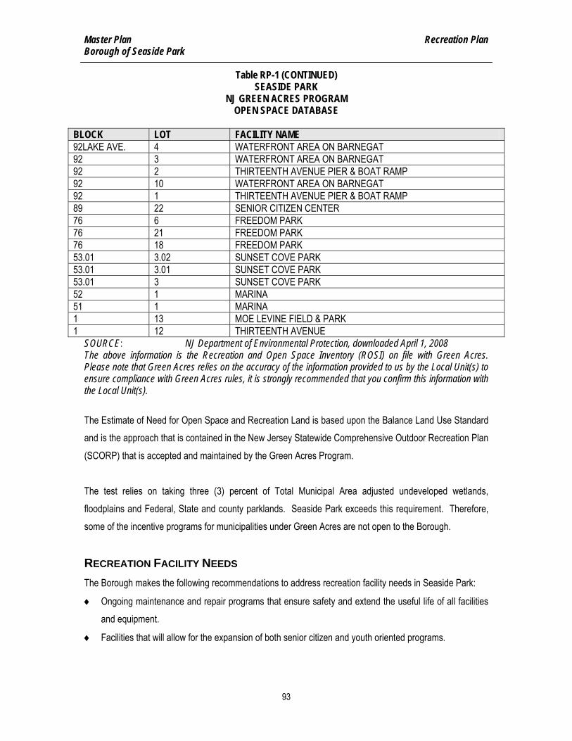
Master Plan Recreation Plan Borough of Seaside Park
93
Table RP-1 (CONTINUED) SEASIDE PARK
NJ GREEN ACRES PROGRAM OPEN SPACE DATABASE
BLOCK LOT FACILITY NAME 92LAKE AVE. 4 WATERFRONT AREA ON BARNEGAT 92 3 WATERFRONT AREA ON BARNEGAT 92 2 THIRTEENTH AVENUE PIER & BOAT RAMP 92 10 WATERFRONT AREA ON BARNEGAT 92 1 THIRTEENTH AVENUE PIER & BOAT RAMP 89 22 SENIOR CITIZEN CENTER 76 6 FREEDOM PARK 76 21 FREEDOM PARK 76 18 FREEDOM PARK 53.01 3.02 SUNSET COVE PARK 53.01 3.01 SUNSET COVE PARK 53.01 3 SUNSET COVE PARK 52 1 MARINA 51 1 MARINA 1 13 MOE LEVINE FIELD & PARK 1 12 THIRTEENTH AVENUE
SOURCE: NJ Department of Environmental Protection, downloaded April 1, 2008 The above information is the Recreation and Open Space Inventory (ROSI) on file with Green Acres. Please note that Green Acres relies on the accuracy of the information provided to us by the Local Unit(s) to ensure compliance with Green Acres rules, it is strongly recommended that you confirm this information with the Local Unit(s). The Estimate of Need for Open Space and Recreation Land is based upon the Balance Land Use Standard and is the approach that is contained in the New Jersey Statewide Comprehensive Outdoor Recreation Plan (SCORP) that is accepted and maintained by the Green Acres Program. The test relies on taking three (3) percent of Total Municipal Area adjusted undeveloped wetlands, floodplains and Federal, State and county parklands. Seaside Park exceeds this requirement. Therefore, some of the incentive programs for municipalities under Green Acres are not open to the Borough.
RECREATION FACILITY NEEDS The Borough makes the following recommendations to address recreation facility needs in Seaside Park:
♦ Ongoing maintenance and repair programs that ensure safety and extend the useful life of all facilities and equipment.
♦ Facilities that will allow for the expansion of both senior citizen and youth oriented programs.

Master Plan Recreation Plan Borough of Seaside Park
94
RECOMMENDATIONS ♦ Create a five year capital improvement plan that anticipates long term needs and provides the funding
to achieve the defined recreational goals of the Borough.
♦ Support an aggressive maintenance program for the Bay front that prevents overgrowth and creates a more hospitable environment for recreation.
♦ Ensure that all playground equipment is barrier-free and all equipment and safety surfacing meet 2007CPSC (Consumer Product Safety Commission) revised guidelines.
♦ Develop a proposal that identifies possible recreational uses for the underutilized land adjacent to the Marina.
♦ Support the recommendations to expand bike paths and walkways throughout the Borough.
♦ Coordinate with Ocean County and New Jersey Department of Transportation to install “Share the Road” signs and include other pedestrian and bike friendly measures that should be pursued in support of the recreation element.
♦ Pursue grant funding for the second phase of boat ramp improvements relating to bulkhead reconstruction, landscaping and walkway upgrades.
♦ Investigate the feasibility of developing a protected beach area on the Bay front at O Street and Lake Avenue.

Master Plan Historic Preservation Plan Borough of Seaside Park
95
HISTORIC PRESERVATION PLAN

Master Plan Historic Preservation Plan Borough of Seaside Park
96
INTRODUCTION Historic preservation refers to the recognition and preservation of the history, culture, and physical characteristics of a community. Fostering an understanding and appreciation for the historic landmarks, buildings, and events is an important step in providing a sense of identity and pride. Through the co-operative efforts of local governments, businesses, property owners, residents and institutions, communities can collectively celebrate their history and culture.
Although Seaside Park has no registered Historic Buildings or Historic District, this element of the Seaside
Park Borough Master Plan is intended to provide information on historic preservation for future consideration within the Borough (See Figure HI-1). This element can serve as a reference point for the Borough to recognize the historic significance of events that shaped the history of Seaside Park. With an understanding of the history, the community can be proactive towards recording historic preservation and can avail itself to other agencies to protect and record its history and culture for future generations. This element has been prepared in accordance with Municipal Land Use Law Section 40:55D-28b (10), which identifies a historic preservation element as an optional element of a municipal master plan. Section 40:55D-28b(10) indicates that a historic preservation plan element shall: “(a) indicate the location
and significance of historic sites and historic districts; (b) identify the standards used to assess worthiness
for historic site or district modification; and (c) analyze the impact of each component and element of the
master plan on the reservation of historic sites and districts.”
PRESERVATION STANDARDS AND GUIDELINES Historic Preservation Standards The Secretary of the Interior is responsible for advising Federal agencies on the preservation of historic properties listed in or eligible for listing on the National Register of Historic Places. They have developed Standards for Rehabilitation, which serve to assist in the long-term preservation of a property’s signification through the preservation of historic materials and features2. The Standards pertain to historic buildings of all materials, construction types, sizes, and occupancy and encompass the building exterior and interior. In
2The Standards for Rehabilitation have also been used to determine the appropriateness of a proposed work projected of registered
properties within the Historic Preservation Fund grant-in-aid program, as well as if rehabilitation qualifies as a Certified Rehabilitation for Federal tax purposes. Generally speaking, to be certified for Federal tax purposes, a rehabilitation project must be determined by the Secretary to be consistent with the historic character of the structure(s), and where applicable, the district in which it is located.

Master Plan Historic Preservation Plan Borough of Seaside Park
97
addition they encompass related landscape features and the building’s site and environment, as well as attached, adjacent, or related new construction. The Standards for rehabilitation are as follows: 1. A property shall be used for its historic purpose or be placed in a new use that requires minimal
change to the defining characteristics of the building and its site and environment. 2. The historic character of a property shall be retained and preserved. The removal of historic
materials or alteration of features and spaces that characterize a property shall be avoided. 3. Each property shall be recognized as a physical record of its time, place, and use. Changes that
create a false sense of historical development, such as adding conjectural features or architectural elements from other buildings, shall not be undertaken.
4. Most properties change over time; those changes that have acquired historic significance in their own right shall be retained and preserved.
5. Distinctive features, finishes, and construction techniques or examples of craftsmanship that characterize a property shall be preserved.
6. Deteriorated historic features shall be repaired rather than replaced. Where the severity of deterioration requires replacement of a distinctive feature, the new feature shall match the old in design, color, texture, and other visual qualities and, where possible, materials. Replacement of missing features shall be substantiated by documentary, physical, or pictorial evidence.
7. Chemical or physical treatments, such as sandblasting, that cause damage to historic materials shall not be used. The surface cleaning structures, if appropriate shall be undertaken using the gentlest means possible.
8. Significant archaeological resources affected by a project shall be protected and preserved. If such resources must be disturbed, mitigation measures shall be undertaken.
9. New additions, exterior alterations, or related new construction shall not destroy historic materials that characterize the property. The new work shall be differentiated from the old and shall be compatible with the massing size, scale, and architectural features to protect the historic integrity of the property and its environment.
10. New additions and adjacent or related new construction shall be undertaken in such a manner that if removed in the future, the essential form and integrity of the historic property and its environment would be unimpaired.
Historic Preservation Guidelines Seaside Park may consider applying the Guidelines for Rehabilitating Historic Buildings which were established in the late 1970s through the National Park Service in conjunction with architects, historians and

Master Plan Historic Preservation Plan Borough of Seaside Park
98
craftspeople. They are intended to assist in applying the above standards to projects to ensure that historic resources are appropriately maintained, rehabilitated, and restored. The recommended course of action for property owners are prioritized into seven areas to be addressed.
♦ Identify, Retain, and Preserve – The identification, retention and preservation of the form and detailing of architectural features which define the historic character of a building is the number one priority for rehabilitating historic buildings. Even minor interventions that change the historic character of a building can have the cumulative of destroying a buildings historic character.
♦ Protect and Maintain – After identifying materials and features to be retained, protecting them is the next important step. Protection includes the maintenance of historic material through treatments such as rust removal, caulking, limited paint removal, and re-application of protective coating; the cyclical cleaning of roof gutter systems; or installation of fencing, protective plywood, alarm systems and other temporary protective measures.
♦ Repair – When the physical condition of historic features requires additional work, repairing is recommended. The guideline for repairing historic materials such as masonry, wood, and architectural metals begins with the least degree of intervention possible such as patching, piecing-in, splicing, or consolidating.
♦ Replace – Replacing should only be an option when deterioration is so severe to be considered beyond repair. When replacing however, a compatible substitute or prototype should be used. Ideally the same type of material should be used, but substitute material is acceptable if the form and design of substitute material convey visual appearance of remaining parts.
♦ Design for Missing Historic Features – Where an important architectural feature is missing, its recovery is always recommended in the guidelines as the preferred course of action. Therefore, if it is desirable to recreate the feature, and adequate historical, pictorial, and physical documentation exists to accurately reproduce the feature, than it should be designed and built based on the information. Another option is to produce a replacement feature based on a new design that is compatible with the remaining character, but that does not give a false historical appearance.
♦ Alterations/Additions to Historic Buildings – Alterations or additions to an historic building may include construction of an additional building, installing a new mechanical system, inserting a new floor, adding new entrances or windows, and so on. While it such alterations or additions to the exterior or interior of a building may be made to extend the use of the building, it is recommended that they should not dramatically change, obscure, or destroy the historic features, materials or finishes.

Master Plan Historic Preservation Plan Borough of Seaside Park
99
♦ Energy Efficiency / Accessibility Considerations / Health and Safety Considerations – As with any other building, historic buildings need to consider factors such as energy conservation, accessibility, and health and safety code requirements. Similar to the above guidelines it is suggested that changes made to accommodate these considerations should be approached with care not to radically change, obstruct, damage, or destroy the historic features, materials or finishes.
LANDMARK DESIGNATION For a property to be designated as a state or national historic place, it must be at least 50 years of age and demonstrate a high degree of physical integrity and significance in history or architecture. To be classified with a Landmark Designation, the following criteria are required: 1. The landmark is associated with events that have made a significant contribution to the broad
patterns of local, state or national history; or 2. The landmark is associated with the lives of persons significant in our past; or 3. The landmark embodies the distinctive characteristics of a type, period, or method of construction, or
that it represents the work of a master, or that it possesses high artistic values, or that it represents a significant and distinguishable entity whose components may lack individual distinction (This recommendation is intended for properties that retain a high degree of architectural integrity. However, rehabilitating architecturally altered buildings should also be encouraged.); or
4. The landmark has yielded, or may be likely to yield, information important in prehistory or history; or 5. The landmark exhibits a combination of scenic historic, architectural, or archaeological or cultural
features which make a unique contribution to the townscape of the Borough. This process will ensure that changes to any historic structure are documented so the Historic Society can maintain a list of historic buildings.
LANDMARK DESIGNATION RECOMMENDATIONS While Seaside Park may contain historically eligible properties, they are scattered throughout the Borough. Accordingly, this master plan element does not recommend the creation of any historic districts.
The Historic Society should be encouraged to take a proactive approach to inventory all structures in Seaside Park and determine which properties have potentially eligible historic facilities. Any submissions to the New Jersey Historic Preservation Office or other agency should not occur without property owner and/or

Master Plan Historic Preservation Plan Borough of Seaside Park
100
Borough Council approval. In addition, listing on the state or national register may also provide certain investment tax credits to income-producing properties. In cooperation with the Historic Society, the Borough could play an important role in identifying buildings that may be eligible for historic preservation. Such a study could also detail the important historic features, materials, and designs within the Borough so that residents could recognize and appreciate these elements.
RECOMMENDATIONS ♦ Public Education on Historic Preservation. The Historical Society should play an active role in the public
education of Seaside Park residents. Many residents may be unaware of the importance of historic preservation and what it means to the community. To further educate the public, the Borough may consider collaborating with the Historical Society to produce promotional materials, such as brochures, handouts, and booklets, which outline the importance of historic preservation. Manuals can be produced to assist the public in identifying historic properties and architectural features, and provide relevant technical assistance and guidance for preservation and rehabilitation of historic property and features. Matching funds for such a project may be available from the New Jersey Historic Preservation Office.
♦ Exploring Government Agency Support. This section of the Master Plan has emphasized that historical elements should be considered resources or assets within a community. Preservation, rehabilitation and promotion of these resources however do require investment. For this reason, identifying funding support through State or Federal programs is essential. The Borough might consider contacting the following agencies for program assistance in developing its historic preservation plan: 1. National Trust for Historic Preservation - Provides technical support for local government
organizations ranging from site visits, guest speakers, promotional materials and media, and program development grants.
2. National Park Service (Mid-Atlantic Regional Office - Philadelphia) -Provides technical information on building rehabilitation and conservation issues, matching grants to encourage preservation efforts, tax incentives for income-producing properties, and promotes the preservation of significant historic battlefields associated with wars on America soil. Also, through the “Save America’s Treasures” program, provides grants for preservation and/or conservation work on nationally significant intellectual and cultural artifacts and nationally significant historic structures and sites.

Master Plan Historic Preservation Plan Borough of Seaside Park
101
3. NJ Department of Community Affairs (Trenton) -In addition to the Neighborhood Preservation Program, there is also a Main Street program, which provides downtown commercial revitalization support, such as marketing, design, and business development.
4. NJ Historic Trust (Trenton) – Provides support and protection for New Jersey’s historic resources through a variety of grant, loan, and property donation programs.
5. NJ Historic Preservation Office (Trenton) -This office provides a variety of technical information and support for historic preservation activity. It can provide further assistance in completing the National Register nomination process. This office also implements the Certified Local Government (CLG) program which provides program development matching funds to qualifying municipalities with an appropriately-managed local historic society. The benefits of CLG status include state grants, state and federal government information exchange, and participation in the National Register and statewide preservation planning process. CLGs are expected to maintain and support their municipality's historic preservation ordinance, commission, planning, local survey, public participation, and registration process.
6. Preservation New Jersey (Trenton) - As the major non-profit, statewide historic preservation advocacy group, this organization is the general clearinghouse for information and local referrals. The organization offers workshops and conferences on private and public preservation planning issues and on technical matters related to restoration. Membership includes notification of programs, technical assistance, and subscriptions to its quarterly newsletter.
7. NJDEP Green Acres Program (Trenton) – Provides low-interest loans to counties and municipalities for the acquisition or development of land for public outdoor recreation or conservation purposes. Eligible projects include historic sites.

At
la
nt
ic
O
ce
an
Barn
egat
Bay
B E R K E L E Y T W PB E R K E L E Y T W P
S E A S I D E H E I G H T S B O R OS E A S I D E H E I G H T S B O R O
Midway Camps Historic District
OCEA
N AV
E (C
R 53
)
CENT
RAL
AVE
(NJ 3
5)
K ST
H ST
F ST
G ST
E ST
D ST
CENT
RAL
AVE
(NJ 3
5 SEC
ONDA
RY)
C ST
S BAY
VIEW A
VE
13TH AVE
J ST
12TH AVE
L ST
N ST
11TH AVE
O ST
BOUL
EVAR
D
M ST
9TH AVE
10TH AVE
I ST
8TH AVE
7TH AVE
4TH AVE
LAKE
AVE
3RD AVE
2ND AVE
1ST AVE
BARN
EGAT
AVE
K CT
ISLAND AVE
NORTH AVE
5TH AVE
BRIGHTON AVE
DECATUR A VE
LAFAYETTE AVE
14TH AVE
6TH AVE
NJ 37 SECONDARY
N CE
NTRA
L AV
E
N BA
YVIE
W A
VE
STOCKTON AVE
BERK
ELEY
LN
FARRAGUT A VEFARRAGUT A VE
STOCKTON AVE
M ST
I ST
14TH AVE
J ST
O ST
L ST
6TH AVE
O ST
N ST
14TH AVE
5TH AVE
K ST
N ST
N BAYVIEW AVE
BERK
ELEY
LN
Figure HI-1:Historic SitesBorough of Seaside Park
Ocean County, New JerseyPrepared by: STK, October 14, 2008Source: Ocean County GIS Department - Tax Parcels, Rights-of-Way, Municipal Boundary; NJDOT - 2005 Roads; NJDEP Historic Preservation Office (HPO) - 2004 New Jersey Register of Historic PlacesFile Path: H:\SSPB\00010\GIS\Projects\sspb10_HistoricTabloid.mxd
NOTE: This map was developed using New Jersey Department of Environmental Protection Geographic Information System digital data, but this secondary product has not been verified by NJDEP and is not State-authorized.
11 Tindall RoadMiddletown, NJ 07748-2792Phone: 732-671-6400Fax: 732-671-7365
Historic SitesTax ParcelsRoadsOpen WaterMunicipal Boundary
0 700 1,400350 Feet

Master Plan Economic Plan Borough of Seaside Park
103
ECONOMIC PLAN

Master Plan Economic Plan Borough of Seaside Park
104
INTRODUCTION The Economic Plan Element of the Master Plan is required by Municipal Land Use Law (MLUL) to address the economic development and sustained economic vitality of the community. This includes the types of employment expected to be provided by the economic development to be promoted, the occupational characteristics of the residents and an analysis of the stability and diversity of that economic development. While the above statement may correctly reflect the MLUL mandate, it is essential that this element of the Master Plan accurately defines the current status of the business community, objectively determines future opportunities, develops realistic alternatives that might contribute to a more successful business environment and quantifies the potential results of such recommendations.
CURRENT STATUS - BUSINESS Year round The business community within Seaside Park consists of two groups. The first, the year round enterprise, has historically relied on both the consistent support of Borough residents as well as the increased business generated by the large influx of summer visitors and seasonal residents. This group provides a variety of professional services as well as a range of retail stores, restaurants, rooms etc. In 2007, 28 mercantile licenses, excluding the boardwalk, were issued to this group (22 percent less than in 1999, See Schedule ED-1). Although required by Borough Code (Chapter 43), not all businesses have a mercantile license. However, those that do, appear to represent the majority of the businesses. With some limited exceptions, a year round business is generally small; family owned and operated and, in many cases, the business property has been within the family for many years. Employment opportunities are limited both in terms of compensation and career opportunities. Seasonal The second group of businesses is seasonal. It consists of those located in the commercial section of the boardwalk (26 licenses) and businesses that have facilities on Borough streets (17 licenses). Mobile vendors (16 licenses) are not included because these businesses are not vested in the community, do not pay property taxes nor provide significant employment opportunities. The vending license and designated parking fees they pay are only minor sources of revenue for the Borough.

Master Plan Economic Plan Borough of Seaside Park
105
Most seasonal businesses open in spring and close in the fall. They offer services and shopping options primarily designed to meet the needs of summer visitors and seasonal residents. Based on mercantile license records, boardwalk licenses dropped by 13 percent while street located seasonal licenses fell by 10 percent since 1999 (See Schedule ED-1). All seasonal businesses are totally dependent upon the summer population and, based on their location, can be even more specifically dependent on a unique segment of that population as a customer base. The boardwalk businesses would be such an example with local beachgoers and visitors to adjacent Seaside Heights a key part of their success. With exceptions, these are also small, family owned and operated and, obviously, offering only short term employment opportunities. While a summer job provides the ability to supplement an individual’s income or to enhance a student’s ability pay for an education, these temporary jobs cannot provide a financial base for improving the Borough’s long term economic development.
ECONOMIC CONTRIBUTION Business The Borough does not have a municipal sales tax or a local income tax. It derives no revenues from any form of local payroll taxes. Property taxes are the only basis for generating tax revenues. According to property tax records, in October, 2007 Seaside Park had an assessed value of $771,230,000 (See Schedule EC-2). Of that, less than six percent (5.8 percent) or $44.8 million was identified as commercial, 1.6 percent in boardwalk properties, 3.4 percent in commercial and 0.8 percent in buildings containing 5 or more apartments (See Schedule ED-2). Based on these assessed values and using the 2008 municipality tax rate of 0.00708, the total commercial contribution to municipal tax revenues will be $317,055 or 6.5 percent of the projected $4.8 million total (See Schedule ED-3). Residential Residential properties represent slightly more than eighty (80) percent or more than $622 million dollars of the Borough’s property values and, using the same calculation as noted above, are expected to generate ninety-one (91) percent or $4.4 million of the Borough’s total tax revenues for 2008 (See Schedule ED-3).

Master Plan Economic Plan Borough of Seaside Park
106
Other Revenue Schedule ED-4 provides a more detailed listing of the Borough revenues for 2005-2007 as well as the town budget for 2008 and demonstrates just how dependent the Borough’s operating revenues are on property taxes. In 2007, property taxes accounted for 72 percent of the Borough’s operating revenues.
CURRENT BUSINESS ENVIRONMENT The current business environment consists of: 1. Year round population is between 2,200 and 2,300. There is no available data that projects any major
growth that might offer businesses a larger, local year round customer base. 2. The limited availability of land, as well as the high cost of acquisition and development, generally
creates too high an entrance barrier for most small business owners. 3. The existing retail businesses are mainly scattered along Route 35 and the Boulevard, while the hotels
and motels are concentrated on North Ocean Avenue and at the southern end of Central Avenue. The four to six lane highway that is Central Avenue (Route 35) adversely impacts the concept of an integrated central business district as does the isolation of the Boulevard from the other primary business areas.
4. Seaside Park’s geographic location is a handicap for year round businesses: a) Except for seasonal traffic to and from Island Beach State Park, there is no significant through
traffic that might be induced to utilize local businesses. b) Proximity to Toms River, with a much larger year round population, is able to offer significant
service and shopping options that directly compete with local businesses. This competition puts Seaside Park’s small local businesses at a severe disadvantage.
TOURISM No statistical data is available that demonstrates the economic contribution of this group to the Borough. However, there are some facts that can provide a basis for formulating some limited conclusions. For purposes of this section, tourists include all non residents whether they are renters or day visitors: Beach The current beach economic situation consists of: 1. The single largest group of “tourists” is the daily and seasonal beach badge holders. In 2007, the
Borough sold 69,264 daily badges, 3,445 weekly badges, and 19,367 seasonal badges (See Schedule ED-5).

Master Plan Economic Plan Borough of Seaside Park
107
2. Although the Borough does not maintain any records indicating the number of times a seasonal badge is used, assuming a usage of 10 to 15 times per badge during the season and excluding children, it can be estimated that there were between 280,000 and 377,000 individual beach visits during the 2007 summer season.
3. The beach revenues for 2007 amounted to $1,308,969 or about fifteen percent of the Borough’s total annual reoccurring revenues.
4. However, the State of New Jersey, by statute, requires municipal beaches to utilize all beach revenues to support beach operations. In effect, the beach is “revenue neutral”. Beach related expenses and offsetting revenues must be equal and thus a public beach cannot be a profit center for a community.
5. Since the Borough cannot apply beach revenues against other municipal expenses, beach operations cannot directly make an economic contribution to the Borough. Thus the Borough must ensure that beach related expenses are not subsidized by taxpayer property taxes.
Parking Meter Revenues Metered parking is a major feature of Seaside Park that consists of: 1. Mainly a seasonal revenue source, in 2007, the meter revenues amounted to $577,144 or about eight
percent of the Borough’s operating revenues (Schedule ED-4). A thirty-five percent increase from the prior year that resulted from a fifty cent ($0.50) increase in the hourly rate. The Borough is budgeting $540,000 in 2008 (See Schedule ED-4).
2. However, even though the Borough can apply all of this revenue to offsetting municipal operating expenses, only twelve percent of the Borough’s 6,062 parking spaces are metered and all of the metered revenues are generated from the northern end of Seaside Park (North of C Street, See Schedule ED-6).
3. Directly related to the use of meters is the indirect revenue they generate through fines. In 2007, total revenues from court fines amounted to $352,742 (See Schedule ED-4). Although all of the revenue was not the result of parking violations, according to 2007 court records, about sixty percent (60%) result from meter penalties. The 2008 budget includes $350,000 in fines.
Seasonal Expenses There are seasonal expenses that include: 1. According to the Borough’s 2008 budget, 105 seasonal employees, excluding beach personnel, will be
hired at a direct salary and wage cost of $445,910 excluding related payroll taxes. Historical comparative data is not available.

Master Plan Economic Plan Borough of Seaside Park
108
2. Additional costs are incurred but not limited to: added solid waste land fill fees; incremental increases in municipal consumption of water and subsequent added sewerage costs; increased maintenance and repairs; added fuel costs for vehicles; sand removal and capital costs for equipment and vehicles that are required to support the increased seasonal population.
3. The Borough does not maintain detailed financial records that provide the actual incremental costs required to support the higher seasonal population.
CONCLUSIONS – BUSINESS The business conclusions include: 1. If economic development is to be successfully nurtured, those efforts must focus on providing
incentives that encourage both current and new business owners to invest in and acquire properties. While this may expand employment opportunities, creating minimum wage jobs should not be the strategic objective.
2. Initiatives should be directed at potential year round opportunities. Expanding more storefronts that are vacant most of the year is not conducive to establishing a viable business environment nor does it contribute to sustaining the residential property values that provide the financial foundation for the Borough.
3. Based on the current and projected population, the cost of real estate, the competition from neighboring municipalities and the adverse geographic impact of a four to six lane highway as a “Main” street, establishing a viable year round downtown business district, while desirable, is a formidable goal. More than enhanced facades, improved landscaping and new architectural designs will be needed to achieve success.
4. Seasonal businesses may continue to provide income for private individuals but, with very limited exceptions, have not demonstrated the willingness to invest profits in the construction of new, or the revitalization of, existing structures.
5. Professionals and skilled craftsmen may be viable if the business and dwelling elements of the property are integrated and they have the ability to attract customers from outside the Borough.
CONCLUSIONS - TOURISM Conclusions regarding the tourism sector include: 1. The beach is a recreational and open space amenity for the Borough and a defining natural feature that
adds intrinsic value to the Borough’s attractiveness as a residential community. However, by itself, the beach is not an economic opportunity for the Borough and can, if not properly managed, actually be a financial burden to the taxpayers.

Master Plan Economic Plan Borough of Seaside Park
109
2. By statute, the beach cannot be a source of revenues for the municipality. Any financial contribution must be indirectly produced and not assignable to the beach operations. Such assignment would immediately remove such revenues from the Borough’s operating revenue stream.
3. The lack of data that identifies all of the incremental seasonal costs prevents specific calculations that would demonstrate the net financial impact on the Borough. However, it would appear that the approximately $900,000 in revenue (meter and fines), is largely, if not entirely, offset by the $445,910 (per 2008 Borough budget) in seasonal, non-beach related direct payroll costs and the undetermined added seasonal costs related to supporting the summer visitors.
4. The Borough has limited parking capabilities. The cost of real estate and the absence of contributing revenue opportunities for the Borough that might justify such an investment, sustainable only by the seasonal population, do not appear to exist.
5. Attracting more people will not create more incremental operating revenue for the Borough. By increasing congestion and encouraging excessive development it could, in fact, negatively impact the quality of life within the community and thus undermine the values of the single family properties which are the financial strength of the Borough.
6. Job creation is a fine aspiration but unless there are significant year round business ventures that would require highly skilled or professionally trained personnel, employment opportunities appear more likely to be low skilled, low paid, seasonal positions that would not make a strategic contribution to the community.
CONCLUSIONS – RESIDENTIAL The residential conclusions include: 1. Residential property values, particularly detached, single family properties (56 percent of all taxable
property and 63 percent of all property taxes), are critical to the economic viability of the Borough and sustaining these values must be the Borough’s first priority (See Schedules ED-2 and ED-3).
2. Statistically, the values for detached, single family properties in the R-1 zone are substantially higher than those within the existing R-2 and R-3 zones, $425,540, $338,857 and $256,876 respectively (Interpolated from Schedule ED-7).
3. The reasons for this are varied but certainly land use regulations are an important factor. R-1 requires a larger lot size but mandates lower building and lot coverage and does not allow multi unit complexes thus reducing density and storm water runoff.
4. Other contributing factors would include quality-of-life issues such as greater light, air and space between properties as well as location (less noise, traffic congestion and more parking space availability).

Master Plan Economic Plan Borough of Seaside Park
110
RECOMMENDATIONS ♦ Recognize that the Borough’s financial strength is its high valued residential properties, most of which
are single family dwellings. Equally protect and enhance all residential areas by creating one residential zone.
♦ Maximize the value of the underdeveloped properties along Route 35 by creating a new more diverse land use zone that encourages an integrated approach along that corridor and offers a less restrictive approach to develop multiple dwelling unit complexes as well as expanded mixed use (commercial and residential) options.
♦ Anticipate the development opportunities of the larger properties located within the hotel/motel zone for both existing owners and developers by incorporating this area into the concept of a new land use zone.
♦ Create a committee and hire professionals to support the goal of developing a new zone. Place oversight responsibility with the Planning Board.
♦ Consider creative uses in the new zone to allow live-work arrangements and encourage professional services and businesses to locate in the new land use zone.
♦ Pursue, with professional assistance, all grant opportunities that may be available to fund the study, design and development of the new zoning concept.
♦ Create an integrated financial system that will provide the Borough with the information necessary to identify, evaluate and effectively manage the economic interests of the community.
♦ Encourage the business owners to form a working committee to determine if there is a willingness to invest the resources required to create a more attractive, better integrated and possibly expanded business district. If so, create a jointly (public and private) funded, professionally directed effort to develop ideas, solicit State and Federal grants and to create alternative design concepts.
♦ Consider the possibility of a major, privately funded redevelopment project. If the there is public and political support, hire professional representation to determine if there are developers willing to consider such an investment opportunity and explore the ramifications of such a decision.


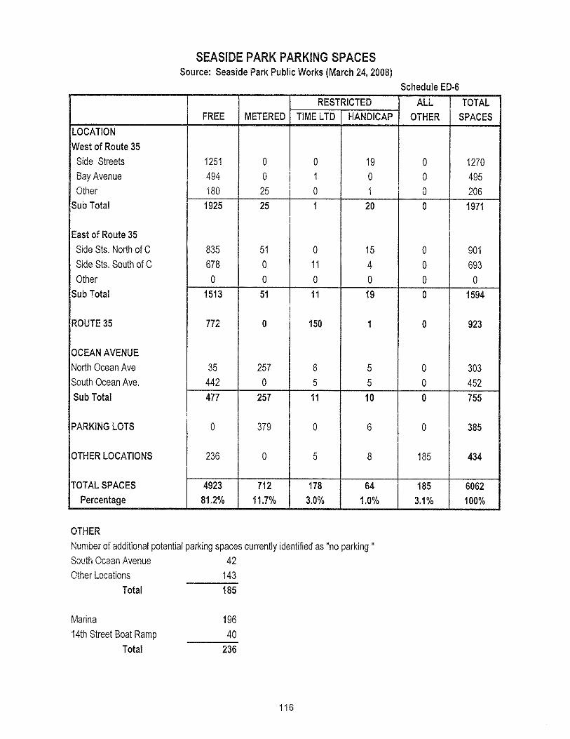


Master Plan Recycling Plan Borough of Seaside Park
118
RECYCLING PLAN

Master Plan Recycling Plan Borough of Seaside Park
119
INTRODUCTION Over the past two decades in New Jersey, recycling of household and commercial waste and used materials has become a common practice. To encourage and increase recycling, the Municipal Land Use Law was amended to incorporate a recycling plan element as a section within a municipal master plan. The creation of this element is the basis for implementing the Mandatory Statewide Source Separation and Recycling Act of 1987, which requires the creation of a municipal recycling program and adoption of a recycling ordinance. This element of the master plan is intended to affirm Seaside Park's commitment to meet and exceed the statewide goals for recycling and to expand the local recycling program.
CURRENT STATUS OF WASTE MANAGEMENT PROGRAM Waste and Recycling Collection Program Solid Waste Waste is picked up twice a week from residences and businesses, except for those that utilize private collection services (hotels, motels, boardwalk), by the Borough’s Public Works employees. Collection of cardboard, newspapers and mixed papers is performed on every Wednesday and bottles and cans are picked up each Saturday during the summer season and bi-weekly in the off season. The Seaside Park Department of Public Works has three garbage trucks for solid waste collection and curbside pickup of recyclables as well as two roll off container trucks that are used for recycling and other Public Works’ related functions.
Recyclable Materials
The Mandatory Statewide Source Separation and Recycling Act of 1987 set goals for recycling and requires each municipality to implement a recycling program. In addition, the Act required municipalities to adopt a recycling ordinance, designate a Recycling Coordinator, and report annual recycling tonnage to the New Jersey Department of Environment Protection and Ocean County. Mandated recyclables in Seaside Park include:
♦ Aluminum and steel cans, glass containers
♦ Newspapers, plastic beverage containers
♦ Leaves, mixed paper and cardboard
♦ Motor oil, batteries, white goods and tires

Master Plan Recycling Plan Borough of Seaside Park
120
♦ Paint cans In addition, concrete, cement blocks, bricks, asphalt, ferrous and non-ferrous scrap are recycled by construction contractors and the Borough. Waste Generation and Recycling Rates The Borough of Seaside Park prepares Recycling Tonnage reports for submission to the New Jersey Department of Environment Protection (NJDEP) and Ocean County. The reports categorize the recyclable materials into numerous categories and provide the total tonnage collected for the particular year in each category. In 2007, the Borough reported 5,177 recycled tons. This consisted of 1,032 tons of residential and 4,145 tons of commercial recycled products. About one-third of the residential recyclables was comprised of commingled materials and slightly less than one-fifth of the 2007 recycling by residents was newspapers. On the commercial side, over one-third of the recyclables were comprised on concrete and 45 percent was road millings. The official State of New Jersey recycling percentages are not available for 2007 but the information from the NJDEP for 2006 indicates that the residents and businesses in Seaside Park recycled approximately 32 percent of the municipal solid waste. The highest recycling rate in Ocean County in 2006 was 62 percent in Bay Head and the lowest was 15 percent in Berkeley Township.
RECOMMENDATIONS ♦ Borough Study. The Borough should identify the actual costs of the recycle program and determine if its
current “open door” policy of accepting recycling materials from sources outside of the Borough rather than limiting access to residents, business and property owners is cost effective.
♦ NJ Department of Environmental Protection Programs. Since the mid-1990’s, the New Jersey Department of Environmental Protection has offered a wide range of programs and grants to educate the public on the benefits of recycling and to assist municipalities in developing more effective recycling programs. The long-term future of these programs is dependent upon the additional funding.
♦ Education. Increasing the awareness among Borough residents, renters and visitors to the Borough of the economic and environmental benefits of recycling may improve the amount and the rate of recycling. Programs at the elementary school level should also be encouraged.
♦ Encourage Recycling Through Development Regulations. The NJ Municipal Land Use Law requires the recycling plan element to include provisions for:

Master Plan Recycling Plan Borough of Seaside Park
121
…the collection , disposition and recycling of recyclable materials within a development proposal
for the construction of fifty (50) or more units of single family residential housing or twenty-five
(25) or more units of multifamily residential housing and any commercial or industrial development proposal for the utilization of one thousand (1,000) square feet or more of land (NJSA 40:55D-28.b. (12)).
Although the potential of such large residential developments is small in Seaside Park Borough, many commercial developments will exceed the minimal cited threshold. It is recommended that the Borough regulations remain current with this requirement to ensure that site plans include details and information on the storage and disposal of recyclable materials.

Master Plan Contiguous Municipalities Relationships Borough of Seaside Park
122
CONTIGUOUS MUNICIPALITIES RELATIONSHIPS

Master Plan Contiguous Municipalities Relationships Borough of Seaside Park
123
INTRODUCTION The New Jersey Municipal Land Use Law (MLUL) requires the Borough to provide a policy statement of the relationship of its Master Plan with the plans of adjacent communities, Ocean County, and the State Development and Redevelopment Plan. The policy of the Borough of Seaside Park is to work with neighboring municipalities, the County, and the State, to advance sound planning and develop compatible plans. This section of the Borough Master Plan reviews the relationship of the Borough plan to the plans of the State, the County, and the adjoining municipalities.
RELATIONSHIP TO ADJOINING MUNICIPALITIES The Borough of Seaside Park is bordered by land to the north by the Borough of Seaside Heights and to the south by South Seaside Park, a portion of Berkeley Township. The east and west borders of the Borough are the Atlantic Ocean and the Barnegat Bay, respectively. The lands in the Borough of Seaside Heights abutting Seaside Park from Porter Avenue through to Hamilton are planned and zoned for mixed use (apartments, private residences, commercial, and motels) as shown on the Seaside Heights existing land use map dated June 2001. South Seaside Park, a section of Berkeley Township, abuts Seaside Park to the south. Lands in South Seaside Park abutting Seaside Park are generally developed as single family residences at a density higher than in Seaside Park. The zoning in South Seaside Park (Berkeley Township) in the area just south of Seaside Park allows development at a density slightly higher than Seaside Park’s R-1 density according to the Berkeley Township Comprehensive Master Plan, December 4, 1997.
RELATIONSHIP TO THE OCEAN COUNTY PLAN The Ocean County Planning Board last adopted a Comprehensive Master Plan in December of 1988. The Ocean County General Development Plan map provides generalized land uses for all of the land areas within Ocean County. The lands within the Borough of Seaside Park are designated as Suburban Density (5 units per acre or more). The Suburban Density is to allow for a variety of housing types.

Master Plan Contiguous Municipalities Relationships Borough of Seaside Park
124
The County Master Plan also has a comment regarding the future population growth of the barrier islands. Page 3-12 of the County Planning Board states: “The barrier beach communities will continue to have small but steady population increases.” The statement in the County Master Plan is based on the availability of developed land in some towns in 1988, and the trend at that time by other barrier beach towns to allow increased density.
RELATIONSHIP TO THE STATE DEVELOPMENT AND REDEVELOPMENT PLAN The NJ State Planning Commission adopted the State Development and Redevelopment Plan (SDRP) in June of 1992 and adopted a revised SDRP on March 1, 2001. The most recent SDRP was released for cross acceptance in 2004. The NJ Office of Smart Growth is currently preparing a new Plan based on the cross acceptance process. The SDRP contains goals, objectives, and policies regarding the future development and redevelopment of New Jersey. The primary objective of the SDRP is to guide development to areas where infrastructure is available or can be readily extended such as along existing transportation corridors, in developed or developing suburbs, and in urban areas. New growth and development should be located in “centers,” which are “compact” forms of development with a pedestrian-oriented area of commercial and civic uses as defined in the SDRP. The overall goal of the SDRP is to promote development and redevelopment that will consume less land, deplete fewer natural resources and use the State’s infrastructure more efficiently. Among these is the redevelopment and revitalization of New Jersey’s cities and urban areas. Seaside Park is designated as PA-5B Environmentally Sensitive Area Barrier Island Planning Area. PA-5B is the NJ State Plan designation for the Environmentally Sensitive/Barrier Islands Planning Area that "are coastal land forms... with the most notable geologic features being a separation from the mainland by water. New Jersey's coastal barrier chain extends from Monmouth to Cape May County."
The SDRP’s intent for the Environmentally Sensitive Area Barrier Island Planning Area is to:
• “Accommodate growth in Centers
• Protect and enhance the existing character of barrier island communities
• Minimize the risks from natural hazards
• Provide access to coastal resources for public use and enjoyment
• Maintain and improve coastal resource quality; and, revitalize cities and towns.”
Master Plan Contiguous Municipalities Relationships Borough of Seaside Park
125
The State Plan also promotes “barrier island communities with sustainable economies which are compatible with the natural environment, minimize the risks from natural hazards, and maximize public access to and enjoyment of coastal resources. The Seaside Park Master Plan, as expressed in the Vision Statement and the Master Plan recommendations, is supportive of the State Plan approach for the future of barrier island communities.

Master Plan Reexamination Report Borough of Seaside Park
126
REEXAMINATION REPORT

Master Plan Reexamination Report Borough of Seaside Park
127
INTRODUCTION The New Jersey Municipal Land Use Law (MLUL) requires that the Borough of Seaside Park periodically reexamine the Borough Master Plan and development regulations at least every six years (N.J.S.A. 40:55D-89). The Planning Board must adopt by resolution a report presenting the findings of its reexamination and submit a copy of the adopted report and resolution to the Ocean County Planning Board, and to the municipal clerks of all adjoining municipalities. The Seaside Park Master Plan was adopted on February 26, 1985. Subsequently, Master Plan Reexamination Reports were completed and adopted by the Borough Planning Board on July 20, 1987; July 21, 1994; April 24, 2001; and January 24, 2007. Subsequent to the completion of the 2007 Reexamination Report, the New Jersey Council on Affordable Housing (COAH) in June and September 2008 adopted revised housing allocations and regulations that affect municipal planning for affordable housing. In addition, the State in 2008 amended the Fair Housing Act which is the enabling legislation for COAH’s regulatory authority. This Reexamination Report presents the recommendations of the Borough Planning Board as to the changes it recommends as a result of a Master Plan review and reexamination that the Board completed in 2008.
CONTENT OF THE REEXAMINATION REPORT The MLUL requires that the content of the Master Plan Reexamination Report address the following five items related to the planning of the Borough. A. The major problems and objectives relating to land development in the Municipality at the time of such
adoption, last revision or re-examination. B. The extent to which such problems and objectives have been reduced or have increased subsequent to
such date. C. The extent to which there have been significant changes in the assumptions, policies and objectives
forming the basis for such plan or regulations as last revised, with particular regard to the density and distribution of population and land uses, housing conditions, circulation, conservation of natural resources, energy conservation, and changes in State, County and Municipal policies and objectives.

Master Plan Reexamination Report Borough of Seaside Park
128
D. The specific changes recommended for the master plan or development regulations, if any, including underlying objectives, policies and standards, or whether a new plan or regulations should be prepared.
E. The recommendations of the Planning Board concerning the incorporation of redevelopment plans adopted pursuant to the Local Redevelopment and Housing Law, FL. 1992, c. 79 (N.J.S.A. 40A:12A-1 et al.) into the land use plan element of the municipal master plan, and recommended changes, if any, in the local development regulations necessary to effectuate the redevelopment plans of the municipality.
1. THE MAJOR PROBLEMS AND OBJECTIVES RELATING TO LAND DEVELOPMENT IN SEASIDE PARK MUNICIPALITY AT THE TIME OF THE ADOPTION OF THE
2007 RE-EXAMINATION. The major issue cited in the 2007 Reexamination Report was the need to establish reasonable objectives to provide a balance between year round and seasonal housing, and to establish reasonable densities recognizing present development patterns. The 2007 Report noted that several zoning ordinances had been adopted to help control the intensity of development in the Borough. Specifically, the Borough had adopted the following ordinances:
• An impervious coverage ordinance
• A signage ordinance
• Building height
• Stormwater control
• Flood plain regulations The 2007 Report anticipated that there will be “rezoning the area to decrease permitted density and to provide for more targeted development” regarding the residential districts.
The Reexamination Report further noted a need to maintain the level of public service to accommodate the year-round needs of the Borough while also providing for the additional needs of tourists during the summer. The Borough continued a program of maintaining municipal roads and repair and updating of sewer and water improvements within tight financial constraints. Capital improvement projects were undertaken on an

Master Plan Reexamination Report Borough of Seaside Park
129
annual basis to improve the Borough’s road system and infrastructure. Since 2001, the following major projects had been completed, begun, or planned:
• Beach access improvements along Ocean Avenue at “F” Street and 7 Avenue
• Road improvements to “N” Street (2003) and First Avenue.
• “M” Street and Lake Avenue bulkhead and walkway improvements
• Sanitary sewer improvements along First, Second & Third Avenues
• Road improvements to First and Second Avenues. Parking was identified as a major issue in the Borough during the months of July and August. The Borough had investigated several means of adding off-street parking spaces near the beach and boardwalk. In August 2004, under a Smart Growth Planning Grant from the New Jersey Department of Community Affairs, the Borough prepared a Small Area Master Plan for the Northeast Quadrant. Conservation of the coastal environment was identified as a major objective and the reexamination recommended preserving environmentally sensitive areas along the bay and ocean front through:
• Restoration of bay front beaches and restoration and stabilization of ocean front dunes;
• Planting of beach grasses on beaches and bay front; and
• Protection from development.
The Borough had received funding from Green Acres for the following open space and outdoor recreation projects:
• Boardwalk reconstruction from 11th Avenue to 12th Avenue, and for a handicapped ramp at 11th Avenue and,
• O Street bulkhead improvements.
2. THE EXTENT TO WHICH SUCH PROBLEMS AND OBJECTIVES HAVE BEEN REDUCED OR HAVE INCREASED SUBSEQUENT TO SUCH DATE
Housing, density, parking, and conservation of the environment have continued to be significant concerns of the Borough.

Master Plan Reexamination Report Borough of Seaside Park
130
Since the Borough is fully developed, future development will largely be limited to tear downs and reconstruction of existing sites, infill development, adaptive reuse of existing buildings and sites, changes of use, and building expansions and alterations. The Borough has become increasingly concerned with the need to ensure that the bulk and scale of new building development and building alterations and expansions are reasonable and appropriate to the desired character, density, and visual environment of the Borough and its neighborhoods. Development issues facing the Borough include an increased frequency of street flooding, on-street parking, quality of life issues, and impacts of increasing building size on the light, air, and open space within residential neighborhoods. In addition, the Borough notes that the seasonal character of the Borough’s economic activity and its location on a barrier island limit the potential for the expansion of the non-residential economic base of the Borough. As a result of its continued concern with these issues and the future direction of the Borough, at the beginning of 2008, the Planning Board initiated a review and revision of the 1985 Master Plan.
3. THE EXTENT TO WHICH THERE HAVE BEEN SIGNIFICANT CHANGES IN THE ASSUMPTIONS, POLICIES AND OBJECTIVES FORMING THE BASIS FOR THE
MASTER PLAN OR REGULATIONS AS LAST REVISED, WITH PARTICULAR
REGARD TO THE DENSITY AND DISTRIBUTION OF POPULATION AND LAND
USES, HOUSING CONDITIONS, CIRCULATION, CONSERVATION OF NATURAL
RESOURCES, ENERGY CONSERVATION, AND CHANGES IN STATE, COUNTY
AND MUNICIPAL POLICIES AND OBJECTIVES. The Planning Board recommends that the Borough pursue a new land use planning policy to more effectively maintain the desirable features of the Borough as a single-family residential community, and also to provide appropriate locations for opportunities for mixed use development that can provide new economic development and more varied housing types. The basic approach of the new land use policy should be to simplify the residential plan for the community be consistent with a desired density reduction and minimum lot size for single family residential development. At the same time Central Avenue will be planned as a

Master Plan Reexamination Report Borough of Seaside Park
131
mixed use corridor for residential and non-residential uses. A smaller area for mixed use will also be planned in the northeast section of the Borough.
4. THE SPECIFIC CHANGES RECOMMENDED FOR THE MASTER PLAN OR DEVELOPMENT REGULATIONS, IF ANY, INCLUDING UNDERLYING OBJECTIVES, POLICIES AND STANDARDS, OR WHETHER A NEW PLAN OR REGULATIONS
SHOULD BE PREPARED. The Planning Board recommends the adoption of a new Master Plan as prepared by T & M Associates and dated November 25, 2008. The Planning Board further recommends that the Borough development regulations and the zone plan be revised to implement the proposed zone plan as depicted by Figure LU-4 of the new Master Plan and that the regulations be revised as described in this section. The Planning Board recommends establishing one single-family residential land use zone district to provide uniformity within the community in terms of lot size and building type. The Planning Board further notes that the Zoning Board of Adjustment has recommended the elimination of the R-2 zone. The single-family residential area would allow single-family detached dwellings on lots of 5,000 square feet or greater. The conversion of single-family homes to duplexes is an undesirable change to the desired single-family residential development and density pattern for the Borough. The land use plan recommends changing the Borough zone plan to eliminate the R-2 district which permits single-family homes and two-family homes on 5,000 square foot lots and the R-3 district which permits single-family homes on 2,500 square foot lots and, as a conditional use, two-family homes on 5,000 square foot lots. The quality of life issue is important to the community as a whole and the proposed changes discussed in this section will encourage the consolidation and merger of small lots with narrow frontages to help improve the residential character of the Borough. The current land use regulations that govern the development and redevelopment in the Borough threaten the quality of life desired for the community (light, air, open space, and tranquility). By maxing out building coverage, lot coverage and the building to the maximum 4-foot side setbacks, the Borough is creating a crowded and congested situation. Not only is it a threat to quality of life and not esthetically pleasing, but it is contributing to the increase in flooding that the Borough has been experiencing over the last 10 years. This excess storm water run off also causes pollution to our bay and ocean waters. To remedy problems

Master Plan Reexamination Report Borough of Seaside Park
132
with excessive building and lot coverage and building bulk that creates a crowded and congested situation that is not aesthetically pleasing, and detracts from light, air, and open space, development in the single family residential area should be based on a minimum 50’ wide x 100’ deep lot and conform to the following standards for principal building. A. Side Setback: A total of 15 feet with a minimum of 5 feet on either side B. Front Setback: 20 feet C. Rear Setback: 15 feet D. Building Coverage: 30% maximum E. Lot Coverage: 65% maximum F. Height: 35 feet maximum The Borough should further change its zone plan to take a fundamentally different approach to commercial land use and to residential development for two-family, multifamily, attached housing, and affordable housing. Because of the Borough’s character as a seasonal residential community and its small size, it is difficult for commercial enterprise to be sustained year round within the Borough. To allow more flexibility for non-residential development, the Borough should consider mixed-use development. Central Avenue will be planned as a new mixed-use corridor that extends from the northern boundary of the Borough and Seaside Heights to the southern boundary with South Seaside Park (Berkeley Township). This new land use designation will also apply to an area, currently zoned as hotel/motel, on the west side of Ocean Avenue located from Stockton Avenue to L Street. This new mixed use area will allow commercial as well as single-family, duplex, and multifamily housing and motel/hotel use. The mixed use will allow greater flexibility for the Borough to provide for commercial uses, professional offices, and retail with residential use.

Master Plan Reexamination Report Borough of Seaside Park
133
5. THE RECOMMENDATIONS OF THE PLANNING BOARD CONCERNING THE INCORPORATION OF REDEVELOPMENT PLANS ADOPTED PURSUANT TO THE
LOCAL REDEVELOPMENT AND HOUSING LAW, FL. 1992, C. 79 (N.J.S.A. 40A:12A-1 ET AL.) INTO THE LAND USE PLAN ELEMENT OF THE MUNICIPAL
MASTER PLAN, AND RECOMMENDED CHANGES, IF ANY, IN THE LOCAL
DEVELOPMENT REGULATIONS NECESSARY TO EFFECTUATE THE
REDEVELOPMENT PLANS OF THE MUNICIPALITY. The redevelopment statute, also known as the Local Housing and Redevelopment Law, is the enabling legislation that allows local government to exercise eminent domain to condemn private property and convey it to a private developer. The redeveloper must then redevelop the property in accordance with a redevelopment plan that has been adopted by the municipal Governing Body. If a redevelopment plan has been adopted, it supersedes or overlays the local zoning regulations. In such a case, the Planning Board in the reexamination report must go on record as to how the Borough should reconcile the redevelopment plan with the Master Plan and the development regulations. The Borough has not indicated that it has adopted any redevelopment plan (s) to date, there is no need to do anything further to reconcile the Master Plan with redevelopment plans in the Borough. At this time, the Planning Board has no recommendations concerning the incorporation of redevelopment plans adopted pursuant to the Local Redevelopment and Housing Law, FL. 1992, c. 79 (N.J.S.A. 40A:12A-1 et al.) into the land use plan element of the Borough Master Plan, nor does it recommend any changes in the local development regulations to effectuate the redevelopment plans of the municipality.
SUMMARY RECOMMENDATIONS To implement these Re-Examination Plan recommendations, the Planning Board proposes the following changes to the development regulations and development review procedures of the Borough. 1. Consolidate the existing R-1, R-2 and R-3 Zones into one new single family residential zone with the
building standards detailed above.

Master Plan Reexamination Report Borough of Seaside Park
134
2. Review current regulations regarding building on corner lots with the goal of improving development on these lots. Currently, these lots have 20-foot setbacks for front and side. This causes the structures to be pushed to the rear corner of the property, creating a crowded and congested situation. The land use plan recommends that the adjoining property be evaluated to see if the side street setbacks are less than the 20-foot standard and, if so, offer some relief to the corner lot development but not less than fifteen feet (15’).
3. Eliminate Conditional Uses in each Zone. 4. Consider additional on-site parking requirements for proposed residences that exceed 4 bedrooms. 5. Eliminate the construction of observation decks or any other platform that can be traversed above the
structure’s authorized height. Ensure that no portion of the structure, including roof railings, exceed the building’s authorized height limitation.
6. Complete review of Development Regulations (Chapter 25) including all definitions to clarify any
potential misunderstanding as to their intent. 7. The governing body should consider combining the Planning Board and the Zoning Board into one
board. 8. Eliminate the Hotel/Motel Zone. This zone would be included in the new mixed use zone. 9. Establish an Implementation Committee to make specific recommendations to the Borough to
implement the Master Plan. The Committee should be within the Planning Board and include representatives from the Governing Body, Zoning Board of Adjustment, the Planning Board, Code Enforcement Office, and the Planning Board Engineer.
10. Recommend that the governing body appoint a committee to review, at the request of the property
owner, all construction and reconstruction in the Borough. The purpose of this committee would be to assist property owners in developing privately-held property that meets the Borough’s land use regulations and to recommend, if necessary, alternative approaches. This input would help the property owner in developing architectural plans that comply with the Borough development regulations in a more cost-effective way. The land use plan recommends that the committee consist of a member of the

Master Plan Reexamination Report Borough of Seaside Park
135
Planning Board, a member of the Zoning Board, and a representative of the building department. The Committee may request professional services thorough the Planning Board.
11. Flood and storm water issues need to be addressed. The Borough has a community rating with FEMA
that gives residents a 10 percent discount on flood insurance. Seaside Park should strive to improve that rating. The Borough needs to improve storm water run off with a multi-faceted approach, so that there is a reduction in run off, flooding, and pollution. These include using more pervious materials in construction, placing pervious or natural perimeters around dwellings to absorb water, and directing leader and gutter discharge to areas that can absorb it. There are other best management practices that should be pursued too improve storm water management, which is a major problem in Seaside Park.
12. At this time, the Planning Board has no recommendations concerning the incorporation of
redevelopment plans adopted pursuant to the Local Redevelopment and Housing Law, FL. 1992, c. 79 (N.J.S.A. 40A:12A-1 et al.) into the land use plan element of the Borough Master Plan, nor does it recommend any changes in the local development regulations to effectuate the redevelopment plans of the municipality.
H:\SSPB\00010\Final Master Plan\FINAL MASTER PLAN.doc

Master Plan Implementation Plan Borough of Seaside Park
136
IMPLEMENTATION PLAN