Seaport City Feasibility Study - Welcome to NYC.gov 2013_MPL...north of the Manhattan Bridge, in...
21
CONFIDENTIAL 1 Seaport City Feasibility Study Community Board Presentation November 2013
Transcript of Seaport City Feasibility Study - Welcome to NYC.gov 2013_MPL...north of the Manhattan Bridge, in...

CONFIDENTIAL 1
Seaport City Feasibility Study Community Board Presentation November 2013

CONFIDENTIAL 2
100-YEAR FLOODPLAIN*
2013 PWMs
2050s Projected
Change (%)
Residents 398,000 801,000 101%
Jobs 271,000 430,000 59%
Buildings 68,000 114,000 68%
Floor Area (SF)
534M 855M 60%
Using the NPCC projections, the City, with the CUNY Institute for Sustainable Cities, developed maps showing how floodplains will expand by the 2050s…
FEMA PWMs, with 2020s and 2050s Floodplain Growth
* Numbers are rounded for clarity
Source: FEMA; CUNY Institute for Sustainable Cities
100-Year Floodplain (FEMA 2013 PWMs) 100-Year Floodplain (Projected 2020s) 100-Year Floodplain (Projected 2050s)
The Risks We Face

CONFIDENTIAL 3
Source: DCP Pluto, FEMA, CUNY Institute for Sustainable Cities
SOUTHERN MANHATTAN 100-YEAR FLOODPLAIN*
Buildings and Units 2013 PWMs
2020s Projected
2050s Projected
Residential Buildings 940 1,400 1,650
Residential Units 42,000 60,800 68,000
Commercial and Other Buildings 670 910 1,080
Comparison of Preliminary Work Maps and Future Floodplains
The Risks We Face The number of buildings in the floodplain is expected to increase in Southern Manhattan through the 2050s.

CONFIDENTIAL 4
CHRONIC HAZARDS
Baseline (1971-2000) 2020s 2050s
Middle Range (25th-75th
percentile)
High End (90th
percentile)
Middle Range (25th-75th
percentile)
High End (90th
percentile)
Average Temperature 54ºF +2.0ºF to 2.8ºF +3.2ºF +4.1ºF to 5.7ºF +6.6ºF
Precipitation 50.1 in. +1% to 8% +10% +4% to 11% +13%
Sea Level Rise¹ 0 +4 to 8 in. +11 in. +11 to 24 in. +31 in.
At the Administration’s request, the NYC Panel on Climate Change updated its 2009 analysis of how climate change might impact New York for SIRR, including the risk for chronic hazards…
Sea levels likely to rise 1-2 ft. and could rise by > 2 ½ ft. (on top of 1 ft. since 1900)
These sea level rise projections have been incorporated into NOAA’S coastal flood risk mapping tool and USACE’s recently released storm surge calculator.
¹ Baseline period for sea level rise projections is 2000-2004. Source: NPCC; for more details, see Climate Risk Information 2013
NPCC is extending projections out to the 2100s
The Risks We Face

CONFIDENTIAL 5
EXTREME EVENTS Baseline
(1971-2000) 2050s
Middle Range (25th-75th percentile)
High End 90th percentile)
Heat Waves and Cold Events
Days per year > 90ºF 18 39 to 52 57
Heat waves per year 2 5 to 7 7
Intense Precipitation
Days per year with rainfall > 2 in.
3 4 5
Coastal Floods at the Battery¹
Future annual frequency of today’s 100-year flood
1.0% 1.7% to 3.2% 5.0%
Flood heights from a 100-year flood (feet above NAVD88)
15.0 15.9 to 17.0 17.6
Source: NPCC; for more details, see Climate Risk Information 2013 ¹ Baseline period for sea level rise projections is 2000-2004.
The number of 90+ degree days could double (or triple), to current level of Birmingham, AL
The Risks We Face The NPCC also updated its 2009 analysis for extreme events.
CONFIDENTIAL 6
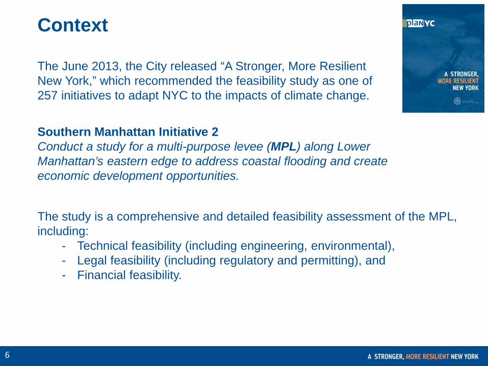
Context
Southern Manhattan Initiative 2 Conduct a study for a multi-purpose levee (MPL) along Lower Manhattan’s eastern edge to address coastal flooding and create economic development opportunities.
The study is a comprehensive and detailed feasibility assessment of the MPL, including:
- Technical feasibility (including engineering, environmental), - Legal feasibility (including regulatory and permitting), and - Financial feasibility.
The June 2013, the City released “A Stronger, More Resilient New York,” which recommended the feasibility study as one of 257 initiatives to adapt NYC to the impacts of climate change.

CONFIDENTIAL 7
Install integrated flood protection system in Lower Manhattan, including LES
Install an integrated flood protection system at Hospital Row and remaining areas around Southern Manhattan and funding is secured
Harden key utility, telecom, and transit networks
Facilitate Water St. revitalization with plaza activation and enhancement and streetscape improvements
Expand Take the HELM program to incent technology and creative businesses to relocate to Lower Manhattan
Context This initiative is among the several dozen from the City’s resiliency plan that directly impact Southern Manhattan. Taken together, they represent a comprehensive, integrated, and multi-layered strategy.
Plan Highlights

CONFIDENTIAL 8
LOWER EAST SIDE
FINANCIAL DISTRICT
Study Area Encompasses approx. 1.2 miles of Lower Manhattan’s eastern edge, north to south.

CONFIDENTIAL 9
Consultant Team
Company Expertise
Engineering (lead consultant)
Marine engineering
Environmental law
Real estate, economic development, and energy efficiency
Architecture, planning, and urban design
Design and planning
Planning, environmental, and engineering
Multidisciplinary team with significant experience in the study’s subject matters.
CONFIDENTIAL 10
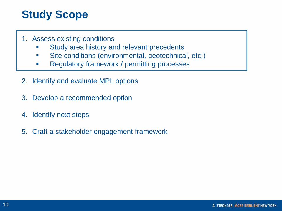
Study Scope
1. Assess existing conditions Study area history and relevant precedents Site conditions (environmental, geotechnical, etc.) Regulatory framework / permitting processes
2. Identify and evaluate MPL options
3. Develop a recommended option
4. Identify next steps
5. Craft a stakeholder engagement framework
CONFIDENTIAL 11
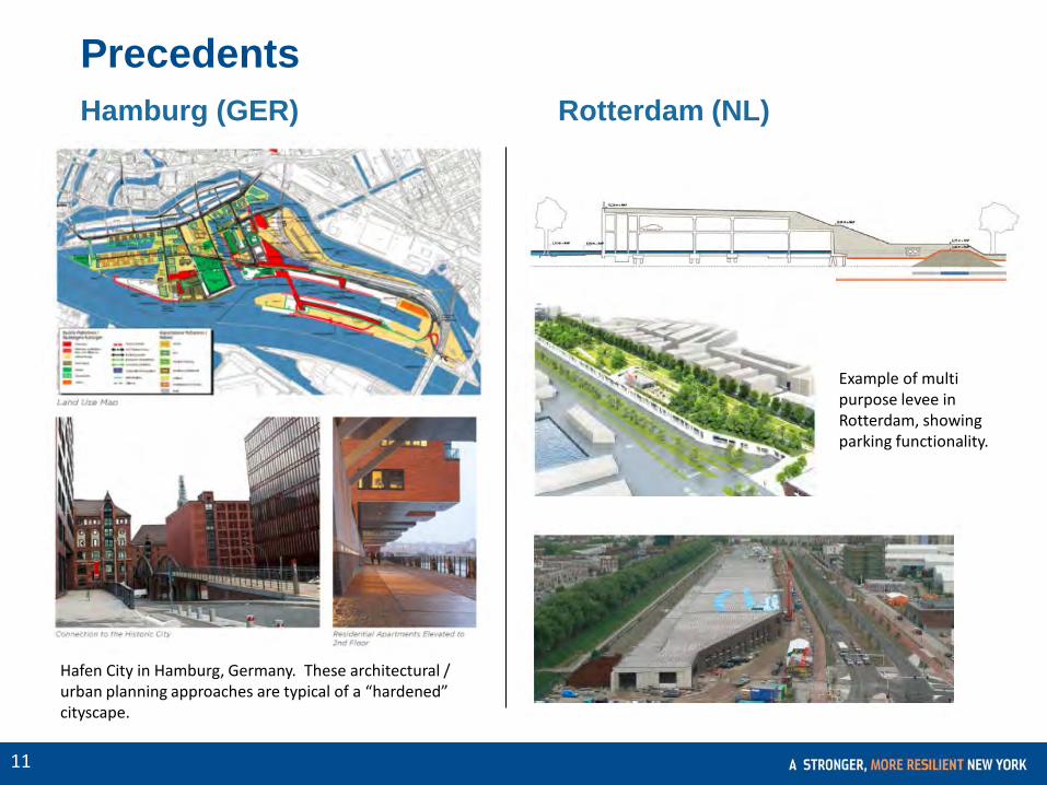
Precedents Hamburg (GER) Rotterdam (NL)
Hafen City in Hamburg, Germany. These architectural / urban planning approaches are typical of a “hardened” cityscape.
Example of multi purpose levee in Rotterdam, showing parking functionality.

CONFIDENTIAL 12
Precedents
The Hague (NL)
Battery Park City (NYC)
A multi-purpose levee in the Hague integrated with a commercial district.
Battery Park City suffered less damage than the east side of Lower Manhattan during Hurricane Sandy.
CONFIDENTIAL 13
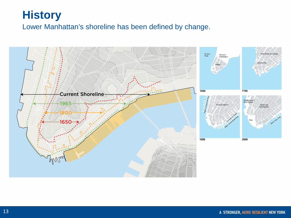
History Lower Manhattan’s shoreline has been defined by change.

CONFIDENTIAL 14
Site Conditions Lower Manhattan’s topography consists of an elevated central rib and lower shorelines.

CONFIDENTIAL 15
Site Conditions Water depths vary along the Study Area, with greater depths in the northern section of the area (faster currents).

CONFIDENTIAL 16
Site Conditions There are a number of historic landmarks and cultural assets in the Study Area and its vicinity.

CONFIDENTIAL 17
Potential Regulatory Framework / Permitting Processes Federal, State, and City laws and regulations that will be analyzed for the study:
Potential Congressional Actions
Environmental Impact Review • National Environmental Policy Act (NEPA) • New York State Environmental Quality Review
Act (SEQRA) • New York City Environmental Quality Review
(CEQR) Transportation • Clean Air Act • U.S. Department of Transportation • Smart Growth Public Infrastructure Policy Historic Preservation • National Historic Preservation • New York City Landmarks Preservation
Commission
Major Environmental Statutes, Executive Orders, and Regulators • Multi-Agency Determinations • U.S. Army Corps of Engineers (ACOE) • U.S. Environmental Protection Agency (EPA) • National Marine Fisheries Service • U.S. Fish and Wildlife Services • New York State Department of Environmental
Conservation (NYSDEC) • New York State Department of State
(NYSDOS)

CONFIDENTIAL 18
Next Steps
1. Assess existing conditions Study area history and relevant precedents Site conditions (environmental, geotechnical, etc.) Regulatory framework / permitting processes
2. Identify and evaluate MPL options
3. Develop a recommended option
4. Identify next steps
5. Craft a stakeholder engagement framework

Subject: Multi-Purpose Levee Existing Conditions Update Following Hurricane Sandy, Mayor Michael R. Bloomberg's Special Initiative for Rebuilding and Resiliency (SIRR) issued "A Stronger, More Resilient New York," a plan to rebuild locally and make City infrastructure and buildings more resilient to climate change. The plan contains a range of short-, medium-, and long-term initiatives. One of the most ambitious long-term concepts is a multipurpose levee (MPL) for the east side of Lower Manhattan called "Seaport City." The first step, which NYCEDC was tasked to administer, is to conduct a comprehensive feasibility analysis. The eastern edge of Lower Manhattan is one of the lowest-lying areas on the island and is at higher risk to threats both from extreme weather events and long-term sea level rise. An MPL would be a barrier to protect Lower Manhattan from flooding while also supporting residential, retail or commercial uses, providing open space, serving as transportation infrastructure, and/or providing parking. Ultimately, this MPL would be integrated with and enhance the resiliency being implemented and planned around Southern Manhattan, as directed by "A Stronger, More Resilient New York." In July 2013, NYCEDC issued an RFP to examine the feasibility of the MPL concept. We have since selected a consultant team led by the engineering firm ARCADIS. ARCADIS is ranked among the top 10 design and engineering consultancies in the world and is New York's largest environmental engineering firm. The company's core expertise is in the fields of infrastructure, water, environment and buildings. ARCADIS has partnered with the following sub-consultants: Mueser Rutledge Consulting Engineers: Geotechnical and structural foundation design engineering firm Ocean and Coastal Consultants: Marine engineering firm Sive Paget & Riesel, P.C.: Environmental law firm HR&A Advisors, Inc.: Real estate, economic development and energy efficiency consulting firm) FXFOWLE Architects: Architecture, planning and urban design firm WXY: Design and planning firm AKRF: Planning, environmental and engineering firm
The team will examine a 1.2-mile area along the eastern edge of Lower Manhattan from the Battery Maritime Building to just north of the Manhattan Bridge, in order to determine the technical, financial and legal feasibility for a range of MPL options. To date, the consultants have assessed existing conditions and contextual considerations within the study area, MPL precedents around the globe and in the U.S., as well as the regulatory framework that would govern the potential development of an MPL. Included below is a high-level summary of what has been looked at to date (see attached Community Board presentation for related graphics):

Precedents Rotterdam, Netherlands: The Roof Park in the west of Rotterdam provides safety against flooding by combining a
parking garage, a shopping mall, a levee and a city park. Hamburg, Germany: HafenCity in Hamburg, Germany uses pedestrian bridges and other architectural approaches
to allow for easy evacuation when waters rise. The Hague: A MPL in The Hague is integrated within a commercial district. Battery Park City: Battery Park City suffered less damage than the east side of Lower Manhattan during Hurricane
Sandy. Site Conditions Historical Shoreline: Lower Manhattan's shoreline has been defined by change since the 17th century,
accommodating demographic and economic growth and development. Topography: Lower Manhattan's topography consists of an elevated central rib and lower shorelines. An in-depth
understanding of these characteristics will be critical as the study moves into the assessment of different MPL configurations.
Water Depth & Currents: Water depths vary along the study area, with greater depths and faster currents in the northern section. The relationship between these aspects and the MPL options to be considered will require close analysis.
Historical & Cultural Assets: There are a number of historic landmarks and cultural assets in the study area, including Civic Center, the National Museum of the American Indian, historic banks, the Seaport District, the Battery Maritime Building and the Manhattan and Brooklyn Bridges. The MPL alternatives to be considered as part of the study will have to be mindful of these assets.
Regulatory framework: Any future project would certainly require environmental and land use review, and would be subject to various levels of local, state, and federal regulations. Involved or interested agencies would likely include: U.S. Army Corps of Engineers U.S. Environmental Protection Agency U.S. Department of Transportation National Marine Fisheries Service U.S. Fish and Wildlife Services New York State Department of Environmental Conservation (NYSDEC) New York State Department of State (NYSDOS) New York City Landmarks Preservation Commission

The next step after completing the existing conditions analysis will be to identify and evaluate different MPL options. Later on, towards the end of the study, a recommended MPL configuration will be presented together with a stakeholder engagement framework that advances the dialogue and builds consensus around a future project. As Hurricane Sandy taught, it is vital that we are better prepared for the effects of climate change. With the increasing density of our City, incorporating water defense into the urban fabric warrants further exploration and may be the best path forward. We look forward to keeping you apprised of our progress and working with you on this important initiative.