side-scan sonar mapping of anthropogenically influenced seafloor
Upload
harv-stanicCategory
view
27download
0
Seafloor mapping and visualisation
Harpha Sea, d.o.o. Koper
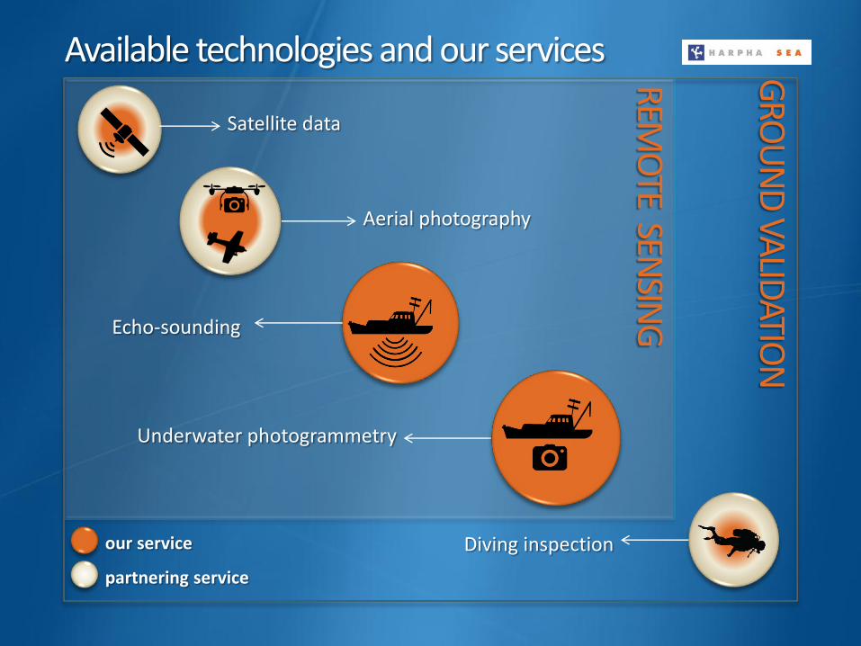
Available technologies and our services
our service
partnering service
REMO
TE SENSIN
G
GRO
UN
D VA
LIDATIO
N
Satellite data
Aerial photography
Echo-sounding
Underwater photogrammetry
Diving inspection
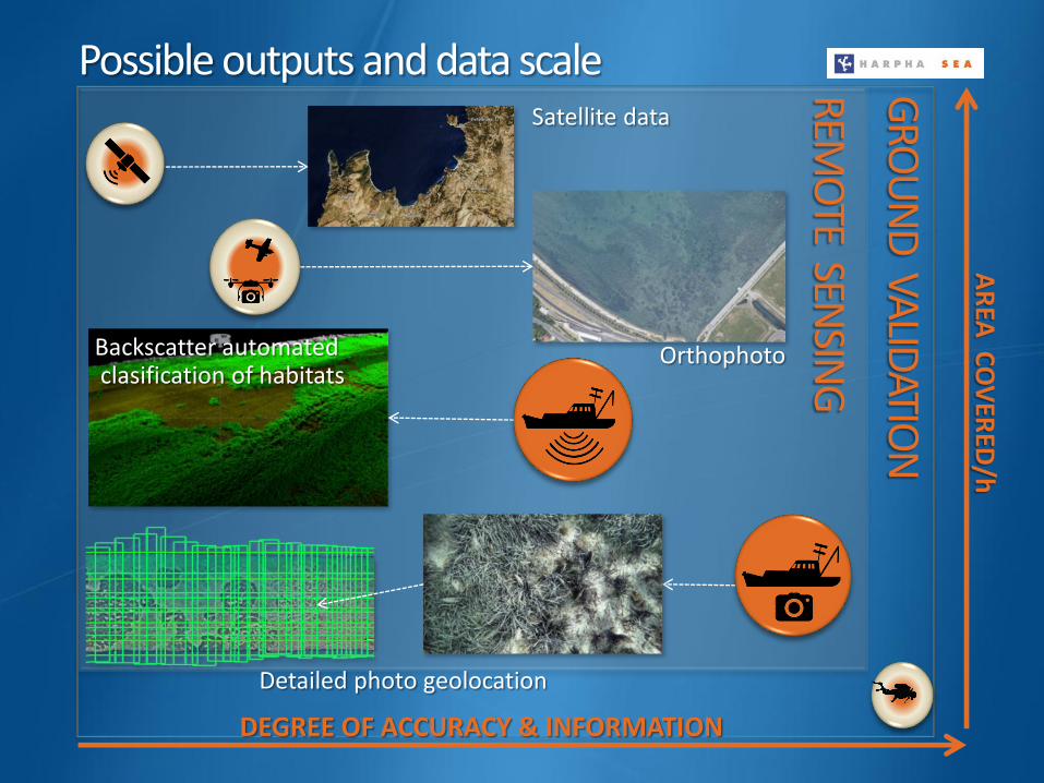
Possible outputs and data scale REMO
TE SENSIN
G
GRO
UN
D VA
LIDATIO
N
DEGREE OF ACCURACY & INFORMATION
AR
EA C
OV
ERED
/h
Backscatter automated clasification of habitats
Satellite data
Orthophoto
Detailed photo geolocation

Multi-sensor data fusion (echo-sounder and underwater photography)
Seabed morphology
Sub-bottom layers
Integrated data from our core hydrographic, geophysical and environmental services can provide map products reflecting spatial patterns of seabed
habitats, benthic macro-flora & fauna and geomorphological characteristics.
(Posidonia oceanica, Pinna nobilis, Verongia aerophoba,…)
ECHO
-SOU
ND
ER LAYERS
PHOTOGRAMMETRY LAYERS
Precise distribution and size of seabed
habitats, distribution of larger species

Advanced visualisation and data manipulation
Enhanced high detail survey images
Underwater orthophoto GIS application (Posidonia oceanica distribution)
3D model of terrain and vegetation

3D GIS tool Data from different sources (like MBES, photo, video) is georeferenced and
merged in 3D GIS application for quantitative and qualitative analysis.
PostGIS/PostgreSQL database supporting 3D GIS.
Visualization of continuous land-sea terrain model.
Biomass evaluation from 3D model.
Video survey post processing.
click for demo video download

Marine mapping is all about holistic approach to create picture of seabed: morphology, sedimentology and biology.
Our data is suitable to create and interpret thematic maps of diverse habitats that can be used to implement marine policy, management and resource utilization.
Seafloor mapping and visualisation
Application Monitoring indicators for Marine Strategy Framework Directive (MSFD) descriptors based on precise geolocation:
Biodiversity: distribution and size of seabed habitats, larger species and non-indigenous species, biomass evaluation from 3D model;
Eutrophication and Physical damage effects on seabed and habitats
Seafloor integrity: damage on sea bottom, changes in integrity;
Monitoring of changes in hydrographical conditions;
Marine litter hot spots (surface and sea bottom)
Integrated research of large underwater areas – detailed georeferenced
seafloor mapping.
Implementation of Marine Spatial Planning (MSP) and
Integrated Coastal Zone Management (ICZM).
3D visualization, modeling and projection for research and
dissemination (cultural and natural heritage, virtual “travelling” over
underwater natural or archaeological sites).

Harpha Sea, d.o.o. Koper Čevljarska 8 6000 Koper Slovenia - Europe Phone: +38656638920 Mobile: +38641513285 Email: [email protected]
Contact details
Thank you for your attention!