sdfsdf
24
GOFC/GOLD Fire Monitoring and Mapping Implementation Team 2 nd Workshop on Geostationary Fire Monitoring and Applications EUMETSAT, Darmstadt, Germany, December 4 - 6, 2006 Elaine Prins (Workshop Co-Chair, UW-Madison CIMSS - Consultant) Yves Govaerts (Workshop Co-Chair, EUMETSAT) Ivan Csiszar (GOFC/GOLD Fire Team Project Office, University of Maryland – College Park) Executive Summary The Global Observation of Forest and Land Cover Dynamics (GOFC/GOLD) Fire Monitoring and Mapping Implementation Team 2 nd Workshop on Geostationary Fire Monitoring and Applications was hosted by the EUropean Organization for the Exploitation of METeorological SATellites (EUMETSAT) in Darmstadt, Germany on December 4 – 6, 2006. The workshop served as a follow-on to the Joint GOFC/GOLD Fire and CEOS LPV Workshop on Global Geostationary Fire Monitoring Applications held at EUMETSAT in March 2004. Over 45 representatives from 18 countries in Europe, Africa, Asia and the Americas participated in the workshop. Participants included representatives from operational agencies, algorithm developers, data providers and users, research and validation scientists, and GOFC regional network representatives. The number of countries and research and operational groups involved in geostationary fire monitoring has significantly grown in the last 2 years with applications in a variety of areas (hazards, air quality monitoring, climate change, and industrial applications). The GOFC/GOLD project provides a forum for international exchange of information, observation and data coordination, and serves as a framework for establishing long-term monitoring systems. The GOFC/GOLD Fire Mapping and Monitoring Theme is primarily focused on determining international observation requirements and making the best use of products from existing and future satellite systems for fire management, policy decision-making and global change research (see http://gofc-fire.umd.edu/index.asp). A specific goal of the GOFC/GOLD-Fire program is to develop and foster the implementation of a near real-time operational global geostationary fire monitoring network using current (GOES, MSG, MTSAT, FY-2C) and future geostationary platforms (Indian INSAT-3D, Russian GOMS Elektro L MSU- GS, Korean COMS). This effort also supports Global Earth Observation System of Systems (GEOSS) activities and the Group on Earth Observations (GEO) 2006 work plan which calls for the initiation of “a globally coordinated warning system for fire and monitoring for forest conversion, including the development of improved information products and risk assessment models(DI-06-13)” and expanding “the use of meteorological geostationary satellites for the management of non-weather related hazards (DI-06-09).” The overall objective of this workshop was to discuss ongoing activities and plans for the development, implementation, validation and application of regional and global geostationary fire products. Specific objectives and topics of discussion included the following: 0
-
Upload
kirancalls -
Category
Documents
-
view
212 -
download
0
description
s
Transcript of sdfsdf

GOFC/GOLD Fire Monitoring and Mapping Implementation Team 2nd Workshop on Geostationary Fire Monitoring and Applications
EUMETSAT, Darmstadt, Germany, December 4 - 6, 2006
Elaine Prins (Workshop Co-Chair, UW-Madison CIMSS - Consultant) Yves Govaerts (Workshop Co-Chair, EUMETSAT)
Ivan Csiszar (GOFC/GOLD Fire Team Project Office, University of Maryland – College Park)
Executive Summary The Global Observation of Forest and Land Cover Dynamics (GOFC/GOLD) Fire Monitoring and Mapping Implementation Team 2nd Workshop on Geostationary Fire Monitoring and Applications was hosted by the EUropean Organization for the Exploitation of METeorological SATellites (EUMETSAT) in Darmstadt, Germany on December 4 – 6, 2006. The workshop served as a follow-on to the Joint GOFC/GOLD Fire and CEOS LPV Workshop on Global Geostationary Fire Monitoring Applications held at EUMETSAT in March 2004. Over 45 representatives from 18 countries in Europe, Africa, Asia and the Americas participated in the workshop. Participants included representatives from operational agencies, algorithm developers, data providers and users, research and validation scientists, and GOFC regional network representatives. The number of countries and research and operational groups involved in geostationary fire monitoring has significantly grown in the last 2 years with applications in a variety of areas (hazards, air quality monitoring, climate change, and industrial applications). The GOFC/GOLD project provides a forum for international exchange of information, observation and data coordination, and serves as a framework for establishing long-term monitoring systems. The GOFC/GOLD Fire Mapping and Monitoring Theme is primarily focused on determining international observation requirements and making the best use of products from existing and future satellite systems for fire management, policy decision-making and global change research (see http://gofc-fire.umd.edu/index.asp). A specific goal of the GOFC/GOLD-Fire program is to develop and foster the implementation of a near real-time operational global geostationary fire monitoring network using current (GOES, MSG, MTSAT, FY-2C) and future geostationary platforms (Indian INSAT-3D, Russian GOMS Elektro L MSU-GS, Korean COMS). This effort also supports Global Earth Observation System of Systems (GEOSS) activities and the Group on Earth Observations (GEO) 2006 work plan which calls for the initiation of “a globally coordinated warning system for fire and monitoring for forest conversion, including the development of improved information products and risk assessment models(DI-06-13)” and expanding “the use of meteorological geostationary satellites for the management of non-weather related hazards (DI-06-09).” The overall objective of this workshop was to discuss ongoing activities and plans for the development, implementation, validation and application of regional and global geostationary fire products. Specific objectives and topics of discussion included the following:
0

1.) assess the status of current geostationary satellite sensors and capabilities for active fire detection and pre- and post-fire monitoring applications;
2.) survey current distribution of geostationary DB stations generating fire products;
3.) review and exchange experiences in geostationary algorithm development activities, product generation and distribution;
4.) discuss current and future applications of geostationary fire products (e.g. air quality, hazards, real-time aerosol model data assimilation, fire dynamics modeling, global change research, etc.);
5.) review progress in geostationary fire product validation;
6.) assess progress in satellite data fusion and inter-use for fire monitoring and analysis;
7.) review the status of the Geostationary Demonstration Project recommended in 2004;
8.) assess progress towards a coordinated near real-time global geostationary fire monitoring applications system;
9.) discuss future geostationary fire capabilities.
These topics were addressed in plenary, the poster session and in discussion sessions. Specific plenary session topics included: international working groups and fire initiatives; satellite fire monitoring programs; product development and applications; applications in emissions monitoring and modeling; and intercomparisons and cal/val. The oral presentations in the plenary session were primarily programmatic in nature. There were 17 presentations in the poster session with the majority of the posters related to new product development and applications and over half focused on Met-8 SEVIRI. There were also several poster presentations on calibration and validation. The discussion sessions focused on user needs and requirements; the status of algorithm development and applications; and status and plans for a global geostationary fire monitoring system. One of the primary goals of this workshop was to assess progress made since the last Workshop on Global Geostationary Fire Monitoring Applications held at EUMETSAT in March 2004. At the previous workshop, the participants recommended a demonstration/feasibility project be conducted in the summer of 2005 to demonstrate the science and show the benefits and feasibility of a global geostationary fire monitoring network. This effort was to be funded through current funding mechanisms and the goal was to use the study to encourage implementation at operational agencies. Although a formal demonstration study was not performed in 2005 due to delays in funding and other issues, many of the components were performed by individual groups as outlined in the summary of discussion session 3. This workshop included many presentations on current research and applications of GOES, Met-8, FY-2C, and MTSAT-1R demonstrating the capabilities of these instruments for fire detection and monitoring. Furthermore, several operational agencies (e.g. NOAA/NESDIS, EUMETSAT, UK Met Office, China Meteorological Administration, and India) plan to develop or expand existing geostationary fire detection and monitoring programs. NOAA/NESDIS and the UK Met
1

Office plan to implement a real-time global geostationary fire monitoring system in 2007 and 2009, respectively. At the conclusion of the GOFC/GOLD 2nd Workshop on Geostationary Fire Monitoring and Applications participants formulated the following general list of recommendations in the areas of research and product development, data sharing protocols, validation and calibration activities, involvement in future sensor development, and international coordination activities.
• Research and Product Development 1.) Continue data fusion efforts and characterization. 2.) Encourage products based on a multi-sensor approach. 3.) There is a need for more evaluation of the Dozier technique and comparison of Fire Radiative Power (FRP) and Dozier products.
• Data Sharing
1.) Develop a coordinated depository to share data sets with each other and the general user community. 2.) Provide ancillary data sets for algorithm development (e.g. improved land/water data sets, known locations of false alarms, emissivity, etc.).
• Validation and Calibration Activities
1.) Encourage joint validation efforts regarding global fire detection and characterization products within the geostationary network (GOES, Met-8/-9, MTSAT, FY-2C/2D, etc.). 2.) Provide access to ground truth including location, size and temperature, and higher resolution imagery (Landsat, ASTER). Regional validation should also be encouraged. 3.) Utilize aircraft validation campaigns/experiments (e.g. NASA-Ames). 4.) Encourage investigators working with similar instruments to intercompare products. 5.) Improve characterization of the 3.9 micron band on existing geostationary sensors.
• Future Sensors
1.) Encourage active involvement of the fire monitoring community in evaluating specifications for next generation operational geostationary satellites and provide feedback to operational agencies (e.g. calibration on hot end, pre-processing, flagging of saturated raw data, etc.).
• International Coordination 1.) Increase involvement of climate community and gain a better understanding of their needs. 2.) Encourage greater involvement from agencies with new sensor capabilities in Asia. (Korea, Japan, India, Russia). Collaborate with surrounding countries and dialogue on user needs/requirements. 3.) Continue active participation in GEOSS/GEO tasks and planning. 4.) Establish link with CGMS and operational agencies. 5.) Adapt elements of the CEOS constellation process and maintain a strong relationship with the CEOS WGCV LPV to ensure ongoing cal/val activities in the community. 6.) Convene follow-on meeting to address progress on global geostationary products,
2

applications, and validation.
As the global geostationary fire monitoring effort expands, participants felt it was important to establish closer ties with operational agencies through the Coordinated Group for Meteorological Satellites. Initially GOFC/GOLD will inform CGMS regarding applications of global geostationary fire products in aerosol, air quality, and emissions modeling efforts including results of demonstration and evaluation studies. At the conclusion of the workshop participants drafted the following recommendation to CGMS.
With the plans of operational agencies to produce real-time fire detection and characterization products, developers and implementation teams need access to detailed information on pre-processing of data, calibration of the 3.9 micron band at high temperatures, and noise. Specifically there is a need for detailed characterization of the 3.9 micron band. It is recommended that operational agencies characterize the behavior of the 3.9 micron band beyond 300K up to the saturation point.
Workshop co-chairs: Elaine Prins, UW-Madison - CIMSS (Consultant), Grass Valley, CA, USA Yves Govaerts, EUMETSAT, Darmstadt, Germany
3

Overview of the GOFC/GOLD Fire Monitoring and Mapping Implementation Team 2nd Workshop on GeostationaryFire Monitoring and Applications
The overall goal of the 2nd Workshop on Geostationary Fire Monitoring and Applications was to assess the progress made since the last workshop and discuss ongoing activities and plans for the development, implementation, validation, and application of regional and global geostationary fire products. At the last workshop, application of Met-8 SEVIRI data for fire detection and diurnal monitoring was just beginning and MTSAT-1R and FY-2C were not yet launched. Since then, the use of Met-8 SEVIRI data for fire applications has grown significantly throughout Europe and in Africa. FY-2C and MTSAT-1R were launched in 2004 and 2005, respectively, allowing for nearly global geostationary fire monitoring capabilities. Over the past 2 years, FY-2C and MTSAT-1R have been used to some extent for fire detection and monitoring in Asia and Australia. This configuration leaves a gap in coverage over Eastern Europe and Western Asia to monitor burning in India and the boreal forests of Russia. Within the next 2 years additional geostationary instruments with fire monitoring capabilities will be launched by India (INSAT-3D, 2007), Russia (GOMS Elektro L MSU-GS, 2007) and Korea (COMS, 2008) providing coverage of this region as well. This suite of geostationary sensors will provide unprecedented high temporal coverage of fire activity in Europe, Africa, Asia, and Australia.
Figure 1. Components of a global geostationary fire monitoring system.
4

The format of the workshop consisted of five plenary sessions with invited oral presentations focusing on specific topics/objectives, a poster session, and three discussion sessions to further address the goals and objectives of the workshop. The plenary session topics included: international working groups and fire initiatives; satellite fire monitoring programs; product development and applications; applications in emissions monitoring and modeling; and intercomparisons and cal/val. The poster session followed the plenary session on product development and applications. There were 17 posters with the majority of the poster presentations related to new product development and applications and over half focusing on Met-8 SEVIRI. The discussion sessions focused on user needs and requirements; the status of algorithm development and applications; and the status and plans for a global geostationary fire monitoring system. The discussion sessions were led by two co-chairs and were guided by a series of questions, although the co-chairs were free to amend the questions and pursue related topics as necessary. A summary report of each of the session discussions is provided on the following pages. In some cases the discussion sessions addressed each of the questions individually; in others it was more appropriate to address multiple questions simultaneously. The three discussion session topics and associated questions are outlined below:
1.) Global and Regional Requirements and Needs: Role of Geostationary Fire Monitoring International and agency needs/requirements and specifications, priorities, current capabilities, planned activities. How can current or future geostationary fire products help meet these needs/requirements? How will they be used in conjunction with other products? Should we propose a CEOS constellation concept? How does this effort fit into CGMS plans?
2.) Status of Algorithm Development and Applications What algorithms exist? What are the products? What are the applications? Can existing algorithms be applied globally to different operational geostationary instruments? What is the feasibility of a common cross-platform algorithm/product? What metadata is needed? What further works needs to be done?
3.) Global Geostationary Fire Monitoring System and Plans Where do we stand in meeting the goals of the last meeting? What are the plans of operational agencies? What is the feasibility and timeline for implementing a coordinated real-time global geostationary fire monitoring applications system? What are the plans for operational multi-sensor implementation, data fusion, cal/val?
5

Discussion Session 1: Global and Regional Requirements and Needs: Role of Geostationary Fire Monitoring Co-Chairs: Ivan Csiszar (University of Maryland) and Jeffrey Reid (NRL-Monterey) The discussions in this session addressed multiple questions simultaneously. The summary provided below addresses the following questions and overlapping issues. International and agency needs/requirements and specifications, priorities, current capabilities, planned activities. How can current or future geostationary fire products help meet these needs/requirements? How will they be used in conjunction with other products? Should we propose a CEOS constellation concept? How does this effort fit into CGMS plans? Employment of fire hot spot datasets has grown significantly over the past several years, impacting both scientific and regulatory communities. While the data has a long history of usage to study biome disturbance, emissions assessment and the carbon budget for climate based studies, fidelity has recently improved to a point where geostationary fire data can contribute to a number of hazard and environmental applications. These include air quality, burning regulation, early warning in remote regions, fire weather forecasting, global change research, fire dynamics modeling, and now even international treaty verification such as those required under the Kyoto Protocols. The increase in interest of geostationary fire product data comes from a number of advantages, but most notably temporal resolution, coverage, limited number of saturated pixels for most platforms, and operational availability. Research has demonstrated the importance of the inclusion of diurnal fire data in emissions and transport models, in particular at the meso-scale. An assessment of fire counts and fire hazard early warning in less developed regions is heavily dependant on data timeliness which only geostationary satellites can provide. Similarly, the consistent geographic coverage of geostationary satellites makes data implementation fairly straightforward for a given platform. This consistent coverage also makes interpretation of data in partially cloudy scenes easier. Given current hardware specifications for NPOESS/VIIRS it is likely that the large fires (which also account for the bulk of atmospheric emissions) will saturate the longwave IR window band which is used in conjunction with the fire channel to detect and characterize fires. This will disrupt sub-pixel fire characterization and complicate fire emissions algorithms. Specifications for other next generation polar orbiting systems (e.g. GMES Sentinel) are currently being defined. In contrast, due in part to coarser resolution and increased detector saturation temperature, geostationary systems in the future should have reasonable fire characterization fidelity for moderate to large fires potentially excluded from the polar systems, provided high pixel co-registration accuracy is achieved. The international fire monitoring and user communities have emphasized the need to utilize operational meteorological satellites to produce routine fire products from similar platforms over many years. While fire products are developed on a number of polar orbital platforms, to date none have reached full operational status, apart from regional/national heritage AVHRR-based
6

systems and the ESA ATSR World Fire Atlas. MODIS fire products from EOS Terra and Aqua currently operate in a quasi-operational fashion, but there is no follow-on MODIS mission. Given potential operational delays in the NPOESS program, geostationary systems provide a consistency needed for hazard applications and long-term trend analysis. The operational status of geostationary data products does not imply that fire products from polar orbiting systems will not be required. To the contrary, only polar orbiting systems such as NPOESS can give globally consistent products. Such consistency is necessary for basic research as well as intercomparison with geostationary products. Further, polar orbiting satellites will have a higher spatial resolution in comparison to all geostationary systems in the foreseeable future. Ultimately, the best value added fire products will be made by a combination of polar and geostationary satellite systems. Because of the diversity in geostationary satellite platforms over the globe it is difficult to set direct international hardware requirements for fire hotspot detection and sub-pixel characterization. Indeed, it is understood that major sensor requirements will likely be heavily influenced by other factors. But in general, fire product fidelity can be most improved by increases in infrared channel resolution and the maximum resolvable temperature in both ~3.7 and ~10.8 µm channels. Planned missions (i.e. GOES-R and MTG) include 2 km pixel size and 400-450 K 3.9 micron band saturation temperatures for hemispheric mapping, and enhanced capabilities for regional mapping (see presentations by E. Prins and Y. Govaerts). These requirements were deemed to be non-intrusive and are recommended as minimum standards for all future sensors in the global network. Despite the diverse applications of fire hotspot data, the requirements for a consistent dataset of fire hotspots derived from global geostationary satellites are very similar. Given the current hardware situation with very diverse satellites making up the global constellation the development of a global operational geostationary network requires cross algorithm uniformity in data availability, sub-pixel fire characterization, and metadata. Clear documentation and consistency in validation methods are also necessary. These five requirements are discussed individually as follows.
• Availability and flagging Calibrated and pre-gridded/sampled data must be made available in near real time, preferably less than 10 minutes after collection. The georectification process on some platforms (Met-8) smears out fire signals. Because state-of-the-art fire hotspot detection algorithms are almost entirely texturally based, this significantly hampers noise and commission identification processes. This reduces algorithm fidelity. Similarly, data must be flagged before georectification for temperature saturation. A standardized level 1b product across platforms would be most preferable.
• Fire Characterization
It is been repeatedly demonstrated that sub-pixel fire characterization can improve on emissions estimations over simple pixel count techniques. Currently there are two
7

commonly employed methods, the two wavelength Dozier method for sub-pixel derivation of instantaneous estimates of fire size and temperature, and the Fire Radiative Power method where emissions are directly related to fire radiance. At best both methods should be employed. However, to simplify analyses at this moment the most fundamental requirement would be the inclusion of hotspot and background pixel temperatures so that user specific fire characterization algorithms can be used.
• Metadata
It is universally agreed that complete metadata is required for the proper interpretation of fire products and in particular for the proper comparison of data from different geostationary satellite systems. Most importantly are satellite and processing coverage regions, algorithm block-out zones associated with viewing geometry, solar reflection contamination, biome type, and recent geo-location characterization uncertainties. Also needed are cloud masks and consistent surface characterization.
• Validation
Cross platform inter-calibration/validation is key especially with higher resolution instruments (such as MODIS/ASTER), but additional ground-truth validation is also needed. Different algorithm developers need to agree on consistent validation data sets and methodologies. Developers are responsible for first order omission and commission error statistics.
• Documentation
All products and product revisions must be clearly documented and made available online.
This discussion session also addressed the need to become more closely connected to international working groups and inter-agency efforts to gain better insight into the needs of the global user community, to enable better coordination of data sources and products, and to provide input for future missions. Both international and inter-governmental activities provide suitable forums for reaching a consensus on sensor and algorithmic requirements. In particular, the relationship between the GOFC/GOLD-Fire Global Geostationary Network and CGMS and CEOS were discussed. CGMS, primarily through its working groups, promotes standardization and coordinated operational production by operational agencies. Fire products have been on the agenda for the recent GCMS annual meetings as highlighted below:
• 32nd CGMS Meeting (2004) Action 32.18: - CGMS Members with satellites that have the capability of detecting fires should
8

develop near real time products for distribution to WMO Members. This activity should be coordinated by the WMO Space Programme in conjunction with the Expert Team on Satellite System Utilisation and Products (ET-SSUP). - CGMS Members to report on their capability and plans for fire products and their availability at CGMS-33.
• 33rd CGMS Meeting (2005)
Action 33.18: - The fire papers [presented by ESA, EUMETSAT, CMA and NOAA in the WG on Satellite Products, under the agenda item on Fire Related Parameters] prompted CGMS to recommend that the WMO Space Programme Office create a web site posting all the links to real time fire detection data. - Recommendation 33.06: CGMS Members are encouraged to provide the location of their web sites on real time fire detection to the WMO.
• 34th CGMS Meeting (2006)
Action 33.18 remains open - (…) CGMS to recommend that the WMO Space Programme Office create a web site posting all the links to real time fire detection data. - Two working papers were presented by EUMETSAT and NOAA in the WG on Satellite Products.
The recently emerging CEOS constellations are aimed at fostering the international planning process for space-based observations. Major elements of the concept include a clear and common statement of requirements defined by the target user communities, definition of a series of virtual satellite constellations that satisfy these requirements, definition of a series of standards for a mission to be included in the constellation and a process for recognition and acceptance. The standards include requirement of sensor capabilities, calibration and validation and data production and distribution. This discussion group suggested the following action items.
1.) The group agreed to prepare a document for the 2007 CGMS annual meeting to open a dialogue regarding expanded coordination between member nations producing operational fire products and data requirements and about potentially creating a formal CGMS Working Group on Fires as this activity matures.
It was also noted that many elements of the CEOS constellation process should be adapted by the network. A strong relationship with the CEOS WGCV LPV also needs to be maintained to ensure ongoing cal/val activities in the community.
9

Discussion Session 2: Status of Algorithm Development and Applications Co-Chairs: M. Wooster (Kings College, London) and W. Schroeder (University of Maryland) What algorithms exist for geostationary fire detection (and characterization), and what, if any, comparisons between algorithms and products exist? In terms of algorithm development, the number of products listed in the summary overview of the Joint GOFC/GOLD Fire and CEOS LVP Workshop (EUMETSAT, March 2004) has increased, particularly so with regard to algorithms designed for fire detection with SEVIRI. New SEVIRI products are being designed and implemented by the LandSAF, Univ. of Valladolid, EUMETSAT/KCL, UW-Madison and others. Operational real-time fire detections are currently being produced by the AFIS system using SEVIRI (South Africa), in addition to the long-standing GOES WF_ABBA products covering the America’s. There are operational products from FY2C over China also. Some products concentrate on fire detections, others such as the WF_ABBA include fire characterization measures using the Dozier approach or fire radiative power measures using the MIR radiance method (EUMETSAT/KCL). Additional operational products from certain prototype products are expected in the coming year, including the possibility to adapt algorithms to other systems (e.g. MTSAT-1R). Some approaches to geostationary fire detection are now starting to give emphasis to the use of change detection (multi-temporal signal analysis) in addition to the former spectral and spatially-based detection approaches. Indirect validation by means of sensor-to-sensor comparisons was presented as a more realistic alternative to the use of field-data in order to more rapidly assess the performance and characteristics of individual instruments and their derived products. Examples were listed relating the use of MODIS vs. GOES and MODIS vs. SEVIRI (including fire detection and characterization), as well as using higher resolution instruments such as ASTER and ETM+ to validate moderate (MODIS) and coarse (GOES) resolution fire detections. Continuation of product inter-comparison was recommended to incorporate FY-2C, MTSAT, COMS and INSAT-3D into future analyses, including comparisons of areas where different geostationary sensors cover the same geographic region (e.g. MTSAT and FY2C). Another possibility suggested for improving product characterization and understanding was the use of simulation studies similar to what was previously conducted by Giglio et al (1999) and Giglio and Kendall (2001) for fire detection and characterization with polar orbiting sensors. What plans, if any, are there for the new satellite operators to develop fire products? Listed by sensor, the following organizations have existing geostationary fire products or plans to develop fire products.
• GOES-E, GOES-W (UW-Madison CIMSS, NOAA/NESDIS, Colorado State University, INPE - Brazil, KCL)
• MET-8/9 (CSIR, LandSAF, EUMETSAT/KCL (x2), NOAA/NESDIS, UW-Madison Telespazio, U. Rome, U. Valladolid)
• MTSAT-1R (no Japanese plans, SRSS, ASMC, NOAA/NESDIS, UW-Madison CIMSS)
10

• FY-2C (CMA, UW – Madison CIMSS, SRSS) • COMS (Korean Met Agency, UW-Madison CIMSS) • GOMS ELEKTRO (UW-Madison CIMSS) • INSAT-3D (IRSS likely with NOAA/NESDIS, UW-Madison CIMSS)
What requirements are there for other data layers to support these algorithms? What are the limiting requirements for such data layers? Among the critical data layers required for adequate fire detection and characterization performance when using geostationary imagery, the following items were identified:
• Cloud Mask: Cloud masks are usually available from geostationary data (since cloud-detection is one of their main tasks) but their performance characteristics do not necessarily satisfy the needs of fire detection algorithms. For example, in some cases a ‘clear sky’ pixel mask maybe more appropriate than a cloud-contaminated pixel mask – the former identifying pixels that are believed to certainly be without cloud and thus where any fire detection/characterization has most confidence. Equally important is information that only identifies opaque clouds, since it is possible to identify fires in semi-transparent cloudy conditions. Cloud masks that are specifically tailored to serve as data layers for active fire processing operations need to be developed.
• Emissivity: Some algorithms (e.g., GOES WF_ABBA) require information on land surface emissivity in the mid-IR (and TIR) spectral channels. Static values are used with current implementation, but in actual fact emissivity is a dynamically varying quantity that will change with vegetation cover and status for example. Methods exist for determining surface emissivity from measured radiance signals, and this could be produced for MET8 and MET9 through the LandSAF for example (and by other agencies for other geostationary sensors). The methods likely require well-calibrated radiances to function well.
• Water Mask: Sunglint contamination especially over small inland water bodies (ponds, lakes, rivers) could be significantly improved with the availability of high quality water masks. Current products need refinements. However, overly conservative water masks could prevent fire detections being made close to water-bodies and this trade-off requires investigation.
• Persistent Detections: A database of persistent hot sources (industrial plants, oil refineries, etc.) could help flag such ‘false alarms’ in the daily fire products. The availability of increasingly long time-series data from instruments such as MODIS provide a stable, systematic and well-navigated data source that could be used quite easily to create such a data layer.
• Atmospheric Correction: The primary parameter here is likely to be the total precipitable water (TPW) along the viewing path length, which can be provided from ECMWF or NCEP model output, or derived from the geostationary imagery itself through techniques such as the split-window variance ratio method. A LUT approach could be used to obtain
11

atmospheric transmissivity for each spectral channel, varying with TPW content scaled by the path-length. Currently the WF_ABBA uses a LUT approach to correct for TPW.
What products exits using these algorithms? Currently the products themselves consist only of fire detections and fire characterizations, such as those produced by the WF_ABBA using the Dozier approach. What applications use these products? The applications are developing. Currently the vast majority of applications are all based on GOES WF_ABBA data, since that is the only geostationary fire data that has historically been available. Applications using WF_ABBA products are primarily aimed at driving models of biomass burning aerosol and trace gas emissions estimates for the Americas. NRL-Monterey utilizes the WF_ABBA fire products in the NAAPS model for aerosol diagnosis and forecasting. NOAA is piloting the use of GOES WF_ABBA data in air quality forecast modelling. Active fire detections from the AFIS system are used in South Africa to warn of situations where fires are approaching high voltage power lines and thus where there is a risk of short-circuits due to particulate-rich, heated air. Text messages based on fire detections are automatically sent to the local line managers. The problem fire can then be either extinguished before reaching the power line, or that particular line can be temporarily shut down in a stable manner. Can existing algorithms be applied globally to different sensors? The basic algorithmic principles are likely to hold since the underlying physics is the same. However there will be perturbations due to the different radiometric behaviour of the instruments (e.g. spectral bandwith, dynamic range, PSF details) and variations in the image generation algorithms used by each instrument operator (e.g. data resampling/re-gridding procedures). Case studies are required to assess this and the degree of algorithm ‘tuning’ that maybe required. This ‘tuning’ may depend on the application (i.e. the accuracy level required and level of omission/commission that is acceptable). What is the feasibility of a ‘global’ product (using same or different algorithms)? This is feasible for the area covered by geostationary systems having the appropriate spectral channels, provided that the detailed intercomparisons are performed to minimize any regional differences due to the product being derived from different sensors in different areas. Such intercomparisons are likely to use a separate, common dataset available everywhere, for example that provided by MODIS. Most probably a consistent grid-cell size/temporal interval would need to be chosen for re-gridding the geostationary fire detections to a uniform system across the globe in order to provide a uniform product. What metadata is needed? The landcover class of each detected fire pixel should be provided, together with the view (and sun) angles; which are useful for example for atmospheric correction. Atmospheric correction or
12

other adjustments applied should also be documented. The time and location of each fire pixel are clearly required, together with the detection confidence / error, and the fire characterization uncertainty. The definition of confidence is important (c.f. collection 5 MODIS MOD14). Cloud coverage and blockout zones (areas of uniform saturation for example) need to be defined for the entire disk so the user can differentiate between ‘no fire’ and ‘no data’. The possibility for the source data (i.e. pixel radiances) for each fire pixel to be included in the metadata (inc. background characterization) should be considered. The geolocation accuracy assessment is important, but this may be approximately constant for large areas/periods and only need updating sporadically (e.g. eclipse periods etc). With regard to the aforementioned fire pixel detection ‘confidence’, proper use of this is important. Data producers and users must use caution and not put too much emphasis on the confidence value as it has its own limitations and possible problems. Confidence parameter must undergo a rigorous validation process to become meaningful to the users and to avoid misuse by the community. What documentation and ATBDs exist for the algorithm? Documentation exists but to varying degrees, but is certainly considered important. Some products appear only documented in the public domain by peer-reviewed papers at present, that do not necessarily contain all the algorithmic details as would an ATBD. A user manual (in addition to an ATBD) is also considered very useful if not essential (c.f. MODIS active fire products). All these should ideally be written to common standards to aid intercomparisions. Validation reports are equally necessary, but are expensive and time-consuming to facilitate. The question was raised as to who will support such validation efforts? GOFC is perhaps able to coordinate but not fund validation activities (c.f. MODIS burned area regional validation programme). What tools do we need to exchange data and products and ideas/studies effectively? The possibility of the GOFC/GOLD website hosting a data pool that could be used to circulate data and information was discussed. Meetings such as this were considered valuable. There have been quite a number of developments since the last meeting, including the launch of new sensors (FY2C and MTSAT) and the development of new fire detection products from existing sensors. Many attendees were discussing the possibility of fire characterization (e.g. via fire radiative power or other measures) than seemed to be the case previously. A two-year interval between meetings seemed to work well. What further work needs to be done? Data pre-processing steps need to be fully characterized. Data fusion of different products types (e.g. burned area and active fire) and between different sensors (polar orbiting and geostationary) needs to be explored. The quality and consistency of the different geostationary imagers with regard to fire detection and fire characterization needs to be examined. FY-2C and MTSAT-1R imagery of the same
13

area covering the same time period appeared to look, visually at least, quite significantly different. Validation of fire characterization data determined from geostationary (and other) sensors needs to be conducted. This could involve overflights of fires by, for example, NASA Ames (UAV), data from (nighttime) USFS overflights, dedicated over-flights by fire-dedicated airborne systems (e.g. FIREMAPPER; Riggan et al.). Although there can be errors on the side of omission, we should investigate possibilities of using official statistics for detection validation, and to use fire spread models to interpolate between missing (e.g. cloudy) observations. We need to foster improved communication between data providers and product developers, especially in light of the new instruments becoming operational. Image generation processes should be clearly documented and accessible to product developers, and ideally the applications of active fire detection and characterization should be taken into account when developing new generation sensors (e.g. in terms of dynamic range) and pre-processing procedures (e.g. geolocation and re-gridding)
14

Discussion Session 3: Global Geostationary Fire Monitoring System Status and Plans Co-Chairs: Yves Govaerts (EUMETSAT) and E, Prins (UW-Madison CIMSS – Consultant) Where do we stand in meeting goals of the last meeting? At the previous meeting the participants recommended a demonstration/feasibility project to demonstrate the science and show the benefits and feasibility of a global geostationary fire monitoring network to be funded through current funding mechanisms. A summary of the components of the demonstration project are listed as follows along with a brief overview of the status of these activities:
• A rapid scan GOES-10/-12 WF_ABBA will be implemented in the U.S. to show the impact of high temporal geostationary fire monitoring capabilities on fire detection and suppression efforts.
Several studies have been done in the U.S. showing the increased number of small agricultural fires that can be detected by using rapid scan information. Futhermore preliminary efforts have shown the possibility for using rapid scan information for early detection of wildfires in remote areas and diurnal monitoring of fire variability. The GOES-11/-12 Rapid Scan WF_ABBA will be transferred to NESDIS operations in Spring 2007.
• NOAA NESDIS ORA and UW-Madison CIMSS will adapt the operational GOES-10/-12 WF_ABBA to Met-8 SEVIRI with an experimental version in place by June 2005. Experimental WF_ABBA fire products will be made available to users to solicit feedback and support. EUMETSAT anticipates producing a fire product after the demonstration phase at the end of 2005 at the earliest.
Due to delayed funding and reduction in personnel, the effort at UW-Madison CIMSS did not begin until the first quarter of 2006. A version of the WF_ABBA was adapted to Met-8 and tested on various case studies in Africa and Europe in 2006. The code will run in real-time during the summer of 2007 and made operational in NOAA/NESDIS in the fall of 2007. EUMETSAT implemented an experimental version of a Met-8 SEVIRI fire detection product in 2005 with data available via FTP. The product was refined in 2006 with the addition of a Fire Radiative Energy product. The experimental data is available in GRIB2 and ASCII format via the EUMETSAT web site.
• NOAA/NESDIS/ORA and CIMSS will adapt the WF_ABBA for application with the Japanese MTSAT-1R JAMI after launch.
15

The GOES WF_ABBA was adapted to MTSAT-1R and tested in Southeast Asia. Due to the low saturation in the 3.9 µm band, large areas may need to be blocked out within 3 to 4 hours of local noon. The code will be tested in real-time during the summer of 2007 and made operational in NOAA/NESDIS in the fall of 2007.
• NRL-Monterey will demonstrate the impact of assimilating all available global
geostationary fire products (GOES, Met-8, MTSAT-1R) into the operational NAAPS to diagnose and predict aerosol loading and transport. Since 2001 NRL-Monterey has been assimilating GOES WF_ABBA fire products into the NAAPS in near real time. NRL-Monterey will demonstrate the impact of assimilating global geostationary fire products in 2008.
• Validation efforts will be performed in coordination with the CEOS LPV working group Validation efforts for GOES have been conducted by the University of Maryland in the U.S. and South America and by Natural Resources Canada and Canadian Fire Agencies. For Met-8 SEVIRI a number of validation efforts have been done on various scales in Europe (e.g. Kings College – London, University of Lisbon, University of Valladolid, Telespazio, University of Rome La Sapienza, JRC – Ispra, University of Basilicata, Turkish State Meteorological Services) and South Africa (CSIR). The China Meteorological Administration CMA has been validating FY-2C fire detection.
• Results will be documented and publicized to the broad user community for evaluation and feedback and to the operational satellite and user agencies. Although a formal demonstration project was not performed, this workshop includes presentations on current research and applications of GOES, Met-8, FY-2C, and MTSAT-1R demonstrating the capabilities of these instruments for fire detection and monitoring.
Other recommendations included a follow-on workshop to discuss results and a request for increased involvement of the Japanese Meteorological Agency (JMA) in this activity. Unfortunately we continue to have limited involvement from the JMA and other agencies in Asia. Applications of MTSAT-1R for fire monitoring in Australia were presented. What are the plans of operational agencies? EUMETSAT is currently providing an active fire product to the general user community via ftp with evaluation completed by the 3rd quarter of 2007. The FRP product is being produced for evaluation/validation and to demonstrate the added value of this product. Results of this evaluation will be available by the 4th quarter of 2007. There is a recommendation for the generation of FRP for Meteosat Third Generation.
16

The China Meteorological Administration (CMA) is currently using FY-2C to detect and monitor fires in the region. FY-2D was launched in December of 2006 and has the same spectral characteristics as FY-2C in terms of fire monitoring. During the summer both FY-2C and FY-2D will be in sync but only in the northern sector. Both satellites will be used for fire monitoring. The CMA will inform GOFC/GOLD and the geostationary fire monitoring community regarding the 3.9 µm band calibration activities. There is no continuous monitoring of fire in the tropics, but the user community can request this. Fire detection and monitoring is a requirement for the next generation of Chinese meteorological geostationary satellites. NOAA/NESDIS/SSD currently provides GOES-E/-W WF_ABBA fire products for the Western Hemisphere in near real time via anonymous ftp and as part of the multi-platform Hazards Mapping System (HMS). In the fall of 2007, NESDIS will start providing fire products (including fire detection and sub-pixel characterization) for Met-9 and MTSAT-1R in near-real time. NOAA/NESDIS is providing funding to adapt the GOES WF_ABBA to INSAT-3D, GOMS-N2/Electro and COMS, but real-time operational implementation will depend on data accessibility and support for the program. Fire detection is a requirement for the next generation GOES-R Advanced Baseline Imager (ABI) and recommendations have been made to expand the requirement to include sub-pixel fire characterization. In the 4th quarter of 2007 India will launch INSAT-3D with the capability for fire detection/characterization. Preliminary plans include fire product generation and distribution. What is the feasibility and timeline for implementing a coordinated real-time global geostationary fire monitoring system? There are at least two efforts under way to implement a global geostationary fire monitoring system. NOAA/NESDIS/SSD will expand their current operational GOES-E/-W fire monitoring activity to include Met-9 and MTSAT-1R by the 4th quarter of 2007. Depending on data availability and support, the effort will be expanded to include future systems (e.g. INSAT-3D, FY-2C/2D, COMS, etc). Fire products will be disseminated via the HMS and anonymous ftp. The UK Met Office plans to implement a global geostationary fire monitoring system (SEVIRI, GOES-E/-W, INSAT-3D, MTSAT ?, FY-2C ?) in 2009. The distribution policy is not yet known. What are the plans for operational multi-sensor implementation? NOAA/NESDIS/SSD will continue to provide multi-platform (e.g. GOES, MODIS, AVHRR) fire products via the HMS. NRL – Monterey will utilize GOES and MODIS fire data for aerosol modeling. There are plans for a possible ESA Sentinel Satellite Series consisting of 1 to 3 platforms with enhanced fire monitoring capabilities. What are the plans for data fusion?
17

NOAA/NESDIS/SSD plans to continue to provide fused fire products (GOES, MODIS, AVHRR, Met-9, MTSAT-1R, AVHRR, etc.) through the HMS. NRL-Monterey will also continue to integrate both MODIS and all available geostationary fire products into the NAAPS. What are the plans for cal/val? There are a number of ongoing cal/val efforts in the U.S., Canada, South America, Europe, Africa, China, Australia, etc. There were several presentations and posters on cal/val at this workshop. Several groups are conducting intercalibration studies in regions of overlapping coverage (Met-8/-9, GOES-E/W, FY-2C/2D, MTSAT-1R).
18

APPENDIX
Agenda for 2nd Workshop on Geostationary Fire Monitoring and Applications
December 4-6 , 2006, EUMETSAT, Darmstadt, Germany
Room: AFG/STG Day 1 – December 4, 2006 Overview and Introduction (Chair- Y. Govaerts) 13:00 – 13:05 Welcome Remarks (Paul Counet, EUMETSAT) 13:05 – 13:15 Introduction and Logistics (Y. Govaerts, EUMETSAT) 13:15 – 13:45 General Overview of International Geostationary Satellite Fire Monitoring
Capabilities, Review of Last Meeting & Objectives for this Meeting (E. Prins, UW-Madison CIMSS)
International Working Groups / Fire Initiatives (Chair – M. Brady) 13:45 – 14:00 Overview of GOFC/GOLD Fire Project (I. Csiszar, UMD-College Park ) 14:00 – 14:30 Overview of GEOSS/GEO Fire Components (M. Brady, Natural Resources
Canada / GOFC-GOLD Project Office) 14:30 – 14:45 CGMS Role and Fire Recommendations (P. Valabrega, EUMETSAT) 14:45 – 15:15 Update on U.N. Fire Related Activities, Emissions Inventory and Discussion
(J. Goldammer, Max Planck Institute GFMC)
15:15 – 15:45 Coffee break Agency Satellite Fire Monitoring Programs: Current Capabilities, Requirements and Future Plans (Chair - E. Prins) 15:45 – 16:15 Status of the Meteosat Missions (Y. Govaerts, EUMETSAT - Europe) 16:15 – 16:45 The Hazard Mapping System (HMS) (J. Kibler, NOAA/NESDIS - USA) 16:45 – 17:15 Application of Fire Monitoring By Using FY-2C Geostationary
Meteorological Satellite and Other Satellites (L. Cheng, NSMC - China) 17:15 – 17:45 Forest Fire Monitoring Over Indian Region Using Satellite Data (K.V.S.
Badarinath, NRSA - India) 17:45 – 18:15 Remote Sensing of Fires in Australia and First Results of Using MTSAT-1R
for Fire Detection in Australia and South-East Asia (S. Maier, SRSS - Australia)
18:15 Adjourn

Day 2 – December 5, 2006
Satellite Fire Monitoring Programs: Current Capabilities, Requirements and Future Plans (Cont., Chair - Y. Govaerts) 08:30 – 09:00 The Role of Remote Sensing to Support Active Fire Mapping, Post-Fire
Rehabilitation and Forest Monitoring within the USDA Forest Service (T. Bobbe, USFS - USA)
09:00 – 09:30 Development of a Fire Information System: Monitoring Fires Underneath Transmission Lines (P. Frost and H. Vosloo, CSIR – South Africa)
09:30 – 10:00 Status and Plans for Global Geostationary Fire Detection and Monitoring with the WF_ABBA (E. Prins, UW-Madison CIMSS)
10:00 – 10:30 Break 10:30 – 11:30 Discussion Session 1: Global and Regional Requirements and Needs: Role
of Geostationary Fire Monitoring. (Co–chairs: I. Csiszar and J. Reid) International and agency needs/requirements and specifications, priorities, current capabilities, planned activities. How can current or future geostationary fire products help meet these needs/requirements? How will they be used in conjunction with other products? Should we propose a CEOS constellation concept? How does this effort fit into CGMS plans?
Product Development and Applications (Chair – P. Frost) 11:30 – 12:00 Geostationary Fire Detection and Characterization: New Method and Results
from One Year of SEVIRI Data (M. Wooster, Kings College) 12:00 – 12:30 GOES Rapid Scan Wildfire ABBA (C. Schmidt, UW-Madison CIMSS) 12:30 – 13:45 Lunch 13:45 – 14:00 Introduction of Posters 14:00 – 15:30 Poster Session 15:30 – 16:00 Coffee break 16:00 – 17:30 Discussion Session 2: Status of Algorithm Development and Applications
(Co-chairs: M. Wooster and W. Schroeder) What algorithms exist? What are the products? What are the applications? Can existing algorithms be applied globally to different operational geostationary instruments? What is the feasibility of a common cross-platform algorithm/product? What metadata is needed? What further works needs to be done?
17:30 Adjourn 19:00 Social Event
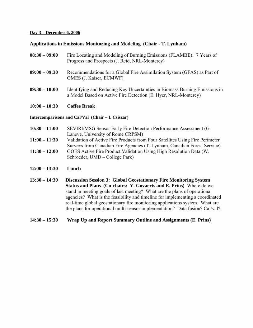
Day 3 – December 6, 2006 Applications in Emissions Monitoring and Modeling (Chair - T. Lynham) 08:30 – 09:00 Fire Locating and Modeling of Burning Emissions (FLAMBE): 7 Years of
Progress and Prospects (J. Reid, NRL-Monterey) 09:00 – 09:30 Recommendations for a Global Fire Assimilation System (GFAS) as Part of
GMES (J. Kaiser, ECMWF) 09:30 – 10:00 Identifying and Reducing Key Uncertainties in Biomass Burning Emissions in
a Model Based on Active Fire Detection (E. Hyer, NRL-Monterey) 10:00 – 10:30 Coffee Break Intercomparisons and Cal/Val (Chair – I. Csiszar) 10:30 – 11:00 SEVIRI/MSG Sensor Early Fire Detection Performance Assessment (G.
Laneve, University of Rome CRPSM) 11:00 – 11:30 Validation of Active Fire Products from Four Satellites Using Fire Perimeter
Surveys from Canadian Fire Agencies (T. Lynham, Canadian Forest Service) 11:30 – 12:00 GOES Active Fire Product Validation Using High Resolution Data (W.
Schroeder, UMD – College Park) 12:00 – 13:30 Lunch 13:30 – 14:30 Discussion Session 3: Global Geostationary Fire Monitoring System
Status and Plans (Co-chairs: Y. Govaerts and E. Prins) Where do we stand in meeting goals of last meeting? What are the plans of operational agencies? What is the feasibility and timeline for implementing a coordinated real-time global geostationary fire monitoring applications system. What are the plans for operational multi-sensor implementation? Data fusion? Cal/val?
14:30 – 15:30 Wrap Up and Report Summary Outline and Assignments (E. Prins)

Poster Presentations Analysis of MSG-SEVIRI for Fire Parameterization (A. Calle, J-L. Casanova, and J. Sanz) A System for Automatic Fire Detection and Monitoring from MSG SEVIRI Data (M.
Costantini and M. Zavagli) Fire Detection Over Africa Using MSG/SEVIRI Data (M. Amraoui, C. C. DaCamara, and
J.M.C. Pereira) Robust Satellite Techniques (RST) for Forest Fire Detection (C. Filizzola, F. Marchese, G.
Mazzeo, N. Pergola, V. Tramutoli) Advanced Fire Information System: AFIS I (P.E. Frost, H. Vosloo, and D. Davis) Global Early Warning System for Wildland Fire: The Links to Multi-Hazard Approaches
in Early Warning (J. Goldammer and M. Brady) The Use of Remote Sensing Products for Early Wildland Fire Warning and Detection:
Contributory Projects within GOFC-GOLD-Fire (J. Goldammer and M. Brady) A New Algorithm to Estimate Burnt Areas Using AWiFS and MODIS Information (F.
González-Alonso, S. Merino de Miguel, G. Ventura Parra, and J.M. Cuevas Gozalo) Validation of MSG-SEVIRI Hot Spot Detection: The Galacia Forest Fires Events in
August 2006 (F. González-Alonso, C. Moclan, S. Merino de Miguel, and A. Calle) Characterizing and Understanding the Differences Between GOES WF_ABBA and
MODIS Fire Products (J.P. Hoffman, E.M. Prins, C.C. Schmidt, S.A. Ackerman, J.S. Reid)
The Operational Active Fire Monitoring Algorithm at EUMETSAT (H.-J. Lutz) Lava Flow Evolution Monitoring Using Geo-stationary Satellite (M. Musacchio, M.F.
Buongiorno, A. Bartoloni, F. Aversa, A. Canestro, A. Fiorani, V. Lombardo, L. Merucci, B. Greco)
Monitoring Fire Activity in a Mediterranean Ecosystem Using SEVIRI Geostationary
Imagery: A Case Study (I. Palumbo, J. Kucera, P. Barbosa, V W. O’Brien, R. Valentini)
Global Mapping of Fire Affected Area Uisng Multi-temporal MODIS data: the MDC45
Product (D. Roy, L. Boschetti, and C. Justice) Quantifying the Impact of Cloud Obscuration on Remote Sensing of Active Fires in the
Brazilian Amazon (W. Schroeder, I. Csiszar, C. Justice)

A Tool for Early Warning and Monitoring of Fire: MSG Active Fire Monitoring Product
(A. E. TEKELİ, E. EDRİ, F. DEMİR) Using GOES Instantaneous Fire Sizes as a Proxy for Burned Areas (X. Zhang and S.
Kondragunta)