Scientific Contributions of Lunar Robotic Precursor Missions
25
1 Paul D. Spudis Johns Hopkins University Applied Physics Laboratory [email protected] www.spudislunarresources.com Scientific Contributions of Lunar Robotic Precursor Missions Presentation to LEAG Annual Meeting Houston, TX October 3, 2007
Transcript of Scientific Contributions of Lunar Robotic Precursor Missions

1
Paul D. SpudisJohns Hopkins University Applied Physics Laboratory
www.spudislunarresources.com
Scientific Contributions of Lunar Robotic Precursor Missions
Presentation to LEAG Annual MeetingHouston, TX
October 3, 2007

2
Why robotic precursor missions?Strategic knowledge
Important information on lunar environment and materials obtained before people return
Scientific and operational reconnaissanceProgrammatic milestones
Decade between LRO and first human landings
Sustain program with cadence of visible milestones
Emplacement of assetsPre-landed machines can prepare site,
emplace equipment for later human useSite Precedence
Assets in orbit and landed payloads are statement of intent to use lunar resources

3
Why Robotic Scientific Exploration?Characterize processes and environments
likely to be changed as a result of human presence (e.g., lunar atmosphere)
Obtain information on unknown or poorly understood processes and history (e.g., polar deposits)
Reconnoiter areas and sites to make subsequent human exploration more productive
Explore to characterize, map, learn and understand (all sites)

4
Types of robotic missionsFlybys
Galileo; cheap but limited in dwell timeOrbiters
Clementine; synoptic regional and global remote sensing
Impactors (hard landers)Ranger; Nested data of increasing resolution.
Post-impact survival?Soft landers
Surveyor; Point landings and in situ measurements
Surface stationsFar UV spectrograph; observe and measure
from a pointRovers
Lunakhod; traverse and measure in situNetworks
ALSEP; instruments laid out over wide area to measure in tandem
Sample returnsLuna; collect samples and return to Earth for
analysis

5
Orbital ReconnaissanceCurrent missions
Kaguya (a.k.a. SELENE)Global mapping, far side gravity
Chang’EGlobal mapping, RF subsurface
sounding
Chandrayaan 1Global mapping, SAR coverage of
poles, impact probe
Lunar Reconnaissance OrbiterGlobal mapping, polar deposits
and environment (neutron, thermal, UV, SAR)

6
Advanced Orbiters
Advanced, second-generation sensors to map Moon regionally and globally from orbit
Examples:multi-spectral imaging radaractive neutron spectroscopythermal IR spectroscopyUV spectroscopymicrowave radiometryVHF radio sounding

7
Site specific landersSimple landers (100-200 kg class)
Surveyor-class; could carry up to 30-40 kg payloads
Visual surveys, soil analysis, geotechnical properties, small ISRU demos
Larger Landers (>300 kg class)All of the above, plus deployment
of a mobility deviceRover could determine spatial
extent of compositional variability
Should carry mechanism to sample subsurface (up to ~2 m depth)

8
Landers to non-polar areasKnowledge of the Moon and its processes is
reasonably complete for non-polar sitesLanded exploration (both robotic and
human) and sample returns from six near-equatorial sites (both mare and terra)
Some sites of unusual properties and great practical potential could be characterized (e.g., mature, regional pyroclastics)
Scientific targets of great desirability (in situ analyses and sample returns):
Far side compositional provinces (ancient feldspathic crust, floor of SPA basin, maria)
Youngest mare basalts (Flamsteed ring mare)
Floors of a variety of impact craters for radiometric dating (Copernicus)
Unusual features (Reiner γ, Ina, Airy, young highland ridges)

9
Global and regional networksKey geophysical data to
characterize Moon as a planetary body
Seismic, heat flow, magnetic properties of Moon are poorly known
Need multiple stations, robotic delivery, global deployment, long life, comsat relay for limb and far side stations
Regional experiments can be undertaken with long-range roving missions (e.g., active seismometry)

10
Surface point landers, traverses and in situanalyses
Simple point-landers can analyze single spots for certain key propertiese.g., solar wind hydrogen in regional
mature pyroclasticsMineralogy, chemistry and
geology of complex regions(e.g., Aristarchus plateau)
Complex regions could be characterized by landing instrumented surface rovers to conduct in situ measurements(e.g., K-Ar age dating)
Need long life, high mobility, precision analyses

11
Demonstration-Infrastructure landers
Stationary-local mobility landers for ISRU, construction demonstrationsDeliver ~200 kg payloads; deploy ISRU
demonstrations, collect and process regolith
Need power source for weeks to months; traverse minimal distances (~100’s m)
Infrastructure emplacementTeleoperated systems for site
preparation, habitat emplacementLunar paving, clear large rocks, grade
and level habitat sitesManipulate and move outpost items of ~
a few hundred kg or lessScientific instrument packages for
environmental monitoring, experimentation

12
Robotic sample returnRobotic sample collection provides
key information unobtainable by in situ measurementsHigh-precision (e.g., Sm-Nd, Rb-Sr) age
dating, trace element and isotopic analysis, mineral analysis
Significant questions can be answered with carefully chosen landing sitesReconnaissance sites can provide
samples that address specific problems (e.g., age of youngest mare lavas)
Small rock chips and soils are adequate for most analysesLarge enough for multiple
measurements but small enough so that many can be collected; statistical analysis of site geology

13
Polar explorationNew and poorly understood
processes must be addressed by surface measurements
Need pinpoint landing, roving capability, long life in extreme environments, comsat relay
ObjectivesPolar thermal environmentVolatiles and exosphereHistory and inventory of
cometary debrisInteraction with Earth’s
magnetosphereCharacterize potential
resources

14
Information Needed on Lunar Polar VolatilesInformation Needed on Lunar Polar Volatiles
Inventory of trapped iceComposition of iceVariability in ice compositionState of volatiles (ices, amorphous
compounds, separate phases, clathrates)
Spatial distribution of iceHow ice binds soil grainsWhether ice reacts with soil grainsGeotechnical properties of ice-
bearing regolith in cold trapsPhysical environment of polar
regions

15
Characterizing Polar Volatiles
Need orbital and in situ measurementsOrbital:
Map temperatures on surfaceDetermine all permanently shadowed
locations (imaging)Obtain H concentrations at higher
spatial resolutionMap topography of permanently
shadowed regionsIn situ:
Determine nature of ice: chemical composition, structure
Measure geotechnical properties of ice-bearing regolith
Orbital and landed missions

16
Orbital Data Relevant to Finding VolatilesOrbital Data Relevant to Finding VolatilesChandrayaan-1 (launch March 2008)
Mini-SAR Radar images of polar areas (> 80° lat.) at 75 m/pixel. Total radar albedo and Circular Polarization RatioImage terrain within polar dark areasBistatic imaging with mini-RF on LRO spacecraft (if possible)
ImagingGlobal coverage at 5 m / pixelGlobal topography (better than 10 m/pixel DEM expected)
Lunar Reconnaissance Orbiter (launch late 2008)LROC
High resolution morphology of surface at ~ 0.5 m / pixelIllumination conditions over a year at ~100 m / pixel
Mini-RFRadar images of polar dark areas of interest at very high (~10
m/pixel) resolution. Total radar albedo and Circular Polarization RatioBistatic imaging with mini-SAR on Chandrayaan spacecraft (if
possible)LOLA Topography of polar regions (best resolution ~25 m);
oversampling at poles permits higher resolution map to be made. LEND Neutron spectrometer H2 content (best resolution >10 km)

17
Multiple hard landers
Cover diversity of polar lighting conditionsIdeal dispersion is at least one in
light, one in darkAssure sensor release (no null
results due to inverted orientation)Will need to clear H-bearing
material on spacecraft for accurate measurement of regolith
Mission RedundancyAssure at least one probe works
and gives ground truth

18
Ranger hard landing spacecraftSRM to remove bulk of approach velocity
Spherical crushable balsa wood structure containing spherical experiment package (6 lbs/ft3)Impact velocities of <200 ft/sec at 0° to 60° from vertical; Impact loads <3000 gOffset CG / Center of BuoyancyMass: 41.7 kg / 91.95 lbs.Volume: 0.119 m3 / 4.189 ft3 Diameter: 26.5 cm / 10.4 in.30-day lifetime
SeismometerZinc-silver oxide battery50 mW solid state transmitterSuspended magnetic seismometer (3.36 kg)Coil, spring suspended magnetc, internal calibration device1.7 kg mass – permanent magnet

19
Orbital resolution issuesNeutron data roughly 40
km/pixel resolutionBoth poles show enhanced
H content (~ 200 ppm)Consistent with uniform 2x
enhancement or heterogeneous distribution at much higher (up to 40 wt.%) concentrations
Latter is consistent with presence of water ice

20
Hard lander targeting
Both sunlit and darkness present at pole
Neutron data cannot distinguish H locations, just a general enhancement
Spot measurements at either lit (A), dark (B) and partly lit (C) can yield insight into hydrogen distribution and hence, likely origin, e.g., land in sunlight (A):If high, suggests H is uniform and
of solar wind originIf low suggests higher
concentrations must exist in darkness, consistent with polar ice

21
Hard lander payloadsNeutron spectrometer
Direct measurement of neutron flux from surface provides ground truth for orbital data
Estimate bulk hydrogen in upper 70 cm of Moon
Mass ~500 g, ~1.5 W, ~10 min. integration time
Mass spectrometerDirect measurement of volatiles, species
and abundanceRequires acquisition of soil sample from
beneath upper 10 cm; heat and analyze
Mass ~1-2 kg, 3-4 W, ~ 1 hr. for analysis

22
Mission conceptComsat orbiter and hard
landers approach MoonRelease hard landers (each
has separate SRM for de-orbit)
Comsat fires into relay orbitFire SRMs for de-orbit of
hard landersLand and operate (minimum
5-6 hours)Comsat receives lander
signals and relays to Earth
23
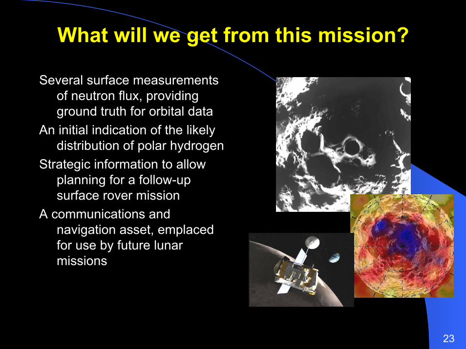
What will we get from this mission?
Several surface measurements of neutron flux, providing ground truth for orbital data
An initial indication of the likely distribution of polar hydrogen
Strategic information to allow planning for a follow-up surface rover mission
A communications and navigation asset, emplaced for use by future lunar missions

24
Lunar robotic precursor programRevised concept
Orbital mapping and reconnaissance with Chandrayaan, LRO etc.
Probing the surface with impactors (LCROSS) and hard landers
Emplacing orbital communications and navigation assets to support future missions
Exploring and prospecting future habitation sites with surface landers and rovers

25
SummaryPrecursor robotic missions to the Moon
enable significant scientific opportunities
Most important scientific uses:Characterize new or poorly understood
processes and environments (e.g., lunar poles)
Pure exploration (lunar processes and history)
Pre-reconnaissance of targets for future human exploration
Resource prospectingNo current robotic architecture; NASA has
punted on this oneRobotic missions have other important
programmatic uses beyond science; scientific exploration can be opportunistic
Should re-examine lunar return architecture to decide what principal mission is, then plan series of robotic missions around it