sci-ps216 - World Meteorological Organization · Experiment2 random perturbations in ... different...
21
Studying impacts of the Saharan Air Layer on hurricane development using WRF‐Chem/EnKF ‐ case study: Earl (2010) Jianyu(Richard) Liang Yongsheng Chen York University WWOSC 2014
Transcript of sci-ps216 - World Meteorological Organization · Experiment2 random perturbations in ... different...
Studying impacts of the Saharan Air Layer on hurricane development using WRF‐Chem/EnKF
‐ case study: Earl (2010)
Jianyu(Richard) LiangYongsheng Chen
York University
WWOSC 2014

+METEOSAT‐7/GOES‐11 combined Dry Air/SAL Product (source: University of Wisconsin‐CIMSS)
00Z25th, August, 2010
Definition: warm and dry air with rich mineral dust particles originated from Sahara Desert
Duration : late spring to early fallCoverage : in the North Atlantic OceanVertical extend : can reach 500 hPa
Hurricane Earl (2010)
Saharan Air Layer (SAL)

SAL Impact on Hurricane
Positive impact:Enhance easterly wave growth and cyclongenesispotential(eg., Karyampudi and Carlson, 1988)
Negative impact:1) Bring dry and warm air into mid‐level of tropical
storms, thus increase stability2) Enhance the vertical wind shear to suppress the
development of tropical cyclones(eg., Dunion and Velden2004; Sun et al. 2009)

Dust inside SAL potentially plays an important role in weather forecast and climate.
(1) Indirect effect: modification of the cloud droplet concentration and size distribution (Twomey, 1977; Albrecht, 1989).
(2) Direct effect: change radiation budget by absorbing and scattering solar radiation.
Objectives:Use numerical models to quantify the impact of SAL(air and
dust) on TCs.
SAL Impact on Hurricane

Hurricane Earl (2010)
Hurricane Earl best track from 25th , August to 4th September, 2010. (Cangialosi 2011)
Official track forecast from 00Z 26th , August to 00Z 30 th, August. (Cangialosi 2011)
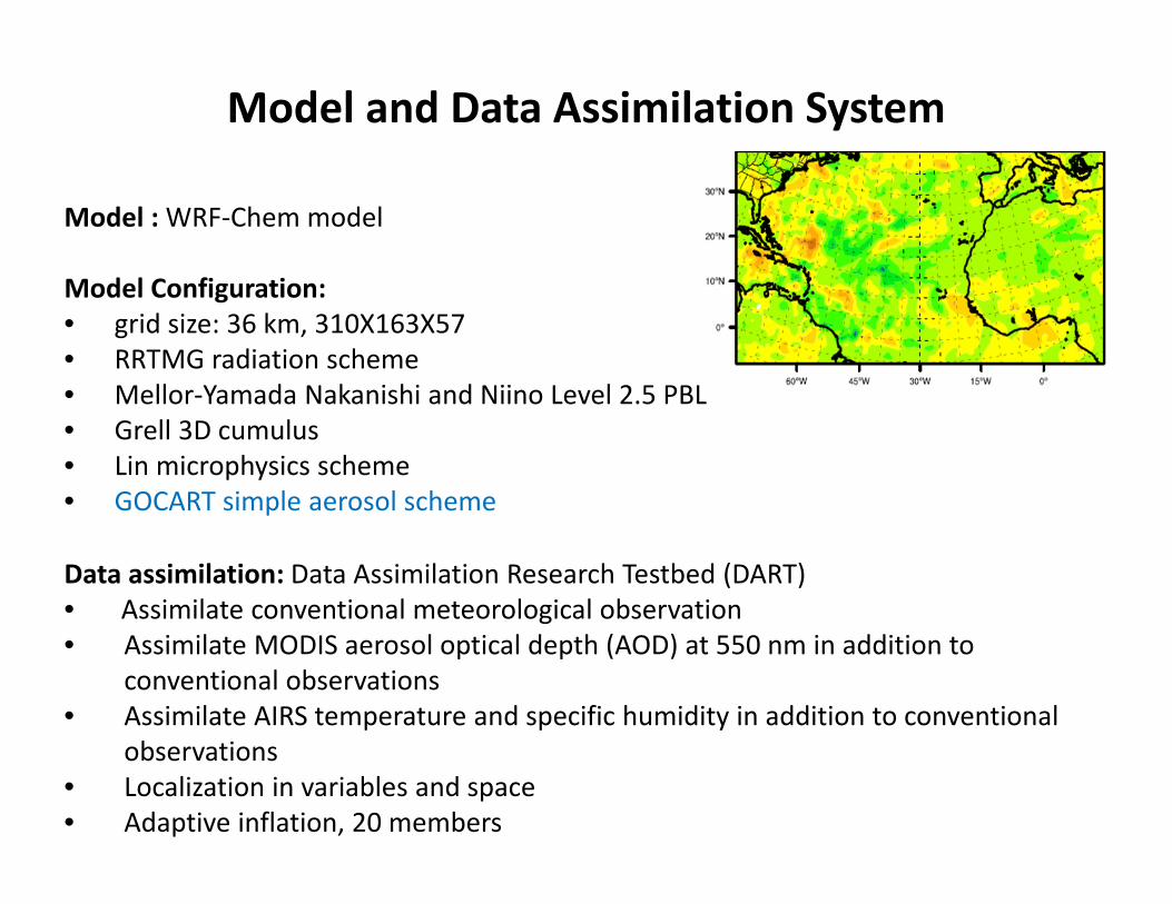
Model : WRF‐Chem model
Model Configuration:• grid size: 36 km, 310X163X57• RRTMG radiation scheme• Mellor‐Yamada Nakanishi and Niino Level 2.5 PBL• Grell 3D cumulus• Lin microphysics scheme• GOCART simple aerosol scheme
Data assimilation: Data Assimilation Research Testbed (DART) • Assimilate conventional meteorological observation• Assimilate MODIS aerosol optical depth (AOD) at 550 nm in addition to
conventional observations• Assimilate AIRS temperature and specific humidity in addition to conventional
observations• Localization in variables and space• Adaptive inflation, 20 members
Model and Data Assimilation System
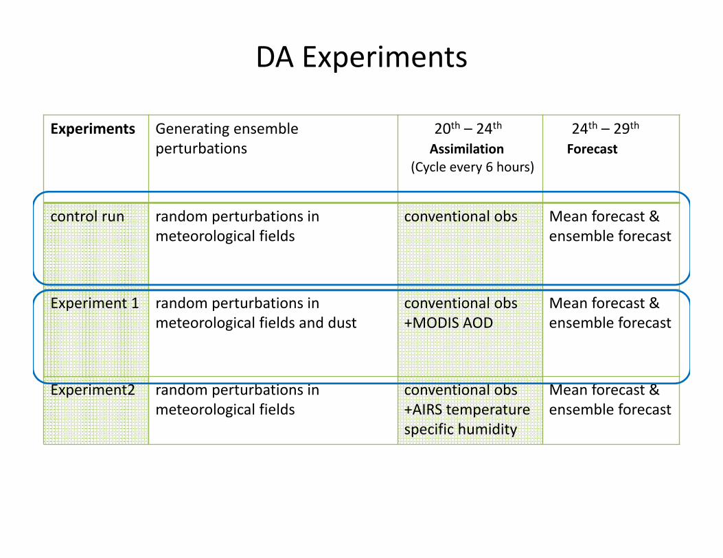
DA Experiments
Experiments Generating ensemble perturbations
20th – 24thAssimilation
(Cycle every 6 hours)
24th – 29thForecast
control run random perturbations in meteorological fields
conventional obs Mean forecast &ensemble forecast
Experiment 1 random perturbations in meteorological fields and dust
conventional obs+MODIS AOD
Mean forecast &ensemble forecast
Experiment2 random perturbations in meteorological fields
conventional obs+AIRS temperaturespecific humidity
Mean forecast &ensemble forecast

a) Use existing dust product to reduce spin‐up problemMOZART‐4 : output from MOZART (driven by NASA GMAO GEOS‐5 model).
MODIS AODMOZART‐4 AOD 00Z20th
Assimilating MODIS AOD
b) Generating initial and time‐dependent boundary condition for dust and other aerosol species by adding random perturbations

Data assimilation cyclesCycle 6‐hourly for 4 days ( from 20th‐24th) , assimilate conventional and
MODIS AOD observations
MODIS coverage12Z20th
18Z20th
AOD Prior vs. Observation

00Z24th Model AOD MODIS AOD
Total Spread
RMSE
Data assimilation cycles
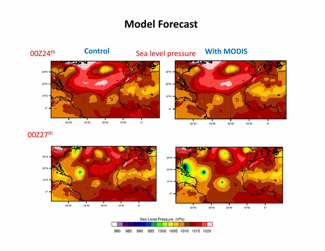
Model Forecast
00Z24th
00Z27th
Control With MODISSea level pressure

Assimilating AIRS data
• SAL has unique temperature and humiditycomparing to its surrounding area. From another perspective, dust direct effect and part of the indirect effect can be reflected in its unique temperature and humidity distribution.
• Assimilating AIRS temperature and specific humidity retrieval data

DA Experiments
Experiments Generating ensemble perturbations
20th – 24thAssimilation
(Cycle every 6 hours)
24th – 29thForecast
control run random perturbations in meteorological fields
conventional obs Mean forecast &ensemble forecast
Experiment 1 random perturbations in meteorological fields and dust
conventional obs+MODIS AOD
Mean forecast &ensemble forecast
Experiment2 random perturbations in meteorological fields
conventional obs+AIRS temperaturespecific humidity
Mean forecast &ensemble forecast

Relative humidity from AIRS
Temperature (oC) from AIRS
00Z 23th 850hPaAssimilating AIRS data
Diagnostics in assimilating AIRS temperature .
Bias: Post
Bias: Prior
rmse: Prior
rmse: Post
Temperature RMSE and Bias
From Aug. 20th to Aug.24th , assimilating conventional observation and AIRS temperature, specific humidity observation together

Sea level pressure. 00Z 24th,August
Control With AIRS
Analysis difference –sea level pressure
r2

Slide 15
r2 storm weak
daniel stronger
cyclone on the northrichard, 5/10/2014

After the data assimilation, two forecasts have been made, from 24th to 29th , August.a) Control: from the initial condition which comes from assimilating
conventional observation alone. b) AIRS: from the initial condition which comes from assimilating ARIS data
and conventional observation together.Hurricane track
mean track (No AIRS )
Best track AIRS mean track
Ensemble track (no AIRS)
AIRS ensemble track
Model Forecast

minimum sea level pressure
With airs
maximum wind speed
Best trackAIRS
AIRS
Best track
Control
Control
Data assimilation can improve the representation of thermal properties of SAL, which in turn can reduce forecast errors of Hurricane Earl significantly.
Model Forecast

Summary
(1) Including dust through assimilating MODIS AOD influence hurricane Earl (2010) development in this case. However, the forecast has not been improved in terms of its track and the large scale environment.
(2) The thermal property of SAL can be well represented by assimilating AIRS observations. The subsequent forecasting of Hurricane Earl was improved.
(3) Dust direct effect alone may not be enough to represent SAL thermal properties.

Future Works
(1) Considering dust indirect effect by employing different chemistry schemes such as MOSAIC, which includes interactions between aerosols and microphysics processes.
(2) Assimilating MODIS AOD on top of conventional observations and AIRS retrievals to assess the added value of MODIS AOD.

Thank you!