Satellite monitoring of a large tailings storage · PDF fileSatellite monitoring of a large...
10
Proceedings Tailings and Mine Waste 2015 Vancouver, BC, October 26 to 28, 2015 Satellite monitoring of a large tailings storage facility Benjamin Schmidt, Matt Malgesini Golder Associates Inc., USA Jim Turner PhotoSat Ltd, Canada Jeff Reinson Goldcorp Inc., Canada ABSTRACT Minera Peñasquito, S.A. de C.V., operates a tailings storage facility (TSF) that currently covers 650 hectares (ha) and will have an ultimate dam length of approximately 11 kilometers (km) at their mine in the state of Zacatecas, Mexico. Historically, the size of the Peñasquito TSF has presented challenges with respect to monitoring and documenting construction and operational activities. Ground-based observation and topographic survey methods have been time-consuming, labor-intensive, and have been limited by site distances, shallow relief of tailings beaches, and restricted access to the tailings beach. Utilization of outside contractors to perform large-scale as- built surveying with unmanned aerial systems (drones) has been successful but also time- consuming and expensive, due to mobilization and site logistics. Through the innovative application of both publically and commercially available satellite data and data processing techniques developed by Photosat Ltd., Golder Associates Inc. (Golder) has been able to provide cost effective and reliable topography and aerial imagery to monitor and document the development of the Peñasquito TSF. This data has provided valuable insights into the construction progress and operational performance of the facility. Landsat Survey Infrared Construction Operation Capacity. 1. INTRODUCTION Visual observation and as-built surveys are common aspects of TSF operation, maintenance, and surveillance (OMS) plans; however, for large facilities, these activities can be time-consuming, labor-intensive, and costly. Ground-based observation and topographic survey methods can be limited by site distances and shallow relief of tailings beaches. Further restrictions can include safe access to the tailings beach, dam slopes, or surrounding natural topography. Unmanned aerial systems (commonly referred to as drones) are an increasingly popular tool for developing topography and aerial imagery as a convenient alternative to light aircraft survey methods. However, drone systems require a qualified operator and spotter to be mobilized to the TSF, may require multiple flights to cover the complete survey area, and can be costly to complete on a routine basis, if multiple mobilizations are required. Furthermore, governmental regulations may restrict where and how drones may be used. Collecting survey data and imagery using satellites, however, is largely unencumbered by these limitations. Since 2013, Golder has been providing the mine with weekly moderate-resolution satellite imagery of the entire mine site and TSF from the USGS/NASA Landsat program. Although limited in physical resolution, the high temporal resolution provides valuable insight to the operation and performance of the TSF, in particular the behavior of the tailings beach and water reclaim pond. On a monthly basis since December 2014, Golder has also contracted with PhotoSat Ltd. (PhotoSat) to produce high-resolution satellite imagery and digital elevation models using stereo satellite imagery. The topographic survey data is used for construction quality assurance review
Transcript of Satellite monitoring of a large tailings storage · PDF fileSatellite monitoring of a large...
Proceedings Tailings and Mine Waste 2015
Vancouver, BC, October 26 to 28, 2015
Satellite monitoring of a large tailings storage facility
Benjamin Schmidt, Matt Malgesini
Golder Associates Inc., USA
Jim Turner
PhotoSat Ltd, Canada
Jeff Reinson
Goldcorp Inc., Canada
ABSTRACT
Minera Peñasquito, S.A. de C.V., operates a tailings storage facility (TSF) that currently covers
650 hectares (ha) and will have an ultimate dam length of approximately 11 kilometers (km) at
their mine in the state of Zacatecas, Mexico. Historically, the size of the Peñasquito TSF has
presented challenges with respect to monitoring and documenting construction and operational
activities. Ground-based observation and topographic survey methods have been time-consuming,
labor-intensive, and have been limited by site distances, shallow relief of tailings beaches, and
restricted access to the tailings beach. Utilization of outside contractors to perform large-scale as-
built surveying with unmanned aerial systems (drones) has been successful but also time-
consuming and expensive, due to mobilization and site logistics.
Through the innovative application of both publically and commercially available satellite data
and data processing techniques developed by Photosat Ltd., Golder Associates Inc. (Golder) has
been able to provide cost effective and reliable topography and aerial imagery to monitor and
document the development of the Peñasquito TSF. This data has provided valuable insights into
the construction progress and operational performance of the facility.
Landsat Survey Infrared Construction Operation Capacity.
1. INTRODUCTION
Visual observation and as-built surveys are common aspects of TSF operation, maintenance, and
surveillance (OMS) plans; however, for large facilities, these activities can be time-consuming,
labor-intensive, and costly. Ground-based observation and topographic survey methods can be
limited by site distances and shallow relief of tailings beaches. Further restrictions can include
safe access to the tailings beach, dam slopes, or surrounding natural topography. Unmanned aerial
systems (commonly referred to as drones) are an increasingly popular tool for developing
topography and aerial imagery as a convenient alternative to light aircraft survey methods.
However, drone systems require a qualified operator and spotter to be mobilized to the TSF, may
require multiple flights to cover the complete survey area, and can be costly to complete on a
routine basis, if multiple mobilizations are required. Furthermore, governmental regulations may
restrict where and how drones may be used. Collecting survey data and imagery using satellites,
however, is largely unencumbered by these limitations.
Since 2013, Golder has been providing the mine with weekly moderate-resolution satellite
imagery of the entire mine site and TSF from the USGS/NASA Landsat program. Although
limited in physical resolution, the high temporal resolution provides valuable insight to the
operation and performance of the TSF, in particular the behavior of the tailings beach and water
reclaim pond.
On a monthly basis since December 2014, Golder has also contracted with PhotoSat Ltd.
(PhotoSat) to produce high-resolution satellite imagery and digital elevation models using stereo
satellite imagery. The topographic survey data is used for construction quality assurance review

Proceedings Tailings and Mine Waste 2015
Vancouver, BC, October 26 to 28, 2015
of TSF including monitoring of the deposited tailings volumes; tracking of TSF dam construction
quantities; validation of storage capacity estimates and monitoring of average in-place density of
deposited tailings.
These powerful tools have significantly enhanced the monitoring of the TSF at considerable
savings with respect to costs, labor, and time compared to similar comprehensive methods.
2. BACKGROUND
Minera Peñasquito
The Peñasquito mine, operated by a wholly owned subsidiary of Goldcorp Inc., produces gold,
silver, lead, and zinc from a mixed sulfide and oxide ore body. Oxide ore is leached and sulfide
ore is processed by floatation and grinding. The sulfide circuit has a capacity of 130,000 tonnes
per day (tpd) and the discharged tailings are transported as a slurry to the TSF.
The TSF is a three-sided, 11 km long hybrid rockfill and cycloned sand dam. The dam is raised
continually via centerline-raise methods. Rockfill for the dam construction is hauled via truck
from a local waste rock stockpile and cycloned sand tailings, which is used as a transition zone
between the rockfill and deposited tailings, are placed by hydraulically utilizing paddock
construction and deposition methods. The Peñasquito TSF includes a water reclaim pond that
must be managed to achieve minimum beach lengths, while maintaining the required minimum
water storage volumes for reclaim.
Landsat Program
Since 1972, the U.S. Geological Survey and NASA have launched and successfully orbited a
series of seven earth-observing satellites under the Landsat program (USGS 2013a and 2013b).
The newest satellite, Landsat 8, was launched on February 11, 2013, and was fully operational on
April 11, 2013. Landsat 8 orbits the Earth once every 99 minutes, collecting 185-km wide images
and providing a revisit time of 16 days. Landsat 7 follows an offset orbit to allow a revisit time of
8 days for every point on the planet with the Landsat program.
Landsat 8 carries optical and thermal sensors that collect 11 spectral bands of data at pixel
resolutions of 15 to 100 m, as summarized in Table 1. A typical natural-color image produced
from Landsat 8 data is shown as Figure 1. This image is produced by combining data from the
blue, green, and red data bands. The panchromatic band, with a higher 15 m resolution, is used to
pansharpen the color imagery.
Proceedings Tailings and Mine Waste 2015
Vancouver, BC, October 26 to 28, 2015
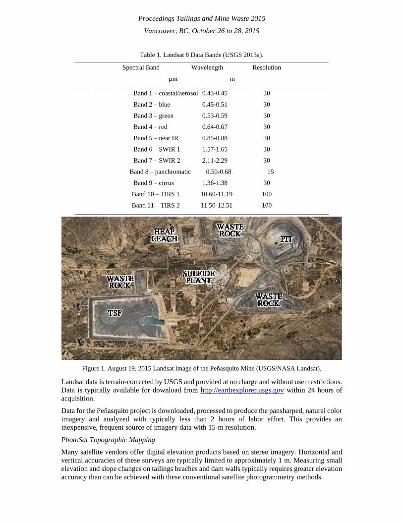
Table 1. Landsat 8 Data Bands (USGS 2013a). _____________________________________________________________________________
Spectral Band Wavelength Resolution
µm m _____________________________________________________________________________
Band 1 – coastal/aerosol 0.43-0.45 30
Band 2 – blue 0.45-0.51 30
Band 3 – green 0.53-0.59 30
Band 4 – red 0.64-0.67 30
Band 5 – near IR 0.85-0.88 30
Band 6 – SWIR 1 1.57-1.65 30
Band 7 – SWIR 2 2.11-2.29 30
Band 8 – panchromatic 0.50-0.68 15
Band 9 – cirrus 1.36-1.38 30
Band 10 – TIRS 1 10.60-11.19 100
Band 11 – TIRS 2 11.50-12.51 100 _____________________________________________________________________________
Figure 1. August 19, 2015 Landsat image of the Peñasquito Mine (USGS/NASA Landsat).
Landsat data is terrain-corrected by USGS and provided at no charge and without user restrictions.
Data is typically available for download from http://earthexplorer.usgs.gov within 24 hours of
acquisition.
Data for the Peñasquito project is downloaded, processed to produce the pansharped, natural color
imagery and analyzed with typically less than 2 hours of labor effort. This provides an
inexpensive, frequent source of imagery data with 15-m resolution.
PhotoSat Topographic Mapping
Many satellite vendors offer digital elevation products based on stereo imagery. Horizontal and
vertical accuracies of these surveys are typically limited to approximately 1 m. Measuring small
elevation and slope changes on tailings beaches and dam walls typically requires greater elevation
accuracy than can be achieved with these conventional satellite photogrammetry methods.

Proceedings Tailings and Mine Waste 2015
Vancouver, BC, October 26 to 28, 2015
To achieve accuracy better than 30 cm, PhotoSat uses algorithms that were derived from Oil and
Gas seismic data processing. These algorithms and processing methods result in an accuracy
improvement of about 5x over the best photogrammetry methods. Producing stereo satellite
surveying accurate to better than 30 cm in elevation requires knowledge of the specific
characteristics of each of the various types of stereo satellite photos. Over the past seven years,
PhotoSat has measured satellite photo characteristics using dozens of accuracy studies and in over
500 client satellite survey projects. These projects include continuous monitoring of some mine
sites and their tailings facilities. Using these case histories, PhotoSat has built a database of
processing parameters and procedures that routinely achieve better than 15 cm surveying accuracy
at some mine sites. With these methods, accurate surveys of areas exceeding 100 km2 can be
rapidly produced, with typical elevation model grid spacing of 1 m.
Imagery for the Peñasquito project is acquired monthly using DigitalGlobe’s WorldView-1, -2
and -3 satellites. These satellites provide panchromatic ground resolution of 0.31 to 0.5 m
(DigitalGlobe 2013, 2014a, and 2014b). WorldView-3 is the most advanced satellite in the fleet,
with 0.31-m panchromatic imagery, 1.24-m resolution multi-spectral and near infrared imagery
in eight bands covering 0.400 to 1.040 µm, and 3.7-m resolution shortwave infrared imagery in
eight bands covering 1.195 to 2.365 µm. Among the three satellites, revisit times of less than one
day can be achieved, subject to a prioritization hierarchy lead by government tasking requests. An
example WorldView-2 image is shown as Figure 2.
After stereo satellite images are acquired, PhotoSat processes them using their proprietary
algorithms. The code for these runs on massively parallel multicore GPUs. This allows surveys to
be processed, projected into any coordinate space (including custom mine grids), and then
delivered within a few days of imagery acquisition. Surveys are projected to the mine coordinate
system and vertical accuracy evaluated using photo-identifiable ground control points (GCP).
Following construction and initial survey of these points, no action is required from on-site
personnel.
For the Peñasquito project, surveying costs are less than $12,000 USD for an imagery area of
100-km2 covering the active mining and TSF areas and an elevation model area of 23-km2
covering the TSF. The elevation model area could be expanded to the full extent of the stereo
imagery and can also be developed using archival stereo imagery.
Figure 2. July 16, 2015, WorldView-2 Image of Construction Equipment and Deposition Piping at the
Peñasquito TSF.

Proceedings Tailings and Mine Waste 2015
Vancouver, BC, October 26 to 28, 2015
3. APPLICATION OF SATELLITE DATA AT MINERA PEÑASQUITO
3.1 Change Monitoring
Minera Peñasquito is located at the edge of two adjacent flight paths of Landsat 8, allowing
alternative 7- and 9-day repeat coverage. As Landsat 7 has a mechanical fault that results in bands
of data gaps across the imagery, it is not used for new imagery in the Peñasquito project. However,
data from Landsat 7 has been used to develop a complete image history of the TSF dating back to
pre-construction starting in 2008.
Example imagery developed from the Landsat 8 data from 2013 to 2015 is shown as Figure 3. As
seen in this imagery, the advancement of the tailings deposit, liner system construction, and
development of the reclaim pond can be readily identified.
Figure 3. Landsat Imagery of Peñasquito TSF (USGS/NASA Landsat).

Proceedings Tailings and Mine Waste 2015
Vancouver, BC, October 26 to 28, 2015
3.2 Topographic Survey
Golder has contracted PhotoSat to produce monthly, high-resolution imagery and digital elevation
models of the TSF. Example images with 10-m and 0.5-m interval elevation contours from the
July 16, 2015, survey of the TSF are shown as Figures 4 and 5, respectively. The survey has been
matched to the site coordinate system using four GCP and matches their ground survey elevations
to within approximately 20 cm. As shown in Figure 5, the stereo satellite survey can measure the
topography of the relatively flat tailings deposition cones (approximately 0.5% grade).
As additional facilities have been designed in and around the TSF, the stereo satellite survey has
provided a valuable resource of current topographic data for construction planning, reducing the
amount of field verification survey required.
Figure 4. July 16, 2015 Satellite Imagery and Topography by PhotoSat (10-m Interval Contours).
Figure 5. July 16, 2015 Satellite Imagery and Topography by PhotoSat (0.5-m Interval Contours).

Proceedings Tailings and Mine Waste 2015
Vancouver, BC, October 26 to 28, 2015
3.3 Construction Quality Assurance
The stereo satellite survey maps provided by PhotoSat have been used to produce as-built
drawings to track construction of the dam and water reclaim management facilities at the
Peñasquito TSF. Golder plots cross sections of the as-built dam construction to evaluate
conformance with the design line and grade of the dam, as shown in Figure 6. The surveys are
also used to evaluate the minimum freeboard elevations, minimum beach lengths, construction
progress and conformance of cycloned sand tailings paddock construction requirements.
Figure 6. Typical As-Built Construction Cross Section.
In addition to generation of as-built drawings, the monthly survey is used to estimate construction
volumes by comparing month-to-month surveys, providing an independent measure of material
contract payment quantities. As-built drawings are also used to evaluate the remaining freeboard,
the remaining tailings storage volume, and the monthly rate of construction. These enable the
mine to improve forecasts and schedule future construction activities.
3.4 Water Reclaim Pond Tracking
The Peñasquito TSF includes a water reclaim pond that must be managed to maintain minimum
beach lengths and water storage requirements. Satellite imagery is used to monitor the reclaim
pond size and shape through the topographic survey and natural color imagery (both Landsat and
Photosat surveys). Additional satellite data bands are used to enhance the visualization of water
across the TSF.
Historically, the Peñasquito TSF had relatively flat tailings beach grades (less than 0.5% beach
slope) resulting in large areas of shallow water that were difficult to identify and delineate in the
natural color imagery. Taking advantage of water’s poor reflectance of infrared light, the Band 7
shortwave infrared Landsat 8 data and near infrared band of the WorldView satellites is used to
colorize the surface of the TSF and highlight the areas of water or very wet tailings.
More recently, improved tailings deposition strategies have been implemented increase the
tailings beach grades to between 0.5 and 1.25% slopes. Examples of the flatter and more steep
tailings beaches and resulting water reclaim pond are shown as Figures 7 and 8, based on the
source natural color imagery shown in Figures 1 and 4, respectively. The shortwave infrared data
from Landsat 8 provides a more clear delineation of the water/wet areas, which is particularly
beneficial due the limited resolution of the Landsat imagery. WorldView-2 does not carry a
shortwave infrared sensor.

Proceedings Tailings and Mine Waste 2015
Vancouver, BC, October 26 to 28, 2015
Figure 7. August 19, 2015, Water Area Enhanced Landsat Image (USGS/NASA Landsat).
Figure 8. July 16, 2015, Water Area Enhanced WorldView-2 Image.
3.5 Tailings Deposition Monitoring
The accuracy of the PhotoSat survey allows for detailed monitoring of the tailings beach grades
and calculation of the volume of the deposited tailings. An example profile of the tailings beach
from the December 2014 to July 2015 monthly surveys is shown as Figure 9. The total volume of
tailings contained behind the dam in July 2015 was estimated to be 119.7 million m3. Monthly
satellite topographic survey allows for evaluation of the remaining storage capacity of the TSF
compared to the design stage-storage relationship of the facility.

Proceedings Tailings and Mine Waste 2015
Vancouver, BC, October 26 to 28, 2015
Figure 9. PhotoSat Stereo Satellite Survey Tailings Beach Profiles, December 2014 through July 2015.
3.6 Storage Capacity Validation
A key aspect of monitoring the storage performance of the Peñasquito TSF is measurement of the
in-place density of the tailings. Golder developed a large-strain consolidation model to predict the
density of the tailings through time. Satellite survey data is evaluated monthly to compare
calculated in-place tailings densities against the predictive model. This allows the mine to
compare the future life of the facility against future mine production plans. Calculated in-place
tailings density estimates have compared favorably to the predictive model as shown in Figure 10.
These values have also compared favorably with the results of a geotechnical drilling and
sampling and cone penetration test program of the tailings beach completed by Golder in 2014
and 2015.
Figure 10. Stereo Satellite Survey Estimated Density versus Predictive Consolidation Model.
4. SUMMARY
Satellite monitoring has provided a valuable, cost-effective, and timely source of data for
observing, evaluating, and managing the development of the Minera Peñasquito TSF. Through
Proceedings Tailings and Mine Waste 2015
Vancouver, BC, October 26 to 28, 2015
both commercial and public data sources, data is collected to prepare aerial imagery and
topographic models to evaluate dam construction, tailings deposition, and reclaim water storage.
The use of satellites eliminates a significant amount of field labor compared to traditional ground,
light aircraft, or even unmanned aerial imagery system survey methods.
5. REFERENCES
DigitalGlobe. 2013. WorldView-2 Data Sheet. Available at:
http://global.digitalglobe.com/sites/default/files/DG_WorldView2_DS_PROD.pdf (Accesse
d: 21 August 2015).
DigitalGlobe. 2014a. WorldView-1 Data Sheet. Available at:
http://global.digitalglobe.com/sites/default/files/WorldView1-DS-WV1.pdf (Accessed: 21
August 2015).
DigitalGlobe. 2014b. WorldView-3 Data Sheet. Available at:
http://global.digitalglobe.com/sites/default/files/DG_WorldView3_DS_forWeb_0.pdf (Acce
ssed: 21 August 2015)
U.S. Department of the Interior, U.S. Geological Survey (USGS). 2013a. Landsat – A Global
Land-Imaging Mission. Fact Sheet 2012-3072. Revised May 2013. Available at:
http://pubs.usgs.gov/fs/2012/3072/fs2012-3072.pdf (Accessed: 21 August 2015).
U.S. Department of the Interior, U.S. Geological Survey (USGS). 2013b. Landsat 8. Fact Sheet
2013-3060. August 2013. Available at: http://pubs.usgs.gov/fs/2013/3060/pdf/fs2013-
3060.pdf (Accessed: 21 August 2015).