SANEEDS - CSAH - Segment Report Roadway Segment Status ... · County Name : RICE Segment Nbr :...
226
SANEEDS - CSAH - Segment Report Roadway Segment Information Status : Original County Name : RICE Segment Nbr : 066-601-010 Original Current Unassigned/Unknown Municipality Unassigned/Unknown 4 Segment Length 4 BIT CONC OR ASPH Existing Surface Type BIT CONC OR ASPH 2 Existing Surface Lanes 2 NOT DIVIDED Existing Lane Description NOT DIVIDED W CO LINE TO CSAH 4 Termini W CO LINE TO CSAH 4 2240 Present AADT 1755 2012 Year of Count 2016 1.4 Projection Factor 1.3 2240 Projected Traffic 1755 RURAL Design Type RURAL 3 - RURAL : 1500 - 6999 Design Group 3 ( RURAL : 1500 - 6999 ) 1989 Latest Year SA funds 1989 0 Number of Signal Legs 0 No Special Message Special Message Code No Special Message Comments Interchange Override Segment Override Segment Cost Information Computation Factor Computation Formula Values Used For Calculation Computation Result Signal Leg TrafficSignalLegs * UnitCost / SignalLifeCycle * StatutoryNeedsYear 0 * 56250 / 40 * 25 $0 Construction Length * UnitCost / ConstrLifeCycle * StatutoryNeedsYear * DevelopmentCost 4 * 1280397.01 / 60 * 25 * 1.1 $2,347,395 Preservation Length * Quantity * UnitCost / PreservationLifeCycle * StatutoryNeedsYear 4 * 2376 * 57.98 / 20 * 25 $688,802 ROW Length * UnitCost / ROWLifeCycle * StatutoryNeedsYear 4 * 13705.86 / 60 * 25 $22,843 Total Segment Cost Signal Leg + Construction + Preservation + ROW $0 + $2,347,395 + $688,802 + $22,843 $3,059,040
Transcript of SANEEDS - CSAH - Segment Report Roadway Segment Status ... · County Name : RICE Segment Nbr :...

SANEEDS - CSAH - Segment Report
Roadway SegmentInformation
Status : Original
County Name : RICE Segment Nbr : 066-601-010
Original Current
Unassigned/Unknown Municipality Unassigned/Unknown
4 Segment Length 4
BIT CONC OR ASPH Existing Surface Type BIT CONC OR ASPH
2 Existing Surface Lanes 2
NOT DIVIDED Existing Lane Description NOT DIVIDED
W CO LINE TO CSAH 4 Termini W CO LINE TO CSAH 4
2240 Present AADT 1755
2012 Year of Count 2016
1.4 Projection Factor 1.3
2240 Projected Traffic 1755
RURAL Design Type RURAL
3 - RURAL : 1500 - 6999 Design Group 3 ( RURAL : 1500 - 6999 )
1989 Latest Year SA funds 1989
0 Number of Signal Legs 0
No Special Message Special Message Code No Special Message
Comments
Interchange Override
Segment Override
Segment CostInformation
Computation Factor Computation Formula Values Used ForCalculation
Computation Result
Signal Leg TrafficSignalLegs *UnitCost / SignalLifeCycle* StatutoryNeedsYear
0 * 56250 / 40 * 25 $0
Construction Length * UnitCost /ConstrLifeCycle *StatutoryNeedsYear *DevelopmentCost
4 * 1280397.01 / 60 * 25 *1.1
$2,347,395
Preservation Length * Quantity *UnitCost /PreservationLifeCycle *StatutoryNeedsYear
4 * 2376 * 57.98 / 20 * 25 $688,802
ROW Length * UnitCost /ROWLifeCycle *StatutoryNeedsYear
4 * 13705.86 / 60 * 25 $22,843
Total Segment Cost Signal Leg + Construction+ Preservation + ROW
$0 + $2,347,395 + $688,802+ $22,843
$3,059,040

SANEEDS - CSAH - Segment Report
Roadway SegmentInformation
Status : Original
County Name : RICE Segment Nbr : 066-601-020
Original Current
Unassigned/Unknown Municipality Unassigned/Unknown
6 Segment Length 6
MIXED BITUMINOUS Existing Surface Type MIXED BITUMINOUS
2 Existing Surface Lanes 2
NOT DIVIDED Existing Lane Description NOT DIVIDED
CSAH 4 TO MILLERSBURG Termini CSAH 4 TO MILLERSBURG
1680 Present AADT 1560
2012 Year of Count 2016
1.4 Projection Factor 1.3
1680 Projected Traffic 1560
RURAL Design Type RURAL
3 - RURAL : 1500 - 6999 Design Group 3 ( RURAL : 1500 - 6999 )
2014 Latest Year SA funds 2014
0 Number of Signal Legs 0
No Special Message Special Message Code No Special Message
2014 SAP 066-601-023 RC&OL
2012 SAP 066-601-022 RECONST
Comments 2014 SAP 066-601-023 RC&OL
2012 SAP 066-601-022 RECONST
Interchange Override
Segment Override
Segment CostInformation
Computation Factor Computation Formula Values Used ForCalculation
Computation Result
Signal Leg TrafficSignalLegs *UnitCost / SignalLifeCycle* StatutoryNeedsYear
0 * 56250 / 40 * 25 $0
Construction Length * UnitCost /ConstrLifeCycle *StatutoryNeedsYear *DevelopmentCost
6 * 1280397.01 / 60 * 25 *1.1
$3,521,092
Preservation Length * Quantity *UnitCost /PreservationLifeCycle *StatutoryNeedsYear
6 * 2376 * 57.98 / 20 * 25 $1,033,204
ROW Length * UnitCost /ROWLifeCycle *StatutoryNeedsYear
6 * 13705.86 / 60 * 25 $34,265
Total Segment Cost Signal Leg + Construction+ Preservation + ROW
$0 + $3,521,092 +$1,033,204 + $34,265
$4,588,561

SANEEDS - CSAH - Segment Report
Roadway SegmentInformation
Status : Original
County Name : RICE Segment Nbr : 066-601-030
Original Current
Unassigned/Unknown Municipality Unassigned/Unknown
1.4 Segment Length 1.4
MIXED BITUMINOUS Existing Surface Type MIXED BITUMINOUS
2 Existing Surface Lanes 2
NOT DIVIDED Existing Lane Description NOT DIVIDED
MILLERSBURG TO CSAH 46 Termini MILLERSBURG TO CSAH 46
1680 Present AADT 1560
2012 Year of Count 2016
1.4 Projection Factor 1.3
1680 Projected Traffic 1560
RURAL Design Type RURAL
3 - RURAL : 1500 - 6999 Design Group 3 ( RURAL : 1500 - 6999 )
2012 Latest Year SA funds 2012
0 Number of Signal Legs 0
No Special Message Special Message Code No Special Message
2012 SAP 066-601-022 RECONST Comments 2012 SAP 066-601-022 RECONST
Interchange Override
Segment Override
Segment CostInformation
Computation Factor Computation Formula Values Used ForCalculation
Computation Result
Signal Leg TrafficSignalLegs *UnitCost / SignalLifeCycle* StatutoryNeedsYear
0 * 56250 / 40 * 25 $0
Construction Length * UnitCost /ConstrLifeCycle *StatutoryNeedsYear *DevelopmentCost
1.4 * 1280397.01 / 60 * 25 *1.1
$821,588
Preservation Length * Quantity *UnitCost /PreservationLifeCycle *StatutoryNeedsYear
1.4 * 2376 * 57.98 / 20 * 25 $241,081
ROW Length * UnitCost /ROWLifeCycle *StatutoryNeedsYear
1.4 * 13705.86 / 60 * 25 $7,995
Total Segment Cost Signal Leg + Construction+ Preservation + ROW
$0 + $821,588 + $241,081+ $7,995
$1,070,664

SANEEDS - CSAH - Segment Report
Roadway SegmentInformation
Status : Original
County Name : RICE Segment Nbr : 066-601-040
Original Current
Unassigned/Unknown Municipality Unassigned/Unknown
0.2 Segment Length 0.2
MIXED BITUMINOUS Existing Surface Type MIXED BITUMINOUS
2 Existing Surface Lanes 2
NOT DIVIDED Existing Lane Description NOT DIVIDED
CSAH 46 TO I-35 Termini CSAH 46 TO I-35
3710 Present AADT 4160
2012 Year of Count 2016
1.4 Projection Factor 1.3
3710 Projected Traffic 4160
RURAL Design Type RURAL
3 - RURAL : 1500 - 6999 Design Group 3 ( RURAL : 1500 - 6999 )
2012 Latest Year SA funds 2012
0 Number of Signal Legs 0
No Special Message Special Message Code No Special Message
2012 SAP 066-601-022 RECONST Comments 2012 SAP 066-601-022 RECONST
Interchange Override
Segment Override
Segment CostInformation
Computation Factor Computation Formula Values Used ForCalculation
Computation Result
Signal Leg TrafficSignalLegs *UnitCost / SignalLifeCycle* StatutoryNeedsYear
0 * 56250 / 40 * 25 $0
Construction Length * UnitCost /ConstrLifeCycle *StatutoryNeedsYear *DevelopmentCost
0.2 * 1280397.01 / 60 * 25 *1.1
$117,370
Preservation Length * Quantity *UnitCost /PreservationLifeCycle *StatutoryNeedsYear
0.2 * 2376 * 57.98 / 20 * 25 $34,440
ROW Length * UnitCost /ROWLifeCycle *StatutoryNeedsYear
0.2 * 13705.86 / 60 * 25 $1,142
Total Segment Cost Signal Leg + Construction+ Preservation + ROW
$0 + $117,370 + $34,440 +$1,142
$152,952

SANEEDS - CSAH - Segment Report
Roadway SegmentInformation
Status : Original
County Name : RICE Segment Nbr : 066-601-041
Original Current
Unassigned/Unknown Municipality Unassigned/Unknown
4 Segment Length 4
MIXED BITUMINOUS Existing Surface Type MIXED BITUMINOUS
2 Existing Surface Lanes 2
NOT DIVIDED Existing Lane Description NOT DIVIDED
I-35 TO W LIMS DUNDAS Termini I-35 TO W LIMS DUNDAS
3710 Present AADT 4160
2012 Year of Count 2016
1.4 Projection Factor 1.3
3710 Projected Traffic 4160
RURAL Design Type RURAL
3 - RURAL : 1500 - 6999 Design Group 3 ( RURAL : 1500 - 6999 )
2010 Latest Year SA funds 2010
0 Number of Signal Legs 0
No Special Message Special Message Code No Special Message
RECONSTRUCTED GRADED 2010,SAP 66-601-019
Comments RECONSTRUCTED GRADED 2010,SAP 66-601-019
Interchange Override
Segment Override
Segment CostInformation
Computation Factor Computation Formula Values Used ForCalculation
Computation Result
Signal Leg TrafficSignalLegs *UnitCost / SignalLifeCycle* StatutoryNeedsYear
0 * 56250 / 40 * 25 $0
Construction Length * UnitCost /ConstrLifeCycle *StatutoryNeedsYear *DevelopmentCost
4 * 1280397.01 / 60 * 25 *1.1
$2,347,395
Preservation Length * Quantity *UnitCost /PreservationLifeCycle *StatutoryNeedsYear
4 * 2376 * 57.98 / 20 * 25 $688,802
ROW Length * UnitCost /ROWLifeCycle *StatutoryNeedsYear
4 * 13705.86 / 60 * 25 $22,843
Total Segment Cost Signal Leg + Construction+ Preservation + ROW
$0 + $2,347,395 + $688,802+ $22,843
$3,059,040

SANEEDS - CSAH - Segment Report
Roadway SegmentInformation
Status : Original
County Name : RICE Segment Nbr : 066-601-050
Original Current
DUNDAS Municipality DUNDAS
1.77 Segment Length 1.77
MIXED BITUMINOUS Existing Surface Type MIXED BITUMINOUS
2 Existing Surface Lanes 2
NOT DIVIDED Existing Lane Description NOT DIVIDED
W LIM DUNDAS TO E. LIMITSDUNDAS
Termini W LIM DUNDAS TO E. LIMITSDUNDAS
4410 Present AADT 4030
2012 Year of Count 2016
1.4 Projection Factor 1.3
4410 Projected Traffic 4030
URBAN Design Type URBAN
5 - URBAN : 0 - 9999 Design Group 5 ( URBAN : 0 - 9999 )
1996 Latest Year SA funds 1996
1 Number of Signal Legs 1
No Special Message Special Message Code No Special Message
COMBINED SEGMENTS 050, 060AND 080 IN 2006, APS.
Comments COMBINED SEGMENTS 050, 060AND 080 IN 2006, APS.
Interchange Override
Segment Override
Bridge Information Status: Original
Original Current
66515 Structure Number 66515
16.65 Milepoint 16.65
1978 Year Built 1978
CANNON RIVER (MAIN CHAN) Feature Crossed CANNON RIVER (MAIN CHAN)
Type of Service
Number of Spans
200.5 Bridge Length 200.5
55.2 Bridge Width 55.2
100% Shared Structure 100%
Comments
2 ( 150-999,999 ) Bridge Group Code 2 ( 150-999,999 )
Bridge Information Status: Original
Original Current
66518 Structure Number 66518
16.7 Milepoint 16.7
1978 Year Built 1978
CANNON RIVER (OVERFLOW) Feature Crossed CANNON RIVER (OVERFLOW)
Type of Service
Number of Spans
87.5 Bridge Length 87.5
55.2 Bridge Width 55.2
100% Shared Structure 100%
Comments
1 ( 0-149 ) Bridge Group Code 1 ( 0-149 )
RailRoadCrossingInformation
Status: Original
Original Current
CANADIAN PACIFIC RAILWAY RailRoad Name CANADIAN PACIFIC RAILWAY
380362H USDOT Number 380362H
0.5 Located at Milepoint 0.5
1 Mainline Tracks 1

SIGNALS ONLY Protection Type SIGNALS ONLY
2003 Last Year Protection Upgraded 2003
48 Crossing Length 48
Last Year Surfaced
100% Percentage of Cost 100%
Comments
Segment CostInformation
Computation Factor Computation Formula Values Used ForCalculation
Computation Result
Signal Leg TrafficSignalLegs *UnitCost / SignalLifeCycle* StatutoryNeedsYear
1 * 56250 / 40 * 25 $35,156
Construction Length * UnitCost /ConstrLifeCycle *StatutoryNeedsYear *DevelopmentCost
1.77 * 2904860.94 / 60 * 25* 1.15
$2,463,685
Preservation Length * Quantity *UnitCost /PreservationLifeCycle *StatutoryNeedsYear
1.77 * 2904 * 57.98 / 15 * 25 $496,703
ROW Length * UnitCost /ROWLifeCycle *StatutoryNeedsYear
1.77 * 51162.01 / 60 * 25 $37,732
Bridge BridgeLength *BridgeWidth * UnitCost /BridgeLifeCycle *StatutoryNeedsYear *DevelopmentCost
200.5 * 55.2 * 138 / 80 * 25* 1.15
$548,884
Bridge BridgeLength *BridgeWidth * UnitCost /BridgeLifeCycle *StatutoryNeedsYear *DevelopmentCost
87.5 * 55.2 * 152 / 80 * 25 *1.15
$263,839
RR Crossing Protection UnitCost /RRCrossingLifeCycle *StatutoryNeedsYear
275000 / 25 * 25 $275,000
RR Crossing Surface SurfaceLength * UnitCost/ RRCrossingLifeCycle *StatutoryNeedsYear
48 * 1350 / 25 * 25 $64,800
Total Segment Cost Signal Leg + Construction+ Preservation + ROW +Bridge + Bridge + RRCrossing Protection + RRCrossing Surface
$35,156 + $2,463,685 +$496,703 + $37,732 +$548,884 + $263,839 +$275,000 + $64,800
$4,185,799

SANEEDS - CSAH - Segment Report
Roadway SegmentInformation
Status : Original
County Name : RICE Segment Nbr : 066-601-090
Original Current
Unassigned/Unknown Municipality Unassigned/Unknown
1.7 Segment Length 1.7
MIXED BITUMINOUS Existing Surface Type MIXED BITUMINOUS
2 Existing Surface Lanes 2
NOT DIVIDED Existing Lane Description NOT DIVIDED
E LIM DUNDAS TO TH 246 Termini E LIM DUNDAS TO TH 246
5600 Present AADT 5590
2012 Year of Count 2016
1.4 Projection Factor 1.3
5600 Projected Traffic 5590
RURAL Design Type RURAL
3 - RURAL : 1500 - 6999 Design Group 3 ( RURAL : 1500 - 6999 )
1970 Latest Year SA funds 1970
1 Number of Signal Legs 1
No Special Message Special Message Code No Special Message
Comments
Interchange Override
Segment Override
Segment CostInformation
Computation Factor Computation Formula Values Used ForCalculation
Computation Result
Signal Leg TrafficSignalLegs *UnitCost / SignalLifeCycle* StatutoryNeedsYear
1 * 56250 / 40 * 25 $35,156
Construction Length * UnitCost /ConstrLifeCycle *StatutoryNeedsYear *DevelopmentCost
1.7 * 1280397.01 / 60 * 25 *1.1
$997,643
Preservation Length * Quantity *UnitCost /PreservationLifeCycle *StatutoryNeedsYear
1.7 * 2376 * 57.98 / 20 * 25 $292,741
ROW Length * UnitCost /ROWLifeCycle *StatutoryNeedsYear
1.7 * 13705.86 / 60 * 25 $9,708
Total Segment Cost Signal Leg + Construction+ Preservation + ROW
$35,156 + $997,643 +$292,741 + $9,708
$1,335,248

SANEEDS - CSAH - Segment Report
Roadway SegmentInformation
Status : Original
County Name : RICE Segment Nbr : 066-602-010
Original Current
Unassigned/Unknown Municipality Unassigned/Unknown
1.5 Segment Length 1.5
BIT CONC OR ASPH Existing Surface Type BIT CONC OR ASPH
2 Existing Surface Lanes 2
NOT DIVIDED Existing Lane Description NOT DIVIDED
LESUEUR CO. 28 TO 1.5 MI.NORTH
Termini LESUEUR CO. 28 TO 1.5 MI.NORTH
742 Present AADT 767
2012 Year of Count 2016
1.4 Projection Factor 1.3
742 Projected Traffic 767
RURAL Design Type RURAL
2 - RURAL : 150 - 1499 Design Group 2 ( RURAL : 150 - 1499 )
2012 Latest Year SA funds 2012
0 Number of Signal Legs 0
No Special Message Special Message Code No Special Message
2012 SP 066-602-007 M&OL Comments 2012 SP 066-602-007 M&OL
Interchange Override
Segment Override
Segment CostInformation
Computation Factor Computation Formula Values Used ForCalculation
Computation Result
Signal Leg TrafficSignalLegs *UnitCost / SignalLifeCycle* StatutoryNeedsYear
0 * 56250 / 40 * 25 $0
Construction Length * UnitCost /ConstrLifeCycle *StatutoryNeedsYear *DevelopmentCost
1.5 * 975142.53 / 60 * 25 *1.1
$670,410
Preservation Length * Quantity *UnitCost /PreservationLifeCycle *StatutoryNeedsYear
1.5 * 2112 * 57.98 / 20 * 25 $229,601
ROW Length * UnitCost /ROWLifeCycle *StatutoryNeedsYear
1.5 * 32462.65 / 60 * 25 $20,289
Total Segment Cost Signal Leg + Construction+ Preservation + ROW
$0 + $670,410 + $229,601+ $20,289
$920,300

SANEEDS - CSAH - Segment Report
Roadway SegmentInformation
Status : Original
County Name : RICE Segment Nbr : 066-602-020
Original Current
Unassigned/Unknown Municipality Unassigned/Unknown
4.1 Segment Length 4.1
MIXED BITUMINOUS Existing Surface Type MIXED BITUMINOUS
2 Existing Surface Lanes 2
NOT DIVIDED Existing Lane Description NOT DIVIDED
W CO LINE TO TH 19 Termini W CO LINE TO TH 19
3220 Present AADT 3705
2012 Year of Count 2016
1.4 Projection Factor 1.3
3220 Projected Traffic 3705
RURAL Design Type RURAL
3 - RURAL : 1500 - 6999 Design Group 3 ( RURAL : 1500 - 6999 )
2004 Latest Year SA funds 2004
0 Number of Signal Legs 0
No Special Message Special Message Code No Special Message
SP 66-602-06 GRADE, SURFACEAND BRIDGE 66J17, LET 7-12-04(APS 1-24-05).
Comments SP 66-602-06 GRADE, SURFACEAND BRIDGE 66J17, LET 7-12-04(APS 1-24-05).
Interchange Override
Segment Override
Culvert Information Status: Original
Original Current
66J17 Structure Number 66J17
4.12 Milepoint 4.12
2005 Year Built 2005
CO DITCH # 25 Feature Crossed CO DITCH # 25
STREAM CROSSING Type of Service STREAM CROSSING
1 Number of Barrels 1
12 Culvert Width 12
6 Culvert Height 6
108 Culvert Length 108
71.9997271 Area of Waterway Opening 71.9997271
100% Shared Structure 100%
Comments
1 Culvert Group Code 1
Segment CostInformation
Computation Factor Computation Formula Values Used ForCalculation
Computation Result
Signal Leg TrafficSignalLegs *UnitCost / SignalLifeCycle* StatutoryNeedsYear
0 * 56250 / 40 * 25 $0
Construction Length * UnitCost /ConstrLifeCycle *StatutoryNeedsYear *DevelopmentCost
4.1 * 1280397.01 / 60 * 25 *1.1
$2,406,079
Preservation Length * Quantity *UnitCost /PreservationLifeCycle *StatutoryNeedsYear
4.1 * 2376 * 57.98 / 20 * 25 $706,022
ROW Length * UnitCost /ROWLifeCycle *StatutoryNeedsYear
4.1 * 13705.86 / 60 * 25 $23,414
Culvert CulvertLength * Area *UnitCost /CulvertLifeCycle *StatutoryNeedsYear *DevelopmentCost
108 * 71.9997271 * 15.47 /100 * 25 * 1.15
$34,585

Total Segment Cost Signal Leg + Construction+ Preservation + ROW +Culvert
$0 + $2,406,079 + $706,022+ $23,414 + $34,585
$3,170,100

SANEEDS - CSAH - Segment Report
Roadway SegmentInformation
Status : Original
County Name : RICE Segment Nbr : 066-603-020
Original Current
Unassigned/Unknown Municipality Unassigned/Unknown
0.2 Segment Length 0.2
MIXED BITUMINOUS Existing Surface Type MIXED BITUMINOUS
2 Existing Surface Lanes 2
NOT DIVIDED Existing Lane Description NOT DIVIDED
SCOTT COUNTY LINE TO 0.20MILES SOUTH
Termini SCOTT COUNTY LINE TO 0.20MILES SOUTH
5670 Present AADT 5265
2012 Year of Count 2016
1.4 Projection Factor 1.3
5670 Projected Traffic 5265
RURAL Design Type RURAL
3 - RURAL : 1500 - 6999 Design Group 3 ( RURAL : 1500 - 6999 )
2004 Latest Year SA funds 2004
0 Number of Signal Legs 0
No Special Message Special Message Code No Special Message
SAP 66-603-07, MILL ANDOVERLAY, LET 7-19-04 (APS 1-24-05).
Comments SAP 66-603-07, MILL ANDOVERLAY, LET 7-19-04 (APS 1-24-05).
Interchange Override
Segment Override
Segment CostInformation
Computation Factor Computation Formula Values Used ForCalculation
Computation Result
Signal Leg TrafficSignalLegs *UnitCost / SignalLifeCycle* StatutoryNeedsYear
0 * 56250 / 40 * 25 $0
Construction Length * UnitCost /ConstrLifeCycle *StatutoryNeedsYear *DevelopmentCost
0.2 * 1280397.01 / 60 * 25 *1.1
$117,370
Preservation Length * Quantity *UnitCost /PreservationLifeCycle *StatutoryNeedsYear
0.2 * 2376 * 57.98 / 20 * 25 $34,440
ROW Length * UnitCost /ROWLifeCycle *StatutoryNeedsYear
0.2 * 13705.86 / 60 * 25 $1,142
Total Segment Cost Signal Leg + Construction+ Preservation + ROW
$0 + $117,370 + $34,440 +$1,142
$152,952

SANEEDS - CSAH - Segment Report
Roadway SegmentInformation
Status : Original
County Name : RICE Segment Nbr : 066-603-021
Original Current
Unassigned/Unknown Municipality Unassigned/Unknown
2.4 Segment Length 2.4
MIXED BITUMINOUS Existing Surface Type MIXED BITUMINOUS
2 Existing Surface Lanes 2
NOT DIVIDED Existing Lane Description NOT DIVIDED
0.20 MI S OF SCOTT CO LINE TOCSAH 5
Termini 0.20 MI S OF SCOTT CO LINE TOCSAH 5
5670 Present AADT 5265
2012 Year of Count 2016
1.4 Projection Factor 1.3
5670 Projected Traffic 5265
RURAL Design Type RURAL
3 - RURAL : 1500 - 6999 Design Group 3 ( RURAL : 1500 - 6999 )
2004 Latest Year SA funds 2004
0 Number of Signal Legs 0
No Special Message Special Message Code No Special Message
SAP 66-603-07 MILL ANDOVERLAY, LET 7-19-04 (APS 1-24-05).
Comments SAP 66-603-07 MILL ANDOVERLAY, LET 7-19-04 (APS 1-24-05).
Interchange Override
Segment Override
Culvert Information Status: Original
Original Current
88023 Structure Number 88023
0.63 Milepoint 0.63
1955 Year Built 1955
PORTER CREEK Feature Crossed PORTER CREEK
Type of Service
1 Number of Barrels 1
12 Culvert Width 12
12 Culvert Height 12
142 Culvert Length 142
113.00049859 Area of Waterway Opening 113.00049859
100% Shared Structure 100%
Comments
1 Culvert Group Code 1
Segment CostInformation
Computation Factor Computation Formula Values Used ForCalculation
Computation Result
Signal Leg TrafficSignalLegs *UnitCost / SignalLifeCycle* StatutoryNeedsYear
0 * 56250 / 40 * 25 $0
Construction Length * UnitCost /ConstrLifeCycle *StatutoryNeedsYear *DevelopmentCost
2.4 * 1280397.01 / 60 * 25 *1.1
$1,408,437
Preservation Length * Quantity *UnitCost /PreservationLifeCycle *StatutoryNeedsYear
2.4 * 2376 * 57.98 / 20 * 25 $413,281
ROW Length * UnitCost /ROWLifeCycle *StatutoryNeedsYear
2.4 * 13705.86 / 60 * 25 $13,706
Culvert CulvertLength * Area *UnitCost /CulvertLifeCycle *StatutoryNeedsYear *DevelopmentCost
142 * 113.00049859 * 15.47/ 100 * 25 * 1.15
$71,367

Total Segment Cost Signal Leg + Construction+ Preservation + ROW +Culvert
$0 + $1,408,437 + $413,281+ $13,706 + $71,367
$1,906,791

SANEEDS - CSAH - Segment Report
Roadway SegmentInformation
Status : Original
County Name : RICE Segment Nbr : 066-603-030
Original Current
Unassigned/Unknown Municipality Unassigned/Unknown
0.3 Segment Length 0.3
MIXED BITUMINOUS Existing Surface Type MIXED BITUMINOUS
2 Existing Surface Lanes 2
NOT DIVIDED Existing Lane Description NOT DIVIDED
CSAH 5 TO 0.3 MI E Termini CSAH 5 TO 0.3 MI E
812 Present AADT 754
2012 Year of Count 2016
1.4 Projection Factor 1.3
812 Projected Traffic 754
RURAL Design Type RURAL
2 - RURAL : 150 - 1499 Design Group 2 ( RURAL : 150 - 1499 )
2006 Latest Year SA funds 2006
0 Number of Signal Legs 0
No Special Message Special Message Code No Special Message
SAP 66-603-008 Comments SAP 66-603-008
Interchange Override
Segment Override
Segment CostInformation
Computation Factor Computation Formula Values Used ForCalculation
Computation Result
Signal Leg TrafficSignalLegs *UnitCost / SignalLifeCycle* StatutoryNeedsYear
0 * 56250 / 40 * 25 $0
Construction Length * UnitCost /ConstrLifeCycle *StatutoryNeedsYear *DevelopmentCost
0.3 * 975142.53 / 60 * 25 *1.1
$134,082
Preservation Length * Quantity *UnitCost /PreservationLifeCycle *StatutoryNeedsYear
0.3 * 2112 * 57.98 / 20 * 25 $45,920
ROW Length * UnitCost /ROWLifeCycle *StatutoryNeedsYear
0.3 * 32462.65 / 60 * 25 $4,058
Total Segment Cost Signal Leg + Construction+ Preservation + ROW
$0 + $134,082 + $45,920 +$4,058
$184,060

SANEEDS - CSAH - Segment Report
Roadway SegmentInformation
Status : Original
County Name : RICE Segment Nbr : 066-603-040
Original Current
Unassigned/Unknown Municipality Unassigned/Unknown
3.3 Segment Length 3.3
MIXED BITUMINOUS Existing Surface Type MIXED BITUMINOUS
2 Existing Surface Lanes 2
NOT DIVIDED Existing Lane Description NOT DIVIDED
0.3 M E CSAH 5 TO CSAH 46 Termini 0.3 M E CSAH 5 TO CSAH 46
812 Present AADT 754
2012 Year of Count 2016
1.4 Projection Factor 1.3
812 Projected Traffic 754
RURAL Design Type RURAL
2 - RURAL : 150 - 1499 Design Group 2 ( RURAL : 150 - 1499 )
2004 Latest Year SA funds 2004
0 Number of Signal Legs 0
No Special Message Special Message Code No Special Message
SAP 66-603-07 MILL ANDOVERLAY, LET 7-19-04 (APS 1-24-05).
Comments SAP 66-603-07 MILL ANDOVERLAY, LET 7-19-04 (APS 1-24-05).
Interchange Override
Segment Override
Segment CostInformation
Computation Factor Computation Formula Values Used ForCalculation
Computation Result
Signal Leg TrafficSignalLegs *UnitCost / SignalLifeCycle* StatutoryNeedsYear
0 * 56250 / 40 * 25 $0
Construction Length * UnitCost /ConstrLifeCycle *StatutoryNeedsYear *DevelopmentCost
3.3 * 975142.53 / 60 * 25 *1.1
$1,474,903
Preservation Length * Quantity *UnitCost /PreservationLifeCycle *StatutoryNeedsYear
3.3 * 2112 * 57.98 / 20 * 25 $505,122
ROW Length * UnitCost /ROWLifeCycle *StatutoryNeedsYear
3.3 * 32462.65 / 60 * 25 $44,636
Total Segment Cost Signal Leg + Construction+ Preservation + ROW
$0 + $1,474,903 + $505,122+ $44,636
$2,024,661

SANEEDS - CSAH - Segment Report
Roadway SegmentInformation
Status : Revised
County Name : RICE Segment Nbr : 066-604-010
Original Current
Unassigned/Unknown Municipality Unassigned/Unknown
2.3 Segment Length 2.3
MIXED BITUMINOUS Existing Surface Type MIXED BITUMINOUS
2 Existing Surface Lanes 2
NOT DIVIDED Existing Lane Description NOT DIVIDED
TH 21 TO SO JCT CSAH 1 Termini TH 21 TO SO JCT CSAH 1
1470 Present AADT 1430
2012 Year of Count 2016
1.4 Projection Factor 1.3
1470 Projected Traffic 1430
RURAL Design Type RURAL
2 - RURAL : 150 - 1499 Design Group 2 ( RURAL : 150 - 1499 )
2016 Latest Year SA funds 2016
0 Number of Signal Legs 0
No Special Message Special Message Code No Special Message
2016 SAP 066-604-006 TURN LANEPAVING @ CSAH 1
2014 SAP 066-604-005 RC&OL @INTERSECTION
Comments 2016 SAP 066-604-006 TURN LANEPAVING @ CSAH 1
2014 SAP 066-604-005 RC&OL @INTERSECTION
Interchange Override
Segment Override
Segment CostInformation
Computation Factor Computation Formula Values Used ForCalculation
Computation Result
Signal Leg TrafficSignalLegs *UnitCost / SignalLifeCycle* StatutoryNeedsYear
0 * 56250 / 40 * 25 $0
Construction Length * UnitCost /ConstrLifeCycle *StatutoryNeedsYear *DevelopmentCost
2.3 * 975142.53 / 60 * 25 *1.1
$1,027,963
Preservation Length * Quantity *UnitCost /PreservationLifeCycle *StatutoryNeedsYear
2.3 * 2112 * 57.98 / 20 * 25 $352,055
ROW Length * UnitCost /ROWLifeCycle *StatutoryNeedsYear
2.3 * 32462.65 / 60 * 25 $31,110
Total Segment Cost Signal Leg + Construction+ Preservation + ROW
$0 + $1,027,963 + $352,055+ $31,110
$1,411,128

SANEEDS - CSAH - Segment Report
Roadway SegmentInformation
Status : Original
County Name : RICE Segment Nbr : 066-604-011
Original Current
Unassigned/Unknown Municipality Unassigned/Unknown
2.3 Segment Length 2.3
MIXED BITUMINOUS Existing Surface Type MIXED BITUMINOUS
2 Existing Surface Lanes 2
NOT DIVIDED Existing Lane Description NOT DIVIDED
SOUTH JUNCTION OF CSAH 1 TOSOUTH LIMITS OF LONSDALE N
Termini SOUTH JUNCTION OF CSAH 1 TOSOUTH LIMITS OF LONSDALE N
4130 Present AADT 3900
2012 Year of Count 2016
1.4 Projection Factor 1.3
4130 Projected Traffic 3900
RURAL Design Type RURAL
3 - RURAL : 1500 - 6999 Design Group 3 ( RURAL : 1500 - 6999 )
1994 Latest Year SA funds 1994
0 Number of Signal Legs 0
No Special Message Special Message Code No Special Message
Comments
Interchange Override
Segment Override
Segment CostInformation
Computation Factor Computation Formula Values Used ForCalculation
Computation Result
Signal Leg TrafficSignalLegs *UnitCost / SignalLifeCycle* StatutoryNeedsYear
0 * 56250 / 40 * 25 $0
Construction Length * UnitCost /ConstrLifeCycle *StatutoryNeedsYear *DevelopmentCost
2.3 * 1280397.01 / 60 * 25 *1.1
$1,349,752
Preservation Length * Quantity *UnitCost /PreservationLifeCycle *StatutoryNeedsYear
2.3 * 2376 * 57.98 / 20 * 25 $396,061
ROW Length * UnitCost /ROWLifeCycle *StatutoryNeedsYear
2.3 * 13705.86 / 60 * 25 $13,135
Total Segment Cost Signal Leg + Construction+ Preservation + ROW
$0 + $1,349,752 + $396,061+ $13,135
$1,758,948

SANEEDS - CSAH - Segment Report
Roadway SegmentInformation
Status : Original
County Name : RICE Segment Nbr : 066-604-020
Original Current
LONSDALE Municipality LONSDALE
0.25 Segment Length 0.25
BIT CONC OR ASPH Existing Surface Type BIT CONC OR ASPH
2 Existing Surface Lanes 2
NOT DIVIDED Existing Lane Description NOT DIVIDED
SO LIM LONSDALE TO .25 MINORTH
Termini SO LIM LONSDALE TO .25 MINORTH
4130 Present AADT 3900
2012 Year of Count 2016
1.4 Projection Factor 1.3
4130 Projected Traffic 3900
RURAL Design Type RURAL
3 - RURAL : 1500 - 6999 Design Group 3 ( RURAL : 1500 - 6999 )
2000 Latest Year SA funds 2000
0 Number of Signal Legs 0
No Special Message Special Message Code No Special Message
Comments
Interchange Override
Segment Override
Segment CostInformation
Computation Factor Computation Formula Values Used ForCalculation
Computation Result
Signal Leg TrafficSignalLegs *UnitCost / SignalLifeCycle* StatutoryNeedsYear
0 * 56250 / 40 * 25 $0
Construction Length * UnitCost /ConstrLifeCycle *StatutoryNeedsYear *DevelopmentCost
0.25 * 1280397.01 / 60 * 25* 1.1
$146,712
Preservation Length * Quantity *UnitCost /PreservationLifeCycle *StatutoryNeedsYear
0.25 * 2376 * 57.98 / 20 * 25 $43,050
ROW Length * UnitCost /ROWLifeCycle *StatutoryNeedsYear
0.25 * 13705.86 / 60 * 25 $1,428
Total Segment Cost Signal Leg + Construction+ Preservation + ROW
$0 + $146,712 + $43,050 +$1,428
$191,190

SANEEDS - CSAH - Segment Report
Roadway SegmentInformation
Status : Original
County Name : RICE Segment Nbr : 066-604-021
Original Current
LONSDALE Municipality LONSDALE
0.49 Segment Length 0.49
BIT CONC OR ASPH Existing Surface Type BIT CONC OR ASPH
2 Existing Surface Lanes 2
NOT DIVIDED Existing Lane Description NOT DIVIDED
0.25 MI N OF S LIM LONSDALE TOARIZONA AVE.
Termini 0.25 MI N OF S LIM LONSDALE TOARIZONA AVE.
4130 Present AADT 3900
2012 Year of Count 2016
1.4 Projection Factor 1.3
4130 Projected Traffic 3900
RURAL Design Type RURAL
3 - RURAL : 1500 - 6999 Design Group 3 ( RURAL : 1500 - 6999 )
1985 Latest Year SA funds 1985
0 Number of Signal Legs 0
No Special Message Special Message Code No Special Message
Comments
Interchange Override
Segment Override
Segment CostInformation
Computation Factor Computation Formula Values Used ForCalculation
Computation Result
Signal Leg TrafficSignalLegs *UnitCost / SignalLifeCycle* StatutoryNeedsYear
0 * 56250 / 40 * 25 $0
Construction Length * UnitCost /ConstrLifeCycle *StatutoryNeedsYear *DevelopmentCost
0.49 * 1280397.01 / 60 * 25* 1.1
$287,556
Preservation Length * Quantity *UnitCost /PreservationLifeCycle *StatutoryNeedsYear
0.49 * 2376 * 57.98 / 20 * 25 $84,378
ROW Length * UnitCost /ROWLifeCycle *StatutoryNeedsYear
0.49 * 13705.86 / 60 * 25 $2,798
Total Segment Cost Signal Leg + Construction+ Preservation + ROW
$0 + $287,556 + $84,378 +$2,798
$374,732

SANEEDS - CSAH - Segment Report
Roadway SegmentInformation
Status : Original
County Name : RICE Segment Nbr : 066-604-030
Original Current
LONSDALE Municipality LONSDALE
0.39 Segment Length 0.39
BIT CONC OR ASPH Existing Surface Type BIT CONC OR ASPH
2 Existing Surface Lanes 2
NOT DIVIDED Existing Lane Description NOT DIVIDED
ARIZONA AVE.THRU TH19 TOMAIN ST
Termini ARIZONA AVE.THRU TH19 TOMAIN ST
4130 Present AADT 3900
2012 Year of Count 2016
1.4 Projection Factor 1.3
4130 Projected Traffic 3900
URBAN Design Type URBAN
5 - URBAN : 0 - 9999 Design Group 5 ( URBAN : 0 - 9999 )
1985 Latest Year SA funds 1985
0 Number of Signal Legs 0
No Special Message Special Message Code No Special Message
CO 93361, EXTEND SEG 0.15MFOR RENUMBER OF CSAH33
Comments CO 93361, EXTEND SEG 0.15MFOR RENUMBER OF CSAH33
Interchange Override
Segment Override
Segment CostInformation
Computation Factor Computation Formula Values Used ForCalculation
Computation Result
Signal Leg TrafficSignalLegs *UnitCost / SignalLifeCycle* StatutoryNeedsYear
0 * 56250 / 40 * 25 $0
Construction Length * UnitCost /ConstrLifeCycle *StatutoryNeedsYear *DevelopmentCost
0.39 * 2904860.94 / 60 * 25* 1.15
$542,846
Preservation Length * Quantity *UnitCost /PreservationLifeCycle *StatutoryNeedsYear
0.39 * 2904 * 57.98 / 15 * 25 $109,443
ROW Length * UnitCost /ROWLifeCycle *StatutoryNeedsYear
0.39 * 51162.01 / 60 * 25 $8,314
Total Segment Cost Signal Leg + Construction+ Preservation + ROW
$0 + $542,846 + $109,443+ $8,314
$660,603

SANEEDS - CSAH - Segment Report
Roadway SegmentInformation
Status : Original
County Name : RICE Segment Nbr : 066-605-010
Original Current
Unassigned/Unknown Municipality Unassigned/Unknown
3.5 Segment Length 3.5
MIXED BITUMINOUS Existing Surface Type MIXED BITUMINOUS
2 Existing Surface Lanes 2
NOT DIVIDED Existing Lane Description NOT DIVIDED
TH 19 TO CSAH 3 Termini TH 19 TO CSAH 3
819 Present AADT 715
2012 Year of Count 2016
1.4 Projection Factor 1.3
819 Projected Traffic 715
RURAL Design Type RURAL
2 - RURAL : 150 - 1499 Design Group 2 ( RURAL : 150 - 1499 )
2007 Latest Year SA funds 2007
0 Number of Signal Legs 0
No Special Message Special Message Code No Special Message
SAP 66-605-06 WAS A MILL ANDOVERLAY IN 2007
Comments SAP 66-605-06 WAS A MILL ANDOVERLAY IN 2007
Interchange Override
Segment Override
Segment CostInformation
Computation Factor Computation Formula Values Used ForCalculation
Computation Result
Signal Leg TrafficSignalLegs *UnitCost / SignalLifeCycle* StatutoryNeedsYear
0 * 56250 / 40 * 25 $0
Construction Length * UnitCost /ConstrLifeCycle *StatutoryNeedsYear *DevelopmentCost
3.5 * 975142.53 / 60 * 25 *1.1
$1,564,291
Preservation Length * Quantity *UnitCost /PreservationLifeCycle *StatutoryNeedsYear
3.5 * 2112 * 57.98 / 20 * 25 $535,735
ROW Length * UnitCost /ROWLifeCycle *StatutoryNeedsYear
3.5 * 32462.65 / 60 * 25 $47,341
Total Segment Cost Signal Leg + Construction+ Preservation + ROW
$0 + $1,564,291 + $535,735+ $47,341
$2,147,367

SANEEDS - CSAH - Segment Report
Roadway SegmentInformation
Status : Original
County Name : RICE Segment Nbr : 066-606-010
Original Current
Unassigned/Unknown Municipality Unassigned/Unknown
2 Segment Length 2
MIXED BITUMINOUS Existing Surface Type MIXED BITUMINOUS
2 Existing Surface Lanes 2
NOT DIVIDED Existing Lane Description NOT DIVIDED
WEST COUNTY LINE TO 2.0 MILESE
Termini WEST COUNTY LINE TO 2.0 MILESE
665 Present AADT 670
2012 Year of Count 2016
1.4 Projection Factor 1.3
665 Projected Traffic 670
RURAL Design Type RURAL
2 - RURAL : 150 - 1499 Design Group 2 ( RURAL : 150 - 1499 )
1993 Latest Year SA funds 1993
0 Number of Signal Legs 0
No Special Message Special Message Code No Special Message
Comments
Interchange Override
Segment Override
Segment CostInformation
Computation Factor Computation Formula Values Used ForCalculation
Computation Result
Signal Leg TrafficSignalLegs *UnitCost / SignalLifeCycle* StatutoryNeedsYear
0 * 56250 / 40 * 25 $0
Construction Length * UnitCost /ConstrLifeCycle *StatutoryNeedsYear *DevelopmentCost
2 * 975142.53 / 60 * 25 * 1.1 $893,881
Preservation Length * Quantity *UnitCost /PreservationLifeCycle *StatutoryNeedsYear
2 * 2112 * 57.98 / 20 * 25 $306,134
ROW Length * UnitCost /ROWLifeCycle *StatutoryNeedsYear
2 * 32462.65 / 60 * 25 $27,052
Total Segment Cost Signal Leg + Construction+ Preservation + ROW
$0 + $893,881 + $306,134+ $27,052
$1,227,067

SANEEDS - CSAH - Segment Report
Roadway SegmentInformation
Status : Original
County Name : RICE Segment Nbr : 066-606-020
Original Current
Unassigned/Unknown Municipality Unassigned/Unknown
1.3 Segment Length 1.3
MIXED BITUMINOUS Existing Surface Type MIXED BITUMINOUS
2 Existing Surface Lanes 2
NOT DIVIDED Existing Lane Description NOT DIVIDED
2.0 M E OF CO LINE TO CR 52 Termini 2.0 M E OF CO LINE TO CR 52
665 Present AADT 670
2012 Year of Count 2016
1.4 Projection Factor 1.3
665 Projected Traffic 670
RURAL Design Type RURAL
2 - RURAL : 150 - 1499 Design Group 2 ( RURAL : 150 - 1499 )
1993 Latest Year SA funds 1993
0 Number of Signal Legs 0
No Special Message Special Message Code No Special Message
Comments
Interchange Override
Segment Override
Segment CostInformation
Computation Factor Computation Formula Values Used ForCalculation
Computation Result
Signal Leg TrafficSignalLegs *UnitCost / SignalLifeCycle* StatutoryNeedsYear
0 * 56250 / 40 * 25 $0
Construction Length * UnitCost /ConstrLifeCycle *StatutoryNeedsYear *DevelopmentCost
1.3 * 975142.53 / 60 * 25 *1.1
$581,022
Preservation Length * Quantity *UnitCost /PreservationLifeCycle *StatutoryNeedsYear
1.3 * 2112 * 57.98 / 20 * 25 $198,987
ROW Length * UnitCost /ROWLifeCycle *StatutoryNeedsYear
1.3 * 32462.65 / 60 * 25 $17,584
Total Segment Cost Signal Leg + Construction+ Preservation + ROW
$0 + $581,022 + $198,987+ $17,584
$797,593

SANEEDS - CSAH - Segment Report
Roadway SegmentInformation
Status : Original
County Name : RICE Segment Nbr : 066-606-030
Original Current
Unassigned/Unknown Municipality Unassigned/Unknown
0.5 Segment Length 0.5
MIXED BITUMINOUS Existing Surface Type MIXED BITUMINOUS
2 Existing Surface Lanes 2
NOT DIVIDED Existing Lane Description NOT DIVIDED
C R 52 TO 0.5 MI E Termini C R 52 TO 0.5 MI E
1022 Present AADT 1001
2012 Year of Count 2016
1.4 Projection Factor 1.3
1022 Projected Traffic 1001
RURAL Design Type RURAL
2 - RURAL : 150 - 1499 Design Group 2 ( RURAL : 150 - 1499 )
2007 Latest Year SA funds 2007
0 Number of Signal Legs 0
No Special Message Special Message Code No Special Message
INCORPORATED BYSUPPLEMENTAL AGREEMENT TOSAP 66-605-06 IN 2007, APS.PROJECT IS SAP 66-606-010.
Comments INCORPORATED BYSUPPLEMENTAL AGREEMENT TOSAP 66-605-06 IN 2007, APS.PROJECT IS SAP 66-606-010.
Interchange Override
Segment Override
Segment CostInformation
Computation Factor Computation Formula Values Used ForCalculation
Computation Result
Signal Leg TrafficSignalLegs *UnitCost / SignalLifeCycle* StatutoryNeedsYear
0 * 56250 / 40 * 25 $0
Construction Length * UnitCost /ConstrLifeCycle *StatutoryNeedsYear *DevelopmentCost
0.5 * 975142.53 / 60 * 25 *1.1
$223,470
Preservation Length * Quantity *UnitCost /PreservationLifeCycle *StatutoryNeedsYear
0.5 * 2112 * 57.98 / 20 * 25 $76,534
ROW Length * UnitCost /ROWLifeCycle *StatutoryNeedsYear
0.5 * 32462.65 / 60 * 25 $6,763
Total Segment Cost Signal Leg + Construction+ Preservation + ROW
$0 + $223,470 + $76,534 +$6,763
$306,767

SANEEDS - CSAH - Segment Report
Roadway SegmentInformation
Status : Original
County Name : RICE Segment Nbr : 066-606-040
Original Current
Unassigned/Unknown Municipality Unassigned/Unknown
0.5 Segment Length 0.5
MIXED BITUMINOUS Existing Surface Type MIXED BITUMINOUS
2 Existing Surface Lanes 2
NOT DIVIDED Existing Lane Description NOT DIVIDED
0.5 M E COUNTY ROAD 52 TO TH19
Termini 0.5 M E COUNTY ROAD 52 TO TH19
1022 Present AADT 1001
2012 Year of Count 2016
1.4 Projection Factor 1.3
1022 Projected Traffic 1001
RURAL Design Type RURAL
2 - RURAL : 150 - 1499 Design Group 2 ( RURAL : 150 - 1499 )
2007 Latest Year SA funds 2007
0 Number of Signal Legs 0
No Special Message Special Message Code No Special Message
INCORPORATED BYSUPPLEMENTAL AGREEMENT TOSAP 66-605-06 IN 2007, APS.PROJECT IS SAP 66-606-010.
Comments INCORPORATED BYSUPPLEMENTAL AGREEMENT TOSAP 66-605-06 IN 2007, APS.PROJECT IS SAP 66-606-010.
Interchange Override
Segment Override
Segment CostInformation
Computation Factor Computation Formula Values Used ForCalculation
Computation Result
Signal Leg TrafficSignalLegs *UnitCost / SignalLifeCycle* StatutoryNeedsYear
0 * 56250 / 40 * 25 $0
Construction Length * UnitCost /ConstrLifeCycle *StatutoryNeedsYear *DevelopmentCost
0.5 * 975142.53 / 60 * 25 *1.1
$223,470
Preservation Length * Quantity *UnitCost /PreservationLifeCycle *StatutoryNeedsYear
0.5 * 2112 * 57.98 / 20 * 25 $76,534
ROW Length * UnitCost /ROWLifeCycle *StatutoryNeedsYear
0.5 * 32462.65 / 60 * 25 $6,763
Total Segment Cost Signal Leg + Construction+ Preservation + ROW
$0 + $223,470 + $76,534 +$6,763
$306,767

SANEEDS - CSAH - Segment Report
Roadway SegmentInformation
Status : Original
County Name : RICE Segment Nbr : 066-606-050
Original Current
Unassigned/Unknown Municipality Unassigned/Unknown
4.4 Segment Length 4.4
MIXED BITUMINOUS Existing Surface Type MIXED BITUMINOUS
2 Existing Surface Lanes 2
NOT DIVIDED Existing Lane Description NOT DIVIDED
TH 19 TO CSAH 3 Termini TH 19 TO CSAH 3
483 Present AADT 481
2012 Year of Count 2016
1.4 Projection Factor 1.3
483 Projected Traffic 481
RURAL Design Type RURAL
2 - RURAL : 150 - 1499 Design Group 2 ( RURAL : 150 - 1499 )
1993 Latest Year SA funds 1993
0 Number of Signal Legs 0
No Special Message Special Message Code No Special Message
Comments
Interchange Override
Segment Override
Segment CostInformation
Computation Factor Computation Formula Values Used ForCalculation
Computation Result
Signal Leg TrafficSignalLegs *UnitCost / SignalLifeCycle* StatutoryNeedsYear
0 * 56250 / 40 * 25 $0
Construction Length * UnitCost /ConstrLifeCycle *StatutoryNeedsYear *DevelopmentCost
4.4 * 975142.53 / 60 * 25 *1.1
$1,966,537
Preservation Length * Quantity *UnitCost /PreservationLifeCycle *StatutoryNeedsYear
4.4 * 2112 * 57.98 / 20 * 25 $673,496
ROW Length * UnitCost /ROWLifeCycle *StatutoryNeedsYear
4.4 * 32462.65 / 60 * 25 $59,515
Total Segment Cost Signal Leg + Construction+ Preservation + ROW
$0 + $1,966,537 + $673,496+ $59,515
$2,699,548

SANEEDS - CSAH - Segment Report
Roadway SegmentInformation
Status : Original
County Name : RICE Segment Nbr : 066-608-005
Original Current
Unassigned/Unknown Municipality Unassigned/Unknown
0.4 Segment Length 0.4
MIXED BITUMINOUS Existing Surface Type MIXED BITUMINOUS
2 Existing Surface Lanes 2
NOT DIVIDED Existing Lane Description NOT DIVIDED
CSAH 46 TO FAI 35 Termini CSAH 46 TO FAI 35
1750 Present AADT 1755
2012 Year of Count 2016
1.4 Projection Factor 1.3
1750 Projected Traffic 1755
RURAL Design Type RURAL
3 - RURAL : 1500 - 6999 Design Group 3 ( RURAL : 1500 - 6999 )
1992 Latest Year SA funds 1992
0 Number of Signal Legs 0
No Special Message Special Message Code No Special Message
Comments
Interchange Override
Segment Override
Segment CostInformation
Computation Factor Computation Formula Values Used ForCalculation
Computation Result
Signal Leg TrafficSignalLegs *UnitCost / SignalLifeCycle* StatutoryNeedsYear
0 * 56250 / 40 * 25 $0
Construction Length * UnitCost /ConstrLifeCycle *StatutoryNeedsYear *DevelopmentCost
0.4 * 1280397.01 / 60 * 25 *1.1
$234,739
Preservation Length * Quantity *UnitCost /PreservationLifeCycle *StatutoryNeedsYear
0.4 * 2376 * 57.98 / 20 * 25 $68,880
ROW Length * UnitCost /ROWLifeCycle *StatutoryNeedsYear
0.4 * 13705.86 / 60 * 25 $2,284
Total Segment Cost Signal Leg + Construction+ Preservation + ROW
$0 + $234,739 + $68,880 +$2,284
$305,903

SANEEDS - CSAH - Segment Report
Roadway SegmentInformation
Status : Original
County Name : RICE Segment Nbr : 066-608-010
Original Current
Unassigned/Unknown Municipality Unassigned/Unknown
2.6 Segment Length 2.6
MIXED BITUMINOUS Existing Surface Type MIXED BITUMINOUS
2 Existing Surface Lanes 2
NOT DIVIDED Existing Lane Description NOT DIVIDED
FAI 35 TO CO RD 77 Termini FAI 35 TO CO RD 77
1750 Present AADT 1755
2012 Year of Count 2016
1.4 Projection Factor 1.3
1750 Projected Traffic 1755
RURAL Design Type RURAL
3 - RURAL : 1500 - 6999 Design Group 3 ( RURAL : 1500 - 6999 )
1990 Latest Year SA funds 1990
0 Number of Signal Legs 0
No Special Message Special Message Code No Special Message
Comments
Interchange Override
Segment Override
RailRoadCrossingInformation
Status: Original
Original Current
CANADIAN PACIFIC RAILWAY RailRoad Name CANADIAN PACIFIC RAILWAY
380357L USDOT Number 380357L
2.4 Located at Milepoint 2.4
1 Mainline Tracks 1
SIGNALS ONLY Protection Type SIGNALS ONLY
2012 Last Year Protection Upgraded 2012
40 Crossing Length 40
Last Year Surfaced
100% Percentage of Cost 100%
Comments
Segment CostInformation
Computation Factor Computation Formula Values Used ForCalculation
Computation Result
Signal Leg TrafficSignalLegs *UnitCost / SignalLifeCycle* StatutoryNeedsYear
0 * 56250 / 40 * 25 $0
Construction Length * UnitCost /ConstrLifeCycle *StatutoryNeedsYear *DevelopmentCost
2.6 * 1280397.01 / 60 * 25 *1.1
$1,525,806
Preservation Length * Quantity *UnitCost /PreservationLifeCycle *StatutoryNeedsYear
2.6 * 2376 * 57.98 / 20 * 25 $447,722
ROW Length * UnitCost /ROWLifeCycle *StatutoryNeedsYear
2.6 * 13705.86 / 60 * 25 $14,848
RR Crossing Protection UnitCost /RRCrossingLifeCycle *StatutoryNeedsYear
275000 / 25 * 25 $275,000
RR Crossing Surface SurfaceLength * UnitCost/ RRCrossingLifeCycle *StatutoryNeedsYear
40 * 1350 / 25 * 25 $54,000
Total Segment Cost Signal Leg + Construction+ Preservation + ROW +RR Crossing Protection +RR Crossing Surface
$0 + $1,525,806 + $447,722+ $14,848 + $275,000 +$54,000
$2,317,376

SANEEDS - CSAH - Segment Report
Roadway SegmentInformation
Status : Original
County Name : RICE Segment Nbr : 066-608-020
Original Current
Unassigned/Unknown Municipality Unassigned/Unknown
1 Segment Length 1
MIXED BITUMINOUS Existing Surface Type MIXED BITUMINOUS
2 Existing Surface Lanes 2
NOT DIVIDED Existing Lane Description NOT DIVIDED
COUNTY ROAD 77 TO TH 3 Termini COUNTY ROAD 77 TO TH 3
1750 Present AADT 1755
2012 Year of Count 2016
1.4 Projection Factor 1.3
1750 Projected Traffic 1755
RURAL Design Type RURAL
3 - RURAL : 1500 - 6999 Design Group 3 ( RURAL : 1500 - 6999 )
2000 Latest Year SA funds 2000
0 Number of Signal Legs 0
No Special Message Special Message Code No Special Message
Comments
Interchange Override
Segment Override
Segment CostInformation
Computation Factor Computation Formula Values Used ForCalculation
Computation Result
Signal Leg TrafficSignalLegs *UnitCost / SignalLifeCycle* StatutoryNeedsYear
0 * 56250 / 40 * 25 $0
Construction Length * UnitCost /ConstrLifeCycle *StatutoryNeedsYear *DevelopmentCost
1 * 1280397.01 / 60 * 25 *1.1
$586,849
Preservation Length * Quantity *UnitCost /PreservationLifeCycle *StatutoryNeedsYear
1 * 2376 * 57.98 / 20 * 25 $172,201
ROW Length * UnitCost /ROWLifeCycle *StatutoryNeedsYear
1 * 13705.86 / 60 * 25 $5,711
Total Segment Cost Signal Leg + Construction+ Preservation + ROW
$0 + $586,849 + $172,201+ $5,711
$764,761

SANEEDS - CSAH - Segment Report
Roadway SegmentInformation
Status : Original
County Name : RICE Segment Nbr : 066-608-030
Original Current
Unassigned/Unknown Municipality Unassigned/Unknown
1.3 Segment Length 1.3
MIXED BITUMINOUS Existing Surface Type MIXED BITUMINOUS
2 Existing Surface Lanes 2
NOT DIVIDED Existing Lane Description NOT DIVIDED
TH 3 TO SOUTH LIMITS DUNDAS Termini TH 3 TO SOUTH LIMITS DUNDAS
1750 Present AADT 1755
2012 Year of Count 2016
1.4 Projection Factor 1.3
1750 Projected Traffic 1755
RURAL Design Type RURAL
3 - RURAL : 1500 - 6999 Design Group 3 ( RURAL : 1500 - 6999 )
2000 Latest Year SA funds 2000
0 Number of Signal Legs 0
No Special Message Special Message Code No Special Message
Comments
Interchange Override
Segment Override
Culvert Information Status: Original
Original Current
66J54 Structure Number 66J54
4.73 Milepoint 4.73
2009 Year Built 2009
WOLF CREEK Feature Crossed WOLF CREEK
STREAM CROSSING Type of Service STREAM CROSSING
2 Number of Barrels 2
Culvert Width
Culvert Height
74 Culvert Length 74
287.99998479 Area of Waterway Opening 287.99998479
100% Shared Structure 100%
Comments
1 Culvert Group Code 1
Segment CostInformation
Computation Factor Computation Formula Values Used ForCalculation
Computation Result
Signal Leg TrafficSignalLegs *UnitCost / SignalLifeCycle* StatutoryNeedsYear
0 * 56250 / 40 * 25 $0
Construction Length * UnitCost /ConstrLifeCycle *StatutoryNeedsYear *DevelopmentCost
1.3 * 1280397.01 / 60 * 25 *1.1
$762,903
Preservation Length * Quantity *UnitCost /PreservationLifeCycle *StatutoryNeedsYear
1.3 * 2376 * 57.98 / 20 * 25 $223,861
ROW Length * UnitCost /ROWLifeCycle *StatutoryNeedsYear
1.3 * 13705.86 / 60 * 25 $7,424
Culvert CulvertLength * Area *UnitCost /CulvertLifeCycle *StatutoryNeedsYear *DevelopmentCost
74 * 287.99998479 * 15.47 /100 * 25 * 1.15
$94,788
Total Segment Cost Signal Leg + Construction+ Preservation + ROW +Culvert
$0 + $762,903 + $223,861+ $7,424 + $94,788
$1,088,976

SANEEDS - CSAH - Segment Report
Roadway SegmentInformation
Status : Original
County Name : RICE Segment Nbr : 066-608-035
Original Current
DUNDAS Municipality DUNDAS
0.2 Segment Length 0.2
MIXED BITUMINOUS Existing Surface Type MIXED BITUMINOUS
2 Existing Surface Lanes 2
NOT DIVIDED Existing Lane Description NOT DIVIDED
SOUTH LIMITS DUNDAS TO .20 MIN. OF S LIMS
Termini SOUTH LIMITS DUNDAS TO .20 MIN. OF S LIMS
1750 Present AADT 1755
2012 Year of Count 2016
1.4 Projection Factor 1.3
1750 Projected Traffic 1755
URBAN Design Type URBAN
5 - URBAN : 0 - 9999 Design Group 5 ( URBAN : 0 - 9999 )
2000 Latest Year SA funds 2000
0 Number of Signal Legs 0
No Special Message Special Message Code No Special Message
66-608-12 WAS DONE WITH LOCALFUNDS AND WE WILL APPLY FORLOCAL EFFORT
Comments 66-608-12 WAS DONE WITH LOCALFUNDS AND WE WILL APPLY FORLOCAL EFFORT
Interchange Override
Segment Override
Segment CostInformation
Computation Factor Computation Formula Values Used ForCalculation
Computation Result
Signal Leg TrafficSignalLegs *UnitCost / SignalLifeCycle* StatutoryNeedsYear
0 * 56250 / 40 * 25 $0
Construction Length * UnitCost /ConstrLifeCycle *StatutoryNeedsYear *DevelopmentCost
0.2 * 2904860.94 / 60 * 25 *1.15
$278,383
Preservation Length * Quantity *UnitCost /PreservationLifeCycle *StatutoryNeedsYear
0.2 * 2904 * 57.98 / 15 * 25 $56,125
ROW Length * UnitCost /ROWLifeCycle *StatutoryNeedsYear
0.2 * 51162.01 / 60 * 25 $4,264
Total Segment Cost Signal Leg + Construction+ Preservation + ROW
$0 + $278,383 + $56,125 +$4,264
$338,772

SANEEDS - CSAH - Segment Report
Roadway SegmentInformation
Status : Original
County Name : RICE Segment Nbr : 066-608-040
Original Current
DUNDAS Municipality DUNDAS
0.51 Segment Length 0.51
MIXED BITUMINOUS Existing Surface Type MIXED BITUMINOUS
2 Existing Surface Lanes 2
NOT DIVIDED Existing Lane Description NOT DIVIDED
.20 NORTH OF THE S LIMDUNDAS TO CSAH 1
Termini .20 NORTH OF THE S LIMDUNDAS TO CSAH 1
1750 Present AADT 1755
2012 Year of Count 2016
1.4 Projection Factor 1.3
1750 Projected Traffic 1755
URBAN Design Type URBAN
5 - URBAN : 0 - 9999 Design Group 5 ( URBAN : 0 - 9999 )
1996 Latest Year SA funds 1996
0 Number of Signal Legs 0
No Special Message Special Message Code No Special Message
Comments
Interchange Override
Segment Override
Segment CostInformation
Computation Factor Computation Formula Values Used ForCalculation
Computation Result
Signal Leg TrafficSignalLegs *UnitCost / SignalLifeCycle* StatutoryNeedsYear
0 * 56250 / 40 * 25 $0
Construction Length * UnitCost /ConstrLifeCycle *StatutoryNeedsYear *DevelopmentCost
0.51 * 2904860.94 / 60 * 25* 1.15
$709,875
Preservation Length * Quantity *UnitCost /PreservationLifeCycle *StatutoryNeedsYear
0.51 * 2904 * 57.98 / 15 * 25 $143,118
ROW Length * UnitCost /ROWLifeCycle *StatutoryNeedsYear
0.51 * 51162.01 / 60 * 25 $10,872
Total Segment Cost Signal Leg + Construction+ Preservation + ROW
$0 + $709,875 + $143,118+ $10,872
$863,865

SANEEDS - CSAH - Segment Report
Roadway SegmentInformation
Status : Original
County Name : RICE Segment Nbr : 066-609-010
Original Current
Unassigned/Unknown Municipality Unassigned/Unknown
1.3 Segment Length 1.3
BIT CONC OR ASPH Existing Surface Type BIT CONC OR ASPH
2 Existing Surface Lanes 2
NOT DIVIDED Existing Lane Description NOT DIVIDED
CSAH 1 TO 1.3 MI SO Termini CSAH 1 TO 1.3 MI SO
511 Present AADT 598
2012 Year of Count 2016
1.4 Projection Factor 1.3
511 Projected Traffic 598
RURAL Design Type RURAL
2 - RURAL : 150 - 1499 Design Group 2 ( RURAL : 150 - 1499 )
2014 Latest Year SA funds 2014
0 Number of Signal Legs 0
No Special Message Special Message Code No Special Message
2014 SAP 066-609-010 RC&OL @INTERSECTION
Comments 2014 SAP 066-609-010 RC&OL @INTERSECTION
Interchange Override
Segment Override
Segment CostInformation
Computation Factor Computation Formula Values Used ForCalculation
Computation Result
Signal Leg TrafficSignalLegs *UnitCost / SignalLifeCycle* StatutoryNeedsYear
0 * 56250 / 40 * 25 $0
Construction Length * UnitCost /ConstrLifeCycle *StatutoryNeedsYear *DevelopmentCost
1.3 * 975142.53 / 60 * 25 *1.1
$581,022
Preservation Length * Quantity *UnitCost /PreservationLifeCycle *StatutoryNeedsYear
1.3 * 2112 * 57.98 / 20 * 25 $198,987
ROW Length * UnitCost /ROWLifeCycle *StatutoryNeedsYear
1.3 * 32462.65 / 60 * 25 $17,584
Total Segment Cost Signal Leg + Construction+ Preservation + ROW
$0 + $581,022 + $198,987+ $17,584
$797,593
SANEEDS - CSAH - Segment Report
Roadway SegmentInformation
Status : Original
County Name : RICE Segment Nbr : 066-609-011
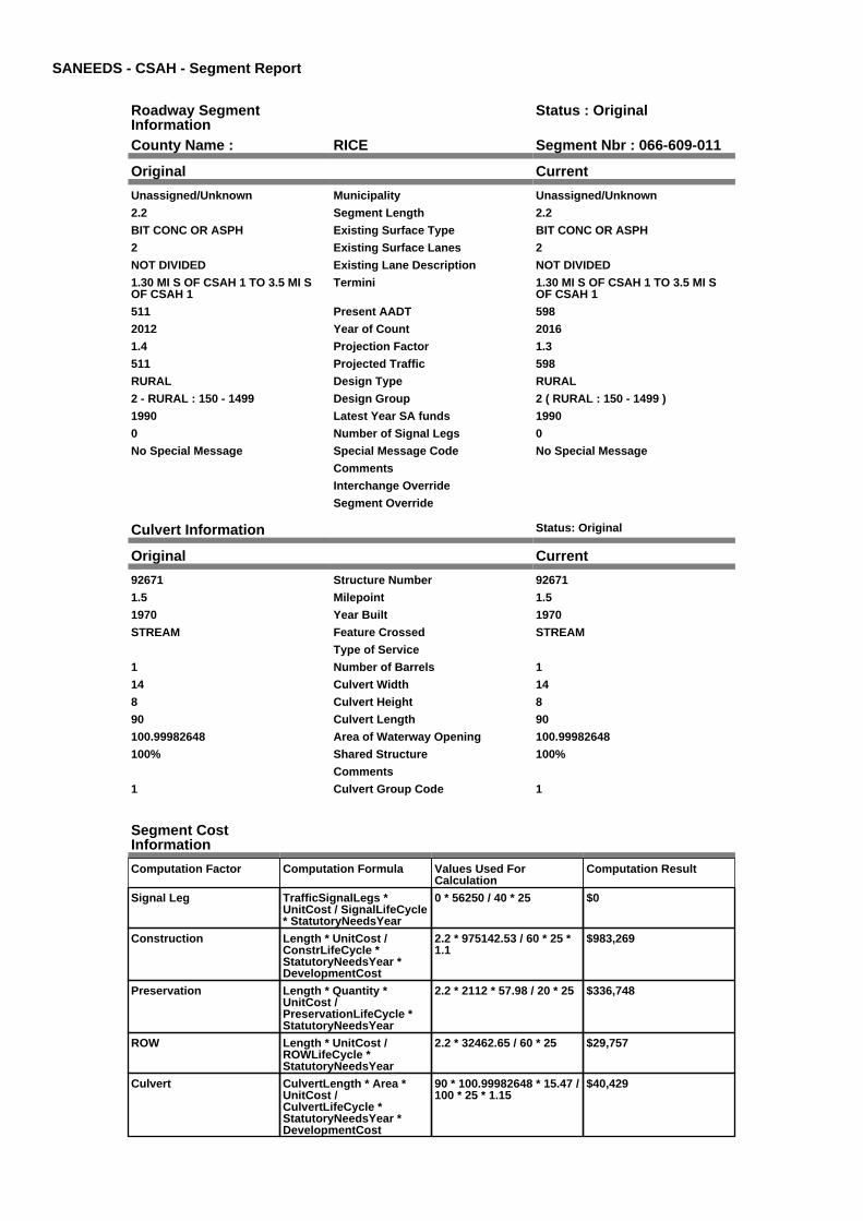
Original Current
Unassigned/Unknown Municipality Unassigned/Unknown
2.2 Segment Length 2.2
BIT CONC OR ASPH Existing Surface Type BIT CONC OR ASPH
2 Existing Surface Lanes 2
NOT DIVIDED Existing Lane Description NOT DIVIDED
1.30 MI S OF CSAH 1 TO 3.5 MI SOF CSAH 1
Termini 1.30 MI S OF CSAH 1 TO 3.5 MI SOF CSAH 1
511 Present AADT 598
2012 Year of Count 2016
1.4 Projection Factor 1.3
511 Projected Traffic 598
RURAL Design Type RURAL
2 - RURAL : 150 - 1499 Design Group 2 ( RURAL : 150 - 1499 )
1990 Latest Year SA funds 1990
0 Number of Signal Legs 0
No Special Message Special Message Code No Special Message
Comments
Interchange Override
Segment Override
Culvert Information Status: Original
Original Current
92671 Structure Number 92671
1.5 Milepoint 1.5
1970 Year Built 1970
STREAM Feature Crossed STREAM
Type of Service
1 Number of Barrels 1
14 Culvert Width 14
8 Culvert Height 8
90 Culvert Length 90
100.99982648 Area of Waterway Opening 100.99982648
100% Shared Structure 100%
Comments
1 Culvert Group Code 1
Segment CostInformation
Computation Factor Computation Formula Values Used ForCalculation
Computation Result
Signal Leg TrafficSignalLegs *UnitCost / SignalLifeCycle* StatutoryNeedsYear
0 * 56250 / 40 * 25 $0
Construction Length * UnitCost /ConstrLifeCycle *StatutoryNeedsYear *DevelopmentCost
2.2 * 975142.53 / 60 * 25 *1.1
$983,269
Preservation Length * Quantity *UnitCost /PreservationLifeCycle *StatutoryNeedsYear
2.2 * 2112 * 57.98 / 20 * 25 $336,748
ROW Length * UnitCost /ROWLifeCycle *StatutoryNeedsYear
2.2 * 32462.65 / 60 * 25 $29,757
Culvert CulvertLength * Area *UnitCost /CulvertLifeCycle *StatutoryNeedsYear *DevelopmentCost
90 * 100.99982648 * 15.47 /100 * 25 * 1.15
$40,429
Total Segment Cost Signal Leg + Construction+ Preservation + ROW +Culvert
$0 + $983,269 + $336,748+ $29,757 + $40,429
$1,390,203

SANEEDS - CSAH - Segment Report
Roadway SegmentInformation
Status : Original
County Name : RICE Segment Nbr : 066-609-020
Original Current
Unassigned/Unknown Municipality Unassigned/Unknown
4.1 Segment Length 4.1
BIT CONC OR ASPH Existing Surface Type BIT CONC OR ASPH
2 Existing Surface Lanes 2
NOT DIVIDED Existing Lane Description NOT DIVIDED
3.5 MI SOUTH OF CSAH 1 TOCSAH 46
Termini 3.5 MI SOUTH OF CSAH 1 TOCSAH 46
511 Present AADT 598
2012 Year of Count 2016
1.4 Projection Factor 1.3
511 Projected Traffic 598
RURAL Design Type RURAL
2 - RURAL : 150 - 1499 Design Group 2 ( RURAL : 150 - 1499 )
1990 Latest Year SA funds 1990
0 Number of Signal Legs 0
No Special Message Special Message Code No Special Message
Comments
Interchange Override
Segment Override
Segment CostInformation
Computation Factor Computation Formula Values Used ForCalculation
Computation Result
Signal Leg TrafficSignalLegs *UnitCost / SignalLifeCycle* StatutoryNeedsYear
0 * 56250 / 40 * 25 $0
Construction Length * UnitCost /ConstrLifeCycle *StatutoryNeedsYear *DevelopmentCost
4.1 * 975142.53 / 60 * 25 *1.1
$1,832,455
Preservation Length * Quantity *UnitCost /PreservationLifeCycle *StatutoryNeedsYear
4.1 * 2112 * 57.98 / 20 * 25 $627,576
ROW Length * UnitCost /ROWLifeCycle *StatutoryNeedsYear
4.1 * 32462.65 / 60 * 25 $55,457
Total Segment Cost Signal Leg + Construction+ Preservation + ROW
$0 + $1,832,455 + $627,576+ $55,457
$2,515,488

SANEEDS - CSAH - Segment Report
Roadway SegmentInformation
Status : Original
County Name : RICE Segment Nbr : 066-609-030
Original Current
Unassigned/Unknown Municipality Unassigned/Unknown
0.7 Segment Length 0.7
BIT CONC OR ASPH Existing Surface Type BIT CONC OR ASPH
2 Existing Surface Lanes 2
NOT DIVIDED Existing Lane Description NOT DIVIDED
CSAH 46 TO CR 76 Termini CSAH 46 TO CR 76
511 Present AADT 598
2012 Year of Count 2016
1.4 Projection Factor 1.3
511 Projected Traffic 598
RURAL Design Type RURAL
2 - RURAL : 150 - 1499 Design Group 2 ( RURAL : 150 - 1499 )
1992 Latest Year SA funds 1992
0 Number of Signal Legs 0
No Special Message Special Message Code No Special Message
Comments
Interchange Override
Segment Override
Segment CostInformation
Computation Factor Computation Formula Values Used ForCalculation
Computation Result
Signal Leg TrafficSignalLegs *UnitCost / SignalLifeCycle* StatutoryNeedsYear
0 * 56250 / 40 * 25 $0
Construction Length * UnitCost /ConstrLifeCycle *StatutoryNeedsYear *DevelopmentCost
0.7 * 975142.53 / 60 * 25 *1.1
$312,858
Preservation Length * Quantity *UnitCost /PreservationLifeCycle *StatutoryNeedsYear
0.7 * 2112 * 57.98 / 20 * 25 $107,147
ROW Length * UnitCost /ROWLifeCycle *StatutoryNeedsYear
0.7 * 32462.65 / 60 * 25 $9,468
Total Segment Cost Signal Leg + Construction+ Preservation + ROW
$0 + $312,858 + $107,147+ $9,468
$429,473

SANEEDS - CSAH - Segment Report
Roadway SegmentInformation
Status : Original
County Name : RICE Segment Nbr : 066-609-040
Original Current
Unassigned/Unknown Municipality Unassigned/Unknown
1.8 Segment Length 1.8
MIXED BITUMINOUS Existing Surface Type MIXED BITUMINOUS
2 Existing Surface Lanes 2
NOT DIVIDED Existing Lane Description NOT DIVIDED
COUNTY ROAD 76 TO TH 3 Termini COUNTY ROAD 76 TO TH 3
700 Present AADT 650
2012 Year of Count 2016
1.4 Projection Factor 1.3
700 Projected Traffic 650
RURAL Design Type RURAL
2 - RURAL : 150 - 1499 Design Group 2 ( RURAL : 150 - 1499 )
1999 Latest Year SA funds 1999
0 Number of Signal Legs 0
No Special Message Special Message Code No Special Message
COMBINED SEGS 031, 032 & 040 IN2005
Comments COMBINED SEGS 031, 032 & 040 IN2005
Interchange Override
Segment Override
RailRoadCrossingInformation
Status: Original
Original Current
CANADIAN PACIFIC RAILWAY RailRoad Name CANADIAN PACIFIC RAILWAY
876399W USDOT Number 876399W
1.2 Located at Milepoint 1.2
1 Mainline Tracks 1
SIGNS ONLY Protection Type SIGNS ONLY
2008 Last Year Protection Upgraded 2008
40 Crossing Length 40
Last Year Surfaced
100% Percentage of Cost 100%
Comments
Segment CostInformation
Computation Factor Computation Formula Values Used ForCalculation
Computation Result
Signal Leg TrafficSignalLegs *UnitCost / SignalLifeCycle* StatutoryNeedsYear
0 * 56250 / 40 * 25 $0
Construction Length * UnitCost /ConstrLifeCycle *StatutoryNeedsYear *DevelopmentCost
1.8 * 975142.53 / 60 * 25 *1.1
$804,493
Preservation Length * Quantity *UnitCost /PreservationLifeCycle *StatutoryNeedsYear
1.8 * 2112 * 57.98 / 20 * 25 $275,521
ROW Length * UnitCost /ROWLifeCycle *StatutoryNeedsYear
1.8 * 32462.65 / 60 * 25 $24,347
RR Crossing Protection UnitCost /RRCrossingLifeCycle *StatutoryNeedsYear
1500 / 25 * 25 $1,500
RR Crossing Surface SurfaceLength * UnitCost/ RRCrossingLifeCycle *StatutoryNeedsYear
40 * 1350 / 25 * 25 $54,000
Total Segment Cost Signal Leg + Construction+ Preservation + ROW +RR Crossing Protection +RR Crossing Surface
$0 + $804,493 + $275,521+ $24,347 + $1,500 +$54,000
$1,159,861

SANEEDS - CSAH - Segment Report
Roadway SegmentInformation
Status : Original
County Name : RICE Segment Nbr : 066-610-010
Original Current
Unassigned/Unknown Municipality Unassigned/Unknown
3.4 Segment Length 3.4
MIXED BITUMINOUS Existing Surface Type MIXED BITUMINOUS
2 Existing Surface Lanes 2
NOT DIVIDED Existing Lane Description NOT DIVIDED
W CO LINE TO JUNCTION CSAH 38 Termini W CO LINE TO JUNCTION CSAH 38
413 Present AADT 364
2012 Year of Count 2016
1.4 Projection Factor 1.3
413 Projected Traffic 364
RURAL Design Type RURAL
2 - RURAL : 150 - 1499 Design Group 2 ( RURAL : 150 - 1499 )
2010 Latest Year SA funds 2010
0 Number of Signal Legs 0
No Special Message Special Message Code No Special Message
2010 OVERLAY, SAP 66-610-005 Comments 2010 OVERLAY, SAP 66-610-005
Interchange Override
Segment Override
Segment CostInformation
Computation Factor Computation Formula Values Used ForCalculation
Computation Result
Signal Leg TrafficSignalLegs *UnitCost / SignalLifeCycle* StatutoryNeedsYear
0 * 56250 / 40 * 25 $0
Construction Length * UnitCost /ConstrLifeCycle *StatutoryNeedsYear *DevelopmentCost
3.4 * 975142.53 / 60 * 25 *1.1
$1,519,597
Preservation Length * Quantity *UnitCost /PreservationLifeCycle *StatutoryNeedsYear
3.4 * 2112 * 57.98 / 20 * 25 $520,428
ROW Length * UnitCost /ROWLifeCycle *StatutoryNeedsYear
3.4 * 32462.65 / 60 * 25 $45,989
Total Segment Cost Signal Leg + Construction+ Preservation + ROW
$0 + $1,519,597 + $520,428+ $45,989
$2,086,014

SANEEDS - CSAH - Segment Report
Roadway SegmentInformation
Status : Original
County Name : RICE Segment Nbr : 066-610-020
Original Current
Unassigned/Unknown Municipality Unassigned/Unknown
4.8 Segment Length 4.8
MIXED BITUMINOUS Existing Surface Type MIXED BITUMINOUS
2 Existing Surface Lanes 2
NOT DIVIDED Existing Lane Description NOT DIVIDED
JUNCTION CSAH 38 TO JUNCTIONTH 21
Termini JUNCTION CSAH 38 TO JUNCTIONTH 21
497 Present AADT 501
2012 Year of Count 2016
1.4 Projection Factor 1.3
497 Projected Traffic 501
RURAL Design Type RURAL
2 - RURAL : 150 - 1499 Design Group 2 ( RURAL : 150 - 1499 )
2010 Latest Year SA funds 2010
0 Number of Signal Legs 0
No Special Message Special Message Code No Special Message
2010 OVERLAY, SAP 66-610-005 Comments 2010 OVERLAY, SAP 66-610-005
Interchange Override
Segment Override
Segment CostInformation
Computation Factor Computation Formula Values Used ForCalculation
Computation Result
Signal Leg TrafficSignalLegs *UnitCost / SignalLifeCycle* StatutoryNeedsYear
0 * 56250 / 40 * 25 $0
Construction Length * UnitCost /ConstrLifeCycle *StatutoryNeedsYear *DevelopmentCost
4.8 * 975142.53 / 60 * 25 *1.1
$2,145,314
Preservation Length * Quantity *UnitCost /PreservationLifeCycle *StatutoryNeedsYear
4.8 * 2112 * 57.98 / 20 * 25 $734,723
ROW Length * UnitCost /ROWLifeCycle *StatutoryNeedsYear
4.8 * 32462.65 / 60 * 25 $64,925
Total Segment Cost Signal Leg + Construction+ Preservation + ROW
$0 + $2,145,314 + $734,723+ $64,925
$2,944,962

SANEEDS - CSAH - Segment Report
Roadway SegmentInformation
Status : Original
County Name : RICE Segment Nbr : 066-611-010
Original Current
FARIBAULT Municipality FARIBAULT
0.05 Segment Length 0.05
BIT CONC OR ASPH Existing Surface Type BIT CONC OR ASPH
4 Existing Surface Lanes 4
NOT DIVIDED Existing Lane Description NOT DIVIDED
TH 21 TO CROCKERS CREEK Termini TH 21 TO CROCKERS CREEK
11760 Present AADT 10920
2012 Year of Count 2016
1.4 Projection Factor 1.3
11760 Projected Traffic 10920
URBAN Design Type URBAN
6 - URBAN : 10000 - 19999 Design Group 6 ( URBAN : 10000 - 19999 )
2010 Latest Year SA funds 2010
1 Number of Signal Legs 1
No Special Message Special Message Code No Special Message
GRADED 2010, SAP 66-611-010 Comments GRADED 2010, SAP 66-611-010
Interchange Override
Segment Override
Segment CostInformation
Computation Factor Computation Formula Values Used ForCalculation
Computation Result
Signal Leg TrafficSignalLegs *UnitCost / SignalLifeCycle* StatutoryNeedsYear
1 * 56250 / 40 * 25 $35,156
Construction Length * UnitCost /ConstrLifeCycle *StatutoryNeedsYear *DevelopmentCost
0.05 * 2522366.1 / 60 * 25 *1.15
$60,432
Preservation Length * Quantity *UnitCost /PreservationLifeCycle *StatutoryNeedsYear
0.05 * 3696 * 57.98 / 15 * 25 $17,858
ROW Length * UnitCost /ROWLifeCycle *StatutoryNeedsYear
0.05 * 479669.82 / 60 * 25 $9,993
Total Segment Cost Signal Leg + Construction+ Preservation + ROW
$35,156 + $60,432 +$17,858 + $9,993
$123,439

SANEEDS - CSAH - Segment Report
Roadway SegmentInformation
Status : Original
County Name : RICE Segment Nbr : 066-611-011
Original Current
FARIBAULT Municipality FARIBAULT
0.42 Segment Length 0.42
BIT CONC OR ASPH Existing Surface Type BIT CONC OR ASPH
2 Existing Surface Lanes 2
NOT DIVIDED Existing Lane Description NOT DIVIDED
CROCKERS CREEK TO 0.17 M EOF W LIMS
Termini CROCKERS CREEK TO 0.17 M EOF W LIMS
11760 Present AADT 10920
2012 Year of Count 2016
1.4 Projection Factor 1.3
11760 Projected Traffic 10920
URBAN Design Type URBAN
6 - URBAN : 10000 - 19999 Design Group 6 ( URBAN : 10000 - 19999 )
1998 Latest Year SA funds 1998
0 Number of Signal Legs 0
No Special Message Special Message Code No Special Message
Comments
Interchange Override
Segment Override
Segment CostInformation
Computation Factor Computation Formula Values Used ForCalculation
Computation Result
Signal Leg TrafficSignalLegs *UnitCost / SignalLifeCycle* StatutoryNeedsYear
0 * 56250 / 40 * 25 $0
Construction Length * UnitCost /ConstrLifeCycle *StatutoryNeedsYear *DevelopmentCost
0.42 * 2522366.1 / 60 * 25 *1.15
$507,626
Preservation Length * Quantity *UnitCost /PreservationLifeCycle *StatutoryNeedsYear
0.42 * 3696 * 57.98 / 15 * 25 $150,006
ROW Length * UnitCost /ROWLifeCycle *StatutoryNeedsYear
0.42 * 479669.82 / 60 * 25 $83,942
Total Segment Cost Signal Leg + Construction+ Preservation + ROW
$0 + $507,626 + $150,006+ $83,942
$741,574

SANEEDS - CSAH - Segment Report
Roadway SegmentInformation
Status : Original
County Name : RICE Segment Nbr : 066-611-012
Original Current
FARIBAULT Municipality FARIBAULT
0.08 Segment Length 0.08
MIXED BITUMINOUS Existing Surface Type MIXED BITUMINOUS
2 Existing Surface Lanes 2
NOT DIVIDED Existing Lane Description NOT DIVIDED
0.17 MI TO 0.09 MI E TO W LIMSFARIBAULT
Termini 0.17 MI TO 0.09 MI E TO W LIMSFARIBAULT
8400 Present AADT 7540
2012 Year of Count 2016
1.4 Projection Factor 1.3
8400 Projected Traffic 7540
URBAN Design Type URBAN
5 - URBAN : 0 - 9999 Design Group 5 ( URBAN : 0 - 9999 )
1998 Latest Year SA funds 1998
0 Number of Signal Legs 0
No Special Message Special Message Code No Special Message
Comments
Interchange Override
Segment Override
Segment CostInformation
Computation Factor Computation Formula Values Used ForCalculation
Computation Result
Signal Leg TrafficSignalLegs *UnitCost / SignalLifeCycle* StatutoryNeedsYear
0 * 56250 / 40 * 25 $0
Construction Length * UnitCost /ConstrLifeCycle *StatutoryNeedsYear *DevelopmentCost
0.08 * 2904860.94 / 60 * 25* 1.15
$111,353
Preservation Length * Quantity *UnitCost /PreservationLifeCycle *StatutoryNeedsYear
0.08 * 2904 * 57.98 / 15 * 25 $22,450
ROW Length * UnitCost /ROWLifeCycle *StatutoryNeedsYear
0.08 * 51162.01 / 60 * 25 $1,705
Total Segment Cost Signal Leg + Construction+ Preservation + ROW
$0 + $111,353 + $22,450 +$1,705
$135,508

SANEEDS - CSAH - Segment Report
Roadway SegmentInformation
Status : Original
County Name : RICE Segment Nbr : 066-611-016
Original Current
FARIBAULT Municipality FARIBAULT
0.09 Segment Length 0.09
MIXED BITUMINOUS Existing Surface Type MIXED BITUMINOUS
2 Existing Surface Lanes 2
NOT DIVIDED Existing Lane Description NOT DIVIDED
0.17 MI E TO W LIMS FARIBAULT Termini 0.17 MI E TO W LIMS FARIBAULT
8400 Present AADT 7540
2012 Year of Count 2016
1.4 Projection Factor 1.3
8400 Projected Traffic 7540
URBAN Design Type URBAN
5 - URBAN : 0 - 9999 Design Group 5 ( URBAN : 0 - 9999 )
2000 Latest Year SA funds 2000
0 Number of Signal Legs 0
No Special Message Special Message Code No Special Message
Comments
Interchange Override
Segment Override
Segment CostInformation
Computation Factor Computation Formula Values Used ForCalculation
Computation Result
Signal Leg TrafficSignalLegs *UnitCost / SignalLifeCycle* StatutoryNeedsYear
0 * 56250 / 40 * 25 $0
Construction Length * UnitCost /ConstrLifeCycle *StatutoryNeedsYear *DevelopmentCost
0.09 * 2904860.94 / 60 * 25* 1.15
$125,272
Preservation Length * Quantity *UnitCost /PreservationLifeCycle *StatutoryNeedsYear
0.09 * 2904 * 57.98 / 15 * 25 $25,256
ROW Length * UnitCost /ROWLifeCycle *StatutoryNeedsYear
0.09 * 51162.01 / 60 * 25 $1,919
Total Segment Cost Signal Leg + Construction+ Preservation + ROW
$0 + $125,272 + $25,256 +$1,919
$152,447

SANEEDS - CSAH - Segment Report
Roadway SegmentInformation
Status : Original
County Name : RICE Segment Nbr : 066-611-020
Original Current
Unassigned/Unknown Municipality Unassigned/Unknown
0.3 Segment Length 0.3
MIXED BITUMINOUS Existing Surface Type MIXED BITUMINOUS
2 Existing Surface Lanes 2
NOT DIVIDED Existing Lane Description NOT DIVIDED
W LIMS FARIBAULT TO FAI 35 Termini W LIMS FARIBAULT TO FAI 35
6580 Present AADT 5655
2012 Year of Count 2016
1.4 Projection Factor 1.3
6580 Projected Traffic 5655
URBAN Design Type URBAN
5 - URBAN : 0 - 9999 Design Group 5 ( URBAN : 0 - 9999 )
2012 Latest Year SA funds 2012
0 Number of Signal Legs 0
No Special Message Special Message Code No Special Message
2012 SP 066-611-015 RECONST
RECONSTRUCT IN 2012 - RURALTO URBAN
Comments 2012 SP 066-611-015 RECONST
RECONSTRUCT IN 2012 - RURALTO URBAN
Interchange Override
Segment Override
Segment CostInformation
Computation Factor Computation Formula Values Used ForCalculation
Computation Result
Signal Leg TrafficSignalLegs *UnitCost / SignalLifeCycle* StatutoryNeedsYear
0 * 56250 / 40 * 25 $0
Construction Length * UnitCost /ConstrLifeCycle *StatutoryNeedsYear *DevelopmentCost
0.3 * 2904860.94 / 60 * 25 *1.15
$417,574
Preservation Length * Quantity *UnitCost /PreservationLifeCycle *StatutoryNeedsYear
0.3 * 2904 * 57.98 / 15 * 25 $84,187
ROW Length * UnitCost /ROWLifeCycle *StatutoryNeedsYear
0.3 * 51162.01 / 60 * 25 $6,395
Total Segment Cost Signal Leg + Construction+ Preservation + ROW
$0 + $417,574 + $84,187 +$6,395
$508,156

SANEEDS - CSAH - Segment Report
Roadway SegmentInformation
Status : Original
County Name : RICE Segment Nbr : 066-611-025
Original Current
FARIBAULT Municipality FARIBAULT
0.1 Segment Length 0.1
MIXED BITUMINOUS Existing Surface Type MIXED BITUMINOUS
2 Existing Surface Lanes 2
NOT DIVIDED Existing Lane Description NOT DIVIDED
FAI 35 TO .10 MILES WEST Termini FAI 35 TO .10 MILES WEST
3080 Present AADT 3120
2012 Year of Count 2016
1.4 Projection Factor 1.3
3080 Projected Traffic 3120
URBAN Design Type URBAN
5 - URBAN : 0 - 9999 Design Group 5 ( URBAN : 0 - 9999 )
2012 Latest Year SA funds 2012
0 Number of Signal Legs 0
No Special Message Special Message Code No Special Message
2012 SP 066-611-015 RECONST
RECONSTRUCT IN 2012 - RURALTO URBAN
Comments 2012 SP 066-611-015 RECONST
RECONSTRUCT IN 2012 - RURALTO URBAN
Interchange Override
Segment Override
Segment CostInformation
Computation Factor Computation Formula Values Used ForCalculation
Computation Result
Signal Leg TrafficSignalLegs *UnitCost / SignalLifeCycle* StatutoryNeedsYear
0 * 56250 / 40 * 25 $0
Construction Length * UnitCost /ConstrLifeCycle *StatutoryNeedsYear *DevelopmentCost
0.1 * 2904860.94 / 60 * 25 *1.15
$139,191
Preservation Length * Quantity *UnitCost /PreservationLifeCycle *StatutoryNeedsYear
0.1 * 2904 * 57.98 / 15 * 25 $28,062
ROW Length * UnitCost /ROWLifeCycle *StatutoryNeedsYear
0.1 * 51162.01 / 60 * 25 $2,132
Total Segment Cost Signal Leg + Construction+ Preservation + ROW
$0 + $139,191 + $28,062 +$2,132
$169,385

SANEEDS - CSAH - Segment Report
Roadway SegmentInformation
Status : Original
County Name : RICE Segment Nbr : 066-611-029
Original Current
FARIBAULT Municipality FARIBAULT
0.1 Segment Length 0.1
MIXED BITUMINOUS Existing Surface Type MIXED BITUMINOUS
2 Existing Surface Lanes 2
NOT DIVIDED Existing Lane Description NOT DIVIDED
FAI 35 TO CSAH 38 Termini FAI 35 TO CSAH 38
3080 Present AADT 3120
2012 Year of Count 2016
1.4 Projection Factor 1.3
3080 Projected Traffic 3120
URBAN Design Type URBAN
5 - URBAN : 0 - 9999 Design Group 5 ( URBAN : 0 - 9999 )
2012 Latest Year SA funds 2012
0 Number of Signal Legs 0
No Special Message Special Message Code No Special Message
2012 SP 066-611-015 RECONST
GRADED 2007, SAP 66-611-011
Comments 2012 SP 066-611-015 RECONST
GRADED 2007, SAP 66-611-011
Interchange Override
Segment Override
Segment CostInformation
Computation Factor Computation Formula Values Used ForCalculation
Computation Result
Signal Leg TrafficSignalLegs *UnitCost / SignalLifeCycle* StatutoryNeedsYear
0 * 56250 / 40 * 25 $0
Construction Length * UnitCost /ConstrLifeCycle *StatutoryNeedsYear *DevelopmentCost
0.1 * 2904860.94 / 60 * 25 *1.15
$139,191
Preservation Length * Quantity *UnitCost /PreservationLifeCycle *StatutoryNeedsYear
0.1 * 2904 * 57.98 / 15 * 25 $28,062
ROW Length * UnitCost /ROWLifeCycle *StatutoryNeedsYear
0.1 * 51162.01 / 60 * 25 $2,132
Total Segment Cost Signal Leg + Construction+ Preservation + ROW
$0 + $139,191 + $28,062 +$2,132
$169,385

SANEEDS - CSAH - Segment Report
Roadway SegmentInformation
Status : Original
County Name : RICE Segment Nbr : 066-611-030
Original Current
Unassigned/Unknown Municipality Unassigned/Unknown
0.6 Segment Length 0.6
MIXED BITUMINOUS Existing Surface Type MIXED BITUMINOUS
2 Existing Surface Lanes 2
NOT DIVIDED Existing Lane Description NOT DIVIDED
CSAH 38 TO 0.8MI NW Termini CSAH 38 TO 0.8MI NW
3080 Present AADT 3120
2012 Year of Count 2016
1.4 Projection Factor 1.3
3080 Projected Traffic 3120
URBAN Design Type URBAN
5 - URBAN : 0 - 9999 Design Group 5 ( URBAN : 0 - 9999 )
2008 Latest Year SA funds 2008
0 Number of Signal Legs 0
No Special Message Special Message Code No Special Message
GRADING 2007 SAP 66-611-011
SAP 66-611-12 GRADE, SURFACEAND STORM SEWER; AWARDED4-22-08, APS
Comments GRADING 2007 SAP 66-611-011
SAP 66-611-12 GRADE, SURFACEAND STORM SEWER; AWARDED4-22-08, APS
Interchange Override
Segment Override
Segment CostInformation
Computation Factor Computation Formula Values Used ForCalculation
Computation Result
Signal Leg TrafficSignalLegs *UnitCost / SignalLifeCycle* StatutoryNeedsYear
0 * 56250 / 40 * 25 $0
Construction Length * UnitCost /ConstrLifeCycle *StatutoryNeedsYear *DevelopmentCost
0.6 * 2904860.94 / 60 * 25 *1.15
$835,148
Preservation Length * Quantity *UnitCost /PreservationLifeCycle *StatutoryNeedsYear
0.6 * 2904 * 57.98 / 15 * 25 $168,374
ROW Length * UnitCost /ROWLifeCycle *StatutoryNeedsYear
0.6 * 51162.01 / 60 * 25 $12,791
Total Segment Cost Signal Leg + Construction+ Preservation + ROW
$0 + $835,148 + $168,374+ $12,791
$1,016,313
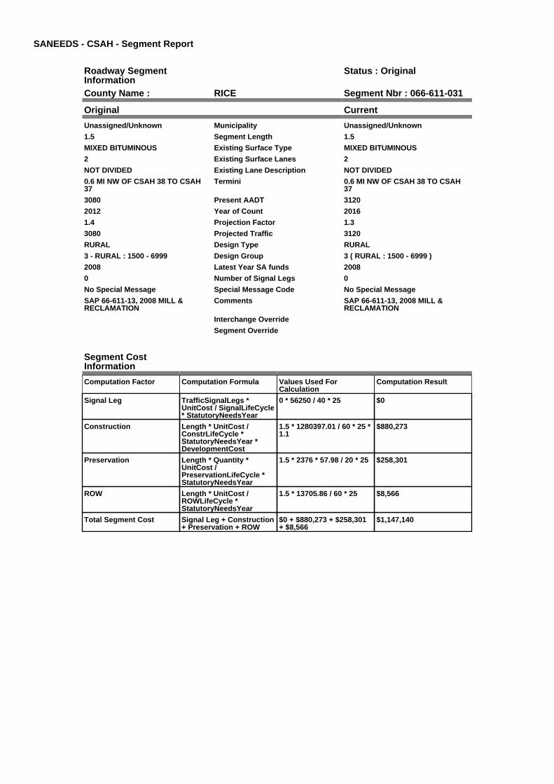
SANEEDS - CSAH - Segment Report
Roadway SegmentInformation
Status : Original
County Name : RICE Segment Nbr : 066-611-031
Original Current
Unassigned/Unknown Municipality Unassigned/Unknown
1.5 Segment Length 1.5
MIXED BITUMINOUS Existing Surface Type MIXED BITUMINOUS
2 Existing Surface Lanes 2
NOT DIVIDED Existing Lane Description NOT DIVIDED
0.6 MI NW OF CSAH 38 TO CSAH37
Termini 0.6 MI NW OF CSAH 38 TO CSAH37
3080 Present AADT 3120
2012 Year of Count 2016
1.4 Projection Factor 1.3
3080 Projected Traffic 3120
RURAL Design Type RURAL
3 - RURAL : 1500 - 6999 Design Group 3 ( RURAL : 1500 - 6999 )
2008 Latest Year SA funds 2008
0 Number of Signal Legs 0
No Special Message Special Message Code No Special Message
SAP 66-611-13, 2008 MILL &RECLAMATION
Comments SAP 66-611-13, 2008 MILL &RECLAMATION
Interchange Override
Segment Override
Segment CostInformation
Computation Factor Computation Formula Values Used ForCalculation
Computation Result
Signal Leg TrafficSignalLegs *UnitCost / SignalLifeCycle* StatutoryNeedsYear
0 * 56250 / 40 * 25 $0
Construction Length * UnitCost /ConstrLifeCycle *StatutoryNeedsYear *DevelopmentCost
1.5 * 1280397.01 / 60 * 25 *1.1
$880,273
Preservation Length * Quantity *UnitCost /PreservationLifeCycle *StatutoryNeedsYear
1.5 * 2376 * 57.98 / 20 * 25 $258,301
ROW Length * UnitCost /ROWLifeCycle *StatutoryNeedsYear
1.5 * 13705.86 / 60 * 25 $8,566
Total Segment Cost Signal Leg + Construction+ Preservation + ROW
$0 + $880,273 + $258,301+ $8,566
$1,147,140

SANEEDS - CSAH - Segment Report
Roadway SegmentInformation
Status : Original
County Name : RICE Segment Nbr : 066-611-040
Original Current
Unassigned/Unknown Municipality Unassigned/Unknown
1.6 Segment Length 1.6
MIXED BITUMINOUS Existing Surface Type MIXED BITUMINOUS
2 Existing Surface Lanes 2
NOT DIVIDED Existing Lane Description NOT DIVIDED
CSAH 37 TO 1.0 MI SO OF TH 21 Termini CSAH 37 TO 1.0 MI SO OF TH 21
714 Present AADT 637
2012 Year of Count 2016
1.4 Projection Factor 1.3
714 Projected Traffic 637
RURAL Design Type RURAL
2 - RURAL : 150 - 1499 Design Group 2 ( RURAL : 150 - 1499 )
2015 Latest Year SA funds 2015
0 Number of Signal Legs 0
No Special Message Special Message Code No Special Message
2015 SAP 066-611-016 SOIL NAILS,BASE & BIT PAVING
S.A.P. 66-611-09 MILL ANDOVERLAY, LET 4-7-03 (APS).
Comments 2015 SAP 066-611-016 SOIL NAILS,BASE & BIT PAVING
S.A.P. 66-611-09 MILL ANDOVERLAY, LET 4-7-03 (APS).
Interchange Override
Segment Override
Culvert Information Status: Original
Original Current
L3945 Structure Number L3945
4.651 Milepoint 4.651
1940 Year Built 1940
STREAM Feature Crossed STREAM
Type of Service
1 Number of Barrels 1
10 Culvert Width 10
6 Culvert Height 6
58 Culvert Length 58
60.00013138 Area of Waterway Opening 60.00013138
100% Shared Structure 100%
Comments
1 Culvert Group Code 1
Segment CostInformation
Computation Factor Computation Formula Values Used ForCalculation
Computation Result
Signal Leg TrafficSignalLegs *UnitCost / SignalLifeCycle* StatutoryNeedsYear
0 * 56250 / 40 * 25 $0
Construction Length * UnitCost /ConstrLifeCycle *StatutoryNeedsYear *DevelopmentCost
1.6 * 975142.53 / 60 * 25 *1.1
$715,105
Preservation Length * Quantity *UnitCost /PreservationLifeCycle *StatutoryNeedsYear
1.6 * 2112 * 57.98 / 20 * 25 $244,908
ROW Length * UnitCost /ROWLifeCycle *StatutoryNeedsYear
1.6 * 32462.65 / 60 * 25 $21,642
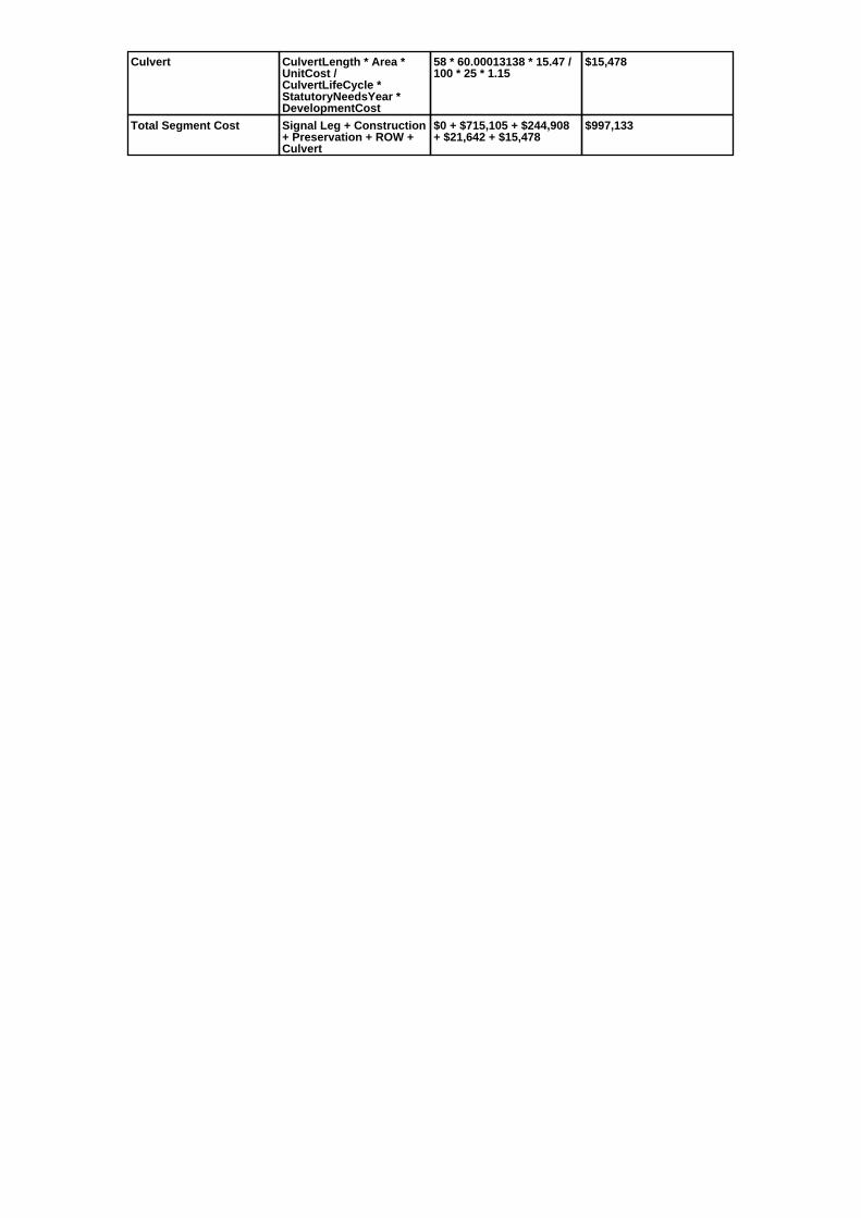
Culvert CulvertLength * Area *UnitCost /CulvertLifeCycle *StatutoryNeedsYear *DevelopmentCost
58 * 60.00013138 * 15.47 /100 * 25 * 1.15
$15,478
Total Segment Cost Signal Leg + Construction+ Preservation + ROW +Culvert
$0 + $715,105 + $244,908+ $21,642 + $15,478
$997,133

SANEEDS - CSAH - Segment Report
Roadway SegmentInformation
Status : Original
County Name : RICE Segment Nbr : 066-611-050
Original Current
Unassigned/Unknown Municipality Unassigned/Unknown
1 Segment Length 1
MIXED BITUMINOUS Existing Surface Type MIXED BITUMINOUS
2 Existing Surface Lanes 2
NOT DIVIDED Existing Lane Description NOT DIVIDED
1.0 MI SO OF TH 21 TO TH 21 Termini 1.0 MI SO OF TH 21 TO TH 21
714 Present AADT 637
2012 Year of Count 2016
1.4 Projection Factor 1.3
714 Projected Traffic 637
RURAL Design Type RURAL
2 - RURAL : 150 - 1499 Design Group 2 ( RURAL : 150 - 1499 )
2003 Latest Year SA funds 2003
0 Number of Signal Legs 0
No Special Message Special Message Code No Special Message
S.A.P. 66-611-09 MILL ANDOVERLAY, LET 4-7-03 (APS).
Comments S.A.P. 66-611-09 MILL ANDOVERLAY, LET 4-7-03 (APS).
Interchange Override
Segment Override
Bridge Information Status: Original
Original Current
66506 Structure Number 66506
5.35 Milepoint 5.35
1965 Year Built 1965
CANNON RIVER Feature Crossed CANNON RIVER
Type of Service
Number of Spans
247 Bridge Length 247
42.1 Bridge Width 42.1
100% Shared Structure 100%
Comments
2 ( 150-999,999 ) Bridge Group Code 2 ( 150-999,999 )
Segment CostInformation
Computation Factor Computation Formula Values Used ForCalculation
Computation Result
Signal Leg TrafficSignalLegs *UnitCost / SignalLifeCycle* StatutoryNeedsYear
0 * 56250 / 40 * 25 $0
Construction Length * UnitCost /ConstrLifeCycle *StatutoryNeedsYear *DevelopmentCost
1 * 975142.53 / 60 * 25 * 1.1 $446,940
Preservation Length * Quantity *UnitCost /PreservationLifeCycle *StatutoryNeedsYear
1 * 2112 * 57.98 / 20 * 25 $153,067
ROW Length * UnitCost /ROWLifeCycle *StatutoryNeedsYear
1 * 32462.65 / 60 * 25 $13,526
Bridge BridgeLength *BridgeWidth * UnitCost /BridgeLifeCycle *StatutoryNeedsYear *DevelopmentCost
247 * 42.1 * 138 / 80 * 25 *1.15
$515,711
Total Segment Cost Signal Leg + Construction+ Preservation + ROW +Bridge
$0 + $446,940 + $153,067+ $13,526 + $515,711
$1,129,244

SANEEDS - CSAH - Segment Report
Roadway SegmentInformation
Status : Original
County Name : RICE Segment Nbr : 066-612-020
Original Current
Unassigned/Unknown Municipality Unassigned/Unknown
1.5 Segment Length 1.5
BIT CONC OR ASPH Existing Surface Type BIT CONC OR ASPH
2 Existing Surface Lanes 2
NOT DIVIDED Existing Lane Description NOT DIVIDED
ALONG W CO LINE TO 1.40 MI WOF CSAH 16
Termini ALONG W CO LINE TO 1.40 MI WOF CSAH 16
224 Present AADT 267
2012 Year of Count 2016
1.4 Projection Factor 1.3
224 Projected Traffic 267
RURAL Design Type RURAL
2 - RURAL : 150 - 1499 Design Group 2 ( RURAL : 150 - 1499 )
1998 Latest Year SA funds 1998
0 Number of Signal Legs 0
No Special Message Special Message Code No Special Message
Comments
Interchange Override
Segment Override
Segment CostInformation
Computation Factor Computation Formula Values Used ForCalculation
Computation Result
Signal Leg TrafficSignalLegs *UnitCost / SignalLifeCycle* StatutoryNeedsYear
0 * 56250 / 40 * 25 $0
Construction Length * UnitCost /ConstrLifeCycle *StatutoryNeedsYear *DevelopmentCost
1.5 * 975142.53 / 60 * 25 *1.1
$670,410
Preservation Length * Quantity *UnitCost /PreservationLifeCycle *StatutoryNeedsYear
1.5 * 2112 * 57.98 / 20 * 25 $229,601
ROW Length * UnitCost /ROWLifeCycle *StatutoryNeedsYear
1.5 * 32462.65 / 60 * 25 $20,289
Total Segment Cost Signal Leg + Construction+ Preservation + ROW
$0 + $670,410 + $229,601+ $20,289
$920,300

SANEEDS - CSAH - Segment Report
Roadway SegmentInformation
Status : Original
County Name : RICE Segment Nbr : 066-612-021
Original Current
Unassigned/Unknown Municipality Unassigned/Unknown
1.4 Segment Length 1.4
MIXED BITUMINOUS Existing Surface Type MIXED BITUMINOUS
2 Existing Surface Lanes 2
NOT DIVIDED Existing Lane Description NOT DIVIDED
1.4 MI W OF CSAH 16 TO CSAH 16 Termini 1.4 MI W OF CSAH 16 TO CSAH 16
224 Present AADT 267
2012 Year of Count 2016
1.4 Projection Factor 1.3
224 Projected Traffic 267
RURAL Design Type RURAL
2 - RURAL : 150 - 1499 Design Group 2 ( RURAL : 150 - 1499 )
2006 Latest Year SA funds 2006
0 Number of Signal Legs 0
No Special Message Special Message Code No Special Message
66-612-016 RESURFACED IN 2006 Comments 66-612-016 RESURFACED IN 2006
Interchange Override
Segment Override
Segment CostInformation
Computation Factor Computation Formula Values Used ForCalculation
Computation Result
Signal Leg TrafficSignalLegs *UnitCost / SignalLifeCycle* StatutoryNeedsYear
0 * 56250 / 40 * 25 $0
Construction Length * UnitCost /ConstrLifeCycle *StatutoryNeedsYear *DevelopmentCost
1.4 * 975142.53 / 60 * 25 *1.1
$625,716
Preservation Length * Quantity *UnitCost /PreservationLifeCycle *StatutoryNeedsYear
1.4 * 2112 * 57.98 / 20 * 25 $214,294
ROW Length * UnitCost /ROWLifeCycle *StatutoryNeedsYear
1.4 * 32462.65 / 60 * 25 $18,937
Total Segment Cost Signal Leg + Construction+ Preservation + ROW
$0 + $625,716 + $214,294+ $18,937
$858,947
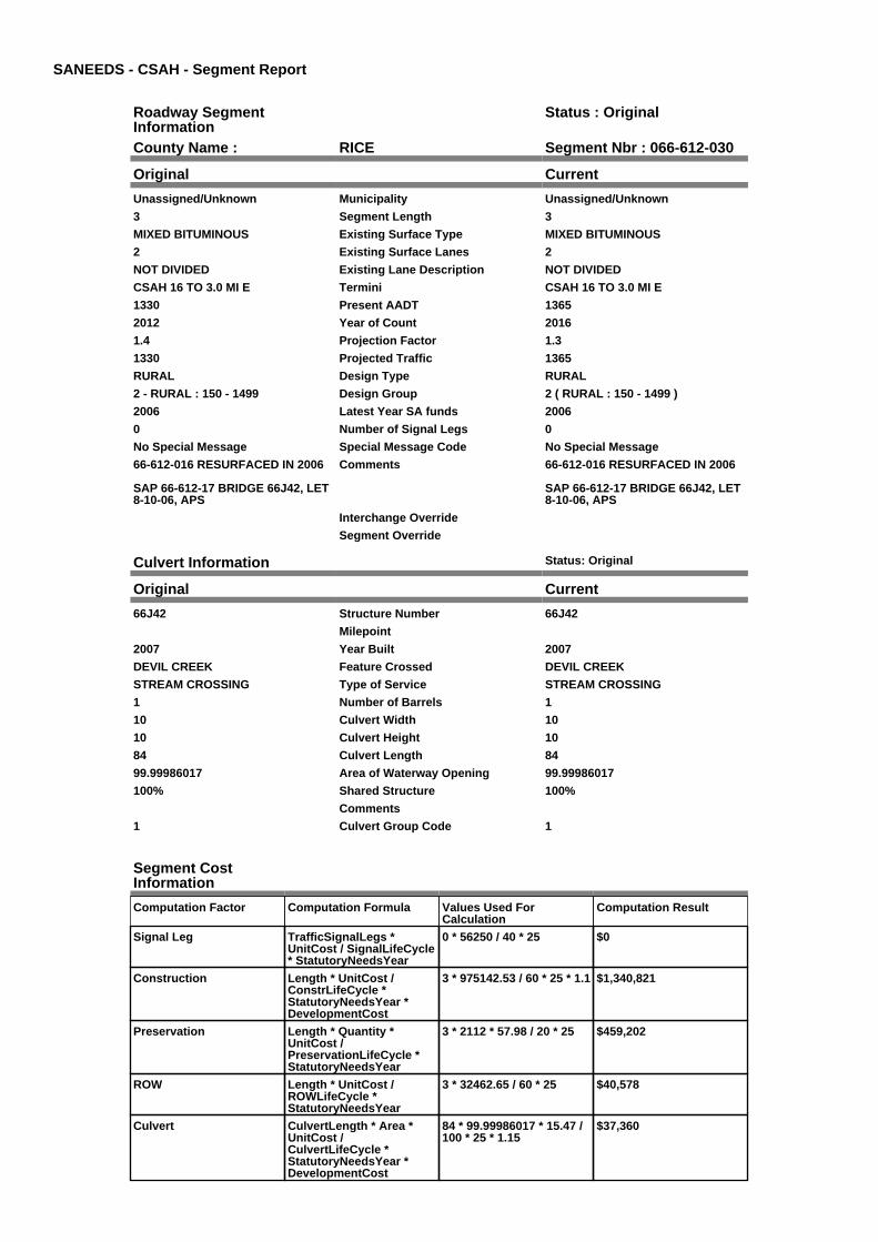
SANEEDS - CSAH - Segment Report
Roadway SegmentInformation
Status : Original
County Name : RICE Segment Nbr : 066-612-030
Original Current
Unassigned/Unknown Municipality Unassigned/Unknown
3 Segment Length 3
MIXED BITUMINOUS Existing Surface Type MIXED BITUMINOUS
2 Existing Surface Lanes 2
NOT DIVIDED Existing Lane Description NOT DIVIDED
CSAH 16 TO 3.0 MI E Termini CSAH 16 TO 3.0 MI E
1330 Present AADT 1365
2012 Year of Count 2016
1.4 Projection Factor 1.3
1330 Projected Traffic 1365
RURAL Design Type RURAL
2 - RURAL : 150 - 1499 Design Group 2 ( RURAL : 150 - 1499 )
2006 Latest Year SA funds 2006
0 Number of Signal Legs 0
No Special Message Special Message Code No Special Message
66-612-016 RESURFACED IN 2006
SAP 66-612-17 BRIDGE 66J42, LET8-10-06, APS
Comments 66-612-016 RESURFACED IN 2006
SAP 66-612-17 BRIDGE 66J42, LET8-10-06, APS
Interchange Override
Segment Override
Culvert Information Status: Original
Original Current
66J42 Structure Number 66J42
Milepoint
2007 Year Built 2007
DEVIL CREEK Feature Crossed DEVIL CREEK
STREAM CROSSING Type of Service STREAM CROSSING
1 Number of Barrels 1
10 Culvert Width 10
10 Culvert Height 10
84 Culvert Length 84
99.99986017 Area of Waterway Opening 99.99986017
100% Shared Structure 100%
Comments
1 Culvert Group Code 1
Segment CostInformation
Computation Factor Computation Formula Values Used ForCalculation
Computation Result
Signal Leg TrafficSignalLegs *UnitCost / SignalLifeCycle* StatutoryNeedsYear
0 * 56250 / 40 * 25 $0
Construction Length * UnitCost /ConstrLifeCycle *StatutoryNeedsYear *DevelopmentCost
3 * 975142.53 / 60 * 25 * 1.1 $1,340,821
Preservation Length * Quantity *UnitCost /PreservationLifeCycle *StatutoryNeedsYear
3 * 2112 * 57.98 / 20 * 25 $459,202
ROW Length * UnitCost /ROWLifeCycle *StatutoryNeedsYear
3 * 32462.65 / 60 * 25 $40,578
Culvert CulvertLength * Area *UnitCost /CulvertLifeCycle *StatutoryNeedsYear *DevelopmentCost
84 * 99.99986017 * 15.47 /100 * 25 * 1.15
$37,360

Total Segment Cost Signal Leg + Construction+ Preservation + ROW +Culvert
$0 + $1,340,821 + $459,202+ $40,578 + $37,360
$1,877,961

SANEEDS - CSAH - Segment Report
Roadway SegmentInformation
Status : Original
County Name : RICE Segment Nbr : 066-612-031
Original Current
Unassigned/Unknown Municipality Unassigned/Unknown
3.5 Segment Length 3.5
MIXED BITUMINOUS Existing Surface Type MIXED BITUMINOUS
2 Existing Surface Lanes 2
NOT DIVIDED Existing Lane Description NOT DIVIDED
3.0 MI E CSAH 16 TO CSAH 13 Termini 3.0 MI E CSAH 16 TO CSAH 13
1330 Present AADT 1365
2012 Year of Count 2016
1.4 Projection Factor 1.3
1330 Projected Traffic 1365
RURAL Design Type RURAL
2 - RURAL : 150 - 1499 Design Group 2 ( RURAL : 150 - 1499 )
2006 Latest Year SA funds 2006
0 Number of Signal Legs 0
No Special Message Special Message Code No Special Message
66-612-016 RESURFACED IN 2006 Comments 66-612-016 RESURFACED IN 2006
Interchange Override
Segment Override
Segment CostInformation
Computation Factor Computation Formula Values Used ForCalculation
Computation Result
Signal Leg TrafficSignalLegs *UnitCost / SignalLifeCycle* StatutoryNeedsYear
0 * 56250 / 40 * 25 $0
Construction Length * UnitCost /ConstrLifeCycle *StatutoryNeedsYear *DevelopmentCost
3.5 * 975142.53 / 60 * 25 *1.1
$1,564,291
Preservation Length * Quantity *UnitCost /PreservationLifeCycle *StatutoryNeedsYear
3.5 * 2112 * 57.98 / 20 * 25 $535,735
ROW Length * UnitCost /ROWLifeCycle *StatutoryNeedsYear
3.5 * 32462.65 / 60 * 25 $47,341
Total Segment Cost Signal Leg + Construction+ Preservation + ROW
$0 + $1,564,291 + $535,735+ $47,341
$2,147,367

SANEEDS - CSAH - Segment Report
Roadway SegmentInformation
Status : Original
County Name : RICE Segment Nbr : 066-612-040
Original Current
Unassigned/Unknown Municipality Unassigned/Unknown
0.4 Segment Length 0.4
MIXED BITUMINOUS Existing Surface Type MIXED BITUMINOUS
2 Existing Surface Lanes 2
NOT DIVIDED Existing Lane Description NOT DIVIDED
JCT CSAH 13 TO 0.40 M NE Termini JCT CSAH 13 TO 0.40 M NE
2450 Present AADT 2275
2012 Year of Count 2016
1.4 Projection Factor 1.3
2450 Projected Traffic 2275
RURAL Design Type RURAL
3 - RURAL : 1500 - 6999 Design Group 3 ( RURAL : 1500 - 6999 )
2003 Latest Year SA funds 2003
0 Number of Signal Legs 0
No Special Message Special Message Code No Special Message
S.A.P. 66-612-15 MILL ANDOVERLAY, LET 4-7-03 (APS).
Comments S.A.P. 66-612-15 MILL ANDOVERLAY, LET 4-7-03 (APS).
Interchange Override
Segment Override
Bridge Information Status: Original
Original Current
66511 Structure Number 66511
9.71 Milepoint 9.71
1976 Year Built 1976
CANNON-WELLS LAKE CHANNE Feature Crossed CANNON-WELLS LAKE CHANNE
Type of Service
Number of Spans
122.7 Bridge Length 122.7
43.8 Bridge Width 43.8
100% Shared Structure 100%
Comments
1 ( 0-149 ) Bridge Group Code 1 ( 0-149 )
Segment CostInformation
Computation Factor Computation Formula Values Used ForCalculation
Computation Result
Signal Leg TrafficSignalLegs *UnitCost / SignalLifeCycle* StatutoryNeedsYear
0 * 56250 / 40 * 25 $0
Construction Length * UnitCost /ConstrLifeCycle *StatutoryNeedsYear *DevelopmentCost
0.4 * 1280397.01 / 60 * 25 *1.1
$234,739
Preservation Length * Quantity *UnitCost /PreservationLifeCycle *StatutoryNeedsYear
0.4 * 2376 * 57.98 / 20 * 25 $68,880
ROW Length * UnitCost /ROWLifeCycle *StatutoryNeedsYear
0.4 * 13705.86 / 60 * 25 $2,284
Bridge BridgeLength *BridgeWidth * UnitCost /BridgeLifeCycle *StatutoryNeedsYear *DevelopmentCost
122.7 * 43.8 * 152 / 80 * 25* 1.15
$293,569
Total Segment Cost Signal Leg + Construction+ Preservation + ROW +Bridge
$0 + $234,739 + $68,880 +$2,284 + $293,569
$599,472

SANEEDS - CSAH - Segment Report
Roadway SegmentInformation
Status : Original
County Name : RICE Segment Nbr : 066-612-041
Original Current
Unassigned/Unknown Municipality Unassigned/Unknown
0.9 Segment Length 0.9
MIXED BITUMINOUS Existing Surface Type MIXED BITUMINOUS
2 Existing Surface Lanes 2
NOT DIVIDED Existing Lane Description NOT DIVIDED
0.4 MI NE CSAH 13 TO TH 60 Termini 0.4 MI NE CSAH 13 TO TH 60
2450 Present AADT 2275
2012 Year of Count 2016
1.4 Projection Factor 1.3
2450 Projected Traffic 2275
RURAL Design Type RURAL
3 - RURAL : 1500 - 6999 Design Group 3 ( RURAL : 1500 - 6999 )
2003 Latest Year SA funds 2003
0 Number of Signal Legs 0
No Special Message Special Message Code No Special Message
S.A.P. 66-612-15 MILL ANDOVERLAY, LET 4-7-03 (APS).
Comments S.A.P. 66-612-15 MILL ANDOVERLAY, LET 4-7-03 (APS).
Interchange Override
Segment Override
Segment CostInformation
Computation Factor Computation Formula Values Used ForCalculation
Computation Result
Signal Leg TrafficSignalLegs *UnitCost / SignalLifeCycle* StatutoryNeedsYear
0 * 56250 / 40 * 25 $0
Construction Length * UnitCost /ConstrLifeCycle *StatutoryNeedsYear *DevelopmentCost
0.9 * 1280397.01 / 60 * 25 *1.1
$528,164
Preservation Length * Quantity *UnitCost /PreservationLifeCycle *StatutoryNeedsYear
0.9 * 2376 * 57.98 / 20 * 25 $154,981
ROW Length * UnitCost /ROWLifeCycle *StatutoryNeedsYear
0.9 * 13705.86 / 60 * 25 $5,140
Total Segment Cost Signal Leg + Construction+ Preservation + ROW
$0 + $528,164 + $154,981+ $5,140
$688,285

SANEEDS - CSAH - Segment Report
Roadway SegmentInformation
Status : Original
County Name : RICE Segment Nbr : 066-613-010
Original Current
Unassigned/Unknown Municipality Unassigned/Unknown
0.6 Segment Length 0.6
MIXED BITUMINOUS Existing Surface Type MIXED BITUMINOUS
2 Existing Surface Lanes 2
NOT DIVIDED Existing Lane Description NOT DIVIDED
TH 60 TO C R 71 Termini TH 60 TO C R 71
1022 Present AADT 1027
2012 Year of Count 2016
1.4 Projection Factor 1.3
1022 Projected Traffic 1027
URBAN Design Type URBAN
5 - URBAN : 0 - 9999 Design Group 5 ( URBAN : 0 - 9999 )
1996 Latest Year SA funds 1996
0 Number of Signal Legs 0
No Special Message Special Message Code No Special Message
Comments
Interchange Override
Segment Override
Bridge Information Status: Original
Original Current
66522 Structure Number 66522
0.48 Milepoint 0.48
1996 Year Built 1996
CANNON RIVER Feature Crossed CANNON RIVER
Type of Service
Number of Spans
127 Bridge Length 127
52.8 Bridge Width 52.8
100% Shared Structure 100%
Comments
1 ( 0-149 ) Bridge Group Code 1 ( 0-149 )
Segment CostInformation
Computation Factor Computation Formula Values Used ForCalculation
Computation Result
Signal Leg TrafficSignalLegs *UnitCost / SignalLifeCycle* StatutoryNeedsYear
0 * 56250 / 40 * 25 $0
Construction Length * UnitCost /ConstrLifeCycle *StatutoryNeedsYear *DevelopmentCost
0.6 * 2904860.94 / 60 * 25 *1.15
$835,148
Preservation Length * Quantity *UnitCost /PreservationLifeCycle *StatutoryNeedsYear
0.6 * 2904 * 57.98 / 15 * 25 $168,374
ROW Length * UnitCost /ROWLifeCycle *StatutoryNeedsYear
0.6 * 51162.01 / 60 * 25 $12,791
Bridge BridgeLength *BridgeWidth * UnitCost /BridgeLifeCycle *StatutoryNeedsYear *DevelopmentCost
127 * 52.8 * 152 / 80 * 25 *1.15
$366,293
Total Segment Cost Signal Leg + Construction+ Preservation + ROW +Bridge
$0 + $835,148 + $168,374+ $12,791 + $366,293
$1,382,606

SANEEDS - CSAH - Segment Report
Roadway SegmentInformation
Status : Original
County Name : RICE Segment Nbr : 066-613-020
Original Current
Unassigned/Unknown Municipality Unassigned/Unknown
0.2 Segment Length 0.2
MIXED BITUMINOUS Existing Surface Type MIXED BITUMINOUS
2 Existing Surface Lanes 2
NOT DIVIDED Existing Lane Description NOT DIVIDED
C R 71 TO 0.2 MI NO Termini C R 71 TO 0.2 MI NO
630 Present AADT 637
2012 Year of Count 2016
1.4 Projection Factor 1.3
630 Projected Traffic 637
RURAL Design Type RURAL
2 - RURAL : 150 - 1499 Design Group 2 ( RURAL : 150 - 1499 )
2000 Latest Year SA funds 2000
0 Number of Signal Legs 0
No Special Message Special Message Code No Special Message
Comments
Interchange Override
Segment Override
Segment CostInformation
Computation Factor Computation Formula Values Used ForCalculation
Computation Result
Signal Leg TrafficSignalLegs *UnitCost / SignalLifeCycle* StatutoryNeedsYear
0 * 56250 / 40 * 25 $0
Construction Length * UnitCost /ConstrLifeCycle *StatutoryNeedsYear *DevelopmentCost
0.2 * 975142.53 / 60 * 25 *1.1
$89,388
Preservation Length * Quantity *UnitCost /PreservationLifeCycle *StatutoryNeedsYear
0.2 * 2112 * 57.98 / 20 * 25 $30,613
ROW Length * UnitCost /ROWLifeCycle *StatutoryNeedsYear
0.2 * 32462.65 / 60 * 25 $2,705
Total Segment Cost Signal Leg + Construction+ Preservation + ROW
$0 + $89,388 + $30,613 +$2,705
$122,706

SANEEDS - CSAH - Segment Report
Roadway SegmentInformation
Status : Original
County Name : RICE Segment Nbr : 066-613-021
Original Current
Unassigned/Unknown Municipality Unassigned/Unknown
2 Segment Length 2
MIXED BITUMINOUS Existing Surface Type MIXED BITUMINOUS
2 Existing Surface Lanes 2
NOT DIVIDED Existing Lane Description NOT DIVIDED
FROM 0.2 MI NO C R 71 TO 0.6 MISO CSAH 12
Termini FROM 0.2 MI NO C R 71 TO 0.6 MISO CSAH 12
630 Present AADT 637
2012 Year of Count 2016
1.4 Projection Factor 1.3
630 Projected Traffic 637
RURAL Design Type RURAL
2 - RURAL : 150 - 1499 Design Group 2 ( RURAL : 150 - 1499 )
2003 Latest Year SA funds 2003
0 Number of Signal Legs 0
No Special Message Special Message Code No Special Message
S.A.P. 66-613-05 MILL ANDOVERLAY, LET 4-7-03 (APS).
Comments S.A.P. 66-613-05 MILL ANDOVERLAY, LET 4-7-03 (APS).
Interchange Override
Segment Override
Segment CostInformation
Computation Factor Computation Formula Values Used ForCalculation
Computation Result
Signal Leg TrafficSignalLegs *UnitCost / SignalLifeCycle* StatutoryNeedsYear
0 * 56250 / 40 * 25 $0
Construction Length * UnitCost /ConstrLifeCycle *StatutoryNeedsYear *DevelopmentCost
2 * 975142.53 / 60 * 25 * 1.1 $893,881
Preservation Length * Quantity *UnitCost /PreservationLifeCycle *StatutoryNeedsYear
2 * 2112 * 57.98 / 20 * 25 $306,134
ROW Length * UnitCost /ROWLifeCycle *StatutoryNeedsYear
2 * 32462.65 / 60 * 25 $27,052
Total Segment Cost Signal Leg + Construction+ Preservation + ROW
$0 + $893,881 + $306,134+ $27,052
$1,227,067

SANEEDS - CSAH - Segment Report
Roadway SegmentInformation
Status : Original
County Name : RICE Segment Nbr : 066-613-030
Original Current
Unassigned/Unknown Municipality Unassigned/Unknown
0.6 Segment Length 0.6
MIXED BITUMINOUS Existing Surface Type MIXED BITUMINOUS
2 Existing Surface Lanes 2
NOT DIVIDED Existing Lane Description NOT DIVIDED
0.6 MI SW CSAH 12 TO CSAH 12 Termini 0.6 MI SW CSAH 12 TO CSAH 12
630 Present AADT 637
2012 Year of Count 2016
1.4 Projection Factor 1.3
630 Projected Traffic 637
RURAL Design Type RURAL
2 - RURAL : 150 - 1499 Design Group 2 ( RURAL : 150 - 1499 )
2003 Latest Year SA funds 2003
0 Number of Signal Legs 0
No Special Message Special Message Code No Special Message
S.A.P. 66-613-05 MILL ANDOVERLAY, LET 4-7-03 (APS).
Comments S.A.P. 66-613-05 MILL ANDOVERLAY, LET 4-7-03 (APS).
Interchange Override
Segment Override
Segment CostInformation
Computation Factor Computation Formula Values Used ForCalculation
Computation Result
Signal Leg TrafficSignalLegs *UnitCost / SignalLifeCycle* StatutoryNeedsYear
0 * 56250 / 40 * 25 $0
Construction Length * UnitCost /ConstrLifeCycle *StatutoryNeedsYear *DevelopmentCost
0.6 * 975142.53 / 60 * 25 *1.1
$268,164
Preservation Length * Quantity *UnitCost /PreservationLifeCycle *StatutoryNeedsYear
0.6 * 2112 * 57.98 / 20 * 25 $91,840
ROW Length * UnitCost /ROWLifeCycle *StatutoryNeedsYear
0.6 * 32462.65 / 60 * 25 $8,116
Total Segment Cost Signal Leg + Construction+ Preservation + ROW
$0 + $268,164 + $91,840 +$8,116
$368,120

SANEEDS - CSAH - Segment Report
Roadway SegmentInformation
Status : Original
County Name : RICE Segment Nbr : 066-614-010
Original Current
Unassigned/Unknown Municipality Unassigned/Unknown
2 Segment Length 2
MIXED BITUMINOUS Existing Surface Type MIXED BITUMINOUS
2 Existing Surface Lanes 2
NOT DIVIDED Existing Lane Description NOT DIVIDED
W CO LINE TO CSAH 16 Termini W CO LINE TO CSAH 16
581 Present AADT 598
2012 Year of Count 2016
1.4 Projection Factor 1.3
581 Projected Traffic 598
RURAL Design Type RURAL
2 - RURAL : 150 - 1499 Design Group 2 ( RURAL : 150 - 1499 )
2000 Latest Year SA funds 2000
0 Number of Signal Legs 0
No Special Message Special Message Code No Special Message
Comments
Interchange Override
Segment Override
Segment CostInformation
Computation Factor Computation Formula Values Used ForCalculation
Computation Result
Signal Leg TrafficSignalLegs *UnitCost / SignalLifeCycle* StatutoryNeedsYear
0 * 56250 / 40 * 25 $0
Construction Length * UnitCost /ConstrLifeCycle *StatutoryNeedsYear *DevelopmentCost
2 * 975142.53 / 60 * 25 * 1.1 $893,881
Preservation Length * Quantity *UnitCost /PreservationLifeCycle *StatutoryNeedsYear
2 * 2112 * 57.98 / 20 * 25 $306,134
ROW Length * UnitCost /ROWLifeCycle *StatutoryNeedsYear
2 * 32462.65 / 60 * 25 $27,052
Total Segment Cost Signal Leg + Construction+ Preservation + ROW
$0 + $893,881 + $306,134+ $27,052
$1,227,067

SANEEDS - CSAH - Segment Report
Roadway SegmentInformation
Status : Original
County Name : RICE Segment Nbr : 066-615-010
Original Current
MORRISTOWN Municipality MORRISTOWN
0.26 Segment Length 0.26
MIXED BITUMINOUS Existing Surface Type MIXED BITUMINOUS
2 Existing Surface Lanes 2
NOT DIVIDED Existing Lane Description NOT DIVIDED
DIVISION ST TO 3RD ST Termini DIVISION ST TO 3RD ST
1106 Present AADT 1001
2012 Year of Count 2016
1.4 Projection Factor 1.3
1106 Projected Traffic 1001
URBAN Design Type URBAN
5 - URBAN : 0 - 9999 Design Group 5 ( URBAN : 0 - 9999 )
2007 Latest Year SA funds 2007
0 Number of Signal Legs 0
No Special Message Special Message Code No Special Message
66-615-08 MILL AND OVERLAYDONE IN 2007
Comments 66-615-08 MILL AND OVERLAYDONE IN 2007
Interchange Override
Segment Override
Segment CostInformation
Computation Factor Computation Formula Values Used ForCalculation
Computation Result
Signal Leg TrafficSignalLegs *UnitCost / SignalLifeCycle* StatutoryNeedsYear
0 * 56250 / 40 * 25 $0
Construction Length * UnitCost /ConstrLifeCycle *StatutoryNeedsYear *DevelopmentCost
0.26 * 2904860.94 / 60 * 25* 1.15
$361,897
Preservation Length * Quantity *UnitCost /PreservationLifeCycle *StatutoryNeedsYear
0.26 * 2904 * 57.98 / 15 * 25 $72,962
ROW Length * UnitCost /ROWLifeCycle *StatutoryNeedsYear
0.26 * 51162.01 / 60 * 25 $5,543
Total Segment Cost Signal Leg + Construction+ Preservation + ROW
$0 + $361,897 + $72,962 +$5,543
$440,402

SANEEDS - CSAH - Segment Report
Roadway SegmentInformation
Status : Original
County Name : RICE Segment Nbr : 066-615-011
Original Current
MORRISTOWN Municipality MORRISTOWN
0.12 Segment Length 0.12
MIXED BITUMINOUS Existing Surface Type MIXED BITUMINOUS
2 Existing Surface Lanes 2
NOT DIVIDED Existing Lane Description NOT DIVIDED
3RD ST TO DIXON CREEK Termini 3RD ST TO DIXON CREEK
1106 Present AADT 1001
2012 Year of Count 2016
1.4 Projection Factor 1.3
1106 Projected Traffic 1001
URBAN Design Type URBAN
5 - URBAN : 0 - 9999 Design Group 5 ( URBAN : 0 - 9999 )
2000 Latest Year SA funds 2000
0 Number of Signal Legs 0
No Special Message Special Message Code No Special Message
Comments
Interchange Override
Segment Override
Segment CostInformation
Computation Factor Computation Formula Values Used ForCalculation
Computation Result
Signal Leg TrafficSignalLegs *UnitCost / SignalLifeCycle* StatutoryNeedsYear
0 * 56250 / 40 * 25 $0
Construction Length * UnitCost /ConstrLifeCycle *StatutoryNeedsYear *DevelopmentCost
0.12 * 2904860.94 / 60 * 25* 1.15
$167,030
Preservation Length * Quantity *UnitCost /PreservationLifeCycle *StatutoryNeedsYear
0.12 * 2904 * 57.98 / 15 * 25 $33,675
ROW Length * UnitCost /ROWLifeCycle *StatutoryNeedsYear
0.12 * 51162.01 / 60 * 25 $2,558
Total Segment Cost Signal Leg + Construction+ Preservation + ROW
$0 + $167,030 + $33,675 +$2,558
$203,263

SANEEDS - CSAH - Segment Report
Roadway SegmentInformation
Status : Original
County Name : RICE Segment Nbr : 066-615-020
Original Current
MORRISTOWN Municipality MORRISTOWN
0.15 Segment Length 0.15
MIXED BITUMINOUS Existing Surface Type MIXED BITUMINOUS
2 Existing Surface Lanes 2
NOT DIVIDED Existing Lane Description NOT DIVIDED
DIXON CREEK TO E LIMMORRISTOWN
Termini DIXON CREEK TO E LIMMORRISTOWN
1106 Present AADT 1001
2012 Year of Count 2016
1.4 Projection Factor 1.3
1106 Projected Traffic 1001
RURAL Design Type RURAL
2 - RURAL : 150 - 1499 Design Group 2 ( RURAL : 150 - 1499 )
2000 Latest Year SA funds 2000
0 Number of Signal Legs 0
No Special Message Special Message Code No Special Message
Comments
Interchange Override
Segment Override
Bridge Information Status: Original
Original Current
4082 Structure Number 4082
0.43 Milepoint 0.43
1923 Year Built 1923
DIXONS CREEK Feature Crossed DIXONS CREEK
Type of Service
Number of Spans
42.3 Bridge Length 42.3
28.8 Bridge Width 28.8
100% Shared Structure 100%
Comments
1 ( 0-149 ) Bridge Group Code 1 ( 0-149 )
Segment CostInformation
Computation Factor Computation Formula Values Used ForCalculation
Computation Result
Signal Leg TrafficSignalLegs *UnitCost / SignalLifeCycle* StatutoryNeedsYear
0 * 56250 / 40 * 25 $0
Construction Length * UnitCost /ConstrLifeCycle *StatutoryNeedsYear *DevelopmentCost
0.15 * 975142.53 / 60 * 25 *1.1
$67,041
Preservation Length * Quantity *UnitCost /PreservationLifeCycle *StatutoryNeedsYear
0.15 * 2112 * 57.98 / 20 * 25 $22,960
ROW Length * UnitCost /ROWLifeCycle *StatutoryNeedsYear
0.15 * 32462.65 / 60 * 25 $2,029
Bridge BridgeLength *BridgeWidth * UnitCost /BridgeLifeCycle *StatutoryNeedsYear *DevelopmentCost
42.3 * 28.8 * 152 / 80 * 25 *1.15
$66,546
Total Segment Cost Signal Leg + Construction+ Preservation + ROW +Bridge
$0 + $67,041 + $22,960 +$2,029 + $66,546
$158,576

SANEEDS - CSAH - Segment Report
Roadway SegmentInformation
Status : Original
County Name : RICE Segment Nbr : 066-615-030
Original Current
Unassigned/Unknown Municipality Unassigned/Unknown
4.5 Segment Length 4.5
MIXED BITUMINOUS Existing Surface Type MIXED BITUMINOUS
2 Existing Surface Lanes 2
NOT DIVIDED Existing Lane Description NOT DIVIDED
E LIM MORRISTOWN TO CSAH 17 Termini E LIM MORRISTOWN TO CSAH 17
1106 Present AADT 1001
2012 Year of Count 2016
1.4 Projection Factor 1.3
1106 Projected Traffic 1001
RURAL Design Type RURAL
2 - RURAL : 150 - 1499 Design Group 2 ( RURAL : 150 - 1499 )
2000 Latest Year SA funds 2000
0 Number of Signal Legs 0
No Special Message Special Message Code No Special Message
Comments
Interchange Override
Segment Override
Culvert Information Status: Original
Original Current
66J11 Structure Number 66J11
3.92 Milepoint 3.92
2001 Year Built 2001
MACKENZIE CREEK Feature Crossed MACKENZIE CREEK
STREAM CROSSING Type of Service STREAM CROSSING
2 Number of Barrels 2
Culvert Width
Culvert Height
86 Culvert Length 86
280.00025431 Area of Waterway Opening 280.00025431
100% Shared Structure 100%
Comments
1 Culvert Group Code 1
Segment CostInformation
Computation Factor Computation Formula Values Used ForCalculation
Computation Result
Signal Leg TrafficSignalLegs *UnitCost / SignalLifeCycle* StatutoryNeedsYear
0 * 56250 / 40 * 25 $0
Construction Length * UnitCost /ConstrLifeCycle *StatutoryNeedsYear *DevelopmentCost
4.5 * 975142.53 / 60 * 25 *1.1
$2,011,231
Preservation Length * Quantity *UnitCost /PreservationLifeCycle *StatutoryNeedsYear
4.5 * 2112 * 57.98 / 20 * 25 $688,802
ROW Length * UnitCost /ROWLifeCycle *StatutoryNeedsYear
4.5 * 32462.65 / 60 * 25 $60,867
Culvert CulvertLength * Area *UnitCost /CulvertLifeCycle *StatutoryNeedsYear *DevelopmentCost
86 * 280.00025431 * 15.47 /100 * 25 * 1.15
$107,099
Total Segment Cost Signal Leg + Construction+ Preservation + ROW +Culvert
$0 + $2,011,231 + $688,802+ $60,867 + $107,099
$2,867,999

SANEEDS - CSAH - Segment Report
Roadway SegmentInformation
Status : Original
County Name : RICE Segment Nbr : 066-615-040
Original Current
Unassigned/Unknown Municipality Unassigned/Unknown
3 Segment Length 3
MIXED BITUMINOUS Existing Surface Type MIXED BITUMINOUS
2 Existing Surface Lanes 2
NOT DIVIDED Existing Lane Description NOT DIVIDED
CSAH 17 TO 3.00 MILES EAST Termini CSAH 17 TO 3.00 MILES EAST
784 Present AADT 715
2012 Year of Count 2016
1.4 Projection Factor 1.3
784 Projected Traffic 715
RURAL Design Type RURAL
2 - RURAL : 150 - 1499 Design Group 2 ( RURAL : 150 - 1499 )
2000 Latest Year SA funds 2000
0 Number of Signal Legs 0
No Special Message Special Message Code No Special Message
Comments
Interchange Override
Segment Override
Segment CostInformation
Computation Factor Computation Formula Values Used ForCalculation
Computation Result
Signal Leg TrafficSignalLegs *UnitCost / SignalLifeCycle* StatutoryNeedsYear
0 * 56250 / 40 * 25 $0
Construction Length * UnitCost /ConstrLifeCycle *StatutoryNeedsYear *DevelopmentCost
3 * 975142.53 / 60 * 25 * 1.1 $1,340,821
Preservation Length * Quantity *UnitCost /PreservationLifeCycle *StatutoryNeedsYear
3 * 2112 * 57.98 / 20 * 25 $459,202
ROW Length * UnitCost /ROWLifeCycle *StatutoryNeedsYear
3 * 32462.65 / 60 * 25 $40,578
Total Segment Cost Signal Leg + Construction+ Preservation + ROW
$0 + $1,340,821 + $459,202+ $40,578
$1,840,601

SANEEDS - CSAH - Segment Report
Roadway SegmentInformation
Status : Original
County Name : RICE Segment Nbr : 066-615-050
Original Current
Unassigned/Unknown Municipality Unassigned/Unknown
0.5 Segment Length 0.5
BIT CONC OR ASPH Existing Surface Type BIT CONC OR ASPH
2 Existing Surface Lanes 2
NOT DIVIDED Existing Lane Description NOT DIVIDED
3.0 M E OF CSAH 17 TO CSAH 45 Termini 3.0 M E OF CSAH 17 TO CSAH 45
784 Present AADT 715
2012 Year of Count 2016
1.4 Projection Factor 1.3
784 Projected Traffic 715
RURAL Design Type RURAL
2 - RURAL : 150 - 1499 Design Group 2 ( RURAL : 150 - 1499 )
2000 Latest Year SA funds 2000
0 Number of Signal Legs 0
No Special Message Special Message Code No Special Message
Comments
Interchange Override
Segment Override
Segment CostInformation
Computation Factor Computation Formula Values Used ForCalculation
Computation Result
Signal Leg TrafficSignalLegs *UnitCost / SignalLifeCycle* StatutoryNeedsYear
0 * 56250 / 40 * 25 $0
Construction Length * UnitCost /ConstrLifeCycle *StatutoryNeedsYear *DevelopmentCost
0.5 * 975142.53 / 60 * 25 *1.1
$223,470
Preservation Length * Quantity *UnitCost /PreservationLifeCycle *StatutoryNeedsYear
0.5 * 2112 * 57.98 / 20 * 25 $76,534
ROW Length * UnitCost /ROWLifeCycle *StatutoryNeedsYear
0.5 * 32462.65 / 60 * 25 $6,763
Total Segment Cost Signal Leg + Construction+ Preservation + ROW
$0 + $223,470 + $76,534 +$6,763
$306,767

SANEEDS - CSAH - Segment Report
Roadway SegmentInformation
Status : Original
County Name : RICE Segment Nbr : 066-616-010
Original Current
Unassigned/Unknown Municipality Unassigned/Unknown
1 Segment Length 1
MIXED BITUMINOUS Existing Surface Type MIXED BITUMINOUS
2 Existing Surface Lanes 2
NOT DIVIDED Existing Lane Description NOT DIVIDED
S CO LINE S LIMITS MORRISTOWN Termini S CO LINE S LIMITS MORRISTOWN
1890 Present AADT 1885
2012 Year of Count 2016
1.4 Projection Factor 1.3
1890 Projected Traffic 1885
RURAL Design Type RURAL
3 - RURAL : 1500 - 6999 Design Group 3 ( RURAL : 1500 - 6999 )
1999 Latest Year SA funds 1999
0 Number of Signal Legs 0
No Special Message Special Message Code No Special Message
Comments
Interchange Override
Segment Override
Segment CostInformation
Computation Factor Computation Formula Values Used ForCalculation
Computation Result
Signal Leg TrafficSignalLegs *UnitCost / SignalLifeCycle* StatutoryNeedsYear
0 * 56250 / 40 * 25 $0
Construction Length * UnitCost /ConstrLifeCycle *StatutoryNeedsYear *DevelopmentCost
1 * 1280397.01 / 60 * 25 *1.1
$586,849
Preservation Length * Quantity *UnitCost /PreservationLifeCycle *StatutoryNeedsYear
1 * 2376 * 57.98 / 20 * 25 $172,201
ROW Length * UnitCost /ROWLifeCycle *StatutoryNeedsYear
1 * 13705.86 / 60 * 25 $5,711
Total Segment Cost Signal Leg + Construction+ Preservation + ROW
$0 + $586,849 + $172,201+ $5,711
$764,761

SANEEDS - CSAH - Segment Report
Roadway SegmentInformation
Status : Original
County Name : RICE Segment Nbr : 066-616-012
Original Current
MORRISTOWN Municipality MORRISTOWN
0.2 Segment Length 0.2
MIXED BITUMINOUS Existing Surface Type MIXED BITUMINOUS
2 Existing Surface Lanes 2
NOT DIVIDED Existing Lane Description NOT DIVIDED
S LIMITS MORRISTOWN TO NLIMITS MORRISTOWN
Termini S LIMITS MORRISTOWN TO NLIMITS MORRISTOWN
1890 Present AADT 1885
2012 Year of Count 2016
1.4 Projection Factor 1.3
1890 Projected Traffic 1885
RURAL Design Type RURAL
3 - RURAL : 1500 - 6999 Design Group 3 ( RURAL : 1500 - 6999 )
1999 Latest Year SA funds 1999
0 Number of Signal Legs 0
No Special Message Special Message Code No Special Message
Comments
Interchange Override
Segment Override
Segment CostInformation
Computation Factor Computation Formula Values Used ForCalculation
Computation Result
Signal Leg TrafficSignalLegs *UnitCost / SignalLifeCycle* StatutoryNeedsYear
0 * 56250 / 40 * 25 $0
Construction Length * UnitCost /ConstrLifeCycle *StatutoryNeedsYear *DevelopmentCost
0.2 * 1280397.01 / 60 * 25 *1.1
$117,370
Preservation Length * Quantity *UnitCost /PreservationLifeCycle *StatutoryNeedsYear
0.2 * 2376 * 57.98 / 20 * 25 $34,440
ROW Length * UnitCost /ROWLifeCycle *StatutoryNeedsYear
0.2 * 13705.86 / 60 * 25 $1,142
Total Segment Cost Signal Leg + Construction+ Preservation + ROW
$0 + $117,370 + $34,440 +$1,142
$152,952

SANEEDS - CSAH - Segment Report
Roadway SegmentInformation
Status : Original
County Name : RICE Segment Nbr : 066-616-015
Original Current
Unassigned/Unknown Municipality Unassigned/Unknown
0.1 Segment Length 0.1
MIXED BITUMINOUS Existing Surface Type MIXED BITUMINOUS
2 Existing Surface Lanes 2
NOT DIVIDED Existing Lane Description NOT DIVIDED
N LIMITS MORRISTOWN TO SLIMITS MORRISTOWN (OUTSIDE)
Termini N LIMITS MORRISTOWN TO SLIMITS MORRISTOWN (OUTSIDE)
1890 Present AADT 1885
2012 Year of Count 2016
1.4 Projection Factor 1.3
1890 Projected Traffic 1885
RURAL Design Type RURAL
3 - RURAL : 1500 - 6999 Design Group 3 ( RURAL : 1500 - 6999 )
1999 Latest Year SA funds 1999
0 Number of Signal Legs 0
No Special Message Special Message Code No Special Message
Comments
Interchange Override
Segment Override
Segment CostInformation
Computation Factor Computation Formula Values Used ForCalculation
Computation Result
Signal Leg TrafficSignalLegs *UnitCost / SignalLifeCycle* StatutoryNeedsYear
0 * 56250 / 40 * 25 $0
Construction Length * UnitCost /ConstrLifeCycle *StatutoryNeedsYear *DevelopmentCost
0.1 * 1280397.01 / 60 * 25 *1.1
$58,685
Preservation Length * Quantity *UnitCost /PreservationLifeCycle *StatutoryNeedsYear
0.1 * 2376 * 57.98 / 20 * 25 $17,220
ROW Length * UnitCost /ROWLifeCycle *StatutoryNeedsYear
0.1 * 13705.86 / 60 * 25 $571
Total Segment Cost Signal Leg + Construction+ Preservation + ROW
$0 + $58,685 + $17,220 +$571
$76,476

SANEEDS - CSAH - Segment Report
Roadway SegmentInformation
Status : Original
County Name : RICE Segment Nbr : 066-616-020
Original Current
MORRISTOWN Municipality MORRISTOWN
0.51 Segment Length 0.51
MIXED BITUMINOUS Existing Surface Type MIXED BITUMINOUS
2 Existing Surface Lanes 2
NOT DIVIDED Existing Lane Description NOT DIVIDED
S LIM MORRISTOWN TO 0.04 MI SOF CHESTNUT ST
Termini S LIM MORRISTOWN TO 0.04 MI SOF CHESTNUT ST
1890 Present AADT 1885
2012 Year of Count 2016
1.4 Projection Factor 1.3
1890 Projected Traffic 1885
RURAL Design Type RURAL
3 - RURAL : 1500 - 6999 Design Group 3 ( RURAL : 1500 - 6999 )
1999 Latest Year SA funds 1999
0 Number of Signal Legs 0
No Special Message Special Message Code No Special Message
Comments
Interchange Override
Segment Override
Segment CostInformation
Computation Factor Computation Formula Values Used ForCalculation
Computation Result
Signal Leg TrafficSignalLegs *UnitCost / SignalLifeCycle* StatutoryNeedsYear
0 * 56250 / 40 * 25 $0
Construction Length * UnitCost /ConstrLifeCycle *StatutoryNeedsYear *DevelopmentCost
0.51 * 1280397.01 / 60 * 25* 1.1
$299,293
Preservation Length * Quantity *UnitCost /PreservationLifeCycle *StatutoryNeedsYear
0.51 * 2376 * 57.98 / 20 * 25 $87,822
ROW Length * UnitCost /ROWLifeCycle *StatutoryNeedsYear
0.51 * 13705.86 / 60 * 25 $2,912
Total Segment Cost Signal Leg + Construction+ Preservation + ROW
$0 + $299,293 + $87,822 +$2,912
$390,027

SANEEDS - CSAH - Segment Report
Roadway SegmentInformation
Status : Original
County Name : RICE Segment Nbr : 066-616-030
Original Current
MORRISTOWN Municipality MORRISTOWN
0.34 Segment Length 0.34
MIXED BITUMINOUS Existing Surface Type MIXED BITUMINOUS
2 Existing Surface Lanes 2
NOT DIVIDED Existing Lane Description NOT DIVIDED
0.04 MI S OF CHESTNUT TOFRANKLIN
Termini 0.04 MI S OF CHESTNUT TOFRANKLIN
3010 Present AADT 2405
2012 Year of Count 2016
1.4 Projection Factor 1.3
3010 Projected Traffic 2405
URBAN Design Type URBAN
5 - URBAN : 0 - 9999 Design Group 5 ( URBAN : 0 - 9999 )
2002 Latest Year SA funds 2002
0 Number of Signal Legs 0
No Special Message Special Message Code No Special Message
GRADE, SURFACE AND STORMSEWER UNDER SAP 66-616-13,LET 7-29-02.
Comments GRADE, SURFACE AND STORMSEWER UNDER SAP 66-616-13,LET 7-29-02.
Interchange Override
Segment Override
Segment CostInformation
Computation Factor Computation Formula Values Used ForCalculation
Computation Result
Signal Leg TrafficSignalLegs *UnitCost / SignalLifeCycle* StatutoryNeedsYear
0 * 56250 / 40 * 25 $0
Construction Length * UnitCost /ConstrLifeCycle *StatutoryNeedsYear *DevelopmentCost
0.34 * 2904860.94 / 60 * 25* 1.15
$473,250
Preservation Length * Quantity *UnitCost /PreservationLifeCycle *StatutoryNeedsYear
0.34 * 2904 * 57.98 / 15 * 25 $95,412
ROW Length * UnitCost /ROWLifeCycle *StatutoryNeedsYear
0.34 * 51162.01 / 60 * 25 $7,248
Total Segment Cost Signal Leg + Construction+ Preservation + ROW
$0 + $473,250 + $95,412 +$7,248
$575,910
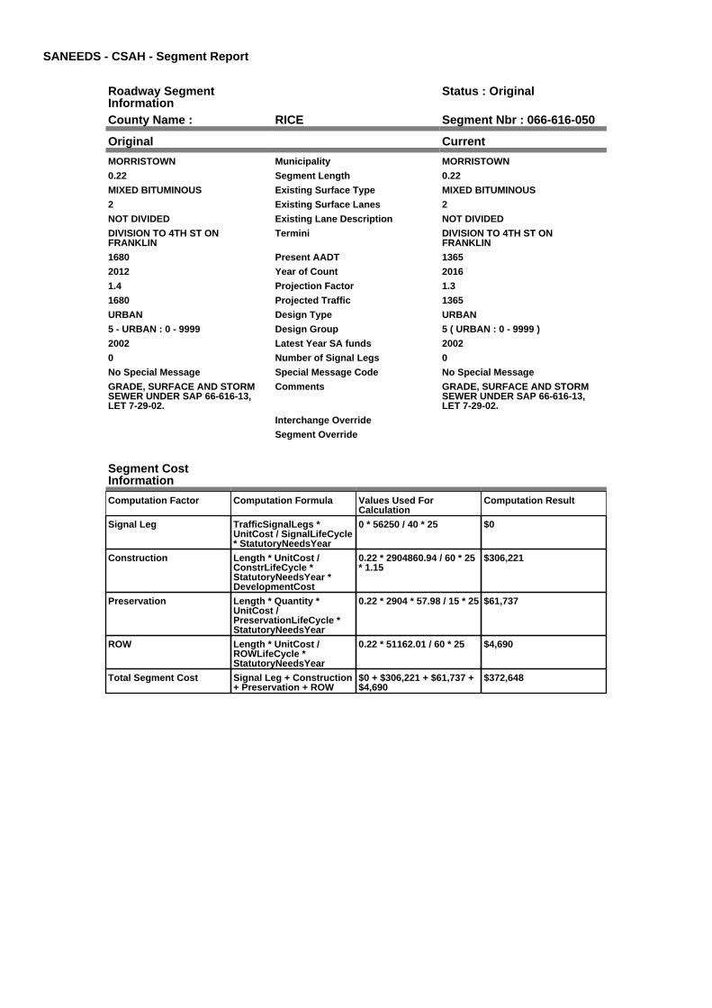
SANEEDS - CSAH - Segment Report
Roadway SegmentInformation
Status : Original
County Name : RICE Segment Nbr : 066-616-050
Original Current
MORRISTOWN Municipality MORRISTOWN
0.22 Segment Length 0.22
MIXED BITUMINOUS Existing Surface Type MIXED BITUMINOUS
2 Existing Surface Lanes 2
NOT DIVIDED Existing Lane Description NOT DIVIDED
DIVISION TO 4TH ST ONFRANKLIN
Termini DIVISION TO 4TH ST ONFRANKLIN
1680 Present AADT 1365
2012 Year of Count 2016
1.4 Projection Factor 1.3
1680 Projected Traffic 1365
URBAN Design Type URBAN
5 - URBAN : 0 - 9999 Design Group 5 ( URBAN : 0 - 9999 )
2002 Latest Year SA funds 2002
0 Number of Signal Legs 0
No Special Message Special Message Code No Special Message
GRADE, SURFACE AND STORMSEWER UNDER SAP 66-616-13,LET 7-29-02.
Comments GRADE, SURFACE AND STORMSEWER UNDER SAP 66-616-13,LET 7-29-02.
Interchange Override
Segment Override
Segment CostInformation
Computation Factor Computation Formula Values Used ForCalculation
Computation Result
Signal Leg TrafficSignalLegs *UnitCost / SignalLifeCycle* StatutoryNeedsYear
0 * 56250 / 40 * 25 $0
Construction Length * UnitCost /ConstrLifeCycle *StatutoryNeedsYear *DevelopmentCost
0.22 * 2904860.94 / 60 * 25* 1.15
$306,221
Preservation Length * Quantity *UnitCost /PreservationLifeCycle *StatutoryNeedsYear
0.22 * 2904 * 57.98 / 15 * 25 $61,737
ROW Length * UnitCost /ROWLifeCycle *StatutoryNeedsYear
0.22 * 51162.01 / 60 * 25 $4,690
Total Segment Cost Signal Leg + Construction+ Preservation + ROW
$0 + $306,221 + $61,737 +$4,690
$372,648

SANEEDS - CSAH - Segment Report
Roadway SegmentInformation
Status : Original
County Name : RICE Segment Nbr : 066-616-051
Original Current
MORRISTOWN Municipality MORRISTOWN
0.08 Segment Length 0.08
MIXED BITUMINOUS Existing Surface Type MIXED BITUMINOUS
2 Existing Surface Lanes 2
NOT DIVIDED Existing Lane Description NOT DIVIDED
FRANKLIN ST TO CANNON RIVER Termini FRANKLIN ST TO CANNON RIVER
1680 Present AADT 1365
2012 Year of Count 2016
1.4 Projection Factor 1.3
1680 Projected Traffic 1365
URBAN Design Type URBAN
5 - URBAN : 0 - 9999 Design Group 5 ( URBAN : 0 - 9999 )
2000 Latest Year SA funds 2000
0 Number of Signal Legs 0
No Special Message Special Message Code No Special Message
Comments
Interchange Override
Segment Override
Segment CostInformation
Computation Factor Computation Formula Values Used ForCalculation
Computation Result
Signal Leg TrafficSignalLegs *UnitCost / SignalLifeCycle* StatutoryNeedsYear
0 * 56250 / 40 * 25 $0
Construction Length * UnitCost /ConstrLifeCycle *StatutoryNeedsYear *DevelopmentCost
0.08 * 2904860.94 / 60 * 25* 1.15
$111,353
Preservation Length * Quantity *UnitCost /PreservationLifeCycle *StatutoryNeedsYear
0.08 * 2904 * 57.98 / 15 * 25 $22,450
ROW Length * UnitCost /ROWLifeCycle *StatutoryNeedsYear
0.08 * 51162.01 / 60 * 25 $1,705
Total Segment Cost Signal Leg + Construction+ Preservation + ROW
$0 + $111,353 + $22,450 +$1,705
$135,508

SANEEDS - CSAH - Segment Report
Roadway SegmentInformation
Status : Original
County Name : RICE Segment Nbr : 066-616-060
Original Current
MORRISTOWN Municipality MORRISTOWN
0.15 Segment Length 0.15
MIXED BITUMINOUS Existing Surface Type MIXED BITUMINOUS
2 Existing Surface Lanes 2
NOT DIVIDED Existing Lane Description NOT DIVIDED
CANNON RIVER TO TH 60 Termini CANNON RIVER TO TH 60
1680 Present AADT 1365
2012 Year of Count 2016
1.4 Projection Factor 1.3
1680 Projected Traffic 1365
RURAL Design Type RURAL
3 - RURAL : 1500 - 6999 Design Group 3 ( RURAL : 150 - 1499 )
2000 Latest Year SA funds 2000
0 Number of Signal Legs 0
No Special Message Special Message Code No Special Message
Comments
Interchange Override
Segment Override
Bridge Information Status: Original
Original Current
66531 Structure Number 66531
2.44 Milepoint 2.44
2001 Year Built 2001
Cannon River Feature Crossed Cannon River
STREAM CROSSING Type of Service STREAM CROSSING
2 Number of Spans 2
108.5 Bridge Length 108.5
53.6 Bridge Width 53.6
100% Shared Structure 100%
Comments
1 ( 0-149 ) Bridge Group Code 1 ( 0-149 )
Segment CostInformation
Computation Factor Computation Formula Values Used ForCalculation
Computation Result
Signal Leg TrafficSignalLegs *UnitCost / SignalLifeCycle* StatutoryNeedsYear
0 * 56250 / 40 * 25 $0
Construction Length * UnitCost /ConstrLifeCycle *StatutoryNeedsYear *DevelopmentCost
0.15 * 975142.53 / 60 * 25 *1.1
$67,041
Preservation Length * Quantity *UnitCost /PreservationLifeCycle *StatutoryNeedsYear
0.15 * 2112 * 57.98 / 20 * 25 $22,960
ROW Length * UnitCost /ROWLifeCycle *StatutoryNeedsYear
0.15 * 32462.65 / 60 * 25 $2,029
Bridge BridgeLength *BridgeWidth * UnitCost /BridgeLifeCycle *StatutoryNeedsYear *DevelopmentCost
108.5 * 53.6 * 152 / 80 * 25* 1.15
$317,677
Total Segment Cost Signal Leg + Construction+ Preservation + ROW +Bridge
$0 + $67,041 + $22,960 +$2,029 + $317,677
$409,707

SANEEDS - CSAH - Segment Report
Roadway SegmentInformation
Status : Original
County Name : RICE Segment Nbr : 066-616-070
Original Current
MORRISTOWN Municipality MORRISTOWN
0.1 Segment Length 0.1
MIXED BITUMINOUS Existing Surface Type MIXED BITUMINOUS
2 Existing Surface Lanes 2
NOT DIVIDED Existing Lane Description NOT DIVIDED
TH 60 TO NO LIMS MORRISTOWN Termini TH 60 TO NO LIMS MORRISTOWN
882 Present AADT 780
2012 Year of Count 2016
1.4 Projection Factor 1.3
882 Projected Traffic 780
RURAL Design Type RURAL
2 - RURAL : 150 - 1499 Design Group 2 ( RURAL : 150 - 1499 )
2000 Latest Year SA funds 2000
0 Number of Signal Legs 0
No Special Message Special Message Code No Special Message
Comments
Interchange Override
Segment Override
Segment CostInformation
Computation Factor Computation Formula Values Used ForCalculation
Computation Result
Signal Leg TrafficSignalLegs *UnitCost / SignalLifeCycle* StatutoryNeedsYear
0 * 56250 / 40 * 25 $0
Construction Length * UnitCost /ConstrLifeCycle *StatutoryNeedsYear *DevelopmentCost
0.1 * 975142.53 / 60 * 25 *1.1
$44,694
Preservation Length * Quantity *UnitCost /PreservationLifeCycle *StatutoryNeedsYear
0.1 * 2112 * 57.98 / 20 * 25 $15,307
ROW Length * UnitCost /ROWLifeCycle *StatutoryNeedsYear
0.1 * 32462.65 / 60 * 25 $1,353
Total Segment Cost Signal Leg + Construction+ Preservation + ROW
$0 + $44,694 + $15,307 +$1,353
$61,354

SANEEDS - CSAH - Segment Report
Roadway SegmentInformation
Status : Original
County Name : RICE Segment Nbr : 066-616-080
Original Current
Unassigned/Unknown Municipality Unassigned/Unknown
2.1 Segment Length 2.1
MIXED BITUMINOUS Existing Surface Type MIXED BITUMINOUS
2 Existing Surface Lanes 2
NOT DIVIDED Existing Lane Description NOT DIVIDED
NO LIM MORRISTOWN TO C R 71 Termini NO LIM MORRISTOWN TO C R 71
882 Present AADT 780
2012 Year of Count 2016
1.4 Projection Factor 1.3
882 Projected Traffic 780
RURAL Design Type RURAL
2 - RURAL : 150 - 1499 Design Group 2 ( RURAL : 150 - 1499 )
2000 Latest Year SA funds 2000
0 Number of Signal Legs 0
No Special Message Special Message Code No Special Message
Comments
Interchange Override
Segment Override
Segment CostInformation
Computation Factor Computation Formula Values Used ForCalculation
Computation Result
Signal Leg TrafficSignalLegs *UnitCost / SignalLifeCycle* StatutoryNeedsYear
0 * 56250 / 40 * 25 $0
Construction Length * UnitCost /ConstrLifeCycle *StatutoryNeedsYear *DevelopmentCost
2.1 * 975142.53 / 60 * 25 *1.1
$938,575
Preservation Length * Quantity *UnitCost /PreservationLifeCycle *StatutoryNeedsYear
2.1 * 2112 * 57.98 / 20 * 25 $321,441
ROW Length * UnitCost /ROWLifeCycle *StatutoryNeedsYear
2.1 * 32462.65 / 60 * 25 $28,405
Total Segment Cost Signal Leg + Construction+ Preservation + ROW
$0 + $938,575 + $321,441+ $28,405
$1,288,421

SANEEDS - CSAH - Segment Report
Roadway SegmentInformation
Status : Original
County Name : RICE Segment Nbr : 066-616-090
Original Current
Unassigned/Unknown Municipality Unassigned/Unknown
2.8 Segment Length 2.8
MIXED BITUMINOUS Existing Surface Type MIXED BITUMINOUS
2 Existing Surface Lanes 2
NOT DIVIDED Existing Lane Description NOT DIVIDED
CR 71 TO CSAH 12 Termini CR 71 TO CSAH 12
616 Present AADT 579
2012 Year of Count 2016
1.4 Projection Factor 1.3
616 Projected Traffic 579
RURAL Design Type RURAL
2 - RURAL : 150 - 1499 Design Group 2 ( RURAL : 150 - 1499 )
2013 Latest Year SA funds 2013
0 Number of Signal Legs 0
No Special Message Special Message Code No Special Message
2013 SAP 066-616-016 CULVERTR&R
Comments 2013 SAP 066-616-016 CULVERTR&R
Interchange Override
Segment Override
Culvert Information Status: Original
Original Current
88024 Structure Number 88024
6.53 Milepoint 6.53
1964 Year Built 1964
DEVIL CREEK Feature Crossed DEVIL CREEK
Type of Service
1 Number of Barrels 1
12 Culvert Width 12
8 Culvert Height 8
96 Culvert Length 96
85.00036552 Area of Waterway Opening 85.00036552
100% Shared Structure 100%
Comments
1 Culvert Group Code 1
Culvert Information Status: Original
Original Current
88480 Structure Number 88480
7.27 Milepoint 7.27
1964 Year Built 1964
DEVIL CREEK Feature Crossed DEVIL CREEK
Type of Service
1 Number of Barrels 1
10 Culvert Width 10
7 Culvert Height 7
72 Culvert Length 72
61.00009769 Area of Waterway Opening 61.00009769
100% Shared Structure 100%
Comments
1 Culvert Group Code 1
Culvert Information Status: Original
Original Current
66J49 Structure Number 66J49

4.77 Milepoint 4.77
2013 Year Built 2013
DEVIL CREEK Feature Crossed DEVIL CREEK
STREAM CROSSING Type of Service STREAM CROSSING
1 Number of Barrels 1
10 Culvert Width 10
10 Culvert Height 10
140 Culvert Length 140
100.99982648 Area of Waterway Opening 100.99982648
100% Shared Structure 100%
2013 SAP 066-616-016 CULVERTR&R
Comments 2013 SAP 066-616-016 CULVERTR&R
1 Culvert Group Code 1
Segment CostInformation
Computation Factor Computation Formula Values Used ForCalculation
Computation Result
Signal Leg TrafficSignalLegs *UnitCost / SignalLifeCycle* StatutoryNeedsYear
0 * 56250 / 40 * 25 $0
Construction Length * UnitCost /ConstrLifeCycle *StatutoryNeedsYear *DevelopmentCost
2.8 * 975142.53 / 60 * 25 *1.1
$1,251,433
Preservation Length * Quantity *UnitCost /PreservationLifeCycle *StatutoryNeedsYear
2.8 * 2112 * 57.98 / 20 * 25 $428,588
ROW Length * UnitCost /ROWLifeCycle *StatutoryNeedsYear
2.8 * 32462.65 / 60 * 25 $37,873
Culvert CulvertLength * Area *UnitCost /CulvertLifeCycle *StatutoryNeedsYear *DevelopmentCost
96 * 85.00036552 * 15.47 /100 * 25 * 1.15
$36,293
Culvert CulvertLength * Area *UnitCost /CulvertLifeCycle *StatutoryNeedsYear *DevelopmentCost
72 * 61.00009769 * 15.47 /100 * 25 * 1.15
$19,534
Culvert CulvertLength * Area *UnitCost /CulvertLifeCycle *StatutoryNeedsYear *DevelopmentCost
140 * 100.99982648 * 15.47/ 100 * 25 * 1.15
$62,889
Total Segment Cost Signal Leg + Construction+ Preservation + ROW +Culvert + Culvert +Culvert
$0 + $1,251,433 + $428,588+ $37,873 + $36,293 +$19,534 + $62,889
$1,836,610

SANEEDS - CSAH - Segment Report
Roadway SegmentInformation
Status : Original
County Name : RICE Segment Nbr : 066-617-010
Original Current
Unassigned/Unknown Municipality Unassigned/Unknown
0.2 Segment Length 0.2
BIT CONC OR ASPH Existing Surface Type BIT CONC OR ASPH
2 Existing Surface Lanes 2
NOT DIVIDED Existing Lane Description NOT DIVIDED
S CO LINE TO 0.2 MI N Termini S CO LINE TO 0.2 MI N
910 Present AADT 845
2012 Year of Count 2016
1.4 Projection Factor 1.3
910 Projected Traffic 845
RURAL Design Type RURAL
2 - RURAL : 150 - 1499 Design Group 2 ( RURAL : 150 - 1499 )
1992 Latest Year SA funds 1992
0 Number of Signal Legs 0
No Special Message Special Message Code No Special Message
DEFICIENT IN STRUCTURE -COLLECTOR SHOULD BE 10-TONROAD
2010 OVERLAY WITH LOCALFUNDS - SAP 66-617-008
Comments DEFICIENT IN STRUCTURE -COLLECTOR SHOULD BE 10-TONROAD
2010 OVERLAY WITH LOCALFUNDS - SAP 66-617-008
Interchange Override
Segment Override
Segment CostInformation
Computation Factor Computation Formula Values Used ForCalculation
Computation Result
Signal Leg TrafficSignalLegs *UnitCost / SignalLifeCycle* StatutoryNeedsYear
0 * 56250 / 40 * 25 $0
Construction Length * UnitCost /ConstrLifeCycle *StatutoryNeedsYear *DevelopmentCost
0.2 * 975142.53 / 60 * 25 *1.1
$89,388
Preservation Length * Quantity *UnitCost /PreservationLifeCycle *StatutoryNeedsYear
0.2 * 2112 * 57.98 / 20 * 25 $30,613
ROW Length * UnitCost /ROWLifeCycle *StatutoryNeedsYear
0.2 * 32462.65 / 60 * 25 $2,705
Total Segment Cost Signal Leg + Construction+ Preservation + ROW
$0 + $89,388 + $30,613 +$2,705
$122,706

SANEEDS - CSAH - Segment Report
Roadway SegmentInformation
Status : Original
County Name : RICE Segment Nbr : 066-617-011
Original Current
Unassigned/Unknown Municipality Unassigned/Unknown
1.8 Segment Length 1.8
BIT CONC OR ASPH Existing Surface Type BIT CONC OR ASPH
2 Existing Surface Lanes 2
NOT DIVIDED Existing Lane Description NOT DIVIDED
0.2 MI N OF S CO LINE TO CSAH 15 Termini 0.2 MI N OF S CO LINE TO CSAH 15
910 Present AADT 845
2012 Year of Count 2016
1.4 Projection Factor 1.3
910 Projected Traffic 845
RURAL Design Type RURAL
2 - RURAL : 150 - 1499 Design Group 2 ( RURAL : 150 - 1499 )
1992 Latest Year SA funds 1992
0 Number of Signal Legs 0
No Special Message Special Message Code No Special Message
2010 OVERLAY WITH LOCALFUNDS - SAP 66-617-008
Comments 2010 OVERLAY WITH LOCALFUNDS - SAP 66-617-008
Interchange Override
Segment Override
Segment CostInformation
Computation Factor Computation Formula Values Used ForCalculation
Computation Result
Signal Leg TrafficSignalLegs *UnitCost / SignalLifeCycle* StatutoryNeedsYear
0 * 56250 / 40 * 25 $0
Construction Length * UnitCost /ConstrLifeCycle *StatutoryNeedsYear *DevelopmentCost
1.8 * 975142.53 / 60 * 25 *1.1
$804,493
Preservation Length * Quantity *UnitCost /PreservationLifeCycle *StatutoryNeedsYear
1.8 * 2112 * 57.98 / 20 * 25 $275,521
ROW Length * UnitCost /ROWLifeCycle *StatutoryNeedsYear
1.8 * 32462.65 / 60 * 25 $24,347
Total Segment Cost Signal Leg + Construction+ Preservation + ROW
$0 + $804,493 + $275,521+ $24,347
$1,104,361
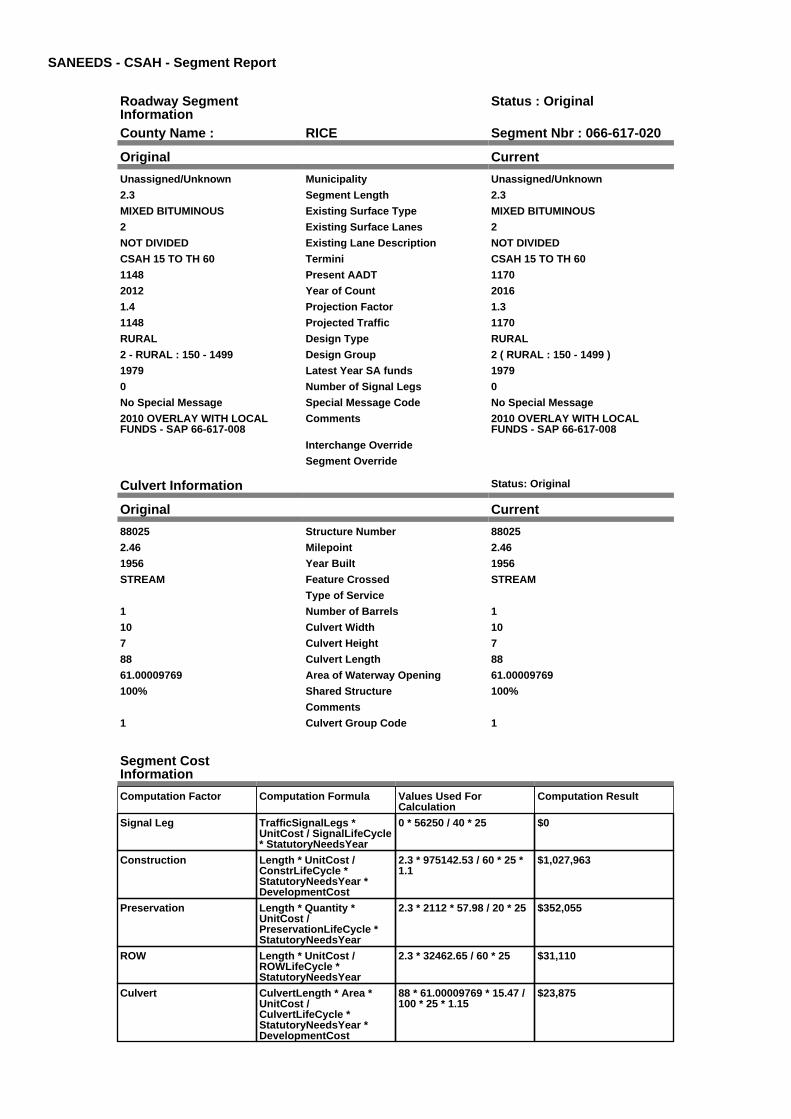
SANEEDS - CSAH - Segment Report
Roadway SegmentInformation
Status : Original
County Name : RICE Segment Nbr : 066-617-020
Original Current
Unassigned/Unknown Municipality Unassigned/Unknown
2.3 Segment Length 2.3
MIXED BITUMINOUS Existing Surface Type MIXED BITUMINOUS
2 Existing Surface Lanes 2
NOT DIVIDED Existing Lane Description NOT DIVIDED
CSAH 15 TO TH 60 Termini CSAH 15 TO TH 60
1148 Present AADT 1170
2012 Year of Count 2016
1.4 Projection Factor 1.3
1148 Projected Traffic 1170
RURAL Design Type RURAL
2 - RURAL : 150 - 1499 Design Group 2 ( RURAL : 150 - 1499 )
1979 Latest Year SA funds 1979
0 Number of Signal Legs 0
No Special Message Special Message Code No Special Message
2010 OVERLAY WITH LOCALFUNDS - SAP 66-617-008
Comments 2010 OVERLAY WITH LOCALFUNDS - SAP 66-617-008
Interchange Override
Segment Override
Culvert Information Status: Original
Original Current
88025 Structure Number 88025
2.46 Milepoint 2.46
1956 Year Built 1956
STREAM Feature Crossed STREAM
Type of Service
1 Number of Barrels 1
10 Culvert Width 10
7 Culvert Height 7
88 Culvert Length 88
61.00009769 Area of Waterway Opening 61.00009769
100% Shared Structure 100%
Comments
1 Culvert Group Code 1
Segment CostInformation
Computation Factor Computation Formula Values Used ForCalculation
Computation Result
Signal Leg TrafficSignalLegs *UnitCost / SignalLifeCycle* StatutoryNeedsYear
0 * 56250 / 40 * 25 $0
Construction Length * UnitCost /ConstrLifeCycle *StatutoryNeedsYear *DevelopmentCost
2.3 * 975142.53 / 60 * 25 *1.1
$1,027,963
Preservation Length * Quantity *UnitCost /PreservationLifeCycle *StatutoryNeedsYear
2.3 * 2112 * 57.98 / 20 * 25 $352,055
ROW Length * UnitCost /ROWLifeCycle *StatutoryNeedsYear
2.3 * 32462.65 / 60 * 25 $31,110
Culvert CulvertLength * Area *UnitCost /CulvertLifeCycle *StatutoryNeedsYear *DevelopmentCost
88 * 61.00009769 * 15.47 /100 * 25 * 1.15
$23,875

Total Segment Cost Signal Leg + Construction+ Preservation + ROW +Culvert
$0 + $1,027,963 + $352,055+ $31,110 + $23,875
$1,435,003

SANEEDS - CSAH - Segment Report
Roadway SegmentInformation
Status : Original
County Name : RICE Segment Nbr : 066-618-010
Original Current
Unassigned/Unknown Municipality Unassigned/Unknown
2 Segment Length 2
MIXED BITUMINOUS Existing Surface Type MIXED BITUMINOUS
2 Existing Surface Lanes 2
NOT DIVIDED Existing Lane Description NOT DIVIDED
CSAH 15 TO CSAH 39 Termini CSAH 15 TO CSAH 39
462 Present AADT 351
2012 Year of Count 2016
1.4 Projection Factor 1.3
462 Projected Traffic 351
RURAL Design Type RURAL
2 - RURAL : 150 - 1499 Design Group 2 ( RURAL : 150 - 1499 )
1990 Latest Year SA funds 1990
0 Number of Signal Legs 0
No Special Message Special Message Code No Special Message
Comments
Interchange Override
Segment Override
Segment CostInformation
Computation Factor Computation Formula Values Used ForCalculation
Computation Result
Signal Leg TrafficSignalLegs *UnitCost / SignalLifeCycle* StatutoryNeedsYear
0 * 56250 / 40 * 25 $0
Construction Length * UnitCost /ConstrLifeCycle *StatutoryNeedsYear *DevelopmentCost
2 * 975142.53 / 60 * 25 * 1.1 $893,881
Preservation Length * Quantity *UnitCost /PreservationLifeCycle *StatutoryNeedsYear
2 * 2112 * 57.98 / 20 * 25 $306,134
ROW Length * UnitCost /ROWLifeCycle *StatutoryNeedsYear
2 * 32462.65 / 60 * 25 $27,052
Total Segment Cost Signal Leg + Construction+ Preservation + ROW
$0 + $893,881 + $306,134+ $27,052
$1,227,067
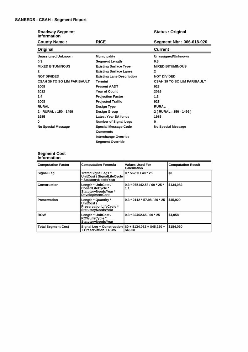
SANEEDS - CSAH - Segment Report
Roadway SegmentInformation
Status : Original
County Name : RICE Segment Nbr : 066-618-020
Original Current
Unassigned/Unknown Municipality Unassigned/Unknown
0.3 Segment Length 0.3
MIXED BITUMINOUS Existing Surface Type MIXED BITUMINOUS
2 Existing Surface Lanes 2
NOT DIVIDED Existing Lane Description NOT DIVIDED
CSAH 39 TO SO LIM FARIBAULT Termini CSAH 39 TO SO LIM FARIBAULT
1008 Present AADT 923
2012 Year of Count 2016
1.4 Projection Factor 1.3
1008 Projected Traffic 923
RURAL Design Type RURAL
2 - RURAL : 150 - 1499 Design Group 2 ( RURAL : 150 - 1499 )
1985 Latest Year SA funds 1985
0 Number of Signal Legs 0
No Special Message Special Message Code No Special Message
Comments
Interchange Override
Segment Override
Segment CostInformation
Computation Factor Computation Formula Values Used ForCalculation
Computation Result
Signal Leg TrafficSignalLegs *UnitCost / SignalLifeCycle* StatutoryNeedsYear
0 * 56250 / 40 * 25 $0
Construction Length * UnitCost /ConstrLifeCycle *StatutoryNeedsYear *DevelopmentCost
0.3 * 975142.53 / 60 * 25 *1.1
$134,082
Preservation Length * Quantity *UnitCost /PreservationLifeCycle *StatutoryNeedsYear
0.3 * 2112 * 57.98 / 20 * 25 $45,920
ROW Length * UnitCost /ROWLifeCycle *StatutoryNeedsYear
0.3 * 32462.65 / 60 * 25 $4,058
Total Segment Cost Signal Leg + Construction+ Preservation + ROW
$0 + $134,082 + $45,920 +$4,058
$184,060

SANEEDS - CSAH - Segment Report
Roadway SegmentInformation
Status : Original
County Name : RICE Segment Nbr : 066-618-030
Original Current
FARIBAULT Municipality FARIBAULT
0.75 Segment Length 0.75
MIXED BITUMINOUS Existing Surface Type MIXED BITUMINOUS
2 Existing Surface Lanes 2
NOT DIVIDED Existing Lane Description NOT DIVIDED
SO LIM FARIBAULT TO 0.75 MI NO Termini SO LIM FARIBAULT TO 0.75 MI NO
1008 Present AADT 923
2012 Year of Count 2016
1.4 Projection Factor 1.3
1008 Projected Traffic 923
RURAL Design Type RURAL
2 - RURAL : 150 - 1499 Design Group 2 ( RURAL : 150 - 1499 )
1985 Latest Year SA funds 1985
0 Number of Signal Legs 0
No Special Message Special Message Code No Special Message
Comments
Interchange Override
Segment Override
Segment CostInformation
Computation Factor Computation Formula Values Used ForCalculation
Computation Result
Signal Leg TrafficSignalLegs *UnitCost / SignalLifeCycle* StatutoryNeedsYear
0 * 56250 / 40 * 25 $0
Construction Length * UnitCost /ConstrLifeCycle *StatutoryNeedsYear *DevelopmentCost
0.75 * 975142.53 / 60 * 25 *1.1
$335,205
Preservation Length * Quantity *UnitCost /PreservationLifeCycle *StatutoryNeedsYear
0.75 * 2112 * 57.98 / 20 * 25 $114,800
ROW Length * UnitCost /ROWLifeCycle *StatutoryNeedsYear
0.75 * 32462.65 / 60 * 25 $10,145
Total Segment Cost Signal Leg + Construction+ Preservation + ROW
$0 + $335,205 + $114,800+ $10,145
$460,150

SANEEDS - CSAH - Segment Report
Roadway SegmentInformation
Status : Original
County Name : RICE Segment Nbr : 066-618-040
Original Current
FARIBAULT Municipality FARIBAULT
1.1 Segment Length 1.1
MIXED BITUMINOUS Existing Surface Type MIXED BITUMINOUS
2 Existing Surface Lanes 2
NOT DIVIDED Existing Lane Description NOT DIVIDED
0.75 MI NO OF SO LIM FARIBAULTTO BOTSFORD CIRCLE
Termini 0.75 MI NO OF SO LIM FARIBAULTTO BOTSFORD CIRCLE
6440 Present AADT 6435
2012 Year of Count 2016
1.4 Projection Factor 1.3
6440 Projected Traffic 6435
URBAN Design Type URBAN
5 - URBAN : 0 - 9999 Design Group 5 ( URBAN : 0 - 9999 )
1998 Latest Year SA funds 1998
0 Number of Signal Legs 0
No Special Message Special Message Code No Special Message
Comments
Interchange Override
Segment Override
Segment CostInformation
Computation Factor Computation Formula Values Used ForCalculation
Computation Result
Signal Leg TrafficSignalLegs *UnitCost / SignalLifeCycle* StatutoryNeedsYear
0 * 56250 / 40 * 25 $0
Construction Length * UnitCost /ConstrLifeCycle *StatutoryNeedsYear *DevelopmentCost
1.1 * 2904860.94 / 60 * 25 *1.15
$1,531,104
Preservation Length * Quantity *UnitCost /PreservationLifeCycle *StatutoryNeedsYear
1.1 * 2904 * 57.98 / 15 * 25 $308,686
ROW Length * UnitCost /ROWLifeCycle *StatutoryNeedsYear
1.1 * 51162.01 / 60 * 25 $23,449
Total Segment Cost Signal Leg + Construction+ Preservation + ROW
$0 + $1,531,104 + $308,686+ $23,449
$1,863,239

SANEEDS - CSAH - Segment Report
Roadway SegmentInformation
Status : Original
County Name : RICE Segment Nbr : 066-618-050
Original Current
FARIBAULT Municipality FARIBAULT
0.4 Segment Length 0.4
PORT CEMENT CONC Existing Surface Type PORT CEMENT CONC
2 Existing Surface Lanes 2
NOT DIVIDED Existing Lane Description NOT DIVIDED
BOTSFORD CIRCLE TO DIVISION Termini BOTSFORD CIRCLE TO DIVISION
7700 Present AADT 7410
2012 Year of Count 2016
1.4 Projection Factor 1.3
7700 Projected Traffic 7410
URBAN Design Type URBAN
5 - URBAN : 0 - 9999 Design Group 5 ( URBAN : 0 - 9999 )
1998 Latest Year SA funds 1998
0 Number of Signal Legs 0
No Special Message Special Message Code No Special Message
Comments
Interchange Override
Segment Override
Segment CostInformation
Computation Factor Computation Formula Values Used ForCalculation
Computation Result
Signal Leg TrafficSignalLegs *UnitCost / SignalLifeCycle* StatutoryNeedsYear
0 * 56250 / 40 * 25 $0
Construction Length * UnitCost /ConstrLifeCycle *StatutoryNeedsYear *DevelopmentCost
0.4 * 2904860.94 / 60 * 25 *1.15
$556,765
Preservation Length * Quantity *UnitCost /PreservationLifeCycle *StatutoryNeedsYear
0.4 * 2904 * 57.98 / 15 * 25 $112,249
ROW Length * UnitCost /ROWLifeCycle *StatutoryNeedsYear
0.4 * 51162.01 / 60 * 25 $8,527
Total Segment Cost Signal Leg + Construction+ Preservation + ROW
$0 + $556,765 + $112,249+ $8,527
$677,541

SANEEDS - CSAH - Segment Report
Roadway SegmentInformation
Status : Original
County Name : RICE Segment Nbr : 066-618-055
Original Current
FARIBAULT Municipality FARIBAULT
0.21 Segment Length 0.21
PORT CEMENT CONC Existing Surface Type PORT CEMENT CONC
2 Existing Surface Lanes 2
NOT DIVIDED Existing Lane Description NOT DIVIDED
DIVISION TO 2ND ST SO Termini DIVISION TO 2ND ST SO
5530 Present AADT 5460
2012 Year of Count 2016
1.4 Projection Factor 1.3
5530 Projected Traffic 5460
URBAN Design Type URBAN
5 - URBAN : 0 - 9999 Design Group 5 ( URBAN : 0 - 9999 )
2000 Latest Year SA funds 2000
0 Number of Signal Legs 0
No Special Message Special Message Code No Special Message
Comments
Interchange Override
Segment Override
Segment CostInformation
Computation Factor Computation Formula Values Used ForCalculation
Computation Result
Signal Leg TrafficSignalLegs *UnitCost / SignalLifeCycle* StatutoryNeedsYear
0 * 56250 / 40 * 25 $0
Construction Length * UnitCost /ConstrLifeCycle *StatutoryNeedsYear *DevelopmentCost
0.21 * 2904860.94 / 60 * 25* 1.15
$292,302
Preservation Length * Quantity *UnitCost /PreservationLifeCycle *StatutoryNeedsYear
0.21 * 2904 * 57.98 / 15 * 25 $58,931
ROW Length * UnitCost /ROWLifeCycle *StatutoryNeedsYear
0.21 * 51162.01 / 60 * 25 $4,477
Total Segment Cost Signal Leg + Construction+ Preservation + ROW
$0 + $292,302 + $58,931 +$4,477
$355,710

SANEEDS - CSAH - Segment Report
Roadway SegmentInformation
Status : Original
County Name : RICE Segment Nbr : 066-618-060
Original Current
FARIBAULT Municipality FARIBAULT
0.1 Segment Length 0.1
PORT CEMENT CONC Existing Surface Type PORT CEMENT CONC
2 Existing Surface Lanes 2
NOT DIVIDED Existing Lane Description NOT DIVIDED
2ND ST SO TO TH 60 Termini 2ND ST SO TO TH 60
5530 Present AADT 5460
2012 Year of Count 2016
1.4 Projection Factor 1.3
5530 Projected Traffic 5460
URBAN Design Type URBAN
5 - URBAN : 0 - 9999 Design Group 5 ( URBAN : 0 - 9999 )
2000 Latest Year SA funds 2000
1 Number of Signal Legs 1
No Special Message Special Message Code No Special Message
Comments
Interchange Override
Segment Override
Segment CostInformation
Computation Factor Computation Formula Values Used ForCalculation
Computation Result
Signal Leg TrafficSignalLegs *UnitCost / SignalLifeCycle* StatutoryNeedsYear
1 * 56250 / 40 * 25 $35,156
Construction Length * UnitCost /ConstrLifeCycle *StatutoryNeedsYear *DevelopmentCost
0.1 * 2904860.94 / 60 * 25 *1.15
$139,191
Preservation Length * Quantity *UnitCost /PreservationLifeCycle *StatutoryNeedsYear
0.1 * 2904 * 57.98 / 15 * 25 $28,062
ROW Length * UnitCost /ROWLifeCycle *StatutoryNeedsYear
0.1 * 51162.01 / 60 * 25 $2,132
Total Segment Cost Signal Leg + Construction+ Preservation + ROW
$35,156 + $139,191 +$28,062 + $2,132
$204,541

SANEEDS - CSAH - Segment Report
Roadway SegmentInformation
Status : Original
County Name : RICE Segment Nbr : 066-619-005
Original Current
FARIBAULT Municipality FARIBAULT
0.7 Segment Length 0.7
MIXED BITUMINOUS Existing Surface Type MIXED BITUMINOUS
2 Existing Surface Lanes 2
NOT DIVIDED Existing Lane Description NOT DIVIDED
CSAH 45 TO 0.70 MILES SOUTH Termini CSAH 45 TO 0.70 MILES SOUTH
4620 Present AADT 4225
2012 Year of Count 2016
1.4 Projection Factor 1.3
4620 Projected Traffic 4225
URBAN Design Type URBAN
5 - URBAN : 0 - 9999 Design Group 5 ( URBAN : 0 - 9999 )
1991 Latest Year SA funds 1991
0 Number of Signal Legs 0
No Special Message Special Message Code No Special Message
Comments
Interchange Override
Segment Override
Segment CostInformation
Computation Factor Computation Formula Values Used ForCalculation
Computation Result
Signal Leg TrafficSignalLegs *UnitCost / SignalLifeCycle* StatutoryNeedsYear
0 * 56250 / 40 * 25 $0
Construction Length * UnitCost /ConstrLifeCycle *StatutoryNeedsYear *DevelopmentCost
0.7 * 2904860.94 / 60 * 25 *1.15
$974,339
Preservation Length * Quantity *UnitCost /PreservationLifeCycle *StatutoryNeedsYear
0.7 * 2904 * 57.98 / 15 * 25 $196,436
ROW Length * UnitCost /ROWLifeCycle *StatutoryNeedsYear
0.7 * 51162.01 / 60 * 25 $14,922
Total Segment Cost Signal Leg + Construction+ Preservation + ROW
$0 + $974,339 + $196,436+ $14,922
$1,185,697

SANEEDS - CSAH - Segment Report
Roadway SegmentInformation
Status : Original
County Name : RICE Segment Nbr : 066-619-010
Original Current
FARIBAULT Municipality FARIBAULT
0.6 Segment Length 0.6
MIXED BITUMINOUS Existing Surface Type MIXED BITUMINOUS
2 Existing Surface Lanes 2
NOT DIVIDED Existing Lane Description NOT DIVIDED
0.7 MI S OF CSAH 45 TO 1.6 MI NOF CSAH 21
Termini 0.7 MI S OF CSAH 45 TO 1.6 MI NOF CSAH 21
1400 Present AADT 1430
2012 Year of Count 2016
1.4 Projection Factor 1.3
1400 Projected Traffic 1430
RURAL Design Type RURAL
2 - RURAL : 150 - 1499 Design Group 2 ( RURAL : 150 - 1499 )
2005 Latest Year SA funds 2005
0 Number of Signal Legs 0
No Special Message Special Message Code No Special Message
SURFACED UNDER 66-619-14 IN2005
ONLY BUILT TO 24X30SURF/RDBD
Comments SURFACED UNDER 66-619-14 IN2005
ONLY BUILT TO 24X30SURF/RDBD
Interchange Override
Segment Override
Segment CostInformation
Computation Factor Computation Formula Values Used ForCalculation
Computation Result
Signal Leg TrafficSignalLegs *UnitCost / SignalLifeCycle* StatutoryNeedsYear
0 * 56250 / 40 * 25 $0
Construction Length * UnitCost /ConstrLifeCycle *StatutoryNeedsYear *DevelopmentCost
0.6 * 975142.53 / 60 * 25 *1.1
$268,164
Preservation Length * Quantity *UnitCost /PreservationLifeCycle *StatutoryNeedsYear
0.6 * 2112 * 57.98 / 20 * 25 $91,840
ROW Length * UnitCost /ROWLifeCycle *StatutoryNeedsYear
0.6 * 32462.65 / 60 * 25 $8,116
Total Segment Cost Signal Leg + Construction+ Preservation + ROW
$0 + $268,164 + $91,840 +$8,116
$368,120

SANEEDS - CSAH - Segment Report
Roadway SegmentInformation
Status : Original
County Name : RICE Segment Nbr : 066-619-011
Original Current
Unassigned/Unknown Municipality Unassigned/Unknown
1.6 Segment Length 1.6
MIXED BITUMINOUS Existing Surface Type MIXED BITUMINOUS
2 Existing Surface Lanes 2
NOT DIVIDED Existing Lane Description NOT DIVIDED
1.6 MILE NORTH OF CSAH 21 TOCSAH 21
Termini 1.6 MILE NORTH OF CSAH 21 TOCSAH 21
1400 Present AADT 1430
2012 Year of Count 2016
1.4 Projection Factor 1.3
1400 Projected Traffic 1430
RURAL Design Type RURAL
2 - RURAL : 150 - 1499 Design Group 2 ( RURAL : 150 - 1499 )
2005 Latest Year SA funds 2005
0 Number of Signal Legs 0
No Special Message Special Message Code No Special Message
MILL AND SURFACE UNDER 66-619-14 2005
Comments MILL AND SURFACE UNDER 66-619-14 2005
Interchange Override
Segment Override
Culvert Information Status: Original
Original Current
66J38 Structure Number 66J38
1.155 Milepoint 1.155
2005 Year Built 2005
STREAM Feature Crossed STREAM
STREAM CROSSING Type of Service STREAM CROSSING
1 Number of Barrels 1
10 Culvert Width 10
8 Culvert Height 8
76 Culvert Length 76
80.00053397 Area of Waterway Opening 80.00053397
100% Shared Structure 100%
Comments
1 Culvert Group Code 1
Segment CostInformation
Computation Factor Computation Formula Values Used ForCalculation
Computation Result
Signal Leg TrafficSignalLegs *UnitCost / SignalLifeCycle* StatutoryNeedsYear
0 * 56250 / 40 * 25 $0
Construction Length * UnitCost /ConstrLifeCycle *StatutoryNeedsYear *DevelopmentCost
1.6 * 975142.53 / 60 * 25 *1.1
$715,105
Preservation Length * Quantity *UnitCost /PreservationLifeCycle *StatutoryNeedsYear
1.6 * 2112 * 57.98 / 20 * 25 $244,908
ROW Length * UnitCost /ROWLifeCycle *StatutoryNeedsYear
1.6 * 32462.65 / 60 * 25 $21,642
Culvert CulvertLength * Area *UnitCost /CulvertLifeCycle *StatutoryNeedsYear *DevelopmentCost
76 * 80.00053397 * 15.47 /100 * 25 * 1.15
$27,042

Total Segment Cost Signal Leg + Construction+ Preservation + ROW +Culvert
$0 + $715,105 + $244,908+ $21,642 + $27,042
$1,008,697

SANEEDS - CSAH - Segment Report
Roadway SegmentInformation
Status : Original
County Name : RICE Segment Nbr : 066-619-020
Original Current
Unassigned/Unknown Municipality Unassigned/Unknown
0.2 Segment Length 0.2
MIXED BITUMINOUS Existing Surface Type MIXED BITUMINOUS
2 Existing Surface Lanes 2
NOT DIVIDED Existing Lane Description NOT DIVIDED
CSAH 21 TO 0.20 MI E OF CSAH 21 Termini CSAH 21 TO 0.20 MI E OF CSAH 21
1400 Present AADT 1430
2012 Year of Count 2016
1.4 Projection Factor 1.3
1400 Projected Traffic 1430
RURAL Design Type RURAL
2 - RURAL : 150 - 1499 Design Group 2 ( RURAL : 150 - 1499 )
2005 Latest Year SA funds 2005
0 Number of Signal Legs 0
No Special Message Special Message Code No Special Message
SURFACED UNDER 66-619-14 Comments SURFACED UNDER 66-619-14
Interchange Override
Segment Override
Bridge Information Status: Original
Original Current
66510 Structure Number 66510
2.91 Milepoint 2.91
1975 Year Built 1975
STRAIGHT RIVER Feature Crossed STRAIGHT RIVER
Type of Service
Number of Spans
162.9 Bridge Length 162.9
39.8 Bridge Width 39.8
100% Shared Structure 100%
Comments
2 ( 150-999,999 ) Bridge Group Code 2 ( 150-999,999 )
RailRoadCrossingInformation
Status: Original
Original Current
UNION PACIFIC RAILROAD RailRoad Name UNION PACIFIC RAILROAD
875735A USDOT Number 875735A
0 Located at Milepoint 0
1 Mainline Tracks 1
SIGNALS ONLY Protection Type SIGNALS ONLY
2001 Last Year Protection Upgraded 2001
40 Crossing Length 40
Last Year Surfaced
100% Percentage of Cost 100%
Comments
Segment CostInformation
Computation Factor Computation Formula Values Used ForCalculation
Computation Result
Signal Leg TrafficSignalLegs *UnitCost / SignalLifeCycle* StatutoryNeedsYear
0 * 56250 / 40 * 25 $0

Construction Length * UnitCost /ConstrLifeCycle *StatutoryNeedsYear *DevelopmentCost
0.2 * 975142.53 / 60 * 25 *1.1
$89,388
Preservation Length * Quantity *UnitCost /PreservationLifeCycle *StatutoryNeedsYear
0.2 * 2112 * 57.98 / 20 * 25 $30,613
ROW Length * UnitCost /ROWLifeCycle *StatutoryNeedsYear
0.2 * 32462.65 / 60 * 25 $2,705
Bridge BridgeLength *BridgeWidth * UnitCost /BridgeLifeCycle *StatutoryNeedsYear *DevelopmentCost
162.9 * 39.8 * 138 / 80 * 25* 1.15
$321,537
RR Crossing Protection UnitCost /RRCrossingLifeCycle *StatutoryNeedsYear
275000 / 25 * 25 $275,000
RR Crossing Surface SurfaceLength * UnitCost/ RRCrossingLifeCycle *StatutoryNeedsYear
40 * 1350 / 25 * 25 $54,000
Total Segment Cost Signal Leg + Construction+ Preservation + ROW +Bridge + RR CrossingProtection + RR CrossingSurface
$0 + $89,388 + $30,613 +$2,705 + $321,537 +$275,000 + $54,000
$773,243

SANEEDS - CSAH - Segment Report
Roadway SegmentInformation
Status : Original
County Name : RICE Segment Nbr : 066-619-021
Original Current
Unassigned/Unknown Municipality Unassigned/Unknown
1 Segment Length 1
MIXED BITUMINOUS Existing Surface Type MIXED BITUMINOUS
2 Existing Surface Lanes 2
NOT DIVIDED Existing Lane Description NOT DIVIDED
0.2 MI E OF CSAH 21 TO 0.1 MI EOF CO RD 90
Termini 0.2 MI E OF CSAH 21 TO 0.1 MI EOF CO RD 90
1400 Present AADT 1430
2012 Year of Count 2016
1.4 Projection Factor 1.3
1400 Projected Traffic 1430
RURAL Design Type RURAL
2 - RURAL : 150 - 1499 Design Group 2 ( RURAL : 150 - 1499 )
1994 Latest Year SA funds 1994
0 Number of Signal Legs 0
No Special Message Special Message Code No Special Message
Comments
Interchange Override
Segment Override
Segment CostInformation
Computation Factor Computation Formula Values Used ForCalculation
Computation Result
Signal Leg TrafficSignalLegs *UnitCost / SignalLifeCycle* StatutoryNeedsYear
0 * 56250 / 40 * 25 $0
Construction Length * UnitCost /ConstrLifeCycle *StatutoryNeedsYear *DevelopmentCost
1 * 975142.53 / 60 * 25 * 1.1 $446,940
Preservation Length * Quantity *UnitCost /PreservationLifeCycle *StatutoryNeedsYear
1 * 2112 * 57.98 / 20 * 25 $153,067
ROW Length * UnitCost /ROWLifeCycle *StatutoryNeedsYear
1 * 32462.65 / 60 * 25 $13,526
Total Segment Cost Signal Leg + Construction+ Preservation + ROW
$0 + $446,940 + $153,067+ $13,526
$613,533

SANEEDS - CSAH - Segment Report
Roadway SegmentInformation
Status : Original
County Name : RICE Segment Nbr : 066-619-030
Original Current
Unassigned/Unknown Municipality Unassigned/Unknown
2.9 Segment Length 2.9
MIXED BITUMINOUS Existing Surface Type MIXED BITUMINOUS
2 Existing Surface Lanes 2
NOT DIVIDED Existing Lane Description NOT DIVIDED
0.10 M E OF CR 90 TO CSAH 23 Termini 0.10 M E OF CR 90 TO CSAH 23
882 Present AADT 871
2012 Year of Count 2016
1.4 Projection Factor 1.3
882 Projected Traffic 871
RURAL Design Type RURAL
2 - RURAL : 150 - 1499 Design Group 2 ( RURAL : 150 - 1499 )
1994 Latest Year SA funds 1994
0 Number of Signal Legs 0
No Special Message Special Message Code No Special Message
Comments
Interchange Override
Segment Override
Segment CostInformation
Computation Factor Computation Formula Values Used ForCalculation
Computation Result
Signal Leg TrafficSignalLegs *UnitCost / SignalLifeCycle* StatutoryNeedsYear
0 * 56250 / 40 * 25 $0
Construction Length * UnitCost /ConstrLifeCycle *StatutoryNeedsYear *DevelopmentCost
2.9 * 975142.53 / 60 * 25 *1.1
$1,296,127
Preservation Length * Quantity *UnitCost /PreservationLifeCycle *StatutoryNeedsYear
2.9 * 2112 * 57.98 / 20 * 25 $443,895
ROW Length * UnitCost /ROWLifeCycle *StatutoryNeedsYear
2.9 * 32462.65 / 60 * 25 $39,226
Total Segment Cost Signal Leg + Construction+ Preservation + ROW
$0 + $1,296,127 + $443,895+ $39,226
$1,779,248

SANEEDS - CSAH - Segment Report
Roadway SegmentInformation
Status : Original
County Name : RICE Segment Nbr : 066-619-031
Original Current
Unassigned/Unknown Municipality Unassigned/Unknown
2.7 Segment Length 2.7
MIXED BITUMINOUS Existing Surface Type MIXED BITUMINOUS
2 Existing Surface Lanes 2
NOT DIVIDED Existing Lane Description NOT DIVIDED
CSAH 23 TO 2.70 MI. E. Termini CSAH 23 TO 2.70 MI. E.
882 Present AADT 871
2012 Year of Count 2016
1.4 Projection Factor 1.3
882 Projected Traffic 871
RURAL Design Type RURAL
2 - RURAL : 150 - 1499 Design Group 2 ( RURAL : 150 - 1499 )
1994 Latest Year SA funds 1994
0 Number of Signal Legs 0
No Special Message Special Message Code No Special Message
Comments
Interchange Override
Segment Override
Bridge Information Status: Original
Original Current
66528 Structure Number 66528
9.63 Milepoint 9.63
1991 Year Built 1991
STREAM Feature Crossed STREAM
STREAM CROSSING Type of Service STREAM CROSSING
1 Number of Spans 1
102.9 Bridge Length 102.9
39.3 Bridge Width 39.3
100% Shared Structure 100%
Comments
1 ( 0-149 ) Bridge Group Code 1 ( 0-149 )
Culvert Information Status: Original
Original Current
66J44 Structure Number 66J44
8.03 Milepoint 8.03
2009 Year Built 2009
STREAM Feature Crossed STREAM
STREAM CROSSING Type of Service STREAM CROSSING
1 Number of Barrels 1
12 Culvert Width 12
6 Culvert Height 6
75 Culvert Length 75
71.9997271 Area of Waterway Opening 71.9997271
100% Shared Structure 100%
Comments
1 Culvert Group Code 1
Culvert Information Status: Original
Original Current
66J45 Structure Number 66J45
9.48 Milepoint 9.48
2009 Year Built 2009
STREAM Feature Crossed STREAM

STREAM CROSSING Type of Service STREAM CROSSING
2 Number of Barrels 2
Culvert Width
Culvert Height
73 Culvert Length 73
191.99998986 Area of Waterway Opening 191.99998986
100% Shared Structure 100%
Comments
1 Culvert Group Code 1
Segment CostInformation
Computation Factor Computation Formula Values Used ForCalculation
Computation Result
Signal Leg TrafficSignalLegs *UnitCost / SignalLifeCycle* StatutoryNeedsYear
0 * 56250 / 40 * 25 $0
Construction Length * UnitCost /ConstrLifeCycle *StatutoryNeedsYear *DevelopmentCost
2.7 * 975142.53 / 60 * 25 *1.1
$1,206,739
Preservation Length * Quantity *UnitCost /PreservationLifeCycle *StatutoryNeedsYear
2.7 * 2112 * 57.98 / 20 * 25 $413,281
ROW Length * UnitCost /ROWLifeCycle *StatutoryNeedsYear
2.7 * 32462.65 / 60 * 25 $36,520
Bridge BridgeLength *BridgeWidth * UnitCost /BridgeLifeCycle *StatutoryNeedsYear *DevelopmentCost
102.9 * 39.3 * 152 / 80 * 25* 1.15
$220,902
Culvert CulvertLength * Area *UnitCost /CulvertLifeCycle *StatutoryNeedsYear *DevelopmentCost
75 * 71.9997271 * 15.47 /100 * 25 * 1.15
$24,017
Culvert CulvertLength * Area *UnitCost /CulvertLifeCycle *StatutoryNeedsYear *DevelopmentCost
73 * 191.99998986 * 15.47 /100 * 25 * 1.15
$62,338
Total Segment Cost Signal Leg + Construction+ Preservation + ROW +Bridge + Culvert + Culvert
$0 + $1,206,739 + $413,281+ $36,520 + $220,902 +$24,017 + $62,338
$1,963,797

SANEEDS - CSAH - Segment Report
Roadway SegmentInformation
Status : Original
County Name : RICE Segment Nbr : 066-619-032
Original Current
Unassigned/Unknown Municipality Unassigned/Unknown
2.5 Segment Length 2.5
MIXED BITUMINOUS Existing Surface Type MIXED BITUMINOUS
2 Existing Surface Lanes 2
NOT DIVIDED Existing Lane Description NOT DIVIDED
2.7 MI E OF CSAH 23 TO N JCTCSAH 26
Termini 2.7 MI E OF CSAH 23 TO N JCTCSAH 26
882 Present AADT 871
2012 Year of Count 2016
1.4 Projection Factor 1.3
882 Projected Traffic 871
RURAL Design Type RURAL
2 - RURAL : 150 - 1499 Design Group 2 ( RURAL : 150 - 1499 )
1993 Latest Year SA funds 1993
0 Number of Signal Legs 0
No Special Message Special Message Code No Special Message
Comments
Interchange Override
Segment Override
Segment CostInformation
Computation Factor Computation Formula Values Used ForCalculation
Computation Result
Signal Leg TrafficSignalLegs *UnitCost / SignalLifeCycle* StatutoryNeedsYear
0 * 56250 / 40 * 25 $0
Construction Length * UnitCost /ConstrLifeCycle *StatutoryNeedsYear *DevelopmentCost
2.5 * 975142.53 / 60 * 25 *1.1
$1,117,351
Preservation Length * Quantity *UnitCost /PreservationLifeCycle *StatutoryNeedsYear
2.5 * 2112 * 57.98 / 20 * 25 $382,668
ROW Length * UnitCost /ROWLifeCycle *StatutoryNeedsYear
2.5 * 32462.65 / 60 * 25 $33,815
Total Segment Cost Signal Leg + Construction+ Preservation + ROW
$0 + $1,117,351 + $382,668+ $33,815
$1,533,834

SANEEDS - CSAH - Segment Report
Roadway SegmentInformation
Status : Original
County Name : RICE Segment Nbr : 066-619-040
Original Current
Unassigned/Unknown Municipality Unassigned/Unknown
0.8 Segment Length 0.8
MIXED BITUMINOUS Existing Surface Type MIXED BITUMINOUS
2 Existing Surface Lanes 2
NOT DIVIDED Existing Lane Description NOT DIVIDED
N JCT CSAH 26 TO EAST COUNTYLINE
Termini N JCT CSAH 26 TO EAST COUNTYLINE
882 Present AADT 871
2012 Year of Count 2016
1.4 Projection Factor 1.3
882 Projected Traffic 871
RURAL Design Type RURAL
2 - RURAL : 150 - 1499 Design Group 2 ( RURAL : 150 - 1499 )
2000 Latest Year SA funds 2000
0 Number of Signal Legs 0
No Special Message Special Message Code No Special Message
Comments
Interchange Override
Segment Override
Segment CostInformation
Computation Factor Computation Formula Values Used ForCalculation
Computation Result
Signal Leg TrafficSignalLegs *UnitCost / SignalLifeCycle* StatutoryNeedsYear
0 * 56250 / 40 * 25 $0
Construction Length * UnitCost /ConstrLifeCycle *StatutoryNeedsYear *DevelopmentCost
0.8 * 975142.53 / 60 * 25 *1.1
$357,552
Preservation Length * Quantity *UnitCost /PreservationLifeCycle *StatutoryNeedsYear
0.8 * 2112 * 57.98 / 20 * 25 $122,454
ROW Length * UnitCost /ROWLifeCycle *StatutoryNeedsYear
0.8 * 32462.65 / 60 * 25 $10,821
Total Segment Cost Signal Leg + Construction+ Preservation + ROW
$0 + $357,552 + $122,454+ $10,821
$490,827

SANEEDS - CSAH - Segment Report
Roadway SegmentInformation
Status : Original
County Name : RICE Segment Nbr : 066-620-010
Original Current
FARIBAULT Municipality FARIBAULT
0.07 Segment Length 0.07
MIXED BITUMINOUS Existing Surface Type MIXED BITUMINOUS
2 Existing Surface Lanes 2
NOT DIVIDED Existing Lane Description NOT DIVIDED
TH 60 TO 2ND ST E IN FARIBAULT Termini TH 60 TO 2ND ST E IN FARIBAULT
3780 Present AADT 3315
2012 Year of Count 2016
1.4 Projection Factor 1.3
3780 Projected Traffic 3315
URBAN Design Type URBAN
5 - URBAN : 0 - 9999 Design Group 5 ( URBAN : 0 - 9999 )
2000 Latest Year SA funds 2000
0 Number of Signal Legs 0
No Special Message Special Message Code No Special Message
Comments
Interchange Override
Segment Override
Segment CostInformation
Computation Factor Computation Formula Values Used ForCalculation
Computation Result
Signal Leg TrafficSignalLegs *UnitCost / SignalLifeCycle* StatutoryNeedsYear
0 * 56250 / 40 * 25 $0
Construction Length * UnitCost /ConstrLifeCycle *StatutoryNeedsYear *DevelopmentCost
0.07 * 2904860.94 / 60 * 25* 1.15
$97,434
Preservation Length * Quantity *UnitCost /PreservationLifeCycle *StatutoryNeedsYear
0.07 * 2904 * 57.98 / 15 * 25 $19,644
ROW Length * UnitCost /ROWLifeCycle *StatutoryNeedsYear
0.07 * 51162.01 / 60 * 25 $1,492
Total Segment Cost Signal Leg + Construction+ Preservation + ROW
$0 + $97,434 + $19,644 +$1,492
$118,570

SANEEDS - CSAH - Segment Report
Roadway SegmentInformation
Status : Original
County Name : RICE Segment Nbr : 066-620-020
Original Current
FARIBAULT Municipality FARIBAULT
0.6 Segment Length 0.6
MIXED BITUMINOUS Existing Surface Type MIXED BITUMINOUS
2 Existing Surface Lanes 2
NOT DIVIDED Existing Lane Description NOT DIVIDED
2ND ST E TO 0.6 M NE Termini 2ND ST E TO 0.6 M NE
3780 Present AADT 3315
2012 Year of Count 2016
1.4 Projection Factor 1.3
3780 Projected Traffic 3315
URBAN Design Type URBAN
5 - URBAN : 0 - 9999 Design Group 5 ( URBAN : 0 - 9999 )
1997 Latest Year SA funds 1997
0 Number of Signal Legs 0
No Special Message Special Message Code No Special Message
Comments
Interchange Override
Segment Override
Segment CostInformation
Computation Factor Computation Formula Values Used ForCalculation
Computation Result
Signal Leg TrafficSignalLegs *UnitCost / SignalLifeCycle* StatutoryNeedsYear
0 * 56250 / 40 * 25 $0
Construction Length * UnitCost /ConstrLifeCycle *StatutoryNeedsYear *DevelopmentCost
0.6 * 2904860.94 / 60 * 25 *1.15
$835,148
Preservation Length * Quantity *UnitCost /PreservationLifeCycle *StatutoryNeedsYear
0.6 * 2904 * 57.98 / 15 * 25 $168,374
ROW Length * UnitCost /ROWLifeCycle *StatutoryNeedsYear
0.6 * 51162.01 / 60 * 25 $12,791
Total Segment Cost Signal Leg + Construction+ Preservation + ROW
$0 + $835,148 + $168,374+ $12,791
$1,016,313

SANEEDS - CSAH - Segment Report
Roadway SegmentInformation
Status : Revised
County Name : RICE Segment Nbr : 066-620-021
Original Current
FARIBAULT Municipality FARIBAULT
0.28 Segment Length 0.28
MIXED BITUMINOUS Existing Surface Type MIXED BITUMINOUS
2 Existing Surface Lanes 2
NOT DIVIDED Existing Lane Description NOT DIVIDED
0.6 M NE OF 2ND ST E TO CSAH 25 Termini 0.6 M NE OF 2ND ST E TO CSAH 25
3780 Present AADT 3315
2012 Year of Count 2016
1.4 Projection Factor 1.3
3780 Projected Traffic 3315
RURAL Design Type URBAN
3 - RURAL : 1500 - 6999 Design Group 3 ( URBAN : 0 - 9999 )
2001 Latest Year SA funds 2001
0 Number of Signal Legs 0
No Special Message Special Message Code No Special Message
RECONDITIONING UNDER SAP 66-620-10, LET 3-20-01. APS
Comments RECONDITIONING UNDER SAP 66-620-10, LET 3-20-01. APS
Interchange Override
Segment Override
Segment CostInformation
Computation Factor Computation Formula Values Used ForCalculation
Computation Result
Signal Leg TrafficSignalLegs *UnitCost / SignalLifeCycle* StatutoryNeedsYear
0 * 56250 / 40 * 25 $0
Construction Length * UnitCost /ConstrLifeCycle *StatutoryNeedsYear *DevelopmentCost
0.28 * 2904860.94 / 60 * 25* 1.15
$389,736
Preservation Length * Quantity *UnitCost /PreservationLifeCycle *StatutoryNeedsYear
0.28 * 2904 * 57.98 / 15 * 25 $78,574
ROW Length * UnitCost /ROWLifeCycle *StatutoryNeedsYear
0.28 * 51162.01 / 60 * 25 $5,969
Total Segment Cost Signal Leg + Construction+ Preservation + ROW
$0 + $389,736 + $78,574 +$5,969
$474,279

SANEEDS - CSAH - Segment Report
Roadway SegmentInformation
Status : Original
County Name : RICE Segment Nbr : 066-620-030
Original Current
FARIBAULT Municipality FARIBAULT
0.18 Segment Length 0.18
MIXED BITUMINOUS Existing Surface Type MIXED BITUMINOUS
2 Existing Surface Lanes 2
NOT DIVIDED Existing Lane Description NOT DIVIDED
CSAH 25 TO E LIMITS FARIBAULT Termini CSAH 25 TO E LIMITS FARIBAULT
3780 Present AADT 3315
2012 Year of Count 2016
1.4 Projection Factor 1.3
3780 Projected Traffic 3315
RURAL Design Type RURAL
3 - RURAL : 1500 - 6999 Design Group 3 ( RURAL : 1500 - 6999 )
2001 Latest Year SA funds 2001
0 Number of Signal Legs 0
No Special Message Special Message Code No Special Message
RECONDITIONING UNDER SAP 66-620-10, LET 3-20-01. APS
Comments RECONDITIONING UNDER SAP 66-620-10, LET 3-20-01. APS
Interchange Override
Segment Override
Segment CostInformation
Computation Factor Computation Formula Values Used ForCalculation
Computation Result
Signal Leg TrafficSignalLegs *UnitCost / SignalLifeCycle* StatutoryNeedsYear
0 * 56250 / 40 * 25 $0
Construction Length * UnitCost /ConstrLifeCycle *StatutoryNeedsYear *DevelopmentCost
0.18 * 1280397.01 / 60 * 25* 1.1
$105,633
Preservation Length * Quantity *UnitCost /PreservationLifeCycle *StatutoryNeedsYear
0.18 * 2376 * 57.98 / 20 * 25 $30,996
ROW Length * UnitCost /ROWLifeCycle *StatutoryNeedsYear
0.18 * 13705.86 / 60 * 25 $1,028
Total Segment Cost Signal Leg + Construction+ Preservation + ROW
$0 + $105,633 + $30,996 +$1,028
$137,657

SANEEDS - CSAH - Segment Report
Roadway SegmentInformation
Status : Original
County Name : RICE Segment Nbr : 066-620-031
Original Current
Unassigned/Unknown Municipality Unassigned/Unknown
0.1 Segment Length 0.1
MIXED BITUMINOUS Existing Surface Type MIXED BITUMINOUS
2 Existing Surface Lanes 2
NOT DIVIDED Existing Lane Description NOT DIVIDED
E LIMS FARIBAULT TO.1 MI NO Termini E LIMS FARIBAULT TO.1 MI NO
3780 Present AADT 3315
2012 Year of Count 2016
1.4 Projection Factor 1.3
3780 Projected Traffic 3315
RURAL Design Type RURAL
3 - RURAL : 1500 - 6999 Design Group 3 ( RURAL : 1500 - 6999 )
2001 Latest Year SA funds 2001
0 Number of Signal Legs 0
No Special Message Special Message Code No Special Message
RECONDITIONING UNDER SAP 66-620-10, LET 3-20-01. APS
Comments RECONDITIONING UNDER SAP 66-620-10, LET 3-20-01. APS
Interchange Override
Segment Override
Segment CostInformation
Computation Factor Computation Formula Values Used ForCalculation
Computation Result
Signal Leg TrafficSignalLegs *UnitCost / SignalLifeCycle* StatutoryNeedsYear
0 * 56250 / 40 * 25 $0
Construction Length * UnitCost /ConstrLifeCycle *StatutoryNeedsYear *DevelopmentCost
0.1 * 1280397.01 / 60 * 25 *1.1
$58,685
Preservation Length * Quantity *UnitCost /PreservationLifeCycle *StatutoryNeedsYear
0.1 * 2376 * 57.98 / 20 * 25 $17,220
ROW Length * UnitCost /ROWLifeCycle *StatutoryNeedsYear
0.1 * 13705.86 / 60 * 25 $571
Total Segment Cost Signal Leg + Construction+ Preservation + ROW
$0 + $58,685 + $17,220 +$571
$76,476
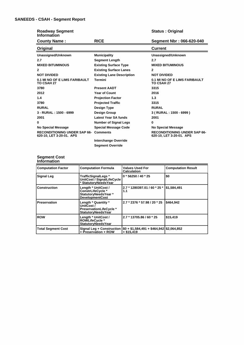
SANEEDS - CSAH - Segment Report
Roadway SegmentInformation
Status : Original
County Name : RICE Segment Nbr : 066-620-040
Original Current
Unassigned/Unknown Municipality Unassigned/Unknown
2.7 Segment Length 2.7
MIXED BITUMINOUS Existing Surface Type MIXED BITUMINOUS
2 Existing Surface Lanes 2
NOT DIVIDED Existing Lane Description NOT DIVIDED
0.1 MI NO OF E LIMS FARIBAULTTO CSAH 27
Termini 0.1 MI NO OF E LIMS FARIBAULTTO CSAH 27
3780 Present AADT 3315
2012 Year of Count 2016
1.4 Projection Factor 1.3
3780 Projected Traffic 3315
RURAL Design Type RURAL
3 - RURAL : 1500 - 6999 Design Group 3 ( RURAL : 1500 - 6999 )
2001 Latest Year SA funds 2001
0 Number of Signal Legs 0
No Special Message Special Message Code No Special Message
RECONDITIONING UNDER SAP 66-620-10, LET 3-20-01. APS
Comments RECONDITIONING UNDER SAP 66-620-10, LET 3-20-01. APS
Interchange Override
Segment Override
Segment CostInformation
Computation Factor Computation Formula Values Used ForCalculation
Computation Result
Signal Leg TrafficSignalLegs *UnitCost / SignalLifeCycle* StatutoryNeedsYear
0 * 56250 / 40 * 25 $0
Construction Length * UnitCost /ConstrLifeCycle *StatutoryNeedsYear *DevelopmentCost
2.7 * 1280397.01 / 60 * 25 *1.1
$1,584,491
Preservation Length * Quantity *UnitCost /PreservationLifeCycle *StatutoryNeedsYear
2.7 * 2376 * 57.98 / 20 * 25 $464,942
ROW Length * UnitCost /ROWLifeCycle *StatutoryNeedsYear
2.7 * 13705.86 / 60 * 25 $15,419
Total Segment Cost Signal Leg + Construction+ Preservation + ROW
$0 + $1,584,491 + $464,942+ $15,419
$2,064,852

SANEEDS - CSAH - Segment Report
Roadway SegmentInformation
Status : Original
County Name : RICE Segment Nbr : 066-620-050
Original Current
Unassigned/Unknown Municipality Unassigned/Unknown
6.5 Segment Length 6.5
MIXED BITUMINOUS Existing Surface Type MIXED BITUMINOUS
2 Existing Surface Lanes 2
NOT DIVIDED Existing Lane Description NOT DIVIDED
CSAH 27 TO S LIM DUNDAS Termini CSAH 27 TO S LIM DUNDAS
3150 Present AADT 2340
2012 Year of Count 2016
1.4 Projection Factor 1.3
3150 Projected Traffic 2340
RURAL Design Type RURAL
3 - RURAL : 1500 - 6999 Design Group 3 ( RURAL : 1500 - 6999 )
2001 Latest Year SA funds 2001
0 Number of Signal Legs 0
No Special Message Special Message Code No Special Message
RECONDITIONING UNDER SAP 66-620-10, LET 3-20-01. APS
Comments RECONDITIONING UNDER SAP 66-620-10, LET 3-20-01. APS
Interchange Override
Segment Override
Segment CostInformation
Computation Factor Computation Formula Values Used ForCalculation
Computation Result
Signal Leg TrafficSignalLegs *UnitCost / SignalLifeCycle* StatutoryNeedsYear
0 * 56250 / 40 * 25 $0
Construction Length * UnitCost /ConstrLifeCycle *StatutoryNeedsYear *DevelopmentCost
6.5 * 1280397.01 / 60 * 25 *1.1
$3,814,516
Preservation Length * Quantity *UnitCost /PreservationLifeCycle *StatutoryNeedsYear
6.5 * 2376 * 57.98 / 20 * 25 $1,119,304
ROW Length * UnitCost /ROWLifeCycle *StatutoryNeedsYear
6.5 * 13705.86 / 60 * 25 $37,120
Total Segment Cost Signal Leg + Construction+ Preservation + ROW
$0 + $3,814,516 +$1,119,304 + $37,120
$4,970,940

SANEEDS - CSAH - Segment Report
Roadway SegmentInformation
Status : Original
County Name : RICE Segment Nbr : 066-620-060
Original Current
DUNDAS Municipality DUNDAS
0.13 Segment Length 0.13
MIXED BITUMINOUS Existing Surface Type MIXED BITUMINOUS
2 Existing Surface Lanes 2
NOT DIVIDED Existing Lane Description NOT DIVIDED
S LIM DUNDAS TO TH 3 Termini S LIM DUNDAS TO TH 3
3150 Present AADT 2860
2012 Year of Count 2016
1.4 Projection Factor 1.3
3150 Projected Traffic 2860
RURAL Design Type RURAL
3 - RURAL : 1500 - 6999 Design Group 3 ( RURAL : 1500 - 6999 )
2001 Latest Year SA funds 2001
0 Number of Signal Legs 0
No Special Message Special Message Code No Special Message
RECONDITIONING UNDER SAP 66-620-10, LET 3-20-01. APS
Comments RECONDITIONING UNDER SAP 66-620-10, LET 3-20-01. APS
Interchange Override
Segment Override
Segment CostInformation
Computation Factor Computation Formula Values Used ForCalculation
Computation Result
Signal Leg TrafficSignalLegs *UnitCost / SignalLifeCycle* StatutoryNeedsYear
0 * 56250 / 40 * 25 $0
Construction Length * UnitCost /ConstrLifeCycle *StatutoryNeedsYear *DevelopmentCost
0.13 * 1280397.01 / 60 * 25* 1.1
$76,290
Preservation Length * Quantity *UnitCost /PreservationLifeCycle *StatutoryNeedsYear
0.13 * 2376 * 57.98 / 20 * 25 $22,386
ROW Length * UnitCost /ROWLifeCycle *StatutoryNeedsYear
0.13 * 13705.86 / 60 * 25 $742
Total Segment Cost Signal Leg + Construction+ Preservation + ROW
$0 + $76,290 + $22,386 +$742
$99,418

SANEEDS - CSAH - Segment Report
Roadway SegmentInformation
Status : Original
County Name : RICE Segment Nbr : 066-620-070
Original Current
DUNDAS Municipality DUNDAS
0.26 Segment Length 0.26
MIXED BITUMINOUS Existing Surface Type MIXED BITUMINOUS
2 Existing Surface Lanes 2
NOT DIVIDED Existing Lane Description NOT DIVIDED
TH 3 TO 0.26 MI NW Termini TH 3 TO 0.26 MI NW
728 Present AADT 728
2012 Year of Count 2016
1.4 Projection Factor 1.3
728 Projected Traffic 728
RURAL Design Type RURAL
2 - RURAL : 150 - 1499 Design Group 2 ( RURAL : 150 - 1499 )
1995 Latest Year SA funds 1995
0 Number of Signal Legs 0
No Special Message Special Message Code No Special Message
Comments
Interchange Override
Segment Override
Segment CostInformation
Computation Factor Computation Formula Values Used ForCalculation
Computation Result
Signal Leg TrafficSignalLegs *UnitCost / SignalLifeCycle* StatutoryNeedsYear
0 * 56250 / 40 * 25 $0
Construction Length * UnitCost /ConstrLifeCycle *StatutoryNeedsYear *DevelopmentCost
0.26 * 975142.53 / 60 * 25 *1.1
$116,204
Preservation Length * Quantity *UnitCost /PreservationLifeCycle *StatutoryNeedsYear
0.26 * 2112 * 57.98 / 20 * 25 $39,797
ROW Length * UnitCost /ROWLifeCycle *StatutoryNeedsYear
0.26 * 32462.65 / 60 * 25 $3,517
Total Segment Cost Signal Leg + Construction+ Preservation + ROW
$0 + $116,204 + $39,797 +$3,517
$159,518

SANEEDS - CSAH - Segment Report
Roadway SegmentInformation
Status : Original
County Name : RICE Segment Nbr : 066-620-080
Original Current
DUNDAS Municipality DUNDAS
0.3 Segment Length 0.3
MIXED BITUMINOUS Existing Surface Type MIXED BITUMINOUS
2 Existing Surface Lanes 2
NOT DIVIDED Existing Lane Description NOT DIVIDED
0.26 MI NW OF TH 3 TO CSAH 1 Termini 0.26 MI NW OF TH 3 TO CSAH 1
1050 Present AADT 1001
2012 Year of Count 2016
1.4 Projection Factor 1.3
1050 Projected Traffic 1001
URBAN Design Type URBAN
5 - URBAN : 0 - 9999 Design Group 5 ( URBAN : 0 - 9999 )
1996 Latest Year SA funds 1996
0 Number of Signal Legs 0
No Special Message Special Message Code No Special Message
Comments
Interchange Override
Segment Override
Segment CostInformation
Computation Factor Computation Formula Values Used ForCalculation
Computation Result
Signal Leg TrafficSignalLegs *UnitCost / SignalLifeCycle* StatutoryNeedsYear
0 * 56250 / 40 * 25 $0
Construction Length * UnitCost /ConstrLifeCycle *StatutoryNeedsYear *DevelopmentCost
0.3 * 2904860.94 / 60 * 25 *1.15
$417,574
Preservation Length * Quantity *UnitCost /PreservationLifeCycle *StatutoryNeedsYear
0.3 * 2904 * 57.98 / 15 * 25 $84,187
ROW Length * UnitCost /ROWLifeCycle *StatutoryNeedsYear
0.3 * 51162.01 / 60 * 25 $6,395
Total Segment Cost Signal Leg + Construction+ Preservation + ROW
$0 + $417,574 + $84,187 +$6,395
$508,156

SANEEDS - CSAH - Segment Report
Roadway SegmentInformation
Status : Original
County Name : RICE Segment Nbr : 066-621-020
Original Current
Unassigned/Unknown Municipality Unassigned/Unknown
3.2 Segment Length 3.2
MIXED BITUMINOUS Existing Surface Type MIXED BITUMINOUS
2 Existing Surface Lanes 2
NOT DIVIDED Existing Lane Description NOT DIVIDED
S CO LINE TO 0.1 MI S JCT CSAH19
Termini S CO LINE TO 0.1 MI S JCT CSAH19
700 Present AADT 702
2012 Year of Count 2016
1.4 Projection Factor 1.3
700 Projected Traffic 702
RURAL Design Type RURAL
2 - RURAL : 150 - 1499 Design Group 2 ( RURAL : 150 - 1499 )
2015 Latest Year SA funds 2015
0 Number of Signal Legs 0
No Special Message Special Message Code No Special Message
2015 SP 066-621-004 / 066-070-014FDR & OL
2014 SAP 066-621-003 CULVERTR&RREPLACES STRUCTURE 1018
Comments 2015 SP 066-621-004 / 066-070-014FDR & OL
2014 SAP 066-621-003 CULVERTR&RREPLACES STRUCTURE 1018
Interchange Override
Segment Override
Bridge Information Status: Original
Original Current
92131 Structure Number 92131
1.78 Milepoint 1.78
1966 Year Built 1966
MUD CREEK Feature Crossed MUD CREEK
Type of Service
Number of Spans
46 Bridge Length 46
31.6 Bridge Width 31.6
100% Shared Structure 100%
Comments
1 ( 0-149 ) Bridge Group Code 1 ( 0-149 )
Culvert Information Status: Original
Original Current
92130 Structure Number 92130
0.7 Milepoint 0.7
1967 Year Built 1967
STREAM Feature Crossed STREAM
Type of Service
2 Number of Barrels 2
Culvert Width
Culvert Height
78 Culvert Length 78
28.00013307 Area of Waterway Opening 28.00013307
100% Shared Structure 100%
Comments
1 Culvert Group Code 1
Culvert Information Status: Original
Original Current
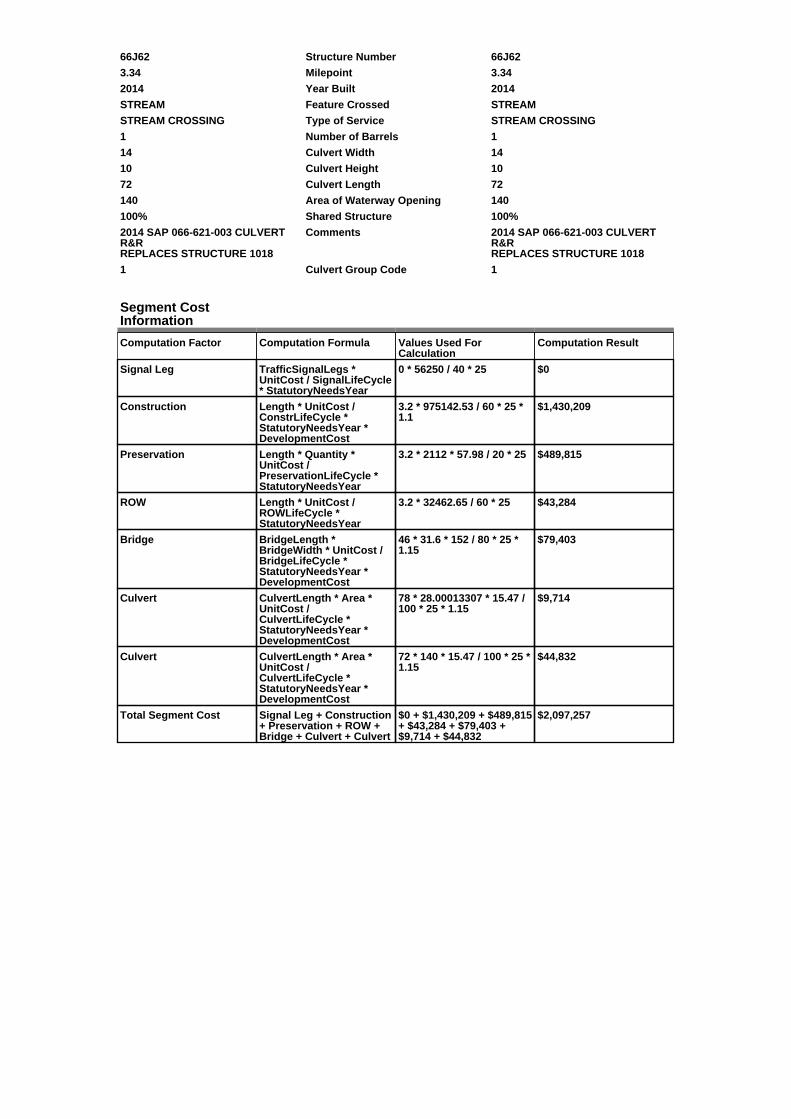
66J62 Structure Number 66J62
3.34 Milepoint 3.34
2014 Year Built 2014
STREAM Feature Crossed STREAM
STREAM CROSSING Type of Service STREAM CROSSING
1 Number of Barrels 1
14 Culvert Width 14
10 Culvert Height 10
72 Culvert Length 72
140 Area of Waterway Opening 140
100% Shared Structure 100%
2014 SAP 066-621-003 CULVERTR&RREPLACES STRUCTURE 1018
Comments 2014 SAP 066-621-003 CULVERTR&RREPLACES STRUCTURE 1018
1 Culvert Group Code 1
Segment CostInformation
Computation Factor Computation Formula Values Used ForCalculation
Computation Result
Signal Leg TrafficSignalLegs *UnitCost / SignalLifeCycle* StatutoryNeedsYear
0 * 56250 / 40 * 25 $0
Construction Length * UnitCost /ConstrLifeCycle *StatutoryNeedsYear *DevelopmentCost
3.2 * 975142.53 / 60 * 25 *1.1
$1,430,209
Preservation Length * Quantity *UnitCost /PreservationLifeCycle *StatutoryNeedsYear
3.2 * 2112 * 57.98 / 20 * 25 $489,815
ROW Length * UnitCost /ROWLifeCycle *StatutoryNeedsYear
3.2 * 32462.65 / 60 * 25 $43,284
Bridge BridgeLength *BridgeWidth * UnitCost /BridgeLifeCycle *StatutoryNeedsYear *DevelopmentCost
46 * 31.6 * 152 / 80 * 25 *1.15
$79,403
Culvert CulvertLength * Area *UnitCost /CulvertLifeCycle *StatutoryNeedsYear *DevelopmentCost
78 * 28.00013307 * 15.47 /100 * 25 * 1.15
$9,714
Culvert CulvertLength * Area *UnitCost /CulvertLifeCycle *StatutoryNeedsYear *DevelopmentCost
72 * 140 * 15.47 / 100 * 25 *1.15
$44,832
Total Segment Cost Signal Leg + Construction+ Preservation + ROW +Bridge + Culvert + Culvert
$0 + $1,430,209 + $489,815+ $43,284 + $79,403 +$9,714 + $44,832
$2,097,257

SANEEDS - CSAH - Segment Report
Roadway SegmentInformation
Status : Original
County Name : RICE Segment Nbr : 066-621-030
Original Current
Unassigned/Unknown Municipality Unassigned/Unknown
0.1 Segment Length 0.1
BIT CONC OR ASPH Existing Surface Type BIT CONC OR ASPH
2 Existing Surface Lanes 2
NOT DIVIDED Existing Lane Description NOT DIVIDED
0.1 MI S OF CSAH 19 TO CSAH 19 Termini 0.1 MI S OF CSAH 19 TO CSAH 19
700 Present AADT 702
2012 Year of Count 2016
1.4 Projection Factor 1.3
700 Projected Traffic 702
RURAL Design Type RURAL
2 - RURAL : 150 - 1499 Design Group 2 ( RURAL : 150 - 1499 )
1988 Latest Year SA funds 1988
0 Number of Signal Legs 0
No Special Message Special Message Code No Special Message
Comments
Interchange Override
Segment Override
Segment CostInformation
Computation Factor Computation Formula Values Used ForCalculation
Computation Result
Signal Leg TrafficSignalLegs *UnitCost / SignalLifeCycle* StatutoryNeedsYear
0 * 56250 / 40 * 25 $0
Construction Length * UnitCost /ConstrLifeCycle *StatutoryNeedsYear *DevelopmentCost
0.1 * 975142.53 / 60 * 25 *1.1
$44,694
Preservation Length * Quantity *UnitCost /PreservationLifeCycle *StatutoryNeedsYear
0.1 * 2112 * 57.98 / 20 * 25 $15,307
ROW Length * UnitCost /ROWLifeCycle *StatutoryNeedsYear
0.1 * 32462.65 / 60 * 25 $1,353
Total Segment Cost Signal Leg + Construction+ Preservation + ROW
$0 + $44,694 + $15,307 +$1,353
$61,354

SANEEDS - CSAH - Segment Report
Roadway SegmentInformation
Status : Original
County Name : RICE Segment Nbr : 066-622-010
Original Current
Unassigned/Unknown Municipality Unassigned/Unknown
0.6 Segment Length 0.6
MIXED BITUMINOUS Existing Surface Type MIXED BITUMINOUS
2 Existing Surface Lanes 2
NOT DIVIDED Existing Lane Description NOT DIVIDED
CSAH 20 TO C R 84 Termini CSAH 20 TO C R 84
826 Present AADT 806
2012 Year of Count 2016
1.4 Projection Factor 1.3
826 Projected Traffic 806
RURAL Design Type RURAL
2 - RURAL : 150 - 1499 Design Group 2 ( RURAL : 150 - 1499 )
1977 Latest Year SA funds 1977
0 Number of Signal Legs 0
No Special Message Special Message Code No Special Message
Comments
Interchange Override
Segment Override
Segment CostInformation
Computation Factor Computation Formula Values Used ForCalculation
Computation Result
Signal Leg TrafficSignalLegs *UnitCost / SignalLifeCycle* StatutoryNeedsYear
0 * 56250 / 40 * 25 $0
Construction Length * UnitCost /ConstrLifeCycle *StatutoryNeedsYear *DevelopmentCost
0.6 * 975142.53 / 60 * 25 *1.1
$268,164
Preservation Length * Quantity *UnitCost /PreservationLifeCycle *StatutoryNeedsYear
0.6 * 2112 * 57.98 / 20 * 25 $91,840
ROW Length * UnitCost /ROWLifeCycle *StatutoryNeedsYear
0.6 * 32462.65 / 60 * 25 $8,116
Total Segment Cost Signal Leg + Construction+ Preservation + ROW
$0 + $268,164 + $91,840 +$8,116
$368,120

SANEEDS - CSAH - Segment Report
Roadway SegmentInformation
Status : Original
County Name : RICE Segment Nbr : 066-622-020
Original Current
Unassigned/Unknown Municipality Unassigned/Unknown
2.1 Segment Length 2.1
MIXED BITUMINOUS Existing Surface Type MIXED BITUMINOUS
2 Existing Surface Lanes 2
NOT DIVIDED Existing Lane Description NOT DIVIDED
CR 84 TO 0.2 MI SOUTH OF TH 246 Termini CR 84 TO 0.2 MI SOUTH OF TH 246
1680 Present AADT 1690
2012 Year of Count 2016
1.4 Projection Factor 1.3
1680 Projected Traffic 1690
RURAL Design Type RURAL
3 - RURAL : 1500 - 6999 Design Group 3 ( RURAL : 1500 - 6999 )
2000 Latest Year SA funds 2000
0 Number of Signal Legs 0
No Special Message Special Message Code No Special Message
Comments
Interchange Override
Segment Override
Segment CostInformation
Computation Factor Computation Formula Values Used ForCalculation
Computation Result
Signal Leg TrafficSignalLegs *UnitCost / SignalLifeCycle* StatutoryNeedsYear
0 * 56250 / 40 * 25 $0
Construction Length * UnitCost /ConstrLifeCycle *StatutoryNeedsYear *DevelopmentCost
2.1 * 1280397.01 / 60 * 25 *1.1
$1,232,382
Preservation Length * Quantity *UnitCost /PreservationLifeCycle *StatutoryNeedsYear
2.1 * 2376 * 57.98 / 20 * 25 $361,621
ROW Length * UnitCost /ROWLifeCycle *StatutoryNeedsYear
2.1 * 13705.86 / 60 * 25 $11,993
Total Segment Cost Signal Leg + Construction+ Preservation + ROW
$0 + $1,232,382 + $361,621+ $11,993
$1,605,996

SANEEDS - CSAH - Segment Report
Roadway SegmentInformation
Status : Original
County Name : RICE Segment Nbr : 066-622-030
Original Current
Unassigned/Unknown Municipality Unassigned/Unknown
0.2 Segment Length 0.2
MIXED BITUMINOUS Existing Surface Type MIXED BITUMINOUS
2 Existing Surface Lanes 2
NOT DIVIDED Existing Lane Description NOT DIVIDED
0.2 MI S OF TH 246 TO TH 246 Termini 0.2 MI S OF TH 246 TO TH 246
1680 Present AADT 1690
2012 Year of Count 2016
1.4 Projection Factor 1.3
1680 Projected Traffic 1690
RURAL Design Type RURAL
3 - RURAL : 1500 - 6999 Design Group 3 ( RURAL : 1500 - 6999 )
2000 Latest Year SA funds 2000
0 Number of Signal Legs 0
No Special Message Special Message Code No Special Message
Comments
Interchange Override
Segment Override
Segment CostInformation
Computation Factor Computation Formula Values Used ForCalculation
Computation Result
Signal Leg TrafficSignalLegs *UnitCost / SignalLifeCycle* StatutoryNeedsYear
0 * 56250 / 40 * 25 $0
Construction Length * UnitCost /ConstrLifeCycle *StatutoryNeedsYear *DevelopmentCost
0.2 * 1280397.01 / 60 * 25 *1.1
$117,370
Preservation Length * Quantity *UnitCost /PreservationLifeCycle *StatutoryNeedsYear
0.2 * 2376 * 57.98 / 20 * 25 $34,440
ROW Length * UnitCost /ROWLifeCycle *StatutoryNeedsYear
0.2 * 13705.86 / 60 * 25 $1,142
Total Segment Cost Signal Leg + Construction+ Preservation + ROW
$0 + $117,370 + $34,440 +$1,142
$152,952

SANEEDS - CSAH - Segment Report
Roadway SegmentInformation
Status : Original
County Name : RICE Segment Nbr : 066-623-010
Original Current
Unassigned/Unknown Municipality Unassigned/Unknown
3 Segment Length 3
BIT CONC OR ASPH Existing Surface Type BIT CONC OR ASPH
2 Existing Surface Lanes 2
NOT DIVIDED Existing Lane Description NOT DIVIDED
SO CO LINE TO CSAH 19 Termini SO CO LINE TO CSAH 19
854 Present AADT 793
2012 Year of Count 2016
1.4 Projection Factor 1.3
854 Projected Traffic 793
RURAL Design Type RURAL
2 - RURAL : 150 - 1499 Design Group 2 ( RURAL : 150 - 1499 )
1985 Latest Year SA funds 1985
0 Number of Signal Legs 0
No Special Message Special Message Code No Special Message
Comments
Interchange Override
Segment Override
Segment CostInformation
Computation Factor Computation Formula Values Used ForCalculation
Computation Result
Signal Leg TrafficSignalLegs *UnitCost / SignalLifeCycle* StatutoryNeedsYear
0 * 56250 / 40 * 25 $0
Construction Length * UnitCost /ConstrLifeCycle *StatutoryNeedsYear *DevelopmentCost
3 * 975142.53 / 60 * 25 * 1.1 $1,340,821
Preservation Length * Quantity *UnitCost /PreservationLifeCycle *StatutoryNeedsYear
3 * 2112 * 57.98 / 20 * 25 $459,202
ROW Length * UnitCost /ROWLifeCycle *StatutoryNeedsYear
3 * 32462.65 / 60 * 25 $40,578
Total Segment Cost Signal Leg + Construction+ Preservation + ROW
$0 + $1,340,821 + $459,202+ $40,578
$1,840,601

SANEEDS - CSAH - Segment Report
Roadway SegmentInformation
Status : Original
County Name : RICE Segment Nbr : 066-623-020
Original Current
Unassigned/Unknown Municipality Unassigned/Unknown
3 Segment Length 3
MIXED BITUMINOUS Existing Surface Type MIXED BITUMINOUS
2 Existing Surface Lanes 2
NOT DIVIDED Existing Lane Description NOT DIVIDED
CSAH 19 TO TH 60 Termini CSAH 19 TO TH 60
854 Present AADT 793
2012 Year of Count 2016
1.4 Projection Factor 1.3
854 Projected Traffic 793
RURAL Design Type RURAL
2 - RURAL : 150 - 1499 Design Group 2 ( RURAL : 150 - 1499 )
2013 Latest Year SA funds 2013
0 Number of Signal Legs 0
No Special Message Special Message Code No Special Message
2013 SAP 066-623-010 CULVERTR&R 66J58
Comments 2013 SAP 066-623-010 CULVERTR&R 66J58
Interchange Override
Segment Override
Culvert Information Status: Original
Original Current
88029 Structure Number 88029
4.1 Milepoint 4.1
1959 Year Built 1959
STREAM Feature Crossed STREAM
Type of Service
3 Number of Barrels 3
4 Culvert Width 4
4 Culvert Height 4
56 Culvert Length 56
37.99979617 Area of Waterway Opening 37.99979617
100% Shared Structure 100%
Comments
1 Culvert Group Code 1
Culvert Information Status: Original
Original Current
66J58 Structure Number 66J58
4.94 Milepoint 4.94
2013 Year Built 2013
DITCH Feature Crossed DITCH
STREAM CROSSING Type of Service STREAM CROSSING
2 Number of Barrels 2
12 Culvert Width 12
9 Culvert Height 9
75 Culvert Length 75
216 Area of Waterway Opening 216
100% Shared Structure 100%
2013 SAP 066-623-010 CULVERTR&R
Comments 2013 SAP 066-623-010 CULVERTR&R
1 Culvert Group Code 1
Segment CostInformation
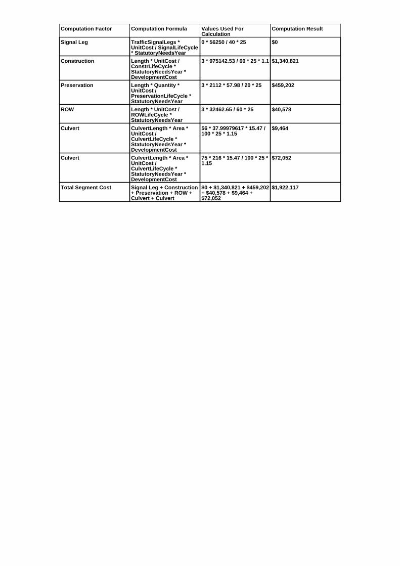
Computation Factor Computation Formula Values Used ForCalculation
Computation Result
Signal Leg TrafficSignalLegs *UnitCost / SignalLifeCycle* StatutoryNeedsYear
0 * 56250 / 40 * 25 $0
Construction Length * UnitCost /ConstrLifeCycle *StatutoryNeedsYear *DevelopmentCost
3 * 975142.53 / 60 * 25 * 1.1 $1,340,821
Preservation Length * Quantity *UnitCost /PreservationLifeCycle *StatutoryNeedsYear
3 * 2112 * 57.98 / 20 * 25 $459,202
ROW Length * UnitCost /ROWLifeCycle *StatutoryNeedsYear
3 * 32462.65 / 60 * 25 $40,578
Culvert CulvertLength * Area *UnitCost /CulvertLifeCycle *StatutoryNeedsYear *DevelopmentCost
56 * 37.99979617 * 15.47 /100 * 25 * 1.15
$9,464
Culvert CulvertLength * Area *UnitCost /CulvertLifeCycle *StatutoryNeedsYear *DevelopmentCost
75 * 216 * 15.47 / 100 * 25 *1.15
$72,052
Total Segment Cost Signal Leg + Construction+ Preservation + ROW +Culvert + Culvert
$0 + $1,340,821 + $459,202+ $40,578 + $9,464 +$72,052
$1,922,117
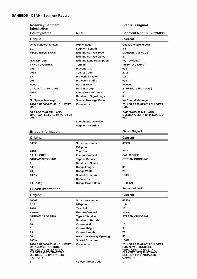
SANEEDS - CSAH - Segment Report
Roadway SegmentInformation
Status : Original
County Name : RICE Segment Nbr : 066-623-030
Original Current
Unassigned/Unknown Municipality Unassigned/Unknown
3.1 Segment Length 3.1
MIXED BITUMINOUS Existing Surface Type MIXED BITUMINOUS
2 Existing Surface Lanes 2
NOT DIVIDED Existing Lane Description NOT DIVIDED
TH 60 TO CSAH 27 Termini TH 60 TO CSAH 27
756 Present AADT 624
2012 Year of Count 2016
1.4 Projection Factor 1.3
756 Projected Traffic 624
RURAL Design Type RURAL
2 - RURAL : 150 - 1499 Design Group 2 ( RURAL : 150 - 1499 )
2014 Latest Year SA funds 2014
0 Number of Signal Legs 0
No Special Message Special Message Code No Special Message
2014 SAP 066-623-011 CULVERTR&R
SAP 66-623-07 MILL ANDOVERLAY, LET 7-19-04 (APS 1-24-05).
Comments 2014 SAP 066-623-011 CULVERTR&R
SAP 66-623-07 MILL ANDOVERLAY, LET 7-19-04 (APS 1-24-05).
Interchange Override
Segment Override
Bridge Information Status: Original
Original Current
66553 Structure Number 66553
Milepoint
2010 Year Built 2010
FALLS CREEK Feature Crossed FALLS CREEK
STREAM CROSSING Type of Service STREAM CROSSING
1 Number of Spans 1
36 Bridge Length 36
26 Bridge Width 26
100% Shared Structure 100%
Comments
1 ( 0-149 ) Bridge Group Code 1 ( 0-149 )
Culvert Information Status: Original
Original Current
66J68 Structure Number 66J68
1.24 Milepoint 1.24
2014 Year Built 2014
stream Feature Crossed stream
STREAM CROSSING Type of Service STREAM CROSSING
1 Number of Barrels 1
10 Culvert Width 10
5 Culvert Height 5
73 Culvert Length 73
50 Area of Waterway Opening 50
100% Shared Structure 100%
2014 SAP 066-623-011 CULVERTR&R NEW STRUCTUREREPLACING AN EXISTINGCULVERT (9FT) THAT WASDEFICIENT IN HYDRAULICCAPACITY
Comments 2014 SAP 066-623-011 CULVERTR&R NEW STRUCTUREREPLACING AN EXISTINGCULVERT (9FT) THAT WASDEFICIENT IN HYDRAULICCAPACITY
1 Culvert Group Code 1

Segment CostInformation
Computation Factor Computation Formula Values Used ForCalculation
Computation Result
Signal Leg TrafficSignalLegs *UnitCost / SignalLifeCycle* StatutoryNeedsYear
0 * 56250 / 40 * 25 $0
Construction Length * UnitCost /ConstrLifeCycle *StatutoryNeedsYear *DevelopmentCost
3.1 * 975142.53 / 60 * 25 *1.1
$1,385,515
Preservation Length * Quantity *UnitCost /PreservationLifeCycle *StatutoryNeedsYear
3.1 * 2112 * 57.98 / 20 * 25 $474,508
ROW Length * UnitCost /ROWLifeCycle *StatutoryNeedsYear
3.1 * 32462.65 / 60 * 25 $41,931
Bridge BridgeLength *BridgeWidth * UnitCost /BridgeLifeCycle *StatutoryNeedsYear *DevelopmentCost
36 * 26 * 152 / 80 * 25 *1.15
$51,129
Culvert CulvertLength * Area *UnitCost /CulvertLifeCycle *StatutoryNeedsYear *DevelopmentCost
73 * 50 * 15.47 / 100 * 25 *1.15
$16,234
Total Segment Cost Signal Leg + Construction+ Preservation + ROW +Bridge + Culvert
$0 + $1,385,515 + $474,508+ $41,931 + $51,129 +$16,234
$1,969,317

SANEEDS - CSAH - Segment Report
Roadway SegmentInformation
Status : Original
County Name : RICE Segment Nbr : 066-625-010
Original Current
FARIBAULT Municipality FARIBAULT
0.13 Segment Length 0.13
MIXED BITUMINOUS Existing Surface Type MIXED BITUMINOUS
2 Existing Surface Lanes 2
NOT DIVIDED Existing Lane Description NOT DIVIDED
CSAH 20 TO E LIMS OFFARIBAULT
Termini CSAH 20 TO E LIMS OFFARIBAULT
1218 Present AADT 988
2012 Year of Count 2016
1.4 Projection Factor 1.3
1218 Projected Traffic 988
RURAL Design Type RURAL
2 - RURAL : 150 - 1499 Design Group 2 ( RURAL : 150 - 1499 )
2001 Latest Year SA funds 2001
0 Number of Signal Legs 0
No Special Message Special Message Code No Special Message
RECONDITIONING UNDER SAP 66-625-010, LET 3-20-01. APS
Comments RECONDITIONING UNDER SAP 66-625-010, LET 3-20-01. APS
Interchange Override
Segment Override
Segment CostInformation
Computation Factor Computation Formula Values Used ForCalculation
Computation Result
Signal Leg TrafficSignalLegs *UnitCost / SignalLifeCycle* StatutoryNeedsYear
0 * 56250 / 40 * 25 $0
Construction Length * UnitCost /ConstrLifeCycle *StatutoryNeedsYear *DevelopmentCost
0.13 * 975142.53 / 60 * 25 *1.1
$58,102
Preservation Length * Quantity *UnitCost /PreservationLifeCycle *StatutoryNeedsYear
0.13 * 2112 * 57.98 / 20 * 25 $19,899
ROW Length * UnitCost /ROWLifeCycle *StatutoryNeedsYear
0.13 * 32462.65 / 60 * 25 $1,758
Total Segment Cost Signal Leg + Construction+ Preservation + ROW
$0 + $58,102 + $19,899 +$1,758
$79,759

SANEEDS - CSAH - Segment Report
Roadway SegmentInformation
Status : Original
County Name : RICE Segment Nbr : 066-625-020
Original Current
Unassigned/Unknown Municipality Unassigned/Unknown
4 Segment Length 4
MIXED BITUMINOUS Existing Surface Type MIXED BITUMINOUS
2 Existing Surface Lanes 2
NOT DIVIDED Existing Lane Description NOT DIVIDED
E LIM FARIBAULT TO CSAH 23 Termini E LIM FARIBAULT TO CSAH 23
1218 Present AADT 988
2012 Year of Count 2016
1.4 Projection Factor 1.3
1218 Projected Traffic 988
RURAL Design Type RURAL
2 - RURAL : 150 - 1499 Design Group 2 ( RURAL : 150 - 1499 )
2001 Latest Year SA funds 2001
0 Number of Signal Legs 0
No Special Message Special Message Code No Special Message
RECONDITIONING UNDER SAP 66-625-010, LET 3-20-01. APS
Comments RECONDITIONING UNDER SAP 66-625-010, LET 3-20-01. APS
Interchange Override
Segment Override
Culvert Information Status: Original
Original Current
L3919 Structure Number L3919
2.32 Milepoint 2.32
1958 Year Built 1958
STREAM Feature Crossed STREAM
Type of Service
2 Number of Barrels 2
5 Culvert Width 5
3 Culvert Height 3
54 Culvert Length 54
23.00030152 Area of Waterway Opening 23.00030152
100% Shared Structure 100%
Comments
1 Culvert Group Code 1
Segment CostInformation
Computation Factor Computation Formula Values Used ForCalculation
Computation Result
Signal Leg TrafficSignalLegs *UnitCost / SignalLifeCycle* StatutoryNeedsYear
0 * 56250 / 40 * 25 $0
Construction Length * UnitCost /ConstrLifeCycle *StatutoryNeedsYear *DevelopmentCost
4 * 975142.53 / 60 * 25 * 1.1 $1,787,761
Preservation Length * Quantity *UnitCost /PreservationLifeCycle *StatutoryNeedsYear
4 * 2112 * 57.98 / 20 * 25 $612,269
ROW Length * UnitCost /ROWLifeCycle *StatutoryNeedsYear
4 * 32462.65 / 60 * 25 $54,104
Culvert CulvertLength * Area *UnitCost /CulvertLifeCycle *StatutoryNeedsYear *DevelopmentCost
54 * 23.00030152 * 15.47 /100 * 25 * 1.15
$5,524

Total Segment Cost Signal Leg + Construction+ Preservation + ROW +Culvert
$0 + $1,787,761 + $612,269+ $54,104 + $5,524
$2,459,658

SANEEDS - CSAH - Segment Report
Roadway SegmentInformation
Status : Original
County Name : RICE Segment Nbr : 066-626-010
Original Current
Unassigned/Unknown Municipality Unassigned/Unknown
3 Segment Length 3
BIT CONC OR ASPH Existing Surface Type BIT CONC OR ASPH
2 Existing Surface Lanes 2
NOT DIVIDED Existing Lane Description NOT DIVIDED
SO CO LINE TO CSAH 19 Termini SO CO LINE TO CSAH 19
637 Present AADT 598
2012 Year of Count 2016
1.4 Projection Factor 1.3
637 Projected Traffic 598
RURAL Design Type RURAL
2 - RURAL : 150 - 1499 Design Group 2 ( RURAL : 150 - 1499 )
1966 Latest Year SA funds 1966
0 Number of Signal Legs 0
No Special Message Special Message Code No Special Message
Comments
Interchange Override
Segment Override
Culvert Information Status: Original
Original Current
92598 Structure Number 92598
1.49 Milepoint 1.49
1965 Year Built 1965
STREAM Feature Crossed STREAM
Type of Service
1 Number of Barrels 1
14 Culvert Width 14
8 Culvert Height 8
50 Culvert Length 50
96.99996124 Area of Waterway Opening 96.99996124
100% Shared Structure 100%
Comments
1 Culvert Group Code 1
Culvert Information Status: Original
Original Current
92771 Structure Number 92771
2.47 Milepoint 2.47
1966 Year Built 1966
STREAM Feature Crossed STREAM
Type of Service
2 Number of Barrels 2
9 Culvert Width 9
6 Culvert Height 6
60 Culvert Length 60
86.00033183 Area of Waterway Opening 86.00033183
100% Shared Structure 100%
Comments
1 Culvert Group Code 1
Segment CostInformation
Computation Factor Computation Formula Values Used ForCalculation
Computation Result

Signal Leg TrafficSignalLegs *UnitCost / SignalLifeCycle* StatutoryNeedsYear
0 * 56250 / 40 * 25 $0
Construction Length * UnitCost /ConstrLifeCycle *StatutoryNeedsYear *DevelopmentCost
3 * 975142.53 / 60 * 25 * 1.1 $1,340,821
Preservation Length * Quantity *UnitCost /PreservationLifeCycle *StatutoryNeedsYear
3 * 2112 * 57.98 / 20 * 25 $459,202
ROW Length * UnitCost /ROWLifeCycle *StatutoryNeedsYear
3 * 32462.65 / 60 * 25 $40,578
Culvert CulvertLength * Area *UnitCost /CulvertLifeCycle *StatutoryNeedsYear *DevelopmentCost
50 * 96.99996124 * 15.47 /100 * 25 * 1.15
$21,571
Culvert CulvertLength * Area *UnitCost /CulvertLifeCycle *StatutoryNeedsYear *DevelopmentCost
60 * 86.00033183 * 15.47 /100 * 25 * 1.15
$22,950
Total Segment Cost Signal Leg + Construction+ Preservation + ROW +Culvert + Culvert
$0 + $1,340,821 + $459,202+ $40,578 + $21,571 +$22,950
$1,885,122

SANEEDS - CSAH - Segment Report
Roadway SegmentInformation
Status : Original
County Name : RICE Segment Nbr : 066-626-020
Original Current
Unassigned/Unknown Municipality Unassigned/Unknown
2.3 Segment Length 2.3
BIT CONC OR ASPH Existing Surface Type BIT CONC OR ASPH
2 Existing Surface Lanes 2
NOT DIVIDED Existing Lane Description NOT DIVIDED
CSAH 19 TO TH 60 Termini CSAH 19 TO TH 60
343 Present AADT 332
2012 Year of Count 2016
1.4 Projection Factor 1.3
343 Projected Traffic 332
RURAL Design Type RURAL
2 - RURAL : 150 - 1499 Design Group 2 ( RURAL : 150 - 1499 )
2013 Latest Year SA funds 2013
0 Number of Signal Legs 0
No Special Message Special Message Code No Special Message
2013 SAP 066-626-013 BR 66554R&R
SEG 020 & 030 COMBINED IN 2005
Comments 2013 SAP 066-626-013 BR 66554R&R
SEG 020 & 030 COMBINED IN 2005
Interchange Override
Segment Override
Bridge Information Status: Original
Original Current
66554 Structure Number 66554
1.7 Milepoint 1.7
2013 Year Built 2013
North Fork of Zumbro River Feature Crossed North Fork of Zumbro River
STREAM CROSSING Type of Service STREAM CROSSING
1 Number of Spans 1
76.85 Bridge Length 76.85
39.33 Bridge Width 39.33
100% Shared Structure 100%
2013 SAP 066-626-013 BR 66554R&R
Comments 2013 SAP 066-626-013 BR 66554R&R
1 ( 0-149 ) Bridge Group Code 1 ( 0-149 )
Segment CostInformation
Computation Factor Computation Formula Values Used ForCalculation
Computation Result
Signal Leg TrafficSignalLegs *UnitCost / SignalLifeCycle* StatutoryNeedsYear
0 * 56250 / 40 * 25 $0
Construction Length * UnitCost /ConstrLifeCycle *StatutoryNeedsYear *DevelopmentCost
2.3 * 975142.53 / 60 * 25 *1.1
$1,027,963
Preservation Length * Quantity *UnitCost /PreservationLifeCycle *StatutoryNeedsYear
2.3 * 2112 * 57.98 / 20 * 25 $352,055
ROW Length * UnitCost /ROWLifeCycle *StatutoryNeedsYear
2.3 * 32462.65 / 60 * 25 $31,110
Bridge BridgeLength *BridgeWidth * UnitCost /BridgeLifeCycle *StatutoryNeedsYear *DevelopmentCost
76.85 * 39.33 * 152 / 80 * 25* 1.15
$165,105

Total Segment Cost Signal Leg + Construction+ Preservation + ROW +Bridge
$0 + $1,027,963 + $352,055+ $31,110 + $165,105
$1,576,233

SANEEDS - CSAH - Segment Report
Roadway SegmentInformation
Status : Original
County Name : RICE Segment Nbr : 066-626-040
Original Current
Unassigned/Unknown Municipality Unassigned/Unknown
4.2 Segment Length 4.2
MIXED BITUMINOUS Existing Surface Type MIXED BITUMINOUS
2 Existing Surface Lanes 2
NOT DIVIDED Existing Lane Description NOT DIVIDED
TH 60 TO S LIM NERSTRAND Termini TH 60 TO S LIM NERSTRAND
658 Present AADT 650
2012 Year of Count 2016
1.4 Projection Factor 1.3
658 Projected Traffic 650
RURAL Design Type RURAL
2 - RURAL : 150 - 1499 Design Group 2 ( RURAL : 150 - 1499 )
1985 Latest Year SA funds 1985
0 Number of Signal Legs 0
No Special Message Special Message Code No Special Message
Comments
Interchange Override
Segment Override
Culvert Information Status: Original
Original Current
66J53 Structure Number 66J53
Milepoint
2010 Year Built 2010
STREAM Feature Crossed STREAM
STREAM CROSSING Type of Service STREAM CROSSING
3 Number of Barrels 3
4 Culvert Width 4
4 Culvert Height 4
36 Culvert Length 36
50.00046828 Area of Waterway Opening 50.00046828
100% Shared Structure 100%
Comments
1 Culvert Group Code 1
Culvert Information Status: Original
Original Current
66J57 Structure Number 66J57
Milepoint
2010 Year Built 2010
STREAM Feature Crossed STREAM
STREAM CROSSING Type of Service STREAM CROSSING
3 Number of Barrels 3
6 Culvert Width 6
6 Culvert Height 6
58 Culvert Length 58
97.99992755 Area of Waterway Opening 97.99992755
100% Shared Structure 100%
Comments
1 Culvert Group Code 1
Segment CostInformation
Computation Factor Computation Formula Values Used ForCalculation
Computation Result
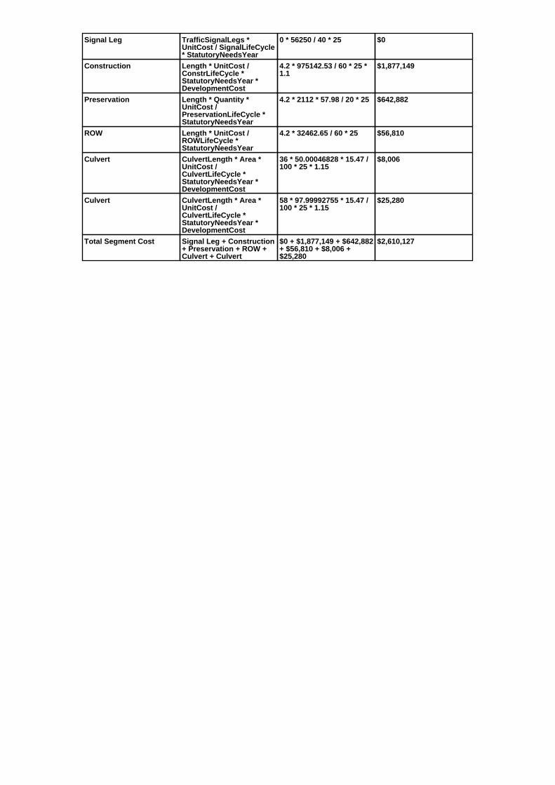
Signal Leg TrafficSignalLegs *UnitCost / SignalLifeCycle* StatutoryNeedsYear
0 * 56250 / 40 * 25 $0
Construction Length * UnitCost /ConstrLifeCycle *StatutoryNeedsYear *DevelopmentCost
4.2 * 975142.53 / 60 * 25 *1.1
$1,877,149
Preservation Length * Quantity *UnitCost /PreservationLifeCycle *StatutoryNeedsYear
4.2 * 2112 * 57.98 / 20 * 25 $642,882
ROW Length * UnitCost /ROWLifeCycle *StatutoryNeedsYear
4.2 * 32462.65 / 60 * 25 $56,810
Culvert CulvertLength * Area *UnitCost /CulvertLifeCycle *StatutoryNeedsYear *DevelopmentCost
36 * 50.00046828 * 15.47 /100 * 25 * 1.15
$8,006
Culvert CulvertLength * Area *UnitCost /CulvertLifeCycle *StatutoryNeedsYear *DevelopmentCost
58 * 97.99992755 * 15.47 /100 * 25 * 1.15
$25,280
Total Segment Cost Signal Leg + Construction+ Preservation + ROW +Culvert + Culvert
$0 + $1,877,149 + $642,882+ $56,810 + $8,006 +$25,280
$2,610,127

SANEEDS - CSAH - Segment Report
Roadway SegmentInformation
Status : Original
County Name : RICE Segment Nbr : 066-626-050
Original Current
NERSTRAND Municipality NERSTRAND
0.5 Segment Length 0.5
MIXED BITUMINOUS Existing Surface Type MIXED BITUMINOUS
2 Existing Surface Lanes 2
NOT DIVIDED Existing Lane Description NOT DIVIDED
SO LIM NERSTRAND TO TH 246 Termini SO LIM NERSTRAND TO TH 246
658 Present AADT 650
2012 Year of Count 2016
1.4 Projection Factor 1.3
658 Projected Traffic 650
RURAL Design Type RURAL
2 - RURAL : 150 - 1499 Design Group 2 ( RURAL : 150 - 1499 )
1985 Latest Year SA funds 1985
0 Number of Signal Legs 0
No Special Message Special Message Code No Special Message
Comments
Interchange Override
Segment Override
Segment CostInformation
Computation Factor Computation Formula Values Used ForCalculation
Computation Result
Signal Leg TrafficSignalLegs *UnitCost / SignalLifeCycle* StatutoryNeedsYear
0 * 56250 / 40 * 25 $0
Construction Length * UnitCost /ConstrLifeCycle *StatutoryNeedsYear *DevelopmentCost
0.5 * 975142.53 / 60 * 25 *1.1
$223,470
Preservation Length * Quantity *UnitCost /PreservationLifeCycle *StatutoryNeedsYear
0.5 * 2112 * 57.98 / 20 * 25 $76,534
ROW Length * UnitCost /ROWLifeCycle *StatutoryNeedsYear
0.5 * 32462.65 / 60 * 25 $6,763
Total Segment Cost Signal Leg + Construction+ Preservation + ROW
$0 + $223,470 + $76,534 +$6,763
$306,767

SANEEDS - CSAH - Segment Report
Roadway SegmentInformation
Status : Original
County Name : RICE Segment Nbr : 066-627-020
Original Current
Unassigned/Unknown Municipality Unassigned/Unknown
7.5 Segment Length 7.5
MIXED BITUMINOUS Existing Surface Type MIXED BITUMINOUS
2 Existing Surface Lanes 2
NOT DIVIDED Existing Lane Description NOT DIVIDED
CSAH 20 TO TH 246 Termini CSAH 20 TO TH 246
1162 Present AADT 923
2012 Year of Count 2016
1.4 Projection Factor 1.3
1162 Projected Traffic 923
RURAL Design Type RURAL
2 - RURAL : 150 - 1499 Design Group 2 ( RURAL : 150 - 1499 )
2013 Latest Year SA funds 2013
0 Number of Signal Legs 0
No Special Message Special Message Code No Special Message
2013 SAP 066-627-004 CULVERTR&R BR
COMBINED 010, 011 & 020 IN 2005
Comments 2013 SAP 066-627-004 CULVERTR&R BR
COMBINED 010, 011 & 020 IN 2005
Interchange Override
Segment Override
Culvert Information Status: Original
Original Current
4053 Structure Number 4053
5.13 Milepoint 5.13
1923 Year Built 1923
STREAM Feature Crossed STREAM
Type of Service
1 Number of Barrels 1
Culvert Width
Culvert Height
72 Culvert Length 72
168.99968834 Area of Waterway Opening 168.99968834
100% Shared Structure 100%
Comments
1 Culvert Group Code 1
Culvert Information Status: Original
Original Current
66J66 Structure Number 66J66
6.76 Milepoint 6.76
2013 Year Built 2013
DITCH Feature Crossed DITCH
STREAM CROSSING Type of Service STREAM CROSSING
1 Number of Barrels 1
10 Culvert Width 10
4 Culvert Height 4
73 Culvert Length 73
40 Area of Waterway Opening 40
100% Shared Structure 100%
2013 SAP 066-627-004 CULVERTR&R BR
Comments 2013 SAP 066-627-004 CULVERTR&R BR
1 Culvert Group Code 1
Segment Cost

Information
Computation Factor Computation Formula Values Used ForCalculation
Computation Result
Signal Leg TrafficSignalLegs *UnitCost / SignalLifeCycle* StatutoryNeedsYear
0 * 56250 / 40 * 25 $0
Construction Length * UnitCost /ConstrLifeCycle *StatutoryNeedsYear *DevelopmentCost
7.5 * 975142.53 / 60 * 25 *1.1
$3,352,052
Preservation Length * Quantity *UnitCost /PreservationLifeCycle *StatutoryNeedsYear
7.5 * 2112 * 57.98 / 20 * 25 $1,148,004
ROW Length * UnitCost /ROWLifeCycle *StatutoryNeedsYear
7.5 * 32462.65 / 60 * 25 $101,446
Culvert CulvertLength * Area *UnitCost /CulvertLifeCycle *StatutoryNeedsYear *DevelopmentCost
72 * 168.99968834 * 15.47 /100 * 25 * 1.15
$54,119
Culvert CulvertLength * Area *UnitCost /CulvertLifeCycle *StatutoryNeedsYear *DevelopmentCost
73 * 40 * 15.47 / 100 * 25 *1.15
$12,987
Total Segment Cost Signal Leg + Construction+ Preservation + ROW +Culvert + Culvert
$0 + $3,352,052 +$1,148,004 + $101,446 +$54,119 + $12,987
$4,668,608

SANEEDS - CSAH - Segment Report
Roadway SegmentInformation
Status : Revised
County Name : RICE Segment Nbr : 066-628-040
Original Current
NORTHFIELD Municipality NORTHFIELD
0.23 Segment Length 0.23
MIXED BITUMINOUS Existing Surface Type MIXED BITUMINOUS
2 Existing Surface Lanes 2
NOT DIVIDED Existing Lane Description NOT DIVIDED
TH 246 TO COLLEGE AVE Termini TH 246 TO COLLEGE AVE
7420 Present AADT 6890
2012 Year of Count 2016
1.4 Projection Factor 1.3
7420 Projected Traffic 6890
URBAN Design Type URBAN
5 - URBAN : 0 - 9999 Design Group 5 ( URBAN : 0 - 9999 )
2016 Latest Year SA funds 2016
0 Number of Signal Legs 0
No Special Message Special Message Code No Special Message
2016 SAP 066-628-008 RECONST Comments 2016 SAP 066-628-008 RECONST
Interchange Override
Segment Override
Segment CostInformation
Computation Factor Computation Formula Values Used ForCalculation
Computation Result
Signal Leg TrafficSignalLegs *UnitCost / SignalLifeCycle* StatutoryNeedsYear
0 * 56250 / 40 * 25 $0
Construction Length * UnitCost /ConstrLifeCycle *StatutoryNeedsYear *DevelopmentCost
0.23 * 2904860.94 / 60 * 25* 1.15
$320,140
Preservation Length * Quantity *UnitCost /PreservationLifeCycle *StatutoryNeedsYear
0.23 * 2904 * 57.98 / 15 * 25 $64,543
ROW Length * UnitCost /ROWLifeCycle *StatutoryNeedsYear
0.23 * 51162.01 / 60 * 25 $4,903
Total Segment Cost Signal Leg + Construction+ Preservation + ROW
$0 + $320,140 + $64,543 +$4,903
$389,586

SANEEDS - CSAH - Segment Report
Roadway SegmentInformation
Status : Revised
County Name : RICE Segment Nbr : 066-628-050
Original Current
NORTHFIELD Municipality NORTHFIELD
0.49 Segment Length 0.49
BIT CONC OR ASPH Existing Surface Type BIT CONC OR ASPH
2 Existing Surface Lanes 2
NOT DIVIDED Existing Lane Description NOT DIVIDED
COLLEGE TO PRAIRIE AVE Termini COLLEGE TO PRAIRIE AVE
5320 Present AADT 4485
2012 Year of Count 2016
1.4 Projection Factor 1.3
5320 Projected Traffic 4485
URBAN Design Type URBAN
5 - URBAN : 0 - 9999 Design Group 5 ( URBAN : 0 - 9999 )
2016 Latest Year SA funds 2016
0 Number of Signal Legs 0
No Special Message Special Message Code No Special Message
2016 SAP 066-628-008 RECONST Comments 2016 SAP 066-628-008 RECONST
Interchange Override
Segment Override
Segment CostInformation
Computation Factor Computation Formula Values Used ForCalculation
Computation Result
Signal Leg TrafficSignalLegs *UnitCost / SignalLifeCycle* StatutoryNeedsYear
0 * 56250 / 40 * 25 $0
Construction Length * UnitCost /ConstrLifeCycle *StatutoryNeedsYear *DevelopmentCost
0.49 * 2904860.94 / 60 * 25* 1.15
$682,037
Preservation Length * Quantity *UnitCost /PreservationLifeCycle *StatutoryNeedsYear
0.49 * 2904 * 57.98 / 15 * 25 $137,505
ROW Length * UnitCost /ROWLifeCycle *StatutoryNeedsYear
0.49 * 51162.01 / 60 * 25 $10,446
Total Segment Cost Signal Leg + Construction+ Preservation + ROW
$0 + $682,037 + $137,505+ $10,446
$829,988

SANEEDS - CSAH - Segment Report
Roadway SegmentInformation
Status : Original
County Name : RICE Segment Nbr : 066-628-051
Original Current
NORTHFIELD Municipality NORTHFIELD
0.3 Segment Length 0.3
MIXED BITUMINOUS Existing Surface Type MIXED BITUMINOUS
2 Existing Surface Lanes 2
NOT DIVIDED Existing Lane Description NOT DIVIDED
PRAIRIE AVE TO SPRING CRKROAD
Termini PRAIRIE AVE TO SPRING CRKROAD
2870 Present AADT 2860
2012 Year of Count 2016
1.4 Projection Factor 1.3
2870 Projected Traffic 2860
URBAN Design Type URBAN
5 - URBAN : 0 - 9999 Design Group 5 ( URBAN : 0 - 9999 )
2008 Latest Year SA funds 2008
0 Number of Signal Legs 0
No Special Message Special Message Code No Special Message
SP 66-628-007 AWARDED 8/25/08RLL
Comments SP 66-628-007 AWARDED 8/25/08RLL
Interchange Override
Segment Override
Segment CostInformation
Computation Factor Computation Formula Values Used ForCalculation
Computation Result
Signal Leg TrafficSignalLegs *UnitCost / SignalLifeCycle* StatutoryNeedsYear
0 * 56250 / 40 * 25 $0
Construction Length * UnitCost /ConstrLifeCycle *StatutoryNeedsYear *DevelopmentCost
0.3 * 2904860.94 / 60 * 25 *1.15
$417,574
Preservation Length * Quantity *UnitCost /PreservationLifeCycle *StatutoryNeedsYear
0.3 * 2904 * 57.98 / 15 * 25 $84,187
ROW Length * UnitCost /ROWLifeCycle *StatutoryNeedsYear
0.3 * 51162.01 / 60 * 25 $6,395
Total Segment Cost Signal Leg + Construction+ Preservation + ROW
$0 + $417,574 + $84,187 +$6,395
$508,156

SANEEDS - CSAH - Segment Report
Roadway SegmentInformation
Status : Revised
County Name : RICE Segment Nbr : 066-628-060
Original Current
NORTHFIELD Municipality NORTHFIELD
0.5 Segment Length 0.5
MIXED BITUMINOUS Existing Surface Type MIXED BITUMINOUS
2 Existing Surface Lanes 2
NOT DIVIDED Existing Lane Description NOT DIVIDED
SPRING CRK ROAD TO E LIMSNORTHFIELD
Termini SPRING CRK ROAD TO E LIMSNORTHFIELD
2800 Present AADT 2730
2012 Year of Count 2016
1.4 Projection Factor 1.3
2800 Projected Traffic 2730
RURAL Design Type URBAN
3 - RURAL : 1500 - 6999 Design Group 3 ( URBAN : 0 - 9999 )
2008 Latest Year SA funds 2008
0 Number of Signal Legs 0
No Special Message Special Message Code No Special Message
BOTH STRUCTURES EXTENDEDUNDER SP 66-628-007 AWARDED8/25/08 RLL
Comments BOTH STRUCTURES EXTENDEDUNDER SP 66-628-007 AWARDED8/25/08 RLL
Interchange Override
Segment Override
Culvert Information Status: Original
Original Current
66J30 Structure Number 66J30
2.74 Milepoint 2.74
1940 Year Built 1940
STREAM Feature Crossed STREAM
STREAM CROSSING Type of Service STREAM CROSSING
1 Number of Barrels 1
10 Culvert Width 10
6 Culvert Height 6
104 Culvert Length 104
60.00013138 Area of Waterway Opening 60.00013138
100% Shared Structure 100%
Comments
1 Culvert Group Code 1
Culvert Information Status: Original
Original Current
88484 Structure Number 88484
2.7 Milepoint 2.7
1940 Year Built 1940
STREAM Feature Crossed STREAM
STREAM CROSSING Type of Service STREAM CROSSING
1 Number of Barrels 1
10 Culvert Width 10
5 Culvert Height 5
104 Culvert Length 104
50.00046828 Area of Waterway Opening 50.00046828
100% Shared Structure 100%
Comments
1 Culvert Group Code 1
Segment CostInformation

Computation Factor Computation Formula Values Used ForCalculation
Computation Result
Signal Leg TrafficSignalLegs *UnitCost / SignalLifeCycle* StatutoryNeedsYear
0 * 56250 / 40 * 25 $0
Construction Length * UnitCost /ConstrLifeCycle *StatutoryNeedsYear *DevelopmentCost
0.5 * 2904860.94 / 60 * 25 *1.15
$695,956
Preservation Length * Quantity *UnitCost /PreservationLifeCycle *StatutoryNeedsYear
0.5 * 2904 * 57.98 / 15 * 25 $140,312
ROW Length * UnitCost /ROWLifeCycle *StatutoryNeedsYear
0.5 * 51162.01 / 60 * 25 $10,659
Culvert CulvertLength * Area *UnitCost /CulvertLifeCycle *StatutoryNeedsYear *DevelopmentCost
104 * 60.00013138 * 15.47 /100 * 25 * 1.15
$27,753
Culvert CulvertLength * Area *UnitCost /CulvertLifeCycle *StatutoryNeedsYear *DevelopmentCost
104 * 50.00046828 * 15.47 /100 * 25 * 1.15
$23,128
Total Segment Cost Signal Leg + Construction+ Preservation + ROW +Culvert + Culvert
$0 + $695,956 + $140,312+ $10,659 + $27,753 +$23,128
$897,808

SANEEDS - CSAH - Segment Report
Roadway SegmentInformation
Status : Original
County Name : RICE Segment Nbr : 066-628-070
Original Current
Unassigned/Unknown Municipality Unassigned/Unknown
2.7 Segment Length 2.7
MIXED BITUMINOUS Existing Surface Type MIXED BITUMINOUS
2 Existing Surface Lanes 2
NOT DIVIDED Existing Lane Description NOT DIVIDED
0.4 M E OF E LIM NORTHFIELD TOCSAH 42
Termini 0.4 M E OF E LIM NORTHFIELD TOCSAH 42
672 Present AADT 501
2012 Year of Count 2016
1.4 Projection Factor 1.3
672 Projected Traffic 501
RURAL Design Type RURAL
2 - RURAL : 150 - 1499 Design Group 2 ( RURAL : 150 - 1499 )
2000 Latest Year SA funds 2000
0 Number of Signal Legs 0
No Special Message Special Message Code No Special Message
Comments
Interchange Override
Segment Override
Segment CostInformation
Computation Factor Computation Formula Values Used ForCalculation
Computation Result
Signal Leg TrafficSignalLegs *UnitCost / SignalLifeCycle* StatutoryNeedsYear
0 * 56250 / 40 * 25 $0
Construction Length * UnitCost /ConstrLifeCycle *StatutoryNeedsYear *DevelopmentCost
2.7 * 975142.53 / 60 * 25 *1.1
$1,206,739
Preservation Length * Quantity *UnitCost /PreservationLifeCycle *StatutoryNeedsYear
2.7 * 2112 * 57.98 / 20 * 25 $413,281
ROW Length * UnitCost /ROWLifeCycle *StatutoryNeedsYear
2.7 * 32462.65 / 60 * 25 $36,520
Total Segment Cost Signal Leg + Construction+ Preservation + ROW
$0 + $1,206,739 + $413,281+ $36,520
$1,656,540

SANEEDS - CSAH - Segment Report
Roadway SegmentInformation
Status : Original
County Name : RICE Segment Nbr : 066-629-010
Original Current
Unassigned/Unknown Municipality Unassigned/Unknown
3.7 Segment Length 3.7
MIXED BITUMINOUS Existing Surface Type MIXED BITUMINOUS
2 Existing Surface Lanes 2
NOT DIVIDED Existing Lane Description NOT DIVIDED
TH 3 TO CSAH 20 Termini TH 3 TO CSAH 20
714 Present AADT 676
2012 Year of Count 2016
1.4 Projection Factor 1.3
714 Projected Traffic 676
RURAL Design Type RURAL
2 - RURAL : 150 - 1499 Design Group 2 ( RURAL : 150 - 1499 )
2015 Latest Year SA funds 2015
0 Number of Signal Legs 0
No Special Message Special Message Code No Special Message
2015 SP 066-629-014 / 066-070-013FDR & OL
Comments 2015 SP 066-629-014 / 066-070-013FDR & OL
Interchange Override
Segment Override
Bridge Information Status: Original
Original Current
66548 Structure Number 66548
0.04 Milepoint 0.04
2007 Year Built 2007
CANNON RIVER Feature Crossed CANNON RIVER
STREAM CROSSING Type of Service STREAM CROSSING
3 Number of Spans 3
156.5 Bridge Length 156.5
47.33 Bridge Width 47.33
100% Shared Structure 100%
Comments
2 ( 150-999,999 ) Bridge Group Code 2 ( 150-999,999 )
Segment CostInformation
Computation Factor Computation Formula Values Used ForCalculation
Computation Result
Signal Leg TrafficSignalLegs *UnitCost / SignalLifeCycle* StatutoryNeedsYear
0 * 56250 / 40 * 25 $0
Construction Length * UnitCost /ConstrLifeCycle *StatutoryNeedsYear *DevelopmentCost
3.7 * 975142.53 / 60 * 25 *1.1
$1,653,679
Preservation Length * Quantity *UnitCost /PreservationLifeCycle *StatutoryNeedsYear
3.7 * 2112 * 57.98 / 20 * 25 $566,349
ROW Length * UnitCost /ROWLifeCycle *StatutoryNeedsYear
3.7 * 32462.65 / 60 * 25 $50,047
Bridge BridgeLength *BridgeWidth * UnitCost /BridgeLifeCycle *StatutoryNeedsYear *DevelopmentCost
156.5 * 47.33 * 138 / 80 * 25* 1.15
$367,348
Total Segment Cost Signal Leg + Construction+ Preservation + ROW +Bridge
$0 + $1,653,679 + $566,349+ $50,047 + $367,348
$2,637,423

SANEEDS - CSAH - Segment Report
Roadway SegmentInformation
Status : Original
County Name : RICE Segment Nbr : 066-629-030
Original Current
Unassigned/Unknown Municipality Unassigned/Unknown
1.9 Segment Length 1.9
AGGREGATE SURF Existing Surface Type AGGREGATE SURF
2 Existing Surface Lanes 2
NOT DIVIDED Existing Lane Description NOT DIVIDED
CSAH 20 TO TWP RD/FALK AVE. Termini CSAH 20 TO TWP RD/FALK AVE.
273 Present AADT 208
2012 Year of Count 2016
1.4 Projection Factor 1.3
273 Projected Traffic 208
RURAL Design Type RURAL
2 - RURAL : 150 - 1499 Design Group 2 ( RURAL : 150 - 1499 )
2000 Latest Year SA funds 2000
0 Number of Signal Legs 0
No Special Message Special Message Code No Special Message
Comments
Interchange Override
Segment Override
Segment CostInformation
Computation Factor Computation Formula Values Used ForCalculation
Computation Result
Signal Leg TrafficSignalLegs *UnitCost / SignalLifeCycle* StatutoryNeedsYear
0 * 56250 / 40 * 25 $0
Construction Length * UnitCost /ConstrLifeCycle *StatutoryNeedsYear *DevelopmentCost
1.9 * 975142.53 / 60 * 25 *1.1
$849,187
Preservation Length * Quantity *UnitCost /PreservationLifeCycle *StatutoryNeedsYear
1.9 * 2112 * 57.98 / 20 * 25 $290,828
ROW Length * UnitCost /ROWLifeCycle *StatutoryNeedsYear
1.9 * 32462.65 / 60 * 25 $25,700
Total Segment Cost Signal Leg + Construction+ Preservation + ROW
$0 + $849,187 + $290,828+ $25,700
$1,165,715

SANEEDS - CSAH - Segment Report
Roadway SegmentInformation
Status : Original
County Name : RICE Segment Nbr : 066-629-031
Original Current
Unassigned/Unknown Municipality Unassigned/Unknown
3.7 Segment Length 3.7
AGGREGATE SURF Existing Surface Type AGGREGATE SURF
2 Existing Surface Lanes 2
NOT DIVIDED Existing Lane Description NOT DIVIDED
TWP RD/FALK AVE. TO 1.50 MI WOF TH 246
Termini TWP RD/FALK AVE. TO 1.50 MI WOF TH 246
133 Present AADT 124
2012 Year of Count 2016
1.4 Projection Factor 1.3
133 Projected Traffic 124
RURAL Design Type RURAL
1 - RURAL : 0 - 149 Design Group 1 ( RURAL : 0 - 149 )
2000 Latest Year SA funds 2000
0 Number of Signal Legs 0
No Special Message Special Message Code No Special Message
SAP 66-629-13 BRIDGE 66J51(NEW STRUCTURE TO REPLACE60" CMP), AWARDED 7-8-08, APS
Comments SAP 66-629-13 BRIDGE 66J51(NEW STRUCTURE TO REPLACE60" CMP), AWARDED 7-8-08, APS
Interchange Override
Segment Override
Bridge Information Status: Original
Original Current
66534 Structure Number 66534
7.94 Milepoint 7.94
2001 Year Built 2001
Stream Feature Crossed Stream
STREAM CROSSING Type of Service STREAM CROSSING
2 Number of Spans 2
51.4 Bridge Length 51.4
33.6 Bridge Width 33.6
100% Shared Structure 100%
Comments
1 ( 0-149 ) Bridge Group Code 1 ( 0-149 )
Culvert Information Status: Original
Original Current
66J12 Structure Number 66J12
5.52 Milepoint 5.52
2001 Year Built 2001
Stream Feature Crossed Stream
STREAM CROSSING Type of Service STREAM CROSSING
1 Number of Barrels 1
10 Culvert Width 10
9 Culvert Height 9
77 Culvert Length 77
90.00019707 Area of Waterway Opening 90.00019707
100% Shared Structure 100%
Comments
1 Culvert Group Code 1
Culvert Information Status: Original
Original Current
66J51 Structure Number 66J51
7.05 Milepoint 7.05

2008 Year Built 2008
STREAM Feature Crossed STREAM
STREAM CROSSING Type of Service STREAM CROSSING
1 Number of Barrels 1
10 Culvert Width 10
6 Culvert Height 6
55 Culvert Length 55
60.00013138 Area of Waterway Opening 60.00013138
100% Shared Structure 100%
Comments
1 Culvert Group Code 1
Segment CostInformation
Computation Factor Computation Formula Values Used ForCalculation
Computation Result
Construction Length * UnitCost /ConstrLifeCycle *StatutoryNeedsYear *DevelopmentCost
3.7 * 487571.27 / 60 * 25 *1.1
$826,840
Preservation Length * Quantity *UnitCost /PreservationLifeCycle *StatutoryNeedsYear
3.7 * 546 * 10.3 / 2 * 25 $260,101
ROW Length * UnitCost /ROWLifeCycle *StatutoryNeedsYear
3.7 * 0 / 60 * 25 $0
Bridge BridgeLength *BridgeWidth * UnitCost /BridgeLifeCycle *StatutoryNeedsYear *DevelopmentCost
51.4 * 33.6 * 152 / 80 * 25 *1.15
$94,340
Culvert CulvertLength * Area *UnitCost /CulvertLifeCycle *StatutoryNeedsYear *DevelopmentCost
77 * 90.00019707 * 15.47 /100 * 25 * 1.15
$30,822
Culvert CulvertLength * Area *UnitCost /CulvertLifeCycle *StatutoryNeedsYear *DevelopmentCost
55 * 60.00013138 * 15.47 /100 * 25 * 1.15
$14,677
Total Segment Cost Construction +Preservation + ROW +Bridge + Culvert + Culvert
$826,840 + $260,101 + $0+ $94,340 + $30,822 +$14,677
$1,226,780

SANEEDS - CSAH - Segment Report
Roadway SegmentInformation
Status : Original
County Name : RICE Segment Nbr : 066-629-035
Original Current
Unassigned/Unknown Municipality Unassigned/Unknown
1.5 Segment Length 1.5
MIXED BITUMINOUS Existing Surface Type MIXED BITUMINOUS
2 Existing Surface Lanes 2
NOT DIVIDED Existing Lane Description NOT DIVIDED
1.5 MI W TH 246 TO TH 246 Termini 1.5 MI W TH 246 TO TH 246
329 Present AADT 319
2012 Year of Count 2016
1.4 Projection Factor 1.3
329 Projected Traffic 319
RURAL Design Type RURAL
2 - RURAL : 150 - 1499 Design Group 2 ( RURAL : 150 - 1499 )
2007 Latest Year SA funds 2007
0 Number of Signal Legs 0
No Special Message Special Message Code No Special Message
66-629-11 MILL AND OVERLAY IN2007 SPR$$
Comments 66-629-11 MILL AND OVERLAY IN2007 SPR$$
Interchange Override
Segment Override
Segment CostInformation
Computation Factor Computation Formula Values Used ForCalculation
Computation Result
Signal Leg TrafficSignalLegs *UnitCost / SignalLifeCycle* StatutoryNeedsYear
0 * 56250 / 40 * 25 $0
Construction Length * UnitCost /ConstrLifeCycle *StatutoryNeedsYear *DevelopmentCost
1.5 * 975142.53 / 60 * 25 *1.1
$670,410
Preservation Length * Quantity *UnitCost /PreservationLifeCycle *StatutoryNeedsYear
1.5 * 2112 * 57.98 / 20 * 25 $229,601
ROW Length * UnitCost /ROWLifeCycle *StatutoryNeedsYear
1.5 * 32462.65 / 60 * 25 $20,289
Total Segment Cost Signal Leg + Construction+ Preservation + ROW
$0 + $670,410 + $229,601+ $20,289
$920,300
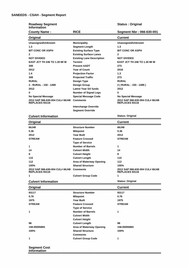
SANEEDS - CSAH - Segment Report
Roadway SegmentInformation
Status : Original
County Name : RICE Segment Nbr : 066-630-001
Original Current
Unassigned/Unknown Municipality Unassigned/Unknown
1.3 Segment Length 1.3
BIT CONC OR ASPH Existing Surface Type BIT CONC OR ASPH
2 Existing Surface Lanes 2
NOT DIVIDED Existing Lane Description NOT DIVIDED
EAST JCT TH 246 TO 1.30 MI W Termini EAST JCT TH 246 TO 1.30 MI W
308 Present AADT 273
2012 Year of Count 2016
1.4 Projection Factor 1.3
308 Projected Traffic 273
RURAL Design Type RURAL
2 - RURAL : 150 - 1499 Design Group 2 ( RURAL : 150 - 1499 )
2012 Latest Year SA funds 2012
0 Number of Signal Legs 0
No Special Message Special Message Code No Special Message
2012 SAP 066-630-004 CUL# 66J48REPLACES 93116
Comments 2012 SAP 066-630-004 CUL# 66J48REPLACES 93116
Interchange Override
Segment Override
Culvert Information Status: Original
Original Current
66J48 Structure Number 66J48
0.36 Milepoint 0.36
2012 Year Built 2012
STREAM Feature Crossed STREAM
Type of Service
1 Number of Barrels 1
14 Culvert Width 14
8 Culvert Height 8
110 Culvert Length 110
112 Area of Waterway Opening 112
100% Shared Structure 100%
2012 SAP 066-630-004 CUL# 66J48REPLACES 93116
Comments 2012 SAP 066-630-004 CUL# 66J48REPLACES 93116
1 Culvert Group Code 1
Culvert Information Status: Original
Original Current
93117 Structure Number 93117
0.76 Milepoint 0.76
1975 Year Built 1975
STREAM Feature Crossed STREAM
Type of Service
1 Number of Barrels 1
Culvert Width
Culvert Height
98 Culvert Length 98
158.00005893 Area of Waterway Opening 158.00005893
100% Shared Structure 100%
Comments
1 Culvert Group Code 1
Segment CostInformation

Computation Factor Computation Formula Values Used ForCalculation
Computation Result
Signal Leg TrafficSignalLegs *UnitCost / SignalLifeCycle* StatutoryNeedsYear
0 * 56250 / 40 * 25 $0
Construction Length * UnitCost /ConstrLifeCycle *StatutoryNeedsYear *DevelopmentCost
1.3 * 975142.53 / 60 * 25 *1.1
$581,022
Preservation Length * Quantity *UnitCost /PreservationLifeCycle *StatutoryNeedsYear
1.3 * 2112 * 57.98 / 20 * 25 $198,987
ROW Length * UnitCost /ROWLifeCycle *StatutoryNeedsYear
1.3 * 32462.65 / 60 * 25 $17,584
Culvert CulvertLength * Area *UnitCost /CulvertLifeCycle *StatutoryNeedsYear *DevelopmentCost
110 * 112 * 15.47 / 100 * 25* 1.15
$54,795
Culvert CulvertLength * Area *UnitCost /CulvertLifeCycle *StatutoryNeedsYear *DevelopmentCost
98 * 158.00005893 * 15.47 /100 * 25 * 1.15
$68,867
Total Segment Cost Signal Leg + Construction+ Preservation + ROW +Culvert + Culvert
$0 + $581,022 + $198,987+ $17,584 + $54,795 +$68,867
$921,255

SANEEDS - CSAH - Segment Report
Roadway SegmentInformation
Status : Original
County Name : RICE Segment Nbr : 066-630-010
Original Current
Unassigned/Unknown Municipality Unassigned/Unknown
5.3 Segment Length 5.3
BIT CONC OR ASPH Existing Surface Type BIT CONC OR ASPH
2 Existing Surface Lanes 2
NOT DIVIDED Existing Lane Description NOT DIVIDED
1.30 MI W OF EAST JCT TH 246 TONORTH JCT TH 246
Termini 1.30 MI W OF EAST JCT TH 246 TONORTH JCT TH 246
308 Present AADT 273
2012 Year of Count 2016
1.4 Projection Factor 1.3
308 Projected Traffic 273
RURAL Design Type RURAL
2 - RURAL : 150 - 1499 Design Group 2 ( RURAL : 150 - 1499 )
1998 Latest Year SA funds 1998
0 Number of Signal Legs 0
No Special Message Special Message Code No Special Message
COMBINED 010, 011 & 020 IN 2005COMBINED 005 & 010 IN 2006
Comments COMBINED 010, 011 & 020 IN 2005COMBINED 005 & 010 IN 2006
Interchange Override
Segment Override
Culvert Information Status: Original
Original Current
66J03 Structure Number 66J03
3.55 Milepoint 3.55
1996 Year Built 1996
PRAIRIE CREEK Feature Crossed PRAIRIE CREEK
STREAM CROSSING Type of Service STREAM CROSSING
3 Number of Barrels 3
10 Culvert Width 10
9 Culvert Height 9
68 Culvert Length 68
269.99951482 Area of Waterway Opening 269.99951482
100% Shared Structure 100%
Comments
1 Culvert Group Code 1
Culvert Information Status: Original
Original Current
66J04 Structure Number 66J04
2.78 Milepoint 2.78
1996 Year Built 1996
STREAM Feature Crossed STREAM
Type of Service
1 Number of Barrels 1
10 Culvert Width 10
10 Culvert Height 10
82 Culvert Length 82
99.99986017 Area of Waterway Opening 99.99986017
100% Shared Structure 100%
Comments
1 Culvert Group Code 1
Segment CostInformation

Computation Factor Computation Formula Values Used ForCalculation
Computation Result
Signal Leg TrafficSignalLegs *UnitCost / SignalLifeCycle* StatutoryNeedsYear
0 * 56250 / 40 * 25 $0
Construction Length * UnitCost /ConstrLifeCycle *StatutoryNeedsYear *DevelopmentCost
5.3 * 975142.53 / 60 * 25 *1.1
$2,368,784
Preservation Length * Quantity *UnitCost /PreservationLifeCycle *StatutoryNeedsYear
5.3 * 2112 * 57.98 / 20 * 25 $811,256
ROW Length * UnitCost /ROWLifeCycle *StatutoryNeedsYear
5.3 * 32462.65 / 60 * 25 $71,688
Culvert CulvertLength * Area *UnitCost /CulvertLifeCycle *StatutoryNeedsYear *DevelopmentCost
68 * 269.99951482 * 15.47 /100 * 25 * 1.15
$81,658
Culvert CulvertLength * Area *UnitCost /CulvertLifeCycle *StatutoryNeedsYear *DevelopmentCost
82 * 99.99986017 * 15.47 /100 * 25 * 1.15
$36,470
Total Segment Cost Signal Leg + Construction+ Preservation + ROW +Culvert + Culvert
$0 + $2,368,784 + $811,256+ $71,688 + $81,658 +$36,470
$3,369,856

SANEEDS - CSAH - Segment Report
Roadway SegmentInformation
Status : Original
County Name : RICE Segment Nbr : 066-631-010
Original Current
Unassigned/Unknown Municipality Unassigned/Unknown
1.9 Segment Length 1.9
MIXED BITUMINOUS Existing Surface Type MIXED BITUMINOUS
2 Existing Surface Lanes 2
NOT DIVIDED Existing Lane Description NOT DIVIDED
TH 246 TO W. LIMITS OFDENNISON
Termini TH 246 TO W. LIMITS OFDENNISON
3640 Present AADT 3770
2012 Year of Count 2016
1.4 Projection Factor 1.3
3640 Projected Traffic 3770
RURAL Design Type RURAL
3 - RURAL : 1500 - 6999 Design Group 3 ( RURAL : 1500 - 6999 )
2005 Latest Year SA funds 2005
0 Number of Signal Legs 0
No Special Message Special Message Code No Special Message
COMBINED SEG 010 & 020 IN 2005
SAP 66-631-03/-04/-05/-06 GRADE,SURFACE AND BRIDGES 66542,66J22, AND 66541, LET 5-19-05.APS
Comments COMBINED SEG 010 & 020 IN 2005
SAP 66-631-03/-04/-05/-06 GRADE,SURFACE AND BRIDGES 66542,66J22, AND 66541, LET 5-19-05.APS
Interchange Override
Segment Override
Bridge Information Status: Original
Original Current
66541 Structure Number 66541
0.67 Milepoint 0.67
2005 Year Built 2005
PRAIRIE CREEK Feature Crossed PRAIRIE CREEK
STREAM CROSSING Type of Service STREAM CROSSING
3 Number of Spans 3
73.5 Bridge Length 73.5
47.3 Bridge Width 47.3
100% Shared Structure 100%
Comments
1 ( 0-149 ) Bridge Group Code 1 ( 0-149 )
Bridge Information Status: Original
Original Current
66542 Structure Number 66542
1.73 Milepoint 1.73
2005 Year Built 2005
STREAM Feature Crossed STREAM
STREAM CROSSING Type of Service STREAM CROSSING
3 Number of Spans 3
73.5 Bridge Length 73.5
47.3 Bridge Width 47.3
100% Shared Structure 100%
Comments
1 ( 0-149 ) Bridge Group Code 1 ( 0-149 )
Culvert Information Status: Original
Original Current
66J22 Structure Number 66J22
0.1 Milepoint 0.1

2005 Year Built 2005
STREAM Feature Crossed STREAM
STREAM CROSSING Type of Service STREAM CROSSING
2 Number of Barrels 2
Culvert Width
Culvert Height
84 Culvert Length 84
223.99998817 Area of Waterway Opening 223.99998817
100% Shared Structure 100%
Comments
1 Culvert Group Code 1
Segment CostInformation
Computation Factor Computation Formula Values Used ForCalculation
Computation Result
Signal Leg TrafficSignalLegs *UnitCost / SignalLifeCycle* StatutoryNeedsYear
0 * 56250 / 40 * 25 $0
Construction Length * UnitCost /ConstrLifeCycle *StatutoryNeedsYear *DevelopmentCost
1.9 * 1280397.01 / 60 * 25 *1.1
$1,115,012
Preservation Length * Quantity *UnitCost /PreservationLifeCycle *StatutoryNeedsYear
1.9 * 2376 * 57.98 / 20 * 25 $327,181
ROW Length * UnitCost /ROWLifeCycle *StatutoryNeedsYear
1.9 * 13705.86 / 60 * 25 $10,850
Bridge BridgeLength *BridgeWidth * UnitCost /BridgeLifeCycle *StatutoryNeedsYear *DevelopmentCost
73.5 * 47.3 * 152 / 80 * 25 *1.15
$189,907
Bridge BridgeLength *BridgeWidth * UnitCost /BridgeLifeCycle *StatutoryNeedsYear *DevelopmentCost
73.5 * 47.3 * 152 / 80 * 25 *1.15
$189,907
Culvert CulvertLength * Area *UnitCost /CulvertLifeCycle *StatutoryNeedsYear *DevelopmentCost
84 * 223.99998817 * 15.47 /100 * 25 * 1.15
$83,687
Total Segment Cost Signal Leg + Construction+ Preservation + ROW +Bridge + Bridge + Culvert
$0 + $1,115,012 + $327,181+ $10,850 + $189,907 +$189,907 + $83,687
$1,916,544

SANEEDS - CSAH - Segment Report
Roadway SegmentInformation
Status : Original
County Name : RICE Segment Nbr : 066-631-030
Original Current
DENNISON Municipality DENNISON
0.1 Segment Length 0.1
MIXED BITUMINOUS Existing Surface Type MIXED BITUMINOUS
2 Existing Surface Lanes 2
NOT DIVIDED Existing Lane Description NOT DIVIDED
W LIM DENNISON TO E CO LINE Termini W LIM DENNISON TO E CO LINE
3640 Present AADT 3770
2012 Year of Count 2016
1.4 Projection Factor 1.3
3640 Projected Traffic 3770
RURAL Design Type RURAL
3 - RURAL : 1500 - 6999 Design Group 3 ( RURAL : 1500 - 6999 )
2005 Latest Year SA funds 2005
0 Number of Signal Legs 0
No Special Message Special Message Code No Special Message
RECONSTRUCTED UNDER 66-631-004COMBINED SEGMENTS 025 & 030IN 2006
Comments RECONSTRUCTED UNDER 66-631-004COMBINED SEGMENTS 025 & 030IN 2006
Interchange Override
Segment Override
Segment CostInformation
Computation Factor Computation Formula Values Used ForCalculation
Computation Result
Signal Leg TrafficSignalLegs *UnitCost / SignalLifeCycle* StatutoryNeedsYear
0 * 56250 / 40 * 25 $0
Construction Length * UnitCost /ConstrLifeCycle *StatutoryNeedsYear *DevelopmentCost
0.1 * 1280397.01 / 60 * 25 *1.1
$58,685
Preservation Length * Quantity *UnitCost /PreservationLifeCycle *StatutoryNeedsYear
0.1 * 2376 * 57.98 / 20 * 25 $17,220
ROW Length * UnitCost /ROWLifeCycle *StatutoryNeedsYear
0.1 * 13705.86 / 60 * 25 $571
Total Segment Cost Signal Leg + Construction+ Preservation + ROW
$0 + $58,685 + $17,220 +$571
$76,476

SANEEDS - CSAH - Segment Report
Roadway SegmentInformation
Status : Original
County Name : RICE Segment Nbr : 066-632-010
Original Current
Unassigned/Unknown Municipality Unassigned/Unknown
2.8 Segment Length 2.8
MIXED BITUMINOUS Existing Surface Type MIXED BITUMINOUS
2 Existing Surface Lanes 2
NOT DIVIDED Existing Lane Description NOT DIVIDED
TWP RD ALONG CO LINE TO 0.30MI W OF CSAH 26
Termini TWP RD ALONG CO LINE TO 0.30MI W OF CSAH 26
504 Present AADT 429
2012 Year of Count 2016
1.4 Projection Factor 1.3
504 Projected Traffic 429
RURAL Design Type RURAL
2 - RURAL : 150 - 1499 Design Group 2 ( RURAL : 150 - 1499 )
1978 Latest Year SA funds 1978
0 Number of Signal Legs 0
No Special Message Special Message Code No Special Message
BRIDGE 4052 REBUILT AS 74J01.SHOULD ONLY APPEAR INSTEELE COUNTY'S DATABASE.APS
Comments BRIDGE 4052 REBUILT AS 74J01.SHOULD ONLY APPEAR INSTEELE COUNTY'S DATABASE.APS
Interchange Override
Segment Override
Segment CostInformation
Computation Factor Computation Formula Values Used ForCalculation
Computation Result
Signal Leg TrafficSignalLegs *UnitCost / SignalLifeCycle* StatutoryNeedsYear
0 * 56250 / 40 * 25 $0
Construction Length * UnitCost /ConstrLifeCycle *StatutoryNeedsYear *DevelopmentCost
2.8 * 975142.53 / 60 * 25 *1.1
$1,251,433
Preservation Length * Quantity *UnitCost /PreservationLifeCycle *StatutoryNeedsYear
2.8 * 2112 * 57.98 / 20 * 25 $428,588
ROW Length * UnitCost /ROWLifeCycle *StatutoryNeedsYear
2.8 * 32462.65 / 60 * 25 $37,873
Total Segment Cost Signal Leg + Construction+ Preservation + ROW
$0 + $1,251,433 + $428,588+ $37,873
$1,717,894

SANEEDS - CSAH - Segment Report
Roadway SegmentInformation
Status : Original
County Name : RICE Segment Nbr : 066-632-020
Original Current
Unassigned/Unknown Municipality Unassigned/Unknown
0.3 Segment Length 0.3
MIXED BITUMINOUS Existing Surface Type MIXED BITUMINOUS
2 Existing Surface Lanes 2
NOT DIVIDED Existing Lane Description NOT DIVIDED
0.3 MI W TO CSAH 26 Termini 0.3 MI W TO CSAH 26
504 Present AADT 429
2012 Year of Count 2016
1.4 Projection Factor 1.3
504 Projected Traffic 429
RURAL Design Type RURAL
2 - RURAL : 150 - 1499 Design Group 2 ( RURAL : 150 - 1499 )
1978 Latest Year SA funds 1978
0 Number of Signal Legs 0
No Special Message Special Message Code No Special Message
Comments
Interchange Override
Segment Override
Segment CostInformation
Computation Factor Computation Formula Values Used ForCalculation
Computation Result
Signal Leg TrafficSignalLegs *UnitCost / SignalLifeCycle* StatutoryNeedsYear
0 * 56250 / 40 * 25 $0
Construction Length * UnitCost /ConstrLifeCycle *StatutoryNeedsYear *DevelopmentCost
0.3 * 975142.53 / 60 * 25 *1.1
$134,082
Preservation Length * Quantity *UnitCost /PreservationLifeCycle *StatutoryNeedsYear
0.3 * 2112 * 57.98 / 20 * 25 $45,920
ROW Length * UnitCost /ROWLifeCycle *StatutoryNeedsYear
0.3 * 32462.65 / 60 * 25 $4,058
Total Segment Cost Signal Leg + Construction+ Preservation + ROW
$0 + $134,082 + $45,920 +$4,058
$184,060

SANEEDS - CSAH - Segment Report
Roadway SegmentInformation
Status : Original
County Name : RICE Segment Nbr : 066-633-010
Original Current
Unassigned/Unknown Municipality Unassigned/Unknown
2.2 Segment Length 2.2
MIXED BITUMINOUS Existing Surface Type MIXED BITUMINOUS
2 Existing Surface Lanes 2
NOT DIVIDED Existing Lane Description NOT DIVIDED
CSAH 1 TO S LIMITS LONSDALE Termini CSAH 1 TO S LIMITS LONSDALE
1148 Present AADT 1014
2012 Year of Count 2016
1.4 Projection Factor 1.3
1148 Projected Traffic 1014
RURAL Design Type RURAL
2 - RURAL : 150 - 1499 Design Group 2 ( RURAL : 150 - 1499 )
2014 Latest Year SA funds 2014
0 Number of Signal Legs 0
No Special Message Special Message Code No Special Message
2014 SAP 066-633-008 RC&OL @INTERSECTION
Comments 2014 SAP 066-633-008 RC&OL @INTERSECTION
Interchange Override
Segment Override
Segment CostInformation
Computation Factor Computation Formula Values Used ForCalculation
Computation Result
Signal Leg TrafficSignalLegs *UnitCost / SignalLifeCycle* StatutoryNeedsYear
0 * 56250 / 40 * 25 $0
Construction Length * UnitCost /ConstrLifeCycle *StatutoryNeedsYear *DevelopmentCost
2.2 * 975142.53 / 60 * 25 *1.1
$983,269
Preservation Length * Quantity *UnitCost /PreservationLifeCycle *StatutoryNeedsYear
2.2 * 2112 * 57.98 / 20 * 25 $336,748
ROW Length * UnitCost /ROWLifeCycle *StatutoryNeedsYear
2.2 * 32462.65 / 60 * 25 $29,757
Total Segment Cost Signal Leg + Construction+ Preservation + ROW
$0 + $983,269 + $336,748+ $29,757
$1,349,774

SANEEDS - CSAH - Segment Report
Roadway SegmentInformation
Status : Original
County Name : RICE Segment Nbr : 066-633-013
Original Current
LONSDALE Municipality LONSDALE
0.5 Segment Length 0.5
MIXED BITUMINOUS Existing Surface Type MIXED BITUMINOUS
2 Existing Surface Lanes 2
NOT DIVIDED Existing Lane Description NOT DIVIDED
S LIMITS TO W LIMS LONSDALE Termini S LIMITS TO W LIMS LONSDALE
1148 Present AADT 1014
2012 Year of Count 2016
1.4 Projection Factor 1.3
1148 Projected Traffic 1014
RURAL Design Type RURAL
2 - RURAL : 150 - 1499 Design Group 2 ( RURAL : 150 - 1499 )
1990 Latest Year SA funds 1990
0 Number of Signal Legs 0
No Special Message Special Message Code No Special Message
Comments
Interchange Override
Segment Override
Segment CostInformation
Computation Factor Computation Formula Values Used ForCalculation
Computation Result
Signal Leg TrafficSignalLegs *UnitCost / SignalLifeCycle* StatutoryNeedsYear
0 * 56250 / 40 * 25 $0
Construction Length * UnitCost /ConstrLifeCycle *StatutoryNeedsYear *DevelopmentCost
0.5 * 975142.53 / 60 * 25 *1.1
$223,470
Preservation Length * Quantity *UnitCost /PreservationLifeCycle *StatutoryNeedsYear
0.5 * 2112 * 57.98 / 20 * 25 $76,534
ROW Length * UnitCost /ROWLifeCycle *StatutoryNeedsYear
0.5 * 32462.65 / 60 * 25 $6,763
Total Segment Cost Signal Leg + Construction+ Preservation + ROW
$0 + $223,470 + $76,534 +$6,763
$306,767

SANEEDS - CSAH - Segment Report
Roadway SegmentInformation
Status : Original
County Name : RICE Segment Nbr : 066-633-017
Original Current
Unassigned/Unknown Municipality Unassigned/Unknown
0.4 Segment Length 0.4
MIXED BITUMINOUS Existing Surface Type MIXED BITUMINOUS
2 Existing Surface Lanes 2
NOT DIVIDED Existing Lane Description NOT DIVIDED
W LIMS TO S LIMITS LONSDALE(OUTSIDE)
Termini W LIMS TO S LIMITS LONSDALE(OUTSIDE)
1148 Present AADT 1014
2012 Year of Count 2016
1.4 Projection Factor 1.3
1148 Projected Traffic 1014
RURAL Design Type RURAL
2 - RURAL : 150 - 1499 Design Group 2 ( RURAL : 150 - 1499 )
1990 Latest Year SA funds 1990
0 Number of Signal Legs 0
No Special Message Special Message Code No Special Message
Comments
Interchange Override
Segment Override
Segment CostInformation
Computation Factor Computation Formula Values Used ForCalculation
Computation Result
Signal Leg TrafficSignalLegs *UnitCost / SignalLifeCycle* StatutoryNeedsYear
0 * 56250 / 40 * 25 $0
Construction Length * UnitCost /ConstrLifeCycle *StatutoryNeedsYear *DevelopmentCost
0.4 * 975142.53 / 60 * 25 *1.1
$178,776
Preservation Length * Quantity *UnitCost /PreservationLifeCycle *StatutoryNeedsYear
0.4 * 2112 * 57.98 / 20 * 25 $61,227
ROW Length * UnitCost /ROWLifeCycle *StatutoryNeedsYear
0.4 * 32462.65 / 60 * 25 $5,410
Total Segment Cost Signal Leg + Construction+ Preservation + ROW
$0 + $178,776 + $61,227 +$5,410
$245,413

SANEEDS - CSAH - Segment Report
Roadway SegmentInformation
Status : Original
County Name : RICE Segment Nbr : 066-633-020
Original Current
LONSDALE Municipality LONSDALE
0.05 Segment Length 0.05
MIXED BITUMINOUS Existing Surface Type MIXED BITUMINOUS
2 Existing Surface Lanes 2
NOT DIVIDED Existing Lane Description NOT DIVIDED
SO LIM LONSDALE TO 0.05 NO Termini SO LIM LONSDALE TO 0.05 NO
1148 Present AADT 1014
2012 Year of Count 2016
1.4 Projection Factor 1.3
1148 Projected Traffic 1014
RURAL Design Type RURAL
2 - RURAL : 150 - 1499 Design Group 2 ( RURAL : 150 - 1499 )
1990 Latest Year SA funds 1990
0 Number of Signal Legs 0
No Special Message Special Message Code No Special Message
Comments
Interchange Override
Segment Override
Segment CostInformation
Computation Factor Computation Formula Values Used ForCalculation
Computation Result
Signal Leg TrafficSignalLegs *UnitCost / SignalLifeCycle* StatutoryNeedsYear
0 * 56250 / 40 * 25 $0
Construction Length * UnitCost /ConstrLifeCycle *StatutoryNeedsYear *DevelopmentCost
0.05 * 975142.53 / 60 * 25 *1.1
$22,347
Preservation Length * Quantity *UnitCost /PreservationLifeCycle *StatutoryNeedsYear
0.05 * 2112 * 57.98 / 20 * 25 $7,653
ROW Length * UnitCost /ROWLifeCycle *StatutoryNeedsYear
0.05 * 32462.65 / 60 * 25 $676
Total Segment Cost Signal Leg + Construction+ Preservation + ROW
$0 + $22,347 + $7,653 +$676
$30,676

SANEEDS - CSAH - Segment Report
Roadway SegmentInformation
Status : Original
County Name : RICE Segment Nbr : 066-633-030
Original Current
LONSDALE Municipality LONSDALE
0.12 Segment Length 0.12
MIXED BITUMINOUS Existing Surface Type MIXED BITUMINOUS
2 Existing Surface Lanes 2
NOT DIVIDED Existing Lane Description NOT DIVIDED
0.05 M N OF S LIMS TO SWFLORIDA ST.
Termini 0.05 M N OF S LIMS TO SWFLORIDA ST.
1148 Present AADT 1014
2012 Year of Count 2016
1.4 Projection Factor 1.3
1148 Projected Traffic 1014
URBAN Design Type URBAN
5 - URBAN : 0 - 9999 Design Group 5 ( URBAN : 0 - 9999 )
2001 Latest Year SA funds 2001
0 Number of Signal Legs 0
No Special Message Special Message Code No Special Message
MILL AND OVERLAY UNDER SAP66-633-05, LET 2001. APS
Comments MILL AND OVERLAY UNDER SAP66-633-05, LET 2001. APS
Interchange Override
Segment Override
Segment CostInformation
Computation Factor Computation Formula Values Used ForCalculation
Computation Result
Signal Leg TrafficSignalLegs *UnitCost / SignalLifeCycle* StatutoryNeedsYear
0 * 56250 / 40 * 25 $0
Construction Length * UnitCost /ConstrLifeCycle *StatutoryNeedsYear *DevelopmentCost
0.12 * 2904860.94 / 60 * 25* 1.15
$167,030
Preservation Length * Quantity *UnitCost /PreservationLifeCycle *StatutoryNeedsYear
0.12 * 2904 * 57.98 / 15 * 25 $33,675
ROW Length * UnitCost /ROWLifeCycle *StatutoryNeedsYear
0.12 * 51162.01 / 60 * 25 $2,558
Total Segment Cost Signal Leg + Construction+ Preservation + ROW
$0 + $167,030 + $33,675 +$2,558
$203,263

SANEEDS - CSAH - Segment Report
Roadway SegmentInformation
Status : Original
County Name : RICE Segment Nbr : 066-633-040
Original Current
LONSDALE Municipality LONSDALE
0.14 Segment Length 0.14
MIXED BITUMINOUS Existing Surface Type MIXED BITUMINOUS
2 Existing Surface Lanes 2
NOT DIVIDED Existing Lane Description NOT DIVIDED
SW FLORIDA ST TO SWCOLORADO ST
Termini SW FLORIDA ST TO SWCOLORADO ST
2100 Present AADT 1820
2012 Year of Count 2016
1.4 Projection Factor 1.3
2100 Projected Traffic 1820
URBAN Design Type URBAN
5 - URBAN : 0 - 9999 Design Group 5 ( URBAN : 0 - 9999 )
2001 Latest Year SA funds 2001
0 Number of Signal Legs 0
No Special Message Special Message Code No Special Message
MILL AND OVERLAY UNDER SAP66-633-05, LET 2001. APS
Comments MILL AND OVERLAY UNDER SAP66-633-05, LET 2001. APS
Interchange Override
Segment Override
Segment CostInformation
Computation Factor Computation Formula Values Used ForCalculation
Computation Result
Signal Leg TrafficSignalLegs *UnitCost / SignalLifeCycle* StatutoryNeedsYear
0 * 56250 / 40 * 25 $0
Construction Length * UnitCost /ConstrLifeCycle *StatutoryNeedsYear *DevelopmentCost
0.14 * 2904860.94 / 60 * 25* 1.15
$194,868
Preservation Length * Quantity *UnitCost /PreservationLifeCycle *StatutoryNeedsYear
0.14 * 2904 * 57.98 / 15 * 25 $39,287
ROW Length * UnitCost /ROWLifeCycle *StatutoryNeedsYear
0.14 * 51162.01 / 60 * 25 $2,984
Total Segment Cost Signal Leg + Construction+ Preservation + ROW
$0 + $194,868 + $39,287 +$2,984
$237,139

SANEEDS - CSAH - Segment Report
Roadway SegmentInformation
Status : Original
County Name : RICE Segment Nbr : 066-633-050
Original Current
LONSDALE Municipality LONSDALE
0.06 Segment Length 0.06
MIXED BITUMINOUS Existing Surface Type MIXED BITUMINOUS
2 Existing Surface Lanes 2
NOT DIVIDED Existing Lane Description NOT DIVIDED
SW COLORADO ST. TO SEARIZONA ST.
Termini SW COLORADO ST. TO SEARIZONA ST.
2100 Present AADT 1820
2012 Year of Count 2016
1.4 Projection Factor 1.3
2100 Projected Traffic 1820
URBAN Design Type URBAN
5 - URBAN : 0 - 9999 Design Group 5 ( URBAN : 0 - 9999 )
2001 Latest Year SA funds 2001
0 Number of Signal Legs 0
No Special Message Special Message Code No Special Message
MILL AND OVERLAY UNDER SAP66-633-05, LET 2001. APS
Comments MILL AND OVERLAY UNDER SAP66-633-05, LET 2001. APS
Interchange Override
Segment Override
Segment CostInformation
Computation Factor Computation Formula Values Used ForCalculation
Computation Result
Signal Leg TrafficSignalLegs *UnitCost / SignalLifeCycle* StatutoryNeedsYear
0 * 56250 / 40 * 25 $0
Construction Length * UnitCost /ConstrLifeCycle *StatutoryNeedsYear *DevelopmentCost
0.06 * 2904860.94 / 60 * 25* 1.15
$83,515
Preservation Length * Quantity *UnitCost /PreservationLifeCycle *StatutoryNeedsYear
0.06 * 2904 * 57.98 / 15 * 25 $16,837
ROW Length * UnitCost /ROWLifeCycle *StatutoryNeedsYear
0.06 * 51162.01 / 60 * 25 $1,279
Total Segment Cost Signal Leg + Construction+ Preservation + ROW
$0 + $83,515 + $16,837 +$1,279
$101,631

SANEEDS - CSAH - Segment Report
Roadway SegmentInformation
Status : Original
County Name : RICE Segment Nbr : 066-633-060
Original Current
LONSDALE Municipality LONSDALE
0.04 Segment Length 0.04
MIXED BITUMINOUS Existing Surface Type MIXED BITUMINOUS
2 Existing Surface Lanes 2
NOT DIVIDED Existing Lane Description NOT DIVIDED
SE ARIZONA ST. TO ALABAMA ST. Termini SE ARIZONA ST. TO ALABAMA ST.
2100 Present AADT 1820
2012 Year of Count 2016
1.4 Projection Factor 1.3
2100 Projected Traffic 1820
URBAN Design Type URBAN
5 - URBAN : 0 - 9999 Design Group 5 ( URBAN : 0 - 9999 )
2001 Latest Year SA funds 2001
0 Number of Signal Legs 0
No Special Message Special Message Code No Special Message
MILL AND OVERLAY UNDER SAP66-633-05, LET 2001. APS
Comments MILL AND OVERLAY UNDER SAP66-633-05, LET 2001. APS
Interchange Override
Segment Override
Segment CostInformation
Computation Factor Computation Formula Values Used ForCalculation
Computation Result
Signal Leg TrafficSignalLegs *UnitCost / SignalLifeCycle* StatutoryNeedsYear
0 * 56250 / 40 * 25 $0
Construction Length * UnitCost /ConstrLifeCycle *StatutoryNeedsYear *DevelopmentCost
0.04 * 2904860.94 / 60 * 25* 1.15
$55,677
Preservation Length * Quantity *UnitCost /PreservationLifeCycle *StatutoryNeedsYear
0.04 * 2904 * 57.98 / 15 * 25 $11,225
ROW Length * UnitCost /ROWLifeCycle *StatutoryNeedsYear
0.04 * 51162.01 / 60 * 25 $853
Total Segment Cost Signal Leg + Construction+ Preservation + ROW
$0 + $55,677 + $11,225 +$853
$67,755

SANEEDS - CSAH - Segment Report
Roadway SegmentInformation
Status : Original
County Name : RICE Segment Nbr : 066-633-065
Original Current
LONSDALE Municipality LONSDALE
0.07 Segment Length 0.07
MIXED BITUMINOUS Existing Surface Type MIXED BITUMINOUS
2 Existing Surface Lanes 2
NOT DIVIDED Existing Lane Description NOT DIVIDED
ALABAMA ST TO E JCT TH 19 Termini ALABAMA ST TO E JCT TH 19
2100 Present AADT 1820
2012 Year of Count 2016
1.4 Projection Factor 1.3
2100 Projected Traffic 1820
URBAN Design Type URBAN
5 - URBAN : 0 - 9999 Design Group 5 ( URBAN : 0 - 9999 )
2001 Latest Year SA funds 2001
0 Number of Signal Legs 0
No Special Message Special Message Code No Special Message
MILL AND OVERLAY UNDER SAP66-633-05, LET 2001. APS
Comments MILL AND OVERLAY UNDER SAP66-633-05, LET 2001. APS
Interchange Override
Segment Override
Segment CostInformation
Computation Factor Computation Formula Values Used ForCalculation
Computation Result
Signal Leg TrafficSignalLegs *UnitCost / SignalLifeCycle* StatutoryNeedsYear
0 * 56250 / 40 * 25 $0
Construction Length * UnitCost /ConstrLifeCycle *StatutoryNeedsYear *DevelopmentCost
0.07 * 2904860.94 / 60 * 25* 1.15
$97,434
Preservation Length * Quantity *UnitCost /PreservationLifeCycle *StatutoryNeedsYear
0.07 * 2904 * 57.98 / 15 * 25 $19,644
ROW Length * UnitCost /ROWLifeCycle *StatutoryNeedsYear
0.07 * 51162.01 / 60 * 25 $1,492
Total Segment Cost Signal Leg + Construction+ Preservation + ROW
$0 + $97,434 + $19,644 +$1,492
$118,570

SANEEDS - CSAH - Segment Report
Roadway SegmentInformation
Status : Original
County Name : RICE Segment Nbr : 066-633-070
Original Current
LONSDALE Municipality LONSDALE
0.07 Segment Length 0.07
MIXED BITUMINOUS Existing Surface Type MIXED BITUMINOUS
2 Existing Surface Lanes 2
NOT DIVIDED Existing Lane Description NOT DIVIDED
E JCT TH 19 TO RAILWAY ST. Termini E JCT TH 19 TO RAILWAY ST.
1750 Present AADT 1560
2012 Year of Count 2016
1.4 Projection Factor 1.3
1750 Projected Traffic 1560
URBAN Design Type URBAN
5 - URBAN : 0 - 9999 Design Group 5 ( URBAN : 0 - 9999 )
2004 Latest Year SA funds 2004
0 Number of Signal Legs 0
No Special Message Special Message Code No Special Message
SAP 66-633-06 MILL ANDOVERLAY, LET 7-19-04 (APS 1-24-05).
Comments SAP 66-633-06 MILL ANDOVERLAY, LET 7-19-04 (APS 1-24-05).
Interchange Override
Segment Override
Segment CostInformation
Computation Factor Computation Formula Values Used ForCalculation
Computation Result
Signal Leg TrafficSignalLegs *UnitCost / SignalLifeCycle* StatutoryNeedsYear
0 * 56250 / 40 * 25 $0
Construction Length * UnitCost /ConstrLifeCycle *StatutoryNeedsYear *DevelopmentCost
0.07 * 2904860.94 / 60 * 25* 1.15
$97,434
Preservation Length * Quantity *UnitCost /PreservationLifeCycle *StatutoryNeedsYear
0.07 * 2904 * 57.98 / 15 * 25 $19,644
ROW Length * UnitCost /ROWLifeCycle *StatutoryNeedsYear
0.07 * 51162.01 / 60 * 25 $1,492
Total Segment Cost Signal Leg + Construction+ Preservation + ROW
$0 + $97,434 + $19,644 +$1,492
$118,570

SANEEDS - CSAH - Segment Report
Roadway SegmentInformation
Status : Original
County Name : RICE Segment Nbr : 066-633-080
Original Current
LONSDALE Municipality LONSDALE
0.32 Segment Length 0.32
MIXED BITUMINOUS Existing Surface Type MIXED BITUMINOUS
2 Existing Surface Lanes 2
NOT DIVIDED Existing Lane Description NOT DIVIDED
FROM RAILWAY ST ON MAIN TO70TH ST W
Termini FROM RAILWAY ST ON MAIN TO70TH ST W
1134 Present AADT 1235
2012 Year of Count 2016
1.4 Projection Factor 1.3
1134 Projected Traffic 1235
URBAN Design Type URBAN
5 - URBAN : 0 - 9999 Design Group 5 ( URBAN : 0 - 9999 )
1976 Latest Year SA funds 1976
0 Number of Signal Legs 0
No Special Message Special Message Code No Special Message
CO 93361 - EXTEND 33 Comments CO 93361 - EXTEND 33
Interchange Override
Segment Override
Segment CostInformation
Computation Factor Computation Formula Values Used ForCalculation
Computation Result
Signal Leg TrafficSignalLegs *UnitCost / SignalLifeCycle* StatutoryNeedsYear
0 * 56250 / 40 * 25 $0
Construction Length * UnitCost /ConstrLifeCycle *StatutoryNeedsYear *DevelopmentCost
0.32 * 2904860.94 / 60 * 25* 1.15
$445,412
Preservation Length * Quantity *UnitCost /PreservationLifeCycle *StatutoryNeedsYear
0.32 * 2904 * 57.98 / 15 * 25 $89,799
ROW Length * UnitCost /ROWLifeCycle *StatutoryNeedsYear
0.32 * 51162.01 / 60 * 25 $6,822
Total Segment Cost Signal Leg + Construction+ Preservation + ROW
$0 + $445,412 + $89,799 +$6,822
$542,033

SANEEDS - CSAH - Segment Report
Roadway SegmentInformation
Status : Original
County Name : RICE Segment Nbr : 066-634-010
Original Current
Unassigned/Unknown Municipality Unassigned/Unknown
4.3 Segment Length 4.3
BIT CONC OR ASPH Existing Surface Type BIT CONC OR ASPH
2 Existing Surface Lanes 2
NOT DIVIDED Existing Lane Description NOT DIVIDED
CSAH 1 TO TH 19 Termini CSAH 1 TO TH 19
392 Present AADT 364
2012 Year of Count 2016
1.4 Projection Factor 1.3
392 Projected Traffic 364
RURAL Design Type RURAL
2 - RURAL : 150 - 1499 Design Group 2 ( RURAL : 150 - 1499 )
2012 Latest Year SA funds 2012
0 Number of Signal Legs 0
No Special Message Special Message Code No Special Message
2012 SAP 066-634-004 M&OL TURNLN
Comments 2012 SAP 066-634-004 M&OL TURNLN
Interchange Override
Segment Override
Culvert Information Status: Original
Original Current
97419 Structure Number 97419
4.168 Milepoint 4.168
1990 Year Built 1990
KNOWLES CREEK Feature Crossed KNOWLES CREEK
STREAM CROSSING Type of Service STREAM CROSSING
1 Number of Barrels 1
10 Culvert Width 10
7 Culvert Height 7
142 Culvert Length 142
51.00043459 Area of Waterway Opening 51.00043459
100% Shared Structure 100%
Comments
1 Culvert Group Code 1
Culvert Information Status: Original
Original Current
97635 Structure Number 97635
1.08 Milepoint 1.08
1995 Year Built 1995
HEATH CREEK Feature Crossed HEATH CREEK
STREAM CROSSING Type of Service STREAM CROSSING
1 Number of Barrels 1
12 Culvert Width 12
8 Culvert Height 8
126 Culvert Length 126
95.99999493 Area of Waterway Opening 95.99999493
100% Shared Structure 100%
Comments
1 Culvert Group Code 1
Segment CostInformation

Computation Factor Computation Formula Values Used ForCalculation
Computation Result
Signal Leg TrafficSignalLegs *UnitCost / SignalLifeCycle* StatutoryNeedsYear
0 * 56250 / 40 * 25 $0
Construction Length * UnitCost /ConstrLifeCycle *StatutoryNeedsYear *DevelopmentCost
4.3 * 975142.53 / 60 * 25 *1.1
$1,921,843
Preservation Length * Quantity *UnitCost /PreservationLifeCycle *StatutoryNeedsYear
4.3 * 2112 * 57.98 / 20 * 25 $658,189
ROW Length * UnitCost /ROWLifeCycle *StatutoryNeedsYear
4.3 * 32462.65 / 60 * 25 $58,162
Culvert CulvertLength * Area *UnitCost /CulvertLifeCycle *StatutoryNeedsYear *DevelopmentCost
142 * 51.00043459 * 15.47 /100 * 25 * 1.15
$32,210
Culvert CulvertLength * Area *UnitCost /CulvertLifeCycle *StatutoryNeedsYear *DevelopmentCost
126 * 95.99999493 * 15.47 /100 * 25 * 1.15
$53,798
Total Segment Cost Signal Leg + Construction+ Preservation + ROW +Culvert + Culvert
$0 + $1,921,843 + $658,189+ $58,162 + $32,210 +$53,798
$2,724,202

SANEEDS - CSAH - Segment Report
Roadway SegmentInformation
Status : Original
County Name : RICE Segment Nbr : 066-636-010
Original Current
Unassigned/Unknown Municipality Unassigned/Unknown
0.9 Segment Length 0.9
MIXED BITUMINOUS Existing Surface Type MIXED BITUMINOUS
2 Existing Surface Lanes 2
NOT DIVIDED Existing Lane Description NOT DIVIDED
TH 21 TO CSAH 9 Termini TH 21 TO CSAH 9
1008 Present AADT 871
2012 Year of Count 2016
1.4 Projection Factor 1.3
1008 Projected Traffic 871
RURAL Design Type RURAL
2 - RURAL : 150 - 1499 Design Group 2 ( RURAL : 150 - 1499 )
1990 Latest Year SA funds 1990
0 Number of Signal Legs 0
No Special Message Special Message Code No Special Message
Comments
Interchange Override
Segment Override
Segment CostInformation
Computation Factor Computation Formula Values Used ForCalculation
Computation Result
Signal Leg TrafficSignalLegs *UnitCost / SignalLifeCycle* StatutoryNeedsYear
0 * 56250 / 40 * 25 $0
Construction Length * UnitCost /ConstrLifeCycle *StatutoryNeedsYear *DevelopmentCost
0.9 * 975142.53 / 60 * 25 *1.1
$402,246
Preservation Length * Quantity *UnitCost /PreservationLifeCycle *StatutoryNeedsYear
0.9 * 2112 * 57.98 / 20 * 25 $137,760
ROW Length * UnitCost /ROWLifeCycle *StatutoryNeedsYear
0.9 * 32462.65 / 60 * 25 $12,173
Total Segment Cost Signal Leg + Construction+ Preservation + ROW
$0 + $402,246 + $137,760+ $12,173
$552,179

SANEEDS - CSAH - Segment Report
Roadway SegmentInformation
Status : Original
County Name : RICE Segment Nbr : 066-637-030
Original Current
Unassigned/Unknown Municipality Unassigned/Unknown
4.6 Segment Length 4.6
MIXED BITUMINOUS Existing Surface Type MIXED BITUMINOUS
2 Existing Surface Lanes 2
NOT DIVIDED Existing Lane Description NOT DIVIDED
CSAH 10 TO 3.6 MI EAST OF CR 66 Termini CSAH 10 TO 3.6 MI EAST OF CR 66
553 Present AADT 436
2012 Year of Count 2016
1.4 Projection Factor 1.3
553 Projected Traffic 436
RURAL Design Type RURAL
2 - RURAL : 150 - 1499 Design Group 2 ( RURAL : 150 - 1499 )
2014 Latest Year SA funds 2014
0 Number of Signal Legs 0
No Special Message Special Message Code No Special Message
2014 SP 066-637-010 RC&OL, 066-070-011 SHOULDERS
Comments 2014 SP 066-637-010 RC&OL, 066-070-011 SHOULDERS
Interchange Override
Segment Override
Segment CostInformation
Computation Factor Computation Formula Values Used ForCalculation
Computation Result
Signal Leg TrafficSignalLegs *UnitCost / SignalLifeCycle* StatutoryNeedsYear
0 * 56250 / 40 * 25 $0
Construction Length * UnitCost /ConstrLifeCycle *StatutoryNeedsYear *DevelopmentCost
4.6 * 975142.53 / 60 * 25 *1.1
$2,055,926
Preservation Length * Quantity *UnitCost /PreservationLifeCycle *StatutoryNeedsYear
4.6 * 2112 * 57.98 / 20 * 25 $704,109
ROW Length * UnitCost /ROWLifeCycle *StatutoryNeedsYear
4.6 * 32462.65 / 60 * 25 $62,220
Total Segment Cost Signal Leg + Construction+ Preservation + ROW
$0 + $2,055,926 + $704,109+ $62,220
$2,822,255

SANEEDS - CSAH - Segment Report
Roadway SegmentInformation
Status : Original
County Name : RICE Segment Nbr : 066-637-050
Original Current
Unassigned/Unknown Municipality Unassigned/Unknown
1 Segment Length 1
MIXED BITUMINOUS Existing Surface Type MIXED BITUMINOUS
2 Existing Surface Lanes 2
NOT DIVIDED Existing Lane Description NOT DIVIDED
3.6 MI E CO RD 66 TO 1.1 MI WCSAH 11
Termini 3.6 MI E CO RD 66 TO 1.1 MI WCSAH 11
1260 Present AADT 1300
2012 Year of Count 2016
1.4 Projection Factor 1.3
1260 Projected Traffic 1300
RURAL Design Type RURAL
2 - RURAL : 150 - 1499 Design Group 2 ( RURAL : 150 - 1499 )
2014 Latest Year SA funds 2014
0 Number of Signal Legs 0
No Special Message Special Message Code No Special Message
2014 SP 066-637-010 RC&OL, 066-070-011 SHOULDERS
Comments 2014 SP 066-637-010 RC&OL, 066-070-011 SHOULDERS
Interchange Override
Segment Override
Segment CostInformation
Computation Factor Computation Formula Values Used ForCalculation
Computation Result
Signal Leg TrafficSignalLegs *UnitCost / SignalLifeCycle* StatutoryNeedsYear
0 * 56250 / 40 * 25 $0
Construction Length * UnitCost /ConstrLifeCycle *StatutoryNeedsYear *DevelopmentCost
1 * 975142.53 / 60 * 25 * 1.1 $446,940
Preservation Length * Quantity *UnitCost /PreservationLifeCycle *StatutoryNeedsYear
1 * 2112 * 57.98 / 20 * 25 $153,067
ROW Length * UnitCost /ROWLifeCycle *StatutoryNeedsYear
1 * 32462.65 / 60 * 25 $13,526
Total Segment Cost Signal Leg + Construction+ Preservation + ROW
$0 + $446,940 + $153,067+ $13,526
$613,533

SANEEDS - CSAH - Segment Report
Roadway SegmentInformation
Status : Original
County Name : RICE Segment Nbr : 066-637-060
Original Current
Unassigned/Unknown Municipality Unassigned/Unknown
1.1 Segment Length 1.1
MIXED BITUMINOUS Existing Surface Type MIXED BITUMINOUS
2 Existing Surface Lanes 2
NOT DIVIDED Existing Lane Description NOT DIVIDED
1.1 MI W OF CSAH 11 TO CSAH 11 Termini 1.1 MI W OF CSAH 11 TO CSAH 11
1260 Present AADT 1300
2012 Year of Count 2016
1.4 Projection Factor 1.3
1260 Projected Traffic 1300
RURAL Design Type RURAL
2 - RURAL : 150 - 1499 Design Group 2 ( RURAL : 150 - 1499 )
2014 Latest Year SA funds 2014
0 Number of Signal Legs 0
No Special Message Special Message Code No Special Message
2014 SP 066-637-010 RC&OL, 066-070-011 SHOULDERS
Comments 2014 SP 066-637-010 RC&OL, 066-070-011 SHOULDERS
Interchange Override
Segment Override
Segment CostInformation
Computation Factor Computation Formula Values Used ForCalculation
Computation Result
Signal Leg TrafficSignalLegs *UnitCost / SignalLifeCycle* StatutoryNeedsYear
0 * 56250 / 40 * 25 $0
Construction Length * UnitCost /ConstrLifeCycle *StatutoryNeedsYear *DevelopmentCost
1.1 * 975142.53 / 60 * 25 *1.1
$491,634
Preservation Length * Quantity *UnitCost /PreservationLifeCycle *StatutoryNeedsYear
1.1 * 2112 * 57.98 / 20 * 25 $168,374
ROW Length * UnitCost /ROWLifeCycle *StatutoryNeedsYear
1.1 * 32462.65 / 60 * 25 $14,879
Total Segment Cost Signal Leg + Construction+ Preservation + ROW
$0 + $491,634 + $168,374+ $14,879
$674,887

SANEEDS - CSAH - Segment Report
Roadway SegmentInformation
Status : Original
County Name : RICE Segment Nbr : 066-638-010
Original Current
Unassigned/Unknown Municipality Unassigned/Unknown
2.9 Segment Length 2.9
MIXED BITUMINOUS Existing Surface Type MIXED BITUMINOUS
2 Existing Surface Lanes 2
NOT DIVIDED Existing Lane Description NOT DIVIDED
CSAH 10 TO 0.2 MI W OF CO RD 71 Termini CSAH 10 TO 0.2 MI W OF CO RD 71
322 Present AADT 325
2012 Year of Count 2016
1.4 Projection Factor 1.3
322 Projected Traffic 325
RURAL Design Type RURAL
2 - RURAL : 150 - 1499 Design Group 2 ( RURAL : 150 - 1499 )
2013 Latest Year SA funds 2013
0 Number of Signal Legs 0
No Special Message Special Message Code No Special Message
2013 SAP 066-070-009 SHOULDERHMA ONLY
Comments 2013 SAP 066-070-009 SHOULDERHMA ONLY
Interchange Override
Segment Override
Segment CostInformation
Computation Factor Computation Formula Values Used ForCalculation
Computation Result
Signal Leg TrafficSignalLegs *UnitCost / SignalLifeCycle* StatutoryNeedsYear
0 * 56250 / 40 * 25 $0
Construction Length * UnitCost /ConstrLifeCycle *StatutoryNeedsYear *DevelopmentCost
2.9 * 975142.53 / 60 * 25 *1.1
$1,296,127
Preservation Length * Quantity *UnitCost /PreservationLifeCycle *StatutoryNeedsYear
2.9 * 2112 * 57.98 / 20 * 25 $443,895
ROW Length * UnitCost /ROWLifeCycle *StatutoryNeedsYear
2.9 * 32462.65 / 60 * 25 $39,226
Total Segment Cost Signal Leg + Construction+ Preservation + ROW
$0 + $1,296,127 + $443,895+ $39,226
$1,779,248

SANEEDS - CSAH - Segment Report
Roadway SegmentInformation
Status : Original
County Name : RICE Segment Nbr : 066-638-011
Original Current
Unassigned/Unknown Municipality Unassigned/Unknown
0.2 Segment Length 0.2
MIXED BITUMINOUS Existing Surface Type MIXED BITUMINOUS
2 Existing Surface Lanes 2
NOT DIVIDED Existing Lane Description NOT DIVIDED
0.2 MI W OF CR 71 TO CR 71 Termini 0.2 MI W OF CR 71 TO CR 71
322 Present AADT 325
2012 Year of Count 2016
1.4 Projection Factor 1.3
322 Projected Traffic 325
RURAL Design Type RURAL
2 - RURAL : 150 - 1499 Design Group 2 ( RURAL : 150 - 1499 )
2013 Latest Year SA funds 2013
0 Number of Signal Legs 0
No Special Message Special Message Code No Special Message
2013 SAP 066-070-009 SHOULDERHMA ONLY
Comments 2013 SAP 066-070-009 SHOULDERHMA ONLY
Interchange Override
Segment Override
Segment CostInformation
Computation Factor Computation Formula Values Used ForCalculation
Computation Result
Signal Leg TrafficSignalLegs *UnitCost / SignalLifeCycle* StatutoryNeedsYear
0 * 56250 / 40 * 25 $0
Construction Length * UnitCost /ConstrLifeCycle *StatutoryNeedsYear *DevelopmentCost
0.2 * 975142.53 / 60 * 25 *1.1
$89,388
Preservation Length * Quantity *UnitCost /PreservationLifeCycle *StatutoryNeedsYear
0.2 * 2112 * 57.98 / 20 * 25 $30,613
ROW Length * UnitCost /ROWLifeCycle *StatutoryNeedsYear
0.2 * 32462.65 / 60 * 25 $2,705
Total Segment Cost Signal Leg + Construction+ Preservation + ROW
$0 + $89,388 + $30,613 +$2,705
$122,706

SANEEDS - CSAH - Segment Report
Roadway SegmentInformation
Status : Original
County Name : RICE Segment Nbr : 066-638-020
Original Current
Unassigned/Unknown Municipality Unassigned/Unknown
5.2 Segment Length 5.2
MIXED BITUMINOUS Existing Surface Type MIXED BITUMINOUS
2 Existing Surface Lanes 2
NOT DIVIDED Existing Lane Description NOT DIVIDED
CR 71 TO CSAH 11 Termini CR 71 TO CSAH 11
2170 Present AADT 1950
2012 Year of Count 2016
1.4 Projection Factor 1.3
2170 Projected Traffic 1950
RURAL Design Type RURAL
3 - RURAL : 1500 - 6999 Design Group 3 ( RURAL : 1500 - 6999 )
2013 Latest Year SA funds 2013
0 Number of Signal Legs 0
No Special Message Special Message Code No Special Message
2013 SAP 066-070-009 SHOULDERHMA ONLY
Comments 2013 SAP 066-070-009 SHOULDERHMA ONLY
Interchange Override
Segment Override
Segment CostInformation
Computation Factor Computation Formula Values Used ForCalculation
Computation Result
Signal Leg TrafficSignalLegs *UnitCost / SignalLifeCycle* StatutoryNeedsYear
0 * 56250 / 40 * 25 $0
Construction Length * UnitCost /ConstrLifeCycle *StatutoryNeedsYear *DevelopmentCost
5.2 * 1280397.01 / 60 * 25 *1.1
$3,051,613
Preservation Length * Quantity *UnitCost /PreservationLifeCycle *StatutoryNeedsYear
5.2 * 2376 * 57.98 / 20 * 25 $895,443
ROW Length * UnitCost /ROWLifeCycle *StatutoryNeedsYear
5.2 * 13705.86 / 60 * 25 $29,696
Total Segment Cost Signal Leg + Construction+ Preservation + ROW
$0 + $3,051,613 + $895,443+ $29,696
$3,976,752

SANEEDS - CSAH - Segment Report
Roadway SegmentInformation
Status : Original
County Name : RICE Segment Nbr : 066-639-010
Original Current
Unassigned/Unknown Municipality Unassigned/Unknown
2.6 Segment Length 2.6
MIXED BITUMINOUS Existing Surface Type MIXED BITUMINOUS
2 Existing Surface Lanes 2
NOT DIVIDED Existing Lane Description NOT DIVIDED
CSAH 17 TO 0.1 MI EAST OFCSAH 18
Termini CSAH 17 TO 0.1 MI EAST OFCSAH 18
1386 Present AADT 1430
2012 Year of Count 2016
1.4 Projection Factor 1.3
1386 Projected Traffic 1430
RURAL Design Type RURAL
2 - RURAL : 150 - 1499 Design Group 2 ( RURAL : 150 - 1499 )
1985 Latest Year SA funds 1985
0 Number of Signal Legs 0
No Special Message Special Message Code No Special Message
OVERLAY/SURFACING DOES NOTREDUCE NEEDS
2010 OVERLAY WITH LOCALFUNDS - SAP 66-639-004
Comments OVERLAY/SURFACING DOES NOTREDUCE NEEDS
2010 OVERLAY WITH LOCALFUNDS - SAP 66-639-004
Interchange Override
Segment Override
Culvert Information Status: Original
Original Current
93191 Structure Number 93191
1.73 Milepoint 1.73
1976 Year Built 1976
CROCKERS CREEK Feature Crossed CROCKERS CREEK
Type of Service
2 Number of Barrels 2
Culvert Width
Culvert Height
66 Culvert Length 66
195.9998551 Area of Waterway Opening 195.9998551
100% Shared Structure 100%
Comments
1 Culvert Group Code 1
Segment CostInformation
Computation Factor Computation Formula Values Used ForCalculation
Computation Result
Signal Leg TrafficSignalLegs *UnitCost / SignalLifeCycle* StatutoryNeedsYear
0 * 56250 / 40 * 25 $0
Construction Length * UnitCost /ConstrLifeCycle *StatutoryNeedsYear *DevelopmentCost
2.6 * 975142.53 / 60 * 25 *1.1
$1,162,045
Preservation Length * Quantity *UnitCost /PreservationLifeCycle *StatutoryNeedsYear
2.6 * 2112 * 57.98 / 20 * 25 $397,975
ROW Length * UnitCost /ROWLifeCycle *StatutoryNeedsYear
2.6 * 32462.65 / 60 * 25 $35,168

Culvert CulvertLength * Area *UnitCost /CulvertLifeCycle *StatutoryNeedsYear *DevelopmentCost
66 * 195.9998551 * 15.47 /100 * 25 * 1.15
$57,534
Total Segment Cost Signal Leg + Construction+ Preservation + ROW +Culvert
$0 + $1,162,045 + $397,975+ $35,168 + $57,534
$1,652,722

SANEEDS - CSAH - Segment Report
Roadway SegmentInformation
Status : Original
County Name : RICE Segment Nbr : 066-639-030
Original Current
Unassigned/Unknown Municipality Unassigned/Unknown
0.9 Segment Length 0.9
MIXED BITUMINOUS Existing Surface Type MIXED BITUMINOUS
2 Existing Surface Lanes 2
NOT DIVIDED Existing Lane Description NOT DIVIDED
0.1 MI E OF CSAH 18 TO CSAH 45 Termini 0.1 MI E OF CSAH 18 TO CSAH 45
1386 Present AADT 1430
2012 Year of Count 2016
1.4 Projection Factor 1.3
1386 Projected Traffic 1430
RURAL Design Type RURAL
2 - RURAL : 150 - 1499 Design Group 2 ( RURAL : 150 - 1499 )
1985 Latest Year SA funds 1985
0 Number of Signal Legs 0
No Special Message Special Message Code No Special Message
OVERLAY DOES NOT REDUCENEEDS
2010 OVERLAY WITH LOCALFUNDS - SAP 66-639-004
Comments OVERLAY DOES NOT REDUCENEEDS
2010 OVERLAY WITH LOCALFUNDS - SAP 66-639-004
Interchange Override
Segment Override
Segment CostInformation
Computation Factor Computation Formula Values Used ForCalculation
Computation Result
Signal Leg TrafficSignalLegs *UnitCost / SignalLifeCycle* StatutoryNeedsYear
0 * 56250 / 40 * 25 $0
Construction Length * UnitCost /ConstrLifeCycle *StatutoryNeedsYear *DevelopmentCost
0.9 * 975142.53 / 60 * 25 *1.1
$402,246
Preservation Length * Quantity *UnitCost /PreservationLifeCycle *StatutoryNeedsYear
0.9 * 2112 * 57.98 / 20 * 25 $137,760
ROW Length * UnitCost /ROWLifeCycle *StatutoryNeedsYear
0.9 * 32462.65 / 60 * 25 $12,173
Total Segment Cost Signal Leg + Construction+ Preservation + ROW
$0 + $402,246 + $137,760+ $12,173
$552,179

SANEEDS - CSAH - Segment Report
Roadway SegmentInformation
Status : Original
County Name : RICE Segment Nbr : 066-642-010
Original Current
Unassigned/Unknown Municipality Unassigned/Unknown
3.2 Segment Length 3.2
BIT CONC OR ASPH Existing Surface Type BIT CONC OR ASPH
2 Existing Surface Lanes 2
NOT DIVIDED Existing Lane Description NOT DIVIDED
CSAH 31 TO CSAH 28 Termini CSAH 31 TO CSAH 28
392 Present AADT 358
2012 Year of Count 2016
1.4 Projection Factor 1.3
392 Projected Traffic 358
RURAL Design Type RURAL
2 - RURAL : 150 - 1499 Design Group 2 ( RURAL : 150 - 1499 )
2015 Latest Year SA funds 2015
0 Number of Signal Legs 0
No Special Message Special Message Code No Special Message
2015 SAP 066-642-008 BR R&RNEW BR 66557
Comments 2015 SAP 066-642-008 BR R&RNEW BR 66557
Interchange Override
Segment Override
Bridge Information Status: Original
Original Current
66557 Structure Number 66557
1.22 Milepoint 1.22
2015 Year Built 2015
PRAIRIE CREEK Feature Crossed PRAIRIE CREEK
STREAM CROSSING Type of Service STREAM CROSSING
3 Number of Spans 3
93.5 Bridge Length 93.5
38 Bridge Width 38
100% Shared Structure 100%
2015 SAP 066-642-008 BRREPLACEMENT - DECKDIMENSIONS FROM BR LOG FOR66557
Comments 2015 SAP 066-642-008 BRREPLACEMENT - DECKDIMENSIONS FROM BR LOG FOR66557
1 ( 0-149 ) Bridge Group Code 1 ( 0-149 )
Segment CostInformation
Computation Factor Computation Formula Values Used ForCalculation
Computation Result
Signal Leg TrafficSignalLegs *UnitCost / SignalLifeCycle* StatutoryNeedsYear
0 * 56250 / 40 * 25 $0
Construction Length * UnitCost /ConstrLifeCycle *StatutoryNeedsYear *DevelopmentCost
3.2 * 975142.53 / 60 * 25 *1.1
$1,430,209
Preservation Length * Quantity *UnitCost /PreservationLifeCycle *StatutoryNeedsYear
3.2 * 2112 * 57.98 / 20 * 25 $489,815
ROW Length * UnitCost /ROWLifeCycle *StatutoryNeedsYear
3.2 * 32462.65 / 60 * 25 $43,284
Bridge BridgeLength *BridgeWidth * UnitCost /BridgeLifeCycle *StatutoryNeedsYear *DevelopmentCost
93.5 * 38 * 152 / 80 * 25 *1.15
$194,083

Total Segment Cost Signal Leg + Construction+ Preservation + ROW +Bridge
$0 + $1,430,209 + $489,815+ $43,284 + $194,083
$2,157,391

SANEEDS - CSAH - Segment Report
Roadway SegmentInformation
Status : Original
County Name : RICE Segment Nbr : 066-642-020
Original Current
Unassigned/Unknown Municipality Unassigned/Unknown
2.3 Segment Length 2.3
BIT CONC OR ASPH Existing Surface Type BIT CONC OR ASPH
2 Existing Surface Lanes 2
NOT DIVIDED Existing Lane Description NOT DIVIDED
CSAH 28 TO 1.0 MILE S OF TH 19 Termini CSAH 28 TO 1.0 MILE S OF TH 19
392 Present AADT 358
2012 Year of Count 2016
1.4 Projection Factor 1.3
392 Projected Traffic 358
RURAL Design Type RURAL
2 - RURAL : 150 - 1499 Design Group 2 ( RURAL : 150 - 1499 )
2000 Latest Year SA funds 2000
0 Number of Signal Legs 0
No Special Message Special Message Code No Special Message
Comments
Interchange Override
Segment Override
Culvert Information Status: Original
Original Current
88052 Structure Number 88052
4.25 Milepoint 4.25
1951 Year Built 1951
STREAM Feature Crossed STREAM
Type of Service
2 Number of Barrels 2
5 Culvert Width 5
5 Culvert Height 5
32 Culvert Length 32
38.99976248 Area of Waterway Opening 38.99976248
100% Shared Structure 100%
Comments
1 Culvert Group Code 1
Culvert Information Status: Original
Original Current
93370 Structure Number 93370
4.53 Milepoint 4.53
1978 Year Built 1978
STREAM Feature Crossed STREAM
Type of Service
4 Number of Barrels 4
Culvert Width
Culvert Height
68 Culvert Length 68
100.99982648 Area of Waterway Opening 100.99982648
100% Shared Structure 100%
Comments
1 Culvert Group Code 1
Segment CostInformation
Computation Factor Computation Formula Values Used ForCalculation
Computation Result

Signal Leg TrafficSignalLegs *UnitCost / SignalLifeCycle* StatutoryNeedsYear
0 * 56250 / 40 * 25 $0
Construction Length * UnitCost /ConstrLifeCycle *StatutoryNeedsYear *DevelopmentCost
2.3 * 975142.53 / 60 * 25 *1.1
$1,027,963
Preservation Length * Quantity *UnitCost /PreservationLifeCycle *StatutoryNeedsYear
2.3 * 2112 * 57.98 / 20 * 25 $352,055
ROW Length * UnitCost /ROWLifeCycle *StatutoryNeedsYear
2.3 * 32462.65 / 60 * 25 $31,110
Culvert CulvertLength * Area *UnitCost /CulvertLifeCycle *StatutoryNeedsYear *DevelopmentCost
32 * 38.99976248 * 15.47 /100 * 25 * 1.15
$5,551
Culvert CulvertLength * Area *UnitCost /CulvertLifeCycle *StatutoryNeedsYear *DevelopmentCost
68 * 100.99982648 * 15.47 /100 * 25 * 1.15
$30,546
Total Segment Cost Signal Leg + Construction+ Preservation + ROW +Culvert + Culvert
$0 + $1,027,963 + $352,055+ $31,110 + $5,551 +$30,546
$1,447,225

SANEEDS - CSAH - Segment Report
Roadway SegmentInformation
Status : Original
County Name : RICE Segment Nbr : 066-643-010
Original Current
NORTHFIELD Municipality NORTHFIELD
0.49 Segment Length 0.49
MIXED BITUMINOUS Existing Surface Type MIXED BITUMINOUS
2 Existing Surface Lanes 2
NOT DIVIDED Existing Lane Description NOT DIVIDED
FOREST AVE TO GREENVALE AVE Termini FOREST AVE TO GREENVALE AVE
5740 Present AADT 5330
2012 Year of Count 2016
1.4 Projection Factor 1.3
5740 Projected Traffic 5330
URBAN Design Type URBAN
5 - URBAN : 0 - 9999 Design Group 5 ( URBAN : 0 - 9999 )
1997 Latest Year SA funds 1997
0 Number of Signal Legs 0
No Special Message Special Message Code No Special Message
Comments
Interchange Override
Segment Override
Segment CostInformation
Computation Factor Computation Formula Values Used ForCalculation
Computation Result
Signal Leg TrafficSignalLegs *UnitCost / SignalLifeCycle* StatutoryNeedsYear
0 * 56250 / 40 * 25 $0
Construction Length * UnitCost /ConstrLifeCycle *StatutoryNeedsYear *DevelopmentCost
0.49 * 2904860.94 / 60 * 25* 1.15
$682,037
Preservation Length * Quantity *UnitCost /PreservationLifeCycle *StatutoryNeedsYear
0.49 * 2904 * 57.98 / 15 * 25 $137,505
ROW Length * UnitCost /ROWLifeCycle *StatutoryNeedsYear
0.49 * 51162.01 / 60 * 25 $10,446
Total Segment Cost Signal Leg + Construction+ Preservation + ROW
$0 + $682,037 + $137,505+ $10,446
$829,988

SANEEDS - CSAH - Segment Report
Roadway SegmentInformation
Status : Original
County Name : RICE Segment Nbr : 066-643-020
Original Current
NORTHFIELD Municipality NORTHFIELD
0.68 Segment Length 0.68
MIXED BITUMINOUS Existing Surface Type MIXED BITUMINOUS
2 Existing Surface Lanes 2
NOT DIVIDED Existing Lane Description NOT DIVIDED
GREENVALE IN NORTHFLD TO NOC L
Termini GREENVALE IN NORTHFLD TO NOC L
4270 Present AADT 3965
2012 Year of Count 2016
1.4 Projection Factor 1.3
4270 Projected Traffic 3965
RURAL Design Type RURAL
3 - RURAL : 1500 - 6999 Design Group 3 ( RURAL : 1500 - 6999 )
2000 Latest Year SA funds 2000
0 Number of Signal Legs 0
No Special Message Special Message Code No Special Message
Comments
Interchange Override
Segment Override
Segment CostInformation
Computation Factor Computation Formula Values Used ForCalculation
Computation Result
Signal Leg TrafficSignalLegs *UnitCost / SignalLifeCycle* StatutoryNeedsYear
0 * 56250 / 40 * 25 $0
Construction Length * UnitCost /ConstrLifeCycle *StatutoryNeedsYear *DevelopmentCost
0.68 * 1280397.01 / 60 * 25* 1.1
$399,057
Preservation Length * Quantity *UnitCost /PreservationLifeCycle *StatutoryNeedsYear
0.68 * 2376 * 57.98 / 20 * 25 $117,096
ROW Length * UnitCost /ROWLifeCycle *StatutoryNeedsYear
0.68 * 13705.86 / 60 * 25 $3,883
Total Segment Cost Signal Leg + Construction+ Preservation + ROW
$0 + $399,057 + $117,096+ $3,883
$520,036

SANEEDS - CSAH - Segment Report
Roadway SegmentInformation
Status : Original
County Name : RICE Segment Nbr : 066-644-010
Original Current
MORRISTOWN Municipality MORRISTOWN
0.23 Segment Length 0.23
MIXED BITUMINOUS Existing Surface Type MIXED BITUMINOUS
2 Existing Surface Lanes 2
NOT DIVIDED Existing Lane Description NOT DIVIDED
DIVISION ST TO BLOOMER ST Termini DIVISION ST TO BLOOMER ST
2870 Present AADT 2795
2012 Year of Count 2016
1.4 Projection Factor 1.3
2870 Projected Traffic 2795
URBAN Design Type URBAN
5 - URBAN : 0 - 9999 Design Group 5 ( URBAN : 0 - 9999 )
1972 Latest Year SA funds 1972
0 Number of Signal Legs 0
No Special Message Special Message Code No Special Message
Comments
Interchange Override
Segment Override
Segment CostInformation
Computation Factor Computation Formula Values Used ForCalculation
Computation Result
Signal Leg TrafficSignalLegs *UnitCost / SignalLifeCycle* StatutoryNeedsYear
0 * 56250 / 40 * 25 $0
Construction Length * UnitCost /ConstrLifeCycle *StatutoryNeedsYear *DevelopmentCost
0.23 * 2904860.94 / 60 * 25* 1.15
$320,140
Preservation Length * Quantity *UnitCost /PreservationLifeCycle *StatutoryNeedsYear
0.23 * 2904 * 57.98 / 15 * 25 $64,543
ROW Length * UnitCost /ROWLifeCycle *StatutoryNeedsYear
0.23 * 51162.01 / 60 * 25 $4,903
Total Segment Cost Signal Leg + Construction+ Preservation + ROW
$0 + $320,140 + $64,543 +$4,903
$389,586

SANEEDS - CSAH - Segment Report
Roadway SegmentInformation
Status : Original
County Name : RICE Segment Nbr : 066-644-011
Original Current
MORRISTOWN Municipality MORRISTOWN
0.07 Segment Length 0.07
MIXED BITUMINOUS Existing Surface Type MIXED BITUMINOUS
2 Existing Surface Lanes 2
NOT DIVIDED Existing Lane Description NOT DIVIDED
SECOND STREET TO CANNONRIVER
Termini SECOND STREET TO CANNONRIVER
2870 Present AADT 2795
2012 Year of Count 2016
1.4 Projection Factor 1.3
2870 Projected Traffic 2795
RURAL Design Type RURAL
3 - RURAL : 1500 - 6999 Design Group 3 ( RURAL : 1500 - 6999 )
1994 Latest Year SA funds 1994
0 Number of Signal Legs 0
No Special Message Special Message Code No Special Message
Comments
Interchange Override
Segment Override
Bridge Information Status: Original
Original Current
66526 Structure Number 66526
0.29 Milepoint 0.29
1994 Year Built 1994
CANNON RIVER Feature Crossed CANNON RIVER
Type of Service
Number of Spans
140.3 Bridge Length 140.3
62.3 Bridge Width 62.3
100% Shared Structure 100%
Comments
1 ( 0-149 ) Bridge Group Code 1 ( 0-149 )
Segment CostInformation
Computation Factor Computation Formula Values Used ForCalculation
Computation Result
Signal Leg TrafficSignalLegs *UnitCost / SignalLifeCycle* StatutoryNeedsYear
0 * 56250 / 40 * 25 $0
Construction Length * UnitCost /ConstrLifeCycle *StatutoryNeedsYear *DevelopmentCost
0.07 * 1280397.01 / 60 * 25* 1.1
$41,079
Preservation Length * Quantity *UnitCost /PreservationLifeCycle *StatutoryNeedsYear
0.07 * 2376 * 57.98 / 20 * 25 $12,054
ROW Length * UnitCost /ROWLifeCycle *StatutoryNeedsYear
0.07 * 13705.86 / 60 * 25 $400
Bridge BridgeLength *BridgeWidth * UnitCost /BridgeLifeCycle *StatutoryNeedsYear *DevelopmentCost
140.3 * 62.3 * 152 / 80 * 25* 1.15
$477,460
Total Segment Cost Signal Leg + Construction+ Preservation + ROW +Bridge
$0 + $41,079 + $12,054 +$400 + $477,460
$530,993

SANEEDS - CSAH - Segment Report
Roadway SegmentInformation
Status : Original
County Name : RICE Segment Nbr : 066-644-020
Original Current
MORRISTOWN Municipality MORRISTOWN
0.38 Segment Length 0.38
MIXED BITUMINOUS Existing Surface Type MIXED BITUMINOUS
2 Existing Surface Lanes 2
NOT DIVIDED Existing Lane Description NOT DIVIDED
CANNON RIV TO TH 60 Termini CANNON RIV TO TH 60
2870 Present AADT 2795
2012 Year of Count 2016
1.4 Projection Factor 1.3
2870 Projected Traffic 2795
RURAL Design Type RURAL
3 - RURAL : 1500 - 6999 Design Group 3 ( RURAL : 1500 - 6999 )
1994 Latest Year SA funds 1994
0 Number of Signal Legs 0
No Special Message Special Message Code No Special Message
Comments
Interchange Override
Segment Override
Segment CostInformation
Computation Factor Computation Formula Values Used ForCalculation
Computation Result
Signal Leg TrafficSignalLegs *UnitCost / SignalLifeCycle* StatutoryNeedsYear
0 * 56250 / 40 * 25 $0
Construction Length * UnitCost /ConstrLifeCycle *StatutoryNeedsYear *DevelopmentCost
0.38 * 1280397.01 / 60 * 25* 1.1
$223,002
Preservation Length * Quantity *UnitCost /PreservationLifeCycle *StatutoryNeedsYear
0.38 * 2376 * 57.98 / 20 * 25 $65,436
ROW Length * UnitCost /ROWLifeCycle *StatutoryNeedsYear
0.38 * 13705.86 / 60 * 25 $2,170
Total Segment Cost Signal Leg + Construction+ Preservation + ROW
$0 + $223,002 + $65,436 +$2,170
$290,608

SANEEDS - CSAH - Segment Report
Roadway SegmentInformation
Status : Original
County Name : RICE Segment Nbr : 066-645-005
Original Current
Unassigned/Unknown Municipality Unassigned/Unknown
0.9 Segment Length 0.9
MIXED BITUMINOUS Existing Surface Type MIXED BITUMINOUS
2 Existing Surface Lanes 2
NOT DIVIDED Existing Lane Description NOT DIVIDED
SO COUNTY LINE TO 1.0 MINORTH
Termini SO COUNTY LINE TO 1.0 MINORTH
2940 Present AADT 2600
2012 Year of Count 2016
1.4 Projection Factor 1.3
2940 Projected Traffic 2600
RURAL Design Type RURAL
3 - RURAL : 1500 - 6999 Design Group 3 ( RURAL : 1500 - 6999 )
2003 Latest Year SA funds 2003
0 Number of Signal Legs 0
THTB-RECONSTRUCTED WITH TBFUNDS
Special Message Code THTB-RECONSTRUCTED WITH TBFUNDS
MILL AND OVERLAY UNDER SAP66-645-04, LET 4-7-03 (APS).
Comments MILL AND OVERLAY UNDER SAP66-645-04, LET 4-7-03 (APS).
Interchange Override
Segment Override
Segment CostInformation
Computation Factor Computation Formula Values Used ForCalculation
Computation Result
Signal Leg TrafficSignalLegs *UnitCost / SignalLifeCycle* StatutoryNeedsYear
0 * 56250 / 40 * 25 $0
Construction Length * UnitCost /ConstrLifeCycle *StatutoryNeedsYear *DevelopmentCost
0.9 * 1280397.01 / 60 * 25 *1.1
$528,164
Preservation Length * Quantity *UnitCost /PreservationLifeCycle *StatutoryNeedsYear
0.9 * 2376 * 57.98 / 20 * 25 $154,981
ROW Length * UnitCost /ROWLifeCycle *StatutoryNeedsYear
0.9 * 13705.86 / 60 * 25 $5,140
Total Segment Cost Signal Leg + Construction+ Preservation + ROW
$0 + $528,164 + $154,981+ $5,140
$688,285

SANEEDS - CSAH - Segment Report
Roadway SegmentInformation
Status : Original
County Name : RICE Segment Nbr : 066-645-010
Original Current
Unassigned/Unknown Municipality Unassigned/Unknown
0.6 Segment Length 0.6
MIXED BITUMINOUS Existing Surface Type MIXED BITUMINOUS
2 Existing Surface Lanes 2
NOT DIVIDED Existing Lane Description NOT DIVIDED
1.0 MI N IF COUNTY LINE TO 1.60MI NORTH
Termini 1.0 MI N IF COUNTY LINE TO 1.60MI NORTH
2940 Present AADT 2600
2012 Year of Count 2016
1.4 Projection Factor 1.3
2940 Projected Traffic 2600
RURAL Design Type RURAL
3 - RURAL : 1500 - 6999 Design Group 3 ( RURAL : 1500 - 6999 )
1976 Latest Year SA funds 1976
0 Number of Signal Legs 0
THTB-RECONSTRUCTED WITH TBFUNDS
Special Message Code THTB-RECONSTRUCTED WITH TBFUNDS
Comments
Interchange Override
Segment Override
Bridge Information Status: Original
Original Current
5336 Structure Number 5336
1.14 Milepoint 1.14
1934 Year Built 1934
Feature Crossed
Type of Service
Number of Spans
112 Bridge Length 112
0 Bridge Width 0
100% Shared Structure 100%
Comments
1 ( 0-149 ) Bridge Group Code 1 ( 0-149 )
Culvert Information Status: Original
Original Current
97706Y Structure Number 97706Y
1.044 Milepoint 1.044
1995 Year Built 1995
MUD CREEK Feature Crossed MUD CREEK
Type of Service
2 Number of Barrels 2
12 Culvert Width 12
12 Culvert Height 12
332 Culvert Length 332
229.99978603 Area of Waterway Opening 229.99978603
100% Shared Structure 100%
Comments
1 Culvert Group Code 1
Segment CostInformation
Computation Factor Computation Formula Values Used ForCalculation
Computation Result
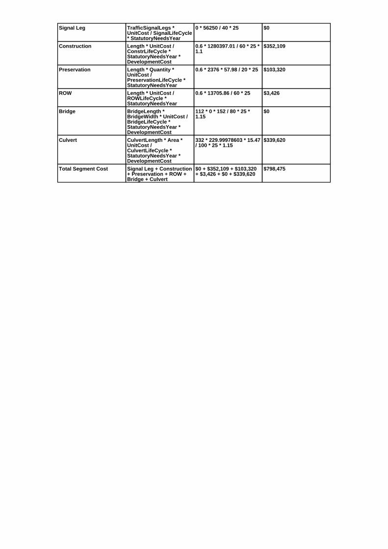
Signal Leg TrafficSignalLegs *UnitCost / SignalLifeCycle* StatutoryNeedsYear
0 * 56250 / 40 * 25 $0
Construction Length * UnitCost /ConstrLifeCycle *StatutoryNeedsYear *DevelopmentCost
0.6 * 1280397.01 / 60 * 25 *1.1
$352,109
Preservation Length * Quantity *UnitCost /PreservationLifeCycle *StatutoryNeedsYear
0.6 * 2376 * 57.98 / 20 * 25 $103,320
ROW Length * UnitCost /ROWLifeCycle *StatutoryNeedsYear
0.6 * 13705.86 / 60 * 25 $3,426
Bridge BridgeLength *BridgeWidth * UnitCost /BridgeLifeCycle *StatutoryNeedsYear *DevelopmentCost
112 * 0 * 152 / 80 * 25 *1.15
$0
Culvert CulvertLength * Area *UnitCost /CulvertLifeCycle *StatutoryNeedsYear *DevelopmentCost
332 * 229.99978603 * 15.47/ 100 * 25 * 1.15
$339,620
Total Segment Cost Signal Leg + Construction+ Preservation + ROW +Bridge + Culvert
$0 + $352,109 + $103,320+ $3,426 + $0 + $339,620
$798,475

SANEEDS - CSAH - Segment Report
Roadway SegmentInformation
Status : Original
County Name : RICE Segment Nbr : 066-645-015
Original Current
Unassigned/Unknown Municipality Unassigned/Unknown
0.6 Segment Length 0.6
MIXED BITUMINOUS Existing Surface Type MIXED BITUMINOUS
2 Existing Surface Lanes 2
NOT DIVIDED Existing Lane Description NOT DIVIDED
1.60 MILES NO OF COUNTY LINETO 2.20 MILES NO
Termini 1.60 MILES NO OF COUNTY LINETO 2.20 MILES NO
2940 Present AADT 2600
2012 Year of Count 2016
1.4 Projection Factor 1.3
2940 Projected Traffic 2600
RURAL Design Type RURAL
3 - RURAL : 1500 - 6999 Design Group 3 ( RURAL : 1500 - 6999 )
2003 Latest Year SA funds 2003
0 Number of Signal Legs 0
THTB-RECONSTRUCTED WITH TBFUNDS
Special Message Code THTB-RECONSTRUCTED WITH TBFUNDS
MILL AND OVERLAY UNDER SAP66-645-04, LET 4-7-03 (APS).
Comments MILL AND OVERLAY UNDER SAP66-645-04, LET 4-7-03 (APS).
Interchange Override
Segment Override
Segment CostInformation
Computation Factor Computation Formula Values Used ForCalculation
Computation Result
Signal Leg TrafficSignalLegs *UnitCost / SignalLifeCycle* StatutoryNeedsYear
0 * 56250 / 40 * 25 $0
Construction Length * UnitCost /ConstrLifeCycle *StatutoryNeedsYear *DevelopmentCost
0.6 * 1280397.01 / 60 * 25 *1.1
$352,109
Preservation Length * Quantity *UnitCost /PreservationLifeCycle *StatutoryNeedsYear
0.6 * 2376 * 57.98 / 20 * 25 $103,320
ROW Length * UnitCost /ROWLifeCycle *StatutoryNeedsYear
0.6 * 13705.86 / 60 * 25 $3,426
Total Segment Cost Signal Leg + Construction+ Preservation + ROW
$0 + $352,109 + $103,320+ $3,426
$458,855

SANEEDS - CSAH - Segment Report
Roadway SegmentInformation
Status : Original
County Name : RICE Segment Nbr : 066-645-018
Original Current
Unassigned/Unknown Municipality Unassigned/Unknown
0.1 Segment Length 0.1
MIXED BITUMINOUS Existing Surface Type MIXED BITUMINOUS
2 Existing Surface Lanes 2
NOT DIVIDED Existing Lane Description NOT DIVIDED
2.2O MILE NO OF COUNTY LINETO CSAH 15
Termini 2.2O MILE NO OF COUNTY LINETO CSAH 15
2940 Present AADT 2600
2012 Year of Count 2016
1.4 Projection Factor 1.3
2940 Projected Traffic 2600
RURAL Design Type RURAL
3 - RURAL : 1500 - 6999 Design Group 3 ( RURAL : 1500 - 6999 )
1976 Latest Year SA funds 1976
0 Number of Signal Legs 0
THTB-RECONSTRUCTED WITH TBFUNDS
Special Message Code THTB-RECONSTRUCTED WITH TBFUNDS
Comments
Interchange Override
Segment Override
Segment CostInformation
Computation Factor Computation Formula Values Used ForCalculation
Computation Result
Signal Leg TrafficSignalLegs *UnitCost / SignalLifeCycle* StatutoryNeedsYear
0 * 56250 / 40 * 25 $0
Construction Length * UnitCost /ConstrLifeCycle *StatutoryNeedsYear *DevelopmentCost
0.1 * 1280397.01 / 60 * 25 *1.1
$58,685
Preservation Length * Quantity *UnitCost /PreservationLifeCycle *StatutoryNeedsYear
0.1 * 2376 * 57.98 / 20 * 25 $17,220
ROW Length * UnitCost /ROWLifeCycle *StatutoryNeedsYear
0.1 * 13705.86 / 60 * 25 $571
Total Segment Cost Signal Leg + Construction+ Preservation + ROW
$0 + $58,685 + $17,220 +$571
$76,476

SANEEDS - CSAH - Segment Report
Roadway SegmentInformation
Status : Original
County Name : RICE Segment Nbr : 066-645-020
Original Current
Unassigned/Unknown Municipality Unassigned/Unknown
2.9 Segment Length 2.9
MIXED BITUMINOUS Existing Surface Type MIXED BITUMINOUS
2 Existing Surface Lanes 2
NOT DIVIDED Existing Lane Description NOT DIVIDED
CSAH 15 TO 0.72 M S OF CSAH 19 Termini CSAH 15 TO 0.72 M S OF CSAH 19
3920 Present AADT 4355
2012 Year of Count 2016
1.4 Projection Factor 1.3
3920 Projected Traffic 4355
RURAL Design Type RURAL
3 - RURAL : 1500 - 6999 Design Group 3 ( RURAL : 1500 - 6999 )
1992 Latest Year SA funds 1992
0 Number of Signal Legs 0
THTB-RECONSTRUCTED WITH TBFUNDS
Special Message Code THTB-RECONSTRUCTED WITH TBFUNDS
Comments
Interchange Override
Segment Override
Segment CostInformation
Computation Factor Computation Formula Values Used ForCalculation
Computation Result
Signal Leg TrafficSignalLegs *UnitCost / SignalLifeCycle* StatutoryNeedsYear
0 * 56250 / 40 * 25 $0
Construction Length * UnitCost /ConstrLifeCycle *StatutoryNeedsYear *DevelopmentCost
2.9 * 1280397.01 / 60 * 25 *1.1
$1,701,861
Preservation Length * Quantity *UnitCost /PreservationLifeCycle *StatutoryNeedsYear
2.9 * 2376 * 57.98 / 20 * 25 $499,382
ROW Length * UnitCost /ROWLifeCycle *StatutoryNeedsYear
2.9 * 13705.86 / 60 * 25 $16,561
Total Segment Cost Signal Leg + Construction+ Preservation + ROW
$0 + $1,701,861 + $499,382+ $16,561
$2,217,804

SANEEDS - CSAH - Segment Report
Roadway SegmentInformation
Status : Revised
County Name : RICE Segment Nbr : 066-645-030
Original Current
FARIBAULT Municipality FARIBAULT
0.58 Segment Length 0.58
MIXED BITUMINOUS Existing Surface Type MIXED BITUMINOUS
2 Existing Surface Lanes 2
NOT DIVIDED Existing Lane Description NOT DIVIDED
0.72 MI S TO 0.14 MI S OF CSAH 19 Termini 0.72 MI S TO 0.14 MI S OF CSAH 19
6090 Present AADT 5980
2012 Year of Count 2016
1.4 Projection Factor 1.3
6090 Projected Traffic 5980
RURAL Design Type URBAN
3 - RURAL : 1500 - 6999 Design Group 3 ( URBAN : 0 - 9999 )
1992 Latest Year SA funds 1992
0 Number of Signal Legs 0
THTB-RECONSTRUCTED WITH TBFUNDS
Special Message Code THTB-RECONSTRUCTED WITH TBFUNDS
Comments
Interchange Override
Segment Override
Segment CostInformation
Computation Factor Computation Formula Values Used ForCalculation
Computation Result
Signal Leg TrafficSignalLegs *UnitCost / SignalLifeCycle* StatutoryNeedsYear
0 * 56250 / 40 * 25 $0
Construction Length * UnitCost /ConstrLifeCycle *StatutoryNeedsYear *DevelopmentCost
0.58 * 2904860.94 / 60 * 25* 1.15
$807,309
Preservation Length * Quantity *UnitCost /PreservationLifeCycle *StatutoryNeedsYear
0.58 * 2904 * 57.98 / 15 * 25 $162,761
ROW Length * UnitCost /ROWLifeCycle *StatutoryNeedsYear
0.58 * 51162.01 / 60 * 25 $12,364
Total Segment Cost Signal Leg + Construction+ Preservation + ROW
$0 + $807,309 + $162,761+ $12,364
$982,434

SANEEDS - CSAH - Segment Report
Roadway SegmentInformation
Status : Original
County Name : RICE Segment Nbr : 066-645-040
Original Current
FARIBAULT Municipality FARIBAULT
0.14 Segment Length 0.14
MIXED BITUMINOUS Existing Surface Type MIXED BITUMINOUS
2 Existing Surface Lanes 2
NOT DIVIDED Existing Lane Description NOT DIVIDED
0.14 MI S TO CSAH 19 Termini 0.14 MI S TO CSAH 19
6090 Present AADT 5980
2012 Year of Count 2016
1.4 Projection Factor 1.3
6090 Projected Traffic 5980
URBAN Design Type URBAN
5 - URBAN : 0 - 9999 Design Group 5 ( URBAN : 0 - 9999 )
1991 Latest Year SA funds 1991
0 Number of Signal Legs 0
THTB-RECONSTRUCTED WITH TBFUNDS
Special Message Code THTB-RECONSTRUCTED WITH TBFUNDS
Comments
Interchange Override
Segment Override
Segment CostInformation
Computation Factor Computation Formula Values Used ForCalculation
Computation Result
Signal Leg TrafficSignalLegs *UnitCost / SignalLifeCycle* StatutoryNeedsYear
0 * 56250 / 40 * 25 $0
Construction Length * UnitCost /ConstrLifeCycle *StatutoryNeedsYear *DevelopmentCost
0.14 * 2904860.94 / 60 * 25* 1.15
$194,868
Preservation Length * Quantity *UnitCost /PreservationLifeCycle *StatutoryNeedsYear
0.14 * 2904 * 57.98 / 15 * 25 $39,287
ROW Length * UnitCost /ROWLifeCycle *StatutoryNeedsYear
0.14 * 51162.01 / 60 * 25 $2,984
Total Segment Cost Signal Leg + Construction+ Preservation + ROW
$0 + $194,868 + $39,287 +$2,984
$237,139

SANEEDS - CSAH - Segment Report
Roadway SegmentInformation
Status : Revised
County Name : RICE Segment Nbr : 066-646-010
Original Current
Unassigned/Unknown Municipality Unassigned/Unknown
0.1 Segment Length 0.1
MIXED BITUMINOUS Existing Surface Type MIXED BITUMINOUS
2 Existing Surface Lanes 2
NOT DIVIDED Existing Lane Description NOT DIVIDED
TH 21 TO 0.10 MI NORTH Termini TH 21 TO 0.10 MI NORTH
2380 Present AADT 2210
2012 Year of Count 2016
1.4 Projection Factor 1.3
2380 Projected Traffic 2210
RURAL Design Type RURAL
3 - RURAL : 1500 - 6999 Design Group 3 ( RURAL : 1500 - 6999 )
2016 Latest Year SA funds 2016
0 Number of Signal Legs 0
THTB-RECONSTRUCTED WITH TBFUNDS
Special Message Code THTB-RECONSTRUCTED WITH TBFUNDS
2016 SAP 066-646-005 CONCRETEOL TH21 TO CSAH1
Comments 2016 SAP 066-646-005 CONCRETEOL TH21 TO CSAH1
Interchange Override
Segment Override
Segment CostInformation
Computation Factor Computation Formula Values Used ForCalculation
Computation Result
Signal Leg TrafficSignalLegs *UnitCost / SignalLifeCycle* StatutoryNeedsYear
0 * 56250 / 40 * 25 $0
Construction Length * UnitCost /ConstrLifeCycle *StatutoryNeedsYear *DevelopmentCost
0.1 * 1280397.01 / 60 * 25 *1.1
$58,685
Preservation Length * Quantity *UnitCost /PreservationLifeCycle *StatutoryNeedsYear
0.1 * 2376 * 57.98 / 20 * 25 $17,220
ROW Length * UnitCost /ROWLifeCycle *StatutoryNeedsYear
0.1 * 13705.86 / 60 * 25 $571
Total Segment Cost Signal Leg + Construction+ Preservation + ROW
$0 + $58,685 + $17,220 +$571
$76,476
SANEEDS - CSAH - Segment Report
Roadway SegmentInformation
Status : Revised
County Name : RICE Segment Nbr : 066-646-020
Original Current
FARIBAULT Municipality FARIBAULT
0.9 Segment Length 0.9
MIXED BITUMINOUS Existing Surface Type MIXED BITUMINOUS
2 Existing Surface Lanes 2
NOT DIVIDED Existing Lane Description NOT DIVIDED
0.10 MI N TO 1.0 MI N OF TH 21 (NLIMITS)
Termini 0.10 MI N TO 1.0 MI N OF TH 21 (NLIMITS)
2380 Present AADT 2210
2012 Year of Count 2016
1.4 Projection Factor 1.3
2380 Projected Traffic 2210
RURAL Design Type RURAL
3 - RURAL : 1500 - 6999 Design Group 3 ( RURAL : 1500 - 6999 )
2016 Latest Year SA funds 2016
0 Number of Signal Legs 0
THTB-RECONSTRUCTED WITH TBFUNDS
Special Message Code THTB-RECONSTRUCTED WITH TBFUNDS
2016 SAP 066-646-005 CONCRETEOL TH21 TO CSAH1
Comments 2016 SAP 066-646-005 CONCRETEOL TH21 TO CSAH1
Interchange Override
Segment Override
Segment CostInformation
Computation Factor Computation Formula Values Used ForCalculation
Computation Result
Signal Leg TrafficSignalLegs *UnitCost / SignalLifeCycle* StatutoryNeedsYear
0 * 56250 / 40 * 25 $0
Construction Length * UnitCost /ConstrLifeCycle *StatutoryNeedsYear *DevelopmentCost
0.9 * 1280397.01 / 60 * 25 *1.1
$528,164
Preservation Length * Quantity *UnitCost /PreservationLifeCycle *StatutoryNeedsYear
0.9 * 2376 * 57.98 / 20 * 25 $154,981
ROW Length * UnitCost /ROWLifeCycle *StatutoryNeedsYear
0.9 * 13705.86 / 60 * 25 $5,140
Total Segment Cost Signal Leg + Construction+ Preservation + ROW
$0 + $528,164 + $154,981+ $5,140
$688,285

SANEEDS - CSAH - Segment Report
Roadway SegmentInformation
Status : Revised
County Name : RICE Segment Nbr : 066-646-030
Original Current
Unassigned/Unknown Municipality Unassigned/Unknown
9.1 Segment Length 9.1
MIXED BITUMINOUS Existing Surface Type MIXED BITUMINOUS
2 Existing Surface Lanes 2
NOT DIVIDED Existing Lane Description NOT DIVIDED
1.0 MI NORTH OF TH 21 TO TH 19 Termini 1.0 MI NORTH OF TH 21 TO TH 19
2380 Present AADT 2210
2012 Year of Count 2016
1.4 Projection Factor 1.3
2380 Projected Traffic 2210
RURAL Design Type RURAL
3 - RURAL : 1500 - 6999 Design Group 3 ( RURAL : 1500 - 6999 )
2016 Latest Year SA funds 2016
0 Number of Signal Legs 0
THTB-RECONSTRUCTED WITH TBFUNDS
Special Message Code THTB-RECONSTRUCTED WITH TBFUNDS
2016 SAP 066-646-005 CONCRETEOL TH21 TO CSAH1
2015 SAP 066-646-006 CULVERTR&R 66J70
2015 SAP 066-646-007 CATTLEPASS R&R - NO STRUCTURE#
2015 SAP 066-646-008 66" RC PIPE- NO STRUCTURE#
2012 SAP 066-646-004 TIED TO066-601-022, INTERSECTION @CSAH 1
Comments 2016 SAP 066-646-005 CONCRETEOL TH21 TO CSAH1
2015 SAP 066-646-006 CULVERTR&R 66J70
2015 SAP 066-646-007 CATTLEPASS R&R - NO STRUCTURE#
2015 SAP 066-646-008 66" RC PIPE- NO STRUCTURE#
2012 SAP 066-646-004 TIED TO066-601-022, INTERSECTION @CSAH 1
Interchange Override
Segment Override
Culvert Information Status: Original
Original Current
66J70 Structure Number 66J70
6.53 Milepoint 6.53
2015 Year Built 2015
WOLF CREEK Feature Crossed WOLF CREEK
STREAM CROSSING Type of Service STREAM CROSSING
2 Number of Barrels 2
14 Culvert Width 14
8 Culvert Height 8
130 Culvert Length 130
210 Area of Waterway Opening 210
100% Shared Structure 100%
2015 SAP 066-646-006 CULVERTR&R - 130FT VERIFIED
1-LINE 14'X8' AND 1-LINE 14'X7'REINFORCED CONCRETE BOXCULVERT
Comments 2015 SAP 066-646-006 CULVERTR&R - 130FT VERIFIED
1-LINE 14'X8' AND 1-LINE 14'X7'REINFORCED CONCRETE BOXCULVERT
1 Culvert Group Code 1
Culvert Information Status: Original
Original Current
6363 Structure Number 6363
8.46 Milepoint 8.46
1947 Year Built 1947
HEATH CREEK Feature Crossed HEATH CREEK
Type of Service

2 Number of Barrels 2
12 Culvert Width 12
8 Culvert Height 8
94 Culvert Length 94
191.99998986 Area of Waterway Opening 191.99998986
100% Shared Structure 100%
Comments
1 Culvert Group Code 1
Segment CostInformation
Computation Factor Computation Formula Values Used ForCalculation
Computation Result
Signal Leg TrafficSignalLegs *UnitCost / SignalLifeCycle* StatutoryNeedsYear
0 * 56250 / 40 * 25 $0
Construction Length * UnitCost /ConstrLifeCycle *StatutoryNeedsYear *DevelopmentCost
9.1 * 1280397.01 / 60 * 25 *1.1
$5,340,323
Preservation Length * Quantity *UnitCost /PreservationLifeCycle *StatutoryNeedsYear
9.1 * 2376 * 57.98 / 20 * 25 $1,567,025
ROW Length * UnitCost /ROWLifeCycle *StatutoryNeedsYear
9.1 * 13705.86 / 60 * 25 $51,968
Culvert CulvertLength * Area *UnitCost /CulvertLifeCycle *StatutoryNeedsYear *DevelopmentCost
130 * 210 * 15.47 / 100 * 25* 1.15
$121,420
Culvert CulvertLength * Area *UnitCost /CulvertLifeCycle *StatutoryNeedsYear *DevelopmentCost
94 * 191.99998986 * 15.47 /100 * 25 * 1.15
$80,271
Total Segment Cost Signal Leg + Construction+ Preservation + ROW +Culvert + Culvert
$0 + $5,340,323 +$1,567,025 + $51,968 +$121,420 + $80,271
$7,161,007

SANEEDS - CSAH - Segment Report
Roadway SegmentInformation
Status : Original
County Name : RICE Segment Nbr : 066-646-040
Original Current
Unassigned/Unknown Municipality Unassigned/Unknown
5.2 Segment Length 5.2
MIXED BITUMINOUS Existing Surface Type MIXED BITUMINOUS
2 Existing Surface Lanes 2
NOT DIVIDED Existing Lane Description NOT DIVIDED
TH 19 TO N. CO. LINE Termini TH 19 TO N. CO. LINE
2870 Present AADT 2405
2012 Year of Count 2016
1.4 Projection Factor 1.3
2870 Projected Traffic 2405
RURAL Design Type RURAL
3 - RURAL : 1500 - 6999 Design Group 3 ( RURAL : 1500 - 6999 )
1994 Latest Year SA funds 1994
0 Number of Signal Legs 0
THTB-RECONSTRUCTED WITH TBFUNDS
Special Message Code THTB-RECONSTRUCTED WITH TBFUNDS
Comments
Interchange Override
Segment Override
Segment CostInformation
Computation Factor Computation Formula Values Used ForCalculation
Computation Result
Signal Leg TrafficSignalLegs *UnitCost / SignalLifeCycle* StatutoryNeedsYear
0 * 56250 / 40 * 25 $0
Construction Length * UnitCost /ConstrLifeCycle *StatutoryNeedsYear *DevelopmentCost
5.2 * 1280397.01 / 60 * 25 *1.1
$3,051,613
Preservation Length * Quantity *UnitCost /PreservationLifeCycle *StatutoryNeedsYear
5.2 * 2376 * 57.98 / 20 * 25 $895,443
ROW Length * UnitCost /ROWLifeCycle *StatutoryNeedsYear
5.2 * 13705.86 / 60 * 25 $29,696
Total Segment Cost Signal Leg + Construction+ Preservation + ROW
$0 + $3,051,613 + $895,443+ $29,696
$3,976,752

SANEEDS - CSAH - Segment Report
Roadway SegmentInformation
Status : Original
County Name : RICE Segment Nbr : 066-647-010
Original Current
FARIBAULT Municipality FARIBAULT
0.52 Segment Length 0.52
MIXED BITUMINOUS Existing Surface Type MIXED BITUMINOUS
2 Existing Surface Lanes 2
NOT DIVIDED Existing Lane Description NOT DIVIDED
CSAH 18 TO CSAH 45 Termini CSAH 18 TO CSAH 45
2170 Present AADT 2340
2012 Year of Count 2016
1.4 Projection Factor 1.3
2170 Projected Traffic 2340
URBAN Design Type URBAN
5 - URBAN : 0 - 9999 Design Group 5 ( URBAN : 0 - 9999 )
1974 Latest Year SA funds 1974
0 Number of Signal Legs 0
No Special Message Special Message Code No Special Message
Comments
Interchange Override
Segment Override
Segment CostInformation
Computation Factor Computation Formula Values Used ForCalculation
Computation Result
Signal Leg TrafficSignalLegs *UnitCost / SignalLifeCycle* StatutoryNeedsYear
0 * 56250 / 40 * 25 $0
Construction Length * UnitCost /ConstrLifeCycle *StatutoryNeedsYear *DevelopmentCost
0.52 * 2904860.94 / 60 * 25* 1.15
$723,795
Preservation Length * Quantity *UnitCost /PreservationLifeCycle *StatutoryNeedsYear
0.52 * 2904 * 57.98 / 15 * 25 $145,924
ROW Length * UnitCost /ROWLifeCycle *StatutoryNeedsYear
0.52 * 51162.01 / 60 * 25 $11,085
Total Segment Cost Signal Leg + Construction+ Preservation + ROW
$0 + $723,795 + $145,924+ $11,085
$880,804

SANEEDS - CSAH - Segment Report
Roadway SegmentInformation
Status : Original
County Name : RICE Segment Nbr : 066-648-010
Original Current
FARIBAULT Municipality FARIBAULT
1.09 Segment Length 1.09
BIT CONC OR ASPH Existing Surface Type BIT CONC OR ASPH
4 Existing Surface Lanes 4
DIVIDED Existing Lane Description DIVIDED
TH 60 TO 1.09 MI S Termini TH 60 TO 1.09 MI S
16800 Present AADT 15210
2012 Year of Count 2016
1.4 Projection Factor 1.3
16800 Projected Traffic 15210
RURAL Design Type RURAL
4 - RURAL : 7000 - 999999 Design Group 4 ( RURAL : 7000 - 999999 )
2004 Latest Year SA funds 2004
3 Number of Signal Legs 3
THTB-NOT ELIGIBLE FOR TBFUNDS
Special Message Code THTB-NOT ELIGIBLE FOR TBFUNDS
2013 SAP 066-648-005INTERSECTION WORK ON CSAH
SAP 66-648-02, MILL ANDOVERLAY, LET 6-16-04 (APS 1-24-05).
Comments 2013 SAP 066-648-005INTERSECTION WORK ON CSAH
SAP 66-648-02, MILL ANDOVERLAY, LET 6-16-04 (APS 1-24-05).
Interchange Override
Segment Override
Segment CostInformation
Computation Factor Computation Formula Values Used ForCalculation
Computation Result
Signal Leg TrafficSignalLegs *UnitCost / SignalLifeCycle* StatutoryNeedsYear
3 * 56250 / 40 * 25 $105,469
Construction Length * UnitCost /ConstrLifeCycle *StatutoryNeedsYear *DevelopmentCost
1.09 * 2417478.95 / 60 * 25* 1.1
$1,207,732
Preservation Length * Quantity *UnitCost /PreservationLifeCycle *StatutoryNeedsYear
1.09 * 3564 * 57.98 / 20 * 25 $281,548
ROW Length * UnitCost /ROWLifeCycle *StatutoryNeedsYear
1.09 * 443115.08 / 60 * 25 $201,248
Total Segment Cost Signal Leg + Construction+ Preservation + ROW
$105,469 + $1,207,732 +$281,548 + $201,248
$1,795,997

SANEEDS - CSAH - Segment Report
Roadway SegmentInformation
Status : Original
County Name : RICE Segment Nbr : 066-676-001
Original Current
FARIBAULT Municipality FARIBAULT
3.54 Segment Length 3.54
BIT CONC OR ASPH Existing Surface Type BIT CONC OR ASPH
2 Existing Surface Lanes 2
NOT DIVIDED Existing Lane Description NOT DIVIDED
INTERSECTION OF NW 30THSTREET & PARK AVE TO THEINTERSECTION OF CSAH NO. 9
Termini INTERSECTION OF NW 30THSTREET & PARK AVE TO THEINTERSECTION OF CSAH NO. 9
1120 Present AADT 1040
2012 Year of Count 2016
1.4 Projection Factor 1.3
1120 Projected Traffic 1040
RURAL Design Type RURAL
2 - RURAL : 150 - 1499 Design Group 2 ( RURAL : 150 - 1499 )
2014 Latest Year SA funds 2014
0 Number of Signal Legs 0
No Special Message Special Message Code No Special Message
2014 SAP 066-676-001 RECONST170TH TO CASH 9
Comments 2014 SAP 066-676-001 RECONST170TH TO CASH 9
Interchange Override
Segment Override
Segment CostInformation
Computation Factor Computation Formula Values Used ForCalculation
Computation Result
Signal Leg TrafficSignalLegs *UnitCost / SignalLifeCycle* StatutoryNeedsYear
0 * 56250 / 40 * 25 $0
Construction Length * UnitCost /ConstrLifeCycle *StatutoryNeedsYear *DevelopmentCost
3.54 * 975142.53 / 60 * 25 *1.1
$1,582,169
Preservation Length * Quantity *UnitCost /PreservationLifeCycle *StatutoryNeedsYear
3.54 * 2112 * 57.98 / 20 * 25 $541,858
ROW Length * UnitCost /ROWLifeCycle *StatutoryNeedsYear
3.54 * 32462.65 / 60 * 25 $47,882
Total Segment Cost Signal Leg + Construction+ Preservation + ROW
$0 + $1,582,169 + $541,858+ $47,882
$2,171,909

SANEEDS - CSAH - Segment Report
Roadway SegmentInformation
Status : Original
County Name : RICE Segment Nbr : 066-678-010
Original Current
DUNDAS Municipality DUNDAS
0.04 Segment Length 0.04
MIXED BITUMINOUS Existing Surface Type MIXED BITUMINOUS
2 Existing Surface Lanes 2
NOT DIVIDED Existing Lane Description NOT DIVIDED
CSAH 1 TO 225 FT WEST Termini CSAH 1 TO 225 FT WEST
3640 Present AADT 3705
2012 Year of Count 2016
1.4 Projection Factor 1.3
3640 Projected Traffic 3705
RURAL Design Type RURAL
3 - RURAL : 1500 - 6999 Design Group 3 ( RURAL : 1500 - 6999 )
Latest Year SA funds
0 Number of Signal Legs 0
No Special Message Special Message Code No Special Message
Comments
Interchange Override
Segment Override
Segment CostInformation
Computation Factor Computation Formula Values Used ForCalculation
Computation Result
Signal Leg TrafficSignalLegs *UnitCost / SignalLifeCycle* StatutoryNeedsYear
0 * 56250 / 40 * 25 $0
Construction Length * UnitCost /ConstrLifeCycle *StatutoryNeedsYear *DevelopmentCost
0.04 * 1280397.01 / 60 * 25* 1.1
$23,474
Preservation Length * Quantity *UnitCost /PreservationLifeCycle *StatutoryNeedsYear
0.04 * 2376 * 57.98 / 20 * 25 $6,888
ROW Length * UnitCost /ROWLifeCycle *StatutoryNeedsYear
0.04 * 13705.86 / 60 * 25 $228
Total Segment Cost Signal Leg + Construction+ Preservation + ROW
$0 + $23,474 + $6,888 +$228
$30,590

SANEEDS - CSAH - Segment Report
Roadway SegmentInformation
Status : Original
County Name : RICE Segment Nbr : 066-678-020
Original Current
DUNDAS Municipality DUNDAS
0.46 Segment Length 0.46
MIXED BITUMINOUS Existing Surface Type MIXED BITUMINOUS
2 Existing Surface Lanes 2
NOT DIVIDED Existing Lane Description NOT DIVIDED
225 FT W OF CSAH 1 TO N LIMDUNDAS
Termini 225 FT W OF CSAH 1 TO N LIMDUNDAS
3640 Present AADT 3705
2012 Year of Count 2016
1.4 Projection Factor 1.3
3640 Projected Traffic 3705
RURAL Design Type RURAL
3 - RURAL : 1500 - 6999 Design Group 3 ( RURAL : 1500 - 6999 )
Latest Year SA funds
0 Number of Signal Legs 0
No Special Message Special Message Code No Special Message
CHANGED FROM CR SYSTEM TOCSAH SYSTEM 2003
Comments CHANGED FROM CR SYSTEM TOCSAH SYSTEM 2003
Interchange Override
Segment Override
Segment CostInformation
Computation Factor Computation Formula Values Used ForCalculation
Computation Result
Signal Leg TrafficSignalLegs *UnitCost / SignalLifeCycle* StatutoryNeedsYear
0 * 56250 / 40 * 25 $0
Construction Length * UnitCost /ConstrLifeCycle *StatutoryNeedsYear *DevelopmentCost
0.46 * 1280397.01 / 60 * 25* 1.1
$269,950
Preservation Length * Quantity *UnitCost /PreservationLifeCycle *StatutoryNeedsYear
0.46 * 2376 * 57.98 / 20 * 25 $79,212
ROW Length * UnitCost /ROWLifeCycle *StatutoryNeedsYear
0.46 * 13705.86 / 60 * 25 $2,627
Total Segment Cost Signal Leg + Construction+ Preservation + ROW
$0 + $269,950 + $79,212 +$2,627
$351,789

SANEEDS - CSAH - Segment Report
Roadway SegmentInformation
Status : Original
County Name : RICE Segment Nbr : 066-678-030
Original Current
Unassigned/Unknown Municipality Unassigned/Unknown
0.1 Segment Length 0.1
MIXED BITUMINOUS Existing Surface Type MIXED BITUMINOUS
2 Existing Surface Lanes 2
NOT DIVIDED Existing Lane Description NOT DIVIDED
N LIM DUNDAS TO S LIM OFNORTHFIELD
Termini N LIM DUNDAS TO S LIM OFNORTHFIELD
3640 Present AADT 3705
2012 Year of Count 2016
1.4 Projection Factor 1.3
3640 Projected Traffic 3705
RURAL Design Type RURAL
3 - RURAL : 1500 - 6999 Design Group 3 ( RURAL : 1500 - 6999 )
2013 Latest Year SA funds 2013
0 Number of Signal Legs 0
No Special Message Special Message Code No Special Message
2013 SAP 066-678-001 CULVERTR&R STEEL PIPE
CHANGED FROM CR SYSTEM TOCSAH SYSTEM 2003
Comments 2013 SAP 066-678-001 CULVERTR&R STEEL PIPE
CHANGED FROM CR SYSTEM TOCSAH SYSTEM 2003
Interchange Override
Segment Override
Culvert Information Status: Original
Original Current
66J67 Structure Number 66J67
0.1 Milepoint 0.1
2013 Year Built 2013
Rice Creek Feature Crossed Rice Creek
STREAM CROSSING Type of Service STREAM CROSSING
1 Number of Barrels 1
12 Culvert Width 12
10 Culvert Height 10
87 Culvert Length 87
120 Area of Waterway Opening 120
100% Shared Structure 100%
2013 SAP 066-678-001 CULVERTR&R STEEL PIPE
Comments 2013 SAP 066-678-001 CULVERTR&R STEEL PIPE
1 Culvert Group Code 1
Segment CostInformation
Computation Factor Computation Formula Values Used ForCalculation
Computation Result
Signal Leg TrafficSignalLegs *UnitCost / SignalLifeCycle* StatutoryNeedsYear
0 * 56250 / 40 * 25 $0
Construction Length * UnitCost /ConstrLifeCycle *StatutoryNeedsYear *DevelopmentCost
0.1 * 1280397.01 / 60 * 25 *1.1
$58,685
Preservation Length * Quantity *UnitCost /PreservationLifeCycle *StatutoryNeedsYear
0.1 * 2376 * 57.98 / 20 * 25 $17,220
ROW Length * UnitCost /ROWLifeCycle *StatutoryNeedsYear
0.1 * 13705.86 / 60 * 25 $571

Culvert CulvertLength * Area *UnitCost /CulvertLifeCycle *StatutoryNeedsYear *DevelopmentCost
87 * 120 * 15.47 / 100 * 25 *1.15
$46,433
Total Segment Cost Signal Leg + Construction+ Preservation + ROW +Culvert
$0 + $58,685 + $17,220 +$571 + $46,433
$122,909

SANEEDS - CSAH - Segment Report
Roadway SegmentInformation
Status : Original
County Name : RICE Segment Nbr : 066-678-040
Original Current
NORTHFIELD Municipality NORTHFIELD
1.37 Segment Length 1.37
MIXED BITUMINOUS Existing Surface Type MIXED BITUMINOUS
2 Existing Surface Lanes 2
NOT DIVIDED Existing Lane Description NOT DIVIDED
S LIM OF NORTHFIELD TOARMSTRONG RD (MSAS 118)
Termini S LIM OF NORTHFIELD TOARMSTRONG RD (MSAS 118)
3640 Present AADT 3705
2012 Year of Count 2016
1.4 Projection Factor 1.3
3640 Projected Traffic 3705
RURAL Design Type RURAL
3 - RURAL : 1500 - 6999 Design Group 3 ( RURAL : 1500 - 6999 )
Latest Year SA funds
0 Number of Signal Legs 0
No Special Message Special Message Code No Special Message
CHANGED FROM CR SYSTEM TOCSAH SYSTEM 2003
Comments CHANGED FROM CR SYSTEM TOCSAH SYSTEM 2003
Interchange Override
Segment Override
Culvert Information Status: Original
Original Current
88048 Structure Number 88048
1.108 Milepoint 1.108
1955 Year Built 1955
HEATH CREEK Feature Crossed HEATH CREEK
Type of Service
2 Number of Barrels 2
Culvert Width
Culvert Height
94 Culvert Length 94
225.99992079 Area of Waterway Opening 225.99992079
100% Shared Structure 100%
Comments
1 Culvert Group Code 1
Segment CostInformation
Computation Factor Computation Formula Values Used ForCalculation
Computation Result
Signal Leg TrafficSignalLegs *UnitCost / SignalLifeCycle* StatutoryNeedsYear
0 * 56250 / 40 * 25 $0
Construction Length * UnitCost /ConstrLifeCycle *StatutoryNeedsYear *DevelopmentCost
1.37 * 1280397.01 / 60 * 25* 1.1
$803,983
Preservation Length * Quantity *UnitCost /PreservationLifeCycle *StatutoryNeedsYear
1.37 * 2376 * 57.98 / 20 * 25 $235,915
ROW Length * UnitCost /ROWLifeCycle *StatutoryNeedsYear
1.37 * 13705.86 / 60 * 25 $7,824
Culvert CulvertLength * Area *UnitCost /CulvertLifeCycle *StatutoryNeedsYear *DevelopmentCost
94 * 225.99992079 * 15.47 /100 * 25 * 1.15
$94,485

Total Segment Cost Signal Leg + Construction+ Preservation + ROW +Culvert
$0 + $803,983 + $235,915+ $7,824 + $94,485
$1,142,207

SANEEDS - CSAH - Segment Report
Roadway SegmentInformation
Status : Original
County Name : RICE Segment Nbr : 066-686-010
Original Current
Unassigned/Unknown Municipality Unassigned/Unknown
1.6 Segment Length 1.6
BIT CONC OR ASPH Existing Surface Type BIT CONC OR ASPH
2 Existing Surface Lanes 2
NOT DIVIDED Existing Lane Description NOT DIVIDED
4.1 MI W TO 2.5 MI W OF CSAH 46(ON NORTH CO LINE)
Termini 4.1 MI W TO 2.5 MI W OF CSAH 46(ON NORTH CO LINE)
5600 Present AADT 6045
2012 Year of Count 2016
1.4 Projection Factor 1.3
5600 Projected Traffic 6045
RURAL Design Type RURAL
3 - RURAL : 1500 - 6999 Design Group 3 ( RURAL : 1500 - 6999 )
2013 Latest Year SA funds 2013
0 Number of Signal Legs 0
No Special Message Special Message Code No Special Message
2013 SAP 066-686-002 M&OL Comments 2013 SAP 066-686-002 M&OL
Interchange Override
Segment Override
Segment CostInformation
Computation Factor Computation Formula Values Used ForCalculation
Computation Result
Signal Leg TrafficSignalLegs *UnitCost / SignalLifeCycle* StatutoryNeedsYear
0 * 56250 / 40 * 25 $0
Construction Length * UnitCost /ConstrLifeCycle *StatutoryNeedsYear *DevelopmentCost
1.6 * 1280397.01 / 60 * 25 *1.1
$938,958
Preservation Length * Quantity *UnitCost /PreservationLifeCycle *StatutoryNeedsYear
1.6 * 2376 * 57.98 / 20 * 25 $275,521
ROW Length * UnitCost /ROWLifeCycle *StatutoryNeedsYear
1.6 * 13705.86 / 60 * 25 $9,137
Total Segment Cost Signal Leg + Construction+ Preservation + ROW
$0 + $938,958 + $275,521+ $9,137
$1,223,616

SANEEDS - CSAH - Segment Report
Roadway SegmentInformation
Status : Original
County Name : RICE Segment Nbr : 066-686-020
Original Current
Unassigned/Unknown Municipality Unassigned/Unknown
2.5 Segment Length 2.5
MIXED BITUMINOUS Existing Surface Type MIXED BITUMINOUS
2 Existing Surface Lanes 2
NOT DIVIDED Existing Lane Description NOT DIVIDED
2.50 M W TO CSAH 46 Termini 2.50 M W TO CSAH 46
2660 Present AADT 2795
2012 Year of Count 2016
1.4 Projection Factor 1.3
2660 Projected Traffic 2795
RURAL Design Type RURAL
3 - RURAL : 1500 - 6999 Design Group 3 ( RURAL : 1500 - 6999 )
2013 Latest Year SA funds 2013
0 Number of Signal Legs 0
No Special Message Special Message Code No Special Message
2013 SAP 066-686-002 M&OL Comments 2013 SAP 066-686-002 M&OL
Interchange Override
Segment Override
Bridge Information Status: Original
Original Current
70543 Structure Number 70543
2.61 Milepoint 2.61
2009 Year Built 2009
PORTER CREEK Feature Crossed PORTER CREEK
Type of Service
Number of Spans
138.67 Bridge Length 138.67
47.33 Bridge Width 47.33
100% Shared Structure 100%
Comments
1 ( 0-149 ) Bridge Group Code 1 ( 0-149 )
Bridge Information Status: Original
Original Current
70544 Structure Number 70544
1.93 Milepoint 1.93
2009 Year Built 2009
STREAM Feature Crossed STREAM
Type of Service
Number of Spans
141.01 Bridge Length 141.01
47.33 Bridge Width 47.33
100% Shared Structure 100%
Comments
1 ( 0-149 ) Bridge Group Code 1 ( 0-149 )
Segment CostInformation
Computation Factor Computation Formula Values Used ForCalculation
Computation Result
Signal Leg TrafficSignalLegs *UnitCost / SignalLifeCycle* StatutoryNeedsYear
0 * 56250 / 40 * 25 $0

Construction Length * UnitCost /ConstrLifeCycle *StatutoryNeedsYear *DevelopmentCost
2.5 * 1280397.01 / 60 * 25 *1.1
$1,467,122
Preservation Length * Quantity *UnitCost /PreservationLifeCycle *StatutoryNeedsYear
2.5 * 2376 * 57.98 / 20 * 25 $430,502
ROW Length * UnitCost /ROWLifeCycle *StatutoryNeedsYear
2.5 * 13705.86 / 60 * 25 $14,277
Bridge BridgeLength *BridgeWidth * UnitCost /BridgeLifeCycle *StatutoryNeedsYear *DevelopmentCost
138.67 * 47.33 * 152 / 80 *25 * 1.15
$358,518
Bridge BridgeLength *BridgeWidth * UnitCost /BridgeLifeCycle *StatutoryNeedsYear *DevelopmentCost
141.01 * 47.33 * 152 / 80 *25 * 1.15
$364,567
Total Segment Cost Signal Leg + Construction+ Preservation + ROW +Bridge + Bridge
$0 + $1,467,122 + $430,502+ $14,277 + $358,518 +$364,567
$2,634,986

SANEEDS - CSAH - Segment Report
Roadway SegmentInformation
Status : Original
County Name : RICE Segment Nbr : 066-686-030
Original Current
Unassigned/Unknown Municipality Unassigned/Unknown
0.1 Segment Length 0.1
AGGREGATE SURF Existing Surface Type AGGREGATE SURF
2 Existing Surface Lanes 2
NOT DIVIDED Existing Lane Description NOT DIVIDED
CSAH 46 TO 0.10 MILES EAST Termini CSAH 46 TO 0.10 MILES EAST
3150 Present AADT 2795
2012 Year of Count 2016
1.4 Projection Factor 1.3
3150 Projected Traffic 2795
RURAL Design Type RURAL
3 - RURAL : 1500 - 6999 Design Group 3 ( RURAL : 1500 - 6999 )
1965 Latest Year SA funds 1965
0 Number of Signal Legs 0
No Special Message Special Message Code No Special Message
Comments
Interchange Override
Segment Override
Segment CostInformation
Computation Factor Computation Formula Values Used ForCalculation
Computation Result
Signal Leg TrafficSignalLegs *UnitCost / SignalLifeCycle* StatutoryNeedsYear
0 * 56250 / 40 * 25 $0
Construction Length * UnitCost /ConstrLifeCycle *StatutoryNeedsYear *DevelopmentCost
0.1 * 1280397.01 / 60 * 25 *1.1
$58,685
Preservation Length * Quantity *UnitCost /PreservationLifeCycle *StatutoryNeedsYear
0.1 * 2376 * 57.98 / 20 * 25 $17,220
ROW Length * UnitCost /ROWLifeCycle *StatutoryNeedsYear
0.1 * 13705.86 / 60 * 25 $571
Total Segment Cost Signal Leg + Construction+ Preservation + ROW
$0 + $58,685 + $17,220 +$571
$76,476

SANEEDS - CSAH - Segment Report
Roadway SegmentInformation
Status : Original
County Name : RICE Segment Nbr : 066-693-010
Original Current
Unassigned/Unknown Municipality Unassigned/Unknown
1.5 Segment Length 1.5
MIXED BITUMINOUS Existing Surface Type MIXED BITUMINOUS
2 Existing Surface Lanes 2
NOT DIVIDED Existing Lane Description NOT DIVIDED
CSAH 39 TO SO LIM OFFARIBAULT
Termini CSAH 39 TO SO LIM OFFARIBAULT
3710 Present AADT 3250
2012 Year of Count 2016
1.4 Projection Factor 1.3
3710 Projected Traffic 3250
RURAL Design Type RURAL
3 - RURAL : 1500 - 6999 Design Group 3 ( RURAL : 1500 - 6999 )
Latest Year SA funds
0 Number of Signal Legs 0
No Special Message Special Message Code No Special Message
PROPOSED CHANGE TO CSAHSYSTEM FROM CO RD
Comments PROPOSED CHANGE TO CSAHSYSTEM FROM CO RD
Interchange Override
Segment Override
Culvert Information Status: Original
Original Current
91820 Structure Number 91820
0.71 Milepoint 0.71
1988 Year Built 1988
CROCKERS CREEK Feature Crossed CROCKERS CREEK
STREAM CROSSING Type of Service STREAM CROSSING
2 Number of Barrels 2
14 Culvert Width 14
10 Culvert Height 10
74 Culvert Length 74
197.99978772 Area of Waterway Opening 197.99978772
100% Shared Structure 100%
Comments
1 Culvert Group Code 1
Segment CostInformation
Computation Factor Computation Formula Values Used ForCalculation
Computation Result
Signal Leg TrafficSignalLegs *UnitCost / SignalLifeCycle* StatutoryNeedsYear
0 * 56250 / 40 * 25 $0
Construction Length * UnitCost /ConstrLifeCycle *StatutoryNeedsYear *DevelopmentCost
1.5 * 1280397.01 / 60 * 25 *1.1
$880,273
Preservation Length * Quantity *UnitCost /PreservationLifeCycle *StatutoryNeedsYear
1.5 * 2376 * 57.98 / 20 * 25 $258,301
ROW Length * UnitCost /ROWLifeCycle *StatutoryNeedsYear
1.5 * 13705.86 / 60 * 25 $8,566
Culvert CulvertLength * Area *UnitCost /CulvertLifeCycle *StatutoryNeedsYear *DevelopmentCost
74 * 197.99978772 * 15.47 /100 * 25 * 1.15
$65,167

Total Segment Cost Signal Leg + Construction+ Preservation + ROW +Culvert
$0 + $880,273 + $258,301+ $8,566 + $65,167
$1,212,307

SANEEDS - CSAH - Segment Report
Roadway SegmentInformation
Status : Original
County Name : RICE Segment Nbr : 066-693-020
Original Current
FARIBAULT Municipality FARIBAULT
0.4 Segment Length 0.4
MIXED BITUMINOUS Existing Surface Type MIXED BITUMINOUS
2 Existing Surface Lanes 2
NOT DIVIDED Existing Lane Description NOT DIVIDED
S LIM OF FARIBAULT TO 0.40 MI N Termini S LIM OF FARIBAULT TO 0.40 MI N
3710 Present AADT 3250
2012 Year of Count 2016
1.4 Projection Factor 1.3
3710 Projected Traffic 3250
RURAL Design Type RURAL
3 - RURAL : 1500 - 6999 Design Group 3 ( RURAL : 1500 - 6999 )
Latest Year SA funds
0 Number of Signal Legs 0
No Special Message Special Message Code No Special Message
PROPOSED CHANGE TO CSAHSYSTEM FROM CO RD
Comments PROPOSED CHANGE TO CSAHSYSTEM FROM CO RD
Interchange Override
Segment Override
Segment CostInformation
Computation Factor Computation Formula Values Used ForCalculation
Computation Result
Signal Leg TrafficSignalLegs *UnitCost / SignalLifeCycle* StatutoryNeedsYear
0 * 56250 / 40 * 25 $0
Construction Length * UnitCost /ConstrLifeCycle *StatutoryNeedsYear *DevelopmentCost
0.4 * 1280397.01 / 60 * 25 *1.1
$234,739
Preservation Length * Quantity *UnitCost /PreservationLifeCycle *StatutoryNeedsYear
0.4 * 2376 * 57.98 / 20 * 25 $68,880
ROW Length * UnitCost /ROWLifeCycle *StatutoryNeedsYear
0.4 * 13705.86 / 60 * 25 $2,284
Total Segment Cost Signal Leg + Construction+ Preservation + ROW
$0 + $234,739 + $68,880 +$2,284
$305,903

SANEEDS - CSAH - Segment Report
Roadway SegmentInformation
Status : Original
County Name : RICE Segment Nbr : 066-693-030
Original Current
FARIBAULT Municipality FARIBAULT
0.47 Segment Length 0.47
MIXED BITUMINOUS Existing Surface Type MIXED BITUMINOUS
2 Existing Surface Lanes 2
NOT DIVIDED Existing Lane Description NOT DIVIDED
0.40 MI N OF S LIM OF FARIBAULTTO 4TH ST (MSAS 113)
Termini 0.40 MI N OF S LIM OF FARIBAULTTO 4TH ST (MSAS 113)
3710 Present AADT 3250
2012 Year of Count 2016
1.4 Projection Factor 1.3
3710 Projected Traffic 3250
URBAN Design Type URBAN
5 - URBAN : 0 - 9999 Design Group 5 ( URBAN : 0 - 9999 )
Latest Year SA funds
0 Number of Signal Legs 0
No Special Message Special Message Code No Special Message
PROPOSED CHANGE TO CSAHSYSTEM FROM CO RD
Comments PROPOSED CHANGE TO CSAHSYSTEM FROM CO RD
Interchange Override
Segment Override
Segment CostInformation
Computation Factor Computation Formula Values Used ForCalculation
Computation Result
Signal Leg TrafficSignalLegs *UnitCost / SignalLifeCycle* StatutoryNeedsYear
0 * 56250 / 40 * 25 $0
Construction Length * UnitCost /ConstrLifeCycle *StatutoryNeedsYear *DevelopmentCost
0.47 * 2904860.94 / 60 * 25* 1.15
$654,199
Preservation Length * Quantity *UnitCost /PreservationLifeCycle *StatutoryNeedsYear
0.47 * 2904 * 57.98 / 15 * 25 $131,893
ROW Length * UnitCost /ROWLifeCycle *StatutoryNeedsYear
0.47 * 51162.01 / 60 * 25 $10,019
Total Segment Cost Signal Leg + Construction+ Preservation + ROW
$0 + $654,199 + $131,893+ $10,019
$796,111

SANEEDS - CSAH - Segment Report
Roadway SegmentInformation
Status : Original
County Name : RICE Segment Nbr : 066-696-015
Original Current
LONSDALE Municipality LONSDALE
0.26 Segment Length 0.26
MIXED BITUMINOUS Existing Surface Type MIXED BITUMINOUS
2 Existing Surface Lanes 2
NOT DIVIDED Existing Lane Description NOT DIVIDED
MAIN ST N TO HALSTAD AVE Termini MAIN ST N TO HALSTAD AVE
1470 Present AADT 1625
2012 Year of Count 2016
1.4 Projection Factor 1.3
1470 Projected Traffic 1625
URBAN Design Type URBAN
5 - URBAN : 0 - 9999 Design Group 5 ( URBAN : 0 - 9999 )
0 Latest Year SA funds 0
0 Number of Signal Legs 0
No Special Message Special Message Code No Special Message
CHANGED FROM CR SYSTEM TOCSAH SYSTEM 2003
66-696-01 WAS DONE IN 2007WITH LOCAL FUNDS WILL BEAPPLYING FOR LOCAL EFFORT
Comments CHANGED FROM CR SYSTEM TOCSAH SYSTEM 2003
66-696-01 WAS DONE IN 2007WITH LOCAL FUNDS WILL BEAPPLYING FOR LOCAL EFFORT
Interchange Override
Segment Override
Segment CostInformation
Computation Factor Computation Formula Values Used ForCalculation
Computation Result
Signal Leg TrafficSignalLegs *UnitCost / SignalLifeCycle* StatutoryNeedsYear
0 * 56250 / 40 * 25 $0
Construction Length * UnitCost /ConstrLifeCycle *StatutoryNeedsYear *DevelopmentCost
0.26 * 2904860.94 / 60 * 25* 1.15
$361,897
Preservation Length * Quantity *UnitCost /PreservationLifeCycle *StatutoryNeedsYear
0.26 * 2904 * 57.98 / 15 * 25 $72,962
ROW Length * UnitCost /ROWLifeCycle *StatutoryNeedsYear
0.26 * 51162.01 / 60 * 25 $5,543
Total Segment Cost Signal Leg + Construction+ Preservation + ROW
$0 + $361,897 + $72,962 +$5,543
$440,402

SANEEDS - CSAH - Segment Report
Roadway SegmentInformation
Status : Original
County Name : RICE Segment Nbr : 066-696-020
Original Current
LONSDALE Municipality LONSDALE
0.1 Segment Length 0.1
MIXED BITUMINOUS Existing Surface Type MIXED BITUMINOUS
2 Existing Surface Lanes 2
NOT DIVIDED Existing Lane Description NOT DIVIDED
HALSTED AVE FROM FIG ST TO0.10 MI N
Termini HALSTED AVE FROM FIG ST TO0.10 MI N
1470 Present AADT 1625
2012 Year of Count 2016
1.4 Projection Factor 1.3
1470 Projected Traffic 1625
RURAL Design Type RURAL
2 - RURAL : 150 - 1499 Design Group 2 ( RURAL : 1500 - 6999 )
Latest Year SA funds
0 Number of Signal Legs 0
No Special Message Special Message Code No Special Message
CHANGED FROM CR SYSTEM TOCSAH SYSTEM 2003
PROJECT 66-696-01 WAS DONE IN2007 WITH LOCAL MONIES WILLBE APPLING FOR LOCAL EFFORT
Comments CHANGED FROM CR SYSTEM TOCSAH SYSTEM 2003
PROJECT 66-696-01 WAS DONE IN2007 WITH LOCAL MONIES WILLBE APPLING FOR LOCAL EFFORT
Interchange Override
Segment Override
Segment CostInformation
Computation Factor Computation Formula Values Used ForCalculation
Computation Result
Signal Leg TrafficSignalLegs *UnitCost / SignalLifeCycle* StatutoryNeedsYear
0 * 56250 / 40 * 25 $0
Construction Length * UnitCost /ConstrLifeCycle *StatutoryNeedsYear *DevelopmentCost
0.1 * 1280397.01 / 60 * 25 *1.1
$58,685
Preservation Length * Quantity *UnitCost /PreservationLifeCycle *StatutoryNeedsYear
0.1 * 2376 * 57.98 / 20 * 25 $17,220
ROW Length * UnitCost /ROWLifeCycle *StatutoryNeedsYear
0.1 * 13705.86 / 60 * 25 $571
Total Segment Cost Signal Leg + Construction+ Preservation + ROW
$0 + $58,685 + $17,220 +$571
$76,476

SANEEDS - CSAH - Segment Report
Roadway SegmentInformation
Status : Original
County Name : RICE Segment Nbr : 066-696-025
Original Current
Unassigned/Unknown Municipality Unassigned/Unknown
0.9 Segment Length 0.9
MIXED BITUMINOUS Existing Surface Type MIXED BITUMINOUS
2 Existing Surface Lanes 2
NOT DIVIDED Existing Lane Description NOT DIVIDED
.1 MI NORTH OF FIG ST TO CR 54 Termini .1 MI NORTH OF FIG ST TO CR 54
1470 Present AADT 1625
2012 Year of Count 2016
1.4 Projection Factor 1.3
1470 Projected Traffic 1625
RURAL Design Type RURAL
2 - RURAL : 150 - 1499 Design Group 2 ( RURAL : 1500 - 6999 )
Latest Year SA funds
0 Number of Signal Legs 0
No Special Message Special Message Code No Special Message
CHANGED FROM CR SYSTEM TOCSAH SYSTEM 2003
Comments CHANGED FROM CR SYSTEM TOCSAH SYSTEM 2003
Interchange Override
Segment Override
Segment CostInformation
Computation Factor Computation Formula Values Used ForCalculation
Computation Result
Signal Leg TrafficSignalLegs *UnitCost / SignalLifeCycle* StatutoryNeedsYear
0 * 56250 / 40 * 25 $0
Construction Length * UnitCost /ConstrLifeCycle *StatutoryNeedsYear *DevelopmentCost
0.9 * 1280397.01 / 60 * 25 *1.1
$528,164
Preservation Length * Quantity *UnitCost /PreservationLifeCycle *StatutoryNeedsYear
0.9 * 2376 * 57.98 / 20 * 25 $154,981
ROW Length * UnitCost /ROWLifeCycle *StatutoryNeedsYear
0.9 * 13705.86 / 60 * 25 $5,140
Total Segment Cost Signal Leg + Construction+ Preservation + ROW
$0 + $528,164 + $154,981+ $5,140
$688,285

SANEEDS - CSAH - Segment Report
Roadway SegmentInformation
Status : Original
County Name : RICE Segment Nbr : 066-696-030
Original Current
Unassigned/Unknown Municipality Unassigned/Unknown
2.7 Segment Length 2.7
MIXED BITUMINOUS Existing Surface Type MIXED BITUMINOUS
2 Existing Surface Lanes 2
NOT DIVIDED Existing Lane Description NOT DIVIDED
CR 54 TO .30 MILE SOUTH OFCSAH 86
Termini CR 54 TO .30 MILE SOUTH OFCSAH 86
1470 Present AADT 1625
2012 Year of Count 2016
1.4 Projection Factor 1.3
1470 Projected Traffic 1625
RURAL Design Type RURAL
2 - RURAL : 150 - 1499 Design Group 2 ( RURAL : 1500 - 6999 )
Latest Year SA funds
0 Number of Signal Legs 0
No Special Message Special Message Code No Special Message
CHANGED FROM CR SYSTEM TOCSAH SYSTEM 2003
Comments CHANGED FROM CR SYSTEM TOCSAH SYSTEM 2003
Interchange Override
Segment Override
Segment CostInformation
Computation Factor Computation Formula Values Used ForCalculation
Computation Result
Signal Leg TrafficSignalLegs *UnitCost / SignalLifeCycle* StatutoryNeedsYear
0 * 56250 / 40 * 25 $0
Construction Length * UnitCost /ConstrLifeCycle *StatutoryNeedsYear *DevelopmentCost
2.7 * 1280397.01 / 60 * 25 *1.1
$1,584,491
Preservation Length * Quantity *UnitCost /PreservationLifeCycle *StatutoryNeedsYear
2.7 * 2376 * 57.98 / 20 * 25 $464,942
ROW Length * UnitCost /ROWLifeCycle *StatutoryNeedsYear
2.7 * 13705.86 / 60 * 25 $15,419
Total Segment Cost Signal Leg + Construction+ Preservation + ROW
$0 + $1,584,491 + $464,942+ $15,419
$2,064,852

SANEEDS - CSAH - Segment Report
Roadway SegmentInformation
Status : Original
County Name : RICE Segment Nbr : 066-696-040
Original Current
Unassigned/Unknown Municipality Unassigned/Unknown
0.3 Segment Length 0.3
MIXED BITUMINOUS Existing Surface Type MIXED BITUMINOUS
2 Existing Surface Lanes 2
NOT DIVIDED Existing Lane Description NOT DIVIDED
.30 MILE SOUTH OF CSAH 86 TOCSAH 86
Termini .30 MILE SOUTH OF CSAH 86 TOCSAH 86
11200 Present AADT 1235
2012 Year of Count 2016
1.4 Projection Factor 1.3
11200 Projected Traffic 1235
RURAL Design Type RURAL
4 - RURAL : 7000 - 999999 Design Group 4 ( RURAL : 150 - 1499 )
Latest Year SA funds
0 Number of Signal Legs 0
No Special Message Special Message Code No Special Message
CHANGED FROM CR SYSTEM TOCSAH SYSTEM 2003
RECONSTRUCTED 2009, SP 66-696-002TIED W/ 66-686-001
Comments CHANGED FROM CR SYSTEM TOCSAH SYSTEM 2003
RECONSTRUCTED 2009, SP 66-696-002TIED W/ 66-686-001
Interchange Override
Segment Override
Segment CostInformation
Computation Factor Computation Formula Values Used ForCalculation
Computation Result
Signal Leg TrafficSignalLegs *UnitCost / SignalLifeCycle* StatutoryNeedsYear
0 * 56250 / 40 * 25 $0
Construction Length * UnitCost /ConstrLifeCycle *StatutoryNeedsYear *DevelopmentCost
0.3 * 975142.53 / 60 * 25 *1.1
$134,082
Preservation Length * Quantity *UnitCost /PreservationLifeCycle *StatutoryNeedsYear
0.3 * 2112 * 57.98 / 20 * 25 $45,920
ROW Length * UnitCost /ROWLifeCycle *StatutoryNeedsYear
0.3 * 32462.65 / 60 * 25 $4,058
Total Segment Cost Signal Leg + Construction+ Preservation + ROW
$0 + $134,082 + $45,920 +$4,058
$184,060