San Francisco Bay Area Water Trail Plan - California
90
DRAFT San Francisco Bay Area Water Trail Plan September 7, 2007 SAN FRANCISCO BAY CONSERVATION AND DEVELOPMENT COMMISSION 50 California Street, Suite 2600 San Francisco, CA 94111 Information: (415) 352-3600
Transcript of San Francisco Bay Area Water Trail Plan - California

DRAFT
San Francisco Bay Area Water Trail Plan
September 7, 2007
SAN FRANCISCO BAY CONSERVATION AND DEVELOPMENT COMMISSION 50 California Street, Suite 2600
San Francisco, CA 94111 Information: (415) 352-3600

2
The San Francisco Bay Area Water Trail Plan was prepared by Sara Polgar and Joe LaClair, San Francisco Bay Conservation and Development Commission (BCDC). Ms. Polgar worked with BCDC as a National Oceanic and Atmospheric Administration Coastal Management Fellow (2005-2007). Acknowledgments Numerous agencies, organizations and individuals supported and contributed their time to the development of this Plan.
Assistance in the planning process was provided by: Ann Buell, California Coastal Conservancy Laura Thompson and Patrycja Bossak, Assoc. of Bay Area Governments’ Bay Trail Project Penny Wells, Bay Access, Inc. Mike Ammon and Steve Watanabe, California Department of Boating and Waterways
Water Trail Steering Committee Members: Mike Ammon, California Department of Boating and Waterways Margot Brown, Harbor Safety Committee of the San Francisco Bay Region Ted Choi, City Kayak (Owner) Arthur Feinstein, Citizens Committee to Committee to Complete the Refuge Cecily Harris, San Mateo County Parks and Recreation Department Beth Huning, San Francisco Bay Joint Venture Marilyn Latta and Jessica Parsons, Save the Bay Jim McGrath, San Francisco Boardsailing Association and Bay Access, Inc. Barbara Salzman, Audubon Society, Marin Chapter Laura Thompson, Association of Bay Area Governments’ Bay Trail Project Penny Wells, Bay Access, Inc. Brian Wiese, East Bay Regional Park District
Issue experts who presented at Steering Committee meetings, or assisted in preparation of planning documents:
Sarah Allen, Point Reyes National Seashore, National Park Service Winnie Chan, S.F. Bay National Wildlife Refuge Complex, U.S. Fish and Wildlife Service Bill Curry, California Department of Boating and Waterways Jules Evens, Avocet Research Associates Robert Johnson, Oyster Point Marina, Harbormaster Paul Kamen, Berkeley Waterfront Commission Sean Kelley, Vessel Traffic Service, U.S. Coast Guard Sector San Francisco Nancy Krebs, Crab Cove Visitor Center, East Bay Regional Park District Joan Lundstrom, Harbor Safety Committee of the San Francisco Bay Region Ken Mannshardt, Bay Area Sea Kayakers Jessica Parsons, Save the Bay Barbara Rice, Rivers Trails and Conservation Assistance, National Park Service Jana Sokale, Environmental Planning Peter Thorner, San Francisco Boardsailing Association Susan Wainwright, U.S. Geologic Survey
Gina Bartlett with the Center for Collaborative Policy facilitated water trail meetings and the planning process. Her facilitation support was paid for by the California Coastal Conservancy.

3
Executive Summary
The Water Trail Vision. The San Francisco Bay Area Water Trail Project strives to create a network of launch and landing sites, or “trail heads,” to allow people in human-powered boats and beachable sail craft to enjoy the historic, scenic and environmental richness of San Francisco Bay through continuous, multiple-day and single-day trips on the Bay. The trail will promote safe and responsible use of the Bay, while protecting and increasing appreciation of its environmental resources through education and coordinated, strategic access to the Bay.
San Francisco Bay Area Water Trail Plan (Plan). The Plan is a guide to trail implementation for the agencies and organizations that will develop and manage water trail access points and programs, as well as trail proponents and other stakeholders also involved in implementation. Recommended policies and procedures in the Plan define how the water trail will take shape over time by guiding trail planning, development and management on organizational, programmatic and trail head project-specific levels.
Trail User Groups. Target water trail user groups are boaters in human-powered and beachable sail craft, such as kayaks, dragon boats, outrigger canoes, rowboats, windsurfers, and kiteboards.
Issues and Needs. Implementing a water trail on San Francisco Bay requires that trail managers and partners address a range of issues and needs. These fall within four, overall categories:
• Non-motorized small boating access onto the Bay; • Wildlife and habitat resource protection; • Personal safety and navigational safety and security; and • Education, outreach and stewardship.
Principles for Implementation. Seven, overarching principles guide how agencies and organizations involved with the water trail should address trail needs and issues. These principles should ‘set the tone’ for water trail design, development and management.
1. Develop Trail Development and Management Strategies to improve and link access for non-motorized small boats, and address issues related to access, wildlife and habitat, safety and security, and education. Recommended strategies are in Section 6 of the Plan.
2. Conduct Site Assessment and Planning for trail heads to identify existing and anticipated trail-related uses of the site, and site-specific issues and needs.
3. Identify Sensitive Wildlife and Safety Areas of the Bay such as navigational exclusion zones, nesting areas and other areas, that require providing users with particular information, limiting access or taking other special management actions.
4. Promote Safety through a water trail education program, active coordination among non-motorized small boating groups, other mariners and regulatory agencies, and appropriate launch facility design and site management.
5. Create a comprehensive water trail Education Program that increases environmental education and interpretation, promotes consistent and accurate educational messages in all outreach efforts, and is accessible to all water trail users.
6. Develop a Water Trail Ethic that teaches and promotes safe, low-impact boating practices and encourages trail users to be stewards of the Bay and the water trail.
7. Develop partnerships with local, state, regional and federal agencies, organizations and other institutions to advance Implementation of the water trail.

4
Organizational Model. The Bay Area Water Trail’s organizational model is shaped by trail needs and issues, the interests and capacities of organizations to participate in water trail implementation, and the Bay Area Water Trail Act, which directs the Conservancy to take the lead for implementation of the trail, and calls for a collaborative partnership among interested organizations and agencies to develop the trail. Three entities make up the organizational structure. The Project Management Team is a small, core group that implements the trail plan and has decision-making authority. The Advisory Committee represents different stakeholder interests and provides guidance to the Management Team on trail head designation and other implementation issues. The Stakeholder Group represents all interested parties who are notified of trail meetings, projects and issues.
Trail Head Designation. The Plan establishes a Water Trail Backbone of existing and planned access points on the Bay for non-motorized small boats that are intended as launches, open to the public, and do not have conditions that would preclude inclusion in the trail. A subset of these are High Opportunity Sites that require minimal planning, management changes and improvements (i.e. signage only) on which initial implementation should be focused. The Plan recommends a step-by-step Process for fully designating access sites as part of the trail that calls for development of a trail head plan by launch site managers with input and review by the Advisory Committee, other stakeholders and experts, and, ultimately, a decision by the Project Management Team on designation. The recommended designation process for high opportunity sites is slightly modified with the goal of streamlining designation of these sites.
Trail Planning and Program Development. The Plan recommends: 1. Trail Advocacy to incorporate the trail into general and master plans, and support
development of access projects that are consistent with the Plan policies; 2. Development of an Education, Outreach and Stewardship Program that includes
signage; educational media; outreach and coordination; active, boater-to-boater education; and trail stewardship;
3. Development of Launch Design Guidelines for non-motorized small boating access that are specific to the conditions in the San Francisco Bay Area;
4. Assessment and development of opportunities for Overnight Accommodations at trail heads;
5. Working with shoreline managers to help them fund and support trail-specific Trail
Head Management and Enforcement efforts; and 6. Selective application of Monitoring of impacts at trail heads where wildlife and habitat
impacts are major concerns.
Information and Expertise Needs. To inform the site designation process and other planning work, staff should maintain current information and fill-in gaps in expertise on existing access for non-motorized small boats; safety, wildlife and boating areas; and accessibility guidelines.
5
Table of Contents
Figures and Tables ..............................................................................................................................6
Purpose and Organization of the Plan ...........................................................................................7
Origins of the Bay Area Water Trail Project, and the Trail Planning Process........................8
Definitions ............................................................................................................................................9
Section 1. Vision for the Water Trail ...........................................................................................10
Section 2. Benefits of a Water Trail..............................................................................................11
Section 3. Trail User Groups and Existing Access Onto the Bay ..........................................12
Section 4. Overview of Water Trail Issues and Principles......................................................16
Section 5. Issues and Needs: Background..................................................................................18
5.1. Access ..............................................................................................................................18
5.2. Wildlife and Habitat ....................................................................................................21
5.3. Safety ...............................................................................................................................23
5.4. Education, Outreach and Stewardship ....................................................................25
Section 6. Trail Development and Management Strategies ...................................................29
Section 7. Organizational Structure and Responsibilities ......................................................39
Section 8. Trail Head Designation ...............................................................................................44
8.1. Water Trail Backbone...................................................................................................44
8.2. High Opportunity Sites ...............................................................................................45
8.3. Trail Head Designation Process ................................................................................45
Section 9. Trail Planning and Program Development.............................................................63
9.1. Education, Outreach and Stewardship Program...................................................63
9.2. Development of Launch Design Guidelines...........................................................65
9.3. Overnight Accommodations......................................................................................66
9.4. Trail Advocacy ..............................................................................................................66
9.5. Monitoring .....................................................................................................................66
9.6. Trail Head Management and Enforcement ............................................................67
Section 10. Information and Expertise Needs ............................................................................68
10.1. Human-Powered Boat and Beachable Sail Craft Access......................................68
10.2. Critical Areas .................................................................................................................68
10.3. Expertise on Accessible Facility and Program Design .........................................71
Section 11. Funding..........................................................................................................................72
Appendices.........................................................................................................................................73
A. San Francisco Bay Area Water Trail Act..................................................................73
B. Regulatory and Institutional Setting for the Water Trail .....................................77
C. The Bay Area Water Trail Planning Process...........................................................89

6
Figures and Tables
Figure 3.1. Water trail user groups................................................................................................12
Figure 3.2. Existing access onto San Francisco Bay for human-powered boats and beachable sail craft........................................................................................................14
Figure 7.1. Organizational model for implementation of the water trail plan ....................39
Figure 8.1.a. Access points for human-powered boats and beachable sail craft on San Francisco Bay: San Pablo Bay.......................................................................................49
Figure 8.1.b. Access points for human-powered boats and beachable sail craft on San Francisco Bay: Carquinez Strait ...................................................................................50
Figure 8.1.c. Access points for human-powered boats and beachable sail craft on San Francisco Bay: Suisun Bay and Marsh ........................................................................51
Figure 8.1.d. Access points for human-powered boats and beachable sail craft on San Francisco Bay: North Central Bay................................................................................52
Figure 8.1.e. Access points for human-powered boats and beachable sail craft on San Francisco Bay: Central Bay ...........................................................................................53
Figure 8.1.f. Access points for human-powered boats and beachable sail craft on San Francisco Bay: South Central Bay ................................................................................54
Figure 8.1.g. Access points for human-powered boats and beachable sail craft on San Francisco Bay: South Bay..............................................................................................55
Table 5.1. Launch needs and preferences of different trail user groups........................................19
Table 6.1. Recommended water trail development and management strategies........................30
Table 7.2. Organizational model for implementation of the water trail plan...............................43
Table 8.2. Site key and information for access points shown in Figure 8.1. .................................57
Table 8.3. Summary statistics for Table 8.2. .........................................................................................62

7
Purpose and Organization of the Plan
The San Francisco Bay Area Water Trail Plan (Plan) is a guide to implementing the water trail. The Plan is written for the agencies and organizations that will plan, develop and manage water trail access points and programs, as well as trail proponents and other stakeholders who will be involved in implementation. The recommended policies and procedures in the Plan define how the water trail will take shape over time by guiding trail planning, development and management on organizational, programmatic and project-specific levels. The Plan also addresses the opportunities and challenges involved in developing a trail that has both land and water components in the San Francisco Bay Area – a large and complex setting for a regional recreation access project.
The Plan includes maps with important information on existing access and trail-related issues. These maps illustrate possible access connections and experiences available to trail users, as well as challenges related to trail development. Along with policies and procedures, information on these maps will influence trail development, particularly during the early stages of trail implementation. In the long term, however, the recommendations in this Plan will continue to guide trail implementation long after the conditions reflected in these maps have changed.
In the first half of the Plan, Sections 1 through 5 describe the water trail vision and potential benefits, provide background on issues that need to be addressed in implementation, and introduce strategies for creating trail access points and water trail programs. The second half of the Plan (Sections 6 through 11) recommends an organizational structure, and defines specific procedures and tasks for trail implementation.

8
Origins of the Bay Area Water Trail Project, and the Trail Planning Process
Origins of the Bay Area Water Trail. The popularity of non-motorized small boating in the San Francisco Bay Area is increasing, contributing to a growing interest in public access onto the Bay. At the same time, urbanization of the San Francisco Bay shoreline, high property costs and a lack of funding for parks leave Bay Area governments and organizations unable to add park land at a pace consistent with demands of the growing population.
The California legislature established the San Francisco Bay Area Bay Area Water Trail, finding that “with loss of public open space, the public increasingly looks to the Bay, the region’s largest open space, for recreational opportunities.” Proponents of the water trail envision a network of launch sites, or ‘trail heads,’ that helps people in human-powered boats and beachable sail craft such as kayaks and sailboards to enjoy the Bay through point-to-point trips. This unique regional trail has the potential to enhance Bay Area communities’ connections to the Bay and create new linkages to existing shoreline open spaces and other regional trails. The water trail concept gained wide recognition with the passage of the San Francisco Bay Area Water Trail Act (AB 1296, Hancock) on September, 22 2005. The legislation culminated years of advocacy efforts by Bay Access Inc., a dedicated group of kayakers, windsurfers and other non-motorized small boating enthusiasts who long ago recognized the potential benefits of this regional trail in the Bay Area.
The Water Trail Act (see Appendix A) outlines requirements for planning and implementing the trail. It directs BCDC, in coordination with other agencies and organizations, to conduct a public process to develop the San Francisco Water Trail Plan (Plan), and assigned the California Coastal Conservancy (Conservancy) as the lead for implementing the Plan. The Water Trail Act requires that the Plan address appropriate location, design, operation and maintenance of access; coordination with landside trails and existing facilities; organizational structure and procedures for developing and administering the trail; education of trail users to advance navigational safety, protect wildlife and foster stewardship of resources; and identify sensitive wildlife areas and areas with navigational safety or security issues where trail access should be limited or prohibited.
Informally, a water trail already exists in the Bay. Boaters in human-powered craft currently enjoy point-to-point access in some portions of the Bay and they have a handful of options for multi-day excursions. However, to create the linked access envisioned for the trail and to fulfill the mandates of the legislation, trail managers need to actively and strategically “build” the trail by improving existing launch sites, developing new trail heads, expanding opportunities for overnight accommodations at trail heads, coordinating and supporting ongoing management and maintenance of these sites, and implementing a comprehensive trail-wide education, outreach and stewardship program.
The Trail Planning Process. Water trail planning began in September 2005 with an assessment of the perspectives, issues, organizations and individuals important to the planning process. BCDC, with help from the Conservancy and the Association of Bay Area Governments’ Bay Trail Project, convened a Water Trail Steering Committee in February 2006 to provide guidance on trail organization and policies for the Water Trail Plan. The Committee was drawn from five primary interest categories (shown in Appendix C). The core of the Steering Committee’s work occurred in seven public planning meetings that were held from February 2006 through March 2007. In these meetings, the Steering Committee and members of the public discussed and provided recommendations on non-motorized small boating access; trail-related wildlife and habitat issues, safety and education; and the organizational structure for the water trail, and trail head designation. A detailed timeline of these meetings as well as other planning milestones is shown in Appendix C.

9
Definitions
Access point A shoreline location where human-powered boats and/or beachable sail craft can be launched and/or landed. This term is used in the Plan to refer to both launch sites and destination sites.
The ‘Bay’ The planning extent for the water trail project – the Bay – is established in the Bay Area Water Trail Act (see Appendix A) as the area within BCDC’s jurisdiction (see Cal Govt Code Section 66610). This includes San Francisco, San Pablo and Suisun Bays, connected sloughs and tributaries subject to tidal influence.
Destination site A shoreline location where human-powered boats and/or beachable sail craft can land, but from which they cannot or should not be launched. A destination site needs to have, at minimum, facilities for landing and then re-launching a non-motorized small boat (e.g. a ramp, float, beach, etc.). Most of these landing-only sites are not accessible by auto at all (e.g., Angel Island), or within a reasonable distance for boaters to transport their boats to the launch. This term is used interchangeably with “landing site” in the Plan.
Human-powered boats and beachable sail craft Any type of paddle or rowing vessel (e.g., kayak, dragon boat, rowboat, scull, etc.), or sailboard (windsurfer or kiteboard). These terms are used interchangeably in the Plan with “non-motorized small boats” to refer to the water trail user groups.
Landing site See “destination site.”
Launch site A shoreline location where human-powered boats and/or beachable sail craft gain access onto the Bay or a waterway connected to the Bay.
Non-motorized small boats Any type of paddle or rowing vessel (e.g., kayak, dragon boat, rowboat, scull, etc.), or sailboard (windsurfer or kiteboard). This phrase is used interchangeably in the Plan with “human-powered boats and beachable sail craft” to refer to the water trail user groups.
Site designation Inclusion of a boat launch or destination site into the water trail. Once a site has been designated, it is considered a trail head and can be promoted as part of the water trail. Ownership and responsibility for site management remain with the site manager and/or owner (i.e. these do not transfer to the water trail organization). A trail head can be undesignated by the trail Project Management Team – this removes it from the water trail, and thus from any education or outreach media (e.g., guidebook, website, etc.). However, undesignating a site does not necessarily affect availability of access and facilities at the site.
Trail head A boat launch or destination site that has been designated as part of the water trail.
Water trail A network of launch and destination, or landing, sites that allows people in human-powered boats and beachable sail craft to take multiple-day and single-day trips on the Bay.

10
Section 1. Vision for the Bay Area Water Trail
The vision for the San Francisco Bay Area Water Trail is a network of launch and landing sites that allows people in human-powered boats and beachable sail craft to enjoy the natural, historic, cultural and scenic richness of San Francisco Bay through continuous, multiple-day and single-day trips on the Bay. Through education and development of coordination, strategic access to the Bay, the trail will promote safe and responsible use of the Bay. It will also protect and increase appreciation and foster stewardship of San Francisco Bay’s environmental, historic and cultural resources. Water trail managers will work with trail users and other stakeholders, and partner with shoreline managers and businesses to design, develop and manage trail access that increases enjoyment of San Francisco Bay for generations to come.
Several general goals are important for achieving this water trail vision. The project will:
• Promote and link access points – with each other, and with the Bay and Ridge Trails – through signage and other education and outreach materials and programs;
• Facilitate access improvements and provision of diverse, water-accessible overnight accommodations for trail users of all abilities and economic means;
• Enrich water trail users’ experiences by providing information about natural, cultural and historic features of the region;
• Inform trail users about when, where and how to boat in a manner that promotes personal and navigational safety and national security, and protects Bay Area resources; and
• Protect wildlife, habitat and historic and cultural resources by developing and locating trail heads such that impacts to these resources are minimized or avoided.
Figure 1.1. 3 Days on the Bay: An example of a multi-day trip in the central Bay.

11
Section 2. Benefits of a Water Trail
The water trail adds a new dimension to the system of regional trails in the Bay Area that offers the public a unique connection to San Francisco Bay. The trail provides many benefits, but also presents some significant challenges. The benefits are the driving force behind creation of the water trail, and it is essential to recognize these in the trail implementation plan. However, the trail-related challenges are also important to shaping many of the plan recommendations, and these challenges and issues are described in detail in Section 5.
For trail users, benefits of the water trail include improved facilities at boat launch sites, and development of more launch sites and overnight accommodations along the Bay shoreline. The trail will also provide better information about places to go and things to do and see – on and around the Bay. Linkages among the Bay, Ridge and Water Trails will enable Bay Area residents to participate in several activities (e.g., rowing, walking, bicycling, etc.) close to their homes.
Benefits for managers and owners of water trail sites, or ‘trail heads’, include access to funding for site improvements. Inclusion of their launch sites into the water trail will provide positive, free publicity and potentially lead to increased use and new customers. At some sites, water trail status may help managers attract concessionaires and other businesses. Businesses can also benefit as the trail increases the customer base for water-oriented concessions, dining and overnight accommodations, as well as outdoor adventure tourism. The trail offers sponsorship opportunities and may even lead to new business opportunities (e.g., on-site equipment storage, outfitters, retail, etc.).
Communities will also benefit from the water trail facilities and programs that encourage healthy activities, and engage local residents and connect them with the Bay. By creating interesting activities to do locally, the trail can help keep recreation dollars ‘at home.’ These benefits extend to the Bay Area as a whole, where this new regional trail will increase appreciation and foster stewardship of the Bay, and make the region a more enjoyable place to live.
The water trail will be a mechanism for disseminating consistent information regionally about safety, protecting wildlife and other non-motorized small boating issues. This information will enable trail users to safely enjoy the Bay and its resources without disturbing or endangering wildlife. By establishing clearly identified and desirable launch and landing sites that are located reasonable distances from each other, the water trail will attract boaters to these trail heads and help decrease use of informal launches, and draw boaters away from less optimal sites such as those that have significant safety or wildlife disturbance issues. Lastly, the water trail will bring together a constituency of end-users who not only care about and advocate for improved access onto the Bay, but also good water quality and other environmental improvements.
Lastly, the structure of the water trail organization provides a means for involving all interested agencies, organizations, and individuals in trail implementation. This helps ensure that trail head designations, site improvements and other parts of the water trail project will optimize trail benefits and incorporate and address known concerns.
12
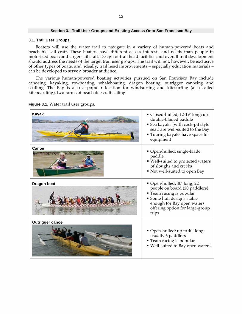
Section 3. Trail User Groups and Existing Access Onto San Francisco Bay
3.1. Trail User Groups.
Boaters will use the water trail to navigate in a variety of human-powered boats and beachable sail craft. These boaters have different access interests and needs than people in motorized boats and larger sail craft. Design of trail head facilities and overall trail development should address the needs of the target trail user groups. The trail will not, however, be exclusive of other types of boats, and, ideally, trail head improvements – especially education materials – can be developed to serve a broader audience.
The various human-powered boating activities pursued on San Francisco Bay include canoeing, kayaking, rowboating, whaleboating, dragon boating, outrigger canoeing and sculling. The Bay is also a popular location for windsurfing and kitesurfing (also called kiteboarding), two forms of beachable craft sailing.
Figure 3.1. Water trail user groups.
Kayak
Closed-hulled; 12-19’ long; use double-bladed paddle
Sea kayaks (with cock-pit style seat) are well-suited to the Bay
Touring kayaks have space for equipment
Canoe
Open-hulled; single-blade paddle
Well-suited to protected waters of sloughs and creeks
Not well-suited to open Bay
Dragon boat
Open-hulled; 40’ long; 22 people on board (20 paddlers)
Team racing is popular Some hull designs stable enough for Bay open waters, offering option for large-group trips
Outrigger canoe
Open-hulled; up to 40’ long; usually 6 paddlers
Team racing is popular Well-suited to Bay open waters

13
Figure 3.1. cont. Water trail user groups.
Sculling
Very narrow and long; 2, 4 or 8 rowers; long rowing oars
Team racing is popular Usually done in calm waters
Whaleboat
Wide, heavy rowboats; usually teams of 10 people (8 rowers)
Team racing is popular Well-suited to touring; very stable and space for equipment
Rowboat / Dinghy
Wide, heavy boat; usually rowed by one person
Well-suited to touring; very stable and space for equipment
Sailboards: Windsurfer & Kitesurfer
Bay conditions are well-suited to boardsailing activities
Windsurfer 6-10’ long board with mast and single sail
Need strong winds: 15-30 knots
Racing is popular in Bay Area
Kitesurfer Large maneuverable kite attached via a harness; separate board straps to feet
Need 10-25 knot winds

14
3.2. Existing Access Onto the Bay.
The planning area for the water trail project – the “Bay” – is established in the Bay Area Water Trail Act (see Appendix A) as the area within BCDC’s jurisdiction (see Cal Govt Code Section 66610). This includes San Francisco, San Pablo and Suisun Bays, connected sloughs and tributaries subject to tidal influence.
Existing access onto the Bay (as defined by this planning area) for human-powered boats and beachable sail craft consists of more than 135 launch and landing sites in waterfront parks, marinas and harbors, sites with public launch ramps or floats, public access areas, wildlife refuges and privately owned sites (Figure 3.2.). The sites vary in terms of level of development and management that supports these types of boating activities. Geographically, the launches are clustered primarily around the central Bay, from southern Marin and Contra Costa Counties south to Redwood City and San Leandro. Most of these sites are in, or near, urban areas, and this portion of the Bay is heavily used for commercial shipping, ferry transportation and all types of recreational boating. Comparatively, the South Bay, San Pablo Bay and Suisun Marsh have fewer access points. Partly, this reflects the management priorities and limitations of the major landowners in these regions (U.S. Fish and Wildlife Service (FWS) and California Department of Fish and Game (DFG)) to protect and preserve wildlife and habitat, and their limited funding for recreation. However, access is also physically limited because the Bay is very shallow in these areas, and trips require careful coordination with the tides to avoid becoming stranded in mudflats at low tides.
Figure 3.2. Existing access onto San Francisco Bay for human-powered boats and beachable sail craft.
CATEGORY PERCENT
Waterfront park 50
Marina/harbor 17
Public boat launch ramp/float
13
Public access area 12
Wildlife refuge/ reserve
1
Privately owned (business)
7

15
Many launch sites are located within parks owned or managed by cities, counties, regional park districts, California Department of Parks and Recreation and the National Park Service. These waterfront parks offer access via beaches, floats, stairs or ramps. Some waterfront parks have launch access and additional improvements (e.g., areas for preparing equipment, boat storage, etc.) that are well-suited for human-powered boating and boardsailing. At other park sites, launching hand-carried watercraft is possible, but current access or facility conditions are less supportive of these activities. For example, they might have only a boat ramp best-suited to launching motorized watercraft, and/or lack parking or restrooms.
Many marinas provide publicly accessible floats, ramps or stairs that are regularly used for landing and launching human-powered boats and sailboards. Marina sites are usually highly developed for boating activities with on-site management by a harbormaster. At public boat launch ramps, levels of facility improvements such as provision of floats (in addition to the ramp), parking and restrooms vary considerably. Some launch ramps require a fee to park or launch, but most do not have on-site management staff. Certain public access areas provide physical access to the Bay via launching ramps, floats or beaches. Most of these public access areas do not have additional improvements beyond the access itself, and lack active management or maintenance efforts. Some private businesses – most often shoreline restaurants – offer use of their docks or ramps for a launch fee or free to their clients.
A handful of planned habitat restoration projects will provide access onto the water or stopover spots for small, human-powered boats. Most of these projects are on lands owned or managed by U.S. Fish and Wildlife Service National Wildlife Refuges, or California Department of Fish and Game Ecological Reserves. The primary purpose of wildlife refuges and ecological reserves is the conservation of wildlife and their habitat, but providing opportunities for wildlife compatible recreation activities is an important part of these land managers’ missions.

16
Section 4. Overview of Issues and Principles
4.1. Overview of Water Trail Issues and Needs.
Implementing a water trail on San Francisco Bay requires that trail managers and partners address a range of issues related to non-motorized small boating access, wildlife and habitat, safety and education. These issues are briefly introduced here, followed by principles that provide an overarching framework to guide the formulation of specific strategies that successfully address these issues. The issues are discussed in more depth in Section 5.
Access. Human-powered boats and beachable sail craft are fairly versatile, but some have specific launch design needs that limit their access opportunities. Access onto the Bay is also limited by availability of sufficient, long-term parking at launch sites. Other facilities such as restrooms, staging areas and boat storage are essential or beneficial at many access points. To make multi-point trips possible, trail users need access points that are in close proximity to each other, and multi-day trips will require overnight accommodations at trail heads (e.g., camping, or arrangements with nearby hostels and hotels). Additional access concerns for boaters include safety of a launch, trail head security, user conflicts, and accessibility for persons with disabilities.
Wildlife and Habitat. The prospect of many more of non-motorized small boaters on the Bay using the water trail raises concerns about protecting wildlife and habitat resources. The primary concerns are disturbances of harbor seals, Bay-related birds, and certain special status species due to trail activities. Although laws exist to protect these species, they are difficult to enforce in an open space as large as the Bay. Impacts to sensitive shoreline habitats caused by trampling and hauling out boats are other potential issues. Appropriate location and management of trail heads, and establishment of good trail behavior and boating practices through the water trail education, outreach and stewardship program are essential tools for protecting wildlife and habitat.
Safety. The Bay has cold waters, strong tidal currents and winds, as well as high volumes of vessel traffic that create personal safety and navigational safety and security problems for water trail users. Safe boating on the open Bay requires good boating skills, knowledge of Bay conditions, navigational safety “Rules of the Road” and security exclusion areas, as well as good planning and preparation for each trip. If promoted as a tourist destination, the water trail may attract non-motorized small boaters who lack boating skills and familiarity with its unique conditions. All boaters need good information, proper equipment and, in some cases, an experienced guide. Achieving safe use of the water trail requires better coordination among boating groups and the maritime community, and implementation of a trail education program.
Education. Much of the water trail success will hinge on implementation of a comprehensive education, outreach and stewardship program. Numerous boating clubs, agencies, organizations and businesses offer outreach and education programs and tours that address non-motorized small boating safety, protection of wildlife and habitat, developing appreciation for Bay resources, and other water trail-related themes. Primary tasks for the trail staff are to coordinate among these programs, to develop and promote consistent trail-related messages for all boating education programs in the Bay Area, to fill in educational programming gaps, such as targeting new users and tourists, and to provide a suite of trail-related media (e.g., a guidebook, maps, an interactive website, brochures, etc).
17
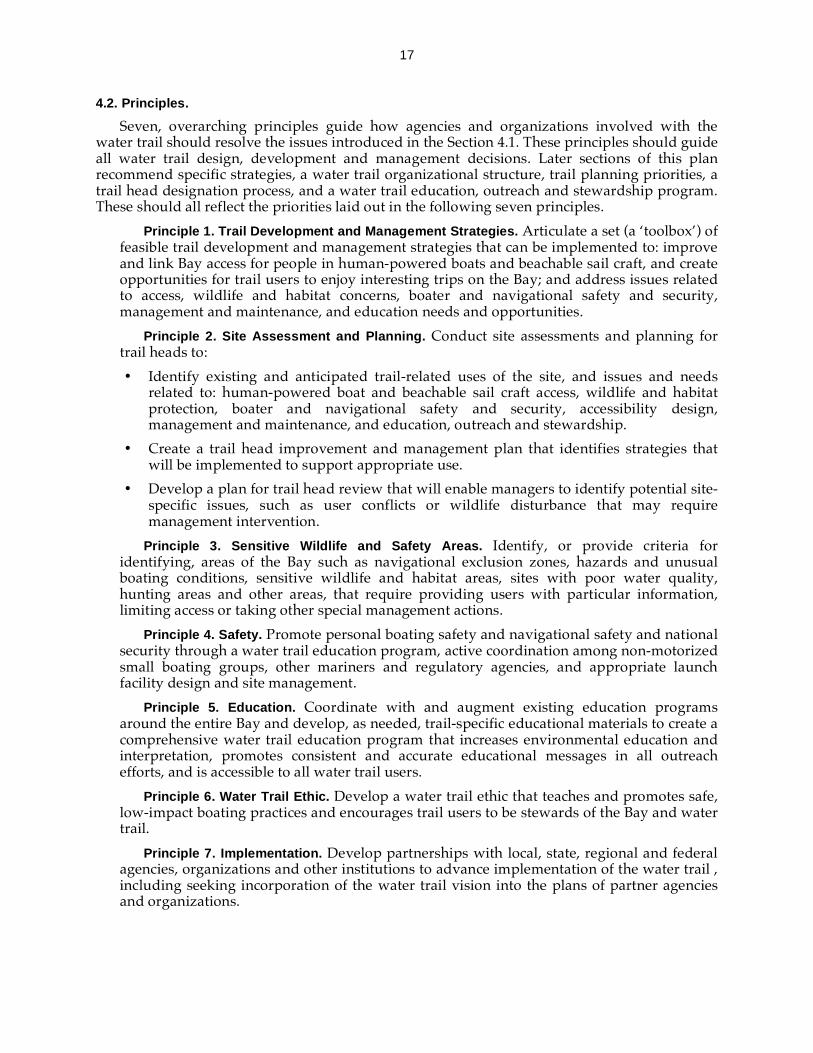
4.2. Principles.
Seven, overarching principles guide how agencies and organizations involved with the water trail should resolve the issues introduced in the Section 4.1. These principles should guide all water trail design, development and management decisions. Later sections of this plan recommend specific strategies, a water trail organizational structure, trail planning priorities, a trail head designation process, and a water trail education, outreach and stewardship program. These should all reflect the priorities laid out in the following seven principles.
Principle 1. Trail Development and Management Strategies. Articulate a set (a ‘toolbox’) of feasible trail development and management strategies that can be implemented to: improve and link Bay access for people in human-powered boats and beachable sail craft, and create opportunities for trail users to enjoy interesting trips on the Bay; and address issues related to access, wildlife and habitat concerns, boater and navigational safety and security, management and maintenance, and education needs and opportunities.
Principle 2. Site Assessment and Planning. Conduct site assessments and planning for trail heads to:
• Identify existing and anticipated trail-related uses of the site, and issues and needs related to: human-powered boat and beachable sail craft access, wildlife and habitat protection, boater and navigational safety and security, accessibility design, management and maintenance, and education, outreach and stewardship.
• Create a trail head improvement and management plan that identifies strategies that will be implemented to support appropriate use.
• Develop a plan for trail head review that will enable managers to identify potential site-specific issues, such as user conflicts or wildlife disturbance that may require management intervention.
Principle 3. Sensitive Wildlife and Safety Areas. Identify, or provide criteria for identifying, areas of the Bay such as navigational exclusion zones, hazards and unusual boating conditions, sensitive wildlife and habitat areas, sites with poor water quality, hunting areas and other areas, that require providing users with particular information, limiting access or taking other special management actions.
Principle 4. Safety. Promote personal boating safety and navigational safety and national security through a water trail education program, active coordination among non-motorized small boating groups, other mariners and regulatory agencies, and appropriate launch facility design and site management.
Principle 5. Education. Coordinate with and augment existing education programs around the entire Bay and develop, as needed, trail-specific educational materials to create a comprehensive water trail education program that increases environmental education and interpretation, promotes consistent and accurate educational messages in all outreach efforts, and is accessible to all water trail users.
Principle 6. Water Trail Ethic. Develop a water trail ethic that teaches and promotes safe, low-impact boating practices and encourages trail users to be stewards of the Bay and water trail.
Principle 7. Implementation. Develop partnerships with local, state, regional and federal agencies, organizations and other institutions to advance implementation of the water trail , including seeking incorporation of the water trail vision into the plans of partner agencies and organizations.

18
Section 5. Issues and Needs: Background
This section provides further elaboration of the access, wildlife and habitat, safety and education issues and needs introduced in Section 4 of the plan. This discussion aids in understanding when, how and why to use the detailed trail design, development and management strategies – following on water trail Principle 1 – that address specific components of the issues and needs. The strategies are presented in Section 6.
5.1. Human-Powered Boat and Beachable Sail Craft Access
Basic access onto the water consists of a place to launch, whether it is a beach, a dock, a float or other means. Parking is usually another essential component of access for human-powered boating and boardsailing enthusiasts. Access can be enhanced with a variety of improvements and services, such as restrooms, boat drop-off parking zones, equipment storage, boat houses, transient docking, overnight accommodations, such as a hostel or campsite, rigging areas and fresh water for washing gear.
Launches. The Bay has relatively few beaches – less than a dozen miles along the entire 400-plus-mile shoreline – and much of the Bay shoreline is marsh and other natural habitat, or armored with riprap or seawalls. As a result, access to the Bay for on-water recreation often requires constructed elements, such as piers, docks, gangways, floats, ramps or steps. In general, floats that are low in the water provide for easy launching of all craft, and ramps through riprap that are designed to withstand the waves and provide good traction are safer for launching. Some types of boats have specific access requirements that must be met if a site is to be successfully used for their activities. These needs as well as user groups’ launching preferences are described in Table 5.1.
Accommodating a variety of boat types at launches is desirable, but can lead to conflicts among user groups at the launch or nearby on the water. For example, there might be conflicts between non-motorized small boaters and other sport craft like jet skis, or recreational non-motorized small boaters and fishers and hunters. Competition for space on low docks could also occur at launches shared by kayakers, scullers, and other human-powered boaters. Conflicts between non-motorized small boaters and motor and sail-boaters can occur at popular public launch ramps where ramp and dock space are scarce, or in narrow waterways where maneuvering options are limited.
Conditions of the launch and the space leading up to the launch are critical for ensuring safe, universal access. Accidents can occur as boaters carry their equipment to the water over rough terrain (e.g., rip rap) and while launching (e.g., from an algae-covered ramp or steps). Most debilitating injuries to boaters occur onshore due to falling. In the case of boardsailing sports, the equipment itself can be a hazard to people around a launch area if boaters do not have enough room for staging (i.e. preparing their boards, sails and lines) or are not careful to follow site-specific norms for staging, launching and landing.
Accessibility of launch facilities is another important component of trail head design. In 2004, the U.S Access Board published new, updated design guidelines that presents accessibility requirements for persons with disabilities. Known as the ADA-ABA Accessibility Guidelines (ADA-ABA), the new guidelines cover access for people with disabilities under the Americans with Disabilities Act of 1990 (ADA) including requirements for a wide range of facilities in the public and private sectors. The ADA-ABA also includes updated guidelines for Federal facilities covered by the Architectural Barriers Act of 1968 (ABA). The new guidelines include direction as to how to provide barrier-free access for newly designed, constructed, and altered recreation facilities. With regard to outdoor trails, the ADA-ABA does not currently address access to such facilities. However, at the time that this Plan was prepared, the Access Board had released (for public comment) proposed guidelines for Federal outdoor developed areas that would address

19
trails; and the Board planned to develop guidelines for outdoor developed areas controlled by non-Federal entities at a future date. Once approved, these will provide guidance for facility planners. It is important to note that these guidelines which address trails for pedestrian use, do not provide guidance for water trail-related boating facilities (e.g. small boat launch design).
Table 5.1. Launch needs and preferences of different trail user groups.
In the interim period before the guidelines for Federal outdoor developed areas are adopted, planners can find design guidance in documents developed by the U.S. Forest Service and the Access Board in recent years. On Federal land, access must conform to the “Forest Service Outdoor Recreation Accessibility Guidelines,” and the “Forest Service Trail Accessibility Guidelines,” both published in 2006. On non-federal property, outdoor trail accessibility guidance is provided in the “Regulatory Negotiation Committee on Accessibility Guidelines for
USER GROUP NEEDS AND PREFERENCES
Kayakers
Prefer to launch from a sand or pebble beach or low-profile (freeboard) float, but a wide range of ramps, floats, docks and shoreline terrains are usable
Space on or near launch to prepare equipment
Dragon Boaters
Beach, float or dock space sufficient to moor a 40-foot boat and accommodate 22 people
Launches adjacent to training areas for racing teams Dock or float with adjacent dock tie space for storage
Boardsailors (Windsurfers and Kitesurfers)
Beach launching is preferable, but ramps through riprap or launch floats are suitable
Strong winds (10-30 knots) blowing from a certain direction with respect to the shoreline
Staging areas for de/rigging equipment
Whale Boaters Launches adjacent to training areas for racing teams Dock or float with adjacent dock tie space for storage
Scullers
Sites protected from winds with calm waters Low-profile (freeboard) float or dock for launching Launches adjacent to training areas for racing teams On-site boat storage
Outrigger Canoeists Beach space sufficient to launch a 40-foot boat Launches adjacent to training areas for racing teams On-site boat storage
Boaters with Disabilities Accessible launch facilities including, accessible
parking, access route, and trails to launch structures, restrooms, picnic and camping facilities
20
Outdoor Developed Areas” published by the Access Board in 1999. In absence of specific guidelines for boating trails, facility planners can look to “Logical Lasting Launches,” published by National Park Service in 2004. This document provides specific design guidance for canoe and kayak launching sites, including information on accessible routes, level and stable landing/launching areas, transfer assistance and surface textures that provide good traction.
Part of the water trail vision is to link access points around the Bay. Kayakers are the most likely water trail users to embark on multi-site and multi-day trips on the Bay. They travel about two to four miles per hour depending on boater skill level, currents and winds. This generally limits their range to four to six miles without a break. A lack of intermediate landing sites could cause safety risks for boaters, and lead to emergency landings in areas where access is not suitable. Therefore, provision of access at reasonable intervals is important to achieving the water trail vision.
All launch sites require some active management to maintain and operate the launch access and related facilities. Without sufficient funding and staff resources devoted to up-keep, launch sites tend to degrade, becoming unusable or unsafe, and managers are often forced to remove or close access (e.g., Paradise Beach County Park in Tiburon). Insufficient management resources for enforcement at launch sites can also leave site managers with little choice but to remove or restrict launching access. For example, vandalism or inability to prevent access to sensitive wildlife areas can force managers to restrict access to avoid further problems.
Parking. Access to adequate parking is essential for water trail users. Human powered boats and sailboards are large and heavy and difficult to carry alone or for long distances. The equipment also consists of many parts. Although parking needs vary for the different on-water recreation pursuits, participants generally prefer parking near the shoreline to reduce the distance that equipment must be carried to the launch and to allow for frequent access to one’s vehicle. At some sites, parking for trailers is needed if boats are not stored on site. For example, several kayaks, or windsurfers may be brought to a launch for a class, a trip or other outing. Similarly, a dragon boat or outrigger canoe may be brought to a site on a trailer.
Parking time limits are a barrier to access at many existing Bay Area launch sites. Most human-powered boaters and boardsailors need at least a few hours for a trip. For example, windsurfing and kite sailing often require a minimum of three hours for rigging, sailing and de-rigging, so parking with a two-hour time limit is not workable. To facilitate multi-day trips, over-night parking is necessary, but many parks and public access areas have prohibitions against overnight parking. This severely limits the locations where one can launch a multi-day trip.
Restrooms. Construction and maintenance of restrooms at launch sites can be expensive. Regardless, provision of restrooms (flush or portable) will be necessary for most trail heads to prevent human waste exposures for visitors, and to protect Bay habitats and water quality.
On-Site Equipment Storage. Storage for non-motorized small boats and equipment at a launch site is essential for certain types of human-powered boats and boating groups. Outrigger canoeing, sculling, whaleboating and dragon boating are popular team racing sports, and, generally, they require on-site storage space at locations where teams train. Additionally, on-site storage increases overall access for human-powered boaters and boardsailors because they no longer need to own a boat or the means to transport it to the launch site. Boaters can share ownership and usage of equipment through cooperative arrangements and boating clubs. This could decrease economic barriers to participation and facilitate trail usage among urban residents who lack space for storing equipment in their homes. A variety of storage facilities can serve human-powered boaters and boardsailors: boat houses for all boat types, including sculling shells; fenced outdoor areas for outrigger canoes; modified shipping containers for kayaks and sailboards; and provision of inside dock ties at marinas for in-water storage of

21
dragon boats, whale boats and kayaks. The feasibility of storage facilities is limited by availability of trail head space and funds for development, management, maintenance and equipment insurance. Furthermore, storage structures, if not properly designed, might disrupt visual access to the Bay, or detract from the character of a trail head setting.
Equipment Concessions. On-site equipment rental concessions can facilitate participation in on-water recreation, especially for beginners and visitors. Concessions can reduce the need to access the site by car, can provide classes for learning the activity and can rent boat storage. Concessions can also be disruptive in parks, because recreation space might be converted to concessionaire storage, display, equipment handling and teaching.
Overnight Accommodations. For human-powered boaters in the urban Bay Area, opportunities for camping are limited to two locations, Kirby Cove (GGNRA) and Angel Island (CA State Parks). East Bay Regional Park District and a few county park departments are planning to create campsites, and development of the trail will lead to new opportunities. Certain waterfront parks can accommodate additional camping, provided that the funding is available for managing the activity; it will not have significant impacts on wildlife; and will be compatible with other recreation activities. Based on the experiences of other water trails, and parks which have campground hosts, volunteer stewards to help maintain campsites can be an effective complement to site owners’ management efforts.
Other opportunities for improving overnight accommodation include hostels, hotels, motels, houseboats, bed and breakfast accommodations, and selected historic structures (e.g., historic ships). Some waterfront parks currently have hostels while others have plans to construct them. If indoor overnight accommodations such as hostels or small hotels that are clearly incidental and do not conflict with the primary recreational uses of a park, they can help meet the trail demand for multi-day, overnight trips.
Other Site Improvements. Additional improvements and services such as guest docking, rigging areas, fresh water for washing gear and trail head signage can facilitate non-motorized small boating activities. Launch sites with improvements that match the level of use expected at the site will accommodate visitor needs, reduce conflicts, and reduce the impacts of boating and other on-water recreation on the site. The appropriate degree of improvement is best determined by the projected use of the site for on-water recreation, the type and intensity of other uses of the site and the site managers’ priorities.
5.2. Wildlife and Habitat
Recreation in non-motorized small boats offers opportunities to enjoy the natural, scenic and historic resources of the Bay in a manner that is generally compatible with sustaining these resources. Despite being relatively low-impact recreational activities, human-powered boating and boardsailing can have adverse impacts on Bay wildlife and habitat. Research has shown that the issues discussed in this section are potential negative impacts of non-motorized small boating on wildlife and habitat and that they can be significant. Implementation of the water trail will avoid or minimize impacts to a less than significant level.
Harbor seals. Disturbance of harbor seals at haul out sites – locations where the seals rest and breed on shore – causes behavioral responses, such as increased alertness or vigilance (head alerts), seals moving from their resting spots towards the water and seals flushing into the water (Suryan and Harvey, 1998). These responses can lead to changes in behavior at a site by altering haul-out times or causing abandonment of haul-out areas, interruption of nursing, increased stress during molting and other seasons, and poorer fitness and health (Calambokidis et al. 1991). San Francisco Bay has a population of harbor seals that consistently haul out at

22
about a dozen locations, and protection of seals at these haul outs is essential to maintaining the population.
In studies of disturbances at haul outs, disturbances due to kayaks and canoes are comparable or more severe than those observed for powered vessels (Suryan and Harvey, 1998; Calambokidis et al. 1991; Allen et al. 2006; Allen et al. 1984; Borhorquez, 2000). Paddle boaters tend to travel closer to shore and in groups, which can increase disturbances. Furthermore, they can approach very quietly and get quite close to a haul out before detection, possibly eliciting a “higher startle response” in seals (Borhorquez, 2000). Studies of impacts suggest that watercraft are less likely to disturb harbor seals if they (1) do not get too close to a haul out site, (2) make a parallel (as opposed to a head-on) approach to seals, (3) travel at a constant, slow speed and (4) avoid erratic behavior and noises. Suitable approach distances are context dependent. For example, seals are more sensitive to disturbance during molting and breeding seasons (Allen et al. 2006).
Birds. Disturbance of Bay-related birds (birds) due to water trail activities are another concern. Flushing (taking flight away from the area of disturbance) or diving responses to disturbance can cause abandonment of and increased predation on nests, decreased foraging time, and avoidance or abandonment of suitable habitat areas. Furthermore, flushing causes higher energy expenditures which can reduce birds’ fitness for migration (Belanger and Bedard, 1990). The degree of sensitivity and impacts varies depending on species and conditions such as proximity and directness of approach, frequency of disturbance, time of year, habituation, location, speed of movement, and type of recreational activity. In general, the faster and louder the approach, the sooner birds will flush; and larger waterbirds flush sooner (Trulio, 2005).
San Francisco Bay plays an essential role in supporting Pacific Flyway migratory bird populations, such as diving ducks and shorebirds (Hickey et al. 2003). These migratory waterfowl and shorebirds utilize large areas of the open Bay and shoreline for roosting, foraging and nesting. More frequent disturbances of roosting and foraging birds due to trail activities might prevent them from feeding and resting sufficiently (reducing fitness and survival), or cause birds to abandon or under-utilize important habitat areas. Bird populations are susceptible to adverse impacts during breeding season because disturbance can cause nest failures. Special efforts to prevent trail-related disturbances in nesting areas during breeding season – particularly in locations that do not currently experience paddleboating or boardsailing activities – and in some areas used by roosting and foraging birds may be critical for preventing significant adverse population effects on certain species.
Special Status Species. The Bay is home to a variety of wildlife species listed under the Federal and California Endangered Species Acts. A subset of these may be directly or indirectly affected by water trail-related activities. For the California clapper rail, black rail, the Western snowy plover and the California least tern, disturbance may lead to nest abandonment and breeding failures, or disruption of foraging and resting. These bird species as well as the salt marsh harvest mouse and grunion (a federally listed fish species) could be indirectly susceptible to water trail-related activities if they result in destruction or impairment of important shoreline habitats.
Some Bay species are designated by the California Department of Fish and Game as "Species of Special Concern". These are not listed under the federal or California Endangered Species Acts, but they “1) are declining at a rate that could result in listing, or 2) historically occurred in low numbers and known threats to their persistence currently exist” (California Department of Fish and Game, 2003). Similarly, FWS identifies Migratory Nongame Birds of Management Concern that have declining or historically small populations, or depend on limited or vulnerable habitats; and Birds of Conservation Concern that, without additional conservation actions, are likely to become candidates for federal Endangered Species Act listing (U.S. Fish
23
and Wildlife Service [FWS], 1995; FWS, 2002). Some of these species of special, management or conservation concern, such as the double-crested cormorant, black skimmer or whimbrel, may be susceptible to adverse impacts from trail activities for similar reasons as those identified for listed species.
Habitat. A potential impact to habitat due to the water trail is trampling of vegetation if trail users disembark in habitat areas while enroute, and conversion of habitat to launch-related facilities (such as a ramp or parking) at a trail head. Since the land-side portion of the trail consists only of the water trail launch sites, trampling effects are likely to be limited to occasions when access to the water is not well-defined (and informal access paths are created) or if boaters land at vegetated sites that are not intended as access points or stopovers.
Wildlife and Habitat Protection Needs. The primary wildlife and habitat protection needs for the trail are education, outreach and stewardship, and good location and management of trail heads. Laws such as the Marine Mammal Protection Act, the Migratory Bird Treaty Act, and the Endangered Species Acts extend some protections to Bay species from disturbance, but these are difficult to enforce on an open space as large as San Francisco Bay. Trail efforts need to be focused on filling gaps in education programs and promoting adequate site management. For example, Bay-focused educational programs and signage at boat launches rarely address wildlife and habitat issues that are relevant to human-powered boating and boardsailing activities. Some kayak boating clubs and tour operators provide information to members and clients about proper boating practices around wildlife, but these efforts need to be expanded and more consistent with the implementation of the water trail. Trail managers need strategies for locating and selecting trail heads and managing these sites to minimize and avoid impacts to wildlife and habitat. Possible strategies include having site stewards at trail heads to talk with boaters, and seasonal closures with signage informing boaters of closed areas. Managers also need to stay informed about wildlife monitoring information for the Bay to identify sensitive wildlife areas and inform boaters about these areas– the third water trail principle.
5.3. Personal and Navigational Safety and National Security
Water trail safety issues fall under two general categories. Personal safety issues encompass factors such as natural boating conditions on the Bay (e.g., wind and currents) and individuals’ boating skills. The second category includes navigational safety – interactions among vessels – and national security.
Personal Safety. Cold waters, rapidly changing weather conditions and strong tidal currents create a challenging boating environment on the Bay. For avid paddlers and boardsailors, the challenging conditions may be an attraction of the Bay Area. Visitors to the area and less experienced local boaters might not be prepared for factors such as strong afternoon gusts, thick fog, currents up to 6 knots and water temperatures between 45° - 60° F. Even a skilled boater who is familiar with Bay conditions can get into trouble. If a paddling trip is poorly planned, kayakers can get caught fighting strong currents or stuck during low tide in mudflats far from a launch site. Windsurfers are vulnerable to changes in winds that can strand them far from shore, and conditions at some sites such as Crissy Field – where windsurfers can get washed out under the Golden Gate Bridge – do not offer much margin for error.
Inevitably there will be incidents in which trail users run into problems, but they can reduce the likelihood of emergencies by:
• Learning boating skills (e.g. self-rescue technique) and being in good physical condition; • Using the proper equipment such as a personal flotation device (PFD) and a wetsuit;

24
• Planning trips based on favorable tide, current and weather predictions, and local knowledge about unique conditions in an area, including navigational concerns such as shipping or ferry lanes and security exclusion zones;
• Planning trips that are suited to one’s capabilities; • Boating with others and informing someone onshore about their plans; and • Knowing how to recognize emergencies and what to do in these situations, and having
the proper, functioning emergency equipment (e.g., VHF radio and signaling devices).
Personal security is a concern that human-powered boaters and boardsailors have raised about the water trail. This is an important consideration for sites that provide overnight or extended stay accommodations. Trail users will not want to store their equipment (e.g., at a guest dock) where it is likely to be stolen or vandalized, nor will they feel secure camping at many locations around the Bay.
Paddleboat and boardsailing activities involve extensive contact with the water and these boaters are vulnerable to sicknesses caused by poor water quality. Urban runoff that enters the Bay through stormdrains – particularly after rainstorms – and occasional overflows at wastewater treatment plants are major causes of water pollution affecting these user groups. Trail users need to be alerted to water quality problems and avoid boating at specific sites or during certain time periods.
Navigational Safety and Security. With the high volume and diversity of vessel traffic on the Bay – motorized and non-motorized recreational boats, fast ferries, commercial shipping vessels, tugs, chemical and petroleum tankers and others – vessel-to-vessel interactions for trail users are inevitable. Although accidents involving human-powered boats and boardsailors and other vessels are rare, incidents such as a near miss between kayakers and a fast ferry raise concerns about future safety on the Bay if numbers of paddleboaters and boardsailors expand due to the water trail.
The U.S. Coast Guard regulates navigation in San Francisco Bay by issuing and enforcing regulations that govern navigation practices, marine events, and safety and security zones within the Bay. The Inland Navigation Rules (commonly called the “Rules of the Road”) apply to all watercraft and address vessel sailing and steering as well as use of lights and sound. Knowing the Rules is important for all mariners – including people navigating in human-powered boats and beachable sail craft which are often the smallest vessels on the Bay, and most difficult for other mariners to see and avoid.
Within the Bay, larger, deep-draft vessels can only navigate safely within dredged shipping lanes (noted on nautical charts), and the Rules oblige other vessels (including non-motorized small boats) not to “impede the passage” of these deep-draft vessels traveling in the lanes. For interactions between other vessel types that are common on the Bay (e.g., sailboats or small motorboats and kayaks), the Rules are less explicit. The Rules require a boater to try to avoid a collision even if s/he has the right of way, but without explicit, broadly accepted navigational protocols or norms for vessel interactions, the expected increases in fast ferry traffic, large sailing vessels and water trail users on the Bay may lead to more accidents. Some maritime user groups, such as fast ferry operators, are developing standard practices (e.g., consistent travel routes) to minimize accidents in general. The San Francisco Bay Harbor Safety Committee coordinates these and other efforts to improve navigational safety. Trail representatives should be involved in establishing standard practices and developing outreach materials to ensure that adopted standards and information are consistent with protecting and improving safety for human-powered boaters and boardsailors.
Another safety issue is that paddleboaters and boardsailors are not well-connected with some sources of maritime safety and security information. For example, the number of human-powered boaters and boardsailors on the Bay carrying VHF radios is increasing, but most do
25
not take advantage of the Vessel Traffic Service information system operated by the Coast Guard. Additionally, the Coast Guard posts a “Local Notice to Mariners” at its Navigation Center website to inform the public about marine events and special restrictions associated with events, but this information is not reaching the paddleboating and boardsailing communities.
Safety Needs. There are numerous boating clubs, rental shops and agencies that provide outreach, education and skills training on personal and navigational safety. Trail-related safety efforts should be coordinated with, and expand upon these existing programs to achieve consistent safety education messages that comprehensively address concerns for all trail users. This will involve overcoming a few issues and gaps.
Site-Specific Information. Many personal and navigational safety concerns are site-specific. To safely launch and paddle or sail in some areas, local knowledge about site-specific conditions is essential. This information – including some suggestion as to the level of expertise needed in order to enjoy boating at a specific site – needs to be made available to all types of trail users through water trail resources. These resources should also address safety preparedness for people planning multi-day trips on the Bay.
Coordination. Communication and coordination are poor among non-motorized small boating groups, other maritime user groups and maritime agencies. Historical conflicts between non-motorized small boating groups and maritime agencies, and differences in organizational cultures of these groups currently inhibit good communication and coordination. Trail managers need to improve relationships and actively engage other maritime groups to ensure that (1) trail safety information is current, accurate and consistent with other organizations’ messages, and (2) trail users’ needs and interests are represented in discussions and decisions about Bay Area navigational safety and national security.
New Boaters and Tourists. Safety outreach and education efforts may not be reaching many new non-motorized small boat owners. Their safety training is often ad hoc or limited to basic skills training. Education efforts may also be inadequate for visiting boaters using the water trail who are unlikely to be affiliated with Bay Area boating clubs. If the water trail is successful in attracting tourists, the main point of contact for these users will be through rental outfitters and tour operators. For tours, the presence of experienced guides can help minimize safety problems. Reaching visitors who want to independently rent a boat and use the trail will require coordination with rental outfitters to ensure that these trail users are receiving trail-related information about safety on the water (e.g., Rules of the Road, nearby boating hazards and no-boating zones, etc.) and suggested sites to see nearby that are appropriate to a boater’s skill level.
5.4. Education, Outreach and Stewardship
A water trail education program is essential to protecting the safety of water trail users and others on the Bay; informing and teaching trail users about site-specific conditions and how to boat in a manner that is consistent with protecting wildlife and habitat; fostering stewardship of the trail and of Bay resources; and enhancing the experience of paddling of the Bay to attract people to get out onto the trail.
Education and Outreach Issues and Needs. Dozens of Bay Area education programs focus on natural, historic and cultural resources, but few are staged on the Bay. Of these Bay-focused programs, only a handful integrate this educational focus with non-motorized small boating activities. A couple of education programs focus entirely on helping participants learn about and gain appreciation for the Bay resources. Other programs are offered by boating outfitters and clubs and the educational emphasis varies. Depending on the design of a tour and how it is led, trips can address all or some of the educational needs for the water trail – promoting safety,

26
protecting wildlife and habitat, encouraging stewardship or enhancing the boaters’ experiences on the water.
The skills-building and safety classes offered by outfitters, boating clubs and other organizations address some safety education needs, but they may only tangentially cover paddling etiquette or practices to prevent or minimize negative impacts to wildlife or habitat. The content of any program depends heavily on the knowledge, and in some cases bias, of the instructor and the circumstances of the class. Other education about safety, wildlife and habitat, stewardship and Bay attractions occurs off-the-water in boating club meetings and special events.
To fulfill the education needs that the water trail creates, significant gaps in the existing education efforts have to be addressed. The Bay Area lacks sufficient integrative programs that combine human-powered boating activities with education and interpretation as a means of building appreciation of Bay resources and motivating participants to protect these resources. One approach to expanding the number of these integrative programs might be to establish additional partnerships between outfitters and organizations and agencies that already do environmental education. Additionally, information about preventing and minimizing disturbances to wildlife and their habitat needs to be consistently, effectively and accurately presented in all trail education settings. Current education efforts often do not address this issue directly, leaving too much to chance; non-motorized small boat users may or may not take away a clear understanding of proper boating behaviors from the educational experience.
Visitors to the Cascadia Water Trail north of Seattle, Washington will notice that, on and off the trail, they get consistent messages about safety and environmental protection and conservation. The information is the same whether a visitor reads it on a water trail campsite sign, hears it from a tour guide or reads it on brochure available on the ferry ride over. The Bay Area Water Trail needs a similar coordinated, multi-media effort to provide consistent and accurate information to trail users.
To be effective, a water trail education program requires sufficient signage at launch sites and decision points that describes site-specific conditions (e.g., safety hazards and sensitive habitat areas) and recommends or requires boating practices for these conditions. Studies on visitor education in natural areas suggest that information intended to change visitor behavior is most effective when presented at decision points. Most key decision points for paddleboaters and boardsailors occur on the water. While it is infeasible to install on-the-water signs in most areas of the Bay, indicator buoys may be a viable alternative for the water trail in some locations. Additional signage is also needed at launch sites to interpret natural, historic and cultural features from an on-the-water perspective. This is an important component in building appreciation for and motivation to protect resources, as well as enhancing the experience of being out on the water and attracting people to the trail.
These last two gaps – outreach signage to promote proper boating practices, and interpretive signage – reflect broader gaps in non-motorized small boating-related educational media. In particular, these boaters do not have site-specific information available in maps, a guidebook, websites or on-site signage. These are critical components of other water trails that enable users to plan and enjoy interesting trips, boat safely and enjoy and protect the natural, historic and cultural resources on the trail.
Stewardship. Fostering stewardship of the Bay’s natural resources was identified in the Bay Area Water Trail Act as an objective for trail. This is consistent with other water trail programs (e.g., Washington Water Trail Association and the Maine Island Trail Association) that motivate boaters to participate in responsible management and protection of resources. They do this through education and outreach programs that have both passive and active elements. Passive components are signage and educational and outreach media such as a guidebook, websites

27
and newspaper articles that promote boating practices that are consistent with protecting wildlife and habitat.
Water trails also foster stewardship through active boater-to-boater education. This type of education is often formalized by providing docents on the water or at launch sites, and by organizing or sponsoring special events, classes or tours. Boater-to-boater education also occurs through informal communication at launch sites where paddleboaters and boardsailors share safety tips and information about boating rules, hazards and practices such as boating etiquette and giving a wide berth to marine mammals and birds.
Additionally, some water trails implement stewardship programs in which volunteers help maintain trail heads (e.g., by participating in site clean-ups) and improve trail facilities (e.g., by improving a path to a launch or planting vegetation). This type of volunteer-based site stewardship (e.g., ‘adopt-a-site’), is especially beneficial at smaller, less developed launch sites, such as in public access areas, where it helps build a constituency of trail users that cares about and has a sense of responsibility for the condition of the trail head. In many cases, a constituency that cares about (and for) a launch site may already exist (e.g., a boating club that launches regularly from a specific site). Rather than implement a de novo stewardship effort for these sites, the water trail project can partner with these individuals or organizations to support and promote their ongoing stewardship efforts.
Stewardship of the Bay’s natural resources can also involve active participation in habitat clean-ups or restoration events. This type of stewardship effort will probably not be an organized component of the water trail organization’s education, outreach and stewardship program, but it is worth recognizing here because opportunities may arise for the water trail to sponsor and/or recruit trail users (i.e. volunteers) to participate in active trail and habitat stewardship programs led by other organizations.
Bibliography.
Allen, S.G., D.G. Ainley, G.W. Page and C.A. Ribic. 1984. The effect of disturbance on harbor seal haul out pattern
at Bolinas Lagoon, CA. U.S. Fish. Bull. 82:493-500.
Allen, S.A., H. Markowitz, D. Green, E. Grigg. 2006. Monitoring the Potential Impact of the Seismic Retrofit
Construction Activities at the Richmond San Rafael Bridge on Harbor Seals: May 1, 1998 – Sep. 15, 2005.
Richmond Bridge Harbor Seal Survey
Belanger, L., and J. Bedard. Jan, 1990. Energetic Cost of Man-Induced Disturbance to Staging Snow Geese. The
Journal of Wildlife Management. Vol. 54, No. 1, pp. 36-41
Borhorquez, A.S., et al. 2000. Differential response of pacific harbor seals towards kayaks compared to other
watercraft. Animal Behavior Soc. Conf., GA, August 5-10, 2000. (Abstract).
Calambokidis, J., G.H. Steiger, J.R. Evans and S.J. Jeffries. 1991. Censuses and disturbance of harbor seals at
Woodard Bay and recommendations for protection. Final report to WA DNR, Olympia WA. 45p.
California Department of Fish and Game, Habitat Conservation Planning Branch. August 5, 2003. “California’s
Plants and Animals: Species of Special Concern.” Retrieved April 27, 2006 from:
http://www.dfg.ca.gov/hcpb/species/ssc/ssc.shtml.
Hickey, C., G.W. Page, W.D. Shuford and S. Warnock. 2003. Southern Pacific Shorebird Plan: A Strategy for
Supporting California’s Central Valley and Coastal Shorebird Populations. PRBO Conservation Science, Wetlands
Division, Stinson Beach, CA, p.25.

28
Trulio, L. 2005. Science Synthesis for Issue 9: Understanding the Effects of Public Access and Recreation on
Wildlife and their Habitats in the Restoration Project Area. South Bay Salt Ponds Restoration Project.
Suryan, R.M. and J.T. Harvey. 1998. Variability in reactions of Pacific harbor seals Phoca vitulina richardsi, to
disturbance. U.S. Fish. Bull. 97:332-339.
U.S. Fish and Wildlife Service. 1995. “Nongame Birds of Management Concern – The 1995 List.” Retrieved July,
2007 from: http://www.fws.gov/migratorybirds/reports/speccon/tblconts.html.
U.S. Fish and Wildlife Service. 2002. Birds of conservation concern 2002. Division of Migratory Bird Management,
Arlington, Virginia. 99 pp. Retrieved July, 2007 from: http://www.fws.gov/migratorybirds/reports/BCC2002.pdf.

29
Section 6. Development and Management Strategies
Water trail Principle 1 recommends that a ‘toolbox’ of strategies be developed to address trail-related access, wildlife and habitat, safety and education issues and needs.
The strategies are guidance – recommendations – for a diverse audience that includes water trail staff and trail head managers, local, regional, state and federal agencies, non-governmental organizations and the public. Organizations responsible for trail implementation (see Section 7) will use the recommendations to guide funding and trail head designation decisions, and resource managers and regulatory agencies will look to them for direction on access-related policies. Other organizations and members of the public will use the strategies as a basis for advocating for development and improvement of trail heads.
Three important considerations apply to these strategies:
1. Not all strategies apply to all trail heads.
As the description of existing access onto the Bay (Section 3) illustrates, there will be a diversity of trail head types. Some access points such as the Berkeley Marina have highly developed launches and facilities and services (e.g., equipment storage and rental concessions) for human-powered boating and sailboarding. At the other end of the spectrum are more primitive sites with only a launching area, such as Turney Street Public Boat Ramp (Sausalito) and India Basin (San Francisco). Maintaining this diversity of access is important for serving trail users who will expect a range of opportunities and experiences, and for protecting site character and resources.
Access sites also vary in terms of management resources and goals and policies. Again, the recommendations in this Plan need to be used in ways that accommodate these differences to encourage and enable launch site managers to participate in the trail. Lastly, trail-related safety and resource issues, and education and outreach opportunities are also site-specific.
The suite of trail head development and management strategies described in this section should be comprehensive enough to facilitate diverse access opportunities and experiences, accommodate needs and constraints of site managers, and provide solutions for the broad range of water trail conditions and issues.
2. While many strategies may provide useful guidance in general for human-powered boating and beachable sail craft access, these strategies apply within the scope of the trail and trail heads. For example, a strategy to link trail heads (Strategy 2) or to provide equipment concessions (Strategy 10) should not be read as a recommendation beyond the context of the trail.
3. These strategies are recommendations. They do not modify existing land and resource management laws and regulations. Trail managers and partners will apply the strategies within existing regulatory frameworks to help them develop and manage access that is consistent with these laws and regulations as well as trail objectives.

30
Table 6.1. Recommended water trail development and management strategies.
STRATEGY PURPOSE AND APPLICATION
1. Trail Head Location Seek opportunities to
increase use capacity at existing launches, or create new access for human-powered boats and beachable sail craft.
Prioritize these efforts at sites that are close to desirable non-motorized small boating conditions and trip destinations, and in areas where trail-related adverse impacts to wildlife and habitat or navigational safety are unlikely.
In all cases, new and expanded access should be sited to avoid or minimize significant adverse impacts to wildlife and habitat.
This strategy supports the primary goal of the Bay Area Water Trail; to improve opportunities for people in human-powered boats and beachable sail craft to enjoy point-to-point trips on the Bay.
The recommended priorities for trail head location:
increase opportunities for boaters to enjoy the trail
reduce trail impacts near trail heads
reduce the number of users visiting sensitive wildlife areas because reaching these areas is more difficult
Examples of how this strategy applies include:
locate new trail heads or increase capacity at existing sites in areas that are good for training new boaters
locate new trail heads away from sensitive wildlife and habitat areas, and avoid increasing capacity at existing sites in these areas unless the site can be adequately managed to avoid impaccts
create new or increased access at sites that can draw trail users away from identified sensitive wildlife and safety areas
2. Linking Access Points
Seek opportunities to link trail heads to each other and with access to other regional trails (e.g. the Bay Trail) and create linkages that serve different trail users’ needs and interests (e.g. different skill levels, viewing nature, learning about cultural or historic features of the Bay Area, etc.).
This strategy facilitates point-to-point trips and varied and interesting access experiences. Furthermore, it promote safe boating conditions by providing sites for boaters to take breaks and seek assistance if needed.
To create a usable linkage between sites for most human-powered boaters, trail heads should be ~3 miles apart. Strong boaters may be able to travel much greater distances without a break, but under some conditions (e.g. strong currents), 3 miles is too far.
Appropriate distances between sites with overnight accommodations are longer (e.g. ~8 miles) because boaters do not need to make a return trip on the same day. These site-specific considerations should be factored into the analysis of linkage opportunities for a trail head.
Trail managers should also assess whether efforts to develop or incorporate a trail head to create a site-to-site linkage will increase the chances of sites being near sensitive wildlife areas or safety areas. Developing linkage opportunities should not be done at the expense of these other trail priorities.
Natural conditions and shoreline ownership in some areas of the Bay will preclude creating these types of site-to-site linkages.

31
Table 6.1. cont. Recommended water trail development and management strategies.
STRATEGY PURPOSE AND APPLICATION
3. Improvements Consistent With Site Characteristics
Match the type and design of trail-related improvements to the site conditions (e.g. shoreline morphology, habi-tats, predominant wind and wave conditions, other uses of the site, etc.) and likely trail user groups.
Ensure that the level of use that a site accommodates is consistent with providing a high-quality recreational experience, protecting environ-mental resources at the site and in surrounding areas, and preserving the safety of water users.
The diversity of the San Francisco Bay shoreline demands a flexible approach to trail head development. Making improvements consistent with site conditions achieves a variety of objectives:
helps preserve the character of the trail head setting
increases the quality of boaters’ experiences
ensures access is available to a broad spectrum of trail users
avoids uses of the site that are incompatible with safe boating, wildlife, habitat and water quality protection
can avoid user conflicts
Implementation of this strategy should occur during site assessment and planning.
4. Consistency With Policies, Plans and Priorities
Coordinate plans for trail head development, management and use to be consistent with existing policies, plans and priorities of land and resources managers at and around trail heads.
Coordinate trail signage and access design guidelines, and education programs to be consistent with existing policies, plans, standards and programs
This strategy facilitates development of trail heads at a diversity of shoreline areas (e.g. parks, marinas, wildlife refuges and protected areas, private lands, etc.)
Coordination for specific trail heads should be done by launch site managers during site assessment and planning for trail head designation.
Trail staff and/or any water trail partners that take the lead in developing signage and access design guidelines and education should coordinate these efforts to be consistent with existing policies, plans, standards and programs.
5. Design Guidelines
Develop and update, as needed, design guidelines for trail-oriented access
improvements.
To address the needs of all trail users, design guidelines should be developed that facilitate consistently durable, accessible and functional facilities.
These guidelines will also assist local governments and others striving to improve trail access, by providing clear guidance on good facility design for non-motorized small boating uses.
The California Department of Boating and Waterways will develop these guidelines in coordination with water trail staff, other agencies and trail user groups.

32
Table 6.1. cont. Recommended water trail development and management strategies.
STRATEGY PURPOSE AND APPLICATION
6. Management Resources
Match the facility improvements and use to the management resources (including staff and funding) available for long-term maintenance of facilities and signage, and provision of other site-specific management needs such as, enforcement, monitoring, and education and outreach programs.
Good site management prevents most problems, and this strategy helps ensure that the managing organization can successfully operate and maintain the site long-term.
Additionally, this approach avoids establishing uses at a site (e.g. camping) that might overwhelm available management resources and lead to problems.
Trail managers will provide input on this consideration during site assessment and planning, but in almost all cases, launch site owners and managers are best able to assess management resource constraints, and to recommend appropriate improvements and use levels for their sites within these limitations.
7. Maintenance and Operations
Develop a plan for trail head facility maintenance and operation, and identify who will be responsible.
Maintenance of trail heads is important for protecting public safety and satisfaction with trail access opportunities.
Maintenance and operation plans should be developed by launch site managers during site assessment and planning for trail head designation. Ideally, these plans will not create extra work because they are already required of site managers and owners in applications for permits or funding.
8. Parking
Provide parking or drop-off zones as close as possible to launch points (e.g. ramp), and extend parking time limits to a minimum of four hours.
Provide overnight parking where possible.
When appropriate, restrict vehicle parking to limit the number of users to a level that is appropriate for the site consistent with Strategy 6.
Locate parking to protect shoreline visual character.
Sufficient, long-term parking is an essential component of trail access because most boaters must bring their equipment to a launch site. Drop-off spots and parking near to the launch are also desirable because they reduce the distance that boaters need to carry their gear.
It may be feasible and appropriate at some trail heads to restrict parking as a tool to prevent over-use of a site.
For trail head designations involving new facility improvements, launch site managers and trail managers should incorporate trail-related needs into the design of the parking.
9. Restrooms
Provide restroom facilities where feasible and appropriate.
Despite costs and maintenance requirements, providing restrooms at the majority of trail heads is important to:
avoid degradation of water quality
protect visitors and wildlife from exposure to human waste

33
Table 6.1. cont. Recommended water trail development and management strategies.
STRATEGY PURPOSE AND APPLICATION
10. Accessibility
Develop and improve launch facilities to be universally accessible.
Trail head facilities should be made accessible to trail users with disabilities and people of all abilities.
In designing accessible facility improvements or entirely new facilities as part of trail head designation, launch site managers should seek guidance from the access design guidelines (Strategy 5) and the water trail Advisory Committee (see Section 7).
11. On-Site Equipment Storage
Where feasible and appropriate, provide storage areas and facilities for human-powered boating and beachable sail craft equipment (e.g. boat house, modified shipping container, fenced areas, or inside tie dockside storage at marinas).
This strategy helps:
decrease economic barriers to participation
facilitate trail usage among urban residents
reduce the need for access to the site via car and demand for scarce parking if the trail head is accessible by public transportation
Inclusion of storage depends on the launch site setting and the constraints of the owner, based on factors such as costs and potential rental space revenues, liability risks, and compatibility of storage structures with site characteristics (Strategy 3).
12. Non-Profit Boating Clubs and On-Site Equipment Concessions
Promote and encourage publicly-accessible non-profit boating clubs and/or on-site equipment concessions at appropriate trail heads.
Boating clubs and concessionaires should provide outreach information and education to clients on site-specific safety and security, and wildlife and habitat issues. They should manage activities in a manner that is compatible with other site uses.
Boating clubs that offer the public cooperative group ownership or use of equipment, and for-profit equipment concessionaires can help:
facilitate trail usage among urban residents
reduce the need for access to the site via car and demand for scarce parking if the trail head is accessible by public transportation
with launch facility management Where the trail is involved in planning for concessions
or clubs – through the trail head designation process – planning considerations should include:
minimizing disruptions to other activities at the site and preventing concessions or clubs from over-running site facilities or displacing other activities
required support structures and their impacts

34
Table 6.1. cont. Recommended water trail development and management strategies.
STRATEGY PURPOSE AND APPLICATION
13. Overnight Accommodations
Develop new campsites at or near trail heads where consistent with land managers’ plans and resources.
Coordinate with land managers, organizations and businesses to provide overnight accommodations on the trail in motels, hostels, historic ships, etc.
Trail head overnight accommodations allow boaters to take multi-day trips – a major trail goal. This increases the tourism value of the trail, provides local residents with opportunities for local vacations, and offers opportunities for the water trail to partner with businesses. An appropriate linkage distance between sites with overnight accommodations is approximately 8 miles.
Developing camping at trail heads introduces a variety of management challenges, and site managers should work with the water trail Project Management Team and the Advisory Committee to identify trail-related issues and solutions, such as:
proper site use and site security
ongoing management and maintenance needs
14. Site Review
Conduct, coordinate or sponsor periodic reviews of trail heads to identify site-specific issues such as user conflicts, overuse of facilities or non-compliance with rules.
Use information from these reviews to improve site management or facilities.
Site review helps water trail staff and site managers recognize trail-specific problems that need intervention, and take action in a timely manner.
In general, launch site managers are aware of major issues at their sites. As trail head managers, this awareness should extend to trail-specific issues: access for non-motorized small boaters, and trail-related safety, wildlife, habitat and education concerns. This may require occasional check-ins with trail users, site volunteers and wildlife or safety stakeholders and experts.
If major trail-related problems arise, trail head managers should coordinate with water trail staff on management changes, and seek advice from the water trail Advisory Committee.
15. Habitat Restoration and Access
Seek opportunities to coordinate trail head develop-ment, with habitat restoration, enhancement or creation.
At locations with the right combination of physical site characteristics and management capacity (i.e. the agency or organization has expertise, resources and a mission consistent with active habitat restoration and protection, as well as providing access), this strategy potentially provides benefits for both habitat and access goals.

35
Table 6.1. cont. Recommended water trail development and management strategies.
STRATEGY PURPOSE AND APPLICATION
16. Monitoring Impacts
Sponsor pilot projects to monitor trail impacts in different habitats to develop and test effective and consistent monitoring methods and learn about impacts and ways to avoid them.
Monitor wildlife and habitat conditions prior to, during and after inclusion of the site as part of the trail.
By improving understanding of trail impacts, this strategy helps trail and site managers develop effective management policies, and education and outreach information. Monitoring results might assist in species and habitat mapping and identification of sensitive wildlife areas.
This strategy should be applied selectively to trail heads where wildlife and habitat impacts are a major concern. Water trail staff should seek input from the Advisory Committee on which prospective trail heads to consider for pilot monitoring. Site monitoring should be designed and implemented in a scientifically sound manner, and with the primary objective of informing trail and site managers about trail-related impacts.
Due to the potential costs of monitoring, trail head owners and managers are unlikely be able to (nor wish to) fund these efforts. The water trail project will probably need to seek and allocate funding for this monitoring, and seek partnerships with researchers to conduct studies.
17. Outreach, Educational and Interpretive Signage
Provide signage and other media at and near trail heads that are both consistent with other trail outreach and education materials, and specific to the sites in terms of their user groups, natural, cultural and historic resources, safety issues and rules. For example, a trail head could have a kiosk with multi-lingual, site specific tide/current information, and interpretive panels and brochures on wildlife and habitat in the area.
Signage is an integral part of the water trail education, outreach and stewardship program. It is not a cure-all for trail education needs, but it helps:
make launch sites recognizable as trail heads
provide site-specific information that helps trail users have positive and interesting boating experiences, protect wildlife and habitat and boat safely
improve users’ knowledge of effects of their actions and reduce damaging or unsafe user behavior
increase compliance with rules by providing explanations of reasons behind site policies
foster public support for the trail and specific trail heads
Developing trail head signage is part of the trail head designation process – unlike many other strategies, this one applies to all sites on the trail.
Signage should be consistent with guidelines and formats provided in the water trail signage program (see Section 9.1). The Coastal Conservancy will take the lead for developing this signage program.
Additionally, site specific content for trail head signage should be developed in coordination with trail managers and with input from the water trail Advisory Committee.

36
Table 6.1. cont. Recommended water trail development and management strategies.
STRATEGY PURPOSE AND APPLICATION
18. Outreach and Coordination Coordinate with and
conduct outreach to paddleboat and boardsailing teachers and guides, outfitters, other businesses and agencies and organizations involved in the trail to make them aware of boating practices that are consistent with the water trail ethic and other trail policies.
Outreach to people and organizations that are already connected with paddleboaters and boardsailors is an efficient way to reach a broad audience of trail users – including tourists and novice boaters – and this outreach can foster support for the trail among businesses and agencies. Furthermore, this coordination can help trail staff learn about education techniques that are effective in achieving positive behavior changes among trail users. Outreach and coordination is also an essential means of promoting consistent trail-related information throughout the Bay Area.
19. Educational Media
Guidebook
Provide a comprehensive and up-to-date guide for using the water trail.
Trail Website
Provide a comprehensive and up-to-date website for the water trail. Post (or link to) current information on trail –related wildlife, habitat and water quality, boating safety and security conditions.
Other Trail Media
Provide brochures, maps, and other educational media.
Like signage, media are essential components of the trail education, outreach and stewardship program. The information in a guidebook, website and brochures:
facilitates better trip preparation by providing general and site-specific information (e.g. site maps and information about boating facilities, conditions, rules, fees, etc.)
improves users’ knowledge of the implications their actions, and reduces damaging or unsafe user behavior
The website, in particular, enables water trail staff to inform trail users of current trail conditions (e.g. weather conditions, currents and tides) and usage guidelines or requirements (e.g. marine events, areas to avoid due to sensitive wildlife or poor water quality)
The guidebook, brochures and website are promotional tools that can foster support for the trail among land managers, businesses, funding agencies and organizations, and the public.
Initial development and funding for these educational materials, and future updates will require significant resource commitments from the water trail education staff. Development of the maps and information in these media should be coordinated. Staff should seek input from the Advisory Committee and other stakeholders and experts on general and site-specific educational information.

37
Table 6.1. cont. Recommended water trail development and management strategies.
STRATEGY PURPOSE AND APPLICATION
20. Guided Trips
Provide guided trips or tours led by docents or rangers.
Offering guided trips can improve trail educational experiences for participants. Personal contact with experienced boaters can be a particularly effective educational approach. Guided trips are a good way for novice boaters and tourists to safely enjoy the trail. This strategy also offers better control over undesirable user behavior in sensitive wildlife and safety areas.
Implementing this strategy requires extensive resources and expertise to lead trips or organize and train docents. Trail staff should work with agencies, organizations and businesses that already offer these trips to coordinate educational messages in the programs and expand trip offerings as feasible.
21. Boater-to-Boater Education
Coordinate with agencies and boating organizations to facilitate and enhance existing boater-to-boater outreach and education efforts, and incorporate trail-supported information and messages.
Train volunteers and water trail staff as trail stewards to conduct boater-to-boater education and outreach at and near trail heads, especially during high-use times of year.
Boater-to-boater outreach is an active educational approach that is more likely than other water trail education, outreach and stewardship program components to lead to positive behaviors among the water trail users who are contacted.
Organizing volunteers and staff and coordinating with other organizations to implement this strategy requires significant staff support. Efforts to develop boater-to-boater education should focus first on coordination with others so that benefits might be more easily achieved. This might also give staff insights into best locations and effective methods for a water trail-managed docent program.
To optimize the positive impacts of boater-to-boater education, staff should focus these efforts near popular trail heads during high-use times of year, and where trail safety and wildlife issues are major concerns.
22. Trail Head Stewards
Recruit and coordinate volunteers to be trail head stewards who help maintain trail heads by doing or organizing site clean-ups, and helping managers do site check-ins (Strategy 14).
Similar volunteer programs in which stewards “adopt” a site have been very successful for other water trails. In addition to providing needed assistance for some trail head owners and managers, the program helps create a core group of water trail members who are committed to maintaining, improving and advocating for the trail.
Managing a stewards program requires significant staff time. Education, outreach and stewardship efforts that focus on signage, outreach and coordination with existing programs and educational media should take priority over developing a site stewards program.

38
Table 6.1. cont. Recommended water trail development and management strategies.
STRATEGY PURPOSE AND APPLICATION
23. Training for Enforcement
Where feasible and appropriate, provide training to local law enforcement on wildlife and environmental regulations (e.g. Endangered Species Act, Migratory Bird Act) in order to identify or prevent violations of these regulations at trail heads.
If local law enforcement agencies are receptive to this type of training, this strategy could improve protection of wildlife and habitat at or near trail heads by leveraging existing enforcement efforts. This also might help trail managers form partnerships with local law enforcement.
24. Limitations on Trail Head Use
Limits on the Number of Users
Establish limits on the number of trail users at a site to prevent identified problems such as significant impacts to wildlife and habitat, or damage to facilities
Use parking restrictions (e.g. limited number of parking spaces and/or time limits) as a means of limiting number of users at a site
Restrictions to Boating Activities
Limit activities at a trail head or on the water to specific types of trail uses or establish site-specific rules for visitors using non-motorized small boats (e.g. a boating corridor) to prevent identified problems such as potentially significant impacts to wildlife and habitat, or damage to facilities
Closing Access
To protect sensitive wildlife or habitat resources at trail heads or locations accessible from trail heads, establish periodic closures based on time of day, season or tidal regime
These strategies that limit trail head use are potential methods for addressing access, wildlife or safety problems at a site. Ideally, implementation of other management approaches that avoid limiting trail access will resolve trail head problems. In some instances, though, these strategies may be appropriate ways to:
decrease wear and tear on facilities
reduce conflicts among different user groups
reduce significant adverse effects on wildlife and habitat and water quality
allow for habitat recovery
ensure safe boating conditions for all water users
It is important to recognize that use limitations can have potentially significant negative affects on Bay Area boaters by depriving them of opportunities to access the Bay and enjoy various benefits associated with being on the Bay.
Trail head managers and owners are responsible for implementing these strategies, and the decision to do so is up to them and the constraints that they have, such as site policies and plans, and funding commitments.
Proposals (by trail head managers or others) to limit access at a trail head should be brought to trail staff, the Project Management Team and the Advisory Committee for input. Ultimately, if there is disagreement between the trail head managers and water trail project managers about limiting trail use, the Project Management Team can choose to un-designate the trail head.
In considering access limitations, managers should analyze and compare expected benefits with likely negative access impacts and the resource requirements to educate visitors about restricted access and enforce these rules.

39
Section 7. Organizational Structure and Responsibilities
The organizational structure reflects the needs and issues of the water trail project identified in Section 5, the interests and capacities of different organizations to participate in water trail implementation and sections of the Bay Area Water Trail Act that explicitly address institutional and organizational aspects of trail implementation. The legislation directs the Conservancy to take the lead for implementation of the trail, and calls for a collaborative partnership among interested organizations and agencies to develop the trail.
Organizational model. Three entities make up the overall organizational structure.
Project Management Team: A small, core group that implements the trail plan and has decision-making authority.
Advisory Committee: A group of representatives of trail-related interests that provides regular guidance to the Project Management Team on trail head designation and other implementation issues.
Stakeholder Group: Represents all interested parties who are notified of trail meetings, projects and issues, as well as trail-related environmental reviews.
Figure 7.1. Organizational model for implementation of the water trail plan.
PROJECT MANAGEMENT
TEAM
ADVISORY COMMITTEE
STAKEHOLDER GROUP

40
The Project Management Team has the primary responsibility for implementing the Water Trail Plan. As a small group, it can communicate and work effectively as a team. At the same time, the Project Management Team must engage and consider all relevant major interests in decision-making. This plan establishes the Advisory Committee as a stable group of representatives of major trail interests who meet regularly and are available individually for consultation on a consistent basis.
The Advisory Committee does not include all interests and expertise that may be needed for any and every trail issue or project. However, the Project Management Team or Advisory Committee should identify instances in which additional input and expertise are needed, and the Project Management Team and staff should solicit appropriate organizations and contacts for this help. The Stakeholder Group encompasses the broader range of all agencies, organizations and individuals interested in the trail, and experts on specific trail-related issues (e.g., disturbance of certain wildlife species). The members of the Stakeholder Group are not committing to consistent participation; they will participate when there is an issue or project of interest to them, or if the Advisory Committee or Project Management Team specifically asks for their input and involvement. The Project Management Team is committed to seeking input from the relevant interests among the Advisory Committee and Stakeholder Group as needed to address issues that arise.
The relationships among the Project Management Team, Advisory Committee and Stakeholder Group are illustrated in Figure 7.2. Of particular importance are: (1) the defined role of the Advisory Committee to participate regularly in trail decision-making, and (2) the capability for the Project Management Team and Advisory Committee to solicit input and expertise as needed. As implementation of the trail gets underway, the trail organization may need adjustments to function effectively under resource constraints, but the structure must maintain explicit mechanisms for incorporating input and expertise from stakeholders into decision-making in a meaningful manner (e.g., providing input on a project early in its development).
Roles and Responsibilities. The responsibilities, membership and functional logistics for the three organizational entities are summarized in Table 7.2.
Project Management Team. The Project Management Team has representation from four state and regional agencies with mandates to act in the public interest for the entire San Francisco Bay Area: the California Coastal Conservancy (Conservancy), California Department of Boating and Waterways (Cal Boating), Association of Bay Area Governments (ABAG), and BCDC. This team-management approach addresses the need for coordination and collaboration on this project among the four agencies, particularly the Conservancy and Cal Boating. The Conservancy serves as the lead for implementation and will have staff dedicated to trail development and management, and facilitating the work and involvement of the three water trail organizational entities.
The Project Management Team is the workhorse of the organizational structure. It is responsible for trail implementation and governance tasks – developing trail projects; making recommendations on trail design and management; designating trail heads; prioritizing and determining project and program objectives, work plans and funding; and amending the water trail plan and policies as needed.
Project Management Team meetings will be forums for decision-making and discussions of broader trail issues, and should be open to the public. To minimize staff resources required to organize and support water trail meetings, Project Management Team and Advisory Committee meetings should coincide. Project Management Team and Advisory Committee meetings should be held four times per year. Project Management Team decisions about trail head designations should not be made outside of the public Project

41
Management Team meetings. If decisions are needed for time-critical projects in between scheduled meetings, additional meetings of the Project Management Team should be held to address these.
Advisory Committee. The role of the Advisory Committee is to integrate major trail-related interests into water trail implementation. Its membership should represent:
• needs and interests of human-powered boaters and users of beachable sail craft; • different types of shoreline managers and owners who provide access onto the Bay; • wildlife and habitat protection interests and expertise; • personal and navigational safety and security community; • environmental outreach, education and stewardship expertise; • interests of and expertise on accessibility for persons with disabilities; and • businesses with trail-related interests.
Table 7.2. includes specific suggestions for Advisory Committee membership to represent some of these interests. As the major water trail advocate, Bay Access, Inc. will have representation on the Advisory Committee to advocate for and provide expertise on the needs and interests of human-powered boaters and people using beachable sail craft. Depending on their capacity to participate, other organizations in the table may or may not end up representing interests on the Advisory Committee. One of the first implementation tasks for project staff will be to organize and establish the Advisory Committee membership.
The Advisory Committee advises the Project Management Team on trail head designation and other implementation issues in its quarterly meetings. Similarly to the Project Management Team, staff should convene additional Advisory Committee meetings as necessary to discuss a time-critical project or issue that arises between regular meetings. In addition to attending these trail meetings, Advisory Committee members commit to being available to provide guidance to the Project Management Team and Conservancy staff individually.
As water trail implementation progresses, the Project Management Team, Advisory Committee and project staff may agree that a different meeting schedule or mechanism for gathering input from these major trail interests and experts is more appropriate than the approach recommended here. Any changes should maintain a formalized public means for these interests to participate in trail decision-making – both in the level of participation that they can have, and the timing of when these interests become involved in the process of trail head designation (described in Section 8.3.).
Stakeholder Group. The Stakeholder Group includes all interested agencies, organizations and individuals who wish to stay informed about and be involved in water trail implementation. Included in this group are any experts on trail-related issues (e.g., navigational safety, harbor seal and bird disturbance) who are not already part of the Advisory Committee. The stakeholders’ primary role in the organizational structure is to participate in trail meetings and discussions, and provide input at their discretion. The Stakeholder Group is also an important resource for the Project Management Team and Advisory Committee which will call on stakeholders with special interest or expertise in an issue or geographic area to participate more actively in a particular trail head designation decision or other trail discussion.
Project staff will maintain an updated mailing list of stakeholders. In addition to notifying the Stakeholder Group members of Project Management Team and Advisory Committee meetings, staff will send alerts about environmental reviews (CEQA) for specific trail-related projects. Currently, noticing for most environmental reviews is limited to the

42
local communities and certain agencies. For those projects that are, or could become, part of the water trail, these reviews are regionally significant and all trail stakeholders should be notified of opportunities for public input.
Meetings and Noticing. As described previously, the quarterly Project Management Team and Advisory Committee meetings will be open to the public. Accommodation for persons with disabilities and for those who cannot attend in-person will be offered. Project staff will publicly notice, lead, and facilitate (or provide for facilitation of) meetings. 1 Notices, agendas, reports and other meeting documents should be sent electronically to Project Management Team, Advisory Committee and Stakeholder Group members and posted at the water trail website (once available) at least ten days in advance of meetings.2 Staff will be responsible for maintaining updated mailing lists.
Project Staff. The trail project staff bears responsibility for supporting the Project Management Team, Advisory Committee and Stakeholder Group. This support work is on top of trail planning, development and management tasks that the Conservancy’s trail staff lead. Recognizing these significant responsibilities, the Conservancy plans to have a staff person dedicated to the water trail project from the outset of trail implementation. As the number of trail projects and the trail itself grows, staffing needs will increase in order to ensure good, ongoing management of trail heads and programs. In anticipation of this growth, the Conservancy, with the help of the other Project Management Team agencies and trail advocates should seek resources to add more water trail project staff.
Water Trail-Affiliated Non-Profit. Another component of the water trail organizational structure is still taking shape; the role of a non-profit organization that is affiliated with the trail. Two major benefits are expected from a non-profit affiliation. First, as a 501(c)(3) organization, the non-profit group could seek and accept funds from private foundations, businesses and other sources that might not be available to an agency. Second, the education, outreach and stewardship program is best housed within and implemented by a non-agency organization specializing in this type of programming. The Project Management Team, Advisory Committee and Stakeholder Group should endeavor to build a relationship with a non-profit to carry out these vital functions.
1 Early in implementation, staff, the Project Management Team and Advisory Committee should establish
procedures such as how meetings are organized, whether and how members of the public should participate in trail
meetings, and how changes in Advisory Committee membership occur. 2 Hard copies should be available upon request, but the Conservancy will not have the resources to support full
mailings of water trail documents.

43
Table 7.2. Organizational structure for implementation of the water trail plan.
* Suggested membership. Eventual representation on the Advisory Committee should include each of these interests, but participation by specific groups or individuals will depend on their interest, capacity and availability to be involved in the Advisory Committee.
ENTITY RESPONSIBILITIES MEMBERSHIP LOGISTICS
Project Management Team (PMT)
• Conducts conceptual and strategic planning for site designation and trail programs
• Consults with stakeholders and experts on trail issues and specific projects
• Works with site managers to guide site development consistent with the plan
• Designates trail heads • Allocates trail funds for
projects and programs • Seeks additional funds • Advocates for trail access
opportunities • Amends the water trail plan
as needed
Representative from: • CA Coastal
Conservancy • CA Department of
Boating and Waterways • Association of Bay Area
Governments • San Francisco Bay
Conservation & Development Commission
• Additional experts or stakeholders as needed for program or project decisions
• Meets quarterly; Meetings are noticed and open to the public
• PMT members coordinate regularly on projects /programs
• Supported by trail staff (e.g. meeting organization; preparation of reports, proposals, meeting summaries)
Advisory Committee (AC)
• Advises the PMT on trail priorities, site design and designations, and other implementation issues
• Members consult with and advise project staff and the PMT individually
• Forms subcommittees as needed to develop recommendations on specific issues (e.g. camping)
Representative from:* • Accessibility expert • Bay Access, Inc. • CA Assoc of Harbor
Masters & Port Cptns • CA Dept of Fish and
Game • CA State Parks • County or local park • East Bay Regional Park
District • Hospitality industry • Outfitter/tour guide • Nat’l Park Service • Save the Bay • U.S. Coast Guard • U.S. Fish and Wildlife
Service • Wildlife and habitat
protection organization
• Meets quarterly; Meetings are noticed and open to the public
• All prospective trail head designation projects are brought to the AC for input
• Supported by trail staff
Stakeholder Group (SG)
• At their discretion, stake-holders participate in trail meetings and provide input to the AC and PMT on projects and programs
• Staff, PMT and AC will consult with stakeholders having particular interest and/or expertise on specific issues or projects
• All interested agencies, organizations and individuals
• No formal meetings, but invited to attend trail meetings
• Staff notify the SG of trail meetings, projects, issues, and trail-related environmental reviews
44
Section 8. Trail Head Designation
Early on, the major trail implementation task will be trail head designation – the addition of launch and destination sites to the water trail. Within the context of the water trail vision and goals, the following needs should drive prioritization of trail head designations:
• Within the first few years of implementation, the Project Management Team should establish a critical mass of trail heads that project managers can promote as a water trail. This momentum will help generate interest among shoreline managers to designate their launch sites as trail heads, and the early successes might open up new funding opportunities.
• The process for adding trail heads should incorporate a meaningful assessment of sites and carry out the requirements in the Bay Area Water Trail Act to protect wildlife, advance navigational safety and foster stewardship.
• Early in project implementation, one or two sites that have more challenging planning and management issues (e.g., problems with wildlife disturbance, or managing and maintaining bathrooms) should be fully designated and developed as trail heads. This will help project staff, managers and partners develop and assess management approaches for addressing these issues.
• The Project Management Team and Advisory Committee need to be flexible and prepared to work on new access opportunities as they become available – particularly sites that can offer overnight accommodations, as these opportunities will be less common.
8.1. Water Trail Backbone
Numerous access points onto San Francisco Bay are already available to human-powered boaters and people using beachable sail craft (see Section 3., Figure 3.2.). Furthermore, at the time this plan was prepared, there were plans to develop more than a dozen new launch and destination sites for non-motorized small boats. The vast majority of new trail heads will be designated from this starting pool of existing and planned access points. To enable trail implementers and stakeholders to recognize the range of possibilities for a network of trail heads, this plan establishes a water trail backbone from these access sites around the Bay.
Figure 8.1. and Table 8.2.3 show 113 existing and planned launch and destination sites that are recommended as the backbone of the water trail. This is not a final trail network, and the backbone of sites is not ready for promotion as the water trail. Some sites included in this group may never be further improved as trail heads, and, as access opportunities develop around the Bay, new sites may be added to this group. Additionally, the trail backbone does not include all of the existing launch and destination points. The starting pool includes those sites that fulfill two basic criteria. The sites:
1. Have launch facilities or planned facilities (e.g., ramp, float, etc.) or launch areas (e.g., a beach) that are used or are planned for this use.
Most of the access points shown in Figure 3.2. in Section 3., fulfill this requirement, but some are informal launches where property owners have not improved the site for access onto the Bay, do not manage it for this purpose, or may not even be aware
3 Inclusion of the launch and destination sites shown on the maps in Figure 8.1. and listed in Table 8.2 does not
necessarily represent endorsement of the managing entity.

45
that it is used for launching or landing. These sites were not included in the water trail backbone shown in Figure 8.1. and Table 8.2.
2. Are open to the public.
This is an essential selection factor because the water trail is a public trail. It is important to note that: (1) many access sites that are open to the public are privately owned or managed, and (2) there may be fees for the public to use a site.
Additionally, some existing and planned sites are not included in the backbone list because they have one or more conditions that could preclude inclusion in the water trail. These conditions are:
• the site lacks necessary facilities and does not have the space or capacity to ever provide any of these additional amenities, and is unlikely to be an interesting or useful destination site (i.e. landing-only site);
• property ownership or rights are unclear for the site; or
• the launch or destination site owner or manager does not want the site on the water trail.
8.2. High Opportunity Sites From the water trail backbone, there are a subset of access points that are ‘high opportunity’
sites. These require minimal assessment, planning, management changes and improvements (i.e. signage only) on which initial implementation efforts should be focused. High opportunity sites are ones where:
1. Launch facilities do not require additional improvements beyond signage.
2. No major management issues (e.g., user conflicts, wildlife disturbances, and health risks from poor water quality) are expected to be caused by trail head designation that would require further site assessment, planning or management changes prior to designation.
Focusing trail development efforts on these high opportunity sites will enable trail managers to designate a critical mass of trail heads relatively quickly. These can be promoted as the water trail early in the implementation process. These launches should be the easiest ones to develop into trail heads because they only require water trail-related signage, and they do not have significant challenges that would complicate site planning and management.
Initial assessment of backbone sites by the water trail planning staff and the Water Trail Steering Committee indicated that 55 of these are high opportunity sites (see Table 8.2.). An early implementation priority for trail staff will be to coordinate with shoreline owners and managers of the identified high opportunity sites to seek their authorization for including these sites in the trail. The trail head designation process for high opportunity sites (see Section 8.3) is intended to be rapid, and to facilitate this process, the environmental review of this Plan should address patterns of use and potential impacts of expanded use of these sites that is allowed by the creation of the water trail.
As implementation of the trail progresses, and conditions at existing launch and destination sites change, trail and shoreline managers and stakeholders will need to reassess and update the list of high opportunity sites, and plans for the development of these to achieve the trail’s evolving goals and objectives.
8.3. Trail Head Designation Process This section establishes a general process for designating launch and destination sites as
trail heads. For high opportunity sites, this process should be streamlined as described at the end of this section.

46
1. Prospective Trail Head. Trail head designation will often begin with the advocacy work of trail staff and proponents to convince agencies, organizations and individuals that own and manage shoreline access to include their sites in the trail. Some shoreline managers will see benefits from having their sites on the trail and approach the water trail project about designating them.
At the stage where a site manager expresses interest in having a launch or destination sites designated as part of the water trail, trail staff and the site manager should prepare a site description. The purpose of this description is twofold. First, it should provide enough information for the Project Management Team and Advisory Committee to understand the existing and planned features of the site, and the trail-related issues that have been identified. Second, once a site has been designated, trail staff will use this site description information for the trail guidebook, website and other site-specific education and outreach materials.
Water trail staff should create and use a standard form for the site description, and take the lead for preparing it and presenting it at the Advisory Committee meeting. The site description should address the following topics as they apply to a site:
• General site information (location, ownership and manager)
• Maps, site pictures, plans and/or drawings (if applicable) that show existing site improvements and features, (e.g., habitat areas and the location of various uses on the site)
• Manager’s/owner’s goals for the site, including site master plans, use plans, general plan policies, zoning, etc.
• Use of the site – including non-boating uses
• Descriptions of existing or planned:
o Launch (type of launch or landing, accessibility, current and expected user groups and usage)
o Parking (amount available for trail-related use, restrictions, fees, drop-off spots, distance to launch)
o Restrooms (number, type, accessibility)
o Other boating-related facilities (staging areas, boat storage, wash station, etc.)
o Overnight accommodations
o Signage
o Education, outreach and stewardship
o Site management and maintenance staffing levels (e.g. pick up trash only, or active management of user behavior)
• Proximity to other launches and landing sites
• Existing and/or anticipated trail-related issues and opportunities:
o Access (e.g., good boating areas nearby; user conflicts; accessibility; security concerns; vandalism)
o Wildlife and habitat (e.g., disturbance at a nearby harbor seal haul out or other sensitive wildlife area; wildlife viewing or interpretive opportunities)

47
o Safety (e.g., strong currents nearby; adjacent to a security exclusion zone; poor water quality)
2. Advisory Committee Review and Discussion. In its review of a site, the Advisory Committee should make suggestions on trail head design, development and management, and identify additional stakeholders and experts to consult. This review should be treated as a discussion among the Advisory Committee members, water trail staff and the project site manager or owner, in which the Advisory Committee ensures that important trail-related issues are addressed, and staff and the launch site manager receive helpful guidance for developing a trail head plan. The Advisory Committee will not be approving or denying the site for inclusion into the trail, but the recommendations from the Advisory Committee will be seriously considered by the Project Management Team.
3. Trail Head Plan. The water trail staff, with help from the site manager, should develop a “trail head plan” based on the input from the Advisory Committee, water trail staff, other experts and stakeholders. This plan should describe proposed trail-related improvements, management and maintenance, and education, outreach and stewardship for the site as a trail head, and how these will support the vision and goals of the Bay Area Water Trail.4 Additionally, the plan should identify who will be responsible or take the lead for implementing the proposed components. The trail head plan should include a budget describing funding that the site manager is seeking for the trail head development. Water trail staff should develop and use a standard form or format for the trail head plan.
4. Project Management Team Review and Decision. The trail head plan will be presented for consideration by the Project Management Team along with a summary of the Advisory Committee’s comments on the project. In its meeting, the Project Management Team will review the trail head plan and decide whether to designate the site as a trail head.
Depending on the proposal from the site manager, the Project Management Team may also make recommendations about allocating funding towards developing a trail head from money set aside for the water trail project in the Conservancy’s or California Department of Boating and Waterway’s (Cal Boating) budgets. The site manager will still need to submit an application (along with the recommendation from the Project Management Team) to the Conservancy or Cal Boating for approval or disapproval. When the site manager is seeking funding from other sources, the Project Management Team’s sole decision is whether or not to designate the site as trail head. Incorporating sites into the water trail will likely have bearing on funding decisions by other grantors regarding those sites.
5. Other Project Approvals and Funding. Outside of the trail designation process, site managers will be seeking funding and other approvals, such as a grant from Cal Boating or a permit from BCDC for site improvements. The reviews by the Advisory Committee, Project Management Team, project staff and other stakeholders and experts will help flag issues that may be important in these other permitting or approvals processes. However, there may be cases in which the site manager needs to modify the trail head plan to comply with requirements or requests from these other entities. If the changes substantially alter the trail head plan, then the project should go back to the Project Management Team for additional review and decision about designation. The choice to take it back for further review is up to the site manager and water trail project staff. If, after implementation of improvements, the trail head does not fulfill the components of its plan, then the site will not be designated.
4 The scope for this trail head plan should be limited to the uses and features of the site that are water trail-specific.
48
6. Implementation of the Trail Head Plan and Designation. A launch site should be designated as a trail head once the components of the trail head plan have been implemented.
7. Follow-up to Designation. Strategy 14 recommends periodic site reviews, or check-ins, at trail heads to identify if there are trail-related problems (e.g., user conflicts, overuse of facilities or non-compliance with rules). Trail head issues will also come to the attention of trail and site managers through feedback from users or other interested stakeholders and experts. Site managers and water trail staff should implement management changes to try to solve any problems. Major issues or persistent problems should be brought to the Advisory Committee for discussion and input.
The primary objective in resolving trail head issues should be to resolve the problem completely or to minimize it to an acceptable level of effects, while maintaining trail head status. Removing a trail head from the water trail is an option for the Project Management Team to take, but this should be a last resort action. Once a trail head is un-designated, the trail will no longer be involved in or supportive of site management, and, most likely, access will remain open at the site allowing problems to continue. However, removing a trail head may be an effective solution if new site users would learn about the trail head primarily through trail promotion (e.g., tourists or new boat owners). If a site is un-designated, it should be removed from all water trail education and outreach media, and signage denoting the site as a trail head should be removed.
Designating High Opportunity Sites. To streamline the designation process for high opportunity sites, the trail staff and site manager should prepare and propose a signage plan for the site (instead of a full trail head plan). The Advisory Committee should have an opportunity to give suggestions on this signage plan, but trail staff should ensure that this review is focused on providing input on signage and does not become redundant to the review of these high opportunity sites done for the California Environmental Quality Act (CEQA) analysis of the Plan. Trail staff and the site manager should still prepare a site description to accompany the signage plan. Information such as site plans, existing site facilities, uses, programs and management, and nearby launch sites and non-motorized small boating conditions will be useful for any consideration of the signage needs for the site, as well as for future description of the site in trail education materials (e.g. guidebook and website). Other trail designation steps (i.e. steps 4-7) remain the same as described in this section.

49
Figure 8.1.a. Access Points for Human-Powered Boats and Beachable Sail Craft on San Francisco Bay: San Pablo Bay.

50
Figure 8.1.b. Access Points for Human-Powered Boats and Beachable Sail Craft on San Francisco Bay: Carquinez Strait.

51
Figure 8.1.c. Access Points for Human-Powered Boats and Beachable Sail Craft on San Francisco Bay: Suisun Bay and Marsh.

52
Figure 8.1.d. Access Points for Human-Powered Boats and Beachable Sail Craft on San Francisco Bay: North Central Bay.

53
Figure 8.1.e. Access Points for Human-Powered Boats and Beachable Sail Craft on San Francisco Bay: Central Bay.

54
Figure 8.1.f. Access Points for Human-Powered Boats and Beachable Sail Craft on San Francisco Bay: South Central Bay.

55
Figure 8.1.g. Access Points for Human-Powered Boats and Beachable Sail Craft on San Francisco Bay: South Bay.

56
Notes for Figure 8.1.
Only Existing and Planned Launch and Destination Sites that are backbone sites (see Section 8.1) are shown on the maps.
The legend item “Ferry Route” is a placeholder; this information will be incorporated into future water trail planning maps if routes are designated by others.
The maps represent a snapshot of information on locations of Protected Species, Sensitive Wildlife Areas with Limited or No Boating Access, Security Exclusion Zones and Shipping Lanes that was compiled in June 2006 as part of a background report for Water Trail Steering Committee Meeting 3 (June 6, 2006). Sources of this information are listed below.
Shipping Lanes and Security Exclusion Zones were digitized from NOAA nautical charts.
Sensitive Wildlife Areas with Limited or No Boating Access were digitized from:
East Bay Regional Park District (EBRPD) and the California Coastal Conservancy (CCC). 2002. Eastshore State Park General Plan. Prepared for the California Department of Parks and Recreation, EBRPD and CCC, Figs. III-5, -8, -9.
California Department of Fish and Game. n.d. “Descriptions and Preliminary Evaluations of Existing California Marine Protected Areas.” Marine Life Protection Act Initiative. Retrieved May 4, 2006 from: http://www.dfg.ca.gov/mrd/mlpa/descriptions.html
East Bay Regional Park District. n.d. “Brooks Island Regional Shoreline.” (brochure).
Approximate locations of Protected Species were taken from:
Liu, L., M. Herzog, N. Nur, P. Abbaspour, A. Robinson and N. Warnock. 2005. San Francisco Bay Tidal Marsh Project Annual Report: 2005. PRBO Conservation Science, Stinson Beach, CA, pp. 9, 53-54, Table 9.
Neuman, K. October 2004. Bird Use of Martin Luther King Jr. Regional Shoreline Wetlands Project. 5-Year Summary. Final Report. Retrieved May 23, 2006 from http://www.goldengateaudubon.org/PDFs/MLK_5year_report.pdf
Golden Gate Audubon. n.d. “Alameda Wildlife Refuge.” Retrieved May 1, 2006 from http://www.goldengateaudubon.org/html/conservation/wetlands_wildlands/awr.htm.
PRBO Conservation Science. 2006. “Alcatraz Island.” Retrieved May 23, 2006 from http://www.prbo.org/
Approximate locations of Harbor Seal Haul Outs were taken from:
Allen, S.A., H. Markowitz, D. Green, E. Grigg. 2006. Monitoring the Potential Impact of the Seismic Retrofit Construction Activities at the Richmond San Rafael Bridge on Harbor Seals (Phoca vitulina): May 1, 1998 – September 15, 2005. Richmond Bridge Harbor Seal Survey.

57
Table 8.2. Site key for access points shown in Figure 8.1. (HOS = High Opportunity Site).
ID SITE NAME CITY CATEGORY EXISTING, PLANNED? HOS?
A1 Albany Beach Albany waterfront park Exist. Launch
A2 Berkeley Marina, Ramp Berkeley marina/harbor Exist. Launch Y
A4 Point Emery Emeryville waterfront park Exist. Launch
A5 Shorebird Park Emeryville waterfront park Exist. Launch
A6 Emeryville City Marina Emeryville marina/harbor Exist. Launch Y
A8 Middle Harbor Park Oakland waterfront park Exist. Launch Y
A9 Jack London Square/ CA
Canoe and Kayak Oakland public boat launch
ramp/float Exist. Launch Y
A11 Estuary Park/Jack London
Aquatic Center Oakland waterfront park Exist. Launch Y
A12 Grand Avenue Boat Ramp Alameda public boat launch
ramp/float Exist. Launch Y
A14 Robert Crowne Memorial
State Beach Alameda waterfront park Exist. Launch Y
A15 Encinal Launching and
Fishing Facility Alameda public boat launch
ramp/float Exist. Launch Y
A18 Doolittle Drive; Airport
Channel Oakland waterfront park Exist. Launch
A20 San Leandro Marina San Leandro marina/harbor Exist. Launch Y
A22 Eden Landing Ecol. Pres. Hayward refuge/reserve Planned Launch
A24 Jarvis Landing Newark privately owned
(business) Exist. Launch
A25 Tidewater Boathouse Oakland public boat launch
ramp/float Planned Launch
A26 Berkeley Marina, Small
Boat Launch Berkeley public boat launch
ramp/float Exist. Launch Y
A27 Coyote Hills Fremont refuge/reserve Planned Dest.
A28 Elmhurst Creek San Leandro public access area Exist. Launch
A30 Hayward's Landing Hayward refuge/reserve Planned Dest.
CC1 Martinez Marina Martinez marina/harbor Exist. Launch Y
CC2 Carquinez Strait Reg.
Shoreline (Eckley Pier) Martinez waterfront park Exist. Launch Y

58
Table 8.2. cont. Site key for access points shown in Figure 8.1. (HOS = High Opportunity Site).
ID SITE NAME CITY CATEGORY EXISTING, PLANNED? HOS?
CC5 Rodeo Marina Rodeo marina/harbor Planned Launch
CC6 Pinole Bay Front Park Pinole waterfront park Exist. Launch Y
CC8 Point Molate Beach Park Richmond waterfront park Planned Launch
CC9 Keller's Beach Pt. Richmond waterfront park Exist. Dest. Y
CC10 Ferry Point Pt. Richmond waterfront park Exist. Launch Y
CC11 Boat Ramp Street Launch
Area Richmond public boat launch
ramp/float Exist. Launch
CC14 Richmond Munic. Marina Richmond marina/harbor Exist. Launch Y
CC15 Marina Bay Park & Rosie
the Riveter Memorial Richmond waterfront park Exist. Launch
CC16 Shimada Friendship Park Richmond waterfront park Exist. Launch Y
CC17 Barbara & Jay Vincent Park Richmond waterfront park Exist. Launch Y
CC19 Point Isabel Regional
Shoreline El Cerrito waterfront park Exist. Launch Y
CC20 SS Red Oak Victory Richmond privately owned
(business) Planned Dest.
CC21 Point Pinole Pinole waterfront park Planned Dest.
CC22 Bay Point Regional
Shoreline Bay Point waterfront park Planned Launch
CC23 Rodeo Beach Rodeo waterfront park Planned Launch
M1 Kirby Cove Sausalito waterfront park Exist. Dest. Y
M2 Horseshoe Cove Sausalito waterfront park Exist. Launch Y
M3 Swede's Beach Sausalito waterfront park Exist. Dest.
M4 Turney Street Public Boat
Ramp Sausalito public boat launch
ramp/float Exist. Launch
M5 Dunphy Park Sausalito waterfront park Exist. Launch Y
M6 Schoonmaker Point Sausalito waterfront park Exist. Launch Y
M8 Clipper Yacht Harbor Sausalito marina/harbor Exist. Launch
M10 Shelter Point Business Park Mill Valley public boat launch
ramp/float Exist. Launch Y
M11 Bayfront Park Mill Valley waterfront park Exist. Launch Y
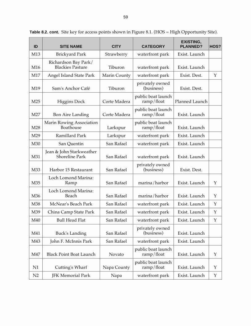
59
Table 8.2. cont. Site key for access points shown in Figure 8.1. (HOS = High Opportunity Site).
ID SITE NAME CITY CATEGORY EXISTING, PLANNED? HOS?
M13 Brickyard Park Strawberry waterfront park Exist. Launch
M16 Richardson Bay Park/
Blackies Pasture Tiburon waterfront park Exist. Launch
M17 Angel Island State Park Marin County waterfront park Exist. Dest. Y
M19 Sam's Anchor Café Tiburon privately owned
(business) Exist. Dest.
M25 Higgins Dock Corte Madera public boat launch
ramp/float Planned Launch
M27 Bon Aire Landing Corte Madera public boat launch
ramp/float Exist. Launch
M28 Marin Rowing Association
Boathouse Larkspur public boat launch
ramp/float Exist. Launch
M29 Ramillard Park Larkspur waterfront park Exist. Launch
M30 San Quentin San Rafael waterfront park Exist. Launch
M31 Jean & John Starkweather
Shoreline Park San Rafael waterfront park Exist. Launch
M33 Harbor 15 Restaurant San Rafael privately owned
(business) Exist. Dest.
M35 Loch Lomond Marina:
Ramp San Rafael marina/harbor Exist. Launch Y
M36 Loch Lomond Marina:
Beach San Rafael marina/harbor Exist. Launch Y
M38 McNear's Beach Park San Rafael waterfront park Exist. Launch Y
M39 China Camp State Park San Rafael waterfront park Exist. Launch Y
M40 Bull Head Flat San Rafael waterfront park Exist. Launch Y
M41 Buck's Landing San Rafael privately owned
(business) Exist. Launch
M43 John F. McInnis Park San Rafael waterfront park Exist. Launch
M47 Black Point Boat Launch Novato public boat launch
ramp/float Exist. Launch Y
N1 Cutting's Wharf Napa County public boat launch
ramp/float Exist. Launch Y
N2 JFK Memorial Park Napa waterfront park Exist. Launch Y
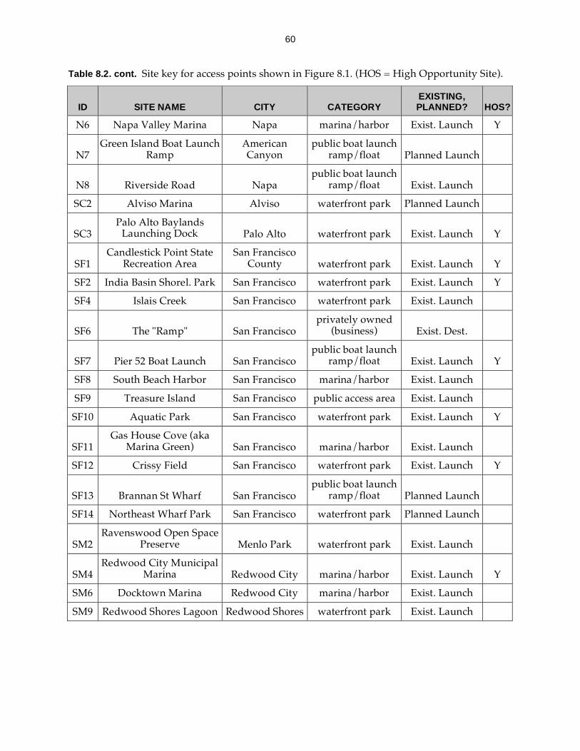
60
Table 8.2. cont. Site key for access points shown in Figure 8.1. (HOS = High Opportunity Site).
ID SITE NAME CITY CATEGORY EXISTING, PLANNED? HOS?
N6 Napa Valley Marina Napa marina/harbor Exist. Launch Y
N7 Green Island Boat Launch
Ramp American Canyon
public boat launch ramp/float Planned Launch
N8 Riverside Road Napa public boat launch
ramp/float Exist. Launch
SC2 Alviso Marina Alviso waterfront park Planned Launch
SC3 Palo Alto Baylands
Launching Dock Palo Alto waterfront park Exist. Launch Y
SF1 Candlestick Point State
Recreation Area San Francisco
County waterfront park Exist. Launch Y
SF2 India Basin Shorel. Park San Francisco waterfront park Exist. Launch Y
SF4 Islais Creek San Francisco waterfront park Exist. Launch
SF6 The "Ramp" San Francisco privately owned
(business) Exist. Dest.
SF7 Pier 52 Boat Launch San Francisco public boat launch
ramp/float Exist. Launch Y
SF8 South Beach Harbor San Francisco marina/harbor Exist. Launch
SF9 Treasure Island San Francisco public access area Exist. Launch
SF10 Aquatic Park San Francisco waterfront park Exist. Launch Y
SF11 Gas House Cove (aka
Marina Green) San Francisco marina/harbor Exist. Launch
SF12 Crissy Field San Francisco waterfront park Exist. Launch Y
SF13 Brannan St Wharf San Francisco public boat launch
ramp/float Planned Launch
SF14 Northeast Wharf Park San Francisco waterfront park Planned Launch
SM2 Ravenswood Open Space
Preserve Menlo Park waterfront park Exist. Launch
SM4 Redwood City Municipal
Marina Redwood City marina/harbor Exist. Launch Y
SM6 Docktown Marina Redwood City marina/harbor Exist. Launch
SM9 Redwood Shores Lagoon Redwood Shores waterfront park Exist. Launch

61
Table 8.2. cont. Site key for access points shown in Figure 8.1. (HOS = High Opportunity Site).
ID SITE NAME CITY CATEGORY
EXISTING, PLANNED? HOS?
SM11 Beaches on the Bay Foster City waterfront park Exist. Launch
SM12 Foster City Lagoon Park Foster City waterfront park Exist. Launch
SM13 East 3rd Ave Foster City waterfront park Exist. Launch Y
SM16 Seal Point Park San Mateo waterfront park Exist. Launch Y
SM17 Coyote Point, Marina San Mateo marina/harbor Exist. Launch Y
SM18 Old Bayshore Highway Burlingame public access area Exist. Launch
SM20 Colma Creek/Genentech So San Francisco public access area Exist. Launch
SM21 Oyster Point Marina So San Francisco marina/harbor Exist. Launch Y
SM22 Brisbane Marina Brisbane marina/harbor Exist. Launch Y
SM23 Coyote Point, Beach San Mateo waterfront park Exist. Launch Y
SM24 Westpoint Marina Redwood City marina/harbor Planned Launch
SM25 Corkscrew Slough Viewing Platform Redwood City refuge/reserve Planned Dest.
Sn3 Hudeman Slough Sonoma County public boat launch
ramp/float Exist. Launch
Sn5 Papa's Taverna/ Lakeville
Marina Petaluma privately owned
(business) Exist. Launch Y
Sn6 Petaluma Marina Petaluma marina/harbor Exist. Launch Y
Sn7 Petaluma River Turning
Basin Petaluma public boat launch
ramp/float Exist. Launch
So1 Brinkman's Marina Vallejo public boat launch
ramp/float Exist. Launch Y
So2 California Maritime
Academy Vallejo privately owned
(business) Exist. Launch
So5 Beldon's Landing Fairfield public boat launch
ramp/float Exist. Launch Y
So7 Matthew Turner Park Benicia waterfront park Exist. Launch Y
So8 W. 9th Street Launch. Fac. Benicia waterfront park Exist. Launch Y
So9 Benicia Point Pier Benicia waterfront park Exist. Launch Y
So10 Benicia Marina Benicia marina/harbor Exist. Launch Y
So11 Suisun City Marina Suisun City marina/harbor Exist. Launch Y

62
Table 8.3. Summary statistics for Table 8.2.
TOTAL
Backbone Sites 112
Category
Waterfront Park 54
Marina/Harbor 21
Public Boat Launch Ramp 21
Public Access Area 4
Wildlife Refuge/Reserve 4
Privately-Owned (Business) 8
Existing or Planned
Existing Launches 89
Existing Destinations 7
Planned Launch 12
Planned Destination 5
High Opportunity Sites (identified in Table 8.2.) 57

63
Section 9. Trail Planning and Program Development
9.1. Education, Outreach and Stewardship The goals of the water trail education, outreach and stewardship program are to:
enhance the experience of paddling on the Bay to attract people to get out onto the trail;
protect the safety of water trail users and others on the Bay; teach trail users how to boat in a manner that is consistent with protecting wildlife
and habitat; and foster stewardship of the trail and of Bay resources.
Recommended components of the program are: trail signage; educational media; outreach to and coordination; boater-to-boater education; and trail stewardship. The program should be accessible to all water trail users as required under the Americans with Disabilities Act.
Signage. Water trail signage is essential for every trail head. At a minimum, this signage should:
enable trail users to easily recognize trail heads; provide maps identifying the trail head location and surrounding area; and provide information about trail and site-specific conditions, rules and policies for
access and protecting wildlife and habitat and safety.
Additionally, trail staff and site managers should seek opportunities to fund interpretive signage at trail heads to enhance end-users’ experiences on the trail, and build understanding of and appreciation for Bay resources.
Content for these trail signs should be developed during the designation process with input from the trail staff, the Advisory Committee and Project Management Team. For trail heads with trail-related or sponsored interpretive signage, the site-specific content should be created by an agency, consultant or organization with expertise in interpretive media development.
To facilitate development of good quality, consistent and coordinated signage across the entire trail, the water trail should have a signage program that provides design guidelines. These guidelines need to address the wide variety of trail signage needs, including basic trail head signs, buoy signage and interpretive designs, as well as signage needs of different trail users including persons with disabilities. Due to the critical importance of signage for the success of the water trail, the Conservancy should develop this signage program as soon as possible.
Outreach and Coordination. Staff should coordinate with local and regional organizations that already offer education and outreach information, programs and events to likely trail users and the broader public. The goals of these outreach and coordination efforts should be to incorporate consistent trail-related information into these other programs and events, and expand program offerings in conjunction with the water trail. As examples:
Work with human-powered boating and sailboarding clubs and tour operators to communicate water trail information to members and clients, and to sponsor and/or organize water trail-themed events (e.g., tours) that highlight trail educational information.
Coordinate with businesses (e.g., equipment outfitters, shoreline restaurants and hotels, ferry terminals, etc.) to display water trail brochures with promotional and educational information targeted for tourists (e.g., promoting guided tours as a fun and safer way for this audience to experience the trail).

64
Establish ties with maritime agencies and organizations to facilitate coordination on development of trail safety information, and to ensure that trail users’ needs are represented in decisions and discussions about Bay Area navigational safety and national security.
Sponsor and/or participate in activities at race events and festivals that are water-oriented, such as the dragon boat festival at Treasure Island, or Aloha Days at Crissy Field.
Co-sponsor and/or organize events with the Bay and Ridge Trails and other organizations to increase awareness about different recreational opportunities within local communities.
Educational Media. Educational media include maps, a guidebook, brochures, web sites,
newspaper and magazine articles and television. Water trail education staff should develop, maintain and update a Bay Area Water Trail web site and a guidebook with current information on:
the water trail ethic trail heads (maps, site-specific information) proper trip preparation personal boating safety navigational safety and national security rules and issues rules and best boating practices for protecting wildlife and habitat (in general and at
a specific trail head or in a specific area) overnight accommodations guided tours, trips and trail-related educational programs recommended trips or trail head linkages links to helpful information such as tides and currents, trail managers’ websites
Staff should seek advice from other water trail programs and input from the Advisory Committee and Stakeholder Group members on the content for the website and guidebook.
Trail staff should also develop brochures that address specific trail issues (e.g., safety or minimizing wildlife disturbances), interpretive opportunities (e.g., birds that boaters may see on the trail), broader trail promotion and specific audiences (e.g., boardsailors). Trail education staff should seek opportunities work with other organizations and agencies that are developing outreach and education materials, such as the Bay Trail Project, boating clubs, Save the Bay and Cal Boating, to incorporate trail-related educational and promotional information. Staff should also work with concessionaires, equipment sales and rental shops and equipment manufacturers to develop and promote consistently conveyed information for novice boaters and boardsailors. At a minimum, this information should cover basic personal safety needs (e.g. equipment) and safe, low-impact boating practices, and direct customers to water trail education information and resources.
Trail staff should seek opportunities to promote the water trail and its access, safety and wildlife and habitat protection objectives through other types of media that reach broader audiences (e.g., newspaper, magazine, radio and television pieces).
Boater-to-Boater Education. This education objective should be accomplished through coordination with existing non-motorized small boating clubs and organizations where boater-to-boater interactions and education already occur. Water trail education staff should do outreach to these groups to encourage members to promote educational messages that are consistent with the water trail ethic and policies. The water trail website and guidebook,

65
brochures and signage should provide information about existing education programs, including guided tours, that promote the water trail objectives and ethic.
Longer-term, a water trail boater-to-boater education program should be expanded as a managed docent program that places informed, experienced boaters (paid or volunteer) at strategic locations on the Bay during high-use times of year to talk with boaters about the water trail (e.g., its mission and ethic), rules that apply in the area, good boating practices to ensure safety and protection of wildlife, and sites to see. Docents should receive training on general water trail information as well as the site-specific issues and rules pertaining to the locations where they will be doing outreach.
Development of other water trail education program components – a signage program, educational media, and outreach and coordination – should take priority over creating a boater-to-boater education program for trail users.
Stewardship. Fostering stewardship of Bay and trail resources will be an outcome of the water trail education program that successfully implements the components described in the previous sections: a good quality and consistent signage program, coordination with other agencies and organizations, comprehensive educational media and boater-to-boater education.
As other water trails have shown, a volunteer stewardship program can help maintain trail heads, reduce management burdens for site owners, improve trail head access facilities, and build a constituency of end-users to support and care for trail resources. With a fully-developed trail education program in place, water trail staff should then develop a volunteer site stewards program. This can be developed as a trail-managed program (i.e. trail staff recruit and organize volunteers) and/or through strategic coordination with and support of individuals and local and regional organizations that have existing connections to certain launch sites (e.g., rowing or paddling clubs).
Implementation of site stewards at a launch or destination site should not become a pre-requisite for its designation as a trail head. Reasons for this are two-fold. Although site stewardship can help with trail head care, it should not be used as a substitute for appropriate maintenance and management by the site owner or manager. Additionally, as other trails show, trail staff will not be able to provide or coordinate volunteer stewards for every launch and destination site, and this limitation should not be used as a means of stymieing designation of a trail head.
9.2. Development of Launch Design Guidelines
Well-designed launch facilities are essential for providing safe, durable, universally accessible trail access for human-powered boaters and people in beachable sail craft. To help launch site managers develop and improve their facilities to accomplish this goal, the water trail should provide launch design guidelines for non-motorized small boating access that are specific to the conditions in the San Francisco Bay Area. The guidelines should address access issues described in Section 5.1. by promoting facility designs that: suit the launching needs of human-powered boats and beachable sail craft; meet accessibility guidelines for people with disabilities and help create universally accessible launch sites; and minimize other potential problems such as user conflicts or extensive maintenance requirements.
The audiences for these guidelines will include shoreline managers and design consultants who are designing and developing the launch facilities, as well as members of the water trail organization – the staff, Project Management Team and Advisory Committee – who will review and provide feedback on prospective trail heads.

66
The California Department of Boating and Waterways has expertise in launch facility design, and has developed similar design guidelines for small boat launches. Cal Boating has agreed to develop these guidelines with input from the water trail staff, Project Management Team, Advisory Committee and other interested stakeholders. Involvement of non-motorized small boaters who are familiar with Bay conditions will be important throughout the process of developing these guidelines, to ensure that trail users’ needs are addressed.
9.3. Overnight Accommodations
An important trail objective is to create opportunities for multi-day excursions on San Francisco Bay. Due to the significant site design and management challenges for providing camping or other overnight accommodations, these opportunities around the Bay will be limited. Trail staff and the Project Management Team should work with shoreline owners to assess prospective camping sites, and prioritize development and designation of trail heads with these opportunities. Additionally, the water trail project should reach out to shoreline hostels, hotels and historic ships to develop arrangements for overnights stays (and equipment storage) by trail users.
To expand the number of trail heads with overnight accommodations, the water trail project should tap into enthusiasm for overnight trips – and camping, in particular – among some water trail advocates, by asking them to form a working group to identify access points with potential for overnight accommodations, and to recommend additional design and management strategies for camping at trail heads and, more generally, overnight trips on the water trail. These findings and suggestions should be reviewed by the Advisory Committee, and based on recommendation from the Advisory Committee, the Project Management Team should update the plan with these new strategies. Staff should pursue development of the launch sites with possibilities for overnight accommodations that the group identifies.
9.4. Trail Advocacy
Expansion of water trail access and opportunities for overnight accommodations will require extensive advocacy by the Project Management Team and the Advisory Committee members, project staff and trail proponents. An essential advocacy objective is to get cities, counties and park districts to incorporate the water trail and specific trail heads into their general and master plans. Additionally, trail proponents should advocate for and support development of specific access projects that will (1) add to or improve Bay access, (2) fulfill the water trail vision, and (3) be consistent with water trail policies recommended in this plan. Successful trail promotion and education, outreach and stewardship will require advocacy to organizations, agencies and businesses to encourage them to include water trail promotional and educational information in their outreach and training materials and programs. This last type of trail advocacy overlaps with the coordination and outreach recommendation in Section 9.1.
9.5. Monitoring
In the Bay Area Water Trail Act and during the water trail planning process, it was recognized that there are certain areas on and around the Bay that have sensitive wildlife, and that significant adverse impacts to these wildlife populations are possible due to trail activities are possible. In some of these areas, boating activities (of all types) are restricted for this reason. Some other areas have access for human-powered boats and beachable sail craft and these boating activities already take place. Although there may be some interest in using the water
67
trail as a mechanism for removing this existing access, the water trail project will not have the authority to do this.
The water trail Project Management Team will have decision-making authority over designation of a launch or destination site as part of the trail. Access sites should not be designated as trail heads where their inclusion in the trail will cause significant adverse environmental impacts that cannot be mitigated. In some cases, the expected impacts of trail head designation will not be clear-cut, and the Project Management Team should consider recommending (and, if possible, allocating funding for) a monitoring study as described in Section 16. The Advisory Committee and experts from the Stakeholder Group should provide input on where and how this should apply.
It is very important that a monitoring study not be a required component of each trail head plan. As stipulated in Strategy 16, monitoring of impacts should be selectively applied where wildlife and habitat impacts are a major concern and where it will provide the most useful information about trail head management.
9.6. Trail Head Management and Enforcement
The water trail organization will have responsibility for management of the trail overall, but management responsibility for trail heads will remain with the site owner and/or manager. A primary way that the trail project will assist site owners with trail head management is through implementation of the education, outreach and stewardship program which will teach about and encourage compliance with rules, regulations and trail guidelines. Due to the difficulty of patrolling the entire Bay and shoreline, trail managers will not be able to rely on enforcement only to ensure that the trail is being used in a manner that is safe and protective of Bay resources. Furthermore, the water trail project does not have the authority, resources, responsibility or mission to become, or create, a new enforcement entity on the Bay.
There will be circumstances in which shoreline managers have authority and capacity, but no funding, to improve trail head management and enforcement. The trail staff and Project Management Team should work with these site owners and managers to help them obtain funding to support their additional trail-specific management and enforcement efforts. Additionally, staff, trail head managers and other trail partners should explore other options to address appropriate management needs, such as using volunteer site stewards to help with trail upkeep (see Section 9.1. Stewardship).

68
Section 10. Information and Expertise Needs
Certain information and expertise will be essential and/or helpful for informing the trail head designation process and other trail planning work. The organizational structure incorporates some of this information and expertise for planning and decision-making through participation by stakeholders representing the major interests and project issues. Most often, the knowledge and expertise that stakeholders contribute to trail planning will be specific to a smaller, sub-region of the Bay, a specific species or issue, such as access for a specific type of paddleboat. To supplement this input, the water trail project staff also needs to maintain a more comprehensive, Bay-wide set of information and knowledge of access, wildlife and habitat and safety issues. At the outset of implementation, water trail staff will have current information in the plan about sensitive wildlife areas and safety areas and existing and planned launches and landings for human-powered boats and beachable sail craft. Staff should update this information, and fill information and expertise gaps concerning good boating areas and accessibility on an ongoing basis.
10.1. Human-Powered Boating and Beachable Sail Craft Access
Trail staff should update trail planning maps with current information on launch and landing sites around the Bay. This includes showing designated sites, and updating the backbone and high opportunity sites lists as needed.
10.2. Sensitive Wildlife, Safety and Good Boating Areas
The following section defines these three types of areas and the ongoing information gathering and mapping that are needed to support overall trail planning (e.g., development of educational materials) and the trail head designation process.
Sensitive Wildlife Areas. Sensitive wildlife areas are sites where water trail access should be managed or prohibited.5 These types of areas can include:
Areas used by species listed under the Federal or California Endangered Species Acts;
Bird nesting sites; Harbor seal haul-outs; Certain open water areas used for foraging and resting by wintering waterfowl; Important species-specific feeding and refugia areas; Subtidal habitat that is known to be sensitive to non-motorized small boating
activities; and Areas being restored, or that have recently been restored and that are not currently
suitable for access. In most cases, sensitive wildlife are more sensitive during discrete times of year. Bird
nesting sites are sensitive during nesting seasons which will vary with different species, and sensitive wintering waterfowl areas potentially occur from October through April. Harbor seals are sensitive year-round to disturbance at haul outs, but the Bay population is especially sensitive to disturbance effects during times of the year when the seals molt and breed. Therefore, certain environmental regulations and shoreline management policies already designate sensitive areas where human-powered boating and boardsailing access is managed or prohibited. The following list describes the types of designated areas that can affect boating access.
5 The phrase “sensitive wildlife areas” and its definition are taken from the Bay Area Water Trail Act. See Appendix
A for the text of the Act.

69
For threatened and endangered species, U.S. Fish and Wildlife Service (FWS) and California Department of Fish and Game (DFG) designate “critical habitat” that may restrict boating access to prevent impacts or “takes.”
Disturbance of tidal marsh vegetation is prohibited to protect endangered species habitat for Clapper and Black Rails and Salt Marsh Harvest Mouse in FWS National Wildlife Refuges (NWR), and state DFG’s Wildlife Areas and Ecological Preserves. Boaters are allowed to navigate the open waters (with some exceptions), but are not allowed to disembark, except at designated landing and launch sites. In instances where there are violations of this policy, FWS can prohibit all boating access.
FWS implements additional management measures on its lands to prevent disturbance of other, (non-listed) wildlife species and address other issues. For example, boating is prohibited in Mowry Slough during harbor seal pupping season; landing at Marin Islands NWR is prohibited to protect the heron and egret rookeries and prevent vandalism to the dock; and there is a proposed a 500-foot recreational boating corridor between Alameda Island and the breakwater to prevent disturbances to nesting terns on the Island, as well as roosting pelicans on the breakwater.6
DFG also prohibits or limits boating and other recreation activities in State Marine Parks (SMPs). Boating is not allowed in Albany Mudflats, Marin Islands and Bair Island SMPs, and limited to small, hand-carry boats in Redwood Shores and Corte Madera SMPs.7
California State Parks prohibits boating in “preserve areas.” These are Emeryville Crescent, Albany Mudflats, and Hoffman Marsh/South Richmond Shoreline.8
To protect listed and sensitive species and habitats, East Bay Regional Park District prohibits boating and landing in some areas (e.g., Brooks Island, certain creeks and sloughs along the Hayward Shoreline) that it owns or manages.9
County and local jurisdictions can also establish limits on boating to protect wildlife.
With development of new access onto the water, trail staff members should work with trail partners to avoid locating access in or adjacent to sensitive areas. Some launch and landing sites are already located in or adjacent to sensitive areas. If these are incorporated into the water trail, signage and outreach, education and interpretive programs should promote low impact boating practices to prevent anticipated, trail-related problems. Implementing new access restrictions such as a seasonal closure of a nesting area might also be appropriate and possible depending on trail use-patterns at the launch site and the management objectives and resources of the site owner.
Safety Areas. Safety areas include:
Navigational exclusion zones (both permanent and temporary) Regulated navigation zones (e.g., shipping lanes for deep draft vessels)
6 U.S. Fish and Wildlife Service. 1998. Draft Comprehensive Conservation Plan for the Alameda National Wildlife
Refuge. Portland, OR, Section 4.2, Figure 9. Retrieved May 2, 2006 from
http://www.fws.gov/pacific/planning/alameda_ccp.htm. 7 California Department of Fish and Game. n.d. “Descriptions and Preliminary Evaluations of Existing California
Marine Protected Areas.” Marine Life Protection Act Initiative. Retrieved May 4, 2006 from:
http://www.dfg.ca.gov/mrd/mlpa/descriptions.html 8 East Bay Regional Park District (EBRPD) and the California Coastal Conservancy (CCC). 2002. Eastshore State
Park General Plan. Prepared for the California Department of Parks and Recreation, EBRPD and CCC, p. III-7. 9 East Bay Regional Park District. n.d. “Brooks Island Regional Shoreline.” (brochure). Retrieved on May 2, 2006
from: http://www.ebparks.org/resources/pdf/trails/brooks_map.pdf.
70
Other navigation routes/protocols (e.g., ferry routes) Sites with known marine debris hazards Regions of the Bay with known natural hazards (e.g., strong currents, winds or
waves and areas with extensive low-tide mudflats) Sites where hunting is permitted Sites with health hazards (e.g., poor water quality)
Some of these areas can be mapped as fixed locations (e.g., exclusion zones around the San Francisco and Oakland International Airports), whereas others are changing or temporary (e.g., exclusion zones around tankers, and boating conditions such as currents, fog and winds). The trail management role with respect to these safety areas is to inform and educate trail users about them by placing information about them on maps and in other trail materials.
Good Boating Areas. Certain areas of the Bay stand out as good boating areas – sites that are consistently and/or broadly well-suited to human-powered boating and boardsailing activities. These include good ‘training’ areas that are safe for individual boaters or teams to practice and participate in classes. These are areas with calm waters (or a ‘bailout’ site for a boater who gets into trouble) and where boaters can train without risk of disturbing wildlife or other water activities. Other characteristics to look for include opportunities for historic, cultural or environmental interpretation or education for groups (e.g., school field trips). Focusing development of access near these areas may help avoid problems in some of the safety and sensitive wildlife areas.
Different human powered boating and boardsailing groups have more specific criteria for good boating areas:
Windsurfers and kitesurfers require wind that blows predictably from a certain direction. The number of such sites around the Bay are limited and are highly valued by these groups. Of these, some, such as Berkeley Marina (A2, Table 8.1.), are suitable from training and practicing by novices.
Dragon boaters, outrigger canoeists and scullers are team and racing-oriented, and generally require long stretches of flat water between sites for training purposes. Good areas for training are in the Oakland Estuary, near Redwood City, and in Corte Madera Creek.
Training new boaters (kayaks and canoes) is ideally carried out in protected water with shoreline nearby, such as in the Richardson Bay area. (Expert boaters seek more extreme conditions.)
Staff should enlist the help of Bay Access, Inc. and other stakeholders representing non-motorized small boating interests to identify a set of good boating areas to add to the water trail planning maps.
Ongoing Information and Mapping Updates. Figure 8.1. shows a ‘snapshot’ of locations of sensitive wildlife and safety areas, and the discussions of wildlife and habitat disturbance and safety issues in Section 5 represent the best available information.10 As conditions change and the state of knowledge about wildlife disturbance improves, launch site managers, water trail staff, the Project Management Team and Advisory Committee should use the most up to date information about sensitive wildlife areas in trail head planning. Project staff should update the maps to reflect current conditions.
10 The information for Sections 5.2 and 5.3 and the maps in Figure 8.1 was compiled in June 2006 as part of a
background report for Water Trail Steering Committee Meeting 3 (June 6, 2006).

71
To stay aware of the current species censuses and habitat surveys, areas with wildlife and habitat-related boating regulations, and recent research on wildlife disturbance issues, water trail staff should maintain contacts in the scientific community and with land and resource managers. In addition to reviewing published reports, they should actively consult with these agencies and other organizations to learn about recent survey data, and this current wildlife and habitat information should be reflected in water trail project maps. These entities include:
U.S. Fish and Wildlife Service, San Francisco Bay National Wildlife Refuge Complex (Endangered species; Bay-related birds; Harbor seals; Habitat areas; Restoration sites)
California Department of Fish and Game (Endangered species; Species of special concern; Habitat areas; Restoration sites)
U.S. Geologic Survey (Wintering waterfowl) NOAA Fisheries (Endangered species; Harbor seals) National Park Service, Point Reyes National Seashore (Harbor seals) PRBO Conservation Science (Endangered species; Bay-related birds) Audubon Society Chapters (Endangered species; Bay-related birds; Habitat areas;
Restoration sites) East Bay Regional Park District (Endangered species; Habitat areas) California State Parks (Habitat areas) San Francisco Bay Joint Venture (Habitat areas) Sonoma Land Trust (Restoration sites) County and Local Parks (Habitat Areas; Restoration sites)
For updates on safety areas, water trail staff primarily need to coordinate and communicate with maritime agencies and organizations and boating clubs, as well as with other agencies and organizations that maintain safety-related information. These entities include:
U.S. Coast Guard and Vessel Traffic Services (Regulated navigation zones; Exclusion zones)
U.S. Coast Guard Local Notice to Mariners (Navigation information: Marine events, hazards)
San Francisco Bay Harbor Safety Committee (Navigational protocols) National Oceanic and Atmospheric Administration (Navigational maps; Bay
conditions) San Francisco Boardsailing Association (Boating hazards; Bay conditions) Cal EPA and State Water Resources Control Board, Beach Watch (Health hazards:
water quality) California Department of Fish and Game, U.S. Fish and Wildlife Service (Hunting
areas and times)
10.3. Expertise on Accessible Facility and Program Design
A primary objective for the water trail is to promote its use for people of all abilities. Universally accessible trail head facilities and trail programs will help achieve this objective. To facilitate this, trail project staff should become educated about accessibility guidelines and requirements (e.g., by attending trainings, and working with accessibility experts). While it is impractical to expect staff to become experts on the guidelines, they should be well-versed in accessibility design, such that they can be a resource to launch site managers during initial site assessment and planning for a prospective trail head, and ensure that trail head facility improvements and trail programs are designed to be universally accessible.
72
Section 11. Funding
The water trail envisioned by this Plan should link access opportunities for all people in human-powered boats and beachable sail craft, allowing them to experience the natural, scenic and cultural wonders of San Francisco Bay, while protecting wildlife and habitat and the safety of trail users and all mariners. Funding to achieve this vision will need to support permanent trail staff, launch site facility design and improvements, and development and ongoing implementation of trail programs such the education, outreach and stewardship program. Additionally, the trail project should seek funding to help site owners and managers with trail head management and enforcement needs, and for monitoring (as described in Section 9.5)
Securing funding to pay for staff time is generally difficult to achieve because funding entities prefer to support projects on a one-time (or phased) basis, as opposed to providing continuous support for personnel or for other recurrent expenses. As part of their respective missions, however, the California Coastal Conservancy (Conservancy), the California Department of Boating and Waterways (Cal Boating), BCDC, and the Association of Bay Area Governments are committed (to varying degrees) to providing continuous staff involvement in the management of the trail at a programmatic level. The Conservancy in particular, as the legislated lead agency for the program, will dedicate permanent trail staff for the foreseeable future.
Two primary funding sources for facility design and improvements (trail head improvements) are grants from the Conservancy and Cal Boating. The Conservancy has funding available through public bond acts that it can offer for trail-related capital improvements. Currently those sources include primarily Proposition 84 (2006), but also Propositions 40 (2002), 12 (2000) and, potentially, 50 (2002). Historically, new bond measures have been passed periodically by voters to support public benefits, such as the water trail, and it is likely in the future that similar bonds will be passed.
Cal Boating supports launch site improvements for non-motorized small boats under its Boat Launching Facilities Grant Program. Matching funds from local jurisdictions, special districts (e.g., East Bay Regional Park District) and private foundations are another potential source of money for facility improvements. Trail managers may be able to expand this funding source by advocating for integration of the water trail into general plans and land use plans. Public and private landowners will be another source of matching funds for trail head facilities. As part of larger shoreline developments, developers may privately fund new public access for non-motorized small boats to enhance the appeal and value of a property, and/or to build support for a project during local public planning processes.
Finding funding for non-capital trail improvements and programs, and ongoing trail management and maintenance will be more challenging. The Conservancy and Cal Boating have very limited (or no) funding available for these costs.11 Other sources of money, such as private foundations, are needed to support these improvements and programs. Project Management Team The water trail project will rely heavily on the affiliated non-profit organization to identify and pursue this funding.
11 It is important to note that despite limitations that the Conservancy and Boating and Waterways have for funding
non-capital improvements, they have identified and planned for resources to complete development of signage
guidelines (Conservancy) and launch design guidelines (Boating and Waterways) – two, high priority
implementation needs.

73
Appendices
Appendix A. San Francisco Bay Area Water Trail Act
Assembly Bill No. 1296 CHAPTER 331
An act to add Chapter 7 (commencing with Section 66690) to Title 7.2 of the
Government Code, and to amend Sections 31161, 31162, and 31163 of the Public
Resources Code, relating to resource conservation.
[Approved by Governor September 22, 2005. Filed with Secretary of State September 22, 2005.]
LEGISLATIVE COUNSEL'S DIGEST
AB 1296, Hancock San Francisco Bay Area Water Trail.
Existing law establishes the jurisdiction of the San Francisco Bay Conservation and
Development Commission over the waters of San Francisco Bay and Suisun Marsh.
Existing law also establishes the State Coastal Conservancy with prescribed powers and
responsibilities for implementing a program of agricultural land protection, area
restoration, and resource enhancement within the coastal zone.
This bill would enact the San Francisco Bay Area Water Trail Act. The act would
establish the San Francisco Bay Area Water Trail to link access to the waters of the San
Francisco Bay and Suisun Marsh that are available for navigation by human-powered
boats and beachable sail craft, and provide for diverse water-accessible Overnight
accommodations. On or before January 1, 2008, the San Francisco Bay Conservation and
Development Commission would be required to prepare and submit to the Legislature the
San Francisco Bay Area Water Trail Plan making recommendations, as specified, on
the development of the water trail. The act would require the commission, in
collaboration with the State Coastal Conservancy and the Association of Bay Area
Governments, to establish and coordinate a collaborative partnership with other interested
parties in the development of the plan.
The bill would designate the State Coastal Conservancy as the lead agency in the
funding and development of projects to implement the San Francisco Bay Area Water
Trail Plan, and would authorize the conservancy to undertake projects and award grants
to advance the preparation or implementation of the plan. The bill would require the
conservancy to help coordinate a collaborative partnership with the San Francisco Bay
Conservation and Development Commission, the Association of Bay Area Governments,
and other interested parties, to advance the preparation of the plan. Upon the completion
of the plan, the bill would require the conservancy to consider the plan's adoption and
inclusion of appropriate elements of the plan in the conservancy's strategic plan.
THE PEOPLE OF THE STATE OF CALIFORNIA DO ENACT AS FOLLOWS:
SECTION 1. Chapter 7 (commencing with Section 66690) is added to Title 7.2 of the
Government Code, to read:
CHAPTER 7. SAN FRANCISCO BAY AREA WATER TRAIL
66690. This chapter shall be known, and may be cited as, the San Francisco Bay Area
Water Trail Act.
66691. The Legislature finds and declares the following:
(a) The public has an interest in the San Francisco Bay and the surrounding watershed
lands as one of the most valuable natural resources of the state, a resource that gives
special character to the San Francisco Bay Area. San Francisco Bay is the central feature
in an interconnected open-space system of watersheds, natural habitats, waterways,
scenic areas, agricultural lands, and regional trails.

74
(b) Water-oriented recreational uses of the San Francisco Bay, including kayaking,
canoeing, sailboarding, sculling, rowing, car-top sailing, and the like, are of great benefit
to the public welfare of the San Francisco Bay Area. With loss of public open space, the
public increasingly looks to the bay, the region's largest open space, for recreational
opportunities. Water-oriented recreational uses are an integral element of the recreational
opportunities that span the San Francisco Bay Area and add to the community vitality and
quality of life that the citizens of the region enjoy.
(c) Water trails have been designated throughout the United States and have proven to
be an important vehicle for promoting water-oriented recreation for citizens of all
economic means. Water trails can inform the public about natural, cultural, and historic
features and foster public stewardship of these resources. Water trails aid in urban
renewal of industrial waterfronts. In combination with hiking, biking, and horse trails,
water trails are an important element in the development of multiuse and multiday
recreational opportunities that in turn have a positive regional economic benefit.
(d) Bay Access, Incorporated, a nonprofit organization dedicated to the creation of the
San Francisco Bay Area Water Trail, has identified a series of existing and potential
access points to the San Francisco Bay that encircle the bay. The designation of a water
trail linking these existing and any future access sites that is designed and implemented
consistent with this chapter, would advance the regional goals and state mandate of the
commission to foster public access and recreational use of the bay.
(e) San Francisco Bay is an aquatic habitat of international importance. It provides
critical habitat for 70 percent of the shore birds and 50 percent of the diving ducks on the
Pacific Flyway, as well as for many other waterbird species. It also provides habitat for
marine mammals, other aquatic species, and colonial nesting birds, including many
federal- and state-listed endangered or threatened species, such as the endangered
California clapper rail.
(f) The San Francisco Bay Area Water Trail, established pursuant to this chapter, shall
be implemented consistent with the goals of improving access to, within, and around the
bay, coast, ridgetops, and urban open spaces while respecting the rights of private
property owners, considering navigation safety and homeland security concerns in
establishing the access points around the bay and the siting of overnight
accommodations, minimizing the adverse impacts on agricultural operations, and
protecting endangered and threatened species, and species of special concern.
(g) It is not the intent of the Legislature, in enacting this chapter, to modify any
provision of this title except as otherwise expressly provided in this chapter.
66692. (a) For the purposes of this chapter, the area referred to as the San Francisco
Bay Area includes the nine Bay Area counties and navigable waters and tributaries under
tidal influence that are part of or feed into San Francisco Bay.
(b) The San Francisco Bay Area Water Trail primary project area shall be the area
within the commission's jurisdiction as defined in Section 66610 of this code, and the
area described in Section 29101 of the Public Resources Code.
66693. (a) The San Francisco Bay Area Water Trail is hereby established.
(b) The San Francisco Bay Area Water Trail shall be developed in a timely manner.
(c) The San Francisco Bay Area Water Trail, to the extent feasible, shall link access to
the waters of the San Francisco Bay that are available for navigation by human-powered
boats and beachable sail craft, and shall provide for diverse water-accessible overnight
accommodations, including camping.
(d) The San Francisco Bay Area Water Trail shall be developed in a manner consistent
with the right to access navigable waters of the state contained in Section 4 of Article X
of the California Constitution.
(e) The San Francisco Bay Area Water Trail shall be developed in a manner consistent
with all federal laws and regulations pertaining to navigation safety and homeland
security.
66694. (a) The commission shall conduct a public process to develop a San Francisco

75
Bay Area Water Trail Plan for the San Francisco Bay Area. The plan shall make
recommendations on all of the following:
(1) Policies, criteria, and guidelines for the appropriate location, design, operation, and
maintenance of access to the bay.
(2) Locations where the water trail can coordinate with landside trails and other
recreational facilities to accommodate opportunities for multiday, overnight travel.
(3) Organizational structure and procedures for the management and operation of the
water trail and the education of end users in ways that will advance navigational safety,
protect wildlife, and foster stewardship of natural resources.
(4) Identification of sensitive wildlife areas where access should be managed or
prohibited.
(5) Identification of areas where access should be limited or prohibited due to
considerations related to navigation safety and homeland security.
(b) In developing the San Francisco Bay Area Water Trail, the commission, in
collaboration with the State Coastal Conservancy and the Association of Bay Area
Governments, shall establish and coordinate a collaborative partnership with other
interested persons, organizations, and agencies, including, but not limited to, interested
state, county, and district departments and commissions, parks and park districts, ports,
regional governmental bodies, nonprofit groups, user groups, and businesses.
(c) On or before January 1, 2008, the commission shall submit the plan to the
Legislature.
SEC. 2. Section 31161 of the Public Resources Code is amended to read:
31161. The Legislature hereby finds and declares that the nine counties that bound San
Francisco Bay constitute a region with unique natural resource and outdoor recreational
needs. San Francisco Bay is the central feature in an interconnected open-space system of
watersheds, natural habitats, waterways, scenic areas, agricultural lands, and regional
trails.
SEC. 3. Section 31162 of the Public Resources Code is amended to read:
31162. The conservancy may undertake projects and award grants in the nine-county
San Francisco Bay Area that will help achieve the following goals of the San Francisco
Bay Area Conservancy Program:
(a) To improve public access to, within, and around the bay, coast, ridgetops, and urban
open spaces, consistent with the rights of private property owners, and without having a
significant adverse impact on agricultural operations and environmentally sensitive areas
and wildlife, including wetlands and other wildlife habitats through completion and
operation of regional bay, coast, water, and ridge trail systems, and local trails connecting
to population centers and public facilities, which are part of a regional trail system and
are consistent with locally and regionally adopted master plans and general plans, and
through the provision and preservation of related facilities, such as interpretive centers,
picnic areas, staging areas, and campgrounds.
(b) To protect, restore, and enhance natural habitats and connecting corridors,
watersheds, scenic areas, and other open-space resources of regional importance.
(c) To assist in the implementation of the policies and programs of the California
Coastal Act of 1976 (Division 20 (commencing with Section 30000)), the San Francisco
Bay Plan, and the adopted plans of local governments and special districts.
(d) To promote, assist, and enhance projects that provide open space and natural areas
that are accessible to urban populations for recreational and educational purposes.
SEC. 4. Section 31163 of the Public Resources Code is amended to read:
31163. (a) The conservancy shall cooperate with cities, counties, and districts, the bay
commission, other regional governmental bodies, nonprofit land trusts, nonprofit
landowner organizations, and other interested parties in identifying and adopting long-
term resource and outdoor recreational goals for the San Francisco Bay Area, which shall
guide the ongoing activities of the San Francisco Bay Area Conservancy Program. The
conservancy shall utilize the list of priority areas and concerns established by the bay

76
commission pursuant to subdivision (b) of Section 31056 as guidance in the selection of
those San Francisco area projects that are within the jurisdiction of the bay commission.
However, the guidance provided by the bay commission is advisory and the conservancy
shall have the responsibility for making program decisions. Any acquisition of real
property using funds authorized pursuant to this chapter shall be from willing sellers if
the land is actively farmed or ranched. Any acquisition of real property by the
conservancy pursuant to this chapter shall be from willing sellers.
(b) The conservancy shall participate in and support interagency actions and
public/private partnerships in the San Francisco Bay Area for the purpose of
implementing subdivision (a), and providing for broad-based local involvement in, and
support for, the San Francisco Bay Area Conservancy Program.
(c) The conservancy shall utilize the criteria specified in this subdivision to develop
project priorities for the San Francisco Bay Area Conservancy Program that provide for
development and acquisition projects, urban and rural projects, and open space and
outdoor recreational projects. The conservancy shall give priority to projects that, to the
greatest extent, meet the following criteria:
(1) Are supported by adopted local or regional plans.
(2) Are multijurisdictional or serve a regional constituency.
(3) Can be implemented in a timely way.
(4) Provide opportunities for benefits that could be lost if the project is not quickly
implemented.
(5) Include matching funds from other sources of funding or assistance.
(d) (1) The conservancy shall be the lead agency in the funding and development of
projects implementing the San Francisco Bay Area Water Trail Plan prepared pursuant to
Section 66694 of the Government Code.
(2) During the period when the plan is being prepared and after the completion of the
plan, the conservancy may undertake projects and award grants that are generally
consistent with and advance the preparation of the plan or achieve the implementation of
the plan.
(3) To advance the preparation of the plan, the conservancy shall help coordinate a
collaborative partnership with the San Francisco Bay Conservation and Development
Commission, the Association of Bay Area Governments, and other interested persons,
organizations and agencies, including, but not limited to, interested state, county, and
district departments and commissions, parks and park districts, ports, regional
governmental bodies, nonprofit groups, user groups, and businesses.
(4) In developing the plan and undertaking projects to implement the plan, areas for
which access is to be managed or prohibited shall be determined in consultation with
resource protection agencies, the United States Coast Guard, the Water Transit Authority,
the State Lands Commission, local law enforcement agencies, and through the
environmental review process required by the California Environmental Quality Act
(Division 13 (commencing with Section 21000)).
(5) Upon the completion of the plan, the conservancy shall consider the plan's adoption
and inclusion of the appropriate elements of the plan in the conservancy's strategic plan.
(6) The conservancy shall not award a grant or undertake a project for the San
Francisco Bay Area Water Trail that would have a significant adverse impact on a
sensitive wildlife area or is in conflict with the goals of subdivision (a) of Section 31162.
77
Appendix B. Regulatory and Institutional Setting for the Bay Area Water Trail
The laws, policies and management plans affecting the Bay, and the multitude of public agencies and private entities that own and manage the Bay and shoreline provide a complex backdrop for water trail planning.
The Water Trail Plan provides guidance to the trail managers on how to develop and manage trail access and activities in the Bay. However, the policies in this plan will not modify existing land and resource management laws and regulations. Water trail managers will work within existing regulatory frameworks, and in partnership with land and resource managers to help them develop and manage access that is also consistent with the trail policies. To be effective, the water trail plan must reflect the constraints and opportunities set by these existing laws and policies.
Public Trust Doctrine and Navigable Waters
The Public Trust Doctrine asserts that the air, seas, waterways and their shores are common assets that are held in trust by government for public benefit.12 The U.S. Constitution grants states sovereignty over their tide and submerged lands, and the Supreme Court established the states’ duty to protect (in perpetuity) the public’s interest in these areas.13 The California Constitution reflects this obligation for state waters; no one may “exclude the right of way to (navigable) waters whenever it is required for any public purpose, nor destroy or obstruct the free navigation of such water.”14 The California Supreme Court has interpreted the range of public interest values in these waterways to include general recreation activities such as swimming and boating; and preservation of lands in their natural state as open space, as wildlife habitat and for scientific study.15
The term “navigable waters” is broadly defined in California statutes and case laws16 giving the public extensive access rights to waterways. However, it does not preclude limitations on navigation. Governments can establish navigation restrictions to promote or protect the overall use of navigable waters, and to strike an appropriate balance among competing public trust uses of a waterway (e.g., commerce, recreation, environmental needs).17
12 The concept of a public trust resource originated in Roman law. Through U.S. federal and state constitutional and
case law, the doctrine has been applied to these resources in the U.S. For a more detailed discussion of the evolution
of public trust law in California, refer to the Public Trust Statements at the California State Lands Commission
website: <http://www.slc.ca.gov/Policy%20Statements/Policy_Statements_Home.htm> 13 Illinois Central Railroad v. Illinois, 1892. 146 U.S. 387. The Public Trust Doctrine has yet to be applied to federal
lands and waters through statutes or case law. 14 CA Constitution, Article X, Section 4. 15 Marks v. Whitney. 1971. 6 Cal.3d 251; National Audubon Society v. Superior Court. 1983. 33 Cal.3d 419; People
v. California Fish Co. 1913. 166 Cal. 576.
Frank, R.M. 1983. “Forever Free: Navigability, Inland Waterways, and the Expanding Public Interest. University of
California, Davis Law Review, 16:579. California case law also establishes a link between navigation and recreation,
and verges on treating the two as interchangeable public interests. 16 Section 100 of the California Harbors and Navigation Code states that “Navigable waters and all streams of
sufficient capacity to transport the products of the country are public ways for the purposes of navigation and of
such transportation.” In People ex rel. Baker v. Mack, the Court articulated a ‘recreational boating test' for
navigability; “Members of the public have the right to navigate and to exercise the incidence to navigation in a
lawful manner at any point below high water mark on waters of this State which are capable of being navigated by
oar or motor-propelled small craft.” 17 City of Berkeley v. Superior Court, supra, at 523-526; People v. California Fish Co., supra, at 598-599; Carstens
v. California Coastal Com. 1986. 182 Cal.App.3d 277, 289.

78
State and local governments have two forms of authority to manage navigation that enable them to strike a balance between recreation and environmental needs: (1) control over development of tide and submerged lands that can affect navigability of waterways, and (2) recreational boating rules. Under the first category, the State Lands Commission manages public uses of navigable waters through its leasing program. When a public or private entity applies for a permit to lease tide and submerged lands, the Commission reviews the application to ensure that the proposed use (e.g., a marina or pier) will maintain the public benefits of the overlying navigable waters. Usually the city or county fulfills this review role because most tide and submerged lands are owned by local authorities through past legislative grants of state lands.
In California, recreational boating rules in Section 660 of the Harbors and Navigation Code empower local governments to establish ordinances that regulate navigation in waters within their jurisdiction through time-of-day restrictions, speed zones, special-use areas, and sanitation and pollution controls.18
Navigational Safety and Security
The U.S. Coast Guard regulates navigation in San Francisco Bay by issuing and enforcing rules that govern navigation practices, marine events, and safety and security zones within the Bay.19 The Inland Navigation Rules (commonly called the “Rules of the Road”) apply to “every description of watercraft” and address vessel sailing and steering as well as use of lights and sound.20 To enforce these rules, the Coast Guard investigates incidents reported by mariners, and imposes fines and license suspensions for violations. Within the context of the Bay, Rules 5, 8 and 9 are especially relevant to human-powered boats and beachable sail craft.21
Rule 5 requires boaters to maintain a “look-out” while operating a vessel. For non-motorized small boat (NMSB) users this translates into being alert of their surroundings and risks of collision at all times.
Rule 8 describes actions that a vessel operator must take to avoid collisions. Rule 9 requires vessels (including NMSBs) to keep clear of, and not hinder or
interfere with, transit of larger vessels that can “safely navigate only within a narrow channel or fairway.” This rule is important in the Bay where most areas are too shallow for large ships that have deep drafts. These vessels are confined to narrow, dredged channels within the Bay.
Although the Rules of the Road apply to NMSBs, they are not specific to these types of
recreational boats.22 In some instances of vessel-to-vessel interactions on the Bay in which a risk of collision or other accident exists, the rules sufficiently clarify the required safety actions for
18 Harbors and Navigation Code §660 (b); and Personal Watercraft Coalition v. Marin County Board of Supervisors.
2002. 100 Cal. App. 4th 129; and People ex. rel. Younger v. County of El Dorado, 96 Cal App.3d. 403. 19
Federal authority over navigation in the Bay derives from the Commerce Clause of the U.S. Constitution (Article
I, Section 8, Clause 3) as interpreted by the U.S. Supreme Court in Gibbons v Ogden 22 U.S. 1 (1824). Under this
clause, U.S. Congress has the power “to regulate Commerce with foreign Nations, and among several States, and
with the Indian Tribes.” In Gibbons v Ogden, the Court ruled that federal power “to regulate navigation is as
expressly granted as if that term had been added to the word 'commerce'". The Court further concluded that the
federal authority over commerce extends to commerce within state waters, and that in cases of conflict between state
and federal laws, the “sovereignty of Congress” over commerce is “plenary” to that of the states.
Navigation and Navigable Waters Law, 33 U.S.C. § 2007 et seq 20
33 U.S.C. § 2003(a) http://www.navcen.uscg.gov/mwv/navrules/rules/Rule03.htm 21
33 U.S.C. § 2007, 2008, 2009. 22
In one case, the Rules do specifically identify vessels that might use the Water Trail; Rule 25 addresses lighting
requirements for sailing vessels less than 7 meters long and vessels under oar. 33 U.S.C. §2025
79
each vessel operator. For example, Rule 12 concerning the right of way between two sailing vessels applies to interactions among boardsailors and other sailing vessels. However, the Rules are less explicit for interactions between certain vessel types that are common on the Bay, including sailboats or small motorboats and kayaks. Regardless of the type of interaction, the Rules oblige a boater to try to avoid a collision, even if s/he has the right of way.23 In practical application this usually means that a smaller, more maneuverable boat will have to get out of the way of a larger vessel.24 These types of situations call for a comprehensive understanding of the Rules of the Road as well as a pragmatic approach to applying them to ‘real-life’ situations on the Bay.
To facilitate compliance with these rules, the Coast Guard operates the Vessel Traffic Service (VTS) system of San Francisco Bay. VTS acts as a clearinghouse of real-time information on vessel movements in the Bay. VTS staff informs “mariners of other vessels and potential hazards,” and provides recommendations and direction to mariners on courses of action to prevent accidents.25 These information and advisory services are available to all mariners on the Bay by monitoring VHF (very high frequency) radio channels 12 and 14.
The Coast Guard administers a permitting system to regulate any “organized water event of limited duration which is conducted according to a prearranged schedule” that will “introduce extra or unusual hazards to the safety of life on the navigable waters of the United States.”26 To maintain safety at a permitted event, the Coast Guard has the authority to establish a safety zone in which marine traffic is excluded from that portion of the Bay. Permits can also stipulate that the event be patrolled by one or more vessels of the Coast Guard or delegated authorities to enforce special event requirements as well as general navigation and safety rules. The Coast Guard posts a “Local Notice to Mariners” at its Navigation Center website to inform the public about marine events and any special restrictions associated with the events.27
The Coast Guard has authority to establish different types of limited or controlled access zones and regulated navigation areas.28 Safety and security exclusion zones around the Bay restrict vessel traffic access (including NMSB access) into these areas.29 Most safety exclusion zones are temporarily established in response to a specific marine event (e.g., fireworks displays). Existing security exclusion zones are in effect around cruise ships, tankers and naval vessels to 100 yards, 25 yards from any pier, abutment, fender or piling of the Golden Gate and Bay Bridges, and 200 yards from the San Francisco and Oakland International Airports.30 Navigation is also affected by ”regulated navigation areas” throughout the Bay. In these areas the Coast Guard has established specific rules (e.g., designating vessel traffic lanes and
23
33 U.S.C. § 2017. 24
This also reflects a widely cited “rule,” the Rule of Tonnage that essentially calls for smaller vessels to give way
to larger ones. This is not a regulation (i.e. it is not one of the Rules of the Road), but it has emerged due to the
reality of interactions between differently-sized vessels: in the event of a collision, the smaller vessel will probably
not fair as well as the other boat. Therefore the smaller vessel that, it is assumed, has the better maneuverability and
an operator with greater incentive to avoid the collision, will steer clear. 25 Information retrieved on February 26, 2006 from the Sector San Francisco Vessel Traffic Service website:
http://www.uscg.mil/d11/vtssf/ 26 33 U.S.C. §100.05, 100.15 27 Local Notices to Mariners are posted at the following website: http://www.navcen.uscg.gov/LNM/default.htm 28 33 U.S.C. §165 29 The Coast Guard establishes safety zones – water and/or shore areas to which access is limited – for safety or
environmental purposes. A safety zone may be stationary and described by fixed limits or be described as a zone
around a vessel in motion. (33 U.S.C. §165.20) Security zones serve to prevent damage or injury to any vessel or
waterfront facility, to safeguard ports, harbors, territories, or waters of the United States or to secure the observance
of the rights and obligations of the United States. (33 U.S.C. §165.30) 30 33 U.S.C. §165.1183-1192

80
separation zones for large vessel traffic) to ensure safety of life.31 The National Oceanic and Atmospheric Administration (NOAA) maintains navigational charts that show long-term exclusion zones and regulated navigation areas.
The Harbors and Navigation Code authorizes the California Department of Boating and Waterways to establish and enforce recreational boating operation and equipment regulations (in conformity with federal navigation rules promulgated by the Coast Guard). Most of these rules address boating practices, equipment requirements and liability issues.32 Under the Code, local governments can also regulate recreational boating in waters within their jurisdiction through time-of-day restrictions, speed zones, special-use areas and sanitation and pollution controls.33
The Harbor Safety Committee of the San Francisco Bay Region also addresses navigational safety issues. The Committee, comprised of representatives of the maritime community and state and federal agencies, makes navigational safety findings based on guidelines established in the California Lempert-Keene-Seastrand Oil Spill Prevention and Response Act of 1990. The Committee is relevant to the water trail because its findings can lead to new navigational safety regulations that may affect non-motorized small boating activities on the Bay. Additionally, public meetings of the full Harbor Safety Committee and its subcommittee work groups enable local and regional interests – non-motorized small boating enthusiasts – to provide input on state and federally-regulated aspects of Bay navigation and national security.
Wildlife and Environmental Quality Regulations
A variety of other federal, state and local laws and regulations apply to the protection of wildlife, habitat and water quality.
The purpose of the Federal Endangered Species Act (ESA) of 1973 is to conserve species populations that are endangered (on the brink of extinction) and threatened (likely to become endangered) to the point that they no longer require special protection. The Act provides mechanisms for listing species as endangered or threatened and identifying critical habitat areas used by these species, and establishes criminal penalties for the take of listed wildlife and fish. Take means to “harass, harm, pursue, hunt, shoot, wound, kill, trap, capture, or collect or attempt to engage in any such conduct,” and includes significant habitat alteration where it kills or injures a listed species through impairment of essential behavior. Harass means “an intentional or negligent act or omission which creates the likelihood of injury to wildlife by annoying it to such an extent as to significantly disrupt normal behavioral patterns which include, but are not limited to, breeding, feeding, or sheltering.”34 Responsibility for implementing this Act is shared by U.S. Fish and Wildlife Service (FWS) for terrestrial and freshwater species and National Oceanic and Atmospheric Administration (NOAA) Fisheries for marine and anadromous species.
California’s Endangered Species Act (CESA) has similar objectives and requirements to the federal ESA except that a permit is required for incidental take of all state listed species
31 33 U.S.C. §165.1181 32 Harbors and Navigation Code §660 (b). In terms of managing access on navigable waters, the department makes
rules within cities, counties or other political subdivisions where “no special rules or regulations exist,” or when “the
department determines that the local laws regulating the use of boats or vessels on that body of water are not
uniform and that uniformity is practicable and necessary.” 33 Harbors and Navigation Code §660 (a). 34 50 C.F.R 17.3

81
(including plants).35 The California Department of Fish and Game (CDFG) implements the California ESA.
Federal, state and local agencies must consult with FWS, NOAA Fisheries or CDFG on proposed actions (e.g., issuing permits, funding projects) that might jeopardize endangered or threatened species. If the reviewing agency determines that an action jeopardizes the continued existence of listed species, the agency cannot move forward with the action without altering it to prevent unacceptable impacts. In the case of privately-funded projects, the agencies can issue permits for incidental take of a listed species, but the project undergoes a lengthy review process and must meet strict requirements including development of a Habitat Conservation Plan or other mitigation plan.36
Both FWS and CDFG implement the Migratory Bird Treaty Act (MBTA) of 1918 which prohibits take of waterfowl, shorebirds, songbirds, hawks, and others, including their body parts (feathers, plumes etc), nests, and eggs.37 The implications of the MBTA for regulating water trail-related activities are less clear than with the ESA because “take” in this case does not expressly include harassing which would encompass the types of disturbances (e.g., causing flushing) that are most commonly associated with NMSB activities.38 However, disturbances that are extreme enough to cause a take, are clearly prohibited under the Act. The following scenario describes an example of this situation.39
A nesting pair of Common Black-Hawks (Buteogallus anthracinus) was found in an area frequented by birders. Overly enthusiastic individuals, in their attempts to observe and photograph the pair, caused the nest and its contents to be abandoned. Although no one was charged in this incident, the collective actions of the birders resulted in the "taking" of migratory birds because the eggs were "killed" as a result of the parent birds' absence.
Both FWS and CDFG issue permits for incidental take of migratory birds, as well as hunting licenses for game species.
Under the Marine Mammal Protection Act (MMPA) of 1972, it is also unlawful to take any marine mammal. Take includes harassment or attempting to harass a marine mammal. Section 3(18)(A) of the Act defines ``harassment'' as:
35 California Fish and Game Code §2080 36 California Department of Fish and Game, Habitat Conservation Planning Branch. 2006. “Environmental Review
and Species Take Permits.” Retrieved May 3, 2006 from:
http://www.dfg.ca.gov/hcpb/ceqacesa/cesa/incidental/incid_perm_proced.shtml; and
South San Francisco Ferry Terminal Project. 2006. Draft Environmental Impact Report/ Environmental Assessment:
3.1: Biological Resources. SCH No. 2004122091. San Francisco Bay Area Water Transit Authority, San Francisco
California, 37 16 U.S.C. §703 38 50 C.F.R. §10.12.
The FWS may issue permitted exemptions from the provisions of the Act for certain activities such as possession of
a hunting license to pursue specific game birds and research activities. Faanes, Craig A., Cleveland Vaughn, Jr., and
Jonathan M. Andrew. 1992. Birders and U.S. Federal Laws. Birding. 24(5):299-302. Northern Prairie Wildlife
Research Center Online. <http://www.npwrc.usgs.gov/resource/birds/birdlaws/birdlaws.htm> (Version 18SEP97). 39 Faanes, Craig A., Cleveland Vaughn, Jr., and Jonathan M. Andrew. 1992. Birders and U.S. Federal Laws.
Birding. 24(5):299-302. Northern Prairie Wildlife Research Center Online.
<http://www.npwrc.usgs.gov/resource/birds/birdlaws/birdlaws.htm> (Version 18SEP97).

82
any act of pursuit, torment, or annoyance which (i) has the potential to injure a marine mammal or marine mammal stock in the wild [Level A harassment]; or (ii) has the potential to disturb a marine mammal or marine mammal stock in the wild by causing disruption of behavioral patterns, including, but not limited to, migration, breathing, nursing, breeding, feeding, or sheltering [Level B harassment].
For an activity that causes harassment of marine mammals, NOAA Fisheries defines ``negligible impact'' as ``an impact resulting from the specified activity that cannot be reasonably expected to, and is not reasonably likely to, adversely affect the species or stock through effects on annual rates of recruitment or survival.''40 FWS is responsible for implementing the MMPA for otters (and certain other species not found the in Bay), while NOAA Fisheries is responsible for all other marine mammals. The most likely relevance of this Act for the water trail is to potential disturbances of harbor seals at haul outs.
Under the National Environmental Policy Act (NEPA) of 1970, federal agencies proposing any major federal action that might have a significant impact on the quality of the human environment must draft an Environmental Impact Statement that evaluates the proposed action as well as alternatives to the proposal. Major federal actions include new and continuing activities on federal lands, as well as projects or programs that are financed, assisted, conducted, regulated or approved by federal agencies. As a full-disclosure law, NEPA creates transparency in federal agency decision-making, but it does not include a substantive mandate to direct agency decisions.
The California Environmental Quality Act (CEQA) of 1970 has four broad objectives: (1) to inform government decision makers and the public about the potential significant environmental effects of proposed activities; (2) to identify ways that environmental damage can be avoided or significantly reduced; (3) require changes in projects through the use of alternatives or mitigation measures when feasible; and (4) disclose to the public the reasons why a project was approved if significant environmental effects are involved. Like NEPA, CEQA is a disclosure law, but it has a substantive component to enforce the third objective above. CEQA applies to projects undertaken, funded or requiring an issuance of a permit by a public agency.41 The lead agency associated with a project is responsible for conducting the CEQA review process. Projects to improve existing launch facilities or develop new access for NMSBs potentially fall within the scope the requirement to report and address the potential environmental impact of the project. The CEQA review process includes assessments of the project’s potential impacts over a broad range of environmental categories (e.g., aesthetics, biological resources, public services and recreation).42
The McAteer-Petris Act of 1969 and the Suisun Marsh Preservation Act of 1976 establish the authority of the San Francisco Bay Conservation and Development Commission (BCDC) to control both Bay filling and dredging, Bay-related shoreline development and Marsh development. BCDC jurisdiction includes the Bay (areas subject to tidal action), a 100-ft shoreline band, salt ponds, managed wetlands, certain waterways, and the primary (wetlands) and secondary (adjacent uplands) management areas of the Suisun Marsh. The Bay Plan describes BCDC’s enforceable policies. It identifies five types of priority use areas (ports, water-
40 50 CFR §216.103 41 California Code of Regulations §15002.
The Act defines a “project” as “any activity which may cause either a direct physical change in the environment, or
a reasonably foreseeable indirect physical change in the environment.” Public Resources Code §21065 42 CEQA Guidelines, Appendix G: Environmental Checklist Form.

83
related industry, water-oriented recreation, airports and wildlife refuges) and provides development policies for these areas. In issuing permits for shoreline development, BCDC must require applicant to provide “maximum feasible public access.” The Bay Plan Public Access policies include specific requirements for permit applicants to prevent significant adverse effects on wildlife, habitat and water quality.
The goals of the Suisun Marsh Protection Plan are to “preserve the integrity and assure the continued wildlife use of the Suisun Marsh.”43 The plan requires local agencies to develop local protection programs to bring county policies and ordinances into conformity with the Preservation Act. (Permits for projects in the Suisun Marsh are issued by Solano County.) The Plan’s findings and policies on Recreation and Access support provision of public access and recreation as long as it does not adversely impact the environmental or aesthetic qualities of the Marsh.44
A water trail project to develop or improve trail access to rivers, streams, or in wetland areas will likely require a permit from the U.S. Army Corps of Engineers based on its authority under Section 404 of the Clean Water Act (CWA) and Section 10 of the Rivers and Harbors Act.45 Section 404 requires Corps authorization for work involving placement of fill into any "waters of the United States."46 The Corps evaluates permit based on criteria designed to protect public interest. The U.S. EPA develops criteria used by the Corps to ensure permits prevent environmental degradation.47 The Rivers and Harbors Act requires Corps authorization for work or structures in or affecting navigable waters of the U.S. Under the Corps’ general policy, a project should: (1) provide public benefits that outweigh foreseeable detriments; (2) not unnecessarily alter or destroy wetlands; (3) conserve wildlife; (4) be consistent with water quality standards; (5) protect historic, scenic, and recreational values; (6) not interfere with adjacent properties or water resources projects; and (7) comply with approved coastal zone management programs.48 These approval criteria are important considerations in trail planning and trail head design.
Other laws related to wildlife, habitat and water quality are less broadly applicable to the water trail, but they are relevant under certain circumstances. If federal or state-sponsored trail head development projects might adversely affect “essential fish habitat” as designated under the Magnuson-Stevens Fishery Resource Conservation and Management Act, the agency must consult with NOAA Fisheries on how to minimize these impacts. Under California’s Porter-Cologne Water Quality Control Act of 1969 and Section 401 of the federal CWA, the State Water Resources Control Board and the Regional Water Quality Control Boards regulate discharges to surface waters (including wetlands) and groundwater, and point and non-point sources of pollution through the issuance and enforcement of waste discharge requirements. These laws potentially apply to projects to develop or improve water trail launch sites (e.g., those that require Section 404 permits from the Corps).
Management Plans and Guidelines
43 San Francisco Bay Conservation and Development Commission (BCDC). 1976. Suisun Marsh Protection Plan.
San Francisco, CA, p. 9. 44 BCDC 1976, pp. 28-29. 45 San Francisco Bay Trail Project. March 2001. The Bay Trail: Planning for a Recreational Ring Around San
Francisco Bay. Association of Bay Area Governments. Oakland, CA. p.II-2; and 33 U.S.C. §1344 and §403. 46 33 U.S.C. §1344 47 U.S. Army Corps of Engineers. n.d. “Regulatory Program Overview: Permit Decision.” Retrieved on March 1,
2006 from the U.S. Army Corps of Engineers website:
<http://www.usace.army.mil/inet/functions/cw/cecwo/reg/oceover.htm> 48 33 C.F.R. §320.4

84
Land and resource managers implement a variety of plans and guidelines that address specific Bay locations, habitat types and species. The goals and policies described in some of the plans are relevant to development of the water trail and vice versa.
Endangered and threatened species critical habitat designations and recovery plans can be sources of guidance on management policies to address potential trail-related wildlife issues. Critical habitat has not been designated for any of the potentially affect species in the Bay. The draft Western Snowy Plover Recovery Plan identifies human disturbance of breeding and wintering habitat as one factor currently limiting species recovery, and recommends minimizing these impacts through access restrictions and public education efforts.49 Recovery information for the other special status species is either out-of-date (the recovery plan for the Salt Marsh Harvest Mouse and California Clapper Rail was last updated in 1984) or not available (California Least Tern and Black Rail).
The Comprehensive Conservation Plans (CCPs) for the National Wildlife Refuges (NWR) in the Bay are another policy source. The “proposed action”of the Draft CCP for Marin Islands NWR includes establishing wildlife education, interpretation and recreation opportunities on the islands (e.g., guided interpretive tours and access for fishing).50 The draft CCP for the proposed Alameda NWR recommends a 500-ft boating corridor between Alameda Island and breakwater to minimize disturbances of tern and snowy plover nesting colonies, and roosting pelicans. 51 CCPs will be developed for the Don Edwards NWR and San Pablo NWR beginning in 2010 and 2006, respectively.52
General plans for parks and park districts provide site-specific guidance for water trail policies that address wildlife, habitat and water quality. For example, the Eastshore State Park General Plan identifies three different land-use categories within the park district that have different management priorities: 53
Preservation Areas: Unique or fragile habitat areas where resources are protected and preserved and recreation activities are prohibited.
Conservation Areas: Areas where natural habitat values are protected and enhanced while allowing lower intensity recreation that is compatible with and dependent on those values.
Recreation Areas: Sites that can accommodate more intensive recreation.
The San Francisco Bay Joint Venture (SFBJV)54 has a 20-year plan (2001) for restoration and wildlife in the Bay that articulates the importance of protecting waterfowl and shorebird
49 U.S. Fish and Wildlife Service. 2001. Western Snowy Plover (Charadrius alexandrinus nivosus) Pacific Coast
Population Draft Recovery Plan. Portland, Oregon, p. 126, Table 6: Recovery Task Outline, tasks 2.2.2 and 5. 50 U.S. Fish and Wildlife Service. Fall 2005. Planning Update 3: Marin Islands National Wildlife Refuge. (bulletin)
Retrieved on May 12, 2005 from http://www.fws.gov/pacific/planning/main/docs/CA/marin%20islands/MINWR-
update3.pdf 51 U.S. Fish and Wildlife Service. 1998. Draft Comprehensive Conservation Plan for the Alameda National Wildlife
Refuge. Portland, OR, Section 4.2, Figure 9. Retrieved May 2, 2006 from
http://www.fws.gov/pacific/planning/alameda_ccp.htm. 52 U.S. Fish and Wildlife Service. November 2005. Pacific Regional National Wildlife Refuge System
Comprehensive Conservation Planning Schedule. Retrieved on May 12, 2006 from
http://www.fws.gov/pacific/planning/main/docs/general/CCP%20Schedule.pdf 53 East Bay Regional Park District (EBRPD) and the California Coastal Conservancy (CCC). 2002. Eastshore State
Park General Plan. Prepared for the California Department of Parks and Recreation, EBRPD and CCC, p. III-7. 54 SFBJV is a non-profit dedicated to protecting, restoring and enhancing habitat to benefit birds, fish and other
wildlife by helping its partners implement these types of projects.

85
habitat. The plan’s waterfowl goals reflect the findings and recommendations of the Baylands Ecosystem Habitat Goals project (1999) and the North American Waterfowl Management Plan Update (1998) which both emphasize the importance of shallow water habitat – open waters and salt ponds – in the Bay for diving ducks.55 PRBO Conservation Southern Pacific Shorebird Conservation Plan sets habitat protection and restoration priorities to increase populations of Western Snowy Plover (as described in the USFWS Snowy Plover Recovery Plan) as well as breeding populations of certain species (e.g., American Avocet) and migratory and wintering populations of all shorebirds.56 Although, these plans do not offer specific guidelines to incorporate into the water trail policies, they highlight important planning and management considerations: proximity of trail-related launch sites and boating activities to protection/restoration projects and compatibility of these activities with the conservation objectives.
Land and Resource Managers
U.S. Fish and Wildlife Service (FWS) administers the Endangered Species Act, Migratory Bird Treaty Act and Marine Mammal Protection Act on 30,000 acres of Bay waters and shoreline that the FWS owns and manages as National Wildlife Refuges. Under the amended National Wildlife Refuge System Administration Act of 1966, FWS has a mission to conserve listed endangered and threatened species and migratory birds through protection and restoration of species’ habitats, and managing uses, such as recreation, of Refuge areas to prevent negative impacts to these species.57 The National Wildlife Refuge System Improvement Act of 1997 designates wildlife-dependent recreational uses involving hunting, fishing, wildlife observation and photography, and environmental education and interpretation as "priority general public uses.” When these activities are compatible with species protection goals (as determined by FWS), they are welcome on refuges and receive priority over other uses.58 Additionally, the law states, in part, that “compatible wildlife-dependent recreation is a legitimate and appropriate general public use of the System, directly related to the mission of the System and the purposes of many refuges, and which generally fosters refuge management and through which the American public can develop an appreciation for fish and wildlife...”59 Access to Refuge waters and shoreline in the Bay for NMSB recreation is subject to restrictions set by the Refuge managers.
The National Park Service (NPS) is another federal land manager in the Bay. The NPS Organic Act of 1916 establishes a dual mission for the park system: to conserve natural and historic features and wildlife, while providing for public enjoyment of these features.60 At Golden Gate National Recreation Area, managers balance the preservation of significant historic resources and important natural areas with provision of recreation opportunities for 16 million visitors per year. The NPS Management Policies stipulate that park managers only allow uses that are “(1) appropriate to the purpose for which the park was established, and (2) can be sustained without causing unacceptable impacts to park resources or values. Recreational activities and other uses that would impair a park’s resources, values, or purposes cannot be
55 San Francisco Bay Joint Venture. 2001. Restoring the Estuary: An Implementation Strategy for the SFBJV.
SFBJV, Novato, CA. Retrieved May 10, 2006 from http://www.sfbayjv.org/estuarybook.html ; and Goals Project,
1999; and North American Waterfowl Management Plan Committee. 1999. North American Waterfowl
Management Plan Update 1998: Expanding the Vision. U.S. Department of the Interior, SEMARNAP Mexico,
Canadian Wildlife Service. 32 pp. 56 PRBO Conservation Science. 2003. Southern Pacific Shorebird Conservation Plan. Stinson Beach, CA, p. vii. 57 16 U.S.C. §668dd 58 16 USC §668dd 59 16 U.S.C. 668dd (a) 3 (B) 60 16 U.S.C. §1

86
allowed.” 61 NMSB launching and overnight camping are existing managed activities in the Golden Gate National Recreation Area. NMSB launching is also an existing activity in San Francisco Maritime National Historic Park.
California Department of Parks and Recreation (State Parks) manages five parks – Benicia State Recreation Area, China Camp, Angel Island, East Shore and Candlestick State Parks –along the Bay shoreline. Like other resource management agencies, State Parks has a dual mission to protect the State’s “most valued natural and cultural resources,” and offer “opportunities for high-quality outdoor recreation.”62 The State Parks strategic plan outlines five core programs for the park system: resource protection, education/interpretation, provision of facilities (including camping and restrooms) at parks, public safety and recreation. The plan does not specifically mention non-motorized boating, but three state parks in the Bay region have facilities for launching a these types of boats and Angel Island has overnight camping facilities that are frequently used by paddle boaters.
The California Department of Fish and Game (CDFG) “manages California's diverse fish, wildlife, and plant resources, and the habitats upon which they depend, for their ecological values and for their use and enjoyment by the public.”63 Of the numerous laws that the Department implements, the Migratory Bird Treaty Act (MBTA) and the California Endangered Species Act (CESA) are most relevant to development of launch sites and on-water use of the trail. CDFG implements MBTA on lands that it owns and/or manages by preventing “take” of migratory birds and their nests and eggs. Both FWS and CDFG issue permits for incidental take of migratory birds, as well as hunting licenses for game species. CDFG implements CESA as described previously.
CDFG owns and/or manages seven wildlife areas64, eight ecological reserves65, five state marine parks66 and one state marine conservation area67 around the Bay. Wildlife areas are managed to protect and enhance habitat for wildlife species, and to provide the public with wildlife-related recreational uses such as hunting, fishing and wildlife observation.68 Ecological reserves are designed to conserve areas for the protection of rare plants, animals and habitats, and to provide areas for education, scientific research and recreation where these activities do not have adverse effects on wildlife and habitats.69 Inclusion of any water trail launch sites within wildlife areas or ecological reserves is subject to the compatibility of NMSB activities with the management objectives for these areas. Existing state marine parks and conservation areas were originally established as ecological reserves, but the non-terrestrial portions of these reserves have been folded into the California Marine Life Protection Act initiative. These non-
61 National Park Service. 2001. Management Policies. Chapter 8.1. Retrieved February 27, 2006 from:
http://www.nps.gov/refdesk/mp/ 62 Department of Parks and Recreation. 2004. Retrieved on March 9, 2006 from the CA State Parks website:
<http://www.parks.ca.gov/?page_id=91> 63 Department of Fish and Game. 2006. “Mission Statement.” Retrieved on March 8, 2006 from the Department of
Fish and Game website: <http://www.dfg.ca.gov/html/dfgmiss.html> 64 Wildlife Areas adjacent to the Bay: San Pablo Bay, Petaluma Marsh, Napa-Sonoma Marshes, Hill Slough, Grizzly
Island and Point Edith. 65 Ecological Reserves adjacent to the Bay: Corte Madera Marsh, Redwood Shores, Bair Island, Albany Mudflats,
Marin Islands, Napa River. 66 State Marine Parks in the Bay: Albany Mudflats, Marin Islands, Bair Island, Redwood Shores and Corte Madera.
Robert Crowne 67 Robert W. Crown State Marine Conservation Area 68 Blankinship, T. January-February 1999. “State Wildlife Areas – Valuable places for wildlife and visitors.”
Outdoor California. Vol: 60, No. 1. 69 Lewis, K. November-December, 2001. “California’s Ecological Reserves.” Outdoor California. Vol: 62, No. 6.

87
terrestrial marine or estuarine areas are specially managed for natural, historic or cultural resource preservation.70 CDFG has discretion to establish restrictions on recreation in these areas on a case-by-case basis.
The California Coastal Conservancy is a state agency that works in partnerships with local governments, other public agencies, nonprofit organizations, and private landowners to preserve, protect and restore the resources of the California coast and San Francisco Bay. Within the San Francisco Bay Program, the Conservancy addresses both resource conservation and recreation goals, including improving public access. The Conservancy is identified in the San Francisco Bay Area Water Trail Act as the agency responsible for implementing the Water Trail plan, and is likely to be one source of funding for water trail projects. To be eligible for funding, water trail projects must be consistent with requirements in the Bay Program’s enabling legislation by not causing “significant adverse impacts on… environmentally sensitive areas and wildlife, including wetlands and other wildlife habitats.”71
Counties and cities around the Bay also own and manage shoreline areas and wetlands as waterfront parks and open space. These areas are primarily managed for recreation, but many waterfront parks contain significant natural areas with important habitat and resource values, and as a result, are managed for both recreation and preservation of these values. The management objectives for a park are described in its master plan.
Different types of special districts own and/or manage Bay shoreline and waters. Regional park and open space districts own and manage substantial portions of the Bay shoreline. The East Bay Regional Park District’s (EBRPD) management priorities range from recreation-focused to emphasizing habitat preservation depending on the park resources. 72 The Midpeninsula Regional Open Space District manages its preserves under a dual mission to preserve and protect natural resources and to provide low intensity recreation and environmental educational opportunities.73 The District has two Bay shoreline preserves, Ravenswood Preserve and Steven’s Creek Shoreline Nature Study Area. Marin Open Space District owns Santa Margarita Island and Santa Venetia Marsh which are preserved for clapper rail and other wildlife, but also offer compatible recreation opportunities.74 Hayward Regional Shoreline (part of Hayward Area Recreation and Park District) has natural and restored marshes and season wetlands as well as walking and bicycling trails. It is another example of a special district area with dual management objectives.
Flood control districts are responsible for maintaining infrastructure (e.g., flood channels, natural creeks, etc.) to control flood and storm waters. Incidental to these responsibilities, flood districts may “provide recreation facilities in connection with flood control works and improvements,” and conduct or coordinate with other agencies to implement projects to protect water quality and restore habitat for wildlife.75
70 California Department of Fish and Game. n.d. “Definitions.” Marine Life Protection Act Initiative. Retrieved May
4, 2006 from: http://www.dfg.ca.gov/MRD/MLPA/defs.html 71 California Public Resources Code 31162(a). 72 East Bay Regional Park District (EBRPD) and the California Coastal Conservancy (CCC). 2002. Eastshore State
Park General Plan. Prepared for the California Department of Parks and Recreation, EBRPD and CCC, p. III-7. 73 Midpeninsula Regional Open Space District. “About the Midpeninsula Regional Open Space District.” Retrieved
April 28, 2006 from: http://www.openspace.org/about_us/default.asp 74 Marin Open Space District. n.d. “Santa Margarita Island and Santa Venetia Marsh.” Retrieved May 2, 2006 from:
http://www.co.marin.ca.us/pos/MCOSD/os_park_29.asp 75 1951:1617:3638; D.A. 1656; West 63. "Contra Costa County Flood Control and Water Conservation District
Act,”; and 1951:1617:3638; D.A. 1656 §5(14); West 63. "Contra Costa County Flood Control and Water

88
Although resource conservation districts (RCD) are not landowners, they are authorized under the California Public Resource Code to work with and provide funding to private and municipal landowners to prevent soil erosion and runoff and improve water quality and natural habitat. Suisun RCD and Southern Sonoma County RCD potentially intersect with water trail activities. Provision of recreation is not an objective of RCDs.
Quite a few of the existing launch sites around the Bay are in marinas (both public and private). Marinas have authority as well as certain obligations to implement rules and policies to prevent wildlife, habitat and water quality impacts on their properties.
Bay shoreline areas are also owned and managed by private entities (e.g., ports, businesses, homeowners, non-profit organizations) with a diversity of interests. Private owners can (and some do) provide on-water access and recreational opportunities that are open to the public.76 Some private land owners have specific management objectives aimed at protecting habitat and wildlife. For example, Sonoma Land Trust owns and/or manages numerous wetlands restoration projects along the Petaluma River and Tolay Creek that are intended to enhance habitat for endangered species and other wildlife.77
Conservation District Act;” and Alameda Flood Control and Water Conservation District. n.d. Home page.
Retrieved on May 9, 2006 from: http://www.acgov.org/pwa/acfcdweb/web/home.html 76 Like other land owners described in this section, private entities may be required to offer public access to the
shoreline in a BCDC permit for Bay fill or shoreline development. In these cases, the access would have to be
consistent with the Bay Plan policies for protection wildlife, habitat and environmental quality. 77 Sonoma Land Trust. n.d. “Mision Statement.” Retrieved on May 10, 2006 from:
http://www.sonomalandtrust.org/mstat.htm

89
Appendix C. The Bay Area Water Trail Planning Process
Water Trail Steering Committee Membership Primary interests and perspectives represented by the thirteen members of the Water Trail Steering Committee.
Timeline of the Planning Process September, 2005 – January, 2006
San Francisco Bay Area Water Trail Legislation signed (September 22, 2005) BCDC staff conducts interviews with stakeholders, researches planning issues and does
launch site visits February, 2006 – March, 2007
Water Trail Steering Committee* is convened Meeting 1, February 2006: Issue identification for water trail planning, and
development of a trail vision statement Meeting 2, April 2006: Access issues and trail head improvements and
management strategies Meeting 3, June 2006: Wildlife and habitat issues Meeting 4, July 2006: Principles and strategies to address access, wildlife and
habitat issues and trail head improvements Meeting 5, October 2006: Safety and education issues, needs, and principles Meeting 6, February 2007: Implementation Part 1: Organizational structure and
approach to trail head designation Meeting 7, March 2007: Implementation Part 2: Revised organizational structure
and trail head designation process
INTEREST OR PERSPECTIVE GROUPS REPRESENTED
Human-powered boating and beachable sail craft communities in the Bay Area
Bay Access, Inc. Bay Area and Western Sea Kayakers Other activities (e.g., windsurfing,
dragonboating) Industry (e.g., outfitters, rental shops)
Shoreline resource planning management and ownership
CA Department of Boating and Waterways San Francisco Bay Trail Project San Mateo County Parks Department East Bay Regional Parks District
Bay Area navigational safety and security
San Francisco Bay Area Harbor Safety Committee
Wildlife protection
Citizens Committee to Complete the Refuge Audubon Society San Francisco Bay Joint Venture
Environmental education and stewardship
Save the Bay

90
Staff leads issue-specific workshops July 2006: Rafting birds and the water trail December 2006: Launch design, development and management January 2007: Implementation tasks and organizational structure (2 workshops)
April, 2007 – July, 2007
Draft Water Trail Plan is prepared by BCDC staff and made available for public review BCDC staff presents revised Plan to the California Coastal Conservancy’s (Conservancy)
Board and BCDC Commission Conservancy initiates the Programmatic Environmental Impact Report of the draft Plan
August, 2007– January, 2008
BCDC and Conservancy staff make further revisions to the Water Trail Plan Conservancy continues development of the draft EIR BCDC submits the plan to the California State Legislature in January 2008
February – Spring, 2008
Conservancy finalizes the programmatic EIR Water trail project officially commences
* Funding for professional facilitation of Steering Committee meetings was provided by the Conservancy.