San Andrea faults Histor: oy f...
20
San Andreas fault: History of concepts MASON L. HILL 1401,7 E. Summit Drive, Wbitticr, California 90602 ABSTRACT The long and active San Andreas fault was revealed by the San Francisco earthquake of 1906. Strike-slip movement on a major crustal fracture was first established by that event. The elastic re- bound theory was developed in an analysis of this earthquake. It was proposed in 1926 that cumulative horizontal movement on the San Andreas amounted to several miles, but such a great displace- ment was generally agreed to be unreasonable. In 1953, new evi- dence of cross-fault stratigraphic correlations of Pleistocene to Cre- taceous rocks was presented which seemed to require tens to hun- dreds of miles of strike-slip displacement. Controversy and additional studies ensued, resulting in general acceptance of such movements by 1968. Since the 1965 proposal that the San Andreas is a transform fault, within a plate-tectonics mechanism, reser- vations about great horizontal movements of the Earth's crust have been essentially eliminated. The single most important factor in de- laying acceptance of miles of strike-slip on the San Andreas has been the long-continued confusion between fault separation and fault slip. Lawson, Noble, Taliaferro, Hill and Dibblee, Wilson, and a few others played the more leading roles in interpretations of the fault. Post-earthquake studies by Gilbert again confirmed his reputation as a great geologist. The San Francisco earthquake was the chief contributor to knowledge about the San Andreas, but now there are more questions than ever regarding the nature, geologic history, and significance of-this important crustal structure. The present consensus about the role of the fault in local and global tectonics surely will be modified by revolutionary new conceptual models. INTRODUCTION This historical account of recognition, mapping, and interpreta- tions of the San Andreas fault provides background for present concepts and problems relating to this important structure. The San Andreas is an important crustal fracture because it (1) is at least 960 km long; (2) produces great earthquakes; (3) is characterized by strike-slip displacement; (4) has a generally agreed upon cumulative right-slip of ~320 km; and (5) is widely accepted as a transform fault which separates the North American and Pacific lithospheric plates. The history recounted here begins with the initial mapping of segments of the fault, follows with highlights of continuing studies and interpretations, and concludes with an analysis of this history and its possible bearing on future studies of the San Andreas. The selection of accounts considered to be significant, and their role in this history, are surely colored by personal bias and are, in some measure, self-serving. The story is separated into five eras by (1) the State Investigation Commission's report on the 1906 earthquake (Lawson, 1908; Reid, 1910); (2) the suggestion of 38 km of Geological Society of America Bulletin, Part 1, v. 92, p. 112-131, 1 fig., March 1981. strike-slip on the San Andreas (Noble, 1926); (3) the proposal of more than 560 km of cumulative right-slip on the fault (Hill and Dibblee, 1953); and (4) the introduction of the San Andreas as a transform fault separating major crustal plates (Wilson, 1965). Justification for this history is to show how concepts about the San Andreas fault have changed, and to indicate that future studies will result in new interpretations. My authorship may be justified by knowing some of the geology and many of the geologists involved in this history. History writing, like much in science, is in large measure subjective. Thus, it will be obvious to the reader that I have "axes to grind." Specifically, I object to (1) confusion between fault separation and fault slip; (2) the long-held assumption that Franciscan strata were deposited on granitic rocks; (3) resistance to miles of strike-slip on the fault; and (4) the present tendency to ac- cept a simplistic role for the San Andreas in plate tectonics. Em- phasis is placed on the roles of new data and new insights in the evolution, or revolutions, in concepts about the San Andreas. Sev- eral controversies are recorded to show how they have stimulated new studies and new interpretations. However, the overriding incentives to intensified studies of the San Andreas have been (1) the San Francisco earthquake; (2) the proposals of tens to hundreds of miles of cumulative strike-slip, (3) the recent interpretation of the San Andreas as a transform fault; and (4) the currently inten- sified research on earthquake prediction. This history of work on the San Andreas cites the studies and in- volvement of many persons of renown. Some of them are recog- nized in brief biographic sketches, alphabetically arranged in Ap- pendix 1, and identified by asterisks in the text. THROUGH THE 1906 EARTHQUAKE It appears that Lawson" was the first to recognize, map, and refer in print to a segment of the San Andreas fault. (Refer to Fig. 1 for location of San Andreas fault and a few of the places mentioned in the text. A good geographic-geologic reference for some readers is the 1:750,000 Geologic Map of California by Jennings, 1977.) His description, probably based on field work beginning in 1890 or 1 891, appeared in the first volume of University of California, Bul- letin, Department of Geology, in "The post-Pliocene diastrophism of the coast of Southern California" (Lawson, 1893). He said (p. 149): The line of demarkation between the Pliocene and Mesozoic terraines is a nearly straight [northwest trending] line coincident with the projection of the axis of San Andreas Valley to Mussell Rock. He also explained (p. 150) the uplift and presumed erosion down into Mesozoic rocks southwest of the fault by "orogenic upthrust" against the Pliocene Merced series to the northeast, with sub- sequent epeirogenic uplift of both the Pliocene and Mesozoic ter- 112
Transcript of San Andrea faults Histor: oy f...

San Andreas fault: History of concepts
M A S O N L. H I L L 1401,7 E. Summit Drive, Wbitticr, California 9 0 6 0 2
ABSTRACT
T h e l o n g a n d ac t ive San A n d r e a s f au l t w a s revea led by t he San F r a n c i s c o e a r t h q u a k e of 1 9 0 6 . St r ike-s l ip m o v e m e n t o n a m a j o r c ru s t a l f r a c t u r e w a s first e s t a b l i s h e d by t h a t even t . T h e e las t ic re-b o u n d t h e o r y w a s d e v e l o p e d in an ana lys i s of th is e a r t h q u a k e . It w a s p r o p o s e d in 1 9 2 6 t h a t c u m u l a t i v e h o r i z o n t a l m o v e m e n t o n the San A n d r e a s a m o u n t e d t o severa l miles , b u t such a g r e a t d isp lace-m e n t w a s genera l ly ag reed t o be u n r e a s o n a b l e . In 1 9 5 3 , n e w evi-d e n c e of c r o s s - f a u l t s t r a t i g r a p h i c c o r r e l a t i o n s of P le i s tocene to Cre -t a c e o u s r o c k s w a s p r e s e n t e d w h i c h seemed t o r equ i r e t ens t o h u n -d r e d s o f mi les o f s t r i k e - s l i p d i s p l a c e m e n t . C o n t r o v e r s y a n d a d d i t i o n a l s tud ies e n s u e d , r e su l t i ng in genera l a c c e p t a n c e of such m o v e m e n t s by 1 9 6 8 . Since t he 1 9 6 5 p r o p o s a l t h a t t he San A n d r e a s is a t r a n s f o r m fau l t , w i t h i n a p l a t e - t ec ton i c s m e c h a n i s m , reser-v a t i o n s a b o u t g r e a t h o r i z o n t a l m o v e m e n t s o f the E a r t h ' s c r u s t have been essent ia l ly e l i m i n a t e d . T h e s ingle m o s t i m p o r t a n t f a c t o r in de-lay ing a c c e p t a n c e of miles of s t r ike-s l ip o n the San A n d r e a s has been t he l o n g - c o n t i n u e d c o n f u s i o n b e t w e e n f a u l t s e p a r a t i o n a n d f au l t sl ip. L a w s o n , N o b l e , T a l i a f e r r o , Hil l a n d Dibb lee , W i l s o n , a n d a f e w o t h e r s p l ayed t he m o r e l e ad ing roles in i n t e r p r e t a t i o n s of the f au l t . P o s t - e a r t h q u a k e s tud i e s by G i l b e r t aga in c o n f i r m e d his r e p u t a t i o n as a g r e a t geo log i s t . T h e San F r a n c i s c o e a r t h q u a k e w a s t he chief c o n t r i b u t o r to k n o w l e d g e a b o u t the San A n d r e a s , b u t n o w the re a r e m o r e q u e s t i o n s t h a n ever r e g a r d i n g t he n a t u r e , geo log ic h i s t o ry , a n d s igni f icance o f - t h i s i m p o r t a n t c rus ta l s t r u c t u r e . T h e p r e s e n t c o n s e n s u s a b o u t t he role of the f au l t in local a n d g loba l t ec ton ic s sure ly will be m o d i f i e d by r e v o l u t i o n a r y n e w c o n c e p t u a l m o d e l s .
INTRODUCTION
T h i s h i s to r ica l a c c o u n t of r e c o g n i t i o n , m a p p i n g , a n d i n t e r p r e t a -t ions of t he San A n d r e a s f a u l t p r o v i d e s b a c k g r o u n d fo r p r e s e n t c o n c e p t s a n d p r o b l e m s r e l a t ing t o th is i m p o r t a n t s t r u c t u r e . T h e San A n d r e a s is an i m p o r t a n t c ru s t a l f r a c t u r e because it (1) is a t least 9 6 0 k m l o n g ; (2) p r o d u c e s g r e a t e a r t h q u a k e s ; (3) is c h a r a c t e r i z e d by s t r ike-s l ip d i s p l a c e m e n t ; (4) ha s a genera l ly ag reed u p o n c u m u l a t i v e r ight -s l ip of ~ 3 2 0 k m ; a n d (5) is wide ly accep t ed as a t r a n s f o r m fau l t w h i c h s e p a r a t e s the N o r t h A m e r i c a n a n d Pacif ic l i t hosphe r i c p la tes .
T h e h i s to ry r e c o u n t e d h e r e beg ins w i t h the ini t ial m a p p i n g of s e g m e n t s of the f au l t , f o l l o w s w i t h h igh l igh t s of c o n t i n u i n g s tud ies a n d i n t e r p r e t a t i o n s , a n d c o n c l u d e s w i t h a n ana lys i s of th is h i s to ry a n d its poss ib le b e a r i n g o n f u t u r e s tud ies of the San A n d r e a s . T h e se lec t ion of a c c o u n t s c o n s i d e r e d t o be s igni f icant , a n d the i r role in th is h i s t o ry , a r e sure ly c o l o r e d by p e r s o n a l b ias a n d a re , in s o m e m e a s u r e , se l f -serving. T h e s to ry is s e p a r a t e d in to five e r a s by (1) the S ta te Inves t iga t ion C o m m i s s i o n ' s r e p o r t on the 1 9 0 6 e a r t h q u a k e ( L a w s o n , 1 9 0 8 ; Re id , 1 9 1 0 ) ; (2) the sugges t ion of 3 8 k m of
Geological Society of America Bulletin, Part 1, v. 92 , p. 1 1 2 - 1 3 1 , 1 fig., M a r c h 1981.
s t r ike-s l ip o n t he San A n d r e a s ( N o b l e , 1 9 2 6 ) ; (3) the p r o p o s a l of m o r e t h a n 5 6 0 k m of c u m u l a t i v e r ight -s l ip o n t he f au l t (Hil l a n d D i b b l e e , 1 9 5 3 ) ; a n d (4) t he i n t r o d u c t i o n of the San A n d r e a s as a t r a n s f o r m f a u l t s e p a r a t i n g m a j o r c ru s t a l p la t e s (Wi l son , 1 9 6 5 ) . Ju s t i f i ca t i on f o r th is h i s to ry is t o s h o w h o w c o n c e p t s a b o u t t he San A n d r e a s f a u l t h a v e c h a n g e d , a n d t o ind ica te t h a t f u t u r e s tud ies will resul t in n e w i n t e r p r e t a t i o n s . M y a u t h o r s h i p m a y be just i f ied by k n o w i n g s o m e of the geo logy a n d m a n y of t he geo log i s t s invo lved in th i s h i s to ry . H i s t o r y w r i t i n g , l ike m u c h in sc ience, is in l a rge m e a s u r e sub jec t ive . T h u s , it will be o b v i o u s t o the r e a d e r t h a t I have " a x e s t o g r i n d . " Specif ical ly , I o b j e c t t o (1) c o n f u s i o n b e t w e e n f au l t s e p a r a t i o n a n d f a u l t s l ip ; (2) t he long-he ld a s s u m p t i o n t h a t F r a n c i s c a n s t r a t a w e r e d e p o s i t e d o n g ran i t i c r o c k s ; (3) r es i s t ance t o miles of s t r ike-s l ip o n t he f a u l t ; a n d (4) the p r e s e n t t e n d e n c y to ac-cep t a s impl i s t ic role f o r t he San A n d r e a s in p l a t e t ec ton ics . E m -phas i s is p l aced o n t he ro les of n e w d a t a a n d n e w ins igh ts in the e v o l u t i o n , o r r e vo lu t i ons , in c o n c e p t s a b o u t t he San A n d r e a s . Sev-era l c o n t r o v e r s i e s a re r e c o r d e d t o s h o w h o w they h a v e s t i m u l a t e d n e w s tud ies a n d n e w i n t e r p r e t a t i o n s . H o w e v e r , t he o v e r r i d i n g incent ives t o in tensi f ied s tud i e s of the San A n d r e a s h a v e been (1) the San F ranc i s co e a r t h q u a k e ; (2) t he p r o p o s a l s o f t ens t o h u n d r e d s o f mi les of c u m u l a t i v e s t r ike-s l ip , (3) the recen t i n t e r p r e t a t i o n of the San A n d r e a s as a t r a n s f o r m f a u l t ; a n d (4) t he c u r r e n t l y in ten-sified r e sea rch on e a r t h q u a k e p r e d i c t i o n .
T h i s h i s to ry of w o r k o n t he San A n d r e a s c i tes the s tud i e s a n d in-v o l v e m e n t of m a n y p e r s o n s of r e n o w n . S o m e of t h e m a r e recog-nized in brief b i o g r a p h i c ske tches , a l p h a b e t i c a l l y a r r a n g e d in A p -p e n d i x 1, a n d ident i f ied by as t e r i sks in t he t ex t .
THROUGH THE 1906 EARTHQUAKE
It a p p e a r s t h a t L a w s o n " w a s the first t o r ecogn ize , m a p , a n d r e fe r in p r i n t t o a s e g m e n t o f t he San A n d r e a s f au l t . (Re fe r t o Fig. 1 f o r l o c a t i o n of San A n d r e a s f au l t a n d a f ew of t he p laces m e n t i o n e d in t he t ex t . A g o o d g e o g r a p h i c - g e o l o g i c r e fe rence f o r s o m e r e a d e r s is t he 1 : 7 5 0 , 0 0 0 G e o l o g i c M a p of C a l i f o r n i a by J e n n i n g s , 1 9 7 7 . ) H i s d e s c r i p t i o n , p r o b a b l y b a s e d o n field w o r k b e g i n n i n g in 1 8 9 0 o r 1 8 9 1 , a p p e a r e d in the first v o l u m e of Univers i ty of C a l i f o r n i a , Bul-let in , D e p a r t m e n t of G e o l o g y , in " T h e p o s t - P l i o c e n e d i a s t r o p h i s m of t he c o a s t of S o u t h e r n C a l i f o r n i a " ( L a w s o n , 1 8 9 3 ) . H e sa id (p. 1 4 9 ) :
The line of demarkation between the Pliocene and Mesozoic terraines is a nearly straight [northwest trending] line coincident with the projection of the axis of San Andreas Valley to Mussell Rock.
H e a l so e x p l a i n e d (p. 150) t he up l i f t a n d p r e s u m e d e r o s i o n d o w n i n t o M e s o z o i c r o c k s s o u t h w e s t of t he f a u l t by " o r o g e n i c u p t h r u s t " a g a i n s t the P l iocene M e r c e d ser ies t o t he n o r t h e a s t , w i t h sub -s e q u e n t e p e i r o g e n i c u p l i f t o f b o t h t he P l iocene a n d M e s o z o i c ter-
112
SAN ANDREAS FAULT: HISTORY OF CONCEPTS 2
r anes . H i s sec t ion (p. 146) ind ica t e s the p o s i t i o n of the f a u l t w i t h -
o u t s h o w i n g o f f se t . L a w s o n did n o t n a m e the f a u l t o r give it any
i m p o r t a n c e e x c e p t in the c o n t e x t of the p a p e r ' s t i t le. Even a f t e r the
ev idence of s t r ike-s l ip a t t he t ime of the e a r t h q u a k e , L a w s o n a n d
o t h e r s c o n t i n u e d to infer t h a t t he o f f se t s revea led in geo log ic sec-
t ions resu l ted f r o m dip-s l ip m o v e m e n t s . T h i s c o n f u s i o n b e t w e e n
OREGON
f a u l t s e p a r a t i o n (geomet ry ) a n d f a u l t sl ip (k inemat i c s ) ha s been ac-
c o m m o d a t e d by a dua l c lass i f ica t ion of f au l t s (Hil l , 1 9 5 9 ) .
B r a n n e r seems t o h a v e been the s e c o n d geo log i s t t o have
m a p p e d a s e g m e n t of the San A n d r e a s fau l t , a l t h o u g h a c c o r d i n g t o
J o r d a n ( 1 9 0 7 ) , B r a n n e r w a s first. H o w e v e r , s ince B r a n n e r did n o t
c o m e to S t a n f o r d unt i l t he fall of 1 8 9 2 , I d o u b t t h a t his m a p p i n g
p r e c e d e d L a w s o n ' s .
L a w s o n (1895) a p p a r e n t l y first i n t r o d u c e d t he n a m e , " S a n An-
d r e a s f a u l t , " in the 15 th A n n u a l R e p o r t o f t he U.S. Geo log ica l Sur-
vey. H i s 7 7 - p a g e a c c o u n t , Sketch of the Geology of the San Fran-
cisco Peninsula, w a s p r o f e s s e d t o be (p. 4 0 6 ) :
the first time the method of systematic mapping has been applied to the study of the Coast Ranges, and the results have strengthened the writer's conviction that this is the only effective method of arriving at clear concep-tions of their general geology.
^SHELTER COVE
H i s c o l o r e d m a p clearly s h o w s the San A n d r e a s l i n e a m e n t e x t e n d -
ing s o u t h e a s t w a r d f r o m M u s s e l R o c k t h r o u g h L a k e San A n d r e a s
a n d Crys t a l Spr ings Lake . In d e s c r i b i n g the s t r u c t u r e of the San
F r a n c i s c o Pen insu la , L a w s o n d iscussed t he f a u l t - b o u n d e d San
B r u n o a n d M o n t a r a M o u n t a i n s . D e s c r i b i n g the geo logy w i t h i n t he
M o n t a r a M o u n t a i n b lock , he w r o t e (p. 4 6 8 ) :
LPT. ARENA 9
\
The deformation of the Merced series [isj along a line of its present contact with the Franciscan terrane, i.e., along a line coincident with the San An-dreas fault.
1906 BREAK AND EPICENTER W
PT. REYES \ C A L A V E R A S FAULT
kSAN\FRANCISCO PENINSULA
k
\ \
ft
\ i SAN JUAN BAUTISTA
o o d ì
100 *
N \ 200
Q ,
S
CHOLAME
7.P 1857 BREAK AND EPICENTER
\
FT TEJON
TEJON
ANSVERSE
\ PASS
SAN GABRI
MOUNTAINS
ANTELOPE CAJON
VALLEY
PASS RANGES
GORGON IO PASS
300 *
400 km
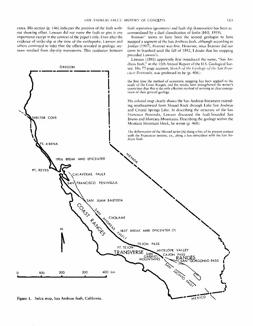
Figure 1. Index map, San Andreas fault, California.

114 M. L. HILL
T h i s casua l use of t he n a m e " S a n A n d r e a s " fo r t he f a u l t is t he only o n e in th is r e p o r t . C lea r ly it w a s n o t c o n s i d e r e d an i m p o r t a n t s t ruc-tu re . H o w e v e r , its n a m e is a p p r o p r i a t e a n d L a k e San A n d r e a s can be a c c e p t e d as the f au l t ' s " t y p e l oca l i t y . "
It a p p e a r s t h a t the t h i rd geo log i s t to desc r ibe , a l t h o u g h n o t m a p , a s e g m e n t of the San A n d r e a s f a u l t w a s F a i r b a n k s 5 ' ( 1 8 9 4 ) , w h o said (p. 4 9 5 ) :
The effects produced by a great earthquake, probably that of 1872, can be traced a number of miles along the stage road from Gorman Station to An-telope Valley, where large depressions still exist.
T h i s s h o r t s en t ence c o n t a i n s s o m e e r r o r s : an e a r t h q u a k e d id n o t p r o d u c e th is line of g r o u n d d e p r e s s i o n s , n o r d id o n e f a u l t dis-p l a c e m e n t , a n d the 1 8 5 7 F o r t T e j o n , n o t t he 1 8 7 2 O w e n s Val ley, e a r t h q u a k e w a s p r o d u c e d by m o v e m e n t o n this f a u l t zone .
Schuy le r ( 1 8 9 6 ) in his c o m p r e h e n s i v e p a p e r en t i t l ed Reservoirs for Irrigation, in the 18th A n n u a l R e p o r t of t he U.S. Geo log ica l Survey , de sc r ibed a f a u l t ( the San A n d r e a s ) o n the n o r t h s ide of the Sier ra M a d r e (San G a b r i e l ) M o u n t a i n s as f o l l o w s (p. 7 1 1 - 7 1 2 ) :
This reservoir [AlpineJ has special interest, not only as the first one of any magnitude completed on the . . . Antelope Valley side of the Sierra Madre in Southern California, but because it lies directly in the line of what is known as the great earthquake crack . . . This remarkable line of fracture can be traced for nearly 200 miles through San Bernardino, Los Angeles, Kern and San Luis Obispo counties . . . there appears to have been a distinct " fau l t " along the line [shown on fig. 120], the portion lying south of the line having sunken, and that to the north of it being raised in a well defined ridge.
A l t h o u g h t he " e a r t h q u a k e c r a c k " w a s wel l k n o w n local ly a n d at-t r i b u t e d t o t he F o r t T e j o n 1 8 5 7 even t , it s eems t h a t e x c e p t fo r Fair-b a n k s , n o geo log i s t h a d d e s c r i b e d it as a f au l t t r ace unt i l th is 1 8 9 6 a c c o u n t , b u t Schuy le r fa i led t o see t he n o w o b v i o u s g e o m o r p h i c ev idence f o r s t r ike-s l ip m o v e m e n t .
A n d e r s o n ( 1 8 9 9 ) p r o d u c e d a geo log ic m a p a n d r e p o r t , " T h e geo logy o f t he Po in t Reyes P e n i n s u l a , " o n the bas is o f field w o r k d o n e in 1 8 9 6 - 1 8 9 7 . H e w r o t e (p. 1 4 3 - 1 4 4 ) :
The evidence for faulting along the Baulinas-Tomales Valley . . . [is] to be seen both in topography and in the general stratigraphic and petrologic re-lations. East of the valley . . . the Franciscan series indicate an old topog-raphy, yet the transition to the narrow valley bottom is abrupt. The western border of the valley is formed by the high, steep ridge of granitic rock. This ridge is in most places capped by Miocene strata . . . Looking at any good map of the region . . . it seems more than probable that the valley and es-carpment of the Point Reyes Peninsula marks the continuation of faulting which is so pronounced at San Bruno Mountain.
A n d e r s o n p r o d u c e d a g o o d m a p s h o w i n g a s e g m e n t of the San A n d r e a s f au l t , b u t he e r r o n e o u s l y in fe r red reversa ls o f d ip-s l ip m o v e m e n t o n it. H e i m a g i n e d t h a t the n o r t h e a s t s ide m o v e d d o w n t o p r e s e r v e the F r a n c i s c a n , t h e n w a s l i f ted to r e m o v e the M i o c e n e s t r a t a , a n d t h e n m o v e d d o w n aga in t o reveal the g r a n i t e e sca rp -m e n t . H e m i s t a k e n l y a s s u m e d t h a t t he F ranc i s can s t r a t a w e r e de-p o s i t ed o n g ran i t i c rocks . H e c o n n e c t e d his f au l t w i t h L a w s o n ' s San B r u n o f a u l t o n the San F r a n c i s c a n Pen insu la , w h e r e a s the ea r th -q u a k e l a t e r p r o v e d t h a t it w a s c o n n e c t e d t o L a w s o n ' s ( 1 8 9 5 ) San A n d r e a s f au l t . H e a lso e r r ed in be l iev ing t h a t t he las t m o v e m e n t on his f a u l t d id n o t o f f s e t la te P le i s tocene t e r r a c e depos i t s .
Su rp r i s ing ly , t he n e x t d e s c r i p t i o n of a s e g m e n t of the San An-d r e a s f a u l t w a s in a p a p e r en t i t l ed Reconnaissance of the borax de-posits of Death Valley and the Mohave Desert ( C a m p b e l l , 1 9 0 2 ) . T h e a u t h o r , in t r ave l ing t h r o u g h C a j o n Pass o n his w a y t o the des-e r t , a t t r i b u t e d t he s t r a igh t s o u t h e a s t w a r d c o u r s e of L o n e Pine C a n -y o n , a n d t he j u x t a p o s i t i o n of u n l i k e r o c k s ac ros s it, t o f au l t i ng .
O s m o n t ( 1 9 0 4 ) a p p e a r s t o h a v e been the n e x t geo log i s t to m a p a n d desc r ibe s e g m e n t s of t he San A n d r e a s f au l t b e f o r e the 1 9 0 6 e a r t h q u a k e . H i s t w o l o n g geo log ica l t raverses f r o m the Pacif ic O c e a n to t he S a c r a m e n t o Val ley c rossed the San A n d r e a s in M a r i n C o u n t y , w h e r e it w a s cal led the B a u l i n a s - T o m a l e s f au l t . H e refer-red t o t he f a u l t (p. 79) as f o l l o w s :
At Bodego Head (section AB) and Point Reyes Peninsula (section CD) the pre-Franciscan granitics (diorite) have probably been brought to light by a great fault along the line of Bodega and Tómales Bay, seemingly the north-west extension of the San Bruno fault . . . of the San Franciscan Peninsula.
O s m o n t o b v i o u s l y f o l l o w e d A n d e r s o n ( 1 8 9 9 ) in i n f e r r i n g reversa ls of t h r o w o n th is f au l t , a n d its c o n n e c t i o n w i t h L a w s o n ' s ( 1 8 9 5 ) San B r u n o f au l t . H e s t a ted (p. 48) ,
But we know that they [granitic rocks] lie unconformably below the Fran-ciscan. . . .
T h e las t of the e igh t a c c o u n t s of s e g m e n t s of t he San A n d r e a s f a u l t t h a t a p p e a r e d b e f o r e t he San F r a n c i s c o e a r t h q u a k e seems t o be t he o n e w r i t t e n by M e n d e n h a l l ( 1905 ) in his p a p e r , The hy-drology of the San Bernardino Valley. H e r e p o r t e d (p. 3 0 ) :
A great fault runs northwest and southeast through the Cajon and San Gor-gonio passes and along the base of the San Bernardino Mountains. In the movement along this fracture a portion of the earth's crust north of the present valley was uplifted and now forms the San Bernardino Mountains.
H i s sec t ions (p. 3 2 , 3 6 , 68) s h o w a n o r m a l f a u l t s e p a r a t i n g the m o u n t a i n s f r o m the val ley. I m a g i n e M e n d e n h a l l ' s s u r p r i s e w h e n , a f t e r t he 1 9 0 6 e a r t h q u a k e , his f a u l t w a s f o u n d t o be c o n n e c t e d t o w h a t h a d been c o n s i d e r e d a " m i n o r " f a u l t o n t he San F r a n c i s c o P e n i n s u l a , s o m e 6 4 0 k m a w a y .
I h a v e f o u n d n o o t h e r r e f e r ences w h i c h c o n t a i n d e s c r i p t i o n s of any p o r t i o n of t he San A n d r e a s f au l t e x c e p t as r e c o r d e d he re , unt i l the g r e a t e a r t h q u a k e of Apr i l 18, 1 9 0 6 , m a d e it f a m o u s . In this case , as so o f t e n h a p p e n s in geo logy , t he n a t u r a l c a t a s t r o p h e s t imu-la ted i m m e d i a t e a n d in tens ive s t u d y o f the fau l t . At last , the p a r t s o f the " e l e p h a n t " w e r e a s s e m b l e d t o reveal a m a j o r f r a c t u r e z o n e p r o -duc t ive of g r e a t e a r t h q u a k e s by h o r i z o n t a l l y o r i e n t e d e las t ic re-b o u n d d u e t o a c c u m u l a t i v e c rus t a l s t r a in . T h e r e f o r e , in a very real sense, the San F ranc i s co e a r t h q u a k e i n t r o d u c e d a r e v o l u t i o n in sci-ent i f ic t h o u g h t as a p p l i e d t o th is f au l t a n d t o s e i smology a n d fau l t -ing in gene ra l .
Ac tua l ly , it t o o k t he e a r t h q u a k e t o d e m o n s t r a t e t h a t s t r ike-s l ip w a s a t leas t o n e k i n e m a t i c m o d e of d i s p l a c e m e n t o n t he San A n -d r e a s f au l t . It m a y h a v e been the first r e c o g n i t i o n o f s t r ike-s l ip m o v e m e n t o n a n y m a j o r f au l t . If so , it surely m a r k s a very i m p o r -t a n t a d v a n c e m e n t in t he u n d e r s t a n d i n g of fau l t s .
T h e s u r f a c e t r ace of t he f au l t , a l o n g w h i c h m o v e m e n t o c c u r r e d a t t he t i m e of t he e a r t h q u a k e , w a s f o u n d t o e x t e n d c o n t i n u o u s l y fo r nea r ly 3 2 0 k m s o u t h e a s t w a r d f r o m Po in t A r e n a t o San J u a n Bau t i s t a . T h e la rges t o f f s e t of a b o u t 6 . 4 m w a s m e a s u r e d o n the P o i n t Reyes Pen insu l a . As n o t e d la te r , t h o u g h , this figure is mi s l ead -ing b e c a u s e it is ~ 1 .5 m m o r e t h a n any o t h e r d i s p l a c e m e n t in the ep i cen t r a l a r ea , a n d a c c o r d i n g to G i l b e r t ( L a w s o n , 1 9 0 8 , p. 71) , it w a s p r o b a b l y a u g m e n t e d by surf ic ia l m o v e m e n t . It qu i ck ly b e c a m e ev iden t t h a t t he f a u l t l ine e x t e n d e d m u c h f a r t h e r t o t he s o u t h e a s t ; c o m p i l a t i o n of r e p o r t s , c o n t a c t s w i t h geo log i s t s w h o w e r e f a m i l i a r w i t h t he reg ion , a n d r a p i d r e c o n n a i s s a n c e ( L a w s o n , 1 9 0 6 ) all con -t r i b u t e d t o k n o w l e d g e of its e x t e n s i o n .
T h e M i n i n g a n d Scient if ic Press inc luded severa l a r t ic les o n t he e a r t h q u a k e sho r t l y a f t e r t he e v e n t . Its p u b l i c a t i o n w a s i m m e d i a t e l y
SAN ANDREAS FAULT: HISTORY OF CONCEPTS 4
t r a n s f e r r e d f r o m San F ranc i s co to Berkeley, and 011 Apri l 2 8 a sol-icited d i scuss ion by G i l b e r t * (1906 ) a p p e a r e d u n d e r the tit le, " T h e n a t u r e a n d cause of e a r t h q u a k e s . " H i s brief e x p l a n a t i o n s a r e the se i smologica l o r t h o d o x y of t o d a y , a n d the f o l l o w i n g q u o t a t i o n s h o w s t h a t he h a d the c o n c e p t of e a r t h q u a k e g e n e r a t i o n by elas t ic r e b o u n d on faul ts , w h i c h w a s deve loped later by Reid (1910) . Gil-be r t w r o t e (p. 2 7 2 ) :
Before fracture occurs there is elastic yielding, or strain; that is, the rock is compressed or stretched or bent somewhat like a spring; and when its strength is at last overcome the dissevered parts recoil . . . The fracturing producing a tectonic earthquake may be the mere parting of the rock, but usually there is a slipping along the fracture, constituting a fault. Some of the faults making earthquakes are visible at the surface. The Inyo county earthquake in 1872 was associated with a dislocation of several feet, which can still be seen along the western margin of Owen's Valley.
B r a n n e r ( 1 9 0 6 ) w r o t e in the s a m e j o u r n a l u n d e r the title " A n au -tho r i t a t i ve o p i n i o n as fo l l ows (p. 3 4 7 ) :
Ever since I've been in California I have been making a study of the geology of the Santa Cruz range of mountains. The work of mapping out the faults was completed about six weeks ago. Immediately after the earthquake 1 went out to see if these fault lines had been doing any business. I found, as expected, they had. Where we had located the line on the map was a great furrow, marking the line of disturbance . . . It showed a lateral displacement of at least 8 feet.
H e p r o p o s e d th ree theor ies fo r the e a r t h q u a k e .
The first is that the increase of temperature in the earth, gradually coming toward the surface, has caused an expansion of the rock and a consequent pressure outward. The second is that rocks which were hot have become cooler and contracted, producing a strain in the other direction. The third is that the shifting of the load on top of the earth [by erosion and deposition] produces the pressure.
It is revea l ing to c o m p a r e th is last s t a t e m e n t of B r a n n e r ' s o n the or ig in o f e a r t h q u a k e s w i t h the m u c h m o r e m e a n i n g f u l o n e by Gil-be r t , q u o t e d above .
L a w s o n (1906 ) , on beha l f of the E a r t h q u a k e C o m m i s s i o n , pre-sen ted a p r e l im ina ry r e p o r t in Science ( June 29) . H e desc r ibed the l oca t i on a n d g e o m o r p h o l o g y of the " r i f t " f r o m n e a r C a p e M e n -d o c i n o in to s o u t h e r n C a l i f o r n i a ; the e x t e n t of g r o u n d r u p t u r e ; the d i s t r i b u t i o n of seismic intensi t ies , a n d the g r o u n d c o n d i t i o n s w h i c h in f luenced the d a m a g e to m a n - m a d e s t ruc tu res . H e w r o t e (p. 9 6 3 ) :
Along the 185 miles of this rift where the movement has actually been ob-served the displacement has been chieflly horizontal on a nearly vertical plane, and the country on the southwest of the rift has moved northwesterly relative to the country on the northeast of the r i f t . . . in one case a roadway was found to be differentially moved twenty feet . . . The cause of these movements in general terms is that stresses are generated in the earth's crust which accumulate till they exceed the strength of the rocks . . . and they find relief in a sudden rupture.
R e f e r r i n g t o the g e o m o r p h o l o g y of the f a u l t zone , he a d d e d (p. 9 6 2 ) ,
The scarps can only be ascribed to a rupture of the earth with a relative vertical displacement along the rupture plane.
It is in te res t ing to c o m p a r e L a w s o n ' s r e a s o n a b l e e x p l a n a t i o n of the e a r t h q u a k e w i t h B r a n n e r ' s . But the 2 0 ft (6.1 m) o f f s e t is exces-sive a n d L a w s o n ' s s ca rp s can be e x p l a i n e d by o t h e r t h a n d ip-s l ip m o v e m e n t , as G i lbe r t (in L a w s o n , 1908) w a s to e x p l a i n .
An in te res t ing co l lec t ion of e igh t p a p e r s , six of w h i c h involve geo logy , a p p e a r e d in the b o o k , The California Earthquake of IVO6, ed i t ed by J o r d a n ( 1 9 0 7 ) . J o r d a n s t a ted (p. 5) :
The California earthquake of 1906 follows the axis of a very ancient break, the Portola-Tomales fault, also called the San Andreas fault, first studied, as far as I know, by Dr. John C. Branner in 1891.
B r a n n e r , the p r inc ipa l a u t h o r o f Santa Cruz Folio I <\ 1 (pub l i shed by t he U.S. Geo log ica l Survey in 1909) h a d m a p p e d the P o r t o l a a n d S tevens C r e e k faul t s in his a rea b e f o r e 1 9 0 6 b u t d id n o t then k n o w they c o m p r i s e d a s ingle f au l t o r w e r e c o n n e c t e d t o L a w s o n ' s San A n d r e a s fau l t . A l t h o u g h B r a n n e r ' s m a p p i n g h a d been as ear ly as 1892 , it w a s n o t pub l i shed (excep t as e x c e r p t s in a p o p u l a r ar t ic le by A r n o l d , 1901 , unti l 1 9 0 9 . A l t h o u g h J o r d a n (1907 ) bel ieved t h a t B r a n n e r w a s the first to m a p a s e g m e n t of the San A n d r e a s fau l t , the record indica tes t h a t L a w s o n m a p p e d his s e g m e n t on the San F ranc i sco Peninsu la ear l ie r .
Q u o t i n g G i lbe r t in J o r d a n ' s b o o k (p. 2 1 6 - 2 1 7 ) :
I did not learn until two hours later that a great disaster had been wrought 011 the opposite side of the bay and that San Francisco was in flames. This information at once incited a tour of observation and thus began, as far as I was personally concerned, the investigation of the earthquake. A similar beginning was doubtless made by every other geologist in the State . . . but organization soon followed, and by the end of the second day . . . men were working in cooperation under the leadership of Professor J. C. Branner, of Stanford University, and Professor A. C. Lawson, of the State University at Berkeley . . . On the third day after the shock, Governor Pardee appointed a State Earthquake Investigation Commission, naming as its chairman — Professor Lawson.
In the s a m e b o o k , T a b o r ' sa id (p. 2 5 9 ) :
The particular fault which caused the earthquake is the Steven's Creek (Portola-Tomales) fault. It has been traced across the Santa Cruz quad-rangle by Dr. J. C. Branner and Dr. J. F. Newsom and described by them in the unpublished Santa Cruz folio of the United States Geological Survey.
T h e last q u o t a t i o n s I t ake f r o m J o r d a n ' s b o o k a re by F a i r b a n k s , w h o w r o t e (p. 3 2 4 ) :
As a matter of fact, certain portions of the great rift [San Andreas] have been known to the country people living along it for many years. Especially is this true of the southern portion, which opened in 1857 . . . Previous to the earthquake of April, 1906, the writer had traced the rift for fully 400 miles . . . It is clear that less than half of the known rift opened during the recent disturbance.
In e x p l a i n i n g sca rps a l o n g the fau l t , he said (p. 3 2 7 ) ,
The effects of the Tejon earthquake are still visible although it took place fifty years ago. Imagination alone can picture the destructive effects of an earthquake which could form scarps 100 to 300 feet high.
T h e first of these s t a t e m e n t s sugges ts t h a t F a i r b a n k s w a s m u c h m o r e impressed w i t h the San A n d r e a s a f t e r the 1906 even t t h a n be-fore , a reac t ion he ce r ta in ly s h a r e d w i t h the seven o t h e r geo logis t s w h o h a d desc r ibed s e g m e n t s of it. In my review of his m a n y publ i -c a t i o n s 011 C o a s t R a n g e s geo logy , the p rev ious ly q u o t e d s t a t e m e n t (1894 ) w a s his on ly p r e - 1 9 0 6 re fe rence to this " g r e a t r i f t . " H i s sec-o n d s t a t e m e n t , above , ind ica tes his belief , even a f t e r the of f se t s of 1906 , t h a t u p - a n d - d o w n (dip-sl ip) m o v e m e n t s w e r e cha rac t e r i s t i c of th is fau l t . In this, a n d o t h e r of his wr i t i ngs , it is o b v i o u s t h a t he t h o u g h t the d i s p l a c e m e n t in 1 9 0 6 w a s very m i n o r c o m p a r e d to those w h i c h he bel ieved f o r m e d 100- to 3 0 0 - f t (30- to 9 1 - m ) sca rps .
T h e f o r e g o i n g a c c o u n t s of the local r ecogn i t i ons of s e g m e n t s of the San A n d r e a s b e f o r e 1 9 0 6 , a n d the i r i n t e r p r e t a t i o n s , are surely no t en t i re ly a c c u r a t e o r c o m p l e t e . H o w e v e r , they serve t o s h o w t h a t these ear ly field geologis t s , l ike the b l ind m a n gues s ing the n a t u r e of the e l e p h a n t , w e r e really in the d a r k w i th respec t t o t he f au l t ' s length . O b v i o u s l y , it t o o k the e a r t h q u a k e t o reveal its c o n t i n u i t y

5 M. L. HILL
a n d t o first ind ica te , as a r e v o l u t i o n a r y scient i f ic c o n c e p t , its t ec ton ic i m p o r t a n c e . F o l l o w i n g the e a r t h q u a k e , m a n y geologis t s l e a r n e d m u c h a b o u t th is g r e a t s t r u c t u r e a n d qu ick ly w r o t e scien-tifically g o o d o r b a d p r e l i m i n a r y a c c o u n t s of it. H o w e v e r , it w a s n o t unt i l the r e p o r t of the C a l i f o r n i a E a r t h q u a k e Inves t iga t ion C o m m i s s i o n ( L a w s o n a n d o the r s , 1908 , a n d Reid , 1910) t ha t these facts a n d a c c o m p a n y i n g i n t e r p r e t a t i o n s w e r e sys temat ica l ly pre-sen ted .
THE EARTHQUAKE COMMISSION REPORT TO 1926
T h r e e d a y s a f t e r t he San F ranc i s co e a r t h q u a k e , t he E a r t h q u a k e Inves t iga t ion C o m m i s s i o n of e igh t h ighly qua l i f i ed sc ient is ts w a s a p p o i n t e d by G o v e r n o r P a r d e e to s tudy a n d r e p o r t on the e f fec ts a n d causes of the e a r t h q u a k e . T h e c h a i r m a n of the C o m m i s s i o n , P r o f e s s o r A. C. L a w s o n , w a s r e spons ib l e fo r p r o d u c i n g a t w o -v o l u m e r e p o r t en t i t l ed , The C.alifornia Earthquake of April IS, 1906 . V o l u m e 1 ( 1 9 0 8 ) by th is s a m e title, w a s w r i t t e n largely by L a w s o n d u r i n g the w i n t e r of 1906—1907 . It inc ludes d e s c r i p t i o n s of the g e o m o r p h o l o g y , a n d w h a t little w a s k n o w n of the geo logy , a l o n g a l m o s t the en t i re l eng th of the San A n d r e a s fau l t , sys-t ema t i ca l ly a r r a n g e d d e s c r i p t i o n s of o f f s e t g r o u n d a n d m a n - m a d e s t r u c t u r e s a l o n g the ac t iva t ed f au l t t race , a n d 146 i l lus t ra t ions , ma in ly p h o t o g r a p h s of g r o u n d d i s t u r b a n c e s a n d d a m a g e d bui ld-ings. ( T h e t e r m , " r i f t , " used cons i s t en t ly in the r e p o r t , is n o longer a p p r o p r i a t e ) . V o l u m e II, en t i t l ed The Mechanics of the Earth-quake, w r i t t e n by P r o f e s s o r H . F. Reid , inc luded an ana lys i s of g r o u n d m o t i o n s and i n s t r u m e n t a l r eco rds of the e a r t h q u a k e . It w a s in th is v o l u m e t h a t the c lass ical , a n d still app l i cab le , elast ic-r e b o u n d t h e o r y of e a r t h q u a k e s w a s deve loped . An At la s (1908 ) of 2 5 m a p s , i nc lud ing the l o c a t i o n of the f au l t t r ace o n U.S. Geo log i -cal Survey t o p o g r a p h i c q u a d r a n g l e s a n d cop ies o f 92 s e i s m o g r a m s f r o m s t a t i o n s a r o u n d the w o r l d , a c c o m p a n i e d the r e p o r t . T h e or ig-inal r e p o r t w a s financed a n d re leased by the C a r n e g i e Ins t i tu t ion of W a s h i n g t o n , D . C . , as Pub l i ca t i on 87 . F o r t u n a t e l y , it is aga in avail-ab le in t he r ep r in t ed C a r n e g i e Ins t i tu t ion ed i t ion of 1 9 6 9 , ed i ted by the late W . W . R u b e y .
T h e r e p o r t of the C o m m i s s i o n w a s a p r o m i n e n t " b e n c h m a r k " in the o n g o i n g s tudy of the San A n d r e a s fau l t , b e c a u s e it p r e sen t ed the first c o m p r e h e n s i v e de sc r ip t i on of t he g e o m o r p h o l o g y a n d the then k n o w n geo logy of th is recent ly d i scove red s t r u c t u r e . T h e f o r e g o i n g sect ion of th is h is tory c u l m i n a t e d w i t h the d i scovery of an act ive fau l t z o n e as revea led by a 3 2 0 - k m - l o n g z o n e of g r o u n d b r e a k a g e a c c o m p a n y i n g t he San F ranc i sco e a r t h q u a k e , w h e r e a s this sect ion t akes of f f r o m the sol id base of the C o m m i s s i o n ' s r epo r t .
I begin here by q u o t i n g an i n t r o d u c t o r y s t a t e m e n t by L a w s o n (p. 2 of the r epo r t ) :
The cause of the earthquake . . . was the sudden rupture of the earth's crust along a line . . . from the vicinity of Point Delgada [Humboldt Countyl to a point in San Benito County near San Juan; a distance, in a nearly straight course, of about 270 miles. For a distance of 190 miles from Point Arena to San Juan, the fissure formed by this rupture is known to be practically con-tinuous . . . This line is marked by features due to former earth movements and will be referred to in a general way as a rift, the term being adopted from the usage for analogous features in Palestine and Africa. To distin-guish it from other rifts of similar origin, it will be referred to more spec-ifically as the San Andreas Rift, the name being taken from the San Andreas Valley on the peninsula of San Francisco . . . where its diastrophic origin was first recognized in the literature. The plane or zone on which the rup-ture took place is . . . nearly vertical; and upon this vertical plane there oc-curred a horizontal displacement. . . The displacement was such as to cause the country to the southwest of the rift line to be moved northwesterly rela-tive to the country on the northeast side of that line. The differential dis-placement in a horizontal direction . . . in many places measured over 15 feet, and in one place as much as 21 feet.
L a w s o n m u s t be r e f e r r i ng he re t o his o w n w o r k ( 1 8 9 3 ) , b u t he m a y h a v e o v e r l o o k e d t he fac t t h a t he first used t he n a m e , " S a n An-d r e a s f a u l t , " in a la ter p u b l i c a t i o n (1895 ) fo r w h a t he h a d p r o b a b l y m a p p e d in 1891 a n d first de sc r ibed in 1893 .
L a w s o n ' s s u m m a r y s t a t e m e n t s on s t r u c t u r e (p. 17 — 19) inc luded a d i scuss ion of fau l t s in C a l i f o r n i a . S o m e of these w e r e n a m e d , lo-c a t e d , a n d very briefly d e s c r i b e d . M a p 1 of the At l a s a c c o m p a n y i n g the r e p o r t is a f au l t m a p of of the Sta te of C a l i f o r n i a , a n d Plate 15 ( o p p o s i t e p. 8) is a g e o m o r p h i c - g e o l o g i c m a p of t he San F ranc i s co Pen insu la , s h o w i n g faul ts , i nc lud ing t he type local i ty of the San A n d r e a s . T h i s first f au l t m a p o f C a l i f o r n i a ( L a w s o n , 1 9 0 8 ) s h o w e d few fau l t s c o m p a r e d to m a p s by Wil l i s a n d W o o d ( 1 9 2 2 ) a n d J e n -n ings ( 1 9 7 5 ) . T h e m a p of the San F r a n c i s c o P e n i n s u l a w a s r e p r o -d u c e d f r o m an ear l ier r e p o r t ( L a w s o n , 1895) . L a w s o n w r o t e (p. 1 8 - 1 9 ) :
The most interesting fault traversing the Peninsula of San Francisco is the San Andreas fault, on which movement was renewed on April 18, 1906, causing the earthquake.
It [the San Andreasl is only one of many faults, on all of which in past time there have occurred many differential movements, each productive of an earthquake.
Before the San F ranc i s co even t , th is f au l t h a d been desc r ibed a n d m a p p e d by L a w s o n (1 8 9 3 , 1895) as a m i n o r o n e o n t he pen insu l a , bu t , of cou r se , a f t e r t he e a r t h q u a k e , it b e c a m e " i n t e r e s t i n g . " W e n o w k n o w t h a t c r eep can o c c u r a l o n g fau l t s w i t h o u t t he g e n e r a t i o n of e a r t h q u a k e s , t h a t f ew ac t ive f au l t s a r e c h a r a c t e r i z e d by suf f ic ien t ly large a n d s u d d e n slips t o cause s ign i f i can t e a r t h q u a k e s , a n d t h a t m a n y fau l t s a re inact ive .
In L a w s o n ' s 2 2 - p a g e d i scuss ion of The San Andreas Rift as a Geoniorphic Feature, w h i c h p rog re s se s in g e o g r a p h i c s e g m e n t s f r o m n e a r C a p e M e n d o c i n o s o u t h e a s t w a r d t o t he Sa l ton Sea, he s t a t ed (p. 2 6 , 27 , 29 ) :
From Shelter Cove to near Point Arena, the Rift, if continuous, lies beneath the waters of the Pacific . . . In the vicinity of Fort Ross, the geomorphic forms of the Rift are particularly well exemplified . . . low ridges . . . mark its course . . . Behind the ridges and scarps are ponds and small swamps. Some of the streams follow the Rift . . . It is also a remarkable fact that altho on the east side of the defile [Bolinas-Tomales valleysjthe Franciscan rocks constitute . . . a thickness of several thousand feet, this entire series . . . i s . . . absent between the Monterey and granitic rocks on the Peninsula in the immediate vicinity [on the west side of the defile]. This indicates clearly that in pre-Miocene time the peninsula mass had been uplifted on a f a u l t . . . so that granite was brought against the Franciscan and denuded of its unconformable mantle of sedimentary strata before it was [again] sub-merged to receive deposits of Monterey time. It is also clear that inasmuch as there is a great volume of Monterey shales on the . . . seaward side of the fault line, and no trace of the same formation of the mainland to the east of the fault line, one of two things must have happened. Either the sub-mergence which permitted the deposition of the Monterey shales was confined to the Peninsula and was effected by a downthrow on that block or the same fault as that upon which it had earlier been upthrust . . . or if the regions on both sides of the fault were submerged together, then in Post-Miocene time the east side of the fault was uplifted into the zone of erosion and denuded of its cover of Monterey . . . There is no escape from one or the other of these conclusions . . . The trace of this ancient fault is also the line of the modern Rift.
In r ega rd t o t he first q u e s t i o n a b o v e , C u r r a y a n d N a s o n ' s ( 1 9 6 7 ) m a r i n e se ismic prof i les ind ica te t h a t t he San A n d r e a s is c o n t i n u o u s f r o m P o i n t A r e n a to Shel te r C o v e . T h e last q u o t a t i o n ind ica t e s t h a t L a w s o n f o l l o w e d , o r led, A n d e r s o n ( 1 8 9 9 ) in e x p l a i n i n g t he d i f fe r -ence b e t w e e n s t r a t i g r a p h i c sec t ions o n o p p o s i t e sides of the f au l t , w h e r e a s , n o w they a re e x p l a i n e d by m a n y miles o f h o r i z o n t a l (s t r ike-s l ip) d i s p l a c e m e n t . A n d e r s o n f o l l o w e d h j s p r o f e s s o r ' s e r r o r ( L a w s o n , 1 8 9 3 ) in a s s u m i n g t h a t F r anc i s can s t r a t a h a d t o be d e p o -

SAN ANDREAS FAULT: HISTORY OF CONCEPTS 117
si ted on g ran i t i c b a s e m e n t , a n d n e i t h e r of t h e m cou ld see the "es -c a p e " f r o m u p a n d d o w n (dip-sl ip) m o v e m e n t s o n the San A n d r e a s .
L a w s o n c o n t i n u e d (p. 3 5 of t he r e p o r t ) :
From the top of these cliffs [Mussell Rock] . . . the course of the Rift as far as San Andreas Lake is marked by a line of shallow . . . depressions, ponds and low scarps. This portion of the modern Rift was recognized as such in 1893.
T h i s last sen tence ind ica tes t h a t L a w s o n w a s n o t su rp r i s ed t h a t g r o u n d b r e a k a g e h a d o c c u r r e d here in 1 9 0 6 . A l t h o u g h he h a d rec-ogn ized t h a t m o v e m e n t o n th is f au l t w a s pos t -P l i ocene (1893 ) , h o w e v e r , he def ini te ly c o n s i d e r e d it t o be a relat ively m i n o r fau l t on the San F ranc i s co Pen insu la ( 1 8 9 5 ) , a n d he p r o b a b l y w a s su rp r i s ed t h a t t he s u r f a c e d i s loca t i on w a s o n it.
T h e Por to la—Steven ' s C r e e k s e g m e n t of t he f au l t is very briefly desc r ibed by L a w s o n , a l t h o u g h a c c o r d i n g to B r a n n e r (1906 ) , J o r -d a n (1907 ) , a n d T a b o r ( 1 9 0 7 ) , th is a r e a h a d been m a p p e d by B r a n n e r a n d his S t a n f o r d Univers i ty assoc ia tes l o n g b e f o r e the e a r t h q u a k e . T h e q u e s t i o n ar ises as t o w h y B r a n n e r d id no t , as a m e m b e r of t he C o m m i s s i o n , w r i t e th is sec t ion of the r e p o r t ? M y guess is t h a t i n s t i tu t iona l c h a u v i n i s m a n d p r o f e s s i o n a l j ea lousy m o t i v a t e d L a w s o n to avo id us ing B r a n n e r , a l t h o u g h he d id use Lar-sen ' s (Univers i ty of C a l i f o r n i a ) desc r ip t ion (p. 36—37) in the n e x t sou the r ly s e g m e n t .
T h e s o u t h e r n p o r t i o n of the f au l t , 4 8 0 k m long a n d less wel l m a p p e d , w a s desc r ibed by H . W . F a i r b a n k s (p. 3 8 - 4 7 ) . H e began (p. 38 ) :
The earthquake of April 18, 1906 opened and displaced the walls of the old fault along the Rift as far south as the town of San Juan in San Benito County . . . at a point midway between the [San Juan River] bridge and San Juan, there is shown in a broken fence a horizontal displacement of 4 feet.
In desc r ib ing the f au l t s o u t h of the San Ben i to Pos t Off ice , he w r o t e (p. 39 ) :
A fertile valley . . . appears to have been formed by subsidence, while on the southwest is an abrupt ridge 200 feet high and fully a mile long. The ridge without doubt has been produced by faulting. Its abrupt northeastern face and long, gentle, southwesterly slope suggest in a remarkable manner the great fault blocks of the west, such as the Sierra Nevada Range.
T h i s s t a t e m e n t by F a i r b a n k s ind ica tes t h a t he, a n d m o s t o t h e r geologis t s , i n t e rp re t ed the t o p o g r a p h i c sca rps in the f a u l t z o n e as h a v i n g been p r o d u c e d by d ip-s l ip m o v e m e n t s . It w o u l d be interest-ing t o k n o w h o w Gi lbe r t w o u l d have i n t e rp r e t ed these sca rps , con-s ide r ing his r ecogn i t ion t h a t s t r ike-s l ip m o v e m e n t a t t he t ime of the e a r t h q u a k e p r o d u c e d a p p a r e n t vert ical m o v e m e n t of a s lop ing g r o u n d s u r f a c e (in L a w s o n , 1 9 0 8 , p. 72) .
F a i r b a n k s c o n t i n u e d (p. 41 - 4 2 ) ,
The people living along the Rift for 150 miles southeastward from Cholame Valley tell wonderful stories of openings made in the earth by the earth-quake of 1857 . . . It [the Rift on the southwest side of the Temblor Range] is marked by a distinctly steeper slope . . . showing that an uplift of 30 to 50 feet took place on the west side . . . This ridge [Elkhorn Hills] is clearly a fault block, now separating the Carissa [Carrizol Plain from Elkhorn Plain. It probably originated during some one of the earlier movements along the Rift; in fact it is reasonable to suppose that it is of the same age as other important scarps which mark the Rift throughout its whole course, and which came into existence as a result of some mighty movement opening the earth for several hundred miles . . . Plainly visible along the steep front of the line of hills described are the lesser ridges and hollows produced during the last violent earthquake in this region, probably in 1857 . . . The larger scarps belong to some ancient disturbance, while the last one, probably dat-ing from 1857, is marked by features comparatively insignificant.
It is likely t h a t F a i r b a n k s h a d seen m o r e of t he f au l t f r o m its n o r t h e r n s e g m e n t in H u m b o l d t C o u n t y t o its u n c e r t a i n loca t ion in t he C o l o r a d o D e s e r t t h a n a n y o t h e r geo log i s t . H o w e v e r , the gene ra l i z a t i on t h a t " i m p o r t a n t s ca rp s m a r k the r i f t t h r o u g h o u t its w h o l e c o u r s e " is t o o s w e e p i n g ; s ca rp s like these b o u n d i n g the Elk-h o r n Hil ls , a n d m o s t o t h e r s a l o n g the r if t , d id n o t c o m e in to exis-t ence t h r o u g h a n y o n e m o v e m e n t of tens to h u n d r e d s of feet, o r even by repet i t ive d ip-s l ip m o v e m e n t s .
In desc r ib ing the f au l t w i t h i n the San E m i g d i o M o u n t a i n s a n d o n the n o r t h side of the San G a b r i e l R a n g e , F a i r b a n k s s t a t ed (p. 4 2 -43) :
Santiago Canyon marks a great fault of earlier times. Soft Tertiary forma-tions are faulted down thousands of feet upon the south side of the canyon, while upon the north appear the steep granitic slopes of the western spur of San Emedio Mountain [San Emigdio Mountains] . . . The long desert waste plain [Antelope Valley] leading up to the foot of the mountains on the south (San Gabriel Range) exhibits a strikingly interesting feature. It is not con-tinuous across the line of the Rift, but shows a break with the uplift upon the lower [north] side. The amount of displacement appears to be between 200 and 300 feet.
T h e s e q u o t a t i o n s s h o w t h a t F a i r b a n k s a s s u m e d , f r o m s t ra t i -g r a p h i c a n d t o p o g r a p h i c c r o s s - f a u l t r e la t ions , t h a t m o v e m e n t s on the f a u l t w e r e p r imar i ly u p a n d d o w n (dip-sl ip) , w h e r e a s w e k n o w h o r i z o n t a l m o v e m e n t s (s tr ike-sl ip) j u x t a p o s e un l ike s t r a t i g r a p h i c sec t ions a n d u n e q u a l g r o u n d e leva t ions . Aga in , th is i l lus t ra tes the c o n f u s i o n , e x t a n t even t o d a y , b e t w e e n the c o n c e p t s of f au l t sep-a r a t i o n (geomet ry) a n d f a u l t slip (k inemat ics ) .
F a i r b a n k s desc r ibed the f a u l t o n the s o u t h side of the San Ber-n a r d i n o M o u n t a i n s as f o l l o w s (p. 4 4 - 4 5 ) :
On the west side of Diablo [Devil] Canyon there is a double escarpment in the gravels, both apparently being due to movements along the Rift. There is a much dissected fault cliff 200-300 feet in height. Plainly traceable in the front of this cliff is a small break, possibly made in 1857. No definite infor-mation could be gained as to whether the earth opened here at that time, but reports say the earthquake was very severe, throwing animals from their feet, etc. . . . The southern portion of the San Bernardino Range lying be-tween Mill Creek and the Conchilla [Coachilla] Desert appears to have un-dergone great disturbance at a recent date. As a consequence, erosion has-been rapid and extensive, and surface features which further north made the Rift easy to follow have in this region been almost completely obliterated.
H e r e is a n o t h e r i nd ica t ion t h a t F a i r b a n k s t h o u g h t s ca rp s several h u n d r e d feet h igh cou ld a c c o m p a n y c a t a s t r o p h i c e a r t h q u a k e s . Re-cen t s tudy (Sieh, 1978) has s h o w n t h a t g r o u n d " o p e n i n g " p r o b a b l y did n o t o c c u r he re in 1 8 5 7 (ac tual ly , o p e n i n g o r r i f t i ng a l o n g the San A n d r e a s fau l t is n o m o r e c o m m o n t h a n " o v e r l a p p i n g " w i t h the f o r m a t i o n of the so-cal led p r e s su re r idges).
F a i r b a n k s c o n t i n u e d (p. 4 6 - 4 7 ) :
It was thought that the Rift, if continued on southeasterly, would be found crossing the San Gorgonio Pass . . . skirting the [north-] eastern base of the San Jacinto Range; bur this proved not to be the case. Instead, it was found to turn more and more easterly and finally to extend parallel to the pass without reaching it . . . It may be reasonably assumed, then, from our best knowledge, that the southern end of the great Rift is to be traced for an unknown distance along the base of the mountains bordering the Salton Basin on the northeast, in all probability dying out.
F a i r b a n k s , o t h e r s of his t ime , a n d even the geologis t s of t o d a y , h a v e t r ied to t race the San A n d r e a s fau l t t h r o u g h the San G o r g o n i o Pass a n d f a r t h e r t o the s o u t h e a s t ; a l t h o u g h several f au l t s have been m a p p e d , t he re is u n c e r t a i n t y a b o u t w h i c h specif ic o n e is t he San A n d r e a s , sensu stricto.
A f t e r a o n e - p a g e de sc r ip t i on of the then k n o w n e a r t h q u a k e p r o -d u c i n g San J a c i n t o fau l t , L a w s o n c o n c l u d e d this sec t ion of the re-

1 1 8 M. L.
p o r t w i t h a five-page " R e v i e w of sa l ien t [ g e o m o r p h i c ] f e a t u r e s . " H e w r o t e (p. 5 2 ) :
The Rift is known from Humboldt County to the north end of the Colorado Desert . . . and in the usage of the term [Rift] it has been understood as terminating at a point where it eluded field observation. But it is by no means certain that, as a larger feature, it does not extend far to the south . . . It thus seems not improbable that the three great earthquakes of California, Chilpancingo [near Acapulco, Mexico] and Jamaica may be on the same seismic line which is known in California as the San Andreas Rift.
P e r h a p s L a w s o n d id n o t ag ree , as he s e l d o m d id , w i t h F a i r b a n k s o n t he t e r m i n a t i o n of t he San A n d r e a s , o r p e r h a p s he on ly w a n t e d t o p o i n t o u t t h a t his s p e c u l a t i o n o n an e x t e n s i o n of t he f r a c t u r e z o n e w a s jus t as g o o d as the s p e c u l a t i o n by F a i r b a n k s . P resen t m a p p i n g a n d i n t e r p r e t a t i o n s f a v o r F a i r b a n k ' s m o d e l , b u t t he loca-t ion a n d m e c h a n i s m of t he f a u l t ' s t e r m i n a t i o n h a v e n o t yet been ful ly r e so lved .
T h e n e x t sec t ion of the r e p o r t (p. 5 3 - 1 1 3 ) c o m p r i s e s desc r ip -t ions , p r o g r e s s i n g f r o m n o r t h t o s o u t h , of the Apr i l 18, 1906 , g r o u n d m o v e m e n t s a n d the i r e f f ec t s a l o n g the San A n d r e a s fau l t . T h e s e de ta i l ed a c c o u n t s a re a c c o m p a n i e d by m a n y figures a n d p h o t o g r a p h s of s ca rps , r idges , t r e n c h e s , a n d p o n d s , a n d of o f f s e t r o a d s , fences , r a i l r o a d s , t ree r o w s , p ipe l ines , d a m s , b r idges , tun-nels, bu i ld ings , e tc . (A p r o b l e m is p o s e d by p h o t o s ; P la tes 6 4 B a n d 6 5 A s h o w several feet of l e f t - l a te ra l of fse t . )
An especia l ly t h o r o u g h a c c o u n t of d i s t u r b a n c e s w h i c h o c c u r r e d a t t he t i m e of t he e a r t h q u a k e w a s w r i t t e n f o r the r e p o r t by Gi lbe r t . H i s d i s cus s ion (p. 6 6 - 9 1 ) w a s ba sed o n his o w n o b s e r v a t i o n s a l o n g t he T o m a l e s B a y - B o l i n a s L a g o o n s e g m e n t of t he fau l t . It is a c c o m p a n i e d by p h o t o g r a p h s a n d 13 figures. H i s a n a l y s e s a n d in-t e r p r e t a t i o n s w e r e s u p e r b . H i s m a n y m e a s u r e m e n t s of o f f se t s a l o n g the f a u l t va r i ed f r o m 3 t o 4 . 7 m of r igh t - l a te ra l slip, a n d o n e o f f s e t of 6 .1 m , w h i c h he t h o u g h t m u s t h a v e been a u g m e n t e d by surficial m o v e m e n t . G i l b e r t sa id (p. 7 2 ) :
The phenomena of vertical displacements are in general so irregular as to indicate they were chiefly determined by surface conditions. Where the ground sloped toward the northwest the horizontal throw caused an appar-ent vertical downthrow to the northeast [side of the fault],
G i l b e r t m a y h a v e be l ieved t h a t ear l ier m o v e m e n t s o n the f au l t w e r e m o s t l y vert ical (dip-s l ip) , b u t th is s t a t e m e n t s h o w s t h a t he un-d e r s t o o d the d i f f e r e n c e b e t w e e n f a u l t s e p a r a t i o n a n d f au l t slip. (I w i s h h e w e r e here t o tell us w h a t he t h o u g h t t h e n a b o u t p r e - 1 9 0 6 m o v e m e n t s . )
In th i s h i s to ry of k n o w l e d g e a b o u t the San A n d r e a s f au l t , the C o m m i s s i o n ' s r e p o r t is a m i l e s tone , b e c a u s e it r e c o r d s a n d c o n f i r m s w h a t w a s revea led by t he e a r t h q u a k e a n d sys t ema t i ca l l y d o c u m e n t s t he San A n d r e a s f a u l t as a l o n g a n d t ec ton ica l ly i m p o r t a n t c rus ta l f r a c t u r e . T h e g e o m o r p h i c a spec t s , b o t h of t e r r a in d i s t u r b a n c e s de-v e l o p e d a t t he t ime of the e a r t h q u a k e a n d t h o s e c a u s e d by a mu l -t i t u d e of ear l ie r d i s p l a c e m e n t s a r e t h o r o u g h l y p r e s e n t e d , a n d they revea led f o r the first t ime m u c h a b o u t the San A n d r e a s fau l t . O n the o t h e r h a n d , the geo log ic a spec t s , e x c e p t f o r t he San F r a n c i s c o Bay r eg ion , w e r e essent ia l ly u n k n o w n in 1 9 0 6 a n d t h e r e f o r e h a d t o w a i t f o r geo log ic m a p p i n g a n d i n t e r p r e t a t i o n s c o n c e r n i n g the c h a r a c -ter i s t ics a n d d i s p l a c e m e n t h i s to ry of th is g r e a t f a u l t . T h e ea r th -q u a k e e s t ab l i shed t he f a u l t o n t he g r o u n d a n d in t he m i n d s of g e o l o g i s t s . T h e i m m e d i a t e field w o r k by t h e f e w a v a i l a b l e geo log i s t s c u l m i n a t e d in t he r e p o r t of t he C o m m i s s i o n , w h i c h p a v e d t he w a y f o r c o n t i n u e d e a r t h q u a k e a n d San A n d r e a s f au l t s tud ies . It m a y seem o d d t h a t th is m a j o r , a n d n o w so o b v i o u s , San A n d r e a s f a u l t h a d n o t b e e n p rev ious ly r e c o g n i z e d by t he s low-t r a v e l i n g geo log i s t s of t he la te 1 9 t h C e n t u r y , espec ia l ly in the i r n u m e r o u s t r ips t h r o u g h t he San G o r g o n i o , C a j o n , a n d T e j o n
HILL
passes , w h e r e g e o m o r p h o l o g y a n d geo logy so c lear ly s h o w evi-dences of f au l t ing . H o w e v e r , they d id n o t h a v e aer ia l p h o t o s o r w e r e they able to fly b e t w e e n Los Angeles a n d San F r a n c i s c o ; geo log ic m a p p i n g , especia l ly in s o u t h e r n C a l i f o r n i a , h a d essent ia l ly n o t c o m m e n c e d unti l a b o u t 1 9 1 0 w h e n reg iona l m a p p i n g fo r oil e x p l o r a t i o n b e c a m e grea t ly acce le ra t ed .
S tud ies of t w o w e l l - m a p p e d a r e a s w h i c h i nc luded s e g m e n t s of t he San A n d r e a s f au l t b e c a m e ava i l ab l e as U.S. G e o l o g i c a l Survey Fo l io s s o o n a f t e r t he San F r a n c i s c o e a r t h q u a k e . Fo l io 163 by B r a n -n e r a n d o t h e r s ( 1909 ) , c o v e r e d t he San ta C r u z 3 0 - m i n u t e q u a d -rang le , a n d Fol io 1 9 3 by L a w s o n (1914 ) c o v e r e d t he a r e a im-m e d i a t e l y t o t he n o r t h o n five 1 5 - m i n u t e q u a d r a n g l e s , i nc lud ing the San F r a n c i s c o a n d Po in t Reyes p e n i n s u l a s . A l t h o u g h L a w s o n a n d B r a n n e r h a d m a p p e d s e g m e n t s of t he San A n d r e a s f a u l t l o n g b e f o r e 1 9 0 6 , a p p a r e n t l y n e i t h e r k n e w of its c o n t i n u i t y b e t w e e n the i r a r ea s unt i l a f t e r t he e a r t h q u a k e .
I q u o t e f r o m Fol io 1 6 3 ( B r a n n e r a n d o t h e r s , 1 9 0 9 , p. 9) :
The most important structural feature of the quadrangle is the great fault passing through Portola. This fault which extends many miles beyond this quadrangle is known throughout its length as the San Andreas f a u l t . . . It is locally referred to as the Portola and Stevens Creek fault . . . The San An-dreas fault forms most of die dividing line between the Tertiary rocks to the southwest and the Cretaceous and Franciscan rocks to the northeast. It ap-pears probable that this fault line has been a line of weakness since early Tertiary time . . . While many movements have probably occurred along it, sometimes with downthrow on the east side and sometimes on the west, the sum total of these movements has resulted in an uplift on the east with a downthrow on the wes t . . . The total uplift on the east is not known. Judg-ing, however, from the thickness of Tertiary rocks on the west which are not represented on the east side of the fracture, the displacement must be several thousand feet.
It is s ign i f ican t t o n o t e t h a t B r a n n e r a lso a s s u m e d t h a t t he pr inc i -pa l c o m p o n e n t of m o v e m e n t s o n t he San A n d r e a s f a u l t w e r e ver t i -cal. H e desc r ibed f o u r o t h e r i m p o r t a n t n o r t h w e s t - t r e n d i n g f au l t s in t he q u a d r a n g l e o n w h i c h he t h o u g h t ver t ical t h r o w s of ~ 6 1 0 m h a d o c c u r r e d ; he s h o w e d u p - a n d - d o w n a r r o w s o n these a n d the San A n d r e a s f au l t o n t he c ross s ec t ions ; h e s h o w e d n o s t r ike - s l ip a r r o w s a l o n g a n y of the f au l t s o n t he geo log ic m a p . O n e w o n d e r s if B r a n -ner w o u l d h a v e c o n s i d e r e d his P o r t o l a - S t e v e n s C r e e k f a u l t z o n e t o h a v e been the m o s t i m p o r t a n t s t r u c t u r e o n the S a n t a C r u z Q u a d -rang le if t he San F r a n c i s c o e a r t h q u a k e h a d n o t o c c u r r e d b e f o r e the p u b l i c a t i o n o f Fol io 163 .
F u r t h e r m o r e , he s t a t ed (p. 9) :
The earthquake of April 18, 1906, is supposed to have been caused by a movement which took place at that time along the San Andreas fault. The displacement was chiefly horizontal, amounting to a maximum of 8V2 feet within this quadrangle, the northeast side moving relatively to the south-east.
H e r e t he w o r d " s u p p o s e d " is reveal ing , as it s e ems t o ind ica t e t h a t B r a n n e r h a d d i f f icu l ty in a c c e p t i n g s t r ike-s l ip o n a f a u l t w h i c h so o b v i o u s l y h a d , a c c o r d i n g to his i n t e r p r e t a t i o n of geo log i c sec-t ions , u p - a n d - d o w n m o v e m e n t s . It is i n t e res t ing t o n o t e t h a t t h e r e a re n o r e f e r ences t o p r e v i o u s geo log i c w o r k in Fo l io 163 , m a y b e b e c a u s e m o s t of it h a d been d o n e by L a w s o n a n d his s t u d e n t s a t t he Univers i ty of C a l i f o r n i a . A p p a r e n t l y B r a n n e r p r e f e r r e d the n a m e " P o r t o l a - T o m a l e s " o v e r " S a n A n d r e a s " a f t e r these s e g m e n t s w e r e c o n n e c t e d by t he 1 9 0 6 g r o u n d b r e a k a g e ( J o r d a n , 1 9 0 7 ) , a n d p e r h a p s a l so b e c a u s e ol: p r o f e s s i o n a l a n d i n s t i t u t i o n a l j ea lous ies .
Q u o t i n g f r o m L a w s o n ' s ( 1 9 1 4 ) San F r a n c i s c o Fo l io 1 9 3 (p. 16) :
In later Quaternary time, subsequent to the large displacements that are represented by the San Bruno fault, there began the movements which are still in progress but are as yet relatively small and are characterized by a great excess of their horizontal over their vertical component. In the
SAN ANDREAS FAULT: HISTORY OF CONCEPTS 119
Tamalpais quadrangle the trace of the San Andreas is coincident with that of the San Bruno fault, but in the area south of the Golden Gate the line of the San Andreas is separate and divergent from the older line of dislocation.
In the a b o v e q u o t a t i o n , L a w s o n i n t r o d u c e d an a m b i g u i t y by giv-ing o n e f au l t n a m e fo r the o l d e r i n fe r r ed d ip-s l ip m o v e m e n t s a n d a n o t h e r n a m e to the s a m e fau l t w i t h the late Q u a t e r n a r y s t r ike-s l ip d i s p l a c e m e n t . O b v i o u s l y he ag reed w i t h A n d e r s o n ( 1 8 9 9 ) here , a n d p r o b a b l y near ly all geo log i s t s of t h a t day , p e r h a p s e x c e p t i n g Gil-be r t , in c o n f u s i n g fau l t s e p a r a t i o n s in geologic sec t ions w i t h f au l t slips. L a w s o n g o t in to f u r t h e r t r o u b l e by a s s u m i n g t he San A n d r e a s fau l t o n the San Franc i scan Pen insu la t o be a m i n o r s t r u c t u r e c o m -p a r e d to the San B r u n o fau l t , as ind ica ted by his f au l t m a p (p. 15). I a m guess ing t h a t he w o u l d h a v e been less su rp r i sed if the g r o u n d b r e a k a g e a c c o m p a n y i n g t he 1 9 0 6 se ismic even t h a d been o n his San B r u n o , r a t h e r t h a n on the San A n d r e a s , fau l t .
A n o t h e r p h a s e of geo log ic m a p p i n g in a r e a s t r a n s e c t e d by the San A n d r e a s f au l t w a s largely d o n e by the U.S. Geo log i ca l Survey a n d p u b l i s h e d in Bul le t ins a n d P ro fes s iona l Paper s . T h e p r inc ipa l ob jec t ive of this w o r k w a s the p r e s e n t a t i o n of reg iona l s t r u c t u r e a n d s t r a t i g r a p h y to he lp the p e t r o l e u m indus t ry select a r ea s fo r m o r e de ta i l ed s tudies , l ead ing to e x p l o r a t o r y dr i l l ing. T h e s e Bulle-t ins, m o s t of w h i c h w e r e p u b l i s h e d b e t w e e n the yea r s 1 9 0 8 a n d 1924 , served thei r p u r p o s e a d m i r a b l y . H o w e v e r , m a p p i n g of seg-m e n t s of the San A n d r e a s f au l t w h e r e they o c c u r r e d w a s on ly inci-den t a l t o the e c o n o m i c ob jec t ive , a n d scan t d i scuss ions of the f au l t w e r e m a d e on ly occas iona l ly . As will be ev iden t in the f o l l o w i n g q u o t a t i o n s , these geologis t s a s s u m e d dip-s l ip d i s p l a c e m e n t s to ac-c o u n t fo r c ros s - f au l t s t r a t i g r a p h i c d i f fe rences , a l t h o u g h k n o w i n g a b o u t s t r ike-s l ip o n the San A n d r e a s a c c o m p a n y i n g the 1 9 0 6 e a r t h q u a k e .
A r n o l d a n d J o h n s o n ( 1 9 1 0 , p. 102) in the i r Bul le t in 4 0 6 o n the oil poss ibi l i t ies in the M i d w a y - S u n s e t a rea (on the w e s t s ide of the s o u t h e r n San J o a q u i n Valley) sa id :
It [Temblor Range] is skirted along its southwest side by the great world structure known in the United States as the San Andreas fault zone . . . Definite evidence of horizontal movement [on the San Andreas fault] has been found in the region, a t o n e point of over 400 feet . . . Elkhorn scarp . . . is undoubtedly due to the dropping down of the Carrizo Plain or elevation of the Elkhorn Valley of about 200 feet.
T h i s s t a t e m e n t a l l o w s s p e c u l a t i o n a b o u t the 1 2 2 m of h o r i z o n t a l m o v e m e n t . I a s s u m e the ev idence w a s a n o f f se t d r a i n a g e line, m a n y of w h i c h a re clear ly seen a l o n g th is s t r e tch of the fau l t , b u t d id they bel ieve t he 1 2 2 - m d i s p l a c e m e n t o c c u r r e d a t o n e t ime , e i the r b e f o r e o r w i t h the 1 8 5 7 e a r t h q u a k e ? T h e y did n o t say, n o r d id they men-t ion t h a t e a r t h q u a k e , w h i c h is n o w in t e rp r e t ed as b e i n g d u e to ~ 9 . 1 m of r ight-s l ip on the San A n d r e a s f au l t (Wal lace , 1 9 6 8 ; Sieh, 1 9 7 8 ) . T h i s s t a t e m e n t a l so reveals t h a t A r n o l d a n d J o h n s o n t h o u g h t t h a t s ca rp s h a d to be the resul t of ver t ical c o m p o n e n t s of m o v e m e n t o n the fau l t s .
Pack a n d Engl ish (1915 ) r e p o r t i n g o n the oil poss ibi l i t ies of a l a rge a rea be tween the San J o a q u i n a n d Sal inas Val ley , C a l i f o r n i a , said (p. 135) :
The dominant structural feature in this part of the Diablo Range is the San Andreas fault, which trends diagonally across the region mapped, separat-ing it into two parts, which exhibit two distinct types of structure. The dis-similarity in the stratigraphic record on opposite sides of the fau l t . . . shows pronounced movements have taken place along it since at least as far back as middle Miocene time. The movements along the line farther north, which caused the earthquake of April 18, 1906, were almost wholly horizontal, but lack of the Franciscan, Cretaceous, and Vaqueros formations and the presence of granite Ion the southwest side of the fault] seems to indicate there was once very considerable elevation [and erosion] . . . of the mass lying west of the fault relative to that lying to the east of it.
In t he Bul le t in o n t he geo logy a n d oil p r o s p e c t s o f t he Sal inas V a l l e y - P a r k f i e l d a r e a , Engl ish ( 1 9 1 9 ) impl ied ver t ical m o v e m e n t o n the San A n d r e a s w h e n he w r o t e (p. 2 4 6 - 2 4 7 ) :
Toward the north . . . the Vaqueros formation and the Santa Margarita (?) formation, which are well developed on the southwest side of the fault, are absent on the northeast side . . . Sometime before the deposition of the upper Miocene sediments . . . the area [northeast of the San Andreas! was uplifted and the Vaqueros and Santa Margarita (?) formations were entirely eroded away.
Pack (1920 ) s h o w e d the San A n d r e a s f au l t a l o n g t he s o u t h w e s t s ide of his geo log ic m a p of t he M i d w a y - S u n s e t a rea ( s o u t h w e s t e r n San J o a q u i n Valley) a n d he s t a t ed (p. 61 ) :
The largest single structural feature in the San Emigdio Mountains is the San Andreas fault, or the "ear thquake line," as it is commonly known be-cause of the fact that movements on this fault farther north were the cause of the San Francisco earthquake . . . Movements along the fault have been profound and in the area shown on the map [Plate II Geologic Map and Sections] have resulted in vertical displacement that aggregates many hun-dreds or perhaps several thousand feet . . . on the east branch of Santiago Creek near the southern edge of the area shown on the geologic map . . . the Mesozoic granite on the north side of the canyon is in fault contact with Miocene sands and gravels on the south . . . it seems possible that most of the faults are normal.
T h e s e a n d o t h e r s t a t e m e n t s ind ica te t h a t geo log i s t s of this e ra bel ieved the p r inc ipa l m o v e m e n t s o n the San A n d r e a s w e r e ver t ical , a l t h o u g h all of t h e m k n e w a b o u t h o r i z o n t a l d i s p l a c e m e n t a t the t ime of the San F ranc i sco E a r t h q u a k e . P r e s u m a b l y they t h o u g h t t he 1 9 0 6 d i s p l a c e m e n t w a s a typ ica l .
Will is ( 1921 ) p i o n e e r e d in a i r r e c o n n a i s s a n c e a l o n g the San An-d r e a s f au l t f r o m San F r a n c i s c o t o T e j o n Pass a n d sa id (p. 139):
1 conclude that the airplane can be used to advantage as a means of rapid reconnaissance to map large structural features.
V a u g h a n (1922 ) w r o t e in his p a p e r o n the g e o l o g y of the San B e r n a r d i n o M o u n t a i n s (p. 3 9 9 ) ,
The most interesting fault in this region is the San Andreas, since it has been the focus of many movements resulting in severe earthquakes, notably those of 1857 and 1906 . . . just west of Stubby Canyon the dip of the fault plane is 70° to the north, so that schists on the north override the fanglomerates to the south. Since the schists are older, it is apparent that the fault [San An-dreas] is a thrust.
T h u s , V a u g h a n in th is 1 9 2 2 r e p o r t , c o n c l u d e d t h a t the p r inc ipa l m o v e m e n t o n the San A n d r e a s is u p a n d d o w n (dip-sl ip) o n the basis of f au l t s e p a r a t i o n s o b s e r v e d in geologic c ross sec t ions .
A p a p e r by Ker r a n d Schenck ( 1 9 2 5 ) o n the f au l t s in San Ben i to C o u n t y covers an a r e a w h i c h is d iv ided by the San A n d r e a s f au l t ( m a p o p p o s i t e p . 4 7 3 ) . T h e y p o i n t e d o u t the g r e a t d i f f e r ence in rock types a n d s t r a t i g r a p h y o n o p p o s i t e sides of the San A n d r e a s , b u t they d id n o t specif ical ly re la te these sec t ions t o m o v e m e n t o n the fau l t . T h e y d id desc r ibe t h r u s t fau l t s a n d fo lds w h i c h t r e n d m o r e wes te r ly t h a n the n o r t h w e s t - t r e n d i n g San A n d r e a s a n d re-la ted th is s t r u c t u r a l p a t t e r n t o t he d i rec t ion of h o r i z o n t a l m o v e -m e n t o n the San A n d r e a s , l ike t h a t a t the t ime of t he San F ranc i s co e a r t h q u a k e . In a f o o t n o t e (p. 4 7 8 ) , they r epea t ed a s t a t e m e n t m a d e by A. C . L a w s o n a t t he 1 9 2 4 Geo log i ca l Society of A m e r i c a meet -ing:
The horizontal displacement [on the San Andreas] is unknown, but may be as great as twenty miles.
I bel ieve t h a t L a w s o n m u s t h a v e been r e f e r r i ng t o N o b l e ' s sugges t ion of 2 4 mi (38 k m ) of s t r ike-s l ip o n the San A n d r e a s f au l t
1 2 0 M. L. HILL
in s o u t h e r n C a l i f o r n i a , b e c a u s e L a w s o n w a s on the C a r n e g i e In-s t i t u t i o n ' s c o m m i t t e e o n se i smo logy , a n d th is i n s t i t u t ion pub l i shed N o b l e ' s ( 1 9 2 6 ) p a p e r . L a w s o n a p p a r e n t l y did n o t say t hen , o r as f a r as I k n o w a t any t ime la te r , w h e t h e r he s u b s c r i b e d t o so m a n y mi les of h o r i z o n t a l m o v e m e n t o n the San A n d r e a s . 1 d o u b t t h a t he bel ieved in the poss ib i l i ty of mi les of o f f s e t on t he San A n d r e a s fau l t , b u t k n o w i n g L a w s o n , I c a n guess t h a t he w a s t ry ing t o sur-pr ise a n d s h o c k the a u d i e n c e . C e r t a i n l y his a s soc ia t e s a t the Uni-versi ty of C a l i f o r n i a , fo r e x a m p l e , T a l i a f e r r o , d id n o t s u b s c r i b e to such m o v e m e n t on the f au l t .
It s e ems t o m e t h a t t he n e x t p a p e r q u o t e d he re s h o u l d h a v e been the " n e w l i g h t " in d e t e r m i n i n g c u m u l a t i v e s t r ike-s l ip o n faul ts . A l t h o u g h th is n e w a p p r o a c h , o r m e t h o d , w a s n o t a p p l i e d t o t he San A n d r e a s f au l t , it m a y h a v e in f luenced the ana lys i s by N o b l e (1926) w i t h w h i c h the n e x t sec t ion of th is h i s to ry begins .
T h e first p u b l i s h e d s u g g e s t i o n of several miles of c u m u l a t i v e s t r ike-s l ip o n any f au l t in C a l i f o r n i a , o r p e r h a p s e l s ewhe re , m a y h a v e been m a d e by Vickery '" ( 1 9 2 5 ) . In his 2 0 - p a g e s t r uc tu r a l ana lys i s of t he L i v e r m o r e a r e a , 6 4 k m s o u t h e a s t of San Franc i sco , he c l a i m e d (p. 6 1 1 - 6 1 2 ) :
The strike shift of the structural and stratigraphic units shows the direction and amount of movement on the Sunol [CalaverasJ fault. The Briones for-mation is a series of sandstones and shell-breccia beds whose phases may be easily recognized. It overlies the Temblor formation, which likewise has distinctive phases. On the westerly side of the Sunol fault northwest of Dublin, the Briones formation is characterized by shell-breccia reefs, and the Temblor sandstone. A similar series lies on the easterly side of the fault southeast of Sunol. In fact the two areas are so alike that Astrodapsis bre-werianas (Redmond) is found only in the northeastern portion of each. Measuring between corresponding points, namely, the southerly intersec-tion of the Briones contact with the fault, the strike shift is 12 miles. Be-tween two lower Miocene localities characterized by the abundance of Pec-ten propatulus (Conrad) the measurement is 13 miles, and between two (the only two) Pliocene rhyolitic localities, it is 9 miles.
I h a v e seen n o p u b l i s h e d e v i d e n c e w h i c h c o n t r a d i c t s V icke ry ' s in-t e r p r e t a t i o n ; a p p a r e n t l y it w a s i g n o r e d . I a m incl ined t o bel ieve t h a t the u n o r t h o d o x y of miles of s t r ike-s l ip o n a f au l t w a s c o n s i d e r e d u n w o r t h y of w r i t t e n c o m m e n t by the Univers i ty of C a l i f o r n i a au-tho r i t i e s o n t he a r ea . P e r h a p s they ignored th is p a p e r as a r id i cu lous i n t e r p r e t a t i o n of a f a u l t by a S t a n f o r d s t u d e n t p o a c h i n g on thei r t e r r i t o ry . If Vickery received n o r eac t i on t o his i n fe rence of a 21 - k m o f f s e t o n t he C a l a v e r a s f au l t , he m u s t h a v e been grea t ly d i sap-p o i n t e d , especial ly since such a n e w c o n c e p t w a s t e s t ab le by geo log ic field s tud ies . I guess t h a t his m e t h o d o l o g y inf luenced N o b l e ( 1 9 2 6 ) , a n d I k n o w t h a t it in f luenced Hil l a n d Dibb lee ( 1 9 5 3 ) in the i r ana lyses o f c u m u l a t i v e slip o n the San A n d r e a s faul t .
E x c e p t f o r the c o m p r e h e n s i v e R e p o r t of the E a r t h q u a k e C o m -mis s ion ( 1 9 0 8 , 1910) , very little in the w a y of geo log i c s tudies , specif ical ly d i rec ted to t he San A n d r e a s f au l t , a p p e a r e d in the geo log i c l i t e ra tu re unti l 1 9 2 6 . As m o r e a n d be t t e r t o p o g r a p h i c m a p c o v e r a g e b e c a m e ava i l ab le , a r e a s t h a t i nc luded t he San A n d r e a s w e r e m a p p e d . As ind ica ted a b o v e , m o s t of these s tud i e s w e r e m a d e t o fac i l i t a te e x p l o r a t i o n f o r p e t r o l e u m . T h e fac t t h a t very little at-t e n t i o n w a s given to the San A n d r e a s f a u l t fo r m a n y yea r s a f t e r the C o m m i s s i o n ' s r e p o r t m a y h a v e been b e c a u s e geo log i s t s genera l ly bel ieved t h a t the last w o r d s h a d been w r i t t e n a b o u t it. In this con-n e c t i o n , they m a y h a v e f o l l o w e d J o r d a n ( 1 9 0 7 ) , w h o sa id (p. 51 ) :
The final report of this commission [Lawson, 1908] should leave no impor-tant question in doubt .
F u r t h e r m o r e , as I h a v e e m p h a s i z e d by f r e q u e n t c o m m e n t s on se lec ted q u o t a t i o n s , essen t ia l ly n o n e of t he i n t e r p r e t a t i o n s , e x c e p t L a w s o n ' s c o m m e n t q u o t e d a b o v e , ind ica ted t he poss ib i l i ty t h a t the
p r i n c i p a l c o m p o n e n t of c u m u l a t i v e slip o n t he San A n d r e a s f au l t c o u l d be h o r i z o n t a l (s t r ike-s l ip) . T h u s , by i m p l i c a t i o n o r d i rec t s t a t e m e n t , s t r ike-s l ip m o v e m e n t o n the San A n d r e a s f a u l t a t the t i m e of t he San F r a n c i s c o e a r t h q u a k e w a s c o n s i d e r e d t o be a n o m a -lous , o r even the b e g i n n i n g of a n e w k i n e m a t i c m e c h a n i s m . H o w -ever , a f t e r N o b l e ' s ( 1 9 2 6 ) p a p e r a n d the c o n t r o v e r s y it i n t r o d u c e d , s o m e r e n e w e d in teres t w a s f o c u s e d o n t he San A n d r e a s , a l t h o u g h o b v i o u s l y n o t so s t r o n g a n d i m m e d i a t e as t h a t f o l l o w i n g the San F r a n c i s c o e a r t h q u a k e .
NOBLE'S PROPOSAL TO 1953
T h e n e x t e ra in a d v a n c i n g u n d e r s t a n d i n g of t he San A n d r e a s f au l t is c o n s i d e r e d he re to begin w i t h N o b l e ' s ' ' s u g g e s t i o n (1926 ) of 3 8 k m of c u m u l a t i v e h o r i z o n t a l d i s p l a c e m e n t a l o n g t he fau l t . It is t he first p u b l i s h e d ev idence fo r miles of m o v e m e n t a n d , a l t h o u g h s h o r t , t en ta t ive , a n d of m i n o r i m p a c t c o m p a r e d to t he San F r a n -cisco e a r t h q u a k e , it i n t r o d u c e d a r e v o l u t i o n a r y a n d f ru i t fu l idea a b o u t the c h a r a c t e r a n d h i s to ry o f the fau l t . C o n s e q u e n t l y , it s t imu-la ted n e w s tud ies , w h i c h g r a d u a l l y p r o d u c e d n e w i n f o r m a t i o n , w h i c h in t u r n g e n e r a t e d s o m e c o n t r o v e r s i e s a n d t h e r e b y even m o r e in tens ive s tudies .
In th is very m o d e s t r e p o r t t o t he C a r n e g i e I n s t i t u t i o n ' s A d v i s o r y C o m m i t t e e o n Se i smology , N o b l e ef fec t ively d e s c r i b e d t he geo logy of an 8 0 - k m - l o n g a n d 9 - k m - w i d e a r e a s t r a d d l i n g t he San A n d r e a s o n t he n o r t h s ide of t he San G a b r i e l M o u n t a i n s .
H e s t a t ed (p. 4 1 8 ) :
Although the San Andreas fault runs for some distance near the northern base of the San Gabriel Range, it does not actually bound the range, for it crosses the range at an elevation of 6,800 feet between Rock Creek and Cajon Pass. The initial uplift of the Range did not take place upon the main San Andreas fault, but, rather, upon faults that branch from the San An-dreas zone. The planes of these branching faults, wherever exposed to ob-servation, are thrust planes which dip steeply southwestward into the mountain mass in such a way that the older crystalline rocks of the range override the younger sedimentary rocks at the base of the range.
T h i s is p r o b a b l y t he first d i r ec t s t a t e m e n t in t he l i t e ra tu re w h i c h d o e s n o t call u p o n t he San A n d r e a s f a u l t t o e f f ec t u p l i f t of the San G a b r i e l M o u n t a i n s .
H e a l so sugges ted (p. 4 2 0 ) :
The distribution of a certain Tertiary rock masses along the master fault affords a suggestion that a horizontal shift of many miles has taken place along the rift. On the north side of the fault, near Cajon Pass, a small block of strata lithologically similar to beds in the Martinez formation at Rock Creek is associated with Mint Canyon Beds [Miocene terrestrial strata]. The only other exposure of Martinez associated with Mint Canyon beds any-where in the region lies on the opposite side of the fault at Rock Creek 24 miles northwest of the locality in Cajon Pass . . . it thus appears possible that horizontal movements along the fault have dragged the rock masses north of the fault to the southeast in relation to those southwest of the fault . . . The evidence just cited, however, is not convincing, and is certainly not definite enough to amount to proof.
C lea r ly , N o b l e h a d d o u b t s a b o u t 3 8 k m of m o v e m e n t o n the San A n d r e a s , a n d , as w e shal l see, he a p p a r e n t l y gave u p the idea a f ew yea r s la te r ( N o b l e , 1 9 3 3 ) . Still l a te r , h o w e v e r , he d e v e l o p e d evi-dence a n d s u p p o r t fo r m o r e t h a n 4 8 k m of h o r i z o n t a l o f f s e t o n th is s e g m e n t of t he f a u l t ( N o b l e , 1 9 5 4 ) .
R. T . Hil l ( 1 9 2 8 ) , in his b o o k en t i t l ed Southern California and Los Angeles Earthquakes w r o t e (p. 175) :
Vertical movements along the Southern Section of the San Andreas Rift have resulted in the production of the master physiographic highlands, val-leys and other lineaments of Southern California. To them are due the
SAN ANDREAS FAULT: HISTORY OF CONCEPTS 121
sharp, rectilinear scarp-lines of the northeast side of the San Gabriel High-lands [Mounta ins! and the southwest side of the San Bernardino Mountains.
Hill k n e w a b o u t s t r ike-s l ip on t he San A n d r e a s a t t he t ime of the San F ranc i s co e a r t h q u a k e , a n d he re fers to N o b l e ' s w o r k on the n o r t h s ide of the San Gabr i e l M o u n t a i n s . H o w e v e r , his e m p h a s i s w a s o n ver t ical m o v e m e n t s to p r o d u c e the a t t r ac t ive l a n d s c a p e a n d c l ima te in s o u t h e r n C a l i f o r n i a . His ob jec t ive w a s to a r g u e t h a t e a r t h q u a k e risk in Los Angeles w a s m i n o r , c o n t r a r y t o s o m e o t h e r o p i n i o n s , because the on ly f au l t s w h i c h cou ld g e n e r a t e large e a r t h -q u a k e s , the San A n d r e a s a n d San J a c i n t o , w e r e t o o f a r f r o m Los Angeles to cause g r e a t d a m a g e .
H e a lso s ta ted (p. 2 2 5 ) :
The recent movements [referring to strike-slip on the San Andreas in the Cajon Pass area and elsewherel are trivial in comparison to the greater ones of the several epochs of the late Pleistocene and, in my opinion, are but the surviving after-effects thereof. It is a grave mistake to believe that the movements are as active now as they were in past epochs when the rhythms of movements [ vertical] were at their apogee.
T h i s q u o t a t i o n ind ica tes to m e t h a t Hill bel ieved s t r ike-s l ip o n the San A n d r e a s w a s a geologica l ly n e w m o d e of d i s p l a c e m e n t , a n d t h a t d e f o r m a t i o n a l forces w e r e d imin i sh ing .
W o o d a n d B u l w a l d a ( 1 9 3 0 ) w r o t e a p a p e r en t i t led " H o r i z o n t a l d i s p l a c e m e n t a l o n g the San A n d r e a s f a u l t in C a r r i z o Pla in , C a l i f o r n i a , " in w h i c h they s t a t ed (p. 75 ) :
The evidence indicates clearly that the block west of the fault [San AndreasJ has moved northward relative to the eastern block at least several thousand feet in very recent time; the [offset] drainage courses are very young fea-tures. Total horizontal displacement of much greater magnitude, measured in terms of many miles, or in tens of miles, is thereby strongly indicated.
T h e s e a u t h o r s w e r e o b v i o u s l y impressed w i t h N o b l e ' s ( 1926 ) sugges t ion of 3 8 k m of h o r i z o n t a l m o v e m e n t a l o n g the San An-d r e a s fau l t . Seeing g e m o r p h i c ev idences for sense of slip in 1 8 5 7 a n d b e f o r e , p lus be l ieving in u n i f o r m i t a r i a n i s m , they cou ld safe ly c o n c l u d e t h a t c u m u l a t i v e r ight -s l ip of m a n y miles h a d o c c u r r e d on the San A n d r e a s fau l t .
C l a r k " (1930 ) w r o t e the long pape r , " T e c t o n i c s of C o a s t R a n g e s , " in f u r t h e r a p p l i c a t i o n of his h y p o t h e s i s of 1929 t h a t in-d iv idua l f a u l t - b o u n d e d b l o c k s h a d b o b b e d u p a n d d o w n to receive, o r be d e n u d e d of , rock un i t s d u r i n g M e s o z o i c a n d C e n o z o i c t ime. H e s t a t ed in the 1 9 3 0 p a p e r (p. 819 ) :
The Coast Ranges of California are formed along a series of old [Mesozoic] faults, here referred to as primary. . . . The uplift of the positive blocks has been mostly vertical. In the writer 's opinion there is no good evidence of great horizontal movements of positive and negative blocks.
C l a r k e x p l a i n e d the g r e a t c o n t r a s t in the s equence of f o r m a t i o n s as seen o n the t w o sides of t he San A n d r e a s fau l t , by reversa ls of t h r o w o n the f au l t (p. 778 ) .
H e sa id (p. 7 8 0 ) :
Reversals of movements on the major faults has been a common phenomena |sic] throughout the Coast Ranges.
H i s m a p (oppos i t e p. 7 7 0 ) s h o w s 5 7 p r i m a r y f au l t s in C a l i f o r n i a a n d t he n a m e s of 2 4 c rus ta l b l o c k s s e p a r a t e d by t h e m . T h e San An-d r e a s f a u l t b o u n d s o n e s ide of m a n y of these b locks . H i s c ross sec-t ions (Pis. 17 a n d 18) s h o w u p a n d d o w n a r r o w s o n all of the faul t s , i nc lud ing the San A n d r e a s . A c c o r d i n g to C l a r k , m o s t of these 5 7 p r i m a r y f au l t s s u f f e r e d reversals of t h r o w d u r i n g M e s o z o i c a n d
C e n o z o i c e ras , w h i c h e x p l a i n s t he p resence o r absence of s t ra t ig-r a p h i c un i t s a c ros s t h e m .
C l a r k w a s aff l ic ted w i t h the de lu s ion , c o m m o n then a n d n o w , t h a t s e p a r a t i o n s (geomet ry ) revealed in geo log ic c ross sec t ions re-sul ted f r o m dip-s l ip m o v e m e n t s (k inemat ics ) on fau l t s . W e n o w be-lieve t h a t m o s t of these c r o s s - f a u l t r e l a t i onsh ips can be e x p l a i n e d m o r e sa t i s fac to r i ly by s t r ike-s l ip in o r d e r to j u x t a p o s e un l ike rock sequences . In this c o n n e c t i o n , as w e shall see la ter , R a l p h Reed ( 1 9 3 3 , p. 1 0 0 - 1 0 1 ) bel ieved t h a t i n t e r m i t t e n t p e r i o d s of fo ld ing p r o d u c e d the u p - a n d - d o w n m o v e m e n t s , w h i c h e x p l a i n e d the p r o x -imity of un l ike s t r a t i g r a p h i c sec t ions be t te r t h a n C l a r k ' s b lock-f au l t i ng hypo thes i s . C l a r k a r g u e d , in o n e of his last p a p e r s (1935 ) , aga in s t R e e d ' s cr i t ic ism of his h y p o t h e s i s . H o w e v e r , ne i the r C l a r k n o r Reed e n t e r t a i n e d the poss ibi l i ty t h a t is n o w f a v o r e d : e x p l a i n i n g a d j a c e n t un l ike s t r a t i g r a p h i c sec t ions by s t r ike-s l ip fau l t ing .
King (1932 ) in his Structural geology of the United States, wr i t -ten f o r the 16 th In t e rna t i ona l Geo log ica l C o n g r e s s , said (p. 5 1 ) :
Movements on the San Andreas fault have been both horizontal and verti-cal. The vertical movements differed in direction at different places along the fault.
O b v i o u s l y , King then bel ieved t h a t vert ical m o v e m e n t s on the San A n d r e a s w e r e ind ica ted by t o p o g r a h i c prof i les a n d geo log ic sec-t ions . H e w a s f ami l i a r w i t h N o b l e ' s ( 1926 ) w o r k , h a v i n g visited h im in the field, b u t t he re is n o ind ica t ion he re t ha t he (King) then believed t h a t t he re h a d been 3 8 k m of s t r ike-s l ip on the fau l t . I guess t h a t King bel ieved vert ical m o v e m e n t s , a n d p e r h a p s reversa ls of these m o v e m e n t s , w e r e m o r e i m p o r t a n t t h a n h o r i z o n t a l ones , a n d t h a t p e r h a p s King he lped ta lk N o b l e o u t o f the idea of miles of h o r i z o n t a l d i s p l a c e m e n t . King accep ted , in this p a p e r , the f igure of 6 . 4 m fo r the m a x i m u m r ight -s l ip on the San A n d r e a s in 1906. Th i s a c c e p t a n c e has he lped to p e r p e t u a t e w h a t is p r o b a b l y an e r r o n e o u s fau l t d i s p l a c e m e n t a c c o r d i n g to G i l b e r t ' s o w n w o r k a n d s t a t e m e n t ( L a w s o n a n d o t h e r s , 1908 , p. 72) , w h e r e a s 4 . 7 m of o f f s e t w a s the c o n f i r m e d a m o u n t .
Loel a n d C o r e y ( 1 9 3 2 ) w r o t e a c o m p r e h e n s i v e b o o k - l o n g p a p e r on the V a q u e r o s F o r m a t i o n of C a l i f o r n i a , c o m p r i s i n g d e s c r i p t i o n s of rock facies a n d thei r d i s t r i b u t i o n s , a n d the t a x o n o m y of the m o l u s c a n assemblages , w i th exce l len t p h o t o g r a p h i c p la tes of selected species. O f in teres t in the c o n t e x t of this h i s to ry is the i r p a l e o g e o g r a p h i c m a p (oppos i t e p. 50) w h i c h dep ic t s the l o w e r M i o c e n e sea of the s o u t h e r n San J o a q u i n Val ley e x t e n d i n g wes t -w a r d d i rec t ly ac ross the San A n d r e a s fau l t . T h i s , R e e d ' s ( 1933 ) m a p s , a n d m o s t o t h e r p a l e o g e o g r a p h i c a n d p a l e o g e o l o g i c m a p s are m i s l e a d i n g because they fail to t ake in to a c c o u n t , by pa l inspas t i c t e c h n i q u e s , the miles of h o r i z o n t a l o f f s e t o n the San A n d r e a s a n d o t h e r m a j o r s t r ike-s l ip fau l t s in C a l i f o r n i a .
N o b l e (1933 ) in his Excursion to the San Andreas Fault and Cajon Pass, w r i t t en fo r the 16th I n t e r n a t i o n a l G e o l o g i c a l C o n g r e s s , sa id (p. 11):
The fault is a very old line of weakness along which movements appear to have been partly horizontal and partly vertical . . . which movements have recurred through much of the pre-Tertiary.
N o b l e d id n o t refer to his 1926 p a p e r on m e n t i o n his sugges t ion of 3 8 k m of h o r i z o n t a l m o v e m e n t on the fau l t . His c ros s sec t ions s h o w a r r o w s fo r u p - a n d - d o w n m o v e m e n t s , a n d n o a r r o w s fo r h o r i z o n t a l m o v e m e n t s are o n t he m a p (PI. 3, o p p o s i t e p . 12). H a d he given u p the idea of miles of s t r ike-s l ip o n the San A n d r e a s fau l t , a n d if so, w h y ? I c a n on ly guess t h a t he cou ld n o t w i t h s t a n d the o p p o s i t i o n of several g o o d geologis t s , such as P. B. King, R. D. Reed , a n d A. C. L a w s o n . H o w e v e r , N o b l e la te r ( 1 9 5 4 ) p resen ted

122 M. L. HILL
g o o d ev idence a n d a r g u e d s t rong ly fo r a t least 4 8 k m of r ight-s l ip o n the fau l t .
Reed : : ( 1933 ) , in his b o o k Geology of California, w r o t e (p. 1 1 - 1 2 , 3 8 ) :
The San Andreas fault, which has been famous since 1906, has been ac-cused of most of the irregularities in the structure and constitution of the whole province. Its existence, at least, is certain . . . There is much evidence that during recent time the district to the southwest of the fault has tended to move northwestward with respect to the district across the fault. In-terpretations of this innocent fact have been numerous and varied. The present writer has not the slightest idea which of them is correct. Nor does there seem to be any clear and incontrovertible evidence as to the total amount of this horizontal movement during the Tertiary period or any part of it. The amount is probably more than 700 feet, the distance that can be measured in the offset of modern streams west of the Temblor Range. It may be 10 miles or 24 miles, or more, but the evidence for any of these figures is inconclusive.
Among the geologists most familiar with different parts of the long course of the fault, the notions held about its nature and history are very diverse. To some it is an ancient feature . . . To others it is a recent feature. At pres-ent there is, on the whole, little more reason for holding one of these views than the other.
Ac tua l l y , all Reed h a d t o say a b o u t the San A n d r e a s f au l t in this b o o k is t h a t he h a d r e s e r v a t i o n s a b o u t a c c e p t i n g mi les of s t r ike-s l ip o n t he San A n d r e a s . H o w e v e r , his T e r t i a r y p a l e o g r a p h i c m a p s (see his Fig. 3 1 , p. 185) p r o v e d t h a t he bel ieved they w e r e n o t sig-n i f i can t . In this a n d o t h e r of R e e d ' s wr i t i ng , it is a p p a r e n t t h a t he l iked t o e x p l a i n the d i s t r i b u t i o n of b a s e m e n t rock facies (Francis-c a n ve r sus Sier ran) a n d un l ike s t r a t i g r a p h i c s ec t i ons by u p - a n d -d o w n m o v e m e n t s o n fau l t s , o r p r e f e r a b l y by f o l d i n g , w i t h a c c o m -p a n y i n g e r o s i o n a n d d e p o s i t i o n .
Reed a n d Hol l i s t e r ( 1 9 3 6 ) , in the i r Structural evolution of South-ern California, w r o t e (p. 84 ) :
Another problem of great difficulty relates to the origin of the San Andreas fault. During the Cretaceous the boundary [east side of Salinia] . . . may have been mantled with sediments or perhaps Salinia remained above sea-level. On the later supposition, the San Andreas line, faulted or not, may have been a shore line.
In th is b o o k , the a u t h o r s t r ied t o exp l a in the a b s e n c e of C r e t a -c e o u s (and F ranc i scan ) s t r a t a w e s t of t he San A n d r e a s f au l t by up-lift a n d e r o s i o n d o w n to t he g ran i t i c b a s e m e n t of Sal in ia . T h e y pre-fe r red t o d o this m a i n l y by f o l d i n g b u t poss ib ly by up l i f t o n the fau l t . T h e y a p p a r e n t l y a ccep t ed s t r ike-s l ip o n the San A n d r e a s as a late a n d n o t very s ign i f ican t m o d e of d i s p l a c e m e n t . N o n e of the i r p a l e o g e o g r a p h i c a n d i s o p a c h o u s m a p s w e r e c o r r e c t e d fo r s t r ike-slip d i s p l a c e m e n t s .
T a l i a f e r r o " ( 1 9 3 8 ) p r e s e n t e d a p a p e r to T h e C o r d i l l e r a n Sect ion of t he G e o l o g i c a l Society of A m e r i c a en t i t l ed , " S a n A n d r e a s f au l t in cen t ra l C a l i f o r n i a , " in w h i c h he sa id (p. 2 5 4 - 2 5 5 ) :
As a result of ten years mapping in the central Coast Ranges and three summers spent along a 40-mile stretch of the San Andreas fault north of Parkfield, certain conclusions contrary to the generally accepted views have been reached. (1) It is very young [late Pleistocene). (2) The total horizontal movement is small, certainly less than a mile. (3) It cuts across structural and topographic features developed in late
Pliocene and Pleistocene. (4) It sends off no branches; faults which have been regarded as branches
are earlier features cut by the San Andreas fault. (5) In many places it follows older faults, but in just as many places it is
independent of such features and is not deflected by them.
A p p a r e n t l y T a l i a f e r r o h a d n o t f o r g o t t e n (or fo rg iven) N o b l e ' s ( 1 9 2 6 ) sugges t ion of 3 8 k m of h o r i z o n t a l m o v e m e n t a l o n g the San
A n d r e a s . 1 guess t h a t , a t th is t ime , m o s t C a l i f o r n i a geologis t s ac-cep ted m o s t of T a l i a f e r r o ' s firm, b u t mos t ly w r o n g , conc lu s ions . ( F u r t h e r c o m m e n t s fo l low q u o t a t i o n s f r o m his 1943 a n d 1951 pa -pers . )
E a t o n ( 1 9 3 9 ) , de sc r ib ing the geo logy of R idge Basin , C a l i f o r n i a , c o n c l u d e d (p. 5 2 0 ) :
The approximate amount of horizontal throw along the San Andreas rift fault can be determined at various points. The largest observed amount oc-curs just northwest of its major bend, where, in and near Carrizo Plain, 100 square miles of coarse, nonmarine upper Miocene sediments are now sur-rounded by finer-grained marine sediments of equivalent age, with there-fore, apparently no possible source. If these are moved by eye southeast-ward [along the San Andreas fault] a distance of approximately 25 miles they parallel the San Emigdio Mountains, seemingly the only possible source for them, indicating a total post-Miocene horizontal throw here along the rift of this amount.
T h i s s t a t e m e n t ind ica tes t h a t E a t o n w a s a c q u a i n t e d w i t h N o b l e ' s s t r ike-s l ip i n t e r p r e t a t i o n of the San A n d r e a s a n d the 4 0 k m of r ight -s l ip p r o v i d e d an e x p l a n a t i o n fo r the j u x t a p o s i t i o n of t he m a r i n e u p p e r M i o c e n e s t r a t a in t he T e m b l o r R a n g e w i t h c o n t i n e n -tal b e d s of the s a m e age i m m e d i a t e l y w e s t of the San A n d r e a s fau l t .
R e e d , in Geological formations and economic development of oil and gas fields of California ( 1 9 4 3 , p. 9 9 - 1 18), de sc r ibed a n d in-t e r p r e t e d s t r a t i g r a p h i c s e c t i o n s a n d s h o w e d f o u r T e r t i a r y p a l e o g r a p h i c - i s o p a c h o u s m a p s w i t h o u t m e n t i o n i n g o r i n d i c a t i n g s t r ike-s l ip d i s p l a c e m e n t o n the San A n d r e a s fau l t . T h i s p a p e r c lear ly reveals t h a t Reed did n o t subsc r ibe to mi les of h o r i z o n t a l m o v e m e n t on the San A n d r e a s f au l t o r the need fo r pa l i n spas t i c m a p s to p o r t r a y d i f f e r ences in ear ly a n d late T e r t i a r y pa l eogeo-g r a p h i c o r p a l e o g e o l o g i c m a p s .
K n o w i n g t h a t Reed a n d E a t o n w e r e f r i ends a n d in d i rec t c o m -m u n i c a t i o n d u r i n g p a r t s of the 1 9 3 0 s a n d ' 4 0 s , 1 w o n d e r h o w the low-vo iced a n d d e l i b e r a t e R a l p h Reed a n d the h igh-vo iced a n d ex-c i t ab le J o e E a t o n b e h a v e d w h e n d i scuss ing m o v e m e n t o n the San A n d r e a s .
T a l i a f e r r o , p e r h a p s t he s t r o n g e s t a n d m o s t a u t h o r i t a t i v e o p p o -n e n t to s u b s t a n t i a l s t r ike-s l ip d i s p l a c e m e n t o n the San A n d r e a s f au l t , w r o t e a l o n g p a p e r ( 1 9 4 3 ) in w h i c h he c l a i m e d (p. 151 —161):
Almost every assertion regarding the fundamental control of Coast Range structure has met with contradiction . . . The San Andreas fault is ancient and the horizontal movement is measurable in scores of miles; it is very young and the movement is measurable in thousands of fee t . . . many of the current opinions regarding Coast Range structures are erroneous because they have confused the effects of two or more diastrophisms; this is particu-larly true of the San Andreas.
Along the ancestral Eocene San Andreas fault the movement was largely vertical, the downthrow being on the northeast.
There is no evidence that the early Eocene fault along the northeastern margin of the Gabilan Mesa experienced any [more] movement, except where crossed by late Pliocene and Pleistocene faults, until the late Pleis-tocene when the present San Andreas fault was formed.
Although a major structural feature, the effects produced by all of the late Pleistocene and recent movements along it [the San Andreas) have not been comparable with those which resulted from the Plio-Pleistocene [and older] diatrophisms.
The writer is well aware that the conclusions presented here will be contrary to many of the current views . . . however, [they] are not based on hypothet-ical reasoning, or a preconceived idea, or on any of the conflicting state-ments that have been made, but have developed gradually as field observa-tions have accumulated during many years mapping over a wide belt from the Pacific Ocean to the San Joaquin Valley.
It is o b v i o u s n o w t h a t T a l i a f e r r o c o n f u s e d ver t ica l s e p a r a t i o n s o n f au l t s w i t h f a u l t sl ip a n d , c o n t r a r y to the las t q u o t a t i o n a b o v e , his

SAN ANDREAS FAULT: HISTORY OF CONCEPTS 123
m a p p i n g , like t h a t o f m o s t geologis t s , w a s in f luenced by his con-cepts . T a l i a f e r r o a r g u e d , in this p a p e r on the g e o l o g y of the C o a s t R a n g e s , t h a t the h o r i z o n t a l sh i f t o n the San A n d r e a s f au l t w a s less t h a n o n e mile. A c c o r d i n g to goss ip , he w a s r e p o r t e d t o h a v e said t h a t t he to ta l s t r ike-s l ip on the f au l t w a s p r o b a b l y n o m o r e than the few feet w h i c h a c c o m p a n i e d the 1 9 0 6 e a r t h q u a k e .
Wi l son (1943 ) , a s t u d e n t of T a l i a f e r r o , in his d i scuss ion of the geo logy of the San Ben i to q u a d r a n g l e , w r o t e (p. 2 5 0 , 25 1, 252 ) :
The San Andreas fau l t . . . extends in a northwest direction through the San Benito quadrangle . . . Recent movement along the fault has been chiefly horizontal, the southwest side having moved relatively nor thwes t . . . Hori-zontal displacement of about half a mile is shown by offset streams and ridges . . . Displacements of several tens of miles along the San Andreas have been suggested in the past, but evidence against such large displace-ments have been presented by Reed 11933] and Taliaferro [19431 . . . The Bear Valley fault marks the boundary between granitic basement |of Salinia] and Franciscan basement | northeast of the fault] . . . Its course parallels and in part coincides with that of the San Andreas fault, which may explain the attribution of some of its characteristics to the San Andreas fault in the past . . . The Bear Valley fault differs in several important characteristics from the San Andreas fault . . . The Bear Valley fault shows an interesting succession of reversals of movement . . . (1) The southwest side . . . was upthrown and Franciscan was eroded off the granite . . . (2) Franciscan on the northeast side of the fault was thrust over granite on the southwest side. Monterey sediments were eroded from the northeast side of the fault . . . (3) The most recent reversal of movement along the Bear Val-ley fault is a downthrow of the San Benito gravels (Plio-Pleistocene] on the northeast side.
W i l s o n ' s Figure 6 (p. 2 2 7 ) s h o w s th ree c ross sec t ions w i th a r r o w s to indica te these reversa ls of d ip-s l ip m o v e m e n t . Wi l son fo l lowed o t h e r s in a s s u m i n g t h a t F ranc i scan s t r a t a w e r e depos i t ed on g ran i t e b a s e m e n t (a g o o d i l lus t ra t ion of the d a n g e r of w h a t C h a m b e r l i n , in his classic 1 8 9 7 p a p e r , cal led t he " r u l i n g t h e o r y " ) . W e n o w believe t h a t the Bear Valley fau l t is a s t r a n d of t he San A n d r e a s zone , all of w h i c h a re cha rac t e r i zed by r ight-s l ip , a n d t h a t the j u x t a p o s i t i o n of these un l ike rocks can be e x p l a i n e d by h o r i z o n t a l m o v e m e n t .
W a l l a c e (1949 ) m a p p e d a s t r ip s o m e 3 2 k m long t h a t s t r a d d l e d the San A n d r e a s f au l t a n d e x t e n d e d n o r t h w e s t f r o m Pa lmda le . His beau t i fu l geo logic m a p , in co lo r a n d on the then n e w 1 : 2 4 , 0 0 0 top-o g r a p h i c m a p , c o n n e c t e d wi th N o b l e ' s ( 1926 ) m a p p i n g to the s o u t h e a s t . Wa l l ace ' s s t a t ed q u e r i e s w e r e (p. 7 8 3 ) :
(1) Does the San Andreas rift date back to the early Tertiary or pre-Tertiary time, or is the strike-slip an extremely recent feature cutting structural features formed by earlier displacement of different type?
(2) Is the strike-slip of the rift many miles or less than a mile? (3) Does a different history of different portions of the rift account for the
discrepancy of interpretations?
H e c o n c l u d e d (p. 7 9 9 , 8 0 0 ) :
The principal evidence of past strike-slip displacement along the San An-dreas rift is the offset of stream channels . . . Little Rock Creek (Fig. 2), one of the best examples, shows a horizontal offset of over 1V2 miles . . . Verti-cal displacements are apparent from a study of the geomorphology.
Based o n the d i s t r i bu t i on of c las ts in t e r race grave ls a n d thei r p r o b a b l e sou rce t e r r anes , he a d d e d (p. 801 - 8 0 2 ) :
It is hard to escape the implication that the north side of the rift has moved 5 to 6 miles relatively eastward. . . .
A n d , r e g a r d i n g the age o f the fau l t , he said (p. 8 0 3 ) :
There are two important characteristics of the rift, the San Andreas line and the San Andreas strike-slip displacement. In speaking of the antiquity of the rift, careful distinction should be made between the two, because, although
there were probably ancient periods of diasrrophism along the San Andreas line, the strike-slip movements may have had a relatively recent beginning.
T h e s e q u o t a t i o n s ind ica te t h a t Wa l l ace bel ieved d ip-s l ip dis-p l a c e m e n t s on the San A n d r e a s h a d been i m p o r t a n t , a l t h o u g h g o o d ev idence fo r late s t r ike-s l ip w a s p re sen t ed . H i s c ross sec t ions s h o w u p - a n d - d o w n a r r o w s , w h e r e a s n o w he w o u l d p r o b a b l y s h o w the s y m b o l s T ( fo r t o w a r d ) a n d A ( fo r a w a y ) to ind ica te r ight-s l ip on the fau l t . W a l l a c e w a s o b v i o u s l y r e luc t an t to a n s w e r his o w n q u e s t i o n s a b o u t age of the f au l t , the to ta l s t r ike-s l ip , a n d the rela-tive i m p o r t a n c e of vert ical a n d h o r i z o n t a l m o v e m e n t s on the f au l t d u r i n g T e r t i a r y t ime, a n d a l o n g d i f f e r en t s egmen t s of the San An-dreas . It seems to m e t h a t he w a s u n d u l y inf luenced by the o p i n i o n s of Reed (1933 ) a n d T a l i a f e r r o (1943 ) , and p e r h a p s by N o b l e ' s ap-p a r e n t r eneg ing (1933 ) on his 3 8 km of s t r ike-s l ip ( 1 9 2 6 ) .
T a l i a f e r r o (1951 ) c o n t r i b u t e d a long p a p e r to the Cwologic guich'book of the Sail hrancisco Hay C.ounties in w h i c h he desc r ibed in c o n s i d e r a b l e detai l the s t r a t i g r a p h y a n d i n t e rp r e t ed the geologic h i s to ry of the en t i re reg ion . His Plate 1 (oppos i t e p. 128) c o m p r i s e s e igh t r a t h e r de ta i led geo log ic sec t ions c ross ing the C o a s t Ranges . H e did n o t specifically desc r ibe the s t ruc tu ra l f ea tu re s of the reg ion , b u t in the geologic h i s to ry , he re fe r red to the San A n d r e a s f au l t as fo l lows :
One of the most important effects of this diastrophism [ referred to as a Laramide pulsel was the formation of the ancestral San Andreas fault and the uplift of the Gabilan mesa. This mesa was upbowed in mid-Upper Cre-taceous . . . The vertical movement on the ancestral San Andreas fault must have been in excess of 15,000 feet in the central Coast Ranges . . . The pro-found normal faulting in the lower Eocene left a strong imprint on all suc-ceeding events in the geologic history of California in that it elevated a fairly broad block that runs diagonally through California from San Luis Obispo County northwestward to San Mateo County . . . western Marin County is part of this block [Salinia). All the Mesozoic sediments were stripped from this block, exposing the ancient crystalline schists and plutonic rocks of the basement complex, but the depressed regions on either side retained their thick prisms of pliable sediments [including Franciscan strata].
T a l i a f e r r o d id n o t d i scuss w h a t he m i g h t have cal led the " m o d e r n " San A n d r e a s f au l t o r refer to any h o r i z o n t a l (str ike-slip) m o v e m e n t on it. O b v i o u s l y he s tuck to the c o n c l u s i o n s of his 1943 p a p e r , w h i c h w a s t h a t u p - a n d - d o w n (dip-sl ip) m o v e m e n t s c h a r a c -ter ize the San A n d r e a s . Th i s i n t e r p r e t a t i o n , s h a r e d by m a n y o the r s , w a s based 011 the e r r o n e o u s a s s u m p t i o n s t h a t F r a n c i s c a n s t r a t a h a d t o lie o n g ran i t i c b a s e m e n t , a n d t h a t c r o s s - f a u l t s t r a t i g r a p h i c mis-m a t c h e s h a d t o be e x p l a i n e d by vert ical d i s p l a c e m e n t s . | R e a d e r s of this p a p e r of T a l i a f e r r o ' s m i g h t w o n d e r , as I d o , w h y he chose the p h o t o g r a p h , his Figure 7 (p. 150) r e p r o d u c e d f r o m Plate 6 4 B of the C o m m i s s i o n ' s r e p o r t ( L a w s o n , 1908) , s h o w i n g the 1 .5-m, left-la tera l o f f s e t of a fence. C o u l d it be t ha t he w a s t ry ing to c o n f u s e o t h e r s a b o u t the sense of slip o n the San A n d r e a s ? C e r t a i n l y , to me , this o f f s e t is con fus ing . ]
C r o w e l l (1952) p resen ted g o o d ev idence for miles of h o r i z o n t a l m o v e m e n t on the San G a b r i e l fau l t , w h i c h t r e n d s s o u t h e a s t t h r o u g h the wes t e rn T r a n s v e r s e R a n g e s a n d m a y be a d e a d o r d o r -m a n t s t r a n d of the San A n d r e a s zone . H e m a i n t a i n e d (p. 2 0 3 0 ) t h a t
the present positions of two different masses of upper Miocene coarse con-glomerate and sedimentary breccia, which crop out next to the San Gabriel fault, apparently required a strike-slip displacement on the fault of many miles. Each mass contains coarse clasts of basement rock types which were washed into place from across the fault. At the present time, however, the regions across the fault from each deposit are mantled by sedimentary rocks older than the conglomerates, which means of course that basement rocks of these areas were not available to erosion. But with a lateral displacement of 1 5 - 2 5 miles, exposed source areas of appropriate composition are aligned properly with respect to the derived sediments . . . Although there
124 M. L. HILL
are other great faults in California apparently similar to the San Gabriel, none of the others, including the San Andreas (Noble, 1926, p. 420; Taliaferro, 1943, p. 159) shows proof of great strike-slip movement.
In s u m m a r y , N o b l e ( 1 9 2 6 ) s t a r t ed s o m e t h i n g i m p o r t a n t , w h i c h on ly a few o t h e r s p icked up , w i t h a r g u m e n t s fo r miles of s t r ike-s l ip on the San A n d r e a s , as well as o n s o m e o t h e r fau l t s . H o w e v e r , m o s t geo log i s t s , a p p a r e n t l y i nc lud ing N o b l e , d r o p p e d t he idea in f a v o r of m i n o r a n d geologica l ly late s t r ike-s l ip r e su l t ing f r o m a relat ively n e w t ec ton i c e n v i r o n m e n t . In my o p i n i o n , they w e r e u n d u l y in f luenced by such e m i n e n t geo log i s t s as R a l p h Reed a n d N . L. T a l i a f e r r o . All of t h e m , i n c l u d i n g t o o m a n y n o w , accep t ed f au l t s e p a r a t i o n s as seen in geo log ic sec t ions as f a u l t s l ips, t he reby er-r o n e o u s l y a s s u m i n g u p - a n d - d o w n m o v e m e n t s . G e n e r a l l y speak ing , it s e ems t h a t t he re w a s t o o little p r o g r e s s in u n d e r s t a n d i n g the na-t u r e a n d h i s to ry of t he San A n d r e a s f au l t fo r t o o m a n y years fo l low-ing t he reve la t ions a c c o m p a n y i n g t he San F r a n c i s c o e a r t h q u a k e . P e r h a p s the a r g u m e n t s fo r s t r ike-s l ip w e r e t o o w e a k t o g e n e r a t e p r o d u c t i v e c o n t r o v e r s y .
HILL-DIBBLEE PROPOSAL TO 1965
T h i s e ra in the h i s to ry of s tudy of the San A n d r e a s f a u l t begins w i t h t he p u b l i c a t i o n of ev idence sugges t ing the poss ib i l i ty of h u n -d r e d s of miles of c u m u l a t i v e h o r i z o n t a l s l ip a l o n g the San A n d r e a s f a u l t (Hil l a n d Dibb lee , 1953) , a n d e n d s a f t e r it w a s d e s i g n a t e d as a t r a n s f o r m fau l t s e p a r a t i n g l i t h o s p h e r i c p la tes (Wi l son , 1965) . T h e H i l l - D i b b l e e p r o p o s a l w a s i n t r o d u c e d in an o ra l p r e s e n t a t i o n a t the 1952 m e e t i n g of Pacif ic Sec t ion , A m e r i c a n A s s o c i a t i o n of Pet ro-l eum Geo log i s t s . In essence , it said t h a t r eg iona l geo log ic m a p s (ma in ly m a p p i n g a n d c o m p i l a t i o n s by Dibb lee) i nd i ca t ed cross-f a u l t c o r r e l a t i o n s t h a t cou ld be a c c o u n t e d fo r by s t r ike-s l ip o n the San A n d r e a s ; t h a t the o l d e r the rock uni t s , the g r e a t e r the o f f se t ; a n d t h a t r igh t - la te ra l sl ip ha s c o n t i n u e d a l o n g t he San A n d r e a s faul t f r o m at least m i d d l e C r e t a c e o u s t ime to the p r e sen t . T h e specific p r o p o s a l s of o f f s e t w e r e : P le i s tocene facies, 2 2 k m ; u p p e r M i o c e n e s t r a t a , 104 k m ; l o w e r M i o c e n e , 2 8 0 k m ; Eocene , 3 6 0 k m ; U p p e r C r e t a c e o u s , 5 1 2 k m ; a n d o f f s e t of b a s e m e n t rock facies , m o r e than 5 6 0 k m .
T h e s e o ra l a n d p u b l i s h e d a r g u m e n t s fo r h u n d r e d s of k i lome t re s of c u m u l a t i v e s t r ike-s l ip o n the San A n d r e a s w e r e s h o c k i n g and " t a k e n w i t h s a l t " a t the t ime , b u t they d id g e n e r a t e in teres t , con-t rove r sy , a n d a d d i t i o n a l field w o r k . Like the San F ranc i s co ea r th -q u a k e , th is p r o p o s a l r e v o l u t i o n i z e d t h i n k i n g a b o u t t he fau l t . Sub-sequen t ly , s o m e of these d i s p l a c e m e n t s have been p r o v e n to be too s h o r t , a n d o t h e r s p e r h a p s t o o long , b u t a l t h o u g h m o r e a n d be t te r c o n t r o l is still r equ i r ed , m o s t geo log i s t s can agree , in the l ight of p l a t e - t e c ton i c s t h e o r y , t h a t the o f f se t s p r o p o s e d in 1953 a re n o l onge r incred ib le .
N o b l e ( 1 9 5 4 ) , in his la tes t a n d m o s t c o m p l e t e a c c o u n t of the geo logy a l o n g the San A n d r e a s f au l t ( ex t end ing in a 6 7 - k m - l o n g s t r ip , n o r t h w e s t w a r d f r o m C a j o n Pass) on the bas i s of his o w n m a p p i n g o v e r a pe r iod of s o m e 4 0 years , c a m e to the conc lus ion t ha t t h e r e ha s been a t least 4 8 k m of s t r ike-s l ip o n the fau l t . H e w r o t e (p. 44 ) :
It should be noted, however, that the figure [.30 miles] given here applies only to the San Andreas fault itself. If the speculation offered by Hill & Dibblee (1953, p. 453) that the San Gabriel and San Jacinto faults may be ancestral portions of the San Andreas fault can be proved correct, it is pos-sible that the aggregate movement on these faults, could it ever be deter-mined, would bring the estimates more nearly into accord [with the hun-dreds of miles of right-slip proposed by Hill & Dibblee in the Coast Ranges!.
H e then p r e s e n t e d ev idence f o r 1 82 m of r igh t - la te ra l o f f s e t of a s t r eam c h a n n e l p r e c e d i n g t he 1 8 5 7 e a r t h q u a k e ; o f f s e t s of s o m e large s t r e a m c h a n n e l s of m o r e t h a n 1.6 k m ; ~ 8 k m of slip since d e p o s i t i o n of the late P le i s tocene H a r o l d F o r m a t i o n ; a g r e a t e r o f f s e t of the Pl iocene A n a v e r d e F o r m a t i o n ; m o r e t h a n 4 8 - k m o f f s e t of the M i o c e n e P u n c h b o w l F o r m a t i o n ; a n d the u n l i k e - b a s e m e n t -rock facies e x t e n d i n g fo r m o r e t h a n 8 0 k m a l o n g the fau l t , poss ib ly i nd i ca t ing ear l ie r r igh t - l a te ra l m o v e m e n t s b e g i n n i n g in ear ly Te r -t ia ry , o r b e f o r e , to p r o v i d e a still g r e a t e r a m o u n t of t o t a l c u m u l a -tive slip.
H e w e t t ( 1954 ) in d i scuss ing f au l t s in the M o j a v e Dese r t reg ion said (p. 17):
The approximate dip Islip] displacement of many of the faults [northwest trendingl is known to be several thousand feet; in only a few places is the existence of lateral movement inferred, and it is small compared with the amount of dip movement. Along some of the faults that have been traced for distances of 10 miles or more, the blocks southwest of these faults seem to have dropped with respect to those on the northeast; a few miles away, however, the displacements commonly are reversed. These relations indi-cate a scissors pattern.
T h e s e s t a t e m e n t s p r o v i d e a n o t h e r e x a m p l e of t a k i n g f au l t sep-a r a t i o n s , as v iewed in c ross sec t ions , t o be indica t ive of f au l t s l ip; the so-cal led reversa ls of d ip -s l ip o r the impl ied scissors m o v e m e n t s a re d e s c r i p t i o n s of c r o s s - f a u l t g e o m e t r y r a t h e r t h a n of real re lat ive m o v e m e n t s (k inemat i c s ) . La t e r m a p p i n g a n d ana lyses ( for e x a m -ples, see D ibb lee , 1 9 6 1 ; G a r f u n k e l , 1974 ; C u m m i n g s , 1976) indi-ca ted t h a t these fau l t s in the M o j a v e Deser t , w h i c h paral le l t he San A n d r e a s , a re r igh t - la te ra l s l ip fau l t s , a l t h o u g h little ev idence fo r the c u m u l a t i v e slip on t h e m is ava i l ab le .
Allen ( 1 9 5 7 ) r e p o r t e d o n the San A n d r e a s f au l t z o n e in San G o r -g o n i o Pass (p. 3 1 6 , 3 4 6 . 3 4 7 ) :
The investigations here described were aimed at increasing the knowledge of a part of the San Andreas fault system of California. The many tectonic problems relating to this fault have been summarized by Hill and Dibblee's (1953) study . . . These investigations have stimulated further field work by their suggestion that the total lateral displacement on the San Andreas fault zone may be as much as 350 miles, in sharp contrast to a previous sugges-tion of less than 1 mile (Taliaferro, 1943) . . . The results of the present study neither prove or disprove the existence of large lateral displacements along the San Andreas fault zone as a whole . . . In view of the increasing evidence of complexity of strike-slip faulting within and south of the Trans-verse Ridges, . . . the writer feels that the entire zone between the Elsinore fault and the eastern side of the Salton depression properly could be re-garded as the San Andreas fault zone. No convincing evidence yet exists that any particular fault w.thin the 50-mile-wide zone deserves the parent name . . . The mechanics of the Banning-San Andreas fault system suggest that reverse and thrust faulting [relatively raising the San Jacinto and San Bernardino Mountains) in the pass area have been caused by local "deflection" of the San Andreas type of strain . . . Thus, local conversion of strike-slip strain into vertical displacements along bounding faults of the San Gorgonio Pass is a reasonable explanation of both the pass and the un-usually high peaks adjacent to it.
A l t h o u g h Al len ' s w o r k d id n o t c o n t r i b u t e to d e t e r m i n a t i o n s of t he a m o u n t of s t r ike-s l ip on t he San A n d r e a s , his g o o d m a p p i n g a n d r e a s o n a b l e ana lys i s f u r t h e r e m p h a s i z e d a c u r r e n t p r o b l e m ; w h e r e is the San A n d r e a s fau l t , scnsu stricto, s o u t h of t he T r a n s -verse R a n g e s ?
C u r t i s a n d o t h e r s ( 1 9 5 8 ) , d a t e d a n d c o r r e l a t e d g r a n i t i c r o c k s in t he Sier ra N e v a d a a n d C o a s t R a n g e s by the p o t a s s i u m - a r g o n tech-n ique , a n d they e x p l a i n e d t he pos i t i on of Sal inia in the C o a s t R a n g e s as f o l l ows (p. 3 1 ) :
A displacement of at least 300 miles along the San Andreas fault appears to have occurred since Upper Cretaceous time.
SAN ANDREAS FAULT: HISTORY OF CONCEPTS 125
I bel ieve th is w a s the first c o r r e l a t i o n of C o a s t R a n g e a n d Sier ran b a s e m e n t rocks . H o w e v e r , the p r e v i o u s l oca t i on of Salinia a n d exac t ly h o w it w a s re la ted t o the Sier ran b a t h o l i t h a re n o t yet k n o w n .
King ( 1 9 5 9 ) w r o t e in his c lassic vo lume , The evolution oj North America, (p. 169):
Total displacement on the San Andreas fault should be indicated by offset of basement rocks which have shared all its later movements. Matching of basement rocks on the two sides is as yet inconclusive, but geologists work-ing in Southern California have found remarkable resemblances between the basement of the San Gabriel Mountains southwest of it and those of the Orocopa Mountains northeast of it, which lie near the Salton Sea 150 miles to the southeast.
T h i s o f f s e t of Pe lona schis t f r o m O r o c o p a schist , p e r h a p s first sugges ted by Hill a n d D ibb l ee ( 1 9 5 3 , p. 4 5 0 ) a n d deve loped in c o n s i d e r a b l e detai l by C r o w e l l ( 1962 ) a n d Ehl ig a n d Ehle r t ( 1972 ) , ha s been con te s t ed by W o o d f o r d (1960 ) a n d Bai rd a n d o t h e r s ( 1 9 7 4 ) .
King d iscussed (p. 169) the o b j e c t i o n s of Reed ( 1 9 3 3 ) to C l a r k ' s ( 1 9 3 0 ) f au l t -b lock h y p o t h e s i s ( re fe r red to in t he p r e v i o u s sect ion of th is h i s to ry) a n d he ten ta t ive ly accep ted a n a l t e r n a t e (str ike-sl ip) e x p l a n a t i o n fo r the j u x t a p o s i t i o n of un l ike s t r a t i g r a p h i c sec t ions .
O a k e s h o t t (1959) , in a c o m p r e h e n s i v e p a p e r o n t he San A n d r e a s f au l t in the San F ranc i sco Bay a rea , w h i c h a c c o m p a n i e d several o t h e r p a p e r s on the San F ranc i sco e a r t h q u a k e of 1957 , w r o t e (p. 23 ) :
It may well be that a great ancestral San Andreas fault developed (with its largest displacement in early Eocene time) with thousands of feet of uplift of the western block to account for the removal by erosion of Franciscan and Upper Cretaceous strata, leaving granite rocks exposed, while the eastern block was relatively downdropped, thus preserving rocks of these ages. Perhaps the apparent reversal of this vertical movement, which closed the Miocene epoch and caused the Monterey formation to be stripped from the eastern block, initiated a new regime in which displacement, in reality, be-came right-lateral strike-slip.
H e r e O a k e s h o t t c o n c u r r e d w i t h his p r o f e s s o r (Ta l i a f e r ro ) t h a t t h e r e m u s t h a v e been an a n c e s t r a l San A n d r e a s o n w h i c h " t h o u s a n d s of f e e t " of vert ical d i s p l a c e m e n t a c c o u n t e d for the ab-sence, o r presence , of p a r t s of the s t r a t i g r a p h i c sec t ion on o n e side of the fau l t .
O n the o t h e r h a n d , Ha l l ( 1 9 6 0 ) used p a l e o - i s o t h e r m s as indi-ca ted by u p p e r M i o c e n e m o l l u s c a n a s semb lages in the C o a s t Ranges , to c o n c l u d e t h a t p o s t - M i o c e n e o f f s e t o n the San A n d r e a s fau l t w a s b e t w e e n 80 a n d 2 4 0 k m (p. 2 8 1 ) :
By plotting the present positions of the late Miocene paleo-molluscan prov-inces and isotherms |based on these assemblages], provincial and tempera-ture differences are revealed on opposite sides of the San Andreas fault. Right-lateral slip displacement of latitudinal provincial boundaries is ap-proximately 120 miles.
P e r h a p s the m o s t i m m e d i a t e c o n t r o v e r s y a b o u t miles of s t r ike-slip deve loped c o n c e r n i n g the San Gabr i e l faul t . C r o w e l l ' s ( 1952 ) 1 9 - 4 0 k m of r ight-s l ip w a s c o n t e s t e d by several s o u t h e r n C a l i f o r n i a geo log is t s , c u l m i n a t i n g in a p a p e r by Paschal l a n d O f f ( 1 9 6 1 ) . T h e y w r o t e (p. 1 9 4 1 , 1956) :
The purpose of this paper is to examine the San Gabriel fault, a possible branch of the San Andreas, . . . to determine whether large horizontal movement has occurred . . . Strike-slip faulting of the order of tens to even hundreds of miles has been suggested for various faults in California. At present, however, there appears to be an excellent case to be made in many instances for dominantly vertical movement . . . By using dip-slip alone, a
geologic history can be inferred which explains the confusing stratigraphic anomalies [on opposite sides of the San Gabriel fault| that first led to the strike-slip hypotheses.
T h e y s h o w e d (Fig. 8, p. 1955) c ross sec t ions w h i c h resolved these a n o m a l i e s by reversa ls of d ip -s l ip m o v e m e n t on the San Gabr i e l fau l t . T h e a c c o m p a n y i n g p a l e o g e o g r a p h i c m a p s s h o w these up-a n d - d o w n a n d scissor m o v e m e n t s by plus a n d m i n u s s y m b o l s .
T h e y c o n c l u d e d (p. 1 9 5 3 ) :
When these cross-sections are combined with Figure 5, which is a section across the central part of the fault, they demonstrate fully the improbability of any major horizontal movement on the Sail Gabriel fault.
In my o p i n i o n , these w r i t e r s did n o t fully a p p r e c i a t e the d i f fe r -ence b e t w e e n f au l t s e p a r a t i o n a n d slip, and they con t r i ved an a w k -w a r d success ion of d ip-s l ip even t s to exp la in c r o s s - f a u l t r e la t ions . T h e s e a u t h o r s impl ied t h a t the p r o p o s e d miles of h o r i z o n t a l dis-p l a c e m e n t on the San A n d r e a s f au l t cou ld , like the i r i n t e r p r e t a t i o n of m o v e m e n t s on the San G a b r i e l fau l t , be m o r e easily a n d r ea son -ably sat isf ied by u p - a n d - d o w n (dip-sl ip) m o v e m e n t s .
Bazely ( 1 9 6 1 ) ca lcu la ted 2 8 0 k m of c u m u l a t i v e r ight -s l ip on the San A n d r e a s fau l t s ince ear ly M i o c e n e t ime by m a t c h i n g a s equence of m a r i n e , c o n t i n e n t a l , a n d vo lcan ic rocks in the San J u a n Baut i s ta a rea w i t h a s imi la r s e q u e n c e in the San E m i g d i o M o u n t a i n s on the o t h e r ( no r the a s t ) side of the fau l t . Bazely m a d e this s tudy as a g r a d -ua te s t u d e n t a t the Univers i ty of C a l i f o r n i a , Los Angeles a n d con -c luded t h a t it c o n f i r m e d o n e of the o f f se t s sugges ted by Hill a n d D ibb l ee (1953) .
C r o w e l l ( 1962 ) , in a c o m p r e h e n s i v e review en t i t l ed , Disjilace-ment along the San Andreas fault, c a m e to the f o l l o w i n g t en ta t ive c o n c l u s i o n s (p. 4 9 - 5 0 ) :
1 6 0 - 1 7 5 miles of right-slip on the San Andreas and closely associated faults since early Miocene is probable . . . Displacements greater than 160 miles referred to in the geological literature depend on evidence and argu-ments of a different order of acceptability . . . Cretaceous and Eocene strata exhibit possible separations of more than 320 and 220 miles, respectively, but the original distribution of these low dipping units . . . has n o t . . . been described. Older and greater displacements, up to as much as 400 miles de-pend on the supposed alignment . . . of the boundary between Sierran basement . . . and Franciscan rocks. . . . Much more work needs to be done to make these [greater] proposed correlations acceptable.
T h e w o r d s of c a u t i o n e x p r e s s e d he re are still app l i cab l e . Bailey a n d o t h e r s (1964 ) c a m e u p w i t h several i nnova t i ve ideas in
the i r ana lys i s of the d i s t r i b u t i o n a n d f a d e s of the F ranc i scan As-s e m b l a g e in C a l i f o r n i a a n d thei r s t r a t i g r a p h i c a n d s t r uc tu r a l rela-t ions to a d j o i n i n g rocks . T h e y d iscussed poss ib le roles of the San A n d r e a s fau l t a n d m o v e m e n t a l o n g it a n d poss ib le e x p l a n a t i o n s for the e m p l a c e m e n t of the Sal in ian c o r r i d o r of g r an i t i c b a s e m e n t be-t w e e n a r ea s of F ranc i s can rocks . T h e y a r g u e d fo r a t ec ton ic m e c h a n i s m of o b l i q u e r i f t ing , initially a l o n g a M e s o z o i c San An-d r e a s fau l t , s o m e t h i n g l ike the p re sen t r i f t ing of Baja C a l i f o r n i a f r o m the eas t side of the Gu l f of C a l i f o r n i a to e f f ec t p e r h a p s as m a n y as 2 4 0 k m of r igh t - la te ra l sh i f t ; this cou ld p r o v i d e for b o t h the pos i t ion of Salinia a n d a r e a s o n a b l e s t r ike-s l ip on the San An-d r e a s fau l t . They a lso p r o p o s e d the ex is tence o f a reg ional C o a s t R a n g e T h r u s t , locally e x p o s e d , to exp l a in the i r C r e t a c e o u s G r e a t Val ley m a r i n e sec t ion of g ran i t i c de r iva t ion on coeva l F ranc i scan rocks t h a t p r e s u m a b l y rest on o c e a n i c basa l t . T h e i r conc lu s ion (p. 8) is as fo l lows :
Several mechanisms that might account for the major dislocations are large strike-slip movement, rifting and westward drifting of the entire Coast Ranges, and thrust faulting or gravity sliding. However, none of the
126 M. L. HILL
mechanisms discussed will alone completely explain the data now available, although some combination of these dislocations may provide a satisfactory solution.
T u r n i n g aga in to O a k e s h o t t ( 1 9 6 4 ) , in a p a p e r en t i t l ed , The San Andreas fault revisited, I find t he f o l l o w i n g (p. 2 6 8 ) :
For a distance of 350 miles north of the San Emigdio Mountains the San Andreas fault zone appears to separate late Mesozoic ensimatic eugeosyn-clinal Franciscan rocks from the late Mesozoic sialic granitic rocks [of Salinia to the westj. Distribution of these two great rock units can not be readily explained by strike-slip movement (on the San Andreas fault) but does appear to require vertical displacements on the order of more than 10 miles.
I d o n o t agree he re w i t h my respec ted f r i end G o r d o n O a k e s h o t t , b u t I a d m i t t h a t m y " r e a d y " s o l u t i o n of ~ 7 2 0 k m of r ight-s l ip a l o n g t he eas t side of Sal inia (Hil l , 1971) ha s n o t been wide ly ac-c e p t e d .
In a n o t h e r p a p e r , O a k e s h o t t ( 1 9 6 5 ) c o n t e n d e d (p. 5 ) :
In central and northern California, matching of stratigraphy, structure and geologic history across the San Andreas fault, from Late Cretaceous to Pleistocene time, leaves little room for large strike-slip displacement. . . The San Andreas zone, during Cenozoic time, was a locus of deposition of sedi-ments; this has made measurement of lateral offsets uncertain. Character of sediments, however, offers convincing evidence of large, adjacent vertical uplift . . . I have been concerned about these problems [of lateral versus vertical displacements], and have made field checks along the San Andreas fault from one end to the other to try to resolve them . . . Critical objective re-evaluation of geologic mapping and the literature, and years of spot-checking important segments of the fault in the field, favor predominantly vertical movement rather than large strike-slip displacement on the San An-dreas fault in pre-Quaternary time.
O a k e s h o t t ( 1 9 6 6 ) , in still a n o t h e r of his several p a p e r s exp res s -ing skep t i c i sm a b o u t mi les of s t r ike-s l ip o n t he San A n d r e a s , a r g u e d (p. 3 7 1 ) :
Late Cretaceous and Tertiary stratigraphy, structure and geologic history which can be matched across the fault in central and northern California leave little room for strike-slip displacement of more than a mile or two . . . Distribution of late Mesozoic Franciscan rocks and granitic rocks of near-equivalent age cannot be satisfactorily explained by large strike-slip move-ment, but does appear to require vertical displacements in the order of more than 10 miles.
T h e s e q u o t a t i o n s all i nd ica t e t h a t O a k e s h o t t , a t leas t unt i l 1966 , p r e f e r r e d d ip-s l ip m o v e m e n t s o n t he San A n d r e a s f au l t .
S o m e o t h e r q u o t a t i o n s b e a r i n g o n the sense a n d c u m u l a t i v e m o v e m e n t o n the San A n d r e a s , w h i c h i l lus t ra te d i f f e r e n c e s of o p i n -ion, a r e as f o l l o w s : H a m i l t o n a n d M y e r s (1966 ) in the i r Cenozoic tectonics of the western United States s t a t ed (p. 5 1 1 ) :
We regard it as proved — many others do not — that the San Andreas and related faults of coastal California have an aggregate Cenozoic displace-ment of hundreds of kilometers.
B a l d w i n ( 1 9 6 7 ) in t he G a b i l a n R a n g e a n d a d j a c e n t San A n d r e a s f au l t g u i d e b o o k said (p. 9 2 ) :
It should be noted that these maps lisopachousj straddle the San Andreas fault but that no isopach interruption or offset is shown across the fault trace. Marked similarities of facies and thickness occur from Eocene into middle Miocene time.
F le t che r ( 1 9 6 7 ) , in t he s a m e p u b l i c a t i o n , c o n c l u d e d t h a t t he p o s t - l a t e M i o c e n e c u m u l a t i v e r igh t -s l ip o n the San A n d r e a s in cen-tral C a l i f o r n i a is — 2 5 6 k m (p. 68 ) :
The lateral offset indicated by correlation of the southern Temblor Ranges with Pinnacles area is approximately 160 miles since late Miocene time. This is considerably greater than the 65 miles suggested by Hill and Dibblee (1953) but is consistent with the work of Bazely (personal communication) and others on the lower Miocene.
A h ighly success fu l c o n f e r e n c e o n geo log ic p r o b l e m s of the San A n d r e a s f au l t w a s he ld a t S t a n f o r d Univers i ty in S e p t e m b e r o f 1 9 6 7 w h i c h resu l ted in the 3 7 5 - p a g e " P r o c e e d i n g s . " T h e s e c o n d p a r t of th is f o u r - p a r t , t h r e e - d a y p r o g r a m w a s c a p t i o n e d " O f f s e t s in T i m e . " D i c k i n s o n a n d G r a n t z ( 1 9 6 8 ) , t he o r g a n i z e r s of t he C o n f e r e n c e a n d e d i t o r s of t he P roceed ings , p r e s e n t e d a g r a p h (p. 118) , i n d i c a t i n g c u m u l a t i v e r igh t -s l ip o n t he f au l t s ince the C r e t a c e o u s . H a l f of t he d o z e n o r so p o i n t s w h i c h e s t ab l i sh the i r cu rve a re f r o m p a p e r s p re -sen ted a t t he c o n f e r e n c e . T h e H i l l - D i b b l e e ( 1 9 5 3 ) o f f se t s , a l so p l o t t e d o n t he g r a p h , are c o m p a t i b l e a n d , t h e r e f o r e , a r e genera l ly c o n f i r m e d by t he n e w e r d a t a . O n e of t he c o n f e r e n c e p a p e r s ( A d d i c o t t , 1 9 6 8 , p. 1 4 4 - 1 6 5 ) , w r i t t e n on the bas is of c r o s s - f a u l t c o r r e l a t i o n s of l i thofac ies , i s o p a c h s , a n d fossil a s s e m b l a g e s , indi-ca t ed r igh t - l a te ra l d i s p l a c e m e n t s of 3 2 0 , 2 7 2 , 2 0 8 , a n d 1 2 8 k m of O l i g o c e n e , ear ly M i o c e n e , m i d d l e M i o c e n e , a n d late M i o c e n e s t r a t a , respect ive ly .
T h e last q u o t a t i o n in th is sec t ion of th is h i s to ry is f r o m W a g n e r ' s ( 1 9 6 9 ) a b s t r a c t of a p a p e r p r e s e n t e d a t the G e o l o g i c a l Society o f A m e r i c a C o r d i l l e r a n Sec t ion mee t ings . H e w r o t e (p. 7 1 ) :
middle Miocene strata of the Caliente Formation . . . on the western side of the fault [San AndreasJ were deposited under nonmarine conditions; they thicken and coarsen to the east, indicating a source in that direction. Middle Miocene strata of the Monterey Formation east of the fault, however, were deposited in a bathyal marine environment. About 100 miles of recon-structed [left-lateralj movement brings a terrestrial source area, as well as a similar marine sequence, into palinspastic position.
T h i s is c o n f i r m a t i o n of l a rge h o r i z o n t a l o f f s e t on t he San A n d r e a s f au l t t o s e p a r a t e r o c k facies of the s o u t h e r n San J o a q u i n V a l l e y -T e m b l o r R a n g e a rea , eas t of t he f au l t , f r o m r o c k s of t he s a m e age b u t of d i f f e r e n t facies in t he C a l i e n t e R a n g e - C u y a m a Val ley a r e a , w e s t of t he f au l t , ear l ier p r o p o s e d by E a t o n ( 1 9 3 9 ) a n d severa l o t h e r s .
It s h o u l d be n o t i c e d t h a t t he las t q u o t a t i o n is f r o m a 1 9 6 9 p a p e r , w h e r e a s t he n e x t sec t ion beg ins w i t h a 1 9 6 5 o n e . O b v i o u s l y , th is is b e c a u s e the w o r k t o e s t ab l i sh a n d ref ine m e a s u r e m e n t s o f c u m u l a -tive o f f s e t o n the San A n d r e a s f au l t s ince specif ic geo log i c t i m e s c o n t i n u e s b e y o n d a n y a r b i t r a r y d a t e . T h e r e is a d d i t i o n a l t i m e ove r -l ap a l so b e c a u s e the c o n c e p t s of p l a t e t ec ton ic s ( fo r e x a m p l e , V ine a n d M a t t h e w s , 1 9 6 3 ) led t o t he 1 9 6 5 i n v o l v e m e n t of t he San A n -d rea s .
T h e e r a 1 9 5 3 - 1 9 6 5 c a n be c o n s i d e r e d as a t ime of r e c o g n i t i o n , tes t ing , a n d finally a g e n e r a l a c c e p t a n c e of a t least t ens a n d p r o b a -bly h u n d r e d s of k i l o m e t r e s of c u m u l a t i v e slip o n t he San A n d r e a s fau l t . It w a s a t i m e of c o n s i d e r a b l e c o n t r o v e r s y , a n d t he final a n -swe r s o n t ime of in i t i a t ion , c u m u l a t i v e slip, a n d r a t e s o f m o v e m e n t o n t he f a u l t a re still n o t in. H o w e v e r , w i t h t h e i n t r o d u c t i o n o f p l a t e - t e c ton i c s theor i e s , firmly e s t ab l i shed by m a n y ar t ic les in geo log ica l a n d g e o p h y s i c a l p u b l i c a t i o n s s ince 1 9 6 7 ( fo r e x a m p l e , H e i r t z l e r a n d o t h e r s , 1 9 6 8 ) , k i l o m e t r e s of s t r ike-s l ip o n f au l t s is n o l o n g e r a c o n t e n t i o u s c o n c e p t .
WILSON'S PROPOSAL AND SEQUEL
W i l s o n ( 1 9 6 5 ) p r o p o s e d a n e w class of f au l t s , ca l led " t r a n s f o r m f a u l t s , " as o n e k i n d of b o u n d a r y b e t w e e n l i t h o s p h e r i c p la tes . It s e ems t h a t he d e v e l o p e d th is r e v o l u t i o n a r y n e w c o n c e p t w h i l e w o r k i n g w i t h geologis t s a n d geophys i c i s t s a t C a m b r i d g e Univer -

SAN ANDREAS FAULT: HISTORY OF CONCEPTS 127
sity, inc lud ing , a m o n g o t h e r s , Vine a n d M a t t h e w s ( 1 9 6 3 ) , w h o a re given c red i t for an ear ly idea of p la te t ec ton ics . W i l s o n used the San A n d r e a s fau l t as o n e type , the r idge- r idge t r a n s f o r m , c h a r a c t e r i z e d by the sense of slip be ing o p p o s i t e to the o f f s e t o f the o c e a n i c s p r e a d i n g r idge. Th i s cha rac t e r i s t i c of r idge- r idge t r a n s f o r m s w a s c o n f i r m e d by se ismic first m o t i o n so lu t i ons (Sykes, 1 9 6 7 ) . Sub-sequen t ly , m a n y pape r s , especial ly in the 1968 v o l u m e of the J o u r -nal of G e o p h y s i c a l R e s e a r c h , h a v e p r o v i d e d d a t a a n d in t e rp re t a -t ions a b o u t t r a n s f o r m fau l t s ( for e x a m p l e , M c K e n z i e a n d Pa rke r , 1 9 6 7 ; M o r g a n , 1 9 6 8 ; J o h n s o n , 1 9 6 7 ; van Ande l , 1 9 6 9 ; G a r f u n k e l , 1 9 7 2 ; F r e u n d , 1 9 7 4 ; Hi l l , 1974a ) . ( N o t e : 1 w a s in the a u d i e n c e a t the 1 9 6 4 A m e r i c a n Assoc i a t i on of P e t r o l e u m G e o l o g i s t s m e e t i n g in T o r o n t o , C a n a d a , w h e n Wi l son d iscussed a n d d e m o n s t r a t e d t r ans -f o r m fau l t s w i t h a c a r d b o a r d m o d e l . I w a s a r o u s e d t o t a k e the f loor t o w a r n the a u d i e n c e n o t t o accep t a n e w n a m e fo r s t r ike-s l ip faul ts . 1 here apo log ize to W i l s o n fo r n o t a p p r e c i a t i n g a t t h a t t ime a sig-n i f i can t d i f f e rence b e t w e e n his o c e a n i c fau l t s a n d c o n v e n t i o n a l s t r ike-s l ip fau l t s . A n d , in sp i te of my q u e s t i o n a b o u t the San An-d r ea s as a t r a n s f o r m fau l t (Hill , 1974b) , I a m n o w incl ined to be-lieve t h a t it p a r t i c i pa t e s in a c o m p l e x d i f f u s e d b o u n d a r y be tween the N o r t h A m e r i c a n a n d Pacif ic l i t hosphe r i c p la tes , a n d sha res a t least s o m e of the cha rac t e r i s t i c s of o c e a n i c t r a n s f o r m faul ts . )
A l t h o u g h the San A n d r e a s f au l t ha s been genera l ly accep ted as a t r a n s f o r m fau l t , s e p a r a t i n g a s e g m e n t of the b o u n d a r y b e t w e e n the N o r t h A m e r i c a n a n d Pacif ic p la tes , s o m e o b j e c t i o n s have been ra ised (Hil l , 1 9 7 4 b , W o o d f o r d a n d M c l n t y r e , 1 9 7 6 ) . H o w e v e r , it a p p e a r s t h a t the San A n d r e a s m u s t p lay s o m e role in s e p a r a t i n g these p la te s t h a t t h e o r y , m o v e m e n t s of a d j a c e n t o c e a n i c c rus t , a n d s t ra in ana lyses of c o n t i n e n t a l geo logy have on ly c rude ly resolved.
M a n y re fe rences to the San A n d r e a s fau l t c o n t i n u e t o a p p e a r in the c u r r e n t l i t e ra ture , especial ly a b o u t its role in p la te t ec ton ic s ( for e x a m p l e s , t hose by A t w a t e r , 1 9 7 0 ; a n d D i c k i n s o n a n d Snyder , 1 9 7 9 ) . In a d d i t i o n , geode t i c a n d geophys ica l s tud ies a n d de ta i led m a p p i n g of s u r f a c e f e a t u r e s a n d H o l o c e n e s e d i m e n t a r y facies a l o n g the San A n d r e a s h a v e been a c c o m p l i s h e d , especial ly by the U.S. Geo log ica l Survey in c o n n e c t i o n w i t h an o n g o i n g se ismic h a z a r d -r e d u c t i o n p r o g r a m (as o n e e x a m p l e , see V e d d e r a n d Wal l ace , 1 9 7 0 , o n recen t b r e a k s a l o n g the San A n d r e a s fau l t b e t w e e n C h o l a m e Val ley a n d T e j o n Pass). H o w e v e r , the m a n y p o s t - 1 9 6 5 s tud ies a re p r o b a b l y t o o recen t t o be p r o p e r l y a p p r a i s e d in a h is tor ica l c o n t e x t . T h e r e f o r e , this seems to be an a p p r o p r i a t e p lace a n d t ime t o end this h i s to ry .
SUMMARY
T h i s h i s to ry of the r ecogn i t i on , m a p p i n g , a n d i n t e r p r e t a t i o n s of the San A n d r e a s f au l t b e g a n w i t h a c c o u n t s of p r e - 1 9 0 6 m a p p i n g of isola ted s e g m e n t s of the fau l t . T h e n , on Apri l 18, 1 9 0 6 , s o m e of these s e g m e n t s w e r e c o n n e c t e d by g r o u n d b r e a k a g e , a n d t he zone w a s la te r e x t e n d e d by f o l l o w i n g g e o m o r p h i c f e a t u r e s ind ica t ive of ear l ier f au l t d i s p l a c e m e n t s . T h e c o n t i n u o u s z o n e of g r o u n d d i s tu r -b a n c e t h a t w a s revealed by the San Franc i sco e a r t h q u a k e p r o v e d the ex i s t ence of a s e v e r a l - h u n d r e d - m i l e - l o n g c rus ta l f r a c t u r e n o w k n o w n w o r l d - w i d e as the San A n d r e a s fau l t . H o r i z o n t a l m o v e m e n t (s tr ike-sl ip) w a s ev idenced by o f f se t s of as m u c h as 4 . 7 m of m a n -m a d e (fences) a n d n a t u r a l l inear ( s t ream channe l s ) e l emen t s . T h i s sense o f m o v e m e n t a l o n g a m a j o r fau l t w a s a p p a r e n t l y first recog-nized then , a n d the San A n d r e a s b e c a m e f a m o u s as a long , act ive s t r u c t u r e , c a p a b l e o f g e n e r a t i n g g r e a t e a r t h q u a k e s . In a d d i t i o n t o e s t a b l i s h i n g la tera l d i s p l a c e m e n t a s an i m p o r t a n t m o d e of f au l t slip, a d y n a m i c a l ana lys i s p r o d u c e d the e las t ic r e b o u n d t h e o r y of e a r t h -q u a k e s .
A f t e r p u b l i c a t i o n of the E a r t h q u a k e Inves t iga t ion C o m m i s s i o n v o l u m e s ( L a w s o n , 1 9 0 8 ; Reid , 1910) , very little m a p p i n g a n d few n e w i n t e r p r e t a t i o n s of the f a u l t w e r e f o r t h c o m i n g , p r e s u m a b l y be-cause the geo log ica l c o m m u n i t y w a s satisf ied w i t h the c o m p l e t e n e s s of t hose p u b l i c a t i o n s . H o w e v e r , the re w a s a d d i t i o n a l m a p p i n g , especial ly by the U.S. Geo log i ca l Survey, as t o p o g r a p h i c m a p s of the s o u t h e r n C o a s t R a n g e s b e c a m e ava i lab le . T h i s m a p p i n g , to aid and e n c o u r a g e oil e x p l o r a t i o n , a d d e d t o s t r uc tu r a l a n d s t ra t i -g r a p h i c i n f o r m a t i o n a l o n g the San A n d r e a s fau l t . G e n e r a l l y , these d a t a w e r e i n t e rp re t ed as ind ica t ive of ear l ier u p - a n d - d o w n (dip-slip) m o v e m e n t on the fau l t .
In an i m p o r t a n t , b u t i gno red , p a p e r in the c o n t e x t of th is h i s to ry , Vickery ( 1 9 2 5 ) sugges ted several k i lome t re s of s t r ike-s l ip o n the Sunol (Ca lave ras ) fau l t . N o o t h e r p r o p o s a l fo r miles of h o r i z o n t a l m o v e m e n t a l o n g any o t h e r f au l t a s soc ia ted w i t h the San A n d r e a s w a s m a d e unti l N o b l e (1926 ) sugges ted the poss ibi l i ty of 3 8 k m of c u m u l a t i v e o f f se t on the f au l t in s o u t h e r n C a l i f o r n i a . T h i s p r o p o s a l g e n e r a t e d c o n s i d e r a b l e in te res t a n d c o n t r o v e r s y . H o w e v e r , m o s t geologis t s , a p p a r e n t l y i nc lud ing N o b l e (1933 ) , w e r e p e r s u a d e d by respec ted geologis t s a n d the i r p u b l i c a t i o n s ( for e x a m p l e , Reed , 1933 ; T a l i a f e r r o , 1 9 4 3 ) t h a t sl ip of such m a g n i t u d e w a s u n r e a s o n -able .
T w e n t y - s e v e n years la ter , Hill a n d Dibb lee ( 1 9 5 3 ) p re sen t ed evi-dence , based o n geologic r e l a t i ons a l o n g a near ly 4 8 0 k m s t re tch of the fau l t z o n e in the s o u t h e r n C o a s t Ranges , fo r p e r h a p s m o r e t h a n 5 6 0 k m of c u m u l a t i v e r igh t - la te ra l slip. T h e i r c r o s s - f a u l t s t ra t i -g r a p h i c c o r r e l a t i o n s ind ica ted 22 , 104, 2 8 0 , 3 6 0 , 5 1 2 , a n d 5 6 0 + k m of slip since Ple is tocene , late M i o c e n e , M i o c e n e - O l i g o c e n e , Eocene , La t e C r e t a c e o u s , a n d m i d - C r e t a c e o u s t ime , respect ively . Surpr i s ing ly , t he re w a s little p u b l i s h e d o p p o s i t i o n to the i r t en t a t ive c o n c l u s i o n s , b u t m u c h in te res t w a s a r o u s e d , a n d m a n y geologis t s w e r e s t i m u l a t e d to d i scover fac ts w h i c h m i g h t c o n f i r m , c o n d e m n , o r m o d i f y these c r o s s - f a u l t c o r r e l a t i o n s . A l t h o u g h a r g u m e n t s aga in s t these sugges t ions w e r e m u s t e r e d , the c o n s e n s u s of the geo log ic c o m m u n i t y , especial ly as ind ica ted by t he S t a n f o r d Uni-versity c o n f e r e n c e of 1 9 6 7 ( D i c k i n s o n a n d G r a n t z , 1968) , t e n d e d to c o n f i r m , w i t h m o d i f i c a t i o n s , these d i s p l a c e m e n t s . Final ly, w i t h the i n t r o d u c t i o n a n d a c c e p t a n c e of p l a t e - t ec ton i c s theor ies , a n d especia l ly w i t h W i l s o n ' s ( 1965 ) p r o p o s a l t h a t t he San A n d r e a s is a t r a n s f o r m fau l t b e t w e e n the N o r t h A m e r i c a n a n d Pacif ic p la tes , t he re is n o longer any inf luent ia l o b j e c t i o n t o s u b s t a n t i a l s t r ike-s l ip a l o n g the San A n d r e a s fau l t .
T h i s h i s to ry of u n d e r s t a n d i n g the San A n d r e a s fau l t is high-l ighted by a few reve la t ions w h i c h resul ted in c o n c e p t u a l revo-lu t ions . O b v i o u s l y , the f irst reve la t ion w a s the 3 2 0 - k m zone of g r o u n d r u p t u r e a c c o m p a n y i n g the 1906 San F r a n c i s c o e a r t h q u a k e ; this led to the r ecogn i t ion of s t r ike-s l ip f a u l t i n g a n d the elast ic-r e b o u n d t h e o r y of e a r t h q u a k e s . N o b l e ' s ( 1 9 2 6 ) sugges t ion of 3 8 k m of r ight-s l ip c o n s t i t u t e d a n e w i n t e r p r e t a t i o n , pa r t i a l ly a b o r t e d , t h a t w a s r e i n t r o d u c e d a n d a u g m e n t e d by Hill a n d D ibb l ee (1953) . Final ly , p la te t ec ton ics a n d W i l s o n ' s ( 1965 ) i n t r o d u c t i o n of the t r a n s f o r m fau l t gave the first , a l t h o u g h pa r t i a l , e x p l a n a t i o n fo r s t r ike-s l ip d i s p l a c e m e n t s of h u n d r e d s of miles .
CONCLUSIONS
W e can specu la te , as an " a f t e r - t h e - f a c t s " exerc i se , h o w this his-to ry w o u l d have been mod i f i ed if geo logis t s h a d been w o r k i n g in s o u t h e r n C a l i f o r n i a w h e n the 1 8 5 7 F o r t T e j o n e a r t h q u a k e oc-c u r r e d . Surely s t r ike-s l ip m o v e m e n t w o u l d h a v e been r ecogn ized , the l o n g a n d act ive f au l t z o n e w o u l d h a v e been t r a c e d fo r several h u n d r e d miles , the e l a s t i c - r e b o u n d t h e o r y m i g h t h a v e been f o r m u -

1 2 8 M. L. HILL
la ted (cer ta in ly , if a G . K. G i l b e r t h a d been the re ) , a n d t he fau l t w o u l d h a v e s o m e o t h e r n a m e . H o w e v e r , it is a l so l ikely t h a t s o m e of t h e i n t r e n c h e d , b u t e r r o n e o u s , c o n c e p t s of t h a t t ime w o u l d have ac t ed t o r e t a r d p r o g r e s s in u n d e r s t a n d i n g t he n a t u r e a n d h i s to ry of d i s p l a c e m e n t o n this g r e a t f au l t . A f t e r t he 1 9 0 6 San Franc i sco even t , t he p r inc ipa l c o n c e p t u a l fa l lacies , o r " r u l i n g t h e o r i e s " ( C h a n i b e r l i n , 1 8 9 7 ) w h i c h r e t a r d e d p rogress in u n d e r s t a n d i n g the San A n d r e a s w e r e (1) r e s i s t ance to accep t i ng s t r ike-s l ip as a c o m -m o n m o d e o f f a u l t d i s p l a c e m e n t ; (2) the a s s u m p t i o n , w i t h o u t evi-d e n c e , t h a t F r anc i s can s t r a t a w e r e d e p o s i t e d o n g r a n i t i c b a s e m e n t ; (3) t he a s s u m p t i o n t h a t o f f s e t t o p o g r a p h i c s u r f a c e s a n d s t ra t i -g r a p h i c sec t ions ac ross t he f a u l t resu l ted f r o m u p - a n d - d o w n (dip-slip) m o v e m e n t s ; a n d (4) t he r e l u c t a n c e to a c c e p t t he poss ib i l i ty of m a n y mi les of h o r i z o n t a l o f f s e t o n the fau l t . C o n f u s i o n b e t w e e n the g e o m e t r y a n d k i n e m a t i c s o f f au l t i ng , c o m m o n even t o d a y , seems to h a v e been the single m o s t i m p o r t a n t c o n c e p t u a l e r r o r involved in h o l d i n g b a c k p r o g r e s s in u n d e r s t a n d i n g the San A n d r e a s fau l t . O n t he o t h e r h a n d , u n d e r s t a n d i n g of the San A n d r e a s h a s been accel-e r a t e d by (1) the San F r a n c i s c o e a r t h q u a k e , (2) de t a i l ed geologic m a p s o f the s o u t h e r n C o a s t r anges , (3) the ava i lab i l i ty of aer ia l -p h o t o m a p s , (4) n e w c o n c e p t s a b o u t s t r ike-s l ip f au l t s a n d the p a r a d i g m of p la te t ec ton ics , a n d (5) in tens i f ied s tud i e s m o t i v a t e d by c o n t r o v e r s i e s . O f these , t he San F r a n c i s c o e a r t h q u a k e w a s p r o b a b l y t he m o s t i m p o r t a n t f a c t o r in acce l e r a t i ng k n o w l e d g e a b o u t the San A n d r e a s fau l t .
W e c a n a l so specu la t e , as an exerc i se in p r e d i c t i o n , h o w c o n c e p t s a b o u t t he San A n d r e a s will c h a n g e , as they sure ly wil l , in t he f u t u r e . W e a re u n d o u b t e d l y b a s i n g s o m e of o u r c u r r e n t c o n c e p t s o n in-a d e q u a t e facts , f a l l ac ious a s s u m p t i o n s , a n d c o n c e p t u a l e r ro r s w h i c h wil l , w h e n e x p o s e d , c h a n g e a t least s o m e of t he a p p e n d a g e s of o u r " e l e p h a n t , " o r p e r h a p s even a m a j o r p a r t of t h e " b o d y . " T h e h i s to ry o f sc ience a n d t he h i s t o r y r e c o r d e d he re t e n d t o p r e d i c t t h a t t h r o u g h u n f o r e s e e n a n d r e v o l u t i o n a r y n e w c o n c e p t s o u r p r e s e n t in-t e r p r e t a t i o n s of the San A n d r e a s f au l t wi l l , in t ime , b e c o m e o b s o -lete. T h e r e a r e sure ly m o r e q u e s t i o n s a b o u t t he San A n d r e a s faul t a n d its role in r eg iona l a n d g l o b a l t ec ton ic s n o w t h a n a t a n y t ime in t he p a s t ( c o n t r a r y to J o r d a n ' s 1 9 0 7 s t a t e m e n t t h a t t he E a r t h q u a k e C o m m i s s i o n r e p o r t w o u l d c o n t a i n all t he a n s w e r s ) . P r o b l e m s such as (1) W h e r e a re t he e n d s of t h e fau l t? (2) W h y d o e s it h a v e several p r o m i n e n t " b e n d s " ? (3) W h e n a n d w h e r e d id it o r i g i n a t e , a n d w a s t h e r e a p r o t o - S a n A n d r e a s ? (4) W h e r e a n d w h e n wil l it g e n e r a t e t he n e x t g r e a t e a r t h q u a k e ? (5) H o w d o e s the San A n d r e a s re la te to t he r o t a t e d a n d t r a n s l a t e d m i n i - b l o c k s in s o u t h e r n C a l i f o r n i a as i n d i c a t e d by p a l e o m a g n e t i c s t ud i e s ( K a m e r l i n g a n d L u y e n d y k , 1 9 7 9 ) ? T h e r e a re m a n y m o r e c u r r e n t q u e s t i o n s a n d p r o b l e m s , and m o r e w h i c h will be p o s e d as n e w d a t a a n d n e w i n t e r p r e t a t i o n s are d e v e l o p e d .
H i s t o r y is a m o r e - o r - l e s s o b j e c t i v e a c c o u n t of w h a t m a n has d o n e . In th i s h i s to ry of u n d e r s t a n d i n g t he San A n d r e a s f au l t , 1 have been b o t h h i s t o r i a n a n d geo log i s t . T h u s , 1 h a v e t r ied , a l t h o u g h in-c o m p l e t e l y a n d sub jec t ive ly , t o p r o v i d e by q u o t a t i o n s f r o m or ig ina l s o u r c e s a n d a c c o m p a n y i n g c o m m e n t s , b o t h c o n v e n t i o n a l h i s to ry a n d geo log i c h i s to ry . T h e s e h i s to r i e s will c o n t i n u e t o c h a n g e , b u t t o o s lowly if w e a c c e p t t he p r e s e n t s impl i s t ic i n t e r p r e t a t i o n s of the role of t he San A n d r e a s f a u l t in p l a t e t ec ton ics , as is a l r e a d y in-t r e n c h e d in t e x t b o o k s . A c o n t i n u e d e f f o r t is r e q u i r e d in o r d e r to p r o d u c e p e r t i n e n t n e w d a t a a n d f r u i t f u l n e w i n t e r p r e t a t i o n s . If w e r e m a i n d i ssa t i s f ied w i t h p r e s e n t k n o w l e d g e , w e c a n c o u n t o n b o t h p r o g r e s s in o u r u n d e r s t a n d i n g o f t he San A n d r e a s a n d a c o n t i n u a -t ion of t he p rog re s s ive h i s to ry o f t h a t u n d e r s t a n d i n g . Le t us keep b o t h o f t he se h i s to r i e s ro l l ing a l o n g .
ACKNOWLEDGMENTS
I a m m o s t t h a n k f u l f o r the use o f t he W o o d f o r d L i b r a r y , a n d a m grea t ly i n d e b t e d t o P r o f e s s o r s A. O . W o o d f o r d , A. K. Ba i rd , a n d D. H . Z e n g e r , Science L i b r a r i a n Brian Eberso le a n d Secre ta ry J e a n M a c K a y , of P o m o n a Co l l ege , fo r aid in t he p r e p a r a t i o n of th is ac-c o u n t . I a l so a p p r e c i a t e the e n c o u r a g e m e n t a n d h e l p of P r o f e s s o r s W . B. W a d s w o r t h a n d Da l l a s R h o d e s , a n d Lisa R o s s b a c h e r , of W h i t t i e r Co l l ege .
APPENDIX 1. BIOGRAPHICAL SKETCHES
J o h n C. B r a n n e r ( 1 8 5 0 - 1 9 2 2 ) , Ph .D . , Univers i ty o f I n d i a n a , 1 8 8 5 ; b e c a m e a geo logy p r o f e s s o r a t S t a n f o r d Univers i ty in 1 8 9 2 ; a n d t he s e c o n d p r e s i d e n t of t h a t ins t i tu t ion in 1 9 1 3 . H e h a d a g o o d r e p u t a t i o n as a geo log i s t a n d t e a c h e r . H e w a s t he p r inc ipa l a u t h o r of the U.S. G e o l o g i c a l Survey S a n t a C r u z Fol io 163 . T h e B r a n n e r C l u b , a geo log ica l society in S o u t h e r n C a l i f o r n i a , is n a m e d in his h o n o r . H e w a s a m e m b e r of the E a r t h q u a k e Inves t iga t ion C o m -miss ion , b u t it s eems t ha t he a n d L a w s o n w e r e n o t very c o m p a t i b l e .
Bruce L. C l a r k ( 1 8 8 0 - 1 9 4 5 ) , Ph .D . , Univers i ty of C a l i f o r n i a , 1 9 1 3 ; P r o f e s s o r , Univers i ty of C a l i f o r n i a 191 1 - 1 9 4 5 . H e w a s a success fu l p r o f e s s o r a n d c o m p e t e n t p a l e o n t o l o g i s t , spec ia l iz ing in l o w e r T e r t i a r y m a r i n e mega fos s i l s . H i s s t r a t i g r a p h i c s tud ies lead t o t e c ton i c i n t e r p r e t a t i o n s , b u t w i t h l imi ted b a c k g r o u n d in s t r u c t u r a l geo logy , he a t t r a c t e d c o n t r o v e r s y — fo r e x a m p l e , w i t h p e t r o l e u m geo log i s t R a l p h Reed a n d P r o f e s s o r A n d r e w L a w s o n . T h e la t te r a p p a r e n t l y t o o k de l igh t in publ ic ly cr i t ic iz ing C l a r k ' s geo log ic in-t e r p r e t a t i o n s .
H a r o l d W . F a i r b a n k s ( 1 8 6 0 — 1 9 5 2 ) w a s g r a d u a t e d f r o m the Univers i ty of M i c h i g a n in 1 8 9 0 , b e c a m e an a s s i s t an t geo log i s t w i t h the C a l i f o r n i a S ta te M i n i n g B u r e a u , received his P h . D . in 1 8 9 6 f r o m the Univers i ty of C a l i f o r n i a , a n d b e c a m e a geo log i s t w i t h the U.S. G e o l o g i c a l Survey . H e w r o t e m o r e t h a n 5 0 geo log ic r e p o r t s ( i nc lud ing the U.S. G e o . o g i c a l Survey San Luis O b i s p o Fol io 101). H e u n d o u b t e d l y s a w m o r e C o a s t R a n g e geo logy t h a n any of his c o n t e m p o r a r i e s (a p r o t o - t y p e of T o m Dibb lee ) . H e lef t geo logy a b o u t 1 9 1 5 , poss ib ly b e c a u s e of d i s a g r e e m e n t s w i t h L a w s o n , t o be-c o m e a g e o g r a p h y t e a c h e r in the Los Angeles Schoo l sys tem.
G r o v e Karl G i l b e r t ( 1 8 4 3 - 1 9 1 8 ) of the U.S. Geo log i ca l Survey w a s s t a t i o n e d in Berkeley a t t he t i m e of t he e a r t h q u a k e a n d , as a m e m b e r of the E a r t h q u a k e C o m m i s s i o n , c o n t r i b u t e d s u b s t a n t i a l l y to field a n d theore t i ca l s t ud i e s of the San A n d r e a s f au l t a n d the e a r t h q u a k e . A classic b i o g r a p h y by Dav i s ( 1 9 2 7 ) , an ana lys i s of his p h i l o s o p h y of sc ience by Gi lu l ly ( 1 9 6 3 ) , a n d a m e m o r i a l by M e n -d e n h a l l ( 1 9 1 9 ) he lp t o e x p l a i n w h y G i l b e r t h a d s u c h a g o o d r e p u -t a t i o n as a geo log is t . As r e c o r d e d here , he u n d e r s t o o d the d i f f e r e n c e b e t w e e n f au l t s e p a r a t i o n a n d f a u l t sl ip ( 1 9 0 8 ) ; he w a s p r o b a b l y t he first t o e x p l a i n the o r ig in of e a r t h q u a k e s by elas t ic r e b o u n d ( 1 9 0 6 ) ; a n d he k n e w a b o u t as m u c h a b o u t e a r t h q u a k e p r e d i c t i o n ( 1 9 0 9 ) as is k n o w n t o d a y . G i l b e r t c o n t r i b u t e d grea t ly to t he fields of g e o m o r p h o l o g y , g l a c i o l o g y , i g n e o u s a c t i v i t y , p a l e o n t o l o g y , m e t e o r o l o g y , s e i smo logy , b a s i n - a n d - r a n g e s t r u c t u r e , i sos tasy , a n d the p h i l o s o p h y of sc ience . H e b e g a n geo logy as an a s s i s t an t in W a r d ' s C o s m o s Ha l l in 1 8 6 7 ; he w o r k e d o n the W h e e l e r a n d Powel l su rveys a n d w i t h the U.S. Geo log i ca l Survey f r o m 1 8 7 9 -1 9 1 8 . H e w a s t he p r e s i d e n t of a t leas t seven i m p o r t a n t scient if ic societ ies , a n d w a s tw ice p r e s i d e n t of the G e o l o g i c a l Society of A m e r i c a a n d t he Geo log i ca l Society of W a s h i n g t o n , D . C . G i l b e r t ' s g o o d g e o l o g y w a s a l so r ecogn i zed by n u m e r o u s m e d a l s a n d o t h e r a w a r d s . A f t e r b e i n g g o n e fo r m o r e t h a n 6 0 years , G i l b e r t is still in
SAN ANDREAS FAULT: HISTORY OF CONCEPTS 1 2 9
rhe " l i m e l i g h t " as ev idenced by a we l l - a t t ended Geo log i ca l Society of A m e r i c a s y m p o s i u m in 1 9 7 9 a n d the f o r t h c o m i n g G S A Special P a p e r 183 o n the scient if ic ideas of G . K. Gi lbe r t .
A n d r e w C. L a w s o n ( 1 8 6 1 - 1 9 5 2 ) , Ph .D. , J o h n s H o p k i n s , 1 8 8 8 ; C a n a d i a n Geo log ica l Survey , 1 8 8 3 - 1 8 9 0 ; P r o f e s s o r a t the Uni-versity of C a l i f o r n i a , 1 8 9 0 - 1 9 2 8 , a n d E m e r i t u s P ro fe s so r , 1 9 2 8 -1952. V a u g h a n (1970 ) ha s w r i t t e n a c a p t i v a t i n g b i o g r a p h y of this
f a b u l o u s b u t con t rove r s i a l , h ighly p r o d u c t i v e geo log i s t a n d suc-cessful t eache r . A c c o r d i n g t o V a u g h a n (p. 2 6 6 ) , the f irst geologica l field c o u r s e for univers i ty c red i t w a s o r g a n i z e d a n d t a u g h t by L a w -son . L a w s o n is r e p o r t e d (p. 60) to have e n a b l e d his field class a t C a r m e l o (Carme l ) Bay to a p p r e c i a t e the d i f f e r ence b e t w e e n re-c o r d e d geo logy a n d the geo log ic r e c o r d , s ince they , i nc lud ing L a w -son , h a d read a b o u t g r a n i t e i n t r u d i n g M i o c e n e s t r a t a the re , b u t in-s tead they s a w these s t r a t a res t ing u p o n an e r o d e d s u r f a c e of g ra -nite. (I su f f e r ed t h r o u g h o n e of L a w s o n ' s s e m i n a r s a n d to me he s eemed to be o p i n i o n a t e d a n d i n to l e r an t , b u t a h ighly c o m p e t i t i v e a n d c o m p e t e n t geologis t . )
Levi F. N o b l e ( 1 8 8 2 - 1 9 6 5 ) , Ph .D . , Yale Univers i ty , 1909 ; U.S. Geo log i ca l Survey, 1 9 0 9 - 1 9 6 5 . In 1 9 1 0 , he se t t led o n a w e d d i n g -p r e s e n t r anch in V a l y e r m o , C a l i f o r n i a . His p r inc ipa l geo logic s tud ies w e r e in the D e a t h Val ley region a n d o n t he San A n d r e a s f au l t , w h i c h t raversed his r a n c h .
R a l p h D. Reed ( 1 8 8 9 - 1 9 4 0 ) , Ph .D. , S t a n f o r d Univers i ty , 1 9 2 4 ; b e c a m e a d i s t ingu i shed p e t r o l e u m geologis t , a n d w r o t e Geology of California ( 1933 ) a n d w i t h J . S. Hol l i s t e r , Structural evolution of southern California ( 1 9 3 6 ) .
Steven T a b o r ( 1 8 8 2 - 1 9 6 2 ) received his A.B. f r o m S t a n f o r d in 1 9 0 6 a n d P h . D . f r o m the Univers i ty of Virg in ia in 1912 . H e w a s p r o f e s s o r of geo logy a t t he Univers i ty of S o u t h C a r o l i n a f r o m 1912 . T a b o r assis ted B r a n n e r in field s tud ies c o n n e c t e d w i t h the San F ranc i sco e a r t h q u a k e , w r o t e a r e p o r t ( 1920 ) o n t he Ing l ewood e a r t h q u a k e in s o u t h e r n C a l i f o r n i a , a n d w a s c o n s i d e r e d to be an au-tho r i t y on se i smology . It s eems t h a t b o t h B r a n n e r a n d T a b o r fa-v o r e d t he n a m e " P o r t o l a - T o m a l e s " for t he fau l t , b u t as usua l , L a w -son w o n the a r g u m e n t w i t h his cho ice fo r a n a m e , " S a n A n d r e a s . "
N i c h o l a s L. T a l i a f e r r o ( 1 8 9 0 - 1 9 6 1 ) , P h . D . , Univers i ty of C a l i f o r n i a , 1920 ; p e t r o l e u m geologis t , 1 9 1 4 - 1 9 2 6 ; p r o f e s s o r , Univers i ty of C a l i f o r n i a , 1 9 2 6 - 1 9 6 1 . H e w a s a field-oriented " g e o l o g i s t ' s g e o l o g i s t " w h o s t rong ly o p p o s e d ev idence for miles of s t r ike-s l ip on the San A n d r e a s a n d , t h e r e f o r e , in f luenced his m a n y s t u d e n t s , a n d o t h e r s , to p r o m o t e his p re jud ices .
F reder ick P. Vickery ( 1 8 8 0 - 1 9 6 5 ) w a s b o r n in San Ra fae l , C a l i f o r n i a , very close to the San A n d r e a s fau l t . H i s B.S. degree c a m e f r o m the Univers i ty of C a l i f o r n i a in 1905 , a n d Ph .D. f r o m S t a n f o r d in 1925. H e t a u g h t geo logy a t the Univers i ty of Ca l i fo r -nia , Los Angeles , f r o m 1 9 2 2 - 1 9 2 6 ; w o r k e d fo r the Miley a n d W e s t e r n Gul f Oi l c o m p a n i e s f r o m 1 9 2 6 - 1 9 3 2 ; a n d t a u g h t a t Sac-r a m e n t o J u n i o r Col lege f r o m 1932 .
REFERENCES CITED
Addicott, W. O., 1968, Mid-Tertiary zoogeographic and paleogeographic discontinuities across the San Andreas fault, California, in Dickinson, W. R., and Grantz, A., eds., Proceedings of conference on geological problems of the San Andreas fault system: Stanford University Publi-cations, Geological Sciences, v. 11, p. 7 0 - 8 2 .
Allen, C. R., 1957, San Andreas fault in San Gorgonio Pass: Geological So-ciety of America Bulletin, v. 68, p. 315—350.
Anderson, F. M., 1899, Geology of the Point Reyes Peninsula: California University Publications, Geological Sciences, v. 2, p. 1 19 — 153.
Arnold, R., 1901, The geology in the vicinity of Stanford University: Stan-ford Sequoia, v. 10, p. 301 - 3 0 4 .
Arnold, R., and Johnson, H., 1910, Geology and oil possibilities of the Midway-Sunset area: U.S. Geological Survey Bulletin 406.
Atwater, T., 1970, Implications of plate tectonics for the Cenozoic tectonics of western North America: Geological Society of America Bulletin, v. 81, p. 3 5 1 3 - 3 5 3 6 .
Bailey, E. H., and others, 1964, Franciscan and related rocks, and their sig-nificance in the geology of western California: California Division of Mines and Geology Bulletin 183, 177 p.
Baird, A. K., and others, 1974, Transverse Ranges province — A unique structural-petrochemical belt across the San Andreas fault system: Geological Society of America Bulletin, v. 85, p. 1 6 3 - 1 7 4 .
Baldwin, T. A., 1967, Morphologic clues to geologic history of northern Salinas Valley and San Andreas fault, in American Association of Pe-troleum Geologists Pacific Section Guidebook — Gabilan Range and adjacent San Andreas fault, p. 9 2 - 9 4 .
Bazely, W.J.M., 1961, 175 miles of lateral movement along the San An-dreas fault since lower Miocene? [abs.|: Pacific Petroleum Geology, v. 15, no. 5, p. 2—3.
Branner, J. C., 1906, An authoritative opinion: Mining and Scientific Press, v. 92, p. 347. 1907, Geology and the earthquake, in Jordan, D. S., ed., The Califor-nia earthquake of 1906, p. 63—77.
Branner, J. C., and others, 1909, Santa Cruz, California, Folio 163: Geologic atlas of the United States, U.S. Geological Survey.
Campbell, M. R., 1902, Reconnaissance of the borax deposits of Death Val-ley and the Mohave Desert: U.S. Geological Survey Bulletin 200, 23 p.
Chamberlin, T. C., 1897, The method of multiple working hypotheses: Journal of Geology, v. 5, p. 8 3 7 - 8 5 0 and reprinted in 1931, Journal of Geology, v. 39, p. 1 5 5 - 1 6 5 .
Clark, B. L., 1929, Tectonics of the Valle Grande of California: American Association of Petroleum Geologists Bulletin, v. 13, p. 199 -238 . 1930, Tectonics of the Coast Ranges of middle California: Geological Society of America Bulletin, v. 41, p. 7 4 7 - 8 2 8 . 1935, Tectonics of Mount Diablo and Coalinga area(s), middle Coast Ranges of California: Geological Society of America Bulletin, v. 46, p. 1 0 2 5 - 1 0 7 8 .
Crowell, J. C., 1952, Probable large lateral displacement on the San Gabriel fault, southern California: American Association of Petroleum Geologists Bulletin 36, p. 2 0 2 6 - 2 0 3 5 . 1962, Displacement along the San Andreas fault, California: Geologi-cal Society of America Special Paper 7 1 , 6 1 p.
Cummings, D., 1976, Theory of plasticity applied to faulting, Mojave Des-ert, southern California: Geological Society of America Bulletin, v. 87, p. 7 2 0 - 7 2 4 .
Curray, J. R., and Nason, R. D., 1967, The San Andreas fault north of Point Arena, California: Geological Society of America Bulletin, v. 78, p. 4 1 3 - 4 1 8 .
Curtis, G. H., and others, 1958, Age determination of some granitic rocks in California by the potassium-argon method: California Division of Mines Special Report 54, 16 p.
Davis, W. M., 1927, Biographical Memoir Grove Karl Gilbert (1843-1918): National Academy of Science, 5th Memoir, v. 21, 303 p.
Dibblee, T. W., Jr., 1961, Evidence of strike-slip movement on northwest-trending faults in the western Mojave Desert, California: U.S. Geolog-ical Survey Professional Paper 424-B, p. B197-B199 .
Dickinson, W. R., and Grantz, A., 1968, Indicated cumulative offsets along the San Andreas fault in the California Coast Ranges, in Dickinson, W. R., and Grantz, A., eds., Proceedings of conference oil geologic problems of the San Andreas fault system: Stanford University Publi-cations, Geological Science, v. 1 1, p. 1 1 7 - 1 2 0 .
Dickinson, W. R., and Snyder, W. S., 1979, Geometry of subducted slabs related to San Andreas transform: Journal of Geology, v. 87, p. 6 0 9 -627.
Eaton, J. E., 1939, Geology and oil possibilities of Caliente Range, Cuyama Valley and Carrizo Plain, California: California Journal of Mines and Geology, v. 35, no. 3, p. 2 5 5 - 2 7 4 .
Ehlig, P. L., and Ehlert, K. W., 1972, Offset of Miocene Mint Canyon for-mation from volcanic source along the San Andreas fault, California: Geological Society of America Abstracts with Programs, v. 4, p. 154.
English, W. A., 1919, Geology and oil prospects of the Salinas Val ley-Parkfield area, California: U.S. Geological Survey Bulletin 691, p. 2 1 9 - 2 5 0 .
Fairbanks, W. H., 1894, Geology of portions of San Luis Obispo, Santa Barbara, Ventura, and Los Angeles Counties: California State Mining

130 M. L. HILL
Bureau 12th Annual Report , p. 4 9 3 - 5 2 6 . Fairbanks, W. H., 1904, San Luis Obispo, California, Folio 101: Geologic
atlas of the United States: U.S. Geological Survey. 1907, The great ear thquake rift of California, in Jo rdan , D. S., ed., The California ear thquake of 1906, p. 3 1 9 - 3 3 7 .
Fletcher, G. L., 1967, Post-upper Miocene displacement along the San An-dreas fault zone, central California: American Association of Petro-leum Geologists, Pacific Section Guidebook — Gabilan Range and ad-jacent San Andreas fault, p. 7 4 - 8 0 .
Freund, R., 1974, Kinematics of t ransform and t ranscurrent faults: Tectonophysics, v. 21, p. 9 3 - 1 3 4 .
Garfunkel , Z., 1972, Transcurrent and t ransform faults: A problem of terminology: Geological Society of America Bulletin, v. 83, p. 3491 -3496.
Gilbert, G. K., 1906, The nature and cause of ear thquakes : Mining and Sci-entific Press, v. 92, p. 2 7 2 - 2 7 3 . 1907, The investigation of the California ear thquake of 1906, in Jor-dan, D. S., ed., The California ear thquake of 1906, p. 2 1 5 - 2 5 6 . 1908, Tomales Bay to Bolinas Lagoon, in Lawson, A. C., ed., Report of the California Ear thquake Investigation Commission, v. 1, p. 6 6 - 7 7 . 1909, Ear thquake forecasts: Science, v. 29, p. 1 2 1 - 1 3 8 .
Gilluly, J., 1963, The scientific philosophy of G. K. Gilbert, in The fabric of geology: Reading, Massachuset ts , Addison-Wesley, 372 p.
Hall, C. A., 1960, Displaced Miocene molluscan provinces along the San Andreas fault, California: California University Publications, Geologi-cal Sciences, v. 34, p. 2 8 1 - 3 0 6 .
Hami l ton , W., and Myers, W. B., 1966, Cenozoic tectonics of the western United States: American Geophysical Union: Reviews of Geophysics, v. 4, no. 4, p. 5 0 9 - 5 4 9 .
Heirtzler, J. R., and others, 1968, Mar ine magnetic anomalies, geomagnetic field reversals, and mot ions of the ocean floor and continents: Journal of Geophysical Research, v. 73, p. 2 1 1 9 - 2 1 3 6 .
Hewet t , D. G., 1954, General geology of the Mojave Desert region, in Jahns , R. H., ed., Geology of southern California: California Division of Mines Bulletin 170, chapter 2, p. 5 - 2 0 .
Hill, M. L., 1959, Dual classification of faults: American Association of Pe-troleum Geologists Bulletin, v. 43, p. 2 1 7 - 2 2 1 . 1971, Newport- Inglewood zone and Mesozoic subduct ion, California: Geological Society of America Bulletin, v. 82, p. 2 9 5 7 - 2 9 6 2 . 1974a, Transform faults, in Kahle, C. F., ed., Plate tectonics — As-sessments and reassessments: American Association of Petroleum Geologists Memoir 23, p. 2 4 0 - 2 4 3 . 1974b, Is the San Andreas a t ransform fault?: Geology, v. 2, p. 5 3 5 -536 .
Hill, M. L., and Dibblee, T. W., Jr. , 1953, San Andreas, Garlock and Big Pine faults, California: Geological Society of America Bulletin, v. 64, p. 4 4 3 - 4 5 8 .
Hill, R. T., 1928, Southern California geology and Los Angeles earth-quakes: Los Angeles, California, Southern Cal ifornia Academy of Sci-ences, 232 p.
Jennings, C. W., 1975, Fault map of California: California Division of Mines and Geology. 1977, Geologic map of California: California Division of Mines and Geology.
Johnson, G. L., 1967, Nor th Atlantic fracture zone near 53°N: Earth and Planetary Science Letters, v. 2, p. 4 4 5 - 4 4 8 .
Jo rdan , D. S., 1907, The ear thquake rift of April, 1906, in Jo rdan , D. S., ed., The California ear thquake of 1906, p. 1 - 6 1 .
Kamerling, M. J., and Luyendyk, B. P., 1979, Tectonic rotat ions of the Santa M o n i c a M o u n t a i n s region, western Transverse Ranges, California, suggested by paleomagnetic vectors: Geological Society of America Bulletin, Part I, v. 90, p. 331 - 3 3 7 .
Kerr, P. F., and Schenck, H. G., 1925, Active thrust faults in San Benito County , California: Geological Society of America Bulletin, v. 36, p. 4 6 5 - 4 9 4 .
King, P. B., 1932, An outline of the structural geology of the United States: International Geological Congress, 16th, Guidebook 28, 57 p.
1959, The evolution of Nor th America: Princeton, New Jersey, Prince-ton University Press, 190 p.
Lawson, A. C., 1893, Post-Pliocene diastrophism of southern California: California University Publications, Geological Sciences, v. 1, p. 1 1 5 -160.
1895, Sketch of the geology of the San Francisco Peninsula, California: U.S. Geological Survey, 15th Annual Report , p. 3 9 9 - 4 7 6 . 1906, The California ear thquake: Science, v. 23, p. 961 - 9 6 7 . 1914, San Francisco, California, Folio 193: Geologic atlas of the United States: U.S. Geological Survey.
Lawson, A. C., and others, 1908, The California ear thquake of April 18, 1906: Report of the State Ear thquake Investigation Commission: Carnegie Institution of Washington Publication 87, v. 1, 451 p.
Loel, W., and Corey, W. H. , 1932, The Vaqueras Formation, lower Miocene of California: California University Publications, Geological Sciences, v. 22, p. 3 1 - 4 1 0 .
McKenzie, D. P., and Parker, R. L., 1967, The North Pacific: An example of tectonics on a sphere: Nature , v. 216, p. 1 2 7 6 - 1 2 8 0 .
Mendenhal l , W. C., 1905, The hydrology of the San Bernardino Valley, California: U.S. Geological Survev Water-Supplv Paper 142, p. 7 -124.
1919, G. K. Gilbert memorial : Geological Society of America Bulletin, v. 31, p. 2 6 - 6 4 .
Noble, L. F., 1926, The Sari Andreas rift and some other active faults in the desert region of southeastern California: Carnegie Institution of Wash-ington Year Book no. 25, p. 4 1 5 - 4 2 2 . 1933, Excursion to the San Andreas fault and Cajon Pass: Interna-tional Geological Congress, 16th, Guidebook 15, p. 1 0 - 2 1 . 1954, The San Andreas fault zone from Soledad Pass to Cajon Pass, California, in Jahns, R. H. , ed., Geology of southern California: California Division of Mines Bulletin 170, chapter 4, p. . 37 -48 .
Oakeshot t , G. B., 1959, The San Andreas fault in Marin and San Mateo Counties, in Oakeshort , G. B., éd., San Francisco ear thquakes of March 1957: California Division of Mines Special Report 57, 127 p. 1964, The San Andreas fault revisited — Evidence for displacement labs.J: Geological Society of America Cordilleran Section, Seattle, Washington: Geological Society of America Special Paper 82, p. 268. 1965, The San Andreas fault — Predominant lateral or vertical dis-placement: San Joaquin Valley Geological Society, Selected Papers, v. 3, p. 5 - 1 8 . 1966, The San Andreas fault in the California Coast Ranges province, in Bailey, E. H., ed., Geology of northern California: California Divi-sion of Mines and Geology Bulletin 190, p. 3 5 7 - 3 7 3 .
Osmont , V. C., 1904, A geological section of the Coast Ranges north of the Bay of San Francisco: California University Publications, Geological Sciences, v. 4, p. 3 9 - 8 7 .
Pack, R. W., 1920, The Sunset-Midway oil field, California: U.S. Geologi-cal Survey Professional Paper 116, Part I, p. 9 - 1 7 9 .
Pack, R. W., and English, W. A., 1915, Geology and oil prospects in Wal tham, Priest, Bitterwater and Peachtree valleys, California: U.S. Geological Survey Bulletin, v. 581, p. 1 1 9 - 1 6 0 .
Paschall, R. H., and Off , T'., 1961, Dip-slip versus strike-slip movement on the San Gabriel fault: American Association of Petroleum Geologists Bulletin, v. 45, p. 1 9 4 1 - 1 9 5 6 .
Reed, R. D., 1933, Geology of California: American Association of Petro-leum Geologists, Tulsa, Ok lahoma , 355 p. 1943, California 's record in the geologic history of the world, in Geologic formations and economic development of the oil and gas fields of California: California Division of Mines Bulletin 118, p. 9 9 - 1 18.
Reed, R. D., and Hollister, J. S., 1936, Structural evolution of southern California: American Association of Petroleum Geologists Bulletin, v. 20, p. 1 5 2 9 - 1 7 0 4 .
Reid, H. F., 1910, The California ear thquake of April 18, 1906: Report of the State Ear thquake Investigation Commission: Carnegie Institution of Washington, Publication 87, v. 2, The mechanics of the ear thquake, 192 p.
Rubey, W. W., 1969, Report of the State Ear thquake Commission (Reprint edition): Washington, D.C. , Carnegie Institution of Washington.
Schuyler, J. D., 1896, Reservoirs for irrigation: U.S. Geological Survey, 18th Annual Report , Part 4, p. 6 1 7 - 7 4 0 .
Sieh, K. E., 1978, Prehistoric large ear thquakes produced by slip on the San Andreas fault at Pallett Creek, California: Journal of Geophysical Re-search, v. 83, p. 3 9 0 7 - 3 9 3 9 .
Sykes, L. R., 1967, Mechanism of ear thquakes and nature of faulting on the mid-ocean ic ridges: J o u r n a l of Geophys ica l Research , v. 72, p. 2 1 3 1 - 2 1 5 3 .

SAN ANDREAS FAULT: HISTORY O F C O N C E P T S 131
Taber , S., 1907, Local effects of the California ear thquake of 1906, in Jor-dan, D. S., ed„ The California ear thquake of 1906, p. 2 5 7 - 2 8 0 . 1920, The Inglewood ear thquake in southern California: Seismological Society of America Bulletin, v. 10, p. 1 2 9 - 1 4 5 .
Taliaferro, N. L., 1938, San Andreas fault in central California [abs.J: Geological Society of America Proceedings, 1937, p. 2 5 4 - 2 5 5 . 194.3, Geologic history and structure of the central Coast Ranges of California, in Geologic format ions and economic development of oil and gas fields of California: California Mining Bureau Bulletin 118, p. 1 1 9 - 1 6 2 . 1951, Geology of the San Francisco Bay Counties, in Geologic guidebook of the San Francisco Bay Counties: California Division of Mines and Geology Bulletin 154, p. 1 1 7 - 1 5 0 .
van Andel, Tj. H., and others, 1969, Rifting origin for the Vema fracture in the Nor th Atlantic: Earth and Planetary Science Letters, v. 5, p. 2 9 6 -300.
Vaughan, F. E., 1922, Geology of the San Bernardino Mounta ins , Califor-nia: California University Publications, Geological Sciences, v. 13, p. 3 1 9 - 4 1 1. 1970, Andrew C. Larson: Glendale, California, Arthur H. Clark Com-pany, 474 p.
Vedder, J. G., and Wallace, R. E., Recent active breaks along the San An-dreas fault between Cholame Valley and Tejon Pass, California: U.S. Geological Survey Miscellaneous Investigation Maps 1-574.
Vickery, F. P., 1925, The structural dynamics of the Livermore region: Journal of Geology, v. 33, p. 6 0 8 - 6 2 8 .
Vine, F. J., and Matthews, D. H., 1963, Magnetic anomalies over oceanic ridges: Nature, v. 199, p. 9 4 7 - 9 4 9 .
Wagner, H. C., 1969, Evidence for large post-middle Miocene right-lateral
movement on San Andreas fault in south-central California: Geologi-cal Society of America Cordilleran Section, 65th Annual Meeting, Abstracts, p. 71.
Wallace, R. E., 1949, Structure of a port ion of the San Andreas rift in southern California: Geological Society of America Bulletin, v. 60, p. 7 8 1 - 8 0 6 . 1968, Notes on stream channels offset by the San Andreas fault, south-ern Coast Ranges, California, in Dickinson, R. W., and Grantz, A., eds., Conference on Geological Problems of the San Andreas Fault Sys-tem, Proceedings: Stanford University Publications, Geological Sci-ences, v. 11, p. 6 - 2 1 .
Willis, B., 1921, Aerial observation of ear thquake rifts: Seismological Soci-ety of America Bulletin, v. 11, p. 1 3 6 - 1 3 9 .
Willis, G., and Wood, H. O., 1922, Fault map of California: Seismological Society of America.
Wilson, J. T., 1965, A new class of faults and their bearing on continental drift : Nature , v. 207, p. 3 4 3 - 3 4 7 .
Wood , A. O., and Buwalda, J. P., 1930, Horizontal displacement along the San Andreas fault in Carrizo Plain, California [abs.J: Pan-American Geology, v. 54, p. 75.
Woodford , A. O., 1960, Bedrock patterns and strike-slip faulting in south-western California: American Journal of Science, v. 258, p. 4 0 0 - 4 1 7 .
Woodford , A. O., and Mclntyre, D. B., 1976, The curvature of the San An-dreas fault, California: Geology, v. 4, p. 5 7 3 - 5 7 5 .
M A N U S C R I P T R E C E I V E D BY T H E S O C I E T Y J U L Y 2 8 , 1 9 8 0
R E V I S E D M A N U S C R I P T R E C E I V E D N O V E M B E R 1 0 , 1 9 8 0
M A N U S C R I P T A C C E P T E D N O V E M B E R 2 1 , 1 9 8 0
Printed in U.S.A.


![oy ie ea504164]t... · 2020. 6. 25. · ie ou oy Paint by Sound ou oy oy oy oy oy ea ea ea ea ea ea ea ay ie ie Page 3 of 13 visit twinkl.com. Crayon Doodles Can you work out what](https://static.fdocuments.us/doc/165x107/5fee301fe867f27cc53e8707/oy-ie-ea-504164t-2020-6-25-ie-ou-oy-paint-by-sound-ou-oy-oy-oy-oy-oy.jpg)