Salmon Watersheds Map Atlas_ Maps 2-9 Biological Values
8
Cook Cook Inlet Inlet Peters Creek (S. Kahiltna River) Subwatershed - 61 mi. Chijuk Creek Subwatershed - 75 mi. South Kroto Creek Subwatershed - 59 mi. Lake Creek Mouth Subwatershed - 56 mi. Alaska Department of Fish and Game maintains a Catalog of Waters Important for the Spawning, Rearing or Migration of Anadromous Fishes that documents spawning, rearing, and presence of anadromous fish. Inclusion in the catalog affords certain state protections under the Anadromous Fish Act (AS 16.05.871). Documenting anadromous waters in Alaska is complicated by remoteness, short field seasons, and limited resources to conduct inventories. Surveys may not capture lifestage information due to varying timing of return of spawning adults of different species and seasonal movement of rearing juveniles. For spawning, the data may reflect Chinook and sockeye salmon better than the other species. Currently the catalog contains less than 5000 miles of the more than 23,900 miles of mapped streams in the Mat-Su Basin. Despite providing an incomplete record of salmon habitat, the catalog can be used to identify patterns of spawning and rearing habitat across the Mat-Su Basin. The National Hydrology Dataset aims to map all national waterbodies. Like the Anadromous Waters Catalog, however, it is not complete yet for the Mat-Su Basin. It does provide a way to assess the relative amount of salmon habitat for all the waterbodies in a watershed. 0 40 80 20 Kilometers Mat-Su Basin - Biological Value Salmon Spawning and Rearing Length DATA SOURCES: Alaska Dept. of Fish and Game - Anadromous Waters Catalog - 2008. Alaska Geographic Data Committee (AGDC) Hydrography Subcommittee. http://agdc.usgs.gov/hydro/ - United States Geological Survey (USGS) All anadromous waters which are coded as spawning and/or rearing were merged for all salmon species and then intersected with the watersheds. Stream lengths have been summed by watershed. The data used for this map will be updated over time as we learn more about Mat-Su salmon and their habitat, which could result in changes to this map in the future. Interpretation of this data is most appropriate at the subwatershed or larger scale. Anadromous Proportion in Watershed Total Length (Miles) of Documented Spawning or Rearing Streams in Watershed 37 - 75 19 - 36 1 - 18 % Anadromous 0 20 40 10 Miles Map 2 highest lowest map by The Nature Conservancy: M. Geist, 2009 Major Streams Watershed Miles Chijuk Creek 75 Peters Creek (S. Kahiltna River) 61 South Kroto Creek 59 Lake Creek Mouth 56 Beaver Creek (Kahiltna River) 48 Low er Little Willow Creek 46 North Kroto Creek 46 Moose Creek Mouth 45 Kroto Creek Headw aters 45 Fish Creek (Susitna River) 42 Watersheds with Most Documented Miles of Spawning & Rearing Ma t anu sk a Litt l e Su s it n a Kas h wit n a T a l k e e t n a C h u l i t n a Sus i tna D e s h k a/ K r o to Wi ll ow S h e e p Ye n t n a Ka h il t n a S kw en tna L a k e T al a c h u l i t n a for each watershed: miles of anadromous waters divided by stream length
Transcript of Salmon Watersheds Map Atlas_ Maps 2-9 Biological Values

CookCookInletInlet
Peters Creek(S. Kahiltna River)
Subwatershed - 61 mi.
Chijuk CreekSubwatershed - 75 mi.
South Kroto CreekSubwatershed - 59 mi.
Lake Creek MouthSubwatershed - 56 mi.
Alaska Department of Fish and Gamemaintains a Catalog of Waters Important for theSpawning, Rearing or Migration ofAnadromous Fishes that documents spawning,rearing, and presence of anadromous fish.Inclusion in the catalog affords certain stateprotections under the Anadromous Fish Act(AS 16.05.871).Documenting anadromous waters in Alaska iscomplicated by remoteness, short field seasons,and limited resources to conduct inventories.Surveys may not capture lifestage informationdue to varying timing of return of spawningadults of different species and seasonalmovement of rearing juveniles. For spawning,the data may reflect Chinook and sockeyesalmon better than the other species.Currently the catalog contains less than 5000miles of the more than 23,900 miles of mappedstreams in the Mat-Su Basin. Despiteproviding an incomplete record of salmonhabitat, the catalog can be used to identifypatterns of spawning and rearing habitat acrossthe Mat-Su Basin.The National Hydrology Dataset aims to mapall national waterbodies. Like the AnadromousWaters Catalog, however, it is not complete yetfor the Mat-Su Basin. It does provide a way toassess the relative amount of salmon habitat forall the waterbodies in a watershed.
0 40 8020Kilometers
Mat-Su Basin - Biological ValueSalmon Spawning and Rearing Length
DATA SOURCES:Alaska Dept. of Fish and Game - Anadromous Waters Catalog - 2008.Alaska Geographic Data Committee (AGDC) Hydrography Subcommittee.http://agdc.usgs.gov/hydro/ - United States Geological Survey (USGS)
All anadromous waters which are coded as spawning and/or rearing were merged for allsalmon species and then intersected with the watersheds. Stream lengths have been summedby watershed. The data used for this map will be updated over time as we learn more aboutMat-Su salmon and their habitat, which could result in changes to this map in the future.Interpretation of this data is most appropriate at the subwatershed or larger scale.
Anadromous Proportionin Watershed
Total Length (Miles) of Documented Spawning or Rearing Streams in Watershed
37 - 7519 - 36
1 - 18
% Anadromous
0 20 4010Miles
Map 2
highest
lowest
map by The Nature Conservancy: M. Geist, 2009
Major Streams
Watershed MilesChijuk Creek 75Peters Creek (S. Kahiltna River) 61South Kroto Creek 59Lake Creek Mouth 56Beaver Creek (Kahiltna River) 48Low er Little Willow Creek 46North Kroto Creek 46Moose Creek Mouth 45Kroto Creek Headw aters 45Fish Creek (Susitna River) 42
Watersheds with Most Documented Miles of Spawning & Rearing
Matanuska
Little Susitna
Kashwitna
TalkeetnaCh
ulitn
a
Susitna
Deshka/Kroto
Willow
Sheep
Yentna
KahiltnaSkwentna
Lake
Talachulitna
for each watershed:miles of anadromous waters divided by stream length

CookCookInletInlet
Alaska Department of Fish and Game maintains aCatalog of Waters Important for the Spawning,Rearing or Migration of Anadromous Fishes thatdocuments spawning, rearing, and presence ofanadromous fish and some resident fish.Inclusion in the catalog affords certain stateprotections under the Anadromous Fish Act (AS16.05.871).Documenting anadromous waters in Alaska iscomplicated by remoteness, short field seasons,and limited resources to conduct inventories.Surveys may not capture lifestage information dueto varying timing of return of spawning adults ofdifferent species and seasonal movement ofrearing juveniles. For spawning, the data mayreflect Chinook and sockeye salmon better thanthe other species.Currently the catalog contains less than 5000miles of the more than 23,900 miles of mappedstreams in the Mat-Su Basin. Despite providingan incomplete record of salmon habitat, thecatalog can be used to identify patterns ofspawning and rearing habitat across the Mat-SuBasin.The density of documented salmon use within awatershed may indicate a watershed’s contributionto maintaining healthy salmon populations in theMat-Su Basin. Due to the general lack of lifestageinformation in the catalog, this assessmentmapped density of spawning and rearing anddensity of all lifestages for comparison.
0 20 4010Miles
0 40 8020Kilometers
Mat-Su Basin - Biological ValueSalmon Spawning and Rearing Density
DATA SOURCES:Alaska Dept. of Fish and Game - Anadromous Waters Catalog - 2008.Alaska Geographic Data Committee (AGDC) Hydrography Subcommittee.http://agdc.usgs.gov/hydro/ - United States Geological Survey (USGS)
All anadromous waters which are coded as spawning and/or rearing are merged for allsalmon species and then intersected with the watersheds. Streams lengths have been summedby watershed and then divided by the watershed's area. The data used for this map will beupdated over time as we learn more about Mat-Su salmon and their habitat, which couldresult in changes to this map in the future. Interpretation of this data is most appropriate atthe subwatershed or larger scale.
Anadromous Densityin Watershed
Density of Documented Spawning & Rearingin Watershed (Length per Watershed Area)
Matanuska
High
Low
Map 3
Anadromous Density
for each watershed:miles of anadromous waters divided by watershed area
highest
lowest
Little Susitna
Kashwitna
TalkeetnaCh
ulitn
a
Susitna
Deshka/Kroto
Willow
Sheep
Yentna
Kahiltna
Lake
Talachulitna
map by The Nature Conservancy: M. Geist, 2009

The Susitna River supports the fourthlargest Chinook (king) salmon(Oncorhynchus tshawytscha) run in Alaska.Between 100,000 to 200,000 king salmonreturn every year to the Susitna and itstributaries. These large returns supportlarge and popular sport fisheries in theMat-Su Basin. Alaska Department of Fishand Game count returning fish at the majorspawning areas. These 26 index streams,mapped here, provide spawning habitat formost returning Chinook salmon.Chinook salmon generally spawn in deeperflowing waters during late summer.Juvenile Chinook salmon emerge from thegravel as fry in the spring and spend oneyear rearing in freshwater before migratingto the ocean the following year. Chinooksalmon spend between one and five yearsin the ocean before returning to spawn asadults. Chinook salmon have beendocumented in 2,815 river miles in theMat-Su Basin.
0 20 4010Miles
0 40 8020Kilometers
Mat-Su Basin - Biological ValueChinook Salmon Spawning
DATA SOURCES:King Salmon Index Streams, Alaska Dept. of Fish and Game - Sport FishDivision - 2008. Anadromous Waters Catalog, ADF&G; 2008.
King Salmon Index streams are intersected with the watersheds which are scored1 for presence and 0 for absence of an index stream. A total of 26 index streamsare mapped within 82 watersheds and/or subwatershed units. The data used forthis map will be updated over time as we learn more about Mat-Su salmon andtheir habitat, which could result in changes to this map in the future.Interpretation of this data is most appropriate at the subwatershed or larger scale.
Little Susitna
Clear
Chuli
tna
Deshka/Kroto
Willow
Sheep
Prairie
TalachulitnaLake
King Salmon DistributionAll Lifestages
Watersheds with King Index StreamKing Salmon Index Stream - ADF&G
Contains Index Stream
Moose
Alexander
Montana
Cook InletCook Inlet
Map 4
Index StreamAlexander CreekCache CreekChuijuk CreekChulitna RiverClear CreekDeshka RiverGoose CreekIndian RiverKroto CreekLake CreekLewis RiverLittle Susitna RiverLittle Willow CreekMontana CreekMoose CreekMoose Creek - MatanuskaNorth Fork Kashwitna RiverPeters CreekPortage CreekPrairie CreekSheep CreekSucker CreekTalachulitna RiverTrapper CreekWillow CreekWolverine Creek
King SalmonIndex Streams
Major Streams
map by The Nature Conservancy: M. Geist, 2009

CookCookInletInlet
Coho salmon (Oncorhynchus kisutch) maybe the most widely distributed Pacificsalmon in the Mat-Su Basin. Coho salmongenerally spawn throughout manyheadwaters during the fall.Juveniles can spend from one to three yearsrearing in freshwater, the longestfreshwater residence of the salmon species,making them possibly more vulnerable tochanges in freshwater habitats. They prefersmaller tributary streams, backwater andoff-channel habitats, and beaver ponds.Wetlands within a watershed also providejuvenile coho salmon rearing habitat. Fewof those rearing wetlands are documentedin the Anadromous Waters Catalog, whichcontains primarily lakes and streams.Coho salmon in the Mat-Su Basin supportthe area’s largest recreational harvest.Commercial harvest of Mat-Su Basin cohosalmon occurs in Upper Cook Inlet inmixed stock fisheries; it is unknown whatportion of those harvested fish were boundfor Mat-Su Basin streams.
0 20 4010Miles
0 40 8020Kilometers
Mat-Su Basin - Biological ValueCoho Salmon Rearing
DATA SOURCES:Alaska Dept. of Fish and Game - Anadromous Waters Catalog - 2008.
The Alaska Department of Fish and Game codes all anadromous waters by species andlifestage. This map highlights Coho salmon rearing stream segments. These streams areintersected with the watersheds which are scored 1 for documented presence and 0 forabsence. A total of 147 watersheds contain documented coho rearing. The data used for thismap will be updated over time as we learn more about Mat-Su salmon and their habitat,which could result in changes to this map in the future. Interpretation of this data is mostappropriate at the subwatershed or larger scale.
Coho Salmon DistributionAll Lifestages
Watersheds with Coho Salmon Rearingdocumented rearing
Map 5
Coho Salmon Rearing - ADF&GMajor Streams
map by The Nature Conservancy: M. Geist, 2009
Deshka/Kroto
TalachulitnaLake
Alexander
Yentna
Sheep

CookCookInletInlet
ShellLake
StephanLake
LarsonLake
ByersLake
ChelatanaLake
SwanLake
JuddLake
HewittLake
Sockeye salmon (Oncorhynchus nerka) spawnand rear in numerous lake and river systems inthe Mat-Su Basin. Most sockeye salmonspawning occurs in lakes and their associatedtributary streams during late summer and fall.Sockeye salmon spawning has been identifiedin over 1845 river miles in the Mat-Su Basin.At least seven major lakes in the Susitna Riverdrainage provide most of the known rearingand spawning habitat for sockeye salmonproduction.Although these lakes receive the majority ofspawners, significant contributions towardoverall productivity of Mat-Su sockeye salmoncomes from minor systems, which includesmall lakes and streams as well as mainstemand side channel spawning and rearing areas inthe Susitna River drainage, Knik Arm streams,and the Knik and Matanuska rivers.Cook Inlet Aquaculture Association studiessockeye spawning lakes each year to improveknowledge about sockeye salmon spawningand habitat.Residents of the Mat-Su have expressedconcern about the health of sockeye salmonstocks in the Mat-Su Basin. Both the YentnaRiver and Fish Creek have not met escapementgoals in some recent years, and the AlaskaBoard of Fisheries has identified the SusitnaRiver sockeye salmon stock as a Stock of YieldConcern.
0 20 4010Miles
0 40 8020Kilometers
Mat-Su Basin - Biological ValueSockeye Salmon Spawning
DATA SOURCES:Alaska Dept. of Fish and Game - Anadromous Waters Catalog - 2008.Cook Inlet Aquaculture Association - CIAA - important sockeye lakes.,2008.
The Alaska Department of Fish and Game codes all anadromous waters by species and lifestage. This maphighlights Sockeye salmon spawning stream segments. Additionally, the map depicts lakes where sockeyesalmon spawn which the Cook Inlet Aquaculture Association studies each year. 77 watersheds containdocumented sockeye salmon spawning. The data used for this map will be updated over time as we learnmore about Mat-Su salmon and their habitat, which could result in changes to this map in the future.Interpretation of this data is most appropriate at the subwatershed or larger scale.
Matanuska
Little Susitna
Talkeetna
Chuli
tna
Susitna
Deshka/Kroto
Willow
Sheep
Yentna
Kahiltna
Skwentna
TalachulitnaLake
Sockeye Salmon DistributionAll Lifestages
Watersheds with Sockeye Salmon Spawning
Cook Inlet Aquaculture Association Sockeye Salmon Study Lakes
Sockeye Salmon Spawning - ADF&G
documented spawning
Map 6
Major Streams
map by The Nature Conservancy: M. Geist, 2009
CookCookInletInlet
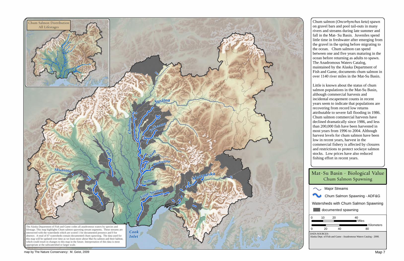
Chum salmon (Oncorhynchus keta) spawnon gravel bars and pool tail-outs in manyrivers and streams during late summer andfall in the Mat- Su Basin. Juveniles spendlittle time in freshwater after emerging fromthe gravel in the spring before migrating tothe ocean. Chum salmon can spendbetween one and five years maturing in theocean before returning as adults to spawn.The Anadromous Waters Catalog,maintained by the Alaska Department ofFish and Game, documents chum salmon inover 1140 river miles in the Mat-Su Basin.Little is known about the status of chumsalmon populations in the Mat-Su Basin,although commercial harvests andincidental escapement counts in recentyears seem to indicate that populations arerecovering from record low returnsattributable to severe fall flooding in 1986.Chum salmon commercial harvests havedeclined dramatically since 1986, and lessthan 200,000 fish have been harvested inmost years from 1996 to 2004. Althoughharvest levels for chum salmon have beenlow in recent years, harvest in thecommercial fishery is affected by closuresand restrictions to protect sockeye salmonstocks. Low prices have also reducedfishing effort in recent years.
0 20 4010Miles
0 40 8020Kilometers
Mat-Su Basin - Biological ValueChum Salmon Spawning
DATA SOURCES:Alaska Dept. of Fish and Game - Anadromous Waters Catalog - 2008.
The Alaska Department of Fish and Game codes all anadromous waters by species andlifestage. This map highlights Chum salmon spawning stream segments. These streams areintersected with the watersheds which are scored 1 for documented presence and 0 forabsence. A total of 67 watersheds contain documented chum spawning. The data used forthis map will be updated over time as we learn more about Mat-Su salmon and their habitat,which could result in changes to this map in the future. Interpretation of this data is mostappropriate at the subwatershed or larger scale.
Watersheds with Chum Salmon SpawningChum Salmon Spawning - ADF&G
documented spawning
Little Susitna
Kashwitna
TalkeetnaCh
uli tn
a
Susitna
Willow
Sheep
Skwentna
Lake
Matanuska
Map 7
Chum Salmon DistributionAll Lifestages
Major Streams
map by The Nature Conservancy: M. Geist, 2009

Alaska Department of Fish and Gamemaintains a Catalog of Waters Important forthe Spawning, Rearing or Migration ofAnadromous Fishes that documentsspawning, rearing, and presence ofanadromous fish and some resident fish.Documenting anadromous waters in Alaska iscomplicated by remoteness, short fieldseasons, and limited number of biologists.Surveys may not capture lifestageinformation due to varying timing of return ofspawning adults of different species andseasonal movement of rearing juveniles.Currently the catalog contains less than 5000miles of the more than 23,900 miles ofmapped streams in the Mat-Su Basin.Despite providing an incomplete record ofsalmon habitat, the catalog can be used toidentify patterns of salmon habitatdistribution across the Mat-Su Basin.Using the catalog, this map counts how manyof the five Pacific salmon species have beendocumented in each watershed. This countshould be viewed as a minimum number ofsalmon species in each watershed. For thoseinterested in restoration or protectionactivities that may have the most benefit forthe greatest number of species, this map canprovide guidance.
0 20 4010Miles
0 40 8020Kilometers
Mat-Su Basin - Biological ValueSalmon Species Richness
DATA SOURCES:Anadromous Waters Catalog, Alaska Dept. of Fish and Game - Sport FishDivision - 2008.
Salmon SpeciesDocumented by Watershed
Species count by watershed is a minimum;additional species may be present yet undocumented
Susitna
All anadromous waters for each species are merged, then intersected with the watershedsand finally total species counts for each watershed are tallied. Salmon richness value isnormalized so that watersheds with five species are scored 1, those with four are scored at4/5 = 0.8, those with three at 3/5 = 0.6, two species are 0.4, and one species is 0.2. The dataused for this map will be updated over time as we learn more about Mat-Su salmon andtheir habitat, which could result in changes to this map in the future. Interpretation of thisdata is most appropriate at the subwatershed or larger scale.
Cook InletCook Inlet
Map 8
Little Susitna
Kashwitna
Talkeetna
Chulitna
Willow
Sheep
Skwentna
Lake
Matanuska
Deshka/Kroto
Yentna
Kahiltna
Tala chulitna
map by The Nature Conservancy: M. Geist, 2009
12
34
5
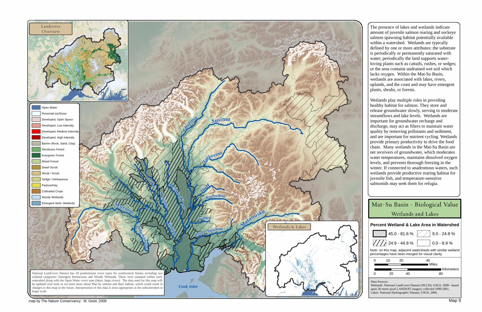
Cook InletData Sources:Wetlands: National LandCover Dataset (NLCD), USGS, 2008 - basedupon 30 meter pixel LANDSAT imagery collected 1999-2001.Lakes: National Hydrographic Dataset, USGS, 2006.
The presence of lakes and wetlands indicateamount of juvenile salmon rearing and sockeyesalmon spawning habitat potentially availablewithin a watershed. Wetlands are typicallydefined by one or more attributes: the substrateis periodically or permanently saturated withwater; periodically the land supports water-loving plants such as cattails, rushes, or sedges;or the area contains undrained wet soil whichlacks oxygen. Within the Mat-Su Basin,wetlands are associated with lakes, rivers,uplands, and the coast and may have emergentplants, shrubs, or forests.Wetlands play multiple roles in providinghealthy habitat for salmon. They store andrelease groundwater slowly, serving to moderatestreamflows and lake levels. Wetlands areimportant for groundwater recharge anddischarge, may act as filters to maintain waterquality by removing pollutants and sediment,and are important for nutrient cycling. Wetlandsprovide primary productivity to drive the foodchain. Many wetlands in the Mat-Su Basin arenet receivers of groundwater, which moderateswater temperatures, maintains dissolved oxygenlevels, and prevents thorough freezing in thewinter. If connected to anadromous waters, suchwetlands provide productive rearing habitat forjuvenile fish, and temperature-sensitivesalmonids may seek them for refugia.
0 20 4010Miles
0 40 8020Kilometers
National LandCover Dataset has 18 predominant cover types for southcentral Alaska including twowetland categories: Emergent Herbaceous and Woody Wetlands. These were summed within eachwatershed along with the Open Water cover type (lakes, large rivers). The data used for this map willbe updated over time as we learn more about Mat-Su salmon and their habitat, which could result inchanges to this map in the future. Interpretation of this data is most appropriate at the subwatershed orlarger scale.
Little Susitna
KashwitnaTal
keetna
Chulitn
a Susitna
Deshka/Kroto
Willow
Sheep
Yentna
KahiltnaSkwentna
TalachulitnaLake
Matanuska
LandcoverOverview
Mat-Su Basin - Biological Value
Percent Wetland & Lake Area in Watershed
Wetlands and Lakes
Open WaterPerennial Ice/SnowDeveloped, Open SpaceDeveloped, Low Intensity Developed, Medium IntensityDeveloped, High IntensityBarren (Rock, Sand, Clay)Deciduous ForestEvergreen ForestMixed ForestDwarf ScrubShrub / ScrubSedge / HerbaceousPasture/HayCultivated CropsWoody WetlandsEmergent Herb. Wetlands
Wetlands & Lakes
Map 9
Note: on this map, adjacent watersheds with similar wetlandpercentages have been merged for visual clarity
map by The Nature Conservancy: M. Geist, 2009
45.0 - 81.6 %24.9 - 44.9 %
9.0 - 24.8 %0.0 - 8.9 %