· Mobile Allied Health Clini UniSA Salisbury . Salisbury . Salisbury
Connor Holmes
SALISBURY HEIGHTS RESIDENTIAL DEVELOPMENT PLAN AMENDMENT TRAFFIC REPORT
November 2012 12‐0200
12‐0200 Salisbury Heights Residential DPA – November 2012 Rev B Document issue
DOCUMENT ISSUE
Revision issue Date Description Approved by
Draft 1 28 September 2012 For comment BNW
Revision A 29 October 2012 BNW
Revision B 8 November 2012 BNW
Disclaimer: This document contains information which is confidential and/or copyright and intended for the use of the client named on the front page of this report. Murray F. Young & Associates disclaims all responsibility or liability of any actions, claims, costs and damages whatsoever resulting from or following upon any reproduction or modifications of these documents, drawings or data contained therein by any other party or application of the said documents or data to other than their original purpose.
12‐0200 Salisbury Heights Residential DPA – November 2012 Rev B Contents
CONTENTS
1.0 INTRODUCTION ................................................................................ 1
2.0 SUBJECT SITE .................................................................................... 2
3.0 PROPOSED REZONING ...................................................................... 4
4.0 TRAFFIC ASSESSMENT ...................................................................... 5
4.1 TRAFFIC GENERATION AND DISTRIBUTION ............................................... 5
4.2 TRAFFIC IMPACT ........................................................................................ 5
4.2.1 TARGET HILL ROAD / MAIN NORTH ROAD ........................................................ 6
4.2.2 STANFORD ROAD / GROVE WAY ....................................................................... 7
4.2.3 GREEN VALLEY DRIVE / THE GROVE WAY .......................................................... 8
4.2.4 MAIN NORTH ROAD / THE GROVE WAY / SAINTS ROAD ................................... 8
5.0 SUMMARY ...................................................................................... 10
APPENDIX A – ADDITIONAL FORECAST VOLUMES
APPENDIX B – SIDRA ANALYSIS RESULTS

12‐0200 Salisbury Heights Residential DPA – November 2012 Rev B Page 1 of 9
1.0 INTRODUCTION
Murray F Young and Associates (MFY) has been engaged to undertake a traffic impact assessment as requested by the Department of Planning, Transport and Infrastructure (DPTI) for the Salisbury Heights Residential Development Plan Amendment (DPA). The DPA proposes to rezone land from Rural Living to a Residential Zone to accommodate increased residential density within the subject area. This report provides a traffic assessment of the potential impacts of future development of the rezoned area on the existing arterial road network.
12‐0200 Salisbury Heights Residential DPA – November 2012 Rev B Page 2 of 9
2.0 SUBJECT SITE
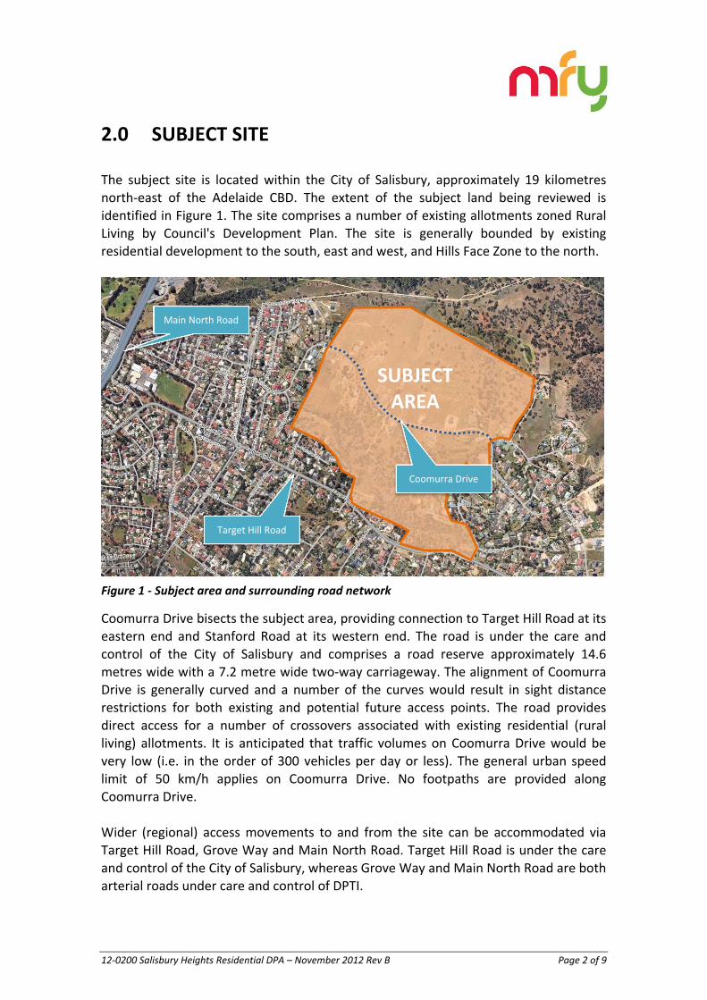
The subject site is located within the City of Salisbury, approximately 19 kilometres north‐east of the Adelaide CBD. The extent of the subject land being reviewed is identified in Figure 1. The site comprises a number of existing allotments zoned Rural Living by Council's Development Plan. The site is generally bounded by existing residential development to the south, east and west, and Hills Face Zone to the north.
Figure 1 ‐ Subject area and surrounding road network
Coomurra Drive bisects the subject area, providing connection to Target Hill Road at its eastern end and Stanford Road at its western end. The road is under the care and control of the City of Salisbury and comprises a road reserve approximately 14.6 metres wide with a 7.2 metre wide two‐way carriageway. The alignment of Coomurra Drive is generally curved and a number of the curves would result in sight distance restrictions for both existing and potential future access points. The road provides direct access for a number of crossovers associated with existing residential (rural living) allotments. It is anticipated that traffic volumes on Coomurra Drive would be very low (i.e. in the order of 300 vehicles per day or less). The general urban speed limit of 50 km/h applies on Coomurra Drive. No footpaths are provided along Coomurra Drive. Wider (regional) access movements to and from the site can be accommodated via Target Hill Road, Grove Way and Main North Road. Target Hill Road is under the care and control of the City of Salisbury, whereas Grove Way and Main North Road are both arterial roads under care and control of DPTI.
SUBJECTAREA
Target Hill Road
Main North Road
Coomurra Drive

12‐0200 Salisbury Heights Residential DPA – November 2012 Rev B Page 3 of 9
Regular public transport (bus) services operate along Target Hill Road and number of bus stops are located within close proximity to the southern boundary of the study area.
12‐0200 Salisbury Heights Residential DPA – November 2012 Rev B Page 4 of 9
3.0 PROPOSED REZONING
It is proposed to rezone the subject land for residential development. It is anticipated that approximately 120 additional residential allotments could be accommodated on the subject land (in addition to existing residential allotments already developed under the Rural Living zoning). In addition the creation of the above residential allotments, future development of the subject area would include the creation of new roads. The internal roads will generally form a linear grid network, with the exception of areas where curved and / or angled sections of road are required to connect (existing and future) areas of different allotment orientation and/or due to topographical features of the terrain. Four‐way intersections will generally be avoided except where treated with either a roundabout. New internal roads within the subject area will all be local roads. It is recommended that road reserves be a minimum of 14.2 metres wide with carriageways 7.2 metres wide. This will allow vehicles to be parked either side of the road and maintain 3.0 metres clear width for vehicle flow as required by the Australian Road Rules to maintain two‐way flow. This width will also allow minimum verge widths of 3.5 metres which will allow adequate sight distance provision at driveways and sufficient width for the provision of footpaths. In addition to the new roads, it is proposed to provide pedestrian connections between the new roads and existing roads to the south of the subject area. These connections will provide greater accessibility to/from the bus services on Target Hill Road for the subject area.

12‐0200 Salisbury Heights Residential DPA – November 2012 Rev B Page 5 of 9
4.0 TRAFFIC ASSESSMENT
4.1 TRAFFIC GENERATION AND DISTRIBUTION
The NSW Road and Traffic Authority’s “Guide to Traffic Generating Developments” (2002) identifies a traffic generation of 9 trips per residential allotment. However, recent master plan assessment have adopted a lower generation rate, based on the mix of land and housing products which are now being offered within residential developments. This is supported by survey data collected by this firm which has identified a lower average generation rate per allotment. For example, recent surveys undertaken at Blackwood Park and Seaford Rise identified average rates of 7.1 trips per allotment and 7.4 trips per allotment, respectively. The residential areas surveyed at Blackwood Park and Seaford Rise would be associated with relatively high level of private motor vehicle use and low levels of public transport use and it is expected that similar rates would be experienced within the study area. For the purposes of this assessment, a generation rate of 7.5 trips per allotment has been adopted. Such a rate has also recently been accepted by DPTI and other Councils within metropolitan Adelaide for assessment of residential trip generation at other development sites. Based on the above rate, future development of the rezoned area could generate approximately 900 additional daily trips or 90 additional peak hour trips. On the basis of the surrounding road network and potential trip destinations for residents of the subject area (i.e. schools, shopping centres and places of work1), the following distribution of the additional trips has been forecast: 66% of trips (60 peak hour trips) to/from the south‐west (via Main North Road);
22% of trips (20 peak hour trips) to/from the north‐west (via Main North Road); and
12% of trips (10 peak hour trips) to/from the east (via Target Hill Road and The Golden Way).
4.2 TRAFFIC IMPACT
The volumes distributed to the surrounding road network are relatively low and it is expected that there would be minimal impact on the surrounding road network. Nevertheless, DPTI has requested that analysis be undertaken of the impact on the following intersections:
1 ‘Places of work’ has been based on ABS Census data for places of employment for residents of the City of Salisbury
12‐0200 Salisbury Heights Residential DPA – November 2012 Rev B Page 6 of 9
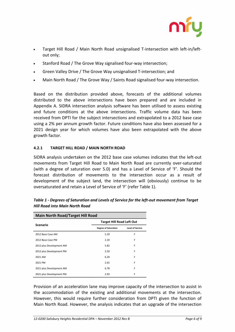
Target Hill Road / Main North Road unsignalised T‐intersection with left‐in/left‐
out only;
Stanford Road / The Grove Way signalised four‐way intersection;
Green Valley Drive / The Grove Way unsignalised T‐intersection; and
Main North Road / The Grove Way / Saints Road signalised four‐way intersection.
Based on the distribution provided above, forecasts of the additional volumes distributed to the above intersections have been prepared and are included in Appendix A. SIDRA intersection analysis software has been utilised to assess existing and future conditions at the above intersections. Traffic volume data has been received from DPTI for the subject intersections and extrapolated to a 2012 base case using a 2% per annum growth factor. Future conditions have also been assessed for a 2021 design year for which volumes have also been extrapolated with the above growth factor.
4.2.1 TARGET HILL ROAD / MAIN NORTH ROAD
SIDRA analysis undertaken on the 2012 base case volumes indicates that the left‐out movements from Target Hill Road to Main North Road are currently over‐saturated (with a degree of saturation over 5.0) and has a Level of Service of ‘F’. Should the forecast distribution of movements to the intersection occur as a result of development of the subject land, the intersection will (obviously) continue to be oversaturated and retain a Level of Service of ‘F’ (refer Table 1).
Table 1 ‐ Degrees of Saturation and Levels of Service for the left‐out movement from Target
Hill Road into Main North Road
Main North Road/Target Hill Road
Scenario Target Hill Road Left Out
Degree of Saturation Level of Service
2012 Base Case AM 5.20 F
2012 Base Case PM 2.20 F
2012 plus Development AM 5.82 F
2012 plus Development PM 2.50 F
2021 AM 6.20 F
2021 PM 2.65 F
2021 plus Development AM 6.78 F
2021 plus Development PM 2.93 F
Provision of an acceleration lane may improve capacity of the intersection to assist in the accommodation of the existing and additional movements at the intersection. However, this would require further consideration from DPTI given the function of Main North Road. However, the analysis indicates that an upgrade of the intersection

12‐0200 Salisbury Heights Residential DPA – November 2012 Rev B Page 7 of 9
is warranted irrespective of the subject rezoning and potential development. In reality, should no treatment be undertaken at the intersection, the small number of additional volumes associated with the proposal would redivert to other access routes, such as the intersections of Stanford Road / The Grove Way and Main North Road / The Grove Way / Saints Road (discussed further below).
4.2.2 STANFORD ROAD / GROVE WAY
The SIDRA analysis undertaken on the 2012 Base Case for the Stanford Road / The Grove Way intersection indicates that conditions are at or near capacity during the am peak hour and over capacity during the pm period (refer Table 2). The analysis however identifies that the capacity issues are mainly associated with through movements and that there is sufficient capacity associated with the left into Stanford Road and right out of Stanford Road to accommodate the additional volumes associated with the proposed rezoning and future development. The 2021 analysis similarly indicates that the additional volumes distributed to this intersection will not affect the overall Degree of Saturation and Level of Service.
Table 2 ‐ Overall intersection performance results for Stanford Road / The Grove Way
intersection
Stanford Road / The Grove Way
Scenario Overall Intersection
Degree of Saturation Level of Service
2012 Base Case AM 1.07 E
2012 Base Case PM 1.48 F
2012 plus Development AM 1.07 F
2012 plus Development PM 1.48 F
2021 AM 1.28 E
2021 PM 1.77 F
2021 plus Development AM 1.28 F
2021 plus Development PM 1.77 F
In addition to the above, analysis has also been undertaken on the impact of a redistribution of volumes from the oversaturated left‐out from Target Hill Road to Main North Road to the right out of Stanford Road for the 2021 + Development Volumes scenario. This analysis also indicates that there is sufficient capacity associated with this movement to accommodate the redistribution without impacting the overall intersection Degree of Saturation or Level of Service. The analysis indicates therefore that, while an upgrade of the Stanford Road / The Grove Way will be required in the future, it is warranted irrespective of the subject rezoning and future development of the subject area. Preliminary SIDRA analysis indicates that such an upgrade may be likely to require additional through lanes on The Grove Way.
12‐0200 Salisbury Heights Residential DPA – November 2012 Rev B Page 8 of 9
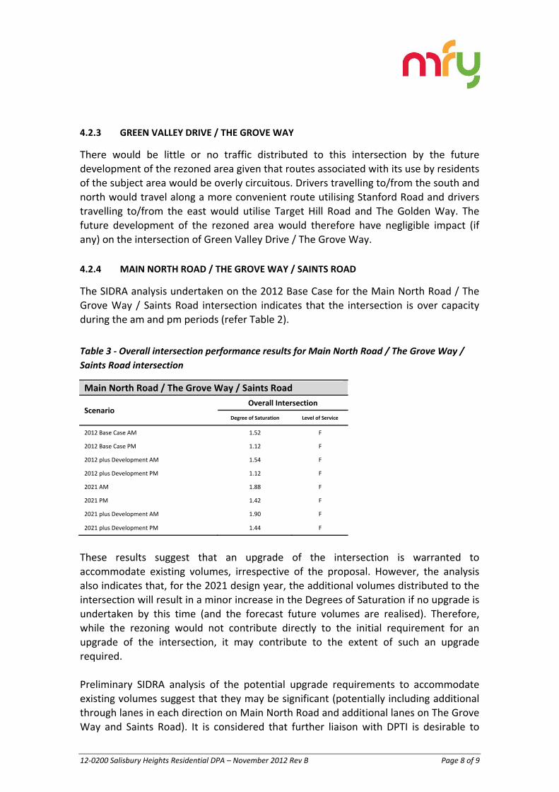
4.2.3 GREEN VALLEY DRIVE / THE GROVE WAY
There would be little or no traffic distributed to this intersection by the future development of the rezoned area given that routes associated with its use by residents of the subject area would be overly circuitous. Drivers travelling to/from the south and north would travel along a more convenient route utilising Stanford Road and drivers travelling to/from the east would utilise Target Hill Road and The Golden Way. The future development of the rezoned area would therefore have negligible impact (if any) on the intersection of Green Valley Drive / The Grove Way.
4.2.4 MAIN NORTH ROAD / THE GROVE WAY / SAINTS ROAD
The SIDRA analysis undertaken on the 2012 Base Case for the Main North Road / The Grove Way / Saints Road intersection indicates that the intersection is over capacity during the am and pm periods (refer Table 2).
Table 3 ‐ Overall intersection performance results for Main North Road / The Grove Way /
Saints Road intersection
Main North Road / The Grove Way / Saints Road
Scenario Overall Intersection
Degree of Saturation Level of Service
2012 Base Case AM 1.52 F
2012 Base Case PM 1.12 F
2012 plus Development AM 1.54 F
2012 plus Development PM 1.12 F
2021 AM 1.88 F
2021 PM 1.42 F
2021 plus Development AM 1.90 F
2021 plus Development PM 1.44 F
These results suggest that an upgrade of the intersection is warranted to accommodate existing volumes, irrespective of the proposal. However, the analysis also indicates that, for the 2021 design year, the additional volumes distributed to the intersection will result in a minor increase in the Degrees of Saturation if no upgrade is undertaken by this time (and the forecast future volumes are realised). Therefore, while the rezoning would not contribute directly to the initial requirement for an upgrade of the intersection, it may contribute to the extent of such an upgrade required. Preliminary SIDRA analysis of the potential upgrade requirements to accommodate existing volumes suggest that they may be significant (potentially including additional through lanes in each direction on Main North Road and additional lanes on The Grove Way and Saints Road). It is considered that further liaison with DPTI is desirable to
12‐0200 Salisbury Heights Residential DPA – November 2012 Rev B Page 9 of 9
review future traffic forecasts (i.e. based on DPTI’s MASTEM macro level traffic models) and undertake more detailed analysis of the potential extent of upgrades required.

12‐0200 Salisbury Heights Residential DPA – November 2012 Rev B Page 10 of 9
5.0 SUMMARY
The proposed rezoning of the subject area from Rural Living to Residential Zone will allow the potential development of an additional 120 residential allotments in the subject area. Future development of the rezoned area would result in the additional of approximately 90 additional vehicle trips on the surrounding road network during the am and pm peak periods. The majority of these trips will be distributed to and from intersections on Main North Road. DPTI has requested analysis of four intersections in proximity to the site. SIDRA analysis of existing and future volumes has been undertaken to assess future conditions at these intersections, with the exception of Green Valley Drive / The Grove Way intersection which will experience little or no increase in volumes as a result of additional development in the subject area. The three other intersections analysed are all currently at or near capacity and would require upgrades to ensure adequate capacity for current and future traffic volumes, irrespective of the proposed rezoning and associated future development of the subject area. The analysis indicates that there is essentially no capacity at the Target Hill Road / Main North Road intersection to accommodate additional left out movements from Target Hill Road. It is therefore expected that movements distributed to this intersection in the theoretical distribution assessment would be likely to redistribute to alternative intersections. The analysis indicates that overall conditions at the intersection of The Grove Way and Stanford Road, while over capacity, would not be impacted by the small increase in additional volumes (including potential redistribution from Target Hill Road / Main North Road). As noted above, the SIDRA analysis suggests that the intersection of Main North Road / The Grove Way / Saints Road is currently over‐saturated. The results indicate that an upgrade is warranted to accommodate existing volumes and improve conditions at the intersection. While the upgrade is warranted irrespective of the subject proposal, the additional volumes do result in a slight worsening of the overall performance of the intersection and therefore may contribute to the overall extent of an upgrade to accommodate future volumes associated with general traffic volume growth and the development of the subject area. Further liaison with DPTI and analysis would be required to identify its preferred upgrade treatment and the extent of works associated with development of the subject area, albeit it is expected that the

12‐0200 Salisbury Heights Residential DPA – November 2012 Rev B Page 11 of 9
additional volumes would have only minor contribution to the overall upgrade requirement.
12‐0200 Salisbury Heights Residential DPA – November 2012 Rev B Appendix A
APPENDIX A
ADDITIONAL VOLUMES DISTRIBUTED TO THE SUBJECT INTERSECTIONS RESULTING FROM FUTURE DEVELOPMENT OF THE REZONED AREA
12‐0200 Salisbury Heights Residential DPA – November 2012 Rev B Appendix B
APPENDIX B
SIDRA ANALYSIS