Sailing to Pasargadae - ACHEMENET an Empire: Achaemenid Persia in Longue Durée 1!!!!! Sailing to...
23
Transcript of Sailing to Pasargadae - ACHEMENET an Empire: Achaemenid Persia in Longue Durée 1!!!!! Sailing to...

Contents v
Excavating an Empire: Achaemenid Persia in
Longue Durée
Edited by Touraj Daryaee & Ali Mousavi
Dr. Samuel M. Jordan Center for Persian Studies & Culture Distributed by the Univeristy of California Press
2011
Excavating an Empire: Achaemenid Persia in Longue Durée
1
Sailing to Pasargadae
D.T. Potts The University of Sydney
‘The paucity of rivers in Persia has been noticed by many travellers in the country...’ - Blanford 1873: 494
‘Rivers, in such parts of their courses as have not actually
been followed or surveyed, I have indicated by broken lines -------; the number of which will illustrate the extent to which there is still need for the explorer’s services’ - Curzon 1892: 71
Introduction
The rivers of Persis have received much less attention than those of Susiana (Bosworth 1987, Potts 1999 with earlier bibliog.), undoubtedly because Susiana’s rivers feature so prominently in accounts of Alexander’s journey from Susa to Persepolis and in the wars of the Diadochoi. Neverthe-less, their elucidation was an aim of Wilhelm Tomaschek in his famous treatise on the voyage of Nearchus (Tomaschek 1890), and they featured prominently in Ernst Herzfeld’s doctoral dissertation (Herzfeld 1908: 7-13). In view of the fact that it is over 100 years since Herzfeld’s dissertation was published, it is perhaps fitting to address this topic
Potts 2
again, in memory of the late Shapur Shahbazi, an Achae-menid scholar of renown whose interests extended to all matters concerned with the Persian Empire. The rivers of Persis Six rivers are attested in the Persepolis fortification texts. Judging by the purview of the Persepolis texts, it is proba-bly safe to assume that all of these rivers lay in Persis or at least no further west than eastern Khuzestan (Ram Hor-muz). Earlier Elamite contexts contain more names (Vallat 1993: 327-330) but many of these are likely to be in Khuzestan, while others are obviously in Mesopotamia. The rivers likely to have been in Persis are as follows:
1. Ahinharishda - PF 1955: 3 2. Betir (?) - PF-NN 339: 8 3. Huputish - PF 339: 6, PF NN 379: 7, 2259: 4 4. Marrish - PF NN 1059: 15, 2183: 3, 2200: 2-3 5. Rannakarra - PF 339: 7, PF NN 379: 8 6. Shaushanush - PF 339: 8, PF NN 379: 9, PF NN
2372: 33
Unfortunately, these references offer little assistance in identifying the rivers. PF 339, for example, is an account of wine received by a priest so that offerings could be made to Ahura-Mazda, Humban and the rivers Huputish, Rannakar-ra and Shaushanush (Hallock 1969: 151). Similarly, PF 1955 begins by listing a quantity of grain received by Ukpish the magus, some of which was intended as an offer-ing for the Ahinharishda River (Hallock 1969: 559; the rest of the texts cited above with NN are unpublished and their nature is unknown to me; but cf. Vallat 1993).
We are somewhat better informed on the rivers of Fars from intelligence gathered in the wake of Alexander’s campaign. The ancient literary sources give us the names of two groups of rivers, those in the interior and those that flowed into the Persian Gulf.
Excavating an Empire: Achaemenid Persia in Longue Durée
3
The inland rivers are described by Strabo (Geography 15.3.6) as follows: ‘There is also a river Cyrus, which flows through Coelê Persis, as it is called, in the neigh-bourhood of Pasargadae; and the king assumed the name of this river, changing his name from Agradatus to Cyrus. Al-exander crossed the Araxes near Persepolis itself....The Araxes flows from the country of the Paraetaci; and this river is joined by the Medus, which has its source in Me-dia. These rivers run through a very productive valley which which borders on Carmania and the eastern parts of the country, as does also Persepolis itself.’
Arrian’s Indica §38 names eight rivers on the coast of Persis in the itinerary which I have abbreviated below
1. ‘sacred island’ to Ilas and the small island of Caïcandrus - 400 stadia.
2. onward sailing to ‘another island...there is pearl fishing here - distance not given.
3. onward sailing past the point of this island - 40 sta-dia.
4. anchoring off a high mountain called Ochus. 5. anchoring at Apostana - 450 stadia.
Apostana - must be Cape Bostana, ‘the first headland on the coast of Persia to the westward of Kishm...a low sloping point with rugged hills above it...Bostana and Schinas, are 2 small towns to the eastward of the Cape, be-tween it and Linga’ (Horsburgh 1817: 259).
6. onward sailing to a gulf with many villages - 400 stadia.
7. onward sailing to Gogana, anchoring off the river Areon - 600 stadia. Areon - the river near Bardistan (Herzfeld 1908: 7)
8. anchoring at the mouth of the river Sitakos - 800 stadia. Sitakos - Sita or Sita-reghian of the Turkish historical geogra-pher Kâtip Chelebi (1609-1657), author of the encyclopaedic geograhical compendium Jihân-numâ (1732), cf. Sitan or Kaneh-Sitan, name of the region near the river (d’Anville 1764: 158, followed by Vincent 1807: 386, von Hammer-
Potts 4
Purgstall 1825: 317 and Berghaus 1832: 40); Jayrah (Bunbury 1879: 538); Mand (Tomaschek 1890)
9. onward sailing to Hieratis, anchorage in a channel of the river Heratemis - 750 stadia. Heratemis - cf. Kierazin, situated near the Persian Gulf and the river Dékian, according to Kâtip Chelebi (1609-1657) (d’Anville 1764: 160); Sekan (Vincent 1807: 390); a canal south of Bushehr (Tomaschek 1890)
10. onward sailing to the river Padargus and the Mesambria peninsula - distance not given. Padargus - a small stream near Shif (Tomaschek 1890)
Mesambria - the point of Risher almost isolated and like an is-land (d’Anville 1764: 161); peninsula on which Buschir, Abuschehr, Abu schähhr sits, Chersoneus of Cl. Ptolemy (Berghaus 1832: 39); ‘probably Bushir’ (Rawlinson 1857: 284); peninsula ‘occupied by the modern town of Abu-Shehr, or Bushire, now the principal trading-place on the Gulf’ (Bun-bury 1879: 538)
11. onward sailing to Taoce on the river Granis - 200 stadia. Granis - Boshavir, by Bender-Boshavir (d’Anville 1764: 161, Vincent 1807: 400); Khist or Shapur river (de Bode 1843a: 76); Dálaki river (Rawlinson 1857: 284); Rudkhaneh-e Shapur (Herzfeld 1908: 7) or possibly the Nahr Ratin or Rud-e Daliki (Herzfeld 1908: 8); Hablerud (Rahimi-Laridjani 1988: 420, n. 12)
12. onward sailing to the river Rogonis - 200 stadia. R(h)ogonis - Shirin or Ab-Shirin at Genava, near Bender-Regh (d’Anville 1764: 162); Khanbidak or Rig river (von Hammer-Purgstall 1825: 318); Bandar Rig, Rigk, Rech, Reig, Reeg (Vincent 1807: 389, Berghaus 1832: 38, de Bode 1843a: 81, n*); Genaveh (Rawlinson 1857: 284); Nahr Shapur of the Ar-ab geographers, near Bandar Rig (Tomaschek 1890)
13. onward sailing to the river Brizana - 400 stadia. Brizana - Bender-Delem (d’Anville 1764: 165); Ab-e Shirin (von Hammer-Purgstall 1825: 318); Bandar Dilem [Deilam] (Berghaus 1832: 38); Shem Si-’arab river (de Bode 1843a: 85); Khor Sini, above Genaveh (Tomaschek 1890); Rud-e Shirin/Hindiyan (Herzfeld 1908: 8)
14. onward sailing to the river Arosis, greatest of all the rivers on the coast - distance not given.
Excavating an Empire: Achaemenid Persia in Longue Durée
5
Arosis - (Arois in some mss), same as Oroates (Strabo), the river that divided Persis from Susiana (or Elymais), same as the Pasitigris of Quintus Curtius (d’Anville 1764: 166); Tab (von Hammer-Purgstall 1825: 318, Berghaus 1832: 38); Khairabad, or Ab-i Shirin of Timur’s route, modern Hindiyan (Vincent 1807: 406, de Bode 1843a: 85, 1843b: 108); Tab or Endian/Hindian, ‘decidedly the most important stream that flows into the Persian Gulf on its eastern side’ (Bunbury 1879: 539, cf. Tomaschek 1890, Herzfeld 1908: 8)
Drawing on the testimony of Onesicritus via Juba, Pliny’s Natural History names five rivers of Persis, as fol-lows: ‘at the middle of the Persian Gulf the river Hyperis, navigable for merchant vessels; the river Sitioganus, up which it is seven days’ voyage to Pasargadae; the navigable river Phrystimus...The river Granis, carrying vessels of moderate size, flows through Susiana...the river Zarotis, the mouth of which is difficult to navigate except for those familiar with it’ (6.99). At 6.111, Pliny identifies the river which separated Persis from Elymais as the Oratis, men-tioned again at 6.136.
Tomaschek suggested that Pliny’s Phrystimus preserved the name given by Arrian as Heratimis (Tomaschek 1890: 63); the Sitioganus he identified with Arrian’s Sitakos (per-haps more correctly Sitakanos) (Tomaschek 1890: 60). In-stead of assuming that Siccanas at 6.110 is a mistaken repe-tition of Sitakos/Sitakanos, Herzfeld suggested that the Si-tioganus might be identified with the modern Shadhegan, and the Siccanas with the Sakkan (Herzfeld 1908: 9).
Ptolemy’s Geography (Ziegler 1998: 67) provides a slightly later enumeration of the rivers of Persis. In describ-ing the borders of the region, he says (6.4.1), ‘On the south (it is bounded) by the part of the Persian Gulf from the es-tuary of the river Oroatis to (the estuary of) the Bagradas’, and then continues 6.4.2. After the estuary of the River Oroatis (follow): Cape Taoke 87˚ 30’ 30˚ 10’ the estuary of the River Rhogomanis 88˚ 30’ 30˚

Potts 6
- the sources of that river (are at) 92˚ 35˚ Cape Chersonnesos 89˚ 40’ 29˚ 30’ Ionaka, a city 90˚ 29˚ 45’ the estuary of the River Brisoanas 92˚ 29˚ 40’ - the sources of that river (are at) 93˚ 34˚ 30’ Ausinza 93˚ 29˚ 20’ the estuary of the River Bagradas 94˚ 29˚ 15’ - the sources of that river (are at) 94˚ 35˚ 15’
The same information is repeated in Marcian of Hera-clea’s Periplus of the Outer Sea 24 (c. 400 AD?) (Schoff 1927: 21). Several correspondences with the rivers men-tioned by Arrian are obvious: Oroatis = Arosis, Rhogoma-nis = Rogonis and Brisoana = Brizana. In his discussion of these names, Herzfeld suggested a correspondence between Arrian’s Padargus and Bagradas (Herzfeld 1908: 9).
As Herzfeld did, we should also consult the Arab geog-raphers. Istakhri provides us with the names of eleven riv-ers in Fars which he says were navigable (Schwarz 1896: 4, 5-9 for the descriptions and text citations). In addition, the 12th century geographer Ibn al-Balkhi also left an account of the rivers of Fars. These are as follows (Le Strange 192: 868-872):
1. Tab - the largest of the rivers of Fars, according to Ibn Haukal; originated in the mountains near Isfa-han, received the waters of the Masin (var. Misri-kan) river, passed through the gates of Arragan un-der the Tukan bridge (the bridge between Khuzestan and Fars), watered the Rishahr area and emptied into the Persian Gulf on the border of the Tuster (Shushtar) region. Tab - the Jerrahi (de Bode 1843b: 87); Kurdistan Rud, called Jerrahi in its lower reaches (Herzfeld 1908: 8); the Arosis of Nearchus (Herzfeld 1908: 8) Ibn al-Balkhi - arose near Sumayram (disputed by Le Strange 1912: 868), passed under the bridge Pul-i Thakan at Arragan, watered the district of Rishahr and emptied into the Persian Gulf near Siniz; Nahr Masin (Armish and Zard streams ac-
Excavating an Empire: Achaemenid Persia in Longue Durée
7
cording to Le Strange 1912: 870) arose near Sumayram and Simtakht and flowed into the Tab (Le Strange 1912: 870 noted that its actual source was.
2. Shirin - arose on Jabal Dinar, in the area of Ba-zereng, watered Furzuk (?) and al-Galadekan, be-fore it headed to Ganaveh (Gannaba) and emptied into the Persian Gulf; also known as the Rud-e Khairabad. Ibn al-Balkhi - arose on the frontier of the Bazrang district, flowed past Gunbad Mallaghan, watered Arragan before it emptied into the Persian Gulf between Siniz and Jannaba (Ge-naveh).
3. Shadekan - arose near Bazareng, entered the region of Tenbuk Muristan and Khan Hammad, watered the region of Zirabad, Nabend and al-Kahrkan, flowed by Dasht-e Destekan and emptied into the Persian Gulf; tributary of the Ab-e Zohra or Ab-e Shur which, with the Rud-e Shirin, formed the Ab-e Hindiyan, according to Tomaschek. Shadekan - ancient Sitoganus (Herzfeld 1908: 10); Ab-Shúr or Sheker-ab is the Rud-e Fahliyan from de Bode’s description (de Bode 1843: 79 and 81, ‘The Ab-shúr, or Sheker-ab, rises in the snowy mountains of Ardekán, to the E. and N.E. of Kal’eh Sefíd, and passes through the whole length of the abovenamed valley, winding from E. to W. It then forces its way through the hills to the W. of Fahliyán, and having joined the river of Behrám, crosses the wild tracts called Mohur, and discharges its waters into the Persian Gulf at, I believe, Bender Rig. The Ab-shúr is not fordable everywhere; and the ruins of a bridge over it are still to be seen near Kal’eh Siyáh. Its wa-ter...is brackish’); cf. Wells 1883: 152, ‘the river Shur or Fahlyun, which runs from Ardakhan’.
4. Darkhid - arose in the mountains of al-Guwikhan and emptied into the Darkhid lake; tributary of the Ab-e Zohra or Ab-e Shur which, with the Rud-e Shirin, formed the Ab-e Hindiyan according to To-maschek.
Potts 8
5. al-Khubedhan - arose at al-Khubedhan, watered this area and that of Anburan, then flowed past al-Galadegan and emptied into the Persian Gulf. Ibn al-Balkhi - Khwabdan, arose at Juyikan, watered the area of Nawbanjan, flowed through Jalladjan until it entered the Nahr Shirin and emptied into the Persian Gulf; the modern Daliki-Jamilah river (Le Strange 1912: 869).
6. Ratin - arose in upper Khumajgan and reached ez-Zirjan, received water from its tributary the Sabur, after which it left the mountains, headed towards Tawwaj, flowed by the gate of the city and emptied into the Persian Gulf. Ratin - Rudkhaneh-e Daliki (Herzfeld 1908: 8).
7. Ikhshin - emerged from the mountains of Dadhin, emptied into the river of Tawwaj (Ratin) at al-Junkan.
8. Jirshik - from the area of Masarm, flowed through the area of al-Mushjan, flowed under the Qantara (weir, bridge) Sebuk, a bridge of cyclopaean stone masonry, watered the area of Jur, and in Dadhin flowed into the Ikhshin. Jirshik - modern Jereh, tributary of the Ratin and the Ikhshin (Herzfeld 1908: 8). Ibn al-Balkhi - Jirrah, arose in Masaram, watered the districts of Nahast Masjan, Jirrah and part of Ghundijan, after which it joined the Bishapur River and emptied into the Persian Gulf.
9. Sabur - or Rud-e Shapur, the Ratin in its upper reaches, also known as the Tawwaj river; called the Bushavir by Thevenot. Ibn al-Balkhi - Nahr Bishapur, arose in the mountains around Bishapur, wa-tered the city and district of Bishapur and the villages of Khisht and Dih Ma-lik, emptied into the Persian Gulf between Jannaba and the Mandistan area; also known as the Zirah, Khisht and Shapur river (Le Strange 1912: 871).
10. Sekkan - arose near ar-Ruwaikhan (Rudijan), near the village of Shadafri, flowed past Sijah, Khabr, es-Simakan, Karezin, Sekk (after which the river took its name), and emptied into the Persian Gulf; no other river in Fars was more useful for agricul-ture; known as the Kara Aghatch, and in its lower reaches as the Mun. Sekkan - the Sitakos/Sitioganus (Andreas apud Ross 1883: 726).
Excavating an Empire: Achaemenid Persia in Longue Durée
9
Ibn al-Balkhi - Nahr Thakan, arose near Jatruyah or Chatruyah, in the Masaram sub-district around Shiraz and watered this region, flowed past Kavar, Khabr, Simkan Karzin, Qir, Abzar and Laghir, watered the Siraf dis-trict, passed the village of Thakan from which it took its name, emptied into the Persian Gulf between Najiram and Siraf (Le Strange 1912: 871).
11. Tirze - tributary of the Sekkan/ Kara Aghatch that flowed through the area of Jur (Firuzabad), origi-nated in the Darjan Sijah, watered the area of al-Khunaifejan and Jur, flowed through the area of Ardashir Khurra and then emptied into the Persian Gulf (incorrect, as this occurred after it had emptied into the Sekkan). Ibn al-Balkhi- Nahr Burazah, the river of Firuzabad, arose at Khunayfghan, watered Firuzabad and its district, joined the Thakan and emptied into the Per-sian Gulf; named after Burazah, ‘the great engineer, who drained the [lake] off from round and about the city of Firuzabad’ (Le Strange 1912: 869) according to a story related by Ibn al-Balkhi about the construction of Firuzabad by Ar-dashir (Le Strange 1912: 324-325).
In addition, Istakhri knew of two inland rivers in Fars. 1. Kur - originated in the area of al-Urd, flowed
through Kurwan (whence the name), emerged from Shi‘b Bawwan, watered the area of Kamfiruz, Ramgejird, Kaskan, at-Tassuj, emptied into a lake at Jufuz, called Bakhtekan (Bakhtegan or modern Neriz/Nayriz); said to have a source in the moun-tains of Darabgird and to flow into the Persian Gulf (cf. von Hammer-Purgstall 1825: 318) but Schwarz considered this a confusion with the Ab-e Kor in Laristan which arose near Furj and emptied into the Persian Gulf west of Suru (Schwarz 1896: 9). Kur - the ancient Araxes according to Houtum-Schindler (1891: 287). Ibn al-Balkhi - Nahr Kur, arose near Kallar, modern Kamfiruz-Ramjird-Kirbal river; ‘a rebellious stream that will irrigate no lands unless a dam has been thrown across it to raise the level, and thus enable the waters to be led over the surface of the soil’, emptied into Lake Bakhtigan/ Neriz (Le Strange 1912: 869-870).
2. Ferewab - originated near the village of the same name in the area of al-Jaubarkan, flowed past the
Potts 10
gate of Istakhr, under the Khorassan bridge, and emptied into the Kurr; today known as the Polvar. Ferewab - Puruab of Houtum-Schindler, identical with the Medus (Houtum-Schindler 1891: 289); after united with the Kur, known as the Rud-e Band Amir after the village of this name, so-called because of the dam there that had been built by the Buyid Sultan of Fars, ‘Adud ad-Daula Daylami (943-983); Mukaddasi also described the dam on the river between Istakhr and Shiraz, off of which 10 canals were constructed, each with a water mill in the fashion of Shushtar, making it one of the wonders of Fars (Schwarz 1896: 9); in the ‘Ard-nama, Davani (1427-1502) called the Band-i Mir ‘one of the wonders of the world’ (Minorsky 1939: 152). Ibn al-Balkhi - Nahr Purvab, arose near the village of Purvab, ‘a most blessed river’, irrigated most of Marv Dasht, flowed into the Kur, also known as the Purvab-Kamin river, the mod-ern Pulvar (Le Strange 1912: 871-872).
Pasargadae and the Sitioganus The ancient Persian attitude towards rivers is expressed several times in the Greek and Latin sources. In his Geog-raphy (15.3.16), Strabo noted, ‘the Persians neither urinate, nor wash themselves, in a river; nor yet bathe therein or cast therein anything dead or any other thing that is consid-ered unclean.’ To this we may add the tradition first report-ed by Herodotus (Histories 1.188), and repeated by Ctesias (cited by Athenaeus, FGrH 688, F.37, see now Lenfant 2004: 168), Quintus Curtius (5.2.9), Isidorus (Etymologiae 13.21.15), Plutarch (De exilio 6), Lucian (Menippus 7), Ae-lian (Varia historia 12.40), and Solinus (Memorabilia 38.4) that the Achaemenid king, while on campaign, only drank the boiled water of the Choaspes/Eulaios river (which ran by Susa) from silver vessels transported on wagons drawn by mules (cf. Schmitt 1992; echoed by Milton, Paradise Regain’d [1671] III.288-289, ‘There Susa by Choaspes, amber stream/ The drink of none but Kings...’).
Whereas the Arab geographers tended to emphasise the economic utility of the rivers they described, noting partic-ularly the areas that were watered or irrigated by a particu-lar river, Arrian’s description frequently refers to the ‘tor-
Excavating an Empire: Achaemenid Persia in Longue Durée
11
rential’ character of the rivers that emptied into the Persian Gulf. This, undoubtedly, reflects the fact that all rivers in Iran that derive their water from a combination of springs, rainfall and snow melt, experience variable levels and often appear as torrents when in spate.
Pliny’s attention to the navigability of the rivers in Per-sis is also noticeable, nowhere more so than in his descrip-tion of the Sitioganus, ‘up which it is seven days’ voyage to Pasargadae’ (Natural History 6.99). This claim has brought considerable howls of derision down on poor Pliny’s head. D’Anville dismissed it in one sentence thus, ‘Mais, ce qui’il dit de cette rivière, qu’en sept jours de navigation elle conduit à Pasargadæ, souffre difficulté (d’Anville 1764: 158). Concurring with Carl Ritter, Forbiger considered its navigability ‘eben so wenig, als irgend ein andrer Fluss die-ser Küste, schiffbar ist’ and thought Pliny’s testimony was based on an error (Forbiger 1844: 574, n. 28). Similarly, Herzfeld rejected it outright and like Stolze, emphasised that there was not a single navigable stream on the entire coast of Fars (Herzfeld 1908: 10).
The identification of Pliny’s Sitioganus with Arrian’s Sitakos was made at least as early as 1764 by d’Anville. It was d’Anville, as well, who first posited the identification of this ancient river with the Sita or Sita-reghian and the Kaneh-Sitan maritime district, mentioned in the Jihân-numâ (1732) of the Turkish historical geographer Kâtip Chelebi (1609-1657) (d’Anville 1764: 158). This identifi-cation was later accepted by Vincent (1807: 386), von Hammer-Purgstall (1825: 317) and Forbiger (1844: 574, n. 28), whereas Herzfeld pointed to the Shadekan of Istakhri’s account as a more likely candidate for the Si-tioganus/Sitakos (Herzfeld 1908: 9). In doing so, he reject-ed the opinion of the eminent German Iranologist F.C. An-dreas to which we now turn.
Potts 12
Haji Mirza Seyyid Hassan, Col. Ross and F.C. Andreas An anonymous geographical note on ‘Recent Explorations in Persia’, published in 1879, records that the Political Res-ident at Bushehr, Lt.-Col. E.C. Ross, ‘reproduced a rough sketch of a map of Southern Persia, obtained by him from Haji Mirza Seyyid Hassan, physician to the Governor of Behbahan, who has been travelling in Fars for the last twelve years and has a slight knowledge of surveying. One geographical identification determined by the Haji is full of interest. The Kara-Aghach (= black wood) River, which rises to the north-west of Shiraz, was hitherto supposed to discharge its waters into the sea at Bardistan, and a note recording that belief will be found appended to the stream as shown in Major St. John’s map of Persia. Major St. John did not venture to indicate its course further than a point about 35 miles from the sea. At the same time its true direc-tion and fate were a matter of interest, as there is no doubt it is identical with the Sitakos River, of Nearchus, the admi-ral of the fleet which Alexander sent from the Indus to the Euphrates; while it is also mentioned by Onesicratus, the pilot, these two authorities being quoted respectively by Arrian and Pliny. From the Haji’s map it now appears that the Kara-Aghach is simply the upper course of the Mun River, which debouches into the gulf about 60 miles south-east of Bushire’ (Anonymous 1879: 332-333).
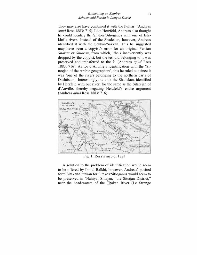
The scholarly apparatus behind this identification was published four years later in a paper on the identification of the Sitakos (Fig. 1) in which a long letter from Andreas was reprinted, translated into English from the original German (Ross 1883). There Andreas identified the Si-tioganus/Sitakos with the Kara-Aghatch, the Turkish name given to the Mand, Mund or Kakee River. Remarking on Pliny’s claim of the navigability of the river all the way to Pasargadae, Andreas noted, ‘This of course is not true....It only shows that people at the mouth of the river knew that its course was very long, and that it came from somewhere up country, perhaps not far from the royal cities of Fars.
Excavating an Empire: Achaemenid Persia in Longue Durée
13
They may also have combined it with the Pulvar’ (Andreas apud Ross 1883: 715). Like Herzfeld, Andreas also thought he could identify the Sitakos/Sitioganus with one of Ista-khri’s rivers. Instead of the Shadekan, however, Andreas identified it with the Sekkan/Sakkan. This he suggested may have been a copyist’s error for an original Persian Sitakan or Sittakan, from which, ‘the t inadvertently was dropped by the copyist, but the teshdid belonging to it was preserved and transferred to the k’ (Andreas apud Ross 1883: 716). As for d’Anville’s identification with the ‘Si-tarejan of the Arabic geographers’, this he ruled out since it was ‘one of the rivers belonging to the northern parts of Dashtistan’. Interestingly, he took the Shadekan, identified by Herzfeld with our river, for the same as the Sitarejan of d’Anville, thereby negating Herzfeld’s entire argument (Andreas apud Ross 1883: 716).
Fig. 1: Ross’s map of 1883
A solution to the problem of identification would seem
to be offered by Ibn al-Balkhi, however. Andreas’ posited form Sitakan/Sittakan for Sitakos/Sitioganus would seem to be preserved in ‘Nahiyat Sittajan, “the Sittajan District,” near the head-waters of the Thakan River (Le Strange
Potts 14
1912: 869, n. 2). According to Ibn al-Balkhi the Sittajan river bed (Rudbal-i-Sittajan) was a stop on the route from Shiraz to the coast (A‘mal-i-Sif) which ran as follows:
1. Shiraz to Masaram - 7 leagues 2. Masaram to Sittajan river-bed - 6 leagues 3. Sittajan river-bed to Jirrah - 3 leagues 4. Jirrah to Ghundijan - 4 leagues 5. Ghundijan to Rawa-adh-Dhiwan - 6 leagues 6. Rawa-adh-Dhiwan to Tawwaj - 6 leagues 7. Tawwaj to the coast - 7 leagues
Le Strange suggested that Rudbal-i-Sittajan, ‘the river-
bed of the Sittajan’, ‘appears to be the river otherwise called the Thakan (Le Strange 1912: 886, n. 1). Ibn al-Balkhi’s Thakan is identical to Istakhri’s Sekkan/Sakkan, and supports Andreas’ proposal, although Andreas made no reference to this source. The identity of the Thakan and the Qarah (Kara) Aghach (Aghatch) was stressed by Le Strange who wrote, ‘This is the very long river of many names, of which the first portion is now known as the Qarah Aghach (“Black Wood”), and the last reach as the Mand River of Mandistan...The village of Thakan is proba-bly represented by Kaki, the chief town of Mandistan’ (Le Strange 1912: 871, n. 3; cf. Schwarz 1896: 8). Elsewhere he noted, ‘The Zakan (Zhakan; the MS. of the Fars Namah always spells the name Thakan) is named by Istakhri (p. 120) and other Arab geographers the Nahr Sakkan, and is the present Kara Aghach, which rises at some distance to the north-west of Shiraz. It flows into the sea a little to the south of Najiram, and in its lower course is now known as the Mand river’ (Le Strange 1902: 518).
Apart from Ross, several other early travellers left de-scriptions of the Sitakos/Kara Aghatch/Mand River. Wil-son’s account from the early 20th century emphasised the agricultural potential of the river. He wrote, ‘There are no traces of irrigation works on a large scale having ever ex-

Excavating an Empire: Achaemenid Persia in Longue Durée
15
isted in the country between Jahrum and Shiraz, where alone sufficient water is found to make such enterprises profitable. There is little doubt that the Kara Agach, if dammed here and there and diverted into small canals, would water a far larger area than it does at present; there is a large area of desert which only requires water to produce perennial crops of wheat, barley, and other grains. The Ka-ra Agach, in the spring, flows at an average rate of about 7 miles an hour; its banks, moreover, are not very high; irri-gation works, therefore, even at present, are easily carried out’ (Wilson 1908: 168-169).
Abbott and Colvill, on the other hand, were more con-cerned with the river’s course. Abbot wrote, ‘The 13 1/2 mile brought us to a river, flowing N. and S. for a short space, about 100 yards in breadth, and in parts nearly up to the horses’ girths. This stream, known near its source as Karaghadj, flows to Siakh, Kewar, and Khafr, where streams from Jehrúm and Simkau join it, and thence it pur-sues its way to Kir and Kazin, and Dizzar of Gheledar, where a stream from Firúzabad enters it, after which it falls into the Persian Gulf between Kenghan and Assalú. It is variously named, being called successively after each dis-trict it passes through’ (Abbott 1857: 168).
Most interestingly, however, Colvill’s description makes it clear that in the mid-19th century, there was some naviga-tion on the river: ‘The river Charactagh, rising in regions about Shapur, and passing through Khona Zuneon near Shi-raz, runs within 30 miles of Ferozabad, and opens into the plains of Khormuj round the north of Khoe Namik, be-tween it and the low sandstone range. It passes across the plain and opens into the sea at Khore Ze-arad, where it en-ters the plain of Khormuj: it is 120 yards wide, and on the day I crossed it it was 3 ½ feet deep, but it was said then to be unusually low, for at this season it is almost always nec-essary to cross it on a raft. It is here called the River Moon, and even now it is slightly brackish. Vessels of forty or fif-
Potts 16
ty tons ascend it almost opposite to Kakee. A natural canal of brackish water, 12 yards wide and 2 feet deep, called the Shura, passes from near the hill of Aram down the centre of the plain and opens into the Moon’ (Colvill 1867: 37).
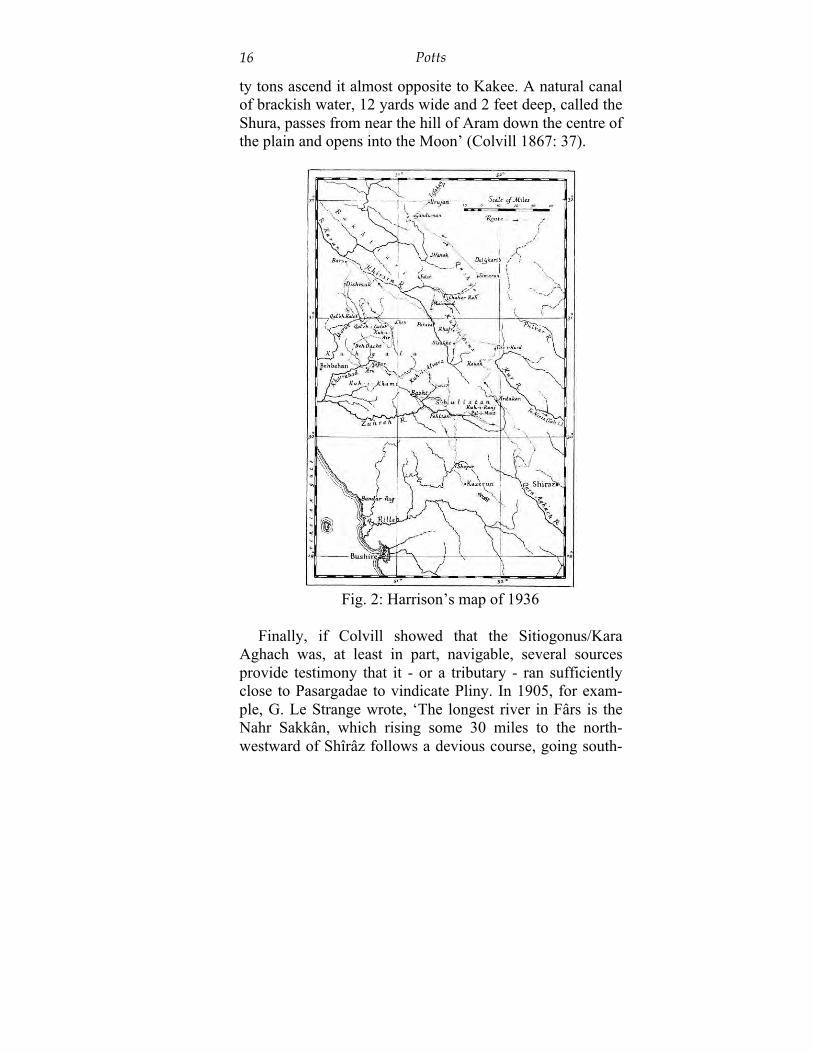
Fig. 2: Harrison’s map of 1936
Finally, if Colvill showed that the Sitiogonus/Kara
Aghach was, at least in part, navigable, several sources provide testimony that it - or a tributary - ran sufficiently close to Pasargadae to vindicate Pliny. In 1905, for exam-ple, G. Le Strange wrote, ‘The longest river in Fârs is the Nahr Sakkân, which rising some 30 miles to the north-westward of Shîrâz follows a devious course, going south-
Excavating an Empire: Achaemenid Persia in Longue Durée
17
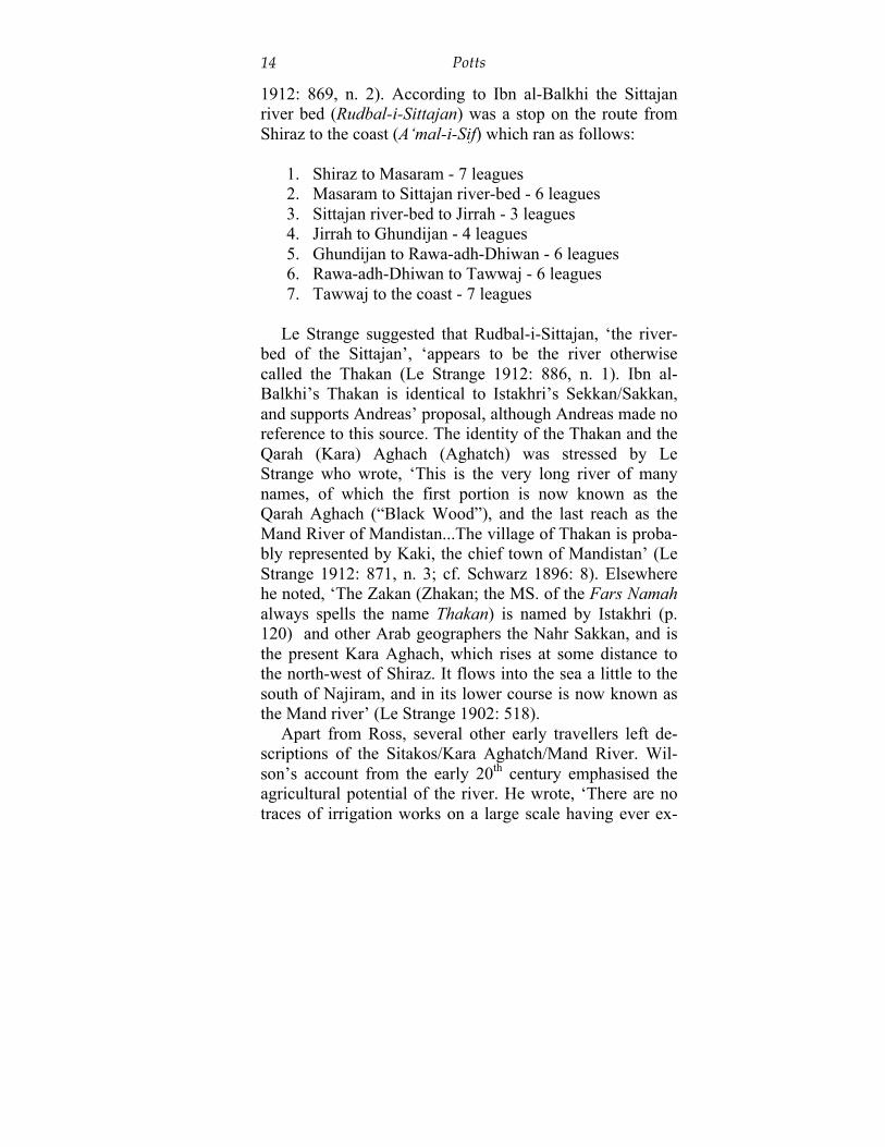
east for over 150 miles; then after making a great bend it runs due west for another 150 miles, but with many wind-ings, and finally, after receiving the waters of the Fîrûzâbâd river from the north, discharges itself into the sea a little to the south of Najiram’ - here a footnote remarks, ‘Its upper course is now known as the Kârâ Aghâch, Black-tree river (in Turkish); its lower course is called the Mând river. The Sakkân is probably identical with the river Sitakus of Near-chus’ - and he continued, ‘The name Sakkân is said by Istakhri to be derived from the village of Sakk, which stands near the great bend westward; other authorities, however, spell the name variously: thus we find Sittajân, Thakkân, and Sikân, while Mustawfi generally has Zakkân or Zhakkân’ (Le Strange 1905: 252 and n. 2). Le Strange’s testimony was confirmed three decades later by the geolo-gist J.V. Harrison, whose map (Fig. 2) clearly marks the Qara Aghach flowing to the west and south of Shiraz. He described camping ‘on a plateau beside three reed-fringed ponds on the water-shed between the Zuhreh and the Qara Aghach which flows far to the eastwards before crossing the ranges to the Persian Gulf below Bushire’ (Harrison 1936: 33-34).
These descriptions do not, of course, confirm the navi-gability of the Sitakos/Sitioganus all the way from the Per-sian Gulf to Pasargadae, but they do, I believe, go a consid-erable way towards accounting for how such a belief could have arisen. Clearly, a river which can be followed - even though its name may change - from a point northwest of Shiraz all the way to the Persian Gulf coast, can plausibly account for Pliny’s claim that Pasargadae could be reached in seven days of sail up the Sitioganus. References to the depth of the water in the river - certainly up to the belly of a horse, as noted by several 19th century visitors - are com-plemented by a report in ‘Abd al-Karim b. Muhammad Nimdihi’s (b. 1439/1440) Tabaqat, where it was mentioned that heavy rains in the upper basin of the Qara Agach in
Potts 18
May, 1441/2, caused serious flooding at Shiraz and Sha-bankara (Aubin 1966: 62, n. 2).
If we remember just how little the Achaemenid sources tell us about the rivers of Persis, the value of scrutinizing the Greek accounts - particularly those which relate ulti-mately to the voyage of Nearchus or the testimony of One-sicritus - becomes clear. And as is so often the case, rather than dismissing as wild claims those statements which seem, at face value, difficult to accept, there is probably, more often than not, a kernel of truth in much that is writ-ten in the Greek and Latin texts about the landscape, topog-raphy and hydrography of ancient Iran.
Bibliography Anonymous. 1879. Geographical notes. PRGS 1: 328-336. Abbott, K.E. 1857. Notes taken on a Journey eastward from
Shiráz to Fessá and Darab, thence westwards by Jehrúm to Kazerún, in 1850. JRGS 27: 149-184.
d’Anville, B. 1764. Recherches géographiques sur le Golfe persique, et sur les bouches de l’Euphrate et du Tigre. Mémoires de littérature, tirés des registres de l’Académie Royale des Inscriptions et Belles-Lettres 30: 132-197.
Aubin, J. 1966. Indo-Islamica I. La vie et l’oeuvre de Nim-dihi. Revue des Études Islamiques 34: 61-81.
Berghaus, H. 1832. Geo-hydrographisches Memoir zur Erklärung und Erlaüterung der reduzirten Karte vom Persischen Golf. Gotha: Justus Perthes.
Blanford, W.T. On the Nature and Probable Origin of the Sueprficial Deposits in the Valleys and Deserts of Cen-tral Persia. The Quarterly Journal of the Geological So-ciety of London 29: 493-503.
Bode, Baron C.A. de. 1843a. Extracts from a Journal kept while travelling, in January, 1841, through the Country of the Mamásení and Khógilú (Bakhtiyárí), situated be-tween Kázerún and Behbehan. JRGS 13: 75-85.
Excavating an Empire: Achaemenid Persia in Longue Durée
19
Bode, Baron C.A. de. 1843b. Notes on a Journey, in Janu-ary and February, 1841, from Behbehán to Shúshter; with a Description of the Bas-reliefs at Tengi-Saulek and Mál Amír; and a Digression on the Jáddehi Atábeg, a Stone Pavement in the Bakhtiyárí Mountains. JRGS 13: 86-112.
Bosworth, A.B. 1988. Nearchus in Susiana. In: Will, W., ed. Zu Alexander d.Gr.: Festschrift G. Wirth zum 60. Geburtstag am 9.12.86. Amsterdam: Hakkert, pp. 541-566.
Briant, P. 1994. L’eau du Grand Roi. In: Milano, L., ed. Drinking in Ancient Societies: History and culture of drinks in the Ancient Near East. Padua: History of the Ancient Near East/Studies 6, pp. 45-65.
Bunbury, E.H. 1879. A History of Ancient Geography, vol. 1. London: John Murray.
Colvill, W.H. 1867. Land Journey along the Shores of the Persian Gulf, from Bushire to Linigah. PRGS 11: 36-38.
Curzon, G. 1892. Memorandum on the Society’s new map of Persia. PRGS 14: 69-78.
Forbiger, A. 1844. Handbuch der alten Geographie, aus den Quellen bearbeitet, vol. 2. Leipzig: Mayer und Wig-and.
Hallock, R.T. 1969. Persepolis fortification tablets. Chica-go: OIP 92.
Hammer-Purgstall, J. von. 1825. Extrait de la traduction faite par M. le Baron de Nerciat d’un Mémoire de M. de Hammer sur la Perse, pour ce qui concerne seulement la partie géographique. Recueil de Voyages et Mémoires publié par la Société de Géographie 2: 247-371.
Harrison, J.V. Kuhgalu: South-West Iran. GJ 88: 20-36. Herzfeld, E. 1908. Pasargadae: Untersuchungen zur per-
sischen Archäologie. Klio 8: 1-68. Horsburgh, J. 1817. India Directory, or Directions for Sail-
ing to and from the East Indies, China, New Holland, Cape of Good Hope, Brazil, and the Interjacent Ports,
Potts 20
compiled chiefly from Original Journals at the East In-dia House, and from Observations and Remarks, made during twenty-one years experience navigating in those seas, vol. 1. London: Printed for the Author.
Houtum-Schindler, A. 1891. Note on the Kur River in Fars, its Sources and Dams, and the Districts it irrigates. PRGS 13: 287-291.
Lenfant, D. 2004. Ctésias de Cnide: La Perse, L’Inde, au-tres fragments. Paris: Les Belles Lettres.
Le Strange, G. 1902. Description of Persia and Mesopota-mia in the year 1340 A.D. JRAS: 49-74, 237-266, 509-536, 733-784.
Le Strange, G. 1905. Lands of the Eastern Caliphate. Cam-bridge: Cambridge Univ. Press.
Le Strange, G. 1912. Description of the province of Fars, in Persia, at the beginning of the twelfth century A.D., translated from the MS. of Ibn al-Balkhi in the British Museum. JRAS 44: 1-30, 311-339, 865-889.
Markham, C.R. 1879. The Annual Address on the Progress of Geography. PRGS 1: 353-367.
Minorsky, V. 1939. A civil and military review in Fars in 881/1476. BSOAS 10: 141-178.
Potts, D.T. 1999. Elamite Ula, Akkadian Ulaya, and Greek Choaspes: A solution to the Eulaios problem. Bulletin of the Asia Institute 13: 27-44.
Rahimi-Laridjani, F. 1988. Die Entwicklung der Bewässerungslandwirtschaft im Iran bis in sasanidisch-frühislamische Zeit. Wiesbaden: Beiträge zur Iranistik 13.
Rawlinson, Col. Sir H.C. 1857. Observations on the Geog-raphy of Southern Persia, with reference to the pending Military Operations. PRGS 1: 280-299.
Ross, Lieut.-Col. E.C. 1883. Notes on the River Mand, or Kara-Aghatch (the Sitakos of the Ancients) in Southern Persia. PRGS NS 5: 712-716.
Schmitt, R. 1992. Choaspes. Encyclopaedia Iranica 5: 496.
Excavating an Empire: Achaemenid Persia in Longue Durée
21
Schoff, W.H. 1927. Periplus of the Outer Sea, East and West, and of the Great Islands therein, by Marcian of Heraclea. Philadelphia: Commercial Museum.
Schwarz, P. 1896. Iran im Mittelalter nach den arabischen Geographen, vol. I. Leipzig: Harrassowitz.
Tomaschek, W. 1890. Topographische Erläuterung der Küstenfahrt Nearchs. Vienna: Sitzungsberichte der kai-serlichen Akademie der Wissenschaften, phil.-hist. Kl. CXXI.
Vallat, F. 1993. Les noms géographiques des sources suso-élamites. Wiesbaden: Beihefte zum TAVO B 7/11 [= Répertoire Géographique des Textes Cunéiformes 11].
Vaughan, Capt. H.B. 1896. Journeys in Persia (1890-91). GJ 7: 163-175.
Vincent, W. 1807. The Commerce and Navigation of the Ancients in the Indian Ocean, vol. 1. The voyage of Nearchus from the Indus to the Euphrates. London: Cadell and Davies.
Wells, Capt. H.L. 1883. Surveying Tours in Southern Per-sia. JRGS 5: 138-163.
Wilson, Lieut. A.T. 1908. Notes on a journey from Bandar Abbas to Shiraz viâ Lar, in February and March, 1907. GJ 31: 152-169.
Ziegler, S. 1998. Ptolemy Geography, Book 6: Middle East, Central and North Asia, China, Pt. 1. Text and Eng-lish/German translations. Wiesbaden: Ludwig Reichert.