
Safeguard Policies for Environment
86
Consultancy Services for preparation of Detailed Project Report (DPR) of Existing/ Design Km 26.000/ 26.000 (Palma Village) To Km 88.600/ 89.170 (Gumla Bypass) in the State 0f Jharkhand for Proposal No.: FP/ JH/ ROAD/ 31842/ 2018. Initial Environmental Examination (IEE) Report PALMA VILLAGE TO GUMLA BYPASS ROAD (National Highway-23) L. N. Malviya Infra Projects Pvt. Ltd. P a g e |1-1 Environmental Assessment Report Safeguard Policies for Environment with Environmental Checklist, Management and Monitoring Plan IEE for Palma Village to Gumla Bypass Road of Bihar, Jharkhand State NHAI: National Highways Authority of India, RANCHI
Transcript of Safeguard Policies for Environment

Consultancy Services for preparation of Detailed Project Report (DPR) of Existing/ Design Km 26.000/ 26.000 (Palma Village) To Km 88.600/ 89.170 (Gumla Bypass) in the State 0f Jharkhand for Proposal No.: FP/ JH/ ROAD/ 31842/ 2018.
Initial Environmental Examination (IEE) Report PALMA VILLAGE TO GUMLA BYPASS ROAD
(National Highway-23)
L. N. Malviya Infra Projects Pvt. Ltd. P a g e |1-1
Environmental Assessment Report
Safeguard Policies for Environment
with
Environmental Checklist, Management and Monitoring Plan
IEE for Palma Village to Gumla Bypass Road of Bihar, Jharkhand State
NHAI: National Highways Authority of India, RANCHI

Consultancy Services for preparation of Detailed Project Report (DPR) of Existing/ Design Km 26.000/ 26.000 (Palma Village) To Km 88.600/ 89.170 (Gumla Bypass) in the State 0f Jharkhand for Proposal No.: FP/ JH/ ROAD/ 31842/ 2018.
Initial Environmental Examination (IEE) Report PALMA VILLAGE TO GUMLA BYPASS ROAD
(National Highway-23)
L. N. Malviya Infra Projects Pvt. Ltd. P a g e |1-2
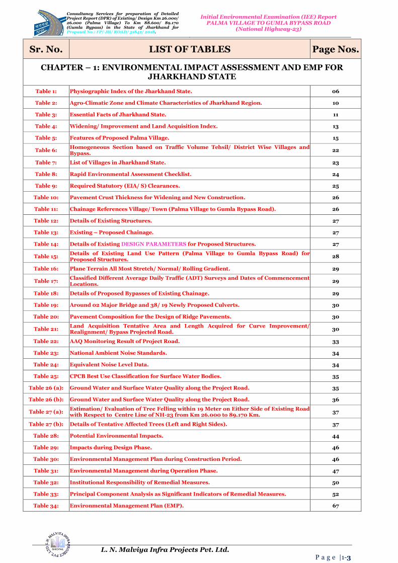
TABLE OF CONTENTS
Sr. No. Description of Item Page Nos.
CHAPTER – 1: ENVIRONMENTAL IMPACT ASSESSMENT AND EMP FOR JHARKHAND STATE
1. INTRODUCTION AND BACKGROUND OF THE PROJECT
06
2. BACKGROUND - Scope and Study 08
3. PROJECT DESCRITPTION AND ALIGNMENT 13
4. OBJECTIVE 16
5. METHODOLOGY: Eco-Friendly OR Environmentally Friendly Road Construction Methods and Materials
17
6. ENVIRONMENTAL INDEX OR FEATURES OF THE PROJECT
20
7. DEMOGRAPHIC INDEX OF THE PROJECT DISTRICT 22
8. ENVIRONMENTAL CHECKLIST 23
9. STATUTORY CLEARANCES REQUIRED 25
10. ENVIRONMENTAL IMPACT ASSESSMENT OF THE PROJECT SITE
32
11. BASELINE ENVIRONMENTAL INDEX AND STATUS OF THE PROJECT SITE
32
12. AIR, WATER AND NOISE LEVEL 33
13. INSTITUTIONAL REQUIREMENTS AND ENVIRONMENTAL MONITORING PLANS
50
14. PRINCIPAL COMPONENT ANALYSIS (PCA) INDICATORS
52
15. ENVIRONMENTAL MANAGEMENT PLAN (EMP) for Palma Village to Gumla Bypass Road in the State of Jharkhand
67
16. CONCLUSIONS AND BUDGET 81
17. CONCLUSIONS AND RECOMONDATIONS 83
Consultancy Services for preparation of Detailed Project Report (DPR) of Existing/ Design Km 26.000/ 26.000 (Palma Village) To Km 88.600/ 89.170 (Gumla Bypass) in the State 0f Jharkhand for Proposal No.: FP/ JH/ ROAD/ 31842/ 2018.
Initial Environmental Examination (IEE) Report PALMA VILLAGE TO GUMLA BYPASS ROAD
(National Highway-23)
L. N. Malviya Infra Projects Pvt. Ltd. P a g e |1-3
Sr. No. LIST OF TABLES Page Nos.
CHAPTER – 1: ENVIRONMENTAL IMPACT ASSESSMENT AND EMP FOR JHARKHAND STATE
Table 1: Physiographic Index of the Jharkhand State. 06
Table 2: Agro-Climatic Zone and Climate Characteristics of Jharkhand Region. 10
Table 3: Essential Facts of Jharkhand State. 11
Table 4: Widening/ Improvement and Land Acquisition Index. 13
Table 5: Features of Proposed Palma Village. 15
Table 6: Homogeneous Section based on Traffic Volume Tehsil/ District Wise Villages and Bypass.
22
Table 7: List of Villages in Jharkhand State. 23
Table 8: Rapid Environmental Assessment Checklist. 24
Table 9: Required Statutory (EIA/ S) Clearances. 25
Table 10: Pavement Crust Thickness for Widening and New Construction. 26
Table 11: Chainage References Village/ Town (Palma Village to Gumla Bypass Road). 26
Table 12: Details of Existing Structures. 27
Table 13: Existing – Proposed Chainage. 27
Table 14: Details of Existing DESIGN PARAMETERS for Proposed Structures. 27
Table 15: Details of Existing Land Use Pattern (Palma Village to Gumla Bypass Road) for Proposed Structures.
28
Table 16: Plane Terrain All Most Stretch/ Normal/ Rolling Gradient. 29
Table 17: Classified Different Average Daily Traffic (ADT) Surveys and Dates of Commencement Locations.
29
Table 18: Details of Proposed Bypasses of Existing Chainage. 29
Table 19: Around 02 Major Bridge and 38/ 19 Newly Proposed Culverts. 30
Table 20: Pavement Composition for the Design of Ridge Pavements. 30
Table 21: Land Acquisition Tentative Area and Length Acquired for Curve Improvement/ Realignment/ Bypass Projected Road.
30
Table 22: AAQ Monitoring Result of Project Road. 33
Table 23: National Ambient Noise Standards. 34
Table 24: Equivalent Noise Level Data. 34
Table 25: CPCB Best Use Classification for Surface Water Bodies. 35
Table 26 (a): Ground Water and Surface Water Quality along the Project Road. 35
Table 26 (b): Ground Water and Surface Water Quality along the Project Road. 36
Table 27 (a): Estimation/ Evaluation of Tree Felling within 19 Meter on Either Side of Existing Road with Respect to Centre Line of NH-23 from Km 26.000 to 89.170 Km.
37
Table 27 (b): Details of Tentative Affected Trees (Left and Right Sides). 37
Table 28: Potential Environmental Impacts. 44
Table 29: Impacts during Design Phase. 46
Table 30: Environmental Management Plan during Construction Period. 46
Table 31: Environmental Management during Operation Phase. 47
Table 32: Institutional Responsibility of Remedial Measures. 50
Table 33: Principal Component Analysis as Significant Indicators of Remedial Measures. 52
Table 34: Environmental Management Plan (EMP). 67

Consultancy Services for preparation of Detailed Project Report (DPR) of Existing/ Design Km 26.000/ 26.000 (Palma Village) To Km 88.600/ 89.170 (Gumla Bypass) in the State 0f Jharkhand for Proposal No.: FP/ JH/ ROAD/ 31842/ 2018.
Initial Environmental Examination (IEE) Report PALMA VILLAGE TO GUMLA BYPASS ROAD
(National Highway-23)
L. N. Malviya Infra Projects Pvt. Ltd. P a g e |1-4
Table 35: Environmental Mitigation and Monitoring Requirements. 81
Table 36 (a): Details of Palma Village to Gumla Bypass Road. 82
Table 36 (b): Cost of Palma Village to Gumla Bypass Road. 83
Table 37 (a): Focus Group Discussion Public Consultation. 84
Table 37 (b): Positive Impacts. 84
Table 37 (c): Negative Impacts. 85
Table 37 (d): Public Consultation and Focus Group Discussions in Palma Village to Gumla Bypass Road.
85
Sr. No. LIST OF TABLES Page Nos.
CHAPTER – 1: ENVIRONMENTAL IMPACT ASSESSMENT AND EMP FOR JHARKHAND STATE
Figure 1: Mountain Ranges, Meandering Rivers and Miles of Forests Supporting Rich Biodiversity.
07
Figure 2 (a): Detailed Project Description Process (Schematic Diagram OR Flowchart Showing Project Layouts and Concluding Components).
09
Figure 2 (b): Index Location and District Map of Jharkhand State Projected Road. 10
Figure 3 (a): Projected Alignment of Palma Village to Gumla Bypass Road. 14
Figure 3 (b): Projected Alignment Showing Location and Index Map of Road. 14
Figure 3 (c): Google Map of Project Alignment Chainage starts from 31 + 650 up-to 71 + 700 (Kms). 15
Figure 4: Project Execution Objectives and Decision Making Work-Life Cycle. 17
Figure 5: Methodological Perspective Over-View of Road Date Base Construction Photographs. 19
Figure 6: Daily Variations of Traffic Volume on Projected Road. 31
Figure 7 (a): Increase in Levels of Pollutant-Emissions-Impact on Future Generated Aspects/ Prospects from Various Sources.
40
Figure 7 (b): Noise Levels Impact Must Not Exceed the Permissible Limits in Sensitive Zones along Road Side.
41
Figure 7 (c): Mitigatory Measures Plans Generated; Initialized and Finalized to Avoid Contamination Impact on Water Resources and Quality.
42
Figure 7 (d): Plan Mitigatory Measures to Avoid Soil Contamination Impact on Agricultural Land and Other Sensitive Zones in Environmental/ Natural/ Ecological Vicinity/ Area/ Site.
43
Figure 8 (a): Mitigation Enhancement as per Alignment Design Phase to Reduce Tree Cutting and Compensatory Plantation Relevance.
45
Figure 8 (b): Process of Pyrolysis in Solid and Waste Water Treatment. 48
Figure 8 (c): Solid Waste Handling Pyrolysis Technique. 49
Figure 8 (d): Sewage Treatment Process (STP) of Wastewater Layout. 49
Figure 9 (a): TYPICAL CROSS SECTION TYPE A-3: FOR OPEN COUNTRY PLAIN/ ROLLING TERRAIN.
55
Figure 9 (b): TYPICAL CROSS SECTION: For BUILT-UP SECTION PLAIN/ ROLLING TERRAIN. 56
Figure 10 (a): Overview of the Environment and Social Framework. 63
Figure 10 (b): Core Principles of the Environmental and Social Framework. 64
Figure 10 (c): The Environmental Objectives; Application Scope; Policy Approach of the Environmental and Social Framework.
65
Figure 10 (d): The Policy Requirements; Roles and Responsibilities of the Environment and Social Framework.
66

Consultancy Services for preparation of Detailed Project Report (DPR) of Existing/ Design Km 26.000/ 26.000 (Palma Village) To Km 88.600/ 89.170 (Gumla Bypass) in the State 0f Jharkhand for Proposal No.: FP/ JH/ ROAD/ 31842/ 2018.
Initial Environmental Examination (IEE) Report PALMA VILLAGE TO GUMLA BYPASS ROAD
(National Highway-23)
L. N. Malviya Infra Projects Pvt. Ltd. P a g e |1-5
ABBREVIATIONS AND ACRONYMS
AADT
Annual Average Daily Traffic
MOEF
Ministry of Environment and Forests AC
Asphaltic Concrete
MORT & H
Ministry of Road Transport & Highways
ADT Average Daily Traffic CPWD Central Public Work Department BBD
Benkelman Beam Deflection
MSA
Million Standard Axles
BC
Bituminous Concrete
MSL
Mean Sea Level BM
Bituminous Macadam
NH
National Highway
BOQ
Bill of Quantities
NMT
Non-Motorized Traffic BOT
Build Operate Transfer
NPV
Net Present Value
BSNL
Bharat Sanchar Nigam Limited
NSDP
Net State Domestic Product BT
Bituminous Track
NTPC
National Thermal Power Corporation
CBR
California Bearing Ratio
O & M
Operation & Maintenance CD
Cross Drainage
O-D
Origin Destination
CGWB
Central Ground Water Board
OFC
Optical Fiber Cable CMSA
Cumulative Million Standard Axles
OMC
Optimum Moisture Content
COI
Corridor of Impact
PCC
Plain Cement Concrete CRRI
Central Road Research Institute (India)
PCU
Passenger Car Unit
CVPD
Commercial Vehicle Per Day
PIU
Project Implementation Unit DBFOT
Design, Build, Finance, Operate & Transfer
PPM
Parts Per Million DBM
Dense Bituminous Macadam
PPP
Public Private Partnership
DLC
Dry Lean Concrete
PPR
Preliminary Project Report DTM
Digital Terrain Model
PQ
Pre-Qualification
EA
Environmental Assessment
PQC
Pavement Quality Control EASL
Equivalent Standard Axle Load
PWD
Public Works Department
EIA
Environment Impact Assessment
QAP
Quality Assurance Plan EIRR
Economic Internal Rate of Return
QC
Quality Control
FFR
Final Feasibility Report
R & R
Resettlement and Rehabilitation FIRR
Financial Internal Rate of Return
RAP
Resettlement Action Plans
GAD
General Arrangement Drawing
RCC
Reinforced Cement Concrete GDP
Gross Domestic Product
RHS
Right Hand Side
GOI
Government of India
RL
Reduced Level GPS
Global Positioning System
ROB/ RUB
Road Over Bridge/ Road Under Bridge
GSB
Granular Sub-Base
ROW
Right of Way GTS
Geodetic Triangulation Survey
Rs.
Rupees
Ha
Hectare
SH
State Highway HDM-4
Highway Design & Maintenance Model (Series-4)
SIA
Social Impact Assessment HDMQ
Highway Design and Maintenance Model with Congestion Analysis
Sq. Km
Square Kilometre
HFL
High Flood Level
TBM
Temporary Bench Mark IRC
Indian Road Congress
Temp
Temperature
IRR
Internal Rate of Return
TOR
Terms of Reference Km
Kilometre
TRL
Transportation Research Laboratory
KMPH
Kilometre Per Hour
UG
Under Ground LA
Land Acquisition
VDF
Vehicles Damage Factor
LT/ HT
Low Tension/ High Tension Electric Lines
Veh.
Vehicles m
Meter
VGF
Viability Gap Funding
MDR
Major District Road
WB
World Bank mm
Millimetre
WBM
Water Bound Macadam
Dia. Diameter WMM
Wet Mix Macadam EPC Engineering, Procurement, and Construction PPE Personal Protective Equipment
PPR Peste-des Petits Ruminants GAD General Administration Department LMI Labour Market Information MSE Mean Squared Error SARA Saturates, Aromatics, Resins and Asphaltenes ACZ Agro-Climatic Zone PET Poly-Ethylene Tere-phthalate SEDP Sustainable Environmental Development
Practices FRC Fibre Reinforced Concrete PCM Public Consultation Method PCM Public Consultation Meeting FGD Focus Group Discussion
Consultancy Services for preparation of Detailed Project Report (DPR) of Existing/ Design Km 26.000/ 26.000 (Palma Village) To Km 88.600/ 89.170 (Gumla Bypass) in the State 0f Jharkhand for Proposal No.: FP/ JH/ ROAD/ 31842/ 2018.
Initial Environmental Examination (IEE) Report PALMA VILLAGE TO GUMLA BYPASS ROAD
(National Highway-23)
L. N. Malviya Infra Projects Pvt. Ltd. P a g e |1-6
CHAPTER -1: ENVIRONMENTAL IMPACT ASSESSMENT AND EMP FOR JHARKHAND STATE
1. INTRODUCTION AND BACKGROUND OF THE PROJECT
Jharkhand is a state in Eastern part of India, carved out of the Southern part of Bihar on 15th
November, 2000. The
State shares its border with the states of Bihar to the North, Uttar Pradesh to the Northwest, Chhattisgarh to the
West, Odisha to the South and West Bengal to the East. It has an area of 79,710 Km2 (30,778 Square Miles). The city
of Ranchi is its capital and Dumka its sub capital. Jharkhand suffers from resource curse and it accounts for more
than 40% of the mineral resources of India, but it suffers widespread poverty as 39.1% of the population is below the
poverty line and 19.6% of the children fewer than five years of age are malnourished. The State is primarily a rural
state as only 24% of the population resides in cities. The state of Jharkhand was created as 28th
state of the Indian
Union by the Bihar Re-organization Act on 15th
November, 2000. The state covers 7.970 million hectare area with a
population of 26.9 million (as per census 2001). The state has sizable tribal population (26.3%). Jharkhand is
historically affected by different types of Natural and Human Disasters. Government of Jharkhand has taken proactive
steps to strengthen its mitigation, preparedness, and response, recovery and rehabilitation strategies to reduce the risk
of disasters in the state by creating State Disaster Management Authority (SDMA) at State level, District Disaster
Management Authority (DDMA) in all the 24 Districts. Apart from this State Executive Committee (SEC) is
proactively strategizing and functioning for the Disaster Management of the State. State Steering Committee has also
been formed as 28th
department level to govern the Government of India and UNDP sponsored Disaster risk reduction
program in the state. Disaster management department under the aegis of State Executive Committee is facilitating the
main streaming of Flagship development program to reduce the risk of Disaster in the State. The Department has
taken several initiatives to strengthen the convergence between different line departments and institutions of
excellence in state to develop sustainable strategy for various disasters in the state. Government of Jharkhand is well
aware of the need to integrate flagship programs for enhancing the coping capacity of community up to village level
in the State. It is often referred to as the "SMART CITIES MISSION, Government of India". Ranchi has been
selected as one of the hundred Indian cities to be developed as a smart city under “PM Narendra Modi's Flagship
SMART CITIES MISSION”. It has diverse varieties of physiographic phenomenon with Large Plateaus and
numerous Mountain Ranges, Meandering Rivers and Miles of Forests Supporting Rich Biodiversity in Figure 1.
Physiographic Index
The spatial extent of Jharkhand State is approximately 21° 55’ to 25° 35’ North Latitude and 83° 20’ to 88° 02’ East
Longitude. The State is land locked and it shares its boundary with Orissa on the Southeast, Chattisgarh on the
Southwest, Bihar on the North, West Bengal on the East and Uttar Pradesh on the Northwest. It comprises of the
Chota-Nagpur Plateau, which forms a part of Deccan bio-geographic province. It is a hilly undulating plateau
characterized by predominantly tropical forests and tribal settlements. The State is endowed with natural resources
that need to be conserved and utilized in a sustainable manner for all-round development of the state in general and
the marginalized tribal population in particular. The total geographical area of the State is 79.70 Lakh Hectares, out of
which 23.22 Lakh Hectares (29.33%) are under forests, 5.66 Lakh Hectares (7.12%) are barren lands, 7.24 Lakh
Hectares (9.10%) are put to non-agricultural use, 0.90 Lakh Hectares (1.15%) are under pastures and other grazing
lands, 3.07 Lakh Hectares (3.86%) are cultivable wastelands, 0.88 Lakh Hectares (1.11%) are under miscellaneous
trees and groves, 12.04 Lakh Hectares (15.14%) are current fallows, 8.45 Lakh Hectares (10.63%) are under other
fallows, and 17.95 Lakh Hectares (22.58%) are the net sown area. The number of electrified villages is 14,667 (45.0%
of the total villages). Around 26.0% (8,484) % of the total villages are connected by roads. The lengths of the National
Highways and the State Highways are 1,006 and 4,662 Kilometers respectively.
The “Jharkhand State”, has different relief because of its “Physiographic Index”, as it consists of four series of plateaus of having different heights (Table 1).
Table 1: Physiographic Index of the Jharkhand State.
Sr. No. Profile of the Jharkhand State 1. The highest plateau lies in the West known as Western or Higher Ranchi Plateau or locally known as the Pat
region located at 2,500 to 3,600 feet above sea level covering Northern part of the old Ranchi district and the Southern edge of the old Palamu district. The term Pat represents a feature similar to a table with steep edges around and a flat top. It is full of dissected hills having a hill station, Netarhat at the top;
2. The second plateau is known as Ranchi Plateau having a height of 2,000 feet composed of gneisses and granites. It is separated by the Damodar trough from the Hazaribagh Plateau;
3. The next plateau is Lower Chotanagpur Plateau consisting mainly of gneisses and granite and partly of schists and other Dharwar rocks;
4. The other plateaus are the Rajmahal Hills and the Kaimur Plateau. These plateaus are separated by the narrow and steep slopes known as scarps.

Consultancy Services for preparation of Detailed Project Report (DPR) of Existing/ Design Km 26.000/ 26.000 (Palma Village) To Km 88.600/ 89.170 (Gumla Bypass) in the State 0f Jharkhand for Proposal No.: FP/ JH/ ROAD/ 31842/ 2018.
Initial Environmental Examination (IEE) Report PALMA VILLAGE TO GUMLA BYPASS ROAD
(National Highway-23)
L. N. Malviya Infra Projects Pvt. Ltd. P a g e |1-7
Figure 1: Mountain Ranges, Meandering Rivers and Miles of Forests Supporting Rich Biodiversity.
It is believed that before the Chota-Nagpur Peneplain was successfully uplifted thrice by the side effect of the three
violent Himalayan movements in Tertiary times continued till Pleistocene times resulting in well-known waterfalls
like Hundru and Jonha, etc. on the scarps. The first up-liftment took place during the Eocene to Oligocene period
creating Pat region, the second one during Miocene forming the Ranchi and Hazaribagh Plateau and the third one
during Pliocene and Pleistocene period uplifting the outer Chota-Nagpur Plateau. All plateaus are the parts of the
same plain successively uplifted during Tertiary and Pliestocene times. Marvellous eye catching are rare and
geological/ geo-morphological features like rejuvenated meandering and deep cutting young rivers like Damodar and

Consultancy Services for preparation of Detailed Project Report (DPR) of Existing/ Design Km 26.000/ 26.000 (Palma Village) To Km 88.600/ 89.170 (Gumla Bypass) in the State 0f Jharkhand for Proposal No.: FP/ JH/ ROAD/ 31842/ 2018.
Initial Environmental Examination (IEE) Report PALMA VILLAGE TO GUMLA BYPASS ROAD
(National Highway-23)
L. N. Malviya Infra Projects Pvt. Ltd. P a g e |1-8
Subarnarekha are the uniqueness in the Jharkahnd State. It is rate because of combination of senility with the character
of young rivers. The state has the luxuriant forests and lush green rolling seasonal meadows and magnificent
undulating hills and valleys are the special attraction. The golden river “Swarnarekha” adds melody in the “Pristine
Environment” along the course/ itinerary. A combination of table-top flat lands and the peneplain with dome shaped
exfoliating hillocks resembling like inverted Nagara (Drum) are spread over the state. Further, the Tors or the
balanced diamond shaped rocks are also present wonderful nature of the State. The state is one of the largest
producers of the mineral resources of the country spreading over majority of the districts with a paradox to be among
the bottom lying states in terms of development. An area of 24.4 Lakh Hectares (30.61%) is under agricultural
wastelands that have to be beneficially utilized for rural development program in the region/ state/ area.
Climatic Index
The state falls under the Tropical-Monsoon climatic region and the Tropic of Cancer cuts across the State passing
through the middle of the Ranchi City. The average temperature of the state is 25°C, which varies greatly because of
varying heights of different plateaus mentioned above. The average temperature of the Pat region is below 23°C while
rest of the state records average annual temperature between 23°C and 26°C except the Eastern part of Santhal
Pargana region, East Singhbhum, Garhwa, Palamu and the Northern part of Chatra districts where it is above 26°C.
There are extremities in climate in the State in two seasons’ summer and winter. The hottest areas are found towards
the North-Western part of the State (Daltonganj) around Jamshedpur and Dhanbad cities having more than 40°C
temperatures. Similarly, the state gets affected by the cold waves with less than 5°C temperature and reeling cold. The
average annual rainfall in the state is 1,400 mm with more than 4/5th
rainfall occurs between months June to
September. It also gets rainfall from the branch of monsoon from the Arabian Sea. There are also variations in rainfall
varying from below 1,200 mm to 1,800 mm. There are “Five”, climatic regions in the State. One, North-Eastern and
North-Central Plateau Region (Western part of Santhal Pargana region, Giridih, Kodarma and Northern Hazaribagh);
Two, Upper Chota-Nagpur region (Pat region, Ranchi Plateau, Gumla and the plateau region of outer Chota-Nagpur
spread in Simdega); Three, South-Eastern Region (East Singhbhum, Saraikela and West Singhbhum); Four, Eastern
Region (Sahibganj, Pakur, Eastern Deoghar, Eastern Jamtara and North-Eastern part of Saraikela); and Five, North-
Western Lower Plateau Region (Garhwa and Palamu).
Mineral Resources Index
Jharkhand is endowed with vast natural resources specially the different variety of minerals ranging from Iron Ore,
Copper Ore, Coal, Mica, Bauxite, Fire Clay, Graphite, Kyanite, Sillimanite, Lime Stone, Uranium and other minerals.
Mumbai and Atomic Minerals, Jharkhand is one of the leading producer of minerals wealth of India in the country.
2. BACKGROURND - Scope and Study
The Jharkhand Road Development Corporation (JRDC) has been entrusted with the assignment of Consultancy
Services for preparation of Detailed Project Report of National Highways/ State Roads (approved as National
Highway) in the State of Jharkhand for up gradation to Two/ Four Lanes with paved shoulder configuration. JRDC now
invites proposal from Technical Consultants for carrying out detailed project report for proper structuring and
implementation of projects on Engineering, Procurement, and Construction (EPC)/ Public Private Partnership (PPP)
mode on Palma Village to Gumla Bypass Road in the State of Jharkhand.
In order to fulfil the traffic needs and road safety requirement, Jharkhand Road Development Corporation (JRDC)
has appointed the M/s HIGHWAY ENGINEERING CONSULTANT BHOPAL (MP) as consultants to Providing
Consultancy Services for Preparation of Detailed Project Report of Palma Village to Gumla Bypass Road in the
State of Jharkhand for Up-gradation to Two Lanes with Paved Shoulder/ Four Lane Configurations, the Assignment for
Widening and Strengthening/ Reconstruction of Existing Pavement to Four Lane including Replacement of Culverts
and Bridges from Existing/ Design Kms 26.000/ 26.000 (Palma Village) To Kms 88.600/ 89.170 (Gumla Bypass) of
NH-23 in the State of Jharkhand, Proposal No.: FP/ JH/ ROAD/ 31842/ 2018.
The project study consists of preparation of the following as shown in Figure 2 (a):
Stage 1 – Inception Report and Quality Assurance Plan;
Stage 2 – Feasibility, Strip Plan and Clearance and Land Acquisition Report;
Stage 3 – (a) – Draft Detailed Project Report;
(b) – Final Detailed Project Report.

Consultancy Services for preparation of Detailed Project Report (DPR) of Existing/ Design Km 26.000/ 26.000 (Palma Village) To Km 88.600/ 89.170 (Gumla Bypass) in the State 0f Jharkhand for Proposal No.: FP/ JH/ ROAD/ 31842/ 2018.
Initial Environmental Examination (IEE) Report PALMA VILLAGE TO GUMLA BYPASS ROAD
(National Highway-23)
L. N. Malviya Infra Projects Pvt. Ltd. P a g e |1-9
Figure 2 (a): Detailed Project Description Process (Schematic Diagram OR Flowchart Showing Project Layouts and Concluding Components).
1. 2. 3.
CONSULTANCY SERVICES FOR PREPARATION OF
FEASIBILITY STUDY AND DETAILED PROJECT REPORT
OF INITIAL ENVIRONMENTAL EXAMINATION (IEE)
ASSESSED-CONTROLLED… AREAS LIKE SUPER
COMMUNICATION EXPRESSWAY...!!!
Preliminary Engineering Applications
(Preferred Plans/ Locations/ IEE REPORT)
Route Inspection/
Innovations and
Inventory
Project Development
Concepts/ Baselines
Operations and
Maintenances
CS/ CC/
Bituminous Road
Construction
Clearing Sites/
Places/ Areas
Standards/ Policies/ Essential
Environmental Clearances
Road/ Bridge
Construction
Network/ Activities
Construction of Roads/ Bridges and
Pertinent/ Applicable Structures
FINAL PLANS/ DPR
Project Planning’s (Alternative
Considerations)
Sanction from JRDC and
State/ Local/ Regional
Government Agencies
Leveling/
Laying
Foundation on
Coat

Consultancy Services for preparation of Detailed Project Report (DPR) of Existing/ Design Km 26.000/ 26.000 (Palma Village) To Km 88.600/ 89.170 (Gumla Bypass) in the State 0f Jharkhand for Proposal No.: FP/ JH/ ROAD/ 31842/ 2018.
Initial Environmental Examination (IEE) Report PALMA VILLAGE TO GUMLA BYPASS ROAD
(National Highway-23)
L. N. Malviya Infra Projects Pvt. Ltd. P a g e |1-10
Table 2: Agro-Climatic Zone and Climate Characteristics of Jharkhand Region.
Sr. No. Features Region-I Region-II Region-III
1. Geographical Area (Lakh
Hectare) 35.18 ---------- ----------
2. Net Sown Area (Lakh Hectare) 07.12 ---------- ----------
3. Irrigation Area (Lakh Hectare) 06.58 ---------- ----------
4. Altitude (Meters) 275-670 ---------- ----------
5. Latitude 23° 25'-25° 30 N 22° 30'-24° 30 N 21° 28'-23° 36 N
6. Longitude 84° 25'-87° 40 E 83° 22'-85° 60 E 85° 5'-86° 54 E
7. Mean Annual Rainfall (mm) 1,270 1,246 1,400
8. Temperature (°C) ---------- ---------- ----------
9. Average (°C) 25.20 25.80 27.20
10. Maximum (°C) 44.20 43.60 44.00
11. Minimum (°C) 04.80 05.30 06.60
During Post-Monsoon period, slowly again the Western end of Jharkhand Region is likely to face decrease in rainfall,
with no change or little increase in rainfall in most other parts of the state. In 2,100 there is an overall increase in
rainfall with Southern states likely to receive more rainfall in the Northern states. The increases in rainfalls during the
Post-Monsoon and Pre-Monsoon periods are projected to be more than the increase in rainfalls in the Table 2.
Average Monsoon Rainfall (June, July, August and September) trends in various Agro-Climatic Zones (ACZ) of
Jharkhand are between years 1961-2002. The project related study/ area/ place within boxes indicate the decreased
trend in rainfall in this period (Source: India Water Portal http://indiawaterportal/metdata accessed on June 2011).
Socio - Economic Profile Index
Some of the environmental indicators that determine the adaptive capacity of population include its economic
strength, access to infrastructure, access to health facilities, land use pattern, literacy rates, income generating sectors
and their strengths, policies and governance structures. Brief descriptions of all these environmental indicators, as
they exist now are summarized below:
The Palma Village to Gumla Bypass Road is located in the district of Bihar, which in turn is located in the State of
Jharkhand. According to the Census of India 2001, total population of the state is 2, 69, 09, 428 with a sex ratio of
941 and density of population is 338 persons per Sq. Kms. According to the 2001 Census, the percentage of the ST
population is 26.30%. Total workforce in the state is 31.24%. The literacy rate, according to the 2001 Census, is
54.15%, where Male and Female Literacy are 67.94 and 39.38% respectively. The Census of 2001 showed that
Jharkhand had 32,615 villages, of which, 29,354 were inhabited. Jharkhand has total population of 2.69 crores as
census 2001 having total geographical area of 7.9 million hectare. Among this 39% of population is consisting of
Schedule Tribes (STs) and Schedule Casts (SCs). Literacy level is 54%. Almost 50% of its total population is
Below Poverty line. Almost 80% of the population is dependent upon rain fed based Agriculture and productivity is
very low i.e., below 1 ton/ hectare. This generates a very low level of coping capacity among the communities of
Jharkhand for Disasters as shown in Figure 2 (b).
Figure 2 (b): Index Location and District Map of Jharkhand State Projected Road.

Consultancy Services for preparation of Detailed Project Report (DPR) of Existing/ Design Km 26.000/ 26.000 (Palma Village) To Km 88.600/ 89.170 (Gumla Bypass) in the State 0f Jharkhand for Proposal No.: FP/ JH/ ROAD/ 31842/ 2018.
Initial Environmental Examination (IEE) Report PALMA VILLAGE TO GUMLA BYPASS ROAD
(National Highway-23)
L. N. Malviya Infra Projects Pvt. Ltd. P a g e |1-11
Demographic Index
Jharkhand (Hindi: झारखंड) is a state in Eastern India. It was carved out of the Southern part of Bihar as 28th
state of
the Indian Union and was brought into existence by the Bihar reorganization Act on November 15th
, 2000 the birth
anniversary of the legendary Bhagwan, Birsa and Munda. Jharkhand shares its border with the states of Bihar to the
North, Uttar Pradesh and Chhattisgarh to the West, Orissa to the South, and West Bengal to the East and it has an area
of 28,833 Square mile (74,677 Km2).
The Name "Jharkhand" Means "The Land of Forest or Woods or Waters or Rains"
This paradoxical development profile of Jharkhand is combined with the fact that distortions in distribution and access
to resources have made little difference to lives of ordinary people. However, the people of the region are politically
mobilized and self-conscious and are actively seeking better bargains for the state. The people in Jharkhand have the
advantage of being culturally vibrant, as reflected in the diversity of languages spoken, festivals celebrated, and
variety of folk music, dances, rituals practices and other traditions of performing arts. Jharkhand is famous for its rich
mineral resources like Uranium, Mica, Bauxite, Granite, Gold, Silver, Graphite, Magnetite, Dolomite, Fireclay,
Quartz, Feldspar, Coal (32% of India), Iron, Copper (25% of India) etc. Forests and woodlands occupy more than
29% of the state which is amongst the highest in India. The industrial city of Ranchi is its capital while Jamshedpur is
the largest city of the state and some of the other major cities and industrial centers are Dhanbad, Bokaro and
Hazaribagh. Jharkhand has 24 districts, 211 blocks and 32, 620 villages in the region/ state out of which only 45% are
electrified while only 8,484 are connected by roads. Jharkhand is the leading producer of mineral wealth in the
country, endowed as it is with vast variety of minerals like iron ore, coal, copper ore, mica, bauxite, graphite,
limestone and uranium. Jharkhand is also known for its vast forest resources or “The Land of Forest or Woods or Waters or Rains”, and Essential Facts of Jharkhand State is shown in the Table 3.
Table 3: Essential Facts of Jharkhand State.
Essential Facts : Remarks
Date of Formation : 15th November, 2018
Size : 79,714 Square Kilometres
Capital : Ranchi of Bihar State
Rivers : Damodar and Subarnarekha Rivers
Forests and National Park : Betla (Palamau), NP and Hazaribagh-WS
Languages : Hindi, Urdu and Santhali etc.
Neighbours State : Bihar, Uttar Pradesh, West Bengal, Orissa and Chhattisgarh
State Animal : Elephant Brute
State Bird : Asian Species Koel
State Tree : Sal Type Category OR Variety/ Diversity
State Flower : Palash Type Boom Flourish
Total Number of Population : 2,69,09,428 as per 2001 Census Record
Total Number of Male Population : 1,38,61,277 as per 2001 Census Record
Total Number of Female Population : 1,30,48,151 as per 2001 Census Record
Per Capita Income : Rs. 4,161.00
Density of Population : 338 Persons per Square Kilometres
Total Number of Districts : 24
Total Number of Sub divisions : 35
Total Number of Blocks : 212
Total Number of Villages : 32,620
Number of Villages Electrified : 14,667 (45% of Total)
Number of Villages connected by Road : 8,484
Total Number of National Highways : 1,006 Kilometres
Total Number of State Highways : 4,662 Kilometres
Consultancy Services for preparation of Detailed Project Report (DPR) of Existing/ Design Km 26.000/ 26.000 (Palma Village) To Km 88.600/ 89.170 (Gumla Bypass) in the State 0f Jharkhand for Proposal No.: FP/ JH/ ROAD/ 31842/ 2018.
Initial Environmental Examination (IEE) Report PALMA VILLAGE TO GUMLA BYPASS ROAD
(National Highway-23)
L. N. Malviya Infra Projects Pvt. Ltd. P a g e |1-12
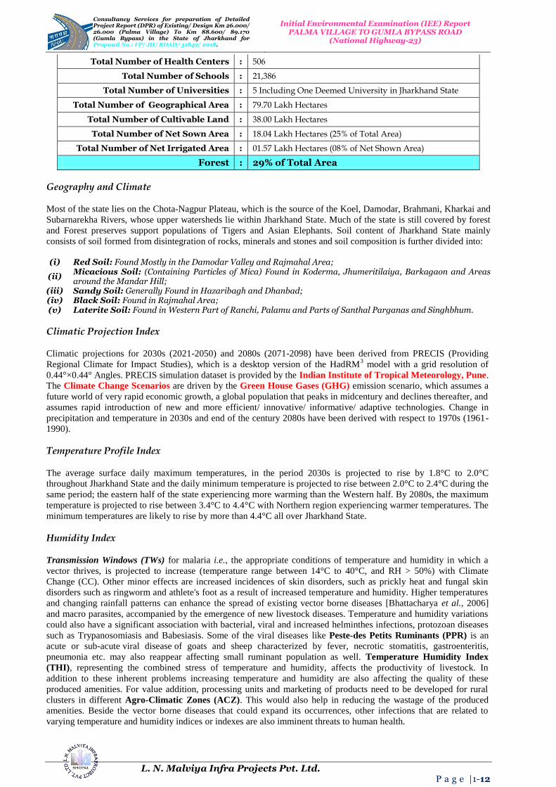
Total Number of Health Centers : 506
Total Number of Schools : 21,386
Total Number of Universities : 5 Including One Deemed University in Jharkhand State
Total Number of Geographical Area : 79.70 Lakh Hectares
Total Number of Cultivable Land : 38.00 Lakh Hectares
Total Number of Net Sown Area : 18.04 Lakh Hectares (25% of Total Area)
Total Number of Net Irrigated Area : 01.57 Lakh Hectares (08% of Net Shown Area)
Forest : 29% of Total Area
Geography and Climate
Most of the state lies on the Chota-Nagpur Plateau, which is the source of the Koel, Damodar, Brahmani, Kharkai and
Subarnarekha Rivers, whose upper watersheds lie within Jharkhand State. Much of the state is still covered by forest
and Forest preserves support populations of Tigers and Asian Elephants. Soil content of Jharkhand State mainly
consists of soil formed from disintegration of rocks, minerals and stones and soil composition is further divided into:
(i) Red Soil: Found Mostly in the Damodar Valley and Rajmahal Area;
(ii) Micacious Soil: (Containing Particles of Mica) Found in Koderma, Jhumeritilaiya, Barkagaon and Areas around the Mandar Hill;
(iii) Sandy Soil: Generally Found in Hazaribagh and Dhanbad; (iv) Black Soil: Found in Rajmahal Area; (v) Laterite Soil: Found in Western Part of Ranchi, Palamu and Parts of Santhal Parganas and Singhbhum.
Climatic Projection Index
Climatic projections for 2030s (2021-2050) and 2080s (2071-2098) have been derived from PRECIS (Providing
Regional Climate for Impact Studies), which is a desktop version of the HadRM3 model with a grid resolution of
0.44°×0.44° Angles. PRECIS simulation dataset is provided by the Indian Institute of Tropical Meteorology, Pune.
The Climate Change Scenarios are driven by the Green House Gases (GHG) emission scenario, which assumes a
future world of very rapid economic growth, a global population that peaks in midcentury and declines thereafter, and
assumes rapid introduction of new and more efficient/ innovative/ informative/ adaptive technologies. Change in
precipitation and temperature in 2030s and end of the century 2080s have been derived with respect to 1970s (1961-
1990).
Temperature Profile Index
The average surface daily maximum temperatures, in the period 2030s is projected to rise by 1.8°C to 2.0°C
throughout Jharkhand State and the daily minimum temperature is projected to rise between 2.0°C to 2.4°C during the
same period; the eastern half of the state experiencing more warming than the Western half. By 2080s, the maximum
temperature is projected to rise between 3.4°C to 4.4°C with Northern region experiencing warmer temperatures. The
minimum temperatures are likely to rise by more than 4.4°C all over Jharkhand State.
Humidity Index
Transmission Windows (TWs) for malaria i.e., the appropriate conditions of temperature and humidity in which a
vector thrives, is projected to increase (temperature range between 14°C to 40°C, and RH > 50%) with Climate
Change (CC). Other minor effects are increased incidences of skin disorders, such as prickly heat and fungal skin
disorders such as ringworm and athlete's foot as a result of increased temperature and humidity. Higher temperatures
and changing rainfall patterns can enhance the spread of existing vector borne diseases [Bhattacharya et al., 2006]
and macro parasites, accompanied by the emergence of new livestock diseases. Temperature and humidity variations
could also have a significant association with bacterial, viral and increased helminthes infections, protozoan diseases
such as Trypanosomiasis and Babesiasis. Some of the viral diseases like Peste-des Petits Ruminants (PPR) is an
acute or sub-acute viral disease of goats and sheep characterized by fever, necrotic stomatitis, gastroenteritis,
pneumonia etc. may also reappear affecting small ruminant population as well. Temperature Humidity Index
(THI), representing the combined stress of temperature and humidity, affects the productivity of livestock. In
addition to these inherent problems increasing temperature and humidity are also affecting the quality of these
produced amenities. For value addition, processing units and marketing of products need to be developed for rural
clusters in different Agro-Climatic Zones (ACZ). This would also help in reducing the wastage of the produced
amenities. Beside the vector borne diseases that could expand its occurrences, other infections that are related to
varying temperature and humidity indices or indexes are also imminent threats to human health.

Consultancy Services for preparation of Detailed Project Report (DPR) of Existing/ Design Km 26.000/ 26.000 (Palma Village) To Km 88.600/ 89.170 (Gumla Bypass) in the State 0f Jharkhand for Proposal No.: FP/ JH/ ROAD/ 31842/ 2018.
Initial Environmental Examination (IEE) Report PALMA VILLAGE TO GUMLA BYPASS ROAD
(National Highway-23)
L. N. Malviya Infra Projects Pvt. Ltd. P a g e |1-13
Rainfall Index
Projections of rainfall in Jharkhand for the period 2021 to 2050 (Table 2) indicates that there is likely to be decrease
in winter rainfall as one move from Eastern part of Jharkhand to Western part of Jharkhand Region. In pre-monsoon
period, the rainfall is increasing only in the Southern part of Jharkhand, with decrease in rain fall in all other parts. In
the Monsoon period, there is a slight increase in rainfall all over Jharkhand (the increase being 1.25 times the rainfall
observed in the current climate) and with no change in the Dhanbad, Bokaro and Hazaribagh Areas. Since monsoon
receives the maximum volume of rain (more than 90% of the total annual rainfall in Jharkhand), further analysis of
the trends of monsoon rainfall is necessary as it forms the main source for agriculture and biodiversity in the state. An
account of average rainfall and minimum temperature for all the eleven Agro-Climatic Zones (ACZ) are observed in
the region/ state. A Widening/ Improvement and Land Acquisition Indexes are being given in the Table 4.
Table 4: Widening/ Improvement and Land Acquisition Index.
Sr. No. Feature Description
1. Land Acquisition 45 m Wide Strip of Land is Required
The Right to Fair Compensation and Transparency in Land Acquisition, Rehabilitation and Resettlement Act' 2013 (RFCTLARR Act' 2013)
The aim of reconnaissance survey was to assess the scope of land acquisition and resettlement study and accordingly
the detailed plan of action was prepared for the preparation of land acquisition planning and resettlement plan.
transparent process for land acquisition for industrialization, development of essential infrastructural facilities and
urbanization with the least disturbance to the owners of the land and other affected families and provide just and fair
compensation to the affected families whose land has been acquired or proposed to be acquired or are affected by such
acquisition and make adequate provisions for such affected persons for their rehabilitation and resettlement and for
ensuring that the cumulative outcome of compulsory acquisition should be that affected persons become partners in
development leading to an improvement in their post acquisition social and economic status and for matters connected
therewith or incidental thereto.
Methodology for Social Impact Assessment
For preparation of resettlement plan, a detailed social impact assessment of the project road was carried out including
resettlement screening, land acquisition planning, project census survey of affected assets and households, Public
Consultation (PC) methods. As far as possible, the Widening/ Improvement work to 2/ 4 Lanning shall be within the
existing right of way avoiding land acquisition, except for locations having inadequate width and where provisions of
short bypasses, service roads, alignment corrections, improvement of intersections are considered necessary and these
are practicable and cost effective. However bypasses proposals should also be considered, wherever in urban areas,
improvement to 2/ 4 Lane of the existing road is not possible. The consultant shall furnish land acquisition details as
per revenue records/ maps for further processing of land acquisition. Consultant shall also submit 3a, 3A and 3D draft
notification for acquisition of land for road network.
Resettlement Screening: A social screening exercise was performed through a reconnaissance survey to gather first
hand information on impact on land acquisition and resettlement with specific attention on land use, presence of legal
and/ or illegal housing, traffic patterns, cultural resources, urban settlements and other sensitive areas. Wherever
required, consultant will liaise with concerned authorities and arrange all clarifications. Approval of all drawings
including General Administration Department (GAD) and detail engineering drawings will be get done by the
consultant from the Railways Department. However, if Railways Department require proof checking of the drawings
prepared by the consultants, the same will be got done by JRDC and payment to the proof consultant shall be made by
JRDC directly. Consultant will also obtain “NO Objection Certificate (NOC)” from Ministry of Environment and
Forest and also incorporate the estimates for shifting of utilities of all types involved from concerned local authorities
in the DPR. Consultant are also required to prepare all Land Acquisition Papers (i.e., all necessary schedule and draft
3a, 3A, and 3D, 3G notification as per L.A.-Act) for acquisition of land either under National Highway-Act or State
Highway-Act.
3. PROJECT DESCRIPTION AND ALIGNMENT
The Projected Alignment/ Corridor starts from Palma Village is in Principally Declared as NH; Proposal No.:
FP/ JH/ ROAD/ 31842/ 2018, which is a Connecting Link between National Highway-23 in Gumla Bypass in
the State of Jharkhand.
The Total Existing Length of the Project Road is 26.000 Kms.

Consultancy Services for preparation of Detailed Project Report (DPR) of Existing/ Design Km 26.000/ 26.000 (Palma Village) To Km 88.600/ 89.170 (Gumla Bypass) in the State 0f Jharkhand for Proposal No.: FP/ JH/ ROAD/ 31842/ 2018.
Initial Environmental Examination (IEE) Report PALMA VILLAGE TO GUMLA BYPASS ROAD
(National Highway-23)
L. N. Malviya Infra Projects Pvt. Ltd. P a g e |1-14
Actual Design Length 63.170 Kms.
The Project Corridor starts in Palma Village at Existing/ Design Kms 26.000/ 26.000 and Terminates at Kms
88.600/ 89.170 of NH-23.
The consultancy services for the same is to include design of best possible alignment and pavement
composition, design of bridges, culverts and other structures in addition to analysis of costs, determining
project feasibility, preparation of Land-Acquisition-Plan (LAP), if any, and obtaining of all requisite
clearances as per need or suitability in the projected areas.
The index map illustrates the project road are presented in the Figures 3 (a) to (b) below:
Figure 3 (a): Projected Alignment of Palma Village to Gumla Bypass Road.
Figure 3 (b): Projected Alignment Showing Location and Index Map of Road.

Consultancy Services for preparation of Detailed Project Report (DPR) of Existing/ Design Km 26.000/ 26.000 (Palma Village) To Km 88.600/ 89.170 (Gumla Bypass) in the State 0f Jharkhand for Proposal No.: FP/ JH/ ROAD/ 31842/ 2018.
Initial Environmental Examination (IEE) Report PALMA VILLAGE TO GUMLA BYPASS ROAD
(National Highway-23)
L. N. Malviya Infra Projects Pvt. Ltd. P a g e |1-15
Figure 3 (c): Google Map of Project Alignment Chainage starts from 31 + 650 up-to 71 + 700 (Kms).
Palma Village
The project road is from Kilometres 26.000 at Palma Village to Kilometres 88.600 at Gumla Bypass in the state of
Jharkhand. Palma is a small Village/ Hamlet in Sikaripara Block in Dumka District of Jharkhand State, India and it
comes under Palma Panchayath. It is located 13 Kilometres towards South from District Head Quarters Dumka. It is
found to be around 20 Kilometres from Shikaripara and approximately 263 Kilometres from State Capital Ranchi.
Palma Local Language is Hindi. Palma Village Total population is 566 and number of houses are 103. Female
Population is 47.7% and Village Literacy Rate is 43.1% and the Female Literacy Rate is 17.0% (Table 5).
Table 5: Features of Proposed Palma Village.
Sr. No.
Feature Description
1. Starting Proposed Ch: 26+000 on National Highway-23
2. Ending Proposed Ch: 88+600 on National Highway-23
3. Start Point Location
(Easting and Northing) 21° 55‟ to 25° 35‟ North Latitude 83° 20‟ to 88° 02‟ East Longitude
4. End Point Location
(Easting and Northing) 21° 55‟ to 25° 35‟ North Latitude 83° 20‟ to 88° 02‟ East Longitude
5. Route Alignment R.H.S.
6. Length of Bypass 26.000 Kms
7. Length of Existing
Alignment 88.600 Kms
8. Terrain Passing Through Plain Terrain
9. Speed 80-100 Km/ Hr
10. Geometrics Horizontal and vertical geometric designed as per IRC
11. At Grade Junction
Improvement Major = 02 Nos., Minor = 06 Nos.
12. Existing Land use pattern
through proposed alignment
Agricultural and Barren Land
13. Number of Structures
Major Bridge = 02 Nos., Minor Bridges = 06 Nos., Abandoned = 00 Nos., New Proposed = 04 Nos., Widening = 00 Nos., New Proposed = 18 Nos., Slab Culvert = 16/ 22 Nos., Box Culvert = 18/ 01 Nos., VUP/ LVUP = 07/ 01 Nos., and Hume Pipe Culvert = 26 Nos., ROB = 01 Nos., Total Number of Structures are = 60 Nos.
14. Land Acquisition 45 m Widening Strip of Land is Required

Consultancy Services for preparation of Detailed Project Report (DPR) of Existing/ Design Km 26.000/ 26.000 (Palma Village) To Km 88.600/ 89.170 (Gumla Bypass) in the State 0f Jharkhand for Proposal No.: FP/ JH/ ROAD/ 31842/ 2018.
Initial Environmental Examination (IEE) Report PALMA VILLAGE TO GUMLA BYPASS ROAD
(National Highway-23)
L. N. Malviya Infra Projects Pvt. Ltd. P a g e |1-16
Gumla Bypass
Gumla District (Hindi: गुमला जिला) is one of the 24th
districts of Jharkhand State, India, and Gumla Town is the
administrative headquarters of this district. For centuries, the place was a meeting center for people from the
hinterland who flocked here to exchange goods using the barter system, and the place was called Gaw-Mela. Gumla is
believed to derive its name from Gaw-Mela, which consists of two words of Hindi (also used in several local dialects),
namely, Gaw (Cows and the Cattle) and Mela, that is, a fair. The place became known as Gaw-mela, and then the
word transformed itself into Gumla.
4. OBJECTIVE
To serve environmental aspects and adopt good Road Consutruction Practices (Sustainable Environmental
Development Practices) under this project . The present research methodology aims to use the waste of some
industries like polypropylene, polyester (as waste of backing and carpet industries respectively) in the preparation of a
special type of asphalt to be used in the production of Hot Mix Asphalt (HMA) for roads, bridges, structures and
dams construction during the civil work. The solid materials in paving mix were low quality aggregates of high
absorptive type and waste marble filler with the final objective to provide added value, to reduce the production costs
and keep the virgin solid materials especially aggregates for a longer period of time. The produced mixes are of
similar or of better performance compared to the conventional asphalt mixtures. And there is an urgent need to
address the great challenges of our times: climate change, resource depletion, pollution, and peak oil. These issues are
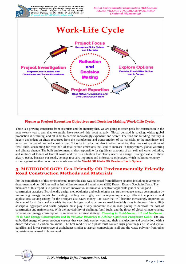
all accelerating rapidly, and all have strong links with the road as well as building industry as shown in Project Execution Objectives and Decision Making Work-Life Cycle (Figure 4).
Consultancy Services for preparation of Detailed Project Report (DPR) of Existing/ Design Km 26.000/ 26.000 (Palma Village) To Km 88.600/ 89.170 (Gumla Bypass) in the State 0f Jharkhand for Proposal No.: FP/ JH/ ROAD/ 31842/ 2018.
Initial Environmental Examination (IEE) Report PALMA VILLAGE TO GUMLA BYPASS ROAD
(National Highway-23)
L. N. Malviya Infra Projects Pvt. Ltd. P a g e |1-17
Figure 4: Project Execution Objectives and Decision Making Work-Life Cycle.
There is a growing consensus from scientists and the industry that, we are going to reach peak for construction in the
next twenty years, and that we might have reached this point already. Global demand is soaring, whilst global
production is declining, and oil is set to become increasingly expensive and scarce. The road and building industry is
hugely dependent on cheap resources from the manufacture and transportation of its materials, to the machinery and
tools used in demolition and construction. Not only in India, but also in other countries, they use vast quantities of
fossil fuels, accounting for over half of total carbon emissions that lead to increase in temperature, global warming
and climate change. The built environment is also responsible for significant amounts of air, soil and water pollution,
and millions of tonnes of landfill waste and this is a situation that clearly needs to change. Strategic value of these
always occur, because our roads, belongs to a very important and informative objectives, which makes our country
strong against another countries as whole around the World OR Globe OR Precious Earth Sphere.
5. METHODOLOGY: Eco-Friendly OR Environmentally Friendly Road Construction Methods and Materials
For the compilation of this environmental report the data was collected from different sources including government
department and our DPR as well as Initial Environmental Examination (IEE) Report, Expert/ Specialist Team. The
main aim of this report is to poduce a smart; innovative/ informative/ adaptive/ applicable guideline for good
construction practices. Eco-friendly design methodologies and technologies can further reduce energy consumption by
minimizing energy inputs for heating, cooling and light, and incorporating energy efficient appliances and
applications. Saving energy for the occupant also saves money - an issue that will become increasingly important as
the cost of fossil fuels and materials for road, bridges, and structure are used inevitably rises in the near future. High
absorptive aggregate and waste polymer must play a very important role in road paving to decrease the cost of
construction and maintenance. With the inevitability of declining fossil fuels, and the threat of global climate change,
reducing our energy consumption is an essential survival strategy. Choosing to Build-Green... !!! and Go-Green...
!!! to Save Energy Consumptions and its Valuable Resources to Achieve Significant Prospective Goals. The low
embodied energy of green products ensures that very little energy went into their manufacture and production, with a
direct reduction in carbon emissions. The best modifier of asphalt must contain high percentages of iso and cyclo-
paraffins and lower percentage of asphaltenes similar to asphalt composition itself and the waste polymer from other
industries can be used in future work.

Consultancy Services for preparation of Detailed Project Report (DPR) of Existing/ Design Km 26.000/ 26.000 (Palma Village) To Km 88.600/ 89.170 (Gumla Bypass) in the State 0f Jharkhand for Proposal No.: FP/ JH/ ROAD/ 31842/ 2018.
Initial Environmental Examination (IEE) Report PALMA VILLAGE TO GUMLA BYPASS ROAD
(National Highway-23)
L. N. Malviya Infra Projects Pvt. Ltd. P a g e |1-18
The report mainly contains environmental points regarding different stages of the Designing; Construction and
Operational Phases like three as depicted below for Palma Village to Gumla Bypass Road, which is situated in the
Eastern part of Jharkhand State to achieve projected goals and mainly these are in:
Designing Phase;
Construction Phase;
Operational Phase.
Bitumen, as a residue from crude oil distillation, is the complex mixture of four main families of compounds, referred
to as SARA fractions (Saturates, Aromatics, Resins and Asphaltenes). The behaviour of bitumen depended on the
relative concentration and the chemical features of asphaltenes and maltenes; thus, variation in its composition
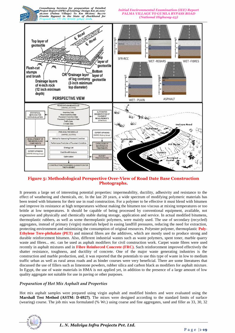
strongly affects its mechanical properties. Methodological Perspective Over-View of Road Date Base Construction
Photographs is given in Figure 5.
Consultancy Services for preparation of Detailed Project Report (DPR) of Existing/ Design Km 26.000/ 26.000 (Palma Village) To Km 88.600/ 89.170 (Gumla Bypass) in the State 0f Jharkhand for Proposal No.: FP/ JH/ ROAD/ 31842/ 2018.
Initial Environmental Examination (IEE) Report PALMA VILLAGE TO GUMLA BYPASS ROAD
(National Highway-23)
L. N. Malviya Infra Projects Pvt. Ltd. P a g e |1-19
Figure 5: Methodological Perspective Over-View of Road Date Base Construction Photographs.
It presents a large set of interesting potential properties: impermeability, ductility, adhesivity and resistance to the
effect of weathering and chemicals, etc. In the last 20 years, a wide spectrum of modifying polymeric materials has
been tested with bitumens for their use in road construction. For a polymer to be effective it must blend with bitumen
and improve its resistance at high temperatures without making the bitumen too viscous at mixing temperatures or too
brittle at low temperatures. It should be capable of being processed by conventional equipment, available, not
expensive and physically and chemically stable during storage, application and service. In actual modified bitumens,
thermoplastic rubbers, as well as some thermoplastic polymers, were mainly used. The use of secondary (recycled)
aggregates, instead of primary (virgin) materials helped in easing landfill pressures, reducing the need for extraction,
protecting environment and minimizing the consumption of original resources. Polyester polymer, thermoplastic Poly-
Ethylene Tere-phthalate (PET) and mineral fibres are the additives, which are mostly used to produce strong and
durable reinforcement bitumen. Also, different industrial wastes such as waste polymers, spent toner, marble quarry
waste and fibres... etc. can be used as asphalt modifiers for civil construction work. Carpet waste fibres were used
recently in asphalt mixtures and in Fibre Reinforced Concrete (FRC). Such reinforcement improved effectively the
shatter resistance, toughness, and ductility of concrete. One of the major waste generating industries is the
construction and marble production, and, it was reported that the potentials to use this type of waste in low to medium
traffic urban as well as rural areas roads and as binder courses were very beneficial. There are some literatures that
discussed the use of fillers such as limestone powders, rubber silica and carbon black as modifiers for asphalt mixture.
In Egypt, the use of waste materials in HMA is not applied yet, in addition to the presence of a large amount of low
quality aggregate not suitable for use in paving or other purposes.
Preparation of Hot Mix Asphalt and Properties
Hot mix asphalt samples were prepared using virgin asphalt and modified binders and were evaluated using the
Marshall Test Method (ASTM: D-6927). The mixes were designed according to the standard limits of surface
(wearing) course. The job mix was formulated (% Wt.) using coarse and fine aggregates, sand and filler as 33, 30, 32

Consultancy Services for preparation of Detailed Project Report (DPR) of Existing/ Design Km 26.000/ 26.000 (Palma Village) To Km 88.600/ 89.170 (Gumla Bypass) in the State 0f Jharkhand for Proposal No.: FP/ JH/ ROAD/ 31842/ 2018.
Initial Environmental Examination (IEE) Report PALMA VILLAGE TO GUMLA BYPASS ROAD
(National Highway-23)
L. N. Malviya Infra Projects Pvt. Ltd. P a g e |1-20
and 5 Wt. %, respectively. The mixes were tested for maximum load and flow along with density and air voids in
mixes and solid materials were determined.
HMA are hot mixes asphalt consisted of normal absorptive aggregate type, primary (virgin) asphalt samples
and limestone filler;
HMA are hot mixes asphalt consisted of high absorptive aggregate type, virgin (primary) asphalt samples and
limestone filler;
HMA are hot mixes asphalt consisted of high absorptive aggregate type, marble dust, modified asphalt
through using 5% of waste polypropylene and waste polyester respectively.
Conclusion and Recommendation
This research aimed to prepare and use special types of HMA consisting of unordinary materials with the final
objective of decreasing the cost of paving and maintenance, keeping the premium aggregate for the longest period of
time and decreasing the land space needed for land filling of un-degradable pollutants. To achieve this aim, 5 to 15%
of each of waste polypropylene and polyester were used in asphalt modifying. High absorptive aggregate and marble
fillers were used in mixes preparation instead of ordering materials such as normal absorptive aggregate and limestone
filler. The obtained results showed that all the types of waste polymers and solid materials used in the study are
suitable in road paving and construction activities. The mixes comply with the standards and have reduced
temperature susceptibility. The best modifier was polypropylene waste and the polyester waste was found to be very
tough. The mix can be used as base course or other purpose in any type of construction and civil work.
6. ENVIRONMENTAL INDEX OR FEATURES OF THE PROJECT
General Characteristics, Locations and Topography of Gumla City of Jharkhand State
About Gumla City
Gumla is a City in Gumla District of Jharkhand State, India and around 97 Kms from State Capital Ranchi towards
East. Gumla City is bounded by Ghaghra Block towards North, Raidih Block towards West, Sisai Block towards East,
Chainpur Block towards West. Gumla City, Lohardaga City, Jashpurnagar City, Simdega City are the nearby Cities to
Gumla. Gumla consist of 239 Villages and 26 Panchayats. It is in the 643 m elevation (altitude). Gumla, Lohardaga,
Jashpur, Chotanagpur, Netarhat are the nearby Important tourist destinations to see or visit area/ region.
Geography and Climate Gumla City
Gumla is believed to derive its name from Gaw-Mela, which consists of two words of Hindi (also used in several
local dialects), namely, Gaw (Cows and the Cattle) and Mela, that is, a fair. The place became known as Gaw-mela,
and then the word transformed itself into Gumla. This District in actual belongs to Hindi Belt in India. Gumla
district (Hindi: गुमला जिला) is one of the 24 districts of Jharkhand state, India, and Gumla town is the administrative
headquarters of this district.
Climate of Gumla City
It is Hot in Summer and Gumla Summer’s Highest Day Temperature varies in between 28°C to 42°C.
Average temperatures of January is 16°C, February is 20°C, March is 25°C, April is 29°C, May is 33°C.
Demo-Graphics of Gumla City
Nagpuri is the Local Language here. Also People Speaks Hindi, Oriya, Bihari, Kurukh. Total population of Gumla
City is 1, 65,508 living in 29,253 Houses, Spread across total 239 Villages and 26 Panchayats. Males are 84,071 and
Females are 81,437. And the total 39,761 people’s lives in Town and 1, 25,747 people’s lives in Villages.
Census 2011 of Gumla District
An official Census 2011 detail of Gumla, a district of Jharkhand has been released by Directorate of Census
Operations in Jharkhand. Enumeration of key persons was also done by census officials in Gumla District of
Jharkhand. In 2011, Gumla had population of 10, 25,213 of which male and female were 5, 14,390 and 5, 10,823
respectively. In 2001 census, Gumla had a population of 8, 32,447 of which males were 4, 18,784 and remaining 4,
13,663 were females. Gumla District population constituted 3.11% of total Maharashtra population. In 2001 census,
this figure for Gumla District was at 3.09% of Maharashtra population. There was change of 23.16% in the population

Consultancy Services for preparation of Detailed Project Report (DPR) of Existing/ Design Km 26.000/ 26.000 (Palma Village) To Km 88.600/ 89.170 (Gumla Bypass) in the State 0f Jharkhand for Proposal No.: FP/ JH/ ROAD/ 31842/ 2018.
Initial Environmental Examination (IEE) Report PALMA VILLAGE TO GUMLA BYPASS ROAD
(National Highway-23)
L. N. Malviya Infra Projects Pvt. Ltd. P a g e |1-21
compared to population as per 2001. In the previous census of India 2001, Gumla District recorded increase of
17.65% to its population compared to 1991 in the region/ area/ state.
Climate and Temperature
The district has dry climate except in the South-West Monsoon Season. The year may be divided into four seasons.
The period from March to the second week of June is the Summer Season. The succeeding period up to the end of
September is the South-West monsoon season. October and November constitute the Post-Monsoon or retreating
Monsoon Season. The cold season is from December to February. There is a meteorological observatory in the district
at Jharkhand. After, February there is found to be a rapid increase in average temperatures. May is generally the
hottest month with the mean daily maximum temperature at 42.4°C and the mean daily minimum at 26.9°C. From the
second week of June, there is an appreciable drop in temperature. After the monsoon by about the end of September,
there is a slight increase in the day’s temperature, but the nights become progressively cooler. After October,
however, both day and night temperature decreases rapidly on an average.
December is generally the coldest month with the mean daily maximum temperature at 26.3°C and the mean daily
minimum at 9.1°C. Winds are blowing generally light with some strengthening in force during the late summer and
early Monsoon Season. In May and in the South-West monsoon months, winds blow mostly from directions between
North-West and South-West. In the Post-Monsoon and the cold seasons winds are variable in direction, but winds
from directions between South-West and South-East are found to be less common. In March and April, winds are
variable in direction in the mornings and are Westerly or North-Westerly in the afternoons. Records of rainfall in the
district are available for 11 stations for periods ranging from 10 to 69 years. The annual rainfall in the district is 813.6
mm. About 93% of the annual rainfall in the district is received during the monsoon June to September. In Jharkhand
and Ranchi Tehsils-bordering Bihar, the rainfall is generally below the district average.
Rainfall and Temperature
PHYSICAL ASPECTS: Ranchi lies at 23°22′N 85°20′ E. Its municipal area is 175.12 Square Kilometres, and its
average elevation is 651 m above Mean Sea Level (MSL). Ranchi is located in the southern part of the Chota-Nagpur
plateau, which is the Eastern section of the Deccan plateau. Ranchi is known as the "City of Waterfalls and Rains"
because of its numerous waterfalls, the most well-known of which are Dassam Falls, Hundru Falls, Jonha Falls, Hirni
Falls, and Panchghagh Falls. The Subarnarekha River and its tributaries constitute the local river system. The
channels Kanke, Rukka and Hatia have been dammed to create reservoirs that supply water to the majority of the
population.
Ranchi has a hilly topography and its dense tropical forests a combination that produces a relatively moderate climate
compared to the rest of the state. During the period of British rule, it was accorded a "Hill Station" status. Since that
time, rapid population growth and industrialization have caused a marked change in its weather patterns and an
increase in average temperature. This has resulted in gradual and steady loss of its eligibility for "Hill Station" status.
Climate and Rainfall
The district falling in tropic monsoon region has broadly three pronounced seasons:
Cool Season : October to February Month Hot Season : March to May Month Rainy Season : June to September Month
Humidity and Temperature Index
Humidity is found to be 48% along with West wind flow at 04 Kph. Palma Village current Weather and
Temperature on an average is 27°C. The temperature in the region reaches and varies minimum to maximum level
in-between 15°C to 29°C on an average in the State of Jharkhand.
Humidity is found to be 25% along with West wind flow from the NNW; 13 Kph. Gumla Sadar City current
Weather and Temperature on an average is 32°C. Winds from the NNW; 13 Kph; Pressure: 1013.80 mb;
UV Index: 0; Cloud Cover: 31%; Ceiling: 9144 m; Dew Point: 7° C; Visibility: 16 km. Sunrise/ Sunset has found to
be as per record of Sunrise: 6:07 AM; Sunset: 5:58 PM; Duration: 11:51 hr. Moonrise/ Moonset. Moonrise: 1:14
PM; Moonset: 11:13 AM; Duration: N/A. The temperature in the region reaches and varies minimum to maximum
level in-between 28°C to 42°C on an average in the State of Jharkhand.

Consultancy Services for preparation of Detailed Project Report (DPR) of Existing/ Design Km 26.000/ 26.000 (Palma Village) To Km 88.600/ 89.170 (Gumla Bypass) in the State 0f Jharkhand for Proposal No.: FP/ JH/ ROAD/ 31842/ 2018.
Initial Environmental Examination (IEE) Report PALMA VILLAGE TO GUMLA BYPASS ROAD
(National Highway-23)
L. N. Malviya Infra Projects Pvt. Ltd. P a g e |1-22
Gumla Sadar City current Weather and Temperature on an average is 16°C to 38°C. During the Southwest
monsoon season the relative humidity generally exceeds 80% (August Month). Rest of the year is drier. The driest
part of the year is the summer season, when relative humidity is less than 35%. April is the driest month of the
year. The wind velocity is higher during the pre-monsoon period as compared to post monsoon period. The
maximum wind velocity 13 Km/ Hr is observed during the month of June and minimum 3.9 Km/ Hr during the
month of December. The average normal annual wind velocity of Gumla Sadar City is 6.0 Km/ Hr. Regional
spoken language of Gumla Sadar City is Hindi. Elevation/ Altitude are found to be in-between 643 meters above
the Mean Sea Level (MSL). The temperature in the region reaches and varies minimum to maximum level in-
between 28°C to 42°C on an average in the State of Jharkhand.
Homogeneous Section
The entire Project Road is considering as one homogeneous sections based on traffic volume and its characteristics in
the below (Table 6).
Table 6: Homogeneous Section based on Traffic Volume Tehsil/ District Wise Villages and Bypass.
Sr. No.
Homogenous Section
Design Chainage Existing Length
(Km) Design Length (Km) From
(Km) To
(Km)
1. Palma Village to Gumla
Bypass Road
00+000 26+000 00.000 to 26.000 00+000 to 63+170
26.000 63.170
7. DEMOGRAPHIC INDEX OF THE PROJECT DISTRICT
About Palma
Palma is a small Village/ Hamlet in Sikaripara Block in Dumka District of Jharkhand State, India and it comes under
Palma Panchayath. It is located 13 Kms towards South from District Head Quarters Dumka and 20 Kms from
Shikaripara. Approximately 263 Kms from State Capital Ranchi and Palma Pin Code is 814 119 and also its postal
head office is Kurwa. Masanjore (6 Kms), Asansol (7 Kms), Ghasipur (7 Kms), Kuruwa (7 Kms), Kurwa (8 Kms) are
the nearby Villages to Palma. Palma is surrounded by Ranishwar Block towards South, Sikaripara Block towards
East, Kathikund Block towards North, Masaliya Block towards West. Dumka, Suri, Rampurhat, Sainthia are the
nearby Cities to Palma Village.
Palma 2011 Census Details
Palma Local Language is Hindi and Palma Village’s Total Population is 566 and Numbers of Houses are
approximately 103. Female Population is 47.7% and Village Literacy Rate is 43.1% and the Female Literacy Rate is
17.0%.
Palma Village Population Record
Census Parameter Census Data
Total Number of Population 566
Total Number of Houses 103
Female Population in %age 47.7% (270)
Total Literacy Rate in %age 43.1% (244)
Female Literacy Rate in %age 17.0% (96)
Scheduled Tribes Population in %age 32.9% (186)
Scheduled Caste Population in %age 5.7% (32)
Working Population in %age 68.6%
Child (00 to 06) Population by 2011 84
Girl Child (00 to 06) Population in % by 2011 50.0% (42)
Consultancy Services for preparation of Detailed Project Report (DPR) of Existing/ Design Km 26.000/ 26.000 (Palma Village) To Km 88.600/ 89.170 (Gumla Bypass) in the State 0f Jharkhand for Proposal No.: FP/ JH/ ROAD/ 31842/ 2018.
Initial Environmental Examination (IEE) Report PALMA VILLAGE TO GUMLA BYPASS ROAD
(National Highway-23)
L. N. Malviya Infra Projects Pvt. Ltd. P a g e |1-23
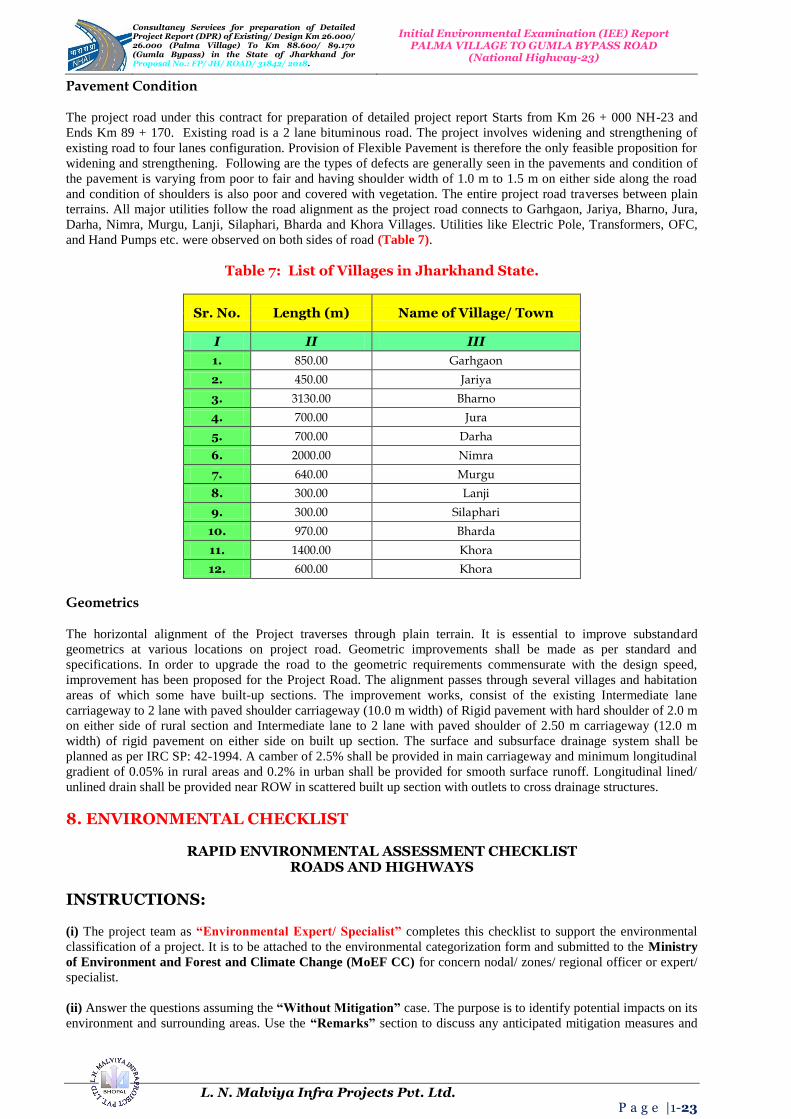
Pavement Condition
The project road under this contract for preparation of detailed project report Starts from Km 26 + 000 NH-23 and
Ends Km 89 + 170. Existing road is a 2 lane bituminous road. The project involves widening and strengthening of
existing road to four lanes configuration. Provision of Flexible Pavement is therefore the only feasible proposition for
widening and strengthening. Following are the types of defects are generally seen in the pavements and condition of
the pavement is varying from poor to fair and having shoulder width of 1.0 m to 1.5 m on either side along the road
and condition of shoulders is also poor and covered with vegetation. The entire project road traverses between plain
terrains. All major utilities follow the road alignment as the project road connects to Garhgaon, Jariya, Bharno, Jura,
Darha, Nimra, Murgu, Lanji, Silaphari, Bharda and Khora Villages. Utilities like Electric Pole, Transformers, OFC,
and Hand Pumps etc. were observed on both sides of road (Table 7).
Table 7: List of Villages in Jharkhand State.
Sr. No. Length (m) Name of Village/ Town
I II III
1. 850.00 Garhgaon
2. 450.00 Jariya
3. 3130.00 Bharno
4. 700.00 Jura
5. 700.00 Darha
6. 2000.00 Nimra
7. 640.00 Murgu
8. 300.00 Lanji
9. 300.00 Silaphari
10. 970.00 Bharda
11. 1400.00 Khora
12. 600.00 Khora
Geometrics
The horizontal alignment of the Project traverses through plain terrain. It is essential to improve substandard
geometrics at various locations on project road. Geometric improvements shall be made as per standard and
specifications. In order to upgrade the road to the geometric requirements commensurate with the design speed,
improvement has been proposed for the Project Road. The alignment passes through several villages and habitation
areas of which some have built-up sections. The improvement works, consist of the existing Intermediate lane
carriageway to 2 lane with paved shoulder carriageway (10.0 m width) of Rigid pavement with hard shoulder of 2.0 m
on either side of rural section and Intermediate lane to 2 lane with paved shoulder of 2.50 m carriageway (12.0 m
width) of rigid pavement on either side on built up section. The surface and subsurface drainage system shall be
planned as per IRC SP: 42-1994. A camber of 2.5% shall be provided in main carriageway and minimum longitudinal
gradient of 0.05% in rural areas and 0.2% in urban shall be provided for smooth surface runoff. Longitudinal lined/
unlined drain shall be provided near ROW in scattered built up section with outlets to cross drainage structures.
8. ENVIRONMENTAL CHECKLIST
RAPID ENVIRONMENTAL ASSESSMENT CHECKLIST
ROADS AND HIGHWAYS
INSTRUCTIONS:
(i) The project team as “Environmental Expert/ Specialist” completes this checklist to support the environmental
classification of a project. It is to be attached to the environmental categorization form and submitted to the Ministry
of Environment and Forest and Climate Change (MoEF CC) for concern nodal/ zones/ regional officer or expert/
specialist.
(ii) Answer the questions assuming the “Without Mitigation” case. The purpose is to identify potential impacts on its
environment and surrounding areas. Use the “Remarks” section to discuss any anticipated mitigation measures and

Consultancy Services for preparation of Detailed Project Report (DPR) of Existing/ Design Km 26.000/ 26.000 (Palma Village) To Km 88.600/ 89.170 (Gumla Bypass) in the State 0f Jharkhand for Proposal No.: FP/ JH/ ROAD/ 31842/ 2018.
Initial Environmental Examination (IEE) Report PALMA VILLAGE TO GUMLA BYPASS ROAD
(National Highway-23)
L. N. Malviya Infra Projects Pvt. Ltd. P a g e |1-24
Rapid Environmental Assessment Checklist/ Initial Environmental Examination (IEE) Report is shown in
Table 8.
Table 8: Rapid Environmental Assessment Checklist.
Country/ Project Title India: Jharkhand State
Sub-Project: Initial Environmental Examination Report for Palma Village To Gumla Bypass Road in Jharkhand State
Sector Division/ Section Road and Transport Government of India (GOI)
Screening Questions Yes No Remarks
A. Project Site
Is the project area adjacent to or within any of the following environmentally sensitive zones/ sites/ areas?
X
No environmentally sensitive zone/ site is located within the projected road;
Cultural Heritage Site; X
No archaeologically protected monument or cultural heritage site/ zones is located within the road;
Protected Area; X
No protected areas are located/ placed close to roads and nearby zones/ areas;
Wetland Area; X
No protected or classified wet land is located close to roads and nearby surrounding areas;
Mangrove Cover/ Area; X Project road is not located in Coastal Areas;
Estuarine Locality/ Area; X No Estuarine is located in the Project Area;
Buffer Zone of Protected Area; X No such area is located in the Project Vicinity;
Special Area for Protecting Biodiversity;
X No such area is located in the Project Vicinity;
B. Potential Environmental Impacts
Encroachment on historical/ cultural areas; disfiguration of landscape by road embankments, cuts, fills, and quarries?
X
The area is no mountainous throughout the proposed alignment and there is no human settelment nor any
historical/ cultural places. So there no human encroachment;
Encroachment of precious ecology (e.g., Sensitive or protected areas)?
X
Attempts have been made to minimizing the cutting of trees while finalizing the road widening options, but we didn't found
any sensitive or procted area in the projected area;
Alteration of surface water hydrology of waterways crossed by roads, resulting in increased sediment in streams affected by increased soil erosion at construction site?
X
The proposed alignment is crossing only small natural drains. All drainage courses will be maintained to avoid alteration in surface water hydrology so that water courses are not affected. The temporary soil stockpiles will be designed so that runoff will not induce sedimentation of waterways. Silt fencing during construction will be provided. To mitigate
this problem the environmental management plan is already in
corporated with their mitigation method ;
Deterioration of surface water quality due to silt runoff and sanitary wastes from worker-based camps and chemicals used in construction?
X
Adequate sanitary facilities including “Soak Pits Treatment
(SPT)”, facilities will be provided at construction camps, which will be set-up away from habitat and water bodies. No harmful ingredients are likely to be used in the construction activities. Surface water quality is not impacted due to construction. Measures like embankment slope stabilization, “Reinforced Cement Concrete (RCC)”, retaining walls are proposed to prevent siltation of ponds located next to the road due to surface runoff;
Increased local/ regional areas air pollution due to rock crushing,
cutting and filling works and
chemicals from asphalt processing?
Regional/ local/ on site “Air Pollution Level (APL)”, will be
high during construction period due to structure/ road construction work; vehicle movements and asphalt processings etc.
The Asphalt Mixing Plant (AMP) OR Hot Mix Plant (HMP) will
be located away from habitat areas adequetly high stack for
effective dispersion of likely Dust Emissions. Separation measures like spraying of water on unpaved vehicle

Consultancy Services for preparation of Detailed Project Report (DPR) of Existing/ Design Km 26.000/ 26.000 (Palma Village) To Km 88.600/ 89.170 (Gumla Bypass) in the State 0f Jharkhand for Proposal No.: FP/ JH/ ROAD/ 31842/ 2018.
Initial Environmental Examination (IEE) Report PALMA VILLAGE TO GUMLA BYPASS ROAD
(National Highway-23)
L. N. Malviya Infra Projects Pvt. Ltd. P a g e |1-25
movement areas are proposed to minimize the dust generation. To mitigate this problem the Environmental
Management Plans (EMPs) are already in corporated with their
mitigation methods and measures;
Risks and vulnerabilities related to occupational health and safety due to physical, chemical, biological and radiological hazards during project construction and operation?
Workers may get exposed to dust and noise during construction activities. However the exposure levels are likely to be short and insignificant. Workers will be provided requisite Personal Protective Equipments (PPEs) to minimize such exposure and associated harmful occupational health effects. To mitigate this problem the Environmental Management
Plan is already in corporated with their mitigation methods;
Noise and vibration activities due to blasting and other civil works on site construction of roads/ bridges and valuable residential and commercial structures establishments?
X
No blasting is involved. No significant noise generation is expected during construction activities except normal construction equipment operational noise. These noise levels will be impulsive in nature and its impact will be confined within few meters of either side of the road. All stationary noise making sources equipment like DG set, compressors will be installed with acoustic enclosures/ mufflers/ silencers to reduce noise level on site if specified for the region or state.
9. STATUTORY CLEARANCES REQUIRED
The Environmental Impact Assessment/ Statement (EIA/ S) process adopted will follow regulations of
Government of India (GOI) and Jharkhand Government. As per current policy since the project is more not more
than 100 Km in length so the MOEF notification will not apply and need no Environmental Impact Assessment/
Statement (EIA/ S) Clearances. Table 9 presents clearances required under the proposed project for roads network
area.
Table 9: Required Statutory (EIA/ S) Clearances.
Sr. No.
Act / Rules Purpose Applicable
Yes/ No Authority
1. Environment Protection Act
(EPA)-1986. To protect and improve overall
environment. No
MOEF; GOI; DOE; SPCB
2.
Environmental Impact Assessment Notification
(EIAN) 14th September, 2006.
To provide environmental clearance to new development
activities following environmental impact assessment.
No MOEF; (EIAN)
3. Notification for use of Fly Ash
(NFA).
Reuse large quantity of fly ash discharged from thermal power plant to minimize land use for
disposal.
Yes NFA
4.
Coastal Regulation Zone (CRZ) Notification 1991
(2002). Protection of fragile coastal belt. No CRZN
5.
National Environment Appellate Authority Act,
(NEAA) 1997.
Address grievances regarding the process of Statutory
Environmental Clearance (SEC). No NEAA; SEC
6. The Land Acquisition Act
(LAA)-NH-1956. Set out rule for acquisition of land
by government. Yes
Revenue Department;
LAA
7.
MOEF Circular on Marginal Land Acquisition and
Bypasses 1999.
Defining “Marginal Land” Acquisition relating to the 1997
Notification (MLAN). No MOEF; MLAN
8.
The Forest (Conservation) Act-1927; The Forest (Conservation) Act-1980; Forest (Conversion)
Rules-1981.
To check deforestation by restricting conversion of forested
areas into non-forested areas. Yes
Forest Department;
Government of Haryana (GOH)
9. Wild Life Protection Act-1972. To protect wildlife through certain of National Parks and Sanctuaries.
No CCF;
Department of Forest; (GOH)
10. Air (Prevention and Control of To control air pollution by and Yes GO UP; SPCB;

Consultancy Services for preparation of Detailed Project Report (DPR) of Existing/ Design Km 26.000/ 26.000 (Palma Village) To Km 88.600/ 89.170 (Gumla Bypass) in the State 0f Jharkhand for Proposal No.: FP/ JH/ ROAD/ 31842/ 2018.
Initial Environmental Examination (IEE) Report PALMA VILLAGE TO GUMLA BYPASS ROAD
(National Highway-23)
L. N. Malviya Infra Projects Pvt. Ltd. P a g e |1-26
Pollution) Act-1981. Transport Controlling Emission of Air Department (TCEPA).
Pollutants as per the prescribed standards.
TCEPA
11. Water Prevention and Control
of Pollution) Act-1974.
To control water pollution by controlling discharge of pollutants
as per the prescribed standards. Yes (GOH); SPCB
12. Noise Pollution (Regulation
and Control Act) 1990.
The standards for noise for day and night have been promulgated
by the MOEF for various land uses.
Yes MOEF; (GOH);
SPCB
13.
Ancient Monuments and Archaeological Sites and
Remains Act-1958.
Conservation of cultural and historical remains found in India.
No ASI; GOI
14. Public Liability and
Insurance Act (PLIA)-1991. Protection form hazardous
materials and accidents. Yes PLIA
15. Explosive Act-1984. Safe transportation, storage and
use of explosive material. Yes
Chief Controller of Explosives
16. Minor Mineral and concession
Rules (MMCR). For opening new quarry. Yes
District Collector; MMCR
17.
Central Motor Vehicle Act-1988 and Central Motor Vehicle
Rules (CMVR)-1989.
To check vehicular air and noise pollution.
Yes Motor Vehicle Department;
CMVR
18.
National Forest Policy 1952; National Forest Policy (Revised) 1988 (NFP).
To maintain ecological stability through preservation and
restoration of biological diversity. Yes
Forest Department;
GOI; and (GOH); NFP
19. The Mining Act (MA)-1989. The mining act has been notified
for safe and sound mining activity.
Yes Department of Mining (DOM);
MA
Widening Proposal
The proposed widening has been carried out through considering social and environmental aspects of the project.
Concentric widening has been proposed in built-up portion to save acquisition of road side established or installed
residential and commercial structures. Likewise eccentric widening (LHS or RHS) has been proposed in open areas to
save tree from the other side. In other words, only one side tree requires to be felled. Out of total 45 Km length
concentric widening is proposed for about 9.630 Km mainly in built-up locations shown in Tables 10 and 11.
Table 10: Pavement Crust Thickness for Widening and New Construction.
Description Proposed
Pavement Crust Thickness for Widening and New Construction
Rigid Pavement: PQC – 300 mm (M40); DLC – 150 mm (M15); Drainage + GSB – 225 (150+75) mm; Sub-Grade – 500 mm
Overlay: BC – 40 mm; DBM – 50 mm
Table 11: Chainage References Village/ Town (Palma Village to Gumla Bypass Road).
Sr. No.
Existing/ Design Chainage (m) Length
(m) Name of Village/
Town From To
A B C D E
1. 27+400 28+250 850.00 Garhgaon
2. 30+800 31+250 450.00 Jariya
3. 48+870 52+000 3130.00 Bharno
4. 57+300 58+000 700.00 Jura
5. 60+100 60+800 700.00 Darha
6. 61+600 63+600 2000.00 Nimra

Consultancy Services for preparation of Detailed Project Report (DPR) of Existing/ Design Km 26.000/ 26.000 (Palma Village) To Km 88.600/ 89.170 (Gumla Bypass) in the State 0f Jharkhand for Proposal No.: FP/ JH/ ROAD/ 31842/ 2018.
Initial Environmental Examination (IEE) Report PALMA VILLAGE TO GUMLA BYPASS ROAD
(National Highway-23)
L. N. Malviya Infra Projects Pvt. Ltd. P a g e |1-27
Sr. No.
Existing/ Design Chainage (m) Length
(m) Name of Village/
Town From To
A B C D E
7. 75+400 76+040 640.00 Murgu
8. 78+700 79+000 300.00 Lanji
9. 79+850 80+150 300.00 Silaphari
10. 81+130 82+100 970.00 Bharda
11. 84+300 85+700 1400.00 Khora
12. 86+400 87+000 600.00 Khora
Major Bridge/ Minor Bridge and Cross Drainage Structures (Culverts)
There are 02 Minor Bridges on the existing road and are to be retained. And 06 Major Bridges exist in the projected road. Also 65 structures are proposed for reconstruction... on the same pace 01 structure is proposed for retain and repair and 01 is proposed for widening. There are total 60 Culverts. Around 38/ 19 of the existing Culverts proposed for widening and 18/ 16 are proposed for reconstruction. During inventory and condition survey, the details of Bridge and Culverts wise Improvement Proposal containing Rehabilitation, Widening or Reconstruction with culverts retained generally require clearing of vent way and existing DESIGN PARAMETERS for Proposed Structures are shown in the Tables 12, 13 and 14 respectively. The flowing design standards have been assumed adopted and approved as per Indian Roads Congress (IRC) Guidelines, contained in IRC: 73, IRC: 86, IRC: 38 and IRC: SP: 23.
Table 12: Details of Existing Structures.
Type of Structure
(TS)
Major Bridges
(MB)
Minor Bridges
(MB)
Slab/ Arch/ Box Culvert
(S/ A/ BC)
Hume Pipe
Culvert (HPC)
ROB Total
A B C D E F G Existing
Structure 60 Nos.
02 06 38/ 19 26 00 91
Table 13: Existing – Proposed Chainage.
Sr. No. Section Existing Chainage
(Km) Proposed Chainage
(Km)
1. Palma Village to Gumla Bypass
Road 00+000 to 26.000 00+000 to 63.170
Table 14: Details of Existing DESIGN PARAMETERS for Proposed Structures.
Sr. No.
Item Plain/ Rolling Terrain
1. Design Speed (Km/ Hr) 80 Km/ Hr – 100 Km/ Hr
2. Land Width (m) Open/ Built-up Area 25 – 30 m
3. Width of Carriageway (m) 7.00 m + 2 × 1.50 m Paved Shoulders = 10 m
4. Unpaved Shoulders 2 × 2.00 m
5. Camber/ Cross Fall -------
(i) Carriageway and Paved Shoulders 02.00%
(ii) Earthen Shoulders 03.00%
6. Maximum Super Elevation 07.00%
7. Minimum Radii of Horizontal Curves (m) 400 m Ruling/ 250 m Minimum
8. Minimum Length of Curves (m) 150 m for every Deflection Angle of 5°
9. Drains As per Design

Consultancy Services for preparation of Detailed Project Report (DPR) of Existing/ Design Km 26.000/ 26.000 (Palma Village) To Km 88.600/ 89.170 (Gumla Bypass) in the State 0f Jharkhand for Proposal No.: FP/ JH/ ROAD/ 31842/ 2018.
Initial Environmental Examination (IEE) Report PALMA VILLAGE TO GUMLA BYPASS ROAD
(National Highway-23)
L. N. Malviya Infra Projects Pvt. Ltd. P a g e |1-28
Sr. No.
Item Plain/ Rolling Terrain
10. Sight Distance As per IRC: 73 and IRC: 86
11. Gradient -------
(i) Ruling Gradient 03.33%
(ii) Limiting Gradient 05.00%
(iii) Exceptional Gradient 06.70%
12.
Vertical Clearance for Power/ Telecommunication Lines Low Voltage up to 220 to 600 V Power Line up to 650 V Electric Power Line up to 132 kV Electric Power Line up to 220 kV Electric Power Line up to 400 kV Electric Power Line up to 765 kV
05.80 m 06.10 m 06.50 m 07.00 m 08.40 m 12.40 m
RIGHT OF WAY AND LAND PATTERN
The available RIGHT OF WAY (ROW) is 10-15 m in Built up Area and 25-30 m in Open Area along the projected
corridor. Design has been done within available ROW and the existing alignment is a link between Garhgaon, Jariya,
Bharno, Jura, Darha, Nimra, Murgu, Lanji, Silaphari, Bharda and Khora Villages. The land use pattern on both side of
road is agricultural and built-up area and the details of land use pattern along the project road are given below (Table
15):
Land Use Pattern of Existing Road Section:-
1. Built-up Area Pattern : 60.00%
2. Agricultural Area Pattern : 11.00%
3. Forest Area Pattern : 29.00%
Table 15: Details of Existing Land Use Pattern (Palma Village to Gumla Bypass Road) for Proposed Structures.
Sr. No. Design Chainage Length
Land Details Name of Village/ Town
Km Km m
1. 27+400 28+250 850.00 Agriculture Garhgaon
2. 30+800 31+250 450.00 Agriculture Jariya
3. 48+870 52+000 3130.00 Builtup Bharno
4. 57+300 58+000 700.00 Agriculture Jura
5. 60+100 60+800 700.00 Builtup Darha
6. 61+600 63+600 2000.00 Agriculture Nimra
7. 75+400 76+040 640.00 Builtup Murgu
8. 78+700 79+000 300.00 Agriculture Lanji
9. 79+850 80+150 300.00 Jaitpura Silaphari
10. 81+130 82+100 970.00 Agriculture Bharda
11. 84+300 85+700 1400.00 Agriculture Khora
12. 86+400 87+000 600.00 Builtup Khora
Consultancy Services for preparation of Detailed Project Report (DPR) of Existing/ Design Km 26.000/ 26.000 (Palma Village) To Km 88.600/ 89.170 (Gumla Bypass) in the State 0f Jharkhand for Proposal No.: FP/ JH/ ROAD/ 31842/ 2018.
Initial Environmental Examination (IEE) Report PALMA VILLAGE TO GUMLA BYPASS ROAD
(National Highway-23)
L. N. Malviya Infra Projects Pvt. Ltd. P a g e |1-29
TERRAIN
The terrain is plane at most of the stretch has normal gradient throughout the plane. The details of which are given in
the Table 16 below:
Table 16: Plane Terrain All Most Stretch/ Normal/ Rolling Gradient.
Sr. No.
Existing Chainage
Length (Km) Land Use Pattern and
Type of Terrain From To
Km Km
1. 00+000 63+170 63.170 Plane Terrain
FOREST
There is no ecologically sensitive area such as national park, wildlife sanctuary, reserved forest, or critically polluted
area within corridor of impact (10 Km on Either or Both Sides) along the project road; however the details of the
above ecological sensitive area within 15 Km will be collected from Forest Department during filling of FORM-1 for
the project road. Tropical dry deciduous forest with Teak (Tectona Grandis) as a dominant tree species occupies 60%
of the area of the Jharkhand Forest Division (JFD). The total managed forest area of the division is 1, 42,536
Hectares of which 62% (85,318 Hectares) is managed as Reserved Forest (RF) and the remaining 34,218 Hectares, as
Protected Forest (PF) category.
TRAFFIC: Projected Traffic
The daily traffic volume count has been carried out at 2 locations (Km 35 + 200 and Km 84 + 700) considering the
traffic intensity and merging and diverging traffic on the project road corridor. To convert the mixed traffic into
common unit, passenger car unit factor is used as given in Indian Road Congress (IRC) 102: 1988; Report Data.
Adopted equivalent passenger car units for the study have been presented in Table 17. A summary of traffic data in
terms of Annual Average Daily Traffic (ADT) and Passenger Car Unit (PCU) has been presented in Table 17 to
have better appreciation. The report is concerned about Palma Village to Gumla Bypass Road and the Traffic
Survey Locations and Schedules are given below:
Table 17: Classified Different Average Daily Traffic (ADT) Surveys and Dates of Commencement Locations.
Sr. No. Chainage (Km) Survey Location/ Area/ Chainage
Survey Date
A B C D
1. 00+000 to 26+000 Near Palma Village
(26+000) 28.08.2017 to 05.09.2017
2. 00+000 to 63+170 Near Gumla Bypass (63+170)
29.09.2017 to 06.10.2017
Traffic Growth: The growth rates estimates were subjected to scenario analysis and the most likely case was adopted
for the purpose of the present study. The traffic growth estimates scenario is based on the likely growth of the Indian
economy and its relationship to the growth in the state economy. Information presented in the study area reveals that
traffic growth is more than 7% in initial years of the project.
PROPOSED ROAD STRENGTHENING-OVER LAYS AND BYPASSES/ REALIGNMENT DETAILS
One Bypass is proposed for this road and the details of which are given below in the Table 18 along with details of
Proposed Bypasses for existing and design chainage.
Table 18: Details of Proposed Bypasses of Existing Chainage.
Sr. No.
City or Town of Bypass
Length Design
Chainage (Km)
Existing Chainage
(Km)
Design Length (Km)
Proposed-Right of Way (ROW in m)
Remark
Km Start End Start End
1. Palma
Village Road
33.475 31+650 35+900 31+650 35+635 4.250 45 Bero
Bypass
2. Gumla Bypass Road
36.460 63+600 71+700 63+370 71+415 8.100 45 Sisai
Bypass

Consultancy Services for preparation of Detailed Project Report (DPR) of Existing/ Design Km 26.000/ 26.000 (Palma Village) To Km 88.600/ 89.170 (Gumla Bypass) in the State 0f Jharkhand for Proposal No.: FP/ JH/ ROAD/ 31842/ 2018.
Initial Environmental Examination (IEE) Report PALMA VILLAGE TO GUMLA BYPASS ROAD
(National Highway-23)
L. N. Malviya Infra Projects Pvt. Ltd. P a g e |1-30
Major Bridge/ Minor Bridge and Cross Drainage Structures (Culverts)
There are existing 02 Major and 06 Minor bridges along with 37 numbers of Culverts. During inventory and condition
survey, the details of culverts wise Improvement Proposal containing Rehabilitation, Widening or Reconstruction is
given in Table 19.
Table 19: Around 02 Major Bridge and 38/ 19 Newly Proposed Culverts.
Type of Structure
(TS)
Major Bridges
(MB)
Minor Bridges
(MB)
Slab/ Arch/ Box Culvert
(S/ A/ BC)
Vented Causeway
(VCW)
Hume Pipe Culvert (HPC)
A B C D E F
Existing Structure 60
Nos. 02 06 38/ 19 00 26
PAVEMENT COMPOSITIONS
As per the existing CVPD and considering 08% CBR, Rigid pavement is recommended for this road as per alignment
suggested or proposed for construction along the roadside. Design is performed as per “IRC-58: 2015 GUIDELINES
FOR THE DESIGN OF RIGID PAVEMENTS”. Hence the proposed pavement composition is shown in the Table
20:
Table 20: Pavement Composition for the Design of Ridge Pavements.
GEOMETRIC CURVE IMPROVEMENT AND LAND REQUIREMENTS
In order to upgrade the road to the geometric requirements commensurate with the design speed, improvement has
been proposed for the Project Road. The alignment passes through several villages and habitation areas of which some
have built-up sections. In order to utilize the existing carriageway to the maximum extent, the proposed center line has
been aligned within the existing carriageway with necessary correction to geometry. Properly designed horizontal
curves have been provided commensurate with design speed. All super-elevated curves have been provided with
designed transition lengths. The existing geometry (both horizontal and vertical) is found to be inadequate. The
alignments of the curves in these locations have been suitably corrected as per IRC standards. At the location of
structures and back-to-back occurrence of summit and valley curves, correction of vertical profile is also carried out
keeping in view the available and adequate sight distances. For the curve improvement/ realignment/ bypass of
projected road an approximate area of 49.23 Hectares of land is required as shown in Table 21. Detailed schedules for
LA is being submitted separately and applied for Land Acquisition (LA) purposes.
Table 21: Land Acquisition Tentative Area and Length Acquired for Curve Improvement/ Realignment/ Bypass Projected Road.
Sr. No. Stretch/ Design Chainage
(from Km to Km)
Type of Deficiency Remarks
Radius of Curve Design Speed
1. 26+000 27+400 1400 100 to 80 Km Per Hr
All Curves are Improved
2. 27+400 28+250 850 100 to 80 Km Per Hr
3. 28+250 30+800 2550 100 to 80 Km Per Hr
4. 30+800 31+250 450 100 to 80 Km Per Hr
5. 31+250 31+650 400 100 to 80 Km Per Hr
6. 31+650 35+900 4250 100 to 80 Km Per Hr
7. 35+900 39+100 3200 100 to 80 Km Per Hr
Sr. No.
Section CVPD CBR
Pavement Composition (mm)
Present Year 2017
Base Year 2020
15 Year
30 Year
(%) PQC DLC GSB+DL
1. Palma Village
to Gumla Bypass Roads
427 494 1027 2141 08% 300 150 225

Consultancy Services for preparation of Detailed Project Report (DPR) of Existing/ Design Km 26.000/ 26.000 (Palma Village) To Km 88.600/ 89.170 (Gumla Bypass) in the State 0f Jharkhand for Proposal No.: FP/ JH/ ROAD/ 31842/ 2018.
Initial Environmental Examination (IEE) Report PALMA VILLAGE TO GUMLA BYPASS ROAD
(National Highway-23)
L. N. Malviya Infra Projects Pvt. Ltd. P a g e |1-31
Sr. No. Stretch/ Design Chainage
(from Km to Km)
Type of Deficiency Remarks
Radius of Curve Design Speed
8. 39+100 39+700 600 100 to 80 Km Per Hr
9. 39+700 44+550 4850 100 to 80 Km Per Hr
10. 44+550 45+000 450 100 to 80 Km Per Hr
11. 45+000 48+870 3870 100 to 80 Km Per Hr
12. 48+870 52+000 3130 100 to 80 Km Per Hr
13. 52+000 57+300 5300 100 to 80 Km Per Hr
14. 57+300 58+000 700 100 to 80 Km Per Hr
15. 58+000 60+100 2100 100 to 80 Km Per Hr
16. 60+100 60+800 700 100 to 80 Km Per Hr
17. 60+800 61+600 800 100 to 80 Km Per Hr
18. 61+600 63+600 2000 100 to 80 Km Per Hr
19. 63+600 71+700 8100 100 to 80 Km Per Hr
20. 71+700 75+400 3700 100 to 80 Km Per Hr
21. 75+400 76+040 640 100 to 80 Km Per Hr
22. 76+040 77+500 1460 100 to 80 Km Per Hr
23. 77+500 78+700 1200 100 to 80 Km Per Hr
24. 78+700 79+000 300 100 to 80 Km Per Hr
25. 79+000 79+850 850 100 to 80 Km Per Hr
26. 79+850 80+150 300 100 to 80 Km Per Hr
27. 80+150 81+130 980 100 to 80 Km Per Hr
28. 81+130 82+100 970 100 to 80 Km Per Hr
29. 82+100 84+300 2200 100 to 80 Km Per Hr
30. 84+300 85+700 1400 100 to 80 Km Per Hr
31. 85+700 86+400 700 100 to 80 Km Per Hr
32. 86+400 87+000 600 100 to 80 Km Per Hr
33. 87+000 89+170 2170 100 to 80 Km Per Hr
Total Length 63.170 Kms
As per IRC: SP: 73 – 2015: The Ruling Minimum Radii for Plain Terrain is 400 m and absolute Minimum Radii for Plain
Terrain are 250 m.
Figure 6: Daily Variations of Traffic Volume on Projected Road.
0
100
200
300
400
500
600
8-9
11-1
2
14-1
5
17-1
8
20-2
1
23-0
0
2-3
5-6
Daily Variation of Traffic Volume for 7 Days
31-01-16
01-02-16
02-02-16
03-02-16
04-02-16
05-02-16
06-02-16

Consultancy Services for preparation of Detailed Project Report (DPR) of Existing/ Design Km 26.000/ 26.000 (Palma Village) To Km 88.600/ 89.170 (Gumla Bypass) in the State 0f Jharkhand for Proposal No.: FP/ JH/ ROAD/ 31842/ 2018.
Initial Environmental Examination (IEE) Report PALMA VILLAGE TO GUMLA BYPASS ROAD
(National Highway-23)
L. N. Malviya Infra Projects Pvt. Ltd. P a g e |1-32
10. ENVIRONMENTAL IMPACT ASSESSMENT OF THE PROJECT SITE
The environmental impact assessment has been carried out and which is based on status of the environment, and impact of proposed four lanning roads/ bridges based on these findings of the Environmental Management Plans (EMPs) have been prepared for the implementation in the project. Following section discusses status of the environment, and its complementary impact assessment work plan assigned to Environmental Management Plans (EMPs) required for the project development/ implementation system and process.
11. BASELINE ENVIRONMENTAL INDEX AND STATUS OF THE PROJECT SITE
Climatic Conditions
The climate of project areas is on the whole dry, hot in summer and cold in winter. The year may be divided
into four seasons in every state/ region of concern. The cold season from November to March is followed by
hot season, which lasts till the onset of the South-West monsoon. The monsoon withdraws by 15th
September
and is followed by the Post-Monsoon or the Transition Period (TP).
Temperature
There is no meteorological observatory in the district Nagpur, on the basis of records of the observatories in
the districts where similar climatic conditions prevail, it is stated that from the beginning of March,
temperature increases rapidly till June, which is generally the warmest month. The mean daily maximum
temperature during June is around 41°C and the mean daily minimum around 27°C. The heat in summer is
intense, on individual days; the day temperature may occasionally exceed 47°C or 48°C on an average for
specific regions.
Humidity
During the South-West Monsoon-Season July to September, the relative humidity is high, being over 75% to
80% in the morning and 55% to 65% in the afternoon. High humidity of more than 70% also prevails during
the winter months of December to February. It is comparatively drier during the rest of the year. April and
May constitute the driest part of the year when in the afternoon the relative humidity is 20% or even less are
found in the specific region for projected site.
Cloudiness
The sky is moderately clouded mainly in July and August and cloudiness decreases rapidly by October
month. In the period of November to May, the sky is mostly clear or lightly clouded, except during passage
of Western Disturbances in the cold season when the sky becomes cloudy or dense/ dark clouds for a brief
spell of a day or two. From June onwards cloudiness increases and rainy season occurs till the month of
August/ September.
Winds
Winds are generally light, with some strengthening in force during late South-West and West are more
common, with the Easterlies and South-Easterlies blowing on some days. In the Post-Monsoon and Winter
Season, South-Easterly and Westerly are common in the mornings, while Northerlies and North-Western lies
are predominant in the afternoons. During summer, winds are from West or South-West in the morning. In
the afternoons, winds blow from directions in between Westerly and Northerly.
Special Weather Phenomena
Thunderstorms, in association with Pre-Monsoon and Monsoon rains occur mostly during June to
September. During the winter also, a few thunderstorms occur in association with the Western Disturbances.
A few thunderstorms may be accompanied by hail. Occasional dust storm occurs during the hot season and
contributes in increasing the level of Suspended Particulate Matter (SPM) in the upper atmospheric
region, which causes increases of CO2 level and Global Warming and Green House Effect (GHE).

Consultancy Services for preparation of Detailed Project Report (DPR) of Existing/ Design Km 26.000/ 26.000 (Palma Village) To Km 88.600/ 89.170 (Gumla Bypass) in the State 0f Jharkhand for Proposal No.: FP/ JH/ ROAD/ 31842/ 2018.
Initial Environmental Examination (IEE) Report PALMA VILLAGE TO GUMLA BYPASS ROAD
(National Highway-23)
L. N. Malviya Infra Projects Pvt. Ltd. P a g e |1-33
Soils
The soil of the area is sandy to clay. In general, there is a deficiency of nitrogen and organic matter in the
soils, but the phosphorus content ranges from low to medium. It is, therefore, evident that, for obtaining
good yields, the soils need heavy manure with natural process of fertilizers; dung cakes; vegetables; plants
and animals waste, which generates nitrogenous and phosphate fertilizers to the soils along with irrigation
facilities.
Geology
The geology of the area, by and large, is underlain by the quaternary alluvium, comprising chiefly clays and
sand of various grades. It has been observed that the clayey material generally constitutes between 31% and
81% of the caustic sediments down to a maximum drilled depth of about 151 meters from the ground level.
Granular material comprising chiefly fine to coarse grained sand with occasional pebbles appear to be
ventricular in shape with their longer axes generally running in the North-South direction for all specific
regions.
Land Use Pattern
The land use pattern in the project area is generally agricultural followed by built-up stretches. Generally
these lands are devoted for two seasonal crops, which include wheat and paddy production in agricultural
field.
Water Resources
Water resources along the road have been recorded, there are 54 perennial and non-perennial; water body
along with roads and are presented in details for significant basic need during construction work on the site/
regional state.
12. AIR, WATER AND NOISE LEVEL
Air Quality
The results analysis of air samples are presented in general for all monitoring stations the PM10 values were
monitored in the range 110-112 µg/m3. While comparing with the National Ambient Air Quality (NAAQ)
Standard of 100 µg/m3 by the Central Pollution Control Board (CPCB) all the monitored PM10 values
were found to be near the limit (Slightly Higher). This is because of high vehicular location and dryness of
the areas. PM2.5 values were ranging from 35-38 µg/m3. While comparing with the NAAQ Standard of 60
µg/m3 and the monitored PM2.5 values were found to be well within the limit. Similarly monitored values for
SOX, NO2 and CO are also found within the limits are as shown in the Table 22.
Table 22: AAQ Monitoring Result of Project Road.
Sr. No.
Parameters Unit
PALMA Chainage
00+000 TO 26+000
GUMLA Chainage
00+000 TO 89+170
Prescribed Limits
(µg/m3) Protocol
Date of AAQ Monitoring 25.09.2017 26.02.2018
A-01 PM10 98 91 100 IS: 5182 (Part
23), 2006.
A-02 PM2.5 35 38 60 CPCB
Guidelines.
A-03 SO2 17 17 80 IS: 5182 (Part-
II), 2001.
A-04 NOX 19 25 80 IS: 5182 (Part-
VI), 2007.
A-05 CO 840 1200 2000 IS: 5182 (Part-
10).

Consultancy Services for preparation of Detailed Project Report (DPR) of Existing/ Design Km 26.000/ 26.000 (Palma Village) To Km 88.600/ 89.170 (Gumla Bypass) in the State 0f Jharkhand for Proposal No.: FP/ JH/ ROAD/ 31842/ 2018.
Initial Environmental Examination (IEE) Report PALMA VILLAGE TO GUMLA BYPASS ROAD
(National Highway-23)
L. N. Malviya Infra Projects Pvt. Ltd. P a g e |1-34
The maximum SO2 and NOX levels monitored were 23.41 µg/m3 and 35.15 µg/m
3 respectively. While
comparing with the NAAQ Standard (80 µg/m3), the monitoring results were found to be well within the
limits. The maximum CO concentration monitored was 1.8 µg/m3 and most of the CO levels were monitored
below the detectable limit of 2 µg/m3. While comparing the NAAQ Standard, the monitored CO levels were
found to be well within the limit. All Hydro-Carbon (HC) values were found to be below the detectable limit
of 65 µg/m3. All Particulate Lead values were found to be below the detectable limit of 0.01 µg/m
3 and
within the NAAQ Standard of 1.0 µg/m3 (24-Hourly).
Noise Levels
Ambient Noise Standards
Ambient noise standards were established as per the CPCB/ MOEF Gazette Notification dated 26th
December, 1989. It is based on the ‘A’ weighted equivalent noise level, Leq are given in the Table 23.
Table 23: National Ambient Noise Standards.
Area Code Category of Zones Day* Limits of
Leq (dB(A)) Night* Limits of
Leq (dB(A))
A Industrial 75 70
B Commercial 65 55
C Residential 55 45
D Silence Zone** 50 40
Sources**: GOI; CPCB, 1989.
Monitoring Locations and Results
The noise measurement work has been carried out continuously for a period of 24 Hours. At each site 2, 880 data
were recorded, each taken at an interval of 30 seconds of which 1, 800 data recorded at day time (07: 00 AM to 10: 00
PM) and 1, 080 at night time (10: 00 PM – 07: 00 AM) as shown in the Table 24.
Table 24: Equivalent Noise Level Data.
Sr. No. Name of
Locations Date of
Monitoring Category of
the Area Leq dB (A),
Day Leq dB (A),
Night
1. PALMA Chainage 00+000 to 26+000
26.11.2017 Educational Area on Site 48.4 52.8
2. GUMLA Chainage 00+000 to 89+170
27.12.2017 Religious Area on Site 46.6 42.5
The monitored noise levels were ranging from 65.2 dB (A) to 54.2 dB (A) While comparing the MOEF
Ambient Noise Norms for different categories, Leq noise levels at all locations during day time and during
night time, were found to be exceeding their respective limits. This is because of regular movement of
diverse vehicles. It may be noted that as the noise survey was carried out at sensitive receptors i.e., School
Zones; Domestic Zones; Sensitive Zones; Old People Living Zones; Children Parks; Zoo Parks and Hospital
Zones respectively, noise standards is found above the limits at almost all the location.
Water Quality
Water Quality Standard
The rivers, canal, lakes and ponds located along the proposed project road are a source of water for the local,
regional inhabitants, for domestic as well as agricultural uses. An analysis of their present status and the
quality of the water has been done through and with the help of state/ local/ regional agencies. They have
been classified as per the CPCB standard classification norms for best optimum use of data and report used
as shown in the Table 25.

Consultancy Services for preparation of Detailed Project Report (DPR) of Existing/ Design Km 26.000/ 26.000 (Palma Village) To Km 88.600/ 89.170 (Gumla Bypass) in the State 0f Jharkhand for Proposal No.: FP/ JH/ ROAD/ 31842/ 2018.
Initial Environmental Examination (IEE) Report PALMA VILLAGE TO GUMLA BYPASS ROAD
(National Highway-23)
L. N. Malviya Infra Projects Pvt. Ltd. P a g e |1-35
Table 25: CPCB Best Use Classification for Surface Water Bodies.
Sr. No. Parameters Class-A Class-B Class-C Class-D Class-E
1. pH 6.5–8.5 6.5–8.5 6.0-9.0 6.5–8.5 6.5–8.5
2. Dissolved Oxygen (as O2),
Mg/ l, Minimum. 6 5 4 4 -------
3. BOD, 5 Days at 20°C,
Maximum. 2 3 3 ------- -------
4. Total Coli-form Organism, MPN/ 100 ML, Maximum.
50 500 5000 ------- -------
5. Free Ammonia (as N),
Mg/ l, Maximum. ------- ------- ------- 1.2 -------
6. Electrical Conductivity, Mhos/ Cm, Maximum.
------- ------- ------- ------- 2250
7. Sodium Absorption
Ratio, Maximum. ------- ------- ------- ------- 26
8. Boron (as B),
Mg/ l, Maximum. ------- ------- ------- ------- 2
Class A : Drinking Water Source without Conventional Treatment but after Disinfection;
Class B : Outdoor Bathing (Organized); Class C : Drinking Water Source after Conventional Treatment and after Disinfections;
Class D : Propagation of Wild-Life and Fisheries;
Class E : Irrigation, Industrial Cooling, and Controlled Waste Disposal; Below E: Not Meeting A, B, C, D and E Criteria.
Water Quality Variation along the Projected Road
Surface Water Quality: The pH of surface water was found to be in the range 7.10 to 7.91 pH along the
Corridors. Total hardness is found 337 to 234 ppm (parts per million). Lead contents were found to be below
the detection limit. In general, surface water quality along the Corridors is good and complies with CPCB
Surface Water Quality Norms. Details of water quality features are mentioned in Tables 26 (a) and (b)
below.
Table 26 (a): Ground Water and Surface Water Quality along the Projected Road.
Sr. No. Parameter Units of
Measurement
Surface Water Quality Monitoring Result along the Project Road
Protocol PALMA GUMLA Desirable
Limit
Date of Sampling 26.12.2017 30.01.2018 < OR ≥ OR Nil
1. Colour Hazen Units
<5 <5 5 IS: 3025
2. Turbidity NTU 34 7 <5 IS: 3025
3. pH ------- 7.91 7.09 6.5-8.5 IS: 3025
4. Temperature
(T) °C 14 14 14 IS: 3025
5. Dissolved
Oxygen (DO) mg/l 3.8 4.2 4.4 IS: 3025
6. Conductivity µmhos/cm 1250 674 976 IS: 3025
7.
Total Suspended Solids (TSS)
mg/l 30 <4 <4 -------
8.
Total Dissolved
Solids (TDS) mg/l 812 316 634 IS: 3025
9. Alkalinity as
CaCO3 mg/l 410 291 370 IS: 3025
10.
Total Hardness as
CaCO3 mg/l 234 289 337 300

Consultancy Services for preparation of Detailed Project Report (DPR) of Existing/ Design Km 26.000/ 26.000 (Palma Village) To Km 88.600/ 89.170 (Gumla Bypass) in the State 0f Jharkhand for Proposal No.: FP/ JH/ ROAD/ 31842/ 2018.
Initial Environmental Examination (IEE) Report PALMA VILLAGE TO GUMLA BYPASS ROAD
(National Highway-23)
L. N. Malviya Infra Projects Pvt. Ltd. P a g e |1-36
11. Calcium as
CaCO3 mg/l 123 198 174 IS: 3025
12. Magnesium as
CaCO3 mg/l 111 91 163 IS: 3025
13. Sodium as Na mg/l 92 41 51 APHA
14. Potassium as
K mg/l 86 13 10 APHA
15. Chloride as Cl mg/l 98 24 24 IS: 3025
16. Phosphate as
PO4 mg/l 0.43 0.03 0.03 -------
17. Sulphate as
SO4 mg/l 29 45 51 IS: 3025
18. Nitrate as NO3 mg/l 0.12 0.06 0.08 IS: 3025
19. Oil and Grease
(OG) mg/l Nil Nil Nil IS: 3025
20.
Phenolic Compounds
(PC) mg/l <0.001 <0.001 <0.001 IS: 3025
21.
Chemical Oxygen Demand (COD)
mg/l 02 <4 <4 -------
22.
Biological Oxygen Demand (BOD)
mg/l 02 <2 <2 IS: 3025
Table 26 (b): Ground Water and Surface Water Quality along the Projected Road.
Sr. No. Parameter Units of
Measurement
Surface Water Quality Monitoring Result along the Project Road
Protocol PALMA GUMLA Desirable
Limit
Date of Sampling 24.12.2017 26.02.2018 < OR ≥ OR Nil
23. Arsenic as As mg/l <0.01 <0.01 0.01 IS: 3025
24. Mercury as Hg mg/l <0.001 <0.001 0.001 IS: 3025
25. Lead as Pb mg/l <0.01 <0.01 0.01 IS: 3025
26. Cadmium as
Cd mg/l <0.01 <0.01 0.003 IS: 3025
27. Chromium as
Cr+6 mg/l <0.05 <0.05 0.05 IS: 3025
28. Copper as Cu mg/l <0.01 <0.01 0.05 IS: 3025
29. Zinc as Zn mg/l <0.01 <0.01 5 IS: 3025
30. Selenium as Se mg/l <0.005 <0.005 0.01 IS: 3025
31. Iron as Fe mg/l 0.15 0.01 0.3 IS: 3025
32. Total Coli-
form MPN/ l00 ml 01 00 -------
IS: 5401-(Part-II)
33. Faecal Coli-
form MPN/ l00 ml 00 00 -------
IS: 5401-(Part-II)
Ecology Flora
The ecological studies have been carried out to understand the present status of terrestrial and aquatic ecosystem
within 10 Km distance, on either side from the Right of Way (ROW) of proposed project. The information provided
is based on physical surveys and secondary sources such as information collected from forest department. There is
Reserved Forest (RF) in this road but no eco-sensitive area near the project route. The prominent species include
teak mixed with Bamboo, Palm, Kadamb and Banyan trees. Other trees include Neem, Peepal and Mango etc. There are no endangered species of flora in the area. Tables 27 (a) and (b) below presents girth-wise loss of trees in
the projected area.

Consultancy Services for preparation of Detailed Project Report (DPR) of Existing/ Design Km 26.000/ 26.000 (Palma Village) To Km 88.600/ 89.170 (Gumla Bypass) in the State 0f Jharkhand for Proposal No.: FP/ JH/ ROAD/ 31842/ 2018.
Initial Environmental Examination (IEE) Report PALMA VILLAGE TO GUMLA BYPASS ROAD
(National Highway-23)
L. N. Malviya Infra Projects Pvt. Ltd. P a g e |1-37
Estimates of Tree Felling
Estimation/ Evaluation of Tree Felling within 19 meter of existing road of Centre Line of NH-23 Road from
Kilometers 26.000 to 89.170 Kilometers is presented in Table 27 (a). The rates of the trees with respect to different
types/ species, girth size and height have been collected from Forest Department (Division-4), Ranchi. As for the
feasibility stage an estimate derived from various ranges of girth size have been considered for value estimation of
the existing trees within 7 meter on either side of Centre Line of Road NH-23 from Kilometers 26.00 to 211.00
Kilometers. Actual cost estimates of individual tree to be cut of different type/species, girth size and length will be
worked out at the EIA study. The Table 27 (a) gives the approximate estimates of the trees is to be cut within 7 m on
either side of existing road of the Centre Line of NH-23.
Table 27 (a): Estimation/ Evaluation of Tree Felling within 19 Meter on Either Side of Existing Road with Respect to Centre Line of NH-23 from Km 26.000 to 89.170 Km.
Sr. No.
Details of Tree Girth Size
National Highway-23
From Km 26.000 To Km 89.170
Rate (Rupees)
Total Cost (Rupees)
1. Number of Tree of Girth Size 30
cm to 60 cm 1,260 0185.47 2,33,692.20
2. Number of Tree of Girth Size 60
cm to 90 cm 0826 0312.42 2,58,058.92
3. Number of Tree of Girth Size 90
cm to 180 cm 0413 0636.75 2,62,977.75
4. Number of Tree of Girth Size
more than 180 cm 0211 1,231.84 2,59,918.24
5. Total 2,710
10,14,647.11
Table 27 (b): Details of Tentative Affected Trees (Left and Right Sides).
NAME OF THE CLIENT AND STATE : JPWD AND NATIONAL HIGHWAYS AUTHORITY, JHARKHAND STATE
PACKAGE/ PROPOSAL NUMBER : FP/ JH/ ROAD/ 31842/ 2018 NAME OF ROAD : PALMA VILLAGE TO GUMLA BYPASS
ROAD TOTAL LENGTH OF ROAD : 00.000 TO 63.170 KMS
Sr. No. EXISTING
CHAINAGE SIDE
DISTANCE FROM EXISTING C/ L
GIRTH OF TREE
TYPE/ NAME OF
TREE 300-600 mm
600-900 mm
900-1800 mm
ABOVE 1800 mm
PALMA VILLAGE TO GUMLA BYPASS ROAD : Tree Cutting Summary
Sr. No.
EXISTING CHAINAGE
SIDE
DISTANCE FROM
EXISTING C/ L
GIRTH OF TREE
LOCAL NAME OF TREE
DESCRIPTION
SIGNIFICANT, PERCIOUS
AND VALUABLE REMARKS
300-600 mm
600-900 mm
900-1800 mm
ABOVE 1800 mm
PALMA ------- GUMLA L.H.S.
1. 28+250 RHS 24 06 ------- 04 09 SAL TREE Save Trees
2. 52+000 RHS 42 10 ------- 09 11 BABOOL TREE Stop Tree Cutting
3. 60+800 LHS 38 08 ------- 14 07 BADAM TREE Save Valuable
Trees
4. 76+040 LHS 55 15 ------- 08 20 BARGAD TREE Save Precious
Trees

Consultancy Services for preparation of Detailed Project Report (DPR) of Existing/ Design Km 26.000/ 26.000 (Palma Village) To Km 88.600/ 89.170 (Gumla Bypass) in the State 0f Jharkhand for Proposal No.: FP/ JH/ ROAD/ 31842/ 2018.
Initial Environmental Examination (IEE) Report PALMA VILLAGE TO GUMLA BYPASS ROAD
(National Highway-23)
L. N. Malviya Infra Projects Pvt. Ltd. P a g e |1-38
5. 80+150 RHS 67 18 ------- 11 23 BERI TREE Save Precious
Trees
6. 85+700 LHS 42 12 ------- 07 13 GULMOHAR TREE Save Precious
Trees
7. 60+800 LHS 70 20 ------- 18 17 IMLI TREE Save Valuable
Trees
8. 76+040 RHS 98 35 ------- 20 18 JANGLI TREE Protect Valuable
Trees
9. 80+150 LHS 12 02 ------- 01 03 CHANDAN TREE Save Trees
10. 85+700 LHS 16 04 ------- 03 04 KAJOO TREE Save Precious
Trees
11. 87+000 RHS 19 06 ------- 05 07 KANJI TREE Save Precious
Trees
Total Number of Trees 136 ------- 100 132
Fauna
The wild animals, which are found in this area/ site / region, include the Nilgai (Boselaphus Tragocamelus), Antelok
(Anelok Cervicapra), Pig (Sus Scrofa), Wolf (Canis Lupus), Jackal (Conis Aureus), Fox (Vulpes Bengalensis), Hare
(Lupus Ruficandatus), Monkey (Macaca Mulatta), Wild Cat (Felis Bengalensis) and the Porcupine (Hystric Leucura).
The game - birds of the area include the usual varieties found throughout the plains as well as hilly areas. Among
them mention may be made of the Peafowl (Pavo Cristatus), the black Partridge (Frencolinus Francolinus) and the
gray Partridge (Francalinus Pondicervanus). The area is famous for the number and variety of water fowls, which
visit it during the winter season. The Goose (Anser Anser), common Teal (Anas Crecca), red-crested Pochard Duck
(Netta Rufina), white-eyed Pochard (Aythya Rufa) and Widgeon (Mareca Penelope) visit the area/ site/ region only in
Winter Season and inhabit the fringes of Rivers, Lakes, Ponds, Stream Channels and Swamps etc.
Aquatic Life
Snakes are common in the area especially in the rural areas or sites, the chief being the Cobra (Naja Naja), Karait
(Bungarus Caeruleus), and Rat-Snake (Ptyas Mucosus). Indian crocodile or Naka (Crocodilus Pulustris), and the
Ghariyal (Gavialis Gangeticus) are also found in the rivers or lakes. Fish of almost all the varieties that occur
elsewhere in the state are found in the rivers, lakes and ponds of this area, the common species being Rohu (Lebeo
Rohita), Bhakur (Catla Catla), Nain (Cirrhina Mrigala), Parhin (Wallagonia Attu), Krunch (Lebeo Calbasu), Tengan
(Mystus Seenghla) etc.
Archaeological and Historical Sites
There is no archeologically protected monument or historical sites along the project route or roadways network of
construction site.
Environmental Impacts
Impact on Topography
During the construction of the proposed project, the topography will change due to excavation of borrow areas, fills
for project road, especially construction of project related cross drainage structures and intersections etc. Provision of
construction camp/ yard for material handling will also alter the existing topography. There will be change in
topography at re-alignments as these re-alignments have been proposed through agriculture farming fields. The
change in topography will also be due to the probable induced developments of the project. With adequate planning,
all topographical impacts or signature could be made to enhance the local aesthetics. Similarly, it will invite benefits
in the form of land leveling and tree plantations in the vicinity/ region/ area/ site of the projected road.
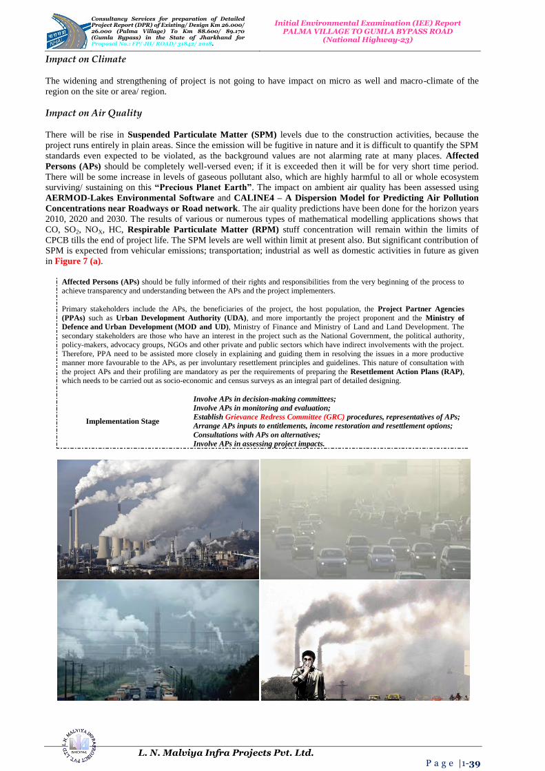
Consultancy Services for preparation of Detailed Project Report (DPR) of Existing/ Design Km 26.000/ 26.000 (Palma Village) To Km 88.600/ 89.170 (Gumla Bypass) in the State 0f Jharkhand for Proposal No.: FP/ JH/ ROAD/ 31842/ 2018.
Initial Environmental Examination (IEE) Report PALMA VILLAGE TO GUMLA BYPASS ROAD
(National Highway-23)
L. N. Malviya Infra Projects Pvt. Ltd. P a g e |1-39
Impact on Climate
The widening and strengthening of project is not going to have impact on micro as well and macro-climate of the
region on the site or area/ region.
Impact on Air Quality
There will be rise in Suspended Particulate Matter (SPM) levels due to the construction activities, because the
project runs entirely in plain areas. Since the emission will be fugitive in nature and it is difficult to quantify the SPM
standards even expected to be violated, as the background values are not alarming rate at many places. Affected
Persons (APs) should be completely well-versed even; if it is exceeded then it will be for very short time period.
There will be some increase in levels of gaseous pollutant also, which are highly harmful to all or whole ecosystem
surviving/ sustaining on this “Precious Planet Earth”. The impact on ambient air quality has been assessed using
AERMOD-Lakes Environmental Software and CALINE4 – A Dispersion Model for Predicting Air Pollution
Concentrations near Roadways or Road network. The air quality predictions have been done for the horizon years
2010, 2020 and 2030. The results of various or numerous types of mathematical modelling applications shows that
CO, SO2, NOX, HC, Respirable Particulate Matter (RPM) stuff concentration will remain within the limits of
CPCB tills the end of project life. The SPM levels are well within limit at present also. But significant contribution of
SPM is expected from vehicular emissions; transportation; industrial as well as domestic activities in future as given
in Figure 7 (a).
Affected Persons (APs) should be fully informed of their rights and responsibilities from the very beginning of the process to
achieve transparency and understanding between the APs and the project implementers.
Primary stakeholders include the APs, the beneficiaries of the project, the host population, the Project Partner Agencies
(PPAs) such as Urban Development Authority (UDA), and more importantly the project proponent and the Ministry of
Defence and Urban Development (MOD and UD), Ministry of Finance and Ministry of Land and Land Development. The
secondary stakeholders are those who have an interest in the project such as the National Government, the political authority,
policy-makers, advocacy groups, NGOs and other private and public sectors which have indirect involvements with the project.
Therefore, PPA need to be assisted more closely in explaining and guiding them in resolving the issues in a more productive
manner more favourable to the APs, as per involuntary resettlement principles and guidelines. This nature of consultation with
the project APs and their profiling are mandatory as per the requirements of preparing the Resettlement Action Plans (RAP),
which needs to be carried out as socio-economic and census surveys as an integral part of detailed designing.
Implementation Stage
Involve APs in decision-making committees;
Involve APs in monitoring and evaluation;
Establish Grievance Redress Committee (GRC) procedures, representatives of APs;
Arrange APs inputs to entitlements, income restoration and resettlement options;
Consultations with APs on alternatives;
Involve APs in assessing project impacts.

Consultancy Services for preparation of Detailed Project Report (DPR) of Existing/ Design Km 26.000/ 26.000 (Palma Village) To Km 88.600/ 89.170 (Gumla Bypass) in the State 0f Jharkhand for Proposal No.: FP/ JH/ ROAD/ 31842/ 2018.
Initial Environmental Examination (IEE) Report PALMA VILLAGE TO GUMLA BYPASS ROAD
(National Highway-23)
L. N. Malviya Infra Projects Pvt. Ltd. P a g e |1-40
Figure 7 (a): Increase in Levels of Pollutant-Emissions-Impact on Future Generated Aspects/ Prospects from Various Sources.
Impact on Noise Levels
The impact of noise levels from the proposed project on the neighbouring communities is addressed by carrying out
Noise Modelling using FHWA Model developed by Federal Highway Administration (FHWA). It has been
concluded after Mathematical Modelling that both day time and night time equivalent noise levels are within the
permissible limits as right from start of project life. Noise sensitive receptors have been identified along the projected
road site/ area. The noise sensitive receptors include school, hospitals, colleges; old orphan people’s sensitive house
zones (Ashrams) and other nearby housing transportation activities along the road side etc. The predicted levels
indicate that the noise levels in future years will not exceed permissible limits right from start of project life as given
in Figure 7 (b). Hence there is no need to protect these noise sensitive receptors.

Consultancy Services for preparation of Detailed Project Report (DPR) of Existing/ Design Km 26.000/ 26.000 (Palma Village) To Km 88.600/ 89.170 (Gumla Bypass) in the State 0f Jharkhand for Proposal No.: FP/ JH/ ROAD/ 31842/ 2018.
Initial Environmental Examination (IEE) Report PALMA VILLAGE TO GUMLA BYPASS ROAD
(National Highway-23)
L. N. Malviya Infra Projects Pvt. Ltd. P a g e |1-41
Figure 7 (b): Noise Levels Impact Must Not Exceed the Permissible Limits in Sensitive Zones along Road Side.
Impact on Water Resources and Quality
The construction and operation of the proposed project roads will not have any major impacts on the surface water
and the ground water quality in the area projected site/ region. Contamination to water bodies may results due to
spilling of construction materials, oil, grease, fuel and paint in the equipment yards and Asphalt Crusher Plants
(ACP) or Hot Mixing Plants (HMP). This will be more prominent in case of locations where the project road
crosses water streams; major canals distributaries, minor/ major ponds and minor/ major small lakes etc. Mitigatory
measures have been planned; generated; initialized and finalized to avoid contamination of these water bodies are
given in Figure 7 (c).
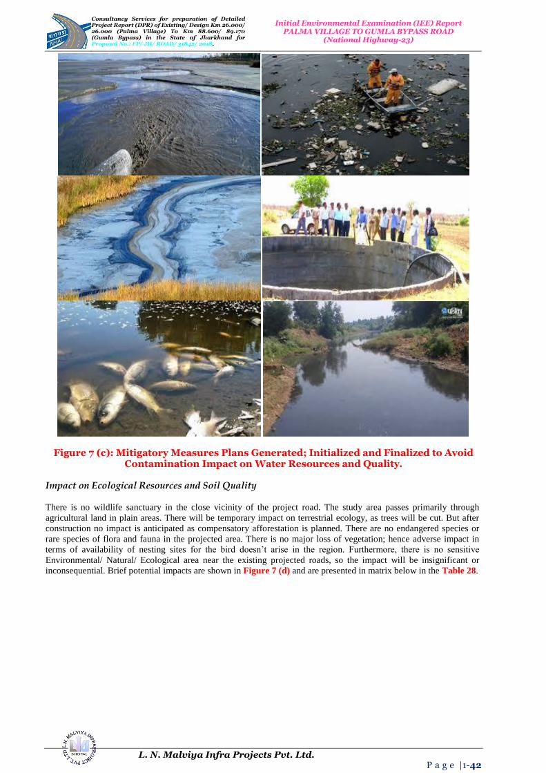
Consultancy Services for preparation of Detailed Project Report (DPR) of Existing/ Design Km 26.000/ 26.000 (Palma Village) To Km 88.600/ 89.170 (Gumla Bypass) in the State 0f Jharkhand for Proposal No.: FP/ JH/ ROAD/ 31842/ 2018.
Initial Environmental Examination (IEE) Report PALMA VILLAGE TO GUMLA BYPASS ROAD
(National Highway-23)
L. N. Malviya Infra Projects Pvt. Ltd. P a g e |1-42
Figure 7 (c): Mitigatory Measures Plans Generated; Initialized and Finalized to Avoid Contamination Impact on Water Resources and Quality.
Impact on Ecological Resources and Soil Quality
There is no wildlife sanctuary in the close vicinity of the project road. The study area passes primarily through
agricultural land in plain areas. There will be temporary impact on terrestrial ecology, as trees will be cut. But after
construction no impact is anticipated as compensatory afforestation is planned. There are no endangered species or
rare species of flora and fauna in the projected area. There is no major loss of vegetation; hence adverse impact in
terms of availability of nesting sites for the bird doesn’t arise in the region. Furthermore, there is no sensitive
Environmental/ Natural/ Ecological area near the existing projected roads, so the impact will be insignificant or
inconsequential. Brief potential impacts are shown in Figure 7 (d) and are presented in matrix below in the Table 28.
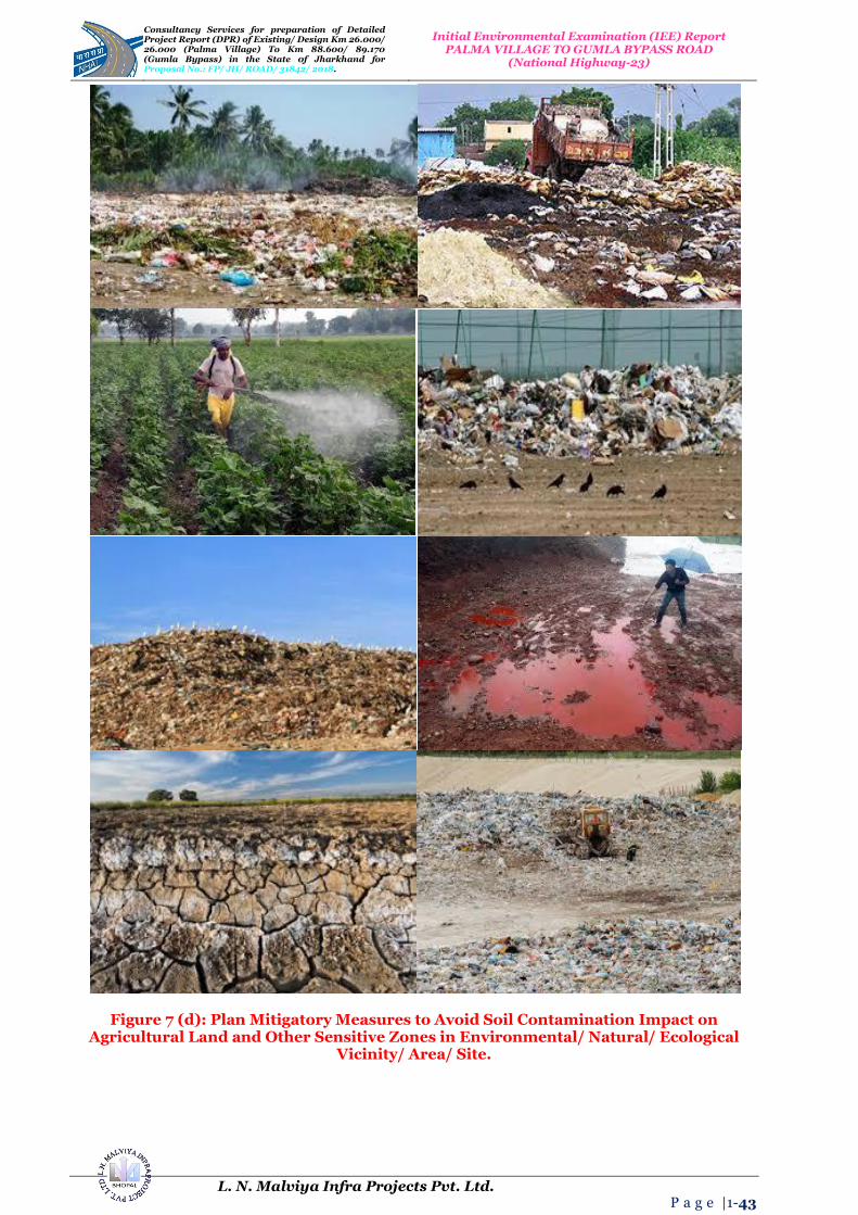
Consultancy Services for preparation of Detailed Project Report (DPR) of Existing/ Design Km 26.000/ 26.000 (Palma Village) To Km 88.600/ 89.170 (Gumla Bypass) in the State 0f Jharkhand for Proposal No.: FP/ JH/ ROAD/ 31842/ 2018.
Initial Environmental Examination (IEE) Report PALMA VILLAGE TO GUMLA BYPASS ROAD
(National Highway-23)
L. N. Malviya Infra Projects Pvt. Ltd. P a g e |1-43
Figure 7 (d): Plan Mitigatory Measures to Avoid Soil Contamination Impact on Agricultural Land and Other Sensitive Zones in Environmental/ Natural/ Ecological
Vicinity/ Area/ Site.
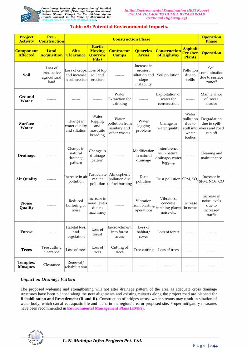
Consultancy Services for preparation of Detailed Project Report (DPR) of Existing/ Design Km 26.000/ 26.000 (Palma Village) To Km 88.600/ 89.170 (Gumla Bypass) in the State 0f Jharkhand for Proposal No.: FP/ JH/ ROAD/ 31842/ 2018.
Initial Environmental Examination (IEE) Report PALMA VILLAGE TO GUMLA BYPASS ROAD
(National Highway-23)
L. N. Malviya Infra Projects Pvt. Ltd. P a g e |1-44
Table 28: Potential Environmental Impacts.
Project Activity
Pre -Construction
Construction Phase Operation
Phase
Component Affected
Land Acquisition
Site Clearance
Earth Moving
(Borrow Pits)
Contractor Camps
Quarries Areas
Construction of Highway
Asphalt Crusher Plants
Operation
Soil
Loss of productive agricultural
land
Loss of crops, and increase
in soil erosion
Loss of top soil and erosion
-------
Increase in erosion,
siltation and slope
instability
Soil pollution Pollution
due to spills
Soil contamination due to surface
runoff
Ground Water
------- ------- ------- Water
Extraction for drinking
------- Exploitation of
water for construction
------- Maintenance
of trees/ shrubs
Surface Water
------- Change in
water quality and siltation
Water logging
and mosquito breeding
Water pollution from sanitary and other wastes
Water logging
problems
Change in water quality
Water pollution
due to spill into
water bodies
Degradation due to spill-
overs and road run off
Drainage -------
Change in natural
drainage pattern
Change in drainage pattern
------- Modification
in natural drainage
Interference with natural
drainage, water logging
------- Cleaning and maintenance
Air Quality ------- Increase in air
pollution
Particulate matter
pollution
Atmospheric pollution due
to fuel burning
Dust pollution
Dust pollution SPM, SO2 Increase in
SPM, NOX, CO
Noise Quality
------- Reduced
buffering of noise
Increase in noise levels
due to machinery
------- Vibration
from blasting operations
Vibrators, concrete
batching plants noise etc.
Increase in noise
Increase in noise levels
due to increased
traffic
Forest ------- Habitat loss,
and vegetation
Loss of forest
Encroachment into forest
areas
Loss of habitat/
cover Loss of forest ------- -------
Trees Tree cutting
clearance Loss of trees
Loss of trees
Cutting of trees
Tree cutting Loss of trees ------- -------
Temples/ Mosques
Clearance Removal/
rehabilitation ------- ------- ------- ------- ------- -------
Impact on Drainage Pattern
The proposed widening and strengthening will not alter drainage pattern of the area as adequate cross drainage
structures have been planned along the new alignments and existing culverts along the project road are planned for
Rehabilitation and Resettlement (R and R). Construction of bridges across water streams may result in siltation of
water body, which can affect aquatic life and fauna in the region/ area or proposed site. Proper mitigatory measures
have been recommended in Environmental Management Plans (EMPs).

Consultancy Services for preparation of Detailed Project Report (DPR) of Existing/ Design Km 26.000/ 26.000 (Palma Village) To Km 88.600/ 89.170 (Gumla Bypass) in the State 0f Jharkhand for Proposal No.: FP/ JH/ ROAD/ 31842/ 2018.
Initial Environmental Examination (IEE) Report PALMA VILLAGE TO GUMLA BYPASS ROAD
(National Highway-23)
L. N. Malviya Infra Projects Pvt. Ltd. P a g e |1-45
Impact on Human Use Values
Impact on human use values are including “Precious Planet Earth’s”, common property resources such as temples,
mosques, wells, hand pumps, stream channels, stream fountains and tube well etc. Impact on these has been
minimized through proper planning of the alignments along roadside/ location site. The environmental impacts have
been summarized as in Figure 8 (a) and Table 29 given below.
Mitigation Avoidance and Enhancement Measures
The mitigation measures have been planned for identified adverse environmental impacts alignment enhancement
design phase is being applied along roadside to reduce tree cuttings as compensatory plantation process or relevance.
These mitigation measures have been identified as Environmental Management Plans (EMPs) during Planning,
Construction and Operation Phase.
Design Phase
Figure 8 (a): Mitigation Enhancement as per Alignment Design Phase to Reduce Tree Cutting and Compensatory Plantation Relevance.
Impacts during design phase is limited to removal of trees, acquisition of land and structures, relocation of water
ways, water parks, water bodies, water locations, water streams or channels identification and management of borrow
pits are as mentioned in Table 29.

Consultancy Services for preparation of Detailed Project Report (DPR) of Existing/ Design Km 26.000/ 26.000 (Palma Village) To Km 88.600/ 89.170 (Gumla Bypass) in the State 0f Jharkhand for Proposal No.: FP/ JH/ ROAD/ 31842/ 2018.
Initial Environmental Examination (IEE) Report PALMA VILLAGE TO GUMLA BYPASS ROAD
(National Highway-23)
L. N. Malviya Infra Projects Pvt. Ltd. P a g e |1-46
Table 29: Impacts during Design Phase.
Impacts Mitigation Measures
Land Acquisition Alignment design to minimize the land acquisition whenever applicable;
Major Displacement Bypasses and detours to be considered preciously;
Removal of Trees Alignment design to reduce the number, widening on the side of the road where less trees are required to be cut. Compensatory plantation to be planned;
Impact on Public Utilities e.g., Community Wells etc.
Alignment design to be considered. In case of removal alternate arrangement to be done before;
Impact on Cultural Sites Alignment design to be considered. Public consultation may be needed if impact cannot be avoided;
Relocation of Waterways Hydrology to be considered. Public consultation will be needed, wherever applicable;
Access Restriction Required alternatives, underpasses, proper signposts for people should be included in design all types of roads constructions;
Congestion in Settlement Areas Service road to be provided everywhere all over the road network;
Borrow Pits Locations to be selected considering minimum loss of productive land and redevelopment and resettlement;
Environmental Specifications for Contractors
Environmental qualifications specification should be included in pre-qualification packages for the contractors and structure designers.
Construction Phase
Environmental management during construction phase is more crucial, because major impacts during construction
like earthworks road network, movement of heavy machineries etc. causes lot of disturbances and management
becomes essential at this stage during construction work. The construction workers camp will be located at least 500
m away from habitations. The construction yard, Hot Mix Plants (HMPs) and crushers like Asphalt Crusher Plants
(ACP) etc. will be located at 500 m away from habitations and in downwind directions. The minimum distance of
these will be kept 3.0 Km from reserve forest areas. Adequate cross drainage structures have been planned to
maintain proper cross drainage. In order to compensate negative impacts on floral species due to cutting of trees the
project plans compensatory plantation in the ratio of 1 : 3 i.e., for everyone has to be applied… if one tree is cut…
!!! Then three or more trees will be planted. The acquisition of forest area will be minimal and will be compensated
through compensatory afforestation. The noise barriers have been planned closed to educational institute so that post
project noise levels are within the specified limits. The project will take an opportunity to provide Environmental
Enhancement Measures (EEM) to improve aesthetic activities in the projected area. The planned Environmental
Enhancement Measures include ponds enhancement, plantation in median and in available clear space in Right of
Way (ROW), seating arrangements around trees must be installed or placed in the specific region. The pond
Enhancement Measures (EM) will include such as stepped access, washing platforms and seating arrangements
ought to be applied etc. Some of ditches will be filled up due to embankment construction in the Right of Way
(ROW). In order to avoid contamination of water bodies during construction sedimentation chambers, oils and grease
separators, oil interceptors at storage areas and at construction yard have been planned. The bill of quantities for
mitigation and enhancement measures has been given in respective Environmental Management Plans (EMPs) of
construction packages. Table 30 below summarizes impacts and its Environmental Management Plan during
Construction Period.
Table 30: Environmental Management Plan during Construction Period.
Impacts Mitigation Measures
Soil Erosion Proper planning for slope stabilization, topsoil storage, plantation and turf on slopes;
Loss of Topsoil Arable lands will be avoided for earth borrowing network. If needed, topsoil will be separated and refilled after excavation on operational site/ region/ area;
Borrowing of Fill Materials
Excavation from pre-selected locations. After excavation the borrow pits will be dressed to match with the surroundings. In specific cases borrow pits can be excavated in consultation with local people to use those pits as water harvesting point locations in particular areas/ sites;
Disposal of Construction Waste
No haphazard dumping of construction waste. Only pre-selected location maintaining local environmental regulations activities/ performance will be used for operational site;
Disposal of Human Waste by Construction
Specific landfill sites should be identified to manage solid waste generated from habitation of construction workers on operational site/ area/ specified region;

Consultancy Services for preparation of Detailed Project Report (DPR) of Existing/ Design Km 26.000/ 26.000 (Palma Village) To Km 88.600/ 89.170 (Gumla Bypass) in the State 0f Jharkhand for Proposal No.: FP/ JH/ ROAD/ 31842/ 2018.
Initial Environmental Examination (IEE) Report PALMA VILLAGE TO GUMLA BYPASS ROAD
(National Highway-23)
L. N. Malviya Infra Projects Pvt. Ltd. P a g e |1-47
Workers
Generation of Dust
Water will be sprayed during construction phase, in earth handling sites, asphalt mixing or crushing sites and other excavation areas for suppression of dust on operational site; In case fly ash is used, dust emission during its unloading, storage at open place and handling for road construction should be suppressed by water sprinkling at regular interval and operation with space and time; Dust emission from piles of excavated material should also be controlled by spraying water on the piles located areas/ sites/ regions; Special care should be taken when working near schools and medical facilities and other sensitive zones.
Environmental issues change during operation phase and its mitigation plans are also related with vehicular
movement, road safety and management of ecological as well as natural/ environmental/ ordinary issues.
Environmental aspects are thus more or less related to vehicular emission; domestic; industrial or anthropogenic
activities in the surrounding areas. The mitigation measures for different environmental aspects are discussed in
Table 31 below.
Table 31: Environmental Management during Operation Phase.
Impacts Mitigation Measures
Dust Bad road maintenance of road gives high rise to dust pollution. Road Surface will be maintained properly and constantly;
Gaseous Pollution
All vehicles should be checked for “Pollution Under Control (PUC)”, certificates and occasional spot testing of emission from vehicles will be carried out in specified regions;
Noise Noise level for different automobiles has been prescribed in Environment (Protection) Rules, 1986. Signs will be posted to restrict blowing of horns with high tons in front of highly sensitive locations or zones;
Surface Runoff
Surface runoff from the road will not be disposed directly in the water-bodies or surfaces used by people for bathing and washings purposes etc. It should also not be disposed directly in to any watercourse with good water quality;
Wild Life
There should be speed restrictions through specific forest area in the night and day time to prevent accident with wild animals. There will be proper signs and indications for the drivers to inform about these activities happening in the region/ area or site;
Flora Tree plantations will be monitored continuously on regularly basis;
Safety Safety signs and signals should be kept always clean and updated on regular basis;
Public Amenities
Bus stops, underpasses etc. should be kept in order for specified zones on the site/ region or area.
Waste Water and Solid Treatment Process
Current treatment strategies are directed towards reducing the amount of solid waste that needs to be land filled, as
well as recovering and utilizing the materials present in the discarded wastes as a resource to the largest possible
extent. Different methods are used for treatment of solid as well as waste water and the choice of proper method
depends upon refuse characteristics, land area available and Disposal of Human Waste by Construction Workers
with disposal cost as they are given below in pyrolysis process as shown in the Figure 8 (b):

Consultancy Services for preparation of Detailed Project Report (DPR) of Existing/ Design Km 26.000/ 26.000 (Palma Village) To Km 88.600/ 89.170 (Gumla Bypass) in the State 0f Jharkhand for Proposal No.: FP/ JH/ ROAD/ 31842/ 2018.
Initial Environmental Examination (IEE) Report PALMA VILLAGE TO GUMLA BYPASS ROAD
(National Highway-23)
L. N. Malviya Infra Projects Pvt. Ltd. P a g e |1-48
Figure 8 (b): Process of Pyrolysis in Solid and Waste Water Treatment.
Pyrolysis: Pyrolysis is defined as thermal degradation of waste in terms of may be water or solid in the absence of air
to produce char, pyrolysis oil and syngas, e.g., the conversion of wood to charcoal also it is defined as destructive
distillation of waste in the absence of oxygen. External source of heat is employed in this process. Because most
organic substances are thermally unstable they can upon heating in an oxygen - free atmosphere be split through a
combination of thermal cracking and condensation reactions into gaseous, liquid and solid fraction.
Incineration process;
Compaction process;
Pyrolysis process;
Gasification process;
Composting process.
Solid Waste Handling Practice
Proper method should be adopted for management of solid waste disposal in a soil. Industrial wastes can be treated
physically, chemically and biologically until they are less hazardous. Acidic and alkaline wastes should be first
neutralized; the insoluble material, if biodegradable should be allowed to degrade under controlled conditions before
being disposed off into the soil. As a last resort, new areas for storage of hazardous waste should be investigated such
as deep well injection and more secure landfills. Burying the waste in locations situated away from residential areas is
the simplest and most widely used technique of solid waste management.
Environmental and aesthetic considerations must be taken into consideration before selecting the dumping site’s soil
condition and quality. Incineration of other wastes is expensive and leaves a huge residue and adds to air, water and
soil as major pollutant in terms of residue as well. “Pyrolysis Practice or Technique” is a process of combustion in
absence of oxygen or the material burnt under controlled atmosphere of oxygen as Solid Waste Handling Pyrolysis
Technique shown Figure 8 (c). It is an alternative to incineration. The gas and liquid thus obtained can be used as
fuels. Pyrolysis of carbonaceous wastes like firewood, coconut, palm waste, corn combs, wheat pod, cashew shell,
rice husk, paddy straw, barley pod, maize husk and saw dust, yields charcoal along with products like tar, methyl
alcohol, acetic acid, and acetone and fuel gases.

Consultancy Services for preparation of Detailed Project Report (DPR) of Existing/ Design Km 26.000/ 26.000 (Palma Village) To Km 88.600/ 89.170 (Gumla Bypass) in the State 0f Jharkhand for Proposal No.: FP/ JH/ ROAD/ 31842/ 2018.
Initial Environmental Examination (IEE) Report PALMA VILLAGE TO GUMLA BYPASS ROAD
(National Highway-23)
L. N. Malviya Infra Projects Pvt. Ltd. P a g e |1-49
Figure 8 (c): Solid Waste Handling Pyrolysis Technique.
Environment Baseline: Environmental, ecological and societal profile of the study region/ vicinity of project location
are based on secondary data of Physiographic, Topology, Climate, Water Quality, Biological outline of town. The
study has to be incorporated regarding “Sewage Treatment Plant (STP)” both in terms of theoretically and
technically applicability for the specific region. The working model of Sewage Treatment Plant or principal subject
matter has to be applied in the town so that it must play significant role for the people and its cultural civilization of
the society as shown in the Figure 8 (d). The flora and fauna recognized in the study spot are commonly found and
not precise to the province due to the deficiency of forest in the study zone.
Figure 8 (d): Sewage Treatment Process (STP) of Wastewater Layout.

Consultancy Services for preparation of Detailed Project Report (DPR) of Existing/ Design Km 26.000/ 26.000 (Palma Village) To Km 88.600/ 89.170 (Gumla Bypass) in the State 0f Jharkhand for Proposal No.: FP/ JH/ ROAD/ 31842/ 2018.
Initial Environmental Examination (IEE) Report PALMA VILLAGE TO GUMLA BYPASS ROAD
(National Highway-23)
L. N. Malviya Infra Projects Pvt. Ltd. P a g e |1-50
13. INSTITUTIONAL REQUIREMENTS AND ENVIRONMENTAL MONITORING PLANS
National Highway Authority of India (NHAI) has a well established Environmental Management Unit (EMU),
Head by a Senior Officer Indian Forest Services (IFS) from Ministry of Environment and Forest, who is
supported by an officer of Dy. G.M. rank from State Pollution Control Board (SPCB). Main responsibility of EMU
will be established to monitor the progress regarding Environmental Management Plan (EMP). Environmental
Management Plan will be the responsibility of contractors and will be closely coordinated by the Engineer
(Supervision Consultant). Table 32 as given below discusses about the remedial measures components, locations/
regions/ areas, time frame work and institutional responsibility with applicable criteria.
Table 32: Institutional Responsibility of Remedial Measures.
Environmental Components
Remedial Measures Components
Locations/ Regions/ Areas
Time Frame Work
Applicable Responsibility
Criteria
Design-Phase
Major Resources (Alignment, Public Amenities and Public Utilities)
Alignment
Avoid impacting school, health facilities, water bodies and
residential quarters.
Throughout the Project Corridor.
During design. Design Consultant
Public Amenities
Provision of service roads, underpasses, safety signs, bus
stops, lay bees, parking spaces etc.
Throughout the Project Corridor as
Mentioned in EIA Report.
During design. Design Consultant
Closure of Public Utilities e.g., Tube-Wells, Wells, Bus
Stops etc.
Alternative arrangement.
Throughout the Project Corridor as
Mentioned in Social Impact
Assessment (SIA).
At the beginning of Construction
Activities.
Contractor, Supervising
Engineer
Construction-Phase
Water Resources and Pollution (Water Bodies, Rivers, Drinking and Wastewater Water)
Water Bodies
Construction of embankments, de-siltation and environmental
enhancement as mentioned in EIA report.
Water Bodies As Mentioned in EIA
Report.
Throughout Construction
Phase.
Contractor, Supervising
Engineer
Rivers/ Nallahs Prevention of pollution of water. Rivers/ Nallahs
Mentioned in EIA Report.
Throughout Construction
Phase.
Consultant, Contractor, Supervising
Engineer
Water Requirement for
Construction
Arrange water without affecting local requirement. Do not use local water bodies. Drill boreholes with
required permission. No water collection within forest area.
Throughout the Project Corridor.
Throughout Construction
Phase.
Contractor, Supervising
Engineer
Drinking Water Requirement
Arrange water without affecting local requirement.
Workers‟ Camps Working Site.
Throughout Construction
Phase.
Contractor, Supervising
Engineer
Wastewater from Workers’ Camp
Ensure proper sanitation and drainage. No direct wastewater discharge in water bodies or the
rivers/ Nallahs.
Workers‟ Camps. Throughout Construction
Phase.
Contractor, Supervising
Engineer
Air and Noise
Dust Generation Spraying of water, proper handling
of fly ash. Throughout the Project Corridor.
Throughout Construction
Phase.
Contractor, Supervising
Engineer
Dust Generation near Sensitive
Locations
Spraying of water, work during scheduled period only.
Schools, PHCs as Mentioned in EIA
Report.
During Construction Near
the Vulnerable Sites.
Contractor, Supervising
Engineer

Consultancy Services for preparation of Detailed Project Report (DPR) of Existing/ Design Km 26.000/ 26.000 (Palma Village) To Km 88.600/ 89.170 (Gumla Bypass) in the State 0f Jharkhand for Proposal No.: FP/ JH/ ROAD/ 31842/ 2018.
Initial Environmental Examination (IEE) Report PALMA VILLAGE TO GUMLA BYPASS ROAD
(National Highway-23)
L. N. Malviya Infra Projects Pvt. Ltd. P a g e |1-51
Asphalt Plant Location away from sensitive areas. Throughout the Project Corridor.
Throughout Construction
Phase.
Contractor, Supervising
Engineer
Stone Crushers Implementing proper air pollution
control measure as per law. Stone Crushers.
Throughout Construction
Phase.
Contractor, Supervising
Engineer
Gaseous Emission from Construction
Work Vehicles
Ensure checking of vehicular emission and obtaining Pollution Under Control (PUC) certificate.
Throughout the Project Corridor.
Throughout Construction
Phase.
Contractor, Supervising
Engineer
Noise from Machineries and
Construction
Ensure machineries meeting noise level standards. Blasting to be done
with required caution.
Throughout Projected Locality/ Region.
Throughout Construction
Phase.
Contractor, Supervising
Engineer
Noise at Sensitive Locations
Work only at scheduled period. Construct noise barrier if suggested.
No work during night in forest areas.
At Schools, PHCs as Mentioned in EIA Report. In Forest
Areas.
During Construction Near
the Vulnerable Sites.
Contractor, Supervising
Engineer
Land and Soil Storage of
Construction Materials, Debris.
Fly Ash, etc.
Prevent siltation from washing of construction materials.
Throughout the Project Corridor.
During Rainy Seasons.
Contractor, Supervising
Engineer
Soil Erosion
Proper planning for slope stabilization, topsoil storage, plantation and turf on slopes.
Throughout the Project Corridor.
Throughout Construction
Phase.
Contractor, Supervising
Engineer
Borrow Pits and Queries
Excavation from pre-selected locations. After excavation the borrow pits will be dressed to match with the surroundings.
Selected Borrow Pits and Quarries as given
in EIA Report.
Throughout Construction
Phase.
Contractor, Supervising
Engineer
Solid Waste from Construction
Work
Ensure dumping outside city area with permission from local authority or used as landfill
material.
Throughout Project Area/ Site/ Region.
Throughout Construction
Phase.
Contractor, Supervising
Engineer
Flora (Plants’ Life)
Tree Felling
Ensure plantation of trees on both sides of road and around in
consultation with forest department.
Throughout the Project Corridor and
Beyond.
Throughout Construction
Phase.
Design Consultant, Contractor, Supervising
Engineer
Fauna (Plants’ Life)
Forest Area
No work after evening. No use of water bodies, safety regulations, no
workers‟ camp. In the Forest Area.
Throughout Construction
Phase.
Contractor, Supervising
Engineer
Others (Public, Religious and Aesthetics)
Workers’ Camp
Ensure providing camp of proper dimension and environmental quality as given in EIA report.
Workers‟ Camps. Throughout Construction
Phase.
Contractor, Supervising
Engineer
Public Facilities Ensure access to all important
locations. Throughout the Project Corridor.
Throughout Construction
Phase.
Contractor, Supervising
Engineer
Religious Places Ensure minimum disturbance
during festival time. Throughout the Project Corridor.
Religious Festivals.
Contractor, Supervising
Engineer
Aesthetics
Planting flowering creepers on medians, slope vegetations, suitable
design of restaurants etc.
Throughout the Project Corridor.
Throughout Construction
Phase.
Contractor, Supervising
Engineer
Operation-Phase
Sources (Dust, Gaseous Pollution, Forest, Safety and Public Amenities)
Dust Road maintenance. Throughout the Project Corridor.
Throughout Operation Phase.
Contractor, Supervising
Engineer
Gaseous Pollution Check the vehicles for pollution
control. Throughout the Project Corridor.
Throughout Operation Phase.
Contractor, Supervising
Engineer, Traffic

Consultancy Services for preparation of Detailed Project Report (DPR) of Existing/ Design Km 26.000/ 26.000 (Palma Village) To Km 88.600/ 89.170 (Gumla Bypass) in the State 0f Jharkhand for Proposal No.: FP/ JH/ ROAD/ 31842/ 2018.
Initial Environmental Examination (IEE) Report PALMA VILLAGE TO GUMLA BYPASS ROAD
(National Highway-23)
L. N. Malviya Infra Projects Pvt. Ltd. P a g e |1-52
Department
Forest Speed restriction safety signs
underpass maintenance. In Forest Areas.
Throughout Operation Phase.
Contractor, Supervising
Engineer, Traffic Department
Safety Maintain all safety provisions. Throughout the Project Corridor.
Throughout Operation Phase.
Contractor, Supervising
Engineer, Traffic Department
Public Amenities Bus stop and other amenities to be
properly kept. Throughout the Project Corridor.
Throughout Operation Phase.
Contractor, Supervising
Engineer, Traffic Department
14. PRINCIPAL COMPONENT ANALYSIS (PCA) INDICATORS
Significant Indicators as Principal Component Analysis (PCA) performed also indicates that indicators, which play
significant role in explaining vulnerability among the districts states. Amongst all the indicators considered in
particular sector indicators with weights greater than the average weight of all indicators are considered as important
in explaining vulnerability study applications. Table 33 gives the list of significant indicators in order of their
importance for each sector. These indicators can play important role in decision making process/ system/ methodology
in a goal to reduce vulnerability as given in Figures 9 (a) to (b).
Table 33: Principal Component Analysis as Significant Indicators of Remedial Measures.
Sr. No. Principal Indicators Analysis/ Aspects Conceptual
Basis (A) Social Aspects/ Analysis
1. Population Served Per Health Centre (Community, Primary and Sub Health Centers); Adaptive Capacity
2. Percentage of Households With Access To Sanitation Facilities; Adaptive Capacity
3. Level of Urbanization; Adaptive Capacity
4. Percentage of Households With Access to Safe Drinking Water; Adaptive Capacity
5. Density of Population; Sensitivity
6. Number of Slum Dwellers Per Slum; Sensitivity
7. Percentage of Households Owning Radio, Transistor, Television and Telephones; Adaptive Capacity
8. Proportion of Elderly Population Aged 65 and Above; Sensitivity
9. Proportion of Child Population in The Age Group 0-6; Sensitivity
10. Literacy Rate and Growth; Adaptive Capacity
(B) Economic Aspects/ Analysis
11. Agricultural Credit Societies Per Lakhs of Population; Adaptive Capacity
12. Loan Disbursed by Agricultural Credit Societies Per Cultivator; Adaptive Capacity
13. Scheduled Commercial Banks Per Lakhs of Population; Adaptive Capacity
(C) Agricultural Aspects/ Analysis 14. Percentage of Land Holdings Below 1 Hectare; Sensitivity
15. Fertilizer Consumption and Utilization; Adaptive Capacity
16. Percentage of Net Irrigated Area to Geographical/ Physical/ Environmental Area By Surface Water; Adaptive Capacity
17. Percentage of Bio-Farming Villages in Total Villages; Adaptive Capacity
18. Percentage Share and Contribution of Agricultural And Cultivators Main Workers; Sensitivity

Consultancy Services for preparation of Detailed Project Report (DPR) of Existing/ Design Km 26.000/ 26.000 (Palma Village) To Km 88.600/ 89.170 (Gumla Bypass) in the State 0f Jharkhand for Proposal No.: FP/ JH/ ROAD/ 31842/ 2018.
Initial Environmental Examination (IEE) Report PALMA VILLAGE TO GUMLA BYPASS ROAD
(National Highway-23)
L. N. Malviya Infra Projects Pvt. Ltd. P a g e |1-53
19. Yield and Capitulate of All Crops; Adaptive Capacity
(D) Water Aspects/ Analysis 20. Crop Water Stress, Strain and Sprain (Evapo-transpiration/ Potential Evapo-transpiration); Sensitivity
21. Surface Water Availability and Accessibility; Adaptive Capacity
(E) Climate Aspects/ Analysis 22. Warm Nights- Days, When Minimum Temperature > 90th Percentile; Exposure
23. Warm Days - Cool Nights- Days, When Maximum Temperature > 90th Percentile; Exposure
24. Warm Spell Duration Indicator (Annual count of days with at least 6 consecutive days when maximum temperature > 90th percentile);
Exposure
25. Cool Days - Cool Nights- Days, When Maximum Temperature < 10th Percentile; Exposure
26. Cool Nights- Days, When Minimum Temperature < 10th Percentile; Exposure
27. Flood Discharge; Exposure
28. Extremely Wet Days-Annual Total Rainfall, When Rainfall > 99th Percentile; Exposure
(F) Health Aspects/ Analysis 29. Percentage of People Having Diarrhea and Other Dieses; Sensitivity
30. Index, Directory, Catalog, Guide, Manifestation or Indicator of Malaria; Sensitivity
(G) Pollution Aspects/ Analysis 31. Pollution of Rivers/ Wetlands, Degradation of Forests and Biodiversity Loss is Being Observed; Exposure
32. Effective Industrial Waste Management and Pollution Control; Exposure
33. With Increasing Pollution Increase in Respiratory Diseases and Allergies is Also Predicted to Increase on the Site;
Exposure
34. Water Pollution is another Big Concern for the State. Depletion of Water Resources and Deterioration of Water Quality is Big Concern for the State;
Exposure
35. Use of More Efficient Technology to Reduce Pollution. Effective Industrial Waste Management and Pollution Control;
Exposure
36. Climate Change (CC) could Increase Air Pollution Levels by Accelerating the Atmospheric Chemical Reactions that Produce Photochemical Oxidants due to a Rise in Temperature;
Exposure
37.
Long Term Targets - By achieving renewable sources of environmental factors/ parameters through agriculture - ecosystem management, implementation of main schemes as soil carbon storage and metering, enhancing soil health, reducing ground water pollution specially harmful chemicals and enhancing biodiversity modifications;
Exposure
38. The other serious issues of groundwater quality are high concentration of fluorides (mainly in granitic terrain), agricultural, municipal and industrial or anthropogenic pollutions;
Exposure
(H) Forest Aspects/ Analysis
39. Percentage of High Density Forest Area to Geographical Area; Adaptive Capacity
40. Non-Timber Forest Products (NTFPs) Diversity (Number of Varieties); Adaptive Capacity
41. Number of Joint Forest Management (JFM) Communities, Neighbourhood-Area-District-Groups of People; Adaptive Capacity
(I) Soil Aspects/ Analysis
42.
Dependence on natural resources is the way of life but unsustainable practices of harvesting, irrigation, elimination of crop residue, forest degradation, deteriorating soil and water quality are augmenting the problems besides other impacts of Climate Change (CC) occur in the state;
Adaptive Capacity
43. Mono-cropping reduces the crop diversity and adversely affects the soil health in the state or region; Sensitivity
44. Soil and water conservation innovative ideas must be applied through demonstration of best engineering practices;
Sensitivity
45.
Set up a knowledge management network to avail information on land-use pattern, soil types, weather or climatic conditions, genotypes of crops, water availability, pasture, off-season crops and agro-forestry practices etc.
Adaptive Capacity
46. Develop capacity to run agriculture related climate models, decipher their projections, to understand the impact on crops, soils and water like precious and important factors etc. in the region/ area or state;
Adaptive Capacity
47. Soil testing- practice and packages must be applied during civil construction work (soil kit to the farmers); Exposure
48. Undertake and revise soil resource mapping at village/ local/ regional or state level; Exposure
49.
Promote use of water and soil conservation techniques, namely dry land farming, drip irrigation, intermittent flooding, dry sowing, Sri Technologies Pvt. Ltd., Indore use of high yielding drought resistant cultivars as appropriate etc. in different areas or states;
Adaptive Capacity
50. Promote agro-forestry and agro-climatic or weather conditions to increase forest biomass and hence soil moisture;
Exposure
51. Identify critical unspecified areas within forests for soil and water conservation; Exposure

Consultancy Services for preparation of Detailed Project Report (DPR) of Existing/ Design Km 26.000/ 26.000 (Palma Village) To Km 88.600/ 89.170 (Gumla Bypass) in the State 0f Jharkhand for Proposal No.: FP/ JH/ ROAD/ 31842/ 2018.
Initial Environmental Examination (IEE) Report PALMA VILLAGE TO GUMLA BYPASS ROAD
(National Highway-23)
L. N. Malviya Infra Projects Pvt. Ltd. P a g e |1-54
52. This effort would not only provide fodder to the animals, but also would curb or reduce further land degradation and soil erosion;
Exposure
53. Soil moisture stress to the crops leading to their stunted growth in the region or state; Exposure
54. Soil and water conservation technologies will need to be strongly adopted after observing or seeing the rising temperatures and decreasing water conditions in the state;
Adaptive Capacity
55.
Soil and water conservation through demonstration of best practices: Application of mulching techniques, drip irrigation, and micro/ macro irrigation practices, techniques and methodologies etc. should be encouraged;
Adaptive Capacity
56. Soil conditions may pose threat problems with an expected increase in acidity, alkalinity and salinity; Sensitivity
57. Soil temperature may increase in spring hence the planting time may also vary accord to space and time; Sensitivity
58.
Further, it would be worthwhile to build and strengthen capacity in the state to run climate models, interpret their projections, and use the same to run the various bio physical models to understand the impact of Climate Change (CC) on crops, soils, water etc. and then to design appropriate adaptation strategies during construction of civil work or human made or designed, but not natural process;
Adaptive Capacity
59.
In some regions mono-cropping of soybean wheat is rendering the soil infertile, sterile, unproductive, barren, unfruitful, arid, uncultivable and may lead to over use of artificial fertilizer which may be detrimental in the long run;
Sensitivity
60.
Promoting and managing agro-forestry, agro-climatic specific crops farming practices and management including that of water, soil, pests, crops, cropping cycle and practices for harnessing the full productivity potential of the different zones should be done on high priority basis for regional areas or site locations;
Adaptive Capacity
61.
This would mean promoting measures for soil moisture conservation through development of watersheds and small catchments that would also increase biomass production and increase the fertility of the “Precious Soil” as well on “Precious Planet Earth”;
Adaptive Capacity
62. Also as the evapo-transpiration rate increases with increase in temperature, it will lead to depletion in moisture retention capacity of the different soil types and can pose a threat to agricultural activities;
Sensitivity
63. Expansion of area of cultivation under mono-cropping of profitable crops without nutrition management is leading to rapid decline in soil fertility of these farms and agricultural fields;
Adaptive Capacity
64. Simple soil and water conservation techniques, methodologies, applications, processes and overall watershed development including the rejuvenation of tanks is proposed to be the focus;
Adaptive Capacity
65. Low capacity of natural water recharge and resources system in the sub-soil in most of the areas of Jharkhand State is also a major concern;
Sensitivity
66. Water logging in canal command areas leads to soil salinity and needs immediate attention towards conjunctive use of surface streams, channels and ground water;
Sensitivity
67.
The state is characterized by a great diversity of parent rocks and minerals, which have weathered under different climatic conditions, vegetative covers and topographic situations to form soils with different characteristics in different zones;
Exposure
68. Shifting of rainfall pattern affects cropping and farming patterns. Mono-cropping reduces the crop diversity and adversely affects the precious and significant soil health conditions.
Sensitivity

Consultancy Services for preparation of Detailed Project Report (DPR) of Existing/ Design Km 26.000/ 26.000 (Palma Village) To Km 88.600/ 89.170 (Gumla Bypass) in the State 0f Jharkhand for Proposal No.: FP/ JH/ ROAD/ 31842/ 2018.
Initial Environmental Examination (IEE) Report PALMA VILLAGE TO GUMLA BYPASS ROAD
(National Highway-23)
L. N. Malviya Infra Projects Pvt. Ltd. P a g e |1-55
Figure 9 (a): TYPICAL CROSS SECTION TYPE A-3: FOR OPEN COUNTRY PLAIN/ ROLLING TERRAIN.
TYPICAL CROSS SECTION – I

Consultancy Services for preparation of Detailed Project Report (DPR) of Existing/ Design Km 26.000/ 26.000 (Palma Village) To Km 88.600/ 89.170 (Gumla Bypass) in the State 0f Jharkhand for Proposal No.: FP/ JH/ ROAD/ 31842/ 2018.
Initial Environmental Examination (IEE) Report PALMA VILLAGE TO GUMLA BYPASS ROAD
(National Highway-23)
L. N. Malviya Infra Projects Pvt. Ltd. P a g e |1-56
Figure 9 (b): TYPICAL CROSS SECTION: FOR BUILT-UP SECTION PLAIN/ ROLLING TERRAIN.
TYPICAL CROSS SECTION – II
***************************
*********************

Consultancy Services for preparation of Detailed Project Report (DPR) of Existing/ Design Km 26.000/ 26.000 (Palma Village) To Km 88.600/ 89.170 (Gumla Bypass) in the State 0f Jharkhand for Proposal No.: FP/ JH/ ROAD/ 31842/ 2018.
Initial Environmental Examination (IEE) Report PALMA VILLAGE TO GUMLA BYPASS ROAD
(National Highway-23)
L. N. Malviya Infra Projects Pvt. Ltd. P a g e |1-57
CHAPTER – 2: ENVIRONMENT SCREENING REPORT
2.1 GENERAL DESCRIPTION
The Initial Environmental Examination (IEE) is carried out to assess the potential environmental impacts likely to be
triggered by the project road. The project road will be reconstructed without any land acquisition and displacement of
people. The project road belongs to Category C projects as per ADB's recent Environmental Assessment Guidelines and
requires an IEE to be carried out. IEE report will be prepared based on the IEE format of Advanced Data or Design
Systems (ADS) with due consideration to environmental legislation e.g., Environmental (Protection) Rules, 1986 of
Government of India (GOI). The Project Road for Palma Village to Gumla Bypass Road is situated in Jharkhand State.
The alignment of the project road connects Palma Village to Gumla Bypass Road respectively.
The objectives of IEE are as following:
To provide information about the general environmental settings around the sub project area as baseline data;
To provide information on potential impacts of the project and characteristic of impacts, magnitude,
distribution and their duration;
To provide information on potential mitigation measures to minimize the impact;
To provide information on the basis of Environmental Management Plans (EMPs);
The field visits were made to collect the requisite information from various government departments and
from other secondary sources (including limited public consultation in the form of focused group discussions).
In the IEE Activities Proposed to be undertaken as part of this project will be considered and the potential impacts will
be analyzed.
2.2 DESCRIPTION OF THE PROJECT
The Project Road for Palma Village to Gumla Bypass Road is situated in Jharkhand State. The proposed project road at
present has single lane carriageway. The road will be widened for intermediate lane. It is planned to reconstruct the
existing road with provisions for side drains, bridges, culverts etc. The project road will be implemented within the
existing Right of Way (ROW) without any land acquisition. The terrain is flat with very minor changes in elevation, and
the landscape is open and devoid of forest cover. The only noticeable changes from the flat terrain occur in the few
places, where the road briefly descends through ravines carved out by streams and then climbs back to the level plain.
Settlements are sparse; the road runs largely through open fields/ barren lands. Many hand pumps are placed alongside
the roadways or roadside for obtaining drinking water.
2.3 JRDC REQUIREMENTS
The JRDC classifies projects such as Scientific Research and Experimental Development (SRED) into one of three
categories based on a screening of their expected environmental impacts:
Category A. Category A projects are defined by the JRDC as "Projects expected to have significant adverse
environmental impacts. An Environmental Impact Statement/ Assessment (EIS/ A) (as defined by the ADB
regulations) is required to address significant impacts."
Category B. Category B projects are defined as "Projects judged to have some adverse environmental impacts,
but of a lesser degree and/ or significance than those for Category A projects. An Initial Environmental
Examination (IEE) is required to determine whether or not significant environmental impacts warranting an
EIA are likely. If an EIA is not needed, the IEE is regarded as the Final Environmental Assessment Report
(FEAR)."
Category C. Category C projects are defined as "Projects unlikely to have adverse environmental impacts. No
EIA or IEE is required, although environmental implications are still reviewed."
2.4 GOVERNMENT OF INDIA REQUIREMENTS
The following is provided for informational purposes. The IEE OR FEAR in hand has not been prepared to meet the
specific criteria/ strategies/ goals/ objectives in actual on priority basis, and does not support to meet Government of
India (GOI) requirements that may ultimately be determined to be applicable to certain Scientific Research and
Experimental Development (SRED) activities. As of this writing, it is not anticipated that any GOI’s process/ system
concerning EIAs will be required. Careful planning of those activities that of necessity occur outside the existing Right
of Way (for example: placement of labour camps, extraction of fill from borrows areas, placement of temporary
approaches to river crossings during bridge replacement), combined with proper contracting and procurement measures
should keep all SRED activities below the thresh-hold limit that would trigger or activate the mechanism, which is in
actual practice the need for an EIA OR EIS.
2.4.1 Central Government Requirements
Primary responsibility for administration and implementation of the GOI policy with respect to conservation,
ecologically or environmentally sustainable development and pollution control rests with the Ministry of
Environment and Forest (MOEF) and the regulations established pursuant to the National Conservation Strategy;
National Forest Policy; the Policy for Abatement or Mitigation Strategies of Pollution (1992); and the Indian
Environmental Protection Act-1986 (29th of 1986), revised in the year 1997.
Guidance for the preparation of Environmental Impact Assessments/ Statements (EIA/ S) within this overall
framework for environmental clearance of new development proposals is provided and suggested by the GOI's

Consultancy Services for preparation of Detailed Project Report (DPR) of Existing/ Design Km 26.000/ 26.000 (Palma Village) To Km 88.600/ 89.170 (Gumla Bypass) in the State 0f Jharkhand for Proposal No.: FP/ JH/ ROAD/ 31842/ 2018.
Initial Environmental Examination (IEE) Report PALMA VILLAGE TO GUMLA BYPASS ROAD
(National Highway-23)
L. N. Malviya Infra Projects Pvt. Ltd. P a g e |1-58
Handbook of Environmental Procedures and Guidelines (1994).
Additional guidelines for road projects are provided by the Ministry of Road Transport and Highways
(MORTH) in its publication entitled Environmental Guidelines for Rail/ Road and Highway Projects. The
Guidelines include the summary questionnaire to be submitted to MOEF for the preparation and planning of EIAs
for domestic road projects requiring EIA as noted above in the paragraphs.
MOEF Circular No. 21012/ 26-99-la-111 dated 22nd August, 2013 exempts linear projects with ROWs of less than
40 metros (including the existing Right of Way (ROW) and land acquisition as may be required by the project)
from most review processes. Projects entirely contained within the existing Right of Way (ROW) are considered as
maintenance, which is generally not subject to MOEF review.
Thus, road projects limited to actions as per instructions such as those are proposed and implemented by Scientific
Research and Experimental Development (SRED) are generally exempted from GOI/ EIA requirements. The
Project will not include construction of any new high level bridges and thus will not require significant changes and
variations to the existing roadsides/ ways alignment or grade level quality construction of civil work.
2.4.2 State Forest Department Requirements
Removal of Trees along the Right of Way (ROW): Trees will have to be removed within the existing Right of Way
(ROW) in some places to allow for widening of the carriageway, construction of shoulders, or to meet and follow current
road safety standards. It should be noted that trees within the Right of Way are considered to be within the purview of the
State Forest Department (SFD). Therefore, an application will be required pursuant to MOEF letter Ref no. 4-1/97'-FC,
dated 18th February, 1998, which provides revised guidelines for applicability of the Forest Conservation Act (1980) to
linear infrastructure projects such as rail and road projects. Clearance by the State Forest Department is assumed to
have been granted/ decided/ approved/ fixed and established unless there is an indication to the contrary within 30 days.
Impacts to Reserved Forests: In the event of potential impacts to Reserved Forests, a Notice of Compliance (NOC) is
required from the State Forest Department (SFD). In the event that a submission to MOEF is required, the NOC must
be obtained prior to action by MOEF as an esteemed organisation.
2.4.3 State Pollution Control Board Requirements (SPCB)
Certain actions to be included in SRED (e.g., the locations and operations of asphalt crushing or mixing plants) will
require submission of an application to the SPCB pursuant to the water (Prevention and Control of Pollution) Act of
1974, Cass Act of 1977, and Air (Prevention and Control of Pollution) Act of 1981.
The SPCB generally establishes a review panel or board/ section/ group/ jury members and circulates the application for
public review and comment in each affected district. At least one public hearing is held in each affected district following
not less than 30 days notice in local and regional newspapers/ media network/ news channels etc.
A state-level hearing is also required, taking all comments received from the districts into account and assuming
acceptability of the SPCB issues as per NOC status and standard maintained for civil construction road network.
The SPCB's NOC, as well as the Forest Department's NOC is required before MOEF action on any required EIA can be
considered complete or whole comprehensive and inclusive report work.
2.5 DESCRIPTION OF THE ENVIRONMENT
Data and information required for preparation of the Initial Environmental Examination (IEE) report have been
collected from various government departments or agencies/ well established organisations, secondary sources and
through actual field visits/ tours/ on site/ area/ location fieldworks etc. Environmental conditions for applicability index
of the area are discussed below one by one in detail:
(i) Physical Resources
Weather and Climate Index
Weather and Climate Index has a great influence on human activities. It affects on the life style of the
population and reduces efficiency of work. Man has made great progress in the field of artificial
intelligence as well as in the field of irrigation, but the food production is still controlled by the climatic
condition of any region as a whole around the world.
Climate and Temperature Index
The district has dry climate except in the South-West Monsoon Season. The year may be divided into four
seasons. The period from March to the second week of June is the Summer Season. The succeeding period
up to the end of September is the South-West monsoon season. October and November constitute the Post-
Monsoon or retreating Monsoon Season. The cold season is from December to February. After, February
there is found to be a rapid increase in average temperatures. May is generally the hottest month with the
mean daily maximum temperature at 42.4°C and the mean daily minimum at 26.9°C. From the second
week of June, there is an appreciable drop in temperature. After the monsoon by about the end of
September, there is a slight increase in the day’s temperature, but the nights become progressively cooler.
After October, however, both day and night temperature decreases rapidly on an average.
December is generally the coldest month with the mean daily maximum temperature at 26.3°C and the
mean daily minimum at 9.1°C. Winds are blowing generally light with some strengthening in force during
the late summer and early Monsoon Season. In May and in the South-West monsoon months, winds blow
mostly from directions between North-West and South-West. In the Post-Monsoon and the cold seasons
winds are variable in direction, but winds from directions between South-West and South-East are found

Consultancy Services for preparation of Detailed Project Report (DPR) of Existing/ Design Km 26.000/ 26.000 (Palma Village) To Km 88.600/ 89.170 (Gumla Bypass) in the State 0f Jharkhand for Proposal No.: FP/ JH/ ROAD/ 31842/ 2018.
Initial Environmental Examination (IEE) Report PALMA VILLAGE TO GUMLA BYPASS ROAD
(National Highway-23)
L. N. Malviya Infra Projects Pvt. Ltd. P a g e |1-59
to be less common. In March and April, winds are variable in direction in the mornings and are Westerly
or North-Westerly in the afternoons. Records of rainfall in the district are available for 11 stations for
periods ranging from 10 to 69 years. The annual rainfall in the district is 813.6 mm. About 93% of the
annual rainfall in the district is received during the monsoon June to September.
Humidity and Temperature Index
Humidity is found to be 48% along with West wind flow at 04 Kph. Palma Village current Weather and
Temperature on an average is 27°C. The temperature in the region reaches and varies minimum to
maximum level in-between 15°C to 29°C on an average in the State of Jharkhand.
Humidity is found to be 25% along with West wind flow from the NNW; 13 Kph. Gumla Sadar City
current Weather and Temperature on an average is 32°C. Winds from the NNW; 13 Kph; Pressure:
1013.80 mb; UV Index: 0; Cloud Cover: 31%; Ceiling: 9144 m; Dew Point: 7° C; Visibility: 16 km.
Sunrise/ Sunset has found to be as per record of Sunrise: 6:07 AM; Sunset: 5:58 PM; Duration: 11:51
hr. Moonrise/ Moonset. Moonrise: 1:14 PM; Moonset: 11:13 AM; Duration: N/A. The temperature in
the region reaches and varies minimum to maximum level in-between 28°C to 42°C on an average in
the State of Jharkhand.
Gumla Sadar City current Weather and Temperature on an average is 16°C to 38°C. During the
Southwest monsoon season the relative humidity generally exceeds 80% (August Month). Rest of the
year is drier. The driest part of the year is the summer season, when relative humidity is less than 35%.
April is the driest month of the year. The wind velocity is higher during the pre-monsoon period as
compared to post monsoon period. The maximum wind velocity 13 Km/ Hr is observed during the
month of June and minimum 3.9 Km/ Hr during the month of December. The average normal annual
wind velocity of Gumla Sadar City is 6.0 Km/ Hr. Regional spoken language of Gumla Sadar City is
Hindi. Elevation/ Altitude are found to be in-between 643 meters above the Mean Sea Level (MSL). The
temperature in the region reaches and varies minimum to maximum level in-between 28°C to 42°C on
an average in the State of Jharkhand.
Since the study region lies far away from the sea coast area/ region, it experiences continental type of
climate zone. It has the Tropical monsoon climate with four distinct/ dissimilar/ divergent seasons
namely…!!!
Monsoon season extending from June to September month;
Retreating monsoon season extending from October to November month;
Winter season- December to February month;
Summer season – March to May month.
The projected road is passing through road Palma Village to Gumla Bypass Road; it is too hot in
summer. In Palma Village to Gumla Bypass Road the summer’s highest day temperature is in between
32°C to 43°C. Average temperatures of January is 23°C, February is 24°C, March is 29°C, April is 32°C,
May is 34°C.
Climate projections for 2030s (2021-2050) and 2080s (2071-2098) have been derived from PRECIS
(Providing Regional Climate for Impact Studies), which is a desktop version of the HadRM3 model
with a grid resolution of 0.44°×0.44° Angles. PRECIS simulation dataset is provided by the Indian
Institute of Tropical Meteorology, Pune. The Climate Change Scenarios are driven by the Green
House Gases (GHG) Emission Scenario, which assumes a future world of very rapid economic growth, a
global population that peaks in midcentury and declines thereafter and assumes rapid introduction of new
and more efficient technologies/ innovations in this scenario or field. Change in precipitation and
temperature in 2030s and end of the century 2080s have been derived with respect to 1970s (1961-1990).
Temperature Index
Tropical dry deciduous forest with Teak (Tectona Grandis) as a dominant tree species occupies 50% of the
area of the Jharkhand Forest Division (JFD). The total managed forest area of the division is 1, 42,536
hectares of which 67% (98,318 Hectares) is managed as Reserved Forest (RF) and the remaining 44,218
hectares, as Protected Forest (PF) category. The normal maximum temperature occurs during the month of
May i.e., 42.1°C and minimum during the month of January i.e., 11.7°C. The normal annual mean
maximum and minimum temperature of Jharkhand district is 32.8°C and 19.8°C respectively. During the
South-West monsoon season the relative humidity generally exceeds 91% (August month). Rest of the
year is drier. The driest part of the year is the summer season, when relative humidity is less than 33%.
April is the driest month of the year. The wind velocity is higher during the pre-monsoon period as
compared to post monsoon period. The maximum wind velocity 7.7 Km/ Hr is observed during the month
of June and minimum 2.9 Km/ Hr during the month of December. The average normal annual wind
velocity of Jharkhand district is 5.0 Km/ Hr.
Humidity Index
Humidity varies from 80 to 90% and wind flows at 16 KPH from West to East on an average.
Transmission Windows (TWs) for malaria i.e., the appropriate conditions of temperature and humidity in
which a vector thrives, is projected to increase (temperature range between 14°C to 40°C, and RH > 50%)
with Climate Change (CC).

Consultancy Services for preparation of Detailed Project Report (DPR) of Existing/ Design Km 26.000/ 26.000 (Palma Village) To Km 88.600/ 89.170 (Gumla Bypass) in the State 0f Jharkhand for Proposal No.: FP/ JH/ ROAD/ 31842/ 2018.
Initial Environmental Examination (IEE) Report PALMA VILLAGE TO GUMLA BYPASS ROAD
(National Highway-23)
L. N. Malviya Infra Projects Pvt. Ltd. P a g e |1-60
Other minor effects are increased incidences of skin disorders, such as prickly heat and fungal skin
disorders such as ringworm and athlete's foot as a result of increased temperature and humidity. Some of
the viral diseases like Peste des Petits Ruminants (PPR) are an acute or sub-acute viral disease of goats
and sheep characterized by fever, necrotic stomatitis, gastroenteritis, pneumonia etc. May also reappears
affecting small ruminant population as well. Temperature Humidity Index (THI), representing the
combined stress of temperature and humidity, affects the productivity of livestock. In addition to these
inherent problems increasing temperature and humidity are also affecting the quality of these produce. For
value addition, processing units and marketing of products need to be developed for rural clusters in
different Agro-Climatic Zones (ACZ). This would also help in reducing the wastage of the produce.
Beside the vector borne diseases that could expand its occurrences, other infections that are related to
varying temperature and humidity indices are also imminent threats to human health and its well beings.
Rainfall Index
The normal rainfall of Gumla district is 13.745 mm. It receives maximum rainfall during southwest
monsoon period. About 90.5% of the annual rainfall is received during monsoon season and only 9.5% of
the annual rainfall takes place during October to May period. The surplus water for groundwater recharge
is available only during the southwest monsoon period.
(i) Moderate rainfall (more than 800 mm) receiving region in the Northern and South-Eastern parts of the
district/ region/ locality;
(ii) Low rainfall (700 mm to 800 mm) in the extensive Eastern and Southern parts of the district/ region/
locality;
(iii) Very low rainfall (less than 700 mm) in the Western part of the district/ region/ locality.
Ambient Air Quality Index
The air quality along the roadsides/ ways is good as there is less flow of traffic. No major source of
emission of exhaust gases exist along the roadways or roadsides except some commercial and residential
establishments concerns, enterprises, shops etc., which burn wood as a fuel for commercial and domestic
purposes/ reasons or functions.
As existing road is in narrow condition, dust due to wind-blown and movement of vehicles on earthen
shoulder portion is observed experimentally, physically and practically along the roadside. However, such
dust particles are settled or mend or resolved within short distances from the road.
Noise Levels Index
In the area along the projected road, noise levels are moderate as there is less traffic flow. Therefore, the
contribution of traffic, an increase of ambient noise levels can be considered insignificant or unimportant
and immaterial.
Seismological Index
As per seismic zonal map of India, the sub project area is located in seismic zone-II. The bridges,
culverts and other structures, therefore, need to be designed accordingly as per specific record of civil
construction work.
(ii) Ecological Resources Index
Terrestrial Ecology
Impacts to flora will be minimal throughout most of the projected areas. Most of the length of the Right
of Way (ROW) lies in rural areas as well as some parts of urban areas also. Insofar as can be determined,
no threatened or endangered plant species are located within or adjacent to the affected ROWS and no
adverse impacts to special status of species/ varieties/ groups are likely to occur due to these activities.
Virtually all rehabilitation and resettlement applicable processes or activities will be confined to the
existing ROWS, and both direct and indirect impacts to threatened or endangered plant species are
unlikely. Plant species present within the Right of Way (ROW) are either introduced species or
ubiquitous native species, which are highly tolerant of grazing, compaction, and other physical
disturbances. Construction activities will have direct impact only in a narrow band of vegetation adjacent
to the existing roadways. Potential impacts to flora, in both the forested and non-forested land areas will
be avoided by ensuring that roadside activities such as asphalt crushing and hot mixing plants,
construction camps and other ancillary features are properly sited. Right of Way, both inside and outside
of forested areas is lined by mature trees overarching the roadways/ roadside. In some portion trees will
have to be cut to permit rehabilitation and resettlement of the roads to current/ recent applicable safety
measure standards.
(iii) Economic Development
Industries
There are total no. of registered industrial units are 2355 and total industrial units are 2359 among which
some industries are agro based, jute based, chemical based, repairing and other services.
Commercial Activities
Commercial activities observed mostly near the inhabitation portion, along the projected road. These

Consultancy Services for preparation of Detailed Project Report (DPR) of Existing/ Design Km 26.000/ 26.000 (Palma Village) To Km 88.600/ 89.170 (Gumla Bypass) in the State 0f Jharkhand for Proposal No.: FP/ JH/ ROAD/ 31842/ 2018.
Initial Environmental Examination (IEE) Report PALMA VILLAGE TO GUMLA BYPASS ROAD
(National Highway-23)
L. N. Malviya Infra Projects Pvt. Ltd. P a g e |1-61
commercial activities are in the form of shops/ malls or complexes in the region/ area or site.
Infrastructure Facilities
Infrastructure facilities are adequate/ sufficient and satisfactory in the area along the projected roadside.
Agricultural Development
The climate of the area is more suitable for growing agricultural i.e., wheat, soya bean, Zwaar (Heavy),
Bazra or Pearl Millet (Pennisetum Glaucum) is the most widely grown type of millet as a part of plants
and vegetables. There exist huge potential as far as the agriculture development is concerned. Soils are
Medium to Deep-Black with relatively high clay content. The major agricultural crops are wheat, gram,
soybeans, sugarcane, rice, moong, urad, potato, sweet potato, coriander, onion, kesari and cotton seeds
for cotton generation/ production etc.
2.6 SOCIAL IMPACT ASSESSMENT (SIA): GENERAL DESCRIPTION
As part of the project, to ascertain the Resettlement and Social Development and Improvement Component (SDIC) of
the project, the scope of the present study as defined by the Terms of References (TORs) are involved with several
elements, parameters and factors, which are in order as below:
To examine and assess the overall social and poverty profile of the project area on the basis of the
primary and secondary data sources such as statistical handbooks, poverty data, land use patterns and
prototype models and sample areas/ site visits/ field visits are key stakeholder’s interviews and
preparation of a socio-economic profile of the state of Jharkhand and the project districts.
Preparation of social and poverty or scarcity and deficiency index analysis, taking into account socio-
economic and poverty status of the projected area of influence, including the nature, extent and
determinants of poverty in the project area including assessment of the risk of human trafficking and
HIV/ AIDS due to the project. In addition, estimation/ judgment/ inference/ evaluation/ assessment of the
likely socio-economic and poverty or deficiency index reduction impacts of the project also constituted
an important as well as significant aspect of the study.
Consultations with relevant officials from the governments, NGOs and other relevant officials, including
consultation with Affected Persons (APs) and affected communities to assess responses to the project
and ascertain the nature and scope of local participation in project planning and implementation stage.
To identify, analyze and where appropriate, quantify the potential resettlement impacts of the proposed
project on the area and the population.
To suggest measures to enhance benefits and mitigate adverse impact on socio-economic profile in the
region.
The report is based on the findings of the socio-economic surveys, field visits or site/ area visits and small group
meetings/ discussions with the project populations in the projected area.
2.7 METHODOLOGY
The study will be conducted with a participatory approach that aimed at putting the community at the center with a
collective process of reflection, discussion and consultation with all major stakeholders in the Project. The primary
stakeholders, such as farmers, shopkeepers, daily wage labourers, Panchayat members, women and other socio-
economically deprived groups like Scheduled Caste (SC), Scheduled Tribes (ST), Other Backward Classes (OBC), health
workers, school teachers, General Category (GC) people and Non- Government Organizations (NGOs) will be consulted
individually, in homogenous sub-groups and mixed groups to understand the local needs and responses to the proposed
sub-projects and also to ascertain the impact or contact of the proposed project on the communities, the area and the
overall regional state.
Site or field visits will be made by the team to the respective projects and all the villages getting affected by the proposed
project intervention, in order to ascertain the socio-economic profile of the area, Participatory Rural Appraisal (PRA)
Methodologies and Techniques like social mapping, resource mapping, transect walk and mobility maps etc. will be used
during the course of the field investigation work.
Community meetings shall be initiated to obtain, acquire and achieve the views, responses and possible solutions from
the local people.
Focus Group Discussions (FGD's) will be organized at the village level with different potential affected groups of
people, more importantly, women, indigenous/ native/ local/ original and other socio-economically deprived people to
ascertain the impact of the project on them.
Meetings with village Panchayats, Non-Government Organizations, health workers, and school teachers, social workers
will also be held during the course of field/ site and area visits with emphasis on project impact, poverty, road safety and
related issues.
A Socio-Economic Survey (SES) covering 20% of the total households/ businesses along the alignments of each of the
sub-projects shall be conducted and carried out and accomplished by means of a detailed questionnaire as opinion poll.
A detailed analysis of secondary data sources shall be carried out and accomplished to understand the social, economic
and demographic situation in the projected area and will be submitted along with Initial Environmental Examination
(IEE) OR Final Environmental Assessment Report (FEAR) as shown in the columns with the Flow Diagrams 10 (a,
b, c and d respectively).
Consultancy Services for preparation of Detailed Project Report (DPR) of Existing/ Design Km 26.000/ 26.000 (Palma Village) To Km 88.600/ 89.170 (Gumla Bypass) in the State 0f Jharkhand for Proposal No.: FP/ JH/ ROAD/ 31842/ 2018.
Initial Environmental Examination (IEE) Report PALMA VILLAGE TO GUMLA BYPASS ROAD
(National Highway-23)
L. N. Malviya Infra Projects Pvt. Ltd. P a g e |1-62
2.8 SOCIO-ECONOMIC CHARACTERISTICS
On the basis of socio-economic data collected from the District-Handbooks and other departmental publications and
brochures relevant to the project roads, as stated earlier, a Project Road Influence Area Profile (PRIA) has been
prepared. The profile consists of demographic features, land utilization, occupation structure, agriculture production,
acreage intensity irrigation facilities, and concentration of infrastructure facilities, such as, availability of banks, hospital
beds, primary schools, electrified villages, drinking water facilities, status of accessibility (paved/ unpaved road), number
of hat/ bazaar, primary health centres, government public distribution shops, post offices and family planning centre etc.
The compiled data have been used in the present project for several analyses during the study. A summary with salient
features are presented in and Flow Diagrams 10 (a, b, c and d respectively) as given below.
Since the time series data are not available for the above socio-economic parameters, it is difficult to establish any trend
analysis report work. However the data available reveal the salient features of the Project Road Influence Area Profile
(PRIA) as well as the concentration of different activities occurs in the projected area/ region. The status of a Project
Road Influence Area (PRIA), thus identified, in a specific activity would be useful to appreciate the relative importance
of that particular projected road. The information collected and compiled for all the projected roads has been utilized for
establishing, launching, ascertaining the relative potential, possible, probable, prospective for future development and
growth and in turn an increase in traffic of the state or region.
2.9 IMPACT ON THE INDIGENOUS PEOPLE
The indigenous/ local/ native/ original people who are presently confined to local area only shall look-after the
development of road and thus transportation infrastructure will get more exposure to education, health, markets and other
informative and innovative activities etc. The area is not vulnerable to migration settlements from external people. Since
the major occupation of people in local area is agricultural based and there are no proper warehousing facilities for
storage of agricultural product in the state of Jharkhand area the indigenous people will be benefited by road development
projects. The Column 15 of Table 34: ENVIRONMENTAL MANAGEMENT PLAN (EMP) for Palma Village to
Gumla Bypass Road in the State of Jharkhand.

Consultancy Services for preparation of Detailed Project Report (DPR) of Existing/ Design Km 26.000/ 26.000 (Palma Village) To Km 88.600/ 89.170 (Gumla Bypass) in the State 0f Jharkhand for Proposal No.: FP/ JH/ ROAD/ 31842/ 2018.
Initial Environmental Examination (IEE) Report PALMA VILLAGE TO GUMLA BYPASS ROAD
(National Highway-23)
L. N. Malviya Infra Projects Pvt. Ltd. P a g e |1-63
Figure 10 (a): Overview of the Environment and Social Framework.
ADB’s core principles which governs
operations on environment and social
management; Environmental and Social
Standards (ESS) w.r.to Environment,
Involuntary Resettlement and Indigenous or
Originated People (EIRIOP);
“Purposes” of the Articles of Agreement of
the Asian Development Bank (ADB);
Introduction Objectives Core
Principles
ENVIRONMENTAL OVERVIEWS AND SOCIAL FRAMEWORKS
Aim of this Environment and Social Framework is to:
Manage environmental; social risks; impacts in
projects; manage operational; reputational risks of
ADB and its stakeholders;
Mainstream environmental and social considerations
into decision-making processes of all parties;
Encourage international-good-environmental and
social practices; operations; strengthen country
systems;
Policy seeks to ensure environmental social
soundness and sustainability of projects;
Enable clients to identify, manage environmental
and social risks and impacts in ADB’s projects;
Improve development effectiveness and impact to
increase results on the ground, and facilitate
cooperation on environmental and social matters
with development partners;
Its operations, ADB seeks to balance economic,
social, and environmental interests while fostering
ownership and accountability of member countries.
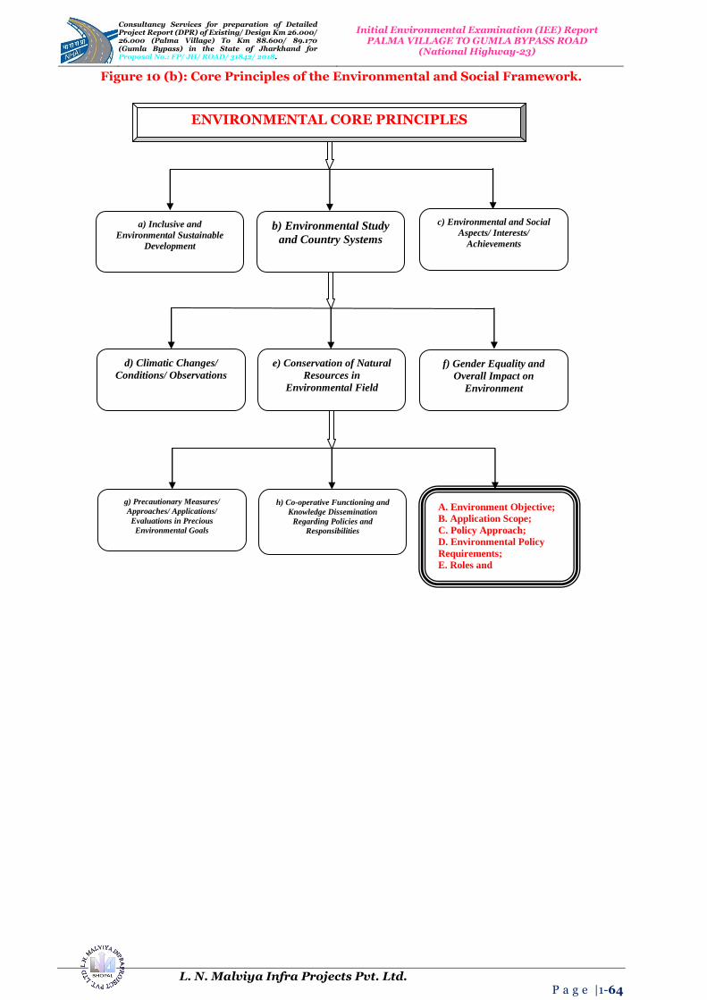
Consultancy Services for preparation of Detailed Project Report (DPR) of Existing/ Design Km 26.000/ 26.000 (Palma Village) To Km 88.600/ 89.170 (Gumla Bypass) in the State 0f Jharkhand for Proposal No.: FP/ JH/ ROAD/ 31842/ 2018.
Initial Environmental Examination (IEE) Report PALMA VILLAGE TO GUMLA BYPASS ROAD
(National Highway-23)
L. N. Malviya Infra Projects Pvt. Ltd. P a g e |1-64
Figure 10 (b): Core Principles of the Environmental and Social Framework.
h) Co-operative Functioning and
Knowledge Dissemination
Regarding Policies and
Responsibilities
g) Precautionary Measures/
Approaches/ Applications/
Evaluations in Precious
Environmental Goals
e) Conservation of Natural
Resources in
Environmental Field
d) Climatic Changes/
Conditions/ Observations
f) Gender Equality and
Overall Impact on
Environment
b) Environmental Study
and Country Systems
a) Inclusive and
Environmental Sustainable
Development
c) Environmental and Social
Aspects/ Interests/
Achievements
ENVIRONMENTAL CORE PRINCIPLES
A. Environment Objective;
B. Application Scope;
C. Policy Approach;
D. Environmental Policy
Requirements;
E. Roles and
Responsibilities;

Consultancy Services for preparation of Detailed Project Report (DPR) of Existing/ Design Km 26.000/ 26.000 (Palma Village) To Km 88.600/ 89.170 (Gumla Bypass) in the State 0f Jharkhand for Proposal No.: FP/ JH/ ROAD/ 31842/ 2018.
Initial Environmental Examination (IEE) Report PALMA VILLAGE TO GUMLA BYPASS ROAD
(National Highway-23)
L. N. Malviya Infra Projects Pvt. Ltd. P a g e |1-65
Figure 10 (c): The Environmental Objectives; Application Scope; Policy Approach of the Environmental and Social Framework.
Environmental
involuntary
resettlement; indigenous
or native peoples
standards; preparation
and implementation of
ADB projects;
ADB addresses gaps, if
any, engaging client or
customer to take adequate
actions to ensure full
success of Environmental
Objectives of Framework
(EOF).
C. Policy Approach:
Under Framework, ADB
requires clients to meet key
requirements for
environmental and social
assessment;
Further, if ADB
determines relevant
requirements of the
country in which the
project is located are
more stringent than
the requirements of its
Environmental Policies
and Goals (EPG);
ADB may require the
customer to comply
environment with more
stringent requirements.
Including investment
projects on
environment and their
components regardless
of financing sources;
ADB agree to apply
additional needs relating
to the environmental or
social affairs with the
Articles of Agreement
and its Policies
Applicability (AAPA).
ADB believes:
Environmental;
Social sustainability
are crucial while
addressing
infrastructure gaps;
Environmental
Sustainable
Development (ESD)
needs consistent with
national laws;
regulations, and its
mandatory policies.
B. Application Scope:
Policy applies to all ADB
financed; ADB
administered projects with
or without sovereign
guarantee;
A. Environmental Objective: To combine the achievement of this it is very important with project decision making process of the client and ADB and the overall operations of ADB;
A. Environmental Objectives;
B. Application Scope;
C. Policy Approach;
ADB will apply on project by project basis,
an appropriate risk-based framework
grounded on ADB experience with BRICS
and other International Good Engineering
Practices (IGEP) in the Environment;
The implementation of the Environmental
Policies (EP) are the responsibility of the
client or costumer, including way of
assessments, consultations, plans,
implementation, complaint redressal, dispute
resolution, disclosure and monitoring.
However, ADB seeks to play a proactive role
by (i) Ensuring stricter compliance with
applicable national standards (ii) Working
with client to strengthen country capacity
and systems (iii) Facts sharing with clients on
International/ Global Good Practices (I/
GGP). ADB provide support to clients
during project processing, monitoring
supervision where and whenever essential in
the field of Environmental Goals (EG).
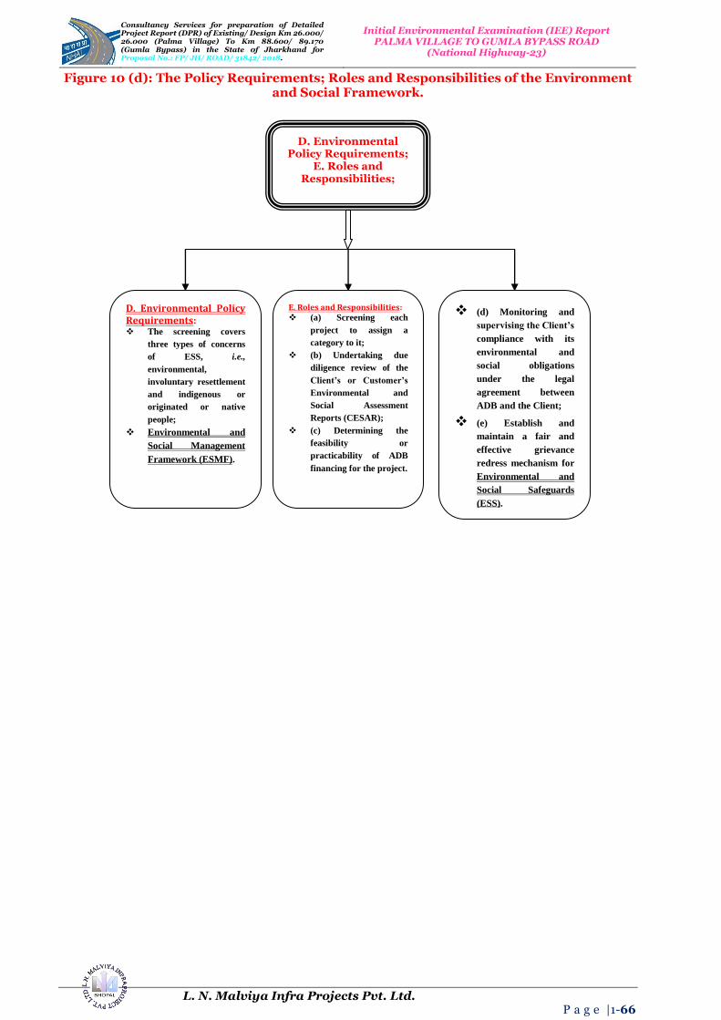
Consultancy Services for preparation of Detailed Project Report (DPR) of Existing/ Design Km 26.000/ 26.000 (Palma Village) To Km 88.600/ 89.170 (Gumla Bypass) in the State 0f Jharkhand for Proposal No.: FP/ JH/ ROAD/ 31842/ 2018.
Initial Environmental Examination (IEE) Report PALMA VILLAGE TO GUMLA BYPASS ROAD
(National Highway-23)
L. N. Malviya Infra Projects Pvt. Ltd. P a g e |1-66
Figure 10 (d): The Policy Requirements; Roles and Responsibilities of the Environment and Social Framework.
D. Environmental Policy Requirements;
E. Roles and Responsibilities;
E. Roles and Responsibilities: (a) Screening each
project to assign a
category to it;
(b) Undertaking due
diligence review of the
Client’s or Customer’s
Environmental and
Social Assessment
Reports (CESAR);
(c) Determining the
feasibility or
practicability of ADB
financing for the project.
D. Environmental Policy Requirements: The screening covers
three types of concerns
of ESS, i.e.,
environmental,
involuntary resettlement
and indigenous or
originated or native
people;
Environmental and
Social Management
Framework (ESMF).
(d) Monitoring and
supervising the Client’s
compliance with its
environmental and
social obligations
under the legal
agreement between
ADB and the Client;
(e) Establish and
maintain a fair and
effective grievance
redress mechanism for
Environmental and
Social Safeguards
(ESS).

Consultancy Services for preparation of Detailed Project Report (DPR) of Existing/ Design Km 26.000/ 26.000 (Palma Village) To Km 88.600/ 89.170 (Gumla Bypass) in the State 0f Jharkhand for Proposal No.: FP/ JH/ ROAD/ 31842/ 2018.
Initial Environmental Examination (IEE) Report PALMA VILLAGE TO GUMLA BYPASS ROAD
(National Highway-23)
L. N. Malviya Infra Projects Pvt. Ltd. P a g e |1-67
15. ENVIRONMENTAL MANAGEMENT PLAN (EMP) for Palma Village to Gumla Bypass Road in the State of Jharkhand
Table 34: Environmental Management Plan (EMP).
Environmental Issues/
Components
Remedial Measure Statements
Reference to Laws/
Guidelines
Locations/ Areas
Monitoring Indicators
Monitoring Methods
Mitigation Coast
Institutional Responsibility and Requirement
Implementation Supervision
A. Pre-Construction and Design Stage 1. Alignment
1.1: Pavement Damage and Inadequate Drainage Provisions in Habitat Areas.
Construction of concrete pavement in habitat areas considering alignment level and drainage.
Raise road level above the nearby areas with provision of adequate side drains to evacuate the rain water and domestic discharges (drained by habitats occasionally) to prevent damage to road and rain water entry to habitats‟ houses.
Provision of adequate number of cross drainage structures based on drainage pattern around the alignment.
Design Requirement. All habitat areas throughout the alignment.
Design of both cross and side drains no. 57 of slab/box culverts, Hume pipes.
Review of detail design documents and drawings.
Included in construction cost.
Design Consultant. PWD/ (CSC)
1.2: Loss of Tree and Vegetation.
Restricting tree cutting within construction limit.
Avoid tree cutting at ancillary site.
Martian compensatory tree plantation of 8,480 trees @ 1: 10.
Design Requirement. Throughout the alignment.
848 Number of tree will be cut.
Observation Included in construction cost
Design Consultant. PWD/ (CSC)
1.3: Protection of Sensitive Receptors.
Careful selection of alignment to the sensitive receptor.
Timely schedule ling of construction activity
Provision of noise suitable barriers.
Project Requirement. Location of sensitive receptors (Refer Table).
Design and alignment plan
Review of design Included in construction cost
Contractor. PWD/ (CSC)
1.4: Safety along the Proposed Alignment.
Make provisions of crash barriers at accident prone areas as identified in the road safety studies.
Provision of rumble strips in habitat areas to regulate speed.
Provision of retro-reflective warning sign boards nears school, hospital, and religious places and forests areas.
Provision of proper sidewalks/pedestrian zone along the road near habitat areas, school, hospital, religious places and forests.
Compliance with norms specified in IRC codes for state highway for
Design Requirement. Places where height of embankment is more than 3.0 m.
Number of accident and vehicle collision.
Field observation, interview of locals.
Included in construction cost.
Design Consultant. PWD/ (CSC)

Consultancy Services for preparation of Detailed Project Report (DPR) of Existing/ Design Km 26.000/ 26.000 (Palma Village) To Km 88.600/ 89.170 (Gumla Bypass) in the State 0f Jharkhand for Proposal No.: FP/ JH/ ROAD/ 31842/ 2018.
Initial Environmental Examination (IEE) Report PALMA VILLAGE TO GUMLA BYPASS ROAD
(National Highway-23)
L. N. Malviya Infra Projects Pvt. Ltd. P a g e |1-68
curvature and grading.
Provision of safety curve at all bridges.
The design should attempt to equalize cut and fill.
Minimize the cutting in hill areas. Incorporate slope stabilization measures to prevent any land slide situation.
Incorporate slope stabilization measures to prevent any land slide situation.
2. Natural Hazards 2.1: Protection for Damage from Earthquake.
Design considering relevant seismic standard in the clause under IRC 6-2014 for earthquakes in bridges.
Throughout the stretch.
Incorporation of IRC 6-2014 guidelines for earthquake in bridge design.
Review of bridge design.
Project preparation cost.
Design Consultant. PWD
2.2: Protection of Road Embankment in Flood Prone Areas.
Raise embankment height above the HFL levels in the flood prone areas.
Provision of adequate balancing culverts.
Improvement in existing culverts/ bridges to increase their carrying
capacity.
IRC: 34 Recommendations for road construction in waterlogged area and IRC: 75 and MORT and H guidelines for
Design of High Embankments (DHE).
All the existing culverts/ bridges.
Design of both cross and side drains, no. of slab/box culverts, number and size of hume pipes.
------- Included in construction cost.
Design Consultant. PWD
3. Shifting of Utility Structures 3.1: Disruption of Utility Services to Local Community.
All telephone and electrical poles/ wires and underground cables should be shifted before start of construction.
Necessary permission and payments should be made to relevant utility service agencies to allow quick shifting and restoration of utility services.
Local people must be informed through appropriate means about the time of shifting of utility structures and potential disruption of services if any.
Project Requirement. Throughout the corridor.
Utility shifting plan. Complaints from local people. Status of local utility services.
Interaction with concerned utility authorities and local public.
Included in construction cost.
Contractor. PWD/ CSC
B. Construction Stage 1. Air Quality
1.1: Dust Generation due to Construction Activities and Transport, Storage and Handling of Construction Materials.
Transport, loading and unloading of loose and fine materials through covered vehicles.
Paved approach roads.
Storage areas to be located downwind of the habitation area.
Water spraying on earthworks, unpaved haulage roads and other
MORT and H Specifications for Road and Bridge Works Air (P and CP) Act-1981 and Central
Motor and Vehicle Act-1988.
Throughout Project corridor.
PM10 level measurements dust pollution or complain of locals.
Standards CPCB methods observations public consultation.
Included in project cost.
Contractor. PWD/ CSC

Consultancy Services for preparation of Detailed Project Report (DPR) of Existing/ Design Km 26.000/ 26.000 (Palma Village) To Km 88.600/ 89.170 (Gumla Bypass) in the State 0f Jharkhand for Proposal No.: FP/ JH/ ROAD/ 31842/ 2018.
Initial Environmental Examination (IEE) Report PALMA VILLAGE TO GUMLA BYPASS ROAD
(National Highway-23)
L. N. Malviya Infra Projects Pvt. Ltd. P a g e |1-69
dust prone areas.
1.2: Emission of Air Pollutants (HC, SO2, NOX, CO etc.) from Vehicles due to Traffic Congestion and use of Equipment and Machinery.
Regular maintenance of machinery and equipment.
Batching, asphalt mixing plants and crushers at downwind (1 Km) direction from the nearest settlement.
Only crushers licensed by the PCB shall be used.
DG sets with stacks of adequate height and use of low sulphur diesel as fuel.
Ambient air quality monitoring.
Follow traffic management plan as given in Section-8.
The Air (Prevention and Control of Pollution) Act, 1981 (Amended 1987) and Rules1982.
Asphalt mixing plants, crushers, DG sets locations.
Monitoring of ambient air quality and checking PUC certificates.
Standards CPCB methods.
Included in project cost.
Contractor. PWD/ CSC
2. Noise 2.1: Noise from Construction Vehicle, Equipment and Machinery.
All equipment to be timely serviced and properly maintained.
Bottlenecks to be removed.
Construction equipment and machinery to be fitted with silencers and maintained properly.
Only IS approved equipment shall be used for construction activities.
The regulation near residential, built up and forest area construction shall be restricted to daylight hours.
Timing of noisy construction activities shall be done during night time and weekends near schools and selected suitable times near temples when there are no visitors, concurrent noisy operations may be separated to reduce the total noise generated, and if possible re-route traffic during construction to avoid the accumulation of noise beyond standards. Else provision of temporary noise barrier at sensitive locations or near sources.
Legal requirement noise Pollution (Regulation and Control) Rules, 2000 and amendments there of + Clause No. 501.8.6. MORT and Highway Specifications for Road and Bridge Works.
Throughout project section especially at construction sites, residential and identified sensitive locations.
Noise levels measurements. Complaints from local people.
As per noise rule, 2000. Consultation with local people.
Included in Project Cost Plantation Cost is Separate.
Contractor. PWD/ CSC
3. Land and Soil 3.1: Land use Change and Loss of Productive/ Top Soil.
Non-agricultural areas to be used as borrow areas to the extent possible.
If using agricultural land, top soil to be preserved and laid over either on the embankment slope for growing vegetation to protect soil erosion.
Project Requirement. Throughout the project section and borrow areas.
Borrow pit locations. Top soil storage area.
Review borrow area plan, site visits.
Included in Construction Cost.
Contractor. PWD/ CSC
3.2: Slope Failure and Soil Erosion due to Construction Activities, Earthwork, and Cut and Fill,
Bio-turfing of embankments to protect slopes.
Slope protection by providing frames, dry stone pitching, masonry
IRC: 56 -1974 recommended practice for treatment of embankment
Throughout the entire project road Especially along hilly areas.
Occurrence of slope failure or erosion issues.
Review of design documents and site observation.
Included in Construction Cost.
Design Consultant and Contractor.
PWD/ CSC
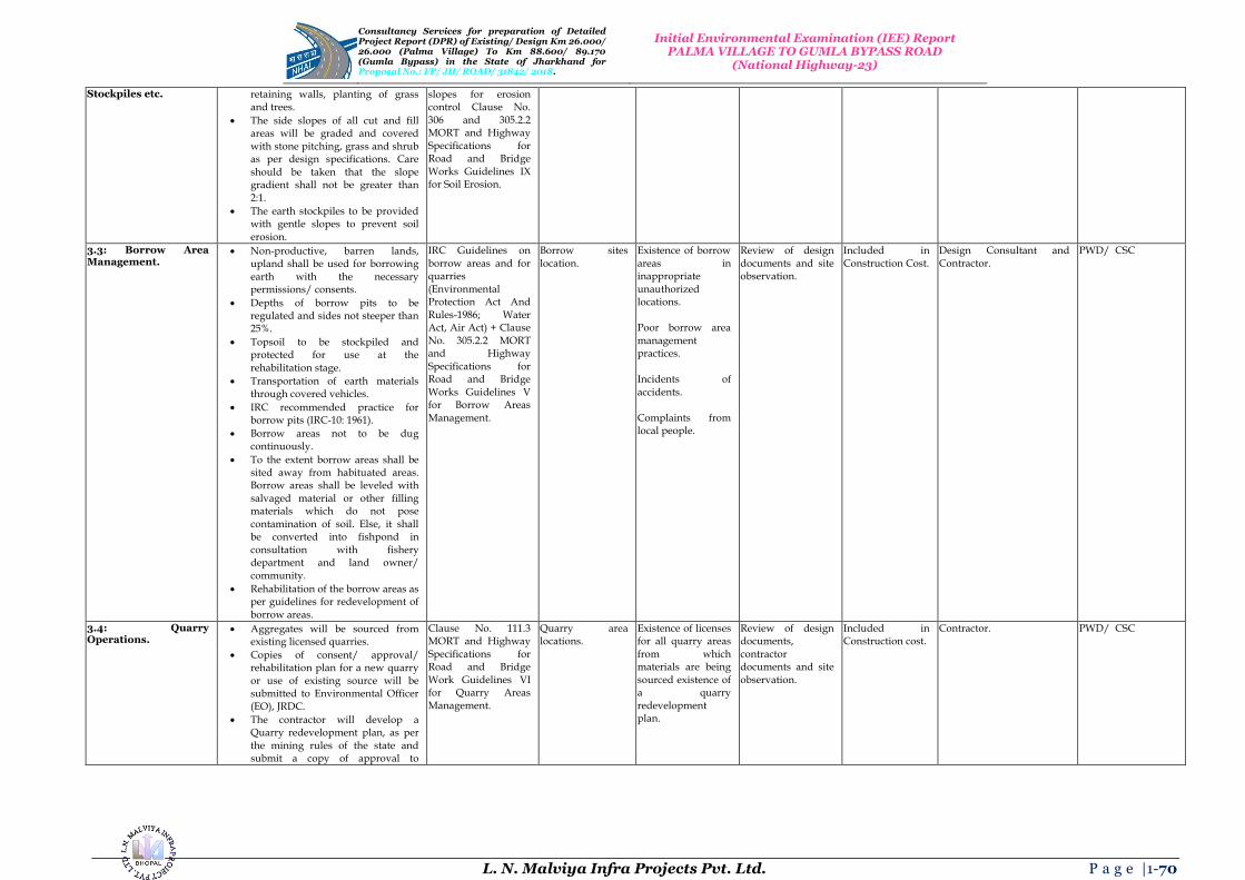
Consultancy Services for preparation of Detailed Project Report (DPR) of Existing/ Design Km 26.000/ 26.000 (Palma Village) To Km 88.600/ 89.170 (Gumla Bypass) in the State 0f Jharkhand for Proposal No.: FP/ JH/ ROAD/ 31842/ 2018.
Initial Environmental Examination (IEE) Report PALMA VILLAGE TO GUMLA BYPASS ROAD
(National Highway-23)
L. N. Malviya Infra Projects Pvt. Ltd. P a g e |1-70
Stockpiles etc. retaining walls, planting of grass and trees.
The side slopes of all cut and fill areas will be graded and covered with stone pitching, grass and shrub as per design specifications. Care should be taken that the slope gradient shall not be greater than 2:1.
The earth stockpiles to be provided with gentle slopes to prevent soil erosion.
slopes for erosion control Clause No. 306 and 305.2.2 MORT and Highway Specifications for Road and Bridge Works Guidelines IX for Soil Erosion.
3.3: Borrow Area Management.
Non-productive, barren lands, upland shall be used for borrowing earth with the necessary permissions/ consents.
Depths of borrow pits to be regulated and sides not steeper than 25%.
Topsoil to be stockpiled and protected for use at the rehabilitation stage.
Transportation of earth materials through covered vehicles.
IRC recommended practice for borrow pits (IRC-10: 1961).
Borrow areas not to be dug continuously.
To the extent borrow areas shall be sited away from habituated areas. Borrow areas shall be leveled with salvaged material or other filling materials which do not pose contamination of soil. Else, it shall be converted into fishpond in consultation with fishery department and land owner/
community.
Rehabilitation of the borrow areas as per guidelines for redevelopment of borrow areas.
IRC Guidelines on borrow areas and for quarries (Environmental Protection Act And Rules-1986; Water Act, Air Act) + Clause No. 305.2.2 MORT and Highway Specifications for Road and Bridge Works Guidelines V for Borrow Areas
Management.
Borrow sites location.
Existence of borrow areas in inappropriate unauthorized locations. Poor borrow area management practices. Incidents of accidents.
Complaints from local people.
Review of design documents and site observation.
Included in Construction Cost.
Design Consultant and Contractor.
PWD/ CSC
3.4: Quarry Operations.
Aggregates will be sourced from existing licensed quarries.
Copies of consent/ approval/ rehabilitation plan for a new quarry or use of existing source will be submitted to Environmental Officer (EO), JRDC.
The contractor will develop a Quarry redevelopment plan, as per
the mining rules of the state and submit a copy of approval to
Clause No. 111.3 MORT and Highway Specifications for Road and Bridge Work Guidelines VI for Quarry Areas Management.
Quarry area locations.
Existence of licenses for all quarry areas from which materials are being sourced existence of a quarry redevelopment plan.
Review of design documents, contractor documents and site observation.
Included in Construction cost.
Contractor. PWD/ CSC

Consultancy Services for preparation of Detailed Project Report (DPR) of Existing/ Design Km 26.000/ 26.000 (Palma Village) To Km 88.600/ 89.170 (Gumla Bypass) in the State 0f Jharkhand for Proposal No.: FP/ JH/ ROAD/ 31842/ 2018.
Initial Environmental Examination (IEE) Report PALMA VILLAGE TO GUMLA BYPASS ROAD
(National Highway-23)
L. N. Malviya Infra Projects Pvt. Ltd. P a g e |1-71
Executing Agency (EA).
3.5: Compaction of Soil and Impact on Quarry Haul Roads due to Movement of Vehicles and Equipment.
Construction vehicles, machinery, and equipment to be stationed in the designated Right of Way (ROW) to avoid compaction.
Approach roads/ haulage roads shall be designed along the barren and hard soil area to reduce the compaction.
Transportation of quarry material to the dumping site through heavy vehicles shall be done through
existing major roads to the extent possible to restrict wear and tear to the village/ minor roads.
Load of haulage trucks will be monitored to ensure they do not exceed the standard limits to avoid safety issues and excessive damage on the roads.
Land taken for construction camp and other temporary facility shall be restored to its original conditions.
Design Requirement. Parking areas, haulage roads and construction yards.
Location of approach and haulage roads presence of destroyed/ compact ted agricultural land or land which has not be restored to its original condition.
Site observation. Included in Construction Cost.
Contractor. PWD/ CSC
3.6: Contamination of Soil due to Leakage/ Spillage of Oil, Bituminous and Non-Bituminous Debris Generated from Demolition and Road Construction.
Construction vehicles and equipment will be maintained and refueled in such a fashion that oil/ diesel spillage does not contaminate the soil.
Fuel storage and refueling sites to be kept away from drainage channels.
Unusable debris shall be dumped in ditches and low lying areas.
To avoid soil contamination Oil-Interceptors shall be provided at wash down and refueling areas.
Waste oil and oil soaked cotton/ cloth shall be stored in containers
labeled „Waste Oil‟ and „Hazardous‟ sold off to MoEF/ SPCB authorized vendors.
Non-bituminous wastes to be dumped in approved borrow pits with the concurrence of landowner and covered with a layer of topsoil conserved from opening the pit.
Bituminous wastes will be disposed off in an identified dumping site approved, appropriately designed, compliant waste management facilities (land-fills).
Design Requirement. Fuelling station, construction sites,
and construction camps and disposal location.
Quality of soil near storage area.
Presence of spilled oil or bitumen in project area.
Site observation. Included in Construction Cost.
Contractor. PWD/ CSC
4. Water Resources 4.1: Sourcing of Water Requisite permission shall be ------- Throughout the Approval from Checking of Included in Contractor. PWD/ CSC

Consultancy Services for preparation of Detailed Project Report (DPR) of Existing/ Design Km 26.000/ 26.000 (Palma Village) To Km 88.600/ 89.170 (Gumla Bypass) in the State 0f Jharkhand for Proposal No.: FP/ JH/ ROAD/ 31842/ 2018.
Initial Environmental Examination (IEE) Report PALMA VILLAGE TO GUMLA BYPASS ROAD
(National Highway-23)
L. N. Malviya Infra Projects Pvt. Ltd. P a g e |1-72
during Construction. obtained for abstraction of groundwater from Central Groundwater Authority (CGA).
Arrangements shall be made by contractor that the water availability and supply to nearby communities remain unaffected.
project section. competent Authority. Complaints from local people on water availability.
documentation on. Talk to local people.
Construction Cost.
4.2: Disposal of Water during Construction.
Provisions shall be made to connect road side drains with exiting nearby ponds otherwise make provision of water harvesting pits intermittently.
Clause No. 1010 EP Act-1986 MORT and Highway Specifications for Road and Bridge
Works.
Throughout the project section.
Design of road side drains existence of proper drainage system for disposal of waste water.
Standards methods site observation and review of documents.
Included in Construction Cost.
Contractor. PWD/ CSC
4.3: Alteration in Surface Water Hydrology due to Embankment.
Existing drainage system to be maintained and further enhanced.
Provision shall be made for adequate size and number of cross drainage structures especially in the areas where land is sloping towards road alignment.
Road level shall be raised above High Flood Level (HFL); level wherever road level is lesser than HFL.
Design Requirement, Clause No. 501.8.6. MORT and Highway Specifications.
Near all drainage channels, river crossings etc.
Design of road side drains.
Review of design documents. Site observation.
Included in Construction Cost.
Contractor. PWD/ CSC
4.4: Siltation in Water Bodies due to Construction Activities/ Earthwork.
Embankment slopes to be modified suitably to restrict the soil debris entering water bodies.
Provision of silt fencing shall be made at water bodies.
Silt/ sediment should be collected and stockpiled for possible reuse as surfacing of slopes where they have to be re-vegetated.
Earthworks and stone works to be prevented from impeding natural flow of rivers, streams and water canals or existing drainage system.
Design Requirement, Clause No. 501.8.6. MORT and Highway Specifications for Road and Bridge Works (CP and CP) and Worldwide Best Practices.
Near all water bodies, river embankment slopes.
Siltation of rivers, streams, ponds and other water bodies in project area.
Field observation. Included in Construction Cost.
Contractor. PWD/ CSC
4.5: Deterioration in Surface Water Quality due to Leakage from Vehicles and Equipments and Waste from Construction Camps.
No vehicles or equipment should be parked or refueled near water-bodies, so as to avoid contamination from fuel and lubricants.
Oil and grease traps and fuelling platforms to be provided at re-fuelling locations.
All chemicals and oil shall be stored away from water and concreted platform with catchment pit for spills collection.
All equipment operators, drivers, and warehouse personnel will be
trained in immediate response for spill containment and eventual
The Water (Prevention and Control of Pollution) Act-1974 and Amendments Thereof.
Water bodies, refueling stations, construction camps.
Water quality of ponds, streams, rivers and other water bodies in project. Presence of oil floating in water bodies in project area.
Conduction of water quality tests as per the monitoring plan. Field observation.
Included in Construction Cost.
Contractor. PWD/ CSC

Consultancy Services for preparation of Detailed Project Report (DPR) of Existing/ Design Km 26.000/ 26.000 (Palma Village) To Km 88.600/ 89.170 (Gumla Bypass) in the State 0f Jharkhand for Proposal No.: FP/ JH/ ROAD/ 31842/ 2018.
Initial Environmental Examination (IEE) Report PALMA VILLAGE TO GUMLA BYPASS ROAD
(National Highway-23)
L. N. Malviya Infra Projects Pvt. Ltd. P a g e |1-73
clean-up. Readily available, simple to understand and preferably written in the local language emergency response procedure, including reporting, will be provided by the contractors.
Construction camp to be sited away from water bodies.
Solid wastes shall be collected, strong and taken to the approved, appropriately designed, compliant waste management facility (landfills) only.
Water quality shall be monitored periodically.
All equipments operators, divers, and ware house personal will be trained in immediate response for spill containment and eventual cleanup. Readily available, simple to understand and preferably retain in the local language emergency response procedure, including reporting, will be provided by the contractor.
5. Flora and Fauna 5.1: Vegetation Loss due to Site Preparation and Construction Activities and Structure Development.
Minimize tree cutting to the extent possible.
Roadside 848 trees to be removed with prior approval of competent authority.
Compensatory plantation at 1:10 basis and additional plantation as per the IRC: guidelines in consultation with Forest Department (FD).
Regular maintenance of all trees
planted.
Provision of LPG in construction camp as fuel source to avoid tree cutting, wherever possible.
Plantation of trees on both sides of the road. Integrate Vegetation Management (IVM) with the carriage way completely clear of vegetation. From the edge of the road to the boundary of Right of Way (ROW), vegetation structured with smaller plants near the line and larger trees further away to avoid costly and provide habitats for a wide variety of plants and animals.
Forest Conservation Act-1980 and IRC: SP: 21 and IRC: SP: 66.
Throughout project corridor.
Right of Way (ROW) width 848 number of trees for felling. Compensatory plantation plan 8,480 number of trees replanted.
Review of relevant documents – tree cutting permit, compensatory plantation plan. Field observations.
Road side Plantation Cost is Included in Project Costs.
Relevant agency specialized in a forestation.
PWD/ CSC

Consultancy Services for preparation of Detailed Project Report (DPR) of Existing/ Design Km 26.000/ 26.000 (Palma Village) To Km 88.600/ 89.170 (Gumla Bypass) in the State 0f Jharkhand for Proposal No.: FP/ JH/ ROAD/ 31842/ 2018.
Initial Environmental Examination (IEE) Report PALMA VILLAGE TO GUMLA BYPASS ROAD
(National Highway-23)
L. N. Malviya Infra Projects Pvt. Ltd. P a g e |1-74
Additional plantation near river banks to check erosion as part of compensatory plantation.
In the event of design changes during the construction stages additional assessments including the possibility to save trees shall be made by the Executing Agency (EA).
Road side Plantation Strategy as per IRC specifications including manuring.
6. Construction Camps 6.1: Impact Associated with Location.
All camps should maintain minimum distance from following:
I. 500 m from habitation; II. 500 m from forest areas where
possible; III. 500 m from water bodies
where possible; IV. 500 m from through traffic
route where possible;
The average distance between two camps should be 50 Km.
Design Requirement. All construction camps.
Location of campsites and distance from habitation, forest areas, water bodies, through traffic route and other construction camps.
On site observation. Interaction with workers and local community.
Included in Construction Costs.
Contractor and Environmental Officer (EO).
PWD/ CSC
6.2: Worker’s Health in Construction Camp.
The location, layout and basic facility provision of each labour camp will be submitted to SQC prior to their construction. The construction shall commence only after approval of SQC.
The contractor will maintain necessary living accommodation and ancillary facilities in functional and hygienic manner as approved by the Executing Agency (EA).
Adequate water and sanitary latrines with septic tanks attached to soak pits shall be provided.
Preventive medical care to be provided to workers including a First-Aid-Kit (FAK) that must be available in the camp.
Waste disposal facilities such as dust bins must be provided in the camps and regular disposal of waste must be carried out.
The contractor will take all precautions to protect the workers from insect and pest to reduce the risk to health. This includes the use of insecticides, which should comply with local regulations.
The Building and Other Construction Workers (Regulation of Employment and Conditions of Service) Act-1996 and The Water (Prevention and Control of Pollution) Act-1974 and Amendments Thereof.
All construction camps.
Camp health records. Existence of proper First-Aid-Kit (FAK) in camp site. Complaints from local people.
Camp records. Site observation. Consultation with local people living nearby.
Part of the Contractors Cost.
Contractor. PWD/ CSC

Consultancy Services for preparation of Detailed Project Report (DPR) of Existing/ Design Km 26.000/ 26.000 (Palma Village) To Km 88.600/ 89.170 (Gumla Bypass) in the State 0f Jharkhand for Proposal No.: FP/ JH/ ROAD/ 31842/ 2018.
Initial Environmental Examination (IEE) Report PALMA VILLAGE TO GUMLA BYPASS ROAD
(National Highway-23)
L. N. Malviya Infra Projects Pvt. Ltd. P a g e |1-75
No alcoholic liquor or prohibited drugs will be imported to, sell, give, and barter to the workers of host community.
Awareness rising, to immigrant workers/ local community on communicable and sexually transmitted diseases.
7. Management of Construction Waste/ Debris 7.1: Selection of Dumping Sites.
Unproductive/ wastelands shall be selected for dumping sites.
Away from residential areas and water bodies.
Dumping sites have adequate capacity equal to the amount of debris generated.
Public perception and consent from the village Panchayats has to be obtained before finalizing the location.
Design Requirement and MORT and Highway Guidelines.
At all dumping sites.
Location of dumping sites.
Public complaints.
Field survey and interaction with local people.
Included in Construction Costs.
Contractor. PWD/ CSC
7.2: Reuse and Disposal of Construction and Dismantled Waste.
The existing bitumen surface shall be utilized for paving of cross roads, access roads, and paving works in construction sites and camps,
temporary traffic diversions, and haulage routes.
Unusable and non-bituminous debris materials should be suitably disposed off at pre-designated disposal locations, with approval of the concerned authority. The bituminous wastes shall be disposed in secure landfill sites only in environmentally accepted manner. For removal of debris, wastes and its disposal MORT and Highway guidelines should be followed.
Unusable and surplus materials, as determined by the Project Engineer (PE), will be removed and disposed off-site.
All excavated materials from roadway, shoulders, verges, drains, cross drainage will be used for backfilling embankments, filling pits, and landscaping.
MORT and Highway Guidelines.
Throughout the project corridor.
Percentage of reuse of existing surface material. Method and location of disposal site of construction debris.
Contractor records. Field observation. Interaction with local people.
Included in Construction Costs.
Contractor. PWD/ CSC
8. Traffic Management and Safety 8.1: Management of Existing Traffic and Safety.
Temporary traffic diversion shall be planned by the contractor and approved by the “Engineer”.
The traffic control plans shall
Design Requirement and IRC: SP: 55.
Throughout the project corridor especially at intersections.
Traffic management plan. Safety signs on site.
Review traffic management plan field observation of traffic management and safety system.
Included in Construction Cost.
Contractor. PWD/ CSC
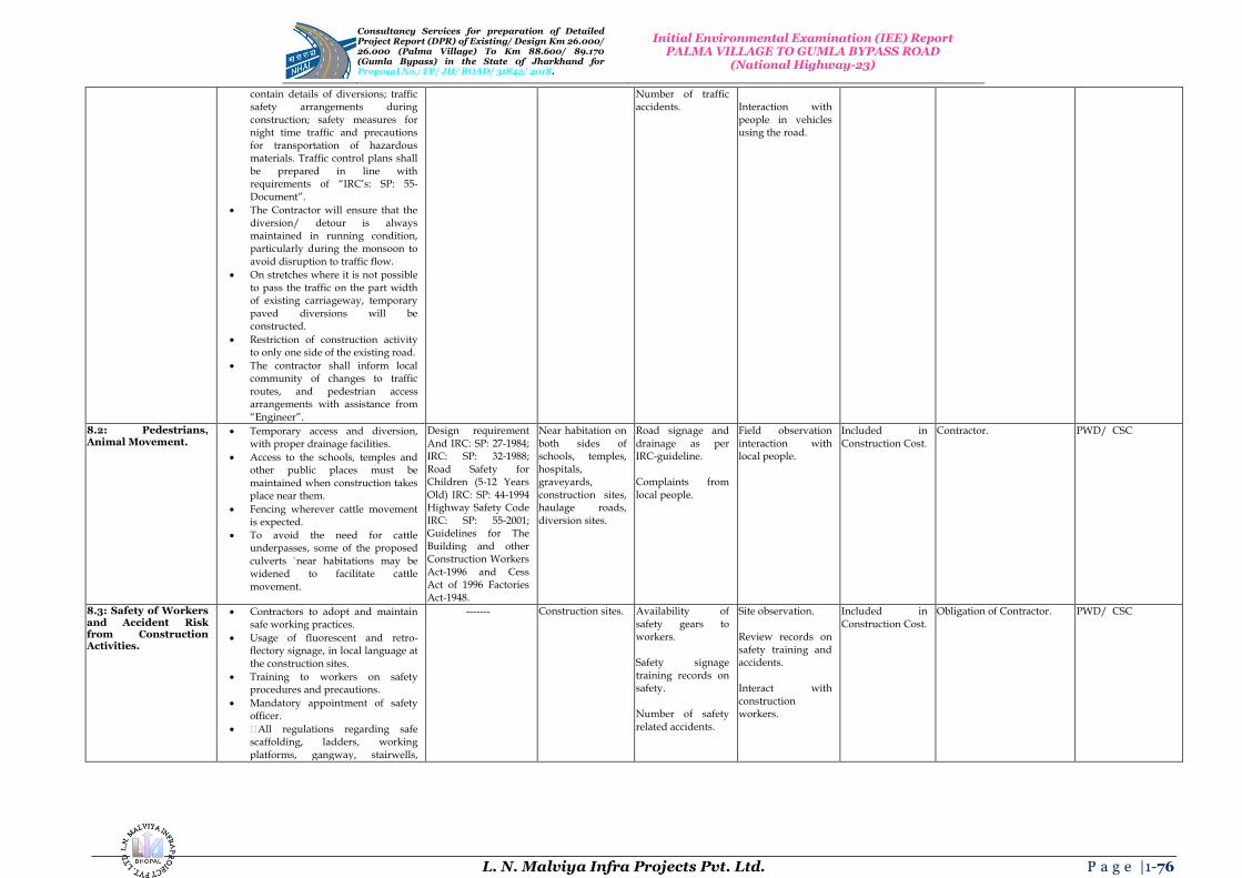
Consultancy Services for preparation of Detailed Project Report (DPR) of Existing/ Design Km 26.000/ 26.000 (Palma Village) To Km 88.600/ 89.170 (Gumla Bypass) in the State 0f Jharkhand for Proposal No.: FP/ JH/ ROAD/ 31842/ 2018.
Initial Environmental Examination (IEE) Report PALMA VILLAGE TO GUMLA BYPASS ROAD
(National Highway-23)
L. N. Malviya Infra Projects Pvt. Ltd. P a g e |1-76
contain details of diversions; traffic safety arrangements during construction; safety measures for night time traffic and precautions for transportation of hazardous materials. Traffic control plans shall be prepared in line with requirements of “IRC‟s: SP: 55-Document”.
The Contractor will ensure that the diversion/ detour is always maintained in running condition, particularly during the monsoon to avoid disruption to traffic flow.
On stretches where it is not possible to pass the traffic on the part width of existing carriageway, temporary paved diversions will be constructed.
Restriction of construction activity to only one side of the existing road.
The contractor shall inform local community of changes to traffic routes, and pedestrian access arrangements with assistance from
“Engineer”.
Number of traffic accidents.
Interaction with people in vehicles using the road.
8.2: Pedestrians, Animal Movement.
Temporary access and diversion, with proper drainage facilities.
Access to the schools, temples and other public places must be maintained when construction takes place near them.
Fencing wherever cattle movement is expected.
To avoid the need for cattle underpasses, some of the proposed culverts `near habitations may be widened to facilitate cattle movement.
Design requirement And IRC: SP: 27-1984; IRC: SP: 32-1988; Road Safety for Children (5-12 Years Old) IRC: SP: 44-1994 Highway Safety Code IRC: SP: 55-2001; Guidelines for The Building and other Construction Workers
Act-1996 and Cess Act of 1996 Factories Act-1948.
Near habitation on both sides of schools, temples, hospitals, graveyards, construction sites, haulage roads, diversion sites.
Road signage and drainage as per IRC-guideline. Complaints from local people.
Field observation interaction with local people.
Included in Construction Cost.
Contractor. PWD/ CSC
8.3: Safety of Workers and Accident Risk from Construction Activities.
Contractors to adopt and maintain safe working practices.
Usage of fluorescent and retro-flectory signage, in local language at the construction sites.
Training to workers on safety procedures and precautions.
Mandatory appointment of safety officer.
All regulations regarding safe scaffolding, ladders, working platforms, gangway, stairwells,
------- Construction sites. Availability of safety gears to workers. Safety signage training records on safety. Number of safety related accidents.
Site observation. Review records on safety training and accidents. Interact with construction workers.
Included in Construction Cost.
Obligation of Contractor. PWD/ CSC

Consultancy Services for preparation of Detailed Project Report (DPR) of Existing/ Design Km 26.000/ 26.000 (Palma Village) To Km 88.600/ 89.170 (Gumla Bypass) in the State 0f Jharkhand for Proposal No.: FP/ JH/ ROAD/ 31842/ 2018.
Initial Environmental Examination (IEE) Report PALMA VILLAGE TO GUMLA BYPASS ROAD
(National Highway-23)
L. N. Malviya Infra Projects Pvt. Ltd. P a g e |1-77
excavations, trenches and safe means of entry and egress shall be complied with.
Provision of PPEs to workers.
Provision of a readily available first aid unit including an adequate supply of dressing materials.
The contractor will not employ any person below the age of 18 years for any work.
Use of hazardous material should be minimized and/ or restricted.
Emergency plan (to be approved by engineer) shall be prepared to respond to any accidents or emergencies.
Accident Prevention Officer (APO) must be appointed by the contractor.
8.4: Accident Risk to Local Community.
Restrict access to construction sites to authorized personnel.
Physical separation must be provided for movement of vehicular and human traffic.
Adequate signage must be provided for safe traffic movement.
------- Construction sites. Safety signs and their location. Incidents of accidents. Complaints from local people.
Site Inspection. Consultation with local people.
Included in Construction Cost.
Contractor. PWD CSC
9. Site Restoration and Rehabilitation 9.1: Clean-up Operations, Restoration and Rehabilitation.
Contractor will prepare site restoration plans, which will be approved by the “Engineer”.
The clean-up and restoration operations are to be implemented by the contractor prior to demobilization.
All construction zones including river-beds, culverts, road-side areas, camps, hot mix plant sites, crushers, batching plant sites and any other area used/ affected by the project will be left clean and tidy, at the contractor's expense, to the satisfaction of the Environmental Officer (EO).
All the opened borrow areas will be rehabilitated and “Engineer” will certify in this regard.
Project Requirement. Throughout the project corridor, construction; camp sites and borrow areas.
Clean and restored camp sites. Presence/ absence of construction material/ debris after completion of construction works on construction site.
Site observation. Interaction with locals. Issue completion certificate after restoration of all sites are found
satisfactory.
Included in Construction Cost.
Contractor. PWD/ CSC
C. Operation Stage 1. Air quality
1.1: Air Pollution due to Vehicular
Roadside tree plantations shall be maintained.
Environmental Protection Act-1986;
Throughout the corridor.
Ambient air quality (PM10, CO, NOX)
As per CPCB requirements site
Included in Operation/
Contractor. PWD/ CSC

Consultancy Services for preparation of Detailed Project Report (DPR) of Existing/ Design Km 26.000/ 26.000 (Palma Village) To Km 88.600/ 89.170 (Gumla Bypass) in the State 0f Jharkhand for Proposal No.: FP/ JH/ ROAD/ 31842/ 2018.
Initial Environmental Examination (IEE) Report PALMA VILLAGE TO GUMLA BYPASS ROAD
(National Highway-23)
L. N. Malviya Infra Projects Pvt. Ltd. P a g e |1-78
Movement or Vehicles Playing on the Road.
Regular maintenance of the road will be done to ensure good surface condition.
Vehicular air pollution will be managed and monitored.
Ambient air quality monitoring. If monitored parameters are above the prescribed limit, suitable control measures must be taken.
Technological and behavioural changes.
Road signs shall be provided reminding the motorist toproperly maintains their vehicles to economize on fuel consumption and unprotect the environment.
The Air (Prevention and Control of Pollution) Act-1981.
survival rate of trees planted.
inspection. Maintenance Cost.
2. Noise 2.1: Noise Pollution due to Movement of Traffic.
Effective traffic management and good riding conditions shall be maintained to reduce the noise level throughout the stretch and speed limitation and honking restrictions may be enforced near sensitive locations.
The effectiveness of the multilayered plantation should be monitored and if needed solid noise barrier shall be placed.
Create awareness amongst the residents about likely noise levels from road operation at different distances, the safe ambient noise limits and easy to implement noise reduction measures while constructing a building close to the road.
Noise Pollution (Regulation and Control) Rules, 2000 and amendments thereof.
Sensitive receptors.
Noise levels. Noise monitoring as per noise rules, 2000. Discussion with people in sensitive receptor sites.
Included in Operation/ Maintenance Cost.
Contractor. PWD/ CSC
3. Land and Soil 3.1: Soil Erosion at Embankment during Heavy Rainfall.
Periodic checking to be carried to assess the effectiveness of the stabilization measures viz. turfing, stone pitching, river training structures etc.
Necessary measures to be followed wherever there are failures.
Project Requirement. At bridge locations and embankment slopes and other probable soil erosion areas.
Existence of soil erosion sites. Number of soil erosion sites.
On site observation. Included in Construction Cost.
Contractor. PWD/ CSC
4. Water Resources/ Flooding and Inundation 4.1: Siltation. Regular checks shall be made for
soil erosion and turfing conditions of river training structures for its effective maintenance.
Project Requirement. Near surface water bodies.
Water quality. Site observation. Included in Operation/ Maintenance Cost.
Contractor. PWD/ CSC
4.2: Water Logging Regular visual checks and cleaning Project Requirement. Near surface water Presence of flooded Site observation. Included in Contractor. PWD/ CSC

Consultancy Services for preparation of Detailed Project Report (DPR) of Existing/ Design Km 26.000/ 26.000 (Palma Village) To Km 88.600/ 89.170 (Gumla Bypass) in the State 0f Jharkhand for Proposal No.: FP/ JH/ ROAD/ 31842/ 2018.
Initial Environmental Examination (IEE) Report PALMA VILLAGE TO GUMLA BYPASS ROAD
(National Highway-23)
L. N. Malviya Infra Projects Pvt. Ltd. P a g e |1-79
due to Blockage of Drains, Culverts or Streams.
of drains shall be done along the alignment to ensure that flow of water is maintained through cross drains and other channels/ streams.
Monitoring of water borne diseases due to stagnant water bodies.
bodies. areas or areas with water stagnation.
Operation/ Maintenance Cost.
4.3: Road Inundation due to Choking of Drainage Channels.
JRDC will ensure that all drains (side drains and all cross drainages) are periodically cleared especially before monsoon season to facilitate the quick passage of rainwater and avoid flooding.
Project Requirement. Flood prone sections.
Incidents of flooding and road inundation with details on change.
Field observation Interaction with local community.
Included in Operation/ Maintenance Cost.
Contractor. PWD/ CSC
5. Flora 5.1: Vegetation. Planted trees, shrubs, and grasses to
be properly maintained.
The tree survivalist audit to be conducted at least once in a year to assess the effectiveness.
Forest Conservation Act-1980.
Project tree plantation sites.
Minimum of 70% of tree survival.
Records and fields observations.
Operation and Maintenance Cost.
Contractor. JRDC/ CSC
6. Maintenance of Right of Way and Safety 6.1: Accident Risk due to Uncontrolled Growth of Vegetation.
Efforts shall be made to make shoulder completely clear of vegetation.
Regular maintenance of plantation along the road side.
Invasive plant not to be planted near the road.
Project Requirement. Throughout the project route.
Presence of and extent of vegetation growth on either side of road. Accident data.
Visual inspection. Accident records.
Included in Operation/ Maintenance Cost.
Contractor. PWD/ CSC
6.2: Accident Risks Associated with Traffic Movement.
Traffic control measures, including speed limits, will be enforced strictly.
Further encroachment of squatters within the Right of Way (ROW) will be prevented.
No school or hospital will be allowed to be established beyond the stipulated planning line as per relevant local law.
Monitor/ ensure that all safety provisions included in design and construction phase are properly maintained.
Highway patrol unit(s) for round the clock patrolling. Phone booths for accidental reporting and ambulance services with minimum response time for rescue of any accident victims, if possible.
Tow-away facility for the break down vehicles if possible.
IRC: SP: 55 Throughout the project route.
Police records on accident. Condition and existence of safety signs, rumble strips etc. on the road. Presence/absence of sensitive receptor structures inside the stipulated planning line as per relevant local law.
Review accident records. Site observation.
Included in Operation/ Maintenance Cost.
Contractor. PWD/ CSC
6.3: Transport of Dangerous Goods.
Existence of spill prevention and control and emergency responsive
------- Throughout the project stretch.
Status of emergency system – whether
Review of spill prevention and
Included in Operation/
Contractor. PWD/ CSC
Consultancy Services for preparation of Detailed Project Report (DPR) of Existing/ Design Km 26.000/ 26.000 (Palma Village) To Km 88.600/ 89.170 (Gumla Bypass) in the State 0f Jharkhand for Proposal No.: FP/ JH/ ROAD/ 31842/ 2018.
Initial Environmental Examination (IEE) Report PALMA VILLAGE TO GUMLA BYPASS ROAD
(National Highway-23)
L. N. Malviya Infra Projects Pvt. Ltd. P a g e |1-80
system.
Emergency plan for vehicles carrying hazardous material.
operational or not. emergency response system.
Maintenance Cost.
Note: EA: Executing Agency, PWD: Jharkhand Road Development Corporation (JRDC), EO: Environmental Officer, IRC: Indian Road Congress.
a) The “Project Engineer” or “The Engineer” is the team of Construction Supervision Consultants (CSC) responsible for approving the plans, engineering drawing, release of payments to
contractor etc. on behalf of the employer (PWD). It is usually the team leader of the CSC that takes the responsibility of signing approval documents on behalf of the “CSC-Team Members/ Jury Members”.
b) The “Environmental Officer” is the “Environmental Specialist or Expert” under the CSC who is responsible for providing recommendations to the “CSC-Team Leader” for approving activities
specific to “Environment Safeguards” on behalf of “The Engineer” or “Project Engineer”.

Consultancy Services for preparation of Detailed Project Report (DPR) of Existing/ Design Km 26.000/ 26.000 (Palma Village) To Km 88.600/ 89.170 (Gumla Bypass) in the State 0f Jharkhand for Proposal No.: FP/ JH/ ROAD/ 31842/ 2018.
Initial Environmental Examination (IEE) Report PALMA VILLAGE TO GUMLA BYPASS ROAD
(National Highway-23)
L. N. Malviya Infra Projects Pvt. Ltd. P a g e |1-81
EA: Executing Agency, JRDC: Central Public Works Department (CPWD); Government of India
(GOI), EO: Environmental Officer, IRC: Indian Road Congress, CSC: Construction Supervision
Consultant, JFM: Joint Forest Management Committee, CPCB: Central Pollution Control Board.
The “Project Engineer” or “The Engineer” is the team of Construction Supervision Consultants
(CSC) responsible for approving the plans, engineering drawing, release of payments to contractor etc.
on behalf of the employer (JRDC). It is usually the team leader of the CSC that takes the responsibility
of signing approval documents on behalf of the CSC team. The “Environmental Officer” is the
“Environmental Specialist or Expert” under the CSC who is responsible for providing
recommendations to the “CSC-Team Leader” for approving activities specific to “Environment
Safeguards” on behalf of “The Engineer” or “Project Engineer”.
Joint Forest Management (JFM) Committee’s exist at the village level. Each Joint Forest
Management committee has 15 members of which 3 to 5 members are mandated to be women. The
member secretary of each committee is the local Forester or Beat Officer, who oversees the accounts
and activities of the Joint Forest Management committee. Respective Joint Forest Management
committee’s will be identified and confirmed by the contractor under the guidance of the
“Environmental Specialist or Expert” of the CSC during construction Palma Village to Gumla
Bypass Road in the State of Jharkhand.
16. CONCLUSIONS AND BUDGET
ENVIRONMENTAL MONITORING PLAN AND COST (EMPC): {Palma Village to Gumla Bypass Road in the State of Jharkhand}
Based on the field survey and data available from secondary sources, it can be concluded that the project will not
have significant negative environmental impacts. The issues of concern in the project are construction of
bypasses, re-alignments, and bridges and acquisition of private land and forest land etc. Proper Environmental
Management Plans (EMPs) compliance needs to be ensured. The issues related to land acquisition and re-
settlement has been evaluated and adequate compensation has been suggested in Resource Allocation Program
(RAP) document. The Environmental Mitigation and Monitoring Requirements are given in the Table 35.
Table 35: Environmental Mitigation and Monitoring Requirements.
Particulars Estimated Rate Total Cost (in Lakhs)
Environmental Monitoring during Construction and Implementation Phase
Lump Sum 5.0
Environmental Training Programs Lump Sum 2.0
Plantation of 12,150 Trees Including Maintenance Cost for 3 Years
Rs. 1000 per Tree Including Maintenance
260
Water Sprinkling for Dust Emission Suppression
80,000 per Km 54.4
Solid Noise Barrier Installation by Trees in Places
Lump Sum -------
Enhancement of Water Bodies Sources and Resources
Rs. 1 Lakh Each -------
Safety Signs and Provisions at Different Locations/ Sites/ Areas
------- Provided in Civil Works
Contract
Cost to be Included in Engineering ------- -------
All Underpasses OR Bypasses/ Roads/ Ways Included in Civil Works -------
Dust Emission Suppression by Watering Incidental to Work with in
Contractor -------
Environmental Measures at Workers’ Camps during Site Visit
Incidental to Work with in Contractor
-------
Vegetation Turf at Slopes along Roadsides/ Roadways
Civil Works -------
Operation Phase
Environmental Monitoring and Evaluation Plans
------- 1.0 per Annum
Tree Maintenance and Monitoring Plans Included Above -------
Training for Segregation; Mitigation and ------- 2.0 per Annum

Consultancy Services for preparation of Detailed Project Report (DPR) of Existing/ Design Km 26.000/ 26.000 (Palma Village) To Km 88.600/ 89.170 (Gumla Bypass) in the State 0f Jharkhand for Proposal No.: FP/ JH/ ROAD/ 31842/ 2018.
Initial Environmental Examination (IEE) Report PALMA VILLAGE TO GUMLA BYPASS ROAD
(National Highway-23)
L. N. Malviya Infra Projects Pvt. Ltd. P a g e |1-82
Monitoring etc. Road Maintenance Cost not Considered as Per Specific Targets OR Proposed Work
------- -------
Sub Total For Contract Period = (3.0×3) 9 for 3 Years
Total Twenty Seven Lakhs 27.00 Lakhs
Grand Total ------- 425.4 Lakhs
Based on the environmental assessment and surveys or visits conducted for the project, associated potential or
prospective adverse environmental impacts can be mitigated to an acceptable/ satisfactory level by adequate
implementation of the measures/ methods/ ways/ processes as stated in the Environmental Impact Assessment
(EIA) Report. Adequate provisions have been made to cover the environmental mitigation and monitoring
requirements (including afforestation cost), which is approximately Rs. 4.25 Crores or Rs. 425.4 Lakhs.
Cost Estimate
Cost estimate for the projected road is finalized based on the improvement proposals are summarized/
recapitalized/ reviewed/ abridged/ précised respectively. The existing Right of Way (ROW) along the project
road varies from 20 m to 40 m. Therefore land acquisition is required for widening of the project road,
Improving and black spots. Hence the project will have social impact in terms of loss of livelihood or shelter,
which will have to be studied and a suitable mitigation/ alleviation/ easing/ improvement plans has to be
prepared.
Construction of project is proposed in Two Phases. Phase-I include intermediate lane/ two lanes of existing road
from Existing Length = 26.000 Kms and Proposed Length = 63.170 Kms. Cost estimate for the project Road
is finalized/ finished/ concluding/ ending with ultimate approach based on the improvement proposals in Table
36 (a) and (b).
Table 36 (a): Details of Palma Village to Gumla Bypass Road.
Description Existing Proposed
Terrain : Plain Plain
Length : Existing Length = 26.000 Kms Proposed Length = 63.170 Kms
Alignment : The Existing Alignment is almost Poor Except at few Locations.
The existing alignment with geometric improvements.
Design Speed : Average 65 Km/ Hr to 80 Km/ Hr. 80 Km/ Hr to 100 Km/ Hr.
Cross-Section :
C/ W Width – Varying b/ w 5.5 – 7.0 m Shoulder – 01 m to 02 m
Rigid (CC) Pavement – 2 Lane in Built-Up Area – RCC
Drain + 12.00 Rigid C/ W+ RCC Drain In Open Area - 10 m Carriageway
CBR Considered : ------- 08%
:
Present Year (2017) PCU – 2203 ADT – 2084 CVPD – 427
On Basis of Projected Traffic* From Km 00.000 to Kms
63.170: 2 – Lane with Paved Shoulders are Considered.
Pavement Crust Thickness for Widening and
New Construction
: Existing Structure = 65 Nos.
Rigid Pavement:
PQC – 300 mm (M-40) DLC – 150 mm (M-15) Drainage + GSB – 225 (150+75) mm Sub-Grade – 500 mm
Overlay: BC – 40 mm DBM – 50 mm
Bridges :
Major Bridge = 02 Nos. On Project Road
02 Nos. of Major Bridge. Retain with Repair = 00 Nos. Reconstruction = 01 Nos. Widening = 00 Nos. 01 Nos. New Proposed for Gumla Bypass
Minor Bridges = 06 Nos. on Project Road
Retain with Repair = 13 Nos. Reconstruction = 03 Nos.

Consultancy Services for preparation of Detailed Project Report (DPR) of Existing/ Design Km 26.000/ 26.000 (Palma Village) To Km 88.600/ 89.170 (Gumla Bypass) in the State 0f Jharkhand for Proposal No.: FP/ JH/ ROAD/ 31842/ 2018.
Initial Environmental Examination (IEE) Report PALMA VILLAGE TO GUMLA BYPASS ROAD
(National Highway-23)
L. N. Malviya Infra Projects Pvt. Ltd. P a g e |1-83
Description Existing Proposed
Widening = 00 Nos. New Proposed = 00 Nos. 01 Nos. New proposed for Gumla Bypass.
Culverts :
Total Culvert = 60 Nos. HPC = 26 Nos. Slab Culvert/ Box Culvert = 32/ 19 Nos. VCW = 00 Nos.
Total = 65 Nos. Widening = 00 Nos. Reconstruction = 18/ 16 Nos. New Proposals = 01/ 22 Nos. See Proposals in Table 36 (b)
Bus – Lay – Bays : 00 Nos. 8 (4 × 2) Nos.
Truck – Lay – Bays
: 00 Nos. 6 (3 × 2) Nos.
Bus Shelters : 00 Nos. 14 Nos.
Toll Plaza : Existing = 01 Nos. 73 + 820 to 74 + 570 (100 m)
Proposed = 01 Nos. Chainage = (74 + 100 to 74 + 850)
ROBS :
Total = 00 Nos. Chainage = (73 + 820 to 74 + 570) Number of Line = 00 Nos. Type of Gauge = Broad Gauge
00 Nos. Proposed for Gumla Bypass Chainage = (74 + 100 to 74 + 850)
Right of Way (ROW)
: 15 – 20 m Design has been done on the Basis of Existing Right of
Way (ROW). It is kept 30 m if LA is required. For Bypasses, Proposed ROW is 45 m.
Total Civil Cost (Rs.): Rs. 1,072.441 Crores
Table 36 (b): Cost of Palma Village to Gumla Bypass Road.
SECTION PROPOSED
LENGTH (KM) BASE COST
(CRORE) BASE COST PER
KM (CRORE)
Palma Village to Gumla Bypass Road 63.170 1,072.441 16.977
17. CONCLUSIONS AND RECOMONDATIONS
As per contract agreement the current stage of corridor comprises preparation of Final Feasibility Report
(FFR) for re-habilitation and upgrading of existing road to 2-lane with paved shoulder. We have conducted
Classified Traffic Volume counts at 2 No. locations for analyzing the capacity. As per analysis of the traffic
surveys total number of PCUs at all two locations has crossed the threshold limit (15,000 PCU) of design service
volume for 2 lane roads with paved shoulder configuration as per the IRC in year 2041. The project road is not
only an important transport link for en-route habitations within Jharkhand State/ Region, but it is also an
important inter-state link. The existing road has stretches whose geometrics do not conform to Indian Road
Congress (IRC) standards will need to be improved by means of re-alignments and by re-construction. The road
passes through ribbon development at 5 Nos. locations, where travel speed does not meet National Highway
(NH) Standards, hence bypasses have been proposed for them. The soil conditions along the projected road are
generally good and the construction materials like soil and aggregates are available nearby area/ region of the
state. The existing Right of Way (ROW) along the projected road varies from 20 m to 40 m and also we
proposed 1 Bypass (at Gumla). Therefore land acquisition is required for widening of the project road,
improving and black spot points. Hence the project will have social impact in terms of loss of livelihood or
shelter, which will have to be studied and a suitable mitigation plan must be prepared thoroughly. Construction
of project is proposed in one Phase. Phase-I includes Two Lanning of Existing Length = 26.000 Kms and
Proposed Length = 63.170 Kms. It is recommended that the project to be undertaken for Two Lanning with
paved in the immediate future. The project can be constructed within 24 months period with strategic planning
and through two construction packages.
One ROB is Proposed at Gumla Bypass where double track of broad gauge is crossed our project road and Two
Locations Proposed Toll Plaza. The project road is to be designed for 80 Km/ Hr to 100 Km/ Hr speed in project
road length but two locations (Km 63.30 to Km 63.80 and Km 82.20 to Km 82.30) designed for 60 Km/ Hr. It is
recommended that the project be undertaken for Two Laning with Paved in the immediate future. The estimated
total capital cost of Projected Road is Rs. 1,072.441 Crores for Palma Village to Gumla Bypass Road in the
State of Jharkhand.
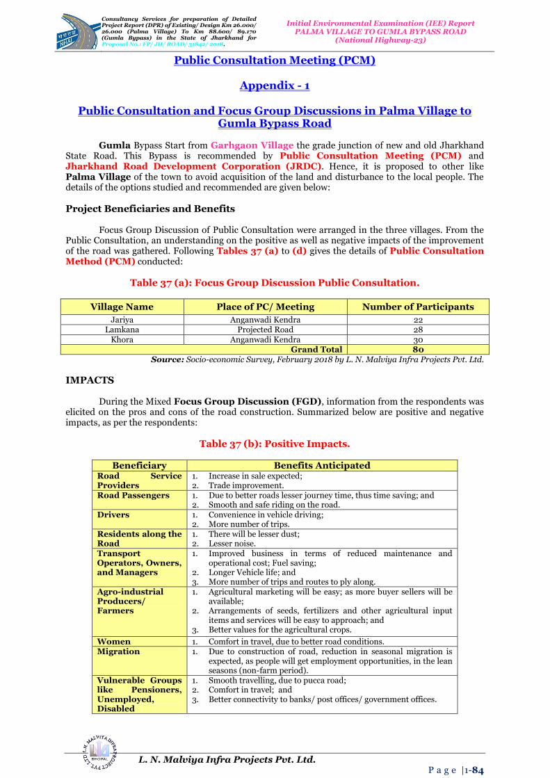
Consultancy Services for preparation of Detailed Project Report (DPR) of Existing/ Design Km 26.000/ 26.000 (Palma Village) To Km 88.600/ 89.170 (Gumla Bypass) in the State 0f Jharkhand for Proposal No.: FP/ JH/ ROAD/ 31842/ 2018.
Initial Environmental Examination (IEE) Report PALMA VILLAGE TO GUMLA BYPASS ROAD
(National Highway-23)
L. N. Malviya Infra Projects Pvt. Ltd. P a g e |1-84
Public Consultation Meeting (PCM)
Appendix - 1
Public Consultation and Focus Group Discussions in Palma Village to Gumla Bypass Road
Gumla Bypass Start from Garhgaon Village the grade junction of new and old Jharkhand
State Road. This Bypass is recommended by Public Consultation Meeting (PCM) and Jharkhand Road Development Corporation (JRDC). Hence, it is proposed to other like Palma Village of the town to avoid acquisition of the land and disturbance to the local people. The details of the options studied and recommended are given below:
Project Beneficiaries and Benefits
Focus Group Discussion of Public Consultation were arranged in the three villages. From the
Public Consultation, an understanding on the positive as well as negative impacts of the improvement of the road was gathered. Following Tables 37 (a) to (d) gives the details of Public Consultation Method (PCM) conducted:
Table 37 (a): Focus Group Discussion Public Consultation.
Village Name Place of PC/ Meeting Number of Participants
Jariya Anganwadi Kendra 22 Lamkana Projected Road 28
Khora Anganwadi Kendra 30 Grand Total 80
Source: Socio-economic Survey, February 2018 by L. N. Malviya Infra Projects Pvt. Ltd.
IMPACTS
During the Mixed Focus Group Discussion (FGD), information from the respondents was
elicited on the pros and cons of the road construction. Summarized below are positive and negative impacts, as per the respondents:
Table 37 (b): Positive Impacts.
Beneficiary Benefits Anticipated
Road Service Providers
1. Increase in sale expected; 2. Trade improvement.
Road Passengers 1. Due to better roads lesser journey time, thus time saving; and 2. Smooth and safe riding on the road.
Drivers 1. Convenience in vehicle driving; 2. More number of trips.
Residents along the Road
1. There will be lesser dust; 2. Lesser noise.
Transport Operators, Owners, and Managers
1. Improved business in terms of reduced maintenance and operational cost; Fuel saving;
2. Longer Vehicle life; and 3. More number of trips and routes to ply along.
Agro-industrial Producers/ Farmers
1. Agricultural marketing will be easy; as more buyer sellers will be available;
2. Arrangements of seeds, fertilizers and other agricultural input items and services will be easy to approach; and
3. Better values for the agricultural crops.
Women 1. Comfort in travel, due to better road conditions. Migration 1. Due to construction of road, reduction in seasonal migration is
expected, as people will get employment opportunities, in the lean seasons (non-farm period).
Vulnerable Groups like Pensioners, Unemployed, Disabled
1. Smooth travelling, due to pucca road; 2. Comfort in travel; and 3. Better connectivity to banks/ post offices/ government offices.

Consultancy Services for preparation of Detailed Project Report (DPR) of Existing/ Design Km 26.000/ 26.000 (Palma Village) To Km 88.600/ 89.170 (Gumla Bypass) in the State 0f Jharkhand for Proposal No.: FP/ JH/ ROAD/ 31842/ 2018.
Initial Environmental Examination (IEE) Report PALMA VILLAGE TO GUMLA BYPASS ROAD
(National Highway-23)
L. N. Malviya Infra Projects Pvt. Ltd. P a g e |1-85
Health Services Providers
1. Easy to reach patients, thus faster delivery of health services; 2. Similarly patients will be able to reach health service providers in
time thereby saving medical attention time. School Children/ Teachers
1. Convenience and easy approach to School and Collages.
Source: Socio-economic Survey, February 2018 by L. N. Malviya Infra Projects Pvt. Ltd.
Table 37 (c): Negative Impacts.
Issues Nature of Problems Anticipated
Pollution (Especially during Construction)
1. More noise and Dust; 2. Water logging, due to flow of excessive water.
Diseases Temporary effect due to: 1. Dust; and 2. Possible water borne (due to water logging, if, it is there).
Road Safety 1. It may lead to more accidents, (as the speed of vehicles on the pucca road will be higher) if proper safety measures are not adopted. However, it could be minimized by constructing speed breakers near populous places;
2. Installing warning boards and safety signs; 3. Construction of railing at desired places.
Migration/ Displacement
1. Road widening, if takes place, shall lead to displacement of people, living along the road.
Agriculture 1. Barring a temporary effect of dust accumulation on the grown crop, no major negative impact on the agriculture and allied sector is anticipated;
2. Road widening, if takes place, shall require possession of agricultural land, which will negatively impact the livelihood of the farmer.
Source: Socio-economic Survey, February 2018 by L. N. Malviya Infra Projects Pvt. Ltd.
Table 37 (d): Public Consultation and Focus Group Discussions in Palma Village to
Gumla Bypass Road.
Village: Jariya
Place/ Road Name: Anganvadi Kendra Date/ Month/ Year: 27/ 02/ 2018
Time: 1 : 50 PM Focus Group Discussions (FGD) Number: 01
Sr. No.
Name Village
1. Smt. Rukamani Das
Place: Anganvadi Kendra
Village: Jariya
2. Smt. Rakhi Benarjee 3. Smt. Mamta Chettrjee 4. Smt. Babita Rani 5. Smt. Krishna Devi Das 6. Smt. Sajni Devi 7. Smt. Surbhi Mukharjee 8. Smt. Gomti Das 9. Smt. Sushma Swaraj
10. Smt. Anika Upadhay
11. Smt. Akshita Das

Consultancy Services for preparation of Detailed Project Report (DPR) of Existing/ Design Km 26.000/ 26.000 (Palma Village) To Km 88.600/ 89.170 (Gumla Bypass) in the State 0f Jharkhand for Proposal No.: FP/ JH/ ROAD/ 31842/ 2018.
Initial Environmental Examination (IEE) Report PALMA VILLAGE TO GUMLA BYPASS ROAD
(National Highway-23)
L. N. Malviya Infra Projects Pvt. Ltd. P a g e |1-86
Village: Lamkana
Place/ Road Name: Projected Road Date/ Month/ Year: 28/ 02/ 2018
Time: 2 : 50 PM Focus Group Discussions (FGD) Number: 02
Sr. No.
Name Village
1. Smt. Kalshi Kumari
Place: Projected Road
Village: Lamkana
2. Smt. Megha Mukharjee 3. Smt. Rajoo Kumari 4. Smt. Devmukhi Das 5. Smt. Harshi Gangwal
6. Smt. Kadimbani
Sukhoje 7. Smt. Hemlata Chettarje 8. Smt. Aruna Erani Devi 9. Smt. Samanti Das Devi
10. Smt. Shobhita Mukhoje 11. Smt. Chander Kanta Jha 12. Smt. Somishtha Das 13. Smt. Hariyali Kukerjee 14. Smt. Kamla Tekerjee
15. Smt. Sakhshi
Mukhopadhay
Village: Khora
Place/ Road Name: Anganwadi Kendra Date/ Month/ Year: 10/ 03/ 2018
Time: 3 : 50 PM Focus Group Discussions (FGD) Number: 03
Sr. No.
Name Village
1. Smt. Shivnshi Das
Place: Anganwadi Kendra
Village: Khora
2. Mr. Kailash Narayan 3. Mr. Ram Prashad Das 4. Mr. Om Prakash Jha 5. Smt. Kusum Benarjee 6. Mr. Dinesh Ganguli 7. Mr. Sharad Pawar 8. Smt. Manisha Makhija
9. Mr. Sarabh Ganguli 10. Smt. Chamali Devi 11. Mr. Aanand Dev 12. Mr. Sachin Tendulkar 13. Smt. Jogeshwari Das 14. Mr. Rustam Ganguli
15. Smt. Jyoti Dolorosa
TeTe
***************************
*********************