Sabah Water Resources Master Plandid.sabah.gov.my/files/documents/Sabah Water... · natural...
75
NATURAL RESOURCES OFFICE SABAH, MALAYSIA WATER RESOURCES MASTER PLAN FINAL REPORT – OVERVIEW April 1994
-
Upload
nguyenduong -
Category
Documents
-
view
225 -
download
3
Transcript of Sabah Water Resources Master Plandid.sabah.gov.my/files/documents/Sabah Water... · natural...

NATURAL RESOURCES OFFICE
SABAH, MALAYSIA
WATER RESOURCES MASTER PLAN
FINAL REPORT – OVERVIEW
April 1994

TABLE OF CONTENTS
PART A: BACKGROUND
1. INTRODUCTION
2. OVERALL REQUIREMENT FOR MASTER PLAN
3. ROLE OF MASTER PLAN
4. HOW THE MASTER PLAN IS ORGANISED
5. TERMS OF REFERENCE
PART B : CURRENT ISSUES
6. QUANTITIES OF SURFACE WATER AVAILABLE
7. SURFACE WATER QUALITY
7.1 Background
7.2 Human Health Issues
7.3 Environmental Factors
8. GROUNDWATER QUANTITY AND QUALITY
9. WATER SUPPLY
10. WASTEWATER DISPOSAL
11. FLOODING
12. URBAN DRAINAGE
13. RURAL DRAINAGE
14. CURRENT LEGISLATION AND ADMINISTRATION ARRANGEMENTS
14.1 Legislation
14.2 Administration
PART C : COMPONENTS OF MASTER PLAN
15. ADMINISTRATION AND LEGISLATION
15.1 A Water Resources Manager
15.2 Functions
15.3 Powers
15.4 Implementation

16. NEW LEGISLATION
17. INTEGRATED CATCHMENT MANAGEMENT
17.1 Overview
17.2 Objectives
17.3 Package Approach to Catchment Management
17.4 Merit Approach to Gazetted Water Catchments
17.5 State Cathcment Management Guidelines
17.6 Integrated Catchment Management Committees
17.7 Legislation for Gazetting Catchments
17.8 Groundwater Management Zones
17.9 Control of Water Catchments
17.10 Water Catchments and Other Protected Areas
17.11 Kampong Water Supply Catchments
17.12 Water Department Proposals for Water Catchments
17.13 Soil Conservation Function
18. WATER RESOURCES MANAGEMENT AND DEVELOPMENT
18.1 General
18.2 Surface Water Management Strategies
18.3 Sharing Flows Between Competing Users
18.4 Groundwater Developments
18.5 Dam Maintenance and Surveillance
18.6 Licensing and Compliance
18.7 Management of Multi-Purpose Developments
19. WATER DEMAND MANAGEMENT
19.1 Objectives
19.2 Strategies
19.3 Security of Supply
20. FLOOD AND FLOODPLAIN MANAGEMENT

20.1 Objective
20.2 Approach and Responsibilities
20.3 Management Measures
21. URBAN AND RURAL DRAINAGE
21.1 Objective
21.2 Approach and Responsibilities
21.3 Management Measures
21.4 Management of Disturbed Areas
22. WASTE MANAGEMENT
22.1 Integrated Planning
22.2 Point Source Effluent Quality
22.3 Solid Wastes
23. WATER QUALITY MANAGEMENT
23.1 Objective
23.2 Approach and Responsibilities
23.3 Regulation and Enforcement
23.4 Water Quality Management Works
24. ENVIRONMENTAL MANAGEMENT
24.1 Objective
24.2 Approach and Responsibilities
24.3 Review of Development Proposals
25. FISHERIES MANAGEMENT
26. RIVER RESERVES
26.1 Purpose
26.2 Approach and Responsibilities
26.3 River Reserves and Forest Reserves
26.4 Riverine Corridors not in River Reserves
26.5 Legislation for River Reserves

27. RIVER BANK AND CHANNEL STABILISATION
27.1 Purpose
27.2 Approach and Responsibilities
28. SAND AND GRAVEL EXTRACTION
28.1 Background
28.2 Future Management of Sand and Gravel Extraction
29. NAVIGATION
30. TOURISM
31. DATA MANAGEMENT
31.1 Database System
31.2 Hydrometeorological Data Collection
31.3 Water Quality Data Collection
31.4 Security of Archive
32. PUBLIC INFORMATION AND EDUCATION
PART D : IMPLEMENTATION FRAMEWORK
33. ADMINISTRATIVE ARRANGEMENTS
34. DESIGNATION OF THE WATER RESOURCES MANAGER
35. STRUCTURE AND EXPERTISE OF THE WATER RESOURCES MANAGEMENT AGENCY
35.1 Structure
35.2 Expertise Required
36. PERFORMANCE INDICATORS
37. REVIEW OF IMPLEMENTATION OF MASTER PLAN
38. NATURAL RESOURCES MANAGEMENT AND CO-ORDINATION
38.1 Ministerial Committee on State Water Resources Management
38.2 A Natural Resources Management Committee
38.3 A Ministry of Natural Resources
39. PRIORITY ACTIVITIES
39.1 Priority Dam Sites for Investigation

39.2 Priorities for Catchment Planning
39.3 Lowland Riparian Catchment Reserves
39.4 Priorities for River Reserves
39.5 Priorities for Hydrometeorological Investigations
39.6 Priorities for Water Quality and Environmental Investigations
39.7 Pilot Catchment Management Plan
39.8 Priorities for Master Plan Implementation
40. ACKNOWLEDGEMENTS
LIST OF FIGURES
1.1 Sabah Locality Map
3.1 Position of Water Resources Master Plan
6.1 The Water Cycle
6.2 Isohyets of Average Annual Rainfall
6.3 Point Values of Average Annual Runoff
8.1 Simplified Draft Hydrogeological Map of Sabah
8.2 Regional Groundwater Assessment Programme in Sabah
17.1 Inter-relationships Between Components of Integrated Catchment
Management
18.1 Denil Fishway
18.2 Vertical Slot Fishway
18.3 Rock Ramp Fishway
18.4 An Example of the Need for Good Well Management
18.5 An Example of a Horizontal Well Arrangement
21.1 "Soft" Engineering Options Available for Flood Mitigation and
Urban Drainage
21.2 Stabilisation of Disturbed Areas
22.1 Erosion Control Measures for a Waste Disposal Site
33.1 Implementation of Water Resources Management Agency

39.1 Priority Dam Sites for Investigation for Development
39.2 Priority Catchments for Catchment Management Plans
39.3 Priority Lowland Riparian Catchment Reserves
LIST OF PHOTOGRAPHS
7.1 Confluence of Two Streams
7.2 Sediment Plume of the Sg. Papar
7.3 Areas Disturbed as a Result of Road Construction
7.4 Plantation Established to River Bank
7.5 Rocks in Stream Stained by Water from Mining Area Upstream
7.6 Floating Rubbish in an Urban Drain in Kota Kinabalu
7.7 Privy Built over a Stream
7.8 Swimming, Bathing and Washing in a Polluted Stream
9.1 Padi Irrigation Areas
9.2 Intensive Vegetable Growing Areas
9.3 Tenom Pangi Power Station During High Flow Period in Sg. Padas
9.4 Tenom Pangi Power Station During Low Flow Period in Sg. Padas
9.5 River Navigation: Loading a Barge with Logs
11.1 Flood Diversion Channel at Tawau
17.1 Groundwater Bores and Well Need Protecting to Prevent Contamination
18.1 A Weir that Provides Relatively Good Fish Passage
18.2 Conflicting Water Uses
21.1 A Good Example of Slope Stabilisation
21.2 A Good Buffer Strip Between Habitation and River
22.1 Urban Sewage Treatment
22.2 Treatment of Industrial Wastewater
25.1 Aquaculture Operation in Mangrove Swamp near Sandakan

A. BACKGROUND
1. INTRODUCTION
Sabah's (Figure 1.1) economic development and population growth are putting
increasing pressure on the state's water resources. Increasing population means
increasing demand for water for drinking, for washing, for laundry, for recreational
pastimes like swimming and for growing crops for food. Economic development
means that more water is needed for purposes such as industrial processes.
At the same time, economic development and population growth are causing
changes in land use and the environment. Forest areas are being logged for timber,
or are being cleared to make way for oil palm estates and other agriculture. Towns
and cities are expanding, so rural land is also being converted to streets, houses,
offices and factories. These land use changes are affecting the quantities of water
available and the quality of water.
The Government of Sabah recognises that action is needed on these problems. It
also recognises that the water resources of Sabah need to be managed in a
sustainable way, to ensure that enough water is available to meet the future needs of
the state as it develops and grows, and to ensure that the environment is looked
after.
A Water Resources Master Plan for Sabah has been developed to help Government
meet these needs. The Master Plan integrates the management of water resources,
including water quantity, water quality, the aquatic environment and land use. The
pattern of growth and development in Sabah is being shaped by Vision 2020 and
related national policies, so this Master Plan has been developed to suit the
objectives of Vision 2020.
2. OVERALL REQUIREMENT FOR MASTER PLAN
The Sabah Water Resources Master Plan provides for effective water resources
planning, development and management to sustain economic, social and
environmental uses. It enables indentification of opportunities for development, and
constraints on development. Its adoption will both require and facilitate the more
efficient co-ordination of all water resources related agencies if the objective of the
Plan is to be met.
3. ROLE OF MASTER PLAN

The role of the Master Plan is to provide a framework for the development of detailed
plans for specific purposes and areas, including the implementation of water
resources development projects, as shown in Figure 3.1. Providing this framework as
a first step in the water resources management process offers advantages including:
• Planning, investigation and management at lower levels shown in Figure 3.1
can be undertaken on a consistent basis, within a known set of parameters.
• There is maximum flexibility in planning, management and project
implementation. Where a priority need is identified at, say, the area or local
level shown in Figure 3.1, a plan or project can be developed immediately.
Because the overall framework is known, these plans or projects can also be
made to be consistent with higher level plans to be prepared at a later date.
4. HOW THE MASTER PLAN IS ORGANISED
The Master Plan consists of four documents:
• Overview of the Water Resources Master Plan for Sabah (this document).
• Summary Report of the Water Resources Master Plan for Sabah.
• Main Report and Appendices in two volumes.
• Resources package consisting of loose leaf binders for easy reference and
updating.
Part A of this document summarises the backgrond to the Master Plan. Part B of the
document explains the current issues affecting water resources. This is followed in
Part C by recommendations for strategies and procedures for water resources
management and development, based on existing and future needs. Part D
describes the implementation of the recommendations in Part C, and also gives
recommendations for administrative arrangements in Government.
More details of the current issues affecting water resources, and the
recommendations for strategies, procedures and administrative arrangements for
water resources management can be found in the Summary Report and the Main
Report of the Master Plan.
5. TERMS OF REFERENCE
The 26 Terms of Reference specified a broad range of issues to be examined. Issues
in the Master Plan include:

• Quantity and quality of surface and groundwater resources available;
• Water supply, including urban, irrigation and hydro-power supplies;
• Flooding, urban and rural drainage;
• Wastewater disposal and dewatering;
• Current and future water use requirements;
• Key catchments;
• The institutional, legislation and policy framework; and
• Master Plan implementation, resourcing and performance indicators.

B. CURRENT ISSUES
6. QUANTITIES OF SURFACE WATER AVAILABLE
The overall process governing the availability of water is the water cycle, illustrated in
Figure 6.1. Water falls to the earth as rain, where it either infiltrates into the ground or
it runs off over the surface to streams or other water bodies, from where it evaporates
backto the atmosphere.The evaporating water forms clouds, from which the rain falls,
completing the cycle.
Water infiltrating into the ground may be taken up by plants and returned to the
atmosphere by the process of transpiration, it may flow slowly through the subsoils
and rock to a surface water body, or it may enter a groundwater storage, known as
an aquifer. It may stay in the aquifer for a very long time (perhaps over 10,000 years),
or maybe only a short while (say, a few months).
In general, Sabah has plenty of surface water available, but enough water is not
always available at the right time (and sometimes there is too much) or in the right
place, nor is the quality always good. Land use changes can alter the pattern of
streamflows (known as the streamflow regime). Clearing of trees and urban
development generally make floods more flashy and low flows lower. Some streams
that used to flow all year round are now drying up during dry periods, leading to water
supply shortages in certain areas.
Figure 6.2 shows broadly how rainfalls are distributed across the state. In parts of the
state there are very few rainfall measuring stations, mainly in the eastern interior, so
the map is not very reliable in these areas. This needs to be remembered when using
the map.
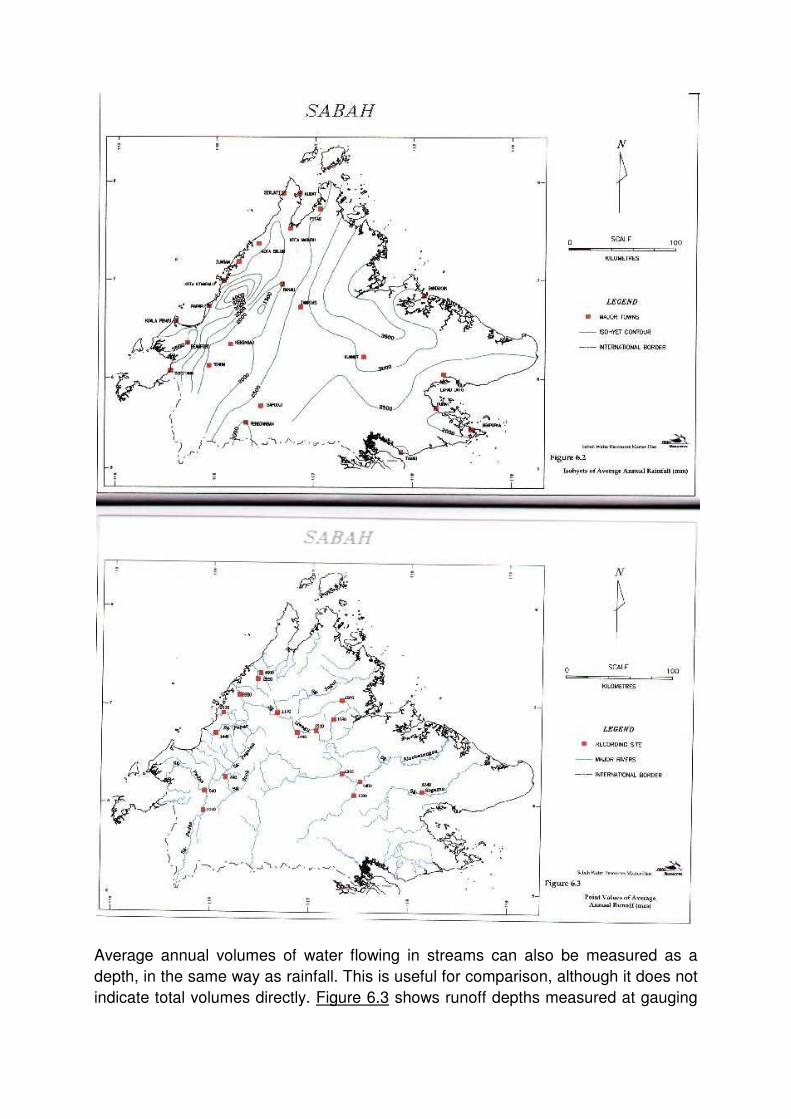
Average annual volumes of water flowing in streams can also be measured as a
depth, in the same way as rainfall. This is useful for comparison, although it does not
indicate total volumes directly. Figure 6.3 shows runoff depths measured at gauging

stations for which sufficient data were available. There are not enough gauging
stations to permit a map to be drawn in the same way as for rainfall.
7. SURFACE WATER QUALITY
7.1 BACKGROUND
As stated in Section 1, water quality, the aquatic environment, water quantity and
land use are all inter-related. Sediment from soil erosion, nutrients from fertilisers and
residues of agricultural chemicals are washed off the land surface and into streams
by water.
When washed from the land surface these materials are often referred to as diffuse
source pollutants. Where pollutants come from places like sewage treatment plants
or factory waste pipes, these are called point source pollutants.
In rural areas in Sabah, sediment is the main diffuse source pollutant affecting rivers
(Plates 7.1 and 7.2). Land that has little or no vegetation is the main source of
sediment. This applies to areas that have been extensively logged or cleared for

plantations, and also to disturbed areas such as construction sites, quarries and
garbage dumps (Plates 7.3 and 7.4). Logged areas will often recover in time, if the
forest is allowed to regrow, but plantations, road, quarries and garbage dumps may
be a source of sediment indefinitely.
Other important pollutants from rural areas include nutrients, chemical residues,
bacteria and viruses, heavy metals (Plate 7.5) and organic loads.

In urban areas the relative importance of pollutants is different. Urban drains and
rivers receive pollutants washed off streets, open spaces, and private properties.
Pollutants from streets and roads, and commercial and industrial areas, include litter
(Plate 7.6), dust and dirt, oil and grease, particles of rubber compounds from tyres,
particles of metal, glass and plastic from vehicles, and lead.
Pollutants washed off private properties can vary widely, depending on the land use.
Residential areas and open spaces usually contribute mainly sediment and nutrients.
Urban drains also act as secondary sewers, carrying sewage overflows in wet
weather, industrial discharges and septic tank seepage and overflows.
Poor quality water causes health problems and environmental damage in waterways
which leads to economic losses through:
• Increased costs of health services, disease control and loss of production due
to illness;
• Increased costs of water treatment;
• maintenance costs at hydro-power stations;
• Damage to fisheries and aquaculture; and
• Siltation of estuaries, shipping channels and coastal marine ecosystems (Plate
7.2).
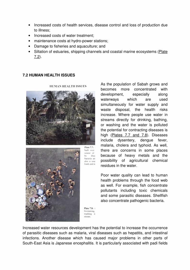
7.2 HUMAN HEALTH ISSUES
As the population of Sabah grows and
becomes more concentrated with
development, especially along
waterways which are used
simultaneously for water supply and
waste disposal, the health risks
increase. Where people use water in
streams directly for drinking, bathing,
or washing and the water is polluted
the potential for contracting diseases is
high (Plates 7.7 and 7.8). Diseases
include dysentery, dengue fever,
malaria, cholera and typhoid. As well,
there are concerns in some places
because of heavy metals and the
possibility of agricultural chemical
residues in the water.
Poor water quality can lead to human
health problems through the food web
as well. For example, fish concentrate
pollutants including toxic chemicals
and some parasitic diseases. Shellfish
also concentrate pathogenic bacteria.
Increased water resources development has the potential to increase the occurrence
of parasitic diseases such as malaria, viral diseases such as hepatitis, and intestinal
infections. Another disease which has caused major problems in other parts of
South-East Asia is Japanese encephalitis. It is particularly associated with padi fields

and its increased incidence is attributed to the switch from dry-land to irrigated rice
growing.
7.3 ENVIRONMENTAL FACTORS
Areas in Sabah that are of high environmental value or are sensitive include:
• Freshwater and estuarine wetlands;
• Conservation forest reserves, wildlife reserve and Sabah Parks;
• Mangrove areas used for fish and prawn aquaculture;
• Rivers used for eco-tourism and nature conservations;
• Marine aquaculture facilities and artificial reefs; and
• Areas underlain by ultrabasic rocks (especially erodible soils).
Some nutrients and some sediment are needed by the aquatic environment to
support life. However, too much nutrient may lead to algal blooms and encourage
unwanted water weed growth, which may destroy the local environmental. Chemical
residues can kill most aquatic life, if concentrations are great enough.
The aquatic environment is also affected by changes in streamflow regime brought
about by land use changes and by the construction of flood mitigation works, dams
and weirs. River channel works transport pollutants more rapidly and with little
attenuation, worsening the downstream effects of pollutants. Increased salt water
intrusion can also result from construction of channel works.
8. GROUNDWATER QUANTITY AND QUALITY
The size and capacity of groundwater systems in Sabah are not very well known but
investigation programmes are in progress to better define them. The Geological
Survey of Malaysia, Sabah Operation, has prepared a draft map which categorises
the groundwater resources of Sabah. A simplified version of this map is presented in
Figure 8.1, which shows the resources summarised as:

• Unconsolidated deposits: beach deposits, alluvial deposits, and coral
deposits;
• Sedimentary rocks (regional groundwater significance);
• Sedimentary rocks (local groundwater significance); and
• Other rocks (no groundwater significance), including igneous rocks.
It is expected that by 1995 the most important beach and alluvial resources will be
investigated and the extent, quantity, quality and any limitations of these resources
will be identified. Current investigation areas are shown in Figure 8.2. Generally good
quality water has been found at each place investigated so far, but the quantities
available have not been finally estimated yet.

Other areas of significance which are likely to contain substantial resources, and
which may be investigated under future five year assessment programmes, include:
• Pitas, Kota Belud, Papar and Kinarut on the west coast;
• Tenom, Keningau and Sook in the interior; and
• the Kinabatangan Valley in the east.
Generally the areas of greatest groundwater potential are on the west coast.
9. WATER SUPPLY
Water is supplied by a number of authorities for various purposes. These are:
• Town water supply; there are thirty schemes operated by the Water
Department that are estimated to serve over 900,000 people.
• Rural water supply through gravity feed schemes and wells provided by the
Department of Medical Services and Health, and estimated to serve almost
400,000 people.
• Drought relief water supply in rural areas funded by the Ministry of Social
Services.
• Industrial and mine water supply where there is no water supply system, or
the water supply system is inadequate, provided by the operator.

• Irrigation water supply provided by DID for padi and vegetable growing (Plates
9.1 and 9.2).
• Hydro-power stations; direct diversion from streams by the Sabah Electricity
Board (SEB); Plates 9.3 and 9.4.

Most water supply relies on surface water from run-of-river schemes, but
groundwater is used in nine town water supply schemes, in wells for rural water
supply schemes, and by industries. The only water supply schemes with storage
dams are at Semporna, Lahad Datu and Kudat. In addition, a dam is planned to be
constructed on the Sg. Babagon for water supply to Kota Kinabalu. The facilities for
supply of bulk water to Kota Kinabalu, Sandakan and Tawau have recently been
privatised, while the bulk supply system for Labuan has been privatised for several
years.
Reliability of supply is a key issue, with water supply shortages experienced in some
places, mainly during the dry season. This applies to urban water supply, rural water
supply and industrial water supply.
One of the aims of privatisation is to improve the security of urban water supply, by
enabling the level of investment in supply schemes to be increased over that which

government could provide. However, as inadequacies in the distribution systems are
a significant factor contributing to unreliability of supplies, privatisation and expansion
of capacity of bulk suplies are unlikely to completely resolve this problem.
Water quality at intakes is also an issue, mainly for urban water supply, with most of
the streams that provide the sources of supply having high sediment loads and
bacteria counts. Floating debris is a problem at some water intakes, such as at
Tenom Pangi Power Station, because it blocks them up. Ranau is an example of a
place with water quality problems because of heavy metals and chemical residues.
Growth in demands in sectors such as urban water supply and hydro-power
generation is expected to be high in the future, but low growth is expected in sectors
such as irrigation.
Some of the larger rivers in Sabah are important navigable waterways, not only for
general community traffic but also for the transport of logs and other produce (Plate
9.5). The main physical constraints for navigation are low river flows during dry
periods and sedimentation of river channels and river mouths.

10. WASTEWATER DISPOSAL
Wastewater discharged to waterways and water bodies include sewage, mill and
industrial effluents and intensive animal husbandry effluents.
Pollutants contributed by these point sources include suspended solids, organic
loads, nutrients, bacteria and toxic substances used in, or as by producst of, various
industrial processes. Uncontrolled dumping of wastes from houses located near
streams and septic tank effluents cause the greatest pollution problems. Septic tank
effluents have similar quality to primary treated sewage, so the impacts of these
effluents on small waterways, where they are often discharged, is severe. Central
sewage treatment plants and package plants generally provide the greatest
improvement in effluent quality.
The Ministry of Local Government and Housing is now examining the (Federal)
Sewerage Act, 1993, to see if the Sabah State Government should adopt it. If it is
adopted then all sewerage works will be privatised. Limited funds and expertise are
problems in this industry and privatisation could be expected to provide a way of
overcoming these.
The main mills and industries of concern in Sabah, in relation to water quality of
effluents and receiving waters, are palm oil, rubber (latex), pulp and paper, cocoa,
timber and food processing. Most of these have treatment systems for reducing
concentrations and loads of pollutants in final effluents to waterways. Activities such
as oil palm and food processing have relatively large volumes of liquid wastes, while
others such as pulp and paper manufacture may recycle their wastes on site.
Solid wastes from palm oil mills are generally sold to farmers as fertiliser, while some
of the liquid wastes may be used on gardens near the effluent discharge point.
However, most of the effluent is discharged to surface drainage. The operation and
occupation of palm oil mill and rubber factory premises are licensed by the
Department of Environment (DoE) and the quality of final treated effluents must
conform to the conditions attached to this licence.
Liquid wastes are also a problem for all animal industries (e.g. piggeries, abattoirs,
etc). These wastes typically contain high biological oxygen demand (BOD), bacteria,
viruses, ammonia, nutrients, turbidity, organic matter, odour and colour, so sites for
animal industries need tobe chosen carefully. In some cases inappropriately sited
operations pollute long sections of rivers and estuaries and people are recommended
against eating shellfish harvested from local marine waters. Sometimes, operations
are located upstream of urban water supply intakes, with potential adverse impacts
on human health. An example is a piggery located upstream of the water supply
intake for Kota Kinabalu on the Sg. Tuaran at Telibong.

Solid wastes from some operations, such as poultry, goats, and sheep, are packaged
and used as fertilisers. However, wastes from the majority of operations (e.g.
piggeries) must be treated and released to waterways. Disposal of piggery waste,
both solid and liquid, is a major intensive animal industry waste disposal problem in
Sabah.
New operations are required to be licensed with local authorities. Licence conditions
stipulate minimum waste treatment and disposal conditions. There are new proposals
for zoning provisions to prevent animal industries being established in sensitive areas
such as near urban residential development. The Veterinary Department occasionally
requests that an inappropriately located industry be relocated, or that the effluent
discharge point be moved.
There are generally no requirements for animal industries to self-monitor the quality
of their effluents. Instead, the DoE and the Veterinary Department make occasional
spot checks and investigations to assess compliance with licence conditions.
11. FLOODING
Flooding is a regular occurrence in Sabah and affects virtually every district and
municipality to some extent. The severity of flooding varies from year to year, and
also from river basin to river basin. Durations of flooding vary from up to one month in
the lower reaches of the Sg. Kinabatangan to less than one hour as a result of
overflow of local urban drains. Warning times range from days, as on the lower Sg.
Kinabatangan, to perhaps only a few minutes in a flash flood in an urban area.
Floods cause community disruption and economic losses, and also increase health
risks. Floods in urban areas, particularly where there is little or no warning, have the
potential to cause far more damage than main stream flooding where warning times
are greater. Even the overflow of local street drainage, which may do no more than
disrupt traffic for an hour or so, has a cost penalty.
Flood relief is provided through the Ministry of Social Services when people are
forced from their homes. Flood mitigation works have been, or are being, built (Plate
11.1) and flood warning systems have been installed on some streams to help
reduce the economic losses from floods.

12. URBAN DRAINAGE
Urbanisation increases flood volumes and decreases response times, due to a
combination of an increase in impervious areas and drainage works. Urban drains in
Sabah are mainly open or covered channels, and are either lined or unlined
depending on location and age. Drainage systems such as these are a primary factor
in shortening response times.
There are no facilities installed in urban drains to manage stormwater quality. The
reasons given for not installing these facilities include the high costs of construction
and maintenance, and that they may encourage greater littering and garbage
disposal to drains.
13. RURAL DRAINAGE
Drainage schemes in rural areas generally accompany irrigation projects. They are
implemented to both remove waterlogging as a constraint on agriculture and to assist
the removal of excess irrigation water applied during the dry season. In some cases,
such as the proposed Langkawit Drainage Scheme, salinity reduction is also given as
an objective.
Channels are unlined and, where appropriate, gates are provided at the outlets to
prevent the entry of flood water from the river or salt water at high tide. Where tide
gates are constructed then there may be adverse environmental effects due to the
resultant change in the fresh water/salt water balance. Other potential problems
concern acid sulphate soils and peat soils. Rural drainage can also adversely affect
the recharge of groundwater.
14. CURRENT LEGISLATION AND ADMINISTRATION ARRANGEMENTS
14.1 LEGISLATION
Existing State legislation covers the provision of water services, land use and forest
management, as well as development planning. It does not cover the management of
water resources. A number of Federal Acts and State Enactments and Ordinances
have implications for water resources management. The most important of these
cover:
• Environmental protection and pollution of water;
• Control of land use and the implications for water resources;
• Control of forest management and the implications for water resources; and
• Control of development and the implications for water resources.
Several State laws allow land to be set aside for the protection of areas of land in
their natural state or to prevent encroachment of development, to protect native
fauna, parks, forest reserves, areas for a public purpose or specifically water supply
areas.
Legislation does not cover:
• Control of surface water use;
• Control of groundwater use;
• Control and management of water pollution from sources other than those
covered in the Environmental Quality Act or from urban sources under the
control of local authorities;
• Catchment management and powers to control land not within forest reserves
for water protection purposes; and
• Aquatic habitat and instream protection, including the protection of fish
habitat.
Legislation recognises the State’s control of water resources, but only in incidental
ways. Water resources are not defined in legislation in a way that would usefully
permit the Government to control and mange water comprehensively.

Water-related functions are distributed by legislation among various State agencies.
Water quality protection, however, is exercised by a combination of Federal and local
government authorities. The absence of a strong State role, and the Federal focus on
only some point sources of pollution, leaves gaps in water quality protection which
need to be filled. The gaps include non-point source pollution and the cumulative
effects of small point sources of pollution.
There is no legislative requirement that Government activities recognise water
resources or that decisions be co-ordinated, whether between State agencies or
between State and local government spheres.
14.2 ADMINISTRATION
Administration follows the provisions of legislation. The Federal Government is most
active in environmental protection (Department of Environmental), health and rural
water supply funding (Department of Medical Services and Health) and geological
investigation (Geological Survey of Malaysia). SEB has an interest in hydro-power
generation and the possible construction of large dams.
State agencies cover urban water supply, sewerage and irrigation. A lack of
coordination has been identified among these agencies, leading to inappropriate
project development decisions in some cases. There is also a lack of technical
expertise in some important fields.
For the protection of catchment areas, the Forestry Department has the greatest
range of powers and resources at its disposal. However, the Water Department has a
specific need for protection of water sources but does not have clear mechanisms for
protection, or the resources, to devote to the task at present; not is it clear that the
Water Department wishes to control such areas itself. DID undertakes some activities
allied to river protection, flood mitigation and water resources data collection.

C. COMPONENTS OF MASTER PLAN
15. ADMINISTRATION AND LEGISLATION
15.1 A WATER RESOURCES MANAGER
The establishment of a Water Resources Manager is essential for achieving the
objectives of the Government in providing sustainable management and use of water
resources for the the future of Sabah.
15.2 FUNCTIONS
The Water Resources Manager's functions are to:
• Ensure that water is of acceptable quantity and quality for all water interests;
• Ensure optimum benefits from the use of water by all users;
• Resolve conflict between water users through a formal water allocation
system;
• Protect and manage the quality of water resources in conjunction with other
water quality protection agencies, including identifying the actual and potential
beneficial uses and environmental significance of rivers, and relating existing
water quality to relevant water quality criteria;
• Make recommendations to the Government and develop policies on ways to
improve water quality and the availability of water, and on ways to encourage
the conservation of water;
• Participate in development of, and implement, guidelines for catchment and
aquifer management, floodplain management, water quality management,
riverine corridor protection and river bank and channel stabilisation (including
sand and gravel extraction);
• Develop catchment and aquifer management plans for the protection of water
resources;
• Develop floodplain management plans to minimise the adverse effects of
flooding and provide flood protection where feasible;
• Develop and implement licence conditions to ensure the sustainable use of
water resources, including a suitable fee structure;
• Review guidelines, policies and plans as required;
• Establish protected water catchments, where required;
• Protect river channels, including undertaking works for that purpose;
• Co-ordinate administrative action for water resources management;
• Co-ordinate water resources planning and catchment management planning;
Establish and maintain databases on water resources; and
• Ensure public accountability through regular reporting to the Government on
the use and condition of water resources

15.3 POWERS
To perform these functions, the Water Resources Manager requires power to :
• Approve water uses, and the ability to impose conditions as to when, in that
volume, and under what conditions a water user may divert, impound or
extract water from a water body;
• Approve the return of waters to water bodies from drains (urban and rural),
canals, etc;
• Prevent pollution of water bodies;
• Establish reserves in riverine corridors so that activities within them are
subject to guidelines which the Water Resources Manager may develop and
implement (although this may be achieved by use of the Land Ordinance);
• Establish protected water catchment areas (although this may be achieved by
use of the Land Ordinance and Forest Enactment);
• Control activities within protected water catchments and river reserves, and a
delegation of powers mechanism which allows a nominated agency to
implement the power in any particular catchment;
• Approve activities in or alongside surface water bodies and waterways,
including in-stream, river beds and banks;
• Approve structure on floodplains of a scale capable of significantly impacting
on flood flows;
• Require water resources data to be provided by government and non-
government bodies;
• Impose charges for water services and water rights, including the right to use
water;
• Require any work or activity to be modified to comply with an approval of the
Water Resources Manager, at the cost of the owner of the work, irrespective
of who undertakes the works; and
• Establish catchment management committees and provide for their
responsibilities to be formalised.
15.4 IMPLEMENTATION
It is recommended that the implementation of the role of the Water Resources
Manager be based on the following principles:
• The agency for the Water Resources Manager should be developed over a
period of time, as resources permit and requirements demand.
• As far as possible the full range of functions should be covered from the
beginning.

• The co-ordination role of the Water Resources Manager with other areas of
government should be given primary consideration.
16. NEW LEGISLATION
It is proposed that a new and separate Water Resources Management Enactment be
developed:
To provide for the continuing sustainability of water resources and the optimisation of
beneficial uses of water and water resources values to the community and the State
of Sabah.
There should be a definition in the legislation of the extent of the water resources
over which the Government of Sabah has control. The definition should include:
• Intermittently flowing streams as well as perennial streams;
• Watercourses whether navigable or not;
• Groundwater resources;
• Water in lakes, wetlands, lagoons and natural ponds; and
• Water impounded behind a dam or other structure on a watercourse, while it
remains impounded.
17. INTEGRATED CATCHMENT MANAGEMENT
17.1 OVERVIEW
The term "Integrated Catchment Management" or "ICM" refers to an approach which
co-ordinates all the activities within a defined catchment and attempts to identify the
effects of various activities on natural resources. In its broadest sense, ICM covers all
natural resources, including vegetation, fauna, water and soils, and development
activities, but in this report the focus is on water resources.
The main issue for water is the impact of catchment land use activities on its quality.
The scond concern is the effect of catchment land use activities on the quantity of
water. The relationship between ICM and water resources management is illustrated
diagrammatically in Figure 17.1.

The term "catchment" means the whole of the land and water surface which
contributes to the discharge at a particular point on a stream or river, or contributes
water to an aquifer. The whole of the land area of Sabah is located in one catchment
or another.
A basic principle of Integrated Catchment Management, and all the components
shown in Figure 17.1, is that every situation should be judged on its merits, subject to
the provisions of management guidelines and plans.
Catchment management tools include:
• Gazettal of water catchments;
• Establishment of riverine reserves;
• Protected river corridors;
• Zoning to control activities;
• Environmental impact assessments, development applications;
• Licensing activities; and

• Education to influence behaviour in catchments.
17.2 OBJECTIVES
Relative to water resources, the objectives of catchment management for Sabah are:
• Prevention of land and soil degradation;
• Prevention of degradation of water quality, with improvement where
appropriate and possible;
• Mitigation of adverse runoff impacts from urbanisation, industries and
agriculture, and other developments;
• Protection of aquatic habitats and ecological values; and
• Protection of fish and other instream life.
17.3 PACKAGE APPROACH TO CATCHMENT MANAGEMENT
The concept behind the gazettal of water catchments is to provide for total protection
of an area so gazetted by totally excluding human activity. This has tended to imply
that if there are any residents in the area, they will be removed and compensated.
This is neither tenable nor necessary in all cases, and each situation needs to be
judged on its merits.
Therefore an alternative, merit based approach is recommended and this is:
• Gazette a protected water catchment area for a dam catchment or sensitive
area only, but permit existing settlement and activity to continue in the
gazzetted area while preventing the most obvious and damaging activities for
water resources.
• Gazette river reserves for the river and its main tributaries, in sensitive areas
outside the water catchment. A river reserve would allow control of activity
within that area. River reserves are discussed further in Section 26.
• Prepare a Integrated Catchment Management Plan, which identifies
undesirable activities and sensitive locations, and uses a planning approach to
control future development and manage ongoing activities.
This approach of using a package of measures for catchment management is more
flexible than the total exclusion approach; it will minimise community disruption and
provide for maximum economic benefits, so it is likely to be more acceptable. The
planning element of the package approach foreshadows a more comprehensive state
planning function in Sabah in the future.

17.4 MERIT APPROACH TO GAZETTED WATER CATCHMENTS
Complete protection of catchments would give the greatest benefit for water.
However, in accordance with the merit approach, a reasonable balance should be
struck between protection of water resources and freedom for human activity already
occuring in the catchment. In an area to be gazetted it is therefore recommended that
existing settlement might be permitted to remain subject to:
• A foreshore buffer zone where no acitivity or dwelling is allowed;
• Strict guidelines for the maintenance and extension of existing structures;
• Imposition of waste disposal requirements for solid and liquid wastes;
• Ceasing undesirable forms of agriculture;
• Allowing other forms og agriculture (such as growing of some trees) to
continue but not increase, subject to restrictions on biocide and fertiliser types
and use; and
• Allowing only "clean" commercial or industrial activity to continue.
Implications of this approach are, firstly, that residents may be permitted to stay with
possibly some subsistence agriculture or strictly prescribed types of commercial or
industrial activity. Secondly, the incentive to enter the catchment prior to the event
and establish a "plantation" is reduced, as this would not provide valuable land, even
if some land entitlement were granted. Thirdly, more comprehensive management is
required. Change of ownership of titled land could also be permitted, subject to the
restrictions on land use listed above.
17.5 STATE CATCHMENT MANAGEMENT GUIDELINES
Catchment management guidelines should be developed for the State as a whole,
through the Ministerial Committee on State Water Resources Management. These
guidelines would cover:
• Principles and general procedures for development of ICM Plans;
• Appropriate and inappropriate features of locations for development in
relation to water bodies, including rivers, wetlands and groundwater aquifers;
• Types of development which should not be located close to water bodies;
• Conditions for protection of water resources, which should apply to
development approvals; and
• Guidance for those wishing to establish new enterprises or extend existing
activities.

Guidelines should be designed to complement and reinforce existing guidelines in
the EIA process. The guidelines would be available to District Officers and local
authorities. The guidelines should also recognise the cumulative effects of many
small developments.
17.6 INTEGRATED CATCHMENT MANAGEMENT COMMITTEES
An important part of ICM is the establishment of "ICM Committees", which should
bring together all the government agencies with responsibilities affecting water
resources. These committees should also include District Officers and/or
representatives of local authorities. Establishment of an ICM Committee could
commence relatively informally and could be co-ordinated by the Water Resources
Manager at local level in conjunction with the District Officer or local authorities.
The primary role of ICM Committees is to co-ordinate the development and
implementation of Integrated Catchment Management Plans. The main activities of
ICM Committees would be to:
• Identify catchment problems with an emphasis on continued sustainability of
water resources and other natural resources;
• Approach the relevant agency with proposals for investigations where agreed;
• Draw up proposals for government funding, or to assist the relevant agency to
do so;
• Identify the activities to be undertaken by all agencies and parties, and to
ensure co-ordination of actions;
• Assist in implementation of solutions where identified and where funding has
been agreed.
17.7 LEGISLATION FOR GAZETTING CATCHMENTS
There are adequate mechanisms for gazetting catchments in existing legislation, and
for nominating managing agencies. However, powers to manage water catchments
by the managing agency are insufficient.
It is therefore recommended that water catchment control powers be provided in the
proposed Water Resources Management Enactment, with responsibility to protect
the water resources in the catchment clearly attributed to the managing agency. For
completeness, and to streamline the gazettal process, it is also recommended that
water catchment gazettal powers should be included in the proposed enactment,
together with a choice of agency and possibility of transfer of responsibility.

17.8 GROUNDWATER MANAGEMENT ZONES
The Government should ensure that its legislation enables groundwater management
zones or protection zones to be established. In instances where groundwater
systems are a potentially useful resource and recharge areas need proper protection
then gazettal of groundwater areas would be appropriate, because groundwater
contamination from surface activities and pollution can be difficult or impossible to
reverse (Plate 17.1). The boundaries of these systems are often very different to
surface water catchments, with "inter catchment" groundwater flow possible.
17.9 CONTROL OF WATER CATCHMENTS
A number of agencies may manage water catchments. The preferred choices are:

• For forest reserves which have a water protection function, the Forestry
Department should retain control. However, if the Forestry Department
proposes a change of classification then it should be referred to the Water
Resouces Manager (and the Water Department where appropriate). The
Water Resources Manager should also have right of entry to all forest
reserves for water resouces management purposes.
• For water catchments (not in forest reserves) protecting dams or sources
exclusively for urban water suppy, the Water Department should exercise
control.
• For other purposes (and not in forest reserves) the Water Resources Manager
should exercise control. Other purposes could include hydro-power, irrigation,
wetland protection, riverine areas, estuarine or coastal areas subject to
disturbance or degradation, and catchments of multi-purpose water resources
developments.
17.10 WATER CATCHMENTS AND OTHER PROTECTED AREAS
It is not necessary for a water catchment reserve to overlap with either a Sabah Park
or any forest reserve in a protected class. These areas are already well protected by
legislation and management, and water resources should not be threatened unless
illegal activities occur. It is therefore recommended that for water catchment
proposals:
• Where a Commercial Forest Reserve Class II, or a Forest Reserve Class V
(Mangrove) occurs within a proposed protected catchment area, it should be
reclassified to Protection Forest Reserve Class I;
• Where a Forest Reserve Class I or other protected class, or a Sabah Park,
occurs no furhter action is required.
17.11 KAMPONG WATER SUPPLY CATCHMENTS
Protection of kampung water supply catchments is important for maintenance of both
water quality and quantity. It is recommended that the catchments of new and
existing gravity feed schemes be given protection by gazettal of the catchments in
the same manner as for other purposes, unless already protected.

17.12 WATER DEPARTMENT PROPOSALS FOR WATER CATCHMENTS
The Water Department has made formal proposal for nine water catchments to be
gazetted under the Land Ordinance. It is recommended that all these proposals be
reviewed in the light of the recommendation of the package approach to catchment
management, and the background to the recommendation.
The proposals should also be reviewed in the light of the prioritisation of catchments
for preparation of ICM Plans and prioritisation of dam sites for investigation for
development, discussed in Section 39.
17.13 SOIL CONSERVATION FUNCTION
It is recommended that the Government consider ways in which an active soil
conservation function can be developed, and a State soils policy be applied to
sensitive lands throughout Sabah.
18. WATER RESOURCES MANAGEMENT AND DEVELOPMENT
18.1 GENERAL
To help meet the future needs of Sabah for water, increased development of the
water resources of the state will be necessary. Because it is becoming more difficult
to satisfy demands for water reliably or economically with run-of-river schemes,
development of both surface water and groundwater storages is becoming
increasingly necessary.
While storages are a means of increasing the reliability and usable yield of a water
source, there is a need to ensure that:
• They are managed in a sustainable and equitable manner;
• Environmental impacts are recognised and adverse impacts minimised;
• They gain community acceptance; and
• They do not impose an unacceptable health or safety hazard on the
community.
The ultimate responsibility for ensuring that these criteria are satisfied will rest with
the Water Resources Manager. In the case of a single purpose development, this
responsibility may be quite easy to fulfil. However, in the case of a multi-purpose
storage, the issues are likely to be more complex.

18.2 SURFACE WATER MANAGEMENT STRATEGIES
There is a range of impacts that a surface water resources development may have,
depending on the type of the development (e.g. run-of-river diversion, dam, off-
stream storage, rain water tank) and its location.
Impacts of these developments include changes to the streamflow regime,
interruption of sediment transport and disruption of fish migration, with consequent
impacts on stream morphology and the aquatic environment. There may also be
impacts on human health. In general the impacts of dams, and especially large dams
low in the catchment, will be the greatest while the impacts of run-of-river schemes
and small scale developments will be least.
It is recommended that management strategies, and their costs, be considered
during the planning, construction and operation of a development to ensure that
these impacts are minimised while ensuring that water supply needs are satisfied.
Strategies include:
• Releases for water supplies;
• Flood air-space operations;
• Water use accounting;
• Instream flow needs;
• Fish migration (Plate 18.1, and Figures 18.1, 18.2 and 18.3);
• Sediment management;
• Disease management; and
• Reservoir eutrophication;


18.3 SHARING FLOWS BETWEEN COMPETING USERS
Satisfying the demands of all users can give rise to conflicts, particularly when water
is scarce. Conflicts can occur because of competition for scarce volumes of water,
and also because of differing patterns of use (Plate 18.2).
One role of the Water Resources Manager will be to minimise or prevent the
occurrence of conflicts. A formal water allocation procedure would be useful in
resolving conflicts.
Conflicts in reservoir operations are most likely to occur in multi-purpose
developments where the water requirements of the competing users are of similar
orders of magnitude. Management of multi-purpose developments is discussed in
Section 18.7.
18.4 GROUNDWATER DEVELOPMENTS
In the management of groundwater developments, the two main concerns are to
ensure that the resources do not become depleted or degraded. For sustainable
management there should be:
• Good understanding of the groundwater system’s recharge, discharge and
flow behaviour, and usable resource;
• An effective monitoring network;
• An aquifer management plan that equitably allocates the available resource;
and
• A bore management strategy to ensure sustainability of the resource.

No depleted groundwater systems exist in Sabah although local depletion problems
occur from time to time (Figure 18.4). The key to overcoming these localised
problems, and the basis of aquifer and bore management, is:
• Not to overcommit the resource in small areas;
• Not pump at excessive rates;
• Have several wells or bores taking small volumes over a large area;
• Install horizontal well type extraction facilities that skim fresh water from larger
areas to avoid salt water intrusion problems (Figure 18.5);
• Drill deeper bores in systems with deeper aquifers; and
• Provide protection against contamination from the surface.
18.5 DAM MAINTENANCE AND SURVEILLANCE
It is recommended that the Water Resources Manager be given responsibility for
ensuring that the Malaysian Dam Maintenance and Surveillance Guidelines are
correctly followed at all referable dams in Sabah as part of its water use licensing
function.
18.6 LICENSING AND COMPLIANCE
To ensure that performance criteria for water resources developments are met a
formal licensing procedure should be implemented. The responsibility for license
conditions and for ensuring compliance would reside with the Water Resources
Manager. Licenses would include conditions covering the full range of operational
aspects of run-of-river, surface storage and groundwater development schemes.
Developments less than a certain minimum size should be exempted from licensing,
provided they are not in a sensitive area from an environmental or community
viewpoint. Possible cumulative impacts should also be taken into account in setting
exemption criteria.
18.7 MANAGEMENT OF MULTI-PURPOSE DEVELOPMENTS
The arrangements for the management of multi-purpose developments should be
such that all the parties involved are adequately represented. For each multi-purpose
development a management committee, composed of representatives of all agencies
and organisations with a vested interest in the project, should be established. The
Water Resources Manager should also be on the committee to look after other
interests such as the environment and those of the wider community.
Responsibility for the day-of-day operation of a multi-purpose development could be
delegated to an Authority established specifically for the purpose. Ownership of the
structure would depend on the sources of funds.
19. DEMAND MANAGEMENT
19.1 OBJECTIVES
Demand management should be investigated as a means of better matching the
demands for water to the supplies available. The main objective is to avoid or
postpone capital expenditure on augmenting the supply system as the demand
approaches, or reaches, the supply system capacity. Other major objectives are to
avoid land degradation caused by excessive water use, to avoid water quality
impacts and to avoid adverse environmental impacts.
19.2 STRATEGIES
There is a range of demand management strategies available. It is recommended
that these be used singly or in combination to achieve the required objectives:
• Metering of water supplies where this is not now practised, including irrigation;
• Pricing policies structured so as to encourage conservation; this extends to
electricity because of the role of hydro-power;
• Penalties for "excessive use";
• Incentives for installing water saving measures such as dual flush toilets,
aerators and restricted flow shower heads;
• Leakage and loss reduction campaigns;
• Recycling of wastewater and industrial process water;
• Encouraging installation of properly sized rainwater tanks;
• Education to encourage less use by consumers; and
• Offset programmes, where developers are required to achieve a reduction in
demand before being permitted to attach a new demand to the system.
19.3 SECURITY OF SUPPLY
It is recommended that the design criteria for water supply developments include
allowances for restriction on water use (for certain durations, frequencies of
occurrence and intervals between occurrences). This would enable the usable yield
from many existing schemes to be increased without noticeably decreasing the
reliability of supply.

20. FLOOD AND FLOODPLAIN MANAGEMENT
20.1 OBJECTIVE
The primary objective of flood and floodplain management is to reduce the impact of
flooding and flood liability on individual owners and occupiers, and to reduce private
and public losses resulting from flooding.
20.2 APPROACH AND RESPONSIBILITIES
In addition to flood characteristics, other socio-economic and environmental factors
should be considered, so an integrated approach is recommended. As with ICM, the
merit approach should be applied. The key to this is the preparation and
implementation of Floodplain Management Plans. The recommended process to
follow is described in the Main Report. Overall responsibility for this process should
reside with the Water Resources Manager, but the success of the process will
depend on local support through Floodplain Management Committees.
Policy and guidelines on flood and floodplain management should be developed
through the Ministerial Committee on State Water Resources Management. These
should be in accordance with the overall requirements of ICM.
Responsibility for approvals and enforcement could be with local authorities, with
advice from the Water Resources Manager where a proposed development is likely
to be contentious. The process could be initiated by virtually any interested agency,
organisation or individual.
20.3 MANAGEMENT MEASURES
There are three recommended types of measures for managing floodplains. These
can be used singly or in combination to reduce flood losses; their optimum
combination is determined through the floodplain management process:
i. Structural measures to modify the behaviour of the flood itself by reducing
flood levels or excluding floodwaters from areas at risk. They include flood
mitigation dams, levees, bypass floodways, channel improvements, flood
diversion channels, retarding basins, and on-site detention.
ii. Planning measures, which refer to property and community infrastructure
controls. These include zoning controls (aimed at keeping inappropriate
development away from high risk areas) and building regulations (such as
minimum floor levels and flood proofing requirements).

iii. Contingency measures, such as flood warning, together with disaster
management plans for the defence and evacuation of an area, for the relief of
evacuees and for the recovery of the affected area once the flood subsides.
21. URBAN AND RURAL DRAINAGE
21.1 OBJECTIVE
The main purpose of urban and rural drainage is to collect excess water, usually
stormwater, from land surfaces and convey it to a river, a lake, a swamp, the sea, or
even a groundwater storage, with minimal nuisance, danger or damage.
21.2 APPROACH AND RESPONSIBILITIES
Drainage strategies should be in accordance with ICM Plans, floodplain management
plans and overall town planning or rural infrastructure development schemes. They
should include provision for multiple use of land for drainage, water quality
management, environmental protection, recreation or transport, as appropriate.
To ensure that performance criteria are met a formal licensing procedure should be
implemented. This should apply to urban and rural drainage schemes, site specific
water quality management measures, and management of water quality from
disturbed areas.
For rural and urban trunk drainage schemes, the responsibility for licence conditions
and for compliance should reside with the Water Resources Manager. For local
urban drainage schemes this responsibility could be delegated to the local
authorities.
21.3 MANAGEMENT MEASURES
The structural measures used for the conveyance of drainage water are generally
well known. For management of drainage water quality there is a range of techniques
including trash racks, gross pollutant traps, water quality control ponds, wetlands,
floating booms, grassed swales, porous pavements, street sweeping, recycling of
drainage water, gully pits, oil and grease traps, and public education.
"Soft" engineering structural measures, such as grassed floodways or grassed
levees, should be adopted wherever practical instead of "hard" engineering solutions

such as concrete-lined channels. The "soft" engineering approach minimises the
impact of urbanisation on flood response times, water quality, and the environment,
while maximising community amenity (Figure 21.1).
However, "soft" engineering generally requires more land area than "hard"
engineering so its applicability may be restricted to new urban areas and to rural
areas where sufficient room can be made available. It may be necessary for suitable
river reserves to be gazetted to ensure that sufficient open spaces are available for
use as artificial wetlands and other management measures at the time required.

"Soft" engineering may also require greater maintenance, but construction costs are
lower.
21.4 MANAGEMENT OF DISTURBED AREAS
Water quality management in drainage of disturbed areas is a special case, because
of the potentially severe impacts that can occur. Suitable management measures
include catch drains, diversion drains, batter toe drains, energy dissipators, level
spreaders straw, bales, filter fences, sediment traps, check dams and weirs, buffer
strips and revegetation (Plates 21.1 and 21.2, Figure 21.2).

Additional measures appropriate to quarries and mines include low bunds to divert
flows, cattle grids and thresholds on access roads, and capture and storage for
recycling.
For management of disturbed areas an Erosion and Sediment Control Plan should
be prepared as the basis of the licence. Responsibility for licence conditions and
compliance should reside as follows:
• Forestry Department in forest reserves, with advice from the Water Resources
Manager before any licence is issued;

• Local authorities where the land is alienated, with advice from the Water
Resources Manager and DoE, as necessary;
• Water Department in any catchments gazetted specifically for urban water
supply, with advice from the Water Resources Manager; and
• The Water Resources Manager in all other areas.
22. WASTE MANAGEMENT
22.1 INTEGRATED PLANNING
The main components in waste management are liquid wastes and solid wastes.
These include domestic sewage, domestic garbage and wastes from various
industries, both solid and liquid. For maximum effectiveness, liquid and solid waste
disposal should be considered together, through integrated waste management
planning.
The aim is to minimise waste generation at source and to prevent waste disposal
moving from one waste stream to another. There should also be special provisions
for disposal of toxic wastes; these should not be discharged to sewerage systems as
they will destroy biological treatment processes, and then create environmental and
health problems downstream.
22.2 POINT SOURCE EFFLUENT QUALITY
There is a range of techniques available for improving the quality of effluents from
point sources. These involve a combination of physical, chemical and biological
processes:
• Conventional techniques, such as primary, secondary and tertiary treatment;
performance is related to the degree of complexity of the technique, together
with retention time and plant management (Plates 22.1 and 22.2).

• Constructed wetlands, which can be used to "polish" final effluent.
• Recycling and land disposal; the latter has only limited application in Sabah for
climatic reasons.

22.3 SOLID WASTES
As land fills used for most solid waste disposal are another instance of disturbed
areas, many of the management measures suitable for disturbed areas are also
suitable for land fills (Figure 22.1). In addition, for new and existing land fills:
• Leachate escaping to the surface and stormwater runoff should be recaptured,
treated and either recycled or discharged;

• Leachate escaping to groundwater may mean construction of interception
works and sealing the site are needed.
Public education is the best approach to dealing with unauthorised dumping, backed
up by enforcement measures as necessary.
23. WATER QUALITY MANAGEMENT
23.1 OBJECTIVE
The objective of water quality management is to maintain the quality of water in the
state's rivers and groundwater aquifers and, where necessary, improve it to meet the
agreed needs of water users and the environment and to protect sustainable
development.
23.2 APPROACH AND RESPONSIBILITIES
Water quality management necessitates:
• A water quality management policy and programme that is co-ordinated with
the needs of ICM, water quantity management, environmental management,
floodplain management and water resources developments; and
• Overall management responsibility to be vested in a single entity; at the State
level this is the Water Resources Manager.
The overall strategy is the "multiple barrier approach", in which water quality can be
managed at a number of points: e.g. at source, during transport or at point of use.
23.3 REGULATION AND ENFORCEMENT
To properly integrate water quality management with water resources management it
is recommended that the Water Resources Manager work with the DoE and local
authorities on regulation and enforcement. It should assume the lead role in these
activities in areas not covered by DoE (e.g. diffuse source pollution).
With the introduction of licensing for water extraction and discharge proposed, the
opportunity should be taken for water quality conditions to be attached. Suitable
water quality criteria and management guidelines will be required, and it may be
possible to adopt or modify an appropriate stream standard such as the Malaysian
Interim Water Quality Standard for the purpose.

The Water Resources Manager should have the authority to prosecute where water
pollution violations occur that are not covered by DoE. This authority would basically
cover most categories of violations except from some point sources.
23.4 WATER QUALITY MANAGEMENT WORKS
The only direct involvement for the Water Resources Manager in constructing water
quality management works is in diffuse source pollution management. However, even
here there would be exceptions; where profitable industries such as forestry or
estates cause diffuse source pollution through poor land management practices they
are responsible for abating their own pollution. In these instances the Water
Resources Manager could provide advice and expertise on how to prevent
contamination through a combination of information data bases, expertise and
demonstration works.
Responsibility for construction of point source effluent management works (such as
sewage treatment plants) should remain with the relevant agencies and industries.
24. ENVIRONMENTAL MANAGEMENT
24.1 OBJECTIVE
The objective of environmental management relative to water resources
management is to identify and conserve areas that are significant to maintaining the
health of the aquatic environment and the health of waterways generally, while
satisfying the requirement for sustainable development of water resources.
24.2 APPROACH AND RESPONSIBILITIES
An environmental management policy should be developed. Strategies in the policy
will flow on from water quality management strategies and procedures adopted, since
the aquatic environment will be managed largely through water quality management.
They should also be compatible with the requirements for ICM. The overall strategy
should be to establish causal connections between elements of water resources
management decisions and ecosystem functioning.
Responsibility for much of the data collection required would fall to the Water
Resources Manager. However, data in some categories would be best collected by
the DoE, Department of Fisheries and specialist groups.

24.3 REVIEW OF DEVELOPMENT PROPOSALS
All development applications or EIA’s which directly or indirectly affect water
resources should be put before the Water Resources Manager for consideration of
water resources aspects, in addition to submission required to other agencies. The
Water Resources Manager must have the legislative power to withhold approval
where aspects relating to water resources are unsatisfactory and to consequently
order alterations.
25. FISHERIES MANAGEMENT
The following strategies are recommended:
• More resources need to be applied to identifying damaging impacts on wild
fish and crustacean populations and implementing solutions via the
appropriate land and water management functions of all relevant government
agencies.
• Suitable, alienated, non-mangrove land should be identified and used for
aquaculture in preference to mangrove forests (Plate 25.1).
• Stocking of exotic species should be confined to rivers already stocked with
those species.
• A wild fish management master plan should be prepared, along the lines of
the Aquaculture Development Master Plan for Marine and Brackish Water
now being prepared by the Department of Fisheries.

• Aquaculture ponds should be managed to ensure that they do not become
breeding areas for disease vectors.
26. RIVER RESERVES
26.1 PURPOSE
River reserves are an important factor in the protection and sustainable management
of water resources in Sabah, because they are intended to protect sensitive areas
adjoining water-ways, and so manage the land/water interface. They are a key
component of the package approach to ICM. The establishment of a river reserve
would allow the relevant authority to:
• Prohibit undesirable developments affecting river banks;
• Determine whether agricultural or other activities should be permitted;
• Approve or deny applications for removal of sand or gravel and quarrying in
reserves or river beds and banks;
• Approve any drain or return of water to the river ; and
• Set out general conditions for development and activity, such as navigation.
26.2 APPROACH AND RESPONSIBILITIES
It is recommended that river reserves be gazetted and that management
responsibility be vested in the Water Resources Manager. Oversighting control over
water quality aspects would have to be shared with the Ministry of Local Government
in respect of Municipal Councils and District Councils, because the Ministry has
responsibility for auditing their performance in this regard. In addition, river reserves
should be able to be applied to intermittent streams as well as perennial streams.
Guidelines for the gazettal and management of river reserves should be developed
through the Ministerial Committee on State Water Resources Management. The
guidelines should include information on width and location criteria, and must be
compatible with the requirements of ICM and floodplain management. They should
apply to rivers in State land or alienated land, and should also be applied in Forest
Reserves, Parks, Wildlife Reserves and Water Catchments.
26.3 RIVER RESERVES AND FOREST RESERVES
It is recommended that:

• Gazettals of forest reserves should take precedence over gazettals of river
reserves.
• Management responsibility for riparian zones in forest reserves remain
unchanged from present arrangements, although the Water Resources
Manager should have a recognised co-ordination and advisory role, and right
of entry to forest reserves for purposes relating to water resources
management.
• Location and width criteria for riparian zones in forest reserves should be the
same as those that would have applied had the area not been forest reserve.
The same situation applies in respect of parks and wildlife reserves.
26.4 RIVERINE CORRIDORS NOT IN RIVER RESERVES
Not all riverine corridors would be included in river reserves, at least not in the short
term. It is therefore suggested that within a specified distance of both perennial and
intermittent streams, there be a clear power to prevent felling of trees or clearing of
vegetation without authorisation. This power could be vested in local authorities who,
in turn, should be required to obtain advice from the Water Resources Manager and
act on it. The distance specified should be in accordance with the guidelines on river
reserves.
26.5 LEGISLATION FOR RIVER RESERVES
To implement the proposals for river reserves, the following powers would be
necessary:
• A power to gazette river reserves for the purpose of water protection;
• A complementary set of powers for the Water Resources Manager to control
activities within River Reserves and set conditions on activities and
development;
• A power permitting the Water Resources Manager and any delegated
authority to prevent the unauthorised clearing of vegetation within a certain
specified distance of a stream anywhere in Sabah, and to require remedies to
be applied if necessary.
Provisions for these should be included in the proposed Water Resources
Management Enactment.

27. RIVER BANK AND CHANNEL STABILISATION
27.1 PURPOSE
River bank and channel stabilisation is used to prevent erosion of the river bed and
bank, and damage to adjacent floodplain areas. River bank and bed erosion is an
issue principally in areas of intensive agriculture, adjacent to kampongs, and in urban
areas. It is of concern to agencies which have constructed channel re-alignment
works for flood mitigation that subsequent erosion and failure of these works will
result in high reinstatement costs.
27.2 APPROACH AND RESPONSIBILITIES
Treatments for the main causes of bank and channel stability problems include:
• Bed lowering; constructing a stable barrier, reducing the bed slope, increasing
the roughness or stabilising the bed.
• Bank erosion: reinforcing the bank with vegetation or lining.
• In-stream siltation: catchment management, bed and bank erosion control
measures.
• Floodplain erosion: stabilisation measures and measures to minimise flows
over floodplain.
• Floodplain siltation: sediment barriers and traps, and measures to minimise
flows over floodplain.
In Sabah, DID has informal responsibility for river bank and channel stabilisation; a
similar situation applies in other states of Malaysia.
Responsibility for river bank and channel stabilisation should reside with the agency
having responsibility for the river at the locality (i.e. the Forestry Department in Forest
Reserves, Water Department in Water Catchments gazetted for urban water supply
protection, Water Resources Manager outside these areas). Where the agency
concerned is not the Water Resources Manager, then the Water Resources Manager
should have a recognised advisory and co-ordination role, to ensure consistency.
It is recommended that guidelines covering river bank and channel stabilisation be
prepared by the Water Resources Manager. These guidelines must be compatible
with proposed State Catchment Management Guidelines and proposed River
Reserve Guidelines. They should also cover sand and gravel extraction.
28. SAND AND GRAVEL EXTRACTION
28.1 BACKGROUND
Sand and gravel extraction from rivers is permitted under Temporary Occupation
Licences, under the Land Ordinance. These licences are issued by the NRO on the
advice of the Director of Lands and Surveys and the recommendation of Assistant
Collectors of Land Revenue. Permission to take material from river beds, river banks
or land adjacent to a river, is subject to conditions which apply to State land.
None of these authorities have any direct technical support available to assist them in
deciding on the merits of the application. Applications may be referred for comment
to DID, DoE, the Ministry of Tourism and Environmental Development, Mines
Department and the Geological Survey.
The delays inherent in the referral process may encourage illegal operations.
28.2 FUTURE MANAGEMENT OF SAND AND GRAVEL EXTRACTION
Primary responsibility for the management of sand and gravel extraction from rivers
should reside with the Water Resources Manager. It is recommended that:
• Extraction be subjected to approval by the Water Resources Manager,
although the actual licence could continue to be issued by the NRO; approval
of the Forestry Department should also be obtained where extraction is
proposed to be undertaken in a Forest Reserve.
• The Water Resources Manager co-ordinate technical input from other
technical agencies.
• Approvals include specific conditions as to the location(s) from which material
may be taken, the type of material which may be taken, the total volume
which may be taken, river flow conditions under which extraction may or may
not occur, and any accompanying measures for the mitigation of adverse
effects of the extraction.
• The Water Resources Manager be empowered to require restoration work to
be undertaken by an extractor, where warranted.
• An extraction policy and guidelines be prepared to provide a consistent
framework for decision making and to guide the industry in its expectations,
particularly in respect of suitable and unsuitable locations for extraction.
• As far as possible, extraction of riparian deposits be confined to the floodplain
and not take place in contemporary channels.

29. NAVIGATION
Installation of facilities on river banks and within waterways and maintenance of
waterways for navigation, including river clearing and dredging programmes, should
be undertaken in accordance with the proposed guidelines covering river bank and
channel stabilisation. As with river bank and channel stabilisation, the Water
Resources Manager should have a recognised advisory and co-ordination role where
it does not have direct responsibility for the river reach involved.
Responsibility for the regulation and enforcement of waste disposal from river traffic
should reside with the Water Resources Manager.
30. TOURISM
Many of the rivers and other areas of interest or significance for tourism are already
in Parks, Reserves of Fauna Conservation Areas. These include the Maliau Basin,
Danum Valley and the Crocker Range.
Outside these areas, where riparian zones have tourist potential, it is recommended
that early priority be given to their gazettal as river reserves. Examples are along the
Sg. Kinabatangan between Kuamut and Sukau, the Padas Gorge and the Likas
Swamp. Other areas having significant current and potential value for adventure and
eco-tourism should be identified in State, regional and catchment management plans
for protection against unsuitable developments, through appropriate gazettals.
31. DATA MANAGEMENT
31.1 DATABASE SYSTEM
From the review of database software available and the needs of Sabah, it is
concluded:
• Sabah needs its own Integrated Natural Resources Information System.
• The system Sabah purchases should be able to handle a wide range of data
types and the system should integrate all data processes; collection,
processing, archival, analysis and dissemination; the HYDSYS Integrated
System best meets these needs.
• A phased implementation of the new system should be used, to give staff time
to become accustomed to it.
• The responsibility for maintaining the integrated database and for providing
any information to clients should reside with the Water Resources Manager.

31.2 HYDROMETEOROLOGICAL DATA COLLECTION
Areas in which hydrometeorological data collection could be improved include:
• Overcoming the uneven spread of the hydrometeorological network.
• Installing additional gauging stations on streams used for water supply, or with
potential for use for water supply.
• Installing additional rainfall and climate stations so as to cover all climatic
regions of Sabah, particularly at high altitudes.
• Implementation of a co-ordinated formal procedure for quality control of data.
• Greater co-ordination of data collection activities between agencies.
• A master list of streamflow, rainfall and climate stations should be maintained
in Kota Kinabalu.
The DID and MMS rainfall station networks should be rationalised, both individually
and together, and stations relocated where duplicate data are being collected or
where there is a good correlation between nearby stations. As with the stream
gauging network, the system of primary and secondary stations should be followed.
31.3 WATER QUALITY DATA COLLECTION
Areas in which water quality data collection could be improved include:
• Data collected by the various agencies and organisations should be integrated
into a single database under the responsibility of a single agency, and
combined with water quantity data.
• Sampling site selection should be based on technical, geographic of statistical
criteria, and sampling sites should have a gauging station to obtain maximum
value from the data.
• Sample holding periods should be reduced, preservation of samples improved
and staff training improved.
• Comprehensive analysis, interpretation and reporting of data are needed.
• Formal quality control and assurance procedures are needed for data
collection, analysis and reporting.
31.4 SECURITY OF ARCHIVE
With the proposed establishment of an integrated data archive it is essential that
consideration be given to security of this archive. Data back-up systems must be
developed. At a minimum field data and back-up storage facilities should be fire and

water proof and preferably in a stable temperature, low humidity environment.
Archive back-ups should be stored off-site.
32. PUBLIC INFORMATION AND EDUCATION
Changes in community attitudes towards rivers and water resources are best
achieved through educating children, because they are most receptive to new ideas.
Children are the main target audience for most educational programmes conducted
relating to water. However, this does mean that most benefits of the educational
programmes in operation will be realised only in the long term. Adult education is also
important, particularly in regard to issues such as avoidance of flood hazard.
The greatest educational need identified for the overall community is the
development of a greater awareness of the value of streams and groundwater,
together with a better understanding of the relationship between land use practices
and the quantity, quality and reliability of water supplies. There are some educational
programmes that are addressing this issue, such as the "River Watch" programme
within the "Cintailah Sungai Kita" campaign now being co-ordinated by Federal DID,
but they could usefully be expanded. It is important that business and industry
interests be made aware of these issues as well. Topics which could be covered in
educational material include:
• The health and pollution effects of disposal of waste to rivers;
• Healthy catchment conditions and water supply, how to protect local
catchments;
• Preservation of riverine area;
• Riverbank activities and erosion;
• Avoiding pollution of urban drains; and
• The importance of water generally.
Additional public education strategies for water resources identified include:
• The Sabah Foundation through its rural development programmes could
promote education modules on the value of water resources and strategies for
protection of water and catchments in rural areas.
• Use of local radio to promote various issues by local authorities, the Water
Resources Manager and the Water Department, preferably in co-ordination.
• Production of written material for education, especially for schools.
• Media releases and updates on the health, or otherwise, of water in local
rivers and streams could be given to local radio and newspaper, to make
people familiar with the condition of their water.

• Carefully planned information campaigns before a new government policy in
water resources is publicly adopted, to explain the need for the policy and the
new requirements.
• Meetings and workshops with government and private sector interests in the
development of water management strategies and prior to their introduction.
• Print material for general distribution explaining those parts of the Master Plan
in which the Government decides to adopt.
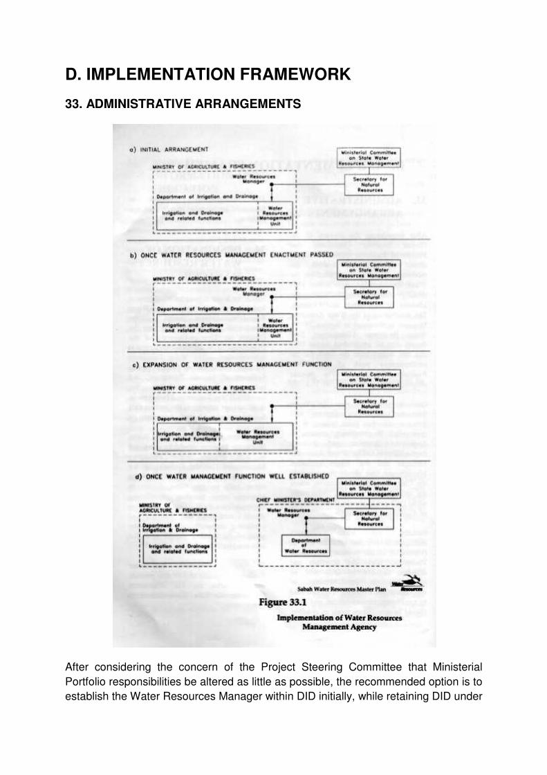
D. IMPLEMENTATION FRAMEWORK
33. ADMINISTRATIVE ARRANGEMENTS
After considering the concern of the Project Steering Committee that Ministerial
Portfolio responsibilities be altered as little as possible, the recommended option is to
establish the Water Resources Manager within DID initially, while retaining DID under

the Ministry of Agriculture and Fisheries. The designation on the Water Resources
Manager is discussed in Section 34. A Water Resources Management Unit should
also be established within DID and this would form the basis for the administrative
work of the Water Resources Manager. The process proposed is illustrated in Figure
33.1.
Over a period of time the Water Resources Manager’s activity will increase, to the
point where it is appropriate to completely separate it from the irrigation and drainage
responsibilities. The Water Resources Manager and the Water Resources
Management Unit should then move to the Chief Minister’s Department where the
unit should become a Department, while DID would remain in the Ministry of
Agriculture and Fisheries.
Initially, the water resources management function of DID will be responsible to the
Secretary of Natural Resources, while the irrigation and drainage function of DID will
be responsible to the Ministry of Agriculture and Fisheries. This may lead to
conflicting responsibilities and these should be avoided as much as possible.
The arrangements proposed in Section 34 are intended to minimise this problem.
34. DESIGNATION OF WATER RESOURCES MANAGER
Under the Water Resources Management Enactment the designated Water
Resources Manager should be the Director of DID initially, and then the Director (or
Director-General) of the Department of Water Resources once it is established.The
Water Resources Manager would report directly to the Secretary of Natural
Resources, and indirectly to the Ministerial Committee on State Water Resources
Management, in all matters relating to the powers and functions involved from the
beginning.
The powers and functions of the Water Resources Manager would be delegated to
staff of the Water Resources Management Unit (or Department) for actual
implementation. This Unit would report only to the Water Resources Manager, so
avoiding conflicting responsibilities for it. This arrangement should minimise the
problem of conflicting responsibilities because the potential for conflict should arise
for only one position.
To function effectively, the Water Resources Manager should also provide the
Secretariat for the Ministerial Committee on State Water Resources Management.

35. STRUCTURE AND EXPERTISE OF WATER RESOURCES MANAGEMENT AGENCY
35.1 STRUCTURE
The internal structure of the Water Resources Management agency should suit the
tasks it has to undertake. These tasks are in the fields of:
• Water Management;
• Licensing, Monitoring and Audit; and
• Water Policy and Planning.
Some of the tasks involved are already being undertaken by State Government, but
may need expanding, while others are new.
35.2 EXPERTISE REQUIRED
Skills in seventeen disciplines have been identified as being needed for the Water
Resources Manager to have available. Initially at least, staff members will have to
cover more than one discipline, although it may be enough to have only background
knowledge in some of them.
Six of these skills are very important. It is recommended that, where these skills are
not currently available, they be developed or brought in as soon as possible.
The key skills are analytical hydrology and hydraulics, hydrogeology, water quality
science, environmental science and water policy analysis (not a formal discipline).
Expertise in the other eleven disciplines can be added later.
36. PERFORMANCE INDICATORS
It is recommended that performance indicators be adopted for the evaluation of the
condition of the water resources of Sabah, and the success of Government strategies
in managing water resources. The following general areas should be covered in the
adoption of indicators for water, and in the reporting process:
• Efficiency of Water Use
• Demand Management
• Water Quality
• Instream Issues
• Aquatic Environment
• Dam Safety
• Catchment Management and Education
• Specific Sectors: e.g. mining, hydro-power.
The Water Resources Manager should be required to develop the performance
indicators and report annually on progress. This should be undertaken in conjunction
with other reporting such as DoE’s annual environment report for Sabah and any
reporting undertaken by the Environmental Development Division of the Ministry of
Tourism and Environmental Development.
37. REVIEW OF IMPLEMENTATION OF MASTER PLAN
It is recommended that the implementation of the Water Resources Master Plan be
reviewed after five years. The review would assess progress on the Plan’s objectives
for water resources and refocus the State’s direction, in line with progress of lack of
progress in water resources management. There should also be ongoing
identification of the success of strategies for protecting and improving the values of
water resources.
38. NATURAL RESOURCES MANAGEMENT
38.1 MINISTERIAL COMMITTEE ON STATE WATER RESOURCES MANAGEMENT
It is strongly recommended that the Ministerial Committee on State Water Resources
Management continue to exercise oversight of water resources management.
Further, it is recommended that some tasks be assigned by the Committee to
relevant agencies or working groups. Initially, these should include:
• Development of State catchment and aquifer management policy and
guidelines;
• Development of protected riverine reserve policy and guidelines, to include
sand and gravel extraction;
• Development of floodplain management policy and guidelines;
• Formulation of a water resources development plan which includes all public
water project proposals, and takes into consideration water resources
development requirements; and
• Further development of water quality protection guidelines and
responsibilities, in conjunction with work being done by DoE.

38.2 A NATURAL RESOURCES MANAGEMENT COMMITTEE
A further possible development is the broadening of the Ministerial Committee on
State Water Resources Management to become a committee which considers all
natural resources. The present membership includes almost all the agencies which
would need to be represented on a natural resources management committee. A
broader committee would co-ordinate issues of land, forestry, water and mineral
development.
38.3 A MINISTRY OF NATURAL RESOURCES
A more radical step would be the establishment of a Natural Resources Ministry, in
which land, forests and water could be located. Preferably soil conservation should
be included as well.
Establishment of a new Ministry is a matter for consideration by the Government, in
conjunction with political priorities, and is seen as an option for consideration in the
longer term. The NRO, as constituted at present, could form the basis for
development of a Natural Resources Ministry.
39. PRIORITY ACTIVITIES
39.1 PRIORITY DAM SITES FOR INVESTIGATION
Fifteen potential dam sites have been identified and ranked into priority order for
investigation, and this ranking is shown in Figure 39.1. Some of the sites have been
given equal rank because either they have the potential to be developed as a
combined scheme or they represent alternative schemes.

In addition, SEB has prioritised its proposals for hydro-power dams as follows:
Project Ranking
Lipaso High
Serudong -
Upper Padas Moderate
Sook Low
SEB also has proposals for eight new mini-hydro schemes, with a total installed
capacity of 4.01 MW. Two schemes were under construction in 1993 and a third is to
be implemented in 1994.
Several of the sites in Figure 39.1 have been identified only from the available
1:50,000 scale topographical mapping. While these sites can be considered in the
context of the Water Resources Master Plan, it is recommended that site inspections
and at least pre-feasibility studies be conducted to confirm them. Data collection
should also begin as soon as possible.

As a general rule for any of the sites that are found to be feasible, it would be prudent
to gazette the catchment or complete an ICM Plan as early as possible.
39.2 PRIORITIES FOR CATCHMENT PLANNING
The ten catchment with the greatest need for development of an ICM Plan have been
identified and ranked, in consultation with Government Officers. The ranked
catchments are shown in Figure 39.2.
39.3 LOWLAND RIPARIAN CATCHMENT RESERVES
Following consultation with Government Officers, a priority list of lowland riparian
catchment reserves has been developed. These could be gazetted as Class I Forest
Reserves, Parks or River Reserves. The locations of these catchments are shown in
Figure 39.3.

39.4 PRIORITIES FOR RIVER RESERVES
Priority should be given to river reaches:
• Upstream of any major potable water supply offtake where it is not practical,
because of developments that have already occurred in the catchment or
some other physical constraint, to gazette the whole catchment;
• In non-urban areas where urban development is starting to occur or will soon
occur close to rivers;
• Having value for eco-tourism;
• Having a particular problem, such as where channel stability, channel erosion,
sedimentation, or contamination from riverine sources threatens important
ecosystems or other values; and
• Where there is particular pressure for quarrying or extraction of sand and
gravel.
A priority programme should be developed by the Water Resources Manager, co-
ordinated with the Lands and Surveys Department and local authorities, and put to
the Natural Resources Office for further clearance. This programme should be
consistent with priorities for investigation of water resources developments and for
ICM Plans.

39.5 PRIORITIES FOR HYDROMETEOROLOGICAL INVESTIGATIONS
Priorities for hydrometeorological investigations are dependent on the priorities for
developing ICM Plans and investigating priority dam sites. To improve the reliability
of information from these investigations, gauging stations with automatic water level
recorders should be installed at dam sites having priority for investigation for
development, where not already gauged. These should be installed as soon as
possible to enable the maximum data to be collected prior to investigations.
Rainfall stations should also be installed in the catchments of existing dams and in
the catchments of dam sites identified as having priority for investigation for
development. Climate stations should be installed at priority dam sites as well. The
rainfall stations should be equipped with pluviographs, while key stations should be
telemetered for dam safety and surveillance purposes. Telemetering rainfall stations
should also be installed upstream of urban areas prone to flash flooding, such as
Inanam and Tawau.
39.6 PRIORITIES FOR WATER QUALITY AND ENVIRONMENTAL INVESTIGATIONS
Initial water quality and environmental investigation studies include:
• Investigations to complement feasibility studies for possible water resources
developments and priority catchment management plans.
• Water quality in urban stormwater drains.
• Quality of waters around water villages.
39.7 PILOT CATCHMENT MANAGEMENT PLAN
It is proposed that a pilot ICM Plan be developed for the Sg. Moyog catchment, a
significant source of water supply for Kota Kinabalu and the surrounding area. The
catchment contains areas of existing and expanding urbanisation, together with rural
areas. There are considerable riverbank activities and settlements as well as a
variety of agricultural activities. In addition, the area includes the catchment of the Sg.
Babagon upstream of the planned water supply dam, where it is proposed that
activity be restricted for water quality reasons.
Development of the plan would require the participation of all government agencies
with major responsibilities in the catchment. A preliminary estimate of the

professional inputs required is a minimum of 54 person-months. An initial estimate of
the cost of professional staff involved,
including report preparation, is RM500,000 to RM600,000. Survey of the river may be
required, primarily to define cross sections and a longitudinal profile. Collection of
field data, such as water quality data or environmental data, may also be needed.
These are additional costs.
39.8 PRIORITIES FOR MASTER PLAN IMPLEMENTATION
Priority actions for the implementation of the Master Plan have been identified and
these are listed and discussed below. These actions do not have to be carried out
sequentially; some of them should occur simultaneously.
1. Preparation of the proposed Water Resources Management Enactment should
begin as soon as possible. This is needed to formalise the position and role of
the Water Resources Manager.
2. Establishment of the Water Resources Manager could proceed informally
immediately, pending the enabling legislation coming into force. Planning and
investigation work could then start, but there could be no enforcement without
legislation.
3. Establishment of the Water Resources Management Unit should proceed as
soon as the Water Resources Manager is established.
4. Human resources capacity building in the Water Resources Management Unit
should start as soon as the Unit is established.
5. Policy development, planning and investigations should also start as soon as
the Unit is established, including:
i. Identifying categories of water extractions, diversions and discharges that
should be licensed, and water quantity and quality conditions that should
be attached to licences.
ii. Preparing policies and procedures on topics such as licensing, water
sharing (conflict resolution), catchment management, floodplain
management, sand and gravel extraction, urban drainage, rural drainage,
pollution prevention and instream water quality.
iii. Database and GIS development.
iv. Becoming involved in reviewing and commenting on any major water
resources development proposals that come up.
6. Once capacity building in the priority fields given in Section 35.2 is well
advanced, a start could be made on priority activities discussed in Sections
39.1-39.6 and the proposed pilot study described in Section 39.7.
7. Once the legislation is passed, active implementation of the Master Plan can
begin, including:
i. Licensing major water users and discharges, and enforcing conditions.
ii. Implementing catchment and riverine corridor protection proposals.
iii. Implementing policies and procedures.
iv. Implementing the remainder of the Master Plan as specific needs arise.
Time frames required for completing these activities will depend on the levels of
funding that are available, on how quickly additional expertise and resources can be
built up, and on the times required for consultative and political processes.
40. ACKNOWLEDGEMENTS
The progress made during this project could not have been achieved without the co-
operation and assistance of many organisations. Altogether, over 40 organisations
were contacted for discussions and for collection of data.
In particular, the assistance of the NRO, the Department of Irrigation and Drainage,
the Water Department, the Forestry Department and the Lands and Survey
Department, which have provided members of the project team, has been crucially
important to the progress of project. The assistance of all the organisations involved
is gratefully acknowledged.
In addition, the input from all participants at the Workshop at Kundasang, and from
the Steering Committee and Technical Committee has been invaluable, and this is
also gratefully acknowledged.