S127 variation applications advice of decision
118
135 Albert Street | Private Bag 92300, Auckland 1142 | aucklandcouncil.govt.nz | Ph 09 301 0101 6 th October 2016 Email: [email protected] Dear Paul, S127 variation applications – advice of decision Application numbers: R/VCC/2015/2748/2 R/VCC/2015/2954/1 Applicant: Wilberforce (Sale Street) Limited Proposed activity: To vary the conditions of resource consents R/LUC/2015/2748 and R/REG/2015/2954 to provide for additional earthworks within the road reserve, which will be for the purpose of supporting the construction of the approved development at 70 Sale Street, Auckland Central. An existing Swamp Cypress street tree will be maintained and protected throughout the duration of the works. Site address: 70 Sale Street, Auckland Central Following an assessment of your variation applications under the Resource Management Act 1991 (RMA) and with reference to the Auckland Council District Plan (Auckland City Central Area Section), and the Proposed Auckland Unitary Plan Notified Version, a decision has been made to approve your variation applications. Please take the time to read and understand the varied consent conditions. Council officers will undertake inspections of your project to check compliance with these resource consents. For your reference, a copy of the decision is attached, along with a set of consolidated consent conditions. If you disagree with the decision, or parts of it including the conditions, you can lodge an objection with us or file an appeal with the Environment Court within 15 working days of receiving this decision. Objections should be addressed to the Principal Planner Hearings and Resolutions – Central, Auckland Council at Private Bag 92300,Victoria Street West, Auckland 1142. Information on the objection process can be found on our website www.aucklandcouncil.govt.nz (type “objection process” in the search field). Information on the appeal process can be found on the Environment Court website www.justice.govt.nz/courts/environment-court. A final invoice will be sent shortly. If you have any queries, please contact the undersigned on (09) 352 2634 or at [email protected] and quote the first application number above. Yours sincerely Daniel Kinnoch Senior Planner
Transcript of S127 variation applications advice of decision

135 Albert Street | Private Bag 92300, Auckland 1142 | aucklandcouncil.govt.nz | Ph 09 301 0101
6th
October 2016 Email: [email protected]
Dear Paul,
S127 variation applications – advice of decision
Application numbers: R/VCC/2015/2748/2
R/VCC/2015/2954/1
Applicant: Wilberforce (Sale Street) Limited
Proposed activity: To vary the conditions of resource consents R/LUC/2015/2748 and
R/REG/2015/2954 to provide for additional earthworks within the road
reserve, which will be for the purpose of supporting the construction of
the approved development at 70 Sale Street, Auckland Central. An
existing Swamp Cypress street tree will be maintained and protected
throughout the duration of the works.
Site address: 70 Sale Street, Auckland Central
Following an assessment of your variation applications under the Resource Management Act 1991 (RMA) and
with reference to the Auckland Council District Plan (Auckland City Central Area Section), and the Proposed
Auckland Unitary Plan Notified Version, a decision has been made to approve your variation applications.
Please take the time to read and understand the varied consent conditions. Council officers will undertake
inspections of your project to check compliance with these resource consents. For your reference, a copy of the
decision is attached, along with a set of consolidated consent conditions.
If you disagree with the decision, or parts of it including the conditions, you can lodge an objection with us or file
an appeal with the Environment Court within 15 working days of receiving this decision.
Objections should be addressed to the Principal Planner Hearings and Resolutions – Central, Auckland Council at
Private Bag 92300,Victoria Street West, Auckland 1142. Information on the objection process can be found on
our website www.aucklandcouncil.govt.nz (type “objection process” in the search field).
Information on the appeal process can be found on the Environment Court website
www.justice.govt.nz/courts/environment-court.
A final invoice will be sent shortly.
If you have any queries, please contact the undersigned on (09) 352 2634 or at
[email protected] and quote the first application number above.
Yours sincerely
Daniel Kinnoch Senior Planner


R/VCC/2015/2748/2 (s127 for land use consent) and R/VCC/2015/2954/1 (s127 for discharge permit)
Attachment 1: Consolidated conditions of consent as amended.
Conditions
Under section 108 of the RMA, these consents are subject to the following conditions:
General conditions
These conditions apply to all resource consents.
1. Except as amended by the conditions that follow, the activity shall be carried out in
accordance with the plans and all information submitted with the application, detailed
below, and all referenced by the council as consent numbers R/LUC/2015/2748,
R/REG/2015/2954 and R/REG/2015/3464.
• Application Form, and Assessment of Effects prepared by Planning Focus
Limited, dated July 2015
Report title and reference (Located as Attachment A)
Author Rev Dated
70 Sale Street Apartments – Design
Statement
Cox Architecture - No Date
70 Sale Street Landscape Concept 112462
Sola - 31/08/2015
Landscape Statement Sola - July 2015
Civil Engineering and Infrastructure Report
DCC REF:468/01
Dodd Civil
Consultants
2 July 2015
Geotechnical Assessment REF: 4454 Argo Thomson
Consulting
Engineers
- 06/07/2015
Traffic Assessment Traffic Engineering
& Management Ltd
- July 2015
Acoustic Assessment of Effects Rp 001 r02
2015174A
Marshall Day
Acoustics
- 08/06/2015
Wind Assessment: 70 Sale Street, Auckland
(Opus Research Report 15-529F50.00
Opus - 16/07/2015
Preliminary Site Investigation (PSI) REP-
0615/PSI/MAY15
Geosciences
Limited
- 14/05/2015
Plan title and reference Author Rev Dated
Drawing List & Location Plan TP-01-00 Cox Architecture D 15/09/2015
Conceptual Images TP-01-01 Cox Architecture D 08/07/2015
Site Plan TP-11-01 Cox Architecture G 08/07/2015
Basement Floor Plan TP-21-09 Cox Architecture H 14/07/2015
Ground Floor Plan TP-21-10 Cox Architecture H 14/07/2015

R/VCC/2015/2748/2 (s127 for land use consent) and R/VCC/2015/2954/1 (s127 for discharge permit)
Level 1 Floor Plan TP-21-11 Cox Architecture H 24/08/2015
Level 2 Floor Plan TP-21-12 Cox Architecture H 24/08/2015
Level 3 Floor Plan TP-21-13 Cox Architecture G 08/07/2015
Level 4 Floor Plan TP-21-14 Cox Architecture E 08/07/2015
Level 5 Floor Plan TP-21-15 Cox Architecture G 08/07/2015
Level 6 Floor Plan TP-21-16 Cox Architecture E 08/07/2015
Level 7 Floor Plan TP-21-17 Cox Architecture E 08/07/2015
Level 8 Floor Plan TP-21-18 Cox Architecture E 08/07/2015
Level 9 Floor Plan TP-21-19 Cox Architecture G 08/07/2015
Level 10 Floor Plan TP-21-20 Cox Architecture H 15/09/2015
Roof Plan TP-21-21 Cox Architecture F 15/09/2015
North Elevation To Sale Street TP-30-01 Cox Architecture F 15/09/2015
West Elevation TP-30-02 Cox Architecture F 15/09/2015
South Elevation TP-30-03 Cox Architecture E 14/07/2015
South West Elevation To Cook St TP-30-04
Cox Architecture B 08/07/2015
East Elevation TP-30-05 Cox Architecture D 08/07/2015
Materials Schedule TP-30-10 Cox Architecture B 08/07/2015
East-West Section TP-40-01 Cox Architecture D 08/07/2015
North-South Section TP-40-02 Cox Architecture D 08/07/2015
Entry Details TP-50-01 Cox Architecture B 08/07/2015
Façade Details TP-50-02 Cox Architecture D 24/08/2015
Breezeway Details TP-50-03 Cox Architecture C 08/07/2015
Level 1 Apartment Windows TP-50-04 Cox Architecture A 24/08/2015
Roof Canopy TP-50-05 Cox Architecture A 15/09/2015
Perspective Views From Sale Street TP-90-10
Cox Architecture B 14/07/2015
Perspective Views – Courtyard & Breezeway TP-90-11
Cox Architecture A 08/07/2015
Section Through CP1 Ramp TP-50-06 Cox Architecture B 30/09/2015
Other additional information (Located as Attachment B)
Author Rev Dated
70 Sale Street – S92 Request (Noise
Response)
Marshall Day
Acoustics
- 27/07/2015
Waste Management Plan 70 Sale Street Shon Smith of
Rubbish Direct
- 05/08/2015
Response to Further Information Request – 70
Sale Street, Auckland Central (Letter)
Planning Focus - 02/09/2015
Level 1 Apartment Windows Drawing No. TP- 50-04
Cox Architecture &
Opus Architecture
A 24/08/2015

R/VCC/2015/2748/2 (s127 for land use consent) and R/VCC/2015/2954/1 (s127 for discharge permit)
Assessment of Landscape and Visual Effects – Residential Apartments – 70 Sale Street Freemans Bay Auckland
LA4 Landscape
Architects
- September
2015
Draft Balcony Landscape Specification,
establishment and Maintenance Plan
SOLA Landscape
Architects
- August 2015
Response to S92 Queries for 70 Sale Street (Letter)
Traffic Engineering
& Management Ltd
- 31/08/2015
Remediation Action Plan (RAP) 70 Sale
Street, Auckland (REP-0615A/RAP/MAY15)
Geosciences
Limited
- 04/06/2015
Health and Safety Guidelines on the Cleanup of Contaminated Sites
Occupational
Safety and Health
Service
- Published
March 1994
Contaminated Soil Discovery Guidelines Geosciences
Limited
- Received
03/09/2015
Groundwater Drawdown and Settlement.
Monitoring and Contingency Plan
Tonkin & Taylor Ltd - October
2015
Re: 70 Sale Street – Response to s92 request – Settlement to adjacent buildings (letter)
John Bolland of
BGT Structures
(Auckland) Limited
- 08/10/2015
GFA allowance (email) Paul Arnesen of
Planning Focus
- 16/10/2015
Site Plan (as annotated in relation to GFA allowance email)
Cox Architecture N/A Date
Received
16/10/2015
70 Sale Street – Additional Shading
Information (email)
Paul Arnesen of
Planning Focus
- 20/10/2015
RE: 70 Sale Street (email) Paul Arnesen of
Planning Focus
- 27/10/2015
Retaining Wall Design and Groundwater
Drawdown Report
Tonkin & Taylor Ltd - November
2015
2. This consent (or any part thereof) shall not commence until such time as the following
charges, which are owing at the time the council's decision is notified, have been paid in
full:
a. All fixed charges relating to the receiving, processing and granting of this resource
consent under section 36(1) of the Resource Management Act 1991 (RMA); and
b. All additional charges imposed under section 36(3) of the RMA to enable the council
to recover its actual and reasonable costs in respect of this application, which are
beyond challenge.
3. The consent holder shall pay any subsequent further charges imposed under section 36 of
the RMA relating to the receiving, processing and granting of this resource consent within
20 days of receipt of notification of a requirement to pay the same, provided that, in the
case of any additional charges under section 36(3) of the RMA that are subject to
challenge, the consent holder shall pay such amount as is determined by that process to

R/VCC/2015/2748/2 (s127 for land use consent) and R/VCC/2015/2954/1 (s127 for discharge permit)
be due and owing, within 20 days of receipt of the relevant decision.
Advice note:
Development contributions levied under the Local Government Act 2002 may be payable
in relation to this application. The consent holder will be advised of the development
contributions payable separately from this resource consent decision. Further information
about development contributions may be found on the Auckland Council website at
www.aucklandcouncil.govt.nz.
4. Under section 125 of the RMA, this consent lapses five years after the date it is
granted unless:
a. The consent is given effect to; or
b. The council extends the period after which the consent lapses.
5. The consent holder shall pay the council an initial consent compliance monitoring charge
of $845 (inclusive of GST), plus any further monitoring charge or charges to recover the
actual and reasonable costs that have been incurred to ensure compliance with the
conditions attached to this consent.
Advice note:
The initial monitoring charge is to cover the cost of inspecting the site, carrying out tests,
reviewing conditions, updating files, etc, all being work to ensure compliance with the
resource consent. In order to recover actual and reasonable costs, inspections, in excess
of those covered by the base fee paid, shall be charged at the relevant hourly rate
applicable at the time. The consent holder will be advised of the further monitoring charge
or charges as they fall due. Such further charges are to be paid within one month of the
date of invoice. Only after all conditions of the resource consent have been met, will the
council issue a letter confirming compliance on request of the consent holder.
Specific conditions – land use consent R/LUC/2015/2748
Section 127 – R/VCC/2015/2748/1 and R/VCC/2015/2748/2
5A. Except as amended by the conditions that follow, the activity shall be carried out in
accordance with the plans and all information submitted with the application and detailed in
Condition 1, with the exception of the plans and information detailed below, and all
referenced by Council as consent numbers R/VCC/2015/2748/1 or R/VCC/2015/2748/2,
which supplement and / or replace general condition 1 plans.
Application Form, and Assessment of Effects prepared by Paul Arnesen of Planning Focus
Limited, dated 10 August 2016 (for R/VCC/2015/2748/1).
Application Form, and email from Paul Arnesen of Planning Focus, dated 27 September 2016
(for R/VCC/2015/2748/2).
Plan title and reference Author Rev Dated
Level 1 Floor Plan A21-11 (replaces Level 1 Floor Plan TP-21-11)
Cox Architecture 10 19/07/2016

R/VCC/2015/2748/2 (s127 for land use consent) and R/VCC/2015/2954/1 (s127 for discharge permit)
Level 2 Floor Plan A21-12 (replaces Level 2 Floor Plan TP-21-12)
Cox Architecture 8 19/07/2016
Level 1 Apartment Windows TP-50-04 (replaces Level 1 Apartment Windows TP-50-04)
Cox Architecture C 08/08/2016
Level 1 Apartment Window Views Sht 1 of 2 TP-50-05 (replaces Level 1 Apartment Windows TP-50-04)
Cox Architecture A 08/08/2016
Level 1 Apartment Window Views Sht 2 of 2 TP-50-06
Cox Architecture A 08/08/2016
Road Reserve Existing Vegetation, Dwg No L1501 (shows the area of additional earthworks being undertaken within the road reserve, and the Swamp Cypress tree that is to be maintained. The tree removals are not subject to this resource consent).
SOLA Landscape Architects
2 22/09/16
Works within Road Reserve
5B. All references in this resource consent to site, property, property boundary, and/or 70 Sale
Street shall be taken to also include the area of works proposed within the road reserve,
shown as ‘Extent of Earthworks’ on the plan titled ‘Road Reserve Existing Vegetation’, Dwg
No L1501, Revision 2, prepared by SOLA Landscape Architects LTD, dated 22.09.2016.
Advice note:
The purpose of this condition is to make it clear that the conditions of this resource consent
apply to the entire area of the proposed works, which includes the road reserve, and not just
works within the site boundaries of 70 Sale Street, Auckland Central.
Pre-Commencement
Earthworks
6. The earthwork activity shall be carried out in accordance with the plans and all information
submitted with the application and under section 92, outlined below and all referenced by
Council as R/LUC/2015/2748 and R/VCC/2015/2748/2.
• Report: ‘“Civil Engineering and Infrastructure Report; Ref: 468/01, Revision 2, dated
July 2015, prepared by Dodd Civil Consultants Limited.
• Application for Land Use Resource Consent, Residential Apartment Building, Planning
Report District Plan and Statutory Assessment, 70 Sale Street Auckland Central, dated
July 2015, prepared by Planning Focus Limited.
• Plan: ‘Road Reserve Existing Vegetation’, Dwg No L1501, Revision 2, prepared by
SOLA Landscape Architects LTD, dated 22.09.2016.
Other additional information Author Rev Dated
Emails regarding Vector Approval for proposed works in proximity to their utility assets
- 08/06/2016 – 20/09/2016

R/VCC/2015/2748/2 (s127 for land use consent) and R/VCC/2015/2954/1 (s127 for discharge permit)
Advice note:
In the event that minor amendments to the erosion and / or sediment controls are required, any
such amendments should be limited to the scope of this consent. Any amendments which
affect the performance of the controls may require an application to be made in accordance
with section 127 of the RMA. Any minor amendments should be provided to the Team Leader
Central Monitoring prior to implementation to confirm that they are within the scope of this
consent.
Management Plans
7. Prior to the commencement of earthworks activities on the subject site, a finalised Erosion and
Sediment Control Plan (ESCP) shall be submitted for approval by Council (Team Leader –
Central Monitoring). No earthworks activities on the subject site shall commence until
confirmation from Council (Team Leader – Central Monitoring) is provided indicating that the
ESCP is satisfactory.
The Erosion and Sediment Control Plan shall, as a minimum, be prepared in accordance with
Auckland Council Technical Publication 90, and shall address the following matters:
• Specific erosion and sediment control measures including cleanwater diversions,
sediment control measures, and stabilised entranceway and other measures (such as a
wheel wash) to avoid tracking of sediment from the site;
• Dewatering methodology;
• Catchment boundaries and contour information (where necessary);
• Details of construction methods;
• Incorporation of any requirements of a Contamination Management Plan or methods
that may also be required for the site. and,
• Monitoring and maintenance requirements.
Advice note:
In the event that minor amendments to the ESCP are required, any such amendments should
be limited to the scope of this consent. Any amendments which affect the performance of the
ESCP may require an application to be made in accordance with section 127 of the RMA. Any
minor amendments should be provided to Council (Team Leader – Central Monitoring) prior to
implementation to confirm that they are within the scope of this consent.
8. Prior to any works commencing on the site the consent holder shall provide to the satisfaction
of the Council (Team Leader – Central Monitoring) a Demolition and Construction
Management Plan ("DCMP"). The DCMP shall include specific details relating to avoiding,
remedying or mitigating adverse effects on the environment of the demolition, earthworks,
construction and management of all works associated with the development, including but not
limited to the following:
• Who the site or project manager is and contact details (phone, facsimile, postal address).
• The location of notice boards that clearly identify the name, telephone number and
address for service of the site or project manager.

R/VCC/2015/2748/2 (s127 for land use consent) and R/VCC/2015/2954/1 (s127 for discharge permit)
• Measures to be adopted to ensure that pedestrian access past the works is provided
and that such access is safe.
• The location and design of all hoardings and gantries.
• Measures to be adopted to maintain the site in a tidy condition in terms of
disposal/storage of rubbish, storage and unloading of building materials and similar
construction activities.
• Control procedures for delivery and removal of construction materials from public
roads or places.
• Location of workers conveniences (eg portaloos).
• Ingress and egress to and from the site for construction vehicles.
• Hours of operation and days of the week for construction activities.
• Measures to control dust deposition and nuisance.
9. Prior to any works commencing on the site the consent holder shall provide a Demolition and
Construction Noise & Vibration Management Plan (DCNVMP) to the satisfaction of the
Council (Team Leader – Central Monitoring). The DCNVMP shall as a minimum, address the
following:
• Construction noise/vibration criteria;
• Identification of the most affected premises where there exists the potential for
noise/vibration effects;
• Description and duration of the works, anticipated equipment and the
processes to be undertaken;
• Hours of operation, including specific times and days when construction activities
causing noise/vibration would occur;
• Mitigation options where noise/vibration levels are predicted or demonstrated to
approach or exceed the relevant limits. Specific noise/vibration mitigation measures must
be implemented which may include, but not limited to, acoustic screening, pre-
construction building condition surveys, time management procedures, alternative
construction/excavation/piling method technologies and equipment/processes;
• The erection of temporary construction noise barriers where appropriate. The noise
barriers should be a minimum height of 2 metres, with no gaps and a minimum density
of 10kg/m2;
• Schedule and methods for monitoring and reporting on construction
noise/vibration;
• Details of noise/vibration monitoring to be undertaken or in the event of any
complaints received. The results of such monitoring shall be submitted to council
within one week of receiving the complaint;
• Implementation of a complaint management system with contact numbers for key
construction staff responsible for the implementation of the DCNVMP and complaint

R/VCC/2015/2748/2 (s127 for land use consent) and R/VCC/2015/2954/1 (s127 for discharge permit)
investigation. This system should include procedures for maintaining contact with
stakeholders, notifying of proposed construction activities and handling of noise/vibration
complaints;
• Specific notification shall be provided to the owners and occupiers of 68 Sale Street/109
Cook Street before demolition and piling activities commence on the site; and
• Construction operator training procedures.
10. Prior to any works commencing on the site the consent holder shall provide to the satisfaction
of the Council (Team Leader – Central Monitoring in consultation with Auckland Transport) a
Demolition and Construction Traffic Management Plan (DCTMP). The purpose of the DCTMP
is to avoid, mitigate or remedy any temporary adverse effects of traffic related to the
redevelopment of the site. The following details shall be shown on a site plan and supporting
documentation:
• Ingress and egress to/from the site for vehicles associated with demolition,
earthworks and delivery of materials and equipment and construction machinery
during the site works and construction periods.
• Proposed numbers and timing of truck movements throughout the day and the
proposed routes. This shall include the identification of heavy vehicle routes that avoid
residential streets.
• Location of parking for contractors and workers.
• Details of how construction traffic will be managed.
• Wheel washing.
• Location of traffic signs on surrounding streets and proposed signage for traffic
management purposes during construction.
• Contact details of the site manager.
• Confirmation of where the crane will be located on-site. It will not be permitted within the
street.
• Management of loading areas during large vehicle movements, including schedule of
deliveries and any measures that may be employed to ensure the safety for all users in
this area.
• Maintenance of pedestrian access.
• Maintaining access for neighbouring sites.
11. Prior to works commencing, a meeting shall be arranged so that all tree protection
measures are explained by the works arborist to all contractors, sub-contractors and work
site supervisory staff who are carrying out any works associated with the project within close
proximity of the Swamp Cypress street tree adjacent to the site. Present at this meeting will
be the Council’s arborist advisor (ph: 0272-448-4993) and Team Leader – Central
Monitoring who shall be given at least five (5) working days’ notice of the intended time and
date of the pre commencement meeting.

R/VCC/2015/2748/2 (s127 for land use consent) and R/VCC/2015/2954/1 (s127 for discharge permit)
Advice note:
The purpose of this pre-commencement meeting is to confirm the precise position of protective
fencing around the Swamp Cypress tree and to determine the initial extent of any pruning
required to demolish the building, along with any gantry, scaffolding or other requirements for
the demolition to proceed.
12. Prior to any site works commencing, protective barrier fencing consisting of 1.8 metre high
pole/wire mesh fencing material with ground anchor spikes (or an accepted alternative
approved by the Council arborist, or representative), shall be erected around the protected
rootzone / dripline of the Swamp Cypress within the road reserve to totally exclude access
or the storage of any materials. 13. The building shall be designed, and such changes made to the buildings as are necessary,
to comply with the following rules of the Auckland Council District Plan (Auckland City
Central Area Section 2004):
• Rule 6.12 Wind Environment Control.
• Rule 6.13 Glare Control. Urban Design
14. [condition cancelled]
15. Prior to the approval of Building Consent for the building (excluding earthworks,
foundations and structural works), the consent holder shall provide a finalised set of
architectural drawings of the building, including (but not be limited to) design details of the
external cladding, glazing, architectural features such as vertical fins, screens and visual
relief treatment to the eastern boundary concrete precast panels in general accordance
with the approved consent drawings with the exception of the following design
amendments:
i. Notwithstanding the approved plans as referenced in Condition 1, final architectural
plans and (northern and western) elevations to demonstrate that the arrangement and
number of aluminium screens to the northern and western elevations are consistent (no
less in number than) with that illustrated in Architectural Drawings # TP-30-01 Revision 5
– North Elevation to Sale Street, dated 25.05.2015 and TP-30-02 Revision 5 – West
Elevation, dated 25.05.2015 (submitted to Council at pre-application stage). This is to
satisfy the Auckland Urban Design Panel recommendation to minimise the ‘corporate’
appearance by introducing greater articulation and richer materiality to the façade;
ii. Amended architectural plans and elevations to illustrate the deletion of the roof-top
space frame canopy structure; and
iii. Detailed design of:
a) The Cook Street ground level frontage, including the design of security fencing,
pedestrian entrance gate and automatic security door for vehicle access; and
b) The Sale Street automatic security door for vehicle access.
The consent holder shall submit this information for approval to Council (Team Leader –

R/VCC/2015/2748/2 (s127 for land use consent) and R/VCC/2015/2954/1 (s127 for discharge permit)
Central Monitoring in consultation with Urban Design team).
16. Prior to the approval of Building Consent for the building (excluding earthworks, foundations
and structural works), the consent holder shall provide a report from a suitably qualified
expert to verify that adequate day light, natural ventilation and visual awareness of outside
will be provided to the rear (breezeway facing) bedrooms of Unit Types 1D, 1F, 2A-B and
2A-A on level 1 without creating undue visual privacy issues for these units. The information
shall include finalised architectural plans, sections and (internal courtyard / breezeway
facing) elevations of these units. The consent holder shall submit this report for approval to
the Council (Team Leader – Central Monitoring in consultation with Urban Design team).
17. Prior to the approval of Building Consent for the building (excluding earthworks, foundations
and structural works), the consent holder shall provide a Materials Schedule and
Specifications for the proposed external cladding and glazing in general accordance with
the approved consent drawings. A sample palette of materials, surface finishes, and colour
schemes shall accompany this. This information shall be submitted for approval to the
Council (Team Leader – Central Monitoring in consultation with Urban Design team).
18. Prior to the approval of Building Consent for the building (excluding earthworks, foundations
and structural works), the consent holder shall provide a finalised set of Landscape and
Pavement Plans in general accordance with the approved consent drawings and prepared by
a suitably qualified landscape architect. Those final plans shall include:
a) Landscape / planting plan and specifications, planting schedule, detailing the specific
planting species, the number of plants provided, locations, heights/Pb sizes;
b) Pavement plans and specifications, detailing materiality, surface finishes and colour
throughout the development site; and
c) Annotated sections with key dimensions to illustrate that adequate widths & depths
are provided for tree pits / planter boxes.
The plans shall address the following detailed design matters:
i. Selection of suitable vegetation species (e.g. succulents, climbers etc.); and
ii. Irrigation requirements for vegetation within the planter boxes.
19. Prior to the approval of Building Consent for the building (excluding earthworks, foundations
and structural works), the consent holder shall submit a Landscape Management Plan,
including vegetation maintenance policies for the proposed planting, in particular details of
maintenance methodology and frequencies by the appointed contractor with arboricultural
experience for approval to the Council (Team Leader – Central Monitoring in consultation with
Urban Design team). This shall include cyclical landscape maintenance programme, outlining a
specific cycle proposed and allowance for replacement of plants / trees, in case plants are
severely damaged / die etc.; an irrigation system; and vandalism response and graffiti
eradication policy and methodology.
20. Prior to the approval of Building Consent for the building (excluding earthworks, foundations
and structural works), the consent holder shall provide a Lighting Plan for approval to the
Council (Team Leader – Central Monitoring in consultation with Urban Design team). This plan
shall include proposed locations, lux levels and types of external lighting (i.e. manufacturer’s
specifications once a lighting style has been determined). The purpose of this plan is to

R/VCC/2015/2748/2 (s127 for land use consent) and R/VCC/2015/2954/1 (s127 for discharge permit)
demonstrate that adequate lighting will be provided, particularly at the building entrances, open
plazas, vehicle entries, car parking areas, internal circulation (breezeway) and any publicly
accessible spaces for the visibility and safety of residents / occupants and visitors to the
premises and passers-by outside the daylight hours.
21. Prior to the approval of Building Consent for the building (excluding earthworks, foundations
and structural works), the consent holder shall provide a final set of Services Plans, including
details / locations of the proposed servicing for the building
e.g. vents, transformers, A/C units, lift overruns, water meters, electric meters, fire hydrants /
sprinkler valve controls, traffic warning devices (if any) etc. This information shall be submitted
for approval to the Council (Team Leader – Central Monitoring in consultation with Urban
Design team).
22. The width of the Cook Street vehicle access at the road boundary and where ramp meets the
footpath shall be no more than 6 metres wide and shall be shown on the Building Consent
drawings.
Footpath Protection
23. Prior to any of the demolition or construction works authorised by this consent, the consent
holder shall obtain the approval of the Council (Team Leader – Central Monitoring in
consultation with Auckland Transport) for the proposed method of protection of footpaths and
underlying services affected by the movement of vehicles to and from the site and by works
being carried out on the site. Proposed methods may include the laying of timber planks or the
provision of a reinforced concrete overlay. The method selected will depend on how the
footpath will be impacted by vehicles.
Hoarding
24. Prior to any of the demolition or construction works authorised by this consent commencing,
the consent holder shall ensure a screen wall of a minimum height of 1.8m is erected along the
external boundaries of the site to the satisfaction of the Council (Team Leader – Central
Monitoring). This wall shall be constructed using solid materials, such as painted plywood and
the materials, colour and finishing of the external screen wall hoarding shall be to the
satisfaction of the Council (Team Leader – Central Monitoring). Unless approved by the
Council (Team Leader – Central Monitoring), the external wall shall remain in place until the
cessation of demolition and construction works on the site.
25. Prior to the commencement of the earthworks activity, the consent holder shall hold a pre-start
meeting that:
• Is located on the subject site
• Is scheduled not less than five days before the anticipated commencement of
earthworks
• Includes Auckland Council officer[s]
• includes representation from the contractors who will undertake the works The
meeting shall discuss the erosion and sediment control measures, the
earthworks methodology and shall ensure all relevant parties are aware of and familiar
with the necessary conditions of this consent.

R/VCC/2015/2748/2 (s127 for land use consent) and R/VCC/2015/2954/1 (s127 for discharge permit)
The following information shall be made available at the pre-start meeting:
• Timeframes for key stages of the works authorised under this consent
• Resource consent conditions
• Erosion and Sediment Control Plan (as required by condition 7)
Advice note:
To arrange the pre-start meeting required by Condition 25, please contact Council (Team
Leader – Central Monitoring) to arrange this meeting on
[email protected] or 09 301 0101. The conditions of consent should be
discussed at this meeting. All additional information required by the Council should be provided
2 days prior to the meeting.
During Construction Activities
During Works Requirements
26. The approved DCMP, DCNVMP and DCTMP shall be implemented and maintained
throughout the entire construction/demolition period.
27. Unless otherwise approved by the Council, all construction works including mechanical
equipment, except for the delivery, installation, breakdown and removal of tower cranes to the
site, shall be restricted to the hours of between 7.30am to 6.00pm Monday to Friday, and
8.00am to 4.00pm Saturday. No works shall be undertaken on Sundays and public holidays.
Non-noisy work may be undertaken outside these hours, on written approval of Council
(Team Leader – Central Monitoring).
Noise and Vibration
28. With the exception of piling, construction noise shall comply with the noise limits outlined in
the table below. Construction noise shall be measured and assessed in accordance with the
New Zealand Standard NZS 6803:1999 “Acoustics – Construction Noise”.
Time Period LAeq
dBA
LAmax
dBA
Monday to Friday 6.30am to 10.30pm 75 90
Saturday 7am to 11.00pm 80 90
29. Vibration levels arising from any activity on the site shall at all times comply with the German
Standard DIN 4150:1999 Part 3, “Structural Vibration - Effects of Vibration on Structures”
criteria, when measured and assessed in accordance with that standard to the satisfaction of
Council (Team Leader – Central Monitoring).
30. Unless otherwise approved by the Council, all construction related traffic shall be restricted
to access the site between the hours of 7am to 9am and 4pm to 6pm on weekdays.
31. There shall be no deposition of earth, mud, dirt or other debris on any road or footpath
resulting from earthworks activity on the subject site. In the event that such deposition does
occur, it shall immediately be removed. In no instance shall roads or footpaths be washed

R/VCC/2015/2748/2 (s127 for land use consent) and R/VCC/2015/2954/1 (s127 for discharge permit)
down with water without appropriate erosion and sediment control measures in place to
prevent contamination of the stormwater drainage system, watercourses or receiving waters.
32. The operational effectiveness and efficiency of all erosion and sediment control measures
specifically required as a condition of resource consent or by the Erosion and Sediment
Control Plan referred to in Condition 7 shall be maintained throughout the duration of
earthworks activity, or until the site is permanently stabilised against erosion.
33. A suitably qualified and experienced contaminated land specialist shall be engaged to
monitor the earthworks.
34. The earthworks shall not result in any airborne and deposited dust beyond the property
boundary of the site that is determined to be noxious, objectionable or offensive. Good
practice measures, such as those described in Section 8 of the Good Practice Guide for
Assessing and Managing the Environmental Effects of Dust Emissions, Ministry for the
Environment (2001), shall be adopted at all times.
35. The consent holder shall ensure excavated materials, when removed from the site, are
disposed of in an appropriate landfill and provide landfill receipts to Council (Team Leader –
Central Monitoring), on completion of the earthworks.
36. If evidence of soil contamination, presence of asbestos and any underground storage tanks or
pipe works which has not been identified, in the initial site investigation, is discovered during
excavation, the consent holder shall immediately cease the works and notify Council (Team
Leader – Central Monitoring) and provide a site contamination report and a remedial action
plan if necessary to the satisfaction of Council (Team Leader – Central Monitoring).
37. The consent holder shall ensure that the contamination level of any imported soil complies
with Auckland Council’s clean fill criteria as outlined by MfE Guide for Managing Clean-fills
2002.
Construction Maintenance
38. Should any damage occur in the course of development of the site, the consent holder shall
bear all costs relating to the reinstatement of the affected footpath, street furniture, and/or
affected services. All reinstatement work shall be carried out at the direction and to the
satisfaction of Council (Team Leader – Central Monitoring in consultation with Auckland
Transport).
39. Where footpath intersects a new vehicle crossing, the overlapped area shall be designed and
constructed to the same levels, using the same materials, kerbing, pavings, patterns and finish
as the footpath, on each side of the crossing. Where entrance locations altered, crossings no
longer required shall be re-instated as verge and/or footpath and kerbs replaced to the
satisfaction of Council (Team Leader – Central Monitoring in consultation with Auckland
Transport).
40. The loading and unloading of all vehicles and storage of plant and equipment associated
with the building construction work, shall take place within the site boundaries of this
application unless otherwise allowed by the approved CTMP or the written approval of the
Council (Team Leader – Central Monitoring in consultation with Auckland Transport).

R/VCC/2015/2748/2 (s127 for land use consent) and R/VCC/2015/2954/1 (s127 for discharge permit)
41. There shall be no storage (or temporary storage) of any description (i.e. no products, no fluids,
no machinery, no tools, etc) in the permeable drip line and root zone area of the Swamp
Cyprus street tree. Special attention shall be paid to any petrol/diesel operated machinery to
avoid contaminating the soil in the root zone of the protected tree.
Prior to Occupation
Site Validation Report
42. Within 3 months of any remediation works, the consent holder shall provide to the satisfaction
of Council (Team Leader – Central Monitoring), a Site Validation Report, which shall include
but not limited to the following:
a) Confirmation of the remediation works being conducted in accordance with an approved
remedial action plan
b) The location and dimensions of the remediation carried out, including a site plan
c) Soil test results for remaining soil, imported fill if any and any other soil testing
d) Total volume of excavated soil disposed off-site
e) Landfill receipts.
Landscaping Implementation
43. Prior to occupation of the building, the landscaping works, as required by Condition 18, shall
be undertaken in accordance with the approved landscape plan and maintained thereafter in
accordance with the Landscape Management Plan, as required by Condition 19, to the
satisfaction of Council (Team Leader – Central Monitoring in consultation with the Urban
Design team).
Design
44. Prior to occupation of any of the residential units, the consent holder shall provide
information to confirm that the prospective purchasers / occupants of the units with balcony
planters (between Grid Lines C and D) have been made aware of the access and
maintenance requirements for the vegetation on the balcony planter boxes and the nature of
body corporate controls formulated to ensure the access and maintenance requirements are
met. This information shall be submitted for approval to the Council (Team Leader – Central
Monitoring in consultation with Urban Design team).
45. Prior to occupation of the building, the consent holder shall provide detailed information to
illustrate the design details of any proposed signs, including the proposed locations,
dimensions, colours, materials, surface finishes. This information shall be submitted for
approval to the Council (Team Leader – Central Monitoring in consultation with Urban Design
team).
46. A final waste management plan shall be provided for approval to Council (Team Leader –
Central Monitoring) prior to the occupation of the building and shall remain implemented in
perpetuity unless otherwise updated by the consent holder and approved by Council (Team
Leader – Central Monitoring).

R/VCC/2015/2748/2 (s127 for land use consent) and R/VCC/2015/2954/1 (s127 for discharge permit)
47. Prior to occupation of the building, appropriate signage shall be provided within the
basement ramp (Sale Street entrance) to advise the exiting vehicles that they need to slow
down and look out for pedestrians while exiting. This information shall be submitted to the
Council (Team Leader – Central Monitoring) for approval.
Noise
48. Prior to occupation of any of the residential units the consent holder shall submit a report,
prepared by a suitably qualified acoustic specialist, to the Council (Team Leader – Central
Monitoring) confirming that the residential units have been designed and constructed to
meet the internal noise requirements of Rule 14.10.8.7(a) of the Auckland Council District
Plan (Auckland City Central Area Section).
49. Bedrooms and habitable spaces that are reliant upon closure of windows to meet the indoor
noise levels stipulated in Rule 14.10.8.7(a) of the Auckland Council District Plan (Auckland City
Central Area Section) must be adequately ventilated in accordance with clause G4 of the NZ
Building Code.
50. Operational noise levels from the occupied apartment block, including all mechanical plant,
shall comply with the noise limits of Rule 14.10.8.7(b) of the Auckland Council District Plan
(Auckland City Central Area Section) at all times.
51. All noise from the ‘‘retail/café’’ units on the ground floor shall comply with the noise limits of
Rules 14.10.8.7 (b) & (c) of the Auckland Council District Plan (Auckland City Central Area
Section) all times. Music played within the café shall be limited to low level background type
for ambience purposes only and no music of any type shall be played within any outdoor
seating area.
52. The outdoor seating area at the ground floor level shall not be used before 7.00am or after
6pm.
53. The disposal of any empty bottles, cans and general waste from the ‘‘retail/café’’ units into
the rubbish room as indicated on Drawing Number TP-21-10 Revision H shall only occur
between 7am and 6pm on any day.
Car Parking
54. Prior to submitting a vehicle crossing application for the new vehicle crossing along Sale
Street, the consent holder shall submit finalised design details of the footpath and vehicle
crossing interface Council (Team Leader – Central Monitoring in consultation with Urban
Design team) for approval.
Advice Note:
The purpose of this condition is to ensure a continuity of the footpath design (i.e. levels,
materials, surface finishes, colours etc.) over vehicle crossings along the Sale Street
frontage.
55. All stacked pairs of parking spaces shall be allocated to individual units only.
56. No parking spaces shall be allocated, leased or sold such that they can be used by any other
sites or activity.

R/VCC/2015/2748/2 (s127 for land use consent) and R/VCC/2015/2954/1 (s127 for discharge permit)
57. Parking space number 50 (as identified on Drawing Number TP-21-09) in the basement shall
be allocated as the ‘retail parking space’ and marked to the satisfaction of Council (Team
Leader – Central Monitoring). Signs shall be posted to direct users to that space.
Specific Conditions – Discharge of Contaminants R/REG/2015/2954
Contamination
58. This consent shall expire on 30 September 2020 unless it has been surrendered or been
cancelled at an earlier date pursuant to the Resource Management Act 1991.
58A. All references in this resource consent to site, property, property boundary, and/or 70 Sale
Street shall be taken to also include the area of works proposed within the road reserve,
shown as ‘Extent of Earthworks’ on the plan titled ‘Road Reserve Existing Vegetation’, Dwg
No L1501, Revision 2, prepared by SOLA Landscape Architects LTD, dated 22.09.2016.
Advice note:
The purpose of this condition is to make it clear that the conditions of this resource consent
apply to the entire area of the proposed works, which includes the road reserve, and not just
works within the site boundaries of 70 Sale Street, Auckland Central.
59. The discharge from disturbance of contaminated soil at 70 Sale Street, Auckland Central
shall be carried out in accordance with the plans and all information submitted with the
application. In particular, the following documents referenced by Auckland Council as
R/REG/2015/2954:
• Application for Land Use Resource Consent, Residential Apartment Building, Planning
Report, District Plan & Statutory Assessment, 70 Sale Street, Auckland Central, dated
July 2015, prepared by Planning Focus Ltd.
• Preliminary Site Investigation (PSI), 70 Sale Street, Auckland, dated 14 May 2015,
prepared by Geosciences Ltd.
• Remediation Action Plan (RAP), 70 Sale Street, Auckland, dated 4 June 2015, prepared
by Geosciences Ltd.
And the following plan, referenced by Auckland Council as R/VCC/2015/2954/1, showing the location of additional soil disturbance within the road reserve: • Plan: ‘Road Reserve Existing Vegetation’, Dwg No L1501, Revision 2, prepared by
SOLA Landscape Architects LTD, dated 22.09.2016.
Advice note:
The Council acknowledges that the Remediation Action Plan is intended to provide
flexibility of the management of the works and contaminated site discharge. Accordingly, it
may need to be updated, any updates should be limited to the scope of this consent and
consistent with the conditions of this consent. If you would like to confirm that any proposed
updates are within scope, please contact Team Leader Earthworks and Contaminated
Land, NRSI on (09) 301 0101.
60. All remediation works shall be supervised by a suitably qualified and experienced
contaminated land practitioner, who shall ensure that all management options and contingency

R/VCC/2015/2748/2 (s127 for land use consent) and R/VCC/2015/2954/1 (s127 for discharge permit)
measures outlined in the report “Remediation Action Plan (RAP), 70 Sale Street, Auckland”,
dated 4 June 2015, and prepared by Geosciences Ltd and all relevant consent conditions are
adhered to.
61. Following the demolition of the onsite building and prior to bulk earthworks, soil sampling of
the areas not previously characterized shall be undertaken as outlined in the report
“Remediation Action Plan (RAP), 70 Sale Street, Auckland”, dated 4 June 2015, and prepared
by Geosciences Ltd.
62. All sampling and testing of contamination on the site, shall be overseen by a suitably qualified
and experienced contaminated land practitioner. All sampling shall be undertaken in
accordance with Contaminated Land Management Guidelines, No.5 - Site Investigation and
Analysis of Soils, Ministry for the Environment, revised 2011.
Advice note:
All testing and analysis should be undertaken in a laboratory with suitable experience and
ability to carry out the analysis. For more details on how to confirm the suitability of the
laboratory please refer to Part 4: Laboratory Analysis, of Contaminated Land Management
Guidelines No.49.
63. The Team Leader, Earthworks and Contaminated Land, Natural Resources and Specialist
Input shall be informed in writing about the commencement of the works at least two (2)
working days prior to commencement.
Advice note:
Condition 63 requires the consent holder to notify the Council of their intention to begin land
disturbance activity works a minimum of two working days prior to commencement. Please
contact the Team Leader Earthworks and Contaminated Land, NRSI at
[email protected] to advise of the start of works. The following details
should also be provided:
• name and telephone number of the project manager and the site owner;
• site address to which the consents relate;
• activity to which the consents relate; and
• expected duration of the works.
64. All excavation in the work areas shall be managed to minimise any discharge of debris, soil,
silt, sediment or sediment-laden water from beyond subject site to either land, stormwater
drainage systems, watercourses or receiving waters.
65. Erosion and sediment controls shall be installed in accordance with the Auckland Regional
Council Guidelines for Land Disturbing Activities in the Auckland Region, Technical
Publication TP90. The excavation areas shall be dampened during the day to supress the
generation of dust during the works. Filter cloths or cover mats shall be installed over the
stormwater cesspits in the vicinity of the excavation areas.
Advice note:

R/VCC/2015/2748/2 (s127 for land use consent) and R/VCC/2015/2954/1 (s127 for discharge permit)
Discharge from the site includes the disposal of water (eg. perched groundwater or collected
surface water) from the remediation area.
66. The soils identified for off-site disposal shall primarily be loaded directly into trucks and shall be
covered during transportation off site. If required, temporary stockpiles shall be located within
an area protected by a silt fence or equivalent method, and be covered with tarpaulins
anchored at the edges outside working hours and during periods of heavy rain. All soil
removed from the land disturbance area shall be deposited at an authorised disposal site that
holds a consent to accept the relevant level of contamination.
Where it can be demonstrated that the soil has been fully characterised in accordance with
the Ministry for the Environment’s ‘A guide to the management of cleanfills’ (2002) and meets
the definition of ‘cleanfill’, the removal to a consented disposal site is not required. In such
circumstances, the Team Leader Earthworks and Contaminated Land, NRSI, shall be advised
prior its removal from the subject site.
67. Any perched groundwater, or surface water encountered within the excavation area requiring
removal shall be considered potentially contaminated, and shall either:
a) be disposed of by a licenced liquid waste contractor; or
b) pumped to sewer, providing the relevant permits are obtained; or
c) discharged to the stormwater system or surface waters provided testing demonstrates
compliance with the Australian and New Zealand Environment Conservation Council
(ANZECC) Guidelines for Fresh and Marine Water Quality (2000) for the protection of 95
percent of freshwater species.
68. All imported fill shall:
a) Comply with the definition of 'cleanfill', as per 'A Guide to the Management of
Cleanfills’, Ministry for the Environment (2002); and
b) Be solid material of an inert nature; and
c) Not contain hazardous substances or contaminants above natural background levels of
the receiving site.
Advice note:
Background levels for the Auckland Region can be found in the Auckland Regional Council
technical publication “TP153, Background concentrations of inorganic elements in soils from the
Auckland Region”, (2001).
69. Within three months of the completion of the soil disturbance activities on site, a Site
Validation Report (SVR) shall be provided to the Team Leader Earthworks and Contaminated
Land, NRSI. The SVR shall be prepared by a suitably qualified and experienced contaminated
land practitioner and shall include details of any soil sampling undertaken.
Advice note:
The Site Validation Report required by Condition 69 should contain sufficient detail to address
the following matters:

R/VCC/2015/2748/2 (s127 for land use consent) and R/VCC/2015/2954/1 (s127 for discharge permit)
i. a summary of the works undertaken, including a statement confirming whether the
excavation of the site has been completed in accordance with the application reports
listed in Condition 59.
ii. the location and dimensions of the excavations carried out, including a relevant site
plan.
iii. a summary of any testing undertaken, including tabulated analytical results, and
interpretation of the results in the context of the contaminated land rules of the
Auckland Council Regional Plan: Air, Land, and Water and the Proposed Auckland
Unitary Plan (PAUP).
iv. copies of the disposal dockets for the material removed from the site.
v. evidence that all imported fill material complies with the definition of 'cleanfill', as per 'A
Guide to the Management of Cleanfills’, Ministry for the Environment (2002).
vi. records of any unexpected contamination encountered during the works, if applicable.
vii. details regarding any complaints and/or breaches of the procedures set out in the
Remediation Action Plan, and the conditions of this consent.
70. Where contaminants are identified that have not been anticipated by the application, works in
the area containing the unexpected contamination shall cease and be notified to the Team
Leader Earthworks and Contaminated Land, NRSI. Works shall not recommence until
confirmation has been received from the Team Leader Earthworks and Contaminated Land
that disturbance of the unexpected contamination is within the scope of this consent. Any
unexpected contamination and contingency measures shall be documented in the Site
Validation Report required by Condition 69.
Advice note:
In accordance with Condition 70 any unexpected contamination, may include contaminated
soil, perched water or groundwater. The consent holder is advised that where unexpected
contamination is significantly different in extent and concentration from that anticipated in the
original site investigations, handling the contamination may be outside the scope of this
consent. Advice should be sought from the Team Leader Earthworks and Contaminated Land
as to whether carrying out any further work in the area of the unexpected contamination is
within scope of this consent.
Specific Conditions – Take and Diversion of Groundwater – R/REG/2015/3464
Groundwater
DEFINITIONS:
AC: Means the Auckland Council
Commencement of Dewatering: Means commencement of bulk excavation and/or
commencing taking any groundwater

R/VCC/2015/2748/2 (s127 for land use consent) and R/VCC/2015/2954/1 (s127 for discharge permit)
Completion of Dewatering: Means when all the external base slab and walls are
essentially watertight, the structure’s internal support
mechanisms, including basement floors have been
completed, any temporary retention removed and no
further groundwater is being taken for the
construction of the basement in accordance with the
design
Commencement of Excavation Means commencement of bulk excavation
Completion of Excavation: When all bulk excavation has been completed and
all foundation/footing excavations within 10m of the
perimeter retaining wall have been completed
Completion of Construction: Means when the Certificate of Completion is issued
by AC
Damage: Includes aesthetic, serviceability and significant
damage
Significant Damage: When damage is considered to affect serviceability
or structural integrity
Serviceability Damage (Burland
1995 and Mair et al 1996):
Moderate: Cracks may require cutting out and
patching. Recurrent cracks can be masked by
suitable linings. Brick pointing and possible
replacement of a small amount of exterior brickwork
may be required. Doors and windows sticking.
Utility services may be interrupted. Weather
tightness often impaired. Typical crack widths are
5mm to 15mm or several greater than 3mm.
Severe: Extensive repair involving removal and
replacement of walls especially over doors and windows
required. Window and door frames distorted. Floor
slopes noticeably. Walls lean or bulge noticeably. Some
loss of bearing in beams. Utility services disrupted.
Typical crack widths are 15mm to 25mm but also
depend on the number of cracks.

R/VCC/2015/2748/2 (s127 for land use consent) and R/VCC/2015/2954/1 (s127 for discharge permit)
Aesthetic Damage (Burland 1995
and Mair et al 1996):
Very Slight Damage: Fine cracks easily treated during
normal redecoration. Perhaps isolated slight fracture in
building. Cracks in exterior visible upon close inspection.
Typical crack widths up to 1mm.
Slight Damage: Cracks easily filled. Redecoration
probably required. Several slight fractures inside
building. Exterior cracks visible, some repainting may be
required for weather tightness. Doors and windows may
stick slightly. Typical crack widths up to 5mm.
Negligible Damage (Burland 1995
and Mair et al 1996):
Hairline cracks
Alert Level: Monitored parameter reaches a level close to, or equal
to the design value, which is below the level where
damage is expected to occur unless movement
continues unchecked, and requires review of available
monitoring information (plus other information) to
assess the future trend
Alarm Level: Monitored parameter reaches the value and/or level
close to which damage could occur, and requires
immediate action including the cessation of ground
dewatering and other construction activities that may
have an effect on ground deformation
NRSI: Means Natural Resources and Specialist Input, AC
RL: Means Reduced Level
Services: Includes for example fibre optic cables, sanitary
drainage, stormwater drainage, gas and water mains,
power and telephone, road infrastructure assets such
as footpaths, kerbs, catch-pits, pavements and street
furniture, all existing ground and building settlement
marks and groundwater monitoring bores.
General Conditions
71. That the taking and diversion of groundwater for dewatering purposes during
construction and in the long term shall be in accordance with the plans and information
submitted with the application and numbered R/REG/2015/2954 by the Council, subject
to such amendments as may be required by the following conditions of this consent.
72. This consent shall expire on 31 October 2050, unless it has lapsed, been
surrendered or been cancelled at an earlier date pursuant to the RMA.

R/VCC/2015/2748/2 (s127 for land use consent) and R/VCC/2015/2954/1 (s127 for discharge permit)
a) G11: 15mm
b) G1 to G10: 20mm
c) G12 to G16: 8mm
a) B2 to B12: 15mm
b) B1 & B13: 8mm
Performance Standards
73. The Consent Holder shall ensure that all excavation, dewatering systems, retaining
structures and associated works for the basement construction and associated works shall
be designed, constructed and maintained so as to avoid any damage to buildings, structures
and services on the site or adjacent properties.
74. The bulk basement excavation is not to extend below RL 15.7 m (excluding lift shaft).
75. Any permanent drainage installed behind retaining walls shall not cause groundwater levels
adjacent to the site to reduce from pre-construction seasonal low levels as specified in the
M&CP.
76. The activity shall not cause:-
(i) Greater (steeper) than 1:500 differential settlement between any two adjacent Ground
Surface Settlement Monitoring Marks required under this consent (the Differential
Ground Settlement Surface Alarm Level)
(ii) Greater than the following total settlement at the Ground Settlement Monitoring Marks
required under this consent (the Total Ground Settlement Alarm Level):
(iii) Greater (steeper) than 1:700 differential settlement between any two adjacent Building
Settlement Monitoring Marks required under this consent (the Differential Building
Settlement Alarm Level)
(iv) Greater (steeper) than 1:400 differential settlement between the Building Settlement
Monitoring Marks on the power transformer (B12 & B15) by the north west corner of
the site (the Differential Power Transformer Settlement Alarm Level)
(v) Greater than the following total settlement at any Building Settlement Monitoring
Mark required under this consent (the Total Building Settlement Alarm Level):
(vi) Greater than the following total Retaining Wall Deflection at the monitoring points
for the retaining wall (the Retaining Wall Deflection Alarm Level):
a) W1, W3, & W6 to W8: 10mm
b) W2, W4, & W5: 25mm
Groundwater and Settlement Monitoring and Contingency Plan (GSMCP)
77. At least 10 days prior to the Commencement of Dewatering, the Consent Holder shall
prepare by a Chartered Professional Engineer and submit a Groundwater and Settlement
Monitoring and Contingency Plan (GSMCP) to Council (Team Leader Water Allocation,
NRSI) for approval. No bulk excavation and/or dewatering activity on the subject site shall
commence until approval from Council is provided.

R/VCC/2015/2748/2 (s127 for land use consent) and R/VCC/2015/2954/1 (s127 for discharge permit)
This Plan shall include the requirements of this resource consent, including but not limited
to:-
i. An “as built” location plan, including all monitoring locations and monitoring bores based
on approximate positions located on the plan entitled “Location Group Ltd, 70 Sale
Street Auckland Central, Contingency and Monitoring Plan, Figure 2, Rev. 1, Project No.
31135, Tonkin & Taylor Ltd, October 2015”.
ii. Full details of the groundwater, ground surface, building and retaining wall deformation
monitoring programme and condition surveys required by this consent including as-
built details of monitoring wells (construction, geological log, reduced level,
coordinates).
iii. Identification of any adjacent services susceptible to damage and details of any
proposed pre and post construction monitoring or inspection.
iv. A bar chart, such as a Gantt chart, showing the timing and frequency of the condition
surveys and monitoring required by this consent relative to the Commencement of
Dewatering and the Completion of Dewatering.
v. Proposed groundwater Alert and Alarm Trigger Levels, including methodology for their
determination. Groundwater Alert and Alarm Trigger Levels should also take into
account seasonal variability.
vi. All Alert and Alarm Trigger levels for each Ground Surface, Building and Retaining
Wall Deformation Mark as determined by conditions of consent, varied following
building condition survey or as otherwise approved by the GSMCP.
vii. Details of the contingency measures to be implemented if Alert or Alarm Trigger
Levels are exceeded, including a response plan.
viii. Reporting requirements.
a) The GSMCP may be varied, including frequency of monitoring, subject to the
written approval of the Team Leader Water Allocation, NRSI.
b) The GSMCP once approved shall be implemented.
78. Where the consent holder is required to access property owned by a third party, (including
buildings or structures) to undertake monitoring, construction of a bore, condition surveys or
inspections and that access is declined or subject to what the Consent Holder considers to be
unreasonable terms, the Consent Holder shall notify the Team Leader Water Allocation, NRSI,
of that circumstance, and provide an alternative monitoring plan in accordance with Condition
77.
Monitoring
Groundwater
79. The proposed monitoring bores (BH1 and BH2) located approximately as shown on the
annotated plan entitled “Location Group Ltd, 70 Sale Street Auckland Central, Contingency
and Monitoring Plan, Figure 2, Rev 1, Project No. 31135, Tonkin & Taylor Ltd, October 2015”
are to be installed to allow groundwater monitoring as specified in Schedule A of this consent.
Alternative locations may be accepted subject to review and approval by the Team Leader

R/VCC/2015/2748/2 (s127 for land use consent) and R/VCC/2015/2954/1 (s127 for discharge permit)
Water Allocation, NRSI. The Team Leader Water Allocation, NRSI must be informed of any
monitoring bore damaged or made inoperable immediately and a new monitoring bore, to the
same depth and specification, is to be drilled at a nearby location.
Schedule A: Borehole Monitoring Frequency
Bore
Name
Location
Establishment
Monitoring Frequency (to an accuracy of 10mm)
Easting
(mE)
est.
Northing
(mN)
est.
From bore
construction to
one month
before
Commencement
of Dewatering
One month
before
Commencement
of Dewatering to
Completion of
Dewatering
Completion of
Dewatering to
three months
after
Completion of
Dewatering
BH1 &
BH2
TBC
TBC
The hole should
be drilled at least
two months prior
to the
Commencement
of Dewatering
Monthly Weekly1
Monthly2
1 If the water level readings vary significantly then further readings must be taken to obtain confidence (-/+ 200mm) in
the groundwater level/trend prior to Commencement of Dewatering.
2 Subject to a consistent pattern of groundwater records having been obtained in this period in which no evidence of
adverse effects is apparent. The monitoring period may be extended at the discretion of Team Leader Water
Allocation, NRSI, where the records are not consistent.
80. The Provisional Groundwater Alert Trigger Level and Alarm Trigger Level will be set at
3.0m and 4.0m respectively below the seasonal low level or RL for the monitoring bores. The
Monitoring and Contingency Plan when lodged and approved may amend provisional Alert
and Alarm Trigger Levels.
Building Inspections
81. Prior to the commencement of perimeter piling adjacent to the buildings listed in
Schedule B and/or Commencement of Dewatering, the Consent Holder shall employ a
suitably qualified person (Chartered Professional Engineer or Chartered Building
Surveyor) to undertake as a minimum an external condition survey or a detailed
condition survey of buildings and structures as specified in Schedule B to confirm their
existing condition, prior to the lodgement of the GSMCP. The survey shall include but not
be limited to:
a) Any information about the type of foundations
b) Existing levels of damage considered to be of an aesthetic or superficial nature
c) Existing levels of damage considered to affect the serviceability or function of the
building where visually apparent without recourse to intrusive or destructive
investigation
d) A professional opinion as to whether observed damage may or may not be

R/VCC/2015/2748/2 (s127 for land use consent) and R/VCC/2015/2954/1 (s127 for discharge permit)
associated with actual structural damage
e) Susceptibility of structure to further movement
f) Photographic evidence of (b) and (c)
g) Review of the proposed Alert/Alarm Trigger Levels to confirm they are
appropriately set and any ground settlement less than the Alarm Trigger Level will
not cause damage, and whether the monitoring frequency and locations are
adequate.
Schedule B: Building Inspection and Deformation Marks
Building
Settlement
Marks ID
Address
Detailed
Structural
Condition
Survey
Settlement
Pins
(Yes/No)
Legal Title
B1 to B6, B8 &
B10 (8 marks)
68 Sale Street
Yes
Yes
Lot 1 DP 74856
B7, B9, B11 to
B13 (5 marks)
109 Cook Street
Yes
Yes
Lot 1 DP 74856
B14 & B15 (2
marks)
Power Transformer, north
west corner of 70 Sale
Street
No
Yes
Legal Road
(Sale Street)
82. The consent holder shall carry out a Visual Inspection of the surrounding ground and
neighbouring buildings and structures (listed in Schedule B) to monitor any deterioration of
existing damage or cracking. Inspections are to be carried out at least twice per week from
the Commencement of Dewatering until completion of excavation and then at least weekly
until Completion of Dewatering. A record is to be maintained of the time, date and any
observations for each inspection and submitted to the Team Leader Water Allocation, NRSI,
in accordance with Condition 97.
83. No earlier than 6 months after Completion of Dewatering and within 6 months of Completion
of Construction, the consent holder must complete a post-construction condition survey as
identified in Condition 81 of any building that had a pre-construction survey as identified in
Condition 81. The condition survey report shall include a determination of the cause of
damage identified (if any) since the pre- construction or previous survey. A copy of the survey
shall be provided to the Team Leader Water Allocation, NRSI. The requirements of this
condition need not be fulfilled for any particular building where the consent holder can provide
written evidence to the Team Leader Water Allocation, NRSI, that the current owner of that
building has agreed they do not require such a survey.
84. The consent holder shall, without delay, at the reasonable request of the Team Leader Water
Allocation, NRSI, undertake an additional condition survey on any building (within the area
defined by the extent of groundwater drawdown) for the purpose of checking for damage and
for following up on a report of damage to that building. The requirement for any such
condition survey will cease 6 months after the Completion of Construction unless the

R/VCC/2015/2748/2 (s127 for land use consent) and R/VCC/2015/2954/1 (s127 for discharge permit)
requirements of Condition 78 (1 above) have not been met and subject to a consistent pattern
of deformation records having been obtained in this period in which no evidence of adverse
effects is apparent.
Ground and Building Deformation Monitoring
85. Ground Surface and Building Deformation monitoring stations shall be established,
maintained, monitored and reported as per Schedule C at the approximate locations shown on
the annotated plan entitled “Location Group Ltd, 70 Sale Street Auckland Central,
Contingency and Monitoring Plan, Figure 2, Rev 1, Project No. 31135, Tonkin & Taylor Ltd,
October 2015” to record any vertical and horizontal movements. Benchmark positions shall be
established no less than 50 metres away from the works.
Schedule C: Deformation Monitoring Survey
Location
Pre-Excavation/
Baseline
Commencement of
Dewatering to
Completion of
Dewatering
Post Completion of
Dewatering
As shown on
location plan
31135 Figure
2, Rev 2
Frequency
Twice to a
horizontal and
vertical accuracy
of +/-2mm
achieved by
precise levelling
At an average of
each 2m depth of
excavation and when
changes to the
propping system are
being carried out, and
at a minimum
frequency of
fortnightly intervals 1
Monthly for 6 months or for
a shorter period if written
approval is obtained from
the Team Leader, Water
Allocation, NRSI
Reporting
Submitted to the
Team Leader
Water Allocation,
NRSI, prior to the
Commencement
of Excavation
As per Condition 977
As per Condition 97
1 The Consent Holder may request the Team Leader Water Allocation, NRSI, approval for this monitoring to be
extended up to monthly periods, subject to the level of deformation that has occurred on site.
Retaining Wall Deformation Monitoring
86. The detailed design of the basement wall and any retention shall be undertaken in accordance
with the recommendations contained in the reports entitled: “Geotechnical Assessment for
Proposed Residential / Commercial Development, 70 Sale Street Auckland City, Ref. 4454,
Argo Thomson Ltd, 6 July 2015” and “70 Sale Street, Auckland CBD, Geotechnical and
Groundwater Investigation Report, Ref 31135, Tonkin & Taylor Ltd, September 2015”.
87. A minimum of 8 Retaining Wall Deformation pins shall be installed along the top of the pile
walls as shown on “Location Group Ltd, 70 Sale Street Auckland Central, Contingency and
Monitoring Plan, Figure 2, Rev. 1, Project No. 31135, Tonkin & Taylor Ltd, October 2015”.
These monitoring pins will measure both vertical and lateral wall movement (combined
settlement / deformation and displacement pins).

R/VCC/2015/2748/2 (s127 for land use consent) and R/VCC/2015/2954/1 (s127 for discharge permit)
88. The consent holder shall survey, record and report the readings of each Retaining Wall
Deformation Mark as per Schedule D below.
Schedule D: Retaining Wall Deformation Monitoring ( Measurement accuracy shall be to best
practice)
Baseline:
Prior to
Commencement of
Dewatering
Commencement of
Dewatering to one month
after Completion of
Excavation
One month after
Completion of Excavation
to Completion of
Dewatering
Retaining Wall pins
Retaining Wall pins
Retaining Wall pins
Frequency:
All retaining
wall marks
Twice to a horizontal and
vertical accuracy of +/-
2mm achieved by
precise levelling
At an average of each 2
metres depth of excavation
and when changes to the
propping system are being
carried out, and at a minimum
frequency of weekly
intervals.1
Monthly
Reporting
Submitted to the Team
Leader Water Allocation,
NRSI, prior to the
Commencement of
Dewatering
As per Condition 97
As per Condition 97
1 The consent holder may request the Team Leader Water Allocation, NRSI, approval for this monitoring to be
extended up to fortnightly periods, subject to the level of deformation that has occurred on site.
Services Monitoring
89. The consent holder shall identify the adjacent services (including gas, water, sewerage,
telecoms, stormwater fibre optics and power) and undertake a condition survey of the
neighbouring services in consultation with the relevant service providers (water and sewer
as a minimum) immediately adjacent to the site before the Commencement of Dewatering.
90. A condition survey of services immediately adjacent to the site must be completed by the
Consent Holder no earlier than 6 months after Completion of Dewatering and no later than
Completion of Construction to confirm in writing to the Team Leader Water Allocation, NRSI
and the asset owner the results of the survey. The survey shall include a determination of
the cause of any damage identified since the condition survey provided for in Condition 89.
The post condition survey need not be completed where the consent holder has written
evidence that a post condition survey was not required by the service provider.
Contingency
91. If any damage to buildings, structures or services is caused wholly or in part by the exercising
of this consent, the consent holder shall:
i. Notify the Team Leader Water Allocation NRSI and the asset owner as soon as
practical; and

R/VCC/2015/2748/2 (s127 for land use consent) and R/VCC/2015/2954/1 (s127 for discharge permit)
a) G11: 10mm
b) G1 to G10: 15mm
c) G12 to G16: 5mm; or
a) B2 to B12: 10mm
b) B1 & B13: 5mm; or
a) W1, W3, W6 to W8: 8mm
b) W2, W4, W5: 20mm.
ii. Engage a Chartered Professional Engineer to prepare a report as soon as practical
describing the damage, ascertaining its cause, identifying methods to avoid, remedy
and mitigate any damage caused and identify the potential for causing further damage.
Provide a copy of the report to the Team Leader Water Allocation NRSI and the asset
owner.
Alert and Alarm Level Notification
92. The Team Leader Water Allocation, NRSI, shall be notified within 24 hours should any of the
following monitoring results eventuate:
i. Total Ground Surface Settlement exceeds the following (the Total Ground Surface
Settlement Alert Level):
ii. Groundwater levels drop below the Alert Level in monitoring bores and secondly
if groundwater levels drop below the Alarm Level, due to the operation of
dewatering the basement construction; or
iii. Total Building Settlement exceeds the following (the Building Settlement Alert
Level):
iv. The differential settlement between any two Ground Surface Monitoring Marks exceeds
1:700 (The Differential Ground Surface Settlement Alert Level); or
v. The differential settlement between any two Building Settlement Monitoring Marks
exceeds 1:1000 (The Differential Building Settlement Alert Level); or
vi. The differential settlement between the Building Settlement Monitoring Marks on the
power transformer (B14 & B15) by the north west corner of the site exceeds 1:600
(The Differential Power Transformer Settlement Alert Level); or
vii. Total Retaining Wall Deflection at the monitoring points exceeds the following (the
Retaining Wall Deflection Alert Level):
93. In the event of any Alert Trigger Level exceedance of Ground Surface, Building, Retaining
Wall Deformation and/or Alarm or Alert Level exceedance of groundwater levels in the
monitoring bores associated with construction at 70 Sale Street, then the Consent Holder
must:-
i. Notify the Team Leader Water Allocation, NRSI within 24 hours.
ii. Re-measure all Monitoring Stations within 50 metres of the affected monitoring
location(s) to confirm the extent of apparent movement and exceedance of the Alert
Trigger Level.

R/VCC/2015/2748/2 (s127 for land use consent) and R/VCC/2015/2954/1 (s127 for discharge permit)
iii. Ensure the data is reviewed by a suitably qualified Chartered Professional Engineer and
seek advice on the need for mitigation measures or other actions and implement such
recommendations as appropriate.
iv. Commission and submit a written report by the suitably qualified Chartered
Professional Engineer responsible for overview of the monitoring to the Team Leader
Water Allocation, NRSI, within one week of Alert Trigger Level exceedance, which
provides analyses of all monitoring data, including wall deflection monitoring, relating to
the exceedance of any of the Alert Trigger levels and any recommendations for
remedial actions which may include additional monitoring and what actions will be or
have already been taken to address the alert level or potentially triggered alarm level.
v. Ensure all monitoring pins within 50 metres are to be measured every two days until such
time the written report in (iv) above has been submitted to the Team Leader, Consents
and Compliance, Water Resources, NRSI.
vi. Ensure that the recommendations of the report required under clause iv are
implemented.
94. In the event of any Alarm Trigger Level exceedance of Ground Surface, Building or
Retaining Wall Deformation associated with construction at 70 Sale Street, then the consent
holder must take advice from the Chartered Professional Engineer providing the report in
Condition 93 (iv) on actions to avoid, remedy or mitigate effects, taking into account any
monitoring information subsequent to the report provided and:-
i. Immediately halt construction activity, including excavation, dewatering and any
works contributing to increasing deformation, unless this is considered more harmful
than continuing.
ii. Review construction activities which have the potential to cause deformation to minimise
any further exceedance of triggers, investigate the causes, and allow for any mitigation
to be instigated. Once the mitigation measures have been implemented and considered
to be effective in avoiding further damage to the satisfaction of the Chartered
Professional Engineer, then construction activities can recommence.
iii. Notify the Team Leader Water Allocation, NRSI, within 24 hours of the Alarm
exceedance.
iv. Ensure that the results of mitigation measures and any remedial works and/or
agreements with affected parties shall be reported to the Team Leader Water
Allocation, NRSI, within one week of recommencement of works.
Reporting
95. The consent holder shall advise the Team Leader Water Allocation, NRSI, in writing at least
10 working days prior, of the date of the proposed Commencement of Dewatering.
96. The consent holder shall ensure that a copy of all building condition survey reports (required by
this consent) be held on file by the consent holder and a copy forwarded to the Team Leader
Water Allocation, NRSI, within 15 working days of completion of the survey.
97. All data collected as required by conditions of this consent from Commencement of Dewatering
to completion of monitoring are to be compiled, compared with the relevant trigger levels and

R/VCC/2015/2748/2 (s127 for land use consent) and R/VCC/2015/2954/1 (s127 for discharge permit)
submitted to the Team Leader, Water Allocation, NRSI, at two monthly intervals, unless
otherwise specified in this consent, setting out the previous results, providing an explanation
for any trends and providing a construction progress timeline. All reports required by
Conditions for consent R/REG/2015/3464 must identify if differential settlement Alert and Alarm
Levels between any deformation monitoring marks were exceeded and if so provide an
explanation and details of any remedial actions taken.
98. The consent holder, shall within 10 working days of completion of construction, advise the
Team Leader Water Allocation, NRSI, in writing, of the date of completion.
3. Advice notes
1. Any reference to number of days within this decision refers to working days as defined
in s2 of the RMA.
2. For the purpose of compliance with the conditions of consent, “the council” refers to the
council’s monitoring inspector unless otherwise specified. Please contact Team Leader –
Central Monitoring on [email protected] to identify your allocated officer.
3. For more information on the resource consent process with Auckland Council see the
council’s website www.aucklandcouncil.govt.nz. General information on resource
consents, including making an application to vary or cancel consent conditions can be
found on the Ministry for the Environment’s website:
www.mfe.govt.nz.
4. If you disagree with any of the above conditions, or disagree with the additional charges
relating to the processing of the application, you have a right of objection pursuant to sections
357A or 357B of the Resource Management Act 1991. Any objection must be made in writing
to the council within 15 working days of notification of the decision.
5. The consent holder is responsible for obtaining all other necessary consents, permits, and
licences, including those under the Building Act 2004, and the Heritage New Zealand Pouhere
Taonga Act 2014. This consent does not remove the need to comply with all other applicable
Acts (including the Property Law Act 2007 and the Health and Safety in Employment Act
1992), regulations, relevant Bylaws, and rules of law. This consent does not constitute
building consent approval. Please check whether a building consent is required under the
Building Act 2004.
6. Further private drainage upgrades and discharge points shall be addressed further with the
building consent application. All details shale be to the satisfaction of Council on advice from
Watercare.
7. The council acknowledges that the DCMP, DCNVMP and DCTMP (Management Plans) are
intended to provide flexibility both for the consent holder and the council for the management
of the development approved by this consent. Accordingly, the Management Plans may need
to be reviewed over time. Any reviews should be in accordance with the stated objectives of
the management plan and limited to the scope of this consent.
8. Certification of the DCMP, DCNVMP and DCTMP (Management Plans) by the council relates
only to those aspects of the management plan that are relevant under the Resource
Management Act 1991. The certification does not amount to an approval or acceptance of

R/VCC/2015/2748/2 (s127 for land use consent) and R/VCC/2015/2954/1 (s127 for discharge permit)
suitability by the council of any elements of the management plan that relate to other
legislation, for example, but not limited to, the Building Act 2004, the Heritage New Zealand
Pouhere Taonga Act 2014, or the Health and Safety in Employment Act 1992.
9. The consent holder will be responsible for ensuring all necessary permits, such as Corridor
Access Requests (CAR) permits for the development approved by this consent, are obtained
from Auckland Transport. See Auckland Transport’s website www.aucklandtransport.govt.nz
for more information.
10. The consent holder will be responsible for ensuring that all necessary approvals are
obtained under section 176 of the RMA from Auckland Transport for works within the road
reserve, including but not limited to undertaking earthworks, and using the road reserve as
a construction support area.
11. Should the residential units be proposed to be subdivided in the future, fire rating
requirements of buildings will apply.
12. If any changes to traffic and parking controls on the road reserve are required, this will require
Traffic Control Committee (TCC) resolutions. The resolutions, prepared by a qualified traffic
engineer, will need to be passed so that the changes to the road reserve can be legally
implemented and enforced. The resolution process may require public consultation to be
undertaken in accordance with Auckland Transport’s standard procedures. It is the
responsibility of the consent holder to prepare and submit a permanent Traffic and Parking
Changes report to AT TCC for review and approval.
13. Vehicle crossing permits will need to be obtained prior to works commencing.
14. Where retaining or structures are proposed within the road reserve an encroachment license
will be required from Auckland Transport, and for a license to be approved Encroachment
guidelines will need to be met as per the Encroachment Policy: https://at.govt.nz/about-
us/working-on-the-road/road-processes-for-property- owners/road-encroachment-licences-or-
leases/.

135 Albert Street | Private Bag 92300, Auckland 1142 | aucklandcouncil.govt.nz | Ph 09 301 0101
6th
October 2016 Email: [email protected]
Dear Paul,
Resource consent application – advice of decision
Application number: R/LUC/2016/3973
Applicant: Wilberforce (Sale Street) Limited
Proposed activity: Removal of street trees
Site address: ROAD Sale Street, Auckland Central
Following an assessment of your resource consent application under the Resource Management Act 1991 (RMA)
and with reference to the Auckland Council District Plan (Auckland City Central Area Section), and the Proposed
Auckland Unitary Plan Decisions Version, a decision has been made to approve your application, subject to
conditions of consent.
Please take the time to read and understand the conditions of consent. Council officers will undertake inspections
of your project to check compliance with this resource consent. For your reference, a copy of the decision is
attached. It outlines the basis for the decision and the conditions.
If you disagree with the decision, or parts of it including the conditions, you can lodge an objection with us or file
an appeal with the Environment Court within 15 working days of receiving this decision.
Objections should be addressed to the Principal Planner Hearings and Resolutions – Central, Auckland Council at
Private Bag 92300,Victoria Street West, Auckland 1142. Information on the objection process can be found on
our website www.aucklandcouncil.govt.nz (type “objection process” in the search field).
Information on the appeal process can be found on the Environment Court website
www.justice.govt.nz/courts/environment-court.
A final invoice will be sent shortly.
Important Notice: Auckland Council released its decisions on the Proposed Auckland Unitary Plan (the PAUP
Decisions Version) on 19 August 2016. All provisions in the PAUP Decisions Version now have legal effect. The
operative district and regional plans will still have legal effect until such time as the PAUP Decisions Version
provisions become operative.
If you have any queries, please contact the undersigned on (09) 352 2634 or at
[email protected] and quote the application number above.
Yours sincerely
Daniel Kinnoch Senior Planner


Decision on notification of an application(s) for resource consent under the Resource Management Act 1991
Non-complying activity
Application numbers: R/LUC/2015/2748 (land use consent)
R/REG/2015/2954 (discharge permit)
R/REG/2015/3464 (water permit)
Applicant: Wilberforce (Sale Street) Limited
Site address: 70 Sale Street
Legal description: Lot 2 DP 74856
Proposal:
To demolish the existing building, erect a 10 level building providing permanent accommodation (107 units), retail to ground floor and 102 car parking spaces provided over 3 levels.
The resource consents are:
Land use consents (s9) – R/LUC/2015/2748
Auckland Council District Plan (Central Area Section)
Design
• District land use consent is required for the demolition of the existing building on site under Clause 5.5.1 and shall be considered as a restricted discretionary activity.
• District land use consent is required for the erection of a new building under Clause 14.10.6.1 and shall be considered as a restricted discretionary activity.
• District land use consent is required to exceed the maximum total floor area ratio under Clause 14.10.8.1 and shall be considered as a non-complying activity as per Clause 14.10.8 a) i). The site allows a maximum permitted floor area of 6,140m² or 4:1 and 7,643m² or 4.97:1 is proposed.
• District land use consent is required to exceed the maximum height under Clause 14.10.8.2 and shall be considered as a restricted discretionary activity as per Clause 14.10.8. The maximum height permitted is 24m and 32.5m is proposed.
• District land use consent is required for the modification of outlook space under Clause 14.10.8.3 and shall be considered as a restricted discretionary activity as per Clause 14.10.8. Unit Types: 1D x1 on Level 1; bedroom, and 1F x1 on Level 1; bedroom, do not meet the minimum 6m outlook requirement.
• District land use consent is required for the modification to the street frontage alignment and height under Clause 14.10.8.4 due to the way in which the building does not address the street for the total length of the site and shall be considered as a restricted discretionary activity as per Clause 14.10.8.
R/LUC/2015/2748, R/REG/2015/2954 & R/REG/2015/3464

• District land use consent is required for the modification to street frontage storey height under Clause 14.10.8.5 a) as ‘Retail 1’ and ‘Retail 2’ provide 3.6m in floor to ceiling height and varied depths of between 5m-9m, not 4m and 10m respectively as required, and shall be considered as a restricted discretionary activity as per Clause 14.10.8.
• District land use consent is required for the modification of minimum gross floor area standards to Unit Type: 2D x6 are 65m² where 70m² is required, and 2E x7 are 67m² and a balcony of 5m² is proposed where 62m² and 8m² balcony is required under Clause 14.10.8.6 a) i) and shall be considered as a restricted discretionary activity as per Clause 14.10.8.
Transport
• District land use consent is required under Clause 14.10.6.1 for a new activity which provides 25 or more car parking spaces on site or which will result in an average daily traffic generation of 100 movements or more. The proposal provides 102 car parking spaces and therefore shall be considered as a restricted controlled activity.
• District land use consent is required for the provision of over 100 car parking spaces under Clause 9.6 (Activity Table) as the proposal provides 102 car parking spaces and as such shall be considered as a restricted controlled activity.
• District land use consent is required for the provision of a vehicle crossing on Cook Street within an interchange control area under Clause 9.6 (Activity Table) and shall be considered as a restricted discretionary activity.
• District land use consent is required for the provision of a vehicle crossing which exceeds 6m in width as specified in Clause 14.10.8.8. Sale Street access is approx. 6.35m wide at the road frontage boundary and shall therefore be considered as a restricted discretionary activity as per Clause 14.10.8(a)(i).
• District land use consent is required under Clause 9.7.3.2 as the site has accesses from 2 different frontages (Cook Street and Sale Street) and shall therefore be considered as a restricted discretionary activity as per 15.3.1.2(b).
• District land use consent is required for the proposed access gradient not provided in accordance with the relevant standards under Clause 9.7.2 (exceeding 1:8 for access to car parks with loading and 1:20 ramp and 1:8 for access to parking with no loading and 1.20 ramp). The proposal has a general grade of 1:6, with 2m long 1:10 transitions at the start and end for the Sale Street access and a grade of 1:4 with 1:8 transitions for the Cook Street access and as such shall be considered as a restricted discretionary activity as per Clause 9.6 (Activity Table).
• District land use consent is required for 8 proposed parking spaces which will be 2.3m wide and 4.5m deep, not 2.4m wide and 4.9m deep as required under Clause 9.7.2. As such shall be considered as a restricted discretionary activity as per Clause 9.6 (Activity Table).
• District land use consent is required for 17 stacked car parking spaces as this fails to meet the size and access to parking spaces requirements under Clause 9.7.2.3. As
R/LUC/2015/2748, R/REG/2015/2954 & R/REG/2015/3464 2

such shall be considered as a restricted discretionary activity as per Clause 9.6 (Activity Table).
• District land use consent is required as the access proposed is to be located within the Defined Road Boundary (Cook Street) under Clause 9.6 (Activity Table) and shall therefore be considered as a restricted discretionary activity.
• District land use consent is required for the non-provision of 1 loading space under Clause 9.6 (Activity Table) as only 1 loading space has been provided and 2 are required (1 for residential activity and 1 for retail activity) and shall be considered as a restricted discretionary activity.
Noise
• District land use consent is required for exceeding the construction noise levels for short periods during piling activities required for the construction of the building under Clause 7.6.4 and shall be considered as a non-complying activity as per Clause 15.5.1.1 b).
Proposed Auckland Unitary Plan
• Regional land use consent is required for earthworks within the city centre zone over 2,500m³ under Clause H.4.2.1.1 and shall be considered as a restricted discretionary activity.
National Environmental Standard for Assessing and Managing Contaminants in Soil to Protect Human Health (“NES”)
• Consent for the disturbance and use of contaminated land that exceeds 25m³ per 500m² where a detailed site investigation has not been prepared is required under Clause 11 and shall be considered as a discretionary activity.
Discharge Permit (s14) – R/REG/2015/2954
Auckland Council Regional Plan: Air, Land & Water
• A discharge permit is required for the discharge of contaminants from land containing elevated levels of contaminants that does not comply with; the permitted activity Clauses 5.5.40, 5.5.41 or 5.5.42. The proposal does however meet the standards and terms as provided in Clause 5.5.44 and is therefore considered as a controlled activity.
Water Permit (s15) – R/LUC/2015/3464
Auckland Council Regional Plan: Air, Land & Water
• Regional consent is required for the diversion of ground water on the site in order to construct the basement car parking and does not meet the permitted activity Rule 6.5.76. As such under Clause 6.5.77 the proposal shall be considered as a restricted discretionary activity.
R/LUC/2015/2748, R/REG/2015/2954 & R/REG/2015/3464 3

Proposed Auckland Unitary Plan
• The diversion of groundwater caused by excavation, trench, tunnel up to 1.0 m diameter or thrust bore does not meet the permitted activity controls in H.4.17.3.1.4 as works will involve; dewatering for longer than 30 days, exceed 4m in depth below natural ground level, reduction in groundwater level by more than 2m and extends 20m in length. As such it is considered as a Restricted Discretionary Activity as per Rule H.4.17.1.
The applications are bundled and on that basis the proposal is a non-complying activity overall.
Decision I have read the application, supporting documents, and the report and recommendations on the consent application. I am satisfied that I have sufficient information to consider the matters required by the Resource Management Act 1991 (RMA) and make a decision under delegated authority on notification.
Public notification
Under section 95A of the RMA this application shall proceed without public notification because:
1. The adverse effects on the environment will, based on the particular design detail and where the conditions offered by the applicant and form part of the application be no more than minor in relation to adverse effects around design and appearance, dominance, bulk, shadowing and visual effects, pedestrian interaction, wind and glare; and transport, construction, contamination, infrastructure, arboriculture and operational effects.
2. There is no district or regional rule or national environment standard that requires public notification and the applicant has not requested it.
3. Having regard to the general discretion to notify under section 95A(1) and the special circumstances discretion under section 95A(4), I find there are no relevant reasons to warrant public notification.
Limited notification
Under section 95B of the RMA this application shall proceed without limited notification because:
1. All adverse effects in terms of the residential amenity of future occupants and adjacent sites and occupants (including during construction), transport, earthworks, contamination, waste management and adverse groundwater effects [which will be experienced beyond the construction stage] will be suitably managed and mitigated through conditions of consent as offered by the applicant and as recommended by the Council’s specialist.
2. No customary rights of title groups are considered adversely affected as the proposal does not interfere with any customary rights or titles.
R/LUC/2015/2748, R/REG/2015/2954 & R/REG/2015/3464 4

Accordingly, this application shall proceed on a NON-NOTIFIED basis.
Barry Kaye
Duty Commissioner
23 December 2015
R/LUC/2015/2748, R/REG/2015/2954 & R/REG/2015/3464 5

Decision on applications for resource consent under the Resource Management Act 1991
Non-complying activity
Application numbers: R/LUC/2015/2748 (land use consent)
R/REG/2015/2954 (discharge permit)
R/REG/2015/3464 (water permit)
Applicant: Wilberforce (Sale Street) Limited
Site address: 70 Sale Street
Legal description: Lot 2 DP 74856
Proposal:
To demolish the existing building, erect a 10 level building providing permanent accommodation (107 units), retail to ground floor and 102 car parking spaces provided over 3 levels.
The resource consents are:
Land use consents (s9) – R/LUC/2015/2748
Auckland Council District Plan (Central Area Section)
Design
• District land use consent is required for the demolition of the existing building on site under Clause 5.5.1 and shall be considered as a restricted discretionary activity.
• District land use consent is required for the erection of a new building under Clause 14.10.6.1 and shall be considered as a restricted discretionary activity.
• District land use consent is required to exceed the maximum total floor area ratio under Clause 14.10.8.1 and shall be considered as a non-complying activity as per Clause 14.10.8 a) i). The site allows a maximum permitted floor area of 6,140m² or 4:1 and 7,643m² or 4.97:1 is proposed.
• District land use consent is required to exceed the maximum height under Clause 14.10.8.2 and shall be considered as a restricted discretionary activity as per Clause 14.10.8. The maximum height permitted is 24m and 32.5m is proposed.
• District land use consent is required for the modification of outlook space under Clause 14.10.8.3 and shall be considered as a restricted discretionary activity as per Clause 14.10.8. Unit Types: 1D x1 on Level 1; bedroom, and 1F x1 on Level 1; bedroom, do not meet the minimum 6m outlook requirement.
• District land use consent is required for the modification to the street frontage alignment and height under Clause 14.10.8.4 due to the way in which the building does not address the street for the total length of the site and shall be considered as a restricted discretionary activity as per Clause 14.10.8.
R/LUC/2015/2748, R/REG/2015/2954 & R/REG/2015/3464

• District land use consent is required for the modification to street frontage storey height under Clause 14.10.8.5 a) as ‘Retail 1’ and ‘Retail 2’ provide 3.6m in floor to ceiling height and varied depths of between 5m-9m, not 4m and 10m respectively as required, and shall be considered as a restricted discretionary activity as per Clause 14.10.8.
• District land use consent is required for the modification of minimum gross floor area standards to Unit Type: 2D x6 are 65m² where 70m² is required, and 2E x7 are 67m² and a balcony of 5m² is proposed where 62m² and 8m² balcony is required under Clause 14.10.8.6 a) i) and shall be considered as a restricted discretionary activity as per Clause 14.10.8.
Transport
• District land use consent is required under Clause 14.10.6.1 for a new activity which provides 25 or more car parking spaces on site or which will result in an average daily traffic generation of 100 movements or more. The proposal provides 102 car parking spaces and therefore shall be considered as a restricted controlled activity.
• District land use consent is required for the provision of over 100 car parking spaces under Clause 9.6 (Activity Table) as the proposal provides 102 car parking spaces and as such shall be considered as a restricted controlled activity.
• District land use consent is required for the provision of a vehicle crossing on Cook Street within an interchange control area under Clause 9.6 (Activity Table) and shall be considered as a restricted discretionary activity.
• District land use consent is required for the provision of a vehicle crossing which exceeds 6m in width as specified in Clause 14.10.8.8. Sale Street access is approx. 6.35m wide at the road frontage boundary and shall therefore be considered as a restricted discretionary activity as per Clause 14.10.8(a)(i).
• District land use consent is required under Clause 9.7.3.2 as the site has accesses from 2 different frontages (Cook Street and Sale Street) and shall therefore be considered as a restricted discretionary activity as per 15.3.1.2(b).
• District land use consent is required for the proposed access gradient not provided in accordance with the relevant standards under Clause 9.7.2 (exceeding 1:8 for access to car parks with loading and 1:20 ramp and 1:8 for access to parking with no loading and 1.20 ramp). The proposal has a general grade of 1:6, with 2m long 1:10 transitions at the start and end for the Sale Street access and a grade of 1:4 with 1:8 transitions for the Cook Street access and as such shall be considered as a restricted discretionary activity as per Clause 9.6 (Activity Table).
• District land use consent is required for 8 proposed parking spaces which will be 2.3m wide and 4.5m deep, not 2.4m wide and 4.9m deep as required under Clause 9.7.2. As such shall be considered as a restricted discretionary activity as per Clause 9.6 (Activity Table).
• District land use consent is required for 17 stacked car parking spaces as this fails to meet the size and access to parking spaces requirements under Clause 9.7.2.3. As
R/LUC/2015/2748, R/REG/2015/2954 & R/REG/2015/3464 2

such shall be considered as a restricted discretionary activity as per Clause 9.6 (Activity Table).
• District land use consent is required as the access proposed is to be located within the Defined Road Boundary (Cook Street) under Clause 9.6 (Activity Table) and shall therefore be considered as a restricted discretionary activity.
• District land use consent is required for the non-provision of 1 loading space under Clause 9.6 (Activity Table) as only 1 loading space has been provided and 2 are required (1 for residential activity and 1 for retail activity) and shall be considered as a restricted discretionary activity.
Noise
• District land use consent is required for exceeding the construction noise levels for short periods during piling activities required for the construction of the building under Clause 7.6.4 and shall be considered as a non-complying activity as per Clause 15.5.1.1 b).
Proposed Auckland Unitary Plan
• Regional land use consent is required for earthworks within the city centre zone over 2,500m³ under Clause H.4.2.1.1 and shall be considered as a restricted discretionary activity.
National Environmental Standard for Assessing and Managing Contaminants in Soil to Protect Human Health (“NES”)
• Consent for the disturbance and use of contaminated land that exceeds 25m³ per 500m² where a detailed site investigation has not been prepared is required under Clause 11 and shall be considered as a discretionary activity.
Discharge Permit (s14) – R/REG/2015/2954
Auckland Council Regional Plan: Air, Land & Water
• A discharge permit is required for the discharge of contaminants from land containing elevated levels of contaminants that does not comply with; the permitted activity Clauses 5.5.40, 5.5.41 or 5.5.42. The proposal does however meet the standards and terms as provided in Clause 5.5.44 and is therefore considered as a controlled activity.
Water Permit (s15) – R/LUC/2015/3464
Auckland Council Regional Plan: Air, Land & Water
• Regional consent is required for the diversion of ground water on the site in order to construct the basement car parking and does not meet the permitted activity Rule 6.5.76. As such under Clause 6.5.77 the proposal shall be considered as a restricted discretionary activity.
R/LUC/2015/2748, R/REG/2015/2954 & R/REG/2015/3464 3

Proposed Auckland Unitary Plan
• The diversion of groundwater caused by excavation, trench, tunnel up to 1.0 m diameter or thrust bore does not meet the permitted activity controls in H.4.17.3.1.4 as works will involve; dewatering for longer than 30 days, exceed 4m in depth below natural ground level, reduction in groundwater level by more than 2m and extends 20m in length. As such it is considered as a Restricted Discretionary Activity as per Rule H.4.17.1.
Decision I have read the applications, supporting documents, and the report and recommendations on the consent applications. I am satisfied that I have sufficient information to consider the matters required by the Resource Management Act 1991 (RMA) and make a decision under delegated authority on the applications.
Acting under delegated authority, under sections 104D, 104, 104B, 105 and 107 the application is GRANTED.
Reasons Under section 113 of the RMA the reasons for this decision are:
• The proposed development may result in actual and potential effects in relation to design and appearance, dominance, bulk, shadowing and visual effects, pedestrian interaction, wind and glare; transport, construction, contamination, infrastructure, arboriculture and operational effects. Any actual and potential adverse effects are considered to be avoided, remedied or mitigated by the design of the building and proposed conditions of consent, including those applying during the construction period. Furthermore, the proposal will result in positive effects resulting from a building that contributes positively to the urban form of the city, provides permanent residential stock and promotes sustainable modes of transport. The design of the building is such that it signals in a positive manner the sense of arrival at this part of the City which is also a positive outcome.
• The proposal meets the relevant objectives, policies and assessment criteria of the Operative District Plan, in particular the proposal is consistent with chapters; Part 4.3 (Western Strategic Management Area), Part 7 (Noise), Part 9 (Transportation) and Part 14.10 (Victoria Quarter), 15.3.1.3 (Non-complying Activities Assessment), 15.3.1.2 b) (Development Control Modification), 5.6.1 (Demolition of Buildings), 14.10.7.2 (Design Assessment Criteria), 9.6.2.1 (Transportation – General criteria for assessing discretionary activities) and 9.6.2.2 c) (Reduction in loading spaces).
• The proposal meets the relevant objectives, policies and assessment criteria of the Air Land and Water Plan. In particular, the proposal is consistent with; 5.3.1 (General Objectives – Contamination), 5.3.15 and 5.3.16 (Contaminated Land and Landfills) and 6.3.3, 6.3.8 and 6.4.49 (Groundwater) and 5.4.34A & B, 5.4.36 and 5.4.37A (Contaminated Land) and 6.5.77 (Diverting Groundwater).
• The proposal meets the relevant objectives, policies and assessment criteria of the Proposed Auckland Unitary Plan. In particular, the proposal is consistent with; C.5.2 (Earthworks), C.5.6 (Contaminated Land), C.5.15.2.18 (Groundwater) and D.3.2
R/LUC/2015/2748, R/REG/2015/2954 & R/REG/2015/3464 4

(City Centre Zone), H.4.4.2.3 (Earthworks - Assessment Restricted Discretionary Activities) and 3.H.4.17.5.1.9, 3.H.4.17.5.2.12 (Groundwater).
• While the proposal exceeds the relevant height and floor area ratio controls, based on the comprehensive assessments by the applicant’s and the Council’s experts it is concluded that the particular design of the building achieves built form outcomes that adequately mitigate any adverse effects arising from those infringements in particular. In reaching this conclusion, the matter of the relative weighting of the PAUP provisions in respect of the height controls has not been a substantive consideration as the proposal has, based on the evidence, met the relevant gateway tests of section 104D of the RMA which apply to the proposal as a non-complying activity overall.
• Other relevant matters including monitoring, conditions of consent, the Auckland Plan, and the City Centre Master Plan have been considered in the determination of the application.
• The proposal results in less than minor adverse effects and will not be contrary to the objectives and policies of the Plan(s) therefore passes both of the gateway tests of section 104D of the RMA.
• In terms of Part 2 of the Resource Management Act 1991, the proposal meets the sustainable management purpose of the Act as it will enable the community to provide for their social, cultural and economic wellbeing, while avoiding and mitigating potential adverse effects on the environment.
Overall, for the reasons stated above it is considered appropriate to grant consent, subject to conditions.
Conditions Under section 108 of the RMA, these consents are subject to the following conditions:
General conditions
These conditions apply to all resource consents.
1. Except as amended by the conditions that follow, the activity shall be carried out in accordance with the plans and all information submitted with the application, detailed below, and all referenced by the council as consent numbers R/LUC/2015/2748, R/REG/2015/2954 and R/REG/2015/3634.
• Application Form, and Assessment of Effects prepared by Planning Focus Limited, dated July 2015
Report title and reference Author Rev Dated
(Located as Attachment A)
70 Sale Street Apartments – Design Statement
Cox Architecture - No Date
70 Sale Street Landscape Concept 112462 Sola - 31/08/2015
R/LUC/2015/2748, R/REG/2015/2954 & R/REG/2015/3464 5
Landscape Statement Sola - July 2015
Civil Engineering and Infrastructure Report DCC REF:468/01
Dodd Civil Consultants
2 July 2015
Geotechnical Assessment REF: 4454 Argo Thomson Consulting Engineers
- 06/07/2015
Traffic Assessment Traffic Engineering & Management Ltd
- July 2015
Acoustic Assessment of Effects Rp 001 r02 2015174A
Marshall Day Acoustics
- 08/06/2015
Wind Assessment: 70 Sale Street, Auckland (Opus Research Report 15-529F50.00
Opus - 16/07/2015
Preliminary Site Investigation (PSI) REP-0615/PSI/MAY15
Geosciences Limited
- 14/05/2015
Plan title and reference Author Rev Dated
Drawing List & Location Plan TP-01-00 Cox Architecture D 15/09/2015
Conceptual Images TP-01-01 Cox Architecture D 08/07/2015
Site Plan TP-11-01 Cox Architecture G 08/07/2015
Basement Floor Plan TP-21-09 Cox Architecture H 14/07/2015
Ground Floor Plan TP-21-10 Cox Architecture H 14/07/2015
Level 1 Floor Plan TP-21-11 Cox Architecture H 24/08/2015
Level 2 Floor Plan TP-21-12 Cox Architecture H 24/08/2015
Level 3 Floor Plan TP-21-13 Cox Architecture G 08/07/2015
Level 4 Floor Plan TP-21-14 Cox Architecture E 08/07/2015
Level 5 Floor Plan TP-21-15 Cox Architecture G 08/07/2015
Level 6 Floor Plan TP-21-16 Cox Architecture E 08/07/2015
Level 7 Floor Plan TP-21-17 Cox Architecture E 08/07/2015
Level 8 Floor Plan TP-21-18 Cox Architecture E 08/07/2015
Level 9 Floor Plan TP-21-19 Cox Architecture G 08/07/2015
Level 10 Floor Plan TP-21-20 Cox Architecture H 15/09/2015
Roof Plan TP-21-21 Cox Architecture F 15/09/2015
North Elevation To Sale Street TP-30-01 Cox Architecture F 15/09/2015
West Elevation TP-30-02 Cox Architecture F 15/09/2015
South Elevation TP-30-03 Cox Architecture E 14/07/2015
South West Elevation To Cook St TP-30-04 Cox Architecture B 08/07/2015
East Elevation TP-30-05 Cox Architecture D 08/07/2015
Materials Schedule TP-30-10 Cox Architecture B 08/07/2015
East-West Section TP-40-01 Cox Architecture D 08/07/2015
North-South Section TP-40-02 Cox Architecture D 08/07/2015
R/LUC/2015/2748, R/REG/2015/2954 & R/REG/2015/3464 6

Entry Details TP-50-01 Cox Architecture B 08/07/2015
Façade Details TP-50-02 Cox Architecture D 24/08/2015
Breezeway Details TP-50-03 Cox Architecture C 08/07/2015
Level 1 Apartment Windows TP-50-04 Cox Architecture A 24/08/2015
Roof Canopy TP-50-05 Cox Architecture A 15/09/2015
Perspective Views From Sale Street TP-90-10 Cox Architecture B 14/07/2015
Perspective Views – Courtyard & Breezeway TP-90-11
Cox Architecture A 08/07/2015
Section Through CP1 Ramp TP-50-06 Cox Architecture B 30/09/2015
Other additional information Author Rev Dated
(Located as Attachment B)
70 Sale Street – S92 Request (Noise Response)
Marshall Day Acoustics
- 27/07/2015
Waste Management Plan 70 Sale Street Shon Smith of Rubbish Direct
- 05/08/2015
Response to Further Information Request – 70 Sale Street, Auckland Central (Letter)
Planning Focus - 02/09/2015
Level 1 Apartment Windows Drawing No. TP-50-04
Cox Architecture & Opus Architecture
A 24/08/2015
Assessment of Landscape and Visual Effects – Residential Apartments – 70 Sale Street Freemans Bay Auckland
LA4 Landscape Architects
- September 2015
Draft Balcony Landscape Specification, establishment and Maintenance Plan
SOLA Landscape Architects
- August 2015
Response to S92 Queries for 70 Sale Street (Letter)
Traffic Engineering & Management Ltd
- 31/08/2015
Remediation Action Plan (RAP) 70 Sale Street, Auckland (REP-0615A/RAP/MAY15)
Geosciences Limited
- 04/06/2015
Health and Safety Guidelines on the Cleanup of Contaminated Sites
Occupational Safety and Health Service
- Published March 1994
Contaminated Soil Discovery Guidelines Geosciences Limited
- Received 03/09/2015
Groundwater Drawdown and Settlement. Monitoring and Contingency Plan
Tonkin & Taylor Ltd - October 2015
Re: 70 Sale Street – Response to s92 request – Settlement to adjacent buildings (letter)
John Bolland of BGT Structures (Auckland) Limited
- 08/10/2015
GFA allowance (email) Paul Arnesen of Planning Focus
- 16/10/2015
Site Plan (as annotated in relation to GFA allowance email)
Cox Architecture N/A Date received
R/LUC/2015/2748, R/REG/2015/2954 & R/REG/2015/3464 7

16/10/2015
70 Sale Street – Additional Shading Information (email)
Paul Arnesen of Planning Focus
- 20/10/2015
RE: 70 Sale Street (email) Paul Arnesen of Planning Focus
- 27/10/2015
Retaining Wall Design and Groundwater Drawdown Report
Tonkin & Taylor Ltd - November 2015
2. This consent (or any part thereof) shall not commence until such time as the following charges, which are owing at the time the council's decision is notified, have been paid in full:
a. All fixed charges relating to the receiving, processing and granting of this resource consent under section 36(1) of the Resource Management Act 1991 (RMA); and
b. All additional charges imposed under section 36(3) of the RMA to enable the council to recover its actual and reasonable costs in respect of this application, which are beyond challenge.
3. The consent holder shall pay any subsequent further charges imposed under section 36 of the RMA relating to the receiving, processing and granting of this resource consent within 20 days of receipt of notification of a requirement to pay the same, provided that, in the case of any additional charges under section 36(3) of the RMA that are subject to challenge, the consent holder shall pay such amount as is determined by that process to be due and owing, within 20 days of receipt of the relevant decision.
Advice note: Development contributions levied under the Local Government Act 2002 may be payable in relation to this application. The consent holder will be advised of the development contributions payable separately from this resource consent decision. Further information about development contributions may be found on the Auckland Council website at www.aucklandcouncil.govt.nz.
4. Under section 125 of the RMA, this consent lapses five years after the date it is granted unless:
a. The consent is given effect to; or
b. The council extends the period after which the consent lapses.
5. The consent holder shall pay the council an initial consent compliance monitoring charge of $845 (inclusive of GST), plus any further monitoring charge or charges to recover the actual and reasonable costs that have been incurred to ensure compliance with the conditions attached to this consent.
Advice note: The initial monitoring charge is to cover the cost of inspecting the site, carrying out tests, reviewing conditions, updating files, etc, all being work to ensure compliance with the resource consent. In order to recover actual and reasonable costs, inspections, in excess of those covered by the base fee paid, shall be charged at the relevant hourly rate applicable at
R/LUC/2015/2748, R/REG/2015/2954 & R/REG/2015/3464 8

the time. The consent holder will be advised of the further monitoring charge or charges as they fall due. Such further charges are to be paid within one month of the date of invoice. Only after all conditions of the resource consent have been met, will the council issue a letter confirming compliance on request of the consent holder.
Specific conditions – land use consent R/LUC/2015/2748
Pre-Commencement
Earthworks
6. The earthwork activity shall be carried out in accordance with the plans and all information submitted with the application and under section 92, outlined below and all referenced by Council as R/LUC/2015/2748.
• Report: ‘“Civil Engineering and Infrastructure Report; Ref: 468/01, Revision 2, dated July 2015, prepared by Dodd Civil Consultants Limited
• Application for Land Use Resource Consent, Residential Apartment Building, Planning Report District Plan and Statutory Assessment, 70 Sale Street Auckland Central, dated July 2015, prepared by Planning Focus Limited
Advice note: In the event that minor amendments to the erosion and / or sediment controls are required, any such amendments should be limited to the scope of this consent. Any amendments which affect the performance of the controls may require an application to be made in accordance with section 127 of the RMA. Any minor amendments should be provided to the Team Leader Central Monitoring prior to implementation to confirm that they are within the scope of this consent.
Management Plans
7. Prior to the commencement of earthworks activities on the subject site, a finalised Erosion and Sediment Control Plan (ESCP) shall be submitted for approval by Council (Team Leader – Central Monitoring). No earthworks activities on the subject site shall commence until confirmation from Council (Team Leader – Central Monitoring) is provided indicating that the ESCP is satisfactory.
The Erosion and Sediment Control Plan shall, as a minimum, be prepared in accordance with Auckland Council Technical Publication 90, and shall address the following matters:
• Specific erosion and sediment control measures including cleanwater diversions, sediment control measures, and stabilised entranceway and other measures (such as a wheel wash) to avoid tracking of sediment from the site;
• Dewatering methodology;
• Catchment boundaries and contour information (where necessary);
• Details of construction methods;
• Incorporation of any requirements of a Contamination Management Plan or methods that may also be required for the site. and,
R/LUC/2015/2748, R/REG/2015/2954 & R/REG/2015/3464 9

• Monitoring and maintenance requirements.
Advice note: In the event that minor amendments to the ESCP are required, any such amendments should be limited to the scope of this consent. Any amendments which affect the performance of the ESCP may require an application to be made in accordance with section 127 of the RMA. Any minor amendments should be provided to Council (Team Leader – Central Monitoring) prior to implementation to confirm that they are within the scope of this consent.
8. Prior to any works commencing on the site the consent holder shall provide to the satisfaction of the Council (Team Leader – Central Monitoring) a Demolition and Construction Management Plan ("DCMP"). The DCMP shall include specific details relating to avoiding, remedying or mitigating adverse effects on the environment of the demolition, earthworks, construction and management of all works associated with the development, including but not limited to the following:
• Who the site or project manager is and contact details (phone, facsimile, postal address).
• The location of notice boards that clearly identify the name, telephone number and address for service of the site or project manager.
• Measures to be adopted to ensure that pedestrian access past the works is provided and that such access is safe.
• The location and design of all hoardings and gantries.
• Measures to be adopted to maintain the site in a tidy condition in terms of disposal/storage of rubbish, storage and unloading of building materials and similar construction activities.
• Control procedures for delivery and removal of construction materials from public roads or places.
• Location of workers conveniences (eg portaloos).
• Ingress and egress to and from the site for construction vehicles.
• Hours of operation and days of the week for construction activities.
• Measures to control dust deposition and nuisance.
9. Prior to any works commencing on the site the consent holder shall provide a Demolition and Construction Noise & Vibration Management Plan (DCNVMP) to the satisfaction of the Council (Team Leader – Central Monitoring). The DCNVMP shall as a minimum, address the following:
• Construction noise/vibration criteria;
• Identification of the most affected premises where there exists the potential for noise/vibration effects;
• Description and duration of the works, anticipated equipment and the processes to be undertaken;
R/LUC/2015/2748, R/REG/2015/2954 & R/REG/2015/3464 10

• Hours of operation, including specific times and days when construction activities causing noise/vibration would occur;
• Mitigation options where noise/vibration levels are predicted or demonstrated to approach or exceed the relevant limits. Specific noise/vibration mitigation measures must be implemented which may include, but not limited to, acoustic screening, pre-construction building condition surveys, time management procedures, alternative construction/excavation/piling method technologies and equipment/processes;
• The erection of temporary construction noise barriers where appropriate. The noise barriers should be a minimum height of 2 metres, with no gaps and a minimum density of 10kg/m2;
• Schedule and methods for monitoring and reporting on construction noise/vibration;
• Details of noise/vibration monitoring to be undertaken or in the event of any complaints received. The results of such monitoring shall be submitted to council within one week of receiving the complaint;
• Implementation of a complaint management system with contact numbers for key construction staff responsible for the implementation of the DCNVMP and complaint investigation. This system should include procedures for maintaining contact with stakeholders, notifying of proposed construction activities and handling of noise/vibration complaints;
• Specific notification shall be provided to the owners and occupiers of 68 Sale Street/109 Cook Street before demolition and piling activities commence on the site; and
• Construction operator training procedures.
10. Prior to any works commencing on the site the consent holder shall provide to the satisfaction of the Council (Team Leader – Central Monitoring in consultation with Auckland Transport) a Demolition and Construction Traffic Management Plan (DCTMP). The purpose of the DCTMP is to avoid, mitigate or remedy any temporary adverse effects of traffic related to the redevelopment of the site. The following details shall be shown on a site plan and supporting documentation:
• Ingress and egress to/from the site for vehicles associated with demolition, earthworks and delivery of materials and equipment and construction machinery during the site works and construction periods.
• Proposed numbers and timing of truck movements throughout the day and the proposed routes. This shall include the identification of heavy vehicle routes that avoid residential streets.
• Location of parking for contractors and workers.
• Details of how construction traffic will be managed.
• Wheel washing.
R/LUC/2015/2748, R/REG/2015/2954 & R/REG/2015/3464 11

• Location of traffic signs on surrounding streets and proposed signage for traffic management purposes during construction.
• Contact details of the site manager.
• Confirmation of where the crane will be located on-site. It will not be permitted within the street.
• Management of loading areas during large vehicle movements, including schedule of deliveries and any measures that may be employed to ensure the safety for all users in this area.
• Maintenance of pedestrian access.
• Maintaining access for neighbouring sites.
11. Prior to works commencing, a meeting shall be arranged so that all tree protection measures are explained by the works arborist to all contractors, sub-contractors and work site supervisory staff who are carrying out any works associated with the project within close proximity of all street trees adjacent to the site. Present at this meeting will be the Council’s arborist advisor (ph: 0272-448-4993) and Team Leader – Central Monitoring who shall be given at least five (5) working days notice of the intended time and date of the pre commencement meeting.
Advice note The purpose of this pre-commencement meeting is to confirm the precise position of all protective fencing around the trees and to determine the initial extent of any pruning required to demolish the building, along with any gantry, scaffolding or other requirements for the demolition to proceed.
12. Prior to any site works commencing, protective barrier fencing consisting of 1.8 metre high pole/wire mesh fencing material with ground anchor spikes (or an accepted alternative approved by the Council arborist, or representative), shall be erected at the extremities of the permeable berm area within the road reserve to totally exclude access or the storage of any materials within the permeable berm area that encompasses the street trees.
13. The building shall be designed, and such changes made to the buildings as are necessary, to comply with the following rules of the Auckland Council District Plan (Auckland City Central Area Section 2004):
• Rule 6.12 Wind Environment Control.
• Rule 6.13 Glare Control.
Urban Design
14. Prior to the approval of Building Consent for the building (excluding earthworks, foundations and structural works), the consent holder shall provide a finalised set of architectural drawings to revise Unit Type 2A on Level 1 to become 1 bedroom units only. This information shall be submitted to the Council for approval (Team Leader – Central Monitoring in consultation with Urban Design team).
R/LUC/2015/2748, R/REG/2015/2954 & R/REG/2015/3464 12

15. Prior to the approval of Building Consent for the building (excluding earthworks, foundations and structural works), the consent holder shall provide a finalised set of architectural drawings of the building, including (but not be limited to) design details of the external cladding, glazing, architectural features such as vertical fins, screens and visual relief treatment to the eastern boundary concrete precast panels in general accordance with the approved consent drawings with the exception of the following design amendments:
i. Notwithstanding the approved plans as referenced in Condition 1, final architectural plans and (northern and western) elevations to demonstrate that the arrangement and number of aluminium screens to the northern and western elevations are consistent (no less in number than) with that illustrated in Architectural Drawings # TP-30-01 Revision 5 – North Elevation to Sale Street, dated 25.05.2015 and TP-30-02 Revision 5 – West Elevation, dated 25.05.2015 (submitted to Council at pre-application stage). This is to satisfy the Auckland Urban Design Panel recommendation to minimise the ‘corporate’ appearance by introducing greater articulation and richer materiality to the façade;
ii. Amended architectural plans and elevations to illustrate the deletion of the roof-top space frame canopy structure; and
iii. Detailed design of:
a) The Cook Street ground level frontage, including the design of security fencing, pedestrian entrance gate and automatic security door for vehicle access; and
b) The Sale Street automatic security door for vehicle access.
The consent holder shall submit this information for approval to Council (Team Leader – Central Monitoring in consultation with Urban Design team).
16. Prior to the approval of Building Consent for the building (excluding earthworks, foundations and structural works), the consent holder shall provide a report from a suitably qualified expert to verify that adequate day light, natural ventilation and visual awareness of outside will be provided to the rear (breezeway facing) bedrooms of Unit Types 1D and 1F on level 1 without creating undue visual privacy issues for these units. The information shall include finalised architectural plans, sections and (internal courtyard / breezeway facing) respective south and east elevations of these units. The consent holder shall submit this report for approval to the Council (Team Leader – Central Monitoring in consultation with Urban Design team).
17. Prior to the approval of Building Consent for the building (excluding earthworks, foundations and structural works), the consent holder shall provide a Materials Schedule and Specifications for the proposed external cladding and glazing in general accordance with the approved consent drawings. A sample palette of materials, surface finishes, and colour schemes shall accompany this. This information shall be submitted for approval to the Council (Team Leader – Central Monitoring in consultation with Urban Design team).
R/LUC/2015/2748, R/REG/2015/2954 & R/REG/2015/3464 13

18. Prior to the approval of Building Consent for the building (excluding earthworks, foundations and structural works), the consent holder shall provide a finalised set of Landscape and Pavement Plans in general accordance with the approved consent drawings and prepared by a suitably qualified landscape architect. Those final plans shall include:
a) Landscape / planting plan and specifications, planting schedule, detailing the specific planting species, the number of plants provided, locations, heights/Pb sizes;
b) Pavement plans and specifications, detailing materiality, surface finishes and colour throughout the development site; and
c) Annotated sections with key dimensions to illustrate that adequate widths & depths are provided for tree pits / planter boxes.
The plans shall address the following detailed design matters:
i. Selection of suitable vegetation species (e.g. succulents, climbers etc.); and
ii. Irrigation requirements for vegetation within the planter boxes.
19. Prior to the approval of Building Consent for the building (excluding earthworks, foundations and structural works), the consent holder shall submit a Landscape Management Plan, including vegetation maintenance policies for the proposed planting, in particular details of maintenance methodology and frequencies by the appointed contractor with arboricultural experience for approval to the Council (Team Leader – Central Monitoring in consultation with Urban Design team). This shall include cyclical landscape maintenance programme, outlining a specific cycle proposed and allowance for replacement of plants / trees, in case plants are severely damaged / die etc.; an irrigation system; and vandalism response and graffiti eradication policy and methodology.
20. Prior to the approval of Building Consent for the building (excluding earthworks, foundations and structural works), the consent holder shall provide a Lighting Plan for approval to the Council (Team Leader – Central Monitoring in consultation with Urban Design team). This plan shall include proposed locations, lux levels and types of external lighting (i.e. manufacturer’s specifications once a lighting style has been determined). The purpose of this plan is to demonstrate that adequate lighting will be provided, particularly at the building entrances, open plazas, vehicle entries, car parking areas, internal circulation (breezeway) and any publicly accessible spaces for the visibility and safety of residents / occupants and visitors to the premises and passers-by outside the daylight hours.
21. Prior to the approval of Building Consent for the building (excluding earthworks, foundations and structural works), the consent holder shall provide a final set of Services Plans, including details / locations of the proposed servicing for the building e.g. vents, transformers, A/C units, lift overruns, water meters, electric meters, fire hydrants / sprinkler valve controls, traffic warning devices (if any) etc. This information shall be submitted for approval to the Council (Team Leader – Central Monitoring in consultation with Urban Design team).
R/LUC/2015/2748, R/REG/2015/2954 & R/REG/2015/3464 14

22. The width of the Cook Street vehicle access at the road boundary and where ramp meets the footpath shall be no more than 6 metres wide and shall be shown on the Building Consent drawings.
Footpath Protection
23. Prior to any of the demolition or construction works authorised by this consent, the consent holder shall obtain the approval of the Council (Team Leader – Central Monitoring in consultation with Auckland Transport) for the proposed method of protection of footpaths and underlying services affected by the movement of vehicles to and from the site and by works being carried out on the site. Proposed methods may include the laying of timber planks or the provision of a reinforced concrete overlay. The method selected will depend on how the footpath will be impacted by vehicles.
Hoarding
24. Prior to any of the demolition or construction works authorised by this consent commencing, the consent holder shall ensure a screen wall of a minimum height of 1.8m is erected along the external boundaries of the site to the satisfaction of the Council (Team Leader – Central Monitoring). This wall shall be constructed using solid materials, such as painted plywood and the materials, colour and finishing of the external screen wall hoarding shall be to the satisfaction of the Council (Team Leader – Central Monitoring). Unless approved by the Council (Team Leader – Central Monitoring), the external wall shall remain in place until the cessation of demolition and construction works on the site.
25. Prior to the commencement of the earthworks activity, the consent holder shall hold a pre-start meeting that:
• Is located on the subject site
• Is scheduled not less than five days before the anticipated commencement of earthworks
• Includes Auckland Council officer[s]
• includes representation from the contractors who will undertake the works
The meeting shall discuss the erosion and sediment control measures, the earthworks methodology and shall ensure all relevant parties are aware of and familiar with the necessary conditions of this consent.
The following information shall be made available at the pre-start meeting:
• Timeframes for key stages of the works authorised under this consent
• Resource consent conditions
• Erosion and Sediment Control Plan (as required by condition 6)
Advice note: To arrange the pre-start meeting required by Condition (24) please contact Council (Team Leader – Central Monitoring) to arrange this meeting on [email protected] or 09 301 0101. The conditions of consent should
R/LUC/2015/2748, R/REG/2015/2954 & R/REG/2015/3464 15

be discussed at this meeting. All additional information required by the Council should be provided 2 days prior to the meeting.
During Construction Activities
During Works Requirements
26. The approved DCMP, DCNVMP and DCTMP shall be implemented and maintained throughout the entire construction/demolition period.
27. Unless otherwise approved by the Council, all construction works including mechanical equipment, except for the delivery, installation, breakdown and removal of tower cranes to the site, shall be restricted to the hours of between 7.30am to 6.00pm Monday to Friday, and 8.00am to 4.00pm Saturday. No works shall be undertaken on Sundays and public holidays. Non-noisy work may be undertaken outside these hours, on written approval of Council (Team Leader – Central Monitoring).
Noise and Vibration
28. With the exception of piling, construction noise shall comply with the noise limits outlined in the table below. Construction noise shall be measured and assessed in accordance with the New Zealand Standard NZS 6803:1999 “Acoustics – Construction Noise”.
Time Period LAeq dBA
LAmax dBA
Monday to Friday 6.30am to 10.30pm 75 90
Saturday 7am to 11.00pm 80 90
29. Vibration levels arising from any activity on the site shall at all times comply with the German Standard DIN 4150:1999 Part 3, “Structural Vibration - Effects of Vibration on Structures” criteria, when measured and assessed in accordance with that standard to the satisfaction of Council (Team Leader – Central Monitoring).
30. Unless otherwise approved by the Council, all construction related traffic shall be restricted to access the site between the hours of 7am to 9am and 4pm to 6pm on weekdays.
31. There shall be no deposition of earth, mud, dirt or other debris on any road or footpath resulting from earthworks activity on the subject site. In the event that such deposition does occur, it shall immediately be removed. In no instance shall roads or footpaths be washed down with water without appropriate erosion and sediment control measures in place to prevent contamination of the stormwater drainage system, watercourses or receiving waters.
32. The operational effectiveness and efficiency of all erosion and sediment control measures specifically required as a condition of resource consent or by the Erosion and Sediment Control Plan referred to in Condition 7 shall be maintained throughout
R/LUC/2015/2748, R/REG/2015/2954 & R/REG/2015/3464 16

the duration of earthworks activity, or until the site is permanently stabilised against erosion.
33. A suitably qualified and experienced contaminated land specialist shall be engaged to monitor the earthworks.
34. The earthworks shall not result in any airborne and deposited dust beyond the property boundary of the site that is determined to be noxious, objectionable or offensive. Good practice measures, such as those described in Section 8 of the Good Practice Guide for Assessing and Managing the Environmental Effects of Dust Emissions, Ministry for the Environment (2001), shall be adopted at all times.
35. The consent holder shall ensure excavated materials, when removed from the site, are disposed of in an appropriate landfill and provide landfill receipts to Council (Team Leader – Central Monitoring), on completion of the earthworks.
36. If evidence of soil contamination, presence of asbestos and any underground storage tanks or pipe works which has not been identified, in the initial site investigation, is discovered during excavation, the consent holder shall immediately cease the works and notify Council (Team Leader – Central Monitoring) and provide a site contamination report and a remedial action plan if necessary to the satisfaction of Council (Team Leader – Central Monitoring).
37. The consent holder shall ensure that the contamination level of any imported soil complies with Auckland Council’s clean fill criteria as outlined by MfE Guide for Managing Clean-fills 2002.
Construction Maintenance
38. Should any damage occur in the course of development of the site, the consent holder shall bear all costs relating to the reinstatement of the affected footpath, street furniture, and/or affected services. All reinstatement work shall be carried out at the direction and to the satisfaction of Council (Team Leader – Central Monitoring in consultation with Auckland Transport).
39. Where footpath intersects a new vehicle crossing, the overlapped area shall be designed and constructed to the same levels, using the same materials, kerbing, pavings, patterns and finish as the footpath, on each side of the crossing. Where entrance locations altered, crossings no longer required shall be re-instated as verge and/or footpath and kerbs replaced to the satisfaction of Council (Team Leader – Central Monitoring in consultation with Auckland Transport).
40. The loading and unloading of all vehicles and storage of plant and equipment associated with the building construction work, shall take place within the site boundaries of this application unless otherwise allowed by the approved CTMP or the written approval of the Council (Team Leader – Central Monitoring in consultation with Auckland Transport).
41. There shall be no storage (or temporary storage) of any description (i.e. no products, no fluids, no machinery, no tools, etc) in the permeable drip line and root zone area of the street trees. Special attention shall be paid to any petrol/diesel operated machinery to avoid contaminating the soil in the root zone of the protected trees.
R/LUC/2015/2748, R/REG/2015/2954 & R/REG/2015/3464 17

Prior to Occupation
Site Validation Report
42. Within 3 months of any remediation works, the consent holder shall provide to the satisfaction of Council (Team Leader – Central Monitoring), a Site Validation Report, which shall include but not limited to the following:
a) Confirmation of the remediation works being conducted in accordance with an approved remedial action plan
b) The location and dimensions of the remediation carried out, including a site plan
c) Soil test results for remaining soil, imported fill if any and any other soil testing
d) Total volume of excavated soil disposed off-site
e) Landfill receipts.
Landscaping Implementation
43. Prior to occupation of the building, the landscaping works, as required by Condition 19, shall be undertaken in accordance with the approved landscape plan and maintained thereafter in accordance with the Landscape Management Plan, as required by Condition 20, to the satisfaction of Council (Team Leader – Central Monitoring in consultation with the Urban Design team).
Design
44. Prior to occupation of any of the residential units, the consent holder shall provide information to confirm that the prospective purchasers / occupants of the units with balcony planters (between Grid Lines C and D) have been made aware of the access and maintenance requirements for the vegetation on the balcony planter boxes and the nature of body corporate controls formulated to ensure the access and maintenance requirements are met. This information shall be submitted for approval to the Council (Team Leader – Central Monitoring in consultation with Urban Design team).
45. Prior to occupation of the building, the consent holder shall provide detailed information to illustrate the design details of any proposed signs, including the proposed locations, dimensions, colours, materials, surface finishes. This information shall be submitted for approval to the Council (Team Leader – Central Monitoring in consultation with Urban Design team).
46. A final waste management plan shall be provided for approval to Council (Team Leader – Central Monitoring) prior to the occupation of the building and shall remain implemented in perpetuity unless otherwise updated by the consent holder and approved by Council (Team Leader – Central Monitoring).
47. Prior to occupation of the building, appropriate signage shall be provided within the basement ramp (Sale Street entrance) to advise the exiting vehicles that they need to slow down and look out for pedestrians while exiting. This information shall be submitted to the Council (Team Leader – Central Monitoring) for approval.
R/LUC/2015/2748, R/REG/2015/2954 & R/REG/2015/3464 18

Noise
48. Prior to occupation of any of the residential units the consent holder shall submit a report, prepared by a suitably qualified acoustic specialist, to the Council (Team Leader – Central Monitoring) confirming that the residential units have been designed and constructed to meet the internal noise requirements of Rule 14.10.8.7(a) of the Auckland Council District Plan (Auckland City Central Area Section).
49. Bedrooms and habitable spaces that are reliant upon closure of windows to meet the indoor noise levels stipulated in Rule 14.10.8.7(a) of the Auckland Council District Plan (Auckland City Central Area Section) must be adequately ventilated in accordance with clause G4 of the NZ Building Code.
50. Operational noise levels from the occupied apartment block, including all mechanical plant, shall comply with the noise limits of Rule 14.10.8.7(b) of the Auckland Council District Plan (Auckland City Central Area Section) at all times.
51. All noise from the ‘‘retail/café’’ units on the ground floor shall comply with the noise limits of Rules 14.10.8.7 (b) & (c) of the Auckland Council District Plan (Auckland City Central Area Section) all times. Music played within the café shall be limited to low level background type for ambience purposes only and no music of any type shall be played within any outdoor seating area.
52. The outdoor seating area at the ground floor level shall not be used before 7.00am or after 6pm.
53. The disposal of any empty bottles, cans and general waste from the ‘‘retail/café’’ units into the rubbish room as indicated on Drawing Number TP-21-10 Revision H shall only occur between 7am and 6pm on any day.
Car Parking
54. Prior to submitting a vehicle crossing application for the new vehicle crossing along Sale Street, the consent holder shall submit finalised design details of the footpath and vehicle crossing interface Council (Team Leader – Central Monitoring in consultation with Urban Design team) for approval.
Advice Note: The purpose of this condition is to ensure a continuity of the footpath design (i.e. levels, materials, surface finishes, colours etc.) over vehicle crossings along the Sale Street frontage.
55. All stacked pairs of parking spaces shall be allocated to individual units only.
56. No parking spaces shall be allocated, leased or sold such that they can be used by any other sites or activity.
57. Parking space number 50 (as identified on Drawing Number TP-21-09) in the basement shall be allocated as the ‘retail parking space’ and marked to the satisfaction of Council (Team Leader – Central Monitoring). Signs shall be posted to direct users to that space.
R/LUC/2015/2748, R/REG/2015/2954 & R/REG/2015/3464 19

Discharge of Contaminants R/REG/2015/2954
Contamination
58. This consent shall expire on 30 September 2020 unless it has been surrendered or been cancelled at an earlier date pursuant to the Resource Management Act 1991.
59. The discharge from disturbance of contaminated soil at 70 Sale Street, Auckland Central shall be carried out in accordance with the plans and all information submitted with the application, in particular:
• Application for Land Use Resource Consent, Residential Apartment Building, Planning Report, District Plan & Statutory Assessment, 70 Sale Street, Auckland Central, dated July 2015, prepared by Planning Focus Ltd.
• Preliminary Site Investigation (PSI), 70 Sale Street, Auckland, dated 14 May 2015, prepared by Geosciences Ltd.
• Remediation Action Plan (RAP), 70 Sale Street, Auckland, dated 4 June 2015, prepared by Geosciences Ltd.
Referenced by Auckland Council as R/REG/2015/2954.
Advice note: The Council acknowledges that the Remediation Action Plan is intended to provide flexibility of the management of the works and contaminated site discharge. Accordingly, it may need to be updated, any updates should be limited to the scope of this consent and consistent with the conditions of this consent. If you would like to confirm that any proposed updates are within scope, please contact Team Leader Earthworks and Contaminated Land, NRSI on (09) 301 0101.
60. All remediation works shall be supervised by a suitably qualified and experienced contaminated land practitioner, who shall ensure that all management options and contingency measures outlined in the report “Remediation Action Plan (RAP), 70 Sale Street, Auckland”, dated 4 June 2015, and prepared by Geosciences Ltd and all relevant consent conditions are adhered to.
61. Following the demolition of the onsite building and prior to bulk earthworks, soil sampling of the areas not previously characterized hall be undertaken as outlined in the report “Remediation Action Plan (RAP), 70 Sale Street, Auckland”, dated 4 June 2015, and prepared by Geosciences Ltd.
62. All sampling and testing of contamination on the site, shall be overseen by a suitably qualified and experienced contaminated land practitioner. All sampling shall be undertaken in accordance with Contaminated Land Management Guidelines, No.5 - Site Investigation and Analysis of Soils, Ministry for the Environment, revised 2011.
Advice note: All testing and analysis should be undertaken in a laboratory with suitable experience and ability to carry out the analysis. For more details on how to confirm the suitability of the laboratory please refer to Part 4: Laboratory Analysis, of Contaminated Land Management Guidelines No.49.
R/LUC/2015/2748, R/REG/2015/2954 & R/REG/2015/3464 20

63. The Team Leader, Earthworks and Contaminated Land, Natural Resources and Specialist Input shall be informed in writing about the commencement of the works at least two (2) working days prior to commencement.
Advice note: Condition 63 requires the consent holder to notify the Council of their intention to begin land disturbance activity works a minimum of two working days prior to commencement. Please contact the Team Leader Earthworks and Contaminated Land, NRSI at [email protected] to advise of the start of works. The following details should also be provided:
• name and telephone number of the project manager and the site owner;
• site address to which the consents relate;
• activity to which the consents relate; and
• expected duration of the works.
64. All excavation in the work areas shall be managed to minimise any discharge of debris, soil, silt, sediment or sediment-laden water from beyond subject site to either land, stormwater drainage systems, watercourses or receiving waters.
65. Erosion and sediment controls shall be installed in accordance with the Auckland Regional Council Guidelines for Land Disturbing Activities in the Auckland Region, Technical Publication TP90. The excavation areas shall be dampened during the day to supress the generation of dust during the works. Filter cloths or cover mats shall be installed over the stormwater cesspits in the vicinity of the excavation areas.
Advice note: Discharge from the site includes the disposal of water (eg. perched groundwater or collected surface water) from the remediation area.
66. The soils identified for off-site disposal shall primarily be loaded directly into trucks and shall be covered during transportation off site. If required, temporary stockpiles shall be located within an area protected by a silt fence or equivalent method, and be covered with tarpaulins anchored at the edges outside working hours and during periods of heavy rain. All soil removed from the land disturbance area shall be deposited at an authorised disposal site that holds a consent to accept the relevant level of contamination.
Where it can be demonstrated that the soil has been fully characterised in accordance with the Ministry for the Environment’s ‘A guide to the management of cleanfills’ (2002) and meets the definition of ‘cleanfill’, the removal to a consented disposal site is not required. In such circumstances, the Team Leader Earthworks and Contaminated Land, NRSI, shall be advised prior its removal from the subject site.
67. Any perched groundwater, or surface water encountered within the excavation area requiring removal shall be considered potentially contaminated, and shall either:
a) be disposed of by a licenced liquid waste contractor; or
b) pumped to sewer, providing the relevant permits are obtained; or
R/LUC/2015/2748, R/REG/2015/2954 & R/REG/2015/3464 21

c) discharged to the stormwater system or surface waters provided testing demonstrates compliance with the Australian and New Zealand Environment Conservation Council (ANZECC) Guidelines for Fresh and Marine Water Quality (2000) for the protection of 95 percent of freshwater species.
68. All imported fill shall:
a) Comply with the definition of 'cleanfill', as per 'A Guide to the Management of Cleanfills’, Ministry for the Environment (2002); and
b) Be solid material of an inert nature; and
c) Not contain hazardous substances or contaminants above natural background levels of the receiving site.
Advice note: Background levels for the Auckland Region can be found in the Auckland Regional Council technical publication “TP153, Background concentrations of inorganic elements in soils from the Auckland Region”, (2001).
69. Within three months of the completion of the soil disturbance activities on site, a Site Validation Report (SVR) shall be provided to the Team Leader Earthworks and Contaminated Land, NRSI. The SVR shall be prepared by a suitably qualified and experienced contaminated land practitioner and shall include details of any soil sampling undertaken.
Advice note: The Site Validation Report required by Condition 69 should contain sufficient detail to address the following matters:
i. a summary of the works undertaken, including a statement confirming whether the excavation of the site has been completed in accordance with the application reports listed in Condition 59.
ii. the location and dimensions of the excavations carried out, including a relevant site plan.
iii. a summary of any testing undertaken, including tabulated analytical results, and interpretation of the results in the context of the contaminated land rules of the Auckland Council Regional Plan: Air, Land, and Water and the Proposed Auckland Unitary Plan (PAUP).
iv. copies of the disposal dockets for the material removed from the site.
v. evidence that all imported fill material complies with the definition of 'cleanfill', as per 'A Guide to the Management of Cleanfills’, Ministry for the Environment (2002).
vi. records of any unexpected contamination encountered during the works, if applicable.
vii. details regarding any complaints and/or breaches of the procedures set out in the Remediation Action Plan, and the conditions of this consent.
70. Where contaminants are identified that have not been anticipated by the application, works in the area containing the unexpected contamination shall cease and be notified to the Team Leader Earthworks and Contaminated Land, NRSI. Works shall not recommence until confirmation has been received from the Team Leader Earthworks and Contaminated Land that disturbance of the unexpected
R/LUC/2015/2748, R/REG/2015/2954 & R/REG/2015/3464 22

contamination is within the scope of this consent. Any unexpected contamination and contingency measures shall be documented in the Site Validation Report required by Condition 69.
Advice note: In accordance with Condition 70 any unexpected contamination, may include contaminated soil, perched water or groundwater. The consent holder is advised that where unexpected contamination is significantly different in extent and concentration from that anticipated in the original site investigations, handling the contamination may be outside the scope of this consent. Advice should be sought from the Team Leader Earthworks and Contaminated Land as to whether carrying out any further work in the area of the unexpected contamination is within scope of this consent.
Take and Diversion of Groundwater – R/REG/2015/3464
Groundwater
DEFINITIONS: AC: Means the Auckland Council
Commencement of Dewatering: Means commencement of bulk excavation and/or commencing taking any groundwater
Completion of Dewatering: Means when all the external base slab and walls are essentially watertight, the structure’s internal support mechanisms, including basement floors have been completed, any temporary retention removed and no further groundwater is being taken for the construction of the basement in accordance with the design
Commencement of Excavation Means commencement of bulk excavation
Completion of Excavation: When all bulk excavation has been completed and all foundation/footing excavations within 10m of the perimeter retaining wall have been completed
Completion of Construction: Means when the Certificate of Completion is issued by AC
Damage: Includes aesthetic, serviceability and significant damage
Significant Damage: When damage is considered to affect serviceability or structural integrity
Serviceability Damage (Burland 1995 and Mair et al 1996):
Moderate: Cracks may require cutting out and patching. Recurrent cracks can be masked by suitable linings. Brick pointing and possible replacement of a small amount of exterior brickwork may be required. Doors and windows sticking.
Utility services may be interrupted. Weather tightness often impaired. Typical crack widths are 5mm to 15mm or several greater than 3mm.
R/LUC/2015/2748, R/REG/2015/2954 & R/REG/2015/3464 23

Severe: Extensive repair involving removal and replacement of walls especially over doors and windows required. Window and door frames distorted. Floor slopes noticeably. Walls lean or bulge noticeably. Some loss of bearing in beams. Utility services disrupted. Typical crack widths are 15mm to 25mm but also depend on the number of cracks.
Aesthetic Damage (Burland 1995 and Mair et al 1996):
Very Slight Damage: Fine cracks easily treated during normal redecoration. Perhaps isolated slight fracture in building. Cracks in exterior visible upon close inspection. Typical crack widths up to 1mm.
Slight Damage: Cracks easily filled. Redecoration probably required. Several slight fractures inside building. Exterior cracks visible, some repainting may be required for weather tightness. Doors and windows may stick slightly. Typical crack widths up to 5mm.
Negligible Damage (Burland 1995 and Mair et al 1996):
Hairline cracks
Alert Level: Monitored parameter reaches a level close to, or equal to the design value, which is below the level where damage is expected to occur unless movement continues unchecked, and requires review of available monitoring information (plus other information) to assess the future trend
Alarm Level: Monitored parameter reaches the value and/or level close to which damage could occur, and requires immediate action including the cessation of ground dewatering and other construction activities that may have an effect on ground deformation
NRSI: Means Natural Resources and Specialist Input, AC
RL: Means Reduced Level
Services: Includes for example fibre optic cables, sanitary drainage, stormwater drainage, gas and water mains, power and telephone, road infrastructure assets such as footpaths, kerbs, catch-pits, pavements and street furniture, all existing ground and building settlement marks and groundwater monitoring bores.
General Conditions 71. That the taking and diversion of groundwater for dewatering purposes during
construction and in the long term shall be in accordance with the plans and
R/LUC/2015/2748, R/REG/2015/2954 & R/REG/2015/3464 24
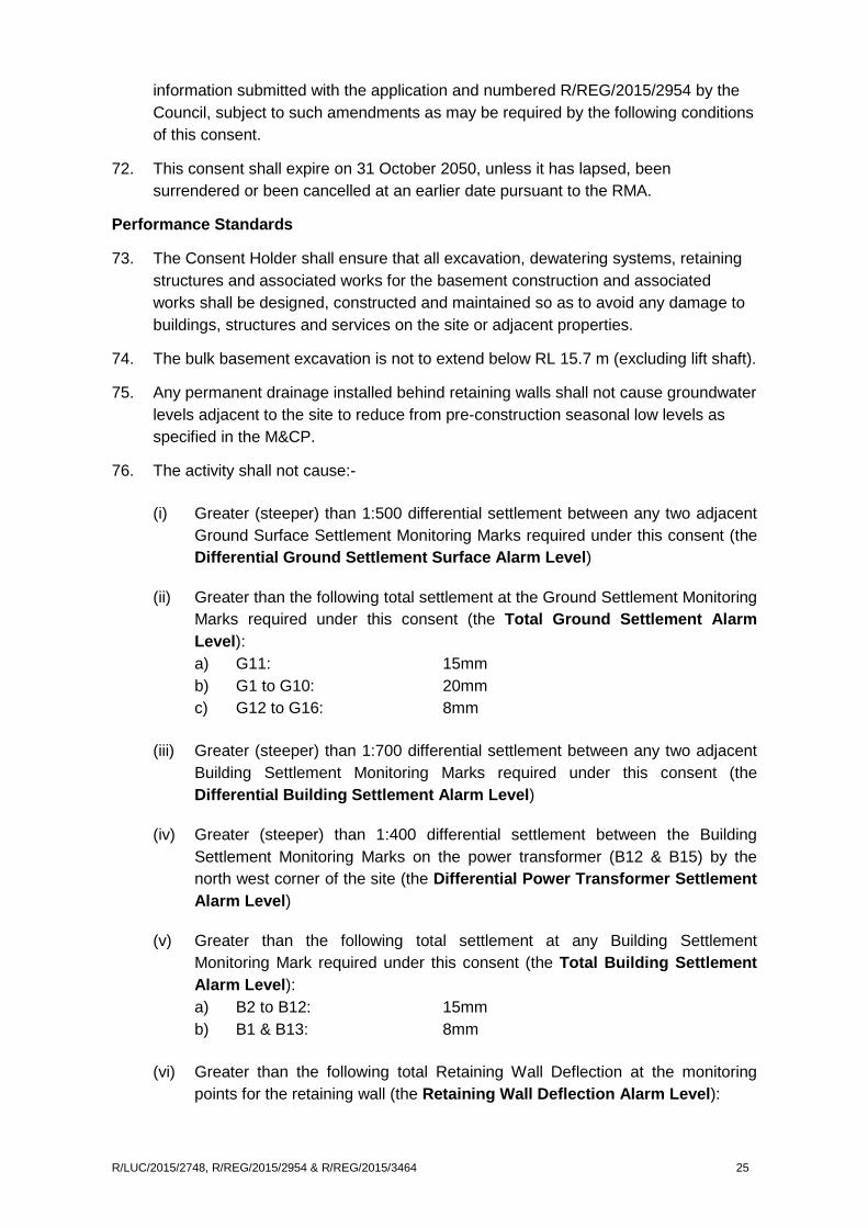
information submitted with the application and numbered R/REG/2015/2954 by the Council, subject to such amendments as may be required by the following conditions of this consent.
72. This consent shall expire on 31 October 2050, unless it has lapsed, been surrendered or been cancelled at an earlier date pursuant to the RMA.
Performance Standards
73. The Consent Holder shall ensure that all excavation, dewatering systems, retaining structures and associated works for the basement construction and associated works shall be designed, constructed and maintained so as to avoid any damage to buildings, structures and services on the site or adjacent properties.
74. The bulk basement excavation is not to extend below RL 15.7 m (excluding lift shaft).
75. Any permanent drainage installed behind retaining walls shall not cause groundwater levels adjacent to the site to reduce from pre-construction seasonal low levels as specified in the M&CP.
76. The activity shall not cause:-
(i) Greater (steeper) than 1:500 differential settlement between any two adjacent Ground Surface Settlement Monitoring Marks required under this consent (the Differential Ground Settlement Surface Alarm Level)
(ii) Greater than the following total settlement at the Ground Settlement Monitoring Marks required under this consent (the Total Ground Settlement Alarm Level): a) G11: 15mm b) G1 to G10: 20mm c) G12 to G16: 8mm
(iii) Greater (steeper) than 1:700 differential settlement between any two adjacent Building Settlement Monitoring Marks required under this consent (the Differential Building Settlement Alarm Level)
(iv) Greater (steeper) than 1:400 differential settlement between the Building Settlement Monitoring Marks on the power transformer (B12 & B15) by the north west corner of the site (the Differential Power Transformer Settlement Alarm Level)
(v) Greater than the following total settlement at any Building Settlement Monitoring Mark required under this consent (the Total Building Settlement Alarm Level): a) B2 to B12: 15mm b) B1 & B13: 8mm
(vi) Greater than the following total Retaining Wall Deflection at the monitoring points for the retaining wall (the Retaining Wall Deflection Alarm Level):
R/LUC/2015/2748, R/REG/2015/2954 & R/REG/2015/3464 25

a) W1, W3, & W6 to W8: 10mm b) W2, W4, & W5: 25mm
Groundwater and Settlement Monitoring and Contingency Plan (GSMCP)
77. At least 10 days prior to the Commencement of Dewatering, the Consent Holder shall prepare by a Chartered Professional Engineer and submit a Groundwater and Settlement Monitoring and Contingency Plan (GSMCP) to Council (Team Leader Water Allocation, NRSI) for approval. No bulk excavation and/or dewatering activity on the subject site shall commence until approval from Council is provided.
This Plan shall include the requirements of this resource consent, including but not limited to:-
i. An “as built” location plan, including all monitoring locations and monitoring bores based on approximate positions located on the plan entitled “Location Group Ltd, 70 Sale Street Auckland Central, Contingency and Monitoring Plan, Figure 2, Rev. 1, Project No. 31135, Tonkin & Taylor Ltd, October 2015”.
ii. Full details of the groundwater, ground surface, building and retaining wall deformation monitoring programme and condition surveys required by this consent including as-built details of monitoring wells (construction, geological log, reduced level, coordinates).
iii. Identification of any adjacent services susceptible to damage and details of any proposed pre and post construction monitoring or inspection.
iv. A bar chart, such as a Gantt chart, showing the timing and frequency of the condition surveys and monitoring required by this consent relative to the Commencement of Dewatering and the Completion of Dewatering.
v. Proposed groundwater Alert and Alarm Trigger Levels, including methodology for their determination. Groundwater Alert and Alarm Trigger Levels should also take into account seasonal variability.
vi. All Alert and Alarm Trigger levels for each Ground Surface, Building and Retaining Wall Deformation Mark as determined by conditions of consent, varied following building condition survey or as otherwise approved by the GSMCP.
vii. Details of the contingency measures to be implemented if Alert or Alarm Trigger Levels are exceeded, including a response plan.
viii. Reporting requirements.
a) The GSMCP may be varied, including frequency of monitoring, subject to the written approval of the Team Leader Water Allocation, NRSI.
b) The GSMCP once approved shall be implemented.
78. Where the consent holder is required to access property owned by a third party, (including buildings or structures) to undertake monitoring, construction of a bore, condition surveys or inspections and that access is declined or subject to what the Consent Holder considers to be unreasonable terms, the Consent Holder shall notify
R/LUC/2015/2748, R/REG/2015/2954 & R/REG/2015/3464 26

the Team Leader Water Allocation, NRSI, of that circumstance, and provide an alternative monitoring plan in accordance with Condition 77.
Monitoring
Groundwater
79. The proposed monitoring bores (BH1 and BH2) located approximately as shown on the annotated plan entitled “Location Group Ltd, 70 Sale Street Auckland Central, Contingency and Monitoring Plan, Figure 2, Rev 1, Project No. 31135, Tonkin & Taylor Ltd, October 2015” are to be installed to allow groundwater monitoring as specified in Schedule A of this consent. Alternative locations may be accepted subject to review and approval by the Team Leader Water Allocation, NRSI. The Team Leader Water Allocation, NRSI must be informed of any monitoring bore damaged or made inoperable immediately and a new monitoring bore, to the same depth and specification, is to be drilled at a nearby location.
Schedule A: Borehole Monitoring Frequency
Bore Name
Location Establishment Monitoring Frequency (to an accuracy of 10mm)
Easting (mE) est.
Northing (mN) est.
From bore construction to one month before Commencement of Dewatering
One month before Commencement of Dewatering to Completion of Dewatering
Completion of Dewatering to three months after Completion of Dewatering
BH1 & BH2
TBC TBC The hole should be drilled at least two months prior to the Commencement of Dewatering
Monthly Weekly1 Monthly2
1 If the water level readings vary significantly then further readings must be taken to obtain confidence (-/+ 200mm) in the groundwater level/trend prior to Commencement of Dewatering.
2 Subject to a consistent pattern of groundwater records having been obtained in this period in which no evidence of adverse effects is apparent. The monitoring period may be extended at the discretion of Team Leader Water Allocation, NRSI, where the records are not consistent.
80. The Provisional Groundwater Alert Trigger Level and Alarm Trigger Level will be set at 3.0m and 4.0m respectively below the seasonal low level or RL for the monitoring bores. The Monitoring and Contingency Plan when lodged and approved may amend provisional Alert and Alarm Trigger Levels.
Building Inspections
81. Prior to the commencement of perimeter piling adjacent to the buildings listed in Schedule B and/or Commencement of Dewatering, the Consent Holder shall employ a suitably qualified person (Chartered Professional Engineer or Chartered Building Surveyor) to undertake as a minimum an external condition survey or a detailed
R/LUC/2015/2748, R/REG/2015/2954 & R/REG/2015/3464 27

condition survey of buildings and structures as specified in Schedule B to confirm their existing condition, prior to the lodgement of the GSMCP. The survey shall include but not be limited to:
a) Any information about the type of foundations
b) Existing levels of damage considered to be of an aesthetic or superficial nature
c) Existing levels of damage considered to affect the serviceability or function of the building where visually apparent without recourse to intrusive or destructive investigation
d) A professional opinion as to whether observed damage may or may not be associated with actual structural damage
e) Susceptibility of structure to further movement
f) Photographic evidence of (b) and (c)
g) Review of the proposed Alert/Alarm Trigger Levels to confirm they are appropriately set and any ground settlement less than the Alarm Trigger Level will not cause damage, and whether the monitoring frequency and locations are adequate.
Schedule B: Building Inspection and Deformation Marks
Building Settlement Marks ID
Address Detailed Structural Condition Survey
Settlement Pins (Yes/No)
Legal Title
B1 to B6, B8 & B10 (8 marks)
68 Sale Street Yes Yes Lot 1 DP 74856
B7, B9, B11 to B13 (5 marks)
109 Cook Street Yes Yes Lot 1 DP 74856
B14 & B15 (2 marks)
Power Transformer, north west corner of 70 Sale Street
No Yes Legal Road (Sale Street)
82. The consent holder shall carry out a Visual Inspection of the surrounding ground and neighbouring buildings and structures (listed in Schedule B) to monitor any deterioration of existing damage or cracking. Inspections are to be carried out at least twice per week from the Commencement of Dewatering until completion of excavation and then at least weekly until Completion of Dewatering. A record is to be maintained of the time, date and any observations for each inspection and submitted to the Team Leader Water Allocation, NRSI, in accordance with Condition 97.
83. No earlier than 6 months after Completion of Dewatering and within 6 months of Completion of Construction, the consent holder must complete a post-construction condition survey as identified in Condition 81 of any building that had a pre-
R/LUC/2015/2748, R/REG/2015/2954 & R/REG/2015/3464 28

construction survey as identified in Condition 81. The condition survey report shall include a determination of the cause of damage identified (if any) since the pre-construction or previous survey. A copy of the survey shall be provided to the Team Leader Water Allocation, NRSI. The requirements of this condition need not be fulfilled for any particular building where the consent holder can provide written evidence to the Team Leader Water Allocation, NRSI, that the current owner of that building has agreed they do not require such a survey.
84. The consent holder shall, without delay, at the reasonable request of the Team Leader Water Allocation, NRSI, undertake an additional condition survey on any building (within the area defined by the extent of groundwater drawdown) for the purpose of checking for damage and for following up on a report of damage to that building. The requirement for any such condition survey will cease 6 months after the Completion of Construction unless the requirements of Condition 78 (1 above) have not been met and subject to a consistent pattern of deformation records having been obtained in this period in which no evidence of adverse effects is apparent.
Ground and Building Deformation Monitoring
85. Ground Surface and Building Deformation monitoring stations shall be established, maintained, monitored and reported as per Schedule C at the approximate locations shown on the annotated plan entitled “Location Group Ltd, 70 Sale Street Auckland Central, Contingency and Monitoring Plan, Figure 2, Rev 1, Project No. 31135, Tonkin & Taylor Ltd, October 2015” to record any vertical and horizontal movements. Benchmark positions shall be established no less than 50 metres away from the works.
Schedule C: Deformation Monitoring Survey
Location Pre-Excavation/ Baseline
Commencement of Dewatering to Completion of Dewatering
Post Completion of Dewatering
As shown on location plan 31135 Figure 2, Rev 2
Frequency Twice to a horizontal and vertical accuracy of +/-2mm achieved by precise levelling
At an average of each 2m depth of excavation and when changes to the propping system are being carried out, and at a minimum frequency of fortnightly intervals 1
Monthly for 6 months or for a shorter period if written approval is obtained from the Team Leader, Water Allocation, NRSI
Reporting Submitted to the Team Leader Water Allocation, NRSI, prior to the Commencement of Excavation
As per Condition 977 As per Condition 97
R/LUC/2015/2748, R/REG/2015/2954 & R/REG/2015/3464 29

1 The Consent Holder may request the Team Leader Water Allocation, NRSI, approval for this monitoring to be extended up to monthly periods, subject to the level of deformation that has occurred on site.
Retaining Wall Deformation Monitoring
86. The detailed design of the basement wall and any retention shall be undertaken in accordance with the recommendations contained in the reports entitled: “Geotechnical Assessment for Proposed Residential / Commercial Development, 70 Sale Street Auckland City, Ref. 4454, Argo Thomson Ltd, 6 July 2015” and “70 Sale Street, Auckland CBD, Geotechnical and Groundwater Investigation Report, Ref 31135, Tonkin & Taylor Ltd, September 2015”.
87. A minimum of 8 Retaining Wall Deformation pins shall be installed along the top of the pile walls as shown on “Location Group Ltd, 70 Sale Street Auckland Central, Contingency and Monitoring Plan, Figure 2, Rev. 1, Project No. 31135, Tonkin & Taylor Ltd, October 2015”. These monitoring pins will measure both vertical and lateral wall movement (combined settlement / deformation and displacement pins).
88. The consent holder shall survey, record and report the readings of each Retaining Wall Deformation Mark as per Schedule D below.
1 The consent holder may request the Team Leader Water Allocation, NRSI, approval for this monitoring to be extended up to fortnightly periods, subject to the level of deformation that has occurred on site.
Services Monitoring
89. The consent holder shall identify the adjacent services (including gas, water, sewerage, telecoms, stormwater fibre optics and power) and undertake a condition survey of the neighbouring services in consultation with the relevant service
Schedule D: Retaining Wall Deformation Monitoring (Measurement accuracy shall be to best practice)
Baseline: Prior to Commencement of Dewatering
Commencement of Dewatering to one month after Completion of Excavation
One month after Completion of Excavation to Completion of Dewatering
Retaining Wall pins Retaining Wall pins Retaining Wall pins
Frequency: All retaining wall marks
Twice to a horizontal and vertical accuracy of +/-2mm achieved by precise levelling
At an average of each 2 metres depth of excavation and when changes to the propping system are being carried out, and at a minimum frequency of weekly intervals.1
Monthly
Reporting Submitted to the Team Leader Water Allocation, NRSI, prior to the Commencement of Dewatering
As per Condition 97 As per Condition 97
R/LUC/2015/2748, R/REG/2015/2954 & R/REG/2015/3464 30

providers (water and sewer as a minimum) immediately adjacent to the site before the Commencement of Dewatering.
90. A condition survey of services immediately adjacent to the site must be completed by the Consent Holder no earlier than 6 months after Completion of Dewatering and no later than Completion of Construction to confirm in writing to the Team Leader Water Allocation, NRSI and the asset owner the results of the survey. The survey shall include a determination of the cause of any damage identified since the condition survey provided for in Condition 89. The post condition survey need not be completed where the consent holder has written evidence that a post condition survey was not required by the service provider.
Contingency
91. If any damage to buildings, structures or services is caused wholly or in part by the exercising of this consent, the consent holder shall:
i. Notify the Team Leader Water Allocation NRSI and the asset owner as soon as practical; and
ii. Engage a Chartered Professional Engineer to prepare a report as soon as practical describing the damage, ascertaining its cause, identifying methods to avoid, remedy and mitigate any damage caused and identify the potential for causing further damage. Provide a copy of the report to the Team Leader Water Allocation NRSI and the asset owner.
Alert and Alarm Level Notification
92. The Team Leader Water Allocation, NRSI, shall be notified within 24 hours should any of the following monitoring results eventuate:
i. Total Ground Surface Settlement exceeds the following (the Total Ground Surface Settlement Alert Level): a) G11: 10mm b) G1 to G10: 15mm c) G12 to G16: 5mm; or
ii. Groundwater levels drop below the Alert Level in monitoring bores and secondly if groundwater levels drop below the Alarm Level, due to the operation of dewatering the basement construction; or
iii. Total Building Settlement exceeds the following (the Building Settlement Alert Level): a) B2 to B12: 10mm b) B1 & B13: 5mm; or
iv. The differential settlement between any two Ground Surface Monitoring Marks exceeds 1:700 (The Differential Ground Surface Settlement Alert Level); or
v. The differential settlement between any two Building Settlement Monitoring Marks exceeds 1:1000 (The Differential Building Settlement Alert Level); or
R/LUC/2015/2748, R/REG/2015/2954 & R/REG/2015/3464 31
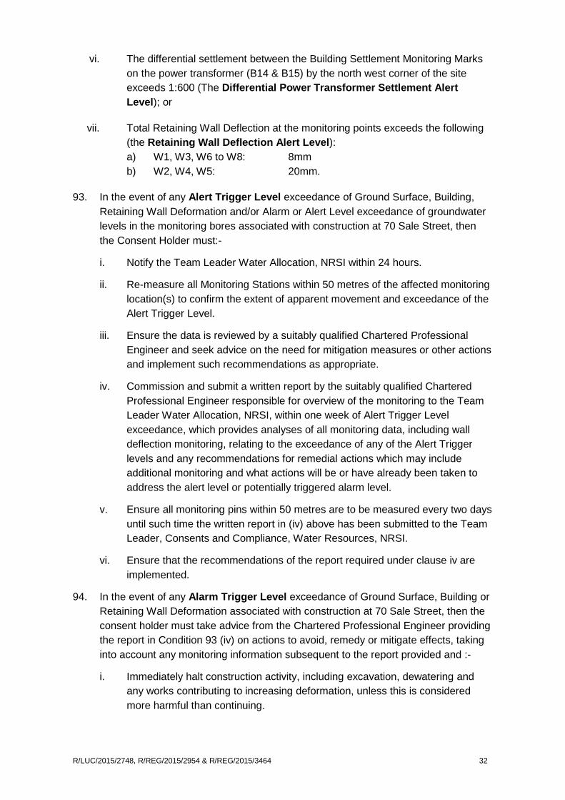
vi. The differential settlement between the Building Settlement Monitoring Marks on the power transformer (B14 & B15) by the north west corner of the site exceeds 1:600 (The Differential Power Transformer Settlement Alert Level); or
vii. Total Retaining Wall Deflection at the monitoring points exceeds the following (the Retaining Wall Deflection Alert Level): a) W1, W3, W6 to W8: 8mm b) W2, W4, W5: 20mm.
93. In the event of any Alert Trigger Level exceedance of Ground Surface, Building, Retaining Wall Deformation and/or Alarm or Alert Level exceedance of groundwater levels in the monitoring bores associated with construction at 70 Sale Street, then the Consent Holder must:-
i. Notify the Team Leader Water Allocation, NRSI within 24 hours.
ii. Re-measure all Monitoring Stations within 50 metres of the affected monitoring location(s) to confirm the extent of apparent movement and exceedance of the Alert Trigger Level.
iii. Ensure the data is reviewed by a suitably qualified Chartered Professional Engineer and seek advice on the need for mitigation measures or other actions and implement such recommendations as appropriate.
iv. Commission and submit a written report by the suitably qualified Chartered Professional Engineer responsible for overview of the monitoring to the Team Leader Water Allocation, NRSI, within one week of Alert Trigger Level exceedance, which provides analyses of all monitoring data, including wall deflection monitoring, relating to the exceedance of any of the Alert Trigger levels and any recommendations for remedial actions which may include additional monitoring and what actions will be or have already been taken to address the alert level or potentially triggered alarm level.
v. Ensure all monitoring pins within 50 metres are to be measured every two days until such time the written report in (iv) above has been submitted to the Team Leader, Consents and Compliance, Water Resources, NRSI.
vi. Ensure that the recommendations of the report required under clause iv are implemented.
94. In the event of any Alarm Trigger Level exceedance of Ground Surface, Building or Retaining Wall Deformation associated with construction at 70 Sale Street, then the consent holder must take advice from the Chartered Professional Engineer providing the report in Condition 93 (iv) on actions to avoid, remedy or mitigate effects, taking into account any monitoring information subsequent to the report provided and :-
i. Immediately halt construction activity, including excavation, dewatering and any works contributing to increasing deformation, unless this is considered more harmful than continuing.
R/LUC/2015/2748, R/REG/2015/2954 & R/REG/2015/3464 32

ii. Review construction activities which have the potential to cause deformation to minimise any further exceedance of triggers, investigate the causes, and allow for any mitigation to be instigated. Once the mitigation measures have been implemented and considered to be effective in avoiding further damage to the satisfaction of the Chartered Professional Engineer, then construction activities can recommence.
iii. Notify the Team Leader Water Allocation, NRSI, within 24 hours of the Alarm exceedance.
iv. Ensure that the results of mitigation measures and any remedial works and/or agreements with affected parties shall be reported to the Team Leader Water Allocation, NRSI, within one week of recommencement of works.
Reporting
95. The consent holder shall advise the Team Leader Water Allocation, NRSI, in writing at least 10 working days prior, of the date of the proposed Commencement of Dewatering.
96. The consent holder shall ensure that a copy of all building condition survey reports (required by this consent) be held on file by the consent holder and a copy forwarded to the Team Leader Water Allocation, NRSI, within 15 working days of completion of the survey.
97. All data collected as required by conditions of this consent from Commencement of Dewatering to completion of monitoring are to be compiled, compared with the relevant trigger levels and submitted to the Team Leader, Water Allocation, NRSI, at two monthly intervals, unless otherwise specified in this consent, setting out the previous results, providing an explanation for any trends and providing a construction progress timeline. All reports required by Conditions for consent R/REG/2015/3464 must identify if differential settlement Alert and Alarm Levels between any deformation monitoring marks were exceeded and if so provide an explanation and details of any remedial actions taken.
98. The consent holder, shall within 10 working days of completion of construction, advise the Team Leader Water Allocation, NRSI, in writing, of the date of completion.
Advice notes 1. Any reference to number of days within this decision refers to working days as
defined in s2 of the RMA.
2. For the purpose of compliance with the conditions of consent, “the council” refers to the council’s monitoring inspector unless otherwise specified. Please contact Team Leader – Central Monitoring on [email protected] to identify your allocated officer.
3. For more information on the resource consent process with Auckland Council see the council’s website www.aucklandcouncil.govt.nz. General information on resource consents, including making an application to vary or cancel consent
R/LUC/2015/2748, R/REG/2015/2954 & R/REG/2015/3464 33

conditions can be found on the Ministry for the Environment’s website: www.mfe.govt.nz.
4. If you disagree with any of the above conditions, or disagree with the additional charges relating to the processing of the application, you have a right of objection pursuant to sections 357A or 357B of the Resource Management Act 1991. Any objection must be made in writing to the council within 15 working days of notification of the decision.
5. The consent holder is responsible for obtaining all other necessary consents, permits, and licences, including those under the Building Act 2004, and the Heritage New Zealand Pouhere Taonga Act 2014. This consent does not remove the need to comply with all other applicable Acts (including the Property Law Act 2007 and the Health and Safety in Employment Act 1992), regulations, relevant Bylaws, and rules of law. This consent does not constitute building consent approval. Please check whether a building consent is required under the Building Act 2004.
6. Further private drainage upgrades and discharge points shall be addressed further with the building consent application. All details shale b to the satisfaction of Council on advice from Watercare.
7. The council acknowledges that the DCMP, DCNVMP and DCTMP (Management Plans) are intended to provide flexibility both for the consent holder and the council for the management of the development approved by this consent. Accordingly, the Management Plans may need to be reviewed over time. Any reviews should be in accordance with the stated objectives of the management plan and limited to the scope of this consent.
8. Certification of the DCMP, DCNVMP and DCTMP (Management Plans) by the council relates only to those aspects of the management plan that are relevant under the Resource Management Act 1991. The certification does not amount to an approval or acceptance of suitability by the council of any elements of the management plan that relate to other legislation, for example, but not limited to, the Building Act 2004, the Heritage New Zealand Pouhere Taonga Act 2014, or the Health and Safety in Employment Act 1992.
9. The consent holder will be responsible for ensuring all necessary permits, such as Corridor Access Requests (CAR) permits for the development approved by this consent, are obtained from Auckland Transport. See Auckland Transport’s website www.aucklandtransport.govt.nz for more information.
10. Should the residential units be proposed to be subdivided in the future, fire rating requirements of buildings will apply.
11. If any changes to traffic and parking controls on the road reserve are required, this will require Traffic Control Committee (TCC) resolutions. The resolutions, prepared by a qualified traffic engineer, will need to be passed so that the changes to the road reserve can be legally implemented and enforced. The resolution process may require public consultation to be undertaken in accordance with Auckland Transport’s standard procedures. It is the responsibility of the consent holder to
R/LUC/2015/2748, R/REG/2015/2954 & R/REG/2015/3464 34

prepare and submit a permanent Traffic and Parking Changes report to AT TCC for review and approval.
12. Vehicle crossing permits will need to be obtained prior to works commencing.
13. Where retaining or structure is proposed within the road reserve an encroachment license will be required from Auckland Transport, and for a license to be approved Encroachment guidelines will need to be met as per the Encroachment Policy: https://at.govt.nz/about-us/working-on-the-road/road-processes-for-property-owners/road-encroachment-licences-or-leases/.
Barry Kaye
Duty Commissioner
23 December 2015
R/LUC/2015/2748, R/REG/2015/2954 & R/REG/2015/3464 35