
S PRAWL REPAIR S MARTC ODE MODULE - Center …transect.org/docs/SPRAWL_REPAIR.pdf · 2016-09-28 ·...
15
S PRAWL R EPAIR S MART C ODE M ODULE _____________________________________________ “The polycentric reorganization of towns, i.e., the trans- formation of underdeveloped suburbs into autonomous urban quarters and villages, will be the impetus for a process of territorial transformation, internal growth, and the flowering of the suburbs”. Léon Krier, The Architecture of Community P REPARED BY D UANY P LATER -Z YBERK & C O .
Transcript of S PRAWL REPAIR S MARTC ODE MODULE - Center …transect.org/docs/SPRAWL_REPAIR.pdf · 2016-09-28 ·...

S P R A W L R E P A I RS M A R T C O D E M O D U L E
_____________________________________________
“The polycentric reorganization of towns, i.e., the trans-formation of underdeveloped suburbs into autonomous urban quarters and villages, will be the impetus for a process of territorial transformation, internal growth, and the fl owering of the suburbs”.
Léon Krier,The Architecture of Community
P R E PA R E D B Y D U A N Y P L AT E R -Z Y B E R K & C O .

SCA2
DRAF
T
Municipality
SM A RTCO D E MA N U A L VE R S I O N 9.2
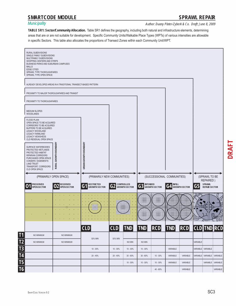
TABLE SR1: SECTOR/COMMUNITY ALLOCATIONTable SR1 should replace Table 2 in any calibration of the model SmartCode that guides the assigning of Sectors. This table defi nes the geography, including both natural and infrastructure elements, determining areas that are or are not suitable for development. Specifi c Community Units/Walkable Place Types (WPTs) of various intensities are allowable in specifi c Sectors. This table also allocates the proportions of Transect Zones within each Community Unit/WPT.The Community Units/WPTs for the G-4 Infi ll Growth Sector do not have allocation percentages because exist-ing conditions are the main determinant for the mapped T-zones. The same is true of the G-5 Sprawl Repair Sector, as exist-ing conditions will determine the T-zone allocations and thoroughfare connections necessary to transform Sprawl Types into Community Units/WPTs.See also “Outline of the Code” in the Introduction of the SmartCode Version 9 and Manual or SmartCode booklet, and Article 2 of the base code. If current versions do not yet include the G-5 Sector, it can be added during calibra-tion and would permit the Community Units/Walkable Place Types shown on Table SR1 and Table SR3 of this Module.
SPRAWL REPAIRAs a comprehensive ordinance, the SmartCode enables both new and infi ll urbanism in the form of Smart Growth neighborhood patterns. The code now identifi es a G-5 Sprawl Repair Sector, which is assigned to areas that are currently single-use, disconnected conventional develop-ment patterns but that have the potential to be completed or redeveloped in the pattern of CLD, Infi ll TND or Infi ll RCD. This Module has been created as a special “plug-in” to the SmartCode, which, when added to the base code, activates the tools and techniques for repair in areas designated G-5 on a Sector Plan, or the equivalent. These methods differ from those used to protect and complete areas assigned to the G-4 Sector, which already take the form of pre-war walkable transect-based tradtional neighborhoods.Instead, Sprawl Repair is a planning technique that restruc-tures and connects the autocentric patterns of suburbia into complete communities based upon a neighborhood unit that is currently missing. It is a method of re-urbanization, intensifi cation and diversifi cation that transforms single-use, auto-oriented, suburban agglomerations into balanced, mixed-use, walkable places, accommodating a diversity of income levels, building types, modes of transportation, and civic spaces. The G-5 Sprawl Repair Sector consists of individual or aggregate areas of the following Sprawl Types:• Rural Subdivisions• Single-family Subdivisions• Multi-family Subdivisions• Shopping Centers and Strips• Business Parks and Suburban Campuses• Malls• Edge Cities• Sprawl Type Thoroughfares• Sprawl Type Open Space Some of these areas will be up-zoned to accommodate higher but well-designed density, and justify the introduc-tion of mixed use and transit. This creates the regulatory basis for successional growth and the transformation of sprawl types into viable neighborhoods with more trans-portation and housing choices. The most important issue will be to allow a fl exibility of use within existing structures (houses becoming live-work units, big box retail becoming offi ce space or a civic building, etc.), as well as densifi ca-tion within existing parcels and lots (such as a mansion turned into multifamily units or an assisted living facility, or the addition of accessory units). Another important task is to calm and retrofi t dangerous thoroughfares so they are safe for walking and bicycling, while creating connections among residential areas, shops, workplaces, schools and other civic buildings, and recreation. All structural urban and zoning changes will be refl ected in specifi c Regulating Plans.
SMARTCODE ANNOTATED These annotations are advisory only. The SmartCode itself appears only on the right side of each spread.
SMARTCODE MODULEMunicipality
SC3SM A RTCO D E VE R S I O N 9.2
DRAF
T
Author: Duany Plater-Zyberk & Co. Draft: June 8, 2009
SPRAWL REPAIR
TABLE SR1: Sector/Community Allocation. Table SR1 defi nes the geography, including both natural and infrastructure elements, determining areas that are or are not suitable for development. Specifi c Community Units/Walkable Place Types (WPTs) of various intensities are allowable in specifi c Sectors. This table also allocates the proportions of Transect Zones within each Community Unit/WPT.
RURAL SUBDIVISIONSSINGLE FAMILY SUBDIVISIONSMULTIFAMILY SUBDIVISIONSSHOPPING CENTERS AND STRIPSBUSINESS PARKS AND SUBURBAN CAMPUSES MALLSEDGE CITIESSPRAWL TYPE THOROUGHFARESSPRAWL TYPE OPEN SPACE
ALREADY DEVELOPED AREAS IN A TRADITIONAL TRANSECT-BASED PATTERN
PROXIMITY TO MAJOR THOROUGHFARES AND TRANSIT
PROXIMITY TO THOROUGHFARES
MEDIUM SLOPESWOODLANDS
FLOOD PLAINOPEN SPACE TO BE ACQUIREDCORRIDORS TO BE ACQUIREDBUFFERS TO BE ACQUIREDLEGACY WOODLANDLEGACY FARMLANDLEGACY VIEWSHEDSCLD RESIDUAL OPEN SPACE
RURA
L GR
OWTH
BOU
NDAR
Y
URBA
N GR
OWTH
BOU
NDAR
Y
SURFACE WATERBODIESPROTECTED WETLANDSPROTECTED HABITATRIPARIAN CORRIDORSPURCHASED OPEN SPACECONSERV. EASEMENTSLAND TRUSTTRANSPORT. CORRIDORSCLD OPEN SPACE
◄ ----------------------------------------------------------------------------------------------------------------------------------------------------------------------------------------------------------------------------------------------------------------------------------------------------------------------------------------------------------------------- ►◄ ------------------------------------------------------------------------------------------------------------------------------------------------------------------------------------------------------------------------------------------------------------------------------------------------------------------------------------------------------------------------ ►◄------------------------------------------------------------------------------------------------------------------------------------------------------------------------------------------- ►◄------------------------------------------------------------------------------------------►(PRIMARILY OPEN SPACE) (PRIMARILY NEW COMMUNITIES) (SUCCESSIONAL COMMUNITIES) (SPRAWL TO BE
REPAIRED )
O1 PRESERVEDOPEN SECTOR O2 RESERVED
OPEN SECTOR G1 RESTRICTEDGROWTH SECTOR G2 CONTROLLED
GROWTH SECTOR G3 INTENDEDGROWTH SECTOR G4 INFILL
GROWTH SECTOR G5
SPRAWL REPAIR SECTOR
CLD CLD TND TND RCD TND RCD CLD TND RCDT1 NO MINIMUM NO MINIMUM
50% MIN 50% MIN
T2 NO MINIMUM NO MINIMUM NO MIN NO MIN VARIABLE
T3 10 - 30% 10 - 30% 10 - 30% 10 - 30% VARIABLE VARIABLE VARIABLE
T4 20 - 40% 20 - 40% 30 - 60% 30 - 60% 10 - 30% VARIABLE VARIABLE VARIABLE VARIABLE VARIABLE
T5 10 - 30% 10 - 30% 10 - 30% VARIABLE VARIABLE VARIABLE VARIABLE
T6 40 - 80% VARIABLE VARIABLE
SCA4
DRAF
T
Municipality
SM A RTCO D E MA N U A L VE R S I O N 9.2
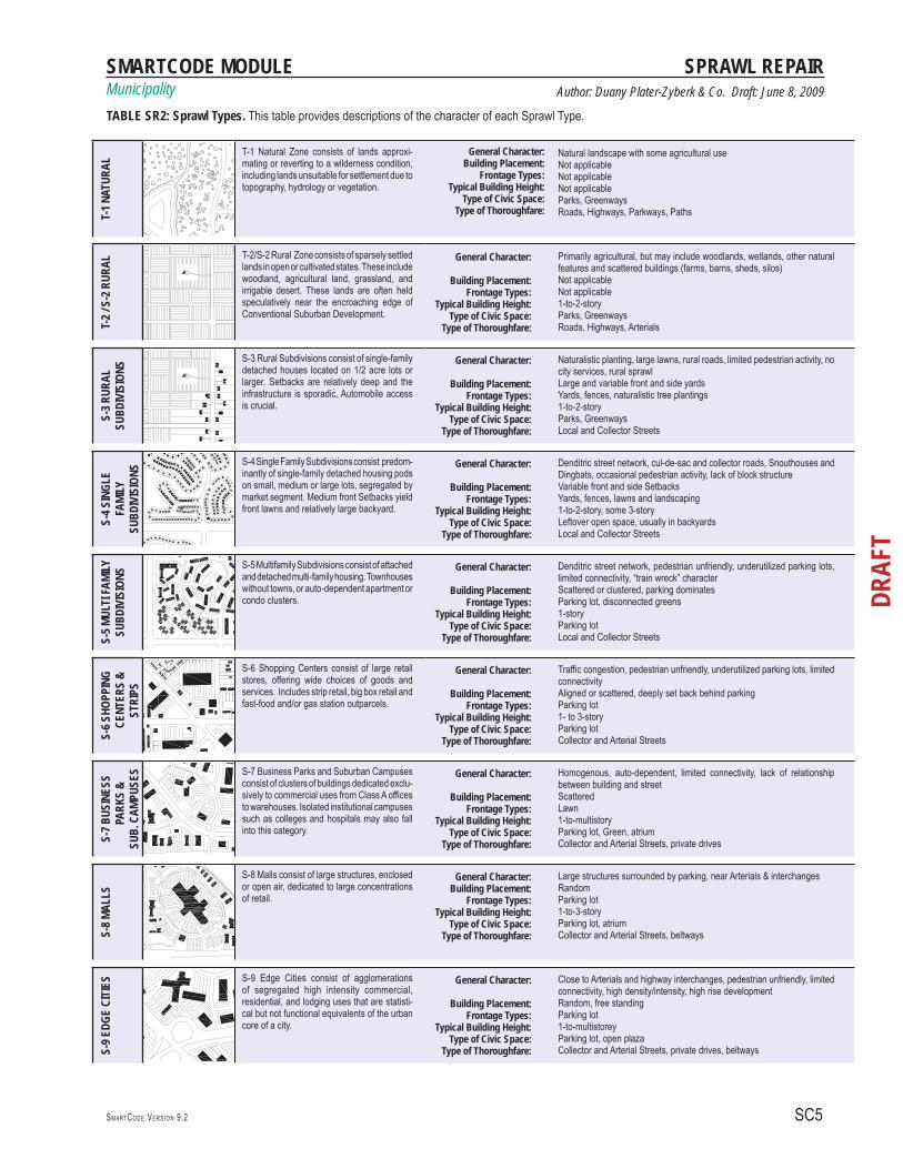
TABLE SR2: SPRAWL TYPES - CONVENTIONAL SUBURBAN DEVELOPMENT (CSD)This table provides descriptions of the character of each Sprawl Type in a manner similar to the descriptions of the T-zones in the SmartCode. The essential difference is that each urban T-zone represents a range of building types in a complex habitat, while each Sprawl Type is a single-use agglomeration, usually a monoculture of a single building type. The T-1 Natural and T-2 Rural Zone are the same as in the SmartCode Transect, but the T-2 Rural is dubbed S-2 Rural within the G-5 Sector, as in some cases these lands are held speculatively near the encroaching edge of conventional suburban development (CSD).
SMARTCODE ANNOTATED These annotations are advisory only. The SmartCode itself appears only on the right side of each spread.
SMARTCODE MODULEMunicipality
SC5SM A RTCO D E VE R S I O N 9.2
DRAF
T
Author: Duany Plater-Zyberk & Co. Draft: June 8, 2009
SPRAWL REPAIRT-
1 NAT
URAL
T-1 Natural Zone consists of lands approxi-mating or reverting to a wilderness condition, including lands unsuitable for settlement due to topography, hydrology or vegetation.
General Character: Building Placement:
Frontage Types: Typical Building Height:
Type of Civic Space: Type of Thoroughfare:
Natural landscape with some agricultural useNot applicable Not applicable Not applicable Parks, GreenwaysRoads, Highways, Parkways, Paths
T-2 /
S-2
RUR
AL
T-2/S-2 Rural Zone consists of sparsely settled lands in open or cultivated states. These include woodland, agricultural land, grassland, and irrigable desert. These lands are often held speculatively near the encroaching edge of Conventional Suburban Development.
General Character:
Building Placement: Frontage Types:
Typical Building Height: Type of Civic Space:
Type of Thoroughfare:
Primarily agricultural, but may include woodlands, wetlands, other natural features and scattered buildings (farms, barns, sheds, silos)Not applicable Not applicable1-to-2-storyParks, GreenwaysRoads, Highways, Arterials
S-3 R
URAL
SU
BDIV
ISIO
NS
S-3 Rural Subdivisions consist of single-family detached houses located on 1/2 acre lots or larger. Setbacks are relatively deep and the infrastructure is sporadic. Automobile access is crucial.
General Character:
Building Placement: Frontage Types:
Typical Building Height: Type of Civic Space:
Type of Thoroughfare:
Naturalistic planting, large lawns, rural roads, limited pedestrian activity, no city services, rural sprawlLarge and variable front and side yardsYards, fences, naturalistic tree plantings1-to-2-storyParks, GreenwaysLocal and Collector Streets
S-4 S
INGL
E FA
MILY
SUBD
IVIS
IONS
S-4 Single Family Subdivisions consist predom-inantly of single-family detached housing pods on small, medium or large lots, segregated by market segment. Medium front Setbacks yield front lawns and relatively large backyard.
General Character:
Building Placement: Frontage Types:
Typical Building Height: Type of Civic Space:
Type of Thoroughfare:
Denditric street network, cul-de-sac and collector roads, Snouthouses and Dingbats, occasional pedestrian activity, lack of block structureVariable front and side SetbacksYards, fences, lawns and landscaping1-to-2-story, some 3-storyLeftover open space, usually in backyardsLocal and Collector Streets
S-5 M
ULTI
FAMI
LYSU
BDIV
ISIO
NS
S-5 Multifamily Subdivisions consist of attached and detached multi-family housing. Townhouses without towns, or auto-dependent apartment or condo clusters.
General Character:
Building Placement: Frontage Types:
Typical Building Height: Type of Civic Space:
Type of Thoroughfare:
Denditric street network, pedestrian unfriendly, underutilized parking lots, limited connectivity, “train wreck” characterScattered or clustered, parking dominatesParking lot, disconnected greens1-storyParking lotLocal and Collector Streets
S-6 S
HOPP
ING
CENT
ERS
& ST
RIPS
S-6 Shopping Centers consist of large retail stores, offering wide choices of goods and services. Includes strip retail, big box retail and fast-food and/or gas station outparcels.
General Character:
Building Placement: Frontage Types:
Typical Building Height: Type of Civic Space:
Type of Thoroughfare:
Traffic congestion, pedestrian unfriendly, underutilized parking lots, limited connectivityAligned or scattered, deeply set back behind parkingParking lot1- to 3-storyParking lotCollector and Arterial Streets
S-7 B
USIN
ESS
PARK
S &
SUB.
CAM
PUSE
S S-7 Business Parks and Suburban Campuses consist of clusters of buildings dedicated exclu-sively to commercial uses from Class A offices to warehouses. Isolated institutional campuses such as colleges and hospitals may also fall into this category.
General Character:
Building Placement: Frontage Types:
Typical Building Height: Type of Civic Space:
Type of Thoroughfare:
Homogenous, auto-dependent, limited connectivity, lack of relationship between building and streetScatteredLawn1-to-multistory Parking lot, Green, atriumCollector and Arterial Streets, private drives
S-8 M
ALLS
S-8 Malls consist of large structures, enclosed or open air, dedicated to large concentrations of retail.
General Character: Building Placement:
Frontage Types: Typical Building Height:
Type of Civic Space:Type of Thoroughfare:
Large structures surrounded by parking, near Arterials & interchangesRandomParking lot1-to-3-story Parking lot, atriumCollector and Arterial Streets, beltways
S-9 E
DGE
CITI
ES S-9 Edge Cities consist of agglomerations
of segregated high intensity commercial, residential, and lodging uses that are statisti-cal but not functional equivalents of the urban core of a city.
General Character:
Building Placement: Frontage Types:
Typical Building Height: Type of Civic Space:
Type of Thoroughfare:
Close to Arterials and highway interchanges, pedestrian unfriendly, limited connectivity, high density/intensity, high rise development Random, free standingParking lot 1-to-multistorey Parking lot, open plazaCollector and Arterial Streets, private drives, beltways
TABLE SR2: Sprawl Types. This table provides descriptions of the character of each Sprawl Type.

SCA6
DRAF
T
Municipality
SM A RTCO D E MA N U A L VE R S I O N 9.2
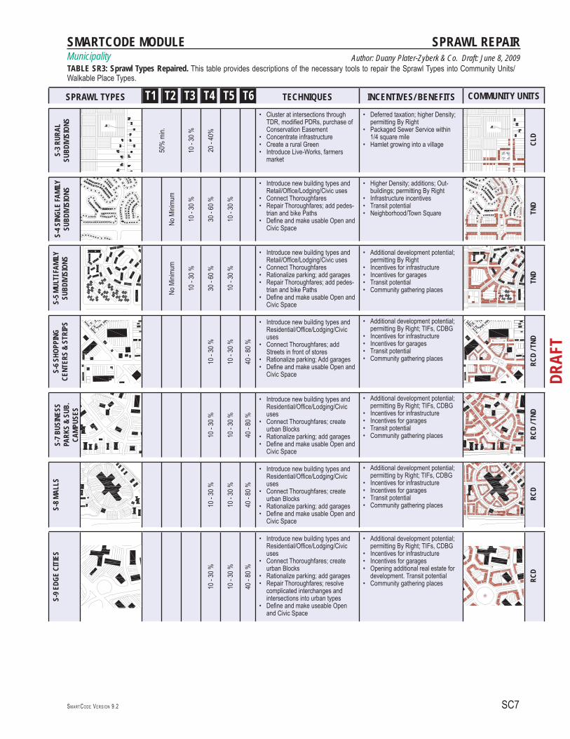
TABLE SR3: SPRAWL TYPES REPAIRED TOCOMMUNITY UNITS / WALKABLE PLACE TYPESThe Sprawl Types cannot be repaired in isolation as sepa-rate elements, but always in the context of Community Units/Walkable Place Types (WPTs). Single-use and typo-logically monocultural areas need to be balanced by other required types and uses in order to form the full range of T-zones appropriate to Community Units/WPTs.The translations on this table are not necessarily one-to-one correspondences. They indicate the Transect Zones that either help complete the Sprawl Type or would (along with the Sprawl Type) comprise the Community Units/WPTs listed at right, depending on scale. For the form of Community Units, see Article 2, Article 3 and Article 4. For the form of Transect Zone elements, see Article 5.
SMARTCODE ANNOTATED These annotations are advisory only. The SmartCode itself appears only on the right side of each spread.
SMARTCODE MODULEMunicipality
SC7SM A RTCO D E VE R S I O N 9.2
DRAF
T
Author: Duany Plater-Zyberk & Co. Draft: June 8, 2009
SPRAWL REPAIR
SPRAWL TYPES T1 T2 T3 T4 T5 T6 TECHNIQUES INCENTIVES/ BENEFITS COMMUNITY UNITS
S-3 R
URAL
SU
BDIV
ISIO
NS
50%
min.
10 -
30 %
20 -
40%
Cluster at intersections through • TDR, modifi ed PDRs, purchase of Conservation EasementConcentrate infrastructure• Create a rural Green• Introduce Live-Works, farmers • market
Deferred taxation; higher Density; • permitting By RightPackaged Sewer Service within • 1/4 square mileHamlet growing into a village• CL
D
S-4 S
INGL
E FA
MILY
SUBD
IVIS
IONS
No M
inimu
m
10 -
30 %
30 -
60 %
10 -
30 %
Introduce new building types and • Retail/Offi ce/Lodging/Civic usesConnect Thoroughfares• Repair Thoroughfares; add pedes-• trian and bike PathsDefi ne and make usable Open and • Civic Space
Higher Density; additions; Out-• buildings; permitting By RightInfrastructure incentives• Transit potential• Neighborhood/Town Square• TN
D
S-5 M
ULTI
FAMI
LYSU
BDIV
ISIO
NS
No M
inimu
m
10 -
30 %
30 -
60 %
10 -
30 %
Introduce new building types and • Retail/Offi ce/Lodging/Civic usesConnect Thoroughfares• Rationalize parking; add garages• Repair Thoroughfares; add pedes-• trian and bike PathsDefi ne and make usable Open and • Civic Space
Additional development potential; • permitting By RightIncentives for infrastructure• Incentives for garages• Transit potential• Community gathering places•
TND
S-6 S
HOPP
ING
CENT
ERS
& ST
RIPS
10 -
30 %
10 -
30 %
40 -
80 %
Introduce new building types and • Residential/Offi ce/Lodging/Civic usesConnect Thoroughfares; add • Streets in front of storesRationalize parking; Add garages• Defi ne and make usable Open and • Civic Space
Additional development potential; • permitting By Right; TIFs, CDBGIncentives for infrastructure• Incentives for garages• Transit potential• Community gathering places•
RCD
/ TND
S-7 B
USIN
ESS
PARK
S &
SUB.
CA
MPUS
ES
10 -
30 %
10 -
30 %
40 -
80 %
Introduce new building types and • Residential/Offi ce/Lodging/Civic usesConnect Thoroughfares; create • urban BlocksRationalize parking; add garages• Defi ne and make usable Open and • Civic Space
Additional development potential; • permitting By Right; TIFs, CDBGIncentives for infrastructure• Incentives for garages• Transit potential• Community gathering places• RC
D / T
ND
S-8 M
ALLS
10 -
30 %
10 -
30 %
40 -
80 %
Introduce new building types and • Residential/Offi ce/Lodging/Civic usesConnect Thoroughfares; create • urban BlocksRationalize parking; add garages• Defi ne and make usable Open and • Civic Space
Additional development potential; • permitting by Right; TIFs, CDBGIncentives for infrastructure• Incentives for garages• Transit potential• Community gathering places•
RCD
S-9 E
DGE
CITI
ES
10 -
30 %
10 -
30 %
40 -
80 %
Introduce new building types and • Residential/Offi ce/Lodging/Civic usesConnect Thoroughfares; create • urban BlocksRationalize parking; add garages• Repair Thoroughfares; resolve • complicated interchanges and intersections into urban typesDefi ne and make useable Open • and Civic Space
Additional development potential; • permitting By Right; TIFs, CDBGIncentives for infrastructure• Incentives for garages• Opening additional real estate for • development. Transit potentialCommunity gathering places• RC
D
TABLE SR3: Sprawl Types Repaired. This table provides descriptions of the necessary tools to repair the Sprawl Types into Community Units/ Walkable Place Types.

SCA8
DRAF
T
Municipality
SM A RTCO D E MA N U A L VE R S I O N 9.2
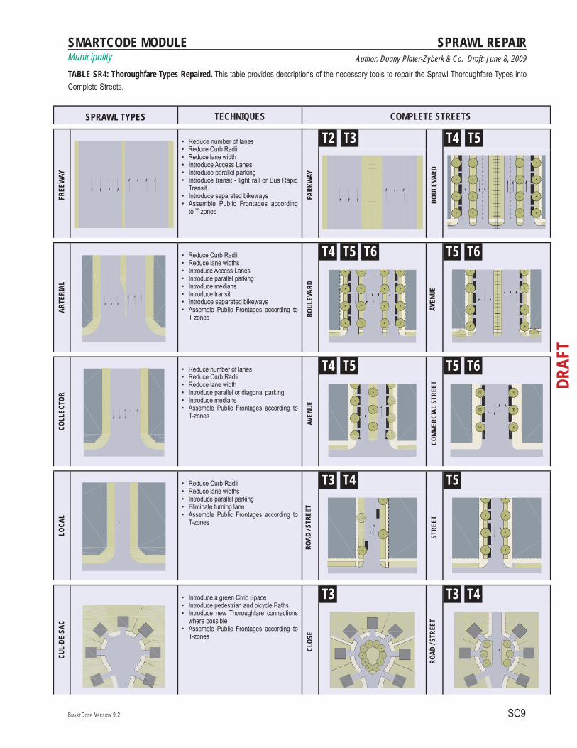
TABLE SR4: SPRAWL THOROUGHFARE TYPESREPAIRED TO COMPLETE STREETS The repair of thoroughfares is a necessary step in the overall retrofi t strategy. The post-war suburban system of thoroughfares is simplistic and dendritic, covering a very limited and over-engineered palette of types. These include: the Highway, the Arterial, the Collector, the Local and the Cul-de-sac. Table SR4 shows typical techniques for retrofi tting basic suburban thoroughfare types designed only for fast and effi cient movement of cars and maximum capacity, into Complete Streets of multi-modal use, achieving public spaces of specifi c character. The shown vehicular lane and parking assemblies are illus-trative only. Existing suburban thoroughfares need to be repaired and calibrated locally according to the principles of context sensitive design. (See the ITE/CNU Manual.)In addition, their public frontages should be assembled along the Transect continuum and according to the needs of local communities. The limited range of suburban types will be expanded to a full assortment of Complete Streets, from very rural types to very urban ones. For Vehicular Lane Dimensions and Target Speeds, see Table 3A & Table 3B. For Public Frontages and Thoroughfare Assemblies, see Table 4 A, Table 4B and Module Tables 4C. For rec-ommendations with regard to bicycle accommodations, see the Bicycle SmartCode Module.
SMARTCODE ANNOTATED These annotations are advisory only. The SmartCode itself appears only on the right side of each spread.
SMARTCODE MODULEMunicipality
SC9SM A RTCO D E VE R S I O N 9.2
DRAF
T
Author: Duany Plater-Zyberk & Co. Draft: June 8, 2009
SPRAWL REPAIR
SPRAWL TYPES TECHNIQUES COMPLETE STREETS
FREE
WAY
Reduce number of lanes• Reduce Curb Radii• Reduce lane width• Introduce Access Lanes• Introduce parallel parking• Introduce transit - light rail or Bus Rapid • TransitIntroduce separated bikeways• Assemble Public Frontages according • to T-zones
PARK
WAY
T2 T3
BOUL
EVAR
D
T4 T5
ARTE
RIAL
Reduce Curb Radii• Reduce lane widths• Introduce Access Lanes • Introduce parallel parking• Introduce medians• Introduce transit• Introduce separated bikeways• Assemble Public Frontages according to • T-zones BO
ULEV
ARD
T4 T5 T6
AVEN
UE
T5 T6
COLL
ECTO
R
Reduce number of lanes• Reduce Curb Radii • Reduce lane width• Introduce parallel or diagonal parking• Introduce medians• Assemble Public Frontages according to • T-zones
AVEN
UE
T4 T5
COMM
ERCI
AL S
TREE
T
T5 T6
LOCA
L
Reduce Curb Radii• Reduce lane widths• Introduce parallel parking• Eliminate turning lane• Assemble Public Frontages according to • T-zones
ROAD
/ STR
EET
T3 T4
STRE
ET
T5
CUL-
DE-S
AC
Introduce a green Civic Space• Introduce pedestrian and bicycle Paths• Introduce new Thoroughfare connections • where possibleAssemble Public Frontages according to • T-zones
CLOS
E
T3
ROAD
/ STR
EET
T3 T4
TABLE SR4: Thoroughfare Types Repaired. This table provides descriptions of the necessary tools to repair the Sprawl Thoroughfare Types into Complete Streets.

SCA10
DRAF
T
Municipality
SM A RTCO D E MA N U A L VE R S I O N 9.2
TABLE SR5: SPRAWL INTERSECTION TYPES REPAIRED TO COMPLETE INTERSECTIONS The repair of suburban intersections will be effective when combined with the simultaneous repair of the corresponding thoroughfares. The goal is to liberate substantial areas of real estate, which currently are misallocated to the single function of handling fast-moving vehicular traffi c. In a varied urban environment, intersections can become important landmark opportunities as well as traffi c calm-ing devices. Without stopping the fl ow of traffi c, a variety of devices can be used to slow it down, which will be benefi cial to pedestrians and bicyclists and even to driv-ers and their passengers, as car accidents will be reduced.Such devices include traffi c circles, roundabouts, change of paving, tightened geometries, and so forth.
Table SR5 shows typical techniques for retrofi tting basic suburban intersection types, designed only for fast and effi cient movement of cars and maximum capacity, into Complete Intersections of multi-modal use, achieving public spaces of specifi c character. The shown vehicular lane and parking assemblies are illustrative only. Existing suburban intersections should be repaired and calibrated locally according to the principles of context sensitive design. In addition, the public front-ages should be assembled along the Transect continuum and according to the needs of local communities. The limited range of suburban types will be expanded to the full assortment of Complete Intersections, from very rural types to very urban ones.
SMARTCODE ANNOTATED These annotations are advisory only. The SmartCode itself appears only on the right side of each spread.

SMARTCODE MODULEMunicipality
SC11SM A RTCO D E VE R S I O N 9.2
DRAF
T
Author: Duany Plater-Zyberk & Co. Draft: June 8, 2009
SPRAWL REPAIR
TABLE SR5: Sprawl Intersection Types. This table provides descriptions of the necessary tools to repair the Sprawl Intersection Types into Com-plete Intersections.
SPRAWL TYPES TECHNIQUES COMPLETE INTERSECTIONS
FREE
WAY
Replace Cloverleaf with a Parkway • Roundabout or Urban IntersectionReduce Curb Radii• Reduce lane widths• Assemble Public Frontages according • to T-zones
BOUL
EVAR
D
T4 T5
PARK
WAY
ROU
NDAB
OUT
T5 T6
ARTE
RIAL
Replace conventional suburban inter-• section with Urban IntersectionReduce lane widths • Introduce Access Lanes • Introduce medians• Introduce parallel parking• Introduce transit• Assemble Public Frontages according • to T-zones
BOUL
EVAR
D / A
VENU
E
T4 T5
BOUL
EVAR
D W
ITH
TRAN
SIT
T5 T6
COLL
ECTO
R
Reduce number of lanes• Reduce Curb Radii• Introduce a median• Introduce parallel parking • Assemble Public Frontages according • to T-zones
AVEN
UE / C
OMME
RCIA
L ST
REET
T4 T5
AVEN
UE / C
OMME
RCIA
L ST
REET
T5 T6
LOCA
L
Reduce Curb Radii• Reduce lane widths• Introduce parallel parking • Assemble Public Frontages according • to T-zones
ROAD
/ STR
EET
T3 T4
STRE
ET
T4 T5

SCA12
DRAF
T
Municipality
SM A RTCO D E MA N U A L VE R S I O N 9.2
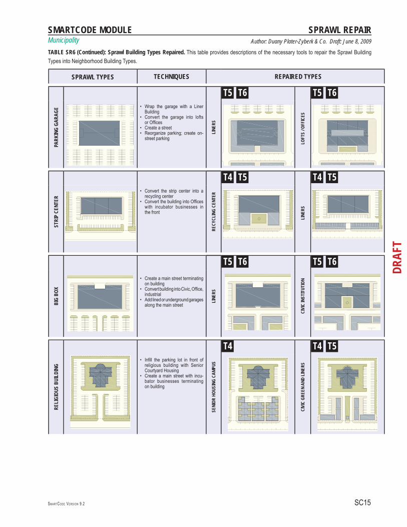
TABLE SR6: SPRAWL BUILDING TYPES REPAIRED INTO NEIGHBORHOOD BUILDING TYPESThe repair of Sprawl Building Types shows techniques for transforming smaller single-use areas and even single structures to prepare them to become part of a future urban fabric within the Transect context. Some building types lend themselves to repair and retrofi t, while others are very diffi cult to modify or not worth the expense; those may require either masking with liners or selective demolition. Repair strategies shown in Table SR6 include: the trans-formation of the ubiquitous McMansions into senior housing, student housing, or apartments; small scale infi ll for individual homeowners using their oversized front and back yards for expansions, family-run businesses or rental outbuildings; drive-through building retrofi t; gas station reversal; liner buildings of parking lots and structures; conversion of parking garages into lofts or offi ce build-ings; big box redevelopment into recycling centers; infi ll of a religious institution’s parking lot with senior housing, and others.To allow some of the retrofi tted types in the T-3 Zone, calibrators must change Table 10 General Function and Table 12 Specifi c Use, and possibly Table 9 Building Disposition. Alternatively, the area may be zoned T-4, but setbacks, lot widths, frontage buildout, etc. may have to be adjusted on Table 14 and Table 15B. A sub-zone should also be considered.
SMARTCODE ANNOTATED These annotations are advisory only. The SmartCode itself appears only on the right side of each spread.

SMARTCODE MODULEMunicipality
SC13SM A RTCO D E VE R S I O N 9.2
DRAF
T
Author: Duany Plater-Zyberk & Co. Draft: June 8, 2009
SPRAWL REPAIR
TABLE SR6: Sprawl Building Types Repaired. This table provides descriptions of the necessary tools to repair the Sprawl Building Types into Neighborhood Building Types.
SPRAWL BUILDING TYPES TECHNIQUES REPAIRED BUILDING TYPES
MCMA
NSIO
N
Subdivide mansion into multiple • bedroomsDesign a common living/ dining/ enter-• tainment areaSubdivide mansion into three or more • fl ats Organize parking behind the building•
SENI
OR /
STUD
ENT
HOUS
ING
T3 T4
APAR
TMEN
TS
T3 T4
FRON
T-LO
ADED
HOU
SE Subdivide the Lot into a duplex• Add to the house in the front Setback, • creating Live-Work, garage, family room, bedroom, etc.
DUPL
EX
T3 T4
LIVE
-WOR
K
T3 T4
DRIV
E-TH
RU
Add liners in front of building to create a • main street Keep drive-thru• Replace buildings with perimeter block•
LINE
RS / M
AIN
STRE
ET
T4 T5
NEIG
HBOR
HOOD
STO
RES
T5
GAS
STAT
ION
Keep gas station and pumps and build a • corner store at the intersectionEliminate gas station; keep the pumps and • increase them, plus build a corner store on both sides of intersection
CORN
ER S
TORE
T4
CORN
ER S
TORE
S
T4 T5
T6
SCA14
DRAF
T
Municipality
SM A RTCO D E MA N U A L VE R S I O N 9.2
TABLE SR6 (CONTINUED): SPRAWL BUILDING TYPES REPAIREDINTO COMMUNITY BUILDING TYPES(See previous page)
SMARTCODE ANNOTATED These annotations are advisory only. The SmartCode itself appears only on the right side of each spread.
SMARTCODE MODULEMunicipality
SC15SM A RTCO D E VE R S I O N 9.2
DRAF
T
Author: Duany Plater-Zyberk & Co. Draft: June 8, 2009
SPRAWL REPAIR
SPRAWL TYPES TECHNIQUES REPAIRED TYPES
PARK
ING
GARA
GE
Wrap the garage with a Liner • BuildingConvert the garage into lofts • or Offi cesCreate a street• Reorganize parking; create on-• street parking
LINE
RS
T5 T6
LOFT
S / O
FFIC
ES
T5 T6
STRI
P CE
NTER
Convert the strip center into a • recycling centerConvert the building into Offi ces • with incubator businesses in the front
RECY
CLIN
G CE
NTER
T4 T5
LINE
RS
T4 T5
BIG
BOX
Create a main street terminating • on buildingConvert building into Civic, Offi ce, • industrialAdd lined or underground garages • along the main street
LINE
RS
T5 T6
CIVI
C IN
STIT
UTIO
N
T5 T6
RELI
GIOU
S BU
ILDI
NG Infi ll the parking lot in front of •
religious building with Senior Courtyard HousingCreate a main street with incu-• bator businesses terminating on building
SENI
OR H
OUSI
NG C
AMPU
S
T4
CIVI
C GR
EEN
AND
LINE
RS
T4 T5
TABLE SR6 (Continued): Sprawl Building Types Repaired. This table provides descriptions of the necessary tools to repair the Sprawl Building Types into Neighborhood Building Types.


![NOTES - Welcome to D-Scholarship@Pitt - D-Scholarship@Pittd-scholarship.pitt.edu/17953/1/77-153-1-SM.pdf · 2007] DIVIDE AND SPRAWL: EUCLIDEAN ZONING 917 8. Andres Duany & Emily Talen,](https://static.fdocuments.us/doc/165x107/60455bd728f81b2bc5101971/notes-welcome-to-d-scholarshippitt-d-scholarshippittd-2007-divide-and-sprawl.jpg)


