S ðL - Great Barrier Reef Marine...
1
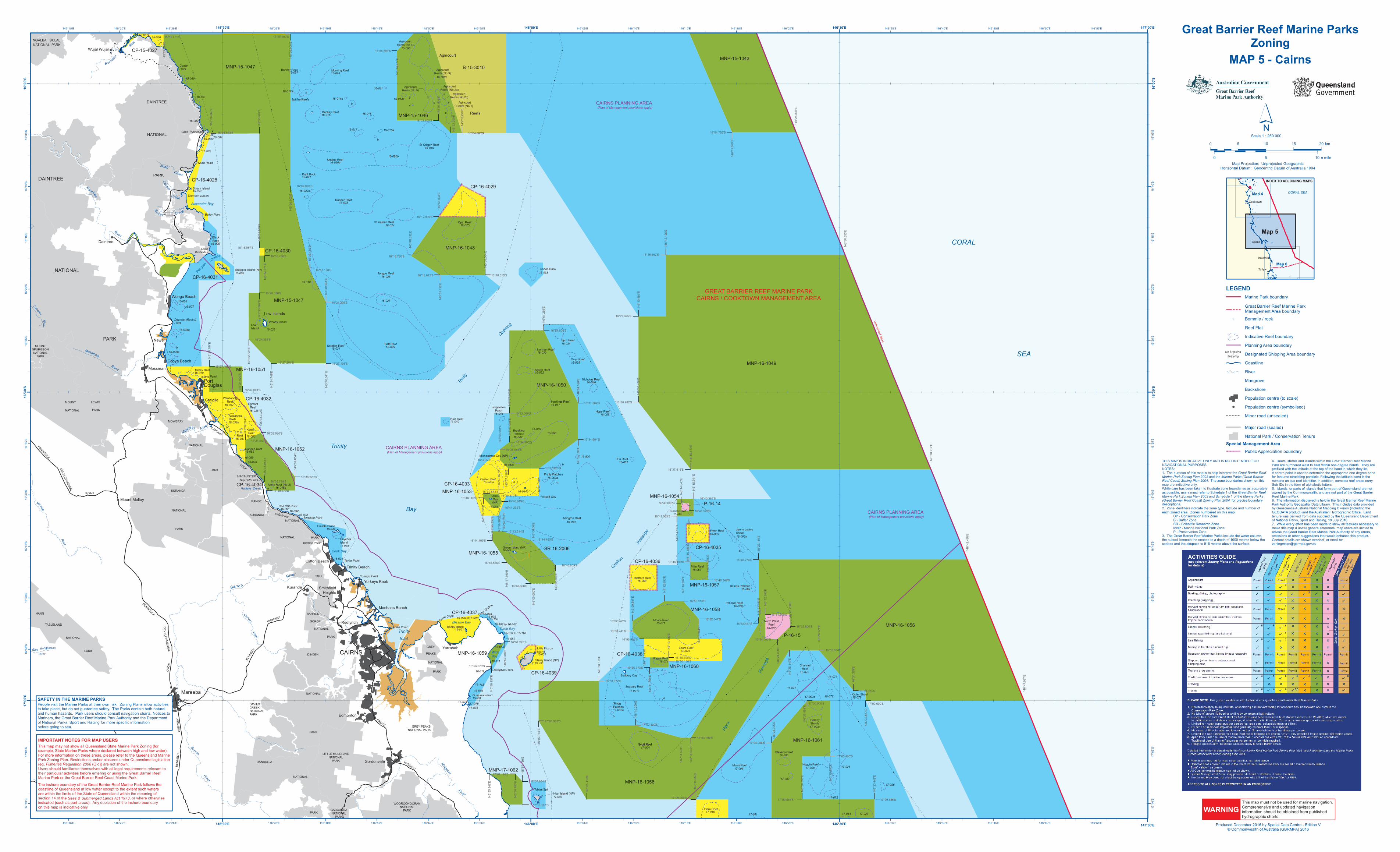
L L L # # # # # # # # # # # # # # # # # # # # # # # # # # # # # # # # # # # # # # # # # # # # # # # # # # # # # # # # # # # # # # # # # # # # # # # # # # # # # # # # # # # # # # # # # # # # # # # # # # # # # # # # # # # # ! ! ! ! CP-16-4028 CP-16-4031 MNP-16-1048 MNP-16-1049 P-16-14 MNP-16-1058 CP-16-4037 MNP-16-1061 MNP-15-1047 MNP-15-1046 B-15-3010 MNP-16-1051 CP-16-4029 MNP-16-1053 SR-16-2006 CP-16-4033 MNP-15-1043 MNP-16-1054 CP-16-4035 CP-16-4036 MNP-16-1060 P-16-15 MNP-16-1059 MNP-16-1056 CP-16-4030 CP-16-4032 CP-16-4039 MNP-16-1050 CP-16-4038 MNP-16-1057 MNP-15-1047 MNP-16-1052 MNP-16-1055 CP-16-4034 MNP-16-1056 MNP-17-1062 CP-15-4027 (Plan of Management provisions apply) CAIRNS PLANNING AREA (Plan of Management provisions apply) CAIRNS PLANNING AREA (Plan of Management provisions apply) CAIRNS PLANNING AREA M o w br a y R i v e r Mu l g r a ve Riv e r HANN TABLELAND NATIONAL PARK Yorkeys Point Ellie Point M i t c h e l l R iv e r NGALBA BULAL NATIONAL PARK KURANDA NATIONAL PARK MOUNT LEWIS NATIONAL PARK DAINTREE NATIONAL PARK Cape Tribulation Cape Kimberley Port Douglas Cape Grafton Hartleys Creek Newell Mossman Mareeba DAVIES CREEK NATIONAL PARK Smithfield Heights Deception Point N o a h Cr eek Co o p e r Creek Slip Cliff Point Trinity Beach Taylor Point Wujal Wujal B a i l e y Cre e k Wonga Beach LITTLE MULGRAVE NATIONAL PARK GADGARRA NATIONAL PARK MACALISTER RANGE NATIONAL PARK Simpson Point Red Cliff Point Island Point Bailey Point Bl o o m fie ld R ive r Cooya Beach Noah Head D a i n t r e e R i v e r Dayman (Rocky) Point Mo ss m a n R i v e r P ENINSULA D EVEL OP MEN T AL R OAD Cowie Point Yarrabah D a i n t r e e R i v e r Mount Molloy CAPTA IN C OOK HI G HWAY B a r r o n R iver P ENINSU LA D E V E L O P M ENTA L RO A D C l o h e s y Ri v e r CAIRNS BARRON GORGE NATIONAL PARK B a r r o n R i v e r GREY PEAKS NATIONAL PARK MOWBRAY NATIONAL PARK DAINTREE NATIONAL PARK Buchan Point Daintree Craiglie K E NNE D Y H IG H WA Y Clifton Beach Yorkeys Knob Machans Beach Redlynch Kuranda B RUCE H IGH W A Y F a l s e C ap e Edmonton Gordonvale KEN N ED Y H IGH WAY East Hodg k in s o n River Thornton Beach MOUNT SPURGEON NATIONAL PARK KURANDA NATIONAL PARK DINDEN NATIONAL PARK DANBULLA NATIONAL PARK WOOROONOORAN NATIONAL PARK GREY PEAKS NATIONAL PARK St Crispin Reef 16-019 Undine Reef 16-020a 16-021 Rudder Reef 16-023 Tongue Reef 16-026 16-800 16-075 Channel Reef Pretty Patches Baines Patches 16-069 Linden Bank 16-011 16-013a 15-096 15-066 16-001 16-089 Morning Reef Spitfire Reefs 16-118 Tobias Spit 16-051 16-033 Trinity Inlet Trinity Bay Cook Bay Low Island 16-028 Mackay Reef 16-015 16-083 c b P engu in Ch a n n e l Michaelmas Cay (NP) 16-043b Green Island (NP) 16-049 b c 16-074 Briggs Reef 16-053 Stagg Patches 16-077 Outer Shoal 16-079 16-062a 16-060 c 17-003a Woody Island d Alexandra Bay Turtle Bay Mission Bay b 15-069 16-007 16-008a 16-009a Elford Reef 16-073 17-003b Stevens Reef 17-005 Bonner Rock 16-016 16-012a 15-097 15-099a b 16-085 16-090 a 16-091 16-056 16-017 CORAL SEA 16-018a 16-027 Flo ra Pa ss a g e Struck Island 16-004 Satellite Reef 16-031 Morey Reef 16-010 Garioch Reef 16-082 Double Island 16-047 Hastings Reef 16-057 Pixie Reef 16-040 Flora Reef 17-010 Sudbury Reef 17-001a Fitzroy Island (NP) 16-054 Little Fitzroy Island 16-055 c b 16-014a d 15-098 e 15-067 16-088 16-092 16-093 Gunjurra Island 16-801 Rocky Island 16-078 T r ini ty Op e n in g 16-005 Black Rock Snapper Island (NP) 16-006 Haycock Island 16-048 Arlington Reef 16-064 Nicholas Reef 16-036 17-009 16-020b Hope Reef 16-058 Fin Reef 16-061 16-059 Milln Reef 16-067 Pellowe Reef 16-070 17-002a b 16-003 Low Islands Unity Reef (No 2) 16-045b 16-039a Alexandra Reefs Egmont Reef 16-038 Yule Reef 16-081 Chinaman Reef 16-024 16-044b Upolu Cay (NP) 16-046 16-042 Jorgensen Patch 16-041 Gr afton P as s a g e Moore Reef 16-071 17-007 Wide Bay North West Reef 16-072 Euston Reef 16-063 Opal Reef 16-025 Wentworth Reef 16-037 Thetford Reef 16-068 Jenny Louise Shoal 16-066a b 16-076 Oyster Reef 16-043a Batt Reef 16-029 High Island (NP) Vlasoff Cay Sudbury Cay Scott Reef 17-004 Maori Reef 17-006 16-002 a Norman Reef 16-030 Saxon Reef 16-032 Onyx Reef 16-035 Spur Reef 16-034 Noggin Reef 17-008 17-025 17-026 Hervey Shoals Flynn Reef 16-065 16-052 b b Pratt Rock 16-022a b Korea Reef 16-080 GREAT BARRIER REEF MARINE PARK CAIRNS / COOKTOWN MANAGEMENT AREA Limit of reef detail b b b 16-099 16-098 16-094 Agincourt Reefs (No 4) Breaking Patches 16-100 16-102 to 16-107 16-108 to 16-110 16-111 16-112 16-113 17-074 17-076 17-075 a b f g c d e Agincourt Reefs (No 3) Agincourt Reefs (No 5) Agincourt Reefs (No 2a) Agincourt Reefs (No 2b) Agincourt Reefs (No 1) Agincourt Reefs 17-011 17-014 17-027 17-072 Scott Reef 16-084 16-095 to16-097 16°04.800'S 145°53.299'E 16°03.600'S 145°51.001'E 16°04.800'S 16°18.138'S 16°16.738'S 145°34.071'E 145°40.041'E 16°21.239'S 16°20.350'S 145°55.942'E 17°07.854'S 17°09.606'S 146°15.486'E 16°51.600'S 16°52.800'S 146°14.640'E 16°41.520'S 145°56.151'E 17°07.116'S 145°51.033'E 16°18.613'S 145°55.564'E 145°51.132'E 16°18.613'S 145°48.332'E 145°31.920'E 16°30.001'S 145°56.906'E 16°41.269'S 16°43.514'S 145°57.201'E 16°34.659'S 145°33.722'E 16°33.960'S 16°38.225'S 16°39.570'S 145°37.054'E 145°28.860'E 145°33.569'E 146°00.790'E 145°56.877'E 16°39.870'S 16°40.260'S 145°55.356'E 16°35.562'S 16°53.996'S 16°56.150'S 146°11.555'E 146°16.344'E 16°52.047'S 146°22.159'E 145°52.200'E 16°04.853'S 16°09.990'S 145°36.600'E 145°33.569'E 16°15.987'S 145°38.469'E 145°33.569'E 145°32.538'E 16°24.855'S 145°40.041'E 16°27.195'S 145°32.204'E 145°34.332'E 145°28.707'E 16°27.498'S 16°12.939'S 16°16.760'S 16°04.759'S 146°19.579'E 146°13.125'E 16°16.652'S 16°22.625'S 146°10.456'E 16°30.982'S 146°10.456'E 146°15.540'E 16°37.516'S 16°24.000'S 146°01.259'E 16°31.064'S 146°04.590'E 146°04.590'E 16°34.604'S 16°37.425'S 145°56.981'E 145°57.906'E 16°34.865'S 16°44.400'S 16°44.409'S 145°57.660'E 16°46.566'S 145°56.238'E 16°46.809'S 146°02.400'E 146°15.841'E 16°40.364'S 16°42.063'S 146°14.197'E 16°46.498'S 16°48.249'S 146°17.235'E 16°50.316'S 146°14.807'E 146°12.990'E 16°52.248'S 16°53.241'S 16°55.799'S 146°13.409'E 16°46.274'S 16°52.487'S 16°55.104'S 146°28.024'E 146°31.379'E 16°59.023'S 146°29.098'E 17°05.400'S 17°09.586'S 146°33.442'E 17°03.594'S 17°02.400'S 146°06.615'E 16°58.077'S 16°56.676'S 145°59.180'E 146°25.149'E 146°22.159'E 146°15.549'E 146°11.013'E 146°15.360'E 146°16.059'E 146°26.398'E 17°09.586'S 16°48.608'S 146°00.000'E 146°09.887'E 16°40.800'S 146°22.800'E 146°25.200'E 16°54.000'S 146°24.000'E 16°56.773'S 145°57.446'E 16°54.275'S 17°01.963'S 146°00.745'E 146°10.200'E 17°00.000'S 146°32.557'E 17°04.086'S 146°23.395'E 17°00.000'S 146°26.858'E 146°25.803'E 146°30.555'E 146°38.917'E 146°47.967'E 146°42.438'E 16°36.592'S 145°57.819'E 146°14.598'E 146°05.415'E 16°38.719'S 145°34.083'E 16°40.619'S 145°34.749'E 16°27.201'S 145°58.480'E 145°57.900'E 16°32.066'S 16°39.843'S 146°00.00'E 17°10.107'S 15°55.201'S 145°24.276'E 15°55.200'S 145°36.600'E 15°56.803'S 145°46.974'E This map must not be used for marine navigation. Comprehensive and updated navigation information should be obtained from published hydrographic charts. WARNING Map Projection: Unprojected Geographic Horizontal Datum: Geocentric Datum of Australia 1994 ´ 0 5 10 15 20 km 0 5 10 n mile Scale 1 : 250 000 ! ! ! ! Map 6 Cairns Cooktown Innisfail Tully Map 5 Map 4 INDEX TO ADJOINING MAPS CORAL SEA LEGEND Marine Park boundary Great Barrier Reef Marine Park Management Area boundary L Bommie / rock Reef Flat Indicative Reef boundary Planning Area boundary Designated Shipping Area boundary Coastline River Mangrove Backshore Population centre (to scale) ! Population centre (symbolised) Minor road (unsealed) Major road (sealed) National Park / Conservation Tenure Special Management Area Public Appreciation boundary # No Shipping Shipping 146°30'E 146°30'E 145°30'E 145°30'E 16°30'S 16°30'S 146°55'E 146°55'E 146°50'E 146°50'E 146°45'E 146°45'E 146°40'E 146°40'E 146°35'E 146°35'E 146°25'E 146°25'E 146°20'E 146°20'E 146°15'E 146°15'E 146°10'E 146°10'E 145°55'E 145°55'E 145°50'E 145°50'E 145°45'E 145°45'E 145°40'E 145°40'E 145°35'E 145°35'E 145°25'E 145°25'E 145°20'E 145°20'E 145°15'E 145°15'E 16°10'S 16°10'S 16°15'S 16°15'S 16°20'S 16°20'S 16°25'S 16°25'S 16°35'S 16°35'S 16°40'S 16°40'S 16°45'S 16°45'S 16°50'S 16°50'S 16°55'S 16°55'S 17°10'S 17°10'S 16°00'S 146°00'E 146°05'E 147°00'E 16°00'S 16°05'S 17°00'S 17°05'S 147°00'E 146°00'E 146°05'E 17°00'S 17°05'S 16°05'S Great Barrier Reef Marine Parks Zoning MAP 5 - Cairns Produced December 2016 by Spatial Data Centre - Edition V © Commonwealth of Australia (GBRMPA) 2016 SAFETY IN THE MARINE PARKS People visit the Marine Parks at their own risk. Zoning Plans allow activities to take place, but do not guarantee safety. The Parks contain both natural and human hazards. Park users should consult navigation charts, Notices to Mariners, the Great Barrier Reef Marine Park Authority and the Department of National Parks, Sport and Racing for more specific information before going to sea. 4. Reefs, shoals and islands within the Great Barrier Reef Marine Park are numbered west to east within one-degree bands. They are prefixed with the latitude at the top of the band in which they lie. A centre point is used to determine the appropriate one-degree band for features straddling parallels. Following the latitude band is the numeric unique reef identifier. In addition, complex reef areas carry Sub IDs in the form of alphabetic letters. 5. Islands, or parts of islands that form part of Queensland are not owned by the Commonwealth, and are not part of the Great Barrier Reef Marine Park. 6. The information displayed is held in the Great Barrier Reef Marine Park Authority Geospatial Data Library. This includes data provided by Geoscience Australia National Mapping Division (including the GEODATA product) and the Australian Hydrographic Office. Land tenure was derived from data supplied by the Queensland Department of National Parks, Sport and Racing, 19 July 2016. 7. While every effort has been made to show all features necessary to make this map a useful general reference, map users are invited to advise the Great Barrier Reef Marine Park Authority of any errors, omissions or other suggestions that would enhance this product. Contact details are shown overleaf, or email to: [email protected] THIS MAP IS INDICATIVE ONLY AND IS NOT INTENDED FOR NAVIGATIONAL PURPOSES. NOTES: 1. The purpose of this map is to help interpret the Great Barrier Reef Marine Park Zoning Plan 2003 and the Marine Parks (Great Barrier Reef Coast) Zoning Plan 2004. The zone boundaries shown on this map are indicative only. While care has been taken to illustrate zone boundaries as accurately as possible, users must refer to Schedule 1 of the Great Barrier Reef Marine Park Zoning Plan 2003 and Schedule 1 of the Marine Parks (Great Barrier Reef Coast) Zoning Plan 2004 for precise boundary descriptions. 2. Zone identifiers indicate the zone type, latitude and number of each zoned area. Zones numbered on this map: CP - Conservation Park Zone B - Buffer Zone SR - Scientific Research Zone MNP - Marine National Park Zone P - Preservation Zone 3. The Great Barrier Reef Marine Parks include the water column, the subsoil beneath the seabed to a depth of 1000 metres below the seabed and the airspace to 915 metres above the surface. The inshore boundary of the Great Barrier Reef Marine Park follows the coastline of Queensland at low water except to the extent such waters are within the limits of the State of Queensland within the meaning of section 14 of the Seas & Submerged Lands Act 1973, or where otherwise indicated (such as port areas). Any depiction of the inshore boundary on this map is indicative only. IMPORTANT NOTES FOR MAP USERS Seas & Submerged Lands Act 1973 This map may not show all Queensland State Marine Park Zoning (for example, State Marine Parks where declared between high and low water). For more information on these areas, please refer to the Queensland Marine Park Zoning Plan. Restrictions and/or closures under Queensland legislation (eg. Fisheries Regulation 2008 (Qld)) are not shown. Users should familiarise themselves with all legal requirements relevant to their particular activities before entering or using the Great Barrier Reef Marine Park or the Great Barrier Reef Coast Marine Park.
Transcript of S ðL - Great Barrier Reef Marine...
L
L
L
#
#
#
#
#
#
#
##
#
#
#
#
#
#
#
#
#
#
#
#
#
#
#
##
#
#
#
#
#
#
#
#
#
#
#
#
#
#
#
#
#
#
#
#
#
#
#
#
#
#
#
#
#
#
#
#
#
#
#
#
#
#
#
#
#
#
#
#
#
#
#
#
#
#
#
#
#
#
#
#
#
#
#
#
#
#
#
#
#
#
#
#
#
#
#
#
#
#
#
#
#
#
#
#
#
#
!
!
!
!
CP-16-4028
CP-16-4031
MNP-16-1048
MNP-16-1049
P-16-14
MNP-16-1058CP-16-4037
MNP-16-1061
MNP-15-1047
MNP-15-1046
B-15-3010
MNP-16-1051
CP-16-4029
MNP-16-1053
SR-16-2006
CP-16-4033
MNP-15-1043
MNP-16-1054
CP-16-4035
CP-16-4036
MNP-16-1060
P-16-15
MNP-16-1059
MNP-16-1056
CP-16-4030
CP-16-4032
CP-16-4039
MNP-16-1050
CP-16-4038
MNP-16-1057
MNP-15-1047
MNP-16-1052
MNP-16-1055
CP-16-4034
MNP-16-1056
MNP-17-1062
CP-15-4027
(Plan of Management provisions apply)CAIRNS PLANNING AREA
(Plan of Management provisions apply)CAIRNS PLANNING AREA
(Plan of Management provisions apply)CAIRNS PLANNING AREA
Mowbray River
Mulgrave
River
HANN
TABLELAND
NATIONAL
PARK
Yorkeys Point
Ellie Point
Mitchell
River
NGALBA BULALNATIONAL PARK
KURANDA
NATIONAL
PARK
MOUNT LEWIS
NATIONAL PARK
DAINTREE
NATIONAL
PARK
Cape Tribulation
CapeKimberley
PortDouglas
Cape Grafton
Hartleys Creek
Newell
Mossman
MareebaDAVIESCREEKNATIONALPARK
SmithfieldHeights
Deception Point
NoahCreek
Cooper
Creek
Slip Cliff Point
Trinity BeachTaylor Point
Wujal Wujal
B a il ey Creek
Wonga Beach
LITTLE MULGRAVENATIONAL
PARK
GADGARRANATIONAL
PARK
MACALISTER
RANGE
NATIONAL
PARK
Simpson Point
Red Cliff Point
Island Point
Bailey Point
Bloomfield
River
Cooya Beach
Noah Head
DaintreeRiver
Dayman (Rocky)Point
Mossman
River
PENINSULA
DEVELOPMENTAL
ROAD
CowiePoint
Yarrabah
Daintree
River
Mount Molloy
CAPTAIN
COOK
HIGHWAY
BarronRiver
PENINSULA
DE VELOPMENTALROAD
Clohesy
River
CAIRNS
BARRON
GORGE
NATIONAL
PARK
Barro nRiver
GREY PEAKSNATIONAL PARK
MOWBRAY
NATIONAL
PARK
DAINTREE
NATIONAL
PARK
Buchan Point
Daintree
Craiglie
KENN
EDY
HIGH
WAY
Clifton Beach
Yorkeys Knob
Machans Beach
Redlynch
Kuranda
BRUCE
HIGHWAY
False Cape
Edmonton
Gordonvale
KENN
EDY
HIGHWAY
East HodgkinsonRiver
Thornton Beach
MOUNTSPURGEONNATIONAL
PARK
KURANDA
NATIONAL
PARK
DINDEN
NATIONAL
PARK
DANBULLA
NATIONAL
PARK
WOOROONOORANNATIONAL
PARK
GREYPEAKS
NATIONAL
PARK
St Crispin Reef16-019
Undine Reef16-020a
16-021
Rudder Reef16-023
Tongue Reef16-026
16-800
16-075Channel
Reef
Pretty Patches
Baines Patches16-069
Linden Bank
16-011
16-013a
15-096
15-066
16-001
16-089
Morning Reef
Spitfire Reefs
16-118
Tobias Spit
16-051
16-033
TrinityInlet
Trinity
Bay
Cook Bay
LowIsland 16-028
Mackay Reef16-015
16-083
c
b
Penguin
Channel
Michaelmas Cay (NP)
16-043b
Green Island (NP)16-049
b c
16-074Briggs Reef
16-053
StaggPatches
16-077Outer Shoal16-079
16-062a
16-060
c
17-003a
Woody Island
d
Alexandra Bay
Turtle BayMission Bay
b
15-069
16-007
16-008a
16-009a
Elford Reef16-073
17-003b
Stevens Reef17-005
Bonner Rock
16-016
16-012a
15-09715-099a
b
16-085
16-090
a
16-091
16-056
16-017
CORAL
SEA
16-018a
16-027
Flora
Passa
ge
Struck Island16-004
Satellite Reef16-031
Morey Reef16-010
Garioch Reef16-082
Double Island16-047
Hastings Reef16-057
Pixie Reef16-040
Flora Reef17-010
Sudbury Reef17-001a
Fitzroy Island (NP)16-054
Little FitzroyIsland16-055
c
b16-014a
d
15-098
e
15-067
16-088
16-09216-093
Gunjurra Island16-801
Rocky Island
16-078
Trinity
Opening
16-005BlackRock
Snapper Island (NP)16-006
HaycockIsland16-048
Arlington Reef16-064
Nicholas Reef16-036
17-009
16-020b
Hope Reef16-058
Fin Reef16-061
16-059
Milln Reef16-067
Pellowe Reef16-070
17-002ab
16-003
Low Islands
Unity Reef (No 2)16-045b
16-039aAlexandraReefs
EgmontReef16-038
YuleReef
16-081
Chinaman Reef16-024
16-044bUpoluCay(NP)
16-046
16-042
JorgensenPatch
16-041
Grafton
Passa
ge
Moore Reef16-071
17-007
WideBay
North WestReef
16-072
Euston Reef16-063
Opal Reef16-025
WentworthReef
16-037
Thetford Reef16-068
Jenny LouiseShoal16-066a
b
16-076
Oyster Reef16-043a
Batt Reef16-029
High Island (NP)
Vlasoff Cay
Sudbury Cay
Scott Reef17-004
Maori Reef17-006
16-002
a
Norman Reef16-030
Saxon Reef16-032
Onyx Reef16-035
Spur Reef16-034
Noggin Reef17-008 17-025
17-026
HerveyShoals
Flynn Reef16-065
16-052
b
b
Pratt Rock
16-022ab
KoreaReef
16-080
GREAT BARRIER REEF MARINE PARKCAIRNS / COOKTOWN MANAGEMENT AREA
Limit of reef detail
b
b
b
16-09916-098
16-094
AgincourtReefs (No 4)
BreakingPatches
16-10016-102 to 16-107
16-108 to 16-110
16-111
16-112
16-113
17-07417-07617-075
ab
fgc
d e
AgincourtReefs (No 3)
AgincourtReefs (No 5)
AgincourtReefs (No 2a)
AgincourtReefs (No 2b)
AgincourtReefs (No 1)
Agincourt
Reefs
17-011 17-014 17-027
17-072
Scott Reef
16-084
16-095 to16-097
16°04.800'S
145°5
3.299
'E
16°03.600'S
145°5
1.001
'E
16°04.800'S
16°18.138'S
16°16.738'S
145°3
4.071
'E
145°4
0.041
'E
16°21.239'S
16°20.350'S
145°5
5.942
'E 17°07.854'S
17°09.606'S
146°1
5.486
'E
16°51.600'S
16°52.800'S
146°1
4.640
'E
16°41.520'S
145°5
6.151
'E
17°07.116'S
145°5
1.033
'E
16°18.613'S
145°5
5.564
'E
145°5
1.132
'E
16°18.613'S
145°4
8.332
'E
145°3
1.920
'E
16°30.001'S
145°5
6.906
'E
16°41.269'S
16°43.514'S145°5
7.201
'E
16°34.659'S
145°3
3.722
'E
16°33.960'S
16°38.225'S
16°39.570'S
145°3
7.054
'E
145°2
8.860
'E
145°3
3.569
'E
146°0
0.790
'E
145°5
6.877
'E16°39.870'S16°40.260'S
145°5
5.356
'E
16°35.562'S
16°53.996'S
16°56.150'S
146°1
1.555
'E
146°1
6.344
'E
16°52.047'S
146°2
2.159
'E
145°5
2.200
'E
16°04.853'S
16°09.990'S
145°3
6.600
'E
145°3
3.569
'E
16°15.987'S
145°3
8.469
'E
145°3
3.569
'E
145°3
2.538
'E
16°24.855'S
145°4
0.041
'E
16°27.195'S
145°3
2.204
'E
145°3
4.332
'E
145°2
8.707
'E
16°27.498'S
16°12.939'S
16°16.760'S
16°04.759'S
146°1
9.579
'E
146°1
3.125
'E
16°16.652'S
16°22.625'S
146°1
0.456
'E
16°30.982'S
146°1
0.456
'E
146°1
5.540
'E
16°37.516'S
16°24.000'S
146°0
1.259
'E
16°31.064'S
146°0
4.590
'E14
6°04.5
90'E
16°34.604'S
16°37.425'S
145°5
6.981
'E
145°5
7.906
'E
16°34.865'S
16°44.400'S16°44.409'S
145°5
7.660
'E
16°46.566'S
145°5
6.238
'E
16°46.809'S
146°0
2.400
'E
146°1
5.841
'E
16°40.364'S
16°42.063'S
146°1
4.197
'E
16°46.498'S
16°48.249'S
146°1
7.235
'E
16°50.316'S
146°1
4.807
'E
146°1
2.990
'E
16°52.248'S
16°53.241'S
16°55.799'S
146°1
3.409
'E
16°46.274'S
16°52.487'S
16°55.104'S
146°2
8.024
'E
146°3
1.379
'E
16°59.023'S
146°2
9.098
'E
17°05.400'S
17°09.586'S
146°3
3.442
'E
17°03.594'S
17°02.400'S
146°0
6.615
'E
16°58.077'S
16°56.676'S
145°5
9.180
'E
146°2
5.149
'E
146°2
2.159
'E
146°1
5.549
'E
146°1
1.013
'E
146°1
5.360
'E14
6°16.0
59'E
146°2
6.398
'E17°09.586'S
16°48.608'S
146°0
0.000
'E
146°0
9.887
'E
16°40.800'S
146°2
2.800
'E
146°2
5.200
'E
16°54.000'S
146°2
4.000
'E
16°56.773'S145°5
7.446
'E
16°54.275'S
17°01.963'S
146°0
0.745
'E
146°1
0.200
'E 17°00.000'S
146°3
2.557
'E
17°04.086'S
146°2
3.395
'E
17°00.000'S
146°2
6.858
'E
146°2
5.803
'E
146°3
0.555
'E
146°3
8.917
'E
146°4
7.967
'E
146°4
2.438
'E
16°36.592'S
145°5
7.819
'E
146°1
4.598
'E
146°0
5.415
'E
16°38.719'S
145°3
4.083
'E
16°40.619'S
145°3
4.749
'E
16°27.201'S
145°5
8.480
'E14
5°57.9
00'E
16°32.066'S
16°39.843'S
146°0
0.00'E
17°10.107'S
15°55.201'S
145°2
4.276
'E
15°55.200'S
145°3
6.600
'E
15°56.803'S
145°4
6.974
'E
This map must not be used for marine navigation.Comprehensive and updated navigationinformation should be obtained from publishedhydrographic charts.
WARNING
Map Projection: Unprojected GeographicHorizontal Datum: Geocentric Datum of Australia 1994
´0 5 10 15 20 km
0 5 10 n mile
Scale 1 : 250 000
!
!
!
!
Map 6
Cairns
Cooktown
Innisfail
Tully
Map 5
Map 4
INDEX TO ADJOINING MAPS
CORAL SEA
LEGENDMarine Park boundaryGreat Barrier Reef Marine ParkManagement Area boundary
L Bommie / rockReef FlatIndicative Reef boundaryPlanning Area boundaryDesignated Shipping Area boundaryCoastlineRiverMangroveBackshorePopulation centre (to scale)
! Population centre (symbolised)Minor road (unsealed)
Major road (sealed)National Park / Conservation Tenure
Special Management AreaPublic Appreciation boundary
#No Shipping
Shipping
146°30'E
146°30'E
145°30'E
145°30'E16
°30'S
16°3
0'S
146°55'E
146°55'E
146°50'E
146°50'E
146°45'E
146°45'E
146°40'E
146°40'E
146°35'E
146°35'E
146°25'E
146°25'E
146°20'E
146°20'E
146°15'E
146°15'E
146°10'E
146°10'E
145°55'E
145°55'E
145°50'E
145°50'E
145°45'E
145°45'E
145°40'E
145°40'E
145°35'E
145°35'E
145°25'E
145°25'E
145°20'E
145°20'E
145°15'E
145°15'E16
°10'S
16°1
0'S
16°1
5'S
16°1
5'S
16°2
0'S
16°2
0'S
16°2
5'S
16°2
5'S
16°3
5'S
16°3
5'S
16°4
0'S
16°4
0'S
16°4
5'S
16°4
5'S
16°5
0'S
16°5
0'S
16°5
5'S
16°5
5'S
17°1
0'S
17°1
0'S
16°0
0'S146°00'E 146°05'E 147°00'E
16°0
0'S16
°05'S
17°0
0'S17
°05'S
147°00'E146°00'E 146°05'E
17°0
0'S17
°05'S
16°0
5'SGreat Barrier Reef Marine Parks
ZoningMAP 5 - Cairns
Produced December 2016 by Spatial Data Centre - Edition V© Commonwealth of Australia (GBRMPA) 2016
SAFETY IN THE MARINE PARKSPeople visit the Marine Parks at their own risk. Zoning Plans allow activitiesto take place, but do not guarantee safety. The Parks contain both naturaland human hazards. Park users should consult navigation charts, Notices toMariners, the Great Barrier Reef Marine Park Authority and the Departmentof National Parks, Sport and Racing for more specific informationbefore going to sea.
4. Reefs, shoals and islands within the Great Barrier Reef MarinePark are numbered west to east within one-degree bands. They areprefixed with the latitude at the top of the band in which they lie. A centre point is used to determine the appropriate one-degree bandfor features straddling parallels. Following the latitude band is thenumeric unique reef identifier. In addition, complex reef areas carrySub IDs in the form of alphabetic letters.5. Islands, or parts of islands that form part of Queensland are notowned by the Commonwealth, and are not part of the Great BarrierReef Marine Park.6. The information displayed is held in the Great Barrier Reef MarinePark Authority Geospatial Data Library. This includes data providedby Geoscience Australia National Mapping Division (including theGEODATA product) and the Australian Hydrographic Office. Landtenure was derived from data supplied by the Queensland Departmentof National Parks, Sport and Racing, 19 July 2016.7. While every effort has been made to show all features necessary tomake this map a useful general reference, map users are invited toadvise the Great Barrier Reef Marine Park Authority of any errors, omissions or other suggestions that would enhance this product.Contact details are shown overleaf, or email to:[email protected]
THIS MAP IS INDICATIVE ONLY AND IS NOT INTENDED FORNAVIGATIONAL PURPOSES.NOTES: 1. The purpose of this map is to help interpret the Great Barrier ReefMarine Park Zoning Plan 2003 and the Marine Parks (Great BarrierReef Coast) Zoning Plan 2004. The zone boundaries shown on thismap are indicative only.While care has been taken to illustrate zone boundaries as accuratelyas possible, users must refer to Schedule 1 of the Great Barrier ReefMarine Park Zoning Plan 2003 and Schedule 1 of the Marine Parks(Great Barrier Reef Coast) Zoning Plan 2004 for precise boundarydescriptions.2. Zone identifiers indicate the zone type, latitude and number ofeach zoned area. Zones numbered on this map: CP - Conservation Park Zone B - Buffer Zone SR - Scientific Research Zone MNP - Marine National Park Zone P - Preservation Zone3. The Great Barrier Reef Marine Parks include the water column, the subsoil beneath the seabed to a depth of 1000 metres below the seabed and the airspace to 915 metres above the surface.
The inshore boundary of the Great Barrier Reef Marine Park follows thecoastline of Queensland at low water except to the extent such watersare within the limits of the State of Queensland within the meaning ofsection 14 of the Seas & Submerged Lands Act 1973, or where otherwiseindicated (such as port areas). Any depiction of the inshore boundaryon this map is indicative only.
IMPORTANT NOTES FOR MAP USERS
Seas & Submerged Lands Act 1973
This map may not show all Queensland State Marine Park Zoning (forexample, State Marine Parks where declared between high and low water).For more information on these areas, please refer to the Queensland MarinePark Zoning Plan. Restrictions and/or closures under Queensland legislation(eg. Fisheries Regulation 2008 (Qld)) are not shown.Users should familiarise themselves with all legal requirements relevant totheir particular activities before entering or using the Great Barrier ReefMarine Park or the Great Barrier Reef Coast Marine Park.