RYA Guide to the Lynher / St Germans River
14
www.rya.org.uk RYA copyright 2010 1 RYA Guide to the Lynher / St Germans River I was as guilty as the next skipper of mooring up in a Plymouth marina and not venturing upstream and exploring the rivers. But explore them once and you’ll be back time and time again as they are some of the prettiest rivers in the South West. Here we look at the River Lynher or St Germans River running up to Dandy Hole anchorage and St Germans Quay. The river offers stunning natural beauty, wildlife, secluded anchorages and a tranquil finishing point at St Germans Quay.
Transcript of RYA Guide to the Lynher / St Germans River

www.rya.org.uk
RYA copyright 2010 1
RYA Guide to the Lynher / St Germans River
I was as guilty as the next skipper of mooring up in a Plymouth marina and not venturing
upstream and exploring the rivers.
But explore them once and you’ll be back time and time again as they are some of the
prettiest rivers in the South West.
Here we look at the River Lynher or St Germans River running up to Dandy Hole anchorage
and St Germans Quay. The river offers stunning natural beauty, wildlife, secluded
anchorages and a tranquil finishing point at St Germans Quay.

www.rya.org.uk
RYA copyright 2010 2
Our journey starts in the Hamoaze, the stretch of water running past Devonport Royal
Dockyard and the convergence of the Rivers Lynher and Tamar.
The Port of Plymouth is under the jurisdiction of the Queens Harbour Master so it is worth
keeping a listening watch on VHF channel 13 or 14.
Devonport Royal Dockyard and the Hamoaze, the gateway to the River Lynher. (Chart point 1)
As the dockyard finishes and Isambard Kingdom Brunel’s Royal Albert Bridge comes into
view the entrance to the River Lynher forks off to the West.
The white day mark on Henn Point is a useful point to steer to as you close the river
entrance.
The Hamoaze

www.rya.org.uk
RYA copyright 2010 3
View from Beggars Island of the Tamar and Royal Albert Bridges joining Devon to Cornwall. Lynher red buoy and
white day mark of Henn Point visible (left). (Chart point 2)
The Lynher/St Germans River
Looking West the Lynher buoy marks the start of the Lynher and St Germans River. Initially,
small craft moorings line the Northern side of the River and port hand marks keep you clear
of the prominent ‘Beggars Island’.
Deep water then favours the Southern side past Sand Acre Point as the channel snakes
past small craft moorings to Jupiter Point. Anchorage is possible on the Northern side of
Sand Acre Bay.
Lynher buoy with Jupiter Point (centre) and Passage Point (right) (Chart point 3)

www.rya.org.uk
RYA copyright 2010 4
Jupiter Point
Jupiter Point is part of HMS Raliegh, the Royal Navy training centre.
Jupiter Point (Chart point 4)
HMS Brecon is moored midstream, a Falkland war veteran now a Navy training ship giving
new recruits their first taste of life at sea and experiencing what it is like to live and sleep on
a warship afloat.
HMS Brecon (Chart point 4)
Just inland from Jupiter Point is Antony House, the setting for Tim Burton’s, Alice in
Wonderland.

www.rya.org.uk
RYA copyright 2010 5
Antony Passage
The picturesque, Forder Lake and Antony Passage are on the Northern Bank facing Jupiter
Point.
Anchorage is possible just outside the lake and also to the West. Trematon Castle peeks out
of the hills and was mentioned in the Domesday Book.
It was the storage place for Sir Francis Drakes’ hordes of treasure, when he returned from
his circumnavigation in 1580.
Forder Lake at Antony Passage. Trematon Castle (above the first arch of the bridge) (Chart point 5)
The river heads South West, widens and deeper water stays closer to the Northern bank.
From Ince Castle the river shallows and a few metres of tidal height is required to carry on (+
- 2 ½hrs LW = 2.5m).

www.rya.org.uk
RYA copyright 2010 6
On approaching Black Rock, stay close to the green buoy as a sand bank (dries 0.4) sits in
mid-channel.
Black Rock (Chart point 6)
Dandy Hole
Redshank point coming down of Erth Hill (right) and Dandy Hole (left) (Chart point 7)
From Black Rock the channel increasingly heads South West past a conspicuous red buoy
towards one of the top anchorages, ‘Dandy Hole’.
www.rya.org.uk
RYA copyright 2010 7
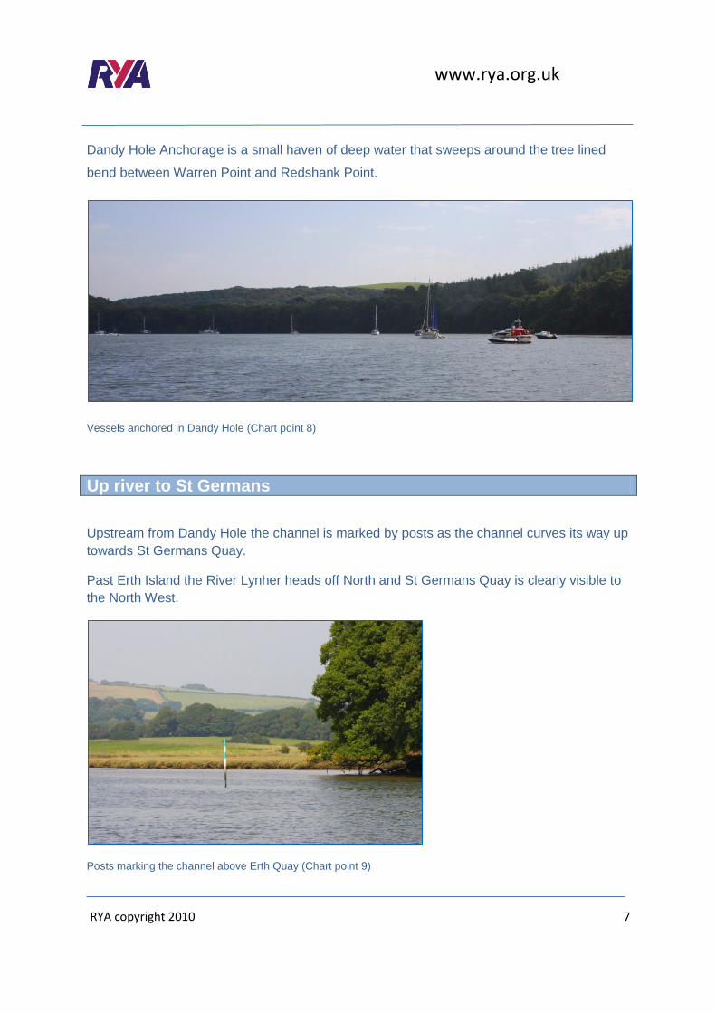
Dandy Hole Anchorage is a small haven of deep water that sweeps around the tree lined
bend between Warren Point and Redshank Point.
Vessels anchored in Dandy Hole (Chart point 8)
Up river to St Germans
Upstream from Dandy Hole the channel is marked by posts as the channel curves its way up
towards St Germans Quay.
Past Erth Island the River Lynher heads off North and St Germans Quay is clearly visible to
the North West.
Posts marking the channel above Erth Quay (Chart point 9)

www.rya.org.uk
RYA copyright 2010 8
St Germans Quay
Tranquillity reins... St Germans Quay is the home to the friendly Quay Sailing Club which
has a pontoon and mooring by arrangement.
Dandy Hole anchorage is only 1.5 miles away and is good for a dinghy ride to the quay or to
come up to on the rising tide.
Ashore, there’s the clubhouse and in the village a shop and pub, the Eliot Arms, 10 minutes’
walk away.
Port Eliot House and Estate is ½ mile further up the River Tiddy, under the viaduct. The
house and grounds are occasionally open to visitors and is home to the Port Eliot Festival.
www.rya.org.uk
RYA copyright 2010 9
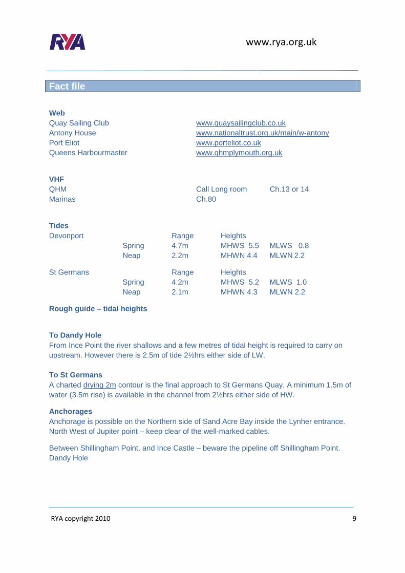
Fact file
Web
Quay Sailing Club www.quaysailingclub.co.uk
Antony House www.nationaltrust.org.uk/main/w-antony
Port Eliot www.porteliot.co.uk
Queens Harbourmaster www.qhmplymouth.org.uk
VHF
QHM Call Long room Ch.13 or 14
Marinas Ch.80
Tides
Devonport Range Heights
Spring 4.7m MHWS 5.5 MLWS 0.8
Neap 2.2m MHWN 4.4 MLWN 2.2
St Germans Range Heights
Spring 4.2m MHWS 5.2 MLWS 1.0
Neap 2.1m MHWN 4.3 MLWN 2.2
Rough guide – tidal heights
To Dandy Hole
From Ince Point the river shallows and a few metres of tidal height is required to carry on
upstream. However there is 2.5m of tide 2½hrs either side of LW.
To St Germans
A charted drying 2m contour is the final approach to St Germans Quay. A minimum 1.5m of
water (3.5m rise) is available in the channel from 2½hrs either side of HW.
Anchorages
Anchorage is possible on the Northern side of Sand Acre Bay inside the Lynher entrance.
North West of Jupiter point – keep clear of the well-marked cables.
Between Shillingham Point. and Ince Castle – beware the pipeline off Shillingham Point.
Dandy Hole

www.rya.org.uk
RYA copyright 2010
10
Charts
Imray C14
BA 5602 folio
BA 871
Thanks
Charts C14 is reproduced with the kind permission of Imray. www.imray.com
Chart copyright UKHO. www.ukho.gov.uk
Many thanks to Richard Brown at Plymouth Sailing School for his kindness in providing a
boat for the making of this article.
www.plymouthsailingschool.com
Tel: 01752 493377
By Simon Jinks, Yachtmaster Examiner and marine journalist

www.rya.org.uk
RYA copyright 2010 11
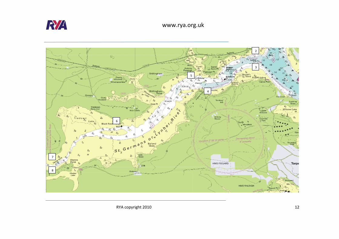
8
7
6
5
4
3
2
1
www.rya.org.uk
RYA copyright 2010 12
2
3
4
5
6
7
8

www.rya.org.uk
RYA copyright 2010
13
10
9
7
8

www.rya.org.uk
RYA copyright 2010
14
© Crown Copyright and/or database rights. Reproduced by permission of the Controller of
Her Majesty’s Stationery Office and the UK Hydrographic Office (www.ukho.gov.uk).
This material is not for resale, redistribution or copying.
Not to be used for navigation.