RWE Renewables UK Developments Ltd Enoch Hill Wind Farm ...
84
RWE Renewables UK Developments Ltd Enoch Hill Wind Farm Variation Application Scoping Report Wood Environment & Infrastructure Solutions UK Limited – February 2020
Transcript of RWE Renewables UK Developments Ltd Enoch Hill Wind Farm ...
RWE Renewables UK Developments Ltd
Enoch Hill Wind Farm Variation Application
Scoping Report
Wood Environment & Infrastructure Solutions UK Limited – February 2020

2 © Wood Environment & Infrastructure Solutions UK Limited
February 2020
Doc Ref. 37898-WOOD-XX-XX-RP-J-0001_S3_P01.1
Report for
Simon Lejeune
Onshore Wind Development Manager
RWE Renewables UK Developments Ltd
Greenwood House
Westwood Business Park
Coventry
CV4 8TT
Main contributors
John Amy
Giles Hine
Jess Welch
Gareth Hughes
Tori Park
Rohan Sinha
Adam Mealing
Adrian Simms
Pete Clark
Glen Robson
Issued by
.................................................................................
Gareth Hughes
Approved by
.................................................................................
Glen Robson
Wood Environment & Infrastructure Solutions
UK Ltd
Partnership House
Regent Farm Road
Gosforth
Newcastle upon Tyne NE3 3AF
United Kingdom
Tel +44 (0) 191 272 6100
Doc Ref. 37898-WOOD-XX-XX-RP-J-0001_S3_P01.1
h:\data\project\37898 enoch hill wind farm post
submission\g030 general\variation development\scoping
report\37898-wood-xx-xx-rp-j-0001_s3_p01 1 enoch hill
variation scoping report_final.docx
3 © Wood Environment & Infrastructure Solutions UK Limited
February 2020
Doc Ref. 37898-WOOD-XX-XX-RP-J-0001_S3_P01.1
Copyright and non-disclosure notice
The contents and layout of this report are subject to copyright
owned by Wood (© Wood Environment & Infrastructure
Solutions UK Limited 2020) save to the extent that copyright
has been legally assigned by us to another party or is used by
Wood under licence. To the extent that we own the copyright
in this report, it may not be copied or used without our prior
written agreement for any purpose other than the purpose
indicated in this report. The methodology (if any) contained in
this report is provided to you in confidence and must not be
disclosed or copied to third parties without the prior written
agreement of Wood. Disclosure of that information may
constitute an actionable breach of confidence or may
otherwise prejudice our commercial interests. Any third party
who obtains access to this report by any means will, in any
event, be subject to the Third Party Disclaimer set out below.
Third party disclaimer
Any disclosure of this report to a third party is subject to this
disclaimer. The report was prepared by Wood at the instruction
of, and for use by, our client named on the front of the report.
It does not in any way constitute advice to any third party who
is able to access it by any means. Wood excludes to the fullest
extent lawfully permitted all liability whatsoever for any loss or
damage howsoever arising from reliance on the contents of
this report. We do not however exclude our liability (if any) for
personal injury or death resulting from our negligence, for
fraud or any other matter in relation to which we cannot legally
exclude liability.
Management systems
This document has been produced by Wood Environment &
Infrastructure Solutions UK Limited in full compliance with the
management systems, which have been certified to ISO 9001,
ISO 14001 and OHSAS 18001 by LRQA.
Document revisions
No. Details Date
1 Draft Report January 2020
2 Final Report February 2020
4 © Wood Environment & Infrastructure Solutions UK Limited
February 2020
Doc Ref. 37898-WOOD-XX-XX-RP-J-0001_S3_P01.1
Executive summary
Purpose of this report
This report sets out the proposed scope of the Environmental Impact Assessment (EIA) for a proposed
variation to the consented Enoch Hill Wind Farm, the findings of which will be presented in an EIA Report.
This purpose of this document is to serve as a formal request to the Scottish Ministers to provide a scoping
opinion under Regulation 12 of the Electricity Works (Environmental Impact Assessment) (Scotland)
Regulations 2017.
This scoping request will inform the EIA of a forthcoming variation application under section 36C of the
Electricity Act 1989 (as amended) to vary the section 36 consent and deemed planning permission to
construct and operate Enoch Hill Wind Farm. The Variation Development would comprise an increase of
turbine hub heights and rotor diameter to maximise potential renewable energy generation, with the
locations of all 16 turbines remaining unchanged.
Summary Findings of the Scoping Report
The proposed variation to the consented Enoch Hill Wind Farm would increase the rotor diameter of all 16
turbines from up to 106m to up to 136m and the tip height from up to 130m to up to 149.9m. All other
infrastructure elements would remain unchanged.
The Electricity Works (Environmental Impact Assessment) (Scotland) Amendment Regulations December
2017 make it clear that for a variation application relating to an EIA development, further assessment
required to inform the application should only consider the impacts of the variation itself rather than
requiring the whole development to be assessed again. As the variation to the Consented Development
relates to an increased rotor diameter and maximum blade tip height of turbines, with all other infrastructure,
construction programme, decommissioning proposals etc. remaining unchanged, the EIA will focus on any
significant effects likely to arise during the operation of the Variation Development only. Impacts during
construction and decommissioning of Enoch Hill Wind Farm and as a result of infrastructure other than
turbines will remain as assessed in the 2015 ES and 2017 Further Environmental Information (FEI) and will
therefore not be repeated in the EIA Report for the Variation Development.
The EIA for this variation application will primarily draw on the previous baseline information that informed
the 2015 ES and 2017 FEI to allow the impacts resulting from the proposed increase in rotor diameter and
blade tip height to be assessed - and directly compared with impacts resulting from the consented
development. This scoping report draws on this baseline information to identify where significant effects are
likely as a result of the proposed increase in turbine rotor diameter and blade tip height.
The following environmental topic areas are proposed to be scoped out of the EIA on the basis that the
proposed increase in blade tip height and rotor diameter will result in little or no change to the magnitude of
impacts previously assessed for the Consented Development, therefore the proposed variation is not likely to
result in any significant effects in respect of the following:
� Historic Environment (Chapter 9);
� Traffic and Transport (Chapter 13);
� Geology/ Hydrology/Hydrogeology (Chapter 12);

5 © Wood Environment & Infrastructure Solutions UK Limited
February 2020
Doc Ref. 37898-WOOD-XX-XX-RP-J-0001_S3_P01.1
� Socio-economics (Chapter 14); and
� Shadow flicker (Chapter 7).
The following environmental topic areas are proposed to be included in the EIA:
� Landscape and Visual (Chapter 8);
� Ornithology (in relation to collision risk only) (Chapter 11);
� Ecology (effects on bats only) (Chapter 10);
� Noise (Chapter 6);
� Aviation( Chapter 16); and
� Infrastructure, Telecommunications and Safety (Chapter 15).
6 © Wood Environment & Infrastructure Solutions UK Limited
February 2020
Doc Ref. 37898-WOOD-XX-XX-RP-J-0001_S3_P01.1
Terminology
For the purposes of this report the following terminology is used:
� The ‘Consented Development’ - the 16 turbines and associated infrastructure of Enoch Hill
Wind Farm as described in the consent granted by the Scottish Ministers in September 2019;
� The ‘Variation Development’ - the revised wind farm subject to the 2020 EIA. The variation
proposed is to increase the rotor diameter and blade tip height of all 16 turbines, with their
locations and all other associated infrastructure remaining unchanged;
� The ‘2015 ES’ - the Enoch Hill Wind Farm Environmental Statement that accompanied a section
36 application for a 19T proposed development that was located on the same site as the
Consented Development;
� The ‘2017 FEI’ – Further Environmental Information that was submitted in 2017 in support of the
Consented Development. This considered an amendment to the (then) Proposed Development
by way of the deletion of three turbines and change to the locations of those remaining, with
this 16T layout being consented in September 2019;
� The ‘Development Site’ means the site of the Consented Development located approximately
5km to the south west of New Cumnock and approximately 7km north east of Dalmellington
and centred at National Grid Reference (NGR) E257360, N608630 and shown on Figure 1.1 in
Appendix A; and
� The ‘Applicant’ is RWE Renewables UK Developments Ltd (the applicant for the variation is the
same legal entity that sought and holds the benefit of the section 36 consent for the Consented
Development, but the company name changed from E.ON Climate & Renewables UK
Developments Ltd, further to the acquisition of the E.ON business by RWE Renewables on 30
September 2019).

7 © Wood Environment & Infrastructure Solutions UK Limited
February 2020
Doc Ref. 37898-WOOD-XX-XX-RP-J-0001_S3_P01.1
8 © Wood Environment & Infrastructure Solutions UK Limited
February 2020
Doc Ref. 37898-WOOD-XX-XX-RP-J-0001_S3_P01.1
Contents
1. Introduction 11
1.1 Introduction 11
1.2 Contents of this Report 11
1.3 The Applicant 12
1.4 The Agent 12
2. Project Description 14
2.1 The Development Site 14
2.2 Historic and Current Development Site Uses 14
2.3 Background Context: Consented Development 14
2.4 The Variation Development 14
Rationale for the Variation Development 14
Project Description 15
3. EIA Process and Consultation 17
3.1 EIA Overview 17
3.2 EIA Terminology 17
Impacts and Effects 17
Type of Effect 18
Temporal and Spatial Scope 18
3.3 EIA Scoping 19
3.4 Cumulative Effects 20
3.5 Mitigation 20
3.6 EIA Methodology 21
3.7 Consultation 21
4. Planning Policy Context 23
4.1 Introduction 23
4.2 Regulatory Framework 23
4.3 Scottish Planning Policy & Guidance 23
4.4 Local Development Planning Policy 24
5. Renewable Energy Policy, Carbon Balance and Peat
Management 26

9 © Wood Environment & Infrastructure Solutions UK Limited
February 2020
Doc Ref. 37898-WOOD-XX-XX-RP-J-0001_S3_P01.1
5.1 Introduction 26
5.2 Renewable Energy & Climate Change Policy Framework 26
5.3 Potential Contribution of the Variation Development to Government Objectives 26
5.4 Carbon Balance Assessment 27
5.5 Peat Management 27
6. Noise 28
6.1 Introduction 28
6.2 Baseline Conditions 28
Data Sources 28
Summary of Baseline Conditions 28
6.3 Methodology 29
Operational Noise 29
6.4 Potential Impacts 29
Operational Impacts 29
6.5 Potential Mitigation 30
6.6 Summary of Effects 30
7. Shadow Flicker 32
8. Landscape and Visual 34
8.1 Introduction 34
8.2 Guidance and Reference Material 34
8.3 Baseline Conditions 34
The Study Area 34
Landscape Character 35
Landscape Designations 36
Wild Land 36
Visual Receptors 37
Visualisations 37
Viewpoint Selection 37
8.4 Potential Landscape and Visual Effects 40
Landscape Effects 40
Visual Effects 41
Sequential Assessment 41
Cumulative Landscape and Visual Effects 41
8.5 Night-time Lighting 45
8.6 Significance of Effects 45
Nature of Effects 45
9. Historic Environment 47
10. Ecology 49

10 © Wood Environment & Infrastructure Solutions UK Limited
February 2020
Doc Ref. 37898-WOOD-XX-XX-RP-J-0001_S3_P01.1
11. Ornithology 53
11.1 Introduction 53
11.2 Baseline Conditions 53
11.3 Methodology for Establishment of Effects and Reporting 54
12. Geology, Hydrology and Hydrogeology 57
13. Traffic and Transport 59
13.1 Introduction 59
14. Socio-economics 61
Economic & Employment 61
Public Access and Recreation on-site 61
Tourism and Recreation 61
15. Infrastructure and Other Issues 62
15.1 Introduction 62
15.2 Existing Infrastructure, Telecommunications and Broadcast Services 62
15.3 Population and Human Health 62
15.4 Climate 62
15.5 Sustainable Resource Use 63
15.6 Major Accidents and Disasters 63
16. Aviation 69
Table 2.1 Turbine Coordinates 15
Table 8.1 Proposed Assessment Viewpoints 38
Table 8.2 Wind Farms within 35km of the Radius of the Site 42
Table 15.1 Major Accidents and Disasters 64
Appendix A Figures
11 © Wood Environment & Infrastructure Solutions UK Limited
February 2020
Doc Ref. 37898-WOOD-XX-XX-RP-J-0001_S3_P01.1
1. Introduction
1.1 Introduction
1.1.1 In September 2019, Enoch Hill Wind Farm gained section 36 consent and deemed planning
permission from Scottish Ministers. The Consented Development comprises 16 wind turbines and
associated infrastructure. The Development Site is located approximately 5km to the south west of
New Cumnock and approximately 7km north east of Dalmellington and centred at National Grid
Reference (NGR) E257360, N608630, with the general site location shown on Figure 1.1 in
Appendix A.
1.1.2 RWE Renewables UK Developments Ltd (the ‘Applicant’)1 is proposing to submit a variation
application under section 36C of the Electricity Act (1989) (as amended) to construct and operate a
wind farm with a generating capacity in excess of 50MW on the site of the Consented
Development. The ‘Development Site’ boundary and turbine locations of the Consented
Development and the ‘Variation Development’ are identical. The proposed variation comprises an
increase in rotor diameter, the maximum blade tip heights of all 16 turbines (as shown in Table 2.1)
and an increase in the operational period from 25 to 30 years. The proposed increase in rotor
diameters and blade tip height would increase potential renewable energy generation within the
Development Site with no requirement to change other associated infrastructure.
1.1.3 Maximum blade tip height of all 16 turbines of the Consented Development is 130m and the
proposed variation would increase their tip height to a maximum of 149.9m to accommodate an
increase in rotor diameter from up to 106m to up to 136m. All other infrastructure elements would
remain the same. The Electricity Works (Environmental Impact Assessment) (Scotland) Amendment
Regulations December 2017 make it clear that for a variation application relating to an EIA
development, further assessment required to inform the application should only consider the
impacts of the variation itself rather than requiring the whole development to be assessed again.
1.1.4 In recognition of the scale and nature of the Variation Development, the Applicant will undertake
an EIA to assess potentially significant environmental effects resulting from the proposed changes
to the turbine parameters. Under section 36 of the Electricity Act 1989 (as amended), the Variation
Development would require authorisation from the Scottish Ministers as it would require a variation
to the terms of a section 36 consent for a power generating station in excess of 50MW.
1.2 Contents of this Report
1.2.1 This report sets out the proposed scope of the EIA for the Variation Development, which is to be
submitted to the Scottish Ministers as a formal request for a scoping opinion. A scoping opinion is
defined under the EIA Regulations as “as opinion adopted by the Scottish Ministers as to the scope
and level of detail of information to be provided in the EIA Report”. The purpose of this Scoping
Report is therefore to:
� Define the Variation Development being considered (Chapter 2);
1 E.ON Climate & Renewables UK Developments Ltd, the applicant for the Consented Development, was acquired by RWE Renewables
on 30 September 2019. The legal entity remains the same, although the company name has been changed, and the applicant for the
proposed variation is the person entitled to the benefit of the section 36 consent for the Consented Development.
12 © Wood Environment & Infrastructure Solutions UK Limited
February 2020
Doc Ref. 37898-WOOD-XX-XX-RP-J-0001_S3_P01.1
� Describe the consenting and EIA requirements in relation to the Variation Development
(Chapter 3, Chapter 4);
� Outline the aspects of the Variation Development that could potentially result in significant
environmental effects (Chapter 3) and, where potentially significant effects may result, the
methodologies that will be used to assess potential impacts (Chapter 5 – 16);
1.3 The Applicant
1.3.1 The ‘Applicant’ is RWE Renewables UK Developments Ltd (the applicant for the variation is the
same legal entity that sought and holds the benefit of the section 36 consent for the Consented
Development, but the company name changed from E.ON Climate & Renewables UK
Developments Ltd, further to the acquisition of the E.ON business by RWE Renewables on 30
September 2019).
1.3.2 RWE Renewables produces electricity from renewable energy sources. RWE has become a “super
player” in the field of renewables. We are the global number two in offshore wind. We have a goal:
to become climate-neutral by 2040. In order to achieve this goal, we are reducing our CO2
emissions as quickly and drastically as possible, by phasing out or converting conventional power
plants. We already cut our greenhouse gas emissions by 60 million tonnes of CO2 between 2012
and 2018. That is a 33 per cent reduction. No other company in Germany has achieved more in the
last few years. We are determined to continue this.
1.3.3 Together, our employees drive forward new, innovative technologies and implement exciting
projects. We are planning to invest billions of pounds net annually in expanding renewables and
developing storage technologies. We are focusing on the American continent, the European core
markets such as the UK as well as new markets in Asia-Pacific. We have plenty of projects in the
pipeline, spanning all technologies: offshore and onshore wind as well as photovoltaics. We are
currently building the largest European onshore wind farm in Sweden and the largest solar power
plant in Australia.
1.4 The Agent
1.4.1 Wood Environment & Infrastructure Solutions UK Limited, part of the international Wood brand
supplying consultancy, engineering and project management services across the globe, has been
commissioned to prepare this scoping report.
1.4.2 Wood includes one of the UK’s largest multidisciplinary environmental and engineering
consultancies within the Environment & Infrastructure Solutions UK business (previously Amec
Foster Wheeler, Amec and Entec UK prior to acquisitions) and operates from 12 office locations.
With skills ranging from development planning and design through an array of environmental and
engineering disciplines, we have a comprehensive service portfolio and applied experience in a
wide range of markets.
1.4.3 The EIA will be carried out by Wood to standards that comply with quality standards identified by
the Institute of Environmental Management and Assessment (IEMA). The EIA Quality Mark scheme
was introduced in 2011 and Wood (through its previous entities Amec Foster Wheeler, Amec and
Entec UK) was a founder member and has held continuous membership since then. Each year,
Wood is required to show that it meets seven commitments relating to EIA management, team
capabilities, regulatory compliance, EIA context and influence, EIA content, and improving EIA
practice. Wood’s approach to these matters are examined by IEMA through several methods,

13 © Wood Environment & Infrastructure Solutions UK Limited
February 2020
Doc Ref. 37898-WOOD-XX-XX-RP-J-0001_S3_P01.1
including reviewing EIA reports we produce, interviewing staff, case studies provided for IEMA to
publish and presentations made at conferences.
1.4.4 Wood requests a ‘Scoping Opinion’ from the Scottish Ministers in relation to a proposal to vary
certain parameters for a >50MW consented wind farm ( the Consented Development).
14 © Wood Environment & Infrastructure Solutions UK Limited
February 2020
Doc Ref. 37898-WOOD-XX-XX-RP-J-0001_S3_P01.1
2. Project Description
2.1 The Development Site
2.1.1 The Development Site (centred at National Grid Reference (NGR) E257360, N608630 and shown on
Figure 1.1 in Appendix A) for the Variation Development is the same as for the Consented
Development. It is located in East Ayrshire approximately 5km to the south west of New Cumnock
and approximately 7km to the north east of Dalmellington, close to the northern border of
Dumfries and Galloway Council. The B741 runs in an east - west direction along the northern part
of the Development Site, connecting the aforementioned settlements of Dalmellington and New
Cumnock. Carsphairn Forest is located to the west and south of the Development Site boundary,
with open cast mining to the north and open moorland to the east.
2.1.2 The majority of the Development Site is rough grazing land and extends to approximately 1,466ha
hectares (ha), although the wind farm infrastructure would occupy only a small part of it.
2.1.3 The elevation of the Development Site is between 210m – 569m above ordnance datum (AOD) with
the topography being characterised by five summits; Peat Hill, Rigg Hill, Enoch Hill, Chang Hill and
Benty Cowan Hill. The highest of these is Enoch Hill at 569m above ordnance datum (AOD).
2.1.4 The Development Site access will be created off the B741 that runs along its northern boundary.
The new access will be located a short distance to the north east of Polmathburn Bridge, on the
north western edge of the Development Site boundary and abnormal loads will not cross this
bridge. The new access will be used for all phases of the Variation Development (construction,
operation and decommissioning).
2.2 Historic and Current Development Site Uses
2.2.1 The Development Site is owned by three landowners and is primarily used for sheep grazing.
[There has been no change in ownership or the primary use of the Development Site since the
grant of the section 36 consent for the Consented Development.]
2.3 Background Context: Consented Development
2.3.1 The Consented Development comprises the construction, operation for a period of 25 years and
decommissioning of a wind farm with a maximum generating capacity exceeding 50MW. It
consists of up to 16 turbines, with a blade tip height of up to 130m, and associated infrastructure as
summarised in Table 2.1. The application was accompanied by the 2015 ES (up to 19 turbine
layout) and 2017 FEI (up to 16 turbine layout as consented), both prepared by Amec Foster Wheeler
(now Wood following acquisition).
2.4 The Variation Development
Rationale for the Variation Development
2.4.1 A result of the greater availability of larger, more efficient turbines since the section 36 application
was submitted and by taking into account the results of further on-site wind monitoring
15 © Wood Environment & Infrastructure Solutions UK Limited
February 2020
Doc Ref. 37898-WOOD-XX-XX-RP-J-0001_S3_P01.1
undertaken since the Consented Development application was submitted, the Applicant has
calculated that the generation capacity can be significantly increased from the 54.4MW referenced
in the 2017 FEI up to a potential 80MW by a relatively modest increase in the height of the turbines.
This, along with preliminary assessment work which has shown that there should only be a limited
increase in any environmental effects, has led the Applicant to undertake an EIA for the Variation
Development described.
Project Description
2.4.2 The Variation Development would comprise the construction and operation of up to 16 wind
turbines, in the same locations as for the Consented Development, with the following main
elements:
� An increase in the operational period from 25 years to 30 years;
� Up to 16 wind turbines with rotor diameters up to 136m and blade tip heights up to 149.9m;
� Access tracks connecting infrastructure elements;
� A new vehicular access point from the public highway;
� Hard standing areas e.g. crane pads;
� Potential borrow pit(s);
� Two anemometer masts;
� Temporary working areas e.g. construction compound; and
� Control building and substation and electrical cabling between this and the turbines.
Wind Turbines
2.4.3 The candidate turbine models (and power output per turbine) would be selected through a
competitive tendering exercise and as such these details of the Variation Development have yet to
be finalised. The proposed increase in maximum rotor diameter from 106m to 136m and maximum
blade tip height from 130 to 149.9m under the Variation Development will allow an increased
generating capacity per turbine; and while the total installed capacity of the Proposed Development
will be confirmed once the turbine model is selected, it will exceed 50MW up to a potential 80MW.
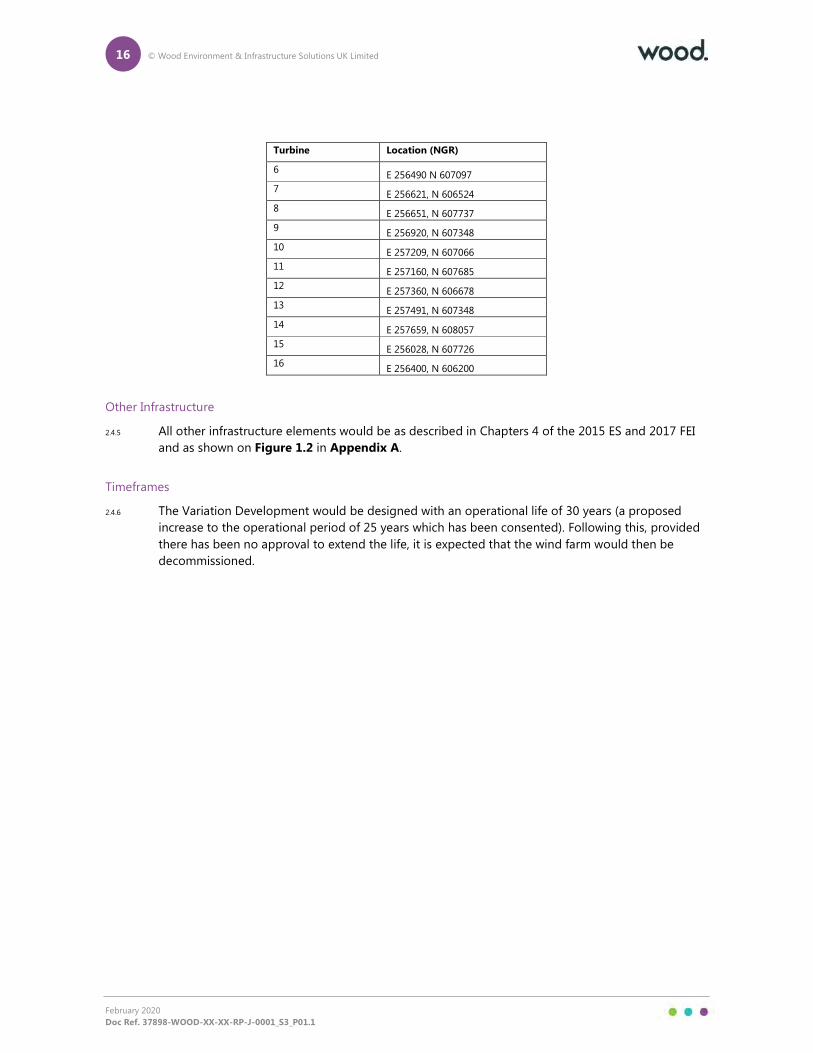
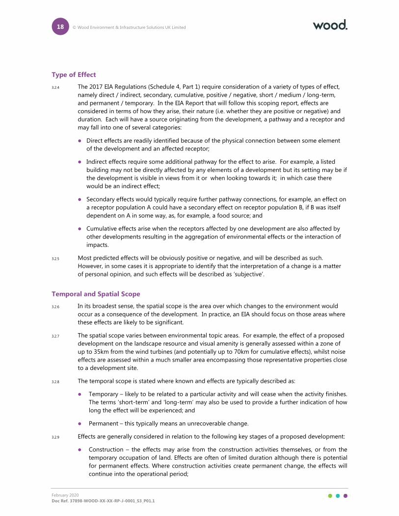
2.4.4 The turbines for the Variation Development would not exceed 136m rotor diameter and 149.9m to
blade tip height and the indicative turbine coordinates remain unchanged from the Consented
Development, as presented in Table 2.1, with the Site Layout shown on Figure 1.2 in Appendix A.
Table 2.1 Turbine Coordinates
Turbine Location (NGR)
1 E 255563, N 607866
2 E 255934, N 608200
3 E 255716, N 607356
4 E 256142, N 606876
5 E 256373, N 608072
16 © Wood Environment & Infrastructure Solutions UK Limited
February 2020
Doc Ref. 37898-WOOD-XX-XX-RP-J-0001_S3_P01.1
Turbine Location (NGR)
6 E 256490 N 607097
7 E 256621, N 606524
8 E 256651, N 607737
9 E 256920, N 607348
10 E 257209, N 607066
11 E 257160, N 607685
12 E 257360, N 606678
13 E 257491, N 607348
14 E 257659, N 608057
15 E 256028, N 607726
16 E 256400, N 606200
Other Infrastructure
2.4.5 All other infrastructure elements would be as described in Chapters 4 of the 2015 ES and 2017 FEI
and as shown on Figure 1.2 in Appendix A.
Timeframes
2.4.6 The Variation Development would be designed with an operational life of 30 years (a proposed
increase to the operational period of 25 years which has been consented). Following this, provided
there has been no approval to extend the life, it is expected that the wind farm would then be
decommissioned.

17 © Wood Environment & Infrastructure Solutions UK Limited
February 2020
Doc Ref. 37898-WOOD-XX-XX-RP-J-0001_S3_P01.1
3. EIA Process and Consultation
3.1 EIA Overview
3.1.1 EIA is a systematic process that must be followed for certain categories of project before they can
receive development consent. It aims to identify a project’s likely significant effects through the
scoping process, and then assess those effects in an EIA Report. This helps to ensure that the
importance of the predicted effects and the scope for mitigation measures to reduce them are
properly understood by the public and, in this instance, the Scottish Ministers before it makes its
decision.
3.1.2 The EIA process should be systematic, analytical, impartial, consultative and iterative, allowing
opportunities for environmental concerns to be addressed in the design of a project. Typically, a
number of design iterations take place in response to environmental constraints identified during
the EIA process prior to the final design being reached.
3.1.3 The EIA should be based upon recognised good practice and guidelines specific to each technical
area and identify the likely significant environmental effects arising from a proposed development.
Consultees are also encouraged to provide confirmation of agreement to the proposed scope in
terms of what is included and excluded, the methodology and the receptors identified.
3.2 EIA Terminology
Impacts and Effects
3.2.1 EIA is concerned with the identification of likely significant effects on the environment. However,
the terms impact and effect are often used synonymously and this can lead to confusion. For
clarity, the convention used in this assessment is to use 'impacts' within the context of the term EIA,
which describes the process from scoping through ES preparation to subsequent monitoring and
other work. Otherwise, this document uses the word 'effects' when describing the environmental
consequences of the Variation Development. For example, such effects may come about as a result
of the following:
� Physical activities that would take place if the development were to proceed (e.g. vehicle
movements during construction operations);
� Environmental changes that are predicted to occur as a result of these activities (e.g. loss of
vegetation prior to the start of construction work or an increase in noise levels). In some cases
one change causes another change, which in turn results in an environmental effect.
3.2.2 The predicted environmental effects are the consequences of the environmental changes for
specific environmental receptors. For example, with respect to bats, the loss of roosting sites or
foraging areas could affect the bats’ population size; with regard to people, an increase in noise
levels could affect amenity.
3.2.3 This assessment is concerned with assessing the significance of the environmental effects of the
Variation Development, rather than the activities or changes that cause them. However, this
requires these activities to be understood and the resultant changes identified; often based on
predictive assessment work.
18 © Wood Environment & Infrastructure Solutions UK Limited
February 2020
Doc Ref. 37898-WOOD-XX-XX-RP-J-0001_S3_P01.1
Type of Effect
3.2.4 The 2017 EIA Regulations (Schedule 4, Part 1) require consideration of a variety of types of effect,
namely direct / indirect, secondary, cumulative, positive / negative, short / medium / long-term,
and permanent / temporary. In the EIA Report that will follow this scoping report, effects are
considered in terms of how they arise, their nature (i.e. whether they are positive or negative) and
duration. Each will have a source originating from the development, a pathway and a receptor and
may fall into one of several categories:
� Direct effects are readily identified because of the physical connection between some element
of the development and an affected receptor;
� Indirect effects require some additional pathway for the effect to arise. For example, a listed
building may not be directly affected by any elements of a development but its setting may be if
the development is visible in views from it or when looking towards it; in which case there
would be an indirect effect;
� Secondary effects would typically require further pathway connections, for example, an effect on
a receptor population A could have a secondary effect on receptor population B, if B was itself
dependent on A in some way, as, for example, a food source; and
� Cumulative effects arise when the receptors affected by one development are also affected by
other developments resulting in the aggregation of environmental effects or the interaction of
impacts.
3.2.5 Most predicted effects will be obviously positive or negative, and will be described as such.
However, in some cases it is appropriate to identify that the interpretation of a change is a matter
of personal opinion, and such effects will be described as ‘subjective’.
Temporal and Spatial Scope
3.2.6 In its broadest sense, the spatial scope is the area over which changes to the environment would
occur as a consequence of the development. In practice, an EIA should focus on those areas where
these effects are likely to be significant.
3.2.7 The spatial scope varies between environmental topic areas. For example, the effect of a proposed
development on the landscape resource and visual amenity is generally assessed within a zone of
up to 35km from the wind turbines (and potentially up to 70km for cumulative effects), whilst noise
effects are assessed within a much smaller area encompassing those representative properties close
to a development site.
3.2.8 The temporal scope is stated where known and effects are typically described as:
� Temporary – likely to be related to a particular activity and will cease when the activity finishes.
The terms ‘short-term’ and ‘long-term’ may also be used to provide a further indication of how
long the effect will be experienced; and
� Permanent – this typically means an unrecoverable change.
3.2.9 Effects are generally considered in relation to the following key stages of a proposed development:
� Construction – the effects may arise from the construction activities themselves, or from the
temporary occupation of land. Effects are often of limited duration although there is potential
for permanent effects. Where construction activities create permanent change, the effects will
continue into the operational period;
19 © Wood Environment & Infrastructure Solutions UK Limited
February 2020
Doc Ref. 37898-WOOD-XX-XX-RP-J-0001_S3_P01.1
� Operation – effects may be permanent, or they may be temporary, intermittent, or limited to the
life of a proposed development until decommissioning (as in the case of wind power
developments which gain planning permission for a defined and finite number of years); and
� Decommissioning - effects may arise from the decommissioning activities themselves, or from
the temporary occupation of land. The effects would generally be temporary and of limited
duration. Additional permanent change would normally be unlikely unless associated with
restoration.
3.3 EIA Scoping
3.3.1 The results of the EIA process are reported in an EIA Report and Schedule 4(4) of the EIA
Regulations specifies that it should describe:
“…factors…likely to be significantly affected by the development: population, human health,
biodiversity (for example fauna and flora), land (for example land take), soil (for example organic
matter, erosion, compaction, sealing), water (for example hydromorphological changes, quantity and
quality), air, climate (for example greenhouse gas emissions, impacts relevant to adaptation), material
assets, cultural heritage, including architectural and archaeological aspects, and landscape.”
3.3.2 Regulation 4(2) of the EIA Regulations requires the interaction between these factors to be
considered. In addition, Regulation 4(4) requires EIA Reports to consider:
“…the expected effects deriving from the vulnerability of the development to risks, so far as relevant to
the development, of major accidents and disasters.”
3.3.3 Establishing which aspects of the environment are likely to be significantly affected by a particular
project is captured in the EIA scoping process, which aims to identify those aspects of the
environment and associated issues that need to be considered when assessing the potential effects
resulting from a proposed development. This recognises that there may be some environmental
elements for which the project is unlikely to have a significant effect, and hence where there is no
need for further investigation to be undertaken as part of the EIA.
3.3.4 This scoping report draws existing baseline data and assessment work from the 2015 ES and 2017
FEI to identify where significant effects are likely in terms of each of the relevant environmental
topics. This provides a robust process to ‘scope in’ those environmental receptors where significant
effects are likely as a result of the proposed variation, and to ‘scope out’ those where significant
effects are unlikely.
3.3.5 The proposed scope of the EIA for the Variation Development is set out in the following chapters of
this report (for ease of cross referencing, the same topic chapter numbers and headings as were
used in the 2015 ES and 2017 FEI will be maintained for the Variation Development EIA Report).
Potentially significant effects as a result of the Variation Development are summarised for each
environmental topic area2, and any such effects would be carried forward into the relevant EIA
Report chapter.
3.3.6 The scope is cognisant of The Electricity Works (Environmental Impact Assessment) (Scotland)
Amendment Regulations December 2017 which make it clear that for a variation application
relating to an EIA development, further assessment required to inform the application should only
consider the impacts of the proposed variation itself and how those differ from those previously
identified in the relevant EIA report or environmental statement. As the variation to the Consented
2 Where an effect cannot be confirmed as being ‘not significant’ these will be ‘scoped in’ to the assessment.
20 © Wood Environment & Infrastructure Solutions UK Limited
February 2020
Doc Ref. 37898-WOOD-XX-XX-RP-J-0001_S3_P01.1
Development primarily relates to an increase in the operational period, increased rotor diameter
and maximum blade tip height of turbines, with all other infrastructure, construction programme,
decommissioning proposals etc. all remaining unchanged, the EIA will focus on effects likely to arise
during the operation of the Variation Development. Impacts during the construction and
decommissioning phases and as a result of infrastructure other than turbines remain as assessed in
the 2015 ES and 2017 FEI and will therefore not be repeated in the EIA Report for the Variation
Development. The exception to this related to the delivery of larger turbine blades and tower
sections to the Development Site during the construction phase and additional Swept Path Analysis
(SPA) will therefore be carried out.
3.3.7 On this basis, elements which have been scoped into the operational phase EIA are:
� Landscape and Visual (Chapter 8);
� Collision risk for birds and bats (Chapters 11 and 10);
� Noise (Chapter 6);
� Aviation (Chapter 16); and
� Infrastructure, Telecommunications and Safety (Chapter 15).
3.3.8 For those elements which have been scoped out, an appropriate justification for this is provided.
3.3.9 The scope and assessment methodologies proposed in the subsequent technical chapters of this
scoping report are based on recognised good practice and guidelines specific to each topic area.
The environmental topic chapters identify where significant effects are anticipated as a result of the
Variation Development and take into account:
� The baseline data from the 2015 ES, and the 2017 FEI where appropriate;
� The description of the Variation Development;
� Changes to guidance on assessment methodologies (if any);
� Existing conclusions regarding significant effects for the Consented Development and the
decisions made by the Scottish Ministers (where relevant); and
� Any cumulative effects, which may arise.
3.4 Cumulative Effects
3.4.1 Cumulative effects can arise from the interaction between a proposed development and other
developments already built or proposed. In line with standard practice, for the purpose of the EIA,
other wind farm developments which are operational (and not already part of the baseline), subject
to planning approval or subject to a full and validated planning application will be included in the
consideration of potential cumulative effects (subject to a cut-off point to allow assessments to be
undertaken). It should be noted that not all of the cumulative developments would necessarily
have a cumulative effect in respect of any particular environmental topic.
3.5 Mitigation
3.5.1 Some mitigation measures to avoid, reduce or offset the consequences of the Variation
Development would be embedded within its design whilst others may require adherence to
21 © Wood Environment & Infrastructure Solutions UK Limited
February 2020
Doc Ref. 37898-WOOD-XX-XX-RP-J-0001_S3_P01.1
particular constraints on construction methodology or mode of operation. The final assessment of
significance will take into account the mitigation measures and constraints that have been
incorporated into the Variation Development (i.e. it will be the assessment of residual effects).
3.6 EIA Methodology
3.6.1 The EIA Report will identify the assessment methodologies based on recognised good practice and
guidelines specific to each of the relevant environmental topic areas where the proposed variation
could result in significant effects. In general terms, the technical studies undertaken for each topic
area and chapter included in the EIA Report to accompany the variation application would include:
� Baseline information about the receiving environment, largely based on the baseline presented
within the 2015 ES and 2017 FEI, together with identification of any relevant trends in, or
evolution of, the baseline;
� Consultation with experts and relevant consultees as necessary;
� Consideration of the potential effects of the Variation Development on the baseline, followed by
identification of any additional mitigation measures to seek to avoid or reduce any predicted
adverse effects;
� Assessment and evaluation of any residual significant effects after mitigation measures have
been implemented; and
� Compilation of the EIA Report chapter.
3.7 Consultation
3.7.1 Consultation is an essential element of the EIA process and will be reported within the EIA Report
and supporting documentation as necessary.
3.7.2 The Applicant is committed to promoting dialogue with statutory and non-statutory consultees and
the local community, seeking to engage with all those with an interest in the Variation
Development to provide transparency during the process.

22 © Wood Environment & Infrastructure Solutions UK Limited
February 2020
Doc Ref. 37898-WOOD-XX-XX-RP-J-0001_S3_P01.1

23 © Wood Environment & Infrastructure Solutions UK Limited
February 2020
Doc Ref. 37898-WOOD-XX-XX-RP-J-0001_S3_P01.1
4. Planning Policy Context
4.1 Introduction
4.1.1 The EIA will be progressed taking account of applicable legislation, policy and guidance. This
chapter outlines the planning policy framework followed by an overview of further legislation,
policy and guidance pertinent to the Variation Development.
4.1.2 The section 36C application will be accompanied by a Planning Statement, which will set out the
planning case for the Variation Development with regards to local and national policies and other
material considerations.
4.2 Regulatory Framework
4.2.1 The application for the Variation Development would be made pursuant to section 36C of the
Electricity Act 1989 (as amended) to vary the extant section 36 consent for Enoch Hill Wind Farm.
4.2.2 The Electricity Generating Stations (Applications for Variation of Consent) (Scotland) Regulations
2013 set out the procedures and information requirements for applications to vary an existing
consent. The section 36C application for the Variation Development would be prepared and
submitted in accordance with information requirements set out within these Regulations.
4.2.3 Section 57 (2ZA) of the Town and Country Planning (Scotland) Act 1997 (‘the Act’) provides for
Scottish Ministers to vary the direction for ‘deemed planning permission’ given under section 57(2)
of the Act in relation to the Consented Development.
4.2.4 The EIA Regulations provide the requirements for undertaking EIAs for developments to be
consented under the Electricity Act 1989 (as amended). The EIA Report would be prepared in
accordance with Schedule 4 of the Regulations.
4.3 Scottish Planning Policy & Guidance
4.3.1 There are legal, policy and advice documents which would be material considerations in the
determination of the section 36C application for the Variation Development, including those noted
in the following sections:
National Planning Framework 3 (NPF3)
4.3.2 NPF3 (June 2014) provides the statutory framework for Scotland’s long term spatial development.
It sets out the Scottish Government’s spatial development priorities over a 20 to 30 year period, and
what is expected of the planning system and the outcomes it must deliver. NPF3 reaffirmed the
Scottish Government’s commitment, at the time of publication, to renewable energy targets (30%)
of overall energy demand from renewable sources by 2020 and recognises the important role of
onshore wind in achieving these targets. The Framework supports the deployment of appropriately
located onshore wind energy development. It should be noted that preparation for NPF4 is
underway.
24 © Wood Environment & Infrastructure Solutions UK Limited
February 2020
Doc Ref. 37898-WOOD-XX-XX-RP-J-0001_S3_P01.1
Scottish Planning Policy (SPP)
4.3.3 SPP (June 2014) sets out national planning policies that reflect the priorities of the Scottish
Ministers for the operation of the planning system and the development and use of land through
sustainable economic growth. The SPP recognises that renewable energy generation including
onshore wind will contribute to more secure and diverse energy supplies and support sustainable
economic growth. The commitment to increase the amount of electricity generated from
renewable sources including onshore wind is a vital part of the response to climate change. It
should be noted that the Scottish Government is currently undertaking a process to reform the
planning policy and the intention is that the next version of SPPP will be incorporated into the NFP
and thus be a statutory requirement.
National Planning Advice, Circulars and Advice Sheets
4.3.4 National planning policy is supported by Planning Circulars, Planning Advice Notes (PANs) and
Specific Advice Sheets and Ministerial / Chief Planning Letters to Planning Authorities, which set out
detailed advice from the Scottish Government in relation to a number of planning issues. The
PANS and Specific Advice Sheets considered relevant to the Variation Development include:
� Planning and Noise (PAN 1/2011), March 2011;
� Planning and Archaeology (PAN 2/2011), July 2011;
� Community Engagement (PAN 3/2010), August 2010;
� Planning, Environmental Protection and Regulation (PAN 51), October 2006;
� Natural Heritage (PAN 60), January 2000;
� Sustainable Urban Drainage Systems (PAN 61), July 2011;
� Planning for Transport (PAN 75), August 2005;
� Water and Drainage (PAN 79), September 2006;
� Wind Farm Developments on Peat Land, May 2013;
� Specific Advice Sheet: Peatland Survey 2017: Guidance on Developments on Peat Land;
� Specific Advice Sheet (updated 28 May 2014): Onshore Wind Turbines;
� Spatial Planning for Onshore Wind Turbines – Natural Heritage Consideration, June 2015; and
� Chief Planner Letter regarding Energy Targets and Scottish Planning Policy, 2015.
4.4 Local Development Planning Policy
4.4.1 In considering the overall legal framework within which the Variation Development would be
assessed, the terms of the Development Plan are a consideration which should be taken into
account in the round with all other relevant considerations; however, section 25 of the Town and
Country Planning (Scotland) Act 1997 is not engaged for variation applications pursuant to Section
36C of the Electricity Act 1989 (i.e. the Development Plan does not take primacy in the
determination process).

25 © Wood Environment & Infrastructure Solutions UK Limited
February 2020
Doc Ref. 37898-WOOD-XX-XX-RP-J-0001_S3_P01.1
26 © Wood Environment & Infrastructure Solutions UK Limited
February 2020
Doc Ref. 37898-WOOD-XX-XX-RP-J-0001_S3_P01.1
5. Renewable Energy Policy, Carbon Balance and
Peat Management
5.1 Introduction
5.1.1 The EIA will be progressed taking account of applicable legislation, policy and guidance in relation
to renewable energy. This section of the EIA Report will set out the policy and energy target
context for renewable energy projects from a European, UK and Scottish perspective as well as
providing the carbon balance assessment.
5.2 Renewable Energy & Climate Change Policy Framework
5.2.1 The following legislation and policy are relevant to the Variation Development and would be
considered in the EIA Report:
� Climate Change (Emissions Reduction Targets) (Scotland) Act 2019;
� The Renewable Energy Directive (2009/28/EC);
� The EU 2030 Climate & Energy Policy Framework;
� Climate Change (Scotland) Act 2009;
� Low Carbon Economic Strategy for Scotland 2010;
� Low Carbon Scotland – Meeting the Emissions Reductions Targets 2013-2027;
� The Scottish Government Renewables Action Plan June 2009 and 2011;
� Electricity Generation Policy Statement 2013;
� 2020 Renewables Routemap June 2011, updated October 2012 and December 2013;
� The Scottish Energy Strategy 2017
� Onshore Wind Policy Statement 2017 ; and
� The Climate Change Plan 2018.
5.3 Potential Contribution of the Variation Development to
Government Objectives
5.3.1 The Scottish and UK legislative and policy framework on climate change is shaped by international
climate change legislation. These incorporate binding targets in the reduction of greenhouse gas
emissions and in the generation of energy from renewable sources.
5.3.2 In 2019, the Scottish Government amended the Climate Change (Scotland) Act 2009 through the
Climate Change (Emissions Reduction Targets) (Scotland) Act 2019. The 2019 Act seeks to ensure
Scotland achieves its ambition to reduce greenhouse gas emissions to a net-zero state by 2045. In
order to achieve this ambition, Scotland will need considerably more renewable energy projects.
27 © Wood Environment & Infrastructure Solutions UK Limited
February 2020
Doc Ref. 37898-WOOD-XX-XX-RP-J-0001_S3_P01.1
5.3.3 The Variation Development would utilise more recent turbine technology than available and
assumed at the time of the planning application for the Consented Development, which in turn
would increase the renewable energy yield and maximise generation within the same footprint.
This would make an important and substantial contribution to achieving multiple existing targets
regarding the deployment of renewable energy technologies and greenhouse gas emissions
reduction in pursuit climate change mitigation.
5.4 Carbon Balance Assessment
5.4.1 A carbon balance assessment (Appendix 6.C) using the Scottish Government Windfarm Carbon
Assessment Tool - Version 2.9.0 was undertaken as part of the 2015 ES. An updated carbon
balance assessment will be undertaken using the most up to date version of the Scottish
Government Windfarm Carbon Assessment Tool, currently v1.6.0 (November 2019)3.
5.5 Peat Management
5.5.1 A peat management plan (Appendix 6.A) and peat slide risk assessment (Appendix 6.B) were
undertaken as part of the 2015 ES.
5.5.2 Comprehensive peat probing surveys were carried out to inform these reports in accordance with
SEPA’s peat depth probing survey guidance at the time. Whilst this guidance was updated in 20174,
the survey work carried out to inform the 2015 ES and 2017 FEI remains valid as it complies with
the updated SEPA guidance.
5.5.3 Since there are no proposed changes to the infrastructure layout within the Variation Development,
the results of the Peat Slide Risk assessment remain valid and no update to this is required.
5.5.4 The predicted volume of excavated peat is expected to remain unchanged from that set out within
Table 2.2 of the revised PMP presented within the 2017 FEI. Table 2.3 in the PMP confirms that all
of the excavated peat can be used within the Development Site for habitat reinstatement and this
conclusion is unchanged for the Variation Development. As a result, it is considered that no update
to the 2017 PMP is required.
3 https://informatics.sepa.org.uk/CarbonCalculator/index.jsp 4 http://www.gov.scot/Topics/Business-Industry/Energy/Energy-sources/19185/17852-1/CSavings/PSG2011
28 © Wood Environment & Infrastructure Solutions UK Limited
February 2020
Doc Ref. 37898-WOOD-XX-XX-RP-J-0001_S3_P01.1
6. Noise
6.1 Introduction
6.1.1 The process for and approach to the construction of the Variation Development would be the same
as that assessed in the 2015 ES and 2017 FEI, with no significant differences anticipated from the
proposed increase in the size of turbines. The results of the construction assessment within the
2015 ES and 2017 FEI showed that due to the high separation distances between works and
sensitive receptors a significant effect would be unlikely. As with the 2015 ES and 2017 FEI, noise
during decommissioning works would also be scoped out of the assessment as these would be
largely similar, though anticipated to be quieter, than during the construction phase of the
development.
6.1.2 As such, the 2015 ES and 2017 FEI assessment is considered applicable and no further work to
update the assessment in respect of the construction and decommissioning phase is required. It is
therefore proposed that noise during construction/decommissioning is scoped out of the
assessment.
6.1.3 The traffic for the maintenance and operation of the wind farm would be minimal and, as with the
Scoping Report for the 2015 ES, it is also proposed that this would be scoped out of the
assessment.
6.1.4 The proposed scope would therefore consist of the assessment of operational noise for the
Variation Development, including cumulative noise impacts from proposed, consented and
operational wind developments in the area.
6.2 Baseline Conditions
Data Sources
6.2.1 The data sources most relevant to the assessment of noise from the Variation Development are
those detailed within the 2015 ES and 2017 FEI, namely the comprehensive background noise
monitoring undertaken in 2014.
6.2.2 Review of the Development Site using current Ordnance Survey mapping and Aerial Photography
has identified no new sensitive receptors that would be considered in addition to those considered
within the 2015 ES and 2017 FEI. Therefore, given that there has been no discernible change to the
Development Site or the surrounding area within which the 2014 noise monitoring took place, and
to allow direct comparison between the noise assessments presented in the 2015 ES and 2017 FEI
and the assessment for the Variation Development, no additional noise monitoring is proposed.
Summary of Baseline Conditions
6.2.3 The site is located in a semi-rural area with the most notable noise source being occasional traffic
on the B741.
6.2.4 There is no evidence to suggest that the prevailing baseline noise conditions have changed
significantly from those presented within the 2015 ES and 2017 FEI. The baseline identification used
within the 2015 ES and 2017 FEI followed the latest accepted approach detailed in ‘A Good Practice
29 © Wood Environment & Infrastructure Solutions UK Limited
February 2020
Doc Ref. 37898-WOOD-XX-XX-RP-J-0001_S3_P01.1
Guide to the Application of ETSU-R-97 for the Assessment and Rating of Wind Turbine Noise’ (IOA,
2013).
6.2.5 The baseline data analysis was undertaken in conjunction with wind speeds at 80 m height, the hub
height of the candidate turbine. As the proposed candidate hub height is likely to be approximately
82 m; the original baseline wind shear analysis for the site is still considered appropriate in line with
ETSU-R-97. The results of background noise monitoring, and the associated noise limits derived
using methodology advocated within the ETSU-R-97 Guidance, would therefore remain applicable
for the Variation Development EIA Report.
6.3 Methodology
Operational Noise
6.3.1 The proposed operational noise assessment would be undertaken in accordance with ‘ETSU-R-97:
The Assessment and Rating of Noise from Wind Farms’, (ETSU-R-97 Guidance) (1996), and the
assessment methodology advocated within the Institute of Acoustics ‘A Good Practice Guide to
Applications of ETSU-R-97 for the Assessment and Rating of Wind Turbine Noise’ (IoA GPG) (2013).
6.3.2 The ETSU Guidance advises that any noise restrictions placed on a wind farm must balance its
environmental impact against the national and global benefits that would arise through the
development of renewable energy sources:
“The planning system must therefore seek to control the environmental impacts from a wind farm
whilst at the same time recognising the national and global benefits that would arise through the
development of renewable energy sources and not be so severe that wind farm development is unduly
stifled”.
6.3.3 In this respect, the wind turbine noise levels imposed by Planning Condition 33 of the Consented
Development are accepted by the Applicant. The final selection of turbine model for the Variation
Development would follow a competitive tendering process and would be required to comply with
the noise criterion levels established by planning condition(s). Consideration will also be given to
the cumulative effect, taking into account both consented and operational wind farms.
6.3.4 The majority of noise related guidance and standards (including the ETSU Guidance) are not
directly related to the concepts of ‘significant’ and ‘not significant’ effects that underpin EIA.
However, for the purposes of the assessment, the determination of effect significance for the
operational phase of the Variation Development is based upon compliance with the applicable
noise limit i.e. a breach of the noise limits indicates a significant effect, whereas compliance with
noise limits indicates an effect which is not significant. As noise levels exceeding the ETSU
Guidance noise limits are deemed to be significant, they would require further consideration were
this the case; with a view to identifying appropriate mitigation to ensure compliance with the
specified limits.
6.4 Potential Impacts
Operational Impacts
6.4.1 When operational, wind turbines emit two types of noise – mechanical noise and aerodynamic
noise. The main sources of mechanical noise are from internal components housed within the
nacelle, such as the gearbox and generator. Mechanical noise from a modern wind turbine is
30 © Wood Environment & Infrastructure Solutions UK Limited
February 2020
Doc Ref. 37898-WOOD-XX-XX-RP-J-0001_S3_P01.1
negligible, as the nacelles are insulated to reduce noise emissions and the various mechanical
components housed within the nacelle are acoustically isolated to prevent structure-borne noise.
6.4.2 Aerodynamic noise occurs from the movement of the blades passing through the air. At higher
wind speeds, aerodynamic noise is usually masked by the increasing sound of wind blowing
through trees and around buildings. The level of masking determines the perceived audibility of the
wind farm. The proposed impact assessment establishes the relationship between wind turbine
noise and the natural masking of noise resulting from features of the surrounding environment and
assesses noise levels against established standards.
6.4.3 For the impact assessment, a range of turbine models appropriate for the Variation Development
will be considered. The final selection of turbine would follow a competitive tendering process and
thus the actual model of turbine may differ from those upon which the assessment has been based.
However, the final choice of turbine will be required to comply with the noise criterion levels which
have been established by the Consented Development.
6.5 Potential Mitigation
6.5.1 Noise modelling would be undertaken using software adopting the IoA GPG advocated
methodologies. In the event that exceedances of the associated noise limits are determined for a
specified turbine model, mitigation options would be investigated. These may include: adoption of
quieter turbines; reducing the power rating, and thus the noise emission of particular turbines in
particular wind environments; or design of a noise management plan which varies the operation of
the wind turbines dependent on the existing wind direction.
6.6 Summary of Effects
6.6.1 The Variation Development is unlikely to result in any significant effects in terms of construction,
operational traffic and decommissioning and therefore it is proposed that these elements are
scoped out of the assessment. However, there is the potential for significant effects during the
operational phase of the Variation Development and this has been scoped into the assessment.

31 © Wood Environment & Infrastructure Solutions UK Limited
February 2020
Doc Ref. 37898-WOOD-XX-XX-RP-J-0001_S3_P01.1
32 © Wood Environment & Infrastructure Solutions UK Limited
February 2020
Doc Ref. 37898-WOOD-XX-XX-RP-J-0001_S3_P01.1
7. Shadow Flicker
7.1.1 Shadow Flicker is a phenomenon that can occur in sunny weather when turbines are operating and
the rotating blades cause a flickering effect inside a building where sunlight passes through an
opening such as a window or door.
7.1.2 For shadow flicker to occur, the receptor must be directly in line with the wind turbines when the
sun is low in the sky and within 10 rotor diameters of a turbine where they are located within 130
degrees either side of north of any turbine. In these circumstances, the moving turbine blade
briefly blocks/reduces the intensity of light entering an opening to a room on each rotation,
causing a flickering to be perceived. In the open, shadow flicker is generally not perceived as light
outdoors is reflected from all directions.
7.1.3 It is stated within the Scottish Government’s Onshore Wind Turbines planning advice note (May
2014) that where separation is provided between wind turbines and nearby dwellings (as a general
rule, 10 rotor diameters), ‘shadow flicker should not be a problem’.
7.1.4 The increase in turbine rotor diameter would lead to a larger area of potential effect. However,
there are still no residential properties within or close to this area (i.e. within 10 rotor diameters of
the Variation Development) and consequently an assessment of shadow flicker effects is scoped
out of the EIA.

33 © Wood Environment & Infrastructure Solutions UK Limited
February 2020
Doc Ref. 37898-WOOD-XX-XX-RP-J-0001_S3_P01.1
34 © Wood Environment & Infrastructure Solutions UK Limited
February 2020
Doc Ref. 37898-WOOD-XX-XX-RP-J-0001_S3_P01.1
8. Landscape and Visual
8.1 Introduction
8.1.1 The objective of the Landscape and Visual Impact Assessment (LVIA) would be to assess the impact
of the proposed increase in turbine height in relation to the following:
� Landscape Effects – assessment of effects on areas of landscape character, including key
characteristics, elements, landscape qualities and landscape designations;
� Visual Effects – assessment of effects on the views and visual amenity experienced by residents,
tourists / visitors, recreational users and road / rail users; and
� Cumulative Effects – assessment of effects in combination with and in addition to other
existing, consented and proposed wind farms, referred to as Cumulative Landscape and Visual
Impact Assessment (CLVIA).
8.1.2 As the variation to the Consented Development is limited to an increased hub height, rotor
diameter and maximum blade tip height of all 16 turbines, with all other infrastructure, construction
programme, decommissioning proposals etc. remaining unchanged, the LVIA would consider the
landscape and visual effects likely to arise during the operation of the Variation Development only.
8.2 Guidance and Reference Material
8.2.1 The LVIA would be undertaken in accordance with best practice guidance including the following:
� Guidelines for Landscape and Visual Impact Assessment, Third Edition, Landscape Institute and
IEMA (2013);
� Visual Representation of Windfarms, Version 2.2, SNH (February 2017);
� Siting and Designing Windfarms in the Landscape, Version 3a, SNH (August 2017);
� Guidance: Assessing the Cumulative Impact of Onshore Wind Energy Developments, SNH (2012);
� Visual Assessment of Windfarms: Best Practice, University of Newcastle for SNH (2002):
Commissioned Report F01AA303A;
� Residential Visual Amenity Assessment: Technical Information Note, Landscape Institute, 15
March 2019; and
� Visual Representation of Development Proposals Technical Guidance Note 06/19, Landscape
Institute, September 2019.
8.3 Baseline Conditions
The Study Area
8.3.1 SNH guidance on the Visual Representation of Windfarms (February 2017) recommends that for
proposed wind farm developments of between 131-150m to blade tip, an initial study area of 40km
is used for landscape and visual assessments. The study area is illustrated in Figure 8.1. The

35 © Wood Environment & Infrastructure Solutions UK Limited
February 2020
Doc Ref. 37898-WOOD-XX-XX-RP-J-0001_S3_P01.1
guidance states that “The extent of ZTV required may need to be adjusted inwards or outwards
according to the specific characteristics of a landscape and/or proposed development. The extent of
the final ZTV should be discussed and agreed with the determining authority and consultees.” Figure
8.2 shows a ZTV generated based on a layout of 149.9m turbine height. This is a comparative ZTV
illustrating the theoretical visibility of the Consented Development (16 turbines @ 130m to blade
tip) and the Variation Development (16 turbines @ 149.9m to blade tip). It should be noted that the
ZTV does not account for the effect of screening provided by buildings and vegetation.
8.3.2 Figure 8.2 shows that there is very limited visibility of the Variation Development between 35 and
40km and on this basis, these views are likely to be Not Significant at these distances. Therefore,
the same study area of 35km used for the Consented Development is considered appropriate for
the Variation Development.
8.3.3 The LVIA reported in the 2015 ES and 2017 FEI assessed significant effects on a number of
landscape and visual receptors within approximately 7km of the turbines. As a precaution and
following a similar approach to the previous LVIAs, the detailed study area is likely to focus on
landscape receptors as follows:
� Landscape Character within 10km; and
� Landscape Designations within 10km.
8.3.4 At a further distance and within the 35km study area, only those areas of landscape receptors which
are designated at a national or international level, and are overlapped by the blade tip ZTV for the
Variation Development, will be included in the assessment.
8.3.5 Visual Receptors will be assessed as follows:
� Settlements within 10km;
� Residential Properties within 2km (a separate Residential Visual Amenity Assessment will be
undertaken);
� Transport Routes within 10km;
� Core Paths, Scottish Hill Tracks and Heritage Paths within 10km;
� Scotland’s Great Trails and the National Cycle Network within 35km; and
� Recreational and Tourist Destinations within 10km.
8.3.6 A review of the broad wind farm context within a 60km radius has been undertaken, based on the
latest SNH mapping of large-scale wind farm development. It is considered that any cumulative
effects that would occur would arise as a result of the pattern of development within the 35km
study area radius rather than as a result of changes beyond this. A 35km study area is therefore
proposed for the cumulative assessment.
8.3.7 A plan showing the locations of wind farms within the 35km study area that are operational, under
construction, consented or which are at application stage and where the turbines are greater than
50m to blade tip is presented in Figure 8.3. Micro-generation turbines between 25-50m to blade
tip within 10km of the Variation Development have been included.
Landscape Character
8.3.8 The landscape character of the Development Site is described in the SNH National Landscape
Character Assessment (NLCA), 2019 which covers the whole of Scotland and supersedes the 1990s
36 © Wood Environment & Infrastructure Solutions UK Limited
February 2020
Doc Ref. 37898-WOOD-XX-XX-RP-J-0001_S3_P01.1
landscape character descriptions and mapping. The SNH website5 advises that this data “should be
used for new development proposals, plans and strategies, and so on. Where current proposals or
projects have analysis based on the 1990s LCT dataset that should still be used. It should be noted
which dataset has been used. Where there are topic-specific landscape capacity or sensitivity studies,
they would take precedence for informing that development type, e.g. wind farms.” It may be noted
that the landscape character of the Development Site and surroundings within 10km are described
in the East Ayrshire, and Dumfries and Galloway Wind Farm Landscape Capacity Studies and will
therefore take precedence over the SNH NLCA 2019, as follows:
� Anderson, Carol Landscape Associates; East Ayrshire Landscape Wind Capacity Study, Main
Study Report (2018); and
� Anderson, Carol Landscape Associates; Dumfries and Galloway Wind Farm Landscape Capacity
Studies (2017).
8.3.9 In particular, the assessment would consider the likely effects on the host landscape within which
the Variation Development is located (East Ayrshire Southern Uplands LCT – Benty Cowan Hill LCA
and Southern Uplands with Forestry LCT – Enoch Hill LCA) and other the LCTs within 10km. LCTs
beyond 10km will be excluded from the assessment.
Landscape Designations
8.3.10 There are no national or international landscape designations within the study area as illustrated in
Figure 8.4. The Galloway Forest Dark Sky Park, and Gardens and Designed Landscapes will be
assessed as Recreational and Tourist Receptors.
8.3.11 The following local landscape designations are located within 10km of the Development Site:
� Sensitive Landscape Character Areas (SLCA) (East Ayrshire), namely:
� Afton SLCA; and
� Doon Valley SLCA.
� Galloway Hills Regional Scenic Area (Dumfries and Galloway).
8.3.12 Effects on the above local designations would be considered in the assessment.
Wild Land
8.3.13 No part of the Development Site is located within a Wild Land Area (WLA), the nearest being
Merrick WLA approximately 18km to the south-west.
8.3.14 The LVIA reported in the 2015 ES and 2017 FEI concluded that the introduction of the Proposed
Development into the baseline landscape in which wind farm development already exists would not
lead to a significant effect on the Merrick WLA or wild land characteristics and special qualities.
This was due mainly to the large intervening distances and visual compatibility of the Proposed
Development with other existing and consented wind farm development, including South Kyle,
Windy Standard and Extension, Pencloe, Windy Rig and Benbrack, affecting a similar area and angle
of view. This also applies to the Variation Development for the same reasons and considering the
5 https://www.nature.scot/professional-advice/landscape/landscape-character-assessment/landscape-character-assessment-scotland
37 © Wood Environment & Infrastructure Solutions UK Limited
February 2020
Doc Ref. 37898-WOOD-XX-XX-RP-J-0001_S3_P01.1
very limited visibility from the WLA. Therefore, the need for a detailed Wild Land Assessment has
been scoped out.
Visual Receptors
8.3.15 The baseline of visual receptors (people) would draw upon the ZTV, site visits and viewpoint
analysis and would include the following visual receptors:
� Views from settlements within 10km, including Burnside, Bankglen, Connel Park, Leggate, New
Cumnock, Dalmellington and Burnton;
� Views experienced whilst travelling through the landscape (road users, walkers, horse riders and
cyclists, for example); and
� Views from tourist and recreational destinations.
8.3.16 The visual assessment would consider the visual effects on transport routes including the A76, A713
and B741, and the Glasgow to Carlisle railway line near New Cumnock within 10km. Other minor
roads also include Glen Afton Road, C36 road between Cumnock and New Cumnock, and the minor
road between the B741 at Littlemark and Garallan Bridge on Skares Road (B7046).
8.3.17 National level recreational routes would include the Sustrans Cycle Route 7 and Southern Upland
Way Long Distance Footpath. Other recreational routes are entirely outwith the blade tip ZTV and
would therefore be excluded from the assessment.
8.3.18 Local recreational routes included within the assessment would be based on the Core Path Network
sourced from the Council’s Core Path Plan and known Rights of Way, and other local promoted
walks.
8.3.19 Recreational and tourist destinations would include those features that appear as prominent
landmarks or landscape features and locations associated with passive recreation such as walking
and where there is a clear relationship between the feature / destination and the landscape. The
key attractions within 10km of the Development Site include Craigengillan Garden and Designed
Landscape (GDL), Burns Memorial, Knockshinnoch Lagoons local nature reserve, Galloway Forest
Dark Sky Park and Loch Doon. The hill summits of Cairnsmore of Carsphairn, Blackcraig Hill and
Windy Standard would also be included in the assessment.
8.3.20 A residential visual amenity assessment would be undertaken for individual or groups of residential
properties within 2km from the outer proposed turbines.
Visualisations
8.3.21 Visualisations and figures would be produced to SNH’s standards as set out in ‘Visual
Representation of Wind Farms Guidance: Version 2.2’ (February 2017). These would include 90-
degree baseline photographs from each representative viewpoint and accompanying wirelines
showing the Variation Development and all other operational, under construction, consented and
application stage cumulative wind farm developments. Wirelines and photomontages at 53.5°
would also be included to show the Variation Development at a larger scale.
Viewpoint Selection
8.3.22 The proposed viewpoints, shown in Table 8.1 and on Figure 8.2, are drawn from the LVIA reported
in the 2015 ES and 2017 FEI. A total of 12 viewpoints are proposed to be included in the
38 © Wood Environment & Infrastructure Solutions UK Limited
February 2020
Doc Ref. 37898-WOOD-XX-XX-RP-J-0001_S3_P01.1
assessment – six of these locations were assessed as Significant (Substantial / Moderate) for the
Consented Development, whilst the remaining six assessed as Not Significant (Moderate to Slight)
are included in the assessment as a precaution.
8.3.23 A further 12 viewpoints (in red) are proposed to be scoped out as set out in the table below, with
wirelines for these provided in Figures 8.5a-f. The agreement of East Ayrshire Council, and SNH is
sought on the suggested viewpoints.
Table 8.1 Proposed Assessment Viewpoints
Viewpoint Distance Comments Included /
Scoped Out
Wireline /
Photomontage
1. B741 North East
of Dalmellington
2.3km Assessed as Significant (Substantial / Moderate) in 2017 FEI Included Photomontage
2. B741 South West
of New Cumnock
3.2km Assessed as Significant (Substantial / Moderate) in 2017 FEI Included Photomontage
3. Core Path 667
Water of Deugh
(Figure 8.5a)
4.5km Assessed as Not Significant (Slight) in 2017 FEI. Considering
the current cumulative baseline, the Variation Development
would be visible beyond the consented South Kyle Wind Farm
and would be further screened by intervening forestry and
landform. The effects of the Variation Development would
therefore be the same as the Consented Development.
Proposed to
be scoped
out
N/A
4. New Cumnock
Cemetery
5.9km Assessed as Significant (Substantial / Moderate) in 2017 FEI Included Photomontage
5. Highpoint north
of site (near
Auchinross)
6.5km Assessed as Significant (Substantial / Moderate) in 2017 FEI Included Photomontage
6. Blackcraig Hill 7.2km Assessed as Significant (Substantial / Moderate) in 2017 FEI Included Photomontage
7. Lochside Hotel 7.2km Assessed as Significant (Substantial / Moderate) in 2017 FEI Included Photomontage
8. Cairnsmore of
Carsphairn
8.7km Assessed as Not Significant (Moderate) in 2017 FEI. This
viewpoint will be included as a precaution.
Included Photomontage
9. Bogton Loch
(Figure 8.5a)
9.5km Assessed as Not Significant (Slight) in 2017 FEI. Considering
the current cumulative baseline, the Variation Development
would be visible beyond the consented South Kyle Wind Farm
and would be partially screened by intervening vegetation and
landform. The effects of the Variation Development would
therefore be the same as the Consented Development.
Proposed to
be scoped
out
N/A
10. Fort Carrick
(Figure 8.5b)
9.6km Very Limited visibility of the Variation Development (two blade
tips) visible beyond the consented South Kyle Wind Farm
blade tips.
Proposed to
be scoped
out
N/A
11. Auchenroy Hill 10.9km Assessed as Not Significant (Moderate) in 2017 FEI. This
viewpoint will be included as a precaution.
Included Photomontage
12. Corsencon Hill 11.6km Assessed as Not Significant (Moderate) in 2017 FEI. This
viewpoint will be included as a precaution.
Included Baseline Photo
and Wireline
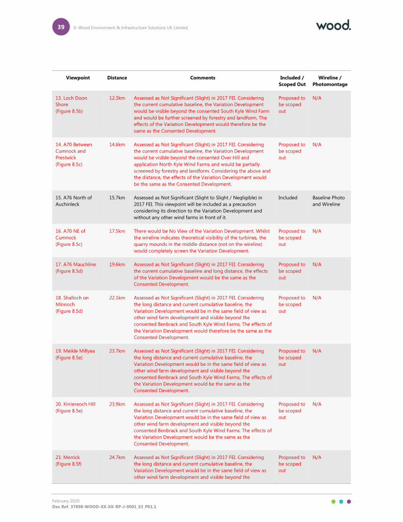
39 © Wood Environment & Infrastructure Solutions UK Limited
February 2020
Doc Ref. 37898-WOOD-XX-XX-RP-J-0001_S3_P01.1
Viewpoint Distance Comments Included /
Scoped Out
Wireline /
Photomontage
13. Loch Doon
Shore
(Figure 8.5b)
12.3km Assessed as Not Significant (Slight) in 2017 FEI. Considering
the current cumulative baseline, the Variation Development
would be visible beyond the consented South Kyle Wind Farm
and would be further screened by forestry and landform. The
effects of the Variation Development would therefore be the
same as the Consented Development.
Proposed to
be scoped
out
N/A
14. A70 Between
Cumnock and
Prestwick
(Figure 8.5c)
14.6km Assessed as Not Significant (Slight) in 2017 FEI. Considering
the current cumulative baseline, the Variation Development
would be visible beyond the consented Over Hill and
application North Kyle Wind Farms and would be partially
screened by forestry and landform. Considering the above and
the distance, the effects of the Variation Development would
be the same as the Consented Development.
Proposed to
be scoped
out
N/A
15. A76 North of
Auchinleck
15.7km Assessed as Not Significant (Slight to Slight / Negligible) in
2017 FEI. This viewpoint will be included as a precaution
considering its direction to the Variation Development and
without any other wind farms in front of it.
Included Baseline Photo
and Wireline
16. A70 NE of
Cumnock
(Figure 8.5c)
17.5km There would be No View of the Variation Development. Whilst
the wireline indicates theoretical visibility of the turbines, the
quarry mounds in the middle distance (not on the wireline)
would completely screen the Variation Development.
Proposed to
be scoped
out
N/A
17. A76 Mauchline
(Figure 8.5d)
19.6km Assessed as Not Significant (Slight) in 2017 FEI. Considering
the current cumulative baseline and long distance, the effects
of the Variation Development would be the same as the
Consented Development.
Proposed to
be scoped
out
N/A
18. Shalloch on
Minnoch
(Figure 8.5d)
22.1km Assessed as Not Significant (Slight) in 2017 FEI. Considering
the long distance and current cumulative baseline, the
Variation Development would be in the same field of view as
other wind farm development and visible beyond the
consented Benbrack and South Kyle Wind Farms. The effects of
the Variation Development would therefore be the same as the
Consented Development.
Proposed to
be scoped
out
N/A
19. Meikle Millyea
(Figure 8.5e)
23.7km Assessed as Not Significant (Slight) in 2017 FEI. Considering
the long distance and current cumulative baseline, the
Variation Development would be in the same field of view as
other wind farm development and visible beyond the
consented Benbrack and South Kyle Wind Farms. The effects of
the Variation Development would be the same as the
Consented Development.
Proposed to
be scoped
out
N/A
20. Kirriereoch Hill
(Figure 8.5e)
23.9km Assessed as Not Significant (Slight) in 2017 FEI. Considering
the long distance and current cumulative baseline, the
Variation Development would be in the same field of view as
other wind farm development and visible beyond the
consented Benbrack and South Kyle Wind Farms. The effects of
the Variation Development would be the same as the
Consented Development.
Proposed to
be scoped
out
N/A
21. Merrick
(Figure 8.5f)
24.7km Assessed as Not Significant (Slight) in 2017 FEI. Considering
the long distance and current cumulative baseline, the
Variation Development would be in the same field of view as
other wind farm development and visible beyond the
Proposed to
be scoped
out
N/A
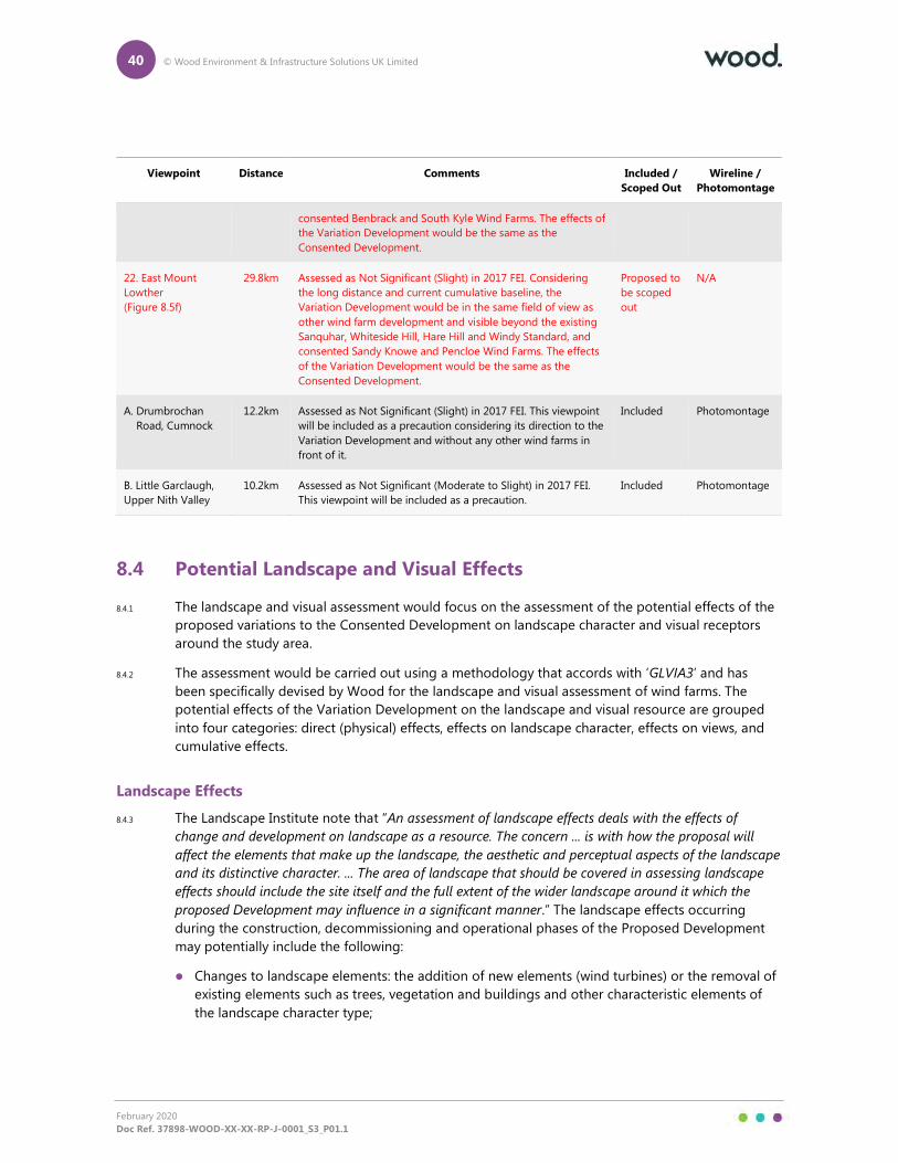
40 © Wood Environment & Infrastructure Solutions UK Limited
February 2020
Doc Ref. 37898-WOOD-XX-XX-RP-J-0001_S3_P01.1
Viewpoint Distance Comments Included /
Scoped Out
Wireline /
Photomontage
consented Benbrack and South Kyle Wind Farms. The effects of
the Variation Development would be the same as the
Consented Development.
22. East Mount
Lowther
(Figure 8.5f)
29.8km Assessed as Not Significant (Slight) in 2017 FEI. Considering
the long distance and current cumulative baseline, the
Variation Development would be in the same field of view as
other wind farm development and visible beyond the existing
Sanquhar, Whiteside Hill, Hare Hill and Windy Standard, and
consented Sandy Knowe and Pencloe Wind Farms. The effects
of the Variation Development would be the same as the
Consented Development.
Proposed to
be scoped
out
N/A
A. Drumbrochan
Road, Cumnock
12.2km Assessed as Not Significant (Slight) in 2017 FEI. This viewpoint
will be included as a precaution considering its direction to the
Variation Development and without any other wind farms in
front of it.
Included Photomontage
B. Little Garclaugh,
Upper Nith Valley
10.2km Assessed as Not Significant (Moderate to Slight) in 2017 FEI.
This viewpoint will be included as a precaution.
Included Photomontage
8.4 Potential Landscape and Visual Effects
8.4.1 The landscape and visual assessment would focus on the assessment of the potential effects of the
proposed variations to the Consented Development on landscape character and visual receptors
around the study area.
8.4.2 The assessment would be carried out using a methodology that accords with ‘GLVIA3’ and has
been specifically devised by Wood for the landscape and visual assessment of wind farms. The
potential effects of the Variation Development on the landscape and visual resource are grouped
into four categories: direct (physical) effects, effects on landscape character, effects on views, and
cumulative effects.
Landscape Effects
8.4.3 The Landscape Institute note that “An assessment of landscape effects deals with the effects of
change and development on landscape as a resource. The concern ... is with how the proposal will
affect the elements that make up the landscape, the aesthetic and perceptual aspects of the landscape
and its distinctive character. ... The area of landscape that should be covered in assessing landscape
effects should include the site itself and the full extent of the wider landscape around it which the
proposed Development may influence in a significant manner.” The landscape effects occurring
during the construction, decommissioning and operational phases of the Proposed Development
may potentially include the following:
� Changes to landscape elements: the addition of new elements (wind turbines) or the removal of
existing elements such as trees, vegetation and buildings and other characteristic elements of
the landscape character type;
41 © Wood Environment & Infrastructure Solutions UK Limited
February 2020
Doc Ref. 37898-WOOD-XX-XX-RP-J-0001_S3_P01.1
� Changes to landscape qualities: degradation or erosion of landscape elements and patterns and
perceptual characteristics, particularly those that form key characteristic elements of landscape
character types or contribute to the landscape value;
� Changes to landscape character: landscape character may be affected through the incremental
effect on characteristic elements, landscape patterns and qualities (including perceptual
characteristics) and the cumulative addition of new features, the magnitude of which is sufficient
to alter the overall landscape character type of a particular area; and
� Cumulative landscape effects: where more than one wind farm may lead to a potential
landscape effect.
8.4.4 Development may have a direct (physical) effect on the landscape as well as an indirect effect which
would be perceived from the wider landscape, outside the immediate site area and associated
landscape character.
Visual Effects
8.4.5 Visual effects are identified for different receptors (people) who will experience the view at their
place of residence, during recreational activities, at work, or when travelling through the area. The
visual effects may include the following:
� a change to an existing static view, sequential views, or wider visual amenity as a result of
development or the loss of particular landscape elements or features already present in the
view; and
� the cumulative or incremental visibility of similar types of development may combine to have a
cumulative visual effect.
Sequential Assessment
8.4.6 Cumulative sequential assessments of the Variation Development would be undertaken for the
B741 and A76.
Cumulative Landscape and Visual Effects
8.4.7 The CLVIA would be conducted in accordance with SNH Guidance and would take account of the
cumulative landscape and visual effects likely to result from other existing, consented and proposed
(planning application submitted) wind energy developments in addition to the Variation
Development. It will focus on wind energy developments considered to have potential to give rise
to significant cumulative effects. This is likely to be those wind farms within 35km of the Variation
Development but will be subject to more detailed consideration. Turbines under 50m to tip beyond
10km from the Proposed Development will not be included.
8.4.8 The current cumulative situation is indicated in Table 8.2 and illustrated in Figures 8.2 and 8.3. We
anticipate that East Ayrshire Council will agree to this list in its response to consultation on the
Scoping Report and advise on any further developments that it is aware of in the planning system.
8.4.9 Wind energy developments which may be at the scoping stages are likely to be excluded from
further assessment on the basis that sufficient detail (on location and size of turbines) is seldom
available to allow meaningful assessment. GLVIA3 (paragraph 7.14) states that developments at the
scoping stage are generally not assessed unless there is a specific reason to include them. It should
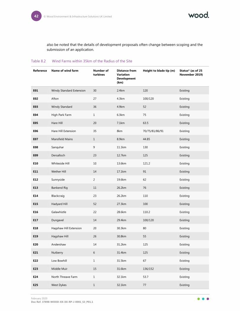
42 © Wood Environment & Infrastructure Solutions UK Limited
February 2020
Doc Ref. 37898-WOOD-XX-XX-RP-J-0001_S3_P01.1
also be noted that the details of development proposals often change between scoping and the
submission of an application.
Table 8.2 Wind Farms within 35km of the Radius of the Site
Reference Name of wind farm Number of
turbines
Distance from
Variation
Development
(km)
Height to blade tip (m) Status* (as of 25
November 2019)
E01 Windy Standard Extension 30 2.4km 120 Existing
E02 Afton 27 4.3km 100/120 Existing
E03 Windy Standard 36 4.9km 52 Existing
E04 High Park Farm 1 6.3km 75 Existing
E05 Hare Hill 20 7.1km 63.5 Existing
E06 Hare Hill Extension 35 8km 70/75/81/86/91 Existing
E07 Mansfield Mains 1 8.9km 44.85 Existing
E08 Sanquhar 9 11.1km 130 Existing
E09 Dersalloch 23 12.7km 125 Existing
E10 Whiteside Hill 10 13.6km 121.2 Existing
E11 Wether Hill 14 17.1km 91 Existing
E12 Sunnyside 2 19.6km 62 Existing
E13 Bankend Rig 11 26.2km 76 Existing
E14 Blackcraig 23 26.2km 110 Existing
E15 Hadyard Hill 52 27.3km 100 Existing
E16 Galawhistle 22 28.6km 110.2 Existing
E17 Dungavel 14 29.4km 100/120 Existing
E18 Hagshaw Hill Extension 20 30.3km 80 Existing
E19 Hagshaw Hill 26 30.8km 55 Existing
E20 Andershaw 14 31.2km 125 Existing
E21 Nutberry 6 31.4km 125 Existing
E22 Low Bowhill 1 31.5km 67 Existing
E23 Middle Muir 15 31.6km 136/152 Existing
E24 North Threave Farm 1 32.1km 53.7 Existing
E25 West Dykes 1 32.1km 77 Existing
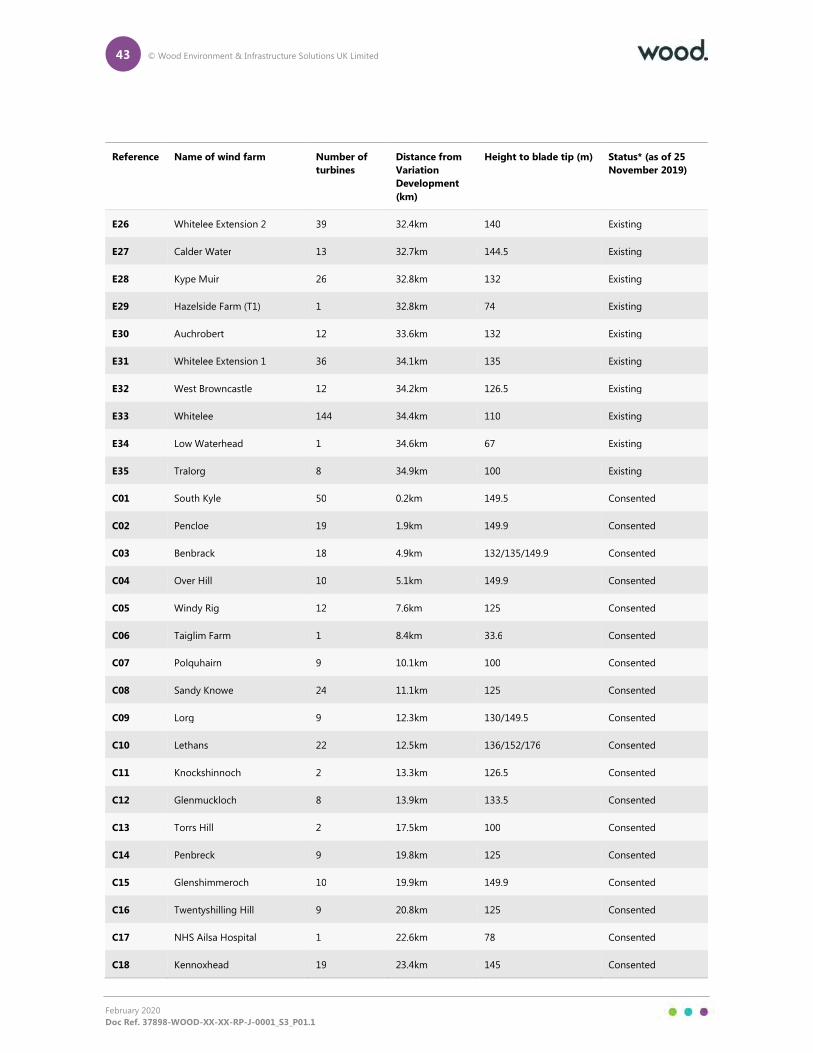
43 © Wood Environment & Infrastructure Solutions UK Limited
February 2020
Doc Ref. 37898-WOOD-XX-XX-RP-J-0001_S3_P01.1
Reference Name of wind farm Number of
turbines
Distance from
Variation
Development
(km)
Height to blade tip (m) Status* (as of 25
November 2019)
E26 Whitelee Extension 2 39 32.4km 140 Existing
E27 Calder Water 13 32.7km 144.5 Existing
E28 Kype Muir 26 32.8km 132 Existing
E29 Hazelside Farm (T1) 1 32.8km 74 Existing
E30 Auchrobert 12 33.6km 132 Existing
E31 Whitelee Extension 1 36 34.1km 135 Existing
E32 West Browncastle 12 34.2km 126.5 Existing
E33 Whitelee 144 34.4km 110 Existing
E34 Low Waterhead 1 34.6km 67 Existing
E35 Tralorg 8 34.9km 100 Existing
C01 South Kyle 50 0.2km 149.5 Consented
C02 Pencloe 19 1.9km 149.9 Consented
C03 Benbrack 18 4.9km 132/135/149.9 Consented
C04 Over Hill 10 5.1km 149.9 Consented
C05 Windy Rig 12 7.6km 125 Consented
C06 Taiglim Farm 1 8.4km 33.6 Consented
C07 Polquhairn 9 10.1km 100 Consented
C08 Sandy Knowe 24 11.1km 125 Consented
C09 Lorg 9 12.3km 130/149.5 Consented
C10 Lethans 22 12.5km 136/152/176 Consented
C11 Knockshinnoch 2 13.3km 126.5 Consented
C12 Glenmuckloch 8 13.9km 133.5 Consented
C13 Torrs Hill 2 17.5km 100 Consented
C14 Penbreck 9 19.8km 125 Consented
C15 Glenshimmeroch 10 19.9km 149.9 Consented
C16 Twentyshilling Hill 9 20.8km 125 Consented
C17 NHS Ailsa Hospital 1 22.6km 78 Consented
C18 Kennoxhead 19 23.4km 145 Consented
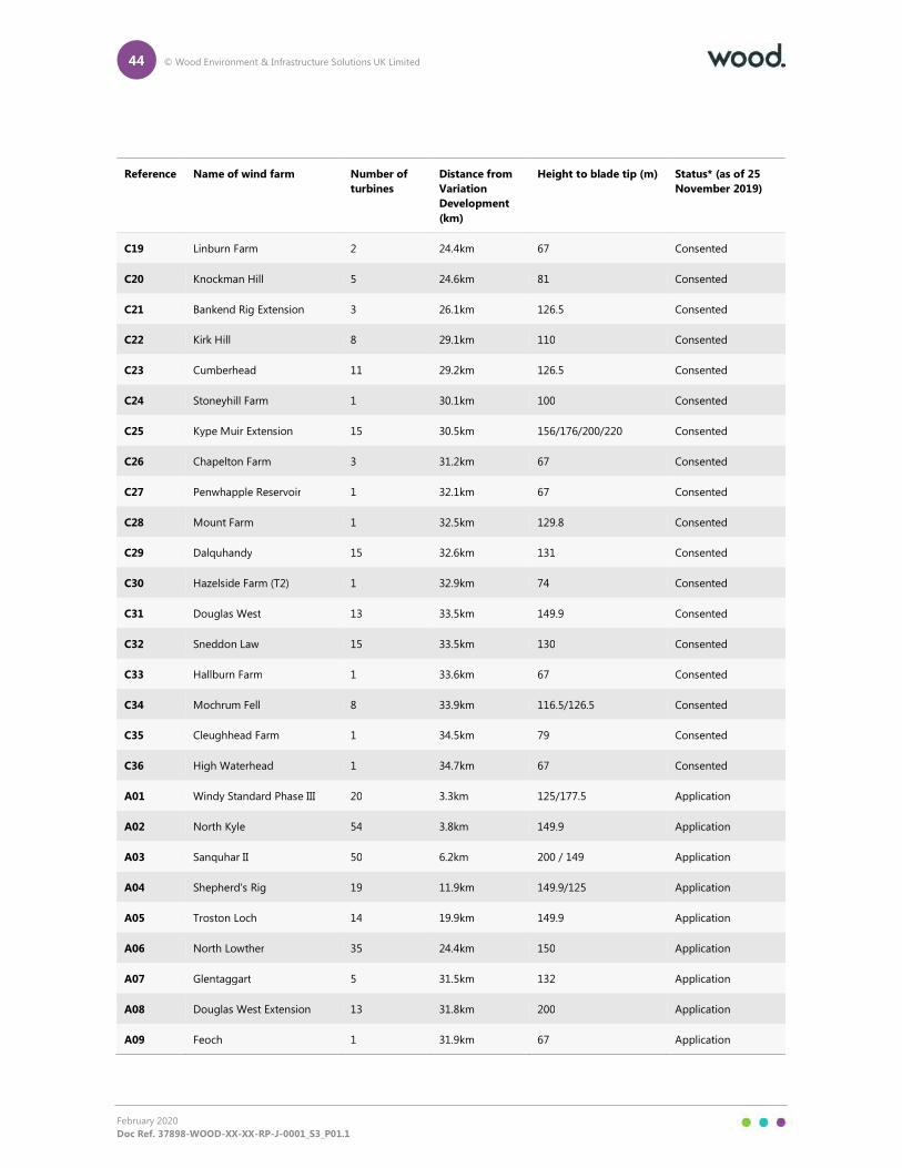
44 © Wood Environment & Infrastructure Solutions UK Limited
February 2020
Doc Ref. 37898-WOOD-XX-XX-RP-J-0001_S3_P01.1
Reference Name of wind farm Number of
turbines
Distance from
Variation
Development
(km)
Height to blade tip (m) Status* (as of 25
November 2019)
C19 Linburn Farm 2 24.4km 67 Consented
C20 Knockman Hill 5 24.6km 81 Consented
C21 Bankend Rig Extension 3 26.1km 126.5 Consented
C22 Kirk Hill 8 29.1km 110 Consented
C23 Cumberhead 11 29.2km 126.5 Consented
C24 Stoneyhill Farm 1 30.1km 100 Consented
C25 Kype Muir Extension 15 30.5km 156/176/200/220 Consented
C26 Chapelton Farm 3 31.2km 67 Consented
C27 Penwhapple Reservoir 1 32.1km 67 Consented
C28 Mount Farm 1 32.5km 129.8 Consented
C29 Dalquhandy 15 32.6km 131 Consented
C30 Hazelside Farm (T2) 1 32.9km 74 Consented
C31 Douglas West 13 33.5km 149.9 Consented
C32 Sneddon Law 15 33.5km 130 Consented
C33 Hallburn Farm 1 33.6km 67 Consented
C34 Mochrum Fell 8 33.9km 116.5/126.5 Consented
C35 Cleughhead Farm 1 34.5km 79 Consented
C36 High Waterhead 1 34.7km 67 Consented
A01 Windy Standard Phase III 20 3.3km 125/177.5 Application
A02 North Kyle 54 3.8km 149.9 Application
A03 Sanquhar II 50 6.2km 200 / 149 Application
A04 Shepherd's Rig 19 11.9km 149.9/125 Application
A05 Troston Loch 14 19.9km 149.9 Application
A06 North Lowther 35 24.4km 150 Application
A07 Glentaggart 5 31.5km 132 Application
A08 Douglas West Extension 13 31.8km 200 Application
A09 Feoch 1 31.9km 67 Application
45 © Wood Environment & Infrastructure Solutions UK Limited
February 2020
Doc Ref. 37898-WOOD-XX-XX-RP-J-0001_S3_P01.1
8.5 Night-time Lighting
8.5.1 As all turbines would be below 150m to blade tip, no aviation lighting will be required, and
therefore a night time lighting assessment is scoped out.
8.6 Significance of Effects
8.6.1 The broad objective in assessing the effects of the Variation Development is to determine what
effects on the landscape and visual resource will be significant. The significance of effects will be
assessed through a combination of two considerations; (i) the sensitivity of the landscape element,
landscape character receptor, view or visual receptor, and (ii) the magnitude of change that would
result from the introduction of the Variation Development:
� Sensitivity is an expression of the ability of a landscape element, landscape character receptor,
view or visual receptor to accommodate the Variation Development, and is dependent on
baseline characteristics including susceptibility to change, value, quality, importance, the nature
of the viewer, and existing character.
� Magnitude of change is an expression of the scale of the change on landscape elements,
landscape character receptors and visual receptors that would result from the Variation
Development.
8.6.2 The factors that are considered in the sensitivity and magnitude of change considerations are
assimilated to assess whether the Variation Development would have an effect that is significant or
not significant. In accordance with GLVIA3 (paragraph 3.23), experienced professional judgement is
applied to the assessment of all effects and the rationale supporting each conclusion is presented.
8.6.3 A significant effect occurs where the proposed changes to the Consented Development would
provide a defining influence on a landscape element, landscape character receptor or view beyond
that already assessed in the 2015 ES and 2017 FEI. A significant cumulative effect occurs where the
combined effect of the Variation Development with other existing and proposed wind farms would
result in a landscape character or view being characterised primarily by wind farms.
Nature of Effects
8.6.4 The EIA Regulations state that the EIA Report should include a description of the likely significant
effects of the Variation Development on the environment, which should cover the direct effects and
any indirect, secondary, cumulative, short and long-term, permanent and reversible, positive and
negative effects of the Variation Development. Guidance provided by the Landscape Institute on
the ‘Nature of Effect’, in the GLVIA3, is limited to a single entry which states that “One of the more
challenging issues is deciding whether the landscape (or visual) effects should be categorised as
positive or negative. It is also possible for effects to be neutral in their consequences for the landscape.
An informed professional judgement should be made about this and the criteria used in reaching the
judgement should be clearly stated.”
8.6.5 In relation to many forms of development, the LVIA would identify ‘positive’, ‘neutral’ and ‘negative’
effects by assessing these under the term ‘Nature of Effect’. In respect of landscape and visual
effects of wind farms however, there are no definitive criteria by which these can be measured as
being categorically ‘positive’ or ‘negative’. In some disciplines, such as noise or ecology, it is
possible to quantify the effect of a wind farm in numeric terms, by objectively identifying or
quantifying the proportion of a receptor that is affected by a proposed development and assessing

46 © Wood Environment & Infrastructure Solutions UK Limited
February 2020
Doc Ref. 37898-WOOD-XX-XX-RP-J-0001_S3_P01.1
the nature of that effect in justifiable terms. However, this is not the case in relation to landscape
and visual effects where the approach combines quantitative and qualitative assessment.
47 © Wood Environment & Infrastructure Solutions UK Limited
February 2020
Doc Ref. 37898-WOOD-XX-XX-RP-J-0001_S3_P01.1
9. Historic Environment
9.1.1 As part of the EIA for the Consented Development, the impact on the historic environment was
assessed and this considered direct effects on heritage assets as well as visual effects on off-site
heritage assets in respect of the ‘setting’ in which they are appreciated and understood.
9.1.2 It is considered that for the Variation Development, direct effects on the Historic Environment can
be scoped out as these would not change from the Consented Development, for which no
significant residual adverse effect was anticipated; no change to the footprint of the development is
proposed and a programme of archaeological works and agreed scheme of archaeological
mitigation would be applied for the Variation Development in the same way as for the Consented
Development.
9.1.3 There are designated heritage assets and non-designated heritage assets of potentially regional or
national importance within the wider area, including listed buildings, scheduled monuments and
garden and designed landscapes and these were considered in terms of the potential for visual
impacts upon their setting. Non designated assets assessed in detail included: Craigengillan garden
and designed landscape, Dumfries House garden and designed landscape, Beoch Cairn and
Fardenreoch prehistoric Cairns. The indirect visual effects of the Variation Development on
designated heritage assets within the wider area were all assessed as being not significant as
reported in the 2015 ES.
9.1.4 For indirect effects, the increase of turbine rotor diameter and blade tip height would generally
present a minor change in the appearance of the Variation Development, although is in not
anticipated that this would discernibly affect understanding or experience of the assets, and would
therefore not present any increase in the magnitude of change to setting from the consented
layout in all cases with the exception of Craigengillan, which is addressed below. The assets which
may be more susceptible, or where the increase in height to blade tip may produce a greater effect
on setting comprise:
� Craigengillan Garden and Designed Landscape and associated listed buildings.
9.1.5 In the case of the setting of Craigengillan Garden and Designated Landscape, the Consented
Development lies 7.7km from the asset. As reported in the 2015 ES and 2017 FEI that there would
be visibility of the turbines from different parts of the landscape to varying degrees. The turbines
appear as distant features and there is a further sense of separation provided by the higher land in
the foreground which screens the lower portion of the turbines. Existing vegetation around
Craigengillan also means that distant views are filtered as the visitor moves around the landscape.
The assessment concluded that the prevailing planting scheme and underlying topography meant
visibility of the Consented Development from the more sensitive and important areas would be
largely screened, and the turbines would only appear in passing or sequential views as the viewer
moved through the landscape, and would appear as a background element.
9.1.6 An increase in turbine height to 149.9m would likely increase the number of locations where the
Variation Development would be visible. As the viewer moves around the general landscape, blade
tips may intermittently appear above planting or above other elements of the group of assets
where currently they would be hidden. However, the views from the house would remain oblique
and largely precluded by planting, while views from other parts of the Garden and Designed
Landscape which are deemed important for their scenic/work of art value would not have visibility
of the turbines. Overall, this would result in minimal increased intrusion, and where visible, the

48 © Wood Environment & Infrastructure Solutions UK Limited
February 2020
Doc Ref. 37898-WOOD-XX-XX-RP-J-0001_S3_P01.1
Variation Development would still appear as a distant (7.7km) element of the background, rather
than an intrusive foreground element, and would not affect the ability to understand and
appreciate the core values of the asset. An increase in turbine height would not increase the
magnitude of change above low as concluded in the 2015 ES and 2017 FEI, and no significant effect
is anticipated. It is therefore proposed to scope Craigengillan Garden and Designed Landscape and
associated listed buildings out of the assessment.
9.1.7 In conclusion, it is not considered that the additional effects caused by the Variation Development
are likely to be significant and it is therefore proposed that a historic environment assessment is
scoped out.
49 © Wood Environment & Infrastructure Solutions UK Limited
February 2020
Doc Ref. 37898-WOOD-XX-XX-RP-J-0001_S3_P01.1
10. Ecology
Introduction
10.1.1 The results of the ecological impact assessment (EcIA) for the Consented Development are
presented in the 2015 ES and 2017 FEI. The scope of the EcIA was determined through a review of
existing biological data relating to the Development Site and the surrounding area, together with
consultations with relevant nature conservation organisations such as SNH. Ecological surveys
undertaken included detailed protected species surveys (for badger, otter, water vole and bats), as
well as a vegetation survey to identify plant communities of higher nature conservation value
and/or those that may be sustained by groundwater (Groundwater Dependent Terrestrial
Ecosystems – GWDTEs). In addition, a fisheries habitat survey, electrofishing surveys and a targeted
survey for freshwater pearl mussels were also undertaken.
10.1.2 The Development Site is dominated by dry modified bog, wet modified bog and marshy grassland,
all of which are affected by sheep grazing and man-made drainage which have degraded the
conservation value of the habitats present. No significant effects were predicted on any plant
communities of high nature conservation value. Furthermore, no significant effects on any
statutory designated sites were predicted to occur.
10.1.3 The presence of otter, water vole, a number of freshwater fish (salmon, trout, stone loach, minnow
and lamprey) and at least five bat species (soprano pipistrelle, common pipistrelle, brown long-
eared bat, Nyctalus species and Myotis species) was confirmed during surveys. No significant
effects were predicted on any species of high nature conservation value or any legally protected
species.
10.1.4 Three schemes at application stage which have subsequently been consented (South Kyle, Pencloe
and Benbrack) were included in the cumulative impact assessment, which concluded that there
would be no significant cumulative effects on ecological receptors.
10.1.5 Since the variation to the Consented Development primarily relates to increasing rotor diameter
and the blade tip height of turbines, with the environmental baseline, all ground level infrastructure,
construction/decommissioning methods and programme etc. remaining unchanged, the only
receptors scoped into the assessment for the Variation Development are bats as there may be an
increased risk of direct mortality through collisions with fast-moving turbine blades or barotrauma
(i.e. internal haemorrhaging in the lungs resulting from rapid changes in air pressure behind
moving turbine blades). This increase in risk is primarily as a result of the increased rotor diameter
which increases the area of airspace swept by rotating blades. Effects on all other ecological
receptors would be predicted to remain non-significant and unchanged from the 2015 ES and 2017
FEI and thus are proposed to be excluded from the EIA.
Baseline Conditions
Consultation
10.1.6 Consultation would be undertaken with South West Scotland Environmental Information Centre
(SWSEIC) to update local baseline information pertaining to bats. Relevant publications released
since the 2015 ES and 2017 FEI will also be reviewed for relevant local bat data.
50 © Wood Environment & Infrastructure Solutions UK Limited
February 2020
Doc Ref. 37898-WOOD-XX-XX-RP-J-0001_S3_P01.1
Field Studies and Assessment
10.1.7 As the habitats and management of the Development Site and surrounding area remain unchanged
(as noted during site visits), roosting, commuting or foraging habitat will remain largely unchanged
since the bat surveys carried out to inform the 2015 ES and 2017 FEI. Therefore, the Variation
Development EIA would utilise any information obtained from consultation with SWSEIC and the
baseline information contained in the 2015 ES and 2017 FEI, summarised as follows:
� Due to the presence of a known bat hibernaculum at Craigdullyeart limestone mine east of
New Cumnock (approximately 10km east north east of the Development Site), static monitoring
surveys were undertaken at ten locations across the Development Site and at four locations at
the mine entrances in October and November 2012, in order to investigate the importance of
the Enoch Hill site to bats during autumn migration;
� To investigate the use of the bat study area by commuting and foraging bats, three pre-
determined transect routes of approximately equal length were walked at night once in each of
spring, summer and autumn 2013;
� Static detector surveys at ground level were undertaken seasonally over five consecutive nights
at seven different locations across the Development Site in 2013;
� Daytime roost assessment surveys were undertaken in four areas adjacent to the Development
Site in 2014; and
� Two meteorological masts (met masts) on the Development Site were fitted with static
detectors and data collected between July and December 2014, with additional data collected
at ground level at control sites outwith the Development Site during September 2014.
10.1.8 Bats from the genera Pipistrellus, Myotis, Plecotus and Nyctalus were identified throughout the
study area, though the overall activity levels were generally low.
10.1.9 No bat roosts were identified during the surveys in 2012 or 2013 and no suitable roosting habitat
was identified on the Development Site. During 2014, individual trees in woodland areas adjacent
to the Development Site were assessed as being suitable to support roosting bats and a pipistrelle
bat roost was recorded off-site at Marshallmark. Anecdotal reports of bats roosting in a house at
Dalleagles Terrace were also noted.
10.1.10 Static detector surveys in autumn 2013 recorded four bat passes in October only, comprising a
single common pipistrelle and three Myotis species passes, with no indication that the
Development Site is an important strategic location for bats travelling to hibernation or swarming
sites. Monitoring at Craigdullyeart Mine recorded 316 bat passes over 17 nights, comprising five
species (Daubenton’s bat, Natterer’s bat, brown long-eared bat, common pipistrelle and soprano
pipistrelle), with activity levels and timings confirming the site’s use for swarming by Myotis species.
10.1.11 Transect surveys in 2013 recorded very low levels of common and soprano pipistrelle activity only.
Static detector surveys at ground level in 2013 recorded a total of 1,372 bat calls, 91.3% of which
were recorded during the summer monitoring period, with low levels of activity recorded in spring
and autumn. Bat species recorded comprised Leisler’s bat, Nyctalus species, soprano pipistrelle,
common pipistrelle and Myotis species. The majority of activity (778 passes) was recorded at the
lowest altitude monitoring location, with 584 of these being Leisler’s bat passes and a further 15
being Nyctalus passes (considered likely to be Leisler’s bat). Leisler’s bat specialises in foraging in
open habitats and shows preference for cattle-grazed pasture farmland, which is found in lower
regions of the Development Site and was recorded at all static detector locations. The pattern of
activity indicates a small number of individuals, which roost off-site, travel to the Development Site
51 © Wood Environment & Infrastructure Solutions UK Limited
February 2020
Doc Ref. 37898-WOOD-XX-XX-RP-J-0001_S3_P01.1
to forage, particularly in summer. It should be noted that hunting grounds of this species are
reported as covering 7.4-18.4km2, and that the detectors deployed covered a collective area of
3km2, and it is possible that the detectors were recording passes by the same bat. As such, the
potential risk to population of this species from collision with turbines was considered lower than is
implied by the 2013 data.
10.1.12 Common pipistrelle, soprano pipistrelle, Leisler’s bat and Daubenton’s bat were recorded at the met
masts in 2014, with a total of 255 bat passes recorded. 96 of these were recorded “at height”. Bat
activity was dominated by pipistrelle species, with 3.1% being attributed to Leisler’s bat and 2.7%
being attributed to Nyctalus species. Bat activity at the ground level control sites was found to be
higher than at the met masts, with brown long-eared bat also recorded at control sites.
10.1.13 Overall, the survey results indicated that low numbers of ‘low risk’6 bat species and a low number of
‘high risk’ bat species occur at the Development Site.
10.1.14 Taking into account this comprehensive survey effort identifying a low level of bat activity, coupled
with the location of infrastructure of the Consented Development and the environmental baseline
being unchanged for the Variation Development, no further survey effort is proposed to inform the
EIA. Basing the EIA on previously gathered data also allows the difference between the collision
risk associated with the Consented Development and the Variation Development to be assessed.
Methodology for Establishment of Effects and Reporting
10.1.15 The evaluation methodology will take account of best practice guidance (CIEEM, 2018)7 and he
assessment of the significance of predicted effects on ecological receptors (bats) will be based on
the ‘value’ or ‘sensitivity’ of the receptor and the predicted magnitude of change resulting from the
proposed increase in rotor diameter and blade tip height.
10.1.16 An Ecology chapter would be produced that would summarise the findings of the updated desk
study and the surveys reported in the 2015 ES and 2017 FEI. These would form the baseline against
which the potential impact of the variation to the Consented Development on bats would be
assessed, based on both ecological importance and the nature and magnitude of the impact that
the Variation Development would have. Recommendations would be made for mitigation where
considered necessary. Cumulative impacts will also be assessed.
6 ‘Risk’ related to risk of collision with turbine blades, as define by the Bat Conservation Trust. 7 Guidelines for Ecological Impact Assessment in the UK and Ireland: Terrestrial, Freshwater, Coastal and Marine version 1.1 (Chartered
Institute of Ecology and Environmental Management [CIEEM], 2018)

52 © Wood Environment & Infrastructure Solutions UK Limited
February 2020
Doc Ref. 37898-WOOD-XX-XX-RP-J-0001_S3_P01.1
53 © Wood Environment & Infrastructure Solutions UK Limited
February 2020
Doc Ref. 37898-WOOD-XX-XX-RP-J-0001_S3_P01.1
11. Ornithology
11.1 Introduction
11.1.1 The 2015 ES and 2017 FEI both concluded that the Development Site was of low sensitivity for
ornithological receptors and that there would be no significant effects as a result of the Consented
Development.
11.1.2 SNH provided consultation on the 2017 FEI, broadly agreeing with the ornithology assessment (no
significant effects predicted) and stating that all mitigation proposed should be fully implemented.
RSPB responded to the 2017 FEI and considered the Consented Development to have the potential
to negatively impact on non-breeding populations of golden plover as well as black grouse and
they requested the inclusion of habitat enhancement work for both species as part of an agreed
Habitat Management Plan (the details of which would be agreed with the planning authority in
consultation with SNH and SEPA prior to construction as per the planning conditions of the
Consented Development) and also a programme of post-construction bird monitoring.
11.1.3 Since the variation to the Consented Development is limited to increasing rotor diameter and the
blade tip height of turbines, with the environmental baseline, all ground level infrastructure,
construction / decommissioning methods and programme etc. remaining unchanged, the only
aspect scoped into the assessment is the risk of birds colliding with turbine blades. Effects in
relation to all other ornithological aspects, for example loss of foraging/nesting habitat, would be
predicted to remain non-significant and unchanged from the 2015 ES and are thus would be
excluded from the EIA.
11.1.4 The risk of collision mortality on birds may increase, primarily as a result of the increased rotor
diameter which increases the area of airspace swept by rotating blades. Given the low levels of
target species flight activity recorded at the Development Site during baseline surveys, it is
considered that any change in impact magnitude arising from the variation element will be minor.
However, it is proposed that collision risk is re-assessed and the previous collision risk modelling
will therefore be updated to assess the change in risk as a result of increasing the size of turbines
and the increase in operational period from 25 to 30 years.
11.1.5 Collision risk modelling presented in the 2015 ES and 2017 FEI was limited to golden plover only
given the presence of relatively small groups of birds during the winter period that were recorded
in flight within the area proposed for turbines. As site visits in the intervening period have
confirmed that habitats and land management remain largely unchanged, as does the bird
community with golden plover continuing to occur during the winter period, the collision risk
assessment for the Variation Development will also consider this species only.
11.2 Baseline Conditions
11.2.1 A literature search and review were carried out for the 2015 ES in order to gain an insight into the
ecology and behaviour of key species that could be affected by the now Consented Development.
The RSPB and the South Strathclyde Raptor Study Group (RSG) were contacted to request the
provision of data relating to black grouse records within 1.5km of the core survey area as well as
protected raptors and other species of designated conservation concern within 2km (including
eagles within 6km). The RSPB provided multiple black grouse records clustered to the north, west
and east of the turbine locations, between 2006 and 2011, all of which related to single displaying
54 © Wood Environment & Infrastructure Solutions UK Limited
February 2020
Doc Ref. 37898-WOOD-XX-XX-RP-J-0001_S3_P01.1
males. Records of barn owl and nightjar present to the north and west of the Consented
Development were also indicated by the data search. The RSG confirmed four barn owl breeding
sites from within the search area, with a further three nest sites were also identified as being
present close to the search areas, as well as two nest sites of peregrine.
11.2.2 A survey programme was also carried out, inclusive of the breeding and non-breeding bird seasons,
between September 2011 and March 2014. This included vantage point watches, with low levels of
flight activity by target species except for golden plover, which had moderate levels of flight activity
in winter. Breeding raptor surveys were undertaken in 2013, with a single Schedule 1 / Annex I
species breeding within the search area (merlin); and breeding barn owl surveys were undertaken in
2012 with a single pair breeding within the search area. Breeding wader / moorland breeding bird
surveys were carried out in 2012 and 2013 with low densities of breeding waders recorded (three
curlew territories recorded in 2013). Black grouse lek surveys were undertaken in 2012 and 2013
with a single lek site identified within the Development Site, comprising a peak count of three
males and two females, with a further three satellite leks within 1km of the main lek location. Winter
transect surveys, carried out in 2011/12 and 2012/13 recorded very low utilisation of the
Development Site by target species with golden plover and black grouse recorded.
11.2.3 The 2015 ES also considered all Natura 2000 sites along with any Sites of Special Scientific Interest
(SSSIs) with ornithological interests within a 20km search radius of the Development Site. One
Special Protection Area (SPA) and three SSSIs were identified, as follows:
� Muirkirk and North Lowther Uplands SPA (approximately 11km from Development Site);
� Merrick Kells SSSI (approximately 16km from Development Site);
� North Lowther Uplands SSSI (approximately 7km from Development Site); and
� Bogton Loch SSSI (approximately 8,5km from Development Site).
11.2.4 No connectivity was identified between the qualifying / cited features of the designated sites and
the now Consented Development as detailed within the 2015 ES. Given that potential impacts on
birds arising from the changes under the Variation Development are likely to be very minor, it is
considered that it will not be necessary to carry out Habitats Regulations Appraisal (HRA) screening.
11.3 Methodology for Establishment of Effects and Reporting
11.3.1 The evaluation methodology will take account of best practice guidance (CIEEM, 2018). The
assessment of the significance of predicted effects on ornithological receptors will be based on the
‘value’ or ‘sensitivity’ of a receptor (golden plover in this case) and the predicted magnitude of
change resulting from the proposed increase in rotor diameter and blade tip height. In the event
that the there is a predicted increase in collision risk that would be of sufficient magnitude to
materially contribute to in-combination effects, a cumulative impact assessment will be undertaken.
This will be carried out assessing other wind farm proposals/schemes within a 10km radius of the
Development Site, in order to be comparable with the 2015 ES and 2017 ES (as opposed to the
current SNH (2018) guidance which requires assessments at the Natural Heritage Zone level).
11.3.2 An EIA Report chapter would be produced which would focus of collision risk for golden plover and
recommendations would be made for mitigation where considered necessary.

55 © Wood Environment & Infrastructure Solutions UK Limited
February 2020
Doc Ref. 37898-WOOD-XX-XX-RP-J-0001_S3_P01.1

56 © Wood Environment & Infrastructure Solutions UK Limited
February 2020
Doc Ref. 37898-WOOD-XX-XX-RP-J-0001_S3_P01.1
57 © Wood Environment & Infrastructure Solutions UK Limited
February 2020
Doc Ref. 37898-WOOD-XX-XX-RP-J-0001_S3_P01.1
12. Geology, Hydrology and Hydrogeology
12.1.1 The assessment reported in the 2015 ES and 2017 FEI highlighted the potential for effects on the
geology, hydrology and hydrogeology of the Development Site, primarily during wind farm
construction, but potentially also during site operation and decommissioning. These effects are
associated with a range of activities, most notably access track construction.
12.1.2 For the proposed variation, the turbines are at the same locations as consented, i.e. only an increase
in rotor diameter and height is proposed, and all other infrastructure remains as assessed
previously. As such, and as a result of the unchanged environmental baseline, the conclusions
presented in the 2015 ES and 2017 FEI remain valid. Therefore, based on the provision of all
mitigation measures covered within the 2017 FEI the conclusions regarding the residual effects of
the Variation Development would remain the same as for the Consented Development – i.e. not
significant.
12.1.3 As stated within the 2017 FEI report, although two turbines (T2 and T5) lie within the precautionary
100 m buffer originally assigned across the whole of the River Nith catchment, the improved
baseline fisheries knowledge for the nearby watercourses (Catloch Burn and LittleChang Burn)
demonstrated that they are of lower sensitivity due to the lack of salmonid habitat. Whilst
downstream watercourses do contain salmonid populations, the measures that will be put in place
provide an appropriate level of protection alongside a 50 m buffer.
12.1.4 On this basis, the moderate level of change with respect to water quality was reduced to low,
leading to a moderate level of residual effect which is ‘not significant’. Residual effects for all
relevant receptors during all phases of the Variation Development are therefore concluded to be
not significant.
12.1.5 In addition, although there is an inherent risk of sediment loading and pollution occurring on all
construction sites, the implementation of the mitigation measures, along with compliance with
Controlled Activity Regulations (CAR) licensing requirements, reduces the residual magnitude of
any potential impact to negligible or low. This has been shown within previous assessments to
result in a residual level of effect that is negligible and not significant for all water environment
interests.
12.1.6 In summary, as the proposed changes relate to above ground infrastructure only and all the
mitigation measures previously defined for each element of the on-site development will be
implemented (most of which involve work being undertaken in accordance with current best
practice), it is concluded that there would be no significant effects on geological, hydrological or
hydrogeological receptors as a result of the Variation Development. It is therefore proposed to
scope out the assessment of receptors related to geology, hydrology and hydrogeology from the
Variation Development EIA.

58 © Wood Environment & Infrastructure Solutions UK Limited
February 2020
Doc Ref. 37898-WOOD-XX-XX-RP-J-0001_S3_P01.1
59 © Wood Environment & Infrastructure Solutions UK Limited
February 2020
Doc Ref. 37898-WOOD-XX-XX-RP-J-0001_S3_P01.1
13. Traffic and Transport
13.1 Introduction
13.1.1 All components of the Variation Development will be transported to the site by road, which creates
the potential for traffic and transport related environmental effects on the trunk and local road
network. The assessments presented in the 2015 ES and 2017 FEI highlighted traffic and transport
related effects as a result of the Consented Development, primarily during wind farm construction,
but potentially also during site operation and decommissioning, and concluded that effects would
not be significant.
13.1.2 Under the proposed variation to the Consented Development, blade length and the height of all 16
turbine towers would increase, though all other infrastructure elements, and hence traffic
movements, would remain the same. As effects relating to
construction/operation/decommissioning would therefore remain not significant, the only change
as a result of the proposed variation to the Consented Development that requires additional
assessment relates to Abnormal Indivisible Loads (AIL).
Proposed Scope of Work - Abnormal Indivisible Loads (AIL)
13.1.3 The proposed variation to the Consented Development relates to the increase in the size of turbine
components and the previous Swept Path Analysis (SPA) will therefore be revisited (Appendix 14.A
of the 2017 FEI) and updated based on the revised turbine and blade specification and presented in
the EIA Report. It is proposed that all other traffic and transport related environmental effects are
scoped out of the assessment as all other infrastructure elements remain unchanged and the 2017
FEI therefore remains valid.
13.1.4 The route used to the deliver turbine components from Ayr Port is expected to remain unchanged.
AILs are expected to depart from the Jura Terminal along Waggon Road, before turning on right on
Allison Street (A79). From here the access route would follow the A719, A77, A76 and the B741,
entering the Development Site at a new junction off the B741 in the north-western part of the
Development Site.
13.1.5 SPAs illustrating the transportation of the larger turbine blades will be undertaken at the following
relevant locations from the access study that informed the 2015 ES and FEI and presented in the
EIA Report:
� Left bend on the B741 at Connel Burn (OS Grid ref: NS 60815 12820);
� Left bend on the B741 at Manse War Memorial (OS Grid ref: NS 60059 12544);
� Right bend on B741 at Farm (OS Grid ref: NS 58007 10673);
� B417 Dalleagles Bridge (OS Grid ref: NS 57365 10656);
� Right bend on B741 (OS Grid ref: NS 56067 10502);
� Left bend on B741 (OS Grid ref: NS 54706 10303); and
� Proposed site access to Enoch Hill Wind Farm (OS Grid ref: NS 54411 09835).

60 © Wood Environment & Infrastructure Solutions UK Limited
February 2020
Doc Ref. 37898-WOOD-XX-XX-RP-J-0001_S3_P01.1

61 © Wood Environment & Infrastructure Solutions UK Limited
February 2020
Doc Ref. 37898-WOOD-XX-XX-RP-J-0001_S3_P01.1
14. Socio-economics
14.1.1 Wind farms have the potential to have both beneficial and negative effects on socio-economics,
tourism and recreation. The 2015 ES and 2017 FEI did not identify any significant effects for socio-
economics, tourism and recreation as a result of the Consented Development.
14.1.2 This scoping report chapter identifies the potential for significant effects as a result of the Variation
Development, considering the receptors as considered in the 2015 ES and 2017 FEI.
Economic & Employment
14.1.3 It is anticipated that the Variation Development would result in a similar positive effect in terms of
direct capital expenditure and employment opportunities during the construction phase to that of
the Consented Development. Overall, it is considered likely that the economic and employment
effects which are predicted to occur through the Variation Development would result in a not
significant effect similar to that of the Consented Development and this is therefore scoped out of
further assessment.
Public Access and Recreation on-site
14.1.4 The Variation Development does not propose any changes to the layout of the Consented
Development. Land use and access to the Development Site has not changed and so the public
access impact of the Variation Development would be very similar in scale and nature to those of
the Consented Development. Therefore, it is considered that the Variation Development would
result in the same level of effects in respect of the access available across the Development Site,
which is considered to be not significant. It is therefore proposed that on-site recreation and public
access are therefore are scoped out of the assessment.
Tourism and Recreation
14.1.5 The previous assessment concluded that landscape and visual effects would not change tourist
activity to a degree that significant effects in respect of visitor numbers or visitor spending would
occur.
An updated assessment of the landscape and visual effects of the Variation Development will be
undertaken (see Chapter 8, Landscape and Visual for further details). If the conclusions of the
landscape and visual chapter suggest that the proposed variation to the Consented Development
would result in a significant increase in the magnitude of change experienced by tourism and
recreation receptors, further socio-economic assessment relating to these receptors will be
undertaken.

62 © Wood Environment & Infrastructure Solutions UK Limited
February 2020
Doc Ref. 37898-WOOD-XX-XX-RP-J-0001_S3_P01.1
15. Infrastructure and Other Issues
15.1 Introduction
15.1.1 Specific Advice Sheet Onshore Wind Turbines (Scottish Government, May 2014) identifies that wind
turbines might impact on infrastructure, telecommunications, utilities and air safeguarding issues.
Effects may, for example, include disruption of microwave rebroadcast links or local radio
communication systems. The quality of television reception may also be affected, though to a
lesser extent than prior to the switchover to digital transmissions, and viewers may suffer reduction
of picture quality and acoustic interference.
15.2 Existing Infrastructure, Telecommunications and Broadcast
Services
15.2.1 A range of investigations would be undertaken to establish the presence of existing infrastructure
associated with utilities such as water, gas, electricity and telecommunications links to establish
either the absence of effects or to identify appropriate mitigation to overcome any effects. These
matters would be addressed through consultation with the relevant system operators to see if
anything has changed in respect of this infrastructure since the 2015 ES and 2017 FEI were
produced.
15.3 Population and Human Health
15.3.1 The potential effects on population and human health arising from the Variation Development
would be considered in the context of the other factors identified in Schedule 4(4) of the 2017
Regulations, given that any environmentally related health issues (both beneficial and adverse) are
likely to result from, for example, any changes in living conditions resulting from noise, and
increased employment opportunities. It is therefore proposed that population and human health
effects of the Variation Development are incorporated within the relevant technical chapters of the
EIA Report (Noise and Landscape & Visual (in respect of residential amenity in particular)).
15.3.2 However, to clearly demonstrate that population and human health effects are included in the EIA
Report, and to assist with ease of reference, it is proposed that a summary table that identifies the
potential effects and the EIA Report chapter that considers the matter in more detail would be
included (either as an appendix or within a succinct ‘Other Issues’ chapter).
15.4 Climate
15.4.1 The vulnerability of the Consented Development to climate change and extreme climate events was
considered within the engineering design element of the 2015 ES and it is not proposed that a
separate EIA Report chapter on ‘Climate’ is prepared, but any effects on climate would be
considered in relevant technical assessments. A Peat Slide Risk Assessment was undertaken as part
of the 2015 ES and updated for the 2017 FEI and as the location of all infrastructure would remain
unchanged from that of the Consented Development, no further updates to this are required.
63 © Wood Environment & Infrastructure Solutions UK Limited
February 2020
Doc Ref. 37898-WOOD-XX-XX-RP-J-0001_S3_P01.1
15.4.2 An updated carbon balance calculator would be undertaken using the most recent version of the
spreadsheet available on the Scottish Government website and this would be reported in the
Renewable Energy Policy, Carbon Balance and Peat Management EIA Report chapter.
15.4.3 Given the non-emitting nature of a wind farm and the fact that it is a renewable technology, it is
not proposed undertake an additional greenhouse gas (GHG) assessment.
15.5 Sustainable Resource Use
15.5.1 Although application sites for wind turbine development can encompass large areas of land, the
actual built development covers a relatively small area and, in most circumstances, farming and
other land based activities would continue in and around turbine development. As a result of this,
the Variation Development (and Consented Development) would only result in a small land take,
which is unlikely to result in significant environmental effects in terms of land use.
15.5.2 In terms of soil and peat, the design of tracks, turbine foundations, hardstanding, borrow pits etc.
has minimised the amount of soil disturbance. Where soils and peat would be excavated, they
would be stored on the Development Site in accordance with the Peat Management Plan
undertaken for the 2015 ES and updated for the 2017 FEI; and the Construction and Environmental
Management Plan (CEMP) would guide restoration of the site post construction to minimise the
loss of soil and peat resource.
15.5.3 With regards water, the key environmental effects of this natural resource would be its use during
the construction, operational and decommissioning phases, the potential increase in flood risk and
the disturbance of surface and groundwater as a result of construction activities. With regards to
construction works, the water resource would be managed in accordance with the CEMP. With
regards to surface and groundwater, any effects were set out in the Hydrology, Hydrogeology and
Geology chapter of the 2015 ES and 2017 FEI and it is not proposed to update these given that no
significant effects were predicted and the location of all infrastructure,
construction/decommissioning methodology etc. remain unchanged.
15.5.4 The potential effects of the Consented Development on biodiversity were primarily addressed
within the Ecology and Ornithology chapters of the 2015 ES, with appropriate mitigation set out in
order to minimise the potential damage to habitats and species during the construction, operation
and decommissioning. As the proposed changes to the Consented Development will not alter
previous conclusions presented in the 2015 ES and 2017 FEI (with the possible exception of bird/bat
collision risk), previously described mitigation remains applicable. Mitigation measures would also
be detailed in a Habitat Management Plan, which it is expected would be required by planning
condition, and also within the CEMP.
15.5.5 As a result, it is not proposed that Sustainable Resource Use is considered as a discrete section of
the EIA Report for the Variation Development.
15.6 Major Accidents and Disasters
15.6.1 The scope for the EIA to consider major accidents and disasters has been initially considered in
Table 15.1 below. Major accidents or disasters have been scoped in where they represent a high
risk to the Variation Development, either from the proposed location or from the project itself. A
high risk is considered to be where there is reasonable likelihood of the accident or disaster
occurring, or where the effect of the accident or disaster would lead to the requirement for
mitigation which is beyond the usual scope of construction or operational activities. Where an

64 © Wood Environment & Infrastructure Solutions UK Limited
February 2020
Doc Ref. 37898-WOOD-XX-XX-RP-J-0001_S3_P01.1
accident or disaster has been scoped in, the Variation Development EIA Report chapter(s) identified
would consider the matter in more detail. This further detail may show that no further assessment
is needed, or it may lead onto an appropriate level of assessment and/or identification of
appropriate mitigation.
Table 15.1 Major Accidents and Disasters
Major Accident or
Disaster
Risk due to
location
Risk due to
project
Scoped in/out due
to risk
Rationale EIA Report Chapter
Biological hazards:
epidemics
Very low Very low Out The probability
of epidemics
which would
affect the
construction or
operation of the
Variation
Development is
considered to be
very low.
N/A
Biological hazards:
animal and insect
infestation
Very low Very low Out The probability
of animal and
insect
infestations
which would
affect the
construction or
operation of the
Proposed
Development is
considered to be
very low.
N/A
Earthquakes No No Out Any earthquakes
in the vicinity of
the Variation
Development
would be of a
very small
magnitude and
the design of
turbine
foundations etc.
is adequate to
withstand such
low magnitude
events.
N/A
Tsunamis / tidal waves
/ storm surges
No No Out The general
location of the
Variation
Development
and its distance
from the coast
means there is
no risk of these
phenomena
affecting the
N/A
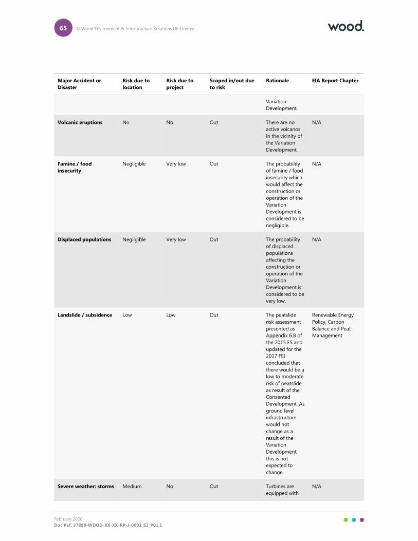
65 © Wood Environment & Infrastructure Solutions UK Limited
February 2020
Doc Ref. 37898-WOOD-XX-XX-RP-J-0001_S3_P01.1
Major Accident or
Disaster
Risk due to
location
Risk due to
project
Scoped in/out due
to risk
Rationale EIA Report Chapter
Variation
Development.
Volcanic eruptions No No Out There are no
active volcanos
in the vicinity of
the Variation
Development.
N/A
Famine / food
insecurity
Negligible Very low Out The probability
of famine / food
insecurity which
would affect the
construction or
operation of the
Variation
Development is
considered to be
negligible.
N/A
Displaced populations Negligible Very low Out The probability
of displaced
populations
affecting the
construction or
operation of the
Variation
Development is
considered to be
very low.
N/A
Landslide / subsidence Low Low Out The peatslide
risk assessment
presented as
Appendix 6.B of
the 2015 ES and
updated for the
2017 FEI
concluded that
there would be a
low to moderate
risk of peatslide
as result of the
Consented
Development. As
ground level
infrastructure
would not
change as a
result of the
Variation
Development,
this is not
expected to
change.
Renewable Energy
Policy, Carbon
Balance and Peat
Management
Severe weather: storms Medium No Out Turbines are
equipped with
N/A
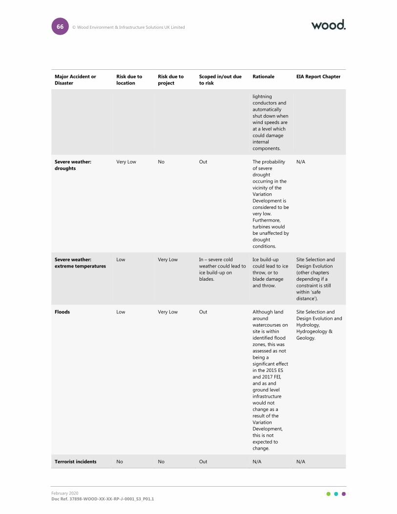
66 © Wood Environment & Infrastructure Solutions UK Limited
February 2020
Doc Ref. 37898-WOOD-XX-XX-RP-J-0001_S3_P01.1
Major Accident or
Disaster
Risk due to
location
Risk due to
project
Scoped in/out due
to risk
Rationale EIA Report Chapter
lightning
conductors and
automatically
shut down when
wind speeds are
at a level which
could damage
internal
components.
Severe weather:
droughts
Very Low No Out The probability
of severe
drought
occurring in the
vicinity of the
Variation
Development is
considered to be
very low.
Furthermore,
turbines would
be unaffected by
drought
conditions.
N/A
Severe weather:
extreme temperatures
Low Very Low In – severe cold
weather could lead to
ice build-up on
blades.
Ice build-up
could lead to ice
throw, or to
blade damage
and throw.
Site Selection and
Design Evolution
(other chapters
depending if a
constraint is still
within ‘safe
distance’).
Floods Low Very Low Out Although land
around
watercourses on
site is within
identified flood
zones, this was
assessed as not
being a
significant effect
in the 2015 ES
and 2017 FEI,
and as and
ground level
infrastructure
would not
change as a
result of the
Variation
Development,
this is not
expected to
change.
Site Selection and
Design Evolution and
Hydrology,
Hydrogeology &
Geology.
Terrorist incidents No No Out N/A N/A
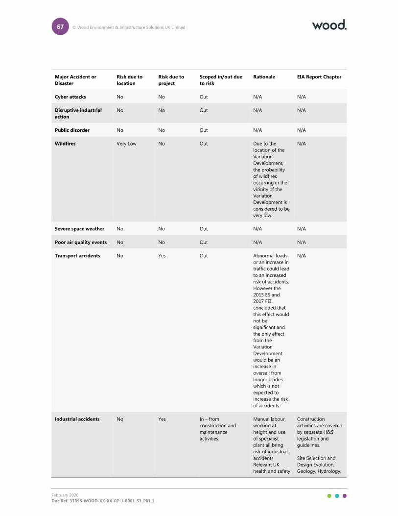
67 © Wood Environment & Infrastructure Solutions UK Limited
February 2020
Doc Ref. 37898-WOOD-XX-XX-RP-J-0001_S3_P01.1
Major Accident or
Disaster
Risk due to
location
Risk due to
project
Scoped in/out due
to risk
Rationale EIA Report Chapter
Cyber attacks No No Out N/A N/A
Disruptive industrial
action
No No Out N/A N/A
Public disorder No No Out N/A N/A
Wildfires Very Low No Out Due to the
location of the
Variation
Development,
the probability
of wildfires
occurring in the
vicinity of the
Variation
Development is
considered to be
very low.
N/A
Severe space weather No No Out N/A N/A
Poor air quality events No No Out N/A N/A
Transport accidents No Yes Out Abnormal loads
or an increase in
traffic could lead
to an increased
risk of accidents.
However the
2015 ES and
2017 FEI
concluded that
this effect would
not be
significant and
the only effect
from the
Variation
Development
would be an
increase in
oversail from
longer blades
which is not
expected to
increase the risk
of accidents.
N/A
Industrial accidents No Yes In – from
construction and
maintenance
activities.
Manual labour,
working at
height and use
of specialist
plant all bring
risk of industrial
accidents.
Relevant UK
health and safety
Construction
activities are covered
by separate H&S
legislation and
guidelines.
Site Selection and
Design Evolution,
Geology, Hydrology,
68 © Wood Environment & Infrastructure Solutions UK Limited
February 2020
Doc Ref. 37898-WOOD-XX-XX-RP-J-0001_S3_P01.1
Major Accident or
Disaster
Risk due to
location
Risk due to
project
Scoped in/out due
to risk
Rationale EIA Report Chapter
legislation will be
adhered to; site
construction
management
practices will
include, but are
not limited to,
temporary
diversions of
public rights of
way, relevant
signage and
fencing as
potential
hazardous
construction
areas where
appropriate.
and Hydrogeology
and Ecology
(pollution).
Electricity, gas, water
supply or sewerage
system failures
No Yes In – site contains
electricity
transmission cables.
Construction
activities or
turbine collapse
could damage
electricity
infrastructure. All
relevant health
and safety
legislation will be
followed, and
industry best
practice
guidance
adhered to. HSE
GS6 Avoiding
danger from
overhead power
lines will be
followed
Site Selection and
Design Evolution;
and Existing
Infrastructure,
Telecommunications
and Broadcast
Services.
Urban fires No No Out The Variation
Development is
not in close
proximity to any
urban areas.
69 © Wood Environment & Infrastructure Solutions UK Limited
February 2020
Doc Ref. 37898-WOOD-XX-XX-RP-J-0001_S3_P01.1
16. Aviation
16.1.1 Specific Advice Sheet Onshore Wind Turbines (Scottish Government, May 2014) identifies that wind
turbines might impact on the safeguarding criteria relating to aviation infrastructure and
operations. Wind turbines within radar Line of Sight (LoS), and therefore detectable by radar
systems, reflect radio waves that can interfere with the system. Turbine induced radar clutter
appearing on radar displays can affect the safe provision of Air Traffic Services as it can mask
unidentified aircraft from the air traffic controller and/or prevent the accurate continued
identification of aircraft under control. In some cases, radar reflections from the turbines can affect
the performance of the radar system itself. Additionally, due to their height, wind turbines could
also potentially present a collision risk to low flying aircraft, therefore affecting military low-level
training flights.
16.1.2 The assessment undertaken for the 2015 ES and 2017 FEI concluded that the Development Site lies
within the operational range of the NATS Lowther Hill En Route Primary Surveillance Radar (PSR)
system and the Glasgow Prestwick Airport (GPA) PSR.
16.1.3 The Applicant is party to agreements with NATS and GPA to provide mitigation for the Consented
Development, and such mitigation is expected to apply equally to the Variation Development.
16.1.4 As a result of previous consultation, the Ministry of Defence (MoD) did not raise an objection to the
Consented Development subject to the Applicant satisfying a request for the fitting of a form of
aviation obstruction lighting.

A1 © Wood Environment & Infrastructure Solutions UK Limited
February 2020
Doc Ref. 37898-WOOD-XX-XX-RP-J-0001_S3_P01.1
Appendix A
Figures

A2 © Wood Environment & Infrastructure Solutions UK Limited
February 2020
Doc Ref. 37898-WOOD-XX-XX-RP-J-0001_S3_P01.1
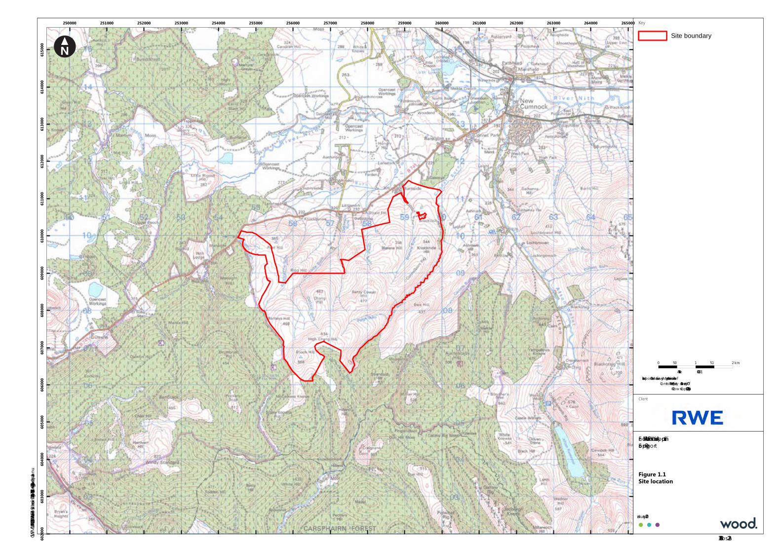
250000 251000 252000 253000 254000 255000 256000 257000 258000 259000 260000 261000 262000 263000 264000 265000
6020
0060
3000
6040
0060
5000
6060
0060
7000
6080
0060
9000
6100
0061
1000
6120
0061
3000
6140
0061
5000
Enoch Hill Wind Farm V ariation ApplicationScoping Report
Figure 1.1Site location
January 2020
Key
Site boundaryF:\GWM\DATA\PROJECT\37898 Enoch Hill Wind Farm Post Submission\D040 Design\ArcGIS\37898-Gos228a.mxd Originator: gwenda.pannu
Based upon the Ordnance Survey Map with the permission of theController of Her Majesty ’s Stationery Office.
© Crow n Copy right. 100027856
0 0.5 1 1.5 2km
1:50,000Scale at A3:
Client
37898-Gos228a
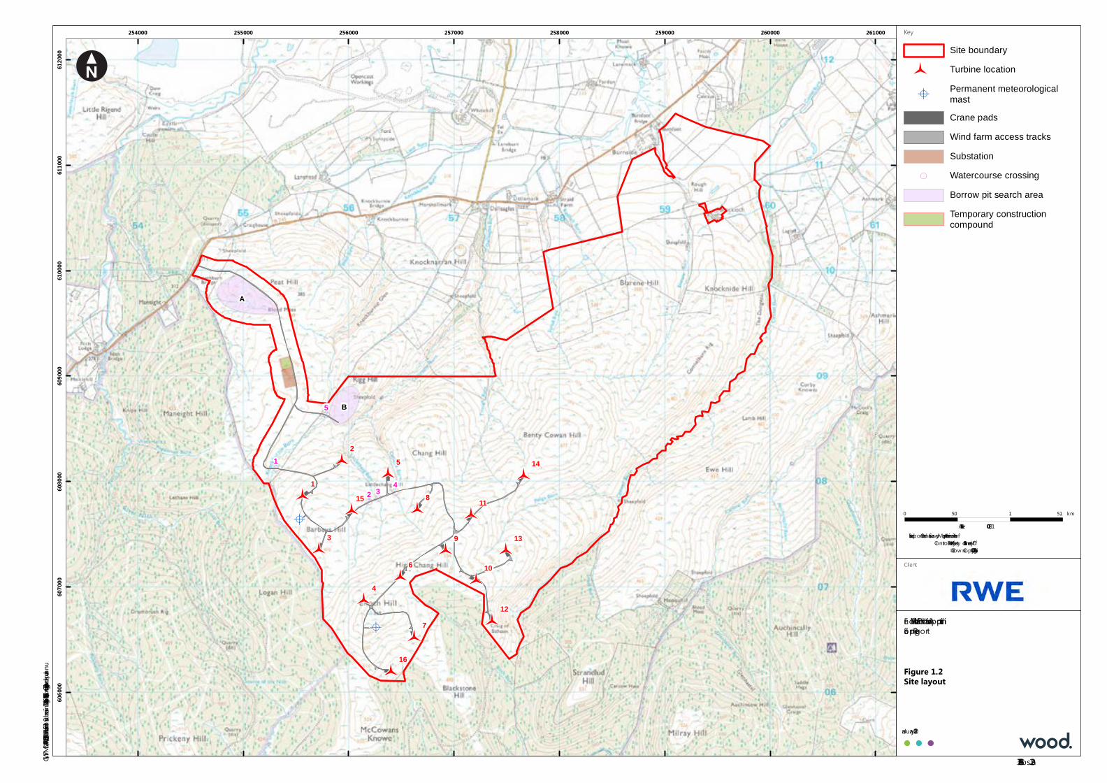
!A
!A
&&&È
&&&È
&&&È
&&&È
&&&È
&&&È
&&&È
&&&È
&&&È
&&&È
&&&È
&&&È
&&&È
&&&È
&&&È
&&&È
A
B5
432
1
9
8
7
6
5
4
3
2
1
16
15
14
13
12
11
10
254000 255000 256000 257000 258000 259000 260000 261000
6060
0060
7000
6080
0060
9000
6100
0061
1000
6120
00
Enoch Hill Wind Farm V ariation ApplicationScoping Report
Figure 1.2Site layout
January 2020
Key
Site boundary&&&È Turbine location
!APermanent meteorologicalmastCrane padsWind farm access tracksSubstation
( Watercourse crossingBorrow pit search areaTemporary constructioncompound
F:\GWM\DATA\PROJECT\37898 Enoch Hill Wind Farm Post Submission\D040 Design\ArcGIS\37898-Gos229a.mxd Originator: gwenda.pannu
Based upon the Ordnance Survey Map with the permission of theController of Her Majesty ’s Stationery Office.
© Crow n Copy right. 100027856
0 0.5 1 1.5km
1:25,000Scale at A3:
Client
37898-Gos229a
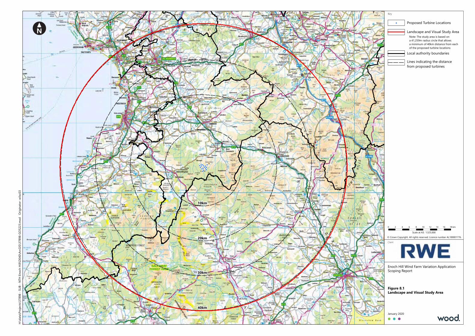
!!
!
!
!
!
!
!!!
!
!
!
!!
!
Enoch Hill Wind Farm Variation ApplicationScoping Report
Figure 8.1Landscape and Visual Study Area
January 2020
KeyH:\
data\
Projec
ts\37
898 -
SUB -
NTH
Enoc
h Hill\
D040
\ArcG
IS\37
898-G
OS22
3.mxd
Orig
inator
: wilsc
03
Client20km
30km
40km
10km
© Crown Copyright. All rights reserved. Licence number AL100001776.1:325,000Scale at A3:
0 2 4 6 8 10 12 14 16 18 km
Local authority boundaries
!
Lines indicating the distancefrom proposed turbines
Landscape and Visual Study AreaNote: The study area is based ona 41,259m radius circle that allowsa minimum of 40km distance from eachof the proposed turbine locations
Proposed Turbine Locations
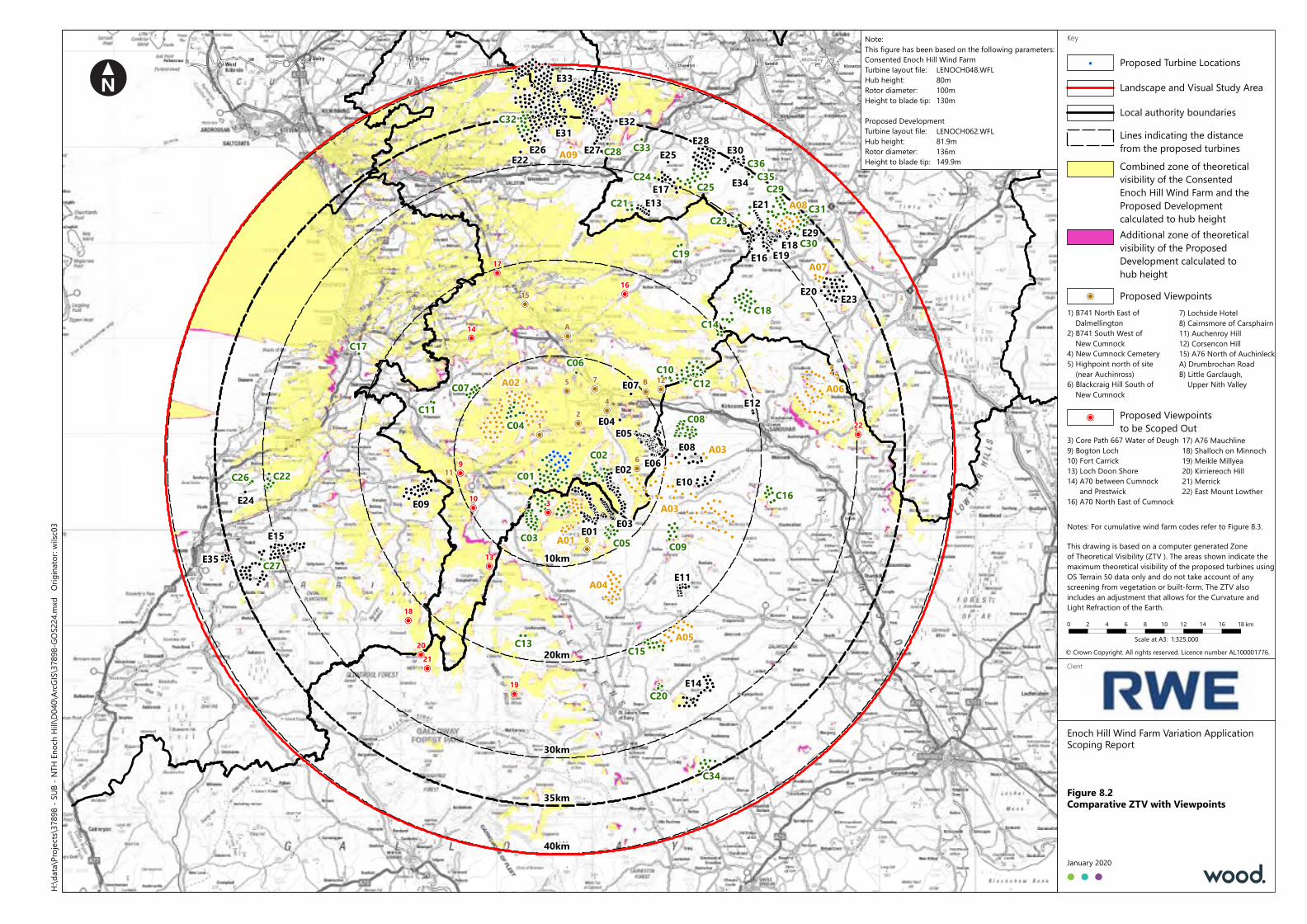
!
!
!!
!
!!
!
!!!
!
!!
!!!
!!
!!!!
! ! !! !
!! ! !
!
!!!!
!!
!
!!!
!!
!
!!
!!!
!!!
!!
!!
!!
!
! !!
! !!!
!! !!!!!!
!! !!!!
!!!!
!
!!
!
!
!!
!!
!
!
!!
!!
!!
!
! !
!
!! !
!
!
!! !
!
!
!!
!
!
!
!!
!! !
!!!
!
!!
!
!
!!
!
!
!
!!
!
!
!
!
!
!
!
!
! !
!!
!
!!
!!!
!!!
!!!
!!!
!
!!
! ! !
!!!!
! ! ! !
!!!!
! ! !
!
!!! ! !!
!!! !
!!
!!!! !
! !
!
!
!
! !!!
!!
!!
!
! !! !
! !!!
! ! !! ! !!
!!!!
!!
!!
!!!!!
!
!!!
!!!
!!
!
!!! ! !!
!
!
!!!
!!
!! !
!!
!!
!!
!
!!
!!
!!
!
!!
!
!
!
!!
!
!!!! !!
!
!
!
! !
!!!!
!
!!
!!!!
!!
!!!
!!!
!!
!!
!!!
!
!!!
!
!!
!!
!
!!!!
!
!
!! !!
!
! !!!
!!
!!
!!
! !! !
! ! !!
!!
!!!! !
!!
! !
!!
!!!
!
!
!
!
!!!
!
!
!
!!
!!
!
!
!
!!!!!
!!!
!!
!!
!!
!!
!!!
!!!!
!
!!
!!
!!
!!
!
!
!
!!
!!
!
!!!
!
!!
!
! !
!! !
! ! !!
!!!! !!!!
! !!
!!
!!!
!
!
!!!!!
!
!!
!!!!
!!!
!!!!
!
!
!!!
!!
!!
!
!!
!!!
!!
!
!
!
!!
!
!!
!
!!
!
!!
!
! !
!!
!
!!!
!
!!
!
!
!!
!
!!
!!!!!!!
!
!
!!
!!
!!
!
!!!!
!!!!!!
! !
!
! ! !
!!!
!!!!!!
!!!
!
!
! !
!!!!
!!!!
!
!
! !
!
!!!!
!!!
!
!!
!
!!
! !
!!!!
!!!
!!! !
!
!!!!
!!
!!!
!
!!!
! !!
!!!!
!!
! !!!
! !
!!
!
! !
!
!
! ! !
! !
!!
!!
!! !
!!
! !
! ! !
! !
!
!!
!
!!
!
!
!
!!!
!!
!!
!!!!!
!!
!!!
!!!
!! ! !
!!!!
!!!! !
! !!!!!
!
! !!!!
!!
!
!!
!!!
!
! !!
!!!
!
!!!
!!!!
!!
!!!!!
!
!
!
!!!
!
!
! !!!
!!!!
!!!!! !
!!!
!!!!!!
!!
!!
!!!!
! !!!
!
!!!
!!!
!!!!
!
! !!
!!
!!
!!
!
!
!! !!!! ! !
! ! !
!!!!
!
!!!!!!
!!
!!!
! !
! !!!
!!!!!!!!!!!
!!!!!!
!!!!!!!!!!
!!
!!!!
!
!!!!!!
!!!
!!
!
!!!!!
!!
!
!!
!!
!
!!!!!
! !!!!!!
!!!
!!!
!!!
!
!
!
!!
!
!!
!
!
!!
!!
!
!
!!!!
!!!
!!
!
!
!
!!!!
!!
!!
!
!
!!
!
!
!
!
!
!
!!
!
!
!
!!
! !!!
!!
!!! !!
!!!!!!
! !!!!
!
!!!!!!!
!!!!
!!
!!!!!!!!
!!!!!!
!! !
!!
!!!!!
!
!
!
!!
!!
!
!!
!
! !
!
!!!
!
!!
! !
!
!!!
!
!
!!
!
!
!
!!!! !!!!!!!!!!!!!!!
!!!!!!!!!!!!!!!!
!!!!!!!
!!!!!!!
!!!!!!
!
!!!!!!!!!
!!!! !
!!!!!!!!!!
!!!!!!!!!!
!!
!!!!!!!!!! !!
!
!!!!!! !! !!
!!!
!
!!
!!
!!
!!
!
!!!!!!!!
!!!!
!!
!!
!!
!
!
!
!P
!P
!P
!P
!P
!P
!P
!P
!P
!P
!P
!P
!P
!P
!P!P
!P
!P
!P
!P
!P
!P
!P
!P
!!
!
!
!
!
!
!!!
!
!
!
!!
!
12
4
5
6
7
8
11
12
15
3
9
10
13
14
16
17
18
19
2021
22
Enoch Hill Wind Farm Variation ApplicationScoping Report
Figure 8.2Comparative ZTV with Viewpoints
January 2020
KeyH:\
data\
Projec
ts\37
898 -
SUB -
NTH
Enoc
h Hill\
D040
\ArcG
IS\37
898-G
OS22
4.mxd
Orig
inator
: wilsc
03
Client
Proposed Turbine Locations!
Landscape and Visual Study Area
Lines indicating the distancefrom the proposed turbines
Local authority boundaries
© Crown Copyright. All rights reserved. Licence number AL100001776.1:325,000Scale at A3:
0 2 4 6 8 10 12 14 16 18 km
1) B741 North East of Dalmellington2) B741 South West of New Cumnock4) New Cumnock Cemetery5) Highpoint north of site (near Auchinross)6) Blackcraig Hill South of New Cumnock
!P
Proposed Viewpointsto be Scoped Out
Proposed Viewpoints
3) Core Path 667 Water of Deugh9) Bogton Loch10) Fort Carrick13) Loch Doon Shore14) A70 between Cumnock and Prestwick16) A70 North East of Cumnock
!P
This drawing is based on a computer generated Zoneof Theoretical Visibility (ZTV ). The areas shown indicate themaximum theoretical visibility of the proposed turbines usingOS Terrain 50 data only and do not take account of anyscreening from vegetation or built-form. The ZTV alsoincludes an adjustment that allows for the Curvature andLight Refraction of the Earth.
7) Lochside Hotel8) Cairnsmore of Carsphairn11) Auchenroy Hill12) Corsencon Hill15) A76 North of AuchinleckA) Drumbrochan RoadB) Little Garclaugh, Upper Nith Valley
17) A76 Mauchline18) Shalloch on Minnoch19) Meikle Millyea20) Kirriereoch Hill21) Merrick22) East Mount Lowther
20km
30km
40km
10km
Combined zone of theoreticalvisibility of the ConsentedEnoch Hill Wind Farm and theProposed Developmentcalculated to hub heightAdditional zone of theoreticalvisibility of the ProposedDevelopment calculated tohub height
Note:This figure has been based on the following parameters:Consented Enoch Hill Wind FarmTurbine layout file:Hub height:Rotor diameter:Height to blade tip:
Proposed DevelopmentTurbine layout file:Hub height:Rotor diameter:Height to blade tip:
LENOCH048.WFL80m100m130m
LENOCH062.WFL81.9m136m149.9m
A
B
35km
E01
E02
E03
E04E05
E06
E07
E08
E09E10
E11
E12
E13
E14
E15E35
E16
E17
E18E19
E20
E21
E22
E23
E24
E25E26 E27 E28
E29
E30E31
E32
E33
E34
C01
C03
C02
C04
C05
C06
C07
C08
C09
C10C12
C11
C13
C14
C15
C16
C17
C18
C19
C20
C21
C22C26
C27
C23
C24C25
C28
C29
C30
C31
C32
C33
C35C36
C34
A01
A02
A03
A04
A05
A06
A07
A08
A09
A03
Notes: For cumulative wind farm codes refer to Figure 8.3.
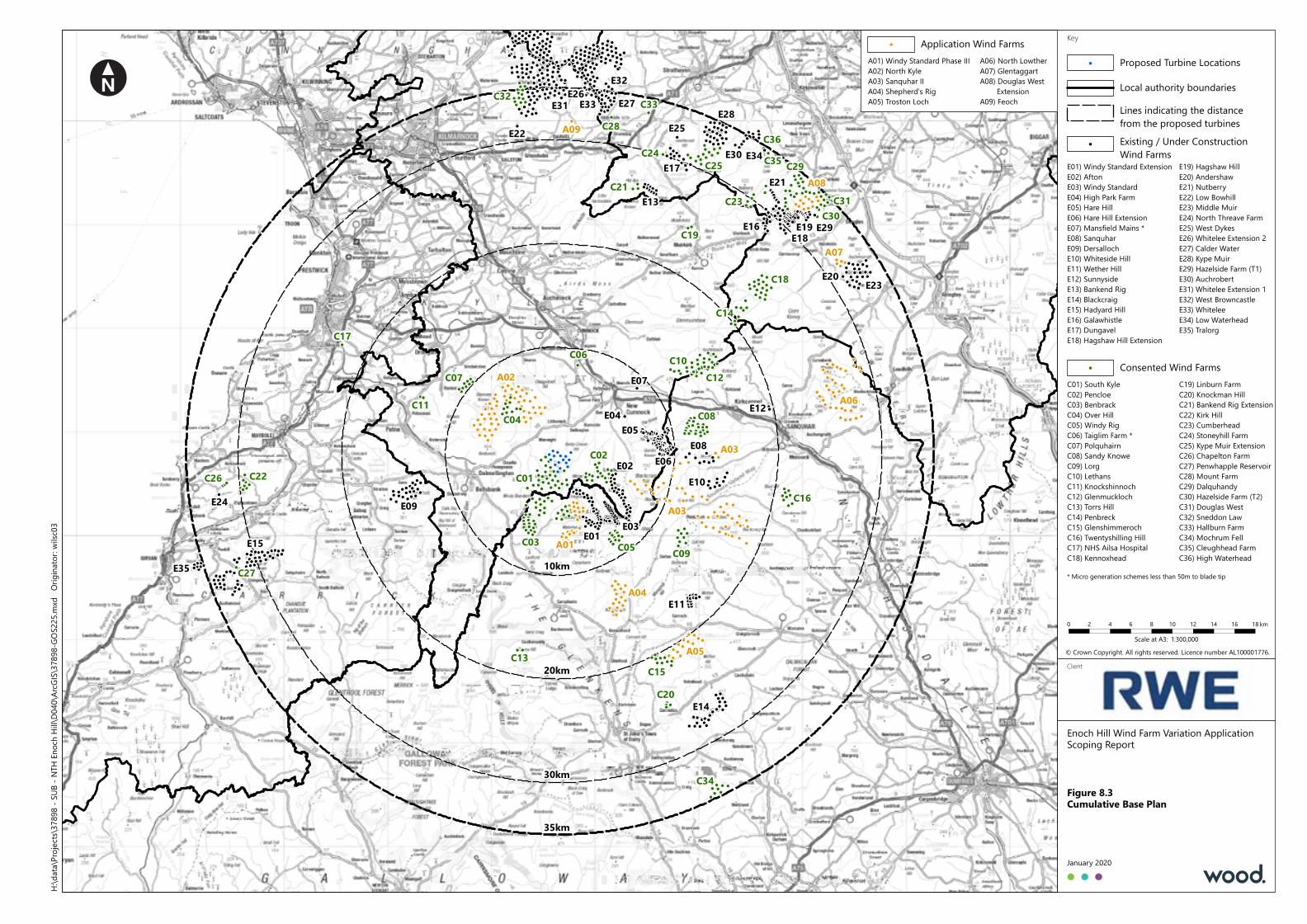
!
!
!!
!
!!
!
!!!
!
!!
!!!
!!
!!!
!! ! !
! !
!! ! !
!
!!
!!
!!
!
!!
!
!!
!
!!
!!
!
!!!
!!
!!
!!
!
! !!
! !!
!
!! !!!!!
!!
! !!!!
!!!!
!
!!
!
!
!
!
!!
!
!
!!
!!
!!
!
! !
!
!! !
!
!
!! !
!
!
!!
!
!
!
!!
!! !
!!
!!
!!
!
!
!
!
!
!
!
!!
!
!
!
!
!
!
!
!
! !
!!
!
!
!!
!!!
!!
!
!!!!
!!
!!
! ! !
!!!!
! ! ! !
!!!!
! ! !
!
!!! ! !!
!!! !
!
!
!!!! !
! !
!
!
!
! !!!
!!
!!
!
! !! !
! !!!
! ! !! ! !!
!!!!
!!
!!
!!!!!
!
!!!
!!!
!!
!
!!
! ! !!
!
!
!!!
!!
!! !
!!
!!
!!
!
!!
!!
!!
!
!!
!
!
!
!!
!
!!!! !!
!
!
!
! !
!!! !
!
!!
!!
!
!
!!
!!
!
!!!
!!
!!
!!
!
!
!!!
!
!!
!!
!
!!
!!
!
!
!! !
!
!
! !!!
!
!! !
!!
!!! !
! ! !!
!!
!!
!! !
!
!
! !
!
!
!
!!
!
!
!
!
!!!
!
!
!
!!
!
!
!
!
!
!!!!!
!!!
!!
!!
!!
!!
!!!
!!
!!
!
!!
!!
!!
!!
!
!
!
!!
!!
!
!!
!
!
!!
!
! !
!!!
! ! !!
!!!! !!!!
! !!
!!
!!!
!
!
!!!
!!
!
!!
!!! !
!!!
!!!!
!
!
!!
!
!!
!
!!
!!
!!!
!!
!
!
!
!!
!
!!
!
!!
!
!!
!
! !
!!
!
!!!
!
!!
!
!
!!
!
!!
!!!!!!!
!
!
!!
!!
!!
!
!!!!
!!!!!!
! !
!
! ! !
!!!
!!!!!!
! !!
!
!
! !
!!!
!
!!!!
!
!
! !
!
!!
!!
!!!
!
!!
!
!!
! !
!!!!
!!!
!
!! !
!
!!
! !
!!
!!
!
!
! ! !
! ! !
!
! ! !
! !
! ! !!
! !
! !
!
! !
!
!
! !!
! !
!!
!!
!! !
!!
! !
! ! !
! !
!
!
!
!
!!
!
!
!
!!
!
!!
!!
!!!! !
!!
!!!
!!!
!!!
!
!!!!
!!!
! !! !
!!!
!!
! !!!!
!!
!
!!
!!!
!
!!!
!!!
!
! !!
!!!!
!!
!!!
!!!
!
!
!!!
!
!
! !!!
!!!!
!!!!! !
!!!
!!
!!!!
!!
!!
!! !
!
!!
!!
!
!!!
!!
!
!!!!
!
!!
!!
!!!
!!
!
!
!
! !!
!! ! !
! ! !
!!
!!
!
!!!!!!
!!
!!!
! !
! !
!!
!!!!!!!!!!!
!!!!!!
!!!!!!!!!!
!!
!!!!
!
!!!!!!
!!!
!!
!
!!!!
!
!!
!
!!
!!
!
!!!!!
! !!
!!!!
!!
!!
!!!!!
!
!
!
!!
!
!!
!
!
!!
!!
!
!
!!!!
!!
!
!!
!
!
!
!!!!
!!
!!
!
!
!!
!
!
!
!
!
!
!!
!
!
!
!!
! !!!
!!
!!! !!
!!!!
!!
! !
!!!
!
!!!!
!!!
!!
!!
!!
!!!!!!!!
!!!!!!
!! !
!!
!
!!
!
!
!
!
!
!!
!!
!
!!
!
! !
!
! !!
!
!!
! !
!
!!!
!
!
!
!!
!
!
!!!! !!!!!!!!!!!
!!!!!!!!!!
!!!!!!!!!!
!!!!!!!
!!!
!!!!
!!!!!!
!
!!!!!!!! !
!!!! !
!!!!!!!!
!!!!!!!!!!!!
!!
!!!!!!!!!! !!
!
!!!!!! !! !!!!!
!
!!
!!
!!
!!
!
!!!!!!!!
!!!!
!!
!!
!!
!
!
!
!!
!
!
!
!
!
!!!
!
!
!
!!
!
Enoch Hill Wind Farm Variation ApplicationScoping Report
Figure 8.3Cumulative Base Plan
January 2020
KeyH:\
data\
Projec
ts\37
898 -
SUB -
NTH
Enoc
h Hill\
D040
\ArcG
IS\37
898-G
OS22
5.mxd
Orig
inator
: wilsc
03
Client
Proposed Turbine Locations!
Lines indicating the distancefrom the proposed turbines
Local authority boundaries
© Crown Copyright. All rights reserved. Licence number AL100001776.1:300,000Scale at A3:
0 2 4 6 8 10 12 14 16 18 km
20km
30km
35km
10km
Application Wind Farms!
A06) North LowtherA07) GlentaggartA08) Douglas West ExtensionA09) Feoch
A01) Windy Standard Phase IIIA02) North KyleA03) Sanquhar IIA04) Shepherd's RigA05) Troston Loch
E01
E02
E03
E04E05
E06
E07
E08
E09
E10
E11
E12
E13
E14
E15
E35
E16
E17
E18E19
E20
E21
E22
E23
E24
E25
E26 E27E28
E29
E30
E31
E32
E33
E34
C01
C03
C02
C04
C05
C06C07
C08
C09
C10C12
C11
C13
C14
C15
C16
C17
C18
C19
C20
C21
C22C26
C27
C23
C24C25
C28
C29
C30C31
C32 C33
C35C36
C34
A01
A02
A03
A04
A05
A06
A07
A08
A09Existing / Under ConstructionWind Farms
!
Consented Wind Farms!
* Micro generation schemes less than 50m to blade tip
E19) Hagshaw HillE20) AndershawE21) NutberryE22) Low BowhillE23) Middle MuirE24) North Threave FarmE25) West DykesE26) Whitelee Extension 2E27) Calder WaterE28) Kype MuirE29) Hazelside Farm (T1)E30) AuchrobertE31) Whitelee Extension 1E32) West BrowncastleE33) WhiteleeE34) Low WaterheadE35) Tralorg
E01) Windy Standard ExtensionE02) AftonE03) Windy StandardE04) High Park FarmE05) Hare HillE06) Hare Hill ExtensionE07) Mansfield Mains *E08) SanquharE09) DersallochE10) Whiteside HillE11) Wether HillE12) SunnysideE13) Bankend RigE14) BlackcraigE15) Hadyard HillE16) GalawhistleE17) DungavelE18) Hagshaw Hill Extension
C01) South KyleC02) PencloeC03) BenbrackC04) Over HillC05) Windy RigC06) Taiglim Farm *C07) PolquhairnC08) Sandy KnoweC09) LorgC10) LethansC11) KnockshinnochC12) GlenmucklochC13) Torrs HillC14) PenbreckC15) GlenshimmerochC16) Twentyshilling HillC17) NHS Ailsa HospitalC18) Kennoxhead
C19) Linburn FarmC20) Knockman HillC21) Bankend Rig ExtensionC22) Kirk HillC23) CumberheadC24) Stoneyhill FarmC25) Kype Muir ExtensionC26) Chapelton FarmC27) Penwhapple ReservoirC28) Mount FarmC29) DalquhandyC30) Hazelside Farm (T2)C31) Douglas WestC32) Sneddon LawC33) Hallburn FarmC34) Mochrum FellC35) Cleughhead FarmC36) High Waterhead
A03
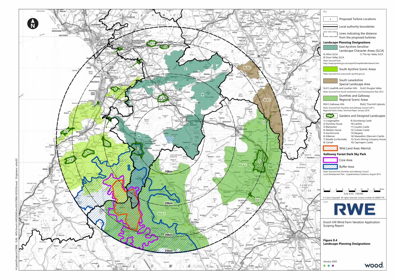
!!
!
!
!
!
!
!!!
!
!
!
!!
!
Enoch Hill Wind Farm Variation ApplicationScoping Report
Figure 8.4Landscape Planning Designations
January 2020
KeyH:\
data\
Projec
ts\37
898 -
SUB -
NTH
Enoc
h Hill\
D040
\ArcG
IS\37
898-G
OS22
6.mxd
Orig
inator
: wilsc
03
Client
Proposed Turbine Locations!
Lines indicating the distancefrom the proposed turbines
Local authority boundaries
© Crown Copyright. All rights reserved. Licence number AL100001776.1:300,000Scale at A3:
0 2 4 6 8 10 12 14 16 18 km
20km
30km
35km
10km
Landscape Planning DesignationsEast Ayrshire SensitiveLandscape Character Areas (SLCA)
A) Afton SLCAB) Doon Valley SLCANote: Sourced fromhttp://maps.ayrshire.gov.uk/mapsAJP/mapWindfarmSearch.htm
South Ayrshire Scenic AreasNote: Sourced from www.south-ayrshire.gov.uk
South LanarkshireSpecial Landscape Area
Dumfries and GallowayRegional Scenic Areas
RSA1) Galloway HillsNote: Sourced from Dumfries and Galloway Council LDP 2,Regional Scenic Areas, Technical Paper, January 2018
Gardens and Designed Landscapes1) Craigengillan2) Dumfries House3) Blairquhan4) Skeldon House5) Auchincruive6) Kilkerran7) Rozelle (La Rochelle)8) Carnell
9) Drumlanrig Castle10) Lanfine11) Loudon Castle12) Culzean Castle13) Bargany14) Maxwelton (Glencairn Castle)15) Scot's Mining Company House16) Caprington Castle
Galloway Forest Dark Sky Park
Note: Sourced from South Lanarkshire Local Development Plan 2015
Core AreaBuffer Area
C) The Ayr Valley SLCA
RSA2) Thornhill Uplands
Note: Sourced from Dumfries and Galloway CouncilLocal Development Plan - Supplementary Guidance, August 2015
SLA1) Leadhills and Lowther Hills SLA2) Douglas Valley
Wild Land Area: Merrick
B
A
C
RSA1
RSA2
SLA2
SLA1
1
2
3
4
5
6
7
8
9
1011
12
13
14
16
15
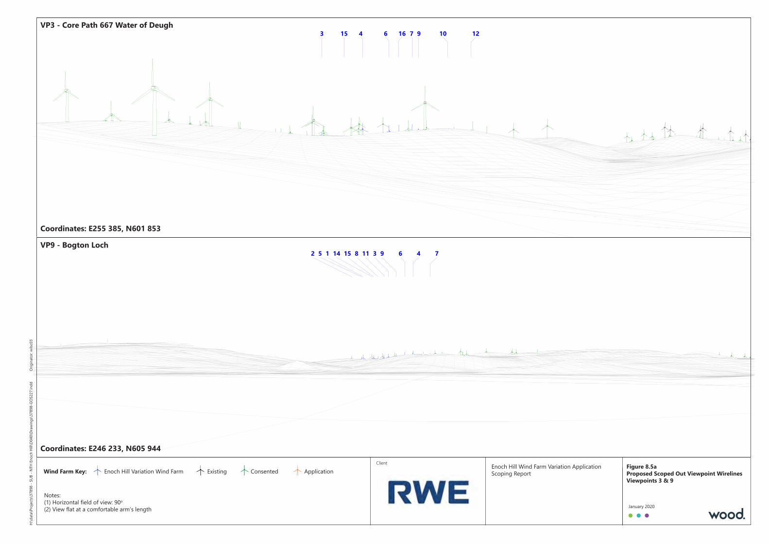
Client Enoch Hill Wind Farm Variation ApplicationScoping ReportWind Farm Key: Enoch Hill Variation Wind Farm Existing Consented Application
Notes:(1) Horizontal field of view: 90o
(2) View flat at a comfortable arm’s length
3 4 6 7 9 10 1215 16H:\
data\
Projec
ts\37
898 -
SUB -
NTH
Enoc
h Hill\
D040
\Draw
ings\3
7898
-GOS
227.i
ndd
Origi
nator
: wilsc
03
January 2020
12 3 45 6 78 91114 15VP9 - Bogton LochVP9 - Bogton Loch
Coordinates: E255 385, N601 853Coordinates: E255 385, N601 853
Figure 8.5aProposed Scoped Out Viewpoint WirelinesViewpoints 3 & 9
VP3 - Core Path 667 Water of DeughVP3 - Core Path 667 Water of Deugh
Coordinates: E246 233, N605 944Coordinates: E246 233, N605 944
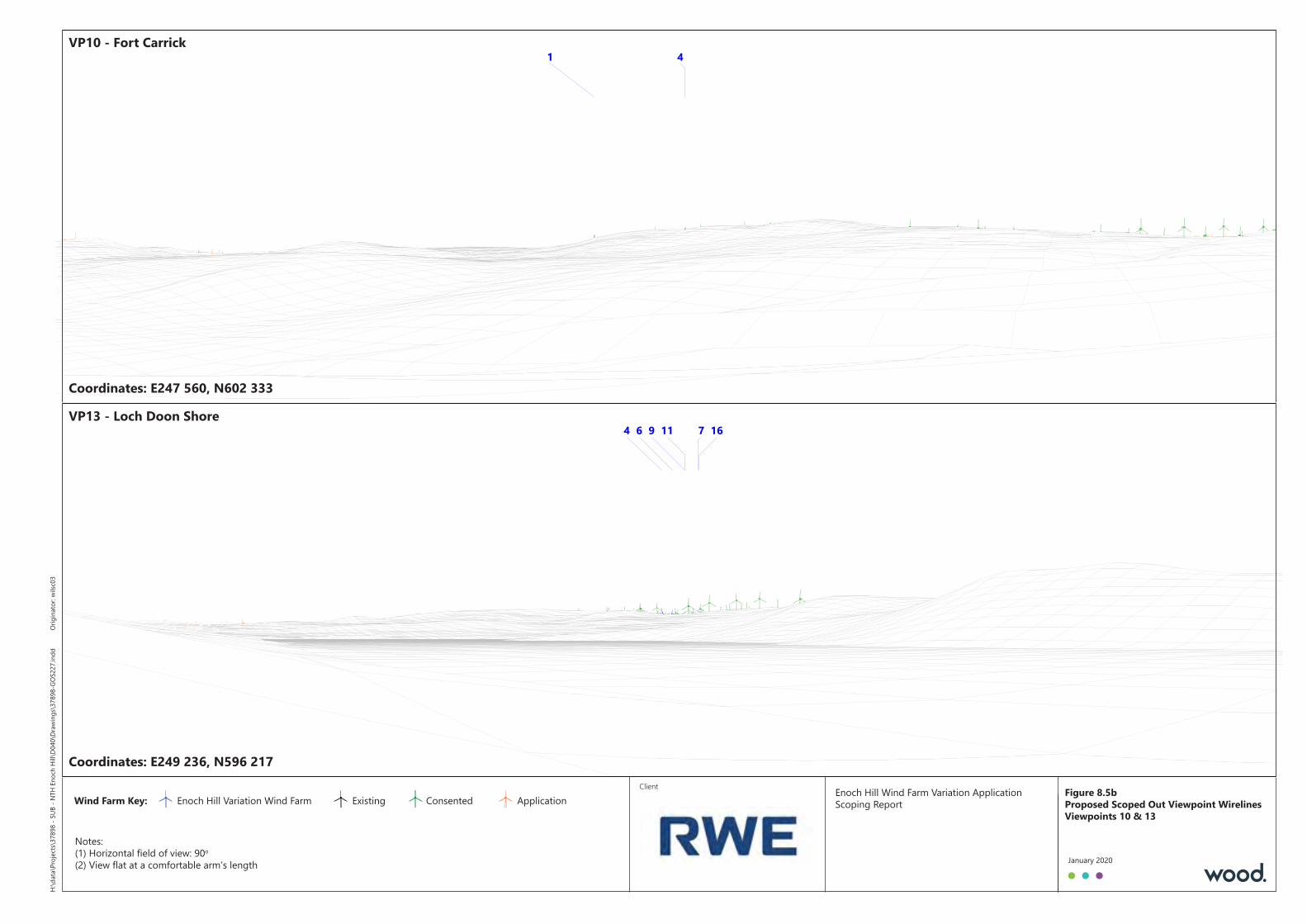
Client Enoch Hill Wind Farm Variation ApplicationScoping ReportWind Farm Key: Enoch Hill Variation Wind Farm Existing Consented Application
Notes:(1) Horizontal field of view: 90o
(2) View flat at a comfortable arm’s length
1 4H:\
data\
Projec
ts\37
898 -
SUB -
NTH
Enoc
h Hill\
D040
\Draw
ings\3
7898
-GOS
227.i
ndd
Origi
nator
: wilsc
03
January 2020
4 6 79 11 16VP13 - Loch Doon ShoreVP13 - Loch Doon Shore
Coordinates: E247 560, N602 333Coordinates: E247 560, N602 333
Figure 8.5bProposed Scoped Out Viewpoint WirelinesViewpoints 10 & 13
VP10 - Fort CarrickVP10 - Fort Carrick
Coordinates: E249 236, N596 217Coordinates: E249 236, N596 217

Client Enoch Hill Wind Farm Variation ApplicationScoping ReportWind Farm Key: Enoch Hill Variation Wind Farm Existing Consented Application
Notes:(1) Horizontal field of view: 90o
(2) View flat at a comfortable arm’s length
12 345 6 78 91011 121314 15 16H:\
data\
Projec
ts\37
898 -
SUB -
NTH
Enoc
h Hill\
D040
\Draw
ings\3
7898
-GOS
227.i
ndd
Origi
nator
: wilsc
03
January 2020
1234 567 8910 1113 14 1516VP16 - A70 North East of CumnockVP16 - A70 North East of Cumnock
Coordinates: E247 353, N620 045Coordinates: E247 353, N620 045
Figure 8.5cProposed Scoped Out Viewpoint WirelinesViewpoints 14 & 16
VP14 - A70 between Cumnock and PrestwickVP14 - A70 between Cumnock and Prestwick
Coordinates: E263 390, N624 657Coordinates: E263 390, N624 657
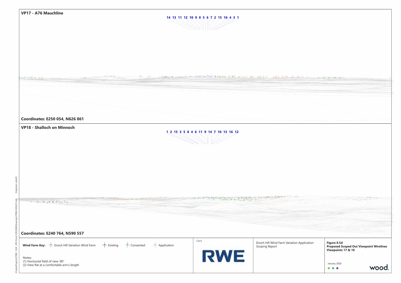
Client Enoch Hill Wind Farm Variation ApplicationScoping ReportWind Farm Key: Enoch Hill Variation Wind Farm Existing Consented Application
Notes:(1) Horizontal field of view: 90o
(2) View flat at a comfortable arm’s length
12 345 6 7891011 121314 15 16H:\
data\
Projec
ts\37
898 -
SUB -
NTH
Enoc
h Hill\
D040
\Draw
ings\3
7898
-GOS
227.i
ndd
Origi
nator
: wilsc
03
January 2020
1 2 3 45 6 78 9 1011 12131415 16VP18 - Shalloch on MinnochVP18 - Shalloch on Minnoch
Coordinates: E250 054, N626 861Coordinates: E250 054, N626 861
Figure 8.5dProposed Scoped Out Viewpoint WirelinesViewpoints 17 & 18
VP17 - A76 MauchlineVP17 - A76 Mauchline
Coordinates: E240 764, N590 557Coordinates: E240 764, N590 557
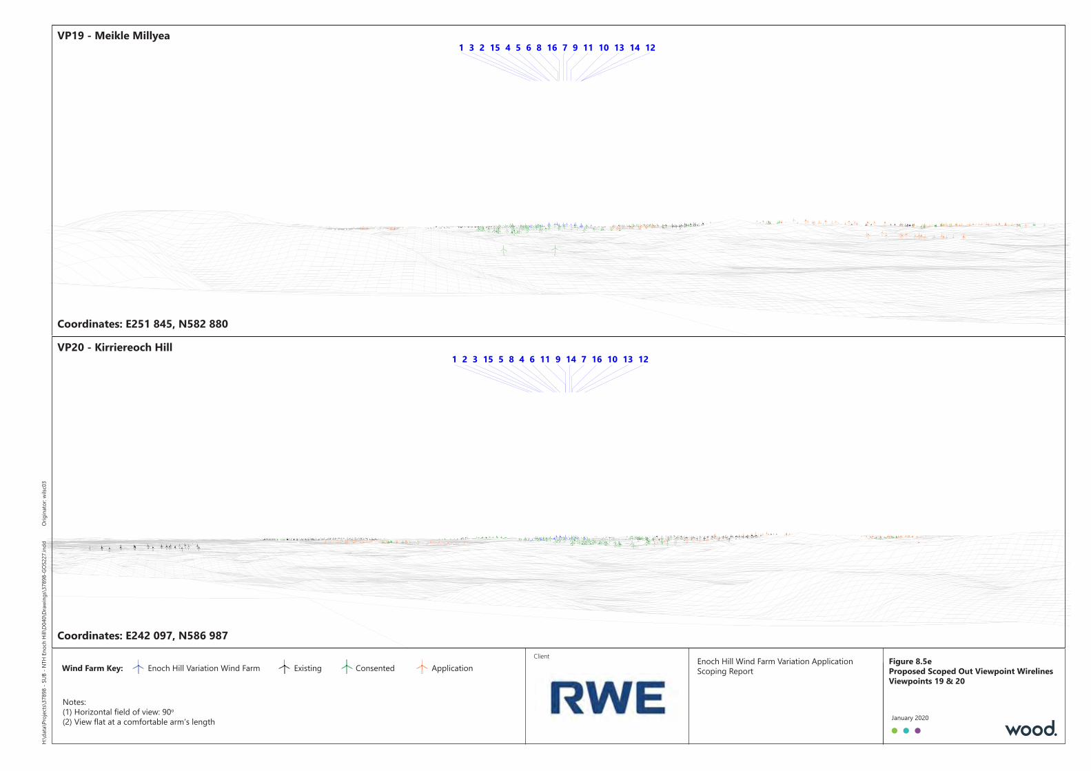
Client Enoch Hill Wind Farm Variation ApplicationScoping ReportWind Farm Key: Enoch Hill Variation Wind Farm Existing Consented Application
Notes:(1) Horizontal field of view: 90o
(2) View flat at a comfortable arm’s length
1 23 4 5 6 78 9 1011 1213 1415 16H:\
data\
Projec
ts\37
898 -
SUB -
NTH
Enoc
h Hill\
D040
\Draw
ings\3
7898
-GOS
227.i
ndd
Origi
nator
: wilsc
03
January 2020
1 2 3 45 6 78 9 1011 12131415 16VP20 - Kirriereoch HillVP20 - Kirriereoch Hill
Coordinates: E251 845, N582 880Coordinates: E251 845, N582 880
Figure 8.5eProposed Scoped Out Viewpoint WirelinesViewpoints 19 & 20
VP19 - Meikle MillyeaVP19 - Meikle Millyea
Coordinates: E242 097, N586 987Coordinates: E242 097, N586 987
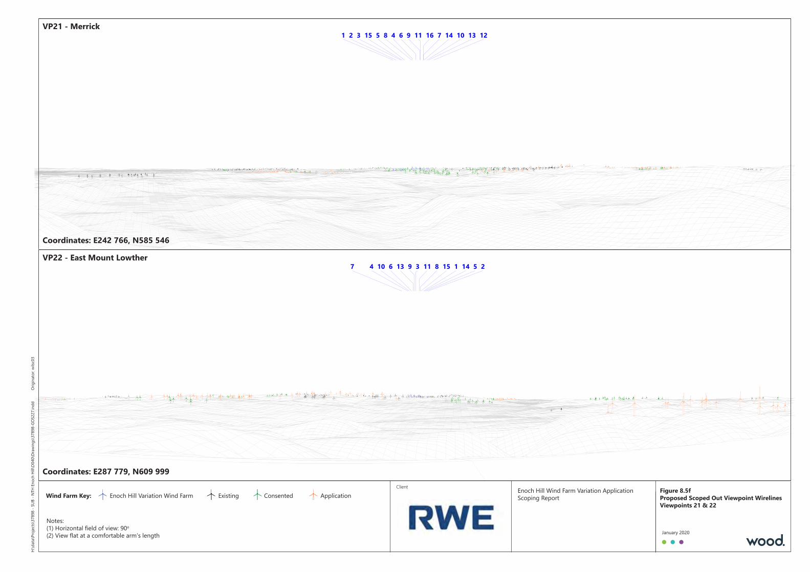
Client Enoch Hill Wind Farm Variation ApplicationScoping ReportWind Farm Key: Enoch Hill Variation Wind Farm Existing Consented Application
Notes:(1) Horizontal field of view: 90o
(2) View flat at a comfortable arm’s length
1 2 3 45 6 78 9 1011 12131415 16H:\
data\
Projec
ts\37
898 -
SUB -
NTH
Enoc
h Hill\
D040
\Draw
ings\3
7898
-GOS
227.i
ndd
Origi
nator
: wilsc
03
January 2020
1 234 567 8910 1113 1415VP22 - East Mount LowtherVP22 - East Mount Lowther
Coordinates: E242 766, N585 546Coordinates: E242 766, N585 546
Figure 8.5fProposed Scoped Out Viewpoint WirelinesViewpoints 21 & 22
VP21 - MerrickVP21 - Merrick
Coordinates: E287 779, N609 999Coordinates: E287 779, N609 999

February 2020
Doc Ref. 37898-WOOD-XX-XX-RP-J-0001_S3_P01.1