RWANDA ENVIRONMENTAL MANAGEMENT...
93
THE LANDSCAPE APPROACH TO FOREST RESTORATION AND CONSERVATION (LAFREC) PROJECT IN RWANDA (GISHWATI AND MUKURA FOREST RESERVES) SOCIAL ASSESSMENT FINAL REPORT THARCISSE MUSABYIMANA Tel. +250 788640812 Email: [email protected] April 2014 RWANDA ENVIRONMENTAL MANAGEMENT AUTHORITY (REMA) Public Disclosure Authorized Public Disclosure Authorized Public Disclosure Authorized Public Disclosure Authorized Public Disclosure Authorized Public Disclosure Authorized Public Disclosure Authorized Public Disclosure Authorized
Transcript of RWANDA ENVIRONMENTAL MANAGEMENT...

THE LANDSCAPE APPROACH TO FOREST RESTORATION AND
CONSERVATION (LAFREC) PROJECT IN RWANDA
(GISHWATI AND MUKURA FOREST RESERVES)
SOCIAL ASSESSMENT
FINAL REPORT
THARCISSE MUSABYIMANA
Tel. +250 788640812
Email: [email protected]
April 2014
RWANDA ENVIRONMENTAL MANAGEMENT
AUTHORITY (REMA)
Pub
lic D
iscl
osur
e A
utho
rized
Pub
lic D
iscl
osur
e A
utho
rized
Pub
lic D
iscl
osur
e A
utho
rized
Pub
lic D
iscl
osur
e A
utho
rized
Pub
lic D
iscl
osur
e A
utho
rized
Pub
lic D
iscl
osur
e A
utho
rized
Pub
lic D
iscl
osur
e A
utho
rized
Pub
lic D
iscl
osur
e A
utho
rized
wb371432
Typewritten Text
wb371432
Typewritten Text
E4579
wb371432
Typewritten Text
wb371432
Typewritten Text
wb371432
Typewritten Text

Page 1 of 93
Table of Contents
Table of Contents ............................................................................................................................................ 0
ACRONYMS AND ABBREVIATIONS ........................................................................................................... 3
EXECUTIVE SUMMARY ............................................................................................................................... 5
1.1 Objective of the Study .................................................................................................................. 5
1.2 Methodology ................................................................................................................................ 5
1.2.1 Desk review .............................................................................................................................................. 6
1.2.2 Field Research .......................................................................................................................................... 6
1.2.3 Sample and sampling technique .............................................................................................................. 6
1.3 Key Findings ................................................................................................................................. 7
2. ASSESSMENT SCOPE AND METHODOLOGY ....................................................................................... 10
2.1 Selection of Areas and Target Groups ........................................................................................ 10
2.2 Applied Definition of Vulnerable Social Groups ........................................................................ 12
3. REVIEW OF DATA FROM SECONDARY SOURCES............................................................................. 13
3.1 MUKURA AND GISHWATI FOREST RESERVES ................................................................. 13
3.1.1 A short description of Mukura and Gishwati forest reserves and Mukura and Gishwati corridor as
LAFREC site ............................................................................................................................................... 13
3.1.2 Mukura Forest Reserve .......................................................................................................................... 15
3.1.3 Gishwati Forest Reserve ........................................................................................................................ 15
3.2 SOCIO-ECONOMIC PROFILES OF DISTRICTS TOUCHING ON MUKURA AND GISHWATI
FORESTS ....................................................................................................................................... 17
3.2.1 Rutsiro District ...................................................................................................................................... 17
3.2.2 NGORORERO DISTRICT .................................................................................................................... 28
3.2.3 NYABIHU DISTRICT ........................................................................................................................... 38
3.2.4 RUBAVU DISTRICT ............................................................................................................................ 51
3.3 POPULATION IN THE VICINITY OF GISHWATI AND MUKURA FORESTS .................... 58
4. MAIN FIELD FINDINGS .......................................................................................................................... 60
4.1 Introduction ............................................................................................................................... 60
4.2 The Socioeconomic and Cultural Fabric of People Living in LAFREC Site ................. 61
4.2.1 People around Gishwati and Mukura forests ........................................................................................ 61
4.2.2 People living in the corridor .................................................................................................................. 61
4.2.3 People living in or neighbouring the buffer zones ................................................................................. 62
4.2.4 Attitudes towards the reserves .............................................................................................................. 62
4.2.5 Expectations of the population from LAFREC ..................................................................................... 63
4.3 Presence of Specific Vulnerable Social Groups in LAFREC site ................................................ 66
4.3.1 People with disability ............................................................................................................................ 67
4.3.2 Women and Girls .................................................................................................................................. 68
4.3.3 Female Headed Households .................................................................................................................. 68

Page 2 of 93
4.3.4 Youth ..................................................................................................................................................... 69
4.3.5 Children and Orphans ........................................................................................................................... 69
4.3.6 Elderly .................................................................................................................................................... 70
4.3.7 Single Parents ........................................................................................................................................ 70
4.3.8 Anticipated Positive LAFREC Impact .................................................................................................. 70
4.4 Anticipated Social Risks .............................................................................................. 71
4.4.1 Possible involuntary resettlement ......................................................................................................... 71
4.4.2 Getting people to accept to introduce new species and farming practices ........................................... 71
4.4.3 Social-Environmental Linkages ............................................................................................................. 71
4.4.4 Formal Access to Finance ...................................................................................................................... 72
4.4.5 Non-Financial Services .......................................................................................................................... 72
4.4.6 Gender Aspects and Institutional Capacities ........................................................................................ 73
4.4.7 VSG Sensitive Cross-Sectorial Coordination ........................................................................................ 74
4.4.8 Access to Information for All ................................................................................................................. 74
4.4.9 Monitoring Capacity ............................................................................................................................. 74
4.4.10 Local Level Actor Coordination and LAFREC Task Forces .............................................................. 74
4.5 Recommendations: Risk Mitigation Measures and Strategies .................................... 75
4.5.1 Getting people’s acceptance and cooperation and satisfaction of LAFREC activities ......................... 75
4.5.2 Accompanying resettled or relocated people for full resettlement ....................................................... 76
4.5.3 Facilitating Women and Girls Participation in LAFREC ..................................................................... 77
4.5.4 Broaden Access to Business Development Services ............................................................................... 78
4.5.5 Broaden Access to Financial Services .................................................................................................... 79
4.5.6 Recognizing Social-Environmental Linkages ........................................................................................ 79
4.5.7 Training and Information Needs at Cell levels ...................................................................................... 80
REFERENCES ............................................................................................................................................... 81
APPENDICES ................................................................................................................................................ 83
APPENDIX 1: SOCIAL ASSESSMENT OF THE LANDSCAPE APPROACH TO FOREST RESTORATION
AND CONSERVATION (LAFREC) PROJECT AREA: INTERVIEW AND DISCUSSION GUIDE83
APPENDIX 2: LIST OF PARTICIPANTS IN THE SOCIAL ASSESSMENT .................................. 87
APPENDIX 3: MAPS OF LAFREC SITE ......................................................................................... 91

Page 3 of 93
ACRONYMS AND ABBREVIATIONS
12YBE: 12-Year Basic Education
7 YGP: Seven Year Government Programme
9YBE: 9-Year Basic Education
AIDS: Acquired Immunodeficiency Syndrome
BDC: Business Development Center,
BDS: Business Development Services
BNR: National Bank of Rwanda
CBP: Community based provision of family planning CIP: Crop Intensification Program
CNJ: National Youth Council,
DDP: District Development Plan
DHS: Demographic and Health Survey
ECIV: Integrated Household Living Conditions Survey
EDPRS: Economic Development and Poverty Reduction Strategy
ENRSSP: Environment and Natural Resources Sector Strategic Plan
FARG: Genocide Survivors Support and Assistance Fund
GACP: Gishwati Area Conservation Program
GEF: Global Environment Facility
GER: Gross Enrolment Rate
GoR: Government of Rwanda
HHs: Households
HIV: Human Immunodeficiency Virus
ICT: Information and Communication Technology
IMCE: Integrated Management of Critical Ecosystems
INECN: National Institute for the Environment and the Conservation of Nature
IT: Information Technology
LAFREC: Landscape Approach to Forest Restoration and Conservation
LDCF: Least Developed Countries Fund
LVEMP: Lake Victoria Environmental Management Project
LWH: Land Husbandry, Water Harvesting and Hillside Irrigation

Page 4 of 93
MFI: Micro Finance Institutions
MINAGRI: Ministry of Agriculture
MINALOC : Ministry of Local Governance
MINECOFIN: Ministry of Finance and Economic Planning
MINELA: Ministry of Environment and Lands
MINIRENA: Ministry of Natural Resources
NAPA: National Adaptation Plan of Action
NER: Net Enrolment Rate
NGO: Non-Governmental Organisation
NISR: National Institute of Statistics of Rwanda
O.P.: Operational Policy
PMTCT: Prevention of Mother to Child Transmission
RAB: Rwanda Agricultural Board
RCA: Rwanda Cooperative Agency
RDRC: Rwanda Demobilization and Reintegration Commission
REMA: Rwanda Environmental Management Authority
RIM: Réseau Interdiocesain de Microfinance (Inter-diocesan Microfinance)
RNAPA: Rwanda’s National Adaptation Plan of Action
RPF: Resettlement Policy Framework
SACCO: Savings and Credit Co-operative
SESECO: Société d'Etudes, Surveillance, Expertise et Construction
SLM: Sustainable Land Management
SOPYRWA: Société de Pyrèthre au Rwanda (Rwanda Pyrethrum Society)
SPIU: Special Projects Implementation Unit (housed in REMA)
TFR: Total Fertility Rate
UNDP: United Nations Development Programme
UNEP: United Nations Environment Program United
USDA: United States Department of Agriculture
VCT: Voluntary Counselling and Testing
VSGs: Vulnerable Social Groups
VUP: Vision 2020 Umurenge programme

Page 5 of 93
EXECUTIVE SUMMARY
1.1 Objective of the Study
This study feeds into the preparation process for the Landscape Approach to Forest Restoration and
Conservation (LAFREC) project. Its main objective was to assess in a consultative process if the
proposed LAFREC activities are likely to affect the socioeconomic and cultural fabric of Gishwati
and Mukura neighbouring people so that suggestions to abide by the World Bank safeguard policies
are provided. It was intended to inform the livelihood component, the delineation of the buffer zone
of the reserves and the community based conservation efforts.
1.2 Methodology
Although many types of impact assessments heavily borrow from the positivistic approach with lots
of decisions informed by statistical inferences, the Social Impact Assessment presents a lot of
unpredictable, multidimensional and human-centric and specific issues that cannot be fully
apprehended quantitatively. This assessment therefore mainly subscribes to the relativist paradigm.
Much as it used both qualitative and quantitative data, analysis and interpretation heavily borrowed
from qualitative approach since it intended to bring the human/social angle that most research
undertakings had not been stressing. It heavily borrowed from Interactive Community Forum
Approach. Practically, it used less structured personal interviews, focus group discussions, document
review and observations.
The study worked with a non-probability/ purposive sample of people who were assumed to be more
likely to have desired information. It involved the following:
• Desk study, that reviewed and analysed the available relevant information on households
and livelihood as well as related projects
• Primary data collection (using mainly qualitative data collection/generation tools like
personal interviews, focus group discussions, document review and observations )
• Community consultation (in form of group discussions with samples from directly
affected communities)
• Discussion/meeting with local stakeholders (including sample informants from the
private sector)
• Key-informant interviews with purposively selected informants (more likely to have
information about the livelihood and social issues related to the project or closely linked
to the project)
• Personal interviews with target groups to explore the priorities they define for their
desired livelihood options.

Page 6 of 93
• Frameworks development (Resettlement policy framework and Resettlement process
framework)
• Validation workshops (these are series of meetings with participants geared towards
crosschecking information with participants so that they can help detect whether their
productions were properly captured).
1.2.1 Desk review
The desk review rotated around the following:
• Understanding project social assessment and the social assessment of environmental
projects
• Understanding the Landscape Approach to Forest Restoration and Conservation
(LAFREC) and related issues
• Reviewing the literature on Gishwati Reserve
• Documenting forest reserves and impact of artisanal mining activities in the area to both
population and forest (Gishwati core forest area, Mukura Forest Reserve buffer zones,
Gishwati - Mukura Corridor)
• Reviewing the literature on Lake Victoria Environmental Management Project (LVEMP)
and/or Land Husbandry, Water Harvesting and Hillside Irrigation (LWH) Project
• Assessing Social structures and social, cultural and economic issues of concerned
communities that have to do with project undertakings (if available in existing literature)
• Project social assessment methodology polishing
1.2.2 Field Research
The field research involved the following:
• Field visits to LAFREC project sites (Gishwati, Mukura and Gishwati-Mukura Corridor)
• Visiting the communities likely to be affected by the project
• Visiting the communities recently resettled from the former Gishwati Forest Reserve to
enquire on their current status
• Primary data collection/ generation (Personal Interviews - in their various forms, Focus
Group Discussions, Document Review, Observation)
• Validation sessions with participants at the field
1.2.3 Sample and sampling technique
Given the location of the project site, the assessment covered 4 Districts of Western Province.
Rutsiro and Ngororero Districts as LAFREC intervention zones were considered as the primary
research site. However, Nyabihu and Rubavu as Districts that host people who got relocated from

Page 7 of 93
Gishwati reserve was also considered in order to study the current relationship between relocated
people and LAFREC intervention. In order to maximize chances of having all information about the
social impact assessment, the study abode by the suggestions by Becker et al., (2003) and used the
following community categories in Interactive Community Forums:
• Elected officials
• Community service organizations and clubs
• Business owners and economic development
• Education interests
• Healthcare professionals and caregivers
• Historic or environmental protection (e.g., historians, conservation organizations)
• Land-Based Resource Production (e.g., farmers, loggers, miners)
• Community conservatives
• Community liberals
• Religious interests
• Minority and vulnerability interests (like porters, homeless, women, widow(er)s, child-
parents and family heads)
• Newcomers (residence of 1– 3 years)
• Senior citizens (60 years of age and older)
• Other active and involved residents (that participants will judge directly concerned but not
in the list)
Because of the large number of people within the research site, it was not possible to obtain
information about each individual/community within the time frame of the assessment. Therefore, in
order to get individuals from the above community categories, a theoretical sampling approach,
purposive sampling technique was used to select a purposive sample of individuals based on a
typology of predetermined criteria such as economic diversity, proximity to the impact area, state of
residence, population size, key economic dependency (e.g., agriculture, timber production, tourism),
recent social changes, community resiliency, anticipated project related changes in transportation
modes and nodes, energy production, construction, recreation, etc.
For each community category, twenty people were selected, i.e., five participants from each District.
This means that at least 260 people were worked with as participants in the assessment. For quick
results, in identifying individuals for each community category in a selected District, a snowball
sampling process was also applied.
1.3 Key Findings
People around Mukura forest reserve mainly live on agriculture. Their livelihood is directly linked to
cultivation and cattle rearing. However, in addition to these main activities, people on Mukura live

Page 8 of 93
on mining, logging, bee keeping. Their crops include tea, potatoes (mainly Irish), maize, beans, etc.
The mining, now more than artisanal, is mainly practised by young men and focuses on coltan,
cassiterite, wolfram (minerals people prevail in that region).
Activities that spoil the environment are related to the following: firewood, charcoal, mining, logging,
water sources, sand and calcareous soil quarrying, fires, etc. The fires were caused by people who
wanted to expand the grazing land but the practice stopped.
People neighbouring Gishwati forest also live on agriculture. They cultivate tea, potatoes (mainly
Irish), maize, beans, etc. Many of them are also cattle keepers. The activities that spoil the forest also
include firewood, charcoal, mining, logging, water sources, sand and calcareous soil quarrying. The
forest is also used for medicinal plants.
So far, the place that might serve as the corridor is a normal inhabited place scattered with hills and
valleys. It has plantations of different crops and their houses. Crops in the area include tea, Irish
potatoes, peas, artificial tree plantations (mainly eucalyptus and pine), grazing land for cows, sheep
and goats, etc. The place also has some infrastructure and public facilities like schools, health
centres, churches and small-scale shops and markets. The buffer zones, which should normally allow
people’s exploitation with certain restrictions, are not physically demarcated. In some parts,
especially in Gishwati forest, people’s settlements go up to the core forest without any visible buffer.
People are aware of the importance of Gishwati and Mukura reserves. They also understand the
importance of the Corridor and the buffer zones. Old people linked the reduction of the reserves to
changes that people are facing in the area.
According to District Development Plans (Rutsiro District Development Plan 2012, Ngororero
District Development Plan 2012, Nyabihu District Development Plan 2012, and Rubavu District
Development Plan 2012) the socioeconomic status of people living in these Districts is among the
poorest districts in the country whereas it is has the most fertile land. Detailed information about the
socioeconomic status of LAFREC Districts is provided in the report in findings from secondary
sources.
Though LAFREC does not envisage relocating people since it aims at supporting landscape approach
to forest restoration and conservation for the improvement of ecosystem functions and services in the
Gishwati and Mukura forest area, the Social Assessment has identified a number of specific issues
linked to LAFREC components that need to be thought of carefully in order for the project to be a
complete success.

Page 9 of 93
In the corridor, LAFREC will simply encourage people to protect their land using proper methods
and to also add new species (especially indigenous trees) which are friendly to other types of crops.
This practice will also interfere with people’s established habits which might cause people’s
resistance to the noble objectives of the project. Suggestions of mitigation measures for cases of
socioeconomic and cultural breakage are also provided in the report towards the end.
The Social Assessment also identified several social groups in LAFREC area that are in a clearly
disadvantaged or vulnerable position, and therefore, needing special attention in order for the project
to succeed. They are categorized as follows:
a) People with disability
b) Women and female headed households; categorically those women without access to farm
land, female heads of households with little land and big family size including those with
enough land but with shortage of labour and women in illegal marriage with unclear property
rights,
c) Youth who are unemployed and landless,
d) Orphaned children and children who become child family heads whose inheritance right is
abused by their custodians, and
e) Elderly people who may have enough land but lack a social support network and cannot
access labour.
f) Single parents
Suggestions on what can be done to properly engage these categories are also detailed towards
the end of this report.

Page 10 of 93
2. ASSESSMENT SCOPE AND METHODOLOGY
This report presents findings from a desk review and field visits to LAFREC area. These are areas
neighbouring Gishwati forest reserve and Mukura forest reserve. These forest reserves are located in
Western Province in Rwanda and are neighboured by four Districts Rutsiro District, Ngororero
District, Nyabihu District and Rubavu District.
Checklists prepared during the Social Assessment Inception Period were used to collect socio-
economic data in a period of March-April 2014.
The study worked with a non-probability/ purposive sample of people who were assumed to be more
likely to have desired information. It involved the following:
• Desk study, that reviewed and analysed the available relevant information on households
and livelihood as well as related projects
• Primary data collection (using mainly qualitative data collection/generation tools like
personal interviews, focus group discussions, document review and observations )
• Community consultation (in form of group discussions with samples from directly
affected communities)
• Discussion/meeting with local stakeholders (including sample informants from the
private sector)
• Key-informant interviews with purposively selected informants (more likely to have
information about the livelihood and social issues related to the project or closely linked
to the project)
• Personal interviews with target groups to explore the priorities they define for their
desired livelihood options.
• Frameworks development (Resettlement policy framework and Resettlement process
framework)
• Validation workshops (these are series of meetings with participants geared towards
crosschecking information with participants so that they can help detect whether their
productions were properly captured)
2.1 Selection of Areas and Target Groups
Given the location of the project site, the assessment covered 4 Districts of Western Province.
Rutsiro and Ngororero Districts as LAFREC intervention zones were considered as the primary
research site. However, Nyabihu and Rubavu as Districts that host people who got relocated from
Gishwati reserve was also considered in order to study the current relationship between relocated

Page 11 of 93
people and LAFREC intervention. In order to maximize chances of having all information about the
social impact assessment, the study followed the suggestions by Becker et al., (2003) and used the
following community categories in Interactive Community Forums:
• Elected officials
• Community service organizations and clubs
• Business owners and economic development
• Education interests
• Healthcare professionals and caregivers
• Historic or environmental protection (e.g., historians, conservation organizations)
• Land-Based Resource Production (e.g., farmers, loggers, miners)
• Community conservatives
• Community liberals
• Religious interests
• Minority and vulnerability interests (like porters, homeless, women, widow(er)s, child-
parents and family heads)
• Newcomers (residence of 1– 3 years)
• Senior citizens (60 years of age and older)
• Other active and involved residents (that participants will judge directly concerned but not
in the list)
Because of the large number of people within the research site, it was not possible to obtain
information about each individual/community within the time frame of the assessment. Therefore, in
order to get individuals from the above community categories, a theoretical sampling approach,
purposive sampling technique was used to select a sample of individuals based on a typology of
predetermined criteria such as economic diversity, proximity to the impact area, state of residence,
population size, key economic dependency (e.g., agriculture, timber production, tourism), recent
social changes, community resiliency, anticipated project related changes in transportation modes
and nodes, energy production, construction, recreation, etc.
For each community category, twenty people were selected, i.e., five participants from each District.
This means that at least 260 people were worked with as participants in the assessment. For quick
results, in identifying individuals for each community category in a selected District, a snowball
sampling process was also applied.

Page 12 of 93
2.2 Applied Definition of Vulnerable Social Groups
During the social assessment, the term vulnerability was considered as a concept broadly
encompassing all disadvantaged social groups in respect to their socio-cultural status as well as their
sharing of benefits or negative effects of mainstream development activities and in this case LAFREC.
The Social Assessment identified major vulnerable social groups in LAFREC area touching on four
Districts (Rutsiro, Ngororero, Nyabihu and Rubavu): people with disability, landless and/or
unemployed youth, different categories of female and child headed households, orphans, elders
without adequate means of social security, and single parents.

Page 13 of 93
3. REVIEW OF DATA FROM SECONDARY SOURCES
3.1 MUKURA AND GISHWATI FOREST RESERVES
3.1.1 A short description of Mukura and Gishwati forest reserves and Mukura and Gishwati
corridor as LAFREC site
Mukura and Gishwati forest reserves are situated in North-Western part of Rwanda. They touch 4
districts, Rutsiro and Rubavu in their West towards Lake Kivu and Ngororero and Nyabihu in their
East. While Gishwati reserve touches all the four districts, Mukura is located within Rutsiro and
Ngororero Districts. The corridor is between Rutsiro and Ngororero. Much as these reserves are now
disconnected, history shows that Mukura Forest used to be attached to Gishwati and Nyungwe
before agents of deforestation came in. History also shows the probability that these reserves might
have been once linked to the Volcanoes National Park area. To date, the reserves have undergone
severe depletion and MINIRENA (2010) observed that if deforestation and land degradation
continued at the same pace, there would be complete loss of these reserves in 2020. The following
map indicates the region where the reserves are situated (note, the core forest of Gishwati is much
smaller than the wider landscape shown on this map).
Schematically, Mukura and Gishwati together with associated corridor and buffer zones can be
represented as follows:

Page 14 of 93
Connecting protected areas with corridors can benefit biodiversity by providing access to other areas
of habitat, increasing gene flow and population viability, enabling “re-colonisation” of patches, and
providing habitat (USDA, 2014).
USDA (2014) provides key considerations in designing corridors:
• Design corridors at several spatial and temporal scales.
• Provide quality habitat in a corridor whenever possible.
• Locate corridors along dispersal and migration routes.
• Corridors, particularly regional corridors, should not be limited to a single topographic
setting.
• Similarity in vegetation between corridors and patches is beneficial.
• Restore historical connections and generally avoid linking areas not historically connected.
For the case of Mukura - Gishwati corridor, most participants in the social assessment proposed a
two- kilometre wide corridor. However, they added that given the wide number of species and the
quality and diversity of the needed habitat, it would be better if that width is increased. The project
will not require people to move from their lands and forest within the corridor to link the core
reserves – but increase the number of trees across the landscape (on steep slopes, along rivers, in
clumps through enhancing BD of small eucalyptus plantations) and agroforestry within cropping
areas. Participants also proposed a one-kilometre wide buffer zone for all the reserves. It is worth
noting that much as the mapping has been thought of (theoretical level), the exact physical
demarcation will need to wait for the related law which might be promulgated anytime (very soon).

Page 15 of 93
3.1.2 Mukura Forest Reserve
Mukura Forest is a protected reserve in the North-West part of Rwanda covering about 1, 988 ha. It
is a great natural resource for the Great Lakes region and the surrounding community. It used to be
attached to Gishwati and Nyungwe before agents of deforestations came in. Mukura Forest reserve
was created in 1951 with an area of 3, 000 ha. Today about 50% of the forest’s area has been lost due
to deforestation and only about 1,600 ha of the original forest remains. This has resulted with high
loss of biodiversity. The forest is mainly covered by Softwood plantation like Pinus spp, Cupressus
spp and Callitris spp.
Mukura forest is home of over 402 species of mammal species over 1,061 species of birds, over 293
species of reptiles and amphibians and over 5, 793 species higher plants.
In order to restore the forest, the following is going on:
• Protection of the forest through provision of Forest guards, capacity building and creating a
wide range public awareness on the advantages of forests.
• Identification of forestry as one of the pillars of national economy playing a role in supporting
Agriculture, Tourism, Environmental stability and Energy.
• Setting a target of 30% tree coverage nation-wide by the year 2020 planting
• Involving local communities in the conservation of the Mukura forest reserve including the
protection activities of the forest
• Increasing income generating activities outside the forest to motivate local communities for the
conservation of the forest
• Creating local cooperatives to facilitate income generating activities
• Involving more women and the youth for the conservation and the development of the forest
3.1.3 Gishwati Forest Reserve
Gishwati Forest is a protected reserve in the north-western part of Rwanda, not far from Lake Kivu.
The reserve’s forests were largely intact in 1978, and substantial forest cover still remained in 1986.
During the Rwandan Genocide, wave after wave of refugees arrived in Gishwati Forest and began
clearing it, often for subsistence farming. By 2001, only a small circular patch of native forest
remained, 1,500 acres (6.1 km2) of the forest’s original 250,000. In addition to tremendous loss of
biodiversity, the region experiences soil erosion and degradation and landslides. Reforestation efforts
in the past few years have increased the remnant native forest to about 1,440 ha. Large tea estates
occupy the central and northern parts of the reserve.
The Gishwati Forest used to be one piece in a complex system of rainforests through the middle of
Africa. It used to extend west beyond Lake Kivu connecting with the rainforests of the Congo, and

Page 16 of 93
south connecting with Nyungwe Forest. These forest systems have become fragmented due to
population increase and deforestation. The Rwandan Genocide put strain on the site as refugees fled
and the population increased as people were displaced from their homes. However, even after
genocide with many returnees from Democratic Republic of Congo, part of the reserve was given to
these people for settlement and agricultural use. When the plan to relocate them from this reserve,
some people remained inside as there was not enough land to resettle all of them. The area was
degraded for cattle ranching and agriculture until it became unproductive. Erosion, landslides,
reduced water quality, and soil infertility had resulted from this degradation of the land.
The Gishwati Area Conservation Program (GACP) began in 2007 with the collaboration of Rwandan
President, Paul Kagame, and Great Ape Trust, founded by Ted Townsend. The initiative began with
the idea of creating a national conservation park in Rwanda to protect the biodiversity of the
Gishwati Forest area and stop some of the rapid degradation. In 1930 the Gishwati Forest covered
70,000 acres but lost about 90 per cent of its cover, this initiative aimed to restore the dramatic loss
the area has seen over the last decade and therefore named the site the Forest of Hope.
Since the Forest of Hope has been in place there has been a 67 per cent increase in size of the
Gishwati Forest. The local chimpanzee population has grown and many research and conservation
initiatives have been employed within the reserve. The Gishwati Area Conservation Program began
with the hopes that down the road the Rwandan government would take over the area make it a
national park.
The forest reserve has recorded 58 species of trees and shrubs, including numerous indigenous
hardwoods and bamboo. A recent study of carbon sequestration of the forest indicated Macaranga
kilimandscharica to be the most common species of tree in areas of the forest that have not been
disturbed. The previously degraded regions of the forest experiencing regeneration show
colonization of Carapa grandiflora, Entandrophagrama excelsum, and Symphonia globulifera. Other
flora of the reserve includes giant tree ferns and blue lichen.
A wide range of fauna can be found within the reserve. Four species of primates are found, the
Eastern Chimpanzee (Pan troglodytes schweinfurtii), the golden monkey, the blue monkey, and the
L'Hoest's monkey (also known as mountain monkey). Though not since 2002, a fifth species of
primate, the black and white colobus has been reportedly sighted. There are currently estimated to
be 20 East African chimpanzees in the forest. This is a 54% increase in population size from the 13
chimps in 2008, when the GACP first started. This includes five infants. The average density of
chimpanzee nests was found to be 1.473 per km2 by Dr. Plumptree. Other mammals include the red

Page 17 of 93
river hog (Potamochoerus porcus), the black front duiker (Cephalophus nigrifrons), the southern
tree hyrax (Dendrohyrax arboreus), the serval (Felis serval), and Felis aurata.
Other fauna found are the 84 species of birds, including Woodhoopoes (Phoeniculidae), White-
headed Woodhoopoe (Phoeniculus bollei), Old World Warblers (Sylviidae), and Mountain Yellow
Warbler (Chloropeta similis). The brown forest frog and multiple species of toads are some of the
amphibian life found in the forest. With respect to reptiles, the great lakes bush viper and multiple
species of chameleons are also found live in the Gishwati forest
3.2 SOCIO-ECONOMIC PROFILES OF DISTRICTS TOUCHING ON MUKURA AND
GISHWATI FORESTS
To understand the socio-economic situation of people neighbouring Gishwati and Mukura forest
reserves, one needs to first understand the socio-economic profiles of each District among the 4
Districts concerned by the assignment. The following profiles of the 4 concerned Districts were
drawn from District Development Plans 2012 (Rutsiro District Development Plan 2012, Ngororero
District Development Plan 2012, Nyabihu District Development Plan 2012, and Rubavu District
Development Plan 2012).
3.2.1 Rutsiro District
3.2.1.1 Population
RUTSIRO District has a total population of 323,251 habitants, including 152,231 males (47.5%) and
171,020 females (52.9%) all on a total area of 1,157.3 km² with a density of 279 inhabitants per sq.km.
Only 47% of the population of RUTSIRO District is identified as non-poor and 53% is poor from
which 26.1% was identified as in extreme poverty. Compared to the Western Province, the poverty
indicators for this district are higher than the average of the Province, which has 48.4% of poor
population (including extreme poor) (NISR/Census 2012)). 78% of households are farmers while
more than 52% of households have less than 0.3 ha of land cultivated and only 49% of incomes are
coming from agriculture. 45 % of the total population are children and 35% are youth. The two
categories represent 80% of the total population of Rutsiro District. Old people (more than 65 years)
represent only 3% of the population. The active population is 17% of the total district population.
Only 17% of the population is active and 13.7% of population with 16 years and above is inactive
(ECIV 3). There is lack of off farm jobs creation (only 8% of the population).
The average annual growth rate of the District is 2.0% and it is higher in Mukura (3.1%) and lowest
in Kigeyo and Mushonyi with 0.7% and 0.8% respectively. The population density of the Rutsiro
District is 279 people per s.q.km. This density is very high in Kivumu sector (1,133 inhabitants per
sq.km) and relatively higher in Mushonyi (747 persons per sq.km) and Boneza (671 persons per

Page 18 of 93
sq.km), and relatively lower in the sectors of Nyabirasi (319 persons per sq.km) and Mukura (330
persons per sq.km).
3.2.1.2 People’s livelihoods and social structures
The economy of the Rutsiro District is based primarily on agricultural production. According to
EICV3 report, more than 90% of the population of Rutsiro is farmers and 49% of incomes is from
agriculture.
Coffee and tea are the major cash crops grown in Rutsiro District. The western part of the District
(the shores of Lake Kivu composed by sectors Kigeyo, Mushonyi, Boneza, Musasa Gihango and
Mushubati) is particularly favourable for coffee. There are 15 coffee washing stations in Rutsiro
District that constitute concrete development. Those are KOPAKAMA/Mushubati; BWISHAZA
Coffee; COOPAC Kirorero/Boneza; COOPAC Gishamwana/Mushonyi; API Musasa; API Mushonyi;
NKORA Coffee; SOCOR Coffee/Boneza; SOCOR Coffee/Rugamba; COOPAC Kabirizi/Kivumu;
INGOBOKA/Kigeyo; CAFERWA ltd Cyebumba; SACOF Kigeyo; API Kivumu; CYIMBIRI
AEBR/Kigeyo. Tea is grown mainly in the Northern part of the District which is close to Gishwati
forest. In 2007 the District had a baseline of 5,000 T of green tea and the production was 1,667T
instead of 8,000T targeted in 2012.
The main food crops for Rutsiro District are maize, beans, Irish potatoes, banana plantations and
cassava. According to the District Development Plan 2012, the district had a baseline in 2007 of
19,263 T of maize, 91,375T of beans, 14,865T of Irish potatoes, 27,297T of banana and 7,609T of
cassava. It targeted for 2012 the production as following: 200,000T of maize, 95,000T of beans,
20,000T of Irish potatoes, 32,00T of banana and 10,000T of cassava. But the achievements were
respectively 39,454T; 8,551T; 72,843T; 67,339T and 56,250T.
Fruits produced are pineapple, passion fruit, Japanese plum (tomato tree). The following
administrative sectors have a high potential for pineapple production (Musasa, Gihango, Mushubati,
Mushonyi).
With regard to livestock, Rutsiro District practices farming livestock such as cows, small livestock
such as goats, sheep, pigs, fish, etc. This livestock is however almost traditional and its production is
insufficient.
Page 19 of 93
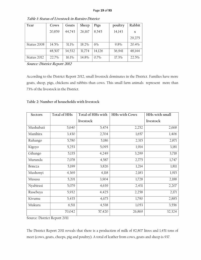
Table 1: Status of Livestock in Rutsiro District
Year Cows
20,859
Goats
44,743
Sheep
26,167
Pigs
8,545
poultry
14,143
Rabbit
s
29,275
Status 2008 14.5% 31.1% 18.2% 6% 9.8% 20.4%
48,507 34,532 31,774 14,126 36,941 48,144
Status 2012 22.7% 16.1% 14.8% 0.7% 17.3% 22.5%
Source: District Report 2012
According to the District Report 2012, small livestock dominates in the District. Families have more
goats, sheep, pigs, chickens and rabbits than cows. This small farm animals represent more than
73% of the livestock in the District.
Table 2: Number of households with livestock
Sectors Total of HHs Total of HHs with
livestock
HHs with Cows HHs with small
livestock
Mushubati 5,640 5,474 2,252 2,668
Manihira 3,430 2,704 1,657 1,406
Ruhango 5,780 5,186 2,315 2,871
Kigeyo 5,253 5,095 1,914 3,181
Gihango 5,135 4,249 3,299 3,718
Murunda 7,078 4,587 2,775 1,747
Boneza 5,199 3,826 1,214 1,811
Mushonyi 4,369 4,118 2,183 1,915
Musasa 5,201 3,904 1,728 2,188
Nyabirasi 5,079 4,639 2,431 2,207
Rusebeya 5,932 4,425 2,258 2,171
Kivumu 5,435 4,675 1,790 2,885
Mukura 6,511 4,538 1,053 3,556
70,042 57,420 26,869 32,324
Source: District Report 2011
The District Report 2011 reveals that there is a production of milk of 82,807 litres and 1,451 tons of
meet (cows, goats, cheeps, pig and poultry). A total of leather from cows, goats and sheep is 937.

Page 20 of 93
Veterinary products are procured from Rubavu and Kigali, and this negatively affects the animal
health. In 2007 the District had 1% of small veterinary pharmacy and this data has stagnated while
the target 2012 was 30%.
Considering the potential of biological honey, the District wishes to focus on beekeeping and
encourage the private sector to invest more in the vitalization of this sector through production,
processing, packaging and marketing of honey. Agricultural output is still insufficient, because the
methods used in agriculture are, in many cases, traditional and there is limited accessibility to
agricultural land as raw materials for agro-processing industries.
The National Institute of Statistics of Rwanda in its EICV3 report have revealed that 84.4 % of
cultivating households cultivate less than 0.9 ha of land whereas 53.89% of households have less than
0.3 ha. 62.5% of cultivating households do not use fertilizers (be it organic or inorganic) and the use
of quality seeds is achieved at the rate of 5%. The same report of EICV3 reveals that more than 90%
of land is protected against soil erosion including 3% of radical terracing.
Serious problems facing food production in the District are not only linked to poor soil fertility due
to soil acidity but also to extreme land fragmentation and very small scale agriculture production by
families. Poverty among farmers has hampered the capacity of families to invest in the improvement
of their land capital and scattered housing system makes land development very difficult. Other
factors which have made the agricultural situation even worse include:
- Acute soil erosion caused by surface rain water;
- Soil acidity;
- Over exploitation of existing land;
- Reduction of farmland available to each family due to demographic pressure;
- Lack of agricultural inputs including organic fertilizers;
- Lack of quality seeds;
- Unpredictable climatic conditions;
- Reduced number of livestock;
- Insufficient systems against soil erosion.
All these factors make agricultural production poor and hence a large portion of the population
remains underfed. Rutsiro District is among the parts of the country with large proportion of its
population living below the poverty line and constantly facing food insecurity. With the economy of
the District based on agricultural activities, access to agricultural land should be one of the drivers of
development of the District. So efforts are needed in proper settlement as well as basic infrastructure,
e.g.: electricity and roads.

Page 21 of 93
3.2.1.3 Settlement
According to the District self-assessment report 2012, the District had planned to elaborate layout
plans for 62 sites by 2012, but only layout plans for 39 rural settlement sites were elaborated. 316
rural settlement sites have been identified. A distance of 100km of roads in settlement sites was
planned and the target has been overachieved with 126 km of roads.
According to EICV report, population in planned rural settlement sites is estimated at 53.5%. From
the same source, 4.1% of households have houses with cement floor and there are 3.5% of households
with houses of mud-covered tree trunks as wall material whereas the national average is respectively
18% and 36%.
3.2.1.4 Energy
The number of people using electricity is one of the lowest of the country even if the micro hydro
power plant located on Rwishwa River was restored and the use of solar energy reinforced. The
study of the rehabilitation and extension of a micro hydropower of Nkora and construction of a
micro hydropower of Cyimbili have been concluded. But power is not used by local population.
Only Congo Nile, Nkora, Nkomero, Gakeri and Bugabo trading centres are connected to the national
electricity grid. According to the EICV3 report, there is a lower percentage of people (0.4% of all
households: source: NISR, EICV3) that use electricity as the main source of lighting. More than
99.2% of homesteads (NISR, EICV3) use firewood and its derivatives or charcoal as a source of
energy to cook their food. Only 6 sectors are connected to electricity (Nyabirasi, Manihira, Mukura,
Rusebeya, Kigeyo and Boneza).
3.2.1.5 Transport
The main road connecting Rutsiro to the two neighbouring districts, Karongi and Rubavu is in poor
condition. Transport of goods and people is still a problem due to the lack of maintenance of 1,500
km of roads, which need to be regularly maintained or rehabilitated. During the rainy season,
transport is seriously hampered due to seasonal rivers which overflow, bridges which collapse and
landslides which make roads impassable.
3.2.1.6 Environment and Natural Resources
The coverage of forest is at 12% but this percentage is still less than the national target set by Vision
2020 for the forest cover to reach 30% of national land area by 2020. The rehabilitation of Gishwati
and Mukura was planned to be achieved at 100% in 2012 but the District is far from achieving this
target because so far only the strategic plan of the rehabilitation is available.

Page 22 of 93
The shores of Kivu Lake have been protected at 70% as well as rivers and watersheds; 76 committees
are available and 48 clubs in secondary schools have been created and have been trained in
environment and climate change issues.
In mining, 5 companies have obtained the license of exploitation and 8 cooperatives are operational
in Rutsiro District.
3.2.1.7 ICT
Concerning ICT, the internet connection is being developed with the arrival of the optic fibre but
this is only used by District administrative office, Murunda Hospital, RSSB, Court and District Police
Unit. There is only one internet cyber café in poor condition. Other internet users use MTN or TIGO
wireless modems. According the EICV3 report, 76.4% of the population do not know about the use
of internet; 0.7% of the population are computer literate whereas the national average rate is 4.2%.
The use of mobile phones has progressed with the telephone network covering the entire District.
However, the percentage of subscription (34.6%) to mobile phone is still lower than the national
average of 45% of people as well as the percentage of households owning radio (51.8% against the
national average of 60.3%).
3.2.1.8 Financial Sector Development
The District has 4 branches of Banque Populaire in Gihango, Murunda, Ruhango and Kivumu
Sectors. CLECAM also has 4 agencies in Nyabirasi, Mushonyi, Ruhango and Boneza. Umurenge
SACCO has an agency in each sector with a total pf 13 agencies. COPEC Inkunga is operational in
Gihango sector. 35 % of households have at least one savings account. The level of financial inclusion,
literacy and access are still low.
Rutsiro District has many associations grouped according to activities they are engaged in, e.g.:
association of craftsmen, farmers, Moto taxi drivers, welders, carpenters, tailors, masons, shoe
repairers, blacksmith, etc. Agricultural and Livestock farmers’ associations help their members to
access loan facilities and agricultural inputs.
3.2.1.9 Private Sector Development
In general, business is not well developed and organized in the District. It is practised in markets,
shops, small pubs of sorghum or banana beer and some restaurants. According to EICV3 report,
69.6% of people work less than 35 hours per week and business income is 12.3%. The business mainly

Page 23 of 93
concerns the flow of food products and some essential items available in shops located in trading
centres in the District.
EICV3 report reveals that 49.4% of income is from agriculture, 23.2% from wages, 12.7% from
business, 6.9% from private transfers, 1.4% from public transfers and 6.4% are from rents. The craft is
also underdeveloped. Basket weaving, brick, carpentry, tile, sewing and embroidery activities are
known in the Rutsiro District. This craft, however, registers production failure due to lack of
financial resources, materials, creativity, innovation, and training.
3.2.1.10 Cooperatives
Cooperatives are in Agriculture, Livestock, Services, Commerce, Saving and credit, Handcraft and
Mining. There are 125 Cooperatives with definitive license provided by Rwanda Cooperative Agency
(RCA) and 58 Cooperatives have provisional license provided by the District. All these cooperatives
total 30,446 members with 56% of male and 44% of women. The percentage of women is lower (less
than 40%) in cooperatives.
3.2.1.11 Industry
Rutsiro District has 15 operational coffee washing stations. One Tea Factory is under construction.
There is a need to establish agro-processing units for the transformation of fruits like pineapple,
passion fruit, Japanese plum (tomato tree). The sectors with high potential of pineapple production
are Musasa, Gihango, Mushubati, and Mushonyi. The key challenges are limited access to
agricultural land (raw materials for agro-processing industries), the low level of off-farm jobs and the
lack of adequate financing schemes for long-term investment (no long-term agricultural financing,
access to finance for Small and Medium Enterprises).
3.2.1.12 Education
Rutsiro District has 29 secondary schools, 87 primary schools and 24 kindergartens. It does not have
any higher learning institution. The District has increased primary and secondary schools as well as
enrolment rates.
The District self-assessment report shows that Rutsiro District has only 24 pre-primary schools. The
total enrolment in pre-primary is 435 girls and 431 boys. The District has 87 primary schools with an
average of 85,867 pupils. Among these schools, 31 schools have launched the 9YBE programme and
23 of them have already started the 12YBE.
The total number of pupils in primary education increased from 73,224 in 2007 to 85,867 in 2012.
This is due to government policy of nine years basic education (9YBE) and public sensitization about

Page 24 of 93
education. The number of male pupils enrolled is greater than that of females thus males represent
50.8% of the total enrolment while females represent 49.2% which gives a gender disparity difference
of 1.6%. There is a need for more public sensitization on girl child education. The Primary Net
Enrolment Rate (NER) has not improved for both girls and boys and is 78.2%.
The District has a high gross enrolment rate (GER) of 145%. This indicates that a significant
proportion of out-of-age children are still enrolled in primary school. A GER of 145% still indicates
that Rutsiro district has an additional 24.9% of students to cater for in primary schooling. In practice
this means 45% more classrooms required, teachers to be employed and learning resources and
support to be provided. Considering the ratio Teacher/Pupil, the District has decreased from 1/67.4 to
1/60 against the target 2012 of 1/45. This target has been underachieved while the national one is 1/38.
It is the same scenario for the ratio Latrine/pupil; the baseline 2007 was 1/90, in the DDP 2011 the
District had targeted two latrines for 45 pupils i.e., 1/22.5 but the achievement is 1/76.5.
The literacy rate in Rutsiro District is 83.1 % for people aged from 15 to 24 and among people aged 15
and above the literacy rate is 64.2 % which is less than the national average of 70% of literacy rate.
The literacy rate among population aged 15-49 is 69.6% of male and 73% of female.
There are 46 secondary schools including 9 and 12YBE, and the number of students in these schools
continues to increase as a result of 9 and 12YBE. The enrolment of girls makes up 48.9% (2,503) of
students in Secondary Education overall. The Net Attendance Rate for females is higher than that for
males with respectively 14.6% and 7.1%.
Generally, in the early years of upper school the number of girls is greater than that of boys however
from 18 years and above the number of Girls fall tremendously compared to that of boys, this
indicates that the dropout rate of females is greater than that of male students, this may be due to
early marriages orchestrated by traditional and cultural beliefs.
According to the District report 2011, in the teaching field the number of qualified females is far lower
to that of males. Rutsiro District has 29 secondary schools. These schools are faced with enormous
problems related to personnel, both in terms of quality and qualifications. In fact, the qualified
teachers represent 44.6% and the ratio teacher/pupil is 25. The administration faces problems related
to recruiting qualified teachers who don’t like to be posted to remote areas of the District.
Available infrastructures and equipment also require urgent rehabilitation or restocking. Sports and
sanitation infrastructures in secondary schools are in dire need of either construction or
rehabilitation.
Page 25 of 93
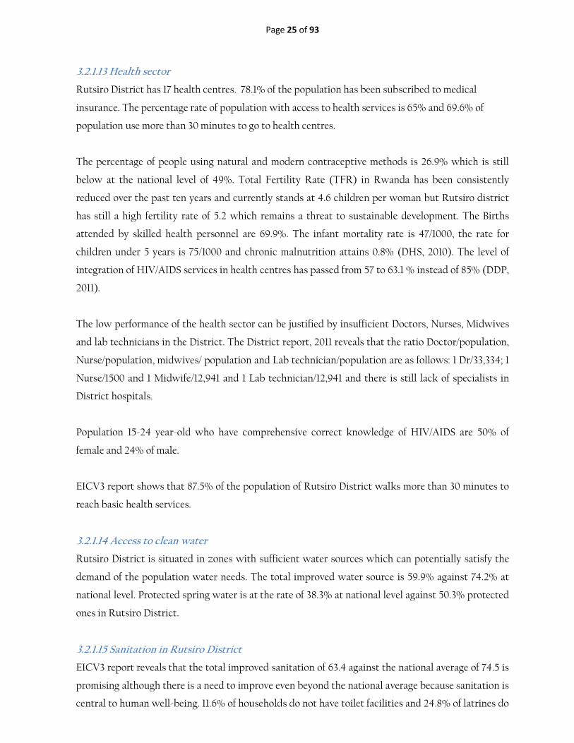
3.2.1.13 Health sector
Rutsiro District has 17 health centres. 78.1% of the population has been subscribed to medical
insurance. The percentage rate of population with access to health services is 65% and 69.6% of
population use more than 30 minutes to go to health centres.
The percentage of people using natural and modern contraceptive methods is 26.9% which is still
below at the national level of 49%. Total Fertility Rate (TFR) in Rwanda has been consistently
reduced over the past ten years and currently stands at 4.6 children per woman but Rutsiro district
has still a high fertility rate of 5.2 which remains a threat to sustainable development. The Births
attended by skilled health personnel are 69.9%. The infant mortality rate is 47/1000, the rate for
children under 5 years is 75/1000 and chronic malnutrition attains 0.8% (DHS, 2010). The level of
integration of HIV/AIDS services in health centres has passed from 57 to 63.1 % instead of 85% (DDP,
2011).
The low performance of the health sector can be justified by insufficient Doctors, Nurses, Midwives
and lab technicians in the District. The District report, 2011 reveals that the ratio Doctor/population,
Nurse/population, midwives/ population and Lab technician/population are as follows: 1 Dr/33,334; 1
Nurse/1500 and 1 Midwife/12,941 and 1 Lab technician/12,941 and there is still lack of specialists in
District hospitals.
Population 15-24 year-old who have comprehensive correct knowledge of HIV/AIDS are 50% of
female and 24% of male.
EICV3 report shows that 87.5% of the population of Rutsiro District walks more than 30 minutes to
reach basic health services.
3.2.1.14 Access to clean water
Rutsiro District is situated in zones with sufficient water sources which can potentially satisfy the
demand of the population water needs. The total improved water source is 59.9% against 74.2% at
national level. Protected spring water is at the rate of 38.3% at national level against 50.3% protected
ones in Rutsiro District.
3.2.1.15 Sanitation in Rutsiro District
EICV3 report reveals that the total improved sanitation of 63.4 against the national average of 74.5 is
promising although there is a need to improve even beyond the national average because sanitation is
central to human well-being. 11.6% of households do not have toilet facilities and 24.8% of latrines do

Page 26 of 93
not meet the required hygienic standards whilst 62.7% of households use compost heap as waste
management facilities. There is 0% of rubbish collection service and 31.5% of households throw
rubbish in bushes or fields.
3.2.1.16 Social Protection Sector
The situation of orphanage is not very critical. There is 15,6% of orphans (one parent or both
parents) among population aged 0–20 while the national average is 18 % but there is a high
percentage of disabled people 7,6% against the national average of 4,4% ( EICV3). Also, 28% of
households are headed by females.
The social protection in Rutsiro District is in line with the initiative of the Government of Rwanda
which began in June 2008 with three components namely:
• The support for vulnerable unable to work (Direct Support);
• Public Works reserved to the poor but who can work; (Public Works)
• And the Credits to be guaranteed to the first two categories of people who do not have
guarantees identified by Ubudehe programme (financial Services).
From 2008 to 2012, the programme has gradually installed in five sectors namely: Manihira, Mukura,
Kivumu Rusebeya and Mushubati and now has added two others which are Gihango and Nyabirasi
sectors where there is only the component of “Direct Support programme’. In addition, the
beneficiaries who have been supported are as follows:
• For Direct Support, 3,439 households have benefited from direct support with the amount of
169,605,400 Rwf
• For Public Works, 7,873 people were employed in the various projects. These workers have
cost an amount of 381,262,916 Rwf in the past 5 year;
• For Financial Services, 3895 families have received loans amounting to Rwf 35,368,000
Through Public Works, various projects have been completed as follows:
• Creation of intercellular routes (Manihira, Mukura, Rusebeya) over a length of 52 km,
• Development of radical terraces (Manihira, Mukura) for an area of 600 ha,
• Construction of 26 classrooms (Manihira, Kivumu Mukura) Anti-erosion ditches, on the area
of 2,500 ha.
With Financial services, several types of projects have been developed in different sectors of the
population. These are agricultural projects, farms, small businesses, crafts, modern ovens, etc. In
addition, the VUP programme within the Rutsiro District has been very beneficial to both the

Page 27 of 93
beneficiary population programme interventions and sectors covered several areas of socio-economic
development (District report, 2011).
District has planned to build 483 houses for genocide survivors during the period of 2007- 2012 and
the target have been overachieved 65% with 3257 houses available. The assistance to child survivors
of the genocide in education has been provided. The District has also planned to identify, categorize,
and support the disabled (physical, mental, albino, deaf, epileptic, blind) and other vulnerable
groups.
From 2008 to 2011:
• 150 cows have been distributed and 2,549 houses have been built for households of vulnerable
groups. 331 households have received a direct support and 2,145 people with health insurance.
• 3,218 people have received some kind of public benefits (educational scholarship, food relief
or cash grant) within the last year.
3.2.1.17 Youth
Rutsiro population is predominantly young. The youth between 14 to 35 years represents 37. 9% of
all the population and 53.9 % are females while male represent 46.1 % of all the population. In the
context of decentralization, an office of the National Youth Council (CNJ), composed of 8 members
at the district level has been elected, with a primary mission to mobilize young people to join
together in cooperatives, clubs and coordinate all operations.
The EICV3 reports that 86.3% of employment rate and 13% of inactivity rate. This last point is due to
the insufficient jobs in the area and the investors are uncounted. There is also a problem of a few
educated people in the area. It means a large number is inactive.
The challenges of youth sector in Rutsiro are summarized as following: insufficient jobs for young
people due to the lack of education oriented to vocational training to support income generating
projects. To address this challenge, the priority is the creation of income generating prospects and
access to micro finance credit through BDCs.
Folkloric troops at Sector and District levels must be organized. So, the efforts are needed in
equipment, training and technical support. The majority of memorials for the victims of genocide are
worn and need maintenance and rehabilitation.

Page 28 of 93
3.2.1.18 Key challenges confronting Rutsiro District
According to the results of different reports (EICV3, DHS4, District Report, etc.) key challenges of
Rutsiro District are the following:
- Limited agricultural products as raw materials for agro-processing industries due to limited land;
- Low agriculture production and productivity;
- Lack of agro-processing units;
- Insufficient infrastructures, especially roads and energy
- Low level of off-farm jobs;
- Limited market access and supply chain failures;
- Lack of adequate financing schemes for long-term investment (no long-term agricultural financing,
accessing to finance for Small and Medium Enterprises);
- Inadequate infrastructure for education to meet increasing enrolment;
- Limited availability of qualified teachers and trainers;
- Limited accessibility to health services due to the insufficient skilled professional staff and health
infrastructures;
- Limited accessibility to water source and improved sanitation;
- Insufficient ICT infrastructures ICT facilities;
- Insufficient forest cover, trees, post-harvest technology and degradation of ecosystems;
- Low level of financial inclusion and access
- Services delivery quality and timelines parameters not well defined
- Inconveniency of Cells, Sectors and District Offices
- Lack of women in key positions
- - - Low absorptive capacity of the budget
- Insufficient income generating activities of youth and limited employability skills
- Inadequate soil protection system
- Skills gap in environment and climate change issue
- Low level of rule of law, accountability and competitiveness
- Unsustainable assistance provided to vulnerable groups.
3.2.2 NGORORERO DISTRICT
3.2.2.1 Population and livelihoods
Ngororero District has 334,413 inhabitants with a density of 493 inhabitants per km² (NISR, 2012
population and housing census: provisional results). The district population is distributed in 74,613
households of which 46.3% of the population is male against 53.7% of female. The average population
per household is estimated to be between 4 and 5 persons (4.5%).

Page 29 of 93
With regard to the economic activities, 87.9% of workforce in Ngororero District is working
compared to 80.9% of national average; unemployment rate is at 0.5% in Ngororero while inactivity
rate is at 11.6%. The private formal employment rate accounts for 13.8% against 71.8% of private
informal employment rate. The public employment rate stands at 11.3% above from the national
average of 9.1%; likewise, the parastatal employment rate is at 2.2% against 3.4% at national level.
Although there is a high number of employed people in the District, most of them have reported
being under-employed. In fact, considering all categories of jobs executed during a week, only 16.1%
in average seem to work more than 46 hours against 20.4% and 24.2% who have reported working
between 26-35 and 16-25 hours respectively (NISR, 2010/11, EICV 3 Thematic report -economic
activities). Like elsewhere in the country, agriculture is the backbone of the District economy. Crop
production constitutes the major part of agricultural production for the District households with
most of them producing a wide diversity of crops. Nearly all cultivating households produce at least
one staple crop and the majority also produces a range of fruits and vegetables. The percentage of
households cultivating at least one parcel of land is over 90% while 84% of cultivating households
cultivate less than 0.9 ha.
The District agriculture activities are mainly subsistence agriculture with the production of food
crops such as cassava, maize, bananas, beans, potatoes, fruits and vegetables. Export crops like tea
and coffee are also cultivated. Tea is cultivated in the high altitude zones characterized by cold and
humid climate with heavy rains, these are the zones around the Gishwati forest; Coffee is grown in
the areas where the climate is relatively warm. The food crops of potatoes, wheat, and maize are
produced in the high mountains while bananas, cassava, beans, soybeans, various vegetables and
fruits (passion fruits, pineapple, etc.) are produced in the lower elevation sites. According to the
EDPRS self-assessment report, the District carries strong competitive advantages in potatoes, fruits
vegetables and beans.
The mean size of cultivated land (ha) in Ngororero District is 0.63 ha. 46.4% of the agricultural
household are cultivating a land sized between 0.3 - 0.9 ha; 16.3% of them are cultivating a land size
of between 0.9- 3 ha and only 2.2% have a land equal or superior to 3 ha. Out of 46 000 ha of
cultivated land area in the District, only 6.1% of the area is affected by land-use consolidation, 1.5% is
irrigated while 86.6% is reported as being protected against erosion. The crop commercialization in
Ngororero District is such that overall 11.7% of harvest is sold, while it is 7.9% for staple crops, 7.9%
for CIP crops, 12.3% for fruits and vegetables and 90.8% for coffee. 83.1% of the District households
are raising livestock of which: cattle (50.6%), sheep (24.6%), goat (43.9), pigs (37.8), chicken (29.7)
and others (12.0%) (NISR, 2012; EICV3 Agriculture Thematic Area report).

Page 30 of 93
The proportion of the District agricultural households purchasing agricultural inputs is 13.9% for
organic fertilizers, 29.1% for chemical fertilizers, 21.6% for improved seeds and 25.2% for insecticides
(NISR, 2010/11, EICV 3). The EICV3 report on agriculture thematic area indicates that the district
agricultural households are producing the following staple crops: dry beans (93.1%), maize (67.7%),
sweet potatoes (92.4%), Irish potatoes (55.1%), cooking banana (60.4%), banana fruit (59.5%),
cassava (59.0%), sorghum (6.0%), peas (29.7%), peanut (0.2%), wheat (14.3%), and rice (3.5%).
Concerning the export crops, 7.2% of the district households are cultivating coffee while 1.2% is
cultivating tea. The table below presents the households cultivating various fruits, vegetables and
export crops.
In addition to crops, livestock is another important activity for the population of Ngororero District,
83.1% of the District households are raising some livestock. The following table presents the different
types of livestock found in the District.
Table 3: Different types of livestock found in the District
Type of
Livestock
% of HHs
Cattle 50.6
Sheep 24.6
Goats 43.9
Pigs 37.8
Rabbits 41.6
Chicken 29.7
Source: District Report 2012
In total, 83.1% (be it 62 000) of the District households are raising certain livestock. Compared to the
national average, the District can perform better in sheep, pigs and rabbits.
Fish farming and beekeeping are not developed. Fishing is almost non-existent in Ngororero, there is
very small number of fish ponds along the Nyabarongo and Satinsyi rivers. Among the problems
encountered in livestock are: low livestock yields due to insufficient pasture and inadequate
production of forage, low practices of insemination, inadequate veterinary infrastructures and
equipment as well as livestock species which are still local races.

Page 31 of 93
3.2.2.2 Industry and trade
With regard to industrial crops, the district produces coffee and tea, which are traditional farm crops
grown in almost all sectors of the district. The district agro-ecological conditions are favorable for
the tea crop especially in the sectors of Kageyo, kavumu, Muhanda and Sovu. Coffee is grown in the
low altitude areas of the district in Gatumba, Hindiro, Kabaya, Kageyo, Muhoror and Ngororero.
Coffee promotion is done through cooperatives of coffee farmers who receive agricultural inputs and
credit facilities. The district has three coffee washing stations and, coffee from Kageyo sector won the
2010 cup of excellence.
The art and craft industry is usually practiced at the level of associations and individuals. The major
artisanal activities are masonry, shoe making, carpentry, pottery, brick making, joinery, hair dressing,
weaving, watch, radio and bicycle repairing.
Concerning trade, the District has low potentiality in trade development due to the fact that it is a
land-locked district compared to the other districts of the western province; the district has only one
tarmacked road. Feeder roads which connect all sectors are not always used especially during the
rain period; this is a constraint for the development of trade in the district. However, the District has
some modern markets (4 in total).
3.2.2.3 Natural Resources
With regard to natural resources and minerals, the district has many rivers and springs and is
relatively full of minerals and quarries. However, the traditional and unlawful exploitation of mines
and quarries affects the rivers, making it murky and hence unsafe for drinking even after boiling. The
minerals available in the district include Cassiterite, wolfram, Columbo-tantalite (coltan). Most
sectors in the district of Ngororero contain minerals (Kabaya, Matyazo, Bwira, Ndaro, Gatumba,
Hindiro, Sovu, Nyange, Muhororo, Muhanda, and Kavumu).
The approved operators include Comikaba, Cemir, Kknmc, Hmc, Coemiki, Munsad Minerals, Bmdc,
Cemiex, Nld, Niyigena, Gmc, Nrd, Success Holding Comivunya, Rmac, Union Stonehmc, Kamina
Mining Development and SESECO (District Report, 2012).
Quarrying and mining has caused damage to the mountains and the district is unable to rehabilitate
degraded soils. Sites where sand and stones have been removed for construction fill with rainwater
and contribute to soil erosion. The district has two waterfalls of Rucanzogera and Nyentanga which
are not well valued and used.

Page 32 of 93
3.2.2.4 Financial Institutions
The district possesses some financial institutions such as "Banque Populaire" branches of Hindiro,
Kivumu, Kabaya and Ramba and Bank of Kigali which perform operations of savings and credits.
Apart from these, there are also Microfinance institutions such as Umurenge SACCO in every sector,
RIM in Muramba, Umutanguha and CLECAM in Kabaya which also play the role of channelling
savings into distribution through small loans.
3.2.2.5 District Poverty level and Challenges
The EICV3 results has indicated that from an estimated population of 341,382 in Ngororero District,
51.9% are under poverty line, compared to 44.9% at the national level, and 29.5% are in extreme
poverty compared to 21.4% at national level (NISR, 2010; EICV 3). In fact, the District is the tenth
last poorest of the country. The national target is to have 20% of the population under poverty line in
2020 (Vision 2020 target).
3.2.2.6 Access to Energy
With regards to access to energy, the EICV3 indicated that about 11% (10.8%) of households in
Rwanda have access to electricity. This is far above those in Ngororero District where only 0.4% have
access to electricity. 98.8% of the District population relies on firewood as primary fuel used for
cooking and 19.1% use firewood as primary fuel used for lighting against 86.3% and 8.8% respectively
at the national level. 1.2% of the households in the district are using charcoal causing progressive and
serious environment degradation in the district.
The Vision 2020 target is to have at least 70% of the Rwandan population with access to electricity
as source of lighting and reduced usage of firewood/biomass to 50%. This indicates a long way that
the District has to go to achieve the national target. The scattered and isolated type of habitat makes
it very challenging to provide access to electricity to the district population.
There are initiatives in the District, such as TABARO that has invented its own "micro-central"
power supply that is shared with the neighbours to light up at night. The District is finding means of
popularizing the use of the improved methods of hearths commonly known as "Rondereza" to reduce
the problem of environmental degradation.
3.2.2.7 ICT Penetration
With regard to the ICT penetration, Ngororero District has a low percentage of ownership in almost
all ICT devices compared to the national average. Only 32.1% of the District population own mobile
phones against 45.2% at national level. None of the District people have a computer nor a TV set.
55.8% of the District population have radios compared to 60.3% of the national average, while 90.0%

Page 33 of 93
of this population does not use internet service facilities and does not even know how to use it. The
national target is to have at least 50 internet users per 100 people and at least 60 mobile subscribers
per 100 people (vision 2020 target).
3.2.2.8 Financial Sector
Despite the presence of a good number of Financial Institutions, 32.0% of the District population do
not enjoy financial services while 55.2% are using informal mechanisms compared to only 38.1%
using formal financial services (MINECOFIN, 2012; FinScope Rwanda: Consumer Survey Topline
Findings). The proportion of District households with saving accounts is 30.6% against 39.4% at
national level (NISR, 2010/11, EICV 3). This low coverage of the District in terms of financial sector
development requires a lot of effort to achieve the national target of 100% of adult people having
access to financial services.
3.2.2.9 Transport sector
With regard to the transport sector, the principal mean of transport in Ngororero District is the
public or common road transport which is regularly used by 46.6% of the population compared to
24% of the Rwandan population. This is mainly due to the fact that very low proportion of the
District population has their own transport facilities: bicycles (3.3%), motorcycles (0.2%) and cars
(0.0%). Most of the population (46.7%) found that the transport services are too expensive and
therefore walk long distances to nearest roads: 51.5% said they have to walk between 0-20 minutes to
reach the nearest road (NISR, 2010/11, EICV 3).
Ngororero District has low potentials in trade development due to the fact that it is a land-locked
District compared to other Districts of the Western Province. The District is crossed by only one
tarmacked road and feeder roads which connect all sectors are difficult to use especially during the
rainy period. This is a constraint for the development of trade in the District. However, the District
has some modern markets and the entire population has access to trading centres and markets. The
trading centres of Gatumba, Rusumo, Birembo and Kabaya are considered as District poles of trade
development. Birembo, Rusumo and Cyome constitute the big District markets gathering different
sellers and vendors from different regions of the country, especially from the neighbouring Districts.
Food crops are the major products sold in these markets.
3.2.2.10 Industry Sector
The industrial sector is almost non-existent in Ngororero District due to lack of basic infrastructure
like electricity. The District has only one single factory which is a tea factory in addition to few
processing units of agricultural products which are in place with the aim of increasing the value of
certain products like coffee, that represent a considerable economic potential for the District. Other

Page 34 of 93
transformation units available in the district include the small handcraft units, sewing / embroidery,
tile and brick and mining. These activities provide employment and income for many households.
The low capacity of organization and management of craftsmen, lack of raw materials, insufficient
incomes, a weak purchasing power, difficulty in accessing markets as well as lack of quality products
that can compete on the market are some of many factors which contribute to the lethargy of the arts
and crafts industry.
3.2.2.11 Urbanization and Rural Settlement
Ngororero is a rural District with only two sectors (Gatumba and Kabaya) is developed compared to
the rest. Like everywhere in rural areas of the country, the communities are scattered with 87.6% of
its people living in isolated rural housing compared to 8.5% living in Imidugudu, 2.5% in
agglomeration and 0% in modern planned area.
3.2.2.12 Tourism and Hospitality
Tourism and hospitality are not developed in Ngororero District, though the high mountains in the
district offer panoramic views of the volcanic chain, the Gishwati natural forest and salted water of
Bugobora River in Magaba and Nshili cells of Gatumba Sector can potentially provide opportunities
for eco-tourism. . The District possesses a non-developed touristic site where the German explorer
Von Gotzen and the King Kigeri IV and King Rwabugiri met in Kageyo Sector. Though tourism
sector is not yet developed it can be a source of employment and income generation to a large number
of people.
3.2.2.13 Agriculture
Land in Ngororero District, like other districts of the country, are over exploited causing
degradation. The inappropriate exploitation of land combined with inadequate anti-erosion system
and the absence of mechanisms for collecting and channelling rainwater are the major causes of
erosion.
The proportion of the district agricultural households using agricultural inputs is 13.9% for organic
fertilizers, 29.1% for chemical fertilizers, 21.6% for improved seeds and 25.2% for insecticides (NISR,
2010/11, EICV 3). From these statistics, it is imminent to say that the use of agricultural inputs is still
in its earlier stage especially the use of mineral fertilizers. This is due to (i) the lack of these inputs,
(ii) the low purchasing power of farmers (due to difficult to get access to agricultural credit) and (iii)
lack of knowledge on how to use such inputs.

Page 35 of 93
In addition to agricultural crops, livestock is another important source of income and food for
agricultural households; the district of Ngororero raises cattle, goats, sheep, pigs, rabbits and poultry
and district has received support from the “one cow per family” program by granting cows to families
fulfilling the requirements. Though the livestock system in Ngororero district is extensive, the
breeding efforts deployed mainly focusing on cattle and poultry.
3.2.2.14 Access to clean water
As far as access to clean water is concerned, 63.7% of the district households have access to improved
water source compared to 74.1% at national level. However, the time spent to fetch water from the
main source still remains a challenge: 25.9% of households of the district still use between 15-29
minutes while 13.5% are using between 30-59 minutes (NISR, 2010; EICV3) to collect water. The
national target in the vision 2020 is that all households (100%) should have access to safe water.
Concerning sanitation, 90.2% of the total households of the district of Ngororero have the basic
sanitation facilities compared to 74.5% of national average. None of the households has flush toilet
whilst 4.4% of the households do not have toilet facilities.
3.2.2.15 Access to health services
81.4% of the District households are covered by health insurance compared to 90% of national
average; the national target of health insurance is 100%. 76.8% of children receive all vaccinations
while the fertility rate is at 4.6% in Ngororero District which is the same as the national average; the
national target is to achieve 3.4%. The proportion of women who delivered in health facilities is at
59.3% compared to 69% of the national average (NISR, 2010/11; DHS 4). Concerning the health
facilities, the District has 2 referral hospitals and 20 health centres.
The proportion of married women using modern family planning methods is 60.2% in Ngororero
against 62.4% of the national average; the unmet needs for family planning account for 17.0% in
Ngororero district compared to 18.9% of the national average. 96.3% of pregnant women receive
antenatal care from a skilled provider compared to 98% of the national average, 21.8% of women in
Ngororero receive antenatal care from doctors and 74.4% from nurses or medical assistants. 59.0% of
births in Ngororero District occur in public health facilities compared to 69% of the national average.
0.3% of births occur in private health facilities and 38.7% at home. Births assisted by doctors account
for 22.1% in Ngororero, 37.8% by nurse or medical assistant, 0.7% by midwife and 27.3% by relative
and other while 60.5% are delivered by a skilled provider compared to the national level of 69.0% for
delivered by skilled provider, 16% for the delivered assisted by untrained relatives or friends and 10%
for the unassisted.

Page 36 of 93
The proportion of children under 5 years classified as malnourished, according to the 3
anthropometric indices of nutritional status, is 53.4% against 44.2% at national level. The
proportion of underweight children is 14.3% against 11.4% at national level. The severely stunted
children under five account for 23.8% against 17.0% at the national level (NISR, 2010/11, DHS 4).
3.2.2.16 Access to Education
The District access to Primary Education has improved, with the proportion of people aged between
7 and 12 years in primary school at 92% in 2010/-11. The literacy rate in Ngororero District is at 63.8%
for people aged from 15 and above compared to 69.7% of the national average. Net primary school
enrolment rate is 91.4% in Ngororero District against 91.7% at the national level. Net secondary
school enrolment rate is 14.8% in Ngororero against 20.9% at the national level. The computer
literacy rate for persons aged 15 years and older is 1.7% in Ngororero against 5.3% at the national level
(NISR, 2010/11, EICV 3).
According to the NISR statistical year book (NISR; 2012), there has been an increase in the primary
pupils enrolment in the District: from 83 587 (40431 boys and 43156 girls) to 85765 (41361 boys and
44401 girls); the number of primary teachers has also increased from 1317 (525 males and 792 female)
to 1454 (762 male and 692 female); this increase goes with the increase in number of schools (from 98
to 100), classrooms (from 970 to 1006) and desks (from 15396 to 16048) respectively for the period of
2010 and 2011.
Likewise there has been an increase of students in secondary education in Ngororero District. This is
to say 10,505 students in total for the lower secondary (4861 boys and 5644 girls) and 3518 in upper
secondary (1889 boys and 1629 girls). The total number of secondary students is 14023 be it 6750
boys and 7273 girls in 2011. The number of schools, classrooms and desks has also increased from 44
to 48 schools, 288 to 335 classrooms and 5780 to 6834 respectively from 2010 to 2011. The total staff
of teachers is estimated at 602 (428 male and 174 female).
Although there has been improved performance in education sector due to the introduction of free
basic education, Ngororero District is not above any national average. This indicates how much the
District still has to do to improve the District education status.
3.2.2.17 Social Protection
The District of Ngororero implements national programmes favouring the vulnerable groups and the
poor people in the District. Among other programmes implemented at District level include the
vision 2020 Umurenge (VUP) with its three pillars of public works for the poor who are able to
Page 37 of 93
work, direct supports for very poor households without labour capacity and financial services such
as the Ubudehe Credit Scheme.
In addition to the VUP, there are other national social assistance schemes implemented at the
District level such as the Genocide Survivors Support and Assistance Fund (FARG), the Rwanda
Demobilization and Reintegration Commission (RDRC), the One Cow-Per-Poor Family, the free
basic education, the subsidized subscriptions for mutual health insurance, and many others. Despite
the lack of District disaggregated data on social protection interventions, the EICV 3 report for social
protection indicates that 65.8% of the District population is covered by government health insurance
compared to 68.8% at national level. This highlights how the population of Ngororero District is not
able to support themselves with health insurance schemes. 3.4% of the District households have
received one cow per family compared to 14.0% who received animals under other programmes.
3.2.2.18 Gender
Gender related sensitizations activities have been conducted, mechanisms for the women
empowerment have been put in place, Gender Based Violence committees from Village to District
level were established and strengthened, Children forums are in place. Five projects were prepared
and implemented as part of promoting women in Ngororero District and about 642 000 000 Rwf
were allocated to gender mainstreaming, empowerment and Gender Based Violence related
activities., 34% of households in the District are female headed, 83% of small scale farms are for
female. However, more gender related disaggregated data has been a big challenge during the
implementation of EDPRS1.
3.2.2.19 HIV/AIDS
Awareness information regarding HIV/AIDS has been provided widely. The strategy was to
mobilize the population of Ngororero District to fight against HIV/AIDS and other sexual
transmitted diseases, VCT/PMTCT services are delivered in all health centres. The District has
allocated about 433 000 000 Rwf of its budget to the HIV/AIDS prevention and treatment projects.
This has resulted in only 1.3% of people aged between 15 and 49 years old as HIV+ compared to 3.0%
at national level with 34.8% and 51.5% respectively for women and men having a comprehensive
knowledge about AIDS compared to the national average of 55.5% and 51.6% respectively.
3.2.2.20 Environment Protection
Environment protection and land conservation aspects have been given their due priority such that
activities like reforestation, erosion control by radical and progressive terraces, water and mining
management systems have been carried out.
Page 38 of 93
Despite the effort made in forestation, available forest resources are still inadequate to meet the local
population needs as well as production requirements for construction, furnishing houses, cooking
pots and other arts and crafts made from woods. These activities require an increase of reforestation
to 50 ha and an extension of forest by more than 15% of the existing forest area.
3.2.2.21 Capacity Building
Concerning the capacity building aspect, the District of Ngororero does not have the technology to
facilitate the monitoring and evaluation of forest activities according to a harmonized results
monitoring framework. There is no formal training manual for the District staff with clear and
defined roles, responsibilities and reporting system. However, according to the District capacity
building strategy (2012), the required staff at the district headquarter is in place while there is still a
gap at administrative sector levels, there are vacant posts which have to be filled. . The existing staff
the cell levels does not have adequate skills and/or qualifications to monitor the forest activities,
including project planning as well as related contract negotiation and management.
3.2.2.22 Disaster Management
With regard to environmental protection and anti-erosion, the District has 1,530 hectares of public
woodland of Eucalyptus, Pinus, Cypres, Acacia and Alums as the common species in the forest.
Besides, the District has the natural forest of Gishwati which is subject to fires and damage as a
result of unauthorized cutting of wood for energy needs.
Although 94.1% of the District lands are protected against erosion, 11.3% of the District lands are
subject to problems resulting from the environment destruction (NISR, 2012, EICV3 Agriculture and
environment thematic reports). 10.8% of district lands are covered by forest against 22.1% at national
level (NISR, 20010/11, EICV3, Environment thematic area). The national target is to have 30% of
National land area covered by forest in 2020.
The District is highly affected by land degradation and soil erosion in all its administrative sectors,
caused by soil acidity and uncontrolled mining and quarrying, f the high population pressure,
frequent rainfall and cultivation on steep slopes.
3.2.3 NYABIHU DISTRICT
3.2.3.1 Population
According to the 2012 Census on Population and Housing, the population of Nyabihu District is
estimated at 295,580 inhabitants with 1% population growth, which is the lowest nationally.
Nevertheless, Nyabihu District has a very high density estimated at 556 inhabitants per square km
according to the same source. Concerning the total fertility rate, Nyabihu District has an average rate

Page 39 of 93
of 4.9 which is higher than the national average which is 4.6. The average age at the first marriage is
21.5 years for girls against 23 years for boys. 62.5% of households have children less than 7 years and
53.2% of households are headed by women. This situation involves significant investments in
education sector and specific programmes to support women.
3.2.3.2 Livelihoods- Agriculture
The economy of the District is heavily dependent on subsistence agriculture, where the majority of
households are smallholders. Approximately 74%, or 105,672 people from the total population of
143,000 in the District, derive their income from the exploitation of the land. However, there is a
scarcity of land because; according EICV3, 50% of the population has an area less than 0.3 ha. This
lack of land pushes farmers to work an average of 5 hours a day instead of at least 8 hours. This has
led to unemployment among economically active people, especially among the youths.
Agricultural food products, industrial and ornamental are grown extensively. For food, there are Irish
potatoes, corn, beans, wheat and banana and vegetables as well. Irish potatoes, maize and beans are
cultivated by 76.6% of households by an average of 51,000 households. Irish potatoes are most
cultivated with 83.7% followed by maize (74.3%) and beans (71.9%). Maize production represents
47.3% of the agricultural production in the District against 8.9% wheat. 84% of potatoes are
produced in five sectors which are Kabatwa, Jenda, Bigogwe, Mukamira and Karago. Wheat is
cultivated at 80% in the areas of Mulinga, Jomba, Rugera, Rurembo and Kintobo. But it is widely
cultivated in Karago, Rurembo, Mulinga, Shyira and Rambura sectors. The six areas cover 82% of the
total production of Nyabihu District.
Banana cultivation is less developed in Nyabihu District, but it is cultivated in two sectors that are
Rugera and Shyira whose annual production in 2012 was 75% in Rugera sector against 19% in Shyira
sector. According to Nyabihu District report of 2012, the current yield per hectare is still low with an
average of 25 kgs per banana. Due to the promotion of the improved seed of banana, the yield will be
65 kgs. Currently, the District planted these improved seed on 700 hectares, of which 70% are
covered by two categories of food banana commonly known as Injagi and Morogoma; and 30%
bearing export banana called THIA 17 with the yield of 100 and 120 Kgs per banana. According the
District report 2012, in two sectors of the District where banana is grown, there are 480 ha available
for planting improved banana seeds.
Cultivation areas for seasons A and B have increased significantly for cereal crop with an average
increase of 109.1% between 2007 and 2012 against 8.1% for legumes including beans (25%). For
tubers, the average change for all products was 5.3% with 36.8% for Irish potatoes. Cereals including
maize (109.2%) and wheat (108.3%) have explosive variations compared to other products including

Page 40 of 93
industrial agricultural products which are coffee (50.8%), tea (32.7%) and pyrethrum (still less than
1%). Although the space for pyrethrum was not raised like other products in the past six years, it
plays an important role in the economy of the country in terms of contribution to foreign currencies
income, job creation and income distribution to farmers.
In Nyabihu District, there are different cash crops that contribute to economic development and
household welfare improvement. These products are tea, coffee, pyrethrum and patchouli. The tea
production is still low and covers only 30% of Nyabihu tea factory. This presents a big challenge to
the District to supply raw material in order to overcome the gap of the remaining 70% that affects the
competitiveness of the company and export revenues increment. Currently, the annual production of
the factory is estimated to 40.000 metric tons by the end of 2012. The District plans to expand the tea
plantation which will allow an increment of 27,000 metric tons as new production that represents
the gap of 133, 333 metric tons of Nyabihu tea factory total capacity installed.
According to SOPYRWA HORIZON, the world pyrethrum market is experiencing a remarkable
problem concerning the supply of raw materials. Market needs are covered at 50% distributed as
follows: Australia with 70%, Rwanda 20% and 10% for Kenya and other countries. The market is still
new. However, there has been a remarkable conflict between cultivators of Irish potatoes and
SOPYRWA in increasing pyrethrum production. Farmers are more interested in Irish potatoes
cultivation than pyrethrum cultivation. This District development plan should think about the
mechanisms that encourage people to promote pyrethrum cultivation in order to take advantage of
this opportunity of international market deficit.
The agricultural productivity is very low, limiting food security and it’s ability to generate a surplus
for the market. For example, Irish potatoes yield is 10 tons per hectare for the majority of farmers, but
40 tons for specialist cultivators. This low productivity is explained by several causes, including the
lack of knowledge in cultivation techniques by farmers, low use of fertilizers, lack of seeds or
improved seeds, high cost of agricultural inputs and lack of land.
Only 14% of households use organic fertilizers. 12.7% use improved seeds, 61.6% and 59%
respectively use chemical fertilizers and pesticides. Unfortunately, chemical fertilizers and
pesticides contribute to the degradation of the environment and deteriorate the health of human
beings. Consideration should be given to the promotion of organic fertilizers and advocating a
decrease in the use of chemical fertilizers (or use of a combination of the two), combined with an
increase in the distribution of improved seeds and an accelerated the programme of land
consolidation and human settlement together to increase agricultural productivity. Nyabihu District

Page 41 of 93
has economic potential in the area of livestock production, which can help in the promotion of the
organic fertilizer production as it would provide the necessary manure as a by-product.
In general, the district faces the following challenges in the sector of agriculture:
• Insufficient land;
• Land fragmentation;
• Lack of improved seeds because they are very expensive and inadequate to the climate,
especially maize, wheat, and particularly for Irish potatoes. These negatively affect
agriculture productivity;
• Low price of agriculture products especially during harvest period;
• Strong land degradation due to harsh weather and nature of the geographical relief;
• Weak capacity of farmers to use agricultural techniques that have positive effects on the
productivity;
3.2.3.3 Livelihoods - Animal husbandry
The District has more than 35,000 cows. However, there is low number of milk cattle which is 1,704
of good heifers for milk production from artificial insemination. This represents 4.9% of all cows of
the District. Milk production by end of 2012, was 13,000 litres which represent 26% of capacity of
Mukamira dairy that is still under construction and that will need 50,000 litres per year in order to
fill its capacity installed. The District plans to expand the space with a new redistribution of 1,300
hectares to farmers. This would increase the number of cows and environmental protection as
farmers are among the people who are destroying the forests in search of grass for their cows.
In addition, statistics show that 64.1% of households have significantly increased the number of their
livestock especially for cows with 45% according to EICV3 report. However, quality of dairy cows is
still very low. There is also the challenge of strengthening the organization of veterinary and ensure
access to quality food for livestock in order to increase the artificial insemination practice and reduce
the problem of transport means for veterinary medicine (Productivity of cows 7 litres target 20
litres).
3.2.3.4 Transport sector
Nyabibu District has 290 Km of roads. 88% is dirt roads and 12% is paved. The District has access to
three paved roads which are:
• Kigali - Rubavu-Goma/ DRC ;
• Mukamira - Ngororero-Muhanga-Huye-Burundi and Bukavu / DRC,
• Muhanga – Karongi- Musanze - Cyanika - Uganda.

Page 42 of 93
There is also the road under construction that will play a major role in the promotion of intra-
regional trade that would allow the District to maximize its benefits. This is the road of KARONGI–
RUSIZI. It has also feeder roads that are regularly in poor conditions due to the high mountains and
strong regular rainfall. These roads connect farms to agricultural products sale points. However, in
some sectors, people walk more than 30 minutes to access the nearest road network. The poor
quality and lack of roads connecting the supply area and the collection centre is a major concern.
During the rainy season, these roads become almost impassable, while during dry season the drought,
there is too much dust that affects milk quality. In addition, the prices offered to farmers and
ranchers by intermediate traders are insignificant and therefore decrease their income.
3.2.3.5 Energy Sector
According to EICV3 report, only 10% of households have access to electricity. However, it is
projected to increase this percentage till to 75% at the end of 2018. These households cannot watch
TV, use Internet and nor enjoy lighting. For cooking, Nyabihu District uses wood and charcoal. This
situation makes the District the second most user of charcoal with 10.5% after Rubavu district
(25.5%) in the western province. It is important to note that 88.7% of households use wood as a
source of energy in Nyabihu District.
The lack of energy and fuel in the district increases the use of natural resources, puts pressure on
forests and land. The use of wood for cooking and lighting degrades the status of the health of the
human being, increases dropout rate in school when children spend hours to look for wood. The use
of other sources of energy is needed including biogas which is still in its embryonic stage. Only
0.02%, or 13 households use this source of energy, very low compared to the national forecast of 50%
of households by 2017. Achieving this goal would reduce the use of wood as an energy source up to
50% of households.
3.2.3.6 Trade, Industry and Mining
The private sector is characterized by the predominance of cooperatives and small traders who trade
small and sundries. The informal sector is dominant and represents 82.2% of all economic activities.
The banking system is dominated by micro-finance institutions (15) and BPR /Banque Populaire du
Rwanda (3) and Unguka Bank (2).
Compared to formal banks, the informal financial sector is experiencing unprecedented
development. At the end of 2012, the informal financial system showed a growth of 78.6% against
only 43.2% for the formal finance system. This growth is justified and reinforced by the insignificant
Page 43 of 93
level of savings. There are only five markets in four sectors out of twelve in Nyabihu District. The
trade of small articles and the trade of agricultural products are predominant. They are located in
small shopping centres in five markets which are Bikingi, Kora, Mukamira, Gasiza and Vunga
situated respectively in the area of Bigogwe, Mukamira, Rambura and Shyira. The majority of
commercial operators are not legally recognized, some have official authorization document to
operate as traders.
There are 17,183 entrepreneurs of whom 6,886 are women grouped into 182 cooperatives of which
36.8% are legally recognized and have legal status delivered by RCA. On the other hand , 48.9% work
using provisional status delivered by the District and their duration value does not exceed 6 months.
Finally, 14.3% work without any authorization either from RCA, the BNR or the District. So 62 % of
cooperatives in Nyabihu District need to be legally registered so that they can carry out their
activities formally with rights to access benefits reserved to legally recognized unions.
Industry and commerce sectors are still under developed. Nyabihu District has only one tea factory, a
small unit of coffee washing, two small banana wine production units and maize mill in Mukamira
which is no longer operational due to mismanagement. There is also the milk collection centre of
Mukamira which is under construction as well as units of cheese production.
3.2.3.7 Water and Sanitation
In Nyabihu District, 79.7% of households have access to improved drinking water, although 30%
(16,259 HHs) use more than 30 minutes to reach clean water. 82.6% are supplied free of charge.
52.5% and 25.6% of households are supplied from protected spring and public standpipe sources
respectively. The District shows high performance compared to national averages (74.2%) and
province (73.9%) and others Western Province’s districts after Rubavu District (93.4%).
Concerning rain water management, only 0.7% of households are harvesting rain although the
District is qualified at high risk zone to climate change disaster. The District needs to increase this
ratio during settlement programme implementation because it is one of the strategic measures
against climate change disasters, strengthens environment protection and supplies free water. Out
of 68,000 households, 13,872 (20.4%) from the District are supplied from unprotected water sources
with serious negative effects on the health of the population.
The District has the poorest performance of waste management compared to the rest of the districts
of the Western Province, 44.6% of waste is thrown in inappropriate areas, such as bushes, rivers and
fields. Waste management is a critical issue for the economy and social protection and for the
welfare of the communities. The District is far from reaching the national target of 2017 where 100%

Page 44 of 93
of waste will be well managed in order to avoid and prevent all risks from poor management of
waste. Nyabihu District does not have any clear waste management system.
According to the EICV 3 report, in Nyabihu District, 70.4% of households have access to improved
sanitation, a lower percentage than the provincial level which is 78.8% and the country (74.5%). It is
expected to achieve 100% of households with access to improved latrines in 2017. Officials in charge
of sanitation in the District say that the geographic location of Nyabihu District which is
characterized by the volcanic soil makes difficult all attempts to excavate. Even one meter has
financial cost implication which is beyond the financial means of the population. This is the major
cause of inaccessibility to improved sanitation.
3.2.3.8 Urbanization and rural Settlement
Nyabihu District is characterized by unplanned housing and households that are scattered on hills at
high risk. The insecurity of people and their properties is enormous. According to the EICV3 NISR,
only 20% of households live in planned sites whilst the national target in 2017 is to achieve a
performance of 65%. There is a gap of 45% of households living in unplanned areas. According to
statistics from the District, 3,005 households live in high risk areas. 64.4% of them or 1,936
households are not able to build houses in the sites identified in the settlement. This population
represents 4.4% of the total households of Nyabihu District.
With regard to the industrial park which is the foundation for attraction and promotion of private
investment, the District has identified a site measuring 53 hectares.
3.2.3.9 Forests, Environment and Natural Resources
Nyabihu District is among districts at high risk in the country that require special attention in
environment protection. The total area that needs to be protected is equivalent to an area of 51,250
hectares. 30% of this or 15,375 hectares have to be reforested in accordance with national
environment protection policy, which states that 30% of the entire national territory must be
covered by forests. For now, a stretch of 8,700 hectares or 56.6% was planted in agro forestry fruit
and ornamental trees. 6,675 hectares are remaining to achieve 30% which was the national target in
2007. The District began rehabilitating Gishwati forest devastated by the population in 1995 with
the aim of getting arable land. 1,405 hectares of forest have already been planted out of 1,948 hectares.
Even if 25,000 households that is 36.7% of all households in the District have installed the Rondereza
(least consuming cooking stoves), the method has not been applied by the households living in the
volcanic area for several reasons including lack of raw materials such as clay, baked bricks and very
cold region that requires other means to heat homes.

Page 45 of 93
In the framework of the fight against erosion and prevent risks related to the nature of the terrain
where there are regular precipitation, fragile soil, high mountains 90% of all land, promotion of
radical terraces has been one of the solutions to protect the soil against erosion. In addition, 500,000
agro forestry trees were planted out of 600,000 expected, or 80% of the total cultivable area of 28,000
hectares. Rivers and lakes are also experiencing pressure from flooding and Lake Karago was
protected by planting trees around the lake within 50 m from the surface of the lake.
Although this programme shows performance in the fight against erosion, there were floods and
landslides. Thus seeds, harvest, tea, roads were damaged. In total 210 hectares were destroyed, 431
houses were totally destroyed and 2,300 people are homeless. Fight against erosion and disaster
prevention is a major challenge for the District.
3.2.3.10 Financial Sector
Nyabihu District is characterized by the predominance of the informal financial system development
and represents a high rate of savings compared to national average. Concerning the integration of
adults in banking system, Nyabihu District showed a better performance compared to the national
level. It has grown to about 2 times between 2008 and 2012 from 21.1% to 43.2% respectively.
However, the informal sector has experienced a growth of 78.6% while the formal finance system has
grown by 43.2% for the same period.
Nyabihu residents trust more informal than formal financial institutions. Compared to the total
active women population aged 19-65 years of 75,000 people, only 11% are members of SACCOs
against 23.4% of men in a population of 56,000 people. The numbers of accounts in the SACCOs are
very small compared to the total active population. The number of accounts of women that hold the
SACCO is 13.1% for a population of 9.833 people. The number of accounts opened by men is more
than twice that of women and covers only 28% for a population of 15,706 people. People who are in
cooperatives are ignored because the number of accounts opened by the cooperative is only 6.9% of
all open accounts in various financial institutions.
Concerning the distribution of credits, only 0.3% of women have received credit from SACCOs
against 1% of men in the same year. The population with low-income does not save. According to the
BNR law, in which the microfinance institutions should only distribute 80% of their deposits,
SACCOs should provide an average loan of Rwf 3.520, amount that cannot finance any project.
However, the District has thousands of Rwandan francs that are circulating outside of the banking
system.

Page 46 of 93
The social mobilization of the community to access funds from SACCOs and the banks is overly time
consuming to avail their services. Savings rates are far from being at the level of 80% expected in
2007 by the Government of Rwanda of adults working with banks. It could be difficult to have 90%
expected in 2020. Farmers in cooperatives and the population in general prefer to work with the
informal financial institutions (IBIMINA) despite their monthly average interest rate of 10% which is
very high compared to the 2.5% interest rate for SACCOs. In addition, SACCOs impose their
conditions and their heavy procedures while Tontines/IBIMINA provides credit faster with fewer
conditions to their customers and only charge interest.
According to them, tontines allow to meet their urgent needs including children's schooling,
education, purchase of inputs and seeds payable at harvest, paying health community insurance
subscription and food during crisis period. This is why informal financial sector is growing faster
than the formal system, although the interest rate is four times less than the rate of IBIMINA
(Tontines).
In brief, the following causes are the basis of the preference of the tontines than SACCOs, because
these impose onerous conditions for farmers. Their costs related to account management have been
revised upwards, products and credit terms that do not fit the needs of farmers and the agricultural
production cycle, delay in processing loans and the issue of bank guarantees. With this situation, the
SACCOs are far from accomplishing their mission of developing the environment in which they
operate as one of partners in economic development and poverty reduction programmes.
3.2.3.11 ICT Sector
According to the EICV 3 report, the level of use of various ICT tools shows poor performance. Only
42.1% of people in Nyabihu District use mobile phones while radios are owned by 54.8%. There is an
improvement even if they are lower than the national average of 45.2% and 60.3% respectively.
Regarding the use of fibre optic, the situation is dramatic even at national level with 0.8% only. Only
0.6% of households use this infrastructure. It is the same for the use of the computer (0.4%) and
television (2.7%). The low level of computer use explains why people who use the Internet regularly
are 0.3% of total households.
In Nyabihu District, 85% of 68,000 households have never heard about the internet. There is a
problem of awareness of the existing opportunities available in the District. However, the internet is
important and easy way to help businessmen to meet their tax obligations on time and at less cost.

Page 47 of 93
3.2.3.12 Youth Sector
The majority of active people in Nyabihu District depend on farm wages. So, according to EICV3
data, in Nyabihu District, the youth population aged between 14 and 35 represents 38% of the total
population which is almost equal to the national ratio of 38.6%. However, of the young from ages 14-
19, there are many more men (38.5%) against (36.2%) for women. Tere is a decrease of men in favour
of women (17.4%) and 16.2% for men in the age group 30-35 years. In education sector, there is also a
low rate of secondary school enrolment of children aged over 12.
Concerning employment among the youth, professional technical employment (0.8%) is still lowest
compared to sales and services (4.4%) and agriculture (89.3%). This shows that there is a lot to do in
order to reverse the share and meet national goal relating to professional technical job promotion.
The District shows the lowest rate compared to the average of Western Province (1.5%).
3.2.3.13 Social Protection Sector
The desegregated data by gender show that the District has more women than men. Women
represent 53.3% of the total population of the District. These women are more dependent on farm
revenues 82.1% and 2% for off-farm revenues. Concerning men, 63.3% depend on farm income and
22.3% earn their income in off-farm activities.
The population living under poverty line is 28.6% of the total population of 330,525 of which 11.9% is
in extreme poverty where the District is ranked fourth nationally behind two districts of Kigali City
that are Kicukiro and Nyarugenge and Musanze Districts. Indeed, these people are an important
segment of the population excluded from the consumption of goods and services. These are key
factors for the development of private enterprises, broadening the tax base and job creation.
To help these poorest people to move out of poverty the District has provided more direct support to
them including one cow per poor family under Girinka programme and regular financial support. It
provided employment to physically active people in public works.
In practice, much of the funds lent are in small projects of people grouped in cooperatives that are
not yet recognized by any regulatory agency. Formation of groups maximizes funds for collective
development projects. However, the impact of the programme on the wellbeing of assisted people is
still invisible and the sustainability of self-financing programme is not yet assured. Thus, the
following causes are responsible for the poor performance of the direct financing of small projects
and constitute a significant barrier to reducing poverty. These are:
• Diversion of resources allocated due to the dishonesty of certain beneficiaries;

Page 48 of 93
• Ignorance due to low levels of literacy;
• Non-bankable projects;
• Problem of monitoring and evaluation of loans granted by local authorities and low capacity
of Vision 2020 Umurenge Programme staff in charge of credit recovery.
3.2.3.14 Education Sector
The enrolment rate in secondary education is very low and equals to the national average of 20.9%
and higher than the provincial level which is 17.7%. This means that 80.1% do not follow high school
and take the way of agricultural fields, exposed to earlier marriage, drugs abuse, etc… Considering the
gross enrolment rate, the level of attendance increases to 44.5% and is higher than the provincial and
national levels, respectively 40.9 and 36.9%. This rate is still below the target of 100% enrolment rate
and is probably due to the level of poverty and a strong dependence of the household income on
traditional practices in agriculture.
The illiteracy level of the population aged over 15 years is also significant because 31.6% cannot read
or write and it is slightly higher than the national average (30.3%) and lower than the Western
provincial average which is 31.8%.
With regard to the qualification of teachers, a set of 662 teachers in the District 79.9%, that is 529
secondary school teachers have no teaching training. Among these, 49.3% or 261 teachers have a
degree of level A1 and 23.4% have a degree of A2 level (secondary school certificate). Finding
qualified teachers is a major problem for the District because the new finalists of educational
institutions prefer to work in the city or remain unemployed instead of working in rural areas.
In addition, teachers do not have financial means to pay for distance learning opportunities that
exist. Then, 60%, or 4 secondary schools in the District do not have basic infrastructure including
access to electricity and ICT to facilitate distance learning.
Nyabihu District has 935 classrooms for primary education. 51% of them or 478 rooms are built of
adobes. These classes built with unsustainable materials that are old might fall down on the students
during the rainy season considering the high and steady precipitation that characterize the region or
reproduction of unexpected events such as weather related to the arrival of winds. These classrooms
and 722 latrine doors require full rehabilitation. A classroom has a capacity to host 40 students,
which is lower compared to international standard which is 46 students maximum.

Page 49 of 93
The adult literacy programme for people aged between 15 and 65 produced poor results because for a
total of 17,097 people only 32% attend literacy centres. Nyabihu District counts a total of 10.625,
35.8% of women against 25.8% of men who cannot read and write. That is why there are more
women than men in these literacy centres. 6.472 people attended the training programme for adults.
In total, there are 135 training centres with an average of 127 people per centre.
3.2.3.15 Gender
Nyabihu District has a population of 295.580 people with 53 % female and 47 % male. However,
women are not well represented in decision making organs. Moreover, the national policy aiming at
economic development will only be achieved if vulnerable groups are equally assisted not only in
education but also in socio-economic development. Among the challenges that the District faces are:
3.9 % of households are headed by disabled people; and 11 % of households are headed by persons
under 21 years of age. The District has also 22.244 illiterate people. The overall population and
mainly women are not used to the cooperative spirit as well as the savings policy.
3.2.3.16 Disability and social inclusion
According to NISR report, households which are managed by children of less than 21 years of age and
the ones which are managed by vulnerable people represent 5.5% of the total population of Nyabihu.
The historically marginalized people are particularly concerned by the social programmes of the
Government of Rwanda. Nyabihu District has a total of 205 identified homeless families or slum
dweller exposed to destruction during heavy rains. Thus, 177 houses were built for vulnerable
families and they represent 86.3% of achievement compared to the total need in houses.
District is experiencing the regular migratory flows from other Districts and the lack of financial
resources to satisfy their basic needs. There are also a big number of unemployed people and this
situation constitutes a bottleneck for poverty reduction in Nyabihu District. The following three
problems are yet to solved in order to achieve the goal of making unemployed people economically
productive: lack of cultivable land, resistance to change due to people’s mentality to join
cooperatives, lack of culture of savings and credit among people, lack of supervision and monitoring
of children's parents during the school days, regular famine faced by families that prevents children
to join classes on a regular basis.
A total of 1,314 genocide survivors were identified in Nyabihu District. Among them, 363 vulnerable
families were identified and 326 houses were built for them and 90% are completed. So there is still a
need of houses for 37 families. The following issues were highlighted and require appropriate
measures in order to support genocide survivors. These are: lack of arable land, lower level of
entrepreneurship and lack of enough financial resources from FARG.

Page 50 of 93
In Nyabihu District, 6,432 people with disabilities were identified and 1,239 of them are grouped into
agricultural cooperatives, craft, trade, etc. People grouped into cooperatives represent only 19.3% of
all people who need assistance. There is still a need of creating jobs for 5,193 people, which
represents 80.7% of people who need to improve their wellbeing and contribute to the development
of their District. The following issues were raised as factors hindering assistance to people with
disabilities: lack of funding, lack of arable land to cooperatives, small assistance from the National
Council of People with Disabilities, lack of qualified staff to coordinate disabled people.
3.2.3.17 Disaster Management
Nyabihu District is among districts at high risk countrywide that require special attention in the
context of the environment management. Its geographical relief is characterized at 90% by high
mountains with a slope of more than 55% exposed to the high risk of erosion and therefore the need
for the establishment of effective mechanisms for control and prevention of erosion and other harms
related to climate change. Although there has been some performance in the fight against erosion,
there were often floods and landslides in this area.
In the framework of the fight against erosion and prevention of risks related to the nature of the
terrain where the precipitation is regular, the soil is fragile and mountains occupy 90% of the entire
land, radical terraces were identified as one of the solutions to protect the soil against erosion. In
addition, 500,000 agro-forestry trees were planted out of 600,000 expected and represent 80% of the
total cultivable area of 28,000 hectares. Rivers and lakes also experience pressure from flooding and
Lake Karago has been protected through planting trees around the lake in 50 metres.
3.2.3.18 Health and related issues
Out of 1000 live births, there are 79 deaths. This rate is higher than the national rate which is 50
deaths per 1000 live births and the rate of 27 deaths per 1000 live is expected in 2017. The worst
situation could be the result of several factors, including lack of access to health services (geographic
and financial inaccessibility), lack of post natal counselling, low vaccination coverage, lack of
support by midwives during childbirth, gynaecologic and paediatric equipment to monitor births.
Concerning the malnutrition, it has been reported that there is a chronic malnutrition of 51% of
children. This ratio is higher than the 2010 national average and the expected rate in 2017 which are
respectively 44% and 15% undernourished according DHS4 results. Ignorance and poverty among
certain families are the main causes of children malnutrition in Nyabihu District.

Page 51 of 93
As for moderate malnutrition of 11.1%, often used by the District and the World Health Organisation
to measure the country economy status is almost equal to the national average of 11% which is far
from the 8% expected in 2017 according to the health statistics analysts. The following causes
underlie this poor performance in malnutrition among children of less than 5 years: poverty,
ignorance, lack of parental monitoring, famine within families. Another indicator that measure
malnutrition is weight for age (0.9%) where the District shows a good performance more than the
national level of 3%. If the current trend is maintained then the expected target of 0.5% in 2017
would be achieved. The causes are many, but the lack of balanced diet is the main cause. It often
leads to the risk of non-brain development and therefore very low Intelligence Quotient, fragility to
diseases, short life and household economic deterioration and.
Health promotion requires a lot of caution in order to prevent risks of diseases resulting from the
lack of washing hands system. So, Nyabihu District ranks second with a rate of 6.6% in using
washing hands system. This is due the promotion of “Kandagira ukarabe programme” (a hand
washing device/programme). Even if this rate is higher than the provincial average (4.3%), this
performance is insignificant compared to the expectations and there is a need to raise awareness on
appropriate technology in order to protect themselves against diseases.
With regard to HIV/AIDS, Nyabihu District displays a rate of 0% knowledge regarding HIV/AIDS
among young women and men aged between 15 and 24 years while the whole Western province has
an average rate of 0.6% for the same age group. The situation is opposite in the population aged
between 15 and 49 years, although the District is second in prevalence (2.7%) after Ngororero (2.1%),
it has higher rates among men (3.4%) compared to the whole Western Provincial average (3%). So,
men are more likely not to use preventive measures than women. There is thus the risk of
contamination of new-borns and facilitate the spread of HIV to other people.
3.2.4 RUBAVU DISTRICT
3.2.4.1 Population and employment
According to the NISR/Census provision result 2012, the total population of Rubavu District is
estimated to 404, 278. The female sex is represented by 208,938 against 195,340 of male sex. This
means that the female sex is 51.68% and the percentage of male sex is 48.32%. The density of
population is 1,041 inhabitants per square kilometre. The population growth rate is 3.3 (DHS4) from
2002 and the sex ratio is 93 men for 100 women. The main household size is 5.2 against 4.8 at
national level.
The Rubavu District self-assessment done in September 2012 shows that employment rate stands
around 76.21% (EICV) and 1,778 non-farm job created from 2010 to 2012. This is an important

Page 52 of 93
challenge for development. However, the low income of households is caused by the lack of land
productivity. This implies the lack of consumption which leads to the high rate of chronic
malnutrition (0.97%) for the children under five years. Then, in case of low income of households, the
rate of investment is therefore rare, hence the capital formation is not possible and the number of
taxpayers is low. It is for this reason that the number of households affiliated to Mutual health
insurance is low (33.5%). This leads to the low use of curative health services (51.6%) from which the
chronic diseases handicaps productivity in terms of financial accessibility of healthcare.
3.2.4.2 Health issues and sanitation
Delivery assisted by professional health workers is only 94.1% and the rate of family planning is 36%
(EICV 3). The rate of maternal mortality and infant mortality are 110 per 100 000 birth lives and 52.8
per 1000 birth lives respectively. In Rubavu District, the poverty is the main factor influencing the
prevalence and the incidence of HIV/AIDS (3.3%). From this evidence, orphans and people with
disability cannot access healthcare in case of illness due to geographical accessibility related to the
low level of improved road network (0.4 Km/Km2 or 40% ).
The lack of access to clean water to 74% of households leads to the high prevalence of diarrhoea and
ophthalmic affections with respectively 17 and 13 %. The lack of electricity (25%) contributes to the
low HHs income. The low household income affects the population skills and reduces the knowledge
based society. Taking into consideration of this common understanding, the poverty explanatory
variable of the low rate of education in Rubavu District for girls and boys to the extent that the
school -drop -out is 23% in primary school. The high rate of illiteracy explains the low use of ICT of
6%.
On the one hand, the unhealthy housing and environmental sanitation limit the productivity of
labour force. On the other hand, the low agricultural production is negatively correlated with the
economic growth and poverty alleviation. In this fact, the modernised agriculture land is estimated to
63.5%; the financial credits from SACCO are 65%. The soil protection is 91.2% and the rate of
reforestation of 10.2%.
3.2.4.3 Livelihoods
Although Rubavu has 12 modern market halls and 41 trade centres and Five Sectors sharing borders
with eastern DRC and conduct many cross-border commercial transactions, the level trade of
derivatives products of agriculture related to border trade is not developed to help and to ensure high
quality agricultural exports and therefore to increase the selling price. Inadequate infrastructure
such as roads denies producers to markets, and then the problem is aggravated by the insufficiency of
electricity and water for production.

Page 53 of 93
The touristic potentialities of the District of Rubavu are under-exploited. The Lake Kivu offers a
place of interest which can generate a multitude of activities capable of increasing tourism-related
incomes and to creating jobs. In addition to this lake there are the Volcano National Park, the caves
of Busasamana, the thermal water of Nyamyumba and the natural forest of Gishwati which can
attract tourists.
Taking into account the situation above, the District will emphasise on the area of agriculture and
economic development which lies in six proposed strategies: Providing more food to the rapidly
expanding population; Increasing the demand for industrial products and thus necessitating the
expansion of the secondary and tertiary sectors; Providing additional foreign exchange by
specialisation in the production of an agriculture goods for export; increasing rural income by
granting credits; providing productive employment and improving the welfare of the rural people.
Agriculture and livestock is the pillar of the District economy where more than 94% (CBP document,
Rubavu, 2012) of the population in rural area is employed. The majority of the population in formal
and informal off-farm employment both in public and private sector is based in Gisenyi city where a
great number of institutions are concentrated. The use of agricultural inputs remains low but in
general greater than the Rwandan averages. The crops of maize are estimated to 6.92%; beans 7.25%,
and Irish potatoes 17.46%. It is observed that 71.5% of farms are exploiting less than 0.5 ha. The
majority is in category of those who have 0-0.1 ha (30.4%), there are no households that hold more
than 5 ha of land.
To enhance economic growth and to reduce poverty, the government programme of One Cow Per
Family has been implemented in Rubavu District with 22% of the crossed cows at 50%. The
livestock of goats, sheep, bees, pigs and fish is developing with the support of some stakeholders
involved in agriculture interventions. The sectors of Nyamyumba, Nyundo and Kanama represent the
District in the production of tea with a transformation unit of Pfunda Tea Company, while Coffee is
cultivated in Nyamyumba sector with one coffee wash. The pyrethrum is developed in the northern
sectors of the District such as Bugeshi, Mudende, Kageshi and Busasamana where it is cultivated and
contributes to the economic growth of households. Concerning pyrethrum, the transformation is
done in SOPYRU in Musanze District.
The factors influencing the low agricultural production and productivity in Rubavu District are:
small land (over-exploited) whereby the majority of the population has less than 0.5 ha of land to be
exploited; surface rain water in sectors of Nyamyumba, Kanama and Nyundo (the rate of radical
terracing to fight against erosion is not improved); soil acidity in Kanama and Nyundo sector;

Page 54 of 93
demographic growth with 1, 041 inhabitants per Km2 on the farmland available (General National
Census, 2012); low use of agricultural inputs including organic fertilisers and pesticides; lack of
selected seeds; unpredictable climate changes; low level of livestock promotion; low agricultural
production of food security and cash crops; insufficient animal productivity and low level of
developed post-harvest handling and storage services.
In Rubavu District, the problems related to flooding have been signalled in the sectors of Kanama,
Nyundo and Nyamyumba damaging a lot of households and crops around Sebeya River and
Gitsimbe. The efforts should be put in place to avoid and prevent disasters from flooding in Rubavu
District where the radical terracing is at the rate of 91.2%. Landslides are also rampant in
Nyamyumba sector. This is due to the non-respect of REMA regulations: the settlement should be at
50 m from Kivu Lake and 10 m from rivers.
In Rubavu District, the extreme poverty rate is 19.2% with 35.8% under poverty line. The percentage
of households with children under 7 years of age is 71.8%, the households headed by women are
30.1%, the households headed by widows are 18.8%, and the rate of households headed by disabled
people is 7%. The employment rate is estimated to 76% and the under-employment rate at 5% for all
active population with inactivity rate of 19.9%.
With regard to farm and off-farm employment, the percentage of farm wages is 11.1% against 23.9% of
wages of non-farmers, the independent farmer households are estimated to 37.8% against 23.8% for
households with the independent non-farmers. In public sector, 9.6% have salaried work and 10.2%
in private formal. The informal private sector represents the rate of 76.2% of households at District
level, according to EICV3/2011.
3.2.4.4 Poverty levels
The rate of poverty of 35.8% in Rubavu District is an important challenge for development. However,
the low income of households implies the lack of consumption which leads to the high rate of
malnutrition. In case of low household income, the rate of investment is therefore rare, hence the
capital formation is not possible and the number of taxpayers is low. It is for the reason that the
number of households affiliated to Mutual Health Insurance is low (55% against 68% at national
level). This leads to the low use of curative health services (51.6%), and delivery assisted by
professional health workers is only 74.1%, family planning (38.5%) and HIV/AIDS (3.30%)
Page 55 of 93
3.2.4.5 Energy, access to water and sanitation
There is a negative correlation between utilization of source of energy: the low rate of the use of
electricity (21%) leads to the high use of wood as source of energy (73.9%). According to the results
of the third household living conditions survey (EICV3), In Rubavu District, the total access to lean
water is 74% against 74.2% at national level. This indicator shows that the target of Vision 2020 and
7 YGP of 100% is possible. In this district the rain water use is estimated to 6.6% against 0.4 at the
use of rain water at national level. However, the public standing pipe is used at level of 59.6% against
25.7% in Rwanda. The challenge is remarkable for the high use of rain water by households at the
District level.
The rate of households using the surface water i.e. the rivers and lake’s water is still high compared
to the total improved water source. It is on the percentage of 5.2% against 11.6% at national level.
There are no boreholes in the District against 1.8% at national level. The number of households with
piped water to their homes is 12.4% against 5.9% in Rwanda. Although there is improvement in the
sector of water and sanitation in Rwanda in general and in Rubavu District in particular, the
challenges are still noted in terms of the time to access main water source. The percentage of
households using less than 60 minutes is 5.9% against 5.7%. This could explain the high morbidity
rate of the diseases from unsafe water such as diarrhoea and intestinal infections of 17% and 13%.
Concerning sanitation, the rate of improved sanitation is 80.1% against 74.5% at national level while
the vision 2020 and 7 YGP (Seven Years Government Programme) suggest to attain 100%. The
percentage of households with flush toilet is 2.3% in Rubavu District, and the households using the
pit latrine with solid slab are at the rate of 77.8% at District level against 72.8% at national level, but
the users of pit latrines without slab are 4.1% into 19.4% at national level. Among the population of
Rubavu District, the rate of 15.6% does not have the toilet facilities against 6.1% at national level.
Considering the domain of waste management, in Rubavu District we count 30.6% of compost heap
against 59.4% at national level. The problem identified in waste management is that 52.1% throw the
solid waste in bushes or field because the rate of the households affiliated to the rubbish collection
services are still low: 10.4% against 5% at national level. There are even those who use rivers and the
lake: 1.9% against 2.5 at national level.
3.2.4.6 Agricultural productivity
In Rubavu District, agriculture has for a long time been a core sector of economy in terms of its
contribution to domestic income and employment. The majority of women in Rubavu District are
employed in agriculture as primary producers and contributes to 29.3 per cent of agriculture
production against 45.7 at national level. The land management proposed the types of crops such as

Page 56 of 93
Maize in sectors of Mudende, Bugeshi, and Busasamana. Beans are proposed in sectors of Nyakiriba,
Rubavu, Kanama, Nyundo and Nyamyumba. Potatoes were proposed in Mudende, Bugeshi,
Busasamana and Cyanzarwe.
The annual report from the unit of agriculture of Rubavu District shows the production of 4.8 tonnes
per hectare of maize in 2012 on 21,300 cultivated hectares, 2.2 tonnes per hectare of beans on 17,500
cultivated hectares. Then, the production of potatoes has been 23 tonnes per hectare in 2012 on
13,600 cultivated hectares. However, cash crops like coffee in sector of Nyamyumba with one
washing coffee, tea in Kanama and Nyundo with a tea factory at Pfunda which contribute strongly to
the economic growth of Rubavu.
The household use of selected seeds is estimated at 19.2% against 80% at national level. According to
EICV3, the percentage of household that have been exposed to land tenure regularization programme
is estimated to 53.0% against 54.1 in the country. Land irrigated and protected against erosion is
respectively 0.1% and 47.9% against 3.0% and 78.1% at national level. This means that the efforts
should be done in soil protection as proved by the result from EICV3. According to the households
using chemical and organic fertilizers, the rates are respectively 32.7% and 1.5% against 28.9% and
9.3% at national level.
The mean share of harvest sold for a total number of households cultivating land for crops
production is at 21.1% for overall against 20.9% at national level, and 20.5% for staple crops against
19.3%, while the fruits and vegetable present 9.5% against 13.6% at national level. In livestock area,
the percentage of households raising livestock is 47.7% against 68.2% at national level. Animal
related resources promoted in Rubavu District are 50 fish cages installed in Lake Kivu, 4 modern
fishponds in Rubavu sector and one modern slaughterhouse under construction.
The cultivated land is 0.26% against 0.59% at national level. The EICV results show that 74.3% of
households have less than 0.3 ha. This size of cultivated land is very low compared with the total
cultivated area at national level. The households with the land of over 3 ha are estimated to 2 per 1
000 against 19 per 1 000 in the country. This is a main factor which can be analysed to explain the
poverty in Rubavu Didtrict.
3.2.4.7 Social Protection
In Rubavu District the quality of life can be measured on the basic of health status indicators such as
the rate of use of family planning services estimated to 38.5% against 45% at national level according
to the data from EICV3. People affiliated to mutual health insurance are 55% against 68% at national
level. This rate is still low compared to the EDPRS and 7 YGP of 100%. The low rate of health

Page 57 of 93
insurance leads to the low use of curative services which is estimated at 51.5%, while the World
Health Organization stipules that this indicator should be at least 50%. The rate of delivery assisted
by the health professional is 74.1%. Then, the vaccination is estimated to 93.9% for VAR. Rubavu
District has one hospital with 18 doctors in which 2 doctors are specialists, 183 nurses in which 23 of
A1 level; and 60 of A2 level, and 4 with A3 level. The number of laboratory technician is 11 among
them 6 at A1 level and 5 of the level of A2.
The social services are endowed by 13 workers among which 7 at the level of A2 and 5 at the level of
A1. The service of Gender Based Violence is managed by a person with A0 in Social sciences. The
number of Health centres is 10 with 6 health posts.
Considering the findings from EICV3, the literacy rate of Rubavu District is 68.8% among population
aged 15 and above. This number is not very different from the rate at the national level which is
69.7%. Whereas, the percentage of individuals aged 6 and above that have ever attended school is
estimated to 82.6% against 83.2% at national level. This means that 16.8% represents those who have
never attended school. The rate of individuals with net attendance in primary school in Rubavu
District is 89.7% against 91.7% at the national level and 23.3% against 20.9% in secondary school. The
EICV also revealed that 90.9% in Rubavu District have never used computer before against 93.5% at
national level. In those cases the programme of government should be reinforced in order to attain at
least 50% proposed by Vision 2020.
The EICV 3/2011 report revealed that the percentage of persons with major disability is estimated to
2.5% in Rubavu district against 4.5% at national level but the individuals with no major disability is
97.5% against 95.6% in country for the total population of 423 respondent people at District level
against 10 762 in Rwanda. Considering the sex of heads of households, the male-headed households
are 65.9% against 30.1% female-headed.
3.2.4.8 Key challenges for development in Rubavu District
The following are development constraints identified in DDP 2012 in Rubavu District:
• Low agricultural productivity due to insufficient processing units for agriculture and
livestock products
• Inadequate PPP (Public Private Partnership) development in tourism and other economic
investment
• Limited access to electricity for many of HHs which leads to high use of wood as source of
power
• Limited access to improved roads network

Page 58 of 93
• Low number of HHs in planned settlements sites.
• Limited accessibility to clean/protected water spring and limited access to improved
sanitation
• Inadequate computer and internet literacy
• Limited accessibility to the health facilities and services
• Insufficient accessibility to basic education for all
• Unsustainable assistance provided to vulnerable groups
• Inadequate soil protection system
• Insufficient forest cover and degradation of ecosystem and Skills gap in environment and
climate change issue and low protection of Lake Kivu and rivers
3.3 POPULATION IN THE VICINITY OF GISHWATI AND MUKURA FORESTS
Mukura and Gishwati forest reserves touch on four Districts of the Western Province of Rwanda.
These are Rutsiro, Ngororero, Nyabihu and Rubavu. However, they only contain and touch certain
sectors of these Districts. The data from concerned Districts show that the cells neighbouring the
reserves count a total of 224,533 people. This means that LAFREC activities are likely to affect
224,533 people. The following table shows a breakdown of people living in the vicinity of Mukura
and Gishwati reserves likely to be affected by LAFREC activities (it is a breakdown by concerned
cells in each district). The table contains figures that were provided by concerned Districts:
Table 4: Statistics of people living in the vicinity of GISHWATI and MUKURA forests
GISHWATI
District Sector Cell Population Total/Sector Total/District
Nyabihu
Jenda Bukinanyana 5,343 5,343
53,409
Karago Busoro 5,166 5,166
Rambura
Rugamba 4,137 14,506
Mutaho 5,292
Kibisabo 5,077
Muringa
Rwantobo 3,780 13,683
Mulinga 3,698
Gisizi 3,180
Nyamasheke 3,025
Bigogwe
Muhe 1,752 14,711
Arusha 4,068
Kijote 8,891

Page 59 of 93
Rubavu
Kanzenze Muramba 1,502 6,533
Nyamikongi 5,031
25,494
Nyakiriba Busizi 5,529 10,262
Gikombe 4,733
Kanama
Yungwe 3,593 8,699
Karambo 2,530
Nkomane 2,576
Ngororero
Muhanda
Gasiza 4,599 18,707
Rutagara 5,516
29,057
Bugarura 4,228
mashya 4,364
Kavumu Rugeshi 4,269 10,350
Tetero 6,081
Rutsiro
Rusebeya Remera 5,475 5,475
70,539
Murunda Kirwa 7,686 7,686
Ruhango
Kavumu 5,255
19,673 Rugasa 5,092
Rundoyi 4,375
Gihira 4,951
Mushonyi Rurara 6,614 6,614
Kigeyo Nyagahinika 5,342
12,008 Rukaragata 6,666
Nyabirasi
Mubuga 6,617 19,083
Ngoma 6,682
Busuku 5,784
Total population living in cells surrounding Gishwati forest 178,499
Source: District 2014
MUKURA
District Sector Cell Population Total/Sector Total/District
Rutsiro
Rusebeya Ruronde 3,109 9,516
34,338
Mberi 6,407
Mukura Kageyo 6,498
Mwendo 9,783

Page 60 of 93
Kagano 6,145 24,822
Kagasa 2,396
Ngororero
Ndaro Kibanda 6,368
11,696
11,696 Bwira Gashubi 5,328
Total population living in cells surrounding Mukura 46,034
Source: District 2014
4. MAIN FIELD FINDINGS
4.1 Introduction
The Landscape Approach to Forest Restoration and Conservation (LAFREC) aims demonstrating
landscape management for enhanced environmental services and climate resilience in one priority
landscape. It aims to arrest and eventually reverse the on-going land conversion in the area through
forest restoration (to the extent feasible) and promotion of agro-forestry approaches in a manner
that will maximize ecological connectivity and hydrological function in the landscape, while also
enhancing soil fertility, reducing degradation and providing non-timber products for marketing (e.g.
fruits).
LAFREC is developed around a landscape approach which will bring the forest ecosystems into
better management and develop multiple benefits. This will be achieved through the conservation
and sustainable use of biodiversity, increased forest cover, climate change adaptation efforts together
with combating land degradation and provision of livelihood alternatives to the impacted
communities.
This project has three two components: (i) Forest-friendly and climate-resilient restoration of
Gishwati-Mukura landscape, and (ii) research, monitoring and management.
The social assessment found that the proposed LAFREC components and activities are generally
compatible with the needs of vulnerable social groups in the target locations researched. LAFREC
will provide considerable opportunities for significant parts of rural communities that are directly
engaged or otherwise related to agricultural production, people’s livelihoods and environmental
protection.
It is believed that LAFREC will facilitate an increase in agricultural production which is coupled
with an increase in trade and other income generating activities. It will also help increase livelihood
Page 61 of 93
activities and employment opportunities for the concerned people while raising environmental
awareness and landscape management approaches and techniques.
4.2 The Socioeconomic and Cultural Fabric of People Living in LAFREC Site
4.2.1 People around Gishwati and Mukura forests
People around Mukura forest reserve mainly live on agriculture. Their livelihood is directly linked to
cultivation and cattle rearing. However, in addition to these main activities, people on Mukura live
on mining, logging, bee keeping. Their crops include tea, potatoes (mainly Irish), maize, beans, etc.
The mining, now more than artisanal, is mainly practised by young men and focuses on coltan,
cassiterite, wolfram (minerals people prevail in that region).
Activities that spoil the environment are related to the following: firewood, charcoal, mining, logging,
water sources, sand and calcareous soil* quarrying, fires, etc. The fires were caused by people who
wanted to expand the grazing land but the practice stopped.
The people neighbouring Gishwati forest also live on agriculture. They cultivate tea, potatoes
(mainly Irish), maize, beans, etc. Many of them are also cattle keepers. The activities that spoil the
forest also include firewood, charcoal, mining, logging, water sources, sand and calcareous soil*
quarrying. The forest is also used for medicinal plants.
4.2.2 People living in the corridor
Much as some people neighbouring Mukura and Gishwati have heard of that corridor, there is not
physical boundary of that corridor. They only know that there will be a corridor linking Mukura
forest reserve and Gishwati forest reserve.
So far, the place that might serve as the corridor is a normal inhabited place scattered with hills and
valleys. It has people’s plantations of different crops and their houses. Crops in the area include tea,
Irish potatoes, peas, artificial tree plantations mainly eucalyptus and pinus, grazing land for cows,
sheep and goats, etc. The place also has some infrastructure and public facilities like schools, health
centres, churches and small-scale shops and markets. This area accommodates rich people
(reportedly enriched by mining).
People in LAFREC area understand the importance of the corridor linking Gishwati and Mukura
forests. Some old people even disclosed that they heard from their grandparents that these forests
used to be linked before human settlements degraded it. They believe that the corridor:
• Can promote tourism
• Can make tourism-related activities develop
• Can extend the existing protected forest which was getting smaller and smaller
Page 62 of 93
• Can help protect different water sources
• Can allow introduction of new species
• Can restore a certain order in seasons, which have become unpredictable
• Should have natural-like flora and fauna
This constitutes an opportunity that LAFREC will exploit, since concerned people know about the
importance of the corridor it will not be difficult to convince them to cooperate with LAFREC staff
and indulge in LAFREC activities.
4.2.3 People living in or neighbouring the buffer zones
While buffer zones are designated areas used to protect sensitive landscape patches (e.g., wetlands,
wildlife reserves) from negative external pressures, corridors are used to connect the buffered
landscape patches (USDA, 2014). USDA (2014) identifies buffer functions:
• Increase habitat area
• Protect sensitive habitats
• Restore connectivity
• Increase access to resources
• Shade stream to maintain temperature
Participants believe that Gishwati and Mukura buffer zones are not properly demarcated. They say
that the use of these zones was not properly adapted to the neighbouring people. They also believe
that a line of pinus should be considered for the buffer zones as these trees do not allow grazing
grass, and therefore can offer more protection as cattle cannot penetrate when they cannot see grass.
4.2.4 Attitudes towards the reserves
People are aware of the importance of Gishwati and Mukura reserves. They also understand the
importance of the Corridor and the buffer zones. Old people linked the reduction of the reserves to
changes that people are facing in the area. One of the farmers at Mwiyereko Centre expressed his
understanding of the role of forest reserves in the following words:
“In my young age, Mukura and Gishwati were considerably large forests. By then, we could not see properly their
importance but now I feel it. When these forests were still in their original state, I could not see all these havocs like
deadly thunders, devastating rains and suns, demolishing landslides and floods, etc. Our agricultural seasons were
regular and easily predictable. Our harvests were very good and we enjoyed farming. We did not have these untimely and

Page 63 of 93
terrible diseases. I think the spoiling of the forests might have contributed to what we are suffering from now, ” (Personal
interview with an old farmer in Mwiyereko centre, Dehero Village, Karambo Cell, Mukura Sector in Rutsiro District
on March 18, 2014).
They all accept that people near the forests are spoiling these resources. They mentioned logging,
firewood and charcoal, etc. They also mention that almost all the water sources used in the area
originate from the reserves. Most adult and strong people, especially men in the area indulge in
mining. The reserves and the area between these reserves are rich in coltan, cassiterite, wolfram, etc.
All participants in the study believe that about 80% of people living near the reserves, especially
people in the area between the reserves live on this mining. People in the periphery report that these
people living on mining have considerably enriched themselves due to this activity. They say that
these people even dig minerals in their own plots of land and many of them own cars and have
started exporting their riches in other parts of the country.
People even observe that there is no way one can safeguard these forests without affecting the
neighbouring population.
4.2.5 Expectations of the population from LAFREC
People in LAFREC site said that they would welcome a project in line with landscape approach to
forest restoration and conservation in their area. They said that they would like to see the project
contribute to the following:
� Increase their adaptive capacity in response to climate change. Attraction of more tourists
and investors
� Infrastructure like roads, electricity, hotels, etc.
� Increase in taxes
� Non-agricultural activities like trade, different types of art
� More employment opportunities
� Inclusion of communities in general and vulnerable groups in particular in reserve
management
� Increase in people’s livelihood and well-being
People in LAFREC site also expressed concerns that the project should consider for better results.

Page 64 of 93
� There has been a remarkable weakness in the way people communicate development
initiatives. This, in the past resulted in leaders being beaten for they were forcing unprepared
residents to move.
� People need to be associated in establishing the needs and how they can be met. They are
supposed to be sensitised, educated, and facilitated to accommodate change. They should be
approached using various means and channels to ensure their cooperation. Local leaders,
opinion leaders, clubs, traders, churches, schools, health centres, farmers need to be
mobilized
� Project operators should effectively work with existing structures.
� Places where people are supposed to be resettled need to be prepared in advance and have all
needed infrastructure
� Alternatives to activities like mining and logging (especially for people that were exploiting
their own plots of land) should first be pondered over
� People should participate in determining the value of their properties. They should also
participate in determining the needed compensation. Here they gave examples of houses built
for resettled people but which are almost empty because they are not the types of houses
beneficiaries needed
� People should not be told to move before they are compensated. On this issue people say that
the law is clear, as they were told, that nobody can be told to move before he/she is
compensated. However, there are cases of people who were told to move before compensation
� There has been a tendency to think that everything can be expressed in monetary language.
People should be allowed to state what they want as compensation. For example one might
need a similar plot of land elsewhere instead of money
� When projects move people they only concentrate on those that are moved and forget that
there could be some people who are not moved but who were depending on the ones moved
� There should be agreement, collaboration and consultation among institutions dealing with
environment and natural resources. Participants reported cases of officers in charge of mining
who allowed mining activities without consulting REMA officials
� District officers pertaining to environment need to be empowered and facilitated to meet
people. People said they rarely see them. There is no budget about forests and natural
resources in Districts.

Page 65 of 93
� Participants believe that projects should think of long lasting impact. They said that for some
projects, there is not even a road leading to their actions. They said that projects utilise a lot
of money but operate with Sectors with leaking roofs, very bad roads, shaky schools, etc. For
them, this is why people easily forget about projects.
People in LAFREC area believe that any initiative that causes people to move or that breaks their
sociocultural fabric should think of accompanying mechanisms. They said that much as when moved
they would want the same or better situation, this cannot fully materialise. Participants expressed
that there are things that cannot be easily or fully replaced. One of the participants expressed the
following: “How can you replace good neighbourhood?”; “How can you replace one’s socialisation
networks?”; “How do you replace the stress caused by moving everything?”; “How do you recover the
time that one takes to cope with the new environment?”; “How do you replace the connections that a
person built over years?”; “How can you restore the joy that I get when I see Satinsyi water every
morning?”
Some people feel that their land can never be replaced. One old farmer in Ngororero District
expressed the following: “I was given this land by my father as recognition of my loyalty to him.
What monetary value can you give to that? Nobody can force me out of this place, not when I am still
alive.”
Participants believe that much as people think they are compensated when relocated, relevant
projects should think of other accompanying advantages that can help people’s full resettlement.
They gave the following examples:
� Setting up sustainable businesses that can employ some of them
� Putting up infrastructure (like road, water and electricity) that can help develop other types
of employment
� Paying school fees for a certain period of time
� Scholastic equipment and materials (e.g., note books bearing scripts and pictures about
natural resources and Mukura-Gishwati conservation; T-shirts and pullovers bearing the
same, etc.)
� Motivating children, e.g. rewarding best performers
� Paying health insurance for a certain period of time
� Supporting initiatives of vulnerable people (people with disability, orphans, widow (er)s,
elders, etc.)

Page 66 of 93
� Giving them agricultural seeds for a certain period
4.3 Presence of Specific Vulnerable Social Groups in LAFREC site
LAFREC targets people neighbouring Mukura and Gishwati in all their categories. It will affect all
community categories of socio economic and cultural interest as Becker et al., (2003) suggested:
• Elected officials
• Community service organizations and clubs
• Business owners and economic development
• Education interests
• Healthcare professionals and caregivers
• Historic or environmental protection (e.g., historians, conservation organizations)
• Land-Based Resource Production (e.g., farmers, loggers, miners)
• Community conservatives
• Community liberals
• Religious interests
• Minority and vulnerability interests (like porters, homeless, women, widow(er)s, child-
parents and family heads)
• Newcomers (residence of 1– 3 years)
• Senior citizens (60 years of age and older)
• Other residents that might be identified during implementation of the project
However, there are vulnerable categories that need special attention during project design and
implementation. The Social Assessment team understands vulnerability as a concept broadly
encompassing all disadvantaged social groups in respect to their socio-cultural status as well as their
sharing of benefits or negative effects of mainstream development activities. Theoretically, economic
growth in LAFREC case within the agriculture sector- should be broad based and holistic, creating
equitable access and choices to vulnerable social groups.
The Social Assessment identified several social groups in LAFREC area that are in a clearly
disadvantaged or vulnerable position. They can be categorized as follows:
g) People with disability
h) Women and female headed households; categorically those women without access to farm
land, female heads of households with little land and big family size including those with
enough land but with shortage of labour and women in illegal marriage with unclear property
rights,
i) Youth who are unemployed and landless,

Page 67 of 93
j) Orphaned children and children who become child family heads whose inheritance right is
abused by their custodians, and
k) Elderly people who may have enough land but lack a social support network and cannot
access labour.
l) Single parents
Youth, children, orphans, elderly or single parent may have to be further gender disaggregated as
specific proposed LAFREC activities may cause particularly negative impacts to either male or
female members. Resource poor households are generally more vulnerable.
Additional location specific risk groups were also identified:
a) Farmers who depend on communal land that might be gazetted or restricted for certain uses,
b) Any other person (miner, logger, quarrier, etc.) who directly depends on the gazetted
place/resource
c) People who are solely cattle keepers who might find themselves in cultivation –devoted
areas as well as cultivators who might find themselves in livestock-prone areas
In summary, in all visited places, vulnerable social groups, put together roughly, constitute about half
of the total population. LAFREC is expected to open up opportunities. However, unless the very
existence of such groups and the situation they live in is properly taken into account, there will be a
danger of exclusion with potential impact of perpetuating poverty.
The history of Rwanda (genocide and other atrocities that country went through), diseases like
HIV/AIDS, disasters and accidents, etc., caused a lot of widows, widowers and orphans, and
sustained economic stress which might prevent resource-poor households from gainful engagement
in LAFREC activities since cash for inputs, hiring of farm labour or marketing of produce is missing.
Youth, children, orphans or elderly may have to be further gender disaggregated as specific proposed
LAFREC activities may cause particularly negative impacts to either male or female community
members. Particularly youth is likely to engage in LAFREC and the programme has to ensure that
activities do not create a situation where male youth engages in cash income generation, whereas
female youth is restricted to carrying out poorly rewarded labour in primary production.
4.3.1 People with disability
LAFREC needs to recognise that an equal society is an inclusive society, where reasons for exclusion
are examined and addressed. It is also one which recognizes that disability is part of the human
Page 68 of 93
condition in every society, rich and poor. Disability is not therefore a specialized concern but a
fundamental issue of universal human rights.
LAFREC area has a significant number of people with disability who if impact is to contribute to real
development are supposed to be brought on board and associated. The following is an estimate of the
rate of people with disability in LAFREC area: Rutsiro District 3.3%, Ngororero 3.3%, Nyabihu 4.9%,
Rubavu 2.7% (MINALOC, 2010)
4.3.2 Women and Girls
In a predominantly agricultural society like Rwanda and more emphatically, LAFREC area, women
play a significant role in agricultural production, household work and income generating activities.
Although men do most of the ox ploughing, women are involved in multiple tasks including land
levelling, weeding, harvesting, threshing or storing in addition to their regular household duties.
They particularly engage in ‘backyard’ agricultural activities, including vegetable production, poultry
rearing and feeding and watering calves and shoats. In field work, women are particularly active in
weeding during the growing season protection and winnowing during threshing operations.
Furthermore, women are responsible for taking care of the sick, elderly and orphan children.
Women are normally also responsible for much of the activities to earn extra income for meeting
basic household needs. The more pervasive poverty is the higher workload women experience. Rural
women particularly are tasked with carrying cereals for flour milling and fetching water and
collecting fuel wood for ever increasing distances due to high environmental degradation.
The fuel wood issue is a growing concern in the country as most Rwandans live on biomass burning
for cooking and warming. There have been some focused interventions relieving fuel wood shortages
but they are yet to produce good results. Even the fuel wood saving stoves (Rondereza) introduction
has not reached all the needy rural communities due to various factors.
These and several other factors lead to a situation where rural women have too little spare time to
rest properly, to feed their children, to maintain household hygiene, address family matters and to
focus on their personal health care that is directly related to their physical and mental strength.
4.3.3 Female Headed Households
Even though data on female headed households that were given during the study were just an
approximation, participants showed that the number of households headed by women is significant.
The District Reports 2012 also confirm the assumption. These reports show that female-headed
households are presented as follows: Rutsiro District 28%, Ngororero District 34%, Nyabihu District
53.2%, and Rubavu District 30.1%. A significant proportion of female headed households are made up
Page 69 of 93
by widows in childbearing age. Female headed households with smaller family size but access to land
face a shortage of labour. They depend on external labour, either through renting or share cropping
farming arrangements, leaving them only with partial benefits from their farm lands.
Women from poorest households as well as resource poor female headed households and the elderly
women are stuck in poverty, their main livelihood being charcoal and fire wood collection and sale. It
is hard to imagine how such women will benefit from LAFREC activities unless specific
interventions ensure their participation.
It is worth noting that even in normal male-headed families women might need special consideration
since men sometimes do not use the income they get in the interest of the family. In the field study,
women reported that in most cases when men get money, they rush to the pubs and finish all the
money drinking beer without thinking about their families.
4.3.4 Youth
In all studied areas, landless youth population is big. The youth in LAFREC area occupy a very
important percentage (Rutsiro 35%, Ngororero 36.7%, Nyabihu 38%, Rubavu 35%). They have to be
taken into consideration if the project is to have sound impact. During the social assessment, many
youth reported to be landless. Most of the male youths are engaged in agricultural related activities
such as casual labour works, contract farming and trading of agricultural produce. Female youths are
engaged in homestead income generation activities like poultry, livestock rearing and vegetable
production.
Female and male youths who are either school leavers or drop-outs also secure incomes through
supported organized group activities like livestock fattening, tree planting, irrigation canal and roof
catchment construction or sand, stone and white calcareous soil collection for construction
purposes.
4.3.5 Children and Orphans
Although their exact numbers are not always known, all consulted people have a commonly shared
concern on child vulnerabilities in general and the deprivation of orphans in particular. However,
even existing data from 2012 Census show that orphans occupy a good percentage. For example in
Rutsiro District orphans occupy 15.6% of the District population.
The well-being and social protection of these orphans depends on their kin who serve as custodians.
In some instances, orphans inheritance rights are abused by their own relatives and as a result, their
benefit from inherited land is controlled by others.

Page 70 of 93
Much as the participants did not come up with exact numbers, they indicated that there are a good
number of child-headed families in LAFREC area. Participants in all concerned Districts indicated
the existence of such child-headed households.
4.3.6 Elderly
The national level population of the elderly above 65 years of age stands at 3% of the total population.
The elderly are often endowed with access to resources and land. These people possess some land
that they are not able to exploit. They sometimes employ landless people in ploughing, weeding and
harvesting.
However, in many places visited, there are elders who have completely lost their extended family ties
and therefore lack the ability to fully utilize their land, thereby endangering their social security.
Most of them are very resistant to change and need a lot of communication and advocacy efforts for
them to accept new initiatives or policy.
Unless this group of elderly land holders receives special recognition through LAFREC supported
activities, they will definitively be excluded and the valuable land they hold will remain largely idle.
4.3.7 Single Parents
Much as participants in the assessment did not provide exact numbers of single parents in the
LAFREC area, they indicated that in all the concerned Districts, there are a good number of single
parents. These include the single mothers, mainly young girls who prematurely gave birth to children
because of various reasons. They are people who actually need parental care but who unintentionally
got impregnated and produced children (child parents). They have negative attitudes towards life
and are somewhat hopeless. This category also includes parents (male and/or female) who, due to
various reasons, got separated, divorced or widowed but still rear children. LAFREC would do good
to also associate them and make them feel part and parcel of the society capable of enjoying the same
rights as others.
4.3.8 Anticipated Positive LAFREC Impact
There are ample opportunities for the success of LAFREC as the designed components are
theoretically compatible even with the needs and resources of vulnerable social groups. Landscape
approach to natural resource restoration and conservation will be fully understood and applied.
People will be provided with livelihood opportunities that will help them live comfortably without
endangering natural resources. Demand and improved market prices for agricultural products
encourage use of improved technologies and contract farming arrangements. Access to market
information is enhanced and mobile phones are widely used. The project does its best to organize
different social groups, especially landless youth, in agriculture production. LAFREC can build on
the many existing self-initiated and organized groups. New initiatives to support orphans, elders and

Page 71 of 93
disabled groups will be achieved by mobilizing resources from different organizations in the
LAFREC area and the community at large.
4.4 Anticipated Social Risks
The Social Assessment identified a number of specific risks linked to LAFREC components that need
to be mitigated for achieving a broad participation of women, youth and other vulnerable social
groups.
4.4.1 Possible involuntary resettlement
Much as LAFREC does not intend to relocate people, there is a low probability for some people to be
moved. The would-be buffer zones are inhabited and people did not respect the distance they are
supposed to keep from the core reserve. Therefore, much as the Government and/or other concerned
institutions might assist in resettling some of these people, the project might need to ensure that the
resettlement is in line with World Bank Social Safeguards. Relevant recommendations are therefore
provided in this Social Assessment Report.
4.4.2 Getting people to accept to introduce new species and farming practices
LAFREC intends to encourage and help people to adhere and abide by existing laws; policies and
regulations in relation to the restoration and conservation of Mukura and Gishwati forest reserves.
In the core reserves, LAFREC might be required to plant new species especially indigenous trees as
well as uprooting the harmful species like eucalyptus. In the buffer zones, LAFREC in collaboration
with concerned institutions will contribute to campaigns to sensitise people to friendlily cohabitate
with the zones by exploiting them with certain agreed-upon restrictions. There will be practices
which will be allowed in certain specific places and others that will not be allowed in certain specific
places. In the corridor, LAFREC will not restrict or impose activities. It will however engage in a
series of sensitisation and advocacy campaigns to make people willingly accept certain farming
methods and practices that are in line with forest restoration and conservation, agricultural
productivity and land protection. This might entail sensitising people to adopt certain anti-erosive
and climate-resistant methods and accept to plant certain trees (especially indigenous trees) that
cannot harm their usual crops in their plots. These practices will definitely interfere with people’s
socioeconomic and cultural fabric which will require certain measures to guard against social
conflicts and destabilisation which might cause people’s resistance to the noble objectives of the
project.
4.4.3 Social-Environmental Linkages
Social well-being and environment are closely interlinked. Reversing environmental degradation and
poverty eradication are mutually reinforcing imperatives and have to be implemented together. The

Page 72 of 93
World Bank has been encouraged to provide greater attention to environmental sustainability. Of
relevance from the SA perspective is the fact that effects of environmental degradation are likely to
hit the hardest those that are already disadvantaged. Traditionally, specific natural resources are
utilised primarily by specific groups and according to gender and age in a rural community for either
domestic or productive use. To reach the objectives of LAFREC activities, current and anticipated
climate change impacts must be considered. People confirmed change in precipitation during the
past decade, with more unpredictable rainy seasons and more intense rainfall. This will directly
impact on the outcome of a lot of initiatives and activities.
Climate change must also be considered for choice of crops and production systems, training
modules, size and allocation of infrastructure projects etc. Not considering climate change could
increase the costs of interventions, as well as the vulnerability of these people to erratic weather
patterns affecting e.g. food security. If new crops and technologies are introduced, they should be
combined with traditional agricultural methods and there needs to be a social protection measure,
e.g. farmer insurance related to crop productivity.
4.4.4 Formal Access to Finance
Access to credit is found to be one critical factor for LAFREC to successfully achieve its objectives. In
all visited places, there is scarcity of micro finance institutions (MFI), and in some cases, there is
more than one UMURENGE Saving and Credit Cooperative (SACCO) branches. There are also a
few banks like Banque Populaire du Rwanda and Bank of Kigali that have started their operations
but which are not yet fully settled.
Women, youth and other farming households face two major barriers to access the MFIs services.
One of the barriers is the group guarantee loan system which is the dominant lending modality in the
absence of material collateral. This system is less preferred by borrowers, besides the loan size is too
small to expand or diversify economic activities in a larger scale. The other barrier felt especially by
growth-oriented farmers and youths is that existing loan products are rigid and small. Farmers
therefore continue to become the prey of individual money lenders, who largely take the form of
cash-for-in kind exchange.
4.4.5 Non-Financial Services
First, unfavourable price changes that mostly follow seasonal variations are reportedly the common
type of market risk for the farmers across LAFREC area. Significant increases in input prices or
decreases in output prices can reduce or eliminate micro enterprise profits. In addition, an enterprise
can be adversely affected by disruptions in vital business services such as marketing channels, and
Page 73 of 93
transport. Losses from market risks lower the return to the household's investment in the micro
enterprise.
Secondly, the commonly shared features of the visited areas are: (i) wastefulness and extravagant
behaviours associated to customary practices, (ii) low saving habit in any form either cash or
material, (iii) very low enterprising culture which is limited to a pre-entrepreneurial stage, and (iv)
absence of properly tailored Business Development Services (BDS).
Strong, ‘bottom-up’ participation of women and youth is assumed in LAFREC. Youth and women
have least exposure and experience to be competitive in the market. They are therefore unlikely to
become fully engaged in the more profitable LAFREC activities, for example in agribusiness and in
market-oriented agricultural commercialization, unless tailor-made interventions are designed to
‘bring them on-board’.
Strong institutions significantly encourage trust, promote property rights and avoid the exclusion of
the different sections of the population. Particularly grass root level institutions play an important
role in maintaining the interest of the local people, safeguarding their physical cultural resources,
facilitating development initiatives, as well as mitigating unexpected adverse effects.
In each visited area, some agriculture development agents for crop, livestock, natural resources and
irrigation are found. However, development agents that monitor Vulnerable Social Groups are not
available. No specific entity at this level, besides certain NGOs works systematically with social and
vulnerability issues. LAFREC could help put in place such social development agents that are
equipped with the necessary skills and implements to facilitate the inclusion of Vulnerable Social
Groups in LAFREC.
4.4.6 Gender Aspects and Institutional Capacities
There is a concern that good policies / strategies are written but the process of translating provisions
into operational practice is still wanting. There is a need to build capacity of institutions at various
levels to ensure specific focus on women and youth.
Evidence shows that qualified staff and better resources are based at higher levels of government
institutions. The lower level such as cells and villages where the brunt of the responsibility lies do
neither have the necessary human resources and supplies (office facilities and motor bicycles/cycles)
for community work nor experienced staff for operation and monitoring purposes.

Page 74 of 93
Staff from concerned sector offices that are trained in gender analysis and mainstreaming to
spearhead /oversee the planning process, monitoring and support in applying criteria for proper
evaluation of LAFREC implementation in relation to women, youth and other VSGs should train and
assist to ensure that social issues are integrated in LAFREC implementation.
4.4.7 VSG Sensitive Cross-Sectorial Coordination
A lack of cross-sector planning is likely to impact negatively on LAFREC when it comes to applying
socially inclusive approaches. Some staff of several social institutions in the visited areas was not
aware of the project at all. Experts in these offices, after the consultation meetings, became more
interested in making their contribution to the project and facilitate its implementation.
There is a need to assist in increasing staff skills in general project cycle management, especially in
planning and analysis, monitoring and evaluation, but also specifically in the techniques of planning
& budgeting, monitoring and evaluation that is sensitive to the needs of vulnerable community
members.
4.4.8 Access to Information for All
LAFREC implementation will have to consider the issue of equitable access to information.
Experience from similar projects shows that crucial information about upcoming development
initiatives like LAFREC first of all reaches local elites that may monopolize this knowledge for a
considerable amount of time. LAFREC design, budget allocation and implementation of investments
and trainings must include awareness campaigns and continued communication and advocacy
mechanisms that reach even those that often are not participating in ‘regular’ meetings at community
levels.
4.4.9 Monitoring Capacity
Experts capable of implementing and undertaking M&E of project components are lacking.
LAFREC might need to have an adequate number of qualified staff to effectively implement the
project.
A monitoring system with simple indicators should be put in place that captures exactly who
benefited from project investments to prevent that LAFREC benefits are reaching only already
better-off local elites.
4.4.10 Local Level Actor Coordination and LAFREC Task Forces
The implementation of LAFREC requires coordinated efforts among the different sectors. The active
participation of these stakeholders in a) decision making and b) continuous provision of advice is
crucial. Their participation is also essential to monitor the progress of the project at each step and
speed up implementation when needed.

Page 75 of 93
Non-state actors are often having their focus on poor and marginalized groups of society. They also
possess a lot of experience on ‘what works and what doesn’t. LAFREC should definitely use the
opportunity to tap into these experiences for making the project more responsive to the needs of
vulnerable groups in an efficient and effective manner.
4.5 Recommendations: Risk Mitigation Measures and Strategies
Women and youth are specific LAFREC target groups. LAFREC must reflect the fact that they
actually make up the majority of the project site, and that they are major productive actors and
crucial for any sustainable rural poverty alleviation. LAFREC cannot afford to treat them as passive
recipients or exclude them from full participation. To ensure that youth, women and other
vulnerable social groups identified by the Social Assessment participate and benefit as intended, it is
important to:
a) Revisit the programme design and its components to create additional opportunities for
these groups of society,
b) Include mechanisms that promote their full participation in the entire project cycle
c) Build the capacity for staff entrusted with overseeing actual implementation of LAFREC
activities.
d) Use communication and advocacy, not as a mere one-time activity but as an integral
component that will accompany the project in all its steps and keep all stakeholders,
especially VSGs focused
4.5.1 Getting people’s acceptance and cooperation and satisfaction of LAFREC activities
During the recent relocation process of people in Gishwati forest, authorities met problems at the
beginning. Due to the strong attachment the people have to their place (fertile land compared to
other places in the country, presence of minerals, etc.) they were not willing and prepared to move.
Participants in the Social Assessment revealed that authorities who tried to force people to move
were beaten by people who were even ready to die instead of leaving their places.
Measures
• People need to be associated in establishing the needs and how they can be met. They are
supposed to be sensitised, educated, and facilitated to accommodate change. They should be
approached using various means and channels to ensure their cooperation. Local leaders, opinion
leaders, clubs, traders, churches, schools, health centres, farmers need to be mobilized
• Project operators should effectively work with existing structures.
• Places where people are supposed to be resettled need to be prepared in advance and have all
needed infrastructure

Page 76 of 93
• Alternatives to activities like mining and logging (especially for people that were exploiting their
own plots of land) should first be pondered over
• People should participate in determining the value of their properties. They should also
participate in determining the needed compensation. Here they gave examples of houses built for
resettled people but which are almost empty because they are not the types of houses
beneficiaries needed
• People should not be told to move before they are compensated. On this issue people say that the
law is clear, as they were told, that nobody can be told to move before he/she is compensated.
However, there are cases of people who were told to move before compensation
• There has been a tendency to think that everything can be expressed in monetary language.
People should be allowed to state what they want as compensation. For example one might need
a similar plot of land elsewhere instead of money
• When projects move people they only concentrate on those that are moved and forget that there
could be some people who are not moved but who were depending on the ones moved
• There should be agreement, collaboration and consultation among institutions dealing with
environment and natural resources. Participants reported cases of officers in charge of mining
who allowed mining activities without consulting REMA officials
• District officers pertaining to environment need to be empowered and facilitated to meet people.
People said they rarely see them. There is no budget about forests and natural resources in
Districts.
• Participants believe that projects should think of long lasting impact. They said that for some
projects, there is not even a road leading to their actions. They said that projects utilise a lot of
money but operate with Sectors with leaking roofs, very bad roads, shaky schools, etc. For them,
this is why people easily forget about projects.
4.5.2 Accompanying resettled or relocated people for full resettlement
People who got resettled recently from Gishwati in Nyabihu District show a high level of
dissatisfaction of their living conditions after resettlement. People in LAFREC area believe that any
initiative that causes people to move or that breaks their sociocultural fabric should think of
accompanying mechanisms. They said that much as when moved they would want the same or better
situation, this cannot fully materialise. Participants expressed that there are things that cannot be
easily or fully replaced. One of the participants expressed the following: “How can you replace good
neighbourhood?”; “How can you replace one’s socialisation networks?”; “How do you replace the
Page 77 of 93
stress caused by moving everything?”; “How do you recover the time that one takes to cope with the
new environment?”; “How do you replace the connections that a person built over years?”; “How can
you restore the joy that I get when I see Satinsyi water every morning?”
Some people feel that their land can never be replaced. One old farmer in Ngororero District
expressed the following: “I was given this land by my father as recognition of my loyalty to him.
What monetary value can you give to that? Nobody can force me out of this place, not when I am still
alive.”
Measures
Participants believe that much as people think they are compensated when relocated, relevant
projects should think of other accompanying advantages that can help people’s full resettlement.
They gave the following examples:
• Setting up sustainable businesses that can employ some of them
• Putting up infrastructure (like road, water and electricity) that can help develop other types of
employment
• Paying school fees for a certain period of time
• Scholastic equipment and materials (e.g., note books bearing scripts and pictures about natural
resources and Mukura-Gishwati conservation; T-shirts and pullovers bearing the same, etc.)
• Motivating children, e.g. rewarding best performers
• Paying health insurance for a certain period of time
• Supporting initiatives of vulnerable people (people with disability, orphans, widow (er)s,
elders, etc.)
• Giving them agricultural seeds for a certain period
• Etc.
4.5.3 Facilitating Women and Girls Participation in LAFREC
If LAFREC wishes to succeed in increasing women’s active participation in the program, the various
proposed activities must consider the element of female time poverty.
Most rural women in LAFREC site cannot be considered a productive force per se unless they are
given the means to free time for income generating activities. They also need spare time to attend

Page 78 of 93
participatory planning exercises, training sessions, for forming of associations and for taking part in
project monitoring.
As long as ‘traditional’ duties prevent them from doing so, it is likely that women will not participate
in LAFREC as expected.
Measures
� ‘Roll out’ the existing regional gender mainstreaming guidelines.
� Consider initiatives that can actively reduce work load of women and girls.
� Ensure that the introduction of new labour intensive production, processing, transporting,
marketing or rural infrastructure maintenance activities in the LAFREC value chains do not
create additional work load on women and girls.
� Include the issue of sharing of expected work load between men and women in sub-project
screening criteria.
� Insist on inclusion of women in entire sub-project cycle.
� Consider women’s role in the agricultural calendar when timing sub-project implementation.
� Create access to appropriate technology for women in production, processing and transport.
� Create access to alternative energy sources to free time for income generating activities.
4.5.4 Broaden Access to Business Development Services
Commonly shared features of the visited areas are lavish spending during times of plenty and very
low saving rates. This is usually coupled with a low enterprising culture at pre-entrepreneurial stage,
and compounded by the absence of properly tailored Business Development Support Services. The
above applies to male and female headed households alike, but particularly youth and women have
the least exposure and experience for becoming competitive actors in the agriculture commodity
market.
Measures
The SA team recommends Business Development Services to be given ample consideration in
LAFREC with the following specific interventions:
a) Training:
� Include demand-driven, business skills training for women and youth using existing good
practices
(b) Value Chain Support:
� Identify and sub-contract BDS providers from private and public sector.

Page 79 of 93
� BDS facilitators provide business training for existing self-initiated and organized women
and youth groups resulting in concrete business plan and value chain development by the
operator.
� Involve agricultural subject matter specialists and other professionals for training and on-the-
spot advice according to specific value chain needs.
� Use BDS facilitators to link the business operators’ projects with LAFREC steering
committees for support.
4.5.5 Broaden Access to Financial Services
Existing financial services by rural cooperatives are underdeveloped. Existing Microfinance
institutions have limitations to reach out with small loans to youth and women clients, while
growth-oriented entrepreneurs cannot obtain sufficiently large loans.
Measures
Appropriate Financial services should be available to all farmers that wish to engage in income
generating and growth enhancing activities. The proposed options are generally applicable, but can
also be used for creating tailor made loan products specifically targeting women, youth and other
marginalized or vulnerable groups of rural society. Commercial banks and MFIs are the main entry
points for LAFREC. Two options might emerge:
(a) Credit Guarantee Arrangements
� Introduce “matching grant scheme” through commercial banks that have the capacity to use
own resources.
� Provide ‘seed capital’ through soft loans to rural MFIs that have a better reach to women and
youth.
� Support MFIs in designing tailor-made loans for particularly marginalized groups of society.
(b) Warehouse Receipts System
� Introduce a Warehouse Receipts System, also known as inventory credits, offering credit for
inventory of products held in storage. Stored agricultural commodities can serve as collateral,
be sold, traded or used for delivery against financial instruments including future contracts.
� Provide technical and capacity support to existing cooperatives and unions in the area of crop
fumigation, stock control, management and warehouse construction.
4.5.6 Recognizing Social-Environmental Linkages
Social well-being and environment are closely interlinked and already vulnerable groups are most
likely to suffer from further environmental degradation. LAFREC cannot aggravate stress on already

Page 80 of 93
overused natural resources. Increases in productivity must not only be achieved by using costly
externally supplied inputs that resource poor HHs cannot afford. Mitigation measures against
increasingly erratic weather patterns must be included in the project.
Measures
� Consider the limited ability of vulnerable groups to adopt new crops/new technology
� Promote application of low-input soil improvement techniques affordable for resource poor
HHs
� Identify mitigation measures for climate change effects on resource poor farming HHs with
labour shortage and/or those on already marginal lands
4.5.7 Training and Information Needs at Cell levels
LAFREC should provide capacity building support in a broad range of gender, social and
vulnerability issues, but also insist that responsible institutions are staffed by people with relevant
skills.
The coordination between various units working with Vulnerable Social Groups (VSG) issues is
equally important.
Measures
� Include a set of minimum criteria that have to be met before funds for sub-projects can be
released covering ‘minimum staffing requirements according to staffing plan are met’.
� Capture capacity gaps in regard to working with vulnerable groups in comprehensive
training needs assessment.
� Consider putting in place well-trained and equipped Social Development Agents.
� Design and implement a VSG capacity building strategy.
� Institutionalise coordination between various LAFLEC units and offices working with VSG
issues.
� Design and implement an initial awareness campaign and information dissemination strategy
on social and environmental issues.
Page 81 of 93
REFERENCES
Becker, D. R.; Harris, C. C.; McLaughlin, W. J.; Nielsen, E. A. (2003) “A participatory approach to
social impact assessment: the interactive community forum”. Environmental
Impact Assessment Review 23 (2003) 367–382
Council for Social Development (2010) Social Impact Assessment: Report of a Research Project on
Social Impact Assessment of R&R Policies and Packages in India. Council for
Social Development: New Delhi
IOCPGSIA (Interorganizational Committee on Principles and Guidelines for Social Impact
Assessment) 2003 “Principles and Guidelines for Social Impact Assessment in the
USA” Impact Assessment and Project Appraisal, volume 21, number 3, September 2003
(pages 231-250)
National Institute of Statistics (2012) General Census 2012.
National Institute of Statistics of Rwanda (NISR), (2010/11), Integrated Household Living
Conditions Survey (EICV3), Kigali, Rwanda.
National Institute of Statistics of Rwanda, Ministry of Finance and Economic Planning, (October
2012), Rwanda Demographic and Health Survey (DHS4), 2010, Kigali, Rwanda.
Ngororero Distric Report 2012
Ngororero District Development Plan 2012
Nyabihu District Report 2012
Nyabihu District Development Plan 2012
Rubavu District Report 2012
Rubavu District Development Plan 2012
Rutsiro District Report 2012
Rustiro District Development Plan 2012

Page 82 of 93
Vanclay, F. (2003) International Principles for Social Impact Assessment. IAIA Special Publication
Series 21 (2003) 5 - 11. Retrieved from
https://www.iaia.org/publicdocuments/special-publications/SP2.pdf
World Bank Involuntary Resettlement Operational Policy OP 4.11 & 4.12

Page 83 of 93
APPENDICES
APPENDIX 1: SOCIAL ASSESSMENT OF THE LANDSCAPE APPROACH TO FOREST
RESTORATION AND CONSERVATION (LAFREC) PROJECT AREA: INTERVIEW
AND DISCUSSION GUIDE
The data needed for the social impact assessment of LAFREC are both qualitative and to a lesser
extent quantitative. However, the paradigm being relativist and the approach being predominantly
qualitative, the consultant will not work with strictly designed questionnaires with pre-coded and
anticipated answers geared towards purely statistical analysis and inferences. Instead, much as the
consultant will also use some numerical data, the design remains relativist and qualitative. He will
therefore predominantly use less structured interviews and discussions intended to elicit informants’
long narrations and productions in order to maximise the chances of exhausting sociocultural data
associated with LAFREC. The following is a guide that will lead interviews and discussions. It is
worth mentioning that it will be used as a guide and follow-up questions, adjustments and
explanations will be needed in the actual discussions to make it more understandable and useful.
I. INFORMANT PARTICULARS
1. Name (Optional)
2. Gender
3. Place of birth
4. Place of work/living
5. For how long have you been living here?
6. What made you leave your birth place? (if applicable)
7. How do you earn a living?
II. CONNECTION WITH GISHWATI AND MUKURA
1. What do you know about Gishwati Forest Reserve/ Mukura Forest Reserve/ Gishwati-
Mukura corridor?
2. How have Gishwati Forest Reserve/ Mukura Forest Reserve/ Gishwati - Mukura corridor
contributed to the development of this area?

Page 84 of 93
3. Outline how Gishwati Forest Reserve/Mukura Forest Reserve/Gishwati- Mukura
corridor are linked to your everyday life
4. What are the sociocultural values attached to Gishwati Forest Reserve/Mukura Forest
Reserve/Gishwati- Mukura corridor?
5. How do you think these resources benefit the neighbouring population?
6. Are there people who spoil these resources? Who are they and how do they spoil the
resources? Why do they spoil the resources? What do you think can be done to make
them to become friendly to those resources?
7. Describe the social and cultural characteristics of displaced communities
8. What formal and informal institutions (e.g., community organizations, non−
governmental organizations) may be relevant to the consultation strategy and to
designing and implementing the livelihood activities?
9. What historical and socio-economic situation of the households displaced from the
reserve?
III. RESETTLEMENT INITIATIVES
1. What is the state of livelihoods of resettled people? What are the most vulnerable groups?
2. Do you feel vulnerable to climate change? How do you cope with changes in climate?
3. What resettlement interventions have taken place in your area? What is your
appreciation of those interventions?
4. What do you know about Gishwati Water and Land Management (GWLM) Project?
What is your appreciation of GWLM interventions?
5. Is there an established value chain for agricultural produce?
6. Has there been an introduction of non-agriculture livelihood activities recently? Eco−
tourism, handicrafts, poultry, etc.? What is your appreciation of these activities?
7. What is your appreciation of the district government’s institutional capacity and existing
structures for coordination to manage resettlement and livelihood activities?
8. What has been the role of the Gishwati Resettlement and Land Redistribution
Commission?

Page 85 of 93
VI. NATURAL RESOURCES USE
1. What common property natural resources from which people derive their livelihoods and
sustenance? What systems do people use for land tenure and transfer?
2. What are the patterns of social interaction in the resettled communities? What are their
social networks and social support systems? How have these supported the resettled
families?
3. What households participate in artisanal mining?
4. What percentage of the livelihood do the artisanal miners owe to mining?
5. What are your perceptions of climate vulnerability and coping strategies?
6. Is there any alternative source of livelihood that can replace mining? How are people
likely to adopt it?
7. Are there other alternatives for natural resource use in your everyday activities? How
manageable and accessible are they?
8. What is your understanding of eco-tourism?
IV. IMPORTANCE ATTACHED TO THE SITE
1. How close is your place (where you live) to these resources? Outline how this place is
connected to your everyday life.
2. How important is this place (where you live) to you?
3. What sociocultural values do you attach to this place?
4. How close are you to Mukura Forest Reserve buffer zones? Describe the cultivation, land
use, community grazing grounds and other natural resource use within the buffer zones.
Are you comfortable with land use in these zones? What would you suggest for
cultivation, land use, community grazing grounds and other natural resource use within
the buffer zones? What social services and other community infrastructure that could be
impacted?
5. How many people would be affected if these zones are enlarged? Would you feel
comfortable if these zones are enlarged? Why or why not?
6. How close are basic facilities like schools, hospitals, church, market, etc.?
7. What do you think you can lose if you are sent somewhere far from this place?
Page 86 of 93
8. In case somebody wants you to leave this place, what would you require him/her to
provide in return?
9. What is your understanding of co-management and sustainable use arrangements for the
buffer zone, benefit-sharing arrangements and local participation in tourism
development?
IV. ATTITUDES TOWARDS LAFREC
1. What sustainable land management and agroforestry techniques or initiatives did you
have so far? Would you welcome more initiatives in this regard?
2. Would you participate in micro-catchment rehabilitation that would include setting
aside some land as protection forest strips in return for investments in the productivity of
agricultural lands – e.g. through intensive investment in terracing? Why or why not?
3. What is the state of community grazing and range management?
4. Do you know the Landscape Approach to Forest Restoration and Conservation
(LAFREC)? If yes, what do you know about it? How did you learn about the project?
5. Are you comfortable with the project? Why or why not?
6. What would you expect the project to do for you?
7. Is there anything you feel can prevent the project from being implemented or succeeding?
8. What would you recommend project implementers to do in order for the project to realise
its objectives without jeopardising your livelihood and well-being?

Page 87 of 93
APPENDIX 2: LIST OF PARTICIPANTS IN THE SOCIAL ASSESSMENT
Participants in Rutsiro District
Full Name Sector Responsibility
1. Jean Pierre NDAYAMBAJE MUKURA Sector Sector Agronomist
Officer
2. Lambert MUHIRE MUKURA Sector Teacher, Rwingogo
Secondary School
3. Pierre Claver NDAYAMBAJE MUKURA Sector Teacher, Rwingogo
Secondary School
4. Furaha MUKAMUDENGE MUKURA Sector Teacher, Rwingogo
Secondary School
5. Vianney USABYIMANA MUKURA Sector Teacher, Rwingogo
Secondary School
6. Immaculée DUSABIMANA MUKURA Sector Teacher, Rwingogo
Secondary School
7. Marie Jeanne YANDEREYE MUKURA Sector Teacher, Rwingogo
Secondary School
8. Espérance MUKANTWARI MUKURA Sector Teacher, Rwingogo
Secondary School
9. Laurent NIYOMUGABO MUKURA Sector Teacher, Rwingogo
Secondary School
10. Perpetue
DUSHIMIRUMUCUNGUZI
MUKURA Sector Teacher, Rwingogo
Secondary School
11. Clément NDAHAYO MUKURA Sector Deputy Director in
charge of studies
12. Emmanuel KANANI MUKURA Sector Teacher, Rwingogo
Secondary School
13. Claudette MUKUNDENTE MUKURA Sector Teacher, Rwingogo
Secondary School
14. Jacqueline
MUSHIMIYIMANA
MUKURA Sector Teacher, Rwingogo
Secondary School
15. Anne Marie
NYIRABAGIRIMPUHWE
MUKURA Sector Teacher, Rwingogo
Secondary School
16. Séraphine URIMUBENSHI MUKURA Sector Teacher, Rwingogo

Page 88 of 93
Secondary School
Participants in Nyabihu District
Full Name Sector Responsibility
1. Innocent HABUMUREMYi BIGOGWE BIKINGI Village Leader
2. Innocent HAKIZIMANA BIGOGWE BIGOGWE Sector Agronomist
Officer
3. Innocent KAJONJORI BIGOGWE Farmer, member of Batwa
Community
4. Jacqueline NYIRAKAMANZA BIGOGWE Farmer, one of the people
relocated from Gishwati forest
5. Josephine MUHAWENIMANA BIGOGWE Farmer, member of Batwa
Community
6. Gashabuka HITIMANA BIGOGWE Farmer, relocated from
Gishwati forest
7.
8.
9.
10.
Participants still living in the Core Gishwati forest
Full Name District Responsibility
1. Pacifique
NSENGIMANA
NYABIHU Still living in part of Gishwati
forest (legally)
2. Paul SIBOMANA NYABIHU Still living in part of Gishwati
forest (legally)
3. Hassan NSABIMANA NYABIHU Still living in part of Gishwati
forest (legally)
4. Salima NIYONKURU NYABIHU Still living in part of Gishwati
forest (legally)
5.
6.

Page 89 of 93
7.
Participants relocated from Gishwati forest (Grouped in Bikindi Village, Kijote Cell, Bigogwe
Sector, Nyabihu District
Full Name Cell Responsibility
1. Ephreim SETAKO Kijote Farmer
2. Pascal KABASHA Kijote Farmer
3. Thomas RUZINDANA Kijote Farmer
4. Gapira MUNYANGORORE Kijote Farmer
5. Soteri RUBANZAMBUGA Kijote Farmer
6. Jonas BARINDA Kijote Farmer
7. Karekezi NGARUJE Kijote Farmer
8. Kabera NDINDAGIHE Kijote Farmer
9. Marie NYIRANTIBIBUKA Kijote Farmer
10. Jeannette NYIRAHABIMANA Kijote Farmer
11. Consolée NYIRAMATABARO Kijote Farmer
12. Justin Gashegu KARIWABO Kijote Farmer
Participants in Ngororero Disrict
Full Name Sector Responsibility
1. Emmanuel MAZIMPAKA Vice-Mayor
Economic Affairs
2. Elisaphane NTAKIRUTINKA MUHANDA Farmer
3. Edouard MAGERA MUHANDA Farmer
4. Rabani RUKERA MUHANDA Farmer
5. Eustache MBAYIHA MUHANDA Farmer
6. Alphonse NDADIJIMANA MUHANDA Farmer
7. Innocent HITIYAREMYE MUHANDA Farmer
8. Jean Damascene NKINAMUBANZI MUHANDA Farmer
9. Francois HAKIZIMANA MUHANDA Farmer
10. Gilbert HATEGEKIMANA MUHANDA Farmer
11. Etienne MUNYENSANGA MUHANDA Farmer

Page 90 of 93
12. Theogene HAKUZIMANA MUHANDA Farmer
13. Vincent CYIZA MUHANDA Farmer
14. Aloys ZIGIRANYIRAZO MUHANDA Farmer
15. Evariste KARONKANO MUHANDA Farmer
16. Silver SEGATASHYA MUHANDA Farmer
17. Christine AYINGENEYE MUHANDA Farmer
18. Jean Damascene MANIRIHO MUHANDA Farmer
19. Jeannette MUHAWENIMANA MUHANDA Farmer
20. Pierre MBONABARYI MUHANDA Farmer
21. Vestine TUYIZERE MUHANDA Farmer
22. Francois NSENGUMUKIZA MUHANDA Farmer
23. Amiel HAKIZIMANA MUHANDA Farmer
24. Pierre NTABANGANYIMANA MUHANDA Farmer
25. Augustin HABUMUREMYI MUHANDA Farmer
26. Emmanuel BARANYERETSE MUHANDA Farmer
27. André HAKIZIMANA MUHANDA Farmer
28. Jean Claude BIZIMUNGU MUHANDA Farmer
29. Claude NIYITEGEKA MUHANDA Farmer
30. Léonidas NGENDAHAYO MUHANDA Farmer
31. Callixte UWIRINGIYIMANA MUHANDA Farmer
32. Paul BITEGA MUHANDA Farmer
33. Jean UWIRINGIYIMANA MUHANDA Farmer
NOTE: 25 participants in RUBAVU Districts; 10 participants in RUTSIRO Districts and 15
participants in NYABIHU Districts declined to give their personal details including their names for,
as they said, their own personal reasons.

Page 91 of 93
APPENDIX 3: MAPS OF LAFREC SITE

Page 92 of 93