RUSALCA 2010 - Polar Science...
55
RUSALCA 2010 - BERING STRAIT MOORING CRUISE REPORT Russian Research Vessel Professor Khromov (also called Spirit of Enderby) Nome, 31 st July 2010 – Nome, 11 th August 2010 Rebecca Woodgate, University of Washington (UW),[email protected] Funding from NOAA RUSALCA Program and NSF Arctic Observing Network Program ARC-0855748 (Photo by Aleksey Ostrovskiy) (Photo by R Woodgate) Expedition Leader: Vladimir Bakhmutov, State Research Navigational Hydrographical Institute, Russia. Science Coordinators: Kathleen Crane, NOAA, USA; Mikhail Zhdanov, Group Alliance, Russia (RF) and Aleksey Ostrovsky, Group Alliance, RF. Chief Scientist: Rebecca Woodgate, University of Washington (UW), USA. Science Liaison at Sea: Kevin Wood, NOAA/UW, USA. As part of the joint US-Russian RUSALCA (Russian US Long-term Census of the Arctic Ocean) Program, a team of US and Russian scientists undertook a ca.10-day oceanographic cruise in July/August 2010 on board the Russian vessel ‘Khromov’, operated by Heritage Expeditions (under the name of Spirit of Enderby). Woodgate 2010 RUSALCA Khromov Cruise report Page 1:46 Nov 2011
Transcript of RUSALCA 2010 - Polar Science...

RUSALCA 2010 - BERING STRAIT MOORING CRUISE REPORT Russian Research Vessel Professor Khromov (also called Spirit of Enderby)
Nome, 31st July 2010 – Nome, 11th August 2010 Rebecca Woodgate, University of Washington (UW),[email protected]
Funding from NOAA RUSALCA Program and NSF Arctic Observing Network Program ARC-0855748
(Photo by Aleksey Ostrovskiy)
(Photo by R Woodgate) Expedition Leader: Vladimir Bakhmutov, State Research Navigational Hydrographical Institute, Russia. Science Coordinators: Kathleen Crane, NOAA, USA; Mikhail Zhdanov, Group Alliance, Russia (RF)
and Aleksey Ostrovsky, Group Alliance, RF. Chief Scientist: Rebecca Woodgate, University of Washington (UW), USA.
Science Liaison at Sea: Kevin Wood, NOAA/UW, USA. As part of the joint US-Russian RUSALCA (Russian US Long-term Census of the Arctic Ocean) Program, a team of US and Russian scientists undertook a ca.10-day oceanographic cruise in July/August 2010 on board the Russian vessel ‘Khromov’, operated by Heritage Expeditions (under the name of Spirit of Enderby).
Woodgate 2010 RUSALCA Khromov Cruise report Page 1:46 Nov 2011

SUMMARY: The major objective of the cruise was mooring work in the Bering Strait region, i.e., the recovery and redeployment of 8 moorings, a joint project by the University of Washington (UW), the University of Alaska, Fairbanks (UAF), and the Arctic and Antarctic Research Institute (AARI). The US portion of the mooring recoveries is supported by a NOAA-RUSALCA grant (PIs: Woodgate, Weingartner, Whitledge and Lindsay). The US portion of the mooring deployments is supported by an NSF-OPP AON (Arctic Observing Network) grant (PIs: Woodgate, Weingartner, Whitledge and Lindsay). The moorings measure water velocity, temperature, salinity, ice motion, ice thickness (crudely) and some bio-optics. The secondary objectives of the cruise were station work, primarily CTD work with sampling for nutrients, chlorophyll, DON (Dissolved organic nitrogen), DIC (Dissolved Inorganic Carbon) and phytoplankton. In addition, some primary productivity casts were made. Net tows for zooplankton were also taken on various sections of the cruise. Also, marine mammal observations were made from the bridge by dedicated observers. Weather conditions were excellent for the majority of the cruise. The mooring operations went extremely smoothly, leaving time for completing 6 CTD lines, as described below: BS – the main Bering Strait line, run at the start and at the end of the cruise. This line has been occupied by past RUSALCA mooring cruises, and in full crosses both channels of the Bering Strait. AL – another previously-run line, just north of the Strait, running from the Russian coast, through the mooring site A3, to where the main channel of the strait shallows on the eastern (US) side. CS - another cross strait line, running from Cape Serdtes Kamen (RF) to Point Hope (US). The CS line gave strong evidence of the presence of the Siberian Coastal Current along the Russian coast, and thus, since the weather remained workable, three additional lines were occupied. CN – a line run north from Cape Netten (RF) CV and CX - two lines run ~ perpendicular to the Russian coast, between the CS and AL line. Finally, half of the BS line was rerun at the end of the cruise, but only in the Russian channel.
International links: Maintaining the time-series measurements in Bering is important to several national and international programs, e.g., the Arctic Observing Network (AON) started as part of the International Polar Year (IPY) effort; NSF’s Freshwater Initiative (FWI) and Arctic Model Intercomparison Project (AOMIP), and the international Arctic SubArctic Ocean Fluxes (ASOF) program. The mooring work also supports regional studies in the area, by providing key boundary conditions for the Chukchi Shelf/Beaufort Sea region; a measure of integrated change in the Bering Sea, and an indicator of the role of Pacific Waters in the Arctic Ocean. Furthermore, the Bering Strait inflow may play a role in Arctic Ocean ice retreat [Woodgate et al., 2010] and variability (especially in the freshwater flux) is considered important for the Atlantic overturning circulation and possibly world climate [Woodgate et al., 2005].
Woodgate 2010 RUSALCA Khromov Cruise report Page 2:46 Nov 2011
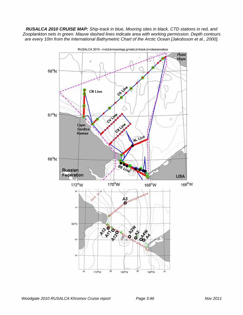
RUSALCA 2010 CRUISE MAP: Ship-track in blue, Mooring sites in black, CTD stations in red, and
Zooplankton nets in green. Mauve dashed lines indicate area with working permission. Depth contours are every 10m from the International Bathymetric Chart of the Arctic Ocean [Jakobsson et al., 2000].
Woodgate 2010 RUSALCA Khromov Cruise report Page 3:46 Nov 2011

RUSALCA 2010 SCIENCE PARTICIPANTS 1. Kathleen Crane (F) NOAA Program Manager, NOAA; 2. Vladimir Bakhmutov (M) SRNHI Expedition Leader 3. Aleksey Ostrovskiy (M) GA Liaison and translator 4. Rebecca Woodgate (F) UW US Chief Scientist 5. Kevin Wood (M) NOAA/UW Science Liaison 6. Jim Johnson (M) UW UW Mooring lead 7. Marla Stone (F) NPS UAF Mooring lead 8. Brian Svabik (M) UAF UAF Moorings 9. Elena Bondareva (F) AARI AARI Moorings 10. Steve Hartz (M) UAF CTD lead 11. Chase Stoudt (M) UAF graduate student, Moorings and CTD 12. Jonathan Whitefield (M) UAF graduate student, Moorings and CTD 13. Dan Naber (M) UAF moored sampler, water sampling, mooring assistance 14. Mike Kong (M) UAF graduate student, water sampling, mooring assistance 15. Valentina Sergeeva (F) SIO Phytoplankton 16. Konstantin Soloviev (M) SIO Phytoplankton 17. Elizaveta Ershova (F) UAF Zooplankton Nets 18. Kate Stafford (F) UW Marine Mammal & moored acoustic recorder 19. Carter Esch (F) WHOI Marine Mammal & moored acoustic recorder 20. Alexey Sherbinen (M) FERHRI Technical Support 21. Sergei Yarosh (M) FERHRI Technical Support 22. Iouri Pashenko (M) FERHRI Technical Support 23. Alexander Murayvev (M) FERHRI Technical Support NOAA – National Ocean Atmosphere Administration, US State R N. Hydro – State Research Navigational Hydrographic Institute, RF GA – Group Alliance, RF UW – University of Washington., US NPS – Naval Postgraduate School, US UAF – University of Alaska, Fairbanks, US AARI – Arctic and Antarctic Research Institute, RF SIO – Shirshov Institute of Oceanology, RF WHOI – Woods Hole Oceanographic Institute, US FERHRI - Far Eastern Regional Hydrometeorological Research Institute
Woodgate 2010 RUSALCA Khromov Cruise report Page 4:46 Nov 2011
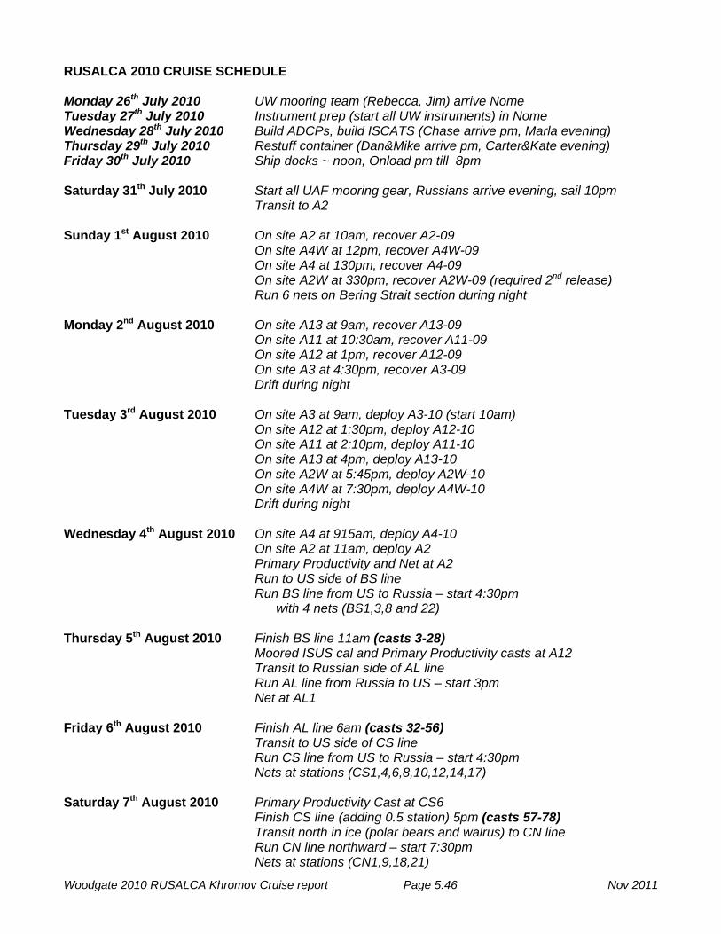
RUSALCA 2010 CRUISE SCHEDULE Monday 26th July 2010 UW mooring team (Rebecca, Jim) arrive Nome Tuesday 27th July 2010 Instrument prep (start all UW instruments) in Nome Wednesday 28th July 2010 Build ADCPs, build ISCATS (Chase arrive pm, Marla evening) Thursday 29th July 2010 Restuff container (Dan&Mike arrive pm, Carter&Kate evening) Friday 30th July 2010 Ship docks ~ noon, Onload pm till 8pm Saturday 31th July 2010 Start all UAF mooring gear, Russians arrive evening, sail 10pm Transit to A2 Sunday 1st August 2010 On site A2 at 10am, recover A2-09 On site A4W at 12pm, recover A4W-09 On site A4 at 130pm, recover A4-09 On site A2W at 330pm, recover A2W-09 (required 2nd release) Run 6 nets on Bering Strait section during night Monday 2nd August 2010 On site A13 at 9am, recover A13-09 On site A11 at 10:30am, recover A11-09 On site A12 at 1pm, recover A12-09 On site A3 at 4:30pm, recover A3-09 Drift during night Tuesday 3rd August 2010 On site A3 at 9am, deploy A3-10 (start 10am) On site A12 at 1:30pm, deploy A12-10 On site A11 at 2:10pm, deploy A11-10 On site A13 at 4pm, deploy A13-10 On site A2W at 5:45pm, deploy A2W-10 On site A4W at 7:30pm, deploy A4W-10 Drift during night Wednesday 4th August 2010 On site A4 at 915am, deploy A4-10 On site A2 at 11am, deploy A2 Primary Productivity and Net at A2 Run to US side of BS line Run BS line from US to Russia – start 4:30pm with 4 nets (BS1,3,8 and 22) Thursday 5th August 2010 Finish BS line 11am (casts 3-28) Moored ISUS cal and Primary Productivity casts at A12 Transit to Russian side of AL line Run AL line from Russia to US – start 3pm Net at AL1 Friday 6th August 2010 Finish AL line 6am (casts 32-56) Transit to US side of CS line Run CS line from US to Russia – start 4:30pm Nets at stations (CS1,4,6,8,10,12,14,17) Saturday 7th August 2010 Primary Productivity Cast at CS6 Finish CS line (adding 0.5 station) 5pm (casts 57-78) Transit north in ice (polar bears and walrus) to CN line Run CN line northward – start 7:30pm Nets at stations (CN1,9,18,21)
Woodgate 2010 RUSALCA Khromov Cruise report Page 5:46 Nov 2011
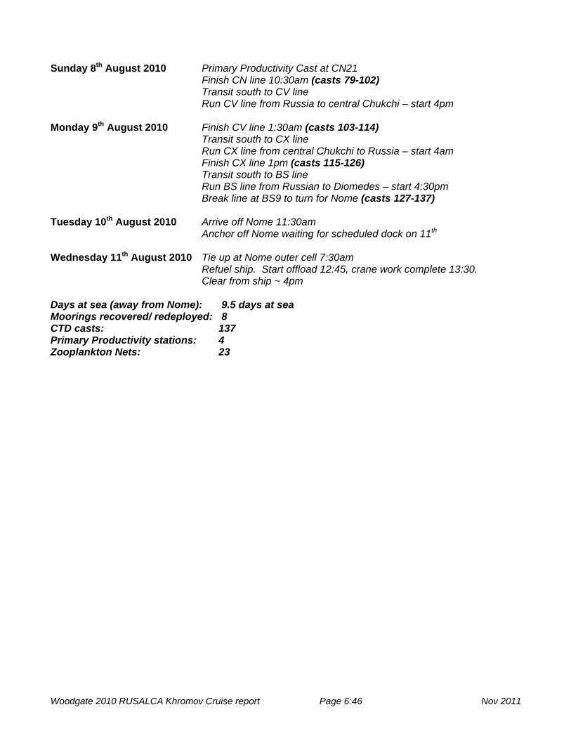
Sunday 8th August 2010 Primary Productivity Cast at CN21 Finish CN line 10:30am (casts 79-102) Transit south to CV line Run CV line from Russia to central Chukchi – start 4pm Monday 9th August 2010 Finish CV line 1:30am (casts 103-114) Transit south to CX line Run CX line from central Chukchi to Russia – start 4am Finish CX line 1pm (casts 115-126) Transit south to BS line Run BS line from Russian to Diomedes – start 4:30pm Break line at BS9 to turn for Nome (casts 127-137) Tuesday 10th August 2010 Arrive off Nome 11:30am Anchor off Nome waiting for scheduled dock on 11th
Wednesday 11th August 2010 Tie up at Nome outer cell 7:30am Refuel ship. Start offload 12:45, crane work complete 13:30. Clear from ship ~ 4pm Days at sea (away from Nome): 9.5 days at sea Moorings recovered/ redeployed: 8 CTD casts: 137 Primary Productivity stations: 4 Zooplankton Nets: 23
Woodgate 2010 RUSALCA Khromov Cruise report Page 6:46 Nov 2011

SCIENCE COMPONENTS OF CRUISE The cruise comprised of the following science components: - Mooring operations Mooring operations were a joint UW, UAF, AARI operation, assisted by other cruise members. - CTD operations CTD operations were led by the UAF team, assisted by other cruise members. -Water sampling from the CTD rosette Water samples were taken for various components, as per the following table. Line Nutrients Chl DIC DON Phyto PP ZNet O18 A2 5 in strait - BS All All Half Half Many A12 A2+4 - AL All All - - Some AL1 - CS All All - Half Some CS6 8 CS0.5 CN All All - - Some CN21 4 - CV All All - - Some - - CX All All - - - - - BS(Rhalf) All - - - - - - Nutrients, Chlorophyll (Chl), Dissolved Inorganic Carbon (DIC), Dissolved Organic Nitrogen (DON), and Primary productivity (PP) were sampled by the UAF group. Phytoplankton (Phyto) samples were taken by the SIO group On one cast (CS0.5) some opportunistic water samples were for delta O18 analysis by UW. - Zooplankton Net Tows (ZNet) Zooplankton Net Tows were taken both independently in the strait during the nights of between mooring operations and during the CTD phase of the cruise. This effort was led from UAF with assistance from SIO. - Whale Observations (including acoustic instruments on the moorings) UW and WHOI whale observers on the ship took observations of marine mammal and birds and were responsible for the moored acoustic whale recorders.
Woodgate 2010 RUSALCA Khromov Cruise report Page 7:46 Nov 2011

RUSALCA 2010 SATELLITE IMAGES
8th July 2010 Ocean Color Image from http://oceancolor.gsfc.nasa.gov/_ (found by Bill Crawford)
24th July 2010 SST Aqua image (thanks to Mike Schmidt) from http://mather.sfos.uaf.edu/~mschmidt/ak_chukchi_sea_2010/A2010205230000_AQUA_LAC_sub1_sst_map.png
Woodgate 2010 RUSALCA Khromov Cruise report Page 8:46 Nov 2011

http://pafc.arh.noaa.gov/ice.php?img=ice
Woodgate 2010 RUSALCA Khromov Cruise report Page 9:46 Nov 2011

MOORING OPERATIONS (Woodgate, Johnson, Stone, Svabik, Bondareva)
Background: The moorings serviced on this cruise are part of a multi-year time-series (started in 1990) of measurements of the flow through the Bering Strait. This flow acts as a drain for the Bering Sea shelf, dominates the Chukchi Sea, influences the Arctic Ocean, and can be traced across the Arctic Ocean to the Fram Strait and beyond. The long-term monitoring of the inflow into the Arctic Ocean via the Bering Strait is important for understanding climatic change both locally and in the Arctic. Data from 2001 to 2004 and 2007 suggest that heat and freshwater fluxes are increasing through the strait [Woodgate et al., 2006; Woodgate et al., 2010]. The work completed this summer should tell us if this is a continuing trend.
An overview of the Bering Strait mooring work (including access to mooring and CTD data) is available at http://psc.apl.washington.edu/BeringStrait.html.
Eight moorings were recovered on this cruise. These moorings (three in Russian waters – A11-09, A12-09, A13-09; five in US waters – A2W-09, A2-09, A4W-09, A4-09, A3-09) were deployed in another joint US-Russian cruise supported by the NOAA RUSALCA (Russian-American Long-term Census of the Arctic, http://www.arctic.noaa.gov/aro/russian-american/) program.
Eight moorings were deployed on this cruise under funding from NSF-AON (Arctic Observing Network) (PIs: Woodgate, Weingartner, Whitledge, Lindsay, ARC-0855748) with ship-time and logistical support from RUSALCA-NOAA. These moorings (three in Russian waters – A11-10, A12-10, A13-10; five in US waters – A2W-10, A2-10, A4W-10, A4-10, A3-10) are almost entirely direct replacements of the recoveries, but with some added instrumentation.
This is the 4th deployment year of the highest resolution array ever placed in the Bering Strait (see map above). Three moorings were deployed across the western (Russian) channel of the strait (from west to east - A12, A11, A13). Four moorings were deployed across the eastern (US) channel of the strait (from west to east - A2W, A2, A4W, A4). A final 8th mooring (A3) was deployed ca. 35 nm north of the strait at a site proposed as a “climate” site, hypothesized to measure a useful average of the flow through both channels [Woodgate et al., 2007]. Testing this hypothesis is one of the main aims of this work. Other science goals including understanding the physics forcing the flow, and quantifying fluxes of volume, heat, freshwater and nutrients.
All moorings (recovered and deployed) measure water velocity, temperature and salinity near bottom (as per historic measurements). Additionally, 6 of the 8 moorings (i.e., all eastern channel moorings, the climate site mooring A3, and the mooring central in the western channel, A11) also carried upward-looking ADCPs (measuring water velocity in 1-2 m bins up to the surface, ice motion, and medium quality ice-thickness) and ISCATS (upper level temperature-salinity-pressure sensors in a trawl resistant housing designed to survive impact by ice keels). Bottom pressure gauges were also deployed on the moorings at the east-west extremes of the strait (A12-10 and A4-10). (Note in the recovered moorings, bottom pressure gauges were deployed only at A2W-09 and A4-09). Two moorings (A2-10, central eastern channel; and A12-10, western part of western channel) also carried ISUS nitrate sensors, moorings A11-10, A2W-10, A2-10 and A4-10 carried biowiper Fluorometer and Turbidity instruments, and moorings A2W-10 and A3-10 carried whale acoustic recorders. For a full instrument listing, see the table below.
This coverage should allow us to assess year-round stratification in the strait and also to study the the physics of the Alaskan Coastal Current, a warm, fresh current present seasonally in the eastern channel, and suggested to be a major part of the heat and freshwater fluxes [Woodgate and Aagaard, 2005; Woodgate et al., 2006]. The current meters and ADCPs (which give an estimate of ice thickness and ice motion) allow the quantification of the movement of ice and water through the strait. The nutrient sampler, the transmissometer and fluorometer time-series measurements should advance our understanding of the biological systems in the region.
2010 Recoveries and Deployments: Mooring operations went extremely smoothly in 2010. For
recoveries, the ship positioned ~ 200m away from the mooring such as to drift over the mooring site. Ranging was done from the aft-deck adjacent to the wet-lab. Without exception, acoustic ranges agreed to within 30m of the expected mooring position. Once the ship had drifted over the mooring and the acoustic ranges had increased to > 100m, the mooring was released. This procedure was followed
Woodgate 2010 RUSALCA Khromov Cruise report Page 10:46 Nov 2011

to prevent the mooring being released too close (or underneath) the ship since in previous years the moorings have taken up to 15min to release. With one exception (A2W), all moorings released successfully on the first release attempt. On A2W, although the first release command was confirmed acoustically by the instrument, the mooring did not surface. The ship repositioned and the second release was fired successfully. On recovery, the first release was found to have activated, but the hook had not released and could not be pulled clear by hand. No clear explanation for the hang-up is available. A gelatinous biofouling was present on recovery, possibly gaining sufficient mechanical advantage to have held the hook in place. Another possibility is that the pin that turns did not turn completely to straight and under certain lateral forces on the release (drag on the mooring) this may have caused it to hang up on the hook. Action item: repaint antifouling on releases. Recheck pin alignment on all releases.
Once the mooring was on the surface, the ship repositioned, bringing the mooring tightly down the starboard side of the ship. Two grapples and a pole with a quick releasing hook attached to a line were used to catch the mooring. The line from the hook was fastened onto an extension on the port-crane, and the mooring lifted aboard. If the pick was too long for the crane, a stopper chain on the starboard rail was used. Iscats (when present) were recovered by hand while the top float was lifted clear of the water by the crane.
Mooring deployments were done through the aft A-frame, using the ship’s trawl wire and block for lifting. The mooring was assembled completely within the A-frame. The ship positioned to steam slowly (~2 knots) into the wind/current. When the ship was approximately 10min from the mooring position, mooring deployment started. The ISCAT was deployed by hand and streamed behind the ship. The top pick (usually float) was deployed using a quick release. Then the anchor was lifted into the water. When the ship arrived on site, the anchor was dropped using the mechanical quick release. Positions were taken using a hand-held GPS on the aft deck by the A-frame. As necessary, slip lines were used to lower equipment on the mooring between picks over the stern.
Action items: - design pick points into the moorings for recovery - shorten BPG mount as the current length is very close to the A-frame reach - put 2 rings on the anchors for tag lines Consider - using chain, not line for the moorings (saves on splicing and gives extra pick points) Instrumentation issues: Most instrumentation was started in Nome or aboard ship on the day prior
to sailing. All instrumentation was started successfully, although there was a learning curve in establishing that the SBE-16+ biowipers had been set on continuous (CTD) mode, rather than mooring mode. This was corrected before deployment.
Overall, data recovery on the moorings was very good. Of the 6 iscats deployed, 4 were recovered with full recorders. Two iscats (from moorings A4 and
A4W) were not present when the mooring was released. Data records from the loggers on these instruments cease at the start of November, but we hypothesize this is not due to loss of the iscat, as the loggers of the recovered iscats also stopped recording around these dates. All loggers recovered had battery voltages below the cut-off voltage for the logger, a state in which they cease to record data. The reason for this battery depletion is not clear - it may relate to insufficient sea-water connection for the inductive modem, or due to generally high power consumption or low powered batteries. In case the failure was due to the latter, where possible (A3 and A11) the newly deployed loggers were set on 1hr sample interval rather than the previous 30min sample interval. Revise power cut off for Iscat loggers.
Of the 6 ADCPs recovered, 5 recorded full records, although in the case of 9396 the instrument stopped briefly after deployment and then restarted with the same sampling regime, thus recording 2 data files. The 6th (11698 on A11) also recorded 2 data files. In this case, however, the 2nd file (started about 1 month after deployment) is of a completely different bin/ping set up to the first. Furthermore, for this second file the ADCP had lost its compass calibration and its clock. Preliminary investigation suggests that period without data is only short (less than 2 days), and, also positively, the data recovered may be reasonable, albeit with greater errors in velocity and direction (ship-board tests
Woodgate 2010 RUSALCA Khromov Cruise report Page 11:46 Nov 2011

suggest direction errors are < 15deg). 1) Do post-deployment compass test on 11698. 2) Follow up with RDI about instruments stopping while in the water.
Two Aanderaa RCMs were recovered with complete data records, even though one (1173) leaked, possibly through the salinity sensor, which returned only erroneous data. The interior of the instrument (especially the paper DSU label) was wet on opening, however the leak appears to have been contained by the packet desiccant inside.
The three Microcats recovered contained complete data records. The two bottom pressure recorders also contained compete data records. Of the 5 SBE16s, 4 contained complete records. The 5th (SBE16plus on A12-09) had low battery
and had stopped recording in July 2010. Possibly this is due to a pump delay time of 10s. The two ISUS instruments also contained almost complete data records, one still running on
recovery, and one having stopped one week before recovery. The two Whale recorder instruments also suffered from draining batteries, but yielded records lasting
until January or March (see report below). The AARI RCM on A11-09 was recovered hanging upside down, with the endplate under the rotor
torn from the instrument and the bottom vane missing. The mooring was saved by the presence of a safety line, which had been strapped to the instrument on deployment because the deployment team were suspicious of the strength of the current meter, even though the frame of the instrument was apparently rated appropriately for the tension of the mooring. The instrument stopped recording meaningful speed after a few months, suggesting this was the time of failure. Other sensors on the meter (temperature and pressure) continued recording beyond this.
Details of mooring positions and instrumentation are given below, along with schematics of the
moorings, photos of the mooring fouling, and preliminary plots of the data as available.
Woodgate 2010 RUSALCA Khromov Cruise report Page 12:46 Nov 2011

RUSALCA 2010 BERING STRAIT MOORING POSITIONS AND INSTRUMENTATION
ID LATITUDE (N) (WGS-84)
LONGITUDE (W) (WGS-84)
WATER DEPTH /m (corrected)
INST.
09 Recoveries - Russian EEZ
A11-09 65 54.002 169 25.984 52 ISCAT, ADCP, SBE37
A12-09 65 55.993 169 37.005 51 ISUS, SBE/TF, RCM9
A13-09 65 52.006 169 16.987 51 AARI, RCM9T, SBE37
- US EEZ A2W-09 65 48.062 168 47.957 54 ISCAT, ADCP,
SBE16, WR, BPG A2-09 65 46.870 168 34.044 57 ISCAT, ADCP,
SBE/TF, ISUS A4W-09 65 45.424 168 21.937 56 ISCAT, ADCP,
SBE16 A4-09 65 44.762 168 15.746 50 ISCAT, ADCP,
SBE16, BPG A3-09 66 19.601 168 57.928 58 ISCAT, ADCP,
SBE37, WR
ID LATITUDE (N) (WGS-84)
LONGITUDE (W) (WGS-84)
WATER DEPTH /m (corrected)
INST.
10 Deployments - Russian EEZ
A11-10 65 54.001 169 25.985 52 ISCAT, ADCP, SBE37
A12-10 65 56.007 169 36.990 50 ISUS, SBE/TF, RCM9, BPG
A13-10 65 52.000 169 16.987 50 AARI, RCM9, SBE37
- US EEZ A2W-10 65 48.071 168 47.903 53 ISCAT, ADCP,
SBE16, WR, FLT A2-10 65 46.872 168 34.048 56 ISCAT, ADCP,
SBE/TF, ISUS A4W-10 65 45.423 168 21.974 55 ISCAT, ADCP,
SBE16 A4-10 65 44.763 168 15.755 49 ISCAT, ADCP,
SBE16, FLT ,BPG A3-10 66 19.610 168 57.925 58 ISCAT, ADCP,
SBE37, WR
AARI = AARI Current meter and CTD ADCP = RDI Acoustic Doppler Current Profiler BPG=Seabird Bottom Pressure Gauge FLT=Wetlabs Biowiper Fluoresence& Turbidity recorder ISCAT = near-surface Seabird TS sensor in trawl resistant housing, with near-bottom data logger ISUS= Nutrient Analyzer RCM9= Aanderaa Acoustic Recording Current Meter RCM9T = Aanderaa Acoustic Recording Current Meter with Turbidity SBE/TF = Seabird CTD recorder with transmissometer and fluorometer SBE16 = Seabird CTD recorder SBE37 = Seabird Microcat CTD recorder WR=Whale Recorder
Woodgate 2010 RUSALCA Khromov Cruise report Page 13:46 Nov 2011

RUSALCA 2010 SCHEMATICS OF MOORING RECOVERIES
= in the eastern channel of the Bering Strait
= in the western channel of the Bering Strait
= at the climate site, ~ 60km north of the Strait
Woodgate 2010 RUSALCA Khromov Cruise report Page 14:46 Nov 2011

RUSALCA 2010 SCHEMATICS OF MOORING DEPLOYMENTS
= in the eastern channel of the Bering Strait
= in the western channel of the Bering Strait
= at the climate site, ~ 60km north of the Strait
Woodgate 2010 RUSALCA Khromov Cruise report Page 15:46 Nov 2011

RUSALCA 2010 RECOVERY PHOTOS
Woodgate 2010 RUSALCA Khromov Cruise report Page 16:46 Nov 2011

RUSALCA 2010 RECOVERY PHOTOS (continued)
Woodgate 2010 RUSALCA Khromov Cruise report Page 17:46 Nov 2011

RUSALCA 2010 RECOVERY PHOTOS (continued)
Woodgate 2010 RUSALCA Khromov Cruise report Page 18:46 Nov 2011

RUSALCA 2010 RECOVERY PHOTOS (continued)
Woodgate 2010 RUSALCA Khromov Cruise report Page 19:46 Nov 2011

RUSALCA 2010 PRELIMINARY ADCP RESULTS
A2W-09 9396
A2-09 12845
A4W-09 2332
A4-09 9397
A3-09 1075
(A11-09 data not included.)
Woodgate 2010 RUSALCA Khromov Cruise report Page 20:46 Nov 2011

RUSALCA 2010 PRELIMINARY SEACAT RESULTS
Woodgate 2010 RUSALCA Khromov Cruise report Page 21:46 Nov 2011

CTD OPERATIONS (Hartz, Stoudt, Whitefield) The moorings are usually supported by annual CTD sections, with water samples for various
projects as described below. The CTD sections for RUSALCA 2010 were taken by a CTD rosette system with the setup described
below, controlled by a SBE-33 deck-unit, running the software package Seasoft. The lowering and raising was done by the ship’s conducting cable winch, at a rate of ~ 0.3 m/s. Bottles were fired by the operator at the deck-unit on the up-cast. Data are recorded in standard SBE format. Configuration Date: August 03 2010 SBE 25 CTD SN:2559287-0484
• SBE 33 Carousel Deck Unit SN:3357671-0180 • SBE 32 Carousel SN:3235784-0534 • Wetlabs FLNTURT SN:1847 (V0 FL/V1 TR) • SBE 5T Pump SN:055663 • Biospherical QCP2300 SN:70285 (V2) • Teledyne Benthos PSA-916 Altimeter:SN50416 (V4) • SBE Temp 5303 • SBE Cond 3814 • SBE Pressure 0690 • Garmin 17xHVS GPS SN:1BN021515
The rosette carried twelve 1.7l bottles.
Initial concerns that the CTD rosette would be too light for the ship’s winch proved unfounded. The CTD was deployed through the stern A-frame using the ship’s 01 starboard 9 mm EM conducting Cable, winch and slip rings.
The positioning of a freezer container on the 01 deck, just aft of the winch controls made visibility of the A-frame difficult, but just workable.
Cameras were set up to give the CTD operator oversight of A-frame and winch operations. In future years, bringing more camera cable would allow this system to be extended to the bridge. CTDs were run using 5 people – 1 CTD operator, 1 winch driver, 1 A-frame driver, 2 persons on deck to assist catching the rosette. (In good weather, 1 person would have been sufficient.) The 2 deck persons also assisted with water sampling. CTDs were run 24hrs using a 2 or 3 watch system. Pallets were stacked under the A-frame to bring the rosette to a comfortable height for sampling.
CTD operations went extremely smoothly, and a total of 137 casts were made. Some casts (some of 9,51,108,135) had comms problems on the upcast, which was suspected to be related to low battery voltage on the internal batteries on the rosette. (The DS command does not appear to inform about internal battery voltage) – certainly, changing the CTD batteries seemed to solve the problem. Investigate this with SBE. Bring plenty of spare batteries. Investigate use of rechargeable batteries
There were occasional bottles which failed to fire, but since this was near the end of the cruise (when less sampling was being done), an explanation for this was not pursued.
Generally the ship drifted during CTD operations, with screws still turning, but feathered for no thrust. Ship’s draft is 5m, and this should be taken into account in viewing the data. Ship drift was at times substantial, and this might be investigated to get some idea of water velocity (combined with wind-driven drift of the ship).
Extremely fresh layers were encountered on the western stations, and some profiles show remarkable layering in temperature and fluorescence maximum.
As CTD work was 24 hr, at some stage operations were done during the dark. It was not recognized initially that the A-frame light was affecting the PAR sensor, so there is inconsistency in the CTD methodology as to if the A-frame light was on or off.
Preliminary CTD sections will be included once the Russian data have been cleared.
Woodgate 2010 RUSALCA Khromov Cruise report Page 22:46 Nov 2011

RUSALCA 2010 CTD Positions
The following lists give the target positions of the CTD lines. The full RUSALCA event log (as noted by the CTD operator) is also included.
%% Bering Strait Line %==================== % - now 26 stations just north of the Bering Strait % - ** added 2 stations near Russian Coast BS0.5 and BS1.5 % to measure SCC. % - goal - 3 km resolution, to be run in 1 day % - 26 stations = 3.4km spacing .. closer near Coast % - total length BS0.5 to BS24 ~ 84km % % Lat (N) Long (W) Lat (N) Long (W) % deg min deg min % Russian Stations 65.989 169.678 65 59.31 169 40.74 %*1 %BS0.5 65.980 169.643 65 58.81 169 38.56 %*1 %BS1 65.971 169.607 65 58.28 169 36.40 %*1 %BS1.5 65.963 169.571 65 57.75 169 34.24 %*2 %BS2 65.945 169.498 65 56.71 169 29.87 %*3 %BS3 65.927 169.425 65 55.65 169 25.52 %*4 %BS4 65.910 169.352 65 54.59 169 21.11 %*5 %BS5 65.892 169.280 65 53.55 169 16.77 %*6 %BS6 65.880 169.214 65 52.78 169 12.83 %*7 %BS7 65.862 169.142 65 51.72 169 8.49 %*8 %BS8 65.841 169.072 65 50.47 169 4.31 %*9 %BS9 65.825 169.000 65 49.50 169 0.00 %*10 %BS10 % US Stations 65.805 168.933 65 48.31 168 55.96 %*11 %BS11 65.788 168.860 65 47.26 168 51.62 %*12 %BS12 65.772 168.794 65 46.33 168 47.64 %*13 %BS13 65.755 168.721 65 45.28 168 43.29 %*14 %BS14 65.739 168.663 65 44.35 168 39.80 %*15 %BS15 65.722 168.591 65 43.29 168 35.46 %*16 %BS16 65.704 168.521 65 42.23 168 31.28 %*17 %BS17 65.686 168.449 65 41.18 168 26.94 %*18 %BS18 65.672 168.391 65 40.35 168 23.44 %*19 %BS19 65.655 168.318 65 39.29 168 19.09 %*20 %BS20 65.642 168.250 65 38.53 168 14.97 %*21 %BS21 65.625 168.177 65 37.48 168 10.63 %*22 %BS22 65.599 168.161 65 35.96 168 9.66 %*23 %BS23 65.582 168.117 65 34.91 168 7.00 %*24 %BS24 % % A3L line %========= % - nominally 85km .. aiming at 3km resolution % - extra station to give better resolution near Russian Coast % - 13 on the Russian side, 12 on US side % gives us about 3.4 km resolution % - total listed here = 77 km % % Lat (N) Long (W) Latdeg Lat min Lon deg Lon min % Russian Stations 66.1190 169.5931 66.0000 7.1400 169.0000 35.5850 %*48 %AL1 66.1285 169.5646 66.0000 7.7100 169.0000 33.8775 %*48 %AL1.5 66.1380 169.5362 66.0000 8.2800 169.0000 32.1700 %*47 %AL2 66.1570 169.4793 66.0000 9.4200 169.0000 28.7550 %*46 %AL3 66.1760 169.4223 66.0000 10.5600 169.0000 25.3400 % 45 %AL4
Woodgate 2010 RUSALCA Khromov Cruise report Page 23:46 Nov 2011

66.1950 169.3654 66.0000 11.7000 169.0000 21.9250 %*44 %AL5 66.2140 169.3085 66.0000 12.8400 169.0000 18.5100 % 43 %AL6 66.2330 169.2516 66.0000 13.9800 169.0000 15.0950 %*42 %AL7 66.2520 169.1947 66.0000 15.1200 169.0000 11.6800 % 41 %AL8 66.2710 169.1378 66.0000 16.2600 169.0000 8.2650 %*40 %AL9 66.2900 169.0808 66.0000 17.4000 169.0000 4.8500 % 39 %AL10 66.3090 169.0239 66.0000 18.5400 169.0000 1.4350 %*38 %AL11 %US stations 66.3280 168.9670 66.0000 19.6800 168.0000 58.0200 % 37 %AL12 66.3398 168.8952 66.0000 20.3867 168.0000 53.7092 %*36 %AL13 66.3516 168.8233 66.0000 21.0933 168.0000 49.3983 % 35 %AL14 66.3633 168.7515 66.0000 21.8000 168.0000 45.0875 %*34 %AL15 66.3751 168.6796 66.0000 22.5067 168.0000 40.7767 % 33 %AL16 66.3869 168.6078 66.0000 23.2133 168.0000 36.4658 %*32 %AL17 66.3987 168.5359 66.0000 23.9200 168.0000 32.1550 % 31 %AL18 66.4104 168.4641 66.0000 24.6267 168.0000 27.8442 %*30 %AL19 66.4222 168.3922 66.0000 25.3333 168.0000 23.5333 % 29 %AL20 66.4340 168.3204 66.0000 26.0400 168.0000 19.2225 %*28 %AL21 66.4458 168.2485 66.0000 26.7467 168.0000 14.9117 % 27 %AL22 66.4576 168.1767 66.0000 27.4533 168.0000 10.6008 %*26 %AL23 66.4693 168.1048 66.0000 28.1600 168.0000 6.2900 %*25 %AL24 % % Cape Serdtse Kamen to Point Hope %========================================== % = Now station list is 19 stations % (including old Russian stations) % has 4-5km spacing within 15km of the coast % 20km spacing elsewhere % R = old Rusalca stations %% Lat (N) Long (W) Latdeg Lat min Lon deg Lon min %Russian stations 66.8300 171.2567 66.0000 49.8000 171.0000 15.4000 %*49 %CS1 66.8649 171.1678 66.0000 51.8920 171.0000 10.0697 % 50 %CS2 66.8997 171.0790 66.0000 53.9840 171.0000 4.7393 %*51 %CS3 66.9346 170.9902 66.0000 56.0760 170.0000 59.4090 %R%*52 %CS4 67.0622 170.6377 67.0000 3.7325 170.0000 38.2645 % 53 %CS5 67.1898 170.2853 67.0000 11.3890 170.0000 17.1200 %R%*54 %CS6 67.3110 169.9413 67.0000 18.6620 169.0000 56.4785 % 55 %CS7 67.4322 169.5973 67.0000 25.9350 169.0000 35.8370 %R%*56 %CS8 67.5334 169.3070 67.0000 32.0065 169.0000 18.4215 % 57 %CS9 67.6346 169.0168 67.0000 38.0780 169.0000 1.0060 %R%*58 %CS10 67.7551 168.6652 67.0000 45.3030 168.0000 39.9110 % 59 %CS11 %US stations 67.8755 168.3136 67.0000 52.5280 168.0000 18.8160 %R%*60 %CS12 67.9887 167.9894 67.0000 59.3235 167.0000 59.3660 % 61 %CS13 68.1020 167.6653 68.0000 6.1190 167.0000 39.9160 %R%*62 %CS14 68.2008 167.3568 68.0000 12.0470 167.0000 21.4080 % 63 %CS15 68.2502 167.2026 68.0000 15.0110 167.0000 12.1540 % 64 %CS16 68.2996 167.0483 68.0000 17.9750 167.0000 2.9000 %R%*65 %CS17 68.3156 166.9600 68.0000 18.9375 166.0000 57.6000 % 66 %CS18 68.3317 166.8717 68.0000 19.9000 166.0000 52.3000 %*67 %CS19
Woodgate 2010 RUSALCA Khromov Cruise report Page 24:46 Nov 2011
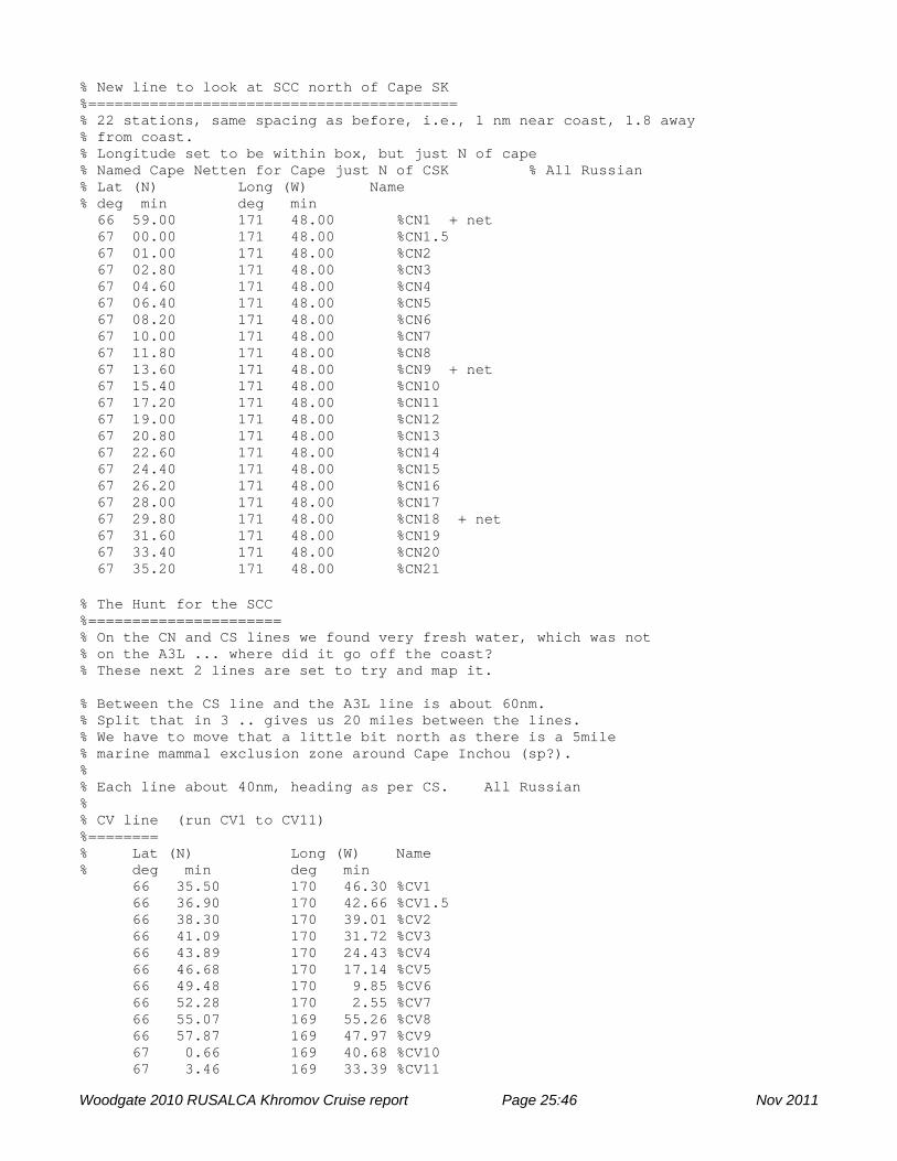
% New line to look at SCC north of Cape SK %========================================== % 22 stations, same spacing as before, i.e., 1 nm near coast, 1.8 away % from coast. % Longitude set to be within box, but just N of cape % Named Cape Netten for Cape just N of CSK % All Russian % Lat (N) Long (W) Name % deg min deg min 66 59.00 171 48.00 %CN1 + net 67 00.00 171 48.00 %CN1.5 67 01.00 171 48.00 %CN2 67 02.80 171 48.00 %CN3 67 04.60 171 48.00 %CN4 67 06.40 171 48.00 %CN5 67 08.20 171 48.00 %CN6 67 10.00 171 48.00 %CN7 67 11.80 171 48.00 %CN8 67 13.60 171 48.00 %CN9 + net 67 15.40 171 48.00 %CN10 67 17.20 171 48.00 %CN11 67 19.00 171 48.00 %CN12 67 20.80 171 48.00 %CN13 67 22.60 171 48.00 %CN14 67 24.40 171 48.00 %CN15 67 26.20 171 48.00 %CN16 67 28.00 171 48.00 %CN17 67 29.80 171 48.00 %CN18 + net 67 31.60 171 48.00 %CN19 67 33.40 171 48.00 %CN20 67 35.20 171 48.00 %CN21
% The Hunt for the SCC %====================== % On the CN and CS lines we found very fresh water, which was not % on the A3L ... where did it go off the coast? % These next 2 lines are set to try and map it. % Between the CS line and the A3L line is about 60nm. % Split that in 3 .. gives us 20 miles between the lines. % We have to move that a little bit north as there is a 5mile % marine mammal exclusion zone around Cape Inchou (sp?). % % Each line about 40nm, heading as per CS. All Russian % % CV line (run CV1 to CV11) %======== % Lat (N) Long (W) Name % deg min deg min 66 35.50 170 46.30 %CV1 66 36.90 170 42.66 %CV1.5 66 38.30 170 39.01 %CV2 66 41.09 170 31.72 %CV3 66 43.89 170 24.43 %CV4 66 46.68 170 17.14 %CV5 66 49.48 170 9.85 %CV6 66 52.28 170 2.55 %CV7 66 55.07 169 55.26 %CV8 66 57.87 169 47.97 %CV9 67 0.66 169 40.68 %CV10 67 3.46 169 33.39 %CV11
Woodgate 2010 RUSALCA Khromov Cruise report Page 25:46 Nov 2011

% % CX line (run CX11 to CX1) %======== % Lat (N) Long (W) Name % deg min deg min 66 22.00 170 16.30 %CX1 66 23.39 170 12.70 %CX1.5 66 24.77 170 9.10 %CX2 66 27.54 170 1.90 %CX3 66 30.31 169 54.70 %CX4 66 33.08 169 47.50 %CX5 66 35.85 169 40.30 %CX6 66 38.62 169 33.10 %CX7 66 41.39 169 25.90 %CX8 66 44.16 169 18.70 %CX9 66 46.93 169 11.50 %CX10 66 49.70 169 4.30 %CX11
Woodgate 2010 RUSALCA Khromov Cruise report Page 26:46 Nov 2011
Reports from Water Sampling Teams
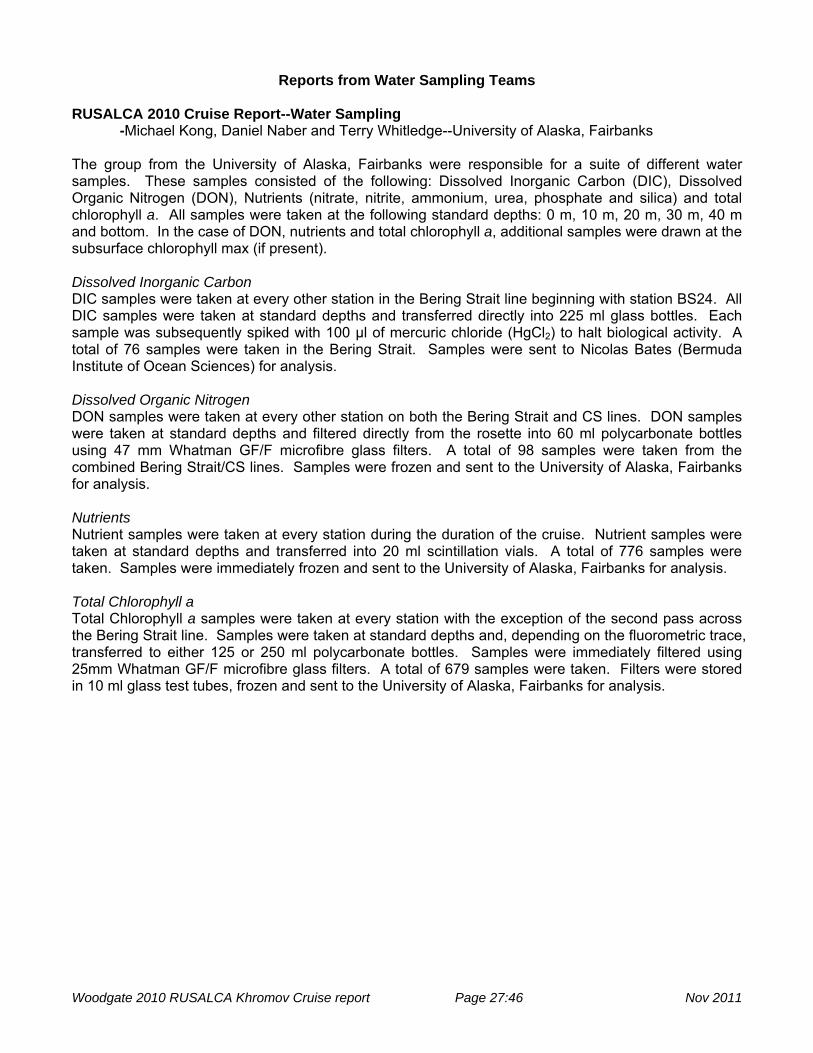
RUSALCA 2010 Cruise Report--Water Sampling -Michael Kong, Daniel Naber and Terry Whitledge--University of Alaska, Fairbanks The group from the University of Alaska, Fairbanks were responsible for a suite of different water samples. These samples consisted of the following: Dissolved Inorganic Carbon (DIC), Dissolved Organic Nitrogen (DON), Nutrients (nitrate, nitrite, ammonium, urea, phosphate and silica) and total chlorophyll a. All samples were taken at the following standard depths: 0 m, 10 m, 20 m, 30 m, 40 m and bottom. In the case of DON, nutrients and total chlorophyll a, additional samples were drawn at the subsurface chlorophyll max (if present). Dissolved Inorganic Carbon DIC samples were taken at every other station in the Bering Strait line beginning with station BS24. All DIC samples were taken at standard depths and transferred directly into 225 ml glass bottles. Each sample was subsequently spiked with 100 μl of mercuric chloride (HgCl2) to halt biological activity. A total of 76 samples were taken in the Bering Strait. Samples were sent to Nicolas Bates (Bermuda Institute of Ocean Sciences) for analysis. Dissolved Organic Nitrogen DON samples were taken at every other station on both the Bering Strait and CS lines. DON samples were taken at standard depths and filtered directly from the rosette into 60 ml polycarbonate bottles using 47 mm Whatman GF/F microfibre glass filters. A total of 98 samples were taken from the combined Bering Strait/CS lines. Samples were frozen and sent to the University of Alaska, Fairbanks for analysis. Nutrients Nutrient samples were taken at every station during the duration of the cruise. Nutrient samples were taken at standard depths and transferred into 20 ml scintillation vials. A total of 776 samples were taken. Samples were immediately frozen and sent to the University of Alaska, Fairbanks for analysis. Total Chlorophyll a Total Chlorophyll a samples were taken at every station with the exception of the second pass across the Bering Strait line. Samples were taken at standard depths and, depending on the fluorometric trace, transferred to either 125 or 250 ml polycarbonate bottles. Samples were immediately filtered using 25mm Whatman GF/F microfibre glass filters. A total of 679 samples were taken. Filters were stored in 10 ml glass test tubes, frozen and sent to the University of Alaska, Fairbanks for analysis.
Woodgate 2010 RUSALCA Khromov Cruise report Page 27:46 Nov 2011

RUSALCA 2010 Cruise Report--Primary Productivity -Michael Kong and Terry Whitledge--University of Alaska, Fairbanks Dual isotope primary productivity experiments were run on four days during the research cruise. Primary productivity station names and locations are as follows: Station Cast # Date Latitude Longitude
A2 1 08/04/10 65°47.21N 168°33.10W
A1-2 30 08/05/10 65°56.204N 169°36.944W
CS6 71 08/07/10 67°11.069N 170°17.526W
CN21 101 08/08/10 67°34.747N 171°48.172W The following illustrates the amount and purpose of primary productivity water samples: Sample Amount (ml) Purpose 13C + 15NO3
- 1000 per sample depth Productivity incubation 13C + 15NH4
- 1000 per sample depth Productivity incubation
Particulate Organic Carbon (POC)
250 per sample depth Natural abundance of stable isotopes
Total Chlorophyll a 125 per sample depth Chlorophyll biomass
Nutrients 20 per sample depth Nutrient concentration at sample depths
Sample depths corresponded to the following light levels: 100%, 50%, 30%, 12%, 5% and 1%. These light depths were determined via the photosynthetically available radiation (PAR) trace. Water was sampled in 1000 ml polycarbonate bottles covered in metal screens corresponding to the above light levels. Samples were spiked with 1 ml of 13C stable isotope solution and, depending on the treatment, either 0.5 ml of 15NO3
- or 15NH4+ stable isotope solution. In total, two sets (one set constitutes six
bottles--one for each light depth) of screened bottles were used for the productivity experiments: one for 15NO3
- experiments and one for 15NH4+ experiments. Each set was placed into a deck incubator
filled with cold flowing seawater for approximately four to six hours (depending on cloudiness). After incubation, 500 ml of each sample were filtered through 25mm Whatman GF/F microfibre glass filters. The samples were placed in 47 mm petri dishes, frozen and sent to the University of Alaska, Fairbanks for analysis. POC samples were filtered through 25mm Whatman GF/F microfibre glass filters, placed in 47 mm petri dishes, frozen and sent to the University of Alaska, Fairbanks for analysis. Total chlorophyll and nutrient samples were treated in the same manner as described in the "water sampling" section.
Woodgate 2010 RUSALCA Khromov Cruise report Page 28:46 Nov 2011

Phytoplankton CTD Sampling for RUSALCA 2010 - Valentina Sergeeva The goal of the research was to continue previous investigation of phytocenosis of the Chukchi Sea, including species composition and quantitative distribution. Investigations of the phytoplankton structure may provide the evidence of interannual variability of phytoplankton succession and elucidate the influence of abiotic factors on this succession . During the RUSALCA – 2010 expedition, phytoplankton samples were collected on CTD lines in the Bering Strait, in the southern Chukchi and on lines extending from the Russian coast across the Siberian Coastal Current. All the CTD lines of the cruise were sampled, except for the CX line and the repeat of the BS line. . The work was completed by researchers of Shirshov Institute of Oceanology (SIO) RAS, Valentina M. Sergeeva and Konstantin A. Solovyev. Materials and methods Samples for assessing vertical distribution of phytoplankton were taken from the 1.7 l Niskin bottles of the CTD rosette. The samples were taken from 3-6 levels, depths being chosen with reference to the CTD profile (upper layer, above the pycnocline, below the pycnocline, the fluorescence maximum, and bottom layer). The concentration of phytoplankton samples was carried out using chambers of reverse filtration (gentle filtration, see photo below) with 1 µm mesh size filter. The initial volume of water from each 1.7 l Niskin bottle was reduced to 50-100 ml. The samples were fixed by formaldehyde with 2% concentration in each sample. In total 243 samples were obtained from a total of 57 stations.
Chamber of reverse filtration.
Woodgate 2010 RUSALCA Khromov Cruise report Page 29:46 Nov 2011
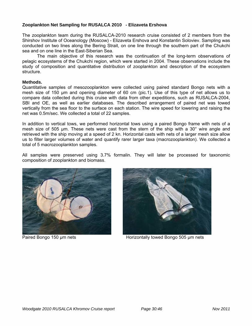
Zooplankton Net Sampling for RUSALCA 2010 - Elizaveta Ershova The zooplankton team during the RUSALCA-2010 research cruise consisted of 2 members from the Shirshov Institute of Oceanology (Moscow) - Elizaveta Ershova and Konstantin Soloviev. Sampling was conducted on two lines along the Bering Strait, on one line through the southern part of the Chukchi sea and on one line in the East-Siberian Sea. The main objective of this research was the continuation of the long-term observations of pelagic ecosystems of the Chukchi region, which were started in 2004. These observations include the study of composition and quantitative distribution of zooplankton and description of the ecosystem structure. Methods. Quantitative samples of mesozooplankton were collected using paired standard Bongo nets with a mesh size of 150 µm and opening diameter of 60 cm (pic.1). Use of this type of net allows us to compare data collected during this cruise with data from other expeditions, such as RUSALCA-2004, SBI and OE, as well as earlier databases. The described arrangement of paired net was towed vertically from the sea floor to the surface on each station. The wire speed for lowering and raising the net was 0.5m/sec. We collected a total of 22 samples. In addition to vertical tows, we performed horizontal tows using a paired Bongo frame with nets of a mesh size of 505 µm. These nets were cast from the stern of the ship with a 30° wire angle and retrieved with the ship moving at a speed of 2 kn. Horizontal casts with nets of a larger mesh size allow us to filter larger volumes of water and quantify rarer larger taxa (macrozooplankton). We collected a total of 5 macrozooplankton samples. All samples were preserved using 3.7% formalin. They will later be processed for taxonomic composition of zooplankton and biomass.
Paired Bongo 150 µm nets Horizontally towed Bongo 505 µm nets
Woodgate 2010 RUSALCA Khromov Cruise report Page 30:46 Nov 2011
Report from Whale Observation Team (Stafford and Esch)
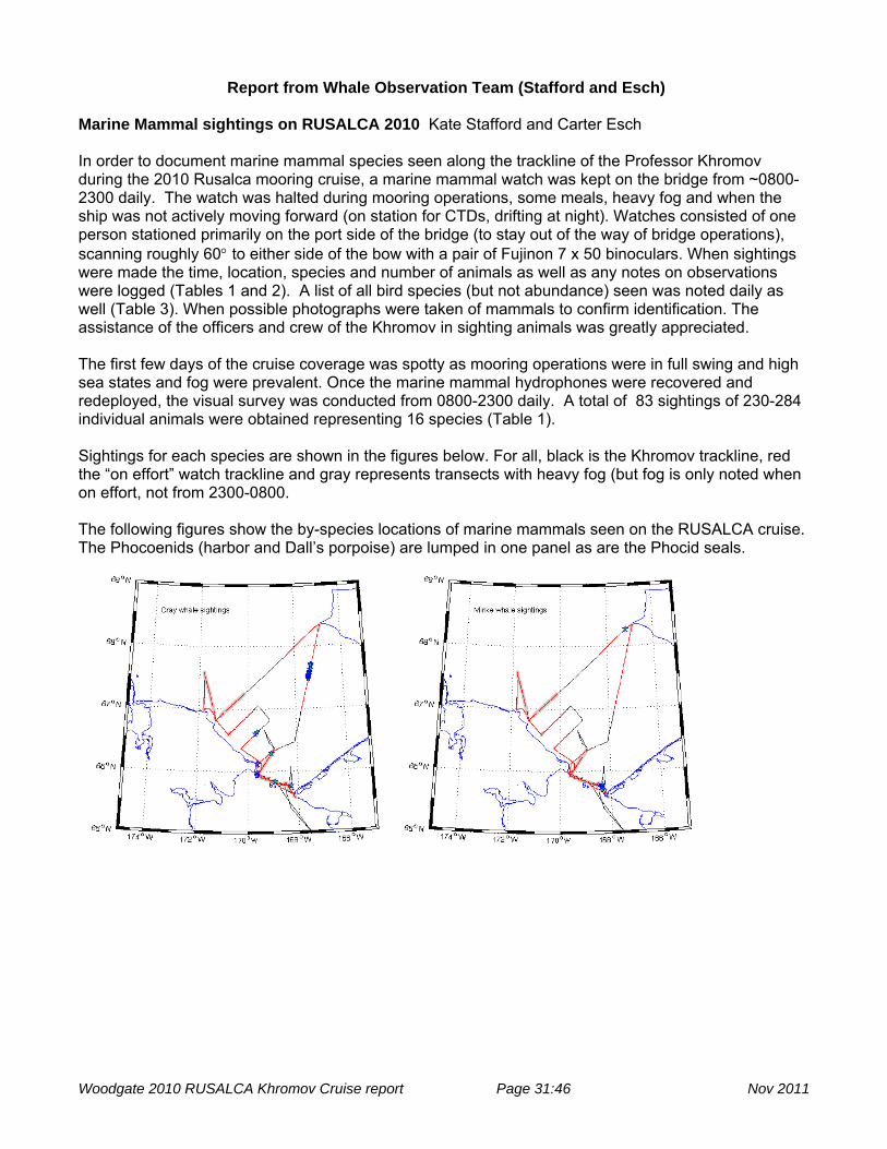
Marine Mammal sightings on RUSALCA 2010 Kate Stafford and Carter Esch In order to document marine mammal species seen along the trackline of the Professor Khromov during the 2010 Rusalca mooring cruise, a marine mammal watch was kept on the bridge from ~0800-2300 daily. The watch was halted during mooring operations, some meals, heavy fog and when the ship was not actively moving forward (on station for CTDs, drifting at night). Watches consisted of one person stationed primarily on the port side of the bridge (to stay out of the way of bridge operations), scanning roughly 60° to either side of the bow with a pair of Fujinon 7 x 50 binoculars. When sightings were made the time, location, species and number of animals as well as any notes on observations were logged (Tables 1 and 2). A list of all bird species (but not abundance) seen was noted daily as well (Table 3). When possible photographs were taken of mammals to confirm identification. The assistance of the officers and crew of the Khromov in sighting animals was greatly appreciated. The first few days of the cruise coverage was spotty as mooring operations were in full swing and high sea states and fog were prevalent. Once the marine mammal hydrophones were recovered and redeployed, the visual survey was conducted from 0800-2300 daily. A total of 83 sightings of 230-284 individual animals were obtained representing 16 species (Table 1). Sightings for each species are shown in the figures below. For all, black is the Khromov trackline, red the “on effort” watch trackline and gray represents transects with heavy fog (but fog is only noted when on effort, not from 2300-0800. The following figures show the by-species locations of marine mammals seen on the RUSALCA cruise. The Phocoenids (harbor and Dall’s porpoise) are lumped in one panel as are the Phocid seals.
Woodgate 2010 RUSALCA Khromov Cruise report Page 31:46 Nov 2011

Woodgate 2010 RUSALCA Khromov Cruise report Page 32:46 Nov 2011

Woodgate 2010 RUSALCA Khromov Cruise report Page 33:46 Nov 2011

Table 1. Marine mammal sightings by species.
Species #sightings number animals
harbor porpoise 4 5 minke 6 6 humpback 11 18 fin 1 1 bowhead 5 15 killer whale 3 16-20 Dall's porpoise 3 5 walrus 1 120-150 Unid baleen 9 17 Phoca spp 7 7 unid Phocoena 1 2 gray whale 25 47 polar bear 2 7 Like Bearded 1 1 Ringed seal 3 2 Bearded seal 1 1 sum 83 230-264
Table 2. Locations, times and counts for all marine mammal sightings.
event date time (local)
time (GMT) declat declon SS vis spp #
1 8/1/10 13:09 8/1/10 22:09 65.742 -168.280 4 OV
killer whale 7-10
2 8/2/10 13:20 8/2/10 22:20 65.939 -169.601 5 foggy
unid baleen 1
3 8/2/10 16:03 8/3/10
1:03 66.287 -169.033 5 OV gray whale 1
4 8/3/10 13:43 8/3/10 22:43 65.939 -169.606
gray whale 1
5 8/3/10 13:54 8/3/10 22:54 65.934 -169.615 3 fog
gray whale 1
6 8/3/10 14:02 8/3/10 23:02 65.930 -169.618 3 fog
gray whale 1
7 8/3/10 17:19 8/4/10
2:19 65.838 -168.911 2 clear Phoca spp 1
8 8/3/10 17:23 8/4/10
2:23 65.835 -168.891 2 clear gray whale 1
9 8/3/10 18:09 8/4/10
3:09 65.796 -168.767 2 clear Phoca spp 1
10 8/3/10 18:13 8/4/10
3:13 65.793 -168.735 2 clear Harbor porpoise 1
11 8/3/10 19:18 8/4/10
4:18 65.780 -168.347 1 clear minke whale 1
12 8/3/10 19:24 8/4/10
4:24 65.773 -168.322 1 clear
Like bearded seal 1
13 8/3/10 19:31 8/4/10
4:31 65.765 -168.342 1 clear Harbor porpoise 2
Woodgate 2010 RUSALCA Khromov Cruise report Page 34:46 Nov 2011

14 8/3/10 19:36 8/4/10
4:36 65.763 -168.351 1 clear minke whale 1
15 8/3/10 20:09 8/4/10
5:09 65.760 -168.378 1 clear Harbor porpoise 1
16 8/4/10 8:50 8/4/10 17:50 65.773 -168.261 3 fog
gray whale 1
17 8/4/10 14:37 8/4/10 23:37 65.742 -168.377 3 clear
minke whale 1
18 8/4/10 14:52 8/4/10 23:52 65.714 -168.329 2 OV
minke whale 1
19 8/4/10 15:51 8/5/10
0:51 65.626 -168.199 2 OV minke whale 1
20 8/5/10 13:42 8/5/10 22:42 65.978 -169.610 2 fog
gray whale 2
21 8/5/10 14:48 8/5/10 23:48 66.120 -169.593 1 fog
gray whale 1
22 8/5/10 15:10 8/6/10
0:10 66.124 -169.600 1 fog gray whale 1
23 8/5/10 17:31 8/6/10
2:31 66.196 -169.364 1 fog Phoca spp 1
24 8/5/10 21:26 8/6/10
6:26 66.318 -168.999 1 clear Killer whale 7
25 8/6/10 8:40 8/6/10 17:40 66.906 -167.823 2 OV
harbor porpoise 1
26 8/6/10 11:29 8/6/10 20:29 67.475 -167.447 2 OV
gray whale 2
27 8/6/10 11:45 8/6/10 20:45 67.476 -167.446 2 OV
gray whale 5
28 8/6/10 11:50 8/6/10 20:50 67.500 -167.432 2 OV
gray whale 3
29 8/6/10 11:52 8/6/10 20:52 67.504 -167.430 2 OV
gray whale 2
30 8/6/10 11:53 8/6/10 20:53 67.507 -167.428 2 OV
gray whale 1
31 8/6/10 11:54 8/6/10 20:54 67.514 -167.424 2 OV
gray whale 2
32 8/6/10 11:55 8/6/10 20:55 67.517 -167.423 2 OV
gray whale 3
33 8/6/10 11:59 8/6/10 20:59 67.527 -167.415 2 OV
gray whale 1
34 8/6/10 12:09 8/6/10 21:09 67.561 -167.391 2 OV
gray whale 2
35 8/6/10 12:12 8/6/10 21:12 67.571 -167.383 2 OV
gray whale 3
36 8/6/10 12:16 8/6/10 21:16 67.584 -167.375 2 OV
gray whale 1
37 8/6/10 12:25 8/6/10 21:25 67.614 -167.356 2 OV
gray whale 1
38 8/6/10 12:49 8/6/10 21:49 67.686 -167.311 2 OV
gray whale 2
39 8/6/10 12:53 8/6/10 21:53 67.700 -167.302 2 OV
gray whale 3
Woodgate 2010 RUSALCA Khromov Cruise report Page 35:46 Nov 2011

40 8/6/10 13:19 8/6/10 22:19 67.784 -167.242 2 OV fin whale 1
41 8/6/10 13:20 8/6/10 22:20 67.784 -167.243 2 OV
Dall's porpoise 2
42 8/6/10 14:21 8/6/10 23:21 67.986 -167.109 2 OV Phoca spp 1
43 8/6/10 14:43 8/6/10 23:43 68.047 -167.054 2 fog
Phocoena spp 2
44 8/6/10 18:24 8/7/10
3:24 68.263 -167.165 2 OV minke whale 1
45 8/6/10 19:41 8/7/10
4:41 68.201 -167.360 2 OV Phoca spp 1
46 8/6/10 20:51 8/7/10
5:51 68.102 -167.664 2 OV Dall's porpoise 2
47 8/6/10 22:05 8/7/10
7:05 68.023 -167.890 2 OV Dall's porpoise 1
48 8/7/10 13:52 8/7/10 22:52 66.936 -170.987 3 fog
Humpback whale 3
49 8/7/10 14:24 8/7/10 23:24 66.920 -171.014 3
clearing
Humpback whale 1
50 8/7/10 14:35 8/7/10 23:35 66.904 -171.066 3 OV
Unid baleen 2
51 8/7/10 14:36 8/7/10 23:36 66.904 -171.066 3 OV Bowhead 6
52 8/7/10 15:26 8/8/10
0:26 66.863 -171.166 4 OV Bowhead 6
53 8/7/10 16:06 8/8/10
1:06 66.829 -171.254 4 OV Polar bear 6
54 8/7/10 17:36 8/8/10
2:36 66.886 -171.365 4 OV Bowhead 1
55 8/7/10 17:44 8/8/10
2:44 66.901 -171.375 4 OV Walrus 120-150
56 8/7/10 17:59 8/8/10
2:59 66.928 -171.423 4 OV Humpback whale 1
57 8/7/10 18:00 8/8/10
3:00 66.929 -171.423 4 OV Polar bear 1
58 8/7/10 18:01 8/8/10
3:01 66.929 -171.423 4 OV Bowhead 1
59 8/7/10 18:08 8/8/10
3:08 66.945 -171.438 4 fog Humpback whale 1
60 8/7/10 18:54 8/8/10
3:54 66.996 -171.630 2 OV Bowhead 1
61 8/7/10 19:23 8/8/10
4:23 66.985 -171.782 2 OV Killer whale 2-3
62 8/8/10 9:40 8/8/10 18:40 67.580 -171.803 4 fog Ring seal 1
63 8/8/10 11:38 8/8/10 20:38 67.397 -171.679 2 fog Ring seal 1
64 8/8/10 13:16 8/8/10 22:16 67.090 -171.461 2 sun!
Humpback whale 2
65 8/8/10 13:55 8/8/10 22:55 66.959 -171.363 2 sun
Humpback whale 1
Woodgate 2010 RUSALCA Khromov Cruise report Page 36:46 Nov 2011

66 8/8/10 14:10 8/8/10 23:10 66.904 -171.331 2 sun
Unid baleen 1
67 8/8/10 14:52 8/8/10 23:52 66.773 -171.176 1 OV Phoca spp 1
68 8/8/10 15:00 8/9/10
0:00 66.745 -171.107 1 OV Unid baleen 1
69 8/8/10 15:28 8/9/10
0:28 66.679 -170.966 1 fog Ring seal 1
70 8/8/10 15:38 8/9/10
0:38 66.655 -170.911 1 fog Bearded seal 1
71 8/8/10 17:57 8/9/10
2:57 66.671 -170.559 2 clear Humpback whale 1
72 8/8/10 20:10 8/9/10
5:10 66.777 -170.283 3 OV Humpback whale 2
73 8/8/10 21:39 8/9/10
6:39 66.869 -170.047 4 OV Unid baleen 1
74 8/9/10 7:20 8/9/10 16:20 66.644 -169.560 4 OV
Unid baleen 7
75 8/9/10 7:43 8/9/10 16:43 66.626 -169.608 4 OV
Gray whale 2
76 8/9/10 7:45 8/9/10 16:45 66.616 -169.629 4 OV
Unid baleen 2
77 8/9/10 8:00 8/9/10 17:00 66.600 -169.665 4 OV
Gray whale 4
78 8/9/10 8:09 8/9/10 17:09 66.598 -169.676 4 OV
Humpback whale 3
79 8/9/10 8:31 8/9/10 17:31 66.586 -169.712 4 OV
Humpback whale 2
80 8/9/10 8:32 8/9/10 17:32 66.586 -169.712 4 OV
Unid baleen 1
81 8/9/10 12:55 8/9/10 21:55 66.370 -170.260 4
light fog
Humpback whale 1
82 8/9/10 17:15 8/10/10
2:15 65.978 -169.646 3 OV Unid baleen 1
83 8/9/10 20:53 8/10/10
5:53 65.893 -169.272 4 OV Phoca spp 1
Woodgate 2010 RUSALCA Khromov Cruise report Page 37:46 Nov 2011

Table 3. Seabird species seen by day. Species 8/1/10 8/2/10 8/3/10 8/4/10 8/5/10 8/6/10 8/7/10 8/8/10 8/9/10Thick-billed murre x x x x x x x x x Common murre x x x x Short-tailed shearwater x x x x x x x x x Tufted puffin x x x x x x x x x Horned puffin x x x x x x x x x Northern fulmar x x x x x x x x x Black legged kittiwake x x x x x x x x x Glaucous gull x x x x x x x x x Crested auklet x x x x x x x Least auklet x x x x x x Parakeet auklet x x x x x x x Herring gull x x x x x Sabine's gull x x x Red-necked phalarope x x x x x x x Phalarope (unid) Pelagic cormorant x x x x x x x Unid jaeger x x Parasitic jaeger x x Long-tailed jaeger x Pomarine jaegar x x x x x Spectacled eider x Steller’s eider x x Marine mammal hydrophones During RUSALCA 2010, 2 hydrophone packages were recovered and then redeployed at sites A2W (65.80N 168.798W) and A3 (66.327N 168.965W). Both instruments stopped recording earlier than expected due to battery drain. The instrument at A2W ran from 1 Sep 2009 to 16 Jan 2010 while the instrument at A3 lasted 6 weeks longer, from 1 Sep 2009 to 3 Mar 2010. Each instrument was on a duty cycle whereby the first 12 minutes of every hour were recorded at a sample rate of 16384 (10-8192 Hz bandwidth). No analysis of these data has occurred to date but a cursory exam of both instruments showed that the following species were recorded on each: humpback whale, bowhead whale, beluga whale, fin whale, walrus, and bearded seal. As analysis proceeds other species are likely to be detected including gray whale and ribbon seal.
Woodgate 2010 RUSALCA Khromov Cruise report Page 38:46 Nov 2011

a b
c d
Example spectrograms of a) bowhead whales; b) humpback whales and walrus; c) ice noise; d) beluga and walrus.
Woodgate 2010 RUSALCA Khromov Cruise report Page 39:46 Nov 2011
RUSALCA 2010 LEG 1 RUSSIAN DOCUMENTS FOR TRANSFER OF 2010 BERING STRAIT CTD DATA,
TRANSFER OF 2009-2010 BERING STRAIT MOORING DATA (from A11-09, A12-09 and A13-09), AND FOR 2010 MOORING DEPLOYMENTS (A11-10, A12-10 and A13-10)
Woodgate 2010 RUSALCA Khromov Cruise report Page 40:46 Nov 2011

Woodgate 2010 RUSALCA Khromov Cruise report Page 41:46 Nov 2011

Woodgate 2010 RUSALCA Khromov Cruise report Page 42:46 Nov 2011
Woodgate 2010 RUSALCA Khromov Cruise report Page 43:46 Nov 2011

Woodgate 2010 RUSALCA Khromov Cruise report Page 44:46 Nov 2011
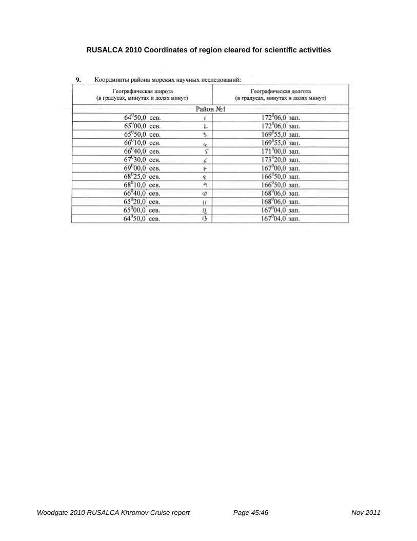
RUSALCA 2010 Coordinates of region cleared for scientific activities
Woodgate 2010 RUSALCA Khromov Cruise report Page 45:46 Nov 2011

REFERENCES Jakobsson, M., C.Norman, J.Woodward, R. MacNab, and B.Coakley (2000), New grid of Arctic
bathymetry aids scientists and map makers, Eos Trans., 81, 89, 93, 96. Woodgate, R. A., and K. Aagaard (2005), Revising the Bering Strait freshwater flux into the Arctic
Ocean, Geophys. Res. Lett., 32, L02602, doi:10.1029/2004GL021747. Woodgate, R. A., K. Aagaard, and T. J. Weingartner (2005), Monthly temperature, salinity, and
transport variability of the Bering Strait throughflow, Geophys. Res. Lett., 32, L04601, doi:10.1029/2004GL021880.
Woodgate, R. A., K. Aagaard, and T. J. Weingartner (2006), Interannual Changes in the Bering Strait Fluxes of Volume, Heat and Freshwater between 1991 and 2004, Geophys. Res. Lett., 33, L15609, doi:10.1029/2006GL026931.
Woodgate, R. A., K. Aagaard, and T. J. Weingartner (2007), First steps in calibrating the Bering Strait throughflow: Preliminary study of how measurements at a proposed climate site (A3) compare to measurements within the two channels of the strait (A1 and A2). 20 pp, University of Washington.
Woodgate, R. A., T. J. Weingartner, and R. W. Lindsay (2010), The 2007 Bering Strait Oceanic Heat Flux and anomalous Arctic Sea-ice Retreat, Geophys. Res. Lett., 37, L01602, doi:10.1029/2009GL041621.
Woodgate 2010 RUSALCA Khromov Cruise report Page 46:46 Nov 2011

RUSALCA 2010 EVENT LOG % date GMTtime type # Ops Water Latitude Longitude Station % yyyymmdd/hhmm Depth Deg/Min Deg/Min Name % (m) (N) (W) % Ops code 1=in 2=Out % Type code 1=CTD 2=Vertical Net tows % ~ 5 nets taken during night of 1-2nd August 2010 20100804 2017 1 1 1 56 65 47.040 168 33.58 A2 Prod cast 20100804 2031 1 1 2 56 65 47.280 168 32.99 A2 20100804 2116 1 2 1 56 65 48.160 168 31.16 A2 Prod cast 20100804 2123 1 2 2 56 65 48.320 168 30.84 A2 20100804 2131 2 1 1 56 65 48.510 168 30.51 A2 20100804 2138 2 1 2 56 65 48.680 168 30.21 A2 20100805 0037 1 3 1 26 65 35.063 168 7.18 BS24 20100805 0045 1 3 2 26 65 35.224 168 7.314 BS24 20100805 0107 1 4 1 33 65 36.238 168 10.404 BS23 20100805 0117 1 4 2 33 65 36.511 168 10.937 BS23 20100805 0150 1 5 1 34 65 37.830 168 11.075 BS22 20100805 0157 1 5 2 34 65 38.110 168 11.153 BS22 20100805 0200 2 2 1 34 65 38.313 168 10.132 BS22 20100805 0206 2 2 2 34 65 38.858 168 6.369 BS22 20100805 0244 1 6 1 42 65 38.610 168 14.99 BS21 20100805 0254 1 6 2 42 65 39.000 168 15.45 BS21 20100805 0331 1 7 1 49 65 39.422 168 19.242 BS20 20100805 0344 1 7 2 49 65 40.452 168 17.234 BS20 20100805 0415 1 8 1 52 65 40.534 168 23.562 BS19 20100805 0430 1 8 2 52 65 40.855 168 23.815 BS19 "Coms lost on upcast, cast in 2 files (,b)" 20100805 0515 1 9 1 54 65 41.704 168 26.81 BS18 Rebatteried before cast. ~1nm N of BS18 20100805 0530 1 9 2 54 65 42.086 168 27.017 BS18 20100805 0556 1 10 1 55 65 42.139 168 31.121 BS17 20100805 0612 1 10 2 55 65 42.417 168 31.247 BS17 20100805 0652 1 11 1 52 65 43.550 168 35.633 BS16 Arrived on site: 6:33 20100805 0706 1 11 2 52 65 43.862 168 35.608 BS16

20100805 0737 1 12 1 52 65 44.271 168 39.761 BS15 20100805 0756 1 12 2 52 65 44.550 168 40.04 BS15 20100805 0819 1 13 1 53 65 45.220 168 43.14 BS14 20100805 0835 1 13 2 53 65 45.576 168 43.318 BS14 20100805 0905 1 14 1 53 65 46.290 168 47.43 BS13 20100805 0917 1 14 2 53 65 46.580 168 47.267 BS13 20100805 0947 1 15 1 46 65 47.278 168 51.607 BS12 20100805 0958 1 15 2 46 65 47.296 168 51.884 BS12 20100805 1030 1 16 1 47 65 48.409 168 55.837 BS11 End of US section 20100805 1042 1 16 2 47 65 48.670 168 55.856 BS11 20100805 1114 1 17 1 38 65 49.492 169 0.012 BS10 20100805 1125 1 17 2 38 65 49.493 169 0.108 BS10 20100805 1153 1 18 1 46 65 50.568 169 4.283 BS9 20100805 1204 1 18 2 46 65 50.818 169 4.266 BS9 20100805 1233 1 19 1 48 65 51.750 169 8.366 BS8 20100805 1244 1 19 2 48 65 51.850 169 7.979 BS8 20100805 1249 2 3 1 48 65 51.907 169 7.779 BS8 20100805 1257 2 3 2 48 65 51.986 169 7.509 BS8 20100805 1331 1 20 1 49 65 52.794 169 12.802 BS7 20100805 1345 1 20 2 49 65 52.932 169 12.964 BS7 20100805 1413 1 21 1 50 65 53.584 169 16.742 BS6 20100805 1424 1 21 2 50 65 53.708 169 16.861 BS6 20100805 1452 1 22 1 51 65 54.601 169 21.102 BS5 20100805 1503 1 22 2 51 65 54.774 169 21.235 BS5 20100805 1531 1 23 1 53 65 55.686 169 25.471 BS4 20100805 1543 1 23 2 53 65 55.849 169 25.475 BS4 20100805 1611 1 24 1 51 65 56.730 169 29.91 BS3 20100805 1623 1 24 2 51 65 56.860 169 29.58 BS3 20100805 1626 2 4 1 51 65 56.860 169 29.58 BS3 20100805 1629 2 4 2 51 65 56.860 169 29.58 BS3 20100805 1700 1 25 1 51 65 57.761 169 34.242 BS2 20100805 1710 1 25 2 51 65 57.852 169 34.192 BS2 20100805 1730 1 26 1 50 65 58.234 169 36.401 BS1.5 20100805 1738 1 26 2 50 65 58.324 169 36.341 BS1.5 20100805 1811 1 27 1 49 65 58.858 169 38.494 BS1 20100805 1820 1 27 2 49 65 59.011 169 38.226 BS1 20100805 1826 2 5 1 49 65 59.123 169 38.013 BS1

20100805 1829 2 5 2 49 65 59.170 169 37.923 BS1 20100805 1859 1 28 1 49 65 59.335 169 40.692 BS.5 End of BS 20100805 1908 1 28 2 49 65 59.447 169 40.472 BS.5 20100805 1953 1 29 1 50 65 56.116 169 37.009 A1-2 Nut cast for A1-2 mooring ISUS 20100805 2003 1 29 2 50 65 56.204 169 36.944 A1-2 20100805 2012 1 30 1 50 65 56.300 169 36.868 a1-2 prod 1 of 2 20100805 2019 1 30 2 50 65 56.370 169 36.806 A1-2 20100805 2117 1 31 1 50 65 56.129 169 36.949 A1-2 prod 2 of 2 20100805 2125 1 31 2 50 65 56.176 169 36.886 A1-2 20100805 2248 1 32 1 38 66 7.199 169 35.54 AL1 Start of AL line 20100805 2255 1 32 2 38 66 7.266 169 35.652 AL1 20100805 2300 2 6 1 38 66 7.281 169 35.683 AL1 20100805 2303 2 6 2 38 66 7.311 169 35.755 AL1 20100805 2326 1 33 1 49 66 7.733 169 33.787 AL1.5 20100805 2334 1 33 2 49 66 7.756 169 33.733 AL1.5 20100805 2353 1 34 1 50 66 8.348 169 32.141 AL2 20100806 0001 1 34 2 50 66 8.442 169 32.021 AL2 Sampling completed at 00:06 20100806 0024 1 35 1 52 66 9.446 169 28.824 AL3 "Bottle 4 reported misfired, 5 fired as well" 20100806 0033 1 35 2 52 66 9.560 169 28.788 AL3 Sampling completed at 00:40 20100806 0100 1 36 1 55 66 10.564 169 25.406 AL4 20100806 0109 1 36 2 55 66 10.666 169 25.394 AL4 Sampling completed at 01:14 20100806 0132 1 37 1 55 66 11.786 169 21.847 AL5 20100806 0142 1 37 2 55 66 11.934 169 21.763 AL5 Sampling completed at 01:48 20100806 0211 1 38 1 56 66 12.842 169 18.546 AL6 20100806 0221 1 38 2 56 66 12.887 169 18.547 AL6 Sampling completed 02:26 20100806 0248 1 39 1 57 66 13.999 169 15.184 AL7 20100806 0258 1 39 2 57 66 14.083 169 15.211 AL7 Sampling completed 20100806 0325 1 40 1 58 66 15.169 169 11.736 AL8 20100806 0333 1 40 2 58 66 15.292 169 11.869 AL8 Sampling completed 03:39 20100806 0358 1 41 1 58 66 16.286 169 8.287 AL9 20100806 0409 1 41 2 58 66 16.409 169 8.324 AL9 Sampling completed 4:15 20100806 0436 1 42 1 57 66 17.490 169 4.861 AL10 20100806 0446 1 42 2 57 66 17.682 169 4.95 AL10 Sampling completed 453 20100806 0512 1 43 1 58 66 18.595 169 1.444 AL11 Last Russian Station on AL line 20100806 0524 1 43 2 58 66 18.679 169 1.594 AL11 Scan length error on CTD at 8 m
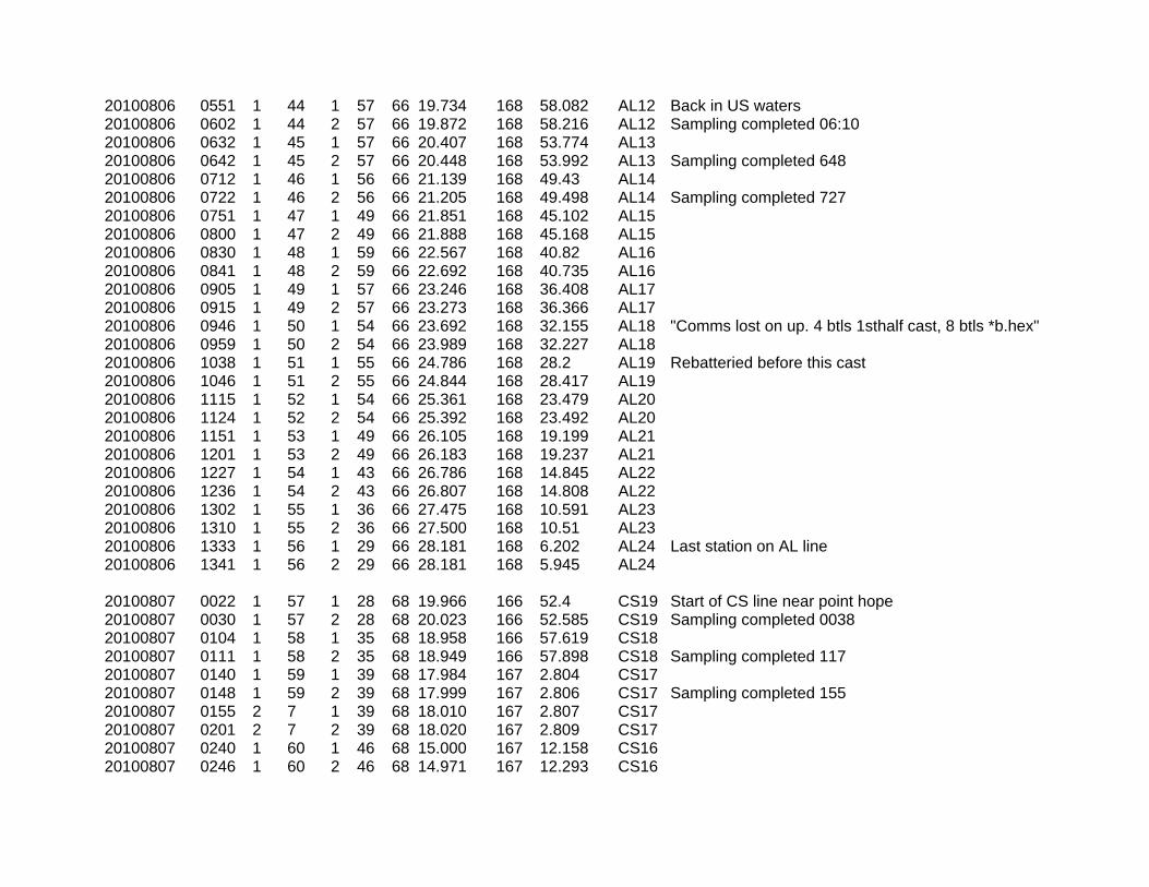
20100806 0551 1 44 1 57 66 19.734 168 58.082 AL12 Back in US waters 20100806 0602 1 44 2 57 66 19.872 168 58.216 AL12 Sampling completed 06:10 20100806 0632 1 45 1 57 66 20.407 168 53.774 AL13 20100806 0642 1 45 2 57 66 20.448 168 53.992 AL13 Sampling completed 648 20100806 0712 1 46 1 56 66 21.139 168 49.43 AL14 20100806 0722 1 46 2 56 66 21.205 168 49.498 AL14 Sampling completed 727 20100806 0751 1 47 1 49 66 21.851 168 45.102 AL15 20100806 0800 1 47 2 49 66 21.888 168 45.168 AL15 20100806 0830 1 48 1 59 66 22.567 168 40.82 AL16 20100806 0841 1 48 2 59 66 22.692 168 40.735 AL16 20100806 0905 1 49 1 57 66 23.246 168 36.408 AL17 20100806 0915 1 49 2 57 66 23.273 168 36.366 AL17 20100806 0946 1 50 1 54 66 23.692 168 32.155 AL18 "Comms lost on up. 4 btls 1sthalf cast, 8 btls *b.hex" 20100806 0959 1 50 2 54 66 23.989 168 32.227 AL18 20100806 1038 1 51 1 55 66 24.786 168 28.2 AL19 Rebatteried before this cast 20100806 1046 1 51 2 55 66 24.844 168 28.417 AL19 20100806 1115 1 52 1 54 66 25.361 168 23.479 AL20 20100806 1124 1 52 2 54 66 25.392 168 23.492 AL20 20100806 1151 1 53 1 49 66 26.105 168 19.199 AL21 20100806 1201 1 53 2 49 66 26.183 168 19.237 AL21 20100806 1227 1 54 1 43 66 26.786 168 14.845 AL22 20100806 1236 1 54 2 43 66 26.807 168 14.808 AL22 20100806 1302 1 55 1 36 66 27.475 168 10.591 AL23 20100806 1310 1 55 2 36 66 27.500 168 10.51 AL23 20100806 1333 1 56 1 29 66 28.181 168 6.202 AL24 Last station on AL line 20100806 1341 1 56 2 29 66 28.181 168 5.945 AL24 20100807 0022 1 57 1 28 68 19.966 166 52.4 CS19 Start of CS line near point hope 20100807 0030 1 57 2 28 68 20.023 166 52.585 CS19 Sampling completed 0038 20100807 0104 1 58 1 35 68 18.958 166 57.619 CS18 20100807 0111 1 58 2 35 68 18.949 166 57.898 CS18 Sampling completed 117 20100807 0140 1 59 1 39 68 17.984 167 2.804 CS17 20100807 0148 1 59 2 39 68 17.999 167 2.806 CS17 Sampling completed 155 20100807 0155 2 7 1 39 68 18.010 167 2.807 CS17 20100807 0201 2 7 2 39 68 18.020 167 2.809 CS17 20100807 0240 1 60 1 46 68 15.000 167 12.158 CS16 20100807 0246 1 60 2 46 68 14.971 167 12.293 CS16

29100807 0333 1 61 1 48 68 12.083 167 21.347 CS15 20100807 0344 1 61 2 48 68 12.084 167 21.649 CS15 Sampling completed 351 20100807 0454 1 62 1 53 68 6.136 167 39.872 CS14 20100807 0507 1 62 2 53 68 6.059 167 40.099 CS14 Sampling completed 0518 20100807 0509 2 8 1 53 68 6.043 167 40.175 CS14 20100807 0515 2 8 2 53 68 6.013 167 40.33 CS14 20100807 0632 1 63 1 56 67 59.335 167 59.365 CS13 Lots of birds observed here 20100807 0641 1 63 2 56 67 59.306 167 59.461 CS13 Sampling completed 0649 20100807 0800 1 64 1 57 67 52.535 168 18.814 CS12 20100807 0809 1 64 2 57 67 52.518 168 18.898 CS12 20100807 0813 2 9 1 57 67 52.510 168 18.933 CS12 20100807 0818 2 9 2 57 67 52.496 168 18.985 CS12 20100807 0945 1 65 1 51 67 45.300 168 39.884 CS11 Last US station on CS Line 20100807 0953 1 65 2 51 67 45.286 168 39.884 CS11 20100807 1123 1 66 1 51 67 38.083 169 0.976 CS10 First Russian station on CS Line 20100807 1133 1 66 2 51 67 38.094 169 0.994 CS10 20100807 1137 2 10 1 51 67 38.106 169 1.02 CS10 20100807 1142 2 10 2 51 67 38.122 169 1.054 CS10 20100807 1302 1 67 1 52 67 32.027 169 18.364 CS9 20100807 1311 1 67 2 52 67 32.009 169 18.364 CS9 20100807 1424 1 68 1 51 67 25.910 169 35.784 CS8 20100807 1434 1 68 2 51 67 25.831 169 35.828 CS8 20100807 1438 2 11 1 51 67 25.802 169 35.842 CS8 20100807 1443 2 11 2 51 67 25.780 169 35.844 CS8 20100807 1609 1 69 1 50 67 18.676 169 56.424 CS7 20100807 1617 1 69 2 50 67 18.658 169 56.495 CS7 20100807 1738 1 70 1 49 67 11.358 170 17.173 CS6 20100807 1746 1 70 2 49 67 11.286 170 17.299 CS6 20100807 1750 2 12 1 49 67 11.240 170 17.365 CS6 20100807 1754 2 12 2 49 67 11.217 170 17.389 CS6 20100807 1815 1 71 1 49 67 11.060 170 17.542 CS6 prod 1 of 2 20100807 1820 1 71 2 49 67 11.020 170 17.612 CS6 20100807 1849 1 72 1 49 67 10.781 170 17.79 CS6 prod 2 of 2 20100807 1856 1 72 2 49 67 10.732 170 17.846 CS6 20100807 2019 1 73 1 46 67 3.719 170 38.189 CS5 20100807 2029 1 73 2 46 67 3.566 170 38.302 CS5 20100807 2156 1 74 1 43 66 56.029 170 59.371 CS4

20100807 2206 1 74 2 43 66 55.877 170 59.347 CS4 20100807 2210 2 13 1 43 66 55.792 170 59.338 CS4 20100807 2212 2 13 2 43 66 55.751 170 59.331 CS4 20100807 2243 1 75 1 42 66 53.903 171 4.609 CS3 20100807 2252 1 75 2 42 66 53.737 171 4.597 CS3 20100807 2223 1 76 1 39 66 51.822 171 9.981 CS2 20100807 2230 1 76 2 39 66 51.671 171 9.918 CS2 20100808 0004 1 77 1 36 66 49.751 171 15.24 CS1 20100808 0014 1 77 2 36 66 49.566 171 15.068 CS1 20100808 0016 2 14 1 36 66 49.397 171 14.953 CS1 20100808 0021 2 14 2 36 66 49.325 171 14.915 CS1 20100808 0044 1 78 1 35 66 48.700 171 18.206 CS0.5 20100808 0051 1 78 2 35 66 48.556 171 18.144 CS0.5 End of CS line. Sampling completed 0057 20100808 0340 1 79 1 32 66 58.932 171 47.79 CN1 Start of CN line 20100808 0347 1 79 2 32 66 58.700 171 47.371 CN1 Sampling completed 351 20100808 0348 2 15 1 32 66 58.712 171 47.168 CN1 20100808 0352 2 15 2 32 66 58.634 171 46.951 CN1 20100808 0422 1 80 1 36 67 0.006 171 47.776 CN1.5 20100808 0430 1 80 2 36 66 59.987 171 47.278 CN1.5 20100808 0453 1 81 1 38 67 0.992 171 47.824 CN2 20100808 0501 1 81 2 38 67 0.965 171 47.456 CN2 drifted about 0.4 nautical miles off station to the east 20100808 0533 1 82 1 41 67 2.748 171 47.886 CN3 20100808 0541 1 82 2 41 67 2.656 171 47.442 CN3 Sampling completed 546 . Drifted ~ 0.3 miles to E 20100808 0615 1 83 1 41 67 4.580 171 47.836 CN4 20100808 0623 1 83 2 41 67 4.518 171 47.335 CN4 Drifted 0.3 miles to ESE. Sampling completed 628 20100808 0655 1 84 1 42 67 6.410 171 47.76 CN5 Bottle 7 failed to fire 20100808 0705 1 84 2 42 67 6.360 171 47.04 CN5 Drifted 0.425 miles to the east. 20100808 0738 1 85 1 45 67 8.216 171 47.818 CN6 20100808 0746 1 85 2 45 67 8.173 171 47.406 CN6 Drifted 0.25 nautical miles to the east 20100808 0814 1 86 1 46 67 10.818 171 47.848 CN7 20100808 0822 1 86 2 46 67 9.997 171 47.502 CN7 20100808 0851 1 87 1 47 67 11.810 171 47.856 CN8 "No fire reported on 1 & 6. Btl 1 open, Btl 6 fired" 20100808 0900 1 87 2 47 67 11.797 171 47.412 CN8 20100808 0933 1 88 1 47 67 13.541 171 47.848 CN9 All btl fires OK 20100808 0942 1 88 2 47 67 13.412 171 47.609 CN9 20100808 0946 2 16 1 47 67 13.361 171 47.46 CN9

20100808 0950 2 16 2 47 67 13.328 171 47.324 CN9 20100808 1025 1 89 1 48 67 15.413 171 47.891 CN10 20100808 1032 1 89 2 48 67 15.433 171 47.695 CN10 20100808 1100 1 90 1 49 67 17.201 171 47.926 CN11 20100808 1109 1 90 2 49 67 17.224 171 47.742 CN11 20100808 1135 1 91 1 49 67 18.990 171 47.934 CN12 20100808 1143 1 91 2 49 67 18.994 171 47.73 CN12 20100808 1208 1 92 1 51 67 20.801 171 47.986 CN13 20100808 1215 1 92 2 51 67 20.806 171 47.857 CN13 20100808 1245 1 93 1 51 67 22.573 171 47.972 CN14 20100808 1254 1 93 2 51 67 22.576 171 47.766 CN14 20100808 1322 1 94 1 51 67 24.379 171 47.98 CN15 20100808 1332 1 94 2 51 67 24.382 171 47.753 CN15 20100808 1357 1 95 1 50 67 26.191 171 47.977 CN16 20100808 1405 1 95 2 50 67 26.210 171 47.836 CN16 20100808 1431 1 96 1 49 67 27.990 171 48.001 CN17 20100808 1440 1 96 2 49 67 28.001 171 47.846 CN17 20100808 1505 1 97 1 47 67 29.788 171 48.024 CN18 20100808 1517 1 97 2 47 67 29.773 171 47.886 CN18 20100808 1520 2 17 1 47 67 29.754 171 47.826 CN18 20100808 1525 2 17 2 47 67 29.739 171 47.709 CN18 20100808 1550 1 98 1 48 67 31.585 171 48.023 CN19 20100808 1559 1 98 2 48 67 31.546 171 47.96 CN19 20100808 1633 1 99 1 48 67 33.421 171 47.988 CN20 20100808 1640 1 99 2 48 67 33.335 171 48 CN20 20100808 1709 1 100 1 47 67 35.231 171 48.007 CN21 20100808 1715 1 100 2 47 67 35.164 171 47.999 CN21 20100808 1720 2 18 1 47 67 35.075 171 48.019 CN21 20100808 1723 2 18 2 47 67 35.035 171 48.033 CN21 20100808 1743 1 101 1 47 67 34.741 171 48.178 CN21 prod 1 of 2 20100808 1750 1 101 2 47 67 34.632 171 48.232 CN21 20100808 1819 1 102 1 47 67 34.299 171 48.499 CN21 prod 2 of 2 20100808 1826 1 102 2 47 67 34.135 171 48.58 CN21 20100809 10 1 103 1 36 66 35.466 170 46.218 CV1 20100809 18 1 103 2 36 66 35.302 170 45.954 CV1 Drifted 0.275 nautical miles to the southeast 20100809 47 1 104 1 40 66 36.977 170 42.431 CV1.5

20100809 55 1 104 2 40 66 36.907 170 42.173 CV1.5 drifted .208 nm directly east 20100809 124 1 105 1 44 66 38.263 170 38.971 CV2 20100809 131 1 105 2 44 66 38.203 170 38.755 CV2 drifted .190 nm southeast 20100809 214 1 106 1 46 66 41.071 170 31.676 CV3 20100809 225 1 106 2 46 66 40.960 170 31.352 CV3 drifted .20 nm southeast 20100809 308 1 107 1 47 66 43.882 170 24.427 CV4 20100809 317 1 107 2 47 66 43.850 170 24.199 CV4 20100809 400 1 108 1 46 66 46.685 170 17.12 CV5 "5 and 6 did not confirm fire, 7 worked. " 20100809 408 1 108 2 46 66 46.615 170 17.03 CV5 CTD Batteries Replaced 20100809 453 1 109 1 46 66 49.447 170 9.779 CV6 20100809 501 1 109 2 46 66 49.361 170 9.474 CV6 20100809 545 1 110 1 47 66 52.267 170 2.407 CV7 20100809 554 1 110 2 47 66 52.175 170 2.083 CV7 20100809 637 1 111 1 48 66 55.040 169 55.19 CV8 20100809 648 1 111 2 48 66 54.907 169 55.007 CV8 20100809 730 1 112 1 49 66 57.865 169 47.93 CV9 "Bottle 4 did not confirm fire, bottle five worked " 20100809 740 1 112 2 49 66 57.748 169 47.839 CV9 20100809 827 1 113 1 50 67 0.677 169 40.662 CV10 Btl 4 OK 20100809 836 1 113 2 50 67 0.600 169 40.553 CV10 20100809 918 1 114 1 51 67 3.443 169 33.34 CV11 20100809 927 1 114 2 51 67 3.365 169 33.264 CV11 20100809 1149 1 115 1 48 66 49.717 169 4.312 CX11 Btl 6 did not confirm fire and did not trip 20100809 1159 1 115 2 48 66 49.706 169 4.236 CX11 20100809 1247 1 116 1 49 66 46.942 169 11.534 CX10 20100809 1256 1 116 2 49 66 46.927 169 11.572 CX10 20100809 1337 1 117 1 49 66 44.142 169 18.851 CX9 20100809 1346 1 117 2 49 66 44.200 169 19.177 CX9 20100809 1429 1 118 1 49 66 41.401 169 25.936 CX8 No fire reports for btl 1-3. B1-3open 20100809 1439 1 118 2 49 66 41.437 169 26.297 CX8 20100809 1518 1 119 1 49 66 38.628 169 33.17 CX7 20100809 1526 1 119 2 49 66 38.656 169 33.527 CX7 20100809 1608 1 120 1 50 66 35.876 169 40.32 CX6 20100809 1615 1 120 2 50 66 35.894 169 40.609 CX6 20100809 1658 1 121 1 58 66 33.083 169 47.635 CX5 20100809 1708 1 121 2 58 66 33.075 169 48.136 CX5 bottles 2 and 3 did not fire 20100809 1750 1 122 1 51 66 30.277 169 54.787 CX4
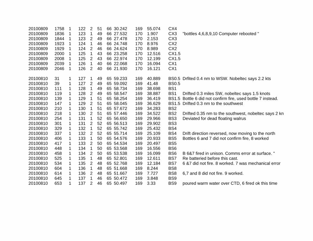
20100809 1758 1 122 2 51 66 30.242 169 55.074 CX4 20100809 1836 1 123 1 49 66 27.532 170 1.907 CX3 "bottles 4,6,8,9,10 Computer rebooted " 20100809 1844 1 123 2 49 66 27.478 170 2.153 CX3 20100809 1923 1 124 1 46 66 24.748 170 8.976 CX2 20100809 1929 1 124 2 46 66 24.624 170 8.989 CX2 20100809 2000 1 125 1 43 66 23.258 170 12.516 CX1.5 20100809 2008 1 125 2 43 66 22.974 170 12.199 CX1.5 20100809 2039 1 126 1 40 66 22.068 170 16.094 CX1 20100809 2046 1 126 2 40 66 21.930 170 16.121 CX1 20100810 31 1 127 1 49 65 59.233 169 40.889 BS0.5 Drfited 0.4 nm to WSW. Nobeltec says 2.2 kts 20100810 39 1 127 2 49 65 59.092 169 41.48 BS0.5 20100810 111 1 128 1 49 65 58.734 169 38.698 BS1 20100810 119 1 128 2 49 65 58.547 169 38.887 BS1 Drifted 0.3 miles SW, nobeltec says 1.5 knots 20100810 139 1 129 1 51 65 58.254 169 36.419 BS1.5 Bottle 6 did not confirm fire, used bottle 7 instead. 20100810 147 1 129 2 51 65 58.045 169 36.629 BS1.5 Drifted 0.3 nm to the southwest 20100810 210 1 130 1 51 65 57.672 169 34.283 BS2 20100810 218 1 130 2 51 65 57.446 169 34.522 BS2 Drifted 0.35 nm to the southwest, nobeltec says 2 kn 20100810 254 1 131 1 52 65 56.650 169 29.966 BS3 Deviated for dead floating walrus 20100810 301 1 131 2 52 65 56.513 169 29.902 BS3 20100810 329 1 132 1 52 65 55.742 169 25.432 BS4 20100810 337 1 132 2 52 65 55.714 169 25.109 BS4 Drift direction reversed, now moving to the north 20100810 406 1 133 1 50 65 54.576 169 20.933 BS5 Bottles 6 and 7 did not confirm fire, 8 worked 20100810 417 1 133 2 50 65 54.534 169 20.497 BS5 20100810 448 1 134 1 50 65 53.568 169 16.556 BS6 20100810 458 1 134 2 50 65 53.538 169 16.099 BS6 B 6&7 fired in unison. Comms error at surface. " 20100810 525 1 135 1 48 65 52.801 169 12.611 BS7 Re batteried before this cast. 20100810 534 1 135 2 48 65 52.768 169 12.184 BS7 6 &7 did not fire. 8 worked. 7 was mechanical error 20100810 604 1 136 1 48 65 51.668 169 8.244 BS8 20100810 614 1 136 2 48 65 51.667 169 7.727 BS8 6,7 and 8 did not fire. 9 worked. 20100810 645 1 137 1 46 65 50.472 169 3.848 BS9 20100810 653 1 137 2 46 65 50.497 169 3.33 BS9 poured warm water over CTD, 6 fired ok this time


![A Synthesis of Year-round Interdisciplinary Mooring ...psc.apl.washington.edu/HLD/Bstrait/MooringSynthesisPaper...before 1650; Vitus Bering, 1728 [see e.g., Black, 2004]), nations](https://static.fdocuments.us/doc/165x107/60d9666e98146a66b57a8287/a-synthesis-of-year-round-interdisciplinary-mooring-pscapl-before-1650.jpg)