RULES AND REGULATIONS - Home - Town of...
117
RULES AND REGULATIONS REGARDING THE SUBDIVISION AND DEVELOPMENT OF LAND TOWN OF MIDDLETOWN, RHODE ISLAND 1995 Adopted by the Middletown Planning Board December 13, 1995 Amendments through December 2008
Transcript of RULES AND REGULATIONS - Home - Town of...

RULES AND REGULATIONS
REGARDING THE SUBDIVISION AND DEVELOPMENT OF LAND
TOWN OF MIDDLETOWN, RHODE ISLAND
1995
Adopted by the Middletown Planning Board
December 13, 1995
Amendments through December 2008


TABLE OF CONTENTS
ARTICLE 1 - AUTHORITY AND PUPOSE .......................................................................................................................... 1 SECTION 101 - AUTHORITY ...................................................................................................................................................... 1 SECTION 102 - PURPOSES OF THE RULES AND REGULATIONS .................................................................................................. 1 SECTION 103 - CONSERVATION DEVELOPMENT ....................................................................................................................... 2
ARTICLE 2 - DEFINITIONS .................................................................................................................................................. 3 ARTICLE 3 - CONSERVATION DEVELOPMENT .......................................................................................................... 11
SECTION 301 - APPLICABILITY ............................................................................................................................................... 11 SECTION 302 - PROCEDURES .................................................................................................................................................. 11 SECTION 303 - CONSERVATION DEVELOPMENT DESIGN PROCESS ......................................................................................... 12 SECTION 304 - BASIC MAXIMUM NUMBER OF DWELLING UNITS .......................................................................................... 15
ARTICLE 4 - PROCEDURES FOR SUBDIVISION AND LAND DEVELOPMENT APPROVAL .............................. 17 SECTION 401 - GENERAL ....................................................................................................................................................... 17 SECTION 402 - PRE-APPLICATION MEETINGS AND CONCEPT REVIEW ...................................................................................... 17 SECTION 403 - APPLICATIONS FOR SUBDIVISION APPROVALS ............................................................................................... 18 SECTION 404 - REQUIRED FINDINGS ...................................................................................................................................... 19 SECTION 405 - PROCEDURE FOR ADMINISTRATIVE SUBDIVISION APPROVAL ........................................................................ 19 SECTION 406 - PROCEDURES FOR MINOR LAND DEVELOPMENT AND MINOR SUBDIVISION APPROVAL ................................ 20 SECTION 407 - PROCEDURE FOR MAJOR LAND DEVELOPMENT AND MAJOR SUBDIVISION APPROVAL .................................. 22 SECTION 408 - PUBLIC HEARING AND NOTICE REQUIREMENTS ............................................................................................. 26
ARTICLE 5 - REQUIRED MINIMUM STANDARDS OF DESIGN ................................................................................ 29 SECTION 501 - STREET ARRANGEMENT ................................................................................................................................. 29 SECTION 502 - PAPER STREETS .............................................................................................................................................. 29 SECTION 503 - ACCESS PROVIDED TO ALL LOTS ................................................................................................................... 29 SECTION 504 - DEAD END STREETS ....................................................................................................................................... 29 SECTION 505 - COLLECTOR STREETS ..................................................................................................................................... 30 SECTION 506 - RESTRICTION OF ACCESS ............................................................................................................................... 30 SECTION 507 - STREET NAMES .............................................................................................................................................. 30 SECTION 508 - STREET FRONTAGE ......................................................................................................................................... 30 SECTION 509 - OVERALL PLAN OF DEVELOPMENT ................................................................................................................ 30 SECTION 510 - SIDEWALKS .................................................................................................................................................... 31 SECTION 511 - PEDESTRIAN WALKWAYS ............................................................................................................................... 31 SECTION 512 - SIDE LOT LINES .............................................................................................................................................. 31 SECTION 513 - MODIFICATION OF LOTS ................................................................................................................................. 31
Extra Size Lot ................................................................................................................................................................... 31 SECTION 514 - OPEN SPACE AND RECREATION FACILITIES .................................................................................................... 31
Section 514.1 - Conservation Development ..................................................................................................................... 31 Section 514.2 - Conventional Development ..................................................................................................................... 34
SECTION 515 - CONSTRUCTION SITE RUNOFF CONTROL ........................................................................................................ 35 SECTION 516 - STORMWATER MANAGEMENT ........................................................................................................................ 35 SECTION 517 - FLOOD PRONE AREAS ..................................................................................................................................... 35 SECTION 518 - RETENTION OF ENVIRONMENTAL FEATURES .................................................................................................. 36 SECTION 519 - MULTI-STAGE SUBDIVISIONS ......................................................................................................................... 37 SECTION 520 - FEES FOR REVIEWS/EVALUATIONS CONDUCTED BY CONSULTANTS/OTHER AGENCIES ................................. 37 SECTION 521 - COMMERCIAL DEVELOPMENT ........................................................................................................................ 37
Section 521.1 - Site Design .............................................................................................................................................. 38 Section 521.2 - Building Design and Architecture ........................................................................................................... 40 Section 521.3 - Landscaping ............................................................................................................................................ 41 Section 521.4 - Environmental Impacts............................................................................................................................ 42 Section 521.5 - Signage .................................................................................................................................................... 43
ARTICLE 6 - SPECIFICATIONS FOR REQUIRED IMPROVEMENTS ....................................................................... 45 SECTION 601 - CONSTRUCTION PROCEDURES ........................................................................................................................ 45 SECTION 602 - SPECIFICATIONS FOR REQUIRED IMPROVEMENTS ........................................................................................... 45 SECTION 603 - GEOMETRIC DATA FOR STREET CONSTRUCTION ............................................................................................ 46 SECTION 604 - STREET INTERSECTIONS ................................................................................................................................. 47 SECTION 605 - CLEARING AND GRUBBING ............................................................................................................................. 47 SECTION 606 - EARTH EXCAVATION ...................................................................................................................................... 47 SECTION 607 - LEDGE AND ROCK EXCAVATION .................................................................................................................... 47 SECTION 608 - SUBSURFACE WATER ..................................................................................................................................... 47 SECTION 609 - RETAINING WALLS ......................................................................................................................................... 47 SECTION 610 - SUB-DRAINS (ON LOTS) ................................................................................................................................. 48 SECTION 611 - SPECIFICATIONS FOR STREET CONSTRUCTION ............................................................................................... 48
Section 611.1 - Materials ................................................................................................................................................. 48 Section 611.2 - General Conditions ................................................................................................................................. 48 Section 611.3 - Construction Methods ............................................................................................................................. 48 Section 611.4 - Traffic Limitation .................................................................................................................................... 50 Section 611.5 - Seasonal Limits ....................................................................................................................................... 50
SECTION 612 - WATER MAINS ............................................................................................................................................... 50 SECTION 613 - SANITARY SEWERS ......................................................................................................................................... 50 SECTION 614 - ELECTRICAL UTILITIES ................................................................................................................................... 50 SECTION 615 - CAPE COD BERM ............................................................................................................................................ 51 SECTION 616 - SIDEWALKS .................................................................................................................................................... 51 SECTION 617 - CURB CUTS INTO HOUSELOTS ........................................................................................................................ 51 SECTION 618 - LOT SLOPES ................................................................................................................................................... 51 SECTION 619 - SURFACE GUTTERS AND SUB-SURFACE STORM AND DRAINAGE PIPES AND FACILITIES ................................ 51 SECTION 620 - SURFACE AND SUB-SURFACE DRAINAGE STRUCTURES AND FACILITIES ........................................................ 51
Section 620.1 - Earthwork and Drainage ......................................................................................................................... 51 Section 620.2 - Storm Drain and Sanitary Sewer Manholes/Catch Basins ...................................................................... 52 Section 620.3 - Minimum Cover ....................................................................................................................................... 52 Section 620.4 - Compaction ............................................................................................................................................. 52
SECTION 621 - MONUMENTS .................................................................................................................................................. 52 SECTION 622 - STREET TREES ................................................................................................................................................ 52 SECTION 623 - STREET NAME AND TRAFFIC CONTROL SIGNS ............................................................................................... 54 SECTION 624 - AS-BUILT DRAWINGS..................................................................................................................................... 54 SECTION 625 – GATED COMMUNITIES AND LIMITED ACCESS GATES .................................................................................... 54
ARTICLE 7 - PERFORMANCE GUARANTEES ............................................................................................................... 56 SECTION 701 - SECURITY FOR COMPLETION OF IMPROVEMENTS ........................................................................................... 56 SECTION 702 - AMOUNT OF SECURITY ................................................................................................................................... 56 SECTION 703 - DURATION AND RELEASE OF GUARANTEE ..................................................................................................... 56
Section 703.1 - Security Duration .................................................................................................................................... 56 Section 703.2 - Security Release ...................................................................................................................................... 56 Section 703.3 - Town Engineer Certification ................................................................................................................... 56 Section 703.4 - Planning Board Certification .................................................................... Error! Bookmark not defined. Section 703.5 - Planning Board Recommendation to Town Council ............................................................................... 57 Section 703.6 - Maintenance Bond ................................................................................................................................... 57 Section 703.7 - Release Of Responsibility ........................................................................................................................ 57 Section 703.8 - Partial Release of Security ...................................................................................................................... 57
SECTION 704 - EXTENSION OF TIME ....................................................................................................................................... 58 SECTION 705 - DEFAULT ........................................................................................................................................................ 58
Section 705.1 - Condition of Default ................................................................................................................................ 58 Section 705.2 - Certificate of Default ............................................................................................................................... 58 Section 705.3 - Execution of Guarantee ........................................................................................................................... 59 Section 705.4 - Payment by Surety ................................................................................................................................... 59
ii

Town of Middletown, Rhode Island
Section 705.5 - Insurance ................................................................................................................................................. 59
ARTICLE 8 - ENFORCEMENT AND PENALTIES .......................................................................................................... 60 SECTION 801 - PENALTIES ..................................................................................................................................................... 60 SECTION 802 - RECOVERY OF DAMAGES ............................................................................................................................... 60 SECTION 803 - BOARD OF REVIEW ......................................................................................................................................... 60 SECTION 804 - POWERS OF THE ZONING BOARD OF REVIEW ................................................................................................. 60 SECTION 805 - APPEAL PROCEDURE ...................................................................................................................................... 61
ARTICLE 9 - SUPPLEMENTARY REGULATIONS ......................................................................................................... 62 SECTION 901 - ADMINISTRATIVE OFFICER ............................................................................................................................. 62 SECTION 902 - ADMINISTRATIVE FEES .................................................................................................................................. 62 SECTION 903 - MEETINGS, VOTES, DECISIONS AND RECORDS ............................................................................................... 62 SECTION 904 - PRECEDENCE OF APPROVALS BETWEEN PLANNING BOARD AND OTHER LOCAL PERMITTING AUTHORITIES .... 63 SECTION 905 - SIGNING AND RECORDING OF PLATS AND PLANS ........................................................................................... 63 SECTION 906 - CHANGES TO RECORDED PLAT AND PLANS .................................................................................................... 64 SECTION 907 - TIME REQUIREMENTS BETWEEN REVIEW STAGES, ENDORSEMENT AND RECORDING OF PLANS, COMMENCEMENT AND COMPLETION OF SUBDIVISION IMPROVEMENTS................................................................................. 64 SECTION 908 - WAIVERS, MODIFICATIONS AND REINSTATEMENT OF PLANS ......................................................................... 65
ARTICLE 10 - DEVELOPMENT PLAN REVIEW ............................................................................................................ 66 SECTION 1001 - GENERAL ..................................................................................................................................................... 66 SECTION 1002 - FAILURE TO ACT .......................................................................................................................................... 66 SECTION 1003 - PRE-APPLICATION MEETING REQUIRED ....................................................................................................... 66 SECTION 1004 - REQUIRED SUBMISSIONS AND DESIGN GUIDELINES ..................................................................................... 66 SECTION 1005 - CERTIFICATION ............................................................................................................................................ 66 SECTION 1006 - REVIEW BY TRC .......................................................................................................................................... 66 SECTION 1007 - REVIEW BY PLANNING BOARD ..................................................................................................................... 67 SECTION 1008 - EXPIRATION OF APPROVAL .......................................................................................................................... 67 SECTION 1009 - SCOPE OF REVIEW ........................................................................................................................................ 67 SECTION 1010 - SPECIFIC AND OBJECTIVE GUIDELINES FOR REVIEW .................................................................................... 68
APPENDIX A - FORMS AND CHECKLISTS ....................................................................................................................... 1
iii

APPENDIX A APPLICATION FOR SUBDIVISION CERTIFICATE OF COMPLETENESS .................................................................... A-1
ADMINISTRATIVE SUBDIVISION CHECKLIST .............................................................................................................. A-2
MINOR SUBDIVISION CHECKLIST ................................................................................................................................... A-3
MAJOR SUBDIVISION CHECKLIST ................................................................................................................................ A-11
APPLICATION FOR DEVELOPMENT PLAN REVIEW CERTIFICATE OF COMPLETENESS .................................. A-23
DEVELOPMENT PLAN REVIEW CHECKLIST ............................................................................................................... A-24
ABUTTERS LIST ................................................................................................................................................................. A-27
STORMWATER MANAGEMENT PLAN CHECKLIST ................................................................................................... A-28
PUBLIC WORKS DEPARTMENT FORM 1 - COST ESTIMATE ..................................................................................... A-30
APPENDIX B
TYPICAL STREET CROSS SECTON DETAIL ................................................................................................................... B-1 TYPICAL DRIVEWAY CURB CUT DETAIL ...................................................................................................................... B-2 CUL DE SAC DETAIL ........................................................................................................................................................... B-3 RIVERINE FLOOD HAZARD AREAS ................................................................................................................................. B-4
APPENDIX C
Conservation Development Design Process
iv

Town of Middletown, Rhode Island
v


Article 1 - AUTHORITY AND PUPOSE
Section 101 - Authority
The Planning Board of the Town of Middletown, Rhode Island, in accordance with the authority vested in the Town Of Middletown by Title 45, Chapter 23 of the General Laws of Rhode Island, 1992, as amended, and in accordance with an ordinance entitled “An Ordinance Authorizing and Empowering the Planning Board to Adopt, Modify and Amend Rules and Regulations Governing the Restricting the Platting or Other Subdivision of Land” passed at a meeting of the Town Council of said Town Of Middletown, duly held on February 17, 1969, does hereby declare its intention to exercise the power granted to it, and hereby adopts the following Rules and Regulations.
These Rules and Regulations are declared effective as of December 13, 1995 and supersede all previous Rules and Regulations Regarding the Platting or Other Subdivisions or Development of Land.
Section 102 - Purposes of the Rules and Regulations
These Rules and Regulations Regarding the Subdivision and Development of Land are designed to:
1. Provide for the orderly, thorough and expeditious review and approval of land developments and subdivisions;
2. Promote high quality and appropriate design and construction of land developments and subdivisions;
3. Make adequate provisions for traffic to facilitate traffic flow and lessen traffic accidents;
4. Furnish guidance for the wise and efficient expenditures of funds for public works and to facilitate adequate, efficient and economic provisions for transportation, water supply, sewage, storm drainage, recreation and other public utilities and requisites.
5. Promote the protection of the existing natural and built environment and the mitigation of all significant negative impacts of any proposed development on the existing environment;
6. Promote design of land developments and subdivisions which are well-integrated with the surrounding neighborhoods with regard to natural and built features, and which concentrate development in areas which can best support intensive use by reason of natural characteristics and existing infrastructure;
7. Encourage local design and improvement standards to reflect the intent of the Comprehensive Community Plans and the Zoning Ordinance with regard to the physical character of the various neighborhoods and districts of the Town;
8. Promote thorough technical review of all proposed land developments and subdivisions by appropriate local officials;
9. Encourage local requirements for dedications of public land, impact mitigation, and payment-in-lieu thereof, to be based on clear documentation of needs and to be fairly applied and administered; and
1

2
10. Encourage the establishment and consistent application of procedures for local record-keeping on all matters of land development and subdivision review, approval and construction.
11. Further implementation of the goals and policies of applicable elements of the Comprehensive Community Plan.
Section 103 - Conservation Development
The Middletown Planning Board finds that in most circumstances conservation development fulfills the above stated goals to a greater extent than conventional development, as conservation development is designed to:
1. Encourage the preservation of open space for its scenic beauty and the appropriate use thereof.
2. Preserve historical and archeological resources.
3. To protect natural resources, including but not limited to those containing woodlands, unique vegetation, streams, floodplains, wetlands, recharge areas, agricultural lands, wellheads, and vernal pools, by setting them aside from development.
4. Protect the value of real property.
5. Promote more sensitive siting of buildings and roads, and better overall site planning.
6. To provide a buffer between new development and existing streets, neighborhoods, active farmland, and adjacent park or conservation land.
7. Perpetuate the appearance of Middletown’s traditional rural/agricultural landscape.
8. Allow landowners a reasonable return on their investment while also reducing the infrastructure costs for development.
9. Facilitate the construction and maintenance of streets, utilities, and public services in a more economical and efficient manner.
10. Offer an alternative to conventional subdivision and land development patterns.
11. To provide for a diversity of lot sizes, building densities, and housing choices to accommodate a variety of age and income groups, and residential preferences, so that the population diversity of the community may be maintained.
12. To create neighborhoods with direct visual and/or physical access to open land, with amenities in the form of neighborhood open space, and with a strong neighborhood identity.
13. To implement adopted land use, transportation and community service policies, as set forth in the Comprehensive Plan.
Article 2 - DEFINITIONS
As used in these Rules and Regulations, the following definitions shall apply where words or phrases used in this chapter are defined in the definitions section of either the “Rhode Island Comprehensive Planning and Land Use Regulation Act,” section 45-22.2-4, or the “Zoning Enabling Act of 1991,” section 45-24-31, they shall have the meanings state therein. In addition, the following words or phrases shall have the following meanings.
Abutter. One whose property abuts, that is, adjoins at a border, boundary, or point with no intervening land, or being separated from such a common border by a right-of-way, alley, or easement.
Administrative Officer. The municipal official designated by these rules and regulations to administer the land development and subdivision regulations and to coordinate with local boards and commissions, municipal staff and state agencies. For purposes of these Rules and Regulations, the Town Planner is designated as the Administrative Officer.
Administrative subdivision. Re-subdivision of existing lots which yields no additional lots for development, and involves no creation or extension of streets. The re-subdivision only involves divisions, mergers, mergers and division, or adjustments of boundaries of existing lots.
Applicant. The applicant for subdivision approval by the Planning Board, which also includes his/her authorized agents or representatives. For purposes of these Rules and Regulations, the terms applicant, subdivider and developer shall be synonymous.
Base Flood Elevation. The water surface elevation of the base flood.
Base Flood. The flood having a one percent chance of being equaled or exceeded in any given year; i.e., flood resulting from a 100-year frequency storm.
Board of appeal. The local review authority for appeals of actions of the Administrative Officer and the Planning Board on matters of land development or subdivision, which is the local Zoning Board of Review constituted as the Board of Appeal. See RIGL. 45-23-57.
Bond. See improvement guarantee.
Buildable lot. A lot where construction for the use(s) permitted on the site under the local Zoning Ordinance is considered practicable by the Planning Board, considering the physical constraints to development of the site as well as the requirements of the pertinent federal, state and local regulations. See RIGL. 45-23-60 (4).
Certificate of completeness. A notice issued by the Administrative Officer informing an applicant that the application is complete and meets the requirements of the municipality’s regulations, and that the applicant may proceed with the approval process.
3

Rules and Regulations Regarding the Subdivision of Land
Concept plan. A drawing with accompanying information showing the basic elements of a proposed land development plan or subdivision as used for pre-application meetings and early discussions, and classification of the project within the approval process.
Conservation Development (CSD). A site planning technique which bases the layout of building lots and structures on the natural characteristics of the land and reduces lot sizes so that the remaining land can be used for recreation, common open space, and/or preservation of environmentally, historically and culturally sensitive features and/or structures. The number of developable lots created and the overall development density is no greater than what is permitted under conventional development.
Conservation Development Design Process. The process used to determine the layout of building lots, development, open space, and other improvements in a Conservation Subdivision/Land Development Project. Consists of five steps: 1) Understanding the site, 2) Evaluating Site Context, 3) Designating the Required Open Space, 4) Locating Development Areas, and 5) Drawing in Lot Lines.
Consistency with the comprehensive plan. A requirement of all local land use regulations which means that all these regulations and subsequent actions are in accordance with the public policies arrived at through detailed study and analysis and adopted by the municipality as the comprehensive community plan as specified in RIGL. 45-22.2-3.
Conventional Development. A subdivision or land development project in which an entire parcel of land is typically converted into privately owned building lots and public street rights-of way. Generally, lots are of equal size and spread evenly throughout the parcel with little or no consideration of the natural setting or environmental and cultural features of the land.
Dedication, fee-in-lieu-of. Payments of cash which are authorized in the local regulations when requirements for mandatory dedication of land are not met because of physical conditions of the site or other reasons. The conditions under which the payments will be allowed and all formulas for calculating the amount shall be specified in advance in the local regulations. See RIGL. 45-23-47.
Development regulation. Zoning, subdivision, land development plan, development plan review, historic district, official map, flood plain regulation, soil erosion control or any other governmental regulation of the use and development of land.
Development. Any made-made change to improved or unimproved real estate; including but not limited to buildings or other structures, mining, dredging, filling, grading, paving, excavation or drilling operation.
Division of land. A subdivision.
Endorsement. The approval of a final subdivision plat by means of signature on final plat drawings by the Chairman of the Planning Board or, in his absence, the Secretary, allowing the recording of the plat in the land evidence records of the Town.
4 Article 3

Town of Middletown, Rhode Island
Environmental constraints. Natural features, resources, or land characteristics that are sensitive to change and may require conservation measures or the application of special development techniques to prevent degradation of the site, or may require limited development, or in certain instances, may preclude development. See also physical constraints to development.
Final plan. The final stage of land development and subdivision review.
Final plat. The final drawing(s) of all or a portion of a subdivision to be recorded after approval by the Planning Board and any accompanying material as described in these regulations and/or required by the Planning Board.
Flood area, gross. See R.I. State Building Code.
Flood Plain. The term “flood plain” means that the land area adjacent to a river, stream, Narragansett Bay or other body of flowing or standing water, which is susceptible to being inundated by water from the base flood (100-year flood).
Floodway. The term “floodway” means the channel of a river or other watercourse and the adjacent land areas that must be reserved in order to discharge a 25-year frequency storm without cumulatively increasing the water surface elevation more than a designated height.
Governing body. The Town Council.
Improvement. Any natural or built item which becomes part of, is placed upon, or as affixed to, real estate.
Improvement guarantee. A security instrument accepted by the Town to ensure that all improvements, facilities, or work required by the land development and subdivision regulations, or required by the Town as a condition of approval, will be completed in compliance with the approved plans and specifications of a development.
Local regulations. The land development and subdivision review regulations adopted under the provisions of R.I.G.L. 45-23. For purposes of clarification, here reference is made to local regulations, it is to be understood as these Rules and Regulations for the Subdivision of Land in the Town Of Middletown, Rhode Island and all related ordinances and rules properly adopted pursuant to RIGL. 45-23.
Maintenance guarantee. Any security instrument which may be required and accepted by the Town to ensure that necessary improvements will function as required for a specific period of time. See improvement guarantee.
Major land development plan. Any land development plan not classified as a minor land development plan.
Major subdivision. Any subdivision not classified as either an administrative subdivision or a minor subdivision.
Definitions 5

Rules and Regulations Regarding the Subdivision of Land
Master plan. An overall plan for a proposed project site outlining general, rather than detailed, development intentions. It describes the basic parameters of a major development proposal, rather than giving full engineering details. Required in major land development or major subdivision review.
Minor land development plan. A development plan for a residential project as defined in these rules and regulations, provided that the development does not require waivers or modifications as specified in these rules and regulations. All non-residential land development projects are considered major land development plans.
Minor subdivision. A plan for subdivision of land consisting of five (5) or fewer units or lots, provided that such subdivision does not require waivers or modifications as specified herein.
Modification of requirements. See Section 908 -.
Open Space. Any parcel or area of land or water set aside, dedicated, designated, or reserved for public or private use or enjoyment or for the use and enjoyment of owners and occupants of land adjoining or neighboring the open space, provided that the area may be improved with only those buildings, structures, streets a, and off-street parking, and other improvements that are designed to be incidental to the natural openness of the land.
Parcel. A lot, or contiguous group of lots in single ownership or under single control, and usually considered a unit for purposes of development. Also referred to as a tract.
Parking area or lot. All that portion of a development that is used by vehicles, the total area used for vehicular access, circulation, parking, loading or unloading.
Permitting authority. The local agency of town government specifically empowered by state enabling law and local ordinance to hear and decide on specific matters pertaining to local land use.
Phased development. Development, usually for large-scale projects, where construction of public and/or private improvements proceeds by sections subsequent to approval of a master plan for the entire site. See Section 509 - and Section 518 -.
Physical constraints to development. Characteristics of a site or area, either natural or man-made, which present significant difficulties to construction of the uses permitted on that site, or would require extraordinary construction methods. See also environmental constraints.
Planning Board. The Planning Board of the Town Of Middletown, Rhode Island. Also referred to as the “Board” in these Rules and Regulations.
Plat. A drawing or drawings of a land development or subdivision plan showing the location, boundaries, and lot lines of individual properties, as well as other necessary information as specified in these regulations.
Pre-application conference. An initial meeting between developers and municipal representatives which affords developers the opportunity to present their proposals informally and to receive comments and directions from the municipal officials and others. See Section 402.
6 Article 3

Town of Middletown, Rhode Island
Preliminary plan. The required stage of land development and subdivision review which requires detailed engineered drawings and all required state and federal permits. Section 407 -C.
Public improvement. Any street or other roadway, sidewalk, pedestrian way, tree, lawn, off-street parking area, drainage feature, or other facility for which the local government and other governmental entity either is presently responsible, or will ultimately assume the responsibility for maintenance and operation upon municipal acceptance.
Public informational meeting. A meeting for the Planning Board or governing body preceded by a notice, open to the public and at which the public is heard.
Re-subdivision. Any change of an approved or recorded subdivision plat or in a lot recorded in the municipal land evidence records, or that affects the lot lines of any areas reserved for public use, or that affects any map or plan legally recorded prior to the adoption of the local and development and subdivision regulations. For the purposes of these Rules and Regulations any such action constitutes a subdivision.
Riverine. The word “riverine” means relating to, formed by, or resembling a river (including tributaries), stream, brook, etc.
Significant environmental impacts. Any activity which is likely to permanently or repeatedly degrade or destroy the quality of the air, water, soil, wetlands, or wildlife habitat; or which presents unacceptable risks to the public health.
Site Analysis Map. A map depicting natural, cultural, and recreational resources, as well as topography and infrastructure of the lot or lots being subdivided or developed.
Site Context Map. An aerial photograph showing the area within a one-mile radius of the property and delineating natural, cultural, and recreational resources.
Storm water detention. A provision for storage of storm water runoff and the controlled release of the runoff during and after a flood or storm.
Storm water retention. A provision for storage of storm water runoff.
Street. A public or private thoroughfare used, or intended to be used, for passage or travel by motor vehicles. Streets are further classified by the functions they perform. See street classification.
Street, access to. An adequate and permanent way of entering a lot. All lots of record shall have access to a public street for all vehicles normally associated with the uses permitted for that lot.
Street, alley. A public or private thoroughfare primarily designed to serve as secondary access to the side or rear of those properties whose principal frontage is on some other street.
Street, cul-de-sac. A local street with only one outlet and having an appropriate vehicular turnaround, either temporary or permanent, at the closed end.
Definitions 7

Rules and Regulations Regarding the Subdivision of Land
Street, limited access highway. A freeway or expressway providing for through traffic. Owners or occupants of abutting property or lands and other persons have no legal right to access, except at the points and in the manner as may be determined by the public authority having jurisdiction over the highway.
Street, private. A thoroughfare established as a separate tract for the benefit of multiple, adjacent properties and meeting specific, municipal improvement standards. This definition does not apply to driveways.
Street, public. All public property reserved or dedicated for street traffic.
Street, stub. A portion of a street reserved to provide access to future development, which may provide for utility connections.
Street classification. A method of roadway organization which identifies a street hierarchy according to function within a road system, that is, types of vehicles served and anticipated volumes, for the purposes of promoting safety, efficient land use and the design character of neighborhoods and districts. Local classifications shall use the following as major categories:
Arterial. A major street that serves as an avenue for the circulation of traffic into, out of, or around the municipality and carries high volumes of traffic. Collector. A street whose principal function is to carry traffic between local streets and arterial streets but that may also provide direct access to abutting properties. Local. Streets whose primary function is to provide access to abutting properties.
Subdivider. Any persons who (1) having an interest in land, causes it, directly or indirectly, to be divided into a subdivision or who (2) directly or indirectly sells, leases, or develops, or offers to sell, lease, or develop, or advertises to sell, lease or develop, any interest, lot, parcel, site, unit, or plat in a subdivision, or who (3) engages directly or through an agent in the business of selling, leasing, developing, or offering for sale, lease, or development a subdivision or any interest, lot, parcel, site, unit, or plat in a subdivision.
Subdivision. The division or re-division, of a lot, tract or parcel of land into two or more lots, tracts, or parcels. Any adjustment to existing lot lines of a recorded lot by any means is considered a subdivision. All re-subdivision activity is considered a subdivision. The division of property for purposes of financing constitutes a subdivision.
Technical Review Committee. A committee appointed by the Planning Board for the purpose of reviewing, commenting, and making recommendations to the Planning Board with respect to approval of land development and subdivision applications.
Temporary improvement. Improvements built and maintained by a developer during construction of a development project and prior to release of the improvement guarantee, but not intended to be permanent.
Town. The word “Town” shall mean the Town of Middletown, Rhode Island.
8 Article 3

Town of Middletown, Rhode Island
Definitions 9
Vested rights. The right to initiate or continue to development of an approved project for a specified period of time, under the regulations that were in effect at the time of approval, even if, after the approval, the regulations change prior to the completion of the project.
Yield Plan. Plan of a conventional subdivision or land development used to demonstrate development potential, including the basic number of lots to be allowed in a conservation subdivision plan, based on the zoning and development requirements of the underlying zoning district.


Article 3 - CONSERVATION DEVELOPMENT
This Article is adopted pursuant to and consistent with the purposes and standards provided in Article 19 of the Zoning Ordinance.
Section 301 - Applicability
A. When Conservation Development is permitted under the Zoning Ordinance, all major subdivision/land development project applications shall be submitted as Conservation Subdivision Developments (CSDs).
B. Conservation Development plan submission shall not be required for:
1. Minor subdivisions/land development projects
2. Administrative subdivisions
3. Subdivisions that create lots that are not for the purpose of present or future development, provided that the lots are preserved in perpetuity as open space.
C. Nothing shall prohibit applicants exempted from CSD under Section 301(B) from applying under this article.
D. Where a Conservation Subdivision Development plan is submitted, the Planning Board shall have the discretion to consider for approval a conventional plan of development provided that such determination is made at the Master Plan stage of review for all major subdivisions, and prior to Preliminary Plan approval for minor subdivisions. In order to make the determination that it will consider a conventional subdivision plan for approval, rather than the conservation plan, the Board must find that one or more of the following statements is true:
1. Employing conservation development for the subject property would not offer significant public and/or environmental benefits compared to the conventional plan.
2. Compared to the conventional plan, employing conservation development for the subject property would cause a nuisance to neighboring uses, and would be detrimental to the appropriate use of neighboring properties.
3. Compared to the conventional plan, employing conservation development for the subject property will not result in the protection of the unique natural features of the land, provide environmental benefits, such as reduced storm water runoff, or reduce infrastructure construction and maintenance costs.
4. The conservation plan would not create a neighborhood with direct visual and/or physical access to the protected open space.
Section 302 - Procedures
Applications for CSD approval shall be made in accordance with procedures for approval of a major or minor subdivision or land development project based on the number of lots or dwellings in the development as provided in Section 403 of these Regulations. In addition, applicants shall:
A. Schedule a pre-application meeting.
11
Rules and Regulations Regarding the Subdivision of Land
12 Article 3
B. Submit all Conservation Development materials listed in Appendix A.
C. Provide the information used to determine the basic number of lots/units, and as applicable, evidence that all lots depicted on the Yield Plan are capable of supporting development.
D. Demonstrate to the Planning Board that the Conservation Development Design Process was used in siting open space.
Section 303 - Conservation Development Design Process
A. The design of a Conservation Development shall follow the design process specified in Appendix C – Conservation Development Design Process. As a guide in designing Conservation Developments, applicants are encouraged to review the provisions of the Rhode Island Conservation Development Manual, RIDEM, June 2003 (as amended), in the preparation of plans. The maps illustrated in this manual provide graphic examples of what is required of applicants.
B. Applicants shall demonstrate to the Planning Board that this design process was considered in determining the layout of proposed streets, building locations, and open space by submitting the following items:
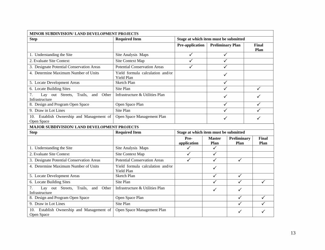
MINOR SUBDIVISION/ LAND DEVELOPMENT PROJECTS Step Required Item Stage at which item must be submitted Pre-application Preliminary Plan Final
Plan1. Understanding the Site Site Analysis Maps 2. Evaluate Site Context Site Context Map 3. Designate Potential Conservation Areas Potential Conservation Areas 4. Determine Maximum Number of Units Yield formula calculation and/or
Yield Plan
5. Locate Development Areas Sketch Plan 6. Locate Building Sites Site Plan 7. Lay out Streets, Trails, and Other Infrastructure
Infrastructure & Utilities Plan
8. Design and Program Open Space Open Space Plan 9. Draw in Lot Lines Site Plan 10. Establish Ownership and Management of Open Space
Open Space Management Plan
MAJOR SUBDIVISION/ LAND DEVELOPMENT PROJECTS Step Required Item Stage at which item must be submitted Pre-
application Master
Plan Preliminary
Plan Final Plan
1. Understanding the Site Site Analysis Maps 2. Evaluate Site Context Site Context Map 3. Designate Potential Conservation Areas Potential Conservation Areas 4. Determine Maximum Number of Units Yield formula calculation and/or
Yield Plan
5. Locate Development Areas Sketch Plan 6. Locate Building Sites Site Plan 7. Lay out Streets, Trails, and Other Infrastructure
Infrastructure & Utilities Plan
8. Design and Program Open Space Open Space Plan 9. Draw in Lot Lines Site Plan 10. Establish Ownership and Management of Open Space
Open Space Management Plan
13

14
Town of Middletown, Rhode Island
Section 304 - Basic Maximum Number of Dwelling Units
A. Yield Formula - The basic number of lots or units to be allowed in a proposed CSD project is defined as the maximum number of lots or units which could reasonably be expected to be developed upon the parcel based on the requirements of the zoning district and other requirements of the Zoning Ordinance. The following formula shall be used in determining the basic number of lots/units:
Lots/units = (Developable Land Area * 0.8)÷Minimum lot or land area required by the Zoning Ordinance for the proposed development. Results of the formula calculation shall be rounded to the nearest whole number using standard mathematical principles.(e.g. 5.50 , round up to 6; 5.44, round down to 5.)
B. Yield Plan - If the applicant believes that the yield formula does not accurately reflect the actual development potential of the subject property, a Yield Plan may be submitted for consideration by the Planning Board in accordance with the requirements of this section. The proponent shall have the burden of proof with regard to the reasonableness and feasibility of the design and the engineering specifications for the Yield Plan; provided, however, that the Planning Board’s determination of the basic maximum number of lots or units shall be conclusive.
1. Yield Plans shall be prepared as conceptual layout plans in accordance with the Pre-application Checklist (Checklist C). Yield plans shall show proposed streets, lots, rights-of-way, land unsuitable for development and other pertinent features. The Yield Plan must be drawn to scale, and must be a realistic layout reflecting a development pattern that could reasonably be expected to be implemented, taking into account the presence of land unsuitable for development (as defined in the Zoning Ordinance), existing easements or encumbrances and the suitability of soils for subsurface sewage disposal where required.
2. The Yield Plan shall also reflect the dimensional standards for uses being proposed, as contained in the Table of Dimensional Regulations in the Zoning Ordinance, or other applicable dimensional requirement of the Zoning Ordinance and these Regulations. The Yield Plan must identify how conventional lots or uses could be developed having the required area, frontage and other dimensional requirements of the Zoning Ordinance. Although lots shown in the Yield Plan may contain land unsuitable for development, only developable land area as defined in the Middletown Zoning Ordinance shall be counted towards the minimum lot area.
3. In determining the maximum number of lots allowed under the Yield Plan the Planning Board shall require the applicant to present evidence, certified by a registered professional engineer, that all lots shown on the Yield Plan are suitable for development under applicable local and state regulations. This certification shall be provided at the master plan stage in the case of a Major Subdivision, and at the Preliminary Plan stage in the case of a Minor Subdivision.
4. On sites not served by public sewer, soil suitability for individual septic systems for lots on the Yield Plan shall be demonstrated. The Planning Board, with the assistance of the Town Engineer, may select a sample of the lots for which the applicant will be required to present specific evidence of septic system suitability. The lots included in the sample will generally be those that are considered to be marginal. If all lots in the selected sample are determined
Procedures for Subdivision and Land Development Approval 15

Rules and Regulations Regarding the Subdivision of Land
to be suitable then all lots on the Yield Plan shall be deemed suitable for septic system development. If any lots in the selected sample fail, those failed lots shall be excluded from the Yield Plan and the Planning Board shall select an additional number of lots to be tested. This process shall continue until all lots in a selected sample are deemed suitable. The number of lots remaining on the yield plan following the final round of testing shall be the basis for determine the number of lots/units allowed in the CSD project.
5. Upon completion of their review, the Planning Board shall determine the initial Basic Maximum Number of lots/dwelling units permitted in a development. This initial determination shall be made at the master plan stage of review for major subdivisions and major land development projects, and at the preliminary stage of review for minor subdivisions and minor land development projects. The applicant shall use this initial determination as the basis for submission of more detailed information during subsequent stages of review. Upon further investigation and upon receipt of more detailed soils and environmental information as may be provided in subsequent stages of review, the Planning Board may increase or reduce the number of lots/dwelling units contained in the initial Basic Maximum Number. For all developments, the final Basic Maximum Number shall be established by the Planning Board at the final stage of review.
6. In developments that require alterations to be made to freshwater wetlands, the Board may establish an initial Basic Maximum Number contingent upon confirmation by the RI Department of Environmental Management that such alterations are permitted under the provisions of the Freshwater Wetlands Act.
16 Article 4

Town of Middletown, Rhode Island
Article 4 - PROCEDURES FOR SUBDIVISION AND LAND DEVELOPMENT APPROVAL
Section 401 - General
A. Any person proposing to subdivide or develop any land in the Town Of Middletown shall submit an application to the Planning Board or, in the case of an administrative subdivision, to the Administrative Officer for approval, or for referral to the Planning Board and/or its Technical Review Committee, as appropriate. No plat of a subdivision or development of land in the Town shall be accepted for filing or recording in the land evidence records of the Town until it shall have been approved by the Planning Board or Administrative Officer, and such approval entered in writing on the plat by the Chairman or Secretary of the Board or the Administrative Officer in the case of an administrative subdivision or of a development requiring Development Plan Review (“DPR”).
B. Whenever any subdivision of land is proposed, before any development shall take place thereon, before any permit for the erection of a structure shall be granted, and before any lot within said subdivision shall be sold, the owner of said land, or his designated representative, shall apply for and secure approval of such proposed subdivision in accordance with the following procedures.
Section 402 - Pre-application meetings and concept review
A. General 1. Pre-application meetings allow the applicant to meet with appropriate officials, boards and/or
commissions, planning staff, and, where appropriate, state agencies, for advice as to the required steps in the approvals process, the pertinent local plans, ordinances, regulations, rules and procedures and standards which may bear upon the proposed development project.
2. Pre-application meetings aim to encourage information sharing and discussion of project concepts among the participants. Pre-application discussions are intended for the guidance of the applicant and are not considered approval of a project or its elements.
B. Meeting required 1. One or more pre-application meetings shall be held for all major land development or
subdivision applications and all minor land development or subdivision applications proposing the creation or extension of a public road.
2. Provided that at least one (1) pre-application meeting has been held for major land development or subdivision application or sixty (60) days has elapsed from the filing of the pre-application submission and no pre-application meeting has occurred within those sixty (60) days, nothing shall be deemed to preclude an applicant from thereafter filing and proceeding with an application for a land development or subdivision project in accordance with RIGL § 45-23-36.
3. Pre-application meetings may be held where not otherwise required upon request of either the municipality or the applicant.
Procedures for Subdivision and Land Development Approval 17

Rules and Regulations Regarding the Subdivision of Land
C. Submittals
1. Where a pre-application meeting is required by this section, applicants shall submit the materials required by Appendix A – Pre-application checklist.
2. Where a pre-application meeting is not required, applicants seeking a pre-application meeting or an informal concept review shall submit general, conceptual materials in advance of the meeting(s) as requested by municipal officials.
D. Concept Review At the pre-application stage the applicant may request that the Planning Board or the Technical Review Committee provide an informal concept plan review for a development. The purpose of the concept plan review is also to provide planning board or technical review committee input in the formative stages of major subdivision and land development concept design.
Section 403 - Applications for Subdivision Approvals
A. Any person intending to subdivide land in the Town of Middletown shall follow the procedure established in these Rules and Regulations and shall provide all the material required in the checklists for the appropriate subdivision contained in Appendix A. The Planning Board will refuse to consider a plat of a subdivision until all items in the appropriate checklists have been submitted by the applicant, and no subdivision shall be considered as having been submitted to the Board unless the proposed plat is accompanied by all the material required by the appropriate checklist.
B. Applications for subdivision approval shall be made to the Administrative Officer, who shall review all applications for form and content in conformity with the requirements set forth herein. Complete applications shall then be officially filed for review by the Planning Board, and the Administrative Officer shall stamp all such applications with the date of official submission to the Town.
C. The Administrative Officer shall advise the applicant as to which approvals are required and the appropriate board for hearing an application for land development or subdivision project. The following types of applications, as defined in Article 3, may be filed:
1. Administrative subdivision
2. Minor subdivision or minor land development plan
3. Major subdivision or major land development plan
D. An application shall be complete for purposes of commencing the applicable time period for action when so certified by the Administrative Officer. In the event such certification of the application is not made within the time specified in this article for the type of plan, the application shall be deemed complete for purposes of commencing the review period unless the application lacks information required for such application as specified in this article and the Administrative Officer has notified the applicant, in writing, of the deficiencies in the application.
E. The Planning Board may subsequently require correction of any information found to be in error and submission of additional information specified in these Rules and Regulations but not required by the Administrative Officer prior to certification, as is necessary to make an informed decision.
18 Article 4
Town of Middletown, Rhode Island
F. Where the review is postponed with the consent of the applicant, pending further information or revision of information, the time period for review shall be stayed and shall resume when the Planning Board determines that the required application information is complete.
G. All proposed subdivisions must meet at least the minimum design requirements set forth in these Rules and Regulations. For conservation subdivision developments (CSD), applicants shall be prepared to demonstrate to the Planning Board that the Conservation Development Design Process outline in Appendix C of these regulations was considered in determining the proposed layout of open space, development areas and lots.
H. No streets or other improvements may be installed until the Planning Board has approved the final plat. No lots may be sold until the final plat has been endorsed by the Planning Board Chairman or Secretary and recorded in the land evidence records of the Town.
Section 404 - Required Findings
The approving authorities responsible for land development and subdivision review and approval shall ensure that each proposal addresses the general purposes listed in Article 2 of these Rules and Regulations and shall make positive findings on the following prior to approving the proposed subdivision/development
A. The proposed development is consistent with the comprehensive community plan and/or has satisfactorily addressed the issues where there may be inconsistencies;
B. The proposed development is in compliance with the standards and provisions of the Town Zoning Ordinance;
C. There will be no significant negative environmental impacts from the proposed development as shown on the final plan, with all required conditions for approval;
D. The subdivision, as proposed, will not result in the creation of individual lots with such physical constraints to development that building on those lots according to pertinent regulations and building standards would be impracticable. (See definition of buildable lot). Lots with such physical constraints to development may be created only if identified as permanent open space or permanently reserved for a public purpose on the approved, recorded plans; and
E. All proposed land developments and all subdivision lots shall have adequate and permanent physical access to a public street. Lot frontage on a public street without physical access shall not be considered compliance with this requirement.
Section 405 - Procedure for Administrative Subdivision Approval
A. Submittals Any applicant requesting approval of a proposed administrative subdivision, as defined in these Rules and Regulations, shall submit to the Administrative Officer the items required by the Administration Subdivision Checklist at Appendix A.
B. Certificate of Completeness The application shall be certified as complete or incomplete by the Administrative Officer within a fifteen (15) day period from the date of its submission according to the provisions of Section 403.
Procedures for Subdivision and Land Development Approval 19

Rules and Regulations Regarding the Subdivision of Land
C. Review Process 1. Within fifteen (15) days of certification of completeness, the Administrative Officer, shall
review the application and approve, deny or refer it to the Planning Board with recommendations. The Administrative Officer shall report his/her actions to the Planning Board at its next regular meeting, to be made part of the record.
2. If no action is taken by the Administrative Officer within the fifteen (15) days, the application shall be placed on the agenda of the next regular Planning Board meeting.
3. If referred to the Planning Board, the Board shall consider the application and the recommendations of the Administrative Officer and shall either approve, approve with conditions, or deny the application within sixty-five (65) days of certification of completeness. Failure of the Planning Board to act within the period prescribed shall constitute approval of the administrative subdivision plan and a certificate of the Administrative Officer as to the failure of the Planning Board to act within the required time and the resulting approval shall be issued on request of the applicant.
4. Denial of an application by the Administrative Officer is not appealable and requires the plan to be submitted as a minor subdivision application.
5. Any approval of an administrative subdivision shall be evidenced by a written decision which shall be filed and posted in the office of the town clerk
6. Approval of an administrative subdivision expires ninety (90) days from the date of approval unless within that period a plat in conformity with that approval is submitted for signature and recorded as specified in Section 905 -.
Section 406 - Procedures for Minor Land Development and Minor Subdivision Approval
A. Review Stages Minor plan reviews consists of two stages, preliminary and final, provided that if a street creation or extension is involved, a public hearing is required. The Planning Board may combine the approval stages, provided requirements for both stages have been met by the applicant to the satisfaction of the Administrative Officer. Applications for CSD also require a pre-application meeting.
B. Submission requirements Any applicant requesting approval of a proposed minor subdivision or minor land development, as defined in these Rules and Regulations, shall submit to the Administrative Officer the items required by the Minor Subdivision Checklist (Appendix A) at least three weeks prior to the Planning Board meeting at which the applicant desires to be heard.
If a pre-application meeting is required or requested, the items required by the Pre-application Checklist (Appendix A) shall be submitted prior to the pre-application meeting.
C. Certification
The application shall be certified complete or incomplete by the Administrative Officer within twenty-five (25) days, or within fifteen (15) days if no street creation or extension is required, according to the provisions of Section 402 -. The running of the time period set forth in this section will be deemed stopped upon the issuance of a certificate of incompleteness of the application by the administrative
20 Article 4

Town of Middletown, Rhode Island
officer and will recommence upon the resubmission of a corrected application by the applicant. However, in no event will the administrative officer be required to certify a corrected submission as complete or incomplete less than fourteen (14) days after its resubmission.
D. Administrative Review The Administrative Officer, shall review the application and shall comment and make recommendations to the Planning Board. The application shall be referred to the Planning Board for review and approval.
E. Re-assignment to Major Review. The Planning Board shall re-assign a proposed minor project to major review only when the Planning Board is unable to make the positive findings required in Section 404 -.
F. Decision 1. If no street creation or extension is required, the Planning Board will approve, deny or
approve with conditions the preliminary plan within sixty-five (65) days of certification of completeness, or within any further time that is agree to by the applicant and the board, according to the requirements of Section 903
2. If a street extension or creation is required, the Planning Board will hold a public hearing prior to approval according to the requirements of Section 408 and will approve, deny or approve with conditions, the preliminary plan within ninety-five (95) days of certification of completeness, or within any specified time that is agreed to by the applicant and the Board, according to the requirements of Section 903.
G. Failure to Act Failure of the Planning Board to act within the period prescribed shall constitute approval of the preliminary plan and a certificate of the Administrative Officer as to the failure of the Planning Board to act within the required time and the resulting approval shall be issued on request of the applicant.
H. Final Plan The Planning Board may delegate final plan review and approval to either the Administrative Officer or the Technical Review Committee. The officer or committee will report its actions to the Planning Board at its next regular meeting, to be made part of the record.
I. Expiration of approval
Approval of a minor land development or subdivision plan shall expire ninety (90) days from the date of approval unless within such period a plat or plan, in conformity with such approval, and as defined in these rules, is submitted for signature and recording as specified in Section 905 -. Validity may be extended for a longer period, for cause shown, if requested by the applicant in writing, and approved by the Planning Board.
Procedures for Subdivision and Land Development Approval 21

Rules and Regulations Regarding the Subdivision of Land
Section 407 - Procedure for Major Land Development and Major Subdivision Approval
Prior to the Master Plan Review, one or more pre-application meetings shall be held in accordance with Section 402 -.
A. Review Stages 1. Major Plan Review is required for all applications for land development and subdivision
approval subject to these Rules and Regulations, unless classified as an administrative subdivision or a as minor land development or a minor subdivision.
2. Major plan review consists of three stages of review, master plan, preliminary plan and final plan, following the pre-application meeting(s) specified in Section 402(C). Also required is a public informational meeting and a public hearing.
3. The Planning Board may vote to combine review stages and to modify and/or waive requirements as specified in Section 908. Review stages may be combined only after the Planning Board determines that all necessary requirements have been met by the applicant.
4. Unless waived by the Planning Board consistent with the provisions of Article 3 of these regulations, all major subdivisions must be submitted as Conservation Subdivision Developments.
B. Master Plan Review
1. Submission requirements
(a) At least three weeks prior to the scheduled Planning Board meeting, at which the applicant wishes to be heard, the applicant shall first submit to the Administrative Officer the items required by the Major Subdivision Master Plan Checklist (Appendix A).
(b) Requirements for the master plan and supporting material for this phase of review shall include, but not be limited to: information on the natural and built features of the surrounding neighborhood, existing natural and man-made conditions of the development site, including topographic features, the freshwater wetland and coastal zone boundaries and floodplains, as well as the proposed design concept, proposed public improvements and dedications, tentative construction phasing, and potential neighborhood impacts.
(c) The Administrative Officer shall solicit initial comments from (a) local agencies including, but not limited to, the Planning Department, the department to public works, fire and police departments, the conservation, tree, and recreation commissions; (b) adjacent communities; (c) state agencies, as appropriate, including the Departments of Environmental Management and Transportation, and the Coastal Resources Management Council (CRMC); and (d) federal agencies, as appropriate. The Administrative Officer shall coordinate review and comments by local officials, adjacent communities, and state and federal agencies.
2. Certification
The application must be certified complete or incomplete by the Administrative Officer within sixty (60) days, according to the provisions of Section 403. The running of the time period set forth herein will be deemed stopped upon the issuance of a certificate of incompleteness of the application by the Administrative Officer and will recommence upon the resubmission of a corrected application by the
22 Article 4

Town of Middletown, Rhode Island
applicant. However in no event will the administrative officer be required to certify a corrected submission as complete or incomplete less than fourteen (14) days after its resubmission.
3. Informational meeting
(a) A public informational meeting shall be held prior to the Planning Board decision on the master plan, unless the master plan and preliminary plan approvals are being combined, in which case the public informational meeting shall be optional, based upon Planning Board determination.
(b) Public notice for the informational meeting shall be given at least seven (7) days prior to the date of the meeting in the Newport Daily News. Written notice shall be mailed to the applicant and to all abutting property owners.
(c) At the public informational meeting the applicant shall present the proposed development project. The Planning Board shall allow oral and written comments from the general public. All public comments shall be made part of the public record of the project application.
4. Decision
The Planning Board shall, within one hundred and twenty (120) days of certification of completeness, or within such further time as may be consented to by the applicant, approve of the master plan as submitted, approve with changes and/or conditions, or deny the application, according to the requirements of Section 903 -.
5. Failure to act
Failure of the Planning Board to act within the period prescribed shall constitute approval of the master plan and a certificate of the Administrative Officer as to the failure of the Planning Board to act within the required time and the resulting approval shall be issued on request of the applicant
6. Vesting
(a) The approved master plan shall be vested for a period of one (1) year with a one (1) year extension upon written request by the applicant, who must appear before the Planning Board for the annual review. Vesting may be extended for a longer period, for good cause shown, if requested by the applicant in writing, and approved by the Planning Board. Master plan vesting shall include the zoning requirements, conceptual layout and all conditions shown on the approved master plan drawings and supporting materials.
(b) The initial two year vesting for the approved master plan shall constitute the vested rights for the development as required in RIGL 45-24-44.
C. Preliminary Review
1. Submission Requirements
(a) The applicant shall submit to the Administrative Officer the items required by the Major Subdivision Preliminary Review Checklist (Appendix A) at least three (3) weeks prior to the scheduled Planning Board meeting at which the applicant wishes to be heard.
(b) Requirements for the preliminary plan and supporting materials for this phase of the review shall include, but not be limited to: engineering plans depicting the existing site conditions,
Procedures for Subdivision and Land Development Approval 23

Rules and Regulations Regarding the Subdivision of Land
engineering plans depicting the proposed development project, a perimeter survey, all permits required by state or federal agencies prior to commencement of construction, including permits related to freshwater wetlands, the coastal zone, floodplains, preliminary suitability for individual septic disposal systems, public water systems, and connections to state roads.
(c) Final written comments and/or approvals shall be provided from the Public Works Department, Town Engineer, Town Solicitor, and other local government departments, commissions, or authorities as appropriate.
(d) Prior to approval of the preliminary plan, copies of all legal documents describing the property, proposed easements and rights-of-way shall be submitted.
(e) In conservation subdivisions/land development projects, proposed arrangements for ownership, use, and maintenance of the required open space shall be reviewed and approved by the Planning Board.
2. Certification
The applications shall be certified as complete or incomplete by the Administrative Officer within sixty (60) days, according to the provisions of Section 403. The running of the time period set forth herein will be deemed stopped upon the issuance of a certificate of incompleteness of the application by the Administrative Officer and will recommence upon the resubmission of a corrected application by the applicant. However, in no event shall the administrative officer be required to certify a corrected submission as complete or incomplete less than fourteen (14) days after its resubmission.
3. Technical Review Committee
The Planning Board may request Technical Review Committee review of all Major Subdivision/Land Development Project preliminary plan materials.
4. Development Impact Review
Unless waived by the Planning Board, all Major Subdivision/Development applications shall undergo Development Impact Review, consistent with the provisions of Section 310 of the Zoning Ordinance.
5. Public hearing
Prior to a Planning Board decision on the preliminary plan, a public hearing, which adheres to the requirements for notice described in Section 408 -, must be held.
6. Public Improvement Guarantees
Proposed arrangements for completion of the required public improvements, including construction schedule and/or financial guarantees, shall be reviewed and approved by the Planning Board, after receiving concurrence from the Town Administrator at preliminary plan approval.
7. Decision
A complete application for major subdivision or development plan shall be approved, approved with changes and/or conditions or denied, within one hundred and twenty (120) days of the date when it is certified complete, or within such further time as may be consented to by the applicant.
24 Article 4
Town of Middletown, Rhode Island
8. Failure to act
Failure of the Planning Board to act within the period prescribed shall constitute approval of the preliminary plan and a certificate of the Administrative Officer as to the failure of the Planning Board to act within the required time and the resulting approval shall be issued on request of the applicant.
9. Vesting
The approved preliminary plan shall be vested for a period of one (1) year and vesting may be extended for a longer period, for good cause shown, if requested in writing by the applicant, and approved by the Planning Board. The vesting for the preliminary plan approval shall include all general and specific conditions as shown on the approved preliminary plan drawings and supporting material.
D. Public Hearing and Notice A public hearing in accordance with Section 408 of these regulations is required.
E. Final Plan Review
1. Submission requirements.
(a) The applicant shall first submit to the Administrative Officer, at least three (3) weeks prior to the scheduled Planning Board meeting at which the applicant wishes to be heard, the items required by the Major Subdivision-Final Plan Checklist, as well as all material required by the Planning Board when the application was given preliminary approval.
(b) Arrangements for completion of the required public improvements including the construction schedule and/or financial guarantees.
(c) Certification by the tax collector that all property taxes are current.
(d) For phased projects, the final plan for phases following the first phase shall be accompanied by copies of as-build drawings, not previously submitted, of all existing public improvements for prior phases.
(e) For CSDs, an Open Space Management Plan and any other necessary legal documentation relating to ownership and management of open space.
2. Certification.
The application for final plan approval shall be certified complete or incomplete by the Administrative Officer within twenty-five (25) days, according to the provisions of Section 402 -. The time period may be extended to forty-five (45) days by written notice from the Administrative Officer to the applicant where the final plans contain changes to or elements not included in the preliminary plan approval. The running of the time period set forth herein shall be deemed stopped upon the issuance of a certification of incompleteness of the application by the Administrative Officer and shall recommence upon the resubmission of a corrected application by the applicant. However, in no event shall the Administrative Officer be required to certify a corrected submission as complete or incomplete less than fourteen (14) days after its resubmission. If the Administrative Officer certifies the application as complete and does not require submission to the Planning Board as per Subsection (3) below, the final plan shall be considered approved..
Procedures for Subdivision and Land Development Approval 25
Rules and Regulations Regarding the Subdivision of Land
3. Referral to the Planning Board.
After certifying the final plan, the Administrative Officer shall refer the final plans to the Planning Board for review. The Planning Board shall, within forty-five (45) days after the certification of completeness, or within such further time as may be consented to by the applicant, approve, approve with modification and/or conditions or deny the final plan as submitted.
4. Failure to act.
Failure of the Planning Board to act within the period prescribed shall constitute approval of the final plan and a certificate of the Administrative Officer as to the failure of the Planning Board to act within the required time and the resulting approval shall be issued on request of the applicant.
5. Recording.
The final approval of a major subdivision or land development project shall expire one (1) year from the date of approval unless, within that period, the plat or plan shall have been submitted for signature and recorded as specified in Section 905 - or, if the applicant has chosen to complete the required improvements in lieu of posting a Guarantee of Performance, within the time requirements outlined in Section 907 -. The Planning Board may, for good cause shown, extend the period for recording for an additional period.
6. Acceptance of public improvements.
Signature and recording, as specified in Section 905 -, shall constitute the acceptance by the Town of any street or other public improvement or other land intended for dedication. Final plan approval shall not impose any duty upon the Town to maintain or improve those dedicated areas until the Town Council accepts the completed public improvements as constructed in compliance with the final plans.
7. Validity of recorded plans.
The approved final plan, once recorded, shall remain valid as the approved plan for the site unless and until an amendment to the plan is approved under the procedure set forth in Section 906 -, or a new plan is approved by the Planning Board. If construction of the subdivision improvements does not begin within one (1) year of the date of final approval, the developer shall return to the Planning Board to bring the Required Minimum Standards of Design and the Specification for Required Improvements of the approved plans into conformance with any changes which may have been made to these rules and regulations.
Section 408 - Public Hearing and Notice Requirements
A. A public hearing shall be held for all major land development projects and major subdivisions and when a street extension or creation is proposed for a minor land development project or minor subdivision.
B. Public notice of the hearing shall be given at least fourteen (14) days prior to the date of the hearing in a newspaper of general circulation within the Town following the Town’s usual and customary practices for such advertising. Notice shall be sent to the applicant and to each abutter, by certified mail, return receipt requested, of the time and place of the hearing not less than ten (10) days prior to the date of the hearing. Said notice shall also include the street address of the subject property,
26 Article 4

Town of Middletown, Rhode Island
Procedures for Subdivision and Land Development Approval 27
or if no street address is available, the distance from the nearest existing intersection in tenths (1/10’s) of a mile.
C. Notice of the public hearing shall be sent by first class mail to the city or Town Planning Board of any municipality where there is a public or quasi-public water source, or private water source that is used or is suitable for use as a public water source, located within two thousand (2,000’) feet of Middletown’s boundaries.
D. Notice of a public hearing shall be sent to the governing body of any state or municipal water department or agency, special water district, or private water company that has riparian rights to a surface water resource and/or surface watershed that is used, or is suitable for use, as a public water source located within either Middletown or two thousand (2,000’) feet of the Middletown’s boundaries, provided, that a map survey has been filed with the Building Inspector as specified in section R.I.G.L. 45-24-53 (E).
E. Notice of the public hearing shall be sent to an adjacent municipality if (1) the adjacent municipality is an abutter or (2) the development site extends into the adjacent municipality, or (3) there is a potential for significant negative impact on the adjacent municipality.
The cost of all notices for Public Hearings shall be borne by the applicant.

28

Article 5 - REQUIRED MINIMUM STANDARDS OF DESIGN
Any subdivision, Land Development Project (LDP) or development subject to Development Plan Review (DPR) approved shall adhere to the following minimum standards of planning and design.
Section 501 - Street Arrangement
A. Unless deemed inappropriate by the Planning Board, streets shall be arranged so as to provide for the continuation of existing or platted streets in abutting properties, whether such streets are public or private. Especially in retail and commercial developments, streets and driveways shall be designed to minimize the number of curb cuts and to allow the free flow of vehicular and pedestrian traffic within the development or developments, without having to enter and exit arterial connectors.
B. Where a plat submitted covers only a part of the applicant’s land, the street arrangement shall be such that it can be coordinated with the remainder of said land. If abutting property is not subdivided or developed, streets within the plat being subdivided or developed shall project to the property line of abutting land.
C. If it is physically impossible to extend streets to adjacent property or existing streets, new proposed streets shall provide continuous flow of traffic being connected together to eliminate dead ends.
D. Whenever possible, all developments shall be provided with at least two (2) means of access.
Section 502 - Paper Streets
Where access to property being subdivided is proposed to be from streets which are platted, but not constructed (i.e., paper streets), the applicant shall be required to construct said access streets in full accordance with the construction standards of these Rules and Regulations from the public street(s) to his/her property and as specified by the Planning Board.
Section 503 - Access Provided to All Lots
There shall be no reserve strips controlling access to a street from lots abutting said street, nor shall land be reserved at the end of a dead-end street preventing access to abutting property, except as specifically allowed or required by the Planning Board.
Section 504 - Dead End Streets
A. All permanent dead-end streets shall terminate in a cul-de-sac constructed according to these Rules and Regulations. The Planning Board may prohibit the use or limit the length of dead-end street(s) where necessary in order to ensure adequate and safe circulation of vehicular traffic and to efficiently provide for public utilities and services. In considering a request to allow a dead-end street, the Planning Board shall evaluate the potential impact on the neighborhood, including public safety; the provision of Town services and utilities; and the potential for road connectivity to existing and potential future development.
29

Rules and Regulations Regarding the Subdivision of Land
B. Whenever possible, cul-de-sacs shall be temporary and provide for future access to adjacent property. Where streets are terminated temporarily, and may be further extended at a future time, a temporary cul-de-sac shall be constructed as specified in these Rules and Regulations. A defeasible easement shall be granted to the Town for that portion of a cul-de-sac right-of-way which would be abandoned when temporary cul-de-sac is extended. See Appendix B for a diagram of the cul-de-sac detail.
Section 505 - Collector Streets
Where collector streets are proposed, or where high traffic volumes are anticipated, the Planning Board may require the construction of a street to a right-of-way width up to sixty (60) feet, and a pavement width up to thirty (30) feet. Collector streets are streets which function as main interior streets, and which collect traffic from local or minor streets to State or Federal highways, or function as streets serving industrial and commercial developments.
Section 506 - Restriction of Access
When a tract fronting a public street for a distance of 500 feet or more with the average depth of 350 feet is to be subdivided into more than ten (10) residential lots, the Planning Board may require that:
A. Residential lots adjoining the public street be provided with frontage on a marginal access street, and
B. Access to the public street be restricted.
Section 507 - Street Names
The extension of an existing street shall have the same name as the existing street. Names of other proposed streets shall be substantially different from any existing street name in the Town of Middletown, and shall be subject to the approval of the Planning Board and the Middletown Fire Department.
Section 508 - Street Frontage
All lots shall have a frontage on a public street equal to the minimum lot width specified in the Middletown Zoning Ordinance. With the permission of the Planning Board, a single-family residential lot may have a minimum of fifty (50) feet of frontage on a cul-de-sac provided that the distance from the side lot lines on opposite sides of the lot, as measured at the front yard depth, is no less than one hundred (100) feet.
Section 509 - Overall Plan of Development
A. Where a development is proposed to be developed in more than one phase, i.e., only a portion of the overall parcel to be developed is subdivided or developed and recorded at one time, the applicant shall be required to file an Overall Plan of Development. Such plan shall be filed at the Master Plan stage and shall indicate the future stages of development and their relationship to the stage being considered for approval by the Board. The Board will consider, among other things, the overall pattern of circulation, provisions for adequate drainage, arrangement of lots and open spaces, the surrounding land uses, and relationship to the Comprehensive Community Plan.
30 Article 5

Town of Middletown, Rhode Island
B. No portion of any multi-phase development shall be approved by the Planning Board unless an Overall Plan of Development shall have been filed and approved, and no change in an approved Overall Plan of Development shall be made by the applicant without approval of the Planning Board.
Section 510 - Sidewalks
Sidewalks shall be installed where sidewalks already exist and where extension of new sidewalks would be desirable; or in areas where deemed necessary by the Planning Board to provide safe pedestrian access.
Section 511 - Pedestrian Walkways
The Planning Board may require a ten (10) foot wide public pedestrian walkway between blocks or lots when required in the design to provide for safe pedestrian access. Such walkways may be left in a natural condition or provided with paved sidewalks as specified in Article 6.
Section 512 - Side Lot lines
Wherever possible, side lot lines shall be substantially at right angles or radial to street line.
Section 513 - Modification of Lots
Extra Size Lot The minimum lot area requirements may be increased by the Planning Board if percolation tests indicate the need for additional area for the safe and efficient installation of individual sewage disposal systems.
Section 514 - Open Space and Recreation Facilities
Section 514.1 - Conservation Development The Planning Board shall specifically authorize plans for the use, ownership, management and maintenance of all open space areas within any Conservation Development, pursuant to Section 1905 of the Zoning Ordinance.
The required open space shall be established as a lot or lots separate and distinct from the lots intended for residential or commercial development, and land dedicated as street rights-of-way, and shall comply with the terms of this section.
A. Resources to be conserved The design of open space lands in any Conservation Development shall reflect the standards set forth in this subsection and, to the fullest extent possible, incorporate any of the resources listed below if they occur on the parcel (not listed in order of significance).
1. Stream channels, floodplains, hydric soils, swales, springs, and other freshwater wetland areas, including adjacent buffer areas that may be required to ensure their protection;
2. Wellhead protection areas;
Required Minimum Standards of Design 31

Rules and Regulations Regarding the Subdivision of Land
3. Special aquatic sites, vernal pools and significant natural areas of species listed as endangered, threatened, or of special concern, such as those listed in the Statewide Natural Heritage Inventory;
4. Moderate to steep slopes, particularly those adjoining watercourses and ponds, where disturbance and resulting soil erosion and sedimentation could be detrimental to water quality;
5. Healthy woodlands, particularly those performing important ecological functions such as soil stabilization and protection of streams, wetlands, and wildlife habitats;
6. Areas where precipitation is most likely to recharge local groundwater resources because of topographic and soil conditions affording high rates of infiltration and percolation;
7. Hedgerows, groups of trees, location and species of large individual trees of botanic significance, specimen vegetation and other vegetation features representing the site's rural past;
8. Active agricultural uses, pastures, croplands;
9. Prime farmland soils and farmland soils of statewide importance;
10. Historic structures and archaeological sites;
11. Visually prominent topographic features such as knolls, hilltops and ridges;
12. Geologic features such as eskers or kettle holes;
13. Scenic viewsheds as seen from public roads (particularly those with historic features);
14. Existing or potential trails connecting the parcel to other locations in the Town;
15. Any other natural, cultural or recreational resources determined by the Planning Board.
B. Location The location of the open space shall be determined during the initial design phase of the project and with the input of the Planning Board. The configuration of proposed open space lands set aside for common use in a Conservation Development shall comply with the following standards::
1. Open space shall be placed in undivided preserves which will be adjacent to the largest number of lots within the development as possible.
2. Open space shall be directly accessible to the largest practicable number of lots or dwellings within the development. Non-adjoining lots shall be provided with safe and convenient pedestrian access to open space land;
3. Required open space shall adjoin open space on adjacent parcels, forming an interconnected network. Areas of open space open to the public in the form of trails and access to significant and natural and cultural features are encouraged. Open space shall be interconnected wherever possible to provide a continuous network of greenway lands within and adjoining the subdivision;
4. Whenever possible, open space shall be undivided by public or private streets, except where necessary for proper traffic circulation;
C. Use & Development Open Space shall:
32 Article 5
Town of Middletown, Rhode Island
1. Be free of all structures except historic buildings or structures, stone walls, and structures related to open space uses. The Planning Board may grant approval of structures and improvements required for storm drainage and privately owned and maintained water supply within the open space provided that such facilities would not be detrimental to the purpose for which the open space is proposed. Placement of individual sewage disposal systems (ISDS) within the open space shall be permitted only by the granting of a waiver by the Board.
2. Be suitable for active or passive recreational uses to the extent deemed necessary by the Planning Board, without interfering with adjacent dwelling units, parking, driveways, and roads;
3. Be interconnected wherever possible to provide a continuous network of greenway lands within and adjoining the subdivision;
4. Provide buffers to adjoining parks, preserves or other protected lands;
5. Provide for pedestrian pathways for use by the residents of the development.
6. Provisions made for access to the open space lands by municipal personnel, as required for land management and emergency purposes;
7. Be suitably landscaped either by retaining existing natural cover and wooded areas and/or according to a landscaping plan to protect open space resources;
D. Ownership 1. Ownership of open space lots shall be vested in a legally viable entity pursuant to Section
1905(A) of the Zoning Ordinance, which shall be responsible for the use and maintenance of the open space. Documents specifying the form of ownership for the open space parcel(s) shall be submitted to the Planning Board for approval. The Planning Board shall have the right to approve, modify or reject the proposed form of ownership if the proposed form of ownership does not adequately provide for control and maintenance of the open space.
2. If ownership of open space is conveyed to lot owners within the CSD, at a minimum the following standards of ownership and management of open space shall be met:
a. If the required open space is to be owned in common by all the lot owners within the CSD, the deed to each lot shall include a fractional interest in the common open space in an amount inversely proportional to the number of lots or dwelling units in the development. The deed shall also include all covenants, restrictions and easements which shall be imposed upon the use, management or maintenance of the open space in order to provide for the necessary control and requisite upkeep of the open space.
b. The applicant or developer shall provide for and establish a homeowners association or indicate an alternate method for the use, care and maintenance of all open space lands and improvements. Unless otherwise allowed by the Planning Board, membership in the homeowners association shall be mandatory for all landowners within the CSD, and each lot shall be entitled to equal representation. The Planning Board shall review the by-laws of the homeowners association to ensure adequate provision for the maintenance of open space is provided.
Required Minimum Standards of Design 33

Rules and Regulations Regarding the Subdivision of Land
c. If the condominium form of ownership is proposed, the open space shall be a common element or a portion of the common elements of the condominium, in accordance with the provisions of Chapter 34 36-1 of the General Laws of Rhode Island.
E. Maintenance The Planning Board may require specific provisions for maintenance of open space, private streets, drainage systems and utilities including requirements for security and including maintenance bond, as provided in the Rules and Regulation Regarding the Subdivision of Land. At a minimum, a Management Plan for the open space detailing ownership, use and maintenance responsibilities shall be developed for the Open Space and must be approved by the Planning Board; such plan may be modified with Planning Board approval. In the event of failure of a homeowners’ association to maintain any common open space, recreation areas, landscaping features, or other required improvements, the Town may enter into said development and perform such necessary maintenance work and charge the cost, including attorney fees, to the owner.
F. Excavation, Grading, and Disturbance 1. Areas proposed to fulfill the minimum open space requirement within a Conservation
Development shall not be excavated or regraded, except as permitted by the Planning Board. Clearing and excavation of open space areas may be permitted only for the installation of stormwater retention or detention facilities, other drainage facilities, or for permitted utilities, park, open space, recreational, agricultural or forest management uses in accordance with a plan approved by the Planning Board.
2. No commercial earth removal, even if permitted by the Zoning Ordinance, in the zoning district in which the development is proposed, shall be permitted within any open space areas. In approving an open space use plan, the Board may permit grading that includes removal of earth materials. The Board shall, however, clearly indicate, as a condition of preliminary approval, the approximate quantities of material and the general areas from which earth removal is authorized, and shall only authorize the minimal amount of earth removal required to grade the land for the intended purpose.
3. Disturbance to the natural contours of the land shall be minimized to the greatest extent possible. Existing natural vegetation and any significant natural or man-made features shall be preserved except as permitted by the Planning Board to create or enhance areas of landscaping, parks, recreation, conservation, forestry or wildlife habitat. These disturbances shall be specifically shown on the open space use plan.
Section 514.2 - Conventional Development A. The Planning Board may require the applicant to dedicate a portion of the land being subdivided
for the purpose of providing recreation areas, open space, conservation areas, or areas of historic significance or natural beauty for the benefit and enjoyment of the present and/or anticipated future residents of the plat. Requirements for the dedication of recreation land are set forth in the Comprehensive Community Plan. The minimum amount of recreation land so dedicated must be at least eleven (11) acres per one thousand (1,000) of the estimated population of the plat.
34 Article 5

Town of Middletown, Rhode Island
B. Requirements for the dedication of conservation areas, natural or scenic areas of historic sites shall be based upon the specific features of the land and dedication of land reasonably necessary to accomplish the intended purpose.
C. Land dedicated in accordance with this section may be dedicated to the Town of Middletown, to the State of Rhode Island, to a recognized public, quasi-public, non-profit or private organization, or may be privately owned. If retained in private ownership, said land shall be covered by an easement granted to the Town of Middletown sufficient to ensure its perpetual maintenance as conservation, open space or recreation land, and to render the land permanently available for the use and enjoyment of the residents of the subdivision. Where land is to be maintained in private ownership, a maintenance plan detailing the ongoing responsibilities for use and maintenance of the land shall be submitted for Planning Board approval, and shall be incorporated by reference in the maintenance easement.
D. Where, by virtue of the location, size or character of the proposed subdivision, such as a dedication of land would not serve the intended purposes, the Planning Board may waive such requirement.
Section 515 - Construction Site Runoff Control
Measures to minimize construction site runoff shall be employed, where applicable, and shall, at a minimum, meet the standards and specifications set forth in the Town’s Construction Site Runoff Control Ordinance, 2005, as amended (Town Code Chapter 151). A Stormwater Pollution Prevention Plan, prepared in accordance with the Ordinance, shall be submitted at the preliminary plat stage for review. If no construction is proposed at time of subdivision, the plan shall include a note requiring implementation of construction site runoff controls at time of construction.
Section 516 - Stormwater Management
All development approved by the Planning Board shall comply with the requirements of the Middletown Stormwater Management Ordinance, 2005, as amended (Town Code Chapter 153). To the extent practical, low impact development (LID) storm water best management practices shall be employed in the storm water management plan.. At the preliminary plan stage, a Stormwater Management Plan meeting the requirements of the Ordinance shall be submitted for review. If no construction is proposed at time of subdivision, the plan shall include a note requiring implementation of stormwater management measures at time of construction. Provision for maintenance of all components of the Stormwater Management system, in accordance with the Town’s Stormwater Management Ordinance, shall be made prior to approval of the subdivision.
Section 517 - Flood prone areas
Subdivision and development proposals will be reviewed to determine whether such proposals will be reasonably safe from flooding. If a proposed subdivision or development project is in a flood-prone area, defined as the 100-year floodplain as established by the Federal Emergency Management Agency (FEMA):
A. Such proposal will be reviewed to assure that:
1. It is consistent with the need to minimize flood damage within the flood prone area.
2. All public utilities and facilities, such as sewer, gas, electrical and water systems are located and constructed to minimize or eliminate flood damage, and
Required Minimum Standards of Design 35

Rules and Regulations Regarding the Subdivision of Land
3. Adequate drainage is provided to reduce exposure to flood hazards by insuring, at a minimum, that there shall be no increase in the rate of water runoff from the site. The Planning Board may, at its discretion, require that the rate of runoff be decreased from the condition existing prior to subdivision development.
B. The Board shall require that the following provisions apply to subdivisions within the 100-year floodplain:
1. Future-condition storm water runoff discharge does not exceed present condition discharges into a floodway as calculated up to a 25-year frequency storm.
2. Development be prohibited within the floodway which will result in any increase in flood levels during the occurrence of a 25-year frequency storm discharge.
3. That there is no reduction in the holding capacity of the 100-year flood plain.
4. All construction of drainage and flood protection systems and all development within areas subject to flooding are adequately designed so as to accommodate flows resulting from up to a 25-year frequency storm.
5. Every lot be located so as to provide an area for construction of a residential building which is not within a riverine floodway.
Section 518 - Retention of Environmental Features
Environmental features such as stone walls, specimen trees, water bodies or other outstanding natural or man-made features shall be retained insofar as possible, and incorporated into the design of the subdivision or land development project so as to preserve the character of the land. . The Planning Board shall ensure that, to the extent practicable, plans accomplish the following:
A. Protect 100-year floodplains, wetlands, and steep slopes (greater than 25%) from clearing, grading, filling, or construction.
B. Preserve and maintain mature woodlands, existing fields, pastures, meadows, and orchards;
C. Create sufficient buffer areas to minimize conflicts between residential and agricultural uses.
D. In cases where development must take place on open fields or pastures because of greater constraints in other parts of the site, site dwellings at the far edge of a field as viewed from existing road(s).
E. Maintain naturally vegetated wetland buffers of sufficient width to protect the wetland from adjacent land use. In general such buffer shall be no less then 100 feet, but may be more or less depending on topography, soils, and wetland characteristics.
F. Preserve existing stonewalls, hedgerows and treelines.
G. Leave scenic views and vistas unblocked or uninterrupted, particularly as viewed from public roads.
H. Avoid siting new construction on hilltops.
I. Protect wildlife habitat areas.
36 Article 5

Town of Middletown, Rhode Island
J. Preserve sites of historic, archaeological or cultural value.
K. Protect rural roadside character.
L. Provide landscaping for common use areas comprised of native or non-invasive plant species.
M. Provide active recreation areas in suitable locations.
N. Include a pedestrian circulation system which provides access to open space from lots not directly adjacent to the open space as well as to open space on adjacent properties where possible.
O. Provide open space that is reasonably contiguous, both within the development and with open space on adjacent land.
Section 519 - Multi-Stage Subdivisions
Where a proposed subdivision contains more than thirty (30) lots, the Planning Board may, at its discretion, limit the number of lots to a maximum of thirty (30) lots in any stage. The Board may require that no subsequent stages be submitted for subdivision approval until construction of all required improvements of each prior stage has been completed. Provided, however, the Board may allow more than thirty (30) lots per stage where development of more than thirty (30) lots would be consistent with the intent and purposes of these Rules and Regulations.
Section 520 - Fees for Reviews/Evaluations Conducted by Consultants/Other Agencies
Fees for reviews required by the Planning Board in connection with a specific development shall be paid by the applicant prior to final approval of the subdivision.
Section 521 - Commercial Development
This section describes the general objectives and intent of Commercial Development Design Standards. (CDDS). The provisions in this section are provided for applicant, Technical Review Committee (TRC), and Planning Board guidance. Specific regulations implementing these objectives and their intent are set forth in the following sections (521.1 – 521.4). The purpose of these standards is to establish and maintain a uniform set of standards that promote the use of high quality design, consistent with the traditional architectural styles of Aquidneck Island and New England.
A. Site Design Buildings and their adjacent spaces, including parking, establish a design landscape rhythm. This rhythm of spaces and buildings should be considered when determining design compatibility, whether between a building or a building and street. Parking should be considered an integral part of site design and should be coordinated with overall site development. Site design shall encourage pedestrian activity through the placement of buildings close to the street, with off-street parking dispersed into small landscaped lots located to the rear or side of buildings and trees, foliage and grassy areas interspersed among buildings.
Required Minimum Standards of Design 37
Rules and Regulations Regarding the Subdivision of Land
B. Building Design and Architecture In general, buildings shall be designed to include traditional New England architectural elements. This includes, but is not limited to, peaked roof, wood-frame, and other styles consistent with colonial through early twentieth-century period architecture. Facades of a building, particularly the front facade, should consist of or resemble traditional building materials such as clapboard, shingles, brick, or stone. Facades, windows, and doors should be visually proportionate.
C. Landscaping Landscaping, including plantings, should be designed to define, soften or screen the appearance of the off-road parking areas and structures from the public right of way and abutting properties. The objective of landscaping should be to enhance the design and minimize the encroachment of the proposed use on neighboring land uses. The species and planting techniques for street-side trees and other plantings should be selected to create a unified image for the street, provide an effective canopy, avoid sidewalk damage, and minimize water consumption.
D. Environmental Impacts Commercial Development shall be designed to control erosion and sedimentation, stormwater runoff, and minimize impacts on surface water and air quality. Erosion and stormwater runoff control shall comply with town regulations, including Town Code Chapters 151 and 153, as amended. If feasible, efforts should be made to decrease runoff rates and volumes from pre-development conditions.
E. Signage Signage shall be visually compatible with the scale and character of the surrounding architecture, and should promote traditional architectural elements. The size, location, design, lighting and materials of all exterior signs and outdoor advertising structures shall be compatible with the design of proposed building(s) and structure(s).
Section 521.1 - Site Design
A. General Location and Layout Buildings should be located so as to create a safe, pleasant walking environment and efficient pedestrian circulation pattern. Building placement, orientation and massing should be planned to promote more active pedestrian-scaled commercial design, with ample opportunities for walking and bicycling, as well as private motor vehicles and to promote the use of public transportation.
B. Off-Street Parking and Circulation
1. Location
In all districts, except Light Industrial, parking lots should be located to the rear or side of buildings. If site configuration does not allow for the placement of all required parking spaces to the rear or side, a limited number of parking spaces may be located between the front of the building and the public street. Such lots shall be limited to one row of parking, except that for Large-scale Shopping Centers and other situations where site conditions warrant, the use of two rows of parking may be permitted. In either case, the number of parking spaces in such lots shall not exceed fifty (50) spaces, and additional landscaping and screening elements may be required.
38 Article 5

Town of Middletown, Rhode Island
In light industrial districts, parking is permitted between building and front lot line only where the front lot line does not abut a public arterial street.
2. Parking Lot Size
The standards of this section are in addition to the requirements of Article 13 of the Middletown Zoning Ordinance regarding off-street parking and loading. No individual parking lot, located between the building and street, may exceed fifty (50) total parking spaces. For a project requiring more than 50 parking spaces, parking shall be broken up into smaller lots; each accommodating no more than 50 vehicles and directly connected with the other lots. Adjacent parking lots must be buffered from each other with a minimum ten (10) foot landscaped strip, which may also be used as a walkway.
3. Access & Circulation
Circulation shall be designed to provide safe and efficient access for pedestrians, automobiles, and emergency vehicles into and throughout the site, including designated pedestrian walkways and crosswalks. Pedestrian access to the site from the public way and neighboring properties shall be provided.
4. Ingress & Egress
(a) Adequate and safe ingress and egress shall be provided. The number and width of curb cuts shall be minimized.
(b) Consolidation of existing curb cuts may be required.
(c) Provision for vehicular and pedestrian connections to adjacent developments shall be provided, whenever possible.
(d) Site design which requires the use of a public street to maneuver in and out of a parking or loading space located on private property shall not be permitted.
C. Utilities All utility lines serving the site shall be installed underground. To the maximum extent possible, power lines and utilities in frontage areas shall be installed underground.
D. Exterior Lighting 1. Exterior lighting shall be designed to minimize impact on neighboring properties and night
light pollution.
2. Fixtures illuminating building facades shall be shielded and directed toward the building and all other lighting fixtures shall be shielded and directed to the ground. Building-mounted decorative light fixtures and pole-mounted decorative fixtures, provided that they are less than twelve (12) feet in height, should also be shielded to the extent possible.
E. Infrastructure Dumpsters, storage areas, exposed machinery installation including but not limited to HVAC units, service areas, truck loading areas, utility buildings and similar structures shall be designed and screened or located to provide an audio-visual buffer sufficient to minimize their adverse impact on other land uses within the development area and surrounding properties. Air conditioning and ventilation units,
Required Minimum Standards of Design 39

Rules and Regulations Regarding the Subdivision of Land
security devices, and other service equipment shall be screened from public view, either by being set back from the roof edge for roof mounted units, or by being screened by landscaping for ground mounted units.
Section 521.2 - Building Design and Architecture
A. Façade and Walls The first impression of a building is that of its front façade, the side of the building facing the most frequently used public away. Accordingly, facades and walls shall incorporate the following features:
1. The primary ground floor public entrances must be oriented directly to streets, interior pedestrian plazas, or walkways. If oriented toward parking lots, such lots must contain said pedestrian plazas and walkways.
2. The street side façade of a building shall not consist of an unarticulated blank wall or an unbroken series of garage doors. In no case shall the unbroken plane of a wall exceed forty (40) linear feet without a break of at least forty-eight (48) inches in plane
3. Except in the GB and LI Zones, commercial garage doors and loading docks shall not be visible from any public way.
4. Loading docks shall not be located on the building façade facing the public way. Commercial garage doors and loading docks shall be screened from public view
B. Windows & Doors Windows and doors are encouraged on all building elevations, and should be visually compatible with the architectural style of the building.
1. Windows should occupy not less than twenty (20) percent or more than sixty (60) percent of any façade visible from the public way. In LI Zones, windows should occupy not less than twenty percent (20%) or more than sixty percent (60%) of any façade that faces a public arterial street.
2. Windows shall be of true divided-light or simulated divided-light design when consistent with the overall building design; except in LI Zones. Double-hung windows are preferred, where consistent with the overall design of the building.
C. Materials Traditional architecture employs authentic materials on building facades and roofs. Traditional façade materials include wooden clapboards, shingles, patterned shingles, brick, and stone and cast stone, depending on the architectural style and location of the building. Traditional roof materials include cedar shingles and slate. The façade and roof of a building, particularly the front façade, shall be visually compatible with these traditional building materials.
1. Building exteriors and roofs shall be constructed of, or resemble, traditional materials such as wooden clapboards, shingles, patterned shingles, brick, or stone.
2. Synthetic materials or substitutes may only be used subject to Planning Board approval. Samples of all primary materials shall be submitted to the Planning Board for approval.
40 Article 5
Town of Middletown, Rhode Island
D. Roof Forms and Roof Design A roof can have a dramatic effect on the appearance of a building. The shape and proportion of the roof shall be visually compatible with the architectural style of the building and shall incorporate the following features:
1. Traditional roof forms such as hip, gambrel, or gable shall be required.
2. The gradient from level of any sloped roof shall be at least 4:12.
3. Flat roofs may be permitted if decorative details are incorporated into the roof design and/or the roof is designed to incorporate a sloped design for the portion of the roof visible from the public way, and provided that any mechanical equipment installed on the roof is not visible from the public way and abutting properties.
E. Architectural Elements Architectural elements such as arcades, porches, bays, windows, balconies, dormers and cupolas shall be in reasonable proportion to the overall building.
Section 521.3 - Landscaping The landscape plan shall incorporate the following features:
A. Existing Vegetation Whenever possible, existing trees and vegetation shall be used to satisfy landscaping requirements. Trees having greater than 18-inch caliper dbh shall be preserved, whenever possible. If such trees cannot be preserved, each must be replaced with two (2) trees of at least four (4) inch caliper dbh. The Planning Board may seek an advisory opinion from the Tree Commission, regarding the removal of trees.
B. Amount Required Planted landscaping shall occupy a minimum of twenty-five percent (25%) of the project area.
C. Screening
Screening elements such as plantings, stone walls, berms and/or fences, or a combination of these is required along all property lines.
D. Buffers Buffers shall be provided as follows:
1. A landscaped buffer of at least ten (10) feet is required along all property lines. This may be reduced if stone walls are used as the screening element.
2. When abutting a residential district or use, the buffer must be at least twenty (20) feet wide and include screening at least six (6) feet in height, measured from finished grade, at time of installation. For large scale shopping centers, the required buffer shall be fifty (50) feet wide.
3. A landscaped buffer of at least ten (10) feet wide shall be provided between buildings and parking lots/driveways. The buffer shall be defined by curbing, and may include sidewalks, but must include a minimum five (5) foot planting strip.
Required Minimum Standards of Design 41
Rules and Regulations Regarding the Subdivision of Land
E. Plantings Plantings shall be noninvasive species, and native to Aquidneck Island, if possible. The Planning Bard may seek an advisory opinion from the Tree Commission, regarding the selection of tree species and locations for planting.
F. Trees 1. Street Trees - Deciduous "street trees" shall be planted along the street side property
boundary and along any private streets or internal driveways in planter strips or tree wells located between the sidewalk and curb. Trees shall be spaced no further apart than thirty (30) feet on center, and shall be a minimum of four (4) inch caliper dbh at time of planting.
2. Parking Lots - A minimum of one (1) tree shall be provided for every five (5) parking spaces. Trees shall be at least four (4) inches caliper dbh and seven (7) feet tall at time of planting. Each tree must be surrounded by at least 25 square feet of permeable unpaved area.
G. Scenic Views Scenic views and historically significant landscape features (including, but not limited to, stone walls, picket fences, and large trees) shall be preserved to the maximum extent reasonably possible. This requirement is in addition to the requirements set forth in the Middletown Town Code Chapter 96: Tree Preservation and Protection, and Chapter 97: Stone Walls.
H. Maintenance Ongoing maintenance of landscaping shall be a continuing requirement of compliance with the Regulations, and failure to maintain landscaping may be cited as a violation. For large projects, or significant landscape features, a maintenance agreement and/or bond may be required.
Section 521.4 - Environmental Impacts
A. Construction Site Runoff/Erosion & Sedimentation Control 1. Erosion and sedimentation shall be controlled so that neighboring property and public
facilities or services are not adversely affected during and/or after construction.
2. Erosion control shall meet the standards of the Town of Middletown, including Chapter 151 of the Town Code of Ordinances, and the RI Erosion and Sediment Control handbook, as amended.
B. Stormwater Management 1. Storm-water runoff provisions shall maximize on-site absorption/recharge and minimize
runoff and to the extent feasible, should reduce runoff rates and volume from the pre-development conditions.
2. Direct discharge of untreated storm-water run-off to a wetland or watercourse from impervious surfaces is prohibited.
3. Storm-water run-off controls shall meet requirements of the Town of Middletown, including Chapter 153 of the Town Code of Ordinances, and the standards of the RI Stormwater Design and Installation Standards Manual
42 Article 5

Town of Middletown, Rhode Island
Required Minimum Standards of Design 43
Section 521.5 - Signage Signage shall meet the requirements of Article 12 of the Zoning Ordinance. Signs and any exterior illumination must be architecturally compatible with the development. Signage for multi-use projects, including industrial/office parks and shopping centers, shall be of uniform design, with similar scale and fabrication.

44

Article 6 - SPECIFICATIONS FOR REQUIRED IMPROVEMENTS
The applicant, at his/her own expense, shall construct all improvements required by the Planning Board as part of its approval of any subdivision, in accordance with the specifications of these Rules and Regulations. Prior to construction, the applicant shall attend a pre-construction conference with the Director of Public Works and the Town Engineer. Any modifications to the final approved subdivision plan shall be referred to the Planning Board for consideration.
Section 601 - Construction Procedures
Each phase or step in the construction of required improvements listed below shall be inspected and approved, in writing, on the site by the Director of Public Works and the Town Engineer or their representative. The Director of Public Works and the Town Engineer may, at their sole discretion, retain the services of a consultant(s) to perform the required inspections. No subsequent phase or step shall commence until such inspection and approval of the prior phase or step has been completed. At a minimum, the applicant shall notify the Public Works Director that the installation of improvements is ready for inspection at the stages of construction listed below.
A. Following installation of all underground drainage and utilities, prior to backfilling.
B. Following preparation of the sub-base, backfilling and the installation of curbing or shoulders, prior to the application of the base course.
C. Following spreading and compaction of the base course of the roadway, prior, to the application of the binder course.
D. Immediately prior to, and during, the application and compaction of the surface course on the roadway and sidewalks.
E. Following completion of all improvements and installation of monuments.
The Director of Public Works or Town Engineer, at their sole discretion, may require inspection at such other intervals which may be deemed necessary to assure proper construction of improvements.
Whether performed by the Director of Public Works, Town Engineer, or consultant, all costs associated with inspections shall be borne by the developer. All such costs shall be documented by the Town Engineer or Director of Public Works and presented to the developer for payment. Payment of the inspection costs to date is required prior to approval of each stage in the construction process, as described above. Final payment for all inspection costs must be received by the Town of Middletown prior to Town Engineer certification of the completion of required improvements, as provided in Section 703.3 - of these regulations.
Section 602 - Specifications for Required Improvements
Construction of all required improvements shall be in accordance with all specifications set forth herein, and shall, at a minimum, meet the construction specifications contained in Standard Specifications for Road and Bridge Construction, published by the State of Rhode Island, Department of Public Works, Division of Roads and Bridges, revision of 1971, and any subsequent corrections and addenda.
45

Rules and Regulations Regarding the Subdivision of Land
Section 603 - Geometric Data for Street Construction
A. All streets, including private streets (those not dedicated to the Town), shall meet the dimensional requirements set forth below unless otherwise approved by the Planning Board. In instances where there is insufficient land available or in order to promote low impact development, the Planning Board may modify these requirements to suit the situation. In all cases, street dimensions must provide adequate access for emergency vehicles.
Typical Street Cross-Section. (see Appendix B)
Right of Way (ROW) Width 50 feet
Pavement Width, Including Curbs 26 feet
Maximum Grade of Street 9 percent
Minimum Grade of Street 1 percent
Maximum Grade of Cul-de-sac 4 percent
Minimum Center Line Radius with Horizontal Curve 150 feet
Cul-de-sac (Permanent and Temporary)
Minimum ROW Diameter 100 feet
Minimum Pavement Diameter 90 feet
Street Intersection Fillet Curve
Minimum Radius of Pavement 37 feet
Minimum Radius of ROW 25 feet
B. Streets within a Conservation Development may be publicly or privately owned and maintained and shall conform to the standards of these Regulations. Streets shall be designed to conform to the standards of the Town where the street is intended for dedication and acceptance by the Town. Private streets shall be adequate for the intended use and vehicular traffic and shall be maintained by an association of unit owners or such other means or entity as may be approved by the Planning Board.
C. The Planning Board may allow for reduced width of streets in order to reduce traffic speeds and the amount of stormwater runoff generated by impervious surfaces, provided that a finding is made that public safety would not be adversely impacted.
46 Article 6

Town of Middletown, Rhode Island
Section 604 - Street Intersections
Street center line intersections shall either be aligned precisely or be offset by at least 200 feet from other intersections. Intersections shall be, as nearly as possible, at right angles and none shall intersect at an angle of less than 75 degrees.
Section 605 - Clearing and Grubbing
The entire right-of-way areas, as shown on the approved plat, shall be cleared and grubbed. All root systems, trees, stumps, bushes and other objectionable material shall be removed and transported away from the subdivision. Healthy trees within the right-of-way, may be left standing, provided they are no more than two (2) feet from the right-of-way line.
Section 606 - Earth Excavation
All earth excavations shall conform to the lines and grades as shown on the approved final plan. Any change in approved excavations, due to unforeseen sub-surface conditions, shall first be approved by the Director of Public Works and the Town Planner to ensure the change does not conflict with any expressed concerns of the Planning Board. Earth excavation shall include, but not be limited to, the removal of clay, sand, gravel, loam, soft or disintegrated rock, which can be removed without blasting, boulders of less than one (1) cubic yard in volume, or one-half (1/2) cubic yard in all trenches, and other unacceptable materials within the limits of the roadway drainage, or other excavation. Earth excavation shall also include removal of all stumps, backfilling of stump holes and other surface irregularities with suitable fill materials.
Section 607 - Ledge and Rock Excavation
Rock and ledge excavations shall include all hard rock which can be removed by drilling or splitting by hand, by mechanical means or by blasting, and shall be removed to a depth of at least twelve (12) inches below sub-grade, and, where applicable, ledge side slopes shall be at least four (4) feet vertical to one (1) foot horizontal.
Section 608 - Subsurface Water
Where ground water is encountered within three (3) feet of finished grade, adequate drainage, approved by the Director of Public Works (after consultation with the Town Planner), shall be constructed to lower ground water levels to a depth of at least four (4) feet below finished grade within the street right-of-way.
Section 609 - Retaining Walls
Where street and shoulder grades require more than two (2) feet of cut or fill, retaining walls may be required along abutting property lines unless an alternative is approved by the Planning Board.
Specifications for Required Improvements 47
Rules and Regulations Regarding the Subdivision of Land
Section 610 - Sub-Drains (On Lots)
Installation of conduits such as tile, pipe, or tubing beneath the ground surface on a lot for the purpose of lowering the ground water, to intercept or prevent water movement into a wet area, to relieve artisan pressure, to remove surface runoff, to serve as an outlet for other drains, or to replace natural subsurface drainage patterns that are interrupted or discontinued, due to construction operations, shall be allowed only with the permission of the Planning Board. The location and design of lot sub-drains shall be indicated on the Stormwater Management Plan as required in Section 516 - of these Rules and Regulations, and shall be designed according to specifications contained in the Rhode Island Erosion and Sediment Control Handbook, 1989, as amended.
Section 611 - Specifications for Street Construction
The following specifications for constructions of streets shall be in addition to the Standard Specifications for Road and Bridge Construction, and shall serve to further clarify and explain specific construction requirements in the Town Of Middletown. See Appendix B for a cross section diagram of a typical “standard” street in Middletown.
Section 611.1 - Materials A. The Base Course shall consist of bank run gravel borrow which conforms to the requirements
of subsection M.01.09 Table I, Column I of the R.I. Standard Specifications or as approved by the Town Engineer and Public Works Director.
B. The Base Surface shall consist of processed gravel which conforms to the requirements of subsection M.01.09, Table I, Column II of the R.I. Standard Specifications or as approved by the Town Engineer and Public Works Director.
C. The Binder Course shall consist of Bituminous Concrete Pavement (hot mix) Class I, Type I – 1 conforming to the requirements of subsection M.03.06 of the R.I. Standard Specifications or as approved by the Town Engineer and Public Works Director.
D. The Surface Course shall consist of Bituminous Concrete Pavement (hot mix) Class I, Type I – 1 conforming to the requirements of subsection M.03.06 of the R.I. Standard Specifications or as approved by the Town Engineer and Public Works Director.
Section 611.2 - General Conditions The developer shall, at all times during construction, ensure that all roads in which he is installing utilities are maintained in passable condition and shall take appropriate measures to eliminate the creation of a dust nuisance during construction. Prior to the construction of any building, the abutting road shall have, at a minimum, the Binder Course installed.
Section 611.3 - Construction Methods
A. Sub-Base All underground sewer and water lines, utilities, laterals, service lines and related facilities shall be installed prior to any street construction. Following filling and compaction of all utility trenches, the sub-base shall be thoroughly compacted with a ten (10) ton roller or its equivalent, true to the lines, grades and cross sections shown on the approved drawings.
48 Article 6

Town of Middletown, Rhode Island
B. Manholes and Catch Basins If the surface course will not be applied within 90 days following the placement of the Binder Course, sanitary manholes and catch basins shall be installed so that their tops are at Binder Course grade level.
C. Base Course After the sub-base has been properly prepared and the curbs or shoulders set, the Base Course of bank run gravel shall be spread for the full width and in such volume as to provide an eight (8) inch cross section after compaction with a ten (10) ton roller or equivalent.
D. Base Surface Following thorough compaction of the Base Course, processed gravel shall be spread for the full width and in such volume as to provide a four (4) inch cross-section after compaction with a ten (10) ton roller or equivalent.
E. Binder Course The Binder Course shall consist of an application of Bituminous Concrete Pavement (hot mix) Class I, Type I-1 applied as follows:
1. The Base Surface shall be clean of all debris, protrusions shall be removed from any holes, ripples or unevenness in the surface shall be brought back to true line and cross section, prior to Binder Course application.
2. The Binder Course shall be applied at a temperature of 250 – 350 degrees Fahrenheit by means of an approved paving spreader. Such material shall be placed in sufficient quantity to provide a minimum of compacted cross section of one-half (1/2) inch.
3. Compaction – The Binder Course shall be compacted as specified in section 401.03.11 of the R.I. Department of Transportation Standard Specifications.
F. Surface Course The surface course shall consist of an application of Bituminous Concrete Pavement (hot mix) Class I, Type I-1, applied as follows:
1. The Binder Course shall be swept clean of all sand and debris. Ripples or unevenness in the surface shall be brought back to true line and cross section by the spot application and proper compaction of Class I mix.
2. The Surface Course shall be applied at a temperature of 250 – 350 degrees Fahrenheit by means of an approved paving spreader. Such material shall be placed in sufficient quantity to provide a minimum of compacted cross section of one and one-half (1 1/2) inches.
3. Compaction – The surface course shall be compacted as specified in Section 401-03-11 of the R.I. Standard Specifications. Upon completion of the application and compaction of the Surface Course, the street shall be allowed to stand for a minimum of eight (8) hours without traffic.
Specifications for Required Improvements 49

Rules and Regulations Regarding the Subdivision of Land
Section 611.4 - Traffic Limitation Traffic passing over constructed streets shall be limited to wheeled vehicles. No tracked equipment shall be permitted.
Section 611.5 - Seasonal Limits No bituminous material shall be laid when the temperature of the area is forty (40) degrees Fahrenheit and falling or during other unfavorable weather conditions, as may be determined by the Director of Public Works.
Section 612 - Water Mains
A. When a public water system is to be utilized, water lines shall be installed, and water stops shall be provided for each lot, in accordance with the rules and regulations of the Newport Water Department, unless otherwise specified by the Planning Board. Fire hydrants shall be installed with a minimum spacing distance of 250 feet in commercial and industrial areas, and 500 feet in residential areas, 18 ft from the center of a standard (26 ft) street or 5 ft from the edge of the roadway when a standard (26 ft) street does not apply, or as directed by the Middletown Fire Department, unless the Planning Board approves otherwise.
B. All water mains shall be public and looped, unless otherwise authorized by the Planning Board. Water serving the subdivision will be obtained from two sources (two different water mains), whenever possible.
Section 613 - Sanitary Sewers
A. Sanitary sewers shall be installed by permission of the Middletown Town Council in accordance with the procedures set forth in An Ordinance Regulating the Use of Public Sewers, August 18, 1982, and subsequent amendments thereto.
B. The use and installation of all sewer (lateral mains) drains and connections to existing sewer lines also shall be in accordance with the Rules and Regulations for the Use and Installation of Sewers, August 18, 1982, and subsequent amendments thereto. Sewer mains constructed of PVC pipe located in Town roads shall have a minimum of three (3) feet of ground cover over the pipe. In areas where three (3) feet of cover is not available, ductile iron pipe shall be used. This requirement is imposed to ensure that the sewer line will not be damage by heavy equipment.
Section 614 - Electrical Utilities
A. All electric, telephone, street lighting and communication lines shall be installed underground. In cases where underground installation is not feasible, due to the physical condition of the site of other limiting factors, an alternative location for these lines, including above ground, may be approved by the Planning Board.
B. Installation of all underground utilities shall be performed according to the rules and regulations of the appropriate utility company. Prior to preliminary approval of any subdivision the applicant shall furnish a letter from the appropriate utility companies indicating concurrence with the plan for installation of the utility.
50 Article 6

Town of Middletown, Rhode Island
Section 615 - Cape Cod Berm
Where deemed necessary by the Planning Board for proper control of traffic or drainage, Cape Cod berm, formed of asphaltic concrete, shall be placed in all streets where concrete or granite curbing is not required. Such curbing shall be installed in accordance with the Typical Street Cross Section, Appendix B, of these Rules and Regulations.
Section 616 - Sidewalks
When located within the street right-of-way, sidewalks shall be located as shown in Appendix B. All materials and methods used in the construction of sidewalks shall be in conformance with the Rhode Island Standard Specifications for Road and Bridge Construction. Sidewalks shall be constructed of a four (4) inch thickness of Portland Cement pavement to a minimum width of four (4) feet and shall be set on a minimum sub base of eight (8) inches compacted bank run gravel and a base of four (4) inches of processed gravel.
Section 617 - Curb Cuts Into Houselots
A. On the side of the road which has the sidewalk, a cement curb cut shall be constructed from the rear of the sidewalk to the edge of the road. This will require a twelve (12) foot section of cement at the curb cut from the road edge to the line. The base of the curb property cut shall be the same as that required for the road. The surface of the curb cut shall be constructed of a four (4) inch thickness of Portland Cement pavement conforming to the sidewalk.
B. On the side where no sidewalk is constructed, asphalt shall extend into the driveway curb cut to the property line. This will require a twelve (12) foot extension of asphalt to the property line. The cross section of the curb cut shall be the same as that required for the road.
See Appendix B for a diagram of the curb cut requirements.
Section 618 - Lot Slopes
No earth, gravel or sand slope shall exceed a three (3) horizontal to one (1) vertical ratio without the use of cribbing, a retaining wall or similar structure.
Section 619 - Surface Gutters and Sub-Surface Storm and Drainage Pipes and Facilities
The Planning Board may require that surface and sub-surface storm drainage pipes and facilities be installed and connected to dry wells or watercourses, retention, detention or holding ponds, or an existing public storm drainage system. Any connection to an existing public storm drainage system shall be allowed only with the approval of the Planning Board.
Section 620 - Surface and Sub-Surface Drainage Structures and Facilities
Section 620.1 - Earthwork and Drainage All necessary surface and sub-surface storm drainage structures and facilities shall conform to the R.I. Standard Specifications for Road and Bridge Construction. Such Standard Specifications may be modified at the discretion of the Planning Board.
Specifications for Required Improvements 51

Rules and Regulations Regarding the Subdivision of Land
Section 620.2 - Storm Drain and Sanitary Sewer Manholes/Catch Basins A. Catch basins shall be R.I. Standard 4.31 Type “R” or as directed by the Director of Public
Works. Storm Drain Manholes or Catch Basins shall be installed as follows:
1. At maximum distances of three hundred (300) feet between manholes)
2. At all angles in the storm sewer line;
3. At street intersections and all points where catch basins, inlets or laterals are to be connected;
4. At points where the pipe sizes change;
5. At points where the grade of the storm sewer changes.
B. All manholes shall be constructed to R.I. Standard 4.32, 4.33 and 4.34, as directed by the Director of Public Works. Sanitary Sewer Manholes shall be installed as follows:
1. At maximum distances of three hundred (300) feet between manholes
2. At all angles in the storm sewer line;
3. At points where the pipe sizes change;
4. At points where the grade of the sanitary sewer changes.
Section 620.3 - Minimum Cover All subsurface storm drainage pipes within street rights-of-way shall have a minimum cover of three (3) feet. Where three (3) feet of cover is not feasible, reinforced concrete or cast iron pipes shall be used. All drainage structures and facilities shall be inspected and approved by the Director of Public Works before covering.
Section 620.4 - Compaction Compaction shall be in accordance with R.I. DOT Standard Specifications for Road and Bridge Construction.
Section 621 - Monuments
Stone, concrete or granite monuments not less than thirty (30) inches in length and four (4) inches X four (4) inches dimension shall be placed along the street right-of-way line at all street intersections, where streets intersect plat boundaries, at all points where there is a change in direction, angle points, or changes in curvature, and at such other locations as the Planning Board may designate. The top of the bound shall be set at the new finished grade.
Section 622 - Street Trees
Where no natural tree growth exists within ten (10) feet of the street right-of-way, the applicant shall be required to plant street trees in accordance with the following standards:
52 Article 6

Town of Middletown, Rhode Island
A. Location Street trees, shall be planted within street rights-of-way along the sides of the street pavement and located within the planting strip as shown in Appendix B.
B. Materials Trees shall be of nursery stock grown under local climatic conditions. Such trees shall be of desirable stock, such as Honeylocust, London Plane, Oak, Selkova, Bradford Pear and Shadblow.
Trees shall be of symmetrical growth, free of insect pests and disease, suitable for street use and durable under normal maintenance. The average trunk diameter measured at a height of six (6) above the finished grade shall be a minimum of two and one-half (2½) inches. Loam shall be clean, of good quality and such fertility and composition that it will continuously support plant growth.
C. Spacing Trees shall be planted at a distance of not less than fifty (50) feet and not more than seventy-five (75) feet apart along each side of the street pavement, except as allowed by the Planning Board. At street corners, trees shall not be planted within twenty-five (25) feet of the intersecting right-of-way lines.
D. Tree Pits The diameter of tree pits (if required) shall be at least six (6) inches greater than that of the root spread; shall have vertical bricked-in sides and shall be at least twenty-four (24) inches below finished grade.
E. Planting Each tree shall be planted plumb slightly lower than when it stood in the nursery (in relation to the finished grade) and shall be thoroughly watered when the hole is two-thirds (2/3) full of loam. After watering the filling shall be completed and the loam thoroughly stamped. After planting, a three (3) inch mulch of well-seasoned manure or peat shall be applied over the disturbed ground and shallow watering basing provided around the tree.
F. Staking Each tree shall be double staked in such a manner as to insure maximum stability and to prevent whipping of the tree in high winds. Such double staking shall be accomplished with a pair of two and one-half inches by eight feet (2½” X 2½” X 8’) stakes driven plumb two and one-half (2 ½) feet into the ground, and tied at the tops and bottoms with figure eight hitches of #14 gauge wire encased in rubber hose or its equivalent.
G. Maintenance All trees shall be watered until suitable maintenance is provided by the occupants of the properties.
H. Season Limits Planting shall be done during the proper seasons. No planting shall be done in frozen soil or during unfavorable weather conditions.
Specifications for Required Improvements 53

Rules and Regulations Regarding the Subdivision of Land
54 Article 6
I. Other Where trees will be subject to more than occasional salt spray and high winds, the more salt-resistant trees such as the Sycamore (a. pseudoplatinus) Maple shall be planted.
Section 623 - Street Name and Traffic Control Signs
Street name and traffic control signs, with supports, of a type acceptable to the Director of Public Works, shall be provided and erected by the applicant at each street intersection in the subdivision. Traffic control sign locations shall be specified by the Chief of Police and recorded in the NOTE section of the plans. A portion of the Performance Bond shall be retained until street signs are erected.
Section 624 - As-Built Drawings
As-Built Drawings will be provided by the Applicant as follows:
A. Within fifteen (15) days of completion of the sanitary sewer installation, a set of progress drawings showing all sewer laterals located by depth and measurement to the two (2) lot corners fronting on the road will be provided to the Public Works Director. The Public Works Director will not issue any sewer hook-up permits until these prints are received.
B. Within thirty (30) working days of completion of construction of all required improvements, a mylar (not sepia mylar) will be provided to the Public Works Director. Additionally, a complete set of As-Built Drawings, showing all changes made to the original construction plans, will be provided to the Public Works Director and Town Planner. The As-Built Drawings must be marked “As-Built Drawing” and must be certified by a registered professional engineer or registered land surveyor.
Section 625 - Gated Communities and Limited Access Gates
Limited access gates proposed as part of new development, which obstruct fire/police department access to the development shall be installed and maintained in accordance with the following provisions:
A. Two sets of plans drawn to scale for plan review and approval shall be submitted to the
Building Official prior to installation.
B. Annual testing and certification is required for limited access gates which obstruct fire apparatus access roads and which open electro-mechanically, using an approved Middletown Fire Department radio receiver and transmitter.
C. Design. Limited access gates that obstruct fire/police department access shall:
1. Be set back a minimum of 20 feet from public access roadways. 2. Provide an opening of 20 feet in width.
3. Open electro-mechanically using an approved Middletown Fire Department radio receiver and transmitter when installed at residential occupancies (to include apartments, hotels/motels, gated residential communities, etc.), institutional occupancies, and other locations when, in the opinion of the fire chief, life safety needs must be addressed. When approved by the Fire Chief, general business occupancies may utilize manual entry equipment, such as a Fire Department approved key access system padlock and chain.

Town of Middletown, Rhode Island
Each radio receiver shall comply with the following design criteria: a. Consist of a multiple channel modular receiver. Each channel shall be preset
to a specified code designated by the Fire Chief b. Be equipped with one external, weather-tight, antenna assembly; c. Be equipped with a flasher unit and external lamp assembly with a red globe
and guard. This shall be clearly visible from the entry side of the gate; d. Be located so that it can receive a clear signal from the transmitter when
activated from inside responding emergency vehicles from a distance of 100 feet ;
e. Shall override all other opening systems; f. Be protected from weather and physical damage; and g. When activated, the gate shall open at a minimum speed of 1 foot per second
and remain open until closed by the fire department.
4. A manual back-up system shall be provided for all electro-mechanical gates. a. A fail-safe manual back-up system shall be installed to allow access through
the gate in the event of operational failure. b. This manual system shall be designed to be clearly visible and easily
accessible from the entry side of the gate and to open manually by one person removing the Fire Department approved key access system padlock and/or pin that is secured in the arm.
5. Pedestrian walkway gates. Limited access gates may be installed across pedestrian walkways provided they swing in the direction of egress travel. Gates serving as part of a required means of egress shall also comply with the Rhode Island Fire Safety Code.
D. Maintenance. The gate opening systems shall be serviced on a regular basis and maintained in an approved operating condition
1. The mechanical and electrical components shall be serviced on a regular basis and maintained in an approved operating condition.
2. A power supply shall be maintained to electronic components at all times.
E. Performance test required.
1. The property owner shall be responsible for scheduling an annual performance test to be conducted by the Fire Department to verify proper operation of equipment.
2. Upon failure of the performance test, the security gate system shall be disabled and maintained in the open position until repaired and approved by the Fire Chief.
Specifications for Required Improvements 55

Article 7 - IMPROVEMENT AND MAINTENANCE GUARANTEES
As a condition of final approval of a subdivision plat, the Board shall require the applicant to demonstrate that all of the improvements required by these Rules and Regulations have been satisfactorily completed and installed, or to guarantee that such improvements will be satisfactorily completed and installed within the time period established by these Rules and Regulations, in which case the Board shall require the applicant to file a bond, surety or other security acceptable to the Finance Director. The Board may also require a maintenance for such improvements pursuant to these Rules and Regulations.
Section 701 - Security for Completion of Improvements
The Planning Board shall specify the required security which shall provide for and secure to the Town Of Middletown the actual construction and installation costs of the improvements shown upon final subdivision plans. The form of security shall be reviewed by the Finance Director and shall be rejected by the Planning Board if the Finance Director disapproves of the content, format or wording of any security submitted to satisfy the intent and requirements of these Rules and Regulations. The required security shall guarantee the completion of construction of all improvements. All construction shall be inspected and approved under the direction of the Town Engineer, Public Works Director, and Town Planner.
Section 702 - Amount of Security
Prior to the submission of any final plat, the applicant shall submit to the Town Engineer, on Form 1 Appendix A, the written estimate of the cost of improvements, including labor and materials. Estimates for labor costs shall be based on prevailing wage rates. Such estimate shall be reviewed by the Town Engineer, or designee, who shall recommend to the Planning Board an amount estimated to be sufficient to cover the cost of improvements as contained on Form 1 Appendix A. The Town Engineer’s estimate shall be advisory in nature and shall not bind the Planning Board to acceptance of said estimate. The amount of surety required shall equal 125% of the cost estimate approved by the Planning Board.
Section 703 - Duration and Release of Guarantee
Section 703.1 - Security Duration
The term of duration of the security shall begin with the date of endorsement of the Final Plan by the Planning Board.
Section 703.2 - Security Release Release of Security shall be conditioned on the completion of required improvements to the land within two (2) years of the date of endorsement of the final plan.
Section 703.3 - Town Engineer Inspection and Certification Upon completion of all required improvements to the land, the applicant shall request certification from the Town Engineer and the appropriate utility companies that all required improvements as shown on the Planning Board approved plans, have been installed in accordance with required specifications and
56

Town of Middletown, Rhode Island
Town regulations and within the specified time period. Such certifications from utility companies shall be provided, in writing, to the Town Engineer and Planning Board. The Town Engineer shall review the request, inspect the improvements claimed to have been made, and provide certification of completion, in writing, or inform the developer of any deficiencies in writing, within thirty (30) days of receiving the request. A copy of the certification or notification of deficiencies shall be provided to the Planning Board.
Section 703.4 - Phased Developments In the cases of developments and subdivisions which are being approved and constructed in phases, the Planning Board shall specify improvement guarantee requirements related to each particular phase.
Section 703.5 - Planning Board Recommendation to Town Council When it certifies that all required improvements have been made in a satisfactory manner the Planning Board shall release the remainder of the improvement guarantee and file a recommendation to the Town Council regarding the acceptance for maintenance of any street, open space or other improvement. Prior to taking action to release the security the Planning Board shall notify the owners of all lots within the subject subdivision and all owners of property abutting the subject subdivision of the pending action. Said notice shall be sent by first-class mail at least fourteen (14) days prior to the Planning Board meeting at which the release of security will be considered, and shall specify the date, time and location of said meeting. Furthermore, at least fourteen (14) days prior to the Planning Board meeting at which the release of security will be considered, the Planning Board shall notify the Middletown Roads & Utilities Advisory Committee of the pending action, and invite comments regarding the status and condition of the required subdivision improvements. The lack of comments from the Roads & Utilities Advisory Committee shall not be cause for delay in the action by the Planning Board to release the improvement guarantee.
Section 703.6 - Maintenance Bond Prior to acceptance of the improvements for maintenance by the Town and release of security, the applicant to file, with the Finance Director, a maintenance bond equal to ten (10) percent of the total initial security amount, guaranteeing the proper functioning and durability of all improvements for a period of one (1) year after the date of their acceptance by the Town Council.
Section 703.7 - Release Of Responsibility
Sixty days before the expiration of the maintenance bond, the applicant shall request an inspection of all required improvements by the Town Engineer. If such inspection reveals deficiencies, the Planning Board, on written request of the applicant, may grant an extension of not more than 90 days to correct the deficiencies identified by the Town Engineer’s inspection. Upon expiration of said maintenance band and correction of any deficiencies in the required improvements, the Planning Board will release the maintenance bond, and will notify the Finance Director of said release.
Section 703.8 - Partial Release of Security The Planning Board may, at its discretion, approve partial release of security to cover the cost of remaining improvements, at any time by notification to the Finance Director, who will so inform the surety company, or take the required action to release the appropriate amount of the security held. However, no amount of the security may be released prior to installation of the binder course of road
Performance Guarantees 57

Rules and Regulations Regarding the Subdivision of Land
pavement in the portion of the subdivision subject to the request partial release. A request from the developer for a partial release of security shall be accompanied by an estimate of the cost to complete the remaining improvements, as required by the approved plan. The estimate shall be reviewed and approved by the Town Engineer prior to the Planning Board taking action on the request. The amount of security retained by the Town must, at a minimum, equal 125% of the amount needed to complete all remaining improvements. All developer requests for partial release must equal at least 20% of the security then held by the Town. Prior to acceptance of the improvements by the Town, no more than 80% of the initial security shall be released.
Section 704 - Extension of Time
If, due to circumstances beyond the control of the applicant, the construction of required improvements to the land cannot be completed within the prescribed time, the Planning Board may grant a time extension for legitimate reason, for a period of time determined by the Planning Board, to be appropriate to ensure satisfactory completion of all improvements. During such time extension, all guarantees shall remain in full force. Such requests for an extension of time shall be made in writing to the Planning Board at least sixty (60) days prior to expiration of the original security.
Section 705 - Default
Section 705.1 - Condition of Default The Town of Middletown shall hold the applicant and surety in default of guarantee should any one or more of the following conditions occur:
A. Failure to meet all specifications for construction or required improvements to the land.
B. Failure to properly notify the Town Engineer or Director of Public Works on the beginning and completion of all phases of construction of required improvements to the land.
C. Failure to protect existing improvements and/or properly repair such improvements should any damage occur during the construction within the subdivision.
D. Failure to remove debris from the side and adjacent area immediately and upon completion of construction within the subdivision and/or as directed by the Director of Public Works.
E. Failure to complete the required improvements to the land within the time prescribed by these Rules and Regulations.
F. Failure to have all construction properly inspected by the Town Engineer or Director of Public Works.
Section 705.2 - Certificate of Default Should any of the conditions cited in Section 705.1 - above occur, the Town Engineer or Director of Public Works shall certify, in writing, to the Planning Board that the subdivider has not complied with the requirements of the Subdivision Rules and Regulations. The Town Engineer or Director of Public Works shall further certify the extent of non-compliance and the conditions thereof.
58 Article 7

Town of Middletown, Rhode Island
Performance Guarantees 59
Section 705.3 - Execution of Guarantee The Planning Board shall, under provisions of the General Laws of Rhode Island, Section 45-23-46, as amended, execute only that portion of the guarantee which shall be necessary to correct the deficiency for which the subdivider and surety are held in default.
Section 705.4 - Payment by Surety Upon notification to the surety by the Planning Board that the subdivider has been held in default of guarantee, the surety shall promptly pay to the Town of Middletown that portion of the guarantee which shall be deemed necessary to correct the deficiency for which the subdivider and surety are held in default.
Section 705.5 - Insurance The applicant shall be required to provide to the Town insurance sufficient to indemnify the Town of Middletown against any claims for damage to property or personal injury which may occur on the property being subdivided as a result of construction activity required as a condition of subdivision approval. Such insurance shall be submitted to the Finance Director for review prior to endorsement of the plat by the Planning Board, and shall remain in full force and effect during the construction period.

Article 8 - ENFORCEMENT AND PENALTIES
Section 801 - Penalties
A. Whoever being the owner, or agent of the owner, of any land within a subdivision in the Town Of Middletown transfers, sells, or negotiates to sell any land, by reference to or exhibition of or by other use of a plat of such subdivision before such plat has been approved by the Planning Board and has been recorded, shall be subject to a penalty of up to five hundred dollars ($500) for each lot so transferred, sold or negotiated for sale, and the description of such lot by metes and bounds in the instrument of transfer or other document used in the process of transferring or selling shall not except the transaction from such penalties or from the remedies herein provided.
B. The Town of Middletown may enjoin such transfer or sale of agreement by action for injunction brought in the Superior Court for Newport County, or may recover such penalty by an action of the case in any court of competent jurisdiction or may pursue both of such remedies. (Title 45, Chapter 23, Section 59 of the General Laws of Rhode Island, 1992)
Section 802 - Recovery of Damages
Any sale of land, subdivided in violation of the provisions of these Rules and Regulations, shall be voidable at the option of the purchaser thereof, and shall subject the seller thereof to the forfeiture of any and all consideration received or pledged therefore, together with any damages sustained by the purchaser, who may maintain any action of the case to recover any amounts due him/her under the provision of Title 45, Chapter 23, Section 59 of the General Laws of Rhode Island, 1992.
Section 803 - Board of Review
The Zoning Board of Review of the Town of Middletown, as the same may be legally constituted from time to time, hereinafter referred to as the Zoning Board of Review, shall constitute and act as the Board of Review prescribed by Title 45, Chapter 23, Section 57 of the General Laws of Rhode Island, 1956, and shall have all the power and authority and be subject to all duties provided for said Board of Review by said Chapter 23, and all amendments thereto.
Section 804 - Powers of the Zoning Board of Review
The Zoning Board of Review may, in appropriate cases and subject to appropriate conditions and safeguards, make special exceptions to the Rules and Regulations of said Planning Board in harmony with the general purpose and intent of such Rules and Regulations, or where exception is reasonably necessary for the convenience or welfare of the public; and shall have the following powers:
A. To hear and decide appeals where it is alleged there is error to any order, requirement, decision or determination made by the Planning Board in the enforcement of the Rules and Regulations.
B. To hear and decide special exceptions to the terms of the Rules and Regulations upon which such Board is authorized to pass.
C. To authorize upon appeal, in specific cases, such variance in the application of the terms of the Rules and Regulations as will not be contrary to public interest where, owing to special conditions, a
60

Town of Middletown, Rhode Island
Enforcement of Penalties 61
literal enforcement of the provisions of such Rules and Regulations will result in unnecessary hardship and so that the spirit of the Rules and Regulations shall be observed and substantial justice done.
D. In exercising the powers mentioned above, the Zoning Board of Review may, in conformity with the provisions of the General Laws of the State of Rhode Island, 1956 (45-23), reverse or affirm, wholly or partly, or may modify the decision appealed from, and make such order requirement, decision or determination as ought to be made and, to that end, shall have all the powers of the Planning Board from whom the appeal was taken.
E. The concurring vote of three (3) members of the Zoning Board of Review shall be necessary to reverse any decision or determination of the Planning Board.
Section 805 - Appeal Procedure
A. An appeal to the Board of Appeals may be taken by any person whose plat has been rejected by the Planning Board. The appellant shall file, with the secretary of the Zoning Board of Review, a statement of his/her appeal, a copy of his/her plat and a copy of the list of the abutting owners furnished therewith and of the grounds of disapproval of the Planning Board, together with the names and addresses of other persons who appeared before said Planning Board in opposition to his/her application for approval of this plat. Such appeal shall be filed with said secretary of the Zoning Board of Review within twenty (20) days after the final action of said Planning Board on said application.
B. The Zoning Board of Review shall fix a reasonable time for the hearing of the appeal, give public notice thereof as well as due notice to the parties in interest including the applicant, abutting owners and any other persons who entered appearance before the Planning Board and shall decide the same, within a reasonable time. Upon the hearing, any party in interest may appear in person or by agent, or by attorney.

Article 9 - SUPPLEMENTARY REGULATIONS
Section 901 - Administrative Officer
The Town Planner shall act as the Administrative Officer and shall have responsibility to:
A. Administer these Rules and Regulations for the subdivision and development of land.
B. Oversee and coordinate the review, approval, recording and enforcement provisions of these Rules and Regulations.
C. Review and approve/disapprove Administrative Subdivisions.
D. Serve as the chair of the Technical Review Committee, should one be established.
E. Coordinate site plan reviews of proposed development projects referred by the Zoning Board of Review.
F. Coordinate reviews of proposed land development projects and subdivisions with adjacent municipalities, as necessary, to be consistent with federal, state and local laws, as directed by the Planning Board.
Section 902 - Administrative Fees
In addition to the fees required for the review stages for subdivision approval, fees in an amount not to exceed actual costs incurred for consultants or other assistance for the adequate review and hearings of applications, issuance of permits and the recording of decisions shall be paid by the applicant. In the case of reviews conducted in response to the Zoning Board of Review, costs associated with each review shall be paid by the applicant.
Section 903 - Meetings, Votes, Decisions and Records
A. All records of the Planning Board proceedings and decisions shall be written and kept permanently available for public review. Completed applications for proposed land development and subdivision projects, under review by the Planning Board, shall be available for public review.
B. Participation in a Planning Board meeting or other proceedings by any party, shall not be a cause for civil action or liability, except for acts not in good faith, intentional misconduct, knowing violation of law, transactions, where there is an improper personal benefit, or malicious, wanton, or willful misconduct.
C. All final written comments to the Planning Board, from the Administrative Officer, municipal departments, the Technical Review Committee, state and federal agencies, and local commissions shall be part of the permanent record of the development application.
D. Votes. All votes of the Planning Board shall be made part of the permanent record and shall show the members present and their votes. A decision by the Planning Board to approve any land development or subdivision application shall require a vote for approval by a majority of the current Planning Board membership.
E. Modification of Final Approval. If the Planning Board, in its review of the final subdivision plat, modifies and approves a final plat, the Board shall notify the applicant of such action by certified or
62

Town of Middletown, Rhode Island
registered mail, of such modification and approval. If the applicant shall, within sixty (60) days of the receipt of such notice, comply with such modification and file an amended plat, such plat shall be deemed to be approved, subject to the requirements and responsibilities as further set forth in these Rules and Regulations.
F. The date of completion of final review shall be construed as the date of the satisfactory filing of the amended plat.
Section 904 - Precedence of approvals between Planning Board and other local permitting authorities
A. Zoning Board 1. Where an applicant requires both a variance from the local Zoning Ordinance and Planning
Board approval, the applicant shall first obtain an advisory recommendation from the Planning Board, as well as conditional Planning Board approval for the first approval stage for the proposed project, which may be simultaneous, then obtain conditional Zoning Board relief, and then return to the Planning Board for subsequent required approval(s).
2. Where an applicant requires both a special-use permit under the local Zoning Ordinance and Planning Board approval, the applicant shall first obtain an advisory recommendation from the Planning Board, as well as conditional Planning Board approval for the first approval stage of the proposed project, which may be simultaneous, then obtain conditional Zoning Board relief, and then return to the Planning Board for subsequent required approval(s).
B. Town Council Where an applicant requires both Planning Board approval and Council approval for a Zoning Ordinance or Zoning map change, the applicant shall first obtain an advisory recommendation from the Planning Board, as well as conditional Planning Board approval for the first approval stage of the proposed project, which may be simultaneous, then obtain conditional Zoning Board relief, and then return to the Planning Board for subsequent required approval(s).
Section 905 - Signing and Recording of Plats and Plans
A. All approved final plans and plats for land development and subdivision projects shall be signed by the appropriate Planning Board official with the date of approval. Plans and plats for major land developments and subdivisions shall be signed by the Planning Board chairperson or secretary of the Planning Board attesting to the approval by the Planning Board. All minor land development or subdivision plans and plats and administrative plats shall be signed by the Planning Board chairperson or secretary or the Board’s designated agent.
B. Upon signature, all plans and plats shall be submitted to the Administrative Officer prior to recording and filing in the appropriate municipal departments. The material to be recorded for all plans and plats shall include all pertinent plans with notes, thereon, concerning all the essential aspects of the approved project design, implementation schedule, special conditions placed on the development by the municipality, permits and agreements with state and federal reviewing agencies, and other information, as required by the Planning Board.
C. Other parts of the applications record for subdivisions and land development projects, including all meeting records, approved master plan and preliminary plans, site analyses, impact
Supplementary Regulations 63

Rules and Regulations Regarding the Subdivision of Land
analyses, all legal agreements, records of the public hearing and the entire final approval set of drawings shall be kept permanently by the municipal departments responsible for implementation and enforcement.
D. The Administrative Officer shall coordinate with the Fire Chief to ensure notification of the statewide “911” emergency authority and the police department servicing the new plat with the information required by each of the authorities.
Section 906 - Changes to Recorded Plat and Plans
A. For all changes to the approved plans of land development projects or subdivisions subject to this act, an amendment of the final development plans is required prior to the issuance of any building permits. Any changes approved in the final plan shall be recorded as amendments to the final plan in accordance with the procedure established for recording of plats in Section 905 -.
B. Minor changes to a land development or subdivision plan may be approved administratively, by the Administrative Officer, whereupon a permit may be issued. Such changes may be authorized, without additional public hearings, at the discretion of the Administrative Officer. All such changes shall be made part of the permanent record of the project application. This provision shall not prohibit the Administrative Officer from requesting a recommendation from the Planning Board. Denial of the proposed change(s) shall be referred to the Planning Board for review as a major change.
C. Major changes, as defined in the local regulations, to land development or subdivision plan may be approved, only by the Planning Board and must follow the same review and public hearing process required for approval of preliminary plans as described in Section 407 -.
Section 907 - Time Requirements between Review Stages, Endorsement and Recording of Plans, Commencement and Completion of Subdivision Improvements
The following time requirements shall be adhered to when completing the process of subdivision plan review through subdivision completion.
A. Interval Between Review Stages The applicant shall have one (1) year, from preliminary plat approval, to submit final plat plans, unless an extension of time is granted by the Planning Board. In the event final plat plans are not submitted within the required time frame, the applicant shall be required to reapply to the Planning Board for preliminary review and approval based on the latest revision of these rules and regulations. Subdivisions in the review process, on the adoption date of these rules and regulations, shall be updated to conform to these rules and regulations within six (6) months of the adoption date, after which the applicant shall be required to reapply for preliminary plat review and approval.
B. Endorsement of Final Plat Plans
Mylars and associate materials may be submitted, to the administrator officer, within one (1) year of final approval for endorsement by the appropriate official. The Administrative Officer shall advise the applicant when the plans have been endorsed after which the applicant shall have seven (7) days in which to record the plat and associated material. In those instances where an applicant chooses to complete the actual construction of required improvements prior to recording the subdivision, the mylar
64 Article 9

Town of Middletown, Rhode Island
Supplementary Regulations 65
and associated material shall be submitted for endorsement within thirty (30) days of approval of the improvements (by the Town) and recorded within seven (7) days of endorsement.
C. Construction Commencement Subdivision construction shall commence within one (1)year of final plat approval by the Planning Board. If subdivision construction is not commenced within the year, the applicant shall be required to reapply, to the Planning Board, for final plat plan review and approval.
D. Construction Completion Subdivision improvements construction shall be completed within two (2) years of final plat approval by the Planning Board. If, due to circumstances beyond the control of the applicant, construction cannot be completed on time, the Planning Board may grant an extension of time. (See Section 704 -“Extension of Time”)
Section 908 - Waivers, Modifications and Reinstatement of Plans
A. Waiver of development plan approval The Planning Board may waive requirements for development plan approval where there is a change in use of occupancy and no extensive construction of improvements is sought. The waiver may be granted only by a decision of the Planning Board finding that the use will not affect existing drainage, circulation, relationship of buildings to each other, landscaping, buffering, lighting and other considerations of development plan approval, and that the existing facilities do not require upgraded or additional site improvements.
B. Documentation The application for a waiver of development plan approval review shall include documentation, as required by the Planning Board, on prior use of the site, the proposed use, and its impact.
C. Grounds for waiver The Planning Board shall have the power to grant such waivers and/or modifications from the requirements for land development and subdivision approval, as may be reasonable, and within the general purposes and intents of the provisions for local regulations. The only grounds for such waivers and/or modifications shall be where the literal enforcement of one (1) or more provisions of the regulations is impracticable and will exact undue hardship, because of the peculiar conditions pertaining to the land in question, or where such waiver and/or modification is in the best interest of good planning practice and/or design, as evidenced by consistency with the municipality’s comprehensive plan and Zoning Ordinance.
D. Decision The Planning Board shall approve, approve with conditions, or deny the request for either a waiver or modifications, as described in subsection (A) or (B) above, according to the requirements of Section 903 -.

Article 10 - DEVELOPMENT PLAN REVIEW
Section 1001 - General
When Development Plan Review (DPR), as set forth in Article 3 of the Middletown Zoning Ordinance, requires the review to be conducted by the Technical Review Committee (TRC) or Planning Board (Board), such review shall be conducted pursuant to the procedures and time periods set forth below.
Section 1002 - Failure to Act
The time periods specified herein are maximum time periods only, and are not meant to indicate the time expected to be taken by the average application. These time periods may be extended by mutual consent between either the TRC or the Board and the applicant. However, failure of either the TRC or the Planning Board to act within the periods prescribed herein shall constitute approval of the Development Plan and a certificate of the Administrative Officer as to the failure of the Planning Board or TRC to act within the required time and the resulting approval shall be issued on request of the applicant.
Section 1003 - Pre-application Meeting Required
Any applicant requiring DPR shall first meet with the Administrative Officer in order to review the procedure and required application materials.
Section 1004 - Required Submissions and Design Guidelines
Any applicant requesting DPR approval shall submit to the Administrative Officer the items and plans as set forth in the checklist provided in Appendix A of these Regulations. Any proposed DPR shall meet the design and construction requirements, as provided in Article 5 of these Regulations.
Section 1005 - Certification
The application shall be certified complete or incomplete by the Administrative Officer within twenty-five (25) days. Failure to provide required materials shall cause an application to be certified incomplete. The running of the time period set forth in this section will be deemed stopped upon the issuance of a certificate of incompleteness of the application by the Administrative Officer and will recommence upon the resubmission of a corrected application by the applicant. However, in no event will the Administrative Officer be required to certify a corrected submission as complete or incomplete less than fourteen (14) days after its resubmission. In the event such certification of the application is not made by the Administrative Officer within the time specified, the application shall be deemed complete for purposes of commencing the review period.
Section 1006 - Review by TRC
Within forty five (45) days of certification of completeness, the TRC shall, by a majority vote, review the application and either approve or deny it if the use is allowed by right, or refer it to the Planning Board with a written finding setting forth special conditions which exist and which require that the Planning Board review the application. Whether reviewed by the TRC or Planning Board, all DPR applications shall be forwarded to the Roads and Utilities Advisory Committee for review. If approved
Development Plan Review 66

Town of Middletown, Rhode Island
or denied, the Administrative Officer shall report, in writing, the actions of the TRC to the Planning Board at its next regular meeting, to be made part of the record. The review by the TRC shall be the only review unless, either the TRC finds that the matter should be forwarded to the Planning Board or the applicant disagrees in writing with the decision of the TRC. In either event, further review shall be conducted by the Planning Board and the TRC’s decision shall be deemed to be advisory to the Planning Board. All applications subject to DPR and requiring a use variance or special use permit shall be referred to the Planning Board for review. The Planning Board may request an advisory recommendation of the TRC, in which case said recommendation shall be provided to the Planning Board within forty five (45) days of certification of completeness.
Section 1007 - Review by Planning Board
If referred to the Planning Board by the TRC, or if the applicant disagrees in writing with the decision of the TRC within twenty (20) days of such decision, the Board shall consider the application, and shall either approve, approve with conditions, or deny the application within a maximum of ninety (90) days of the date of referral by the TRC or disagreement by the applicant. All applications subject to DPR and requiring a use variance or special use permit shall be referred to the Planning Board for review. The Planning Board may request an advisory recommendation from the TRC. The review by the Planning Board shall be advisory only to the permitting authority, being the Zoning Board. Said recommendation shall be forwarded to the Zoning Board of Review within a maximum of 90 days of the date of recommendation of the TRC, or within 90 days of certificate of completeness in cases were TRC review is not requested. Such advisory opinion shall be in writing and shall comply with all requirements of the Regulations, including those for filing of records and decisions.
Section 1008 - Expiration of Approval
Approval of a Development Plan shall expire ninety (90) days from the date of approval unless within such period, an application for a building permit or certificate of occupancy is applied for and diligently pursued, or in the case of a use permitted by variance or special use permit, within such period application is made to and diligently pursued before the Zoning Board. Denial of such building permit or certificate of occupancy, on grounds unrelated to the DPR, shall not affect the validity of the DPR approval, provided that a building permit or certificate of occupancy is eventually issued no later than one hundred and eighty (180) days from the date of DPR approval.
Section 1009 - Scope of Review
There shall be one review procedure, but two distinct DPR products, one for those uses that are permitted as of right and one for those uses that require a variance or special use permit. For uses that are permitted by right, the decision by the TRC or Planning Board shall be binding upon the permitting authority, specifically that officer responsible for issuing the building permit or certificate of occupancy. Such decision shall be in writing and shall comply with all requirements of these Regulations, including those for filing of records and decisions.
The permitting authority may not issue a permit contrary to the decision of the TRC or Planning Board, but such decision may be considered an appealable decision, appealable to the Zoning Board of Review, pursuant to the procedures set forth for the review of a decision of the Planning Board. For those uses that are permitted by variance or special use permit, the review by the Planning Board shall be advisory only to the permitting authority, being the Zoning Board.
67

Rules and Regulations Regarding the Subdivision of Land
68 Article 10
Such advisory opinion shall be in writing and shall comply with all requirements of the Regulations, including those for filing of records and decisions. The permitting authority may reject the advisory opinion of the Planning Board, but only by written findings and decision, specifically setting forth the reasons for rejection.
Section 1010 - Specific and Objective Guidelines for Review
The guidelines for review are set forth in Article 5 of these Regulations.
APPENDIX A - Forms and Checklists This appendix provides forms and checklists required when submitting a request for subdivision of land. Checklists for the various subdivisions and forms related to the subdivision submission process may be found at the pages indicated below.
Form/Checklist Page
APPLICATION FOR SUBDIVISION CERTIFICATE OF COMPLETENESS .................................. A-1
ADMINISTRATIVE SUBDIVISION CHECKLIST ............................................................................. A-2
PRE-APPLICATION CHECKLIST ....................................................................................................... A-3
MINOR SUBDIVISION CHECKLIST .................................................................................................. A-6
MAJOR SUBDIVISION CHECKLIST ............................................................................................... A-11
APPLICATION FOR DEVELOPMENT PLAN REVIEW CERTIFICATE OF COMPLETENESS A-23
DEVELOPMENT PLAN REVIEW CHECKLIST .............................................................................. A-24
ABUTTERS LIST ................................................................................................................................ A-27
STORMWATER MANAGEMENT PLAN CHECKLIST .................................................................. A-28
PUBLIC WORKS DEPARTMENT FORM 1 - COST ESTIMATE ................................................... A-30


TOWN OF MIDDLETOWN PLANNING BOARD
APPLICATION FOR SUBDIVISION CERTIFICATE OF COMPLETENESS
Name of Project:
Stage of Review:
Date Filed:
Applicant’s Name, Address and Telephone Number:
Developer’s Name, Address and Telephone Number:
Assessor’s Plate & Lot of Land Being Subdivided:
Type of Subdivision:
Subdivision Description:
IS APPLICATION A REVISION: Y OR N
IS APPLICATION A NEW SUBMISSION: Y OR N
ARE PREVIOUS PLANS TO BE WITHDRAWN: Y OR N
IF Y, DATE OF PLAN.)
Owner’s Signature
(approval to subdivide)
Action Taken By Administrative Officer
Application Certified as Complete
Application is incomplete and returned. The following deficiencies exist:
Signature of Administrative Office (when certified complete)
A-1

ADMINISTRATIVE SUBDIVISION CHECKLIST
PLAN CHECKLIST
At least three (3) photostat or blue line prints, plus one (1) original drawing on mylar, drawn to scale of no smaller than one inch equals forty feet (1” = 40’) on a maximum sheet size of 34” long by 24” wide, unless otherwise approved by the Administrative Officer, to show the following information:
Name of Subdivision.
Name and address of owner(s).
Tax Assessor’s designation of land being resubdivided with statement describing the adjustment being made to the plan.
Name, address and signature of registered land surveyor, with stamp of registration and certification that the survey conforms to the standards of Class I survey.
North arrow.
Graphic scale.
Boundary lines of the subdivision, with accurate linear and angular dimensions.
Names of all abutting landowners and plat/lot designation. Include land separated from the subdivision by a street or right-of-way.
Existing street right-of-way lines, lot lines, lot numbers, lot areas, and easements to show accurate dimensions, bearings and areas, radii and angles of intersection of all horizontal curves.
Location of permanent boundary monuments.
Supporting Material
Signed letter from owner(s) authorizing subdivision, if applicant is not the owner.
Certification of the Tax Collector that all taxes due on the land to be subdivided have been paid for the period of five (5) years preceding the date of administrative subdivision plan filing, and that there are no outstanding tax liens thereon.
Application filing fee of $100
A-2

PRE-APPLICATION CHECKLIST (NEW CHECKLIST)
(For Major and certain Minor Subdivision and Land Development projects)
Materials submitted for pre-application should be conceptual in nature. Maps based on existing information, such as that available from RIGIS, are appropriate.
At least three (3) copies of the following shall be submitted: • Site Plan
• Site Analysis Map
• Site Context Map
• Potential Conservation Areas
• Soils Map
ITEM
SITE PLAN Plan drawn to a scale of no smaller than forty (40) feet to the inch (1”=40’) to show at a minimum, the information listed below ( may be shown on one or more pages).
Name of the Subdivision
Name and address of the owner(s)
North arrow and graphic scale
Tax Assessor’s designation of land being subdivided
Approximate parcel boundaries and boundary monument locations
Property lines of all lots abutting or across the street from the perimeter of the lot proposed to be subdivided.
Approximate location of public rights-of way and/or easements
Zoning of land being subdivided and all abutting properties
Known surface waters including rivers, streams, lakes, ponds and wetlands.
Location and approximate size of any existing structures, embankments, stone walls or any other significant physical features
SITE ANALYSIS MAP(S) Map(s) at the same scale as the Site Plan, showing as much readily available information as possible, including the following:
Topography and Slopes Present Not present
Topography with 10’ contour lines
Slope map, with slopes grouped according to five categories based on development suitability: 0-3&, 3-8%, 8-15%, 15-25% and over 25%.
Existing drainage and drainage structures, such as culverts and pipes, etc.
A-3

Natural Resource Inventory
Name and location of surface watershed, water quality classification and existing condition of nearest surface water(s) (See RI DEM Water Quality Regs).
Groundwater aquifers, recharge areas and wellhead protection areas
State-designated Natural Heritage Sites
Unfragmented forest tracts
Prime farmland soils
Land in active agricultural use
State, regional, or community greenways and greenspace priorities
100-year floodplains
Cultural Resource Inventory
State or locally-designated historic sites, districts, cemeteries or landscapes
Archaeological sites
Scenic road corridors and state-designated scenic areas
Approximate location of stone walls, structures, outbuildings, roads or trails and other historic features on the parcel
Recreational Resources Inventory
Existing hiking, biking, and bridle trails within and adjacent to site;
Boat launches, lake and stream access points, beaches and water trails
Existing play fields, playgrounds, and play areas on or adjacent to the site
Utilities & Infrastructure (If available)
Size and approximate location of public water lines
Size and approximate location of public sewer lines
Gas service
Electrical serve
Telephone, cable, and other communication services
SITE CONTEXT MAP A 1997 RIGIS orthophoto, or more recent aerial photograph if available, showing the area within one (1) mile of site at a scale of 1” = 400’ or 1” = 500’, showing the following information as may be readily available:
Parcel boundary outline
Surrounding parcels
A-4

Topography (10’ contours)
Surface Waters
Wetlands (from existing data, ie. RIGIS)
Public drinking water supply watersheds
Groundwater aquifers
Conservation & recreation land
Locations of major streets
Zoning Districts
POTENTIAL CONSERVATION AREA MAP Map(s) at the same scale as the Site Plan, showing as much readily available information as possible, including the following:
Development Constraints
Wetlands and vernal pools (mapped in blue/green) Surface waters (mapped in blue)
State-regulated wetland setbacks (mapped in dark blue/green)
Ledge/outcrops (mapped in brown)
Slopes greater than 25% (mapped in orange)
Existing utility easements and power line right-of-ways
Hydric soils (mapped collectively in red cross-hatching).
Partially Constrained Areas
Slopes between 15-25% (mapped in yellow)
100-yr flood plains (mapped with blue cross-hatching)
Soils with seasonal high water table less than 3.5 feet or slowly permeable “hardpan” soils ( mapped with orange cross-hatching)
Important Natural, Cultural, and Recreation Resource Areas (from site analysis)
Natural resource areas (mapped in green transparent tones)
Cultural resource areas (mapped in red transparent tones)
Recreational resources (mapped with solid and dashed lines, hatching for areas, and annotation as appropriate)
SOILS MAP A soils map of the site and surrounding area, along with a general analysis of soil types and suitability for the development proposed. If present, agricultural land as defined in Section X and any very poorly drained soils shall also be shown.
A-5
MINOR SUBDIVISION CHECKLIST
PRELIMINARY PLAN CHECKLIST
At least eight (8) blue line prints drawn to a scale of no smaller than forty (40) feet to the inch (1”=40’) to show at a minimum, the information listed below. Such information may be indicated on more than one plan.
Name of the Subdivision.
Name and address of the owner(s) and applicant(s).
Name, address and signature of land surveyor, with stamp of registration. Certification of survey as required by the Procedural and Technical Standards for the Practice of Land Surveying in the State of Rhode Island.
North arrow and graphic scale.
Tax Assessor’s designation of land being subdivided.
Boundary lines of the subdivision.
Property lines of all lots abutting or across the street from the perimeter of the lot proposed to be subdivided, and the names of the property owners and lot/plat indicated thereon.
Zoning of all abutting properties.
The location of existing streets, railroads, rights-of-way, easements, utilities, cemeteries and lot lines.
Existing and proposed topography at intervals of no greater than two (2) feet.
Bench Mark from which contours.
Proposed location and dimension of street rights-of-way, street paving, sidewalks, easements, boundary monuments, lots, lot lines and lot areas.
Proposed street name(s).
Base flood elevation line, or floodway encroachment lines, if applicable.
Location of any significant natural features such as fresh or salt water wetlands, wooded areas, rock outcrops, cultivated land, beaches, etc.
Location of any existing structures, embankments, stone walls or any other significant physical features which may have an effect upon development of the land, including such features on adjacent land.
Proposed location, dimension and description of utilities, sanitary sewers, storm water drainage facilities, water lines, fire hydrants, electrical, telephone, street lights, and location/description of proposed trees. Number all manholes and catch basins.
Lot numbers,
Parcels of land proposed for dedication to the Town of Middletown, the state of Rhode Island or other public, quasi-public, non-profit organization or homeowner’s association.
A-6
Location of all percolation test holes, (if applicable) indicated by the letter “P” with test hole numbers.
Location of all ground water table determination test holes, (if applicable) indicated by a letter “W” with test hole numbers.
Notation of proposed deed restrictions required by the Planning Board.
Supporting Material – Preliminary Plan
Application filing fee of $200 plus $40 per lot. (see note)
Signed letter from owner(s) authorizing subdivision, if applicant is not the owner.
Overall Plan of Development for any remaining part of the land being subdivided, as required by Section 509 -.
Stormwater Management Plan, as required by Section 516 -.
Written confirmation from appropriate utility companies that they have reviewed and approve proposed plans for installation of water, electric, telephone, gas or other utilities, as may be proposed.
Preliminary certification from R.I. Department of Environmental Management as to the suitability of the subsoil and adequacy of percolation and water table tests for the use of individual sewage disposal systems, if such are planned.
Detailed profiles of all proposed roads, stormwater and sanitary sewers, if such are planned, with description of types.
Certification of the Tax Collector that all taxes due, on the land to be subdivided, have been paid for the period of five (5) years preceding the date of preliminary plan filing, and that there are no outstanding tax liens, thereon.
Names and addresses of all owners of abutting land or land across any street from the perimeter of the property to be subdivided, as determined from the most recent Tax Assessor’s records. Submitted on abutters list form. (Page A-16)
Fees paid for soil erosion and sedimentation and site plan reviews associated with drainage plan evaluation.
Plan for land for the subdivision drawn at the same scale as the Tax Plat on which the subdivision is located.
Comments/recommendations from the Public Works Director, Chiefs of the Fire and Police Departments and other town officials, as appropriate.
Additional Information – Conservation Development Streams and water bodies.
Wetland lines with regulated setbacks, including areas within 200 ft of the parcel.
Existing topographic contours at intervals of two feet in elevation.
Boundaries of wooded areas with notation of species of existing vegetation.
A-7

Large trees (18” dbh or larger), shrubs or other unique vegetation.
Prime Farmland Soils and areas in active or recent agricultural use, with notation of use and condition.
Location and approximate dimensions of roads on or immediately adjacent to the subdivision.
Location and dimension of all existing utilities within the subdivision, and in roads or on parcels abutting the subdivision.
Location of any unique natural and/or historic features, including stonewalls, cemeteries, and archaeological sites.
Base flood elevation data and floodplain lines.
Notation on plan if the subdivision is located within or contains any of the following areas: Natural Heritage Areas; Watershed Protection District; groundwater aquifers, recharge areas and wellhead protection areas; state regional or local greenways and greenspace priorities.
Open Space Use Plan.
General location and area of all proposed open space
General proposed use(s) of the open space
Existing topography and existing ground cover of open space areas;
Location and nature of any existing buildings, structures, stone walls or other unique natural and/or historic features;
Areas of open space from which existing vegetation will be removed or altered and areas which are proposed to be disturbed or otherwise graded, excavated or altered from their existing natural state;
Generalized proposals for the regrading, revegetating and/or landscaping of proposed disturbed areas;
Location and nature of any proposed buildings, structures, parking areas or roadways, impervious areas recreation areas and,
Areas proposed to be left in their existing natural states without any disturbance.
NOTE: If Preliminary and Final reviews are to be combined, the filing fee for both reviews is required.
A-8

MINOR SUBDIVISION
FINAL PLAN CHECKLIST
At least eight (8) photostat or blue line prints, plus one (1) original drawing on mylar, drawn to a scale of no smaller than one inch equals feet (1”=40’) on a maximum sheet size of 34” long by 24” wide, unless otherwise approved by the Planning Board, to show the following information:
Name of Subdivision.
Name and address of owner(s).
Name, address and signature of registered land surveyor, with stamp of registration with certification of survey. Survey shall conform to Class I standards and shall tie to the RIGS coordinate system.
North arrow.
Graphic scale.
Boundary lines of the subdivision, with accurate linear and angular dimensions.
Names of all abutting landowners, and plat/lot designation, including land separate from the subdivision by a street or right-of-way.
Existing street right-of-way lines, lot lines, lot numbers, lot areas, and easements to show accurate dimensions, bearings and areas, radii and angles of intersection of all horizontal curves.
Location of permanent boundary monuments.
A separate Utility Plan to include all of the above information, plus the location and descriptive notation necessary to locate all water lines, sewer lines, storm drainage lines, underground lighting and communication lines, trees and facilities appurtenant thereto.
A separate Profile Drawing(s) of final profiles, at a horizontal scale of one inch equals forty feet (1”=40’) and a vertical scale of one inch equals four feet (1”=4’), showing road grades and cross sections at every one hundred (100) foot station, plus the location and grades of proposed drainage, water and sewer lines.
An autocad disk, if plans are computer generated, shall be submitted with the final subdivision plan.
Two copies of any protective easements or covenants or the statement and conditions of any deed restrictions, including any provisions pertaining to the creation or organization of a homeowner’s association.
If applicable, open space plan detailing the management and use of open space lots.
Confirmation, where applicable, from the Rhode Island Department of Environmental Management that the proposed subdivision does not violate provisions of the Fresh Water Wetlands Act (pursuant to Chapter 2-1, General Laws of Rhode Island, as amended, and regulations thereunder).
Certification, from R.I. Department of Environmental Management, that all lots within the proposed subdivision have been approved for the disposal of sewage by individual sewage
A-9

disposal systems, if such are planned.
Written certification from the Town Council of the Town of Middletown, or its authorized representative, that the proposed plan for use of public sanitary sewers has been reviewed and approved with regard to design, size, location and capacity.
A statement indicating it is the intention of the applicant to file a bond, surety or other security in a form satisfactory to the Planning Board, and in sufficient amount to cover the construction and installation of all improvements to the subdivision within the required completion period; or
Written approval from the Director of Public Works, or their representative, of the detailed costs, including labor materials, of all improvements which must be installed by the applicant submitted on Public Works Form #1 – Detailed Costs (see page A-22).
Filing fee of $100 plus $30 per lot. (see note)
Fees paid for additional reviews as required by the Planning Board.
NOTE: If Preliminary and Final reviews are to be combined, the filing fee for both reviews is required.
A-10

MAJOR SUBDIVISION CHECKLIST
MASTER PLAN CHECKLIST
Contents of Master Plan At least eight (8) copies of the following material, drawn at a suitable scale, shall be filed for the Master Plan Review.
Aerial photograph, or print thereafter, of the area to be subdivided and the surrounding area.
Vicinity plan showing the property to be subdivided, whether immediate or in the future stages, and all property and streets within a one-half (1/2) mile radius of the perimeter of the property to be subdivided.
Topographic map of the area, identifying natural drainage patterns, existing storm water drainage facilities, base flood elevation, if applicable, and the location of any wetlands.
Soil map and description of the physical properties of soils on the property being subdivided, and their limitations for the type of development being proposed.
At least eight (8) copies of the following:
1. Base Map – Subdivision plan at a suitable scale showing the following:
Name of Subdivision.
Date of plan preparation with revision dates.
Name and address of property owner(s) and applicant.
Name of designer, engineer or land surveyor, with stamp of registration.
North arrow and graphic scale.
Tax Assessor’s designation of land being subdivided.
Boundary lines of the subdivision.
Property lines of all lots abutting, or across the street from, the perimeter of the lot proposed to be subdivided, and the names of the property owners and lot/plat indicated thereon.
Zoning district(s) of the land being subdivided and of all abutting properties.
Location of existing and proposed public rights-of-way and/or easements.
Land area of the subject parcel.
Names of abutting property owners and property owners immediately across any adjacent streets.
The location of existing streets, railroads, rights-of-way, easements, utilities, cemeteries and lot lines.
Existing topography at intervals of no greater than two (2) feet.
Base flood elevation line, or floodway encroachment lines, if applicable.
Location of any significant natural features such as fresh or salt water wetlands, wooded areas,
A-11

rock outcrops, cultivated land, beaches, etc.
Location of any existing structures, embankments, stone walls or any other significant physical features which may have an effect upon development of the land, including such features on adjacent land.
Proposed location and dimensions of street, property lines, open spaces, easements, utilities, drainage facilities, and other development which would indicate satisfactory compliance with the requirements of these Rules and Regulations.
Plan and profile sketches shall be on the same sheet with the plan view above and the profile view directly below, matched to the plan view.
Sketch Profiles of all proposed streets in the subdivision plus all existing streets in the vicinity where necessary, to show relationship with proposed streets
Sketch Profiles of all proposed sanitary sewers in the subdivision, if such are planned, with description of types.
Pre-Application meeting with Town Planner, Public Works Director, Fire Chief and other required agencies/commissions held on ________________________.
(date)
Comments/recommendations from the Public Works Director, Chiefs of the Fire and Police Departments and other town officials, as appropriate.
Parcels of land proposed for dedication to the Town of Middletown, the State of Rhode Island or other public, quasi-public, non-profit organization or homeowner’s association.
If used for the determination of the base number of lots, a yield plan showing a conventional subdivision for the site conforming to the zoning requirements of the lot(s) being subdivided.
2. Site Analysis Map. At least ten (10) copies at a suitable scale to show at a minimum, the information listed below. Such information may be indicated on more than one plan.
Topography & Slopes
• Topography with contour lines at 10’ interval, or more detailed if necessary
• Slope map with slopes grouped according to development suitability
• Existing drainage and drainage structures.
Natural Resource Inventory
• Name and location of surface watershed and subwatershed boundaries, water quality classification and existing condition of nearest surface water(s)
• Groundwater aquifers, recharge areas and wellhead protection areas, water table;
• State-designated Natural Heritage Sites, wildlife habitat and fish presence in streams that could be affected by nearby development
• Unfragmented forest tracts
• Prime farmland soils
• Areas in active farm use, with annotations for cropland, pasturage, orchard, etc.
A-12

• Large trees, shrubs, or other significant vegetation,
• State, regional, or community greenways and greenspace priorities
• 100-year floodplains as shown on federal flood protection maps..
Cultural Resource Inventory
• State or locally-designated historic sites, districts, cemeteries or landscapes
• Archaeological sites, scenic road corridors and state-designated scenic areas
• Location of stone walls, structures, outbuildings, roads or trails and other historic features on the parcel
Recreational Resource Inventory
• Existing hiking, biking, and bridle trails within and adjacent to site;
• Boat launches, lake and stream access points, beaches and water trails
• Existing play fields and playgrounds within and adjacent to the site.
Utilities & Infrastructure (if available)
• Size and location of public water lines
• Size and location of public sewer lines
• Gas service
• Electrical service
• Telephone, cable, and other communication services
• Width and surfacing material of existing road(s) at access points
3. Site Context Map –A 1997 RIGIS orthophoto, or more recent aerial photograph if available, showing the area within one (1) mile of site at a scale of 1” = 400’ or 1” = 500’, showing the following:
Parcel boundary outline
Topography (10’ contours)
Public drinking water supply watersheds
Groundwater aquifers
Surface Waters
Wetlands
Conservation & recreation land
Add ional items requested at Pre-Application:
A-13

5. Potential Conservation Areas
Non-buildable areas
• Wetlands and vernal pools (mapped in blue/green)
• Surface waters (mapped in blue)
• State-regulated wetland setbacks (mapped in dark blue/green)
• Ledge/outcrops (mapped in brown)
• Slopes greater than 25% (mapped in orange)
• Existing utility easements and power line right-of-ways
• Hydric soils (mapped collectively in red cross-hatching).
• Existing land restrictions such as utility easements, power line right-of-ways, etc.
Partially Constrained Areas
• Slopes between 15-25% (mapped in yellow)
• 100-yr flood plains (mapped with blue cross-hatching)
• Soils with seasonal high water table less than 3.5 feet or slowly permeable “hardpan” soils (mapped with orange cross-hatching)
Important Natural, Cultural, and Recreation Resource Areas (from site analysis)
• Natural resource areas (mapped in green transparent tones)
• Cultural resource areas (mapped in red transparent tones)
• Recreational resources (mapped with solid and dashed lines, hatching for areas, and annotation as appropriate)
Summary Map – A simplified map showing:
• Non-Buildable Areas (mapped in red or red hatching)
• Partially-constrained areas (mapped in orange or orange hatching)
• Important natural, cultural, and recreational resource areas (mapped in green)
6. Sketch Plan
Potential development areas – show as a tone or boundary line
Conceptual alternatives
Description of overall themes and organizing principles
Description of house types and/or architectural themes
7. Location of Building Sites
Development Suitability – annotate plans to indicate site scale differences in microclimate (such as north-facing areas sheltered from the summer sun but affected by winter winds, or southern
A-14

exposures good for solar heating), soils, hydrology, or special features affecting construction such as unique trees or stone walls to be preserved.
Proposed water supply and wastewater disposal
Views and visual character of house sites – describe with arrows and annotation
Yard spaces and activity areas – distinguish public and private areas, annotate potential ues
Indicate site access, service and parking alternatives
Indicate how the home sites will be connected to or benefit from the dedicated open space.
8. Streets, trails, and Infrastructure
Alternatives for location and alignment of proposed roads and pedestrian system
Cross-section of proposed streetscape, including buildings, plantings, fences, curbs etc. on both sides of the street, along with the width of pavement and shoulders, if any
Alternatives for stormwater treatment and management with an emphasis on maintaining the natural hydrology, and encouraging the infiltration of precipitation as close to the point of origin as possible (see RI Stormwater Design and Installation Standards Manual).
Concept for lighting of streets and homes, placement of utilities including transformer boxes and other access points.
9. Preliminary Open Space Plan
General location, area, proposed uses, and design criteria of all proposed open space
Proposed recreational trails and any potential links to other trails, natural features or amenities on the site or in the context area, and sidewalk connections to other neighborhoods, schools, etc.
Proposed facilities for active sports, playgrounds, stream fishing access, etc.
Plan for active agriculture, or forestry
Conceptual Management criteria, including protection of the natural and cultural resources
10. Lots
Alternatives for location of lot lines
Criteria or statement of design intent for locating lot lines
Location of rights-of-way, utility or trail easements
Building envelopes or build-to lines
11. Ownership and Maintenance of Open Space
Preferred ownership scheme, whether public, private, non-profit or homeowner’s association.
Maintenance alternatives, including potential funding sources
Potential open space to be preserved, conservation easements or other restrictions.
Supporting Material – Master Plan Filing fee of $200 plus $40 per lot proposed.
A-15

A-16
Overall Plan of Development for any remaining part of the land being subdivided as required by Section 509 -.

MAJOR SUBDIVISION
PRELIMINARY PLAN CHECKLIST
Contents of Preliminary Plan 1. Base Map. At least eight (8) prints drawn to a scale of no smaller than forty feet to the
inch (1”=40’) to show at a minimum, the information listed below. Such information may be indicated on more than one plan.
Name of the Subdivision.
Name and address of the owner(s) and applicant(s).
Date of plan preparation with revision dates.
As applicable, name, address and telephone number of designer, engineer, and/or landscape architect, with stamp of registration.
Name of land surveyor with stamp of registration and certification that survey conforms to the standards of a Class I survey. The perimeter survey shall be tied to the RIGS coordinate survey.
North arrow and graphic scale.
Tax Assessor’s designation of land being subdivided.
Perimeter survey of the site.
Property lines of all lots abutting, or across any street from, the perimeter of the lot proposed to be subdivided, whether immediate or future, and the names of the property owners with lot/plat indicated thereon.
Zoning district(s) of the subject property and abutting property.
The location of existing streets, railroads, rights-of-way, easements, utilities, cemeteries and lot lines.
Land area of subject parcel.
2. Existing Conditions Plan(s) Streams and water bodies
Wetland lines with regulated setbacks, including areas within 200 feet of the perimeter of the project site
Existing topography at intervals of no greater than two (2) feet.
Base flood elevation line, or floodway encroachment lines, if applicable.
Boundaries of wooded areas with notation of species of existing vegetation
Large or unusual trees (greater than 18” dbh) and shrubs; unique vegetation
Prime Farmland Soils and areas in active or recent agricultural use, with notation of use and condition
Location of any other significant natural features
A-17

Location and approximate dimensions of any existing buildings or significant aboveground structures the subject parcel and adjacent lots.
Location of embankments, stone walls or any other significant physical features, including such features on adjacent land.
Location and dimension of street rights-of-way, street paving, sidewalks, easements, boundary monuments, lots, lot lines and lot areas.
Location and dimensions of all existing utilities within and on lots or streets adjacent to the subdivision, including sanitary sewers, storm water drainage facilities, water lines, fire hydrants, electrical, telephone, cable TV, fire alarm, utility poles, street lights or other above or underground utilities. (Number all manholes and catch basins)
Location/description of proposed trees.
Proposed street name(s).
Lot numbers
Notation on plan if the subdivision is located within or contains any of the following ares
• Natural Heritage Areas (RIDEM)
• Special Area Management Plan (CRMC)
• Public Drinking Supply Watershed
• Watershed Protection District
• Groundwater aquifers, state-designated “groundwater reservoirs” recharge areas and wellhead protection areas.
• State, regional or local greenways and greenspace priorities.
3. Proposed Design Condition Plan(s) A separate plan of land, on one sheet, drawn at a suitable scale, showing proposed improvements
including streets, trails, sidewalks, lots, lot lines, with approximate lot areas and dimensions, and proposed building envelopes or build-to lines .
Grading plan showing existing and proposed contours at two-foot intervals for all grading proposed for on and offsite street conditions, drainage facilities, and grading on individual lots if part of the proposed subdivision improvement.
Stormwater Management Plan and drainage calculations prepared by a Registered Professional Engineer (as required by Section 516 -).
Utilities plan, including sewer, water, gas, electric, phone, cable TV, fire alarm, hydrants, utility poles, or other proposed above or underground utilities as applicable.
Landscaping plan, to show all significant proposed clearing of land, removal of existing vegetation, revegetation and/or landscaping on street rights-of way and upon individual lots, if part of proposed subdivision improvements. Include proposed street tree plantings and sidewalks, trails, or bike paths.
A-18

Open space plan, showing location, use and proposed improvements for any land proposed to be set aside as open space, with connections to house lots and the surrounding neighborhood.
Limit of disturbance line/limit of clearing, with method of tree protection if applicable.
SWMP plan (in accordance with Chapter X)
Construction plans for access road(s) or route(s), temporary parking and storage areas location of construction trailers, and stockpiles of soil, stone or waste materials.
Proposed street plans and profiles drawn at a scale of 1”=40; horizontal and 1”=4’ vertical
Proposed street cross section(s)
Location of all percolation test holes, indicated by the letter “P”, with test hole numbers if Individual Sewage Disposal Systems (ISDS) are planned.
Location of all ground water table determination test holes, indicated by a letter “W”, with test hole numbers if ISDS are planned.
Notation of proposed deed restrictions required by the Planning Board, utility companies or other appropriate agency/entity.
Supporting Material – Preliminary Plan All permits required by state and federal agencies prior to commencement of construction,
including permits related to freshwater wetlands, the coastal zone, flood plains, and connections to state roads.
Overall Plan of Development for any remaining part of the land being subdivided, as required by Section 509 -.
Written confirmation, from appropriate utility companies, that they have reviewed and approve proposed plans for installation of water, electric, telephone, gas or other utilities, as may be proposed.
Written confirmation from the RI Department of Environmental Management pursuant to the RIDEM Rules and Regulations Governing the Enforcement of the Freshwater Wetlands Act, and any subsequent amendments thereto, that plans of the proposed subdivision, including any required offsite construction, have been reviewed and indicating that the Wetlands Act either does not apply to the proposed site alteration(s) or that the approval has been granted for the proposed site alteration(s).
OR An affidavit signed by a qualified professional stating the there are no freshwater wetlands present on or within 200 feet of the property being subdivided.
A vicinity map drawn to a scale of 1’=200’ or as necessary to show the area within one-half mile of the subdivision parcel showing the location of all streets, existing lot lines, and zoning district boundaries, as well as schools, parks, fire stations and other significant public facilities.
Preliminary certification from R.I. Department of Environmental Management (DEM) as to the suitability of the subsoil and adequacy of percolation and water table tests for the use of individual sewage disposal systems, if such are planned.
A-19

Profiles of all proposed streets in the subdivision plus all exiting streets in the vicinity where necessary, to show relationship with proposed streets.
Profiles of all proposed storm water drainage facilities and sanitary sewers in the subdivision, if such are planned.
Certification of the Tax Collector that all taxes due, on the land to be subdivided, have been paid for the period of five (5) years preceding the date of preliminary plan filing, and that there are no outstanding tax liens thereon.
Names and address of all owners of abutting land or land across any street from the perimeter of the property to be subdivided, as determined from the most recent Tax Assessor’s records. Submitted on abutters list form. (Page A-16)
A Physical Alteration Permit (PAP) issued by the State Department of Transportation for any connection to or construction work within a State highway or other right-of-way, if applicable.
Either of the following:
• A letter to the Planning Board of the subdivider’s intent to complete the required improvements prior to endorsement of the final plan; or,
• A letter to the Planning Board requesting that security sufficient to cover the cost of required improvements be established by the Board according to the regulations.
Water Quality Certification for construction activities that may temporarily affect surface waters in the vicinity of the site work to be performed.
Any permits required under federal statute, including Section 404 Clean Water Act for Fill of Wetland and Waters of the US issued by the US Army Coprs of Engineers.
Proposed ownership scheme for open space areas, with draft legal documentation, such as Homeowner’s Association bylaws.
Open Space Management and Maintenance Plan, including standards and methods, specific responsibilities, and funding sources.
Plan Location and draft legal language of Proposed Conservation Easements or Restrictions to be applied to open space areas.
Pre-Application meeting with Town Planner, Public Works Director, Fire Chief and other required agencies/commissions held on ____________________.
(date)
(If not accomplished at Master Plan Review)
Comments/recommendations from the Public Works Director, Chiefs of the Fire and Police Departments and other town officials, as appropriate.
o Draft copies of all legal documents describing the property, proposed easements and rights of-way, dedications, restrictions, or other required legal documents.
Filing fee of $300 plus $40.00 per lot or dwelling unit, whichever is greater.
A-20

MAJOR SUBDIVISION
FINAL PLAN CHECKLIST
Contents of Final Plan
At least eight (8) photostat or blue line prints, plus one (1) original drawing on mylar, drawn to scale of no smaller than one inch equals forty feet (1” = 40’) on a maximum sheet size of 34” long by 24” wide, unless otherwise approved by the Planning Board, to show the following information:
Name of Subdivision.
Name and address of owner(s).
Name and address of registered engineer and land surveyor, with stamp of registration. Surveyor certification that survey conforms to the standards of Class I survey.
North arrow.
Graphic scale.
Boundary line of the subdivision, with accurate linear and angular dimensions.
Names of all abutting landowners and plat/lot designation. Include land separated from the subdivision by a street or right-of-way.
Existing and proposed street right-of-way lines, lot lines, lot numbers, lot areas, and easements to show accurate dimensions, bearings and areas, radii and angles of intersection of all horizontal curve.
Location of permanent boundary monuments.
A separate Utility Plan, to include all of the above information, plus the location and descriptive notations necessary to locate all water lines, sewer lines, storm drainage lines, underground lighting and communication lines, trees and facilities appurtenant thereto.
A separate Profile Drawing(s) of final profiles, at a horizontal scale of one inch equals forty feet (1”=40’) and a vertical scale of one inch equals four feet (1”=4’), showing road grades and cross sections at every one hundred (100) foot station, plus the location and grades of proposed drainage, water and sewer lines.
An autocad disk, if plans are computer generated, shall be submitted with the final subdivision plan
Supporting Material – Final Plan
A separate plan of land drawn to the same scale as the scale of the Tax Plat on which the lot(s) is being subdivided appear.
A separate maintenance requirements plan describing the maintenance requirements for storm drainage and sanitary sewer systems.
Two (2) copies of any protective easements or the statements and conditions of any deed
A-21
A-22
restrictions, including any provisions pertaining to the creation or organization of a homeowner’s association.
Confirmation. where applicable. from the Rhode Island Department of Environmental Management (RIDEM) that the proposed subdivision does not violate provisions of the Fresh Water Wetlands Act (pursuant to Chapter 2-1, General Laws of Rhode Island, as amended, and regulations thereunder).
Confirmation, where applicable, from the Rhode Island Coastal Resources Management Council (CRMC) that the proposed subdivision does not violate policies and regulations within their jurisdiction (pursuant to Chapter 46-23, General Laws of Rhode Island, 1971, as amended, and regulations thereunder).
Certification from R.I. Department of Environmental Management (DEM) that all lots within the proposed subdivision have been approved for the disposal of sewage by individual sewage disposal systems, if such are planned.
Written certification from the Town Council of the Town of Middletown, or its authorized representative, that the proposed plan for use of public sanitary sewers has been reviewed and approved with regard to design, size, location and capacity.
Written approval, where applicable, from RIDEM Division of Water Resources approving the extension of the existing sewer system.
House numbers corresponding to parcel numbers, as required, for 911 notification system.
Sewer impact fee required yes/no.
Either of the following:
A statement indicating that it is the intention of the applicant to file a bond, surety or other security in a form satisfactory to the Planning Board, and in sufficient amount to cover the construction and installation of all improvements to the subdivision within the required completion period;
or
A statement indicating it is the intention of the applicant to complete the required improvements prior to the endorsement of the subdivision.
Written approval from the Director of Public Works, or their representative, of the detailed costs, including labor materials, of all improvements which must be installed by the applicant submitted on Public Works Form #1 – Detailed Costs (see page A-22).
Filing fee of $200 plus $30 per lot or dwelling unit, whichever is greater.

TOWN OF MIDDLETOWN
PLANNING BOARD
APPLICATION FOR DEVELOPMENT PLAN REVIEW CERTIFICATE OF COMPLETENESS
All applications for Development Plan Review must include:
Pre-application meeting For Office Use Only Item Date Pre-application Meeting Submission Certificate of Completeness Certificate of incompleteness TRC Meeting Planning Board Meeting TRC Decision Planning Board Decision
Application Form
Site Plans (4 copies +10 reduced)
Abutter’s List (see page A-19)
Application Fee (see fee schedule)
Tax Certificate (see Tax Assessor)
Certificate of Zoning Compliance (see Zoning Officer)
Development Plan Review Checklist Items
DEVELOPMENT PLAN REVIEW APPLICATION FORM
Project Name Property Owner Applicant (if different from owner*) Name Name Address Address Phone Number ( ) Phone Number ( ) * Signed letter from owner(s) authorizing application, if applicant is not the owner. Plat & Lot Number(s) Area of Subject Property Zoning District(s) Type of Development New Development Addition Renovation Site Change Other Names and owners of existing rights-of-way within and adjacent to subject property Signed by Owner/Applicant Date Signed by Administrative Officer (when complete)
Date
A-23

DEVELOPMENT PLAN REVIEW CHECKLIST REQUIRED ITEMS
(1) Applicants shall submit: • Four ((4) bluelines or photocopies at a scale of 1” = 40’ with a sufficient number of sheets (sequentially
numbered) to clearly show all of the information required (minimum size of 8.5”x11’; maximum size of 18” x 24”) • Ten (10) reduced copies of all plans (minimum size of 8.5” X 11”; maximum size of 11” X 17”) • Upon DPR approval, one (1) reproducible mylar
(2) All Plans shall conform to the Procedural & Technical Standards For the Practice of Land Surveying in the State of Rhode Island and Providence Plantations, as prepared by the RI Society of Professional Land Surveyors, Inc, as amended. Plans shall meet the minimum requirements for a: Class I Survey Class II Survey Class III Survey Class IV Survey N/A (3) All plans must include: • Name and address of property owner or applicant • Name, address and phone number of preparer • Date Plan was prepared, and revision dates (if any) • Signature Block • Graphic Scale (1”=40’ or larger) & North Arrow • Legend showing all symbols • Assessor’s Plat & Lot numbers and Zoning district(s) • Perimeter boundary lines of subject property SITE PLAN Initial & date
(staff) Vicinity or Locus Map
Existing Structures Location, size and proposed use of existing buildings and structures on the property, including historic designation, if any
Proposed Structures Location and size of proposed buildings and structures, including the designation and area in square feet of each proposed use within the structure and total number of proposed seats indoor/outdoor
Elevation Elevations showing all sides of new structures, or existing structures where any changes are proposed, with a description of the materials to be used in any such structures
Parking Location, dimension and number of existing and proposed parking spaces; handicapped parking spaces; vehicular drives and curb cuts; loading areas and total square footage of parking area (stalls & aisles)
Circulation Location of any existing and/or proposed sidewalks and pedestrian, bicycle and vehicular connections to adjacent parcels
Improvements Cross section and profiles of any proposed impervious surface construction, if intended as a public improvement
Signage Location of any existing and/or proposed outdoor signs, and specifications and photographs and/or renderings of all proposed signs
External Lighting Location of any existing and proposed external lighting
Solid Waste Location of existing and proposed solid waste facilities, including dumpsters, and location of all screening
Legal/Permits Notation of any special conditions of approval imposed by the Zoning or Planning Board, and any permits and agreements with state or federal agencies
SUPPORTING MATERIALS
Legal Documents. Two signed copies of any required legal documents including proposed easements and rights-of way, dedications, restrictions, or other required legal documents, including, but not limited, to conservation easements, homeowners’ association documents, and the like.
Construction Schedule Identifying expected start and finish times for major construction tasks
A-24
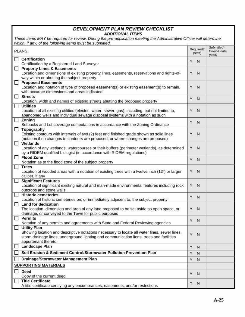
DEVELOPMENT PLAN REVIEW CHECKLIST ADDITIONAL ITEMS
These items MAY be required for review. During the pre-application meeting the Administrative Officer will determine which, if any, of the following items must be submitted.
PLANS Required? (staff)
Submitted- Initial & date (staff)
Certification Certification by a Registered Land Surveyor Y N
Property Lines & Easements Location and dimensions of existing property lines, easements, reservations and rights-of-way within or abutting the subject property.
Y N
Proposed Easements Location and notation of type of proposed easement(s) or existing easement(s) to remain, with accurate dimensions and areas indicated
Y N
Streets Location, width and names of existing streets abutting the proposed property Y N
Utilities Location of all existing utilities (electric, water, sewer, gas); including, but not limited to, abandoned wells and individual sewage disposal systems with a notation as such
Y N
Zoning Setbacks and Lot coverage computations in accordance with the Zoning Ordinance Y N
Topography Existing contours with intervals of two (2) feet and finished grade shown as solid lines (notation if no changes to contours are proposed, or where changes are proposed)
Y N
Wetlands Location of any wetlands, watercourses or their buffers (perimeter wetlands), as determined by a RIDEM qualified biologist (in accordance with RIDEM regulations)
Y N
Flood Zone Notation as to the flood zone of the subject property Y N
Trees Location of wooded areas with a notation of existing trees with a twelve inch (12”) or larger caliper, if any
Y N
Significant Features Location of significant existing natural and man-made environmental features including rock outcrops and stone walls
Y N
Historic cemeteries Location of historic cemeteries on, or immediately adjacent to, the subject property Y N
Land for dedication The location, dimension and area of any land proposed to be set aside as open space, or drainage, or conveyed to the Town for public purposes
Y N
Permits Notation of any permits and agreements with State and Federal Reviewing agencies Y N
Utility Plan Showing location and descriptive notations necessary to locate all water lines, sewer lines, storm drainage lines, underground lighting and communication liens, trees and facilities appurtenant thereto.
Y N
Landscape Plan Y N Soil Erosion & Sediment Control/Stormwater Pollution Prevention Plan Y N Drainage/Stormwater Management Plan Y N
SUPPORTING MATERIALS Deed
Copy of the current deed Y N
Title Certificate A title certificate certifying any encumbrances, easements, and/or restrictions Y N
A-25

A-26
DEVELOPMENT PLAN REVIEW CHECKLIST OTHER APPROVALS
If the project requires any of the following reviews or approvals, a copy of the pertinent approval shall be submitted. APPROVAL/PERMIT Initial &
Date (staff) Soil Erosion and Sediment Control/Construction Site Runoff Control (Middletown DPW)
Written confirmation from the Building Official or designee that the proposal has an approved Plan in accordance with Town Code Chapter 151 – Soil Erosion and Sediment Control/ Construction Site Runoff Control.
Drainage/Stormwater Management (Middletown DPW)
Written confirmation from the Director of Public Works that the proposal has an approved Stormwater Management Plan in accordance with Town Code Chapter 153 – Stormwater Management Ordinance.
Freshwater Wetlands (RI Department of Environmental Management - RIDEM)
1) Written confirmation from the RIDEM that development plans, including any required off-site construction, have been reviewed and indicating that the Wetlands Act either does not apply to the proposed site alteration, or that approval has been granted for the proposed site alteration
or
2) Affidavit signed by a qualified professional (having minimum qualifications as described by the RIDEM Department of Freshwater Wetlands) stating that there are no freshwater wetlands or wetland buffers (perimeter wetlands) present on the subject property (in accordance with RIDEM Wetland Regulations)
Coastal Wetlands (Coastal Resources Management Council – CRMC)
Preliminary determination from the CRMC if the property is subject to the jurisdiction of this agency
Physical Alteration Permit (RI Department of Transportation – RIDOT)
A Physical Alteration Permit (PAP) issued by the RIDOT for any connection or construction work within a state highway or state right-of-way
Water Availability (Newport Water Department)
1) A copy of the water service contract covering the installation of water service
or
2) Written confirmation that a contract has been executed or will be executed upon approval of the Planning Board (a copy of the executed contract must be submitted to the Planning Board prior to recording the plan)
Wastewater (Middletown DPW or RIDEM )
1) Written confirmation from the Middletown Department of Public Works certifying that the development can tie into the Middletown Sewer Service,
or
2) RIDEM Preliminary Subdivision Suitability Report or water table verification within the proposed development are suitable for the safe and proper operation of the ISDS

A-27
ABUTTERS LIST (Type information in boxes)
PLAT/LOT NAME/ADDRESS PLAT/LOT NAME/ADDRESS

A-28
STORMWATER MANAGEMENT PLAN CHECKLIST
(1) The applicant shall submit (x) copies of the Narrative Description and five (5) copies of all plans. Plans shall be a minimum of 8.5” x 11” and a maximum of 18” x 24” at a scale of 1” = 40’ with a sufficient number of sheets to clearly show all of the information required. Sheets shall be numbered sequentially (e.g. sheet 1 of 3, etc.) For projects involving a Subdivision, Land Development Project, or Development Plan Review, an additional seven (7) reduced copies of the plan shall be submitted (minimum size of 8.5” X 11”; maximum size of 11” X 17”).
(2) Plans shall conform to the Procedural & Technical Standards For the Practice of Land Surveying in the State of Rhode Island and Providence Plantations, as prepared by the RI Society of Professional Land Surveyors, Inc, as amended. (3)All plans must include: • Name and address of property owner or applicant and of preparer
• Date plan was prepared, and revision dates (if any)
• Vicinity or Locus Map & Aerial photography • Signature Block • Graphic Scale (1”=40’ or larger) & North Arrow • Legend showing all symbols • Assessor’s Plat & Lot numbers & Zoning district(s) • Perimeter boundary lines of subject property NARRATIVE DESCRIPTION Initial &date
(staff)
Project Description Brief description of the nature and purpose of the land disturbing activity and the amount of grading involved (acreage or square footage of disturbance.
Existing Site Conditions A description of the existing soils, topography, vegetation, and drainage
Adjacent Areas Description of the watershed the site is within, and adjacent areas which might be affected by the land disturbance
Critical Area Description of areas on or adjacent to the site, which may be seriously impacted by the development
Erosion and Sediment Control Measures/Construction Site Runoff Control A description of the methods which will be used to control erosion and sedimentation on the site before, during, and after construction. Reference 1990 RI SEICSC Handbook (available through RI RC&D 885-1321; can refer to proposed SWMPP)
Stormwater Management Guidelines Compute pre-and post-development runoff discharges using “TR 55” method
Adherence to Stormwater Management Regulations Design necessary permanent and temporary stormwater management specifications, including control structures to minimize sediment transport and flooding. Evaluate the final off-site destination of the runoff.
Computations Include all supporting computations, in an orderly manner, for hydrology and design structures, including all “TR 55” and other accepted methodology worksheets and computer printouts (CN number, time of concentration, storage volumes, hydrographs, etc.)
Maintenance Include schedules of regular inspection, operation and maintenance, and authority delegations.
Review Process Include a listing of all agencies currently reviewing the project and the status of these reviews.
Water Quality Impacts Discuss possible pollutant sources; evaluate the impact on any water body, including groundwater aquifers, intermittent and perennial streams, ponds and wetlands; and discuss any possible measures to be used in reducing, mitigating this impact.
Soils If stormwater management control measures depend on the hydrologic properties of soils, a soils report based on onsite boring logs or testhole data

A-29
STORMWATER MANAGEMENT PLAN CHECKLIST – CON’D SITE PLAN Initial & Date
(staff)
Topography Existing and proposed contours (2’ minimum)
Soils Boundaries of different soil types within the watershed, including delineation of the site. (Copies of soil survey sheets with boundaries and roadways drawn on the map are sufficient).
Watershed Patterns Delineate the watershed sub areas and indicate all water course flow directions including pre-and post-development conditions. Delineate all flow “TR 55”, ID segments on the plan.
Wetlands The delineation, if applicable, of the 100-year floodplain and any on site wetlands.
Limits of Clearing and Grading Outline areas to be cleared and graded
Phasing If a project is to be phased, delineate limits of each phase (including temporary grading)
Location of Practices The location of the erosion and sediment control and stormwater management practices used on the site, included within a legend, where appropriate.
Improvements Any existing or proposed improvements, including location of buildings or other structures, impervious surfaces, storm drainage facilities, and all grading.
Easements & rights-of-way Existing and/or proposed
CONSTRUCTION DRAWINGS
Details Structural and construction details for all components of the proposed drainage system or systems, and stormwater management facilities
Specifications All necessary construction specifications
Erosion and Sediment Control Erosion and sediment control measures to be implemented in all construction phases along with final site stabilization plans
Area of Disturbance Limits of clearing and overall site disturbance
Data Data for total site area, disturbed area, new impervious area, and total impervious area
Planting Materials A table of materials to be used for stormwater management facility planting
Certification Certification, by the owner/developer, that all stormwater management construction will be done according to this plan
As-Built An as-built certification signature block to be executed after project completion
Maintenance Plan Detailed maintenance and repair procedures to ensure continued function of stormwater management facilities.

MDPW FORM NO. 1
Sheet No. ( ) of ( )
COST ESTIMATE DEVELOPER
DEVELOPMENT NAME:
DEVELOPMENT LOCATION:
ENGINEER:
ITEM NO.
QUAN.
UNIT
MEAS.
ITEM
UNIT
COST
TOTAL
COST
A-30

A-31
ITEM NO.
QUAN.
UNIT
MEAS.
ITEM
UNIT
COST
TOTAL
COST

APPENDIX B - Drawings
This appendix contains drawings depicting the specifications for required improvements and other graphic information.
TYPICAL STREET CROSS SECTON DETAIL ..................................................................................................... B-1 TYPICAL DRIVEWAY CURB CUT DETAIL ........................................................................................................ B-2 CUL DE SAC DETAIL ............................................................................................................................................. B-3 RIVERINE FLOOD HAZARD AREAS ................................................................................................................... B-4
B-0

TYPICAL STREET CROSS SECTON DETAIL
B- 1

TYPICAL DRIVEWAY CURB CUT DETAIL
B-2

CUL DE SAC DETAIL
B- 3

RIVERINE FLOOD HAZARD AREAS
B-4

APPEDNIX C- Conservation Development Design Process
Step 1 - Analyze the Site The first step is to inventory existing site features, taking care to identify sensitive and noteworthy natural, scenic and cultural resources on the site, and to determine the connection of these important features to each other and strategies for protection.
Step 2 - Evaluate Site Context The second step is to evaluate the site in its larger context of the neighborhood and Town by identifying physical (e.g., stream corridors, wetlands), transportation (e.g., street and bicycle networks), and cultural (e.g., open spaces, recreational opportunities) connections to surrounding land uses and activities.
Step 3 - Designate Potential Conservation Areas The third step is to identify the areas on the site to be preserved on the site as open space. The open space shall at a minimum include portions of the site that are unsuitable for development and which constitute the most sensitive and noteworthy natural, cultural and recreational resources of the site. Where appropriate, areas that serve to extend neighborhood open space networks to/from surrounding property shall be identified. The designation of open space shall reflect consistency with the Middletown Comprehensive Plan.
Step 4 - Determine Maximum Number of Units At the master plan stage for major subdivisions and major land development projects, and at the preliminary stage for minor subdivisions and minor land development projects, the applicant and Planning Board shall agree upon an initial number of dwelling units and total square foot area of non-residential uses that will be permitted in the conservation development or subdivision, using the Yield Plan approach as described in Section 10-10.6 or the density calculations specified in Article 25 of the Zoning Ordinance for the MXD zoning districts..
Step 5 - Locate Development Areas and Explore Conceptual Alternatives
The sixth step is to locate development areas and specific building sites, using the proposed open space as a base map as well as other relevant data on the Existing Resources and Site Analysis Map. The design shall take into account the potential negative impacts of development on nearby conservation areas as well as the potential positive benefits of such locations to provide attractive views and visual settings for residences, with emphasis on consistency with Middletown’s character.
Step 6 - Locate the Building Sites The sixth step is to locate building sites, using the proposed open space as a base map as well as other relevant data on the Existing Resources and Site Analysis Map. The design shall take into
C-1
account the potential negative impacts of development on nearby conservation areas as well as the potential positive benefits of such locations to provide attractive views and visual settings for residences, with emphasis on consistency with Middletown’s character.
Step 7 - Lay Out Streets, Trails and Other Infrastructure Upon designation of the building sites, a street plan shall be designed to provide vehicular access to each building, complying with the standards herein and bearing a logical relationship to topographic conditions. Detailed information regarding stormwater drainage, water supply and sewage disposal, trails, sidewalks and other infrastructure are also provided during this step.
Step 8 – Design and Program Open Space Details regarding the use, design, ownership and management of proposed open spaces shall be developed during the review process. Starting with conceptual proposals at the early stages of review, the function of open space areas shall be developed and refined. Based on review by the Planning Board and other reviewers, these concepts shall be clarified during the review process to establish as clear an approach to the use and maintenance of open space as it does for development areas.
Step 9 - Draw in the Lot Lines Upon completion of the preceding 8 steps, the next step is simply to draw in the lot lines to delineate the boundaries of individual residential lots (if applicable).
Step 10 - Establish Ownership and Management of Open Space and Other Community Elements At the time of preliminary review for major land development projects or major subdivisions, or at the time of final review for minor land development projects or minor subdivisions, a more detailed open space use and management plan as described in Section 10-10.7.A shall be submitted.
C -2

C-3
Conclusions/Outcomes form Pre-application Review
• Agreement on areas for further investigation, necessary detail of field surveys, etc.
• Approximate location of natural, cultural and recreational resources and agreement on town’s priorities for resource protection in the areas of the site.
• Understanding of resource systems within the site’s larger context.
• Preliminary location of potential conservation and development areas.
• Agreement on approach to determining maximum number of units.
• Schedule for the site visit(s)
• Agreement regarding the consultants, if any, the community will use to assist in the review process.
Conclusions/Outcomes from Site Visit
• Agreement on areas for further investigation, necessary detail of field surveys, etc.
• Agreement on general location of natural, cultural and recreational resources within the site and the need for further surveys.
• Review of general boundaries of potential conservation and development areas.
• Agreement on the general visual and social character of the neighborhood, and the type of development that would best fit in.
Conclusions/outcomes from Master Plan Review Areas for further investigation, soil tests, borings, necessary detail of field surveys, tc. To be
done for the Preliminary Plan submission.
• Location and function of natural, cultural and recreational resources.
• Function and value of resource systems within the site’s larger context
• Location of potential conservation and development areas
• Maximum number of units
• Design and uses of open space areas, trail connection, and other shared amenities
• Location and design of streets, homes and other elements
• Criteria for establishing lot lines, pending further site surveys and analysis
• Ownership, maintenance and management responsibility of open space areas
• Relevant town goals for the area.