
RSPO N OTIFICATION O F PROPOSED NEW PLANTING NOTIFICATION OF... · The HCV identified in PT. Karya...
12
This notif procedure on local o Date of n Tick which √ COMPAN SUBSIDIA RSPO Me Location o Compan Locatio Geogra Surroun a. No b. Sou c. We d. Eas New Pla Permit a. De Eliw Sep b. Tax fro Kal Kan RSPO fication sha es for new on‐site noti otification hever is ap This is a co This is par Y ARY (If any) mbership of proposed ny name n phical locat nding Entitie rth. IUPHHK uth. Border est. IUPHHK st. Borderin anting Area ed of Comp waty Tjitra, ptember 19 xable letter m Republic limantan Ta nan Village, NOTIFICA all be on th w plantings ice boards n: 5 Decem ppropriate ompletely rt of an ong ) Number d new plant : P : K d K tion : 0 es : K PT INHUT ing the City K PT INHUTA ng the City D a : ± pany on beh S.H. (Minist 999). Inauguratio c of Indones axation with , Ketapang D ATION O he RSPO w (http://ww s. ber 2013 new devel going plant : PT BU : PT KA : 1‐004 ting : PT Karya M Kampar Seb district of S Kalimantan 0 0 40’ 23” ‐ TANI (Timbe y District of ANI (Timber District of Si ± 12,500 Ha : half PT KML try of Justic on: PEM‐10 sia Ministry h tax numbe District. OF PROPO website for ww.rspo.o opment an ting and is UMITAMA ARYA MAK 43‐07‐000‐ akmur Lang bombam/Si impang Dua , Indonesia 0 0 50’ 16” N er Concessio Simpang Du r Concessio mpang Dua a dated 19 N ce Decree R 0339/WPJ.1 of Finance er 02.355.7 OSED NE 30 days as rg/?q=pag nd stakeho meant for A GUNAJAY KMUR LAN ‐00 ggeng (PTKM mpang Dua a, District o . North and 1 on Company ua n Company a November 2 I No.C‐1746 3/KP.0303/ Regional O 23.4‐703.00 W PLAN s required ge/535). It h olders may r notificatio YA AGRO NGGENG ML) a/Semandan f Ketapang, 110 0 9’ 0.1” y) y) 2003 Numbe 6.HT.03.02‐ /2012 dated ffice of Dire 01 on behal TING by the RSP has also be submit co on only. ng Kanan vi , Province o ‐ 110 0 25’ 3 er 71 based ‐Th.1999 da d 27 Septem ectorate Ge lf PT KML Se PO een posted mments. llages, Sub of West 31” East d Notary ated 1 mber 2012 eneral of We emandang d est
Transcript of RSPO N OTIFICATION O F PROPOSED NEW PLANTING NOTIFICATION OF... · The HCV identified in PT. Karya...

This notif
procedure
on local o
Date of n
Tick which
√
COMPAN
SUBSIDIA
RSPO Me
Location o
Compan
Locatio
Geogra
Surroun
a. No
b. Sou
c. We
d. Eas
New Pla
Permit
a. De
Eliw
Sep
b. Tax
fro
Kal
Kan
RSPO N
fication sha
es for new
on‐site noti
otification
hever is ap
This is a co
This is par
Y
ARY (If any)
mbership
of proposed
ny name
n
phical locat
nding Entitie
rth. IUPHHK
uth. Border
est. IUPHHK
st. Borderin
anting Area
ed of Comp
waty Tjitra,
ptember 19
xable letter
m Republic
limantan Ta
nan Village,
NOTIFICA
all be on th
w plantings
ice boards
n: 5 Decem
ppropriate
ompletely
rt of an ong
)
Number
d new plant
: P
: K
d
K
tion : 0
es :
K PT INHUT
ing the City
K PT INHUTA
ng the City D
a : ±
pany on beh
S.H. (Minist
999).
Inauguratio
c of Indones
axation with
, Ketapang D
ATION O
he RSPO w
(http://ww
s.
ber 2013
new devel
going plant
: PT BU
: PT KA
: 1‐004
ting :
PT Karya M
Kampar Seb
district of S
Kalimantan
00 40’ 23” ‐
TANI (Timbe
y District of
ANI (Timber
District of Si
± 12,500 Ha
:
half PT KML
try of Justic
on: PEM‐10
sia Ministry
h tax numbe
District.
OF PROPO
website for
ww.rspo.o
opment an
ting and is
UMITAMA
ARYA MAK
43‐07‐000‐
akmur Lang
bombam/Si
impang Dua
, Indonesia
00 50’ 16” N
er Concessio
Simpang Du
r Concessio
mpang Dua
a
dated 19 N
ce Decree R
0339/WPJ.1
of Finance
er 02.355.7
OSED NE
30 days as
rg/?q=pag
nd stakeho
meant for
A GUNAJAY
KMUR LAN
‐00
ggeng (PTKM
mpang Dua
a, District o
.
North and 1
on Company
ua
n Company
a
November 2
I No.C‐1746
3/KP.0303/
Regional O
23.4‐703.00
W PLAN
s required
ge/535). It h
olders may
r notificatio
YA AGRO
NGGENG
ML)
a/Semandan
f Ketapang,
1100 9’ 0.1”
y)
y)
2003 Numbe
6.HT.03.02‐
/2012 dated
ffice of Dire
01 on behal
TING
by the RSP
has also be
submit co
on only.
ng Kanan vi
, Province o
‐ 1100 25’ 3
er 71 based
‐Th.1999 da
d 27 Septem
ectorate Ge
lf PT KML Se
PO
een posted
mments.
llages, Sub
of West
31” East
d Notary
ated 1
mber 2012
eneral of We
emandang
d
est
c. Land Information letter from the Regent Ketapang No.525/123/IV‐Bapedalpembda dated
21 February 2006 to explain about the approval area of oil palm plantation development of
± 19,000 ha within the production forest area (HPK) by SK Menhutbun number 259 of 2000.
d. Location Permit
Location Permit for Oil Palm Plantation Development Purposes under the name of PT KML
based on Ketapang Regency Decree No. 293 of 2006 dated 13 October 2006 for an area of
± 19,000 ha, located in the Village of Pasir / Simpang Dua / Mariangin, Sub‐District of
Simpang Dua, District of Ketapang. Location permit is valid for 3 years.
Based on Ketapang Regency Decree No. 24 of 2010 on Construction Site Permit Renewal
Oil Palm Plantation and Processing Plant for PT KML dated 13 January 2010 for the land
area of ± 19,000 ha in force for 12 months from the stipulated of decision date.
Certificate of Regents Ketapang Number: 100/1437/PEM dated 18 July 2013 that explain:
PT KML has obtained the Location Permit through a Renewed Location Permit of
Regent Ketapang No. 24 Year 2010 dated 15 January 2010 for ± 19,000 ha.
PT KML is still active in business and Ketapang district government supports business
activity that is sustainable by not issuing location permits to other companies. And PT
KML intends to continue to obtain the related licensing for its business and in line with
the requirement of the Indonesian Law and Regulations.
e. Converted forest area released by the Republic Indonesia Ministry of Forestry Number:
SK.689/Menhut‐II/2011 dated 8 December 2011 on release of Forest Production Convertible
For Oil Palm Plantation for PT KMLfor the Group of Forest of Semandang River and Kuwalan
River of Ketapang District, West Kalimantan Province covering an area of 18,483.2 ha.
f. Environment Impact Assessment/ Analisa Dampak Mengenai Lingkungan (EIA/AMDAL)
Environmental Feasibility of Plantation Activity (±18,483.2 ha) and the Palm Oil Processing
Plant (plant capacity 60 ton ffb/hour) by PT KML in sub district of Simpang Dua and
Simpang Hulu, Ketapang district of West Kalimantan Province by West Kalimantan Regent
Decree Number: 201/BLHD/2013 dated 14 March 2013.
Environmental Permit for Plantation Activity (± 18,483.2 ha) and the Palm Oil Processing
Plant (plant capacity 60 ton ffb/hour) by PT KML in sub district of Simpang Dua and
Simpang Hulu, Ketapang district of West Kalimantan Province by West Kalimantan Regent
Decree Number: 262/BLHD/2013 dated 29 May 2013.
g. Plantation Business Permit (Izin Usaha Perkebunan/IUP).
Oil Palm Plantation Business Permit (IUP) PT KML according to Ketapang Regency Decree
No.510/DISBUN‐D/2013 dated 16 October 2013 for a land area of 16,700 ha with an oil
processing plant with processing capacity of 60 tons ffb/hour which is located in s sub
district of Simpang Dua and Simpang Hulu District, Ketapang District, West Kalimantan
Province, Indonesia.
h. Report of Field Orientation on Conditions and Potential Wood Vegetation in the Area of
Location Permit of PT KML in Ketapang District of West Kalimantan Province from Forestry
Department of West Kalimantan dated 27 June 2013 which explain technically why a Timber
Utilization Permit (izin Pemanfaatan Kayu/IPK) is not required for Land Clearing:
Area of ± 4,252.85 ha are young forest category which are physically dominated by
small‐diameter trees (10 cm to 20 cm)
Area of ± 14,236.35 ha is a non‐forest area (open land, bushes, farming community
and residential area )
This means that PT KML is allowed to conduct the Land Clearing directly.
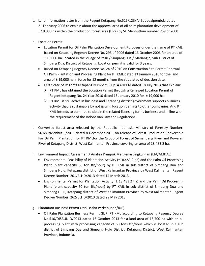
Figure 1. Location Map of PT. Karya Makmur Langgeng
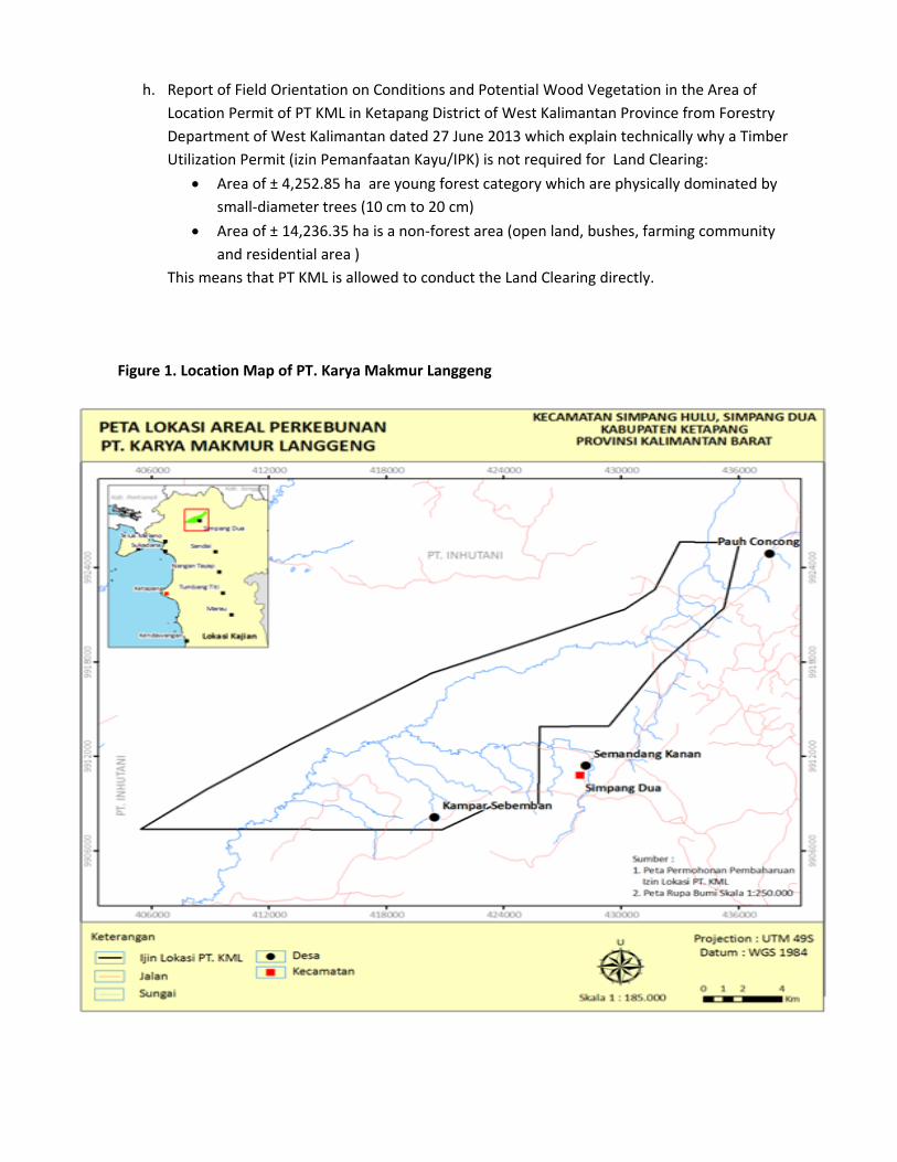
Figure 2. Land System Map of PT. Karya Makmur Langgeng

Figure 3. Topography Map of PT. Karya Makmur Langgeng

Figure 4. Conservation Area Map of PT. Karya Makmur Langgengg

Figure 5. P
Planting Plaan Area Map
p of PT. Karrya Makmuur Langgengg

SUMMARY FROM SEI ASSESSMENT:
PT KML had conducted the Environmental Impact Assessment (EIA/AMDAL) separately from other RSPO required assessment. The EIA was conducted by the government accredited assessor (CV Alam Indo Lestari) while the RSPO assessment called Social Impact Assessment (SIA) was conducted by PT Sonokeling Akreditas Nusantara team and led by RSPO approved HCV assessor (Ir. Kresno Dwi Santosa, M.Si) on May to June 2012.
The main focus of EIA is the company profile, general condition of the project using demographic data, economic status as well as availability of public transportation. The assessment is also conducted to identify the demand of transparent aspect (principal 1) and legal compliance as well as applicable law (principal 2) stated in the Indonesian RSPO P&C, land availability, community perception of the project, as well as the existence of conservation area based on HCV toolkit Indonesia.
The EIA review of documentary sources covers a collection of data and information from the Focus Group Discussion (FGD), in‐depth interview, government policy, and village profile data. The assessment also covered field observation and public consultation meetings for the villages within the project area and for affected landowners of surrounding communities. Summaries and findings of the interviews and public consultation meetings are included in the EIA report.
SUMMARY FROM HCV ASSESSMENT:
The on‐site HCV assessment of PT KML project conducted by the PT Sonokeling Akreditas Nusantara was for the period of 22 June to 07 July 2012 and was led by RSPO approved HCV assessor, Ir. Kresno Dwi Santosa, M.Si.
The assessment included satellite imaginary analysis, extensive field surveys, and public consultations with the communities living in the project area (Villages of Semandang Kanan, Paoh Concong, Kampar Sebomban). The HCV assessment report included recommendations for the management especially on the improvement of the HCV found within the project area.
The HCV identified in PT. Karya Makmur Langgeng project area were clearly mapped. Based on identification and analysis of HCV presence in the area of PT. KML there were found HCV1.1, HCV1.2, HCV1.3, HCV1.4, HCV2.3, HCV4.1, HCV4.2, HCV5 and HCV6 with total area coverage of 2,195.72 ha. No area supporting HCV 3 is identified. Location plan and the new land to be open was not in the area of primary forest, it is in the Conversion Production Forest/Hutan Produksi Konversi (HPK) Table 1. Identification and Analysis of HCVs Presence (HCV1‐6) in the Area of PT. Karya Makmur Langgeng
HCV/ Components Type of HCV
Location
HCV1. Areas with high concentrations of biodiversity
1. Areas that contain or provide biodiversity support functions to protection or conservation areas
Present 1. Riparian of Banjur River 2. Riparian of Lamata River 3. Riparian of Raraba River 4. Riparian of Semadang River/Prodang 5. Seriung Hill 6. Batu Tulur Hill 7. Block 17 hill
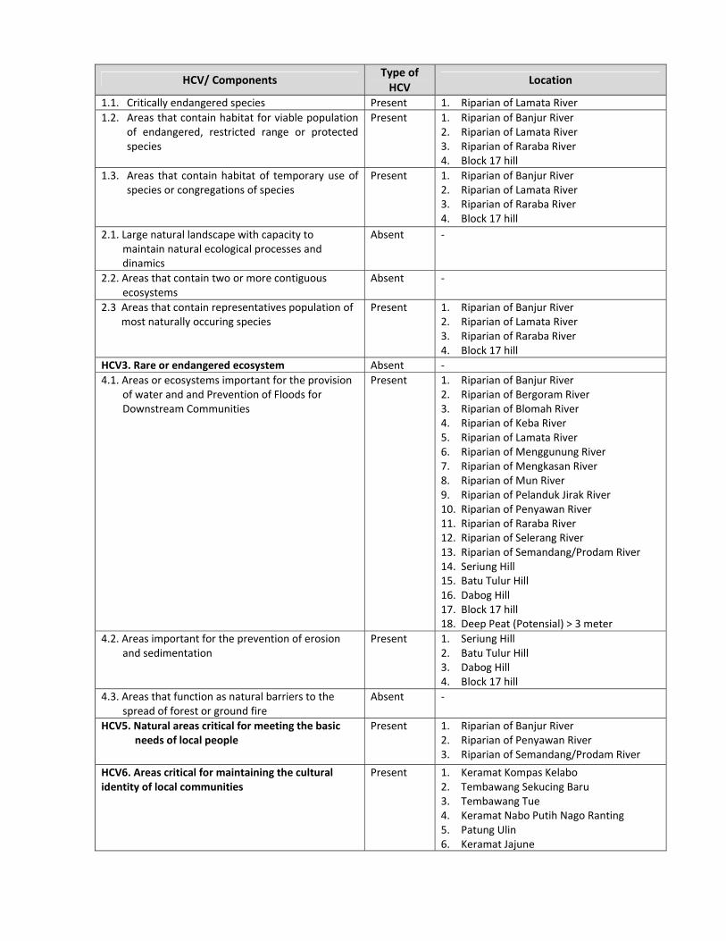
HCV/ Components Type of HCV
Location
1.1. Critically endangered species Present 1. Riparian of Lamata River
1.2. Areas that contain habitat for viable population of endangered, restricted range or protected species
Present 1. Riparian of Banjur River 2. Riparian of Lamata River 3. Riparian of Raraba River 4. Block 17 hill
1.3. Areas that contain habitat of temporary use of species or congregations of species
Present 1. Riparian of Banjur River 2. Riparian of Lamata River 3. Riparian of Raraba River 4. Block 17 hill
2.1. Large natural landscape with capacity to maintain natural ecological processes and dinamics
Absent ‐
2.2. Areas that contain two or more contiguous ecosystems
Absent ‐
2.3 Areas that contain representatives population of most naturally occuring species
Present 1. Riparian of Banjur River 2. Riparian of Lamata River 3. Riparian of Raraba River 4. Block 17 hill
HCV3. Rare or endangered ecosystem Absent ‐
4.1. Areas or ecosystems important for the provision of water and and Prevention of Floods for Downstream Communities
Present 1. Riparian of Banjur River 2. Riparian of Bergoram River 3. Riparian of Blomah River 4. Riparian of Keba River 5. Riparian of Lamata River 6. Riparian of Menggunung River 7. Riparian of Mengkasan River 8. Riparian of Mun River 9. Riparian of Pelanduk Jirak River 10. Riparian of Penyawan River 11. Riparian of Raraba River 12. Riparian of Selerang River 13. Riparian of Semandang/Prodam River 14. Seriung Hill 15. Batu Tulur Hill 16. Dabog Hill 17. Block 17 hill 18. Deep Peat (Potensial) > 3 meter
4.2. Areas important for the prevention of erosion and sedimentation
Present 1. Seriung Hill 2. Batu Tulur Hill 3. Dabog Hill 4. Block 17 hill
4.3. Areas that function as natural barriers to the spread of forest or ground fire
Absent ‐
HCV5. Natural areas critical for meeting the basic needs of local people
Present 1. Riparian of Banjur River 2. Riparian of Penyawan River 3. Riparian of Semandang/Prodam River
HCV6. Areas critical for maintaining the cultural identity of local communities
Present 1. Keramat Kompas Kelabo 2. Tembawang Sekucing Baru 3. Tembawang Tue 4. Keramat Nabo Putih Nago Ranting 5. Patung Ulin 6. Keramat Jajune

Table 2. Management Plan of HCV Area for PT Karya Makmur Langgeng.
Number HCV Area HCV Attribute
Total HCV Area
Identified (ha)
HCV Area Managed
(ha)
1 Sungai Banjur 1.1,1,3,1,4, 2,3, 4.1, 5. 108.38 88.28
2 Sungai Bergoram 4.1 42.87 30.21
3 Sungai Blomah 4.1 52.06 50.07
4 Sungai Keba 4.1 28.5 9.47
5 Sungai Lamata 1.1,1,2,1,3,1,4,2,3, 4.1 80.26 57.30
6 Sungai Menggunung 4.1 27.14 25.56
7 Sungai Mengkasan 4.1 47.64 32.15
8 Sungai Mun 4.1 23.01 6.8
9 Sungai Pelanduk Jirak 4.1 17.83 3.07
10 Sungai Penyawan 4.1, 5 67.9 42.01
11 Sungai Raraba 1.1,1,3,1,4,2,3, 4.1 63.62 50.04
12 Sungai Selerang 4.1 18.33 0.00
13 Sungai Semandang/Prodam 1.1, 4.1, 4.3, 5. 893.73 893.73
14 Bukit Seriung 1.1, 4.1, 4.2 258.96 0.00
15 Bukit Batu Tulur 1.1, 4.1, 4.2 117.94 0.00
16 Bukit Dabog 4.1, 4.2 26.11 26.11
17 Bukit 17 1.1,1.3,1.4,2.3,4.1, 4.2 64.27 64.27
18 Kawasan Lindung Gambut 4.1. 179.59 62.00
19 Keramat Kompas Kelabo 6 0.005 0.05
20 Tembawang Sekucing Baru 6 47.03 47.03
21 Tembawang Tue 6 21.53 21.53
22 Patung Ulin 6 0.005 0.00
23 Keramat Nabo Putih Nago Ranting 6 0.005 0.00
25 Keramat Jajune 6 0.005 0.00
Total 2,195.72 1 ,509.68
DOCUMENTATION OF FREE, PRIOR AND INFORMED CONSENT
In accordance with RSPO requirements PT KML needs to obtain free, prior and informed consent
from the local community that would be affected by the development of the concession area or land
that would be opened. The documents are as follows:
1. Minutes of the Meeting of Socialization Development of Oil Palm Plantation in District PT. Karya
Makmur Langgeng at Sub district of Simpang Dua and Simpang Hulu, Ketapang District on:
a. On 5 March 2012 which took place at the Church of Pantan Hamlet, Village Kampar
Sebomban, sub district of Simpang Dua, attended by TP3K (Tim Pembina Pembangunan
Perkebunan Kabupaten) Ketapang, Muspika of Simpang Dua, Chairman of the Dayak Culture
Board of Simpang Dua, Village Head and the Village Board of Trustees (BPD) Kampar
Sebomban, Chief of Pantan Hamlet, Chief of Mentawa Hamlet, Semandang Kanan Village
Head, head of Sekucing Baru Hamlet, Head of Sei Tontang Hamlet and Head of Selantak
Hamlet.
b. On 6 March 2012 held at Elementary School Building Kek Lipur Hamlet, Concong Paoh village,
Simpang Hulu Sub district, which was attended by TP3K Ketapang, Muspika Simpang Hulu,
Concong Paoh Village Head, Head of Kek Lipur Hamlet, Head of Baram Hamlet and community
representatives.
2. Available evidence of the land acquisitions process on the operational area of PT KML contained
154 land spots with an area of 2,522.85 ha site with total compensation of Rp. 7,988,503,000
from 19 April 2013 until 19 September 2013. All documentations of all land acquisitions are
available.
Land Acquisition Data.
Identity of Land Owner.
Minutes of Land Measurement (Berita Acara Pengukuran)
Location Map of Land Measurement (Peta Lokasi Yang diukur/digantirugi).
Minutes of Price Agreement (Berita Acara Kesepakatan Harga)
Land Submission Statement (Surat Pernyataan Penyerahan Lahan).
Certificate of Land Acquisition Property/ Rights Recognition Letter and Land Tenure (Surat
Keterangan Garap (SKGR) Kepemilikan Lahan/Surat Pengakuan Hak Kepemilikan dan
Penguasaan Lahan)
Land Rights Letter (Surat Penguatan Atas Hak)
Origin of Land Letter (Surat Keterangan Asal Usul Tanah)
A Brief History of Land Tenure (Riwayat Singkat Penguasaan Tanah)
Letter of Approval Heirs (Surat Pernyataan Persetujuan Ahli Waris)
Information Letter of Heirs (Surat Keterangan Ahli Waris)
3. Interviews with local community on PT KML project area
The results of the interviews with the local people (Tunas Kampar Hamlet –Village of Kampar
Sebomban and Sekucing Baru Hamlet, Semandang Village) is known as the process of socialization
and land acquisition for the PT KML project area conducted with free prior and inform consent
where the communities also receive the Oil Palm Plantation development plan of PT KML.
SUMMARY OF PLANs:
The management New Planting Plan has incorporated the findings from EIA (AMDAL), Social Impact Assessment (SIA) and HCV assessment for implementing the operational plans. Recommendations and also conclusion from the results of EIA and HCV have also been integrated into the management plan and this is consistent with RSPO P&C for New Plantings.
VERIFICATION STATEMENT:
PT KML opted for a document verification and field observation method to conduct the New Planting Procedure. PT Mutuagung Lestari (Mutuagung) auditors have conducted desk study and discussions with sustainability officers of PT KML during the desk audit. Two of Mutuagung auditors had conducted the desk audit at KML head office in Jakarta on 16‐17 October 2013 as well as in Pontianak, West Kalimantan Province on 21‐22 October 2013 to review and verify the relevant document and also to interview the management representatives. The auditor conducted field observation on KML project area to verify the company identification of HCV on 22‐23 October 2013.

The EIA (Aassessmenadhered tcompreheapplicable
Signed for,Mutuagun Octo HP N Lead Au5 Decembe
AMDAL) connts conductto RSPO Nnsive and pRSPO Princ
, on behalf ng Lestari
ainggolan uditor er 2013
nducted byed by RSPONew Plantiprofessionaciples, Crite
of,
y the goverO accreditedng Procedully carried oria and lndi
nment appd and approure and dout accordicators for n
proved consoved assessdocumentedng to RSPOnew plantin
PT Kar
FrancGroup 5
sultants as ors. PT Karyd the asseO requiremegs.
rya Makmur
cisca TiurmDepartmen5 Decembe
well as theya Makmuressments aents and co
r Langgeng
a Damanik nt Head CCSer 2013
e HCV and r Langgeng nd plans
omply with t
S
SIA has are the


![Company Profile Makmur Perkasa Group[1].Xxxxxx](https://static.fdocuments.us/doc/165x107/5477b8e1b4af9f81108b4997/company-profile-makmur-perkasa-group1xxxxxx.jpg)