
RRI Quarry - Request for Clarification - owrb.ok.gov · RRI is in the application review and...
12
Environmental Environmental Consulting December 28, 2012 Ms. Julie Cunningham OWRB -Planning & Management Division 3800 N Classen Blvd Oklahoma City, OK 73118 RE: Request for Clarification Roos Resources, Inc.'s RRI Quarry Ms. Cunningham: ¥'-f- DEC 28 2012 Oklahoma Wa ter Resources Board VIA HAND DELIVERY Over the past several weeks I have been corresponding with you and other Oklahoma Water Resources Board (OWRB) staff regarding the monitoring and reporting rule requirements of SB 597 (82 O.S. 1020.2). Unfortunately, final rules have not been approved so there is still some outstanding uncertainty. Per your staffs suggestion, please let this letter serve as a request for clarification. Roos Resources, Inc. (RRI) submitted a mine permit application to the Oklahoma Department of Mines (ODM) on July 28 , 2011. RRI is in the application review and processing stage, but has not received a mining permit from ODM. Since the ODM permit process is rather involved, it appears that RRI will not be issued a permit for an extended period of time. According to Section 1020.2 (C)(2), RRI is considered an exempt mine. In order to maintain that status, RRI must "adopt" and "implement " a plan to monitor the accumulation and disposition of pit water. However, since we are not mining the applicability of this requirement is in question. On January 1, 2013 RRI will not produce any mine products or accumulate any pit water. Given this situation, RRI believes they are not subject to the requirements of 82 O.S. 1020.2 at this time. Section 1020.2 (C) specifically refers to ''producing" mines, which RRI is not. (Your clarification of this point would be appreciated.) RRI wants to comply whole heartedly with this law and the pending rules. In order to do so, RRI has developed and adopted a conceptual plan to monitor the accumulation and disposition of pit water, but it cannot be implemented at this time because they are not mining and there is no accumulation. Once the mining permit is issued, RRI will consult further with the OWRB on implementing the monitoring program. In the meantime, RRI proposes to report quarterly and annually to the OWRB on the mining status. This will be done in accordance with the Section 1020.2(E)(1). If the mine permit is issued between reporting periods, RRI will contact the 205 E. Main St. , Norman, OK 73069 I PO Box 1292 Norman, OK 73070 Phone: (405) 321-8181 I Fax: (405) .307-9290
Transcript of RRI Quarry - Request for Clarification - owrb.ok.gov · RRI is in the application review and...
Environmental
Environmental Consulting
December 28, 2012
Ms. Julie Cunningham OWRB -Planning & Management Division 3 800 N Classen Blvd Oklahoma City, OK 73118
RE: Request for Clarification Roos Resources, Inc.'s RRI Quarry
Ms. Cunningham:
¥'-f- &~3
~'-flo,(_.
DEC 28 2012
Oklahoma Water Resources Board
VIA HAND DELIVERY
Over the past several weeks I have been corresponding with you and other Oklahoma Water Resources Board (OWRB) staff regarding the monitoring and reporting rule requirements of SB 597 (82 O.S. 1 020.2). Unfortunately, final rules have not been approved so there is still some outstanding uncertainty. Per your staffs suggestion, please let this letter serve as a request for clarification.
Roos Resources, Inc. (RRI) submitted a mine permit application to the Oklahoma Department of Mines (ODM) on July 28, 2011. RRI is in the application review and processing stage, but has not received a mining permit from ODM. Since the ODM permit process is rather involved, it appears that RRI will not be issued a permit for an extended period of time.
According to Section 1020.2 (C)(2), RRI is considered an exempt mine. In order to maintain that status, RRI must "adopt" and "implement " a plan to monitor the accumulation and disposition of pit water. However, since we are not mining the applicability of this requirement is in question. On January 1, 2013 RRI will not produce any mine products or accumulate any pit water. Given this situation, RRI believes they are not subject to the requirements of 82 O.S. 1020.2 at this time. Section 1020.2 (C) specifically refers to ''producing" mines, which RRI is not. (Your clarification of this point would be appreciated.)
RRI wants to comply whole heartedly with this law and the pending rules. In order to do so, RRI has developed and adopted a conceptual plan to monitor the accumulation and disposition of pit water, but it cannot be implemented at this time because they are not mining and there is no accumulation. Once the mining permit is issued, RRI will consult further with the OWRB on implementing the monitoring program. In the meantime, RRI proposes to report quarterly and annually to the OWRB on the mining status. This will be done in accordance with the Section 1020.2(E)(1). If the mine permit is issued between reporting periods, RRI will contact the
205 E. Main St. , Norman, OK 73069 I PO Box 1292 Norman, OK 73070 Phone: (405) 321-8181 I Fax: (405) .307-9290

.RRI Quarry Roos Resources, Inc. Pontotoc County, OK Monitoring Plan Consultation
OWRB prior to mining. RRI will modify the strategy as needed to comply with the final rules and requirements.
Your assistance with this matter is greatly appreciated. If you need additional information please feel free to contact me at (405)761-1225 or via email at [email protected].
Geoffrey A. Canty Consultant for Roos Resources, Inc.
GACI cc: Mr. Charles Roos (RRI)
Mr. Chris Nee! (OWRB) Mr. Kent Wi lkins (OWRB) File
December 28, 2012 e.Fnviroomeotal
: . LJ~~LOIIIJ 1(...\l\~\ 21 Page

~ DEC 28 2012
Oklahoma Water Resources Board
ROOS RESOURCES
(DRAFT)
SITE SPECIFIC WATER MANAGEMENT & CONSERVATION PLAN (SSWMCP)
SUMMARY
Prepared For:
Roos Resources, Inc. RRIQUARRY
T1N, R4E & T1N R5E Murray and Pontotoc Counties, OK
Prepared By:
C Environmental 'FU.IlfLOUWG\.\\~\
CC ENVIRONMENTAL, LLC PO Box 1292
Norman, Oklahoma 73070
Plan Updated:
DECEMBER 28, 2012

RRI Q~arry Murray & Pontotoc Counties, OK
Roos Resources SSWMCP Summary
1.0 INTRODUCTION
Roos Resources, Inc. (RRI) is in the process of pennitting a limestone quarry in Murray and Pontotoc Counties near the town of Hickory. The facility, referred to as the RRI Quarry, has not been issued a petmit from the Oklahoma Department of Mines (ODM) at this time. However, according to 82 O.S. § 1020.2 (C)(2), this facility meets the defmition of an exempt mine. RRl is only obligated to adhere to the requirements applicable to an exempt mine and reserves the right to adjust the plan accordingly.
This document is a summary of the Site Specific Water Management and Conservation Plan (SSWMCP) adopted by RRI. The SSWMCP was prepared following the draft guidance released by Oklahoma Water Resources Board (OWRB) staff on November 15, 2012 (OAC 785:30-15) and generally follows a previous format developed as part of the OWRB rule making process (circa April2012). However, until a mine permit is issued and mining operations begin, a SSWMCP cannot be implemented. Currently, the facility is undisturbed, native rangeland (no active or previous mining activities) . The status of the facility will be updated following the required reporting schedule (OAC 785:30-15(E)). This draft plan was prepared for compliance purposes and is subject to change with the adoption of final rules and as the mine development process evolves.
2.0 ELEMENTS OF A SITE-SPECIFIC WATER MANAGEMENT & CONSERVATION PLAN
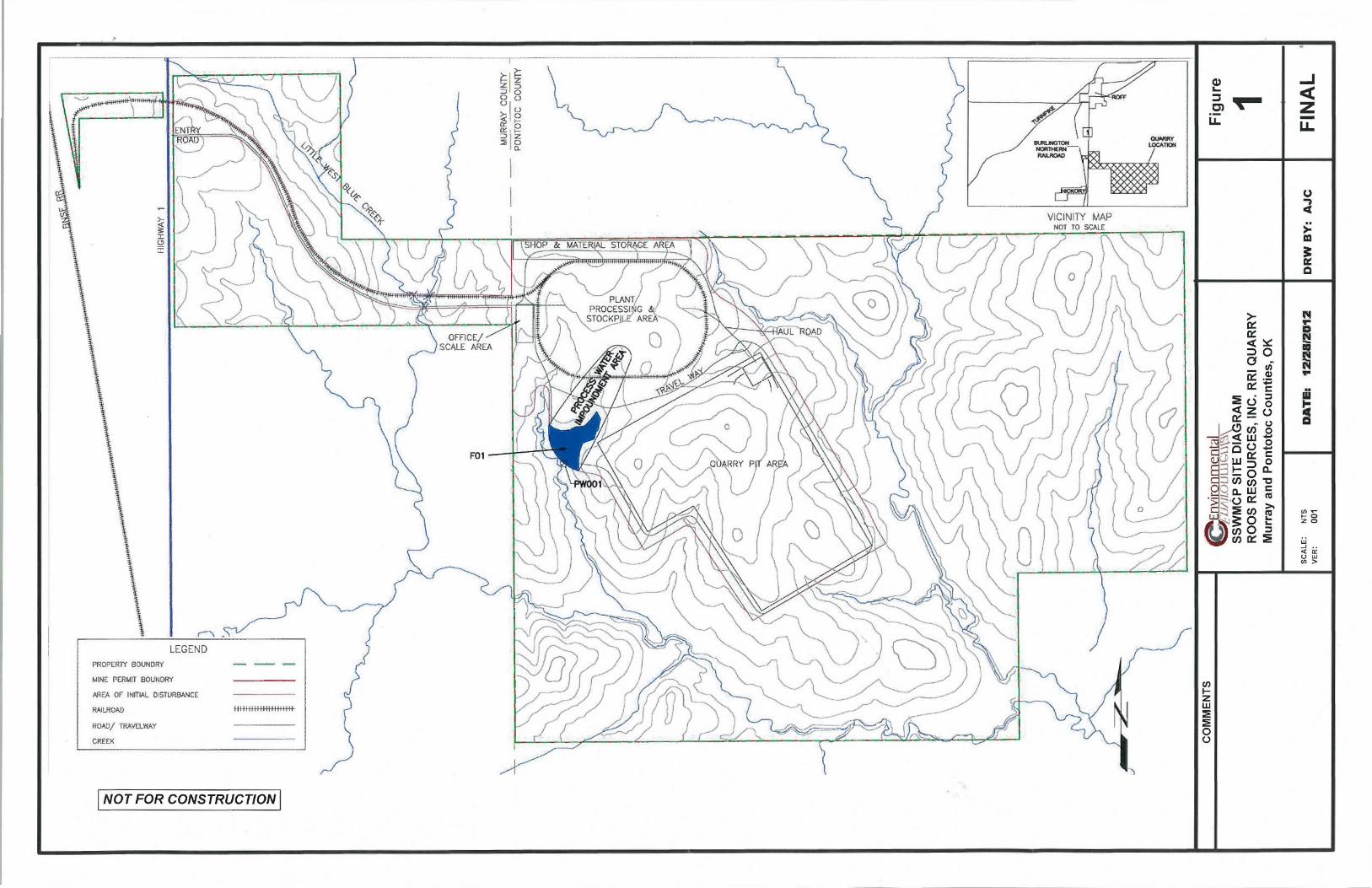
2.1 Characterization of Area (Plot Plan1)
The information associated with this element of the plan is illustrated on Figures 1 & 2. The proposed locations are generally depicted with respect to size and accuracy.
A. Location of the mining pit B. Location ofthe processing facilities C. Location and characterization of collection, settling and retention impoundments
2.2 Facility Layout (Water Flow Diagram2)
The infmmation associated with this element is illustrated on Figures 1 & 2. Please note that the amount of water and flow rate cannot be truly determined until mining begins and the SSWMCP is implemented.
A. Water collection, settling and retention impoundments • See Figures 1 & 2
B. Direction of all major water flow between the impoundments ' • See Figure 2
C. All groundwater, mine pit water, and stream water diversion points • See Figure 2 for the proposed locations of the mining ground water wells. • See Figure 2 for the location of the domestic use ground water well as defined by 82 O.S.
§ 1020.3.
1 Proposed facility layout 2 All information and locations is proposed and subject to change
December 28, 2012 21 Page

RRI Quarry Murray & Pontotoc Counties, OK
Roos Resources SSWMCP Summary
• See Figure 2 for the proposed location of the mine pit water collection area or sump. • No stream water diversion points are proposed at this time.
D. All stream water augmentation points • See Figure 2 for the locations of the proposed stream augmentation points. The number
and locations are subject to change. E. All groundwater recharge points
• No ground water recharge points are proposed at this time. F. Locations and planned quantities of all points of consumptive use
• It is assumed that water would be used for a variety purposes within the boundary of the facility. Consumptive uses would be estimated and reported on Table 1 once the plan is implemented.
2.3 Water Budgee (Anticipated Flows Into & Out of the Mine Site)
Refer to Figure 3 for an assumed depiction of the following information: A. Water flow entry and exit points B. Groundwater C. Mine pit water D. Stream water E. Precipitation runoff F. Evaporation, and G. Augmentation
2.4 Water Rights Information
RRl has two Ground Water Permits. A. Permit Number : B. Entity Name: C. Permitted Amount (ac-ft) : D. Dedicated Acres (ac):
84-653 Roos Ranch, Inc. 3,480 1,740
84-646C Roos Ranch, Inc 18,172.8 9,086.4
The proposed domestic ground water wells would be exempt (per 82 O.S. § 1 020.3)
2.5 Consumptive Use of Pit Water (Table 1)
Once mining activities begin and the monitoring plan is implemented, the consumptive use of pit ground water will be estimated. Values will be added to Table 1 (draft OAC 785 :30-15 Appendix C) and updated to reflect actual site values. This section specifically addresses OAC 785:30-15-7 of the proposed rules, but is not subject to "approval" by the OWRB at this time.
3 Actual volumes and flows will be determined once operations begin
December 28, 2012 e.Enyjroomental
: LJt,flUUl !J,,\ l\ '-\ 31 Page

RRI Qua'rry Murray & Pontotoc Counties, OK
Roos Resources SSWMCP Summary
Table 1: Water Balance Reporting Table
PIT GROUNDWATER VG>LUME
1 Total volume of water pumped from the producing mine pit(s)
2 Volume of precipitation that falls onto the surface of water in the producing mining pit(s)
3 Portion of total precipitation that flows over the land surface that drains into the mine pit water
4 Other non-pit waters pumped from the producing mine pit
5 Add lines 2 through 4
6 Pit Groundwater Volume (Line 1 minus Line 5)
DEFINED ELEMENTS OF CONSUMPTIVE USE Volume of pit groundwater that is driven off (by drying) the mined material transported off the mine
7 site Volume of pit groundwater that is carried away with the mined material transported off the mining
8 site (shipped) Volume of pit groundwater that evaporates from the producing mine pit, process water ponds, and
9 lined ponds (Excluding structures used for augmentation)
10 Volume of pit groundwater that is used for other beneficial uses off the mine site
11 Defined Elements of Consumptive Use of Pit Groundwater (Add Lines 7 through 10)
RIT GR@UNDWATER BALANCE
12 Line 6 minus Line 11 Groundwater Augmentation:
13 Volume of pit groundwater returned to the groundwater basin or subbasin
Stream Augmentation: Volume of pit groundwater discharged to a definite stream, during flow conditions that are less
14 than or equal to 50% exceedance or median historic flows
Precipitation & Run-off: Volume of precipitation and surface run-off into a recharge pit or holding pond used for
15 augmentation
Additional Discharge Volume of pit groundwater discharged to a definite stream, not meeting stream augmentation
16 credit criteria
Recycled Pit Groundwater
Volume of pit groundwater returned to a mine pit or holding basin
17 (not included on lines 7 through 1 0)
Other Non-Consumptive Losses Including pit groundwater returned to the land surface from which surface runoff flows into a mine pit, and other losses
18 (not included in lines 7 through 1 0)
19 Add lines 13 through 18
20 Other Consumptive Use (adjusted) (Line 12 minus Line 19)
TQTAL !REPORTED C®NSUMPrifiVE USE 0.F'Pff
21 Total Net Reported Consumptive Use: (Line 11 plus Line 20)
December 28, 2012 ernyjroomeotal
:u/'~LOUU.l\,\.\\\\
VALUES
0
0
0
0
0
00
0
0
0
0
00
0
0
~ 0
"C Q)
"" (..) 0
0
0
0
0
00
00
41 Page

RRI Quarry Murray & Pontotoc Counties, OK
3.0 MONITORING & MEASUREMENT SUMMARY
Roos Resources SSWMCP Summary
RRI will measure or reasonably estimate ground water and/or surface water volumes entering the mine quarry pit sump as well as measure the amount of water diverted from the pit sump once operations begin. RRI will also measure or monitor consumptive use, stream and ground water augmentation, precipitation, evaporation, hydrology data, and/or other sources and diversions of water as needed or if applicable. This section is a summary of how the various measurements might be done subject to implementation.
3.1 Definitions
For clarification purposes (subject to change per the final rules) the following definitions were adopted: A. Pit Water4
: Water captured or accumulated in a quarry pit sump, which may consist of ground water, surface water runoff, and/or precipitation from direct interception.
B. Diverted Pit Water: Pit Water pumped out of the quarry pit sump. C. Consumptive Use of Pit Water: As defined by 82 O.S. § 1020.2 (F)
3.2 Measuring Diverted Pit Water
Water that accumulates or collects in the quaiTy pit sump in excessive quantities would be pumped to another pond or impoundment or may be discharged off site. The amount of Diverted Pit Water will be estimated by direct measurement and/or by calculation (e.g., operating hours ofthe pump multiplied by its rated capacity). All equipment will be installed, calibrated and maintained according to manufacturer' s recommendations and specifications.
3.3 Measuring & Calculating Pit Water Components
The total Pit Water volume will be estimated based on the measurement or reasonable estimation of the Diverted Pit Water plus any calculated evaporation loses from the wetted surface of the sump. In order to determine what portion of the Pit Water is actual ground water, the various components need to be calculated. Each component is discussed below.
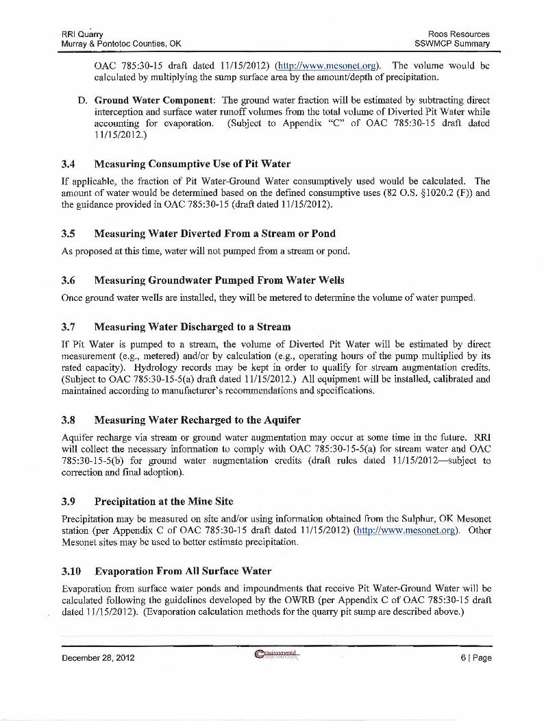
A. Evaporation Component: The volume of water lost via evaporation will be calculated by monitoring evaporation and the wetted surface area of the pit sump. The average surface area will been determined once constructed. Evaporation data will be obtained from the Sulphur, OK Mesonet station and adjusted per Appendix C of OAC 785:30-15 (draft dated 11/15/2012) (http://www.mesonet.org). The volume will be calculated by multiplying the sump surface area by the amount/depth of evaporation.
B. Surface Water Component: The surface water fraction will be estimated by calculating runoff using accepted engineering models and/or calculations (per Appendix "C" of OAC 785:30-15 draft dated 11/15/20 12).
C. Precipitation Component: The precipitation fraction of Pit Water will be measured by determining the amount of water that is contributed by direct interception into the quarry pit sump. The average sump surface area will be determined once constructed. Precipitation may be measured on site and/or obtained from the Sulphur, OK Mesonet station (per Appendix "C" of
4 This definition is different than OAC 785:30-15-2 draft dated 11 /15/2012, but more accurately reflects the definition adopted by the OWRB work group tasked with developing the rules. The final rule definition of Pit Water will be adopted in this plan.
December 28, 2012 ~fnyjronmeotql
L- IJI·.fiCJIJlll~,\\\:\\ 51 Page
RRI Quarry Murray & Pontotoc Counties, OK
Roos Resources SSWMCP Summary
OAC 785:30-15 draft dated 11115/2012) (http://www.mesonet.org). The volume would be calculated by multiplying the sump surface area by the amount/depth of precipitation.
D. Ground Water Component: The ground water fraction will be estimated by subtracting direct interception and surface water runoff volumes from the total volume of Diverted Pit Water while accounting for evaporation. (Subject to Appendix "C" of OAC 785:30-15 draft dated 11/15/2012.)
3.4 Measuring Consumptive Use of Pit Water
If applicable, the fraction of Pit Water-Ground Water consumptively used would be calculated. The amount of water would be determined based on the defined consumptive uses (82 O.S. § 1020.2 (F)) and the guidance provided in OAC 785:30-15 (draft dated 11/15/2012).
3.5 Measuring Water Diverted From a Stream or Pond
As proposed at this time, water will not pumped from a stream or pond.
3.6 Measuring Groundwater Pumped From Water Wells
Once ground water wells are installed, they will be metered to determine the volume of water pumped.
3.7 Measuring Water Discharged to a Stream
If Pit Water is pumped to a stream, the volume of Diverted Pit Water will be estimated by direct measurement (e.g., metered) and/or by calculation (e.g., operating hours of the pump multiplied by its rated capacity). Hydrology records may be kept in order to qualify for stream augmentation credits. (Subject to OAC 785:30-15-5(a) draft dated 11/15/2012.) All equipment will be installed, calibrated and maintained according to manufacturer' s recommendations and specifications.
3.8 Measuring Water Recharged to the Aquifer
Aquifer recharge via stream or ground water augmentation may occur at some time in the future. RRI will collect the necessary information to comply with OAC 785:30-15-5(a) for stream water and OAC 785:30-15-5(b) for ground water augmentation credits (draft rules dated 11/15/2012-subject to correction and final adoption).
3.9 Precipitation at the Mine Site
Precipitation may be measured on site and/or using information obtained from the Sulphur, OK Mesonet station (per Appendix C of OAC 785:30-15 draft dated 11/15/2012) (http://www.mesonet.org). Other Mesonet sites may be used to better estimate precipitation.
3.10 Evaporation From All Surface Water
Evaporation from surface water ponds and impoundments that receive Pit Water-Ground Water will be calculated following the guidelines developed by the OWRB (per Appendix C of OAC 785:30-15 draft dated 11/15/2012). (Evaporation calculation methods for the quarry pit sump are described above.)
December 28, 2012 61 Page

RRI Quarry Murray & Pontotoc Counties, OK
3.11 Water Obtained from Other Sources
Roos Resources SSWMCP Summary
At this time, RRI does not anticipate obtaining water from other sources. However, RRI reserves the right to pursue and obtain water from any and all legally permissible sources.
4.0 REPORTING
As required by 82 O.S. §1020.2(E)(l), RRI will adhere to the schedule for quarterly and annual reporting. However, since RRI does not have an ODM permit and has not mined any property, there is nothing to report-the site is native rangeland. Instead, RRI will report on the status of the mine permit. RRI will consult fmiher with the OWRB once the mine permitting process proceeds. Any report would follow an acceptable format readily readable by the OWRB.
December 28, 2012 71 Page
r--'\
LEGEND PROPERTY BOUNDRY
MINE PERMIT BOUNDRY
AREA OF INfTIAL DISTURBANCE
RAILROAD
ROAD/ TRAVELWAY
CREEl<
ll lllllllllllllllllll
[NOT FOR CONSTRUCTION I
en 1-z w :a: :a: 0 (.)

COMMENTS
PW FLOWPATH ______..
PROPOSED STREAM AUGMENTATION PT •
PROCESS WATER IMPOUNDMENT
STOCK/USGS/WINDMILL WELLS
PROPOSED WELLS • •
~Environmental ~EUAfLOUWG\J\~\ TOPO MAP ROOS RESOURCES, INC. RRI QUARRY Murray and Pontotoc Counties, OK
SCALE: NTS
VER: 001 DATEa 121Z1112D12
Figure
2 DRWBY1 DDS FINAL

.------GROUNDWATER
WELLS STORM WATER ------...,
(OWRB PERMITS 84-653 AND 84-646C) (RUNOFF, PIT WATER, PPT INTERCEPTION, ETC)
0- 2.32 MGD FLOW TBD
I
3: 0 __J I 1.1..
0 z co 0:: 1-::::> I-w 0::
--
_____________ ..,...
SYSTEM GAINS .. (PPT INTERCEPTION, RUNOFF, ETC)
.. I
I TBD I
COMMENTS
-ALL VALUES ARE ESTIMATED & APPROXIMATE
- POTENTIAL FLOW PATH -------~
-TYPICAL FLOW PATH
I : -~>---~: I SHOP USES I
,,
CRUSHED STONE PROCESSING
{SCREENS/WASHERS/DUST SUPPRESSION, ETC.)
TBD
,, PROCESS WATER
IMPOUNDMENT F01
...
... ..
~--
.. -16.29 MG VOLUME I
I I I I I I I I I
' STREAM DISCHARGE/ AUGMENTATION
(TO UNNAMED TRIBS. TO LITTLE
WEST BLUE CREEK)
TBD
• • •
•
L--1 ___ TB_D __ __jl
PROCESS LOSSES (EVAPORATION, M.C., ETC.)
TBD
SYSTEM LOSSES (EVAPORATION, SEEPAGE, ETC.)
I TBD I
FACILITY DUST SUPPRESSION
TBD
• • • • •
-
• •
DOMESTIC WELL DOMESTIC WELL
~Environmental ~£UilfLOUWGti\~\
•
•
•
•
•
•
• •
' OFFICE/SCALE HOUSE CONSUMPTION
TBD
SEPTIC SYSTEM
• • • • •
SSWMCP WATER BALANCE & FLOW PATHWAYS Roos Resources, Inc.- RRI Quarry Murray & Pontotoc Counties, OK
' SHOP CONSUMPTION
TBD
SEPTIC SYSTEM
• • • •
Figure
3
•
FINAL SCALE: NTS
VER: 001 DATE: 12128112 DRWBY: A.IC
•
•
•
•
•
•
•
•
•