Rosemont 138-kV Transmission Line Project · Em pi Ra c h . Rd. ra C n R. Duval Mine Rd. i t e H se...
23
March 2009 Rosemont 138-kV Transmission Line Project Public Open House Meeting #1 March 24 and 25, 2009
Transcript of Rosemont 138-kV Transmission Line Project · Em pi Ra c h . Rd. ra C n R. Duval Mine Rd. i t e H se...

March 2009
Rosemont 138-kVTransmission Line Project
Public Open House Meeting #1
March 24 and 25, 2009

2March 2009
2
Project Overview
• TEP, as a part of its obligation to serve, is proposing to construct and
operate a new 138-kV transmission line for the proposed Rosemont Copper
operations
• Project area - south of Tucson with lands managed by Arizona State Land
Department, Forest Service, some Bureau of Land Management and
privately-owned lands and under the planning jurisdictions of City of Tucson,
Town of Sahuarita, and Pima County
• Planning process - includes environmental studies and public input
conducted to assist in identification and comparison of alternative
transmission line routes and environmental impacts
• Project requires review by the Arizona Corporation Commission’s (ACC)
Power Plant and Transmission Line Siting Committee resulting in a
recommendation to and a final determination by the ACC prior to
construction

N:\projects\Rosemont Copper\TEP_Lopez\mxds\RMC_Base_Hillshade_92.mxd
Arizona
R o s e m o n t 1 3 8 - k V R o s e m o n t 1 3 8 - k V T r a n s m i s s i o n L i n e P r o j e c tT r a n s m i s s i o n L i n e P r o j e c t
March 20, 2009
P i m a C o u n t yP i m a C o u n t y
S a n t a C r u z C o u n t yS a n t a C r u z C o u n t y
S a n X a v i e rS a n X a v i e rI n d i a n R e s e r v a t i o nI n d i a n R e s e r v a t i o n
Sahuarita Rd.
Alvernon W
ay
Wilm
ot Rd.
Loma A
lta
Sonoita Hw
y
Wentw
orth Rd.
Old Spanish Trl
Kolb R
d.
Sonoita Hwy
Box Canyon Rd.
Empire Ranch Rd.
Santa Rita Rd.
Madera C
anyon Rd.
Duval Mine Rd.
White House Canyon Rd.
Pantano Rd.
Colossal Cave Rd
C O R O N A D OC O R O N A D ON A T I O N A L F O R E S TN A T I O N A L F O R E S T
Swan R
d.
Craycroft R
d.
Houghton R
d.
Pima Mine Rd.
Missio
n Rd
.
Sahuarita Rd.
S a n t a R i t aS a n t a R i t a
E x p e r i m e n t a l E x p e r i m e n t a l
R a n g eR a n g e
Sp R
ailro
ad
Sout
hern
Paci
fic Ra
ilroa
d
Sp R
ailro
ad
Southern Pacific
Railroad
Southern Pacific Railro
ad
Southern Pacific Railroad
Southern
Pacific
Railroad
Southern Pacific Railroad
Sp Railroad
Sout
hern
Pacific Railroad
Southern Pacific Railroad
Tucson Intl
83
89
10
19
19
10
Nogales
Sahuarita
AS&RPump
SouthLoop
FortHuachucaBreaker
GreenValley
CyprusInterceptor
CyprusRaw WaterSupply
CyprusEsperanzaWells
Greaterville
Canoa
Vail
South
Summit
Sonoita
Sahuarita
Green Valley
East Sahuarita
Coronade Tucson
Tucson
Amado
Drexel Heights
Vail
06
01 01
06
06
010601 06
01
313636 3131
36
01
3136
36
31
01 06060106
060101 06
36 3131 3136
3631363136
060601 010606 01010601
3636 313136 36 31313136
0106
01
0601
06
0601010601
31 36 36 3131
31 3631
36
36
0601 06 010606
01010601
36313631 31
36 313136 36
L A S C I E N E G A S N A T I O N A LL A S C I E N E G A S N A T I O N A LC O N S E R V A T I O N A R E AC O N S E R V A T I O N A R E A
Rosemont
0 1 20.5Miles
R . 1 3 E . R . 1 4 E . R . 1 5 E . R . 1 6 E . R . 1 7 E .
T .1 5S .
T .1 6S .
T .1 7S .
T .1 8S .
T .1 9S .
R . 1 2 E .
Sources
General Reference Features
Legend
10
40
15
10
PHOENIX
TUCSON
8
17
19
Project Location
Mexico
Arizona
DRAFT
Working Draft
J u r i s d i c t i o n a n d O w n e r s h i pJ u r i s d i c t i o n a n d O w n e r s h i p
County Boundary
Lake
Interstate
Secondary Road
Existing 46-kV Transmission Line
Existing 115-kV Transmission Line
Existing 138-kV Transmission Line
Existing 230-kV Transmission Line
Existing 345-kV Transmission Line
Railroad
Gas Pipeline (Less than 12")
Gas Pipeline (12" or greater)
National Forest Boundary
Highway
Project Area Boundary
Section Boundary
Township Boundary
River / Wash
Proposed Rosemont Substation
Existing Substation
StreetMap USA 2008; TEP 2008; EPG, 2008,Pima County 2008, Rosemont Copper Company 2008
Green Valley Planning Area
Sahuarita Incorporated Boundary
Tucson Incorporated Boundary
Planning Jurisdictions
Land Managing Areas
Rosemont Copper Facilities
Mt. Wrightson Wilderness
Santa Rita Experimental Range
Las Cienegas National Conservation Area
Special Management Areas
Arizona State Land
Indian Reservation
National Park Service
Bureau of Land Management
U.S. Forest Service
Unincorporated Pima County
Local Park (Pima County)
Cienega Creek Natural Preserve
Private Lands
Claim Boundary

4March 2009
4
Purpose and Need
• Electric utilities are required by the State of Arizona to
provide electrical service to customers upon request
• Rosemont Copper Company has requested TEP
provide electric power to the Rosemont Copper
operations
• The primary purpose and need for the proposed
transmission line is to provide adequate and reliable
power for the proposed Rosemont Copper operations
• Currently, there are no existing transmission lines and
substations to serve this proposed operation

5March 2009
5
Project Description
• Up to approximately 30 miles of 138-kV transmission line
(line length depends upon final route)
• A 100-foot-wide right-of-way is required
• Approximately 1 acre of land for construction, operation,
and maintenance of the proposed Rosemont Substation
• Any upgrades to existing substations are not anticipated
to require additional property
• Any potential tap into an existing line may require
additional equipment

6March 2009
66
Proposed Structure Type(s)
74’ - 100’ 74’ - 100’

7March 2009
7
Vail Substation and South Substation
Vail Substation
South Substation

TIMELINE* 4th Quarter 20093rd - 4th Quarter 20093rd Quarter 20091st - 3rd Quarter 20092008 - 1st Quarter 2009 1st - 2nd Quarter 2009
ENGINEERING
ENVIRONMENTALPLANNING
PUBLIC INVOLVEMENT
DetaileD inventory anD link alternatives assessment
Identify preferred engineering route •
alternative(s)Review visual simulations•
Select preferred route and •
alternative(s) to be presented in CEC application, in coordination with customer: Rosemont Copper
Prepare CEC application•
Print and file CEC application•
Review and approve application•
File and notice application•
Prepare hearing notice and post •
signs in project area (announcing CEC application filing and hearings)Track and respond to comments•
CeC Hearings
Prepare stakeholder and public •
involvement summary to support CEC application Track and respond to comments•
PreParation anD Filing oF CeC aPPliCation
Prepare for and conduct stakeholder •
group meeting #4Prepare and distribute newsletter #3•
Prepare for and conduct public open •
house meeting #3Review route alternatives •
Track and respond to comments•
TASK 2TASK 1 TASK 3 TASK 6TASK 5TASK 4
route alternatives seleCtion anD resourCe surveys
Review impact assessment criteria •
Review link alternatives assessment •
resultsDevelop and review mitigation •
measures and planReview route alternatives•
Prepare for and conduct stakeholder •
group meeting #3Review link alternative impact •
assessment and preliminary routesTrack and respond to comments•
siting Criteria, DeFine stuDy area, anD seConDary Data
ColleCtion
Review and approve preliminary •
alternatives siting criteriaReview and approve project study •
areaFinalize project purpose and need •
statementFinalize project description•
Provide typical structure design(s) •
and substation layout
Conduct community leader briefings•
Identify and contact stakeholders •
Prepare project fact sheet #1•
Review project purpose and need •
and descriptionTrack and respond to comments•
oPPortunities/Constraints analysis anD link
alternatives iDentiFiCation
Finalize engineering alternatives •
(e.g., rebuilding existing structures)Review and approve final link •
alternatives
Prepare and provide testimony •
for Arizona Power Plant and Transmission Line Siting CommitteePrepare testimony slides for •
supplemental CEC application filingPrepare virtual route tour (optional)•
Assist with preparation of draft CEC •
Form of OrderPrepare for and attend ACC hearing•
Prepare environmental portions of •
CEC applicationAssist with filing and noticing •
application
Compare and rank route alternatives•
Prepare visual simulations•
Identify preferred environmental •
route alternative(s) Document route alternative •
comparison and selection resultsConduct cultural resource survey of •
preferred route alternativeSHPO consultation•
Prepare cultural resource survey •
report
Collect additional data for link •
alternativesConduct field surveys to support •
resources inventoryDevelop impact assessment criteria•
Conduct link alternatives impact •
assessment and mitigation planningDevelop route alternatives•
Develop preliminary alternatives •
siting criteriaReview preliminary alternatives •
Prepare study area base map•
Collect and map secondary •
environmental data
Identify environmental opportunities •
and constraintsIdentify and finalize link alternatives•
Prepare for and conduct stakeholder •
group meeting #1Develop mailing list•
Prepare and distribute newsletter #1•
Prepare for and conduct public open •
house #1Prepare for and conduct stakeholder •
group meeting #2Prepare and distribute newsletter #2•
Prepare for and conduct public open •
house #2Review link alternatives•
Track and respond to comments•
Prepare and provide testimony •
for Arizona Power Plant and Transmission Line Siting CommitteeReview and approve supplemental •
CEC application filing (as necessary)Prepare draft CEC Form of Order•
Prepare for and attend ACC hearing•
Planning Process and responsibilitiesRosemont 138-kV Transmission Line ProjectMarch 2009
*Timeline is estimated

Pre-ApplicationConference Applicant/
ACC Staff
Post Project Notification
Signs
SitingCommittee
Review
ACC StaffReview
ApplicantRespondsto Data
Requests
Siting CommitteeField Review
Pre-HearingConference
Public CommentHearing(s)
Intervenors File10 Days Prior to Hearing
Applicant andIntervenors
Prepare and ProvideTestimony
Request Briefs/Oral Arguments
ACC Review(May Add Conditions)
ACC Request forBriefs/Arguments
Review Request
(By Any Party to ProceedingWithin 15 Days)
ReconsiderationRequests
Within 30 DaysAfter Decision
File Construction,Operations,Mitigation/
Monitoring Plans
Post Project ApprovalSigns on Site
Periodic SelfCertification Filings
Required activity by Statue (ARS 40-360)or Rules of Practice and Procedure (R14-3-201-219)
Typical requirement
* Decision within 180 days after receipt of application (R14-3-213), subject to extension
Solicit/DocumentAgency andPublic Input
ACC:CEC:Siting Committee:
Arizona Corporation CommissionCertificate of Environmental CompatibilityArizona Power Plant & Transmission Line Siting Committee
180 days 30 to 60 days
File Applicationfor CEC
Prepare Applicationfor CEC
Applicant FilesTen-Year Plan
With ACC
PublicNotice
(Newspaper)Within 10 Days
After Filing
Siting CommitteeDeliberation &
Decision
CEC Granted *
Siting CommitteeHearing(s)
Begin 30 - 60 DaysAfter Notice
ACC HearingDecision to Affirm, Deny,
or Modify at OpenMeeting Held 30 - 60
Days After Notice
ConstructSiting Committee
Submits CEC to ACC
February 2009
Arizona Power Plant and Transmission Line Siting ProcessCertificate of Environmental Compatibility Application Process
Rosemont 138-kV Transmission Line Project

10March 2009
10
Environmental Studies Overview
• Environmental resources
– Land use (existing/future land use and jurisdictionalplanning guidelines)
– Visual (scenic quality, sensitive viewers, and scenicmanagement guidelines)
– Cultural (national register sites, archaeological sites,as well as other eligible sites)
– Biology (wildlife, vegetation, rare species, andsensitive habitat)

N:\projects\Rosemont Copper\TEP_Lopez\mxds\RMC_Base_Hillshade_92.mxd
Arizona
R o s e m o n t 1 3 8 - k V R o s e m o n t 1 3 8 - k V T r a n s m i s s i o n L i n e P r o j e c tT r a n s m i s s i o n L i n e P r o j e c t
March 20, 2009
P i m a C o u n t yP i m a C o u n t y
S a n t a C r u z C o u n t yS a n t a C r u z C o u n t y
S a n X a v i e rS a n X a v i e rI n d i a n R e s e r v a t i o nI n d i a n R e s e r v a t i o n
Sahuarita Rd.
Alvernon W
ay
Wilm
ot Rd.
Loma A
lta
Sonoita Hw
y
Wentw
orth Rd.
Old Spanish Trl
Kolb R
d.
Sonoita Hwy
Box Canyon Rd.
Empire Ranch Rd.
Santa Rita Rd.
Madera C
anyon Rd.
Duval Mine Rd.
White House Canyon Rd.
Pantano Rd.
Colossal Cave Rd
C O R O N A D OC O R O N A D ON A T I O N A L F O R E S TN A T I O N A L F O R E S T
Swan R
d.
Craycroft R
d.
Houghton R
d.
Pima Mine Rd.
Missio
n Rd
.
Sahuarita Rd.
S a n t a R i t aS a n t a R i t a
E x p e r i m e n t a l E x p e r i m e n t a l
R a n g eR a n g e
Southern Pacific Railro
ad
Southern Pacific Railroad
Southern
Pacific
Railroad
Southern Pacific Railroad
Sp Railroad
Sout
hern
Pacific Railroad
Southern Pacific
Railroad
Sout
hern
Paci
fic Ra
ilroa
d
Sp R
ailro
adSp
Rai
lroad
Southern Pacific Railroad
Tucson Intl
83
89
10
19
10
19
Nogales
Sahuarita
Rosemont
Vail
SouthAS&RPump
SouthLoop
FortHuachucaBreaker
GreenValley
CyprusEsperanzaWells
CyprusInterceptor
CyprusRaw WaterSupply
Greaterville
Canoa
313631 31
36 313136 36
06
01 01
06
06
010601 06
01
313636 3131
36
01
31
36
3631
01 06060106
060101 06
36 3131 3136
3631363136
060601 010606 01010601
36 313136 36 31313136
0106
01
0601
06
0601010601
36
31 36 36 3131
3136 363136
0601 06 010606
01010601
36
Sahuarita
Sonoita
Summit
Vail
Amado
Tucson
Drexel Heights
Coronade Tucson
East Sahuarita
Green Valley
0 1 20.5Miles
R . 1 3 E . R . 1 4 E . R . 1 5 E . R . 1 6 E . R . 1 7 E .
T .1 5S .
T .1 6S .
T .1 7S .
T .1 8S .
T .1 9S .
R . 1 2 E .
Sources
General Reference Features
Legend
10
40
15
10
PHOENIX
TUCSON
8
17
19
Project Location
Mexico
Arizona
DRAFT
Working Draft
StreetMap USA 2008; TEP 2008; EPG, 2008; USA Prime Imagery, 2008
Proposed Rosemont Substation
Secondary Road
River / Wash
Section Boundary
Township Boundary
Railroad
County Boundary
Interstate
Existing 115-kV Transmission Line
Existing 138-kV Transmission Line
Existing 230-kV Transmission Line
Existing 345-kV Transmission Line
Existing 46-kV Transmission Line
Pipeline (12" or greater)
Pipeline (Less than 12")
Highway
Existing Substation Study Area Boundary
Lake
National Forest Boundary
A e r i a l I m a g e r yA e r i a l I m a g e r y

N:\projects\Rosemont Copper\TEP_Lopez\mxds\RMC_Base_Hillshade_92.mxd
Arizona
R o s e m o n t 1 3 8 - k V R o s e m o n t 1 3 8 - k V T r a n s m i s s i o n L i n e P r o j e c tT r a n s m i s s i o n L i n e P r o j e c t
March 20, 2009
P i m a C o u n t yP i m a C o u n t y
S a n t a C r u z C o u n t yS a n t a C r u z C o u n t y
S a n X a v i e rS a n X a v i e rI n d i a n R e s e r v a t i o nI n d i a n R e s e r v a t i o n
Sahuarita Rd.
Alvernon W
ay
Wilm
ot Rd.
Loma A
lta
Sonoita Hw
y
Wentw
orth Rd.
Old Spanish Trl
Kolb R
d.
Sonoita Hwy
Box Canyon Rd.
Empire Ranch Rd.
Santa Rita Rd.
Madera C
anyon Rd.
Duval Mine Rd.
White House Canyon Rd.
Pantano Rd.
Colossal Cave Rd
C O R O N A D OC O R O N A D ON A T I O N A L F O R E S TN A T I O N A L F O R E S T
Swan R
d.
Craycroft R
d.
Houghton R
d.
Pima Mine Rd.
Missio
n Rd
.
Sahuarita Rd.
S a n t a R i t aS a n t a R i t a
E x p e r i m e n t a l E x p e r i m e n t a l
R a n g eR a n g e
Southern
Pacific
Railroad
Southern Pacific Railroad
Southern Pacific Railro
ad
Southern Pacific
Railroad
Sout
hern
Paci
fic Ra
ilroa
d
Sp R
ailro
adSp
Rai
lroad
Southern Pacific RailroadSo
uthe
rn
Pacific Railroad
Sp Railroad Southern Pacific Railroad
Tucson Intl
83
89
19
10
19
10
South
Vail
Rosemont
0601 06 010606
01010601
36313631 31
36 313136 36
06
01 01
06
06
010601 06
01
313636 3131
36
01
3136
36
31
01 06060106
060101 06
36 3131 3136
3631363136
060601 010606 01010601
36 313136 36 31313136
01
36
06
01
0601
06
0601010601
31 36 36 3131
3136 363136
L A S C I E N E G A S N A T I O N A LL A S C I E N E G A S N A T I O N A LC O N S E R V A T I O N A R E AC O N S E R V A T I O N A R E A
Nogales
Sahuarita
Drexel Heights
Coronade Tucson
East Sahuarita
Green Valley
Sahuarita
Sonoita
Summit
Vail
Amado
Tucson
AS&RPump
SouthLoop
FortHuachucaBreaker
CyprusEsperanzaWells
GreenValley
CyprusInterceptor
CyprusRaw WaterSupply
Greaterville
Canoa
0 1 20.5Miles
R . 1 3 E . R . 1 4 E . R . 1 5 E . R . 1 6 E . R . 1 7 E .
T .1 5S .
T .1 6S .
T .1 7S .
T .1 8S .
T .1 9S .
R . 1 2 E .
Sources
General Reference Features
Legend
10
40
15
10
PHOENIX
TUCSON
8
17
19
Project Location
Mexico
Arizona
DRAFT
Working Draft
StreetMap USA 2008; TEP 2008; EPG 2008; City of Tucson 2008
E x i s t i n g L a n d U s eE x i s t i n g L a n d U s e
Land Use
Agriculture
Commercial
Industrial
Parks/Preservation
Public Lands
Public/Quasi-Public
Recreation
Utilities
Vacant/Undeveloped
School/Educational Facilities
Residential
Tucson International Airport Instrument Approach Height Zone
Davis Monthan Air Force Base Compatible Use Zone
School
San Xavier Indian Reservation
County Boundary
Lake
Interstate
Secondary Road
Existing 46-kV Transmission Line
Existing 115-kV Transmission Line
Existing 138-kV Transmission Line
Existing 230-kV Transmission Line
Existing 345-kV Transmission Line
Railroad
Gas Pipeline (Less than 12")
Gas Pipeline (12" or greater)
National Forest Boundary
Highway
Project Area Boundary
Section Boundary
Township Boundary
River / Wash
Proposed Rosemont Substation
Existing Substation

N:\projects\Rosemont Copper\TEP_Lopez\mxds\RMC_Base_Hillshade_92.mxd
Arizona
R o s e m o n t 1 3 8 - k V R o s e m o n t 1 3 8 - k V T r a n s m i s s i o n L i n e P r o j e c tT r a n s m i s s i o n L i n e P r o j e c t
March 20, 2009
P i m a C o u n t yP i m a C o u n t y
S a n t a C r u z C o u n t yS a n t a C r u z C o u n t y
S a n X a v i e rS a n X a v i e rI n d i a n R e s e r v a t i o nI n d i a n R e s e r v a t i o n
Sahuarita Rd.
Alvernon W
ay
Wilm
ot Rd.
Loma A
lta
Sonoita Hw
y
Wentw
orth Rd.
Old Spanish Trl
Kolb R
d.
Sonoita Hwy
Box Canyon Rd.
Empire Ranch Rd.
Santa Rita Rd.
Madera C
anyon Rd.
Duval Mine Rd.
White House Canyon Rd.
Pantano Rd.
Colossal Cave Rd
C O R O N A D OC O R O N A D ON A T I O N A L F O R E S TN A T I O N A L F O R E S T
Swan R
d.
Craycroft R
d.
Houghton R
d.
Pima Mine Rd.
Missi
on R
d.
Sahuarita Rd.
S a n t a R i t aS a n t a R i t a
E x p e r i m e n t a l E x p e r i m e n t a l
R a n g eR a n g e
Southern Pacific Railroad
Sp R
ailro
ad
Sout
hern
Pacific Railroad
Sp Railroad Southern Pacific Railroad
Souther n
Pacific
Railroad
Southern Pacific Railroad
Southern Pacific Railro
ad
Southern Pacific
Railroad
Sout
hern
Paci
fic Ra
ilroa
d
Sp R
ailro
ad
Tucson Intl
83
89
19
19
10
10
Rosemont
Canoa
Greaterville
CyprusRaw WaterSupply
AS&RPump
SouthLoop
FortHuachucaBreaker
GreenValley
CyprusInterceptor
CyprusEsperanzaWells
South
Vail
L A S C I E N E G A S N A T I O N A LL A S C I E N E G A S N A T I O N A LC O N S E R V A T I O N A R E AC O N S E R V A T I O N A R E A
Vail
Amado
Tucson
Drexel Heights
Sonoita
Sahuarita
Green Valley
East Sahuarita
Coronade Tucson
Summit
Nogales
Sahuarita
01
06
06
010601 06
01
313636 3131
36
01
3136
36
31
01 06060106
060101 06
36 3131 3136
3631363136
060601 010606 01010601
36 313136 36 31313136
0106
01
0601
06
0601010601
31 36 36 3131
3136 363136
06
36
01 06 010606
01010601
36313631 31
36 313136 36
06
01
0 1 20.5Miles
R . 1 3 E . R . 1 4 E . R . 1 5 E . R . 1 6 E . R . 1 7 E .
T .1 5S .
T .1 6S .
T .1 7S .
T .1 8S .
T .1 9S .
R . 1 2 E .
Sources
Note: Non-status land uses are existing
General Reference Features
Legend
10
40
15
10
PHOENIX
TUCSON
8
17
19
Project Location
Mexico
Arizona
DRAFT
Working Draft
County Boundary
Lake
Interstate
Secondary Road
Existing 46-kV Transmission Line
Existing 115-kV Transmission Line
Existing 138-kV Transmission Line
Existing 230-kV Transmission Line
Existing 345-kV Transmission Line
Railroad
Gas Pipeline (Less than 12")
Gas Pipeline (12" or greater)
National Forest Boundary
Highway
Project Area Boundary
Section Boundary
Township Boundary
River / Wash
Proposed Rosemont Substation
Existing Substation
StreetMap USA 2008; TEP 2008; Sahuarita, 2008;Houghton Area Master Plan, 2005;EPG, 2008; Pima County, 2008; City of Tucson 2008.
F u t u r e L a n d U s eF u t u r e L a n d U s e
Land Use
School
Public Lands
Status
Plat Approved
Conceptual/General/Comprehensive Plan
Agriculture
Commercial
Industrial
Military
Mixed Use
Parks/Preservation
Public/Quasi-Public
Recreation
School/Educational Facilities
Utilities
Vacant/Undeveloped
Residential
Zoning Approved

N:\projects\Rosemont Copper\TEP_Lopez\mxds\RMC_Base_Hillshade_92.mxd
Arizona
R o s e m o n t 1 3 8 - k V R o s e m o n t 1 3 8 - k V T r a n s m i s s i o n L i n e P r o j e c tT r a n s m i s s i o n L i n e P r o j e c t
March 20, 2009
P i m a C o u n t yP i m a C o u n t y
S a n t a C r u z C o u n t yS a n t a C r u z C o u n t y
S a n X a v i e rS a n X a v i e rI n d i a n R e s e r v a t i o nI n d i a n R e s e r v a t i o n
Sahuarita Rd.
Alvernon W
ay
Wilm
ot Rd.
Loma A
lta
Sonoita Hw
y
Wentw
orth Rd.
Old Spanish Trl
Kolb R
d.
Sonoita Hwy
Box Canyon Rd.
Empire Ranch Rd.
Santa Rita Rd.
Madera C
anyon Rd.
Duval Mine Rd.
White House Canyon Rd.
Pantano Rd.
Colossal Cave Rd
C O R O N A D OC O R O N A D ON A T I O N A L F O R E S TN A T I O N A L F O R E S T
Swan R
d.
Craycroft R
d.
Houghton R
d.
Pima Mine Rd.
Missio
n Rd
.
Sahuarita Rd.
S a n t a R i t aS a n t a R i t a
E x p e r i m e n t a l E x p e r i m e n t a l
R a n g eR a n g e
Southern Pacific Railroad
Sp R
ailro
ad
Sout
hern
Pacific Railroad
Sp Railroad Southern Pacific Railroad
Southern
Pacific
Railroad
Southern Pacific Railroad
Southern Pacific Railro
ad
Southern Pacific
Railroad
Sout
hern
Paci
fic Ra
ilroa
d
Sp R
ailro
ad
Tucson Intl
83
89
19
19
10
10
Vail
South
Canoa
Greaterville
CyprusRaw WaterSupply
CyprusInterceptor
AS&RPump
SouthLoop
FortHuachucaBreaker
GreenValley
CyprusEsperanzaWells
L A S C I E N E G A S N A T I O N A LL A S C I E N E G A S N A T I O N A LC O N S E R V A T I O N A R E AC O N S E R V A T I O N A R E A
Nogales
Sahuarita
Amado
Tucson
Drexel Heights
Summit
Sonoita
Sahuarita
Green Valley
East Sahuarita
Coronade Tucson
Vail
01 01
06
06
010601 06
01
313636 3131
36
01
3136
36
31
01 06060106
060101 06
36 3131 3136
3631363136
060601 010606 01010601
3636 313136 36 31313136
0106
01
0601
06
0601010601
31 36 36 3131
31 363136
36
0601 06 010606
01010601
36313631 31
36 313136 36
06
Rosemont
0 1 20.5Miles
R . 1 3 E . R . 1 4 E . R . 1 5 E . R . 1 6 E . R . 1 7 E .
T .1 5S .
T .1 6S .
T .1 7S .
T .1 8S .
T .1 9S .
R . 1 2 E .
Sources
General Reference Features
Legend
10
40
15
10
PHOENIX
TUCSON
8
17
19
Project Location
Mexico
Arizona
DRAFT
Working Draft
StreetMap USA 2008; TEP 2008; EPG 2008; Pima County 2008
P a r k s , O p e n S p a c e , R e c r e a t i o nP a r k s , O p e n S p a c e , R e c r e a t i o n
Las Cienegas National Conservation Area
Anza National Historic Trail
Arizona Trail
Pima County Proposed Park
Pima County ParkCoronado National Forest
Existing Trailhead
Proposed Trailhead
Picnic Area
Campground
Proposed Pima County Trail
County Boundary
Lake
Interstate
Secondary Road
Existing 46-kV Transmission Line
Existing 115-kV Transmission Line
Existing 138-kV Transmission Line
Existing 230-kV Transmission Line
Existing 345-kV Transmission Line
Railroad
Gas Pipeline (Less than 12")
Gas Pipeline (12" or greater)
National Forest Boundary
Highway
Project Area Boundary
Section Boundary
Township Boundary
River / Wash
Proposed Rosemont Substation
Existing Substation

N:\projects\Rosemont Copper\TEP_Lopez\mxds\RMC_Base_Hillshade_92.mxd
Arizona
R o s e m o n t 1 3 8 - k V R o s e m o n t 1 3 8 - k V T r a n s m i s s i o n L i n e P r o j e c tT r a n s m i s s i o n L i n e P r o j e c t
March 20, 2009
P i m a C o u n t yP i m a C o u n t y
S a n t a C r u z C o u n t yS a n t a C r u z C o u n t y
S a n X a v i e rS a n X a v i e rI n d i a n R e s e r v a t i o nI n d i a n R e s e r v a t i o n
Sahuarita Rd.
Alvernon W
ay
Wilm
ot Rd.
Loma A
lta
Sonoita Hw
y
Wentw
orth Rd.
Old Spanish Trl
Kolb R
d.
Sonoita Hwy
Box Canyon Rd.
Empire Ranch Rd.
Santa Rita Rd.
Madera C
anyon Rd.
Duval Mine Rd.
White House Canyon Rd.
Pantano Rd.
Colossal Cave Rd
C O R O N A D OC O R O N A D ON A T I O N A L F O R E S TN A T I O N A L F O R E S T
Swan R
d.
Craycroft R
d.
Houghton R
d.
Pima Mine Rd.
Missio
n Rd
.
Sahuarita Rd.
S a n t a R i t aS a n t a R i t a
E x p e r i m e n t a l E x p e r i m e n t a l
R a n g eR a n g e
Southern Pacific Railro
ad
Southern Pacific Railroad
Souther n
Pacific
Railroad
Southern Pacific Railroad
Sp Railroad
Sout
hern
Pacific Railroad
Southern Pacific
Railroad
Sout
hern
Paci
fic Ra
ilroa
d
Sp R
ailro
adSp
Rai
lroad
Southern Pacific Railroad
Tucson Intl
83
89
10
19
10
19
AS&RPump
SouthLoop
FortHuachucaBreaker
GreenValley
CyprusEsperanzaWells
CyprusInterceptor
CyprusRaw WaterSupply
Greaterville
Canoa
Nogales
Sahuarita
Vail
South
Rosemont
313631 31
36 313136 36
06
01 01
06
06
010601 06
01
313636 3131
36
01
31
36
3631
01 06060106
060101 06
36 3131 3136
3631363136
060601 010606 01010601
36 313136 36 31313136
0106
01
0601
06
0601010601
36
31 36 36 3131
3136 363136
0601 06 010606
01010601
36
Sahuarita
Sonoita
Summit
Vail
Amado
Tucson
Drexel Heights
Coronade Tucson
East Sahuarita
Green Valley
0 1 20.5Miles
R . 1 3 E . R . 1 4 E . R . 1 5 E . R . 1 6 E . R . 1 7 E .
T .1 5S .
T .1 6S .
T .1 7S .
T .1 8S .
T .1 9S .
R . 1 2 E .
Sources
General Reference Features
Legend
10
40
15
10
PHOENIX
TUCSON
8
17
19
Project Location
Mexico
Arizona
County Boundary
Lake
Interstate
Secondary Road
Existing 46-kV Transmission Line
Existing 115-kV Transmission Line
Existing 138-kV Transmission Line
Existing 230-kV Transmission Line
Existing 345-kV Transmission Line
Railroad
Gas Pipeline (Less than 12")
Gas Pipeline (12" or greater)
National Forest Boundary
Highway
Project Area Boundary
Section Boundary
Township Boundary
River / Wash
Proposed Rosemont Substation
Existing Substation
DRAFT
Working Draft
F u t u r e L i n e a r C o r r i d o r sF u t u r e L i n e a r C o r r i d o r s
Errol L. Montgomery & Associates, Inc. 2008; City of Tucson 2008;StreetMap USA 2008; TEP 2008; PAG 2006; EPG 2008
Approved Cienega 138-kV Houghton to Marsh Station Transmission Project
2030 Regional Transportation Plan (Pima Association of Governments)
Transmission
Transportation
PipelinesProposed Water Line Alignment
Alternative Water Line Alignment

N:\projects\Rosemont Copper\TEP_Lopez\mxds\RMC_Base_Hillshade_92.mxd
Arizona
R o s e m o n t 1 3 8 - k V R o s e m o n t 1 3 8 - k V T r a n s m i s s i o n L i n e P r o j e c tT r a n s m i s s i o n L i n e P r o j e c t
March 20, 2009
P i m a C o u n t yP i m a C o u n t y
S a n t a C r u z C o u n t yS a n t a C r u z C o u n t y
S a n X a v i e rS a n X a v i e rI n d i a n R e s e r v a t i o nI n d i a n R e s e r v a t i o n
Sahuarita Rd.
Alvernon W
ay
Wilm
ot Rd.
Loma A
lta
Sonoita Hw
y
Wentw
orth Rd.
Old Spanish Trl
Kolb R
d.
Sonoita Hwy
Box Canyon Rd.
Empire Ranch Rd.
Santa Rita Rd.
Madera C
anyon Rd.
Duval Mine Rd.
White House Canyon Rd.
Pantano Rd.
Colossal Cave Rd
C O R O N A D OC O R O N A D ON A T I O N A L F O R E S TN A T I O N A L F O R E S T
Swan R
d.
Craycroft R
d.
Houghton R
d.
Pima Mine Rd.
Missio
n Rd
.
Sahuarita Rd.
S a n t a R i t aS a n t a R i t a
E x p e r i m e n t a l E x p e r i m e n t a l
R a n g eR a n g e
Southern Pacific Railroad
Sp R
ailro
ad
Sout
hern
Pacific Railroad
Sp Railroad Southern Pacific Railroad
Southern
Pacific
Railroad
Southern Pacific Railroad
Southern Pacific Railro
ad
Southern Pacific
Railroad
Sout
hern
Paci
fic Ra
ilroa
d
Sp R
ailro
ad
Tucson Intl
83
89
19
10
10
19
South
Vail
Sahuarita
Nogales
L A S C I E N E G A S N A T I O N A LL A S C I E N E G A S N A T I O N A LC O N S E R V A T I O N A R E AC O N S E R V A T I O N A R E A
Rosemont
AS&RPump
SouthLoop
FortHuachucaBreaker
GreenValley
CyprusInterceptor
CyprusRaw WaterSupply
Greaterville
Canoa
CyprusEsperanzaWells
Vail
Amado
Tucson
Drexel Heights
Sonoita
Sahuarita
Green Valley
East Sahuarita
Coronade Tucson
Summit
01
06
06
010601 06
01
313636 3131
36
01
3136
36
31
01 06060106
060101 06
36 3131 3136
3631363136
060601 010606 01010601
36 313136 36 31313136
0106
01
0601
06
0601010601
31 36 36 3131
3136 363136
06
36
01 06 010606
01010601
36313631 31
36 313136 36
06
01
0 1 20.5Miles
R . 1 3 E . R . 1 4 E . R . 1 5 E . R . 1 6 E . R . 1 7 E .
T .1 5S .
T .1 6S .
T .1 7S .
T .1 8S .
T .1 9S .
R . 1 2 E .
Sources
General Reference Features
Legend
10
40
15
10
PHOENIX
TUCSON
8
17
19
Project Location
Mexico
Arizona
DRAFT
Working Draft
StreetMap USA 2008; TEP 2008; Pima County 2008; Coronado National Forest 2008; EPG 2008
V i s u a l R e s o u r c e sV i s u a l R e s o u r c e s
Anza National Historic Trail
Arizona Trail
Existing Residential Area
Existing Trailhead
Proposed Trailhead
Picnic Area
Campground
Pima County Level 1 Restricted Peaks and Ridges
Las Cienegas National Conservation Area
Visual Quality Objectives (National Forest)
Retention
Partial Retention
Modification
Preservation
Maximum Modification
Visual Resource Management (BLM)
Class III
Class II
Designated Scenic Road
Proposed Pima County Trail
County Boundary
Lake
Interstate
Secondary Road
Existing 46-kV Transmission Line
Existing 115-kV Transmission Line
Existing 138-kV Transmission Line
Existing 230-kV Transmission Line
Existing 345-kV Transmission Line
Railroad
Gas Pipeline (Less than 12")
Gas Pipeline (12" or greater)
National Forest Boundary
Highway
Project Area Boundary
Section Boundary
Township Boundary
River / Wash
Proposed Rosemont Substation
Existing Substation
N:\projects\Rosemont Copper\TEP_Lopez\mxds\RMC_Base_Hillshade_92.mxd
Arizona
R o s e m o n t 1 3 8 - k V R o s e m o n t 1 3 8 - k V T r a n s m i s s i o n L i n e P r o j e c tT r a n s m i s s i o n L i n e P r o j e c t
March 20, 2009
P i m a C o u n t yP i m a C o u n t y
S a n t a C r u z C o u n t yS a n t a C r u z C o u n t y
S a n X a v i e rS a n X a v i e rI n d i a n R e s e r v a t i o nI n d i a n R e s e r v a t i o n
Sahuarita Rd.
Alvernon W
ay
Wilm
ot Rd.
Loma A
lta
Sonoita Hw
y
Wentw
orth Rd.
Old Spanish Trl
Kolb R
d.
Sonoita Hwy
Box Canyon Rd.
Empire Ranch Rd.
Santa Rita Rd.
Madera C
anyon Rd.
Duval Mine Rd.
White House Canyon Rd.
Pantano Rd.
Colossal Cave Rd
C O R O N A D OC O R O N A D ON A T I O N A L F O R E S TN A T I O N A L F O R E S T
Swan R
d.
Craycroft R
d.
Houghton R
d.
Pima Mine Rd.
Missio
n Rd
.
Sahuarita Rd.
S a n t a R i t aS a n t a R i t a
E x p e r i m e n t a l E x p e r i m e n t a l
R a n g eR a n g e
Southern Pacific
Railroad
Sout
hern
Paci
fic Ra
ilroa
d
Sp R
ailro
adSp
Rai
lroad
Southern Pacific RailroadSo
uthe
rn
Pacific Railroad
Sp Railroad Southern Pacific Railroad
Souther n
Pacific
Railroad
Southern Pacific Railroad
Southern Pacific Railro
ad
Tucson Intl
83
89
10
10
19
19
363136
0601 06 010606
01010601
36313631 31
36 313136 36
06
01 01
06
06
010601 06
01
313636 3131
36
01
3136
36
31
01 06060106
060101 06
36 3131 3136
3631363136
060601 010606 01010601
3636 313136 36 31
36
313136
0106
01
0601
06
0601010601
31 36 36 3131
31
Nogales
Sahuarita
Rosemont
AS&RPump
SouthLoop
FortHuachucaBreaker
CyprusEsperanzaWells
GreenValley
CyprusInterceptor
CyprusRaw WaterSupply
Greaterville
Canoa
Vail
South
L A S C I E N E G A S N A T I O N A LL A S C I E N E G A S N A T I O N A LC O N S E R V A T I O N A R E AC O N S E R V A T I O N A R E A
Sahuarita
Sonoita
Summit
Vail
Amado
Tucson
Drexel Heights
Coronade Tucson
East Sahuarita
Green Valley
0 1 20.5Miles
R . 1 3 E . R . 1 4 E . R . 1 5 E . R . 1 6 E . R . 1 7 E .
T .1 5S .
T .1 6S .
T .1 7S .
T .1 8S .
T .1 9S .
R . 1 2 E .
Sources
General Reference Features
Legend
10
40
15
10
PHOENIX
TUCSON
8
17
19
Project Location
Mexico
Arizona
County Boundary
Lake
Interstate
Secondary Road
Existing 46-kV Transmission Line
Existing 115-kV Transmission Line
Existing 138-kV Transmission Line
Existing 230-kV Transmission Line
Existing 345-kV Transmission Line
Railroad
Gas Pipeline (Less than 12")
Gas Pipeline (12" or greater)
National Forest Boundary
Highway
Project Area Boundary
Section Boundary
Township Boundary
River / Wash
Proposed Rosemont Substation
Existing Substation
DRAFT
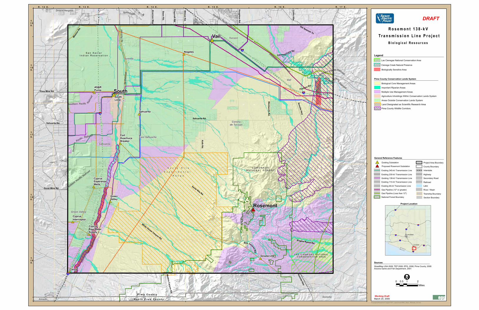
B i o l o g i c a l R e s o u r c e sB i o l o g i c a l R e s o u r c e s
StreetMap USA 2008; TEP 2008; EPG, 2008; Pima County, 2008Arizona Game and Fish Department, 2001
Biologically Sensitive Area
Pima County Wildlife Corridors
Las Cienegas National Conservation Area
Cienega Creek Natural Preserve
Land Designated as Scientific Research Area
Pima County Conservation Lands System
Biological Core Management Areas
Important Riparian Areas
Multiple Use Management Areas
Agriculture Inholdings Within Conservation Lands System
Areas Outside Conservation Lands System
Working Draft

18March 2009
Opportunities and Constraints Analysis
• Identify opportunities and constraints through evaluation
of environmental resources within the project study area
• Conduct an analysis of various environmental resources’
sensitivity to the construction, operation, maintenance,
and abandonment of a transmission line

March 2009
Draft Transmission Line
Siting Criteria
SENSITIVITY OF RESOURCES
Resource Category Proposed Sensitivity Level Existing Land Use and Visual Resource s Residential High
Schools/Educational Facilities High
Scenic Roads/Parkways (e.g., State Route 83) Moderate-High
Parks/Preservation High
Recreation Areas, Open Space, Golf Courses, and Trails/Trailhead Moderate-High
Commercial Retail/Commercial Moderate
Hotel/Resort Moderate
Agricultural Land (pecan groves) Moderate
Vacant Land Low
Industrial Low
Major Property Boundaries (section lines, half-section lines) Low-Moderate
Public/Quasi-Public - Church High
- Cemetery High
- Government Buildings Moderate
- Detention Facilities (Prisons) Low
Visual Classifications – BLM (VRM), Forest Service (VQO) - VRM Class I Incompatible
- VRM Class II Moderate-High
- VRM Class III Low-Moderate
- VRM Class IV Low
- VQO Preservation Incompatible
- VQO Retention High
- VQO Partial Retention Moderate-High
- VQO Modification Low-Moderate
- VQO Maximum Modification Low
Restricted Peaks and Ridges Moderate-High
Future Land Use and Visual Resources Residential Planned – Plat Approved Moderate-High
Residential Planned – Zoning Approved Moderate
Residential Planned – Conceptual/General/Comprehensive Plan Low-Moderate
Commercial Planned – Plat Approved Moderate
Commercial Planned – Zoning Approved Low-Moderate
Commercial Planned – Conceptual/General/Comprehensive Plan Low
Parks /Preservation – Plat Approved Moderate-High
Parks /Preservation – Zoning Approved Moderate
Parks/Preservation – Conceptual/General/Comprehensive Plan Low-Moderate
Recreation Areas, Open Space, Golf Courses, and Trails/Trailhead – Plat Approved Moderate
Recreation Areas, Open Space, Golf Courses, and Trails/Trailhead – Zoning Approved Low-Moderate
Recreation Areas, Open Space, Golf Courses, and Trails/Trailhead – Conceptual/General/Comprehensive Plan
Low
Utility Facilities Planned – Concept Stage Low
Utility Facilities Planned – Plat Approved Low
Mixed Use – Plat Approved Moderate
Mixed Use – Zoning Approved Low-Moderate
Mixed Use – Conceptual/General/Comprehensive Plan Low-Moderate
Military – Plat Approved Moderate
Military – Zoning Approved Low-Moderate
Military – Conceptual/General/Comprehensive Plan Low
Cultural Resource s Listed or Proposed National or State Register Properties Moderate-High
Biological Resource s Pima County Wildlife Corridors Low-Moderate
Santa Cruz River Moderate
Cienega Creek Natural Preserve High
Davidson Canyon High
Las Cienegas National Conservation Area Moderate
Pima County Conservation Lands System
- Agricultural Inholdings within Conservation Area Low
- Biological Core Management Areas Low-Moderate
- Important Riparian Areas Low-Moderate
- Multiple Use Management Areas Low
- Designated Scientific Research Areas Low-Moderate
Note: Sensitivity level modification may occur after evaluation of edge condition (e.g., residential areas adjacent to major arterial roads and 46-kV and above power lines).
Opportunit ies Existing Linear Facilities Roads/Major Arterial Roadways
Pipelines
Railroads
Utility Facilities (substations, etc.)
46-kV Overhead Transmission Line Corridors
115-kV/138-kV Overhead Transmission Line Corridors
230-kV/345-kV Overhead Transmission Line Corridors
Future (Planned) Linear Facilities Certificated transmission line corridors
Roads/Major Arterial Roadways - Approved
Roads/Major Arterial Roadways - Conceptual/General/Comprehensive Plan

N:\projects\Rosemont Copper\TEP_Lopez\mxds\RMC_Base_Hillshade_92.mxd
Arizona
R o s e m o n t 1 3 8 - k V R o s e m o n t 1 3 8 - k V T r a n s m i s s i o n L i n e P r o j e c tT r a n s m i s s i o n L i n e P r o j e c t
March 20, 2009
P i m a C o u n t yP i m a C o u n t y
S a n t a C r u z C o u n t yS a n t a C r u z C o u n t y
S a n X a v i e rS a n X a v i e rI n d i a n R e s e r v a t i o nI n d i a n R e s e r v a t i o n
Sahuarita Rd.
Alvernon W
ay
Wilm
ot Rd.
Loma A
lta
Sonoita Hw
y
Wentw
orth Rd.
Old Spanish Trl
Kolb R
d.
Sonoita Hwy
Box Canyon Rd.
Empire Ranch Rd.
Santa Rita Rd.
Madera C
anyon Rd.
Duval Mine Rd.
White House Canyon Rd.
Pantano Rd.
Colossal Cave Rd
C O R O N A D OC O R O N A D ON A T I O N A L F O R E S TN A T I O N A L F O R E S T
Swan R
d.
Craycroft R
d.
Houghton R
d.
Pima Mine Rd.
Missio
n Rd
.
Sahuarita Rd.
S a n t a R i t aS a n t a R i t a
E x p e r i m e n t a l E x p e r i m e n t a l
R a n g eR a n g e
Southern Pacific Railro
ad
Southern Pacific Railroad
Souther n
Pacific
Railroad
Southern Pacific Railroad
Sp Railroad
Sout
hern
Pacific Railroad
Southern Pacific
Railroad
Sout
hern
Paci
fic Ra
ilroa
d
Sp R
ailro
adSp
Rai
lroad
Southern Pacific Railroad
Tucson Intl
83
89
10
19
10
19
Nogales
Sahuarita
Vail
South
L A S C I E N E G A S N A T I O N A LL A S C I E N E G A S N A T I O N A LC O N S E R V A T I O N A R E AC O N S E R V A T I O N A R E A
AS&RPump
SouthLoop
FortHuachucaBreaker
GreenValley
CyprusEsperanzaWells
CyprusInterceptor
CyprusRaw WaterSupply
Greaterville
Canoa
313631 31
36 313136 36
06
01 01
06
06
010601 06
01
313636 3131
36
01
3136
36
31
01 06060106
060101 06
36 3131 3136
3631363136
060601 010606 01010601
3636 313136 36 31313136
0106
01
0601
06
0601010601
36
31 36 36 3131
31 363136
0601 06 010606
01010601
36
Rosemont
Drexel Heights
Coronade Tucson
East Sahuarita
Green Valley
Sahuarita
Sonoita
Summit
Vail
Amado
Tucson
0 1 20.5Miles
R . 1 3 E . R . 1 4 E . R . 1 5 E . R . 1 6 E . R . 1 7 E .
T .1 5S .
T .1 6S .
T .1 7S .
T .1 8S .
T .1 9S .
R . 1 2 E .
Sources
General Reference Features
Legend
10
40
15
10
PHOENIX
TUCSON
8
17
19
Project Location
Mexico
Arizona
DRAFT
Working Draft
StreetMap USA 2008; TEP 2008; EPG 2008; Pima County 2008;Arizona Game and Fish Department 2001
C o m p o s i t e C o m p o s i t e O p p o r t u n i t i e s & C o n s t r a i n t sO p p o r t u n i t i e s & C o n s t r a i n t s
Opportunities
Sensitivity Level
Moderate-High
Moderate
Low-Moderate
Low
Incompatible
High
Proposed Opportunities
Preferred Water Pipeline Alignment
Alternative Water Pipeline Alignment
County Boundary
Lake
Interstate
Secondary Road
Existing 46-kV Transmission Line
Existing 115-kV Transmission Line
Existing 138-kV Transmission Line
Existing 230-kV Transmission Line
Existing 345-kV Transmission Line
Railroad
Gas Pipeline (Less than 12")
Gas Pipeline (12" or greater)
National Forest Boundary
Highway
Project Area Boundary
Section Boundary
Township Boundary
River / Wash
Proposed Rosemont Substation
Existing Substation

21March 2009
21
Initial Agency/Organization Contacts
TEP sent a letter to community leaders announcing the proposed project:
– Coronado National Forest
– Bureau of Land Management
– Arizona State Land Department
– Pima County, City of Tucson, Town of Sahuarita, Green Valley Coordinating
Council, Vail/Cienega Corridor Volunteer (Mayors, Managers, Development
Directors, Planners, etc.)
– Pima County Association of Governments
– Tohono O’odham Nation (San Xavier District)
– Pascua Yaqui Tribe
– ACC staff
– Southern Arizona Legislative Representatives
– University of Arizona, Santa Rita Experimental Range
– Davis-Monthan Air Force Base

22March 2009
Public Participation Opportunities
• Public open house meetings
• Telephone information line (866) 632-5944
• TEP website: www.tep.com
• Arizona siting committee FAQs website:
www.cc.state.az.us/Divisions/Utilities/Electric/LineSiting-
FAQs.asp
• Media briefings
• Project newsletters mailed to community, including
residents and landowners, and other interested parties

23March 2009
Next Steps
• Collect and document public and agency comments
• Finalize opportunities and constraints analysis
• Identify alternative transmission line links
• Stakeholder meeting #2 (2nd Quarter 2009)
• Public Open House #2 (2nd-3rd Quarter 2009)