Romania : a geopolitical Outline · PDF file1.2 Romania. A geopolitical Outline ... the status...
14
45 1.2 Romania. A geopolitical Outline Radu Săgeată 1.2.1 Abstract With a surface-area of 238,391 km 2 and a population of 21,584,365 (July 1, 2007), Romania is one of the relatively large states in Central Europe, coming third after Germany; as regards its neighbours, it ranks second after Ukraine. The country lies in-between two conflict foci, the former Yugoslav space and the former Soviet Union, were the Transnistrian conflict has a direct bearing on the Romanian population of the Republic of Moldova. Both conflicts have been triggered by eth- nic tensions augmented by the fall of the communist regime and the assertion of national identity. Within this geostrategic context, Romania is an island of stability, with a broad political openness to the European and Euro-Atlantic structures of cooperation, its participating in potential crisis situations in terms of EU and NATO demands. Taking advantage of the country’s geographical and geostrategic posi- tion after 1918, basically at the cross-roads and interaction of the Cen- tral-European, Balkan and East-European countries (Austro-Hungary, Turkey and the Slav states, and Russia and Ukraine, respectively), Romanian geopolitics would focus on the national factor, on the nation and the national state. 1.2.2 The Carpathians, the Danube and the Black Sea The geographical position of Romania at the intersection of parallel 46° north lat. with meridian 25° east long. accounts for three major landmarks that have stamped its historical destiny: the Carpathian Mountains, the Danube River and the Black Sea. The Carpathians in Romania are a relatively low mountain range, with lots of depressions and valleys, propitious to intense settlement since oldest times. Together with the Transylvanian Depression they repre- sent the cradle of the Romanian people’s formation (CONEA, 1941, 1942, 1967). Two-thirds of the entire Carpathian Chain extend on Ro- manian territory, occupying, alongside the Subcarpathians and the hilly Depression of Transylvania, 107,741 km 2 , that is 45.2 % of the country’s surface-area, and also housing 40 % of its population.
-
Upload
nguyenkiet -
Category
Documents
-
view
216 -
download
0
Transcript of Romania : a geopolitical Outline · PDF file1.2 Romania. A geopolitical Outline ... the status...

45
1.2 Romania. A geopolitical Outline
Radu Săgeată
1.2.1 Abstract With a surface-area of 238,391 km2 and a population of 21,584,365 (July 1, 2007), Romania is one of the relatively large states in Central Europe, coming third after Germany; as regards its neighbours, it ranks second after Ukraine. The country lies in-between two conflict foci, the former Yugoslav space and the former Soviet Union, were the Transnistrian conflict has a direct bearing on the Romanian population of the Republic of Moldova. Both conflicts have been triggered by eth-nic tensions augmented by the fall of the communist regime and the assertion of national identity. Within this geostrategic context, Romania is an island of stability, with a broad political openness to the European and Euro-Atlantic structures of cooperation, its participating in potential crisis situations in terms of EU and NATO demands. Taking advantage of the country’s geographical and geostrategic posi-tion after 1918, basically at the cross-roads and interaction of the Cen-tral-European, Balkan and East-European countries (Austro-Hungary, Turkey and the Slav states, and Russia and Ukraine, respectively), Romanian geopolitics would focus on the national factor, on the nation and the national state. 1.2.2 The Carpathians, the Danube and the Black Sea The geographical position of Romania at the intersection of parallel 46° north lat. with meridian 25° east long. accounts for three major landmarks that have stamped its historical destiny: the Carpathian Mountains, the Danube River and the Black Sea. The Carpathians in Romania are a relatively low mountain range, with lots of depressions and valleys, propitious to intense settlement since oldest times. Together with the Transylvanian Depression they repre-sent the cradle of the Romanian people’s formation (CONEA, 1941, 1942, 1967). Two-thirds of the entire Carpathian Chain extend on Ro-manian territory, occupying, alongside the Subcarpathians and the hilly Depression of Transylvania, 107,741 km2, that is 45.2 % of the country’s surface-area, and also housing 40 % of its population.

46
In view of the favourable conditions offered by the natural environment (low altitudes, a host of valleys and intra-montainous depressions sui-table to settlement and to Transcarpathian traffic), the Carpathian area has been heavily populated. These mountains are not an element of demographic divergence, like the Alpes are, but of convergence, and moreover a shelter-place, kind of “natural stronghold”, in times of historical adversity. This shelter role is attested by traces of old and constant habitation. It was here that the centralised Dacian state led by Burebista1, and later on the Roman Dacian state had their capitals. It was again in the Carpathians that the first Romanian state formations emerged. The first mediaeval capitals of the Romanian Countries (Baia, Suceava, Câmpulung and Curtea de Argeş) had strong func-tional links with the mountains, and it was this landform that gave rise to an agro-pastoral civilization and a civilization of the wood. The Car-pathians were the hardcore of the fiercest warring Dacian tribes, which united all the other entities between the Tisa River and the Pontus Euxinus (the Black Sea). In the Middle Ages, these mountains were a place of refuge for the Romanian people from foreign invasions, a reality documented also by the old chronicles. That would explain why it was here that language costume, tradition, and the Romanian people itself have been preserved in their purest form. Speaking of the historical destiny of the Carpathians, geographer Ion Conea (1902-1974), the founder of the Romanian School of Geopolitics, concluded that “the mountain is the true Romanian homeland”, “the backbone of Romanian history is in the Carpathians”, “the Romanian state is a Car-pathian state”. The Danube is not only the river that collects all of the country’s inland drainage network, but also the main navigable avenue of the continent, connecting Central Europe with the Black Sea Basin, also linking the port of Constanţa to the port of Rotterdam (the North Sea) through the Danube-Main-Rhine and Danube-Black Sea canals; it is actually a transcontinental axis. What makes this waterway be of geostrategic importance for Romania is its lower course (1,075 km, 38 % of the to-tal river length) which is the most important section in terms of dis-charge and navigation. Shortly before the union of the Romanian prin-cipalities, the ruling princes of Moldavia and Wallachia had succeeded in attracting the sympathy of the French Emperor Napoleon III and of England’s Queen Victoria, who used to name them the “Danube Prin-ces”, also supporting the unification of all the territories inhabited by Romanians into a powerful state at the Danube mouths in order to
1 The fusion between Dacians and Romans gave birth to the Romanian people.

47
successfully cope with the Russian expansion towards the Bosphorus and the Dardanelles straits (CAZACU 1999). Geopolitically speaking, the Danube played a trebly role (RĂDULESCU 1938): - Navigable route since Roman times; - Borderline separating Balkan Europe from Central and Eastern
Europe. In the course of time, except for some favourable circumstances, the Danube stood for the northern limit of the Roman, Byzantine and Ottoman empires. On the other hand, the river had never been a boundary for the Romanians living on either side of its banks;
- Element of political polarisation of the Romanian state. Ever since the Roman times, the Danube has favoured the development of a real urban belt that structured the macro-space.
Under the new geo-economic and geostrategic conditions, when the transport of hydrocarbons from the Caspian region to Central and Western Europe is of overriding importance, the Black Sea Basin and the Danube-Main-Rhine Canal are of major interest, and here are the reasons behind it: In the first place, there is minimum risk, because the Danubean countries (except for Serbia) have EU membership. In addi-tion, the Black Sea-Aegean Sea straits (Bosphorus and Dardanelles) being overcrowded, there is a higher risk for accidents; moreover, there is frequent and intense pollution in the adjoining area of high hu-man and economic concentration. Within the post-1989 context, com-plex environmental issues in the Danube Basin have acquired a Pan-european dimension, being constantly in the focus of attention of the Council of Europe. Romania’s geostrategic importance at the eastern end of the Danube-Main-Rhine Canal is due also to the port of Constanţa, the largest of the Black Sea Basin and of the Danube riverine harbours. It links the Danube-Main-Rhine axis with the ports at the Black Sea, the Eastern Mediterraneean and the Near East and hence with any of the world’s harbours. Romania’s important geostrategic position is also proven by two of the major Paneuropean transport corridors which cross its territory from west to east (Dresden-Prague-Bratislava-Vienna-Buda-pest-Bucharest-Constanţa-Thessaloniky-Istanbul) and from north to south (Helsinky-Moscow-Odessa-Chishinev-Bucharest-Dimitrovgrad-Alexandropolis). A third element defining Romania’s geographical position is the Black Sea which opens up navigable routes to the whole planetary ocean. The fluvial link between the North Sea (Rotterdam) and the Black Sea

48
(Constanţa) enlarged the geostrategic importance of the latter port beyond a strictly regional cooperation framework. The development of the port of Constanţa has been favoured by its geostrategic function as relay among the European markets, on the one hand, and of South-East Asian and the Black Sea markets, on the other. Besides, this harbour is connected to a many-sided transport system: maritime, fluvial, road-and-railway and air. The Danube-Black Sea Canal is made through the southern area of the harbour, which enables direct trans-shipment of the cargo from maritime to river ves-sels. The hinterland of this port includes the Black Sea Basin and the Danube river. Being located at one terminal of the Rhine-Main-Danube transcontinental axis, it provides direct access to a shorter, basically cheaper, route to Central Europe. Its infrastructure and water height along the dock enables all types of ships crossing the Suez Canal and the Black Sea–Mediterranean straits to anchor in this harbour. Besi-des, it enjoys some strategic facilities such as a free zone regime and ship-building and repair works. As the USSR fell apart and Ukraine and Georgia became independent, geopolitics in the Black Sea zone was assumed by Ukraine. Turkey, the second Black Sea maritime power, which had used to direct its in-terests to the Aegean and the Mediterranean ports, began reafirming its role of regional power within the Balkan and the Caucasian space. Panslavism, favoured by the independence of Azerbaijan and by the separatist movements in Bosnia and Georgia, was supported by Tur-key. As a NATO-member state since 1952 and a candidate to EU accession, Turkish policy had to become a regional catalyst, in view of the conflictual situation at its borders (Kurdistan, Caucasus, Irak, the Near East and the Balkans). Until the 1990s, maritime traffic meant largely imports and exports through the ports of riverine countries, but given the growing interest shown lately by Europe, which is the main hydrocarbon-consuming market, it is expected that the Black Sea region, beside an oil transport route inscribed in the short-and-medium term European development programmes, is included also in EU’s medium-and-long-term regional development programmes. Provided the Black Sea is viewed within a global context and included into an integrating programme, it could play an essential future role in the cohesion and stability of this area whose geopolitics is a pretty complex and conflictual one. The EU accession of Romania and Bulgaria, and prospectively of Turkey as well, on the one hand, and the crises in Abkhazia and South Ossetia, and the tensional situation in Ukraine and in the Republic of Moldova

49
on the other hand, appear to be the main geopolitical data of this region. Fig. 1: Romanian – Ukrainian border-line in the Black Sea Continental
Shelf
Source: Săgeată 2003, S. 174. Even though the Black Sea Basin is not a political, cultural or religious unit, it nevertheless represents a cross-road of European-Asian migra-tions, the place where European, Asian and Arab civilisations, cultures and religions meet, also presenting hotbeds of tension in which con-flicts are going to evolve, e.g. the Caucasus and the Caspian Sea area, and the conflicts in Central Asia and in the Arab states do have an influence. As a matter of fact, the open conflicts manifest on the Balkan-Caucasian axis, on the Caspian-Arab fault-line, and on the Me-diterranean-Arab axis have a negative bearing on the security and sta-
50
bility of states in the Black Sea Basin. Not less detrimental are the dip-lomatic conflicts on the status of the Serpants Island and the delimita-tion of the continental shelf in the Romanian-Ukrainian sector (Fig. 1), the Cyprus problem, the status of the Pomacian minority in Bulgaria, the Abkhasian and Ossetian problem in Georgia, the Russian-Ukrai-nian tensions because of the status of Crimea and of the Tartar com-munity of Crimea, the delimitation of the Caspian Sea oil exploitation areas, the effects of the Chechenyan conflict on the integrity and secu-rity of the Russian Federation, cooperation difficulties between Russia and Central Asia and Caucusus states, etc. In the course of history, the Black Sea has also been a geographical area of geostrategic and geopolitical importance: the Greek colonisa-tion, the Byzantine hegemony, the big Asian migrations, the Venetian and the Genoese colonisation, the Ottoman invasion, the Russian ex-pansion, and currently the reconsideration of this water body by NATO and the European Union. Throughout that time the Black Sea geopoli-tical system experienced paradoxical evolutions. While trade was flou-rishing during the times of the great empires, after World War II this basin became a closed space, with the Soviet military fleet standing against the NATO military bases located in Turkey and the Medi-terranean Sea. For all the efforts made by the Romanian side after 1989, the Black Sea has not regained its status of regional geopolitical power, although the dissolution of Soviet Russia kindled the hope of new prospects for the development of the international relations in this strategic zone. Despite various international organisations being established over nearly all of the last two decades, Russian intervention, Ukrainian and Turkish interests and the lack of interest on the part of international alliances brought positive evolutions to a halt. As the oil crisis got momentum, a crisis actually triggered by Islamic revolutions, the Black Sea was found to have an exceptional geostrategic potential, so far unexploited. A shift in the economic-military policy of Western states opened up new vistas for a fresh approach to the Black Sea, an area lying at the cross-roads of some vital axes (Pontic-Baltic, Pontic-Cas-pian, Caspian-Arab, Mediterranean-Arab and Balkan-Caspian) for in-ternational alliances, part and parcel of the geopolitical system of intra-continental European seas. So, Romania’s geographical position links it essentially to the Black Sea, which thus becomes a main gateway to Europe (through the ports of Constanţa, Constanţa Sud-Agigea and the Danube-Black Sea Canal, unfortunately still not exploited at its full strategic capacity) and the main Caspian-Pontic interface with the West. Situated in the

51
central zone of the geopolitical system of intra-continental seas, Ro-mania can become the “Eastern key” to NATO and EU relationships with Russia, Asia and the Arab states (Fig. 2). Fig. 2: Caspian oil transport to Western Europe
Source: “Romania. Space, Society, Environment”, 2006, S. 24. In this period determined by the globalisation process, Romania pos-sesses the necessary infrastructure to take over, store and transport the energy resources, being a real partner in the alliances it belongs to. A founder, together with Bulgaria, Georgia, Russia, Turkey and Uk-raine, of the Black Sea Economic Community (BSEC), Romania has been actively involved in strengthening trade relations, public and telecomunication works and environmental protection (especially of the Danube Delta, tensioning its relations with Ukraine), stimulating cultu-ral exchanges and granting political support to the Republic of Moldo-va, Ukraine, Georgia, Azerbaijan and Turkey on the world stage. 1.2.3 Romania, a state of European cross-roads Three elements (the Carpathians, the Danube and the Black Sea) pla-ce Romania in Central Europe, a reality confirmed also by appro-ximately even distances from the northernmost, easternmost and southernmost points of Continental Europe: the North Cape – 2,800 km, the Ural Mts – 2,600 km, and the Roca Cape (Capo da

52
Roca) – 2,700 km; however, it lies closer to the Mediterranean Sea – 1,050 km (Akademia Româna 1983, p. 21). Hence the Romanian terri-tory is a point of contact and interference of Europe’s big four climatic and biogeographical domains: - Western, Oceanic, manifest by the penetration of oceanic masses
of air, more frequently in the Banat-Crişana Plain and the western side of the Apuseni Mountains;
- Eastern, featuring a temperate-continental climate, often with ex-cessive shades, in the Moldavian Plateau and the Bărăgan Plain;
- Southern, Balkan, marked by aridity in the south of the country and characteristic flora and fauna species (mainly in the Banat, Cerna and Mehedinţi mountains, and in South Dobrogea),
- Northern, Scandinavian-Baltic, very much attenuated in the forested Carpathians of Ukraine, yet often affecting the Obcinele Bucovinei (Low Bucovinian Mountains) and the Suceava Plateau.
Fig. 3: Romania. A State of European cross-roads
Source: Săgeată 1999–2000, S. 248.
53
Historical and political circumstances have enhanced this interconnec-ting feature. Romania emerged as an area where three distinct cultural and geostrategic domains have met: Central European influences: Ca-tholic religion and Austro-Hungarian influence; East European influ-ences: Orthodox religion and Russophonic influence; South European and Balkan influences represented by the South-Danubian Slavonic branch (Bulgarian and Serbian), influences overlain by Muslim ones through the biggest expansion of the Ottoman Empire (Fig. 3). Moreover, all along the centuries, Romania’s geo-economic position has turned it into a crossing point of the major traffic axes going from Western Europe to the former Soviet space, Asia Minor and the Near East; also of some big transversal geo-economic axes that have been acquiring an ever greater importance: the sea axis (Caspian Sea-Black Sea-Mediterranean Sea), and the axis of rivers and canals (Rhine-Main-Danube and Danube-Black Sea). Romania’s affiliation to the Central-European space has been confir-med by fundamental geographical works produced since the early 20th century. A work published by Jovan Cvijič in 1918 fixes the Danube as northern limit of the Balkan Peninsula. Speaking about the borders of the Balkan Peninsula, Jacques Ancel contended that (1930, p.36) “the Danube is sometimes considered to be the northern boundary of the Balkan Peninsula. But the middle course of the Danube has never been a boundary (...), the Danube does not divide, it unites the Romanian lands with the Balkan lands”. However, six years later he would reconsider his position situating Romania in Central Europe and setting the big river as the southern limit of this European region (Fig. 4a). Giselher Wirsing (Fig. 4b) places Romania, alongside the Baltic Sta-tes, Poland, Czechia, Slovakia, Hungary, the (ex-)Jugoslav states, Al-bania and Bulgaria into “Middle Europe” (Zwischeneuropa), an appela-tion sanctioned by Albrecht Penck (WIRSING 1932). Emmanuel de Martonne (1934) gave a definition of “Central Europe”. In his view, this definition should be used to designate the intermediate position occupied by the countries assumed to lie between a “better articulated” Western Europe and a “more compact Eastern Europe”. What de Martonne actually meant was a location between a Europe of peninsulas, gulfs and seas and a Europe of endless fields, including in this latter part of Europe, Romania, Germany, Poland, Switzerland, Austria, Czechia, Slovakia and Hungary (Fig. 4c). Making a synthesis of all these viewpoints, Nicolae Al. Rădulescu (1938), counts Germany, Switzerland, Austria, Italy, the (ex-)Jugoslav
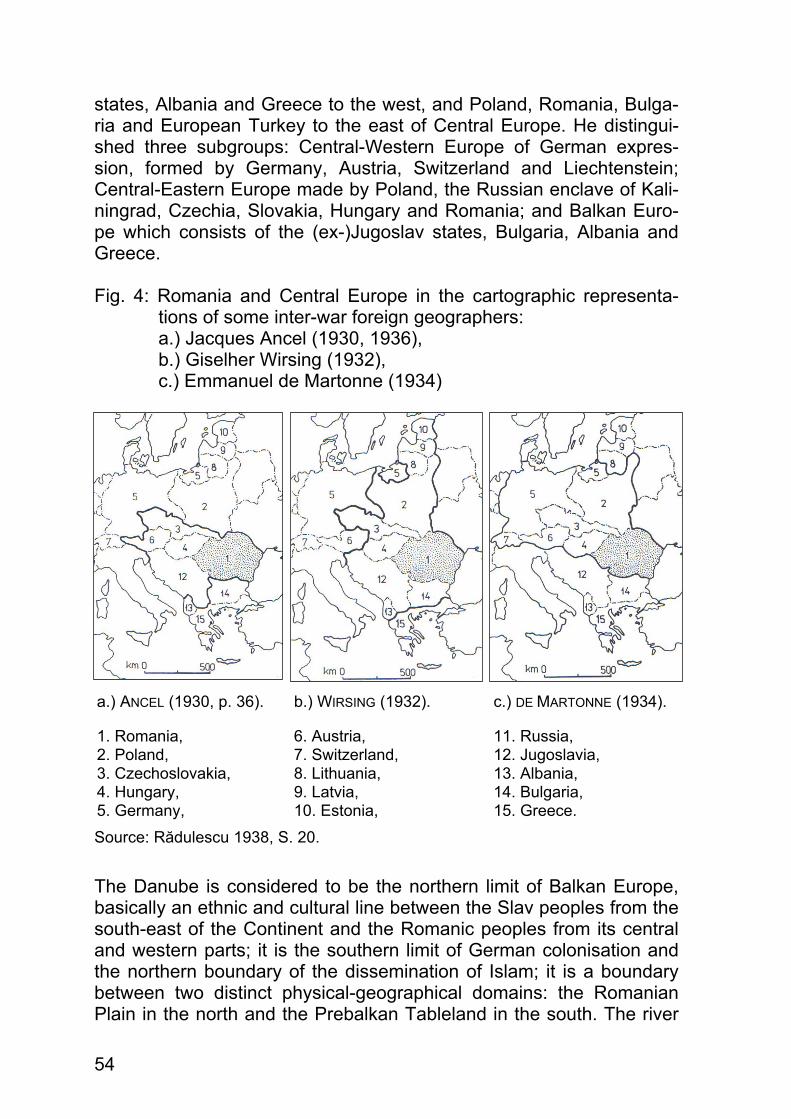
54
states, Albania and Greece to the west, and Poland, Romania, Bulga-ria and European Turkey to the east of Central Europe. He distingui-shed three subgroups: Central-Western Europe of German expres-sion, formed by Germany, Austria, Switzerland and Liechtenstein; Central-Eastern Europe made by Poland, the Russian enclave of Kali-ningrad, Czechia, Slovakia, Hungary and Romania; and Balkan Euro-pe which consists of the (ex-)Jugoslav states, Bulgaria, Albania and Greece. Fig. 4: Romania and Central Europe in the cartographic representa-
tions of some inter-war foreign geographers: a.) Jacques Ancel (1930, 1936), b.) Giselher Wirsing (1932), c.) Emmanuel de Martonne (1934)
a.) ANCEL (1930, p. 36). b.) WIRSING (1932). c.) DE MARTONNE (1934).
1. Romania, 2. Poland, 3. Czechoslovakia, 4. Hungary, 5. Germany,
6. Austria, 7. Switzerland, 8. Lithuania, 9. Latvia, 10. Estonia,
11. Russia, 12. Jugoslavia, 13. Albania, 14. Bulgaria, 15. Greece.
Source: Rădulescu 1938, S. 20. The Danube is considered to be the northern limit of Balkan Europe, basically an ethnic and cultural line between the Slav peoples from the south-east of the Continent and the Romanic peoples from its central and western parts; it is the southern limit of German colonisation and the northern boundary of the dissemination of Islam; it is a boundary between two distinct physical-geographical domains: the Romanian Plain in the north and the Prebalkan Tableland in the south. The river

55
is also a historical line, because none of the empires based in the Bal-kan Peninsula could safely expand north of the Danube; it is a psycho-logical limit between the Balkan peoples who are thoroughly different from their Central European counterparts. And last but not least, the Danube is an economic border because Romania gravitates towards Central Europe. However, the German conception of Mitteleuropa, that is Central Euro-pe, takes a different view, namely, Romania does not belong to this re-gion, instead it regards some Balkan countries like Croatia and Slove-nia, former subjects of the Habsburg Empire, gravitating geopolitically towards Germany, as parts of this space. For a lapse of over 40 years, Central Europe and the name of Europe itself had been monopolised by the geopolitical complex located west of the Iron Curtain. Europe used to be associated with the “realm of freedom”, in opposition to communist Europe, which leaned towards the Soviet Union, and was designated as Eastern Europe, or simply the East, actually a dominantly ideological category without any defi-nite territorial basis (FOURCHER 2000). In the view of Western Euro-peans, the geometry of this territorial unit became increasingly more diffuse; whether Poland and Romania, or Bulgaria, Albania and Hun-gary, states belonging to distinct geographical domains and cultures, they were all opposed to Greece, Spain, Great Britain or Germany, integrated into the same economic and political-military blocs, but they are geographically and culturally fundamentally diverse. Under these conditions, the northern limit of the Balkan Peninsula was shifted up to the Soviet borders, the only states acknowledged to be Central-Euro-pean were East Germany, Poland, former Czechoslovakia and Hun-gary (JELAVICH 1983; CASTELLAN 1991; PRÉVÉLAKIS 1994). In 1991, the-se states formed the Višegrad Group. The fundamental changes experienced at the end of the 1980s made people review the geopolitical relations in the Central and East-Euro-pean space, reactualising some old geostrategic alliences and setting up new ones. The area between the former Soviet borders and the Iron Curtain began turning towards the European and Euro-Atlantic structures, while the buffer zone between “Europe” and Russia was pushed eastwards, towards Ukraine, Belarus and the Baltic states. In this way, the old Eastern Europe continues to be erroneously consi-dered as a homogeneous geographical category named Median Euro-pe (FOURCHER 2000) or New Europe, a geostrategic area of transition between the East and the West (BRUNET/REY 1996). Old foci of tension and conflicts in the Balkans were brought to the fo-re, eventually dismantling Jugoslavia (1991–2006), new ones broke

56
out in the former Soviet Union, triggered by ethnic tensions accumu-lated in the latter half of the 20th century. Europe is thus redefined, but its limits remain uncertain: Europe is a term combining geographical, historical and cultural elements contributing to the European identity. Their experience is marked by a similarity of ideas, values and histori-cal interactions, which could not be condensed within a simple formula and which remain to be reviewed by each successive generation. As a conclusion, we feel justified in stating that geographical, ethnic, historical and social-economic arguments place Romania within the Central European space, a space that best fits into the concept of Em-manuel de Martonne (with difference that we count Slovenia and Croa-tia to Central Europe because of their geographical and geostrategic position, their history and their cultural and economic affinities). 1.2.4 Romania, a factor of regional stability Romania is one of the relatively large states in Central Europe. Its very important regional role also derives from the fact that of all border-states only Ukraine has a larger territory and a bigger demographic potential. It should be remembered that Romania lies between two major foci of conflict, those of the former Jugoslavia and those of the former Soviet Union, where the Transnistrian conflict has a direct bearing on the Romanian population from the Republic of Moldova. Both conflicts were generated by ethnic tensions heightened by the downfall of com-munism and the assertion of national identity. Compared with this geostrategic background Romania emerges as an isle of stability, showing an obvious political opening to all European and Euro-Atlantic structures and the capacity to deal with potential cri-sis situations in terms of the standards set by these structures. Although some ethnic-based internal tendencies to fragmentation be-came vocal in Romania, they are calmed down under the conditions of Romania´s membership in the European Union. At present, the main risk for Romania’s domestic security is of a social nature. Prolonged transition, the economic decline and its social ef-fects might become a source of potential conflicts. Growing poverty, the absence of viable economic alternatives, and generalised corrupt-tion may exacerbate the role of some ethno-cultural or cultural commu-nities and their tendencies to creating enclaves.

57
The main external insecurity risks for Romania have largely been removed because of the country´s NATO membership. The country’s progress on the road of democracy and the advantages of its geo-strategic position as a revolving platform between East and West within a Europe of interdependent entities have already been recog-nised by international organizations as EU and NATO. 1.2.5 References ANCEL, J. (1930): Peuples et nations des Balkans. Paris. ANCEL, J. (1936): Manuel géographique de politique européenne.
Tome 1. Paris. ACADEMIEI ROMÂNA (ed.) (1983): Geografia României. Vol. I. Bucureşti. BOIA, L. (2001): România, ţară de frontieră a Europei. Bucureşti. BRUNET, R./REY, V. (1996), Géographie Universelle. Europes Orienta-
les, Russie, Asie Centrale: Berlin / Reclus, Paris. CASTELLAN, G. (1991): Histoire des Balkans: Fayard. Paris. CAZACU, M. (1999): Le Danube dans le discours géostratégique et éco-
nomique roumain. In: Géopolitique du Danube. M. FOURCHER (Hg.). Paris. S. 43–88.
CONEA, I. (1941): Transilvania, inima pământului şi statului românesc. In: Geopolitica şi Geoistoria, I. S. 18–34.
CONEA, I. (1942): Carpaţii, hotar natural ? In: Geopolitica şi Geoistoria, II, S. 62–68.
CONEA, I. (1967): Cu privire la „teritoriul nucleu” de formare a poporului român. In: Studii şi Cercetări de Geologie, Geofizică şi Geografie, Geografie, XVI, 1, S. 3–14.
DE MARTONNE, E. (1934): Europe Centrale. In: Géographie universelle. Vol. IV. I partie. Paris.
FOURCHER, M. (2000): Fragments d’Europe: Fayard. Paris. FOURCHER, M. (Hg.) (1999): Géopolitique du Danube. Ellipses, Paris. FOURCHER, M (2000): La République Européenne. Berlin, Paris. JELAVICH, B (1983): Histoire of Balkans: Cambridge University Press. KAHL, T./METZELTIN, M./UNGUREANU, M.-R. (Hg.) (2006): Rumänien.
Raum und Bevölkerung, Geschichte und Geschichtsbilder, Kultur, Gesellschaft und Politik heute, Wirtschaft, Recht und Verfassung, Historische Regionen. Wien.

58
NEGUT, S./CUCU, V./VLAD, L.-B. (2004): Geopolitica României. Târgo-vişte.
NEGUT, S./SĂGEATĂ, R. (2006): Romania in the new architecture of Eu-rope. In: Romania. Space, Society, Environment. Bucharest.
POSEA, G. (1999): România. Geografie şi Geopolitică. Bucureşti. PRÉVÉLAKIS, G. (1994): Les Balkans. Cultures et géopolitique: Nathan.
Paris. *** (1997). L’Etat du Monde: La Découverte. Paris. Rădulescu, N.-A. (1938): Poziţia geopolitică a României. In Revista
Geografică Română. Vol. I, 1. Cluj-Napoca, S. 5–35. SĂGEATĂ, R. (1999–2000): Outstanding Personalities in Inter-War Ro-
manian Geopolitics. In Geographica Timisensis. Vol. VIII–IX. Timişo-ara, S. 247–255.
SĂGEATĂ, R. (2002): România – A Central-European Country. In Ro-manian Review on Political Geography. Vol. IV, 1–2. Oradea, S. 15–20.
SĂGEATĂ, R. (2003): The State Frontiers of Romania – between Inter-national Treaties and Diktat. In “Europe between Millenniums. Politi-cal Geography Studies”, IGU Political Geography Commission, S. 171–177.
SĂGEATĂ, R. (2008): Geopolitică, Ed. Universităţii Lucian Blaga. Sibiu. SIMILEANU, V. (2003): România. Tensiuni geopolitice. Bucureşti. SIMILEANU, V./SĂGEATĂ, R. (2008): Geopolitica României. Bucureşti. WIRSING, G. (1932): Zwischeneuropa und die deutsche Zukunft. Leip-
zig.