Roadway Design Standards for Rural and Suburban...
64
Roadway Design Standards for Rural and Suburban Subdivisions Final Report June 2007 Sponsored by the Iowa Highway Research Board (IHRB Project TR-549) and the Iowa Department of Transportation (CTRE Project 03-167) Iowa State University’s Center for Transportation Research and Education is the umbrella organization for the following centers and programs: Bridge Engineering Center • Center for Weather Impacts on Mobility and Safety • Construction Management & Technology • Iowa Local Technical Assistance Program • Iowa Statewide Urban Design and Specifications • Iowa Traffic Safety Data Service • Midwest Transportation Consortium • National Concrete Pavement Technology Center • Partnership for Geotechnical Advancement • Roadway Infrastructure Management and Operations Systems • Traffic Safety and Operations
Transcript of Roadway Design Standards for Rural and Suburban...
Roadway Design Standards for Rural and Suburban Subdivisions
Final ReportJune 2007
Sponsored bythe Iowa Highway Research Board (IHRB Project TR-549) and the Iowa Department of Transportation (CTRE Project 03-167)
Iowa State University’s Center for Transportation Research and Education is the umbrella organization for the following centers and programs: Bridge Engineering Center • Center for Weather Impacts on Mobility
and Safety • Construction Management & Technology • Iowa Local Technical Assistance Program • Iowa Statewide Urban Design and Specifications • Iowa Traffi c Safety Data Service • Midwest Transportation
Consortium • National Concrete Pavement Technology Center • Partnership for Geotechnical Advancement • Roadway Infrastructure Management and Operations Systems • Traffic Safety and Operations

About SUDAS
SUDAS develops and maintains Iowa’s manuals for public improvements, including Iowa Statewide Urban Design Standards Manual and Iowa Statewide Urban Standard Specifi cations for Public Improvements Manual.
Disclaimer Notice
The contents of this report refl ect the views of the authors, who are responsible for the facts and the accuracy of the information presented herein. The opinions, fi ndings, and conclusions expressed in this publication are those of the authors and not necessarily those of the sponsors.
The sponsors assume no liability for the contents or use of the information contained in this document. This report does not constitute a standard, specifi cation, or regulation.
The sponsors do not endorse products or manufacturers. Trademarks or manufacturers’ names appear in this report only because they are considered essential to the objective of the document.
Non-discrimination Statement
Iowa State University does not discriminate on the basis of race, color, age, religion, national origin, sexual orientation, gender identity, sex, marital status, disability, or status as a U.S. veteran. Inquiries can be directed to the Director of Equal Opportunity and Diversity at Iowa State University, (515) 294-7612.

Technical Report Documentation Page
1. Report No. 2. Government Accession No. 3. Recipient’s Catalog No. IHRB Project TR-549
4. Title and Subtitle 5. Report Date June 2007 6. Performing Organization Code
Roadway Design Standards for Rural and Suburban Subdivisions
7. Author(s) 8. Performing Organization Report No. Paul Wiegand and Larry Stevens CTRE Project 03-167 9. Performing Organization Name and Address 10. Work Unit No. (TRAIS)
11. Contract or Grant No.
Center for Transportation Research and Education Iowa State University 2711 South Loop Drive, Suite 4700 Ames, IA 50010-8664
12. Sponsoring Organization Name and Address 13. Type of Report and Period Covered Final Report 14. Sponsoring Agency Code
Iowa Highway Research Board Iowa Department of Transportation 800 Lincoln Way Ames, IA 50010
15. Supplementary Notes Visit www.ctre.iastate.edu for color PDF files of this and other research reports. 16. Abstract In Iowa, there are currently no uniform design standards for rural and suburban subdivision development roadways. Without uniform design standards, many counties are unable to provide adequate guidance for public facilities, particularly roadways, to be constructed as part of a rural subdivision development. If a developer is not required to install appropriate public improvements or does not do so properly, significant liability and maintenance expenses can be expected, along with the potential for major project costs to correct the situation. Not having uniform design standards for rural and suburban subdivision development improvements in Iowa creates situations where there is potential for inconsistency and confusion. Differences in the way development standards are applied also create incentives or disincentives for developers to initiate subdivision platting in a particular county.
With the wide range of standards or lack of standards for local roads in development areas, it is critical that some level of uniformity is created to address equity in development across jurisdictional lines. The standards must be effective in addressing the problem, but they must not be so excessive as to curtail development activities within a local jurisdiction.
In order to address the concerns, cities and counties have to work together to identify where growth is going to be focused. Within that long-term growth area, the roadways should be constructed to urban standards to provide an easier transition to traditional urban facilities as the area is developed. Developments outside of the designated growth area should utilize a rural cross section since it is less likely to have concentrated urban development.
The developers should be required to develop roadways that are designed for a minimum life of 40 years, and the county should accept dedication of the roadway and be responsible for its maintenance.
17. Key Words 18. Distribution Statement collector road—connector road—county—design standards—geometrics—local road—platting—roadway—rural subdivision—suburban subdivision
No restrictions.
19. Security Classification (of this report)
20. Security Classification (of this page)
21. No. of Pages 22. Price
Unclassified. Unclassified. 71 NA
Form DOT F 1700.7 (8-72) Reproduction of completed page authorized
ROADWAY DESIGN STANDARDS FOR RURAL AND SUBURBAN SUBDIVISIONS
Final Report June 2007
Principal Investigator Paul D. Wiegand, P.E.
Research Engineer Center for Transportation Research and Education, Iowa State University
Co-Principal Investigator Larry Stevens, P.E. SUDAS Director
Center for Transportation Research and Education, Iowa State University
Sponsored by the Iowa Highway Research Board
(IHRB Project TR-549)
Preparation of this report was financed in part through funds provided by the Iowa Department of Transportation
through its research management agreement with the Center for Transportation Research and Education,
CTRE Project 03-167.
A report from Center for Transportation Research and Education
Iowa State University 2711 South Loop Drive, Suite 4700
Ames, IA 50010-8664 Phone: 515-294-8103 Fax: 515-294-0467
www.ctre.iastate.edu

v
TABLE OF CONTENTS
ACKNOWLEDGMENTS ................................................................................................ IX
EXECUTIVE SUMMARY .............................................................................................. XI
PROBLEM STATEMENT................................................................................................. 1
TECHNICAL ADVISORY COMMITTEE ....................................................................... 2
LEGAL ELEMENTS.......................................................................................................... 2
STATE OF THE PRACTICE............................................................................................. 3
Literature Search............................................................................................................. 3 Questionnaire .................................................................................................................. 3
ROADWAY STANDARDS............................................................................................... 5
TYPICAL CROSS-SECTIONS.......................................................................................... 7
PAVED VERSUS UNPAVED ROADS .......................................................................... 10
URBAN VERSUS RURAL ROADS ............................................................................... 11
RECOMMENDATIONS.................................................................................................. 12
APPENDIX A: LITERATURE REVIEW...................................................................... A-1
APPENDIX B: QUESTIONNAIRE RESULTS ............................................................ B-1
APPENDIX C: TYPICAL CROSS-SECTIONS............................................................ C-1
APPENDIX D: TYPICAL UTILITY LOCATIONS ..................................................... D-1

vii
LIST OF FIGURES
Figure 1. Unpaved connector road...................................................................................... 5 Figure 2. Traffic circulation................................................................................................ 6 Figure 3. Steep slopes ......................................................................................................... 8 Figure 4. Paved shoulder with maintainable slopes............................................................ 9 Figure 5. Urban cross-section without storm sewer.......................................................... 10 Figure 6. Unpaved local rural subdivision road................................................................ 11 Figure C.1 Rural connector............................................................................................. C-1 Figure C.2 Rural collector within subdivsion................................................................. C-2 Figure C.3 Rural local street ........................................................................................... C-3 Figure C.4 Urban connector............................................................................................ C-4 Figure C.5 Urban collector within subdivision............................................................... C-5 Figure C.6 Urban local.................................................................................................... C-6 Figure C.7 AASHTO low-volume road.......................................................................... C-7 Figure D.1 Typical rural utility locations ....................................................................... D-1 Figure D.2 Typical urban utility locations with sanitary outside of street...................... D-2 Figure D.3 Typical urban utility locations with sanitary under the street ...................... D-3
LIST OF TABLES
Table 1. Rural subdivision cross-section geometrics........................................................ 14 Table 2. Urban and suburban cross-section geometrics.................................................... 15

ix
ACKNOWLEDGMENTS
The Iowa Department of Transportation and the Iowa Highway Research Board sponsored this study under contract TR-549. Their support is gratefully acknowledged. Numerous people provided technical guidance for the development of this report. The authors extend thanks to those individuals from the cities of Ankeny, Cedar Falls, Waterloo, and West Des Moines; Dallas County, Jasper County, Johnson County, and Marion County; the Carroll County Region 12 Council of Governments; and Bishop Engineering. The authors also thank Snyder & Associates for their work in preparation of the typical cross-sections and background information on older subdivisions in central Iowa.

xi
EXECUTIVE SUMMARY
Introduction In Iowa, there are currently no uniform design standards for rural and suburban subdivision development roadways; thus, many counties are unable to provide adequate guidance for public facilities to be constructed as part of a rural subdivision development. It is well-recognized that not having uniform design standards for rural and suburban subdivision development improvements creates situations where there is potential for inconsistency and confusion. Differences in the way development standards are applied also create incentives or disincentives for developers to initiate subdivision platting in a particular county or away from a city. State of the Practice The responses from a questionnaire completed by 36 county officials can be summarized by indicating that the “typical” county does require paving of the roads within a subdivision, but does not require paving of the connecting road. Only one county responded that they have established warrants for the paving of the connecting road. For most of the responding counties, the internal subdivision roads are generally privately owned, with homeowners associations responsible for maintenance. The internal subdivision roads are typically built on 66-foot right-of-way easements or outlots. When the local road within the subdivision is paved, it will more than likely be a rural cross section 22 to 24 feet wide with 4-foot rock shoulders and ditches for drainage. Roadway Geometrics Roadway geometrics are the parameters that create a well-designed facility, and are established as a function of design speed. The design speed is determined by evaluating the use of the road, the use of the adjacent land, and the expected traffic volume on the road. Once the design speed is established, the roadway vertical and horizontal alignments are set to meet those characteristics necessary to travel safely at that speed. The use of a particular cross-section, either rural or urban, should be decided with consideration of the desires of the developer and the location of the road with respect to the designated growth area of the nearest urban area. The most important decision to be made as agencies review subdivision development plans is not whether to use a rural or an urban cross-section, but whether to require paving or allow the construction of granular roads. The answer to that question will determine the long-term impact on the generation of fugitive dust and escalating maintenance costs that the homeowners and the agency must deal with. This decision is particularly important when the development is within the designated growth area of a city. Requiring an appropriate level of paving for the expected traffic volume and adjacent land use will initially cost the developer and the homeowners within the subdivision more, but will minimize long-term concerns of both the homeowners and the regulating agency.

xii
Recommendations It is critical for the county and the adjacent city to cooperate and establish joint development requirements in the designated growth area of the city. The first step in that cooperation process is for the city to look closely at its land use policy plan and evaluate where and to what extent growth over a 20-year period is expected. From that review, a designated growth area should be established. The designated growth area then becomes the most critical area for jointly determining the type of developments that will be allowed and the public improvement regulations that govern the development. Developments within the designated growth area of a city should use the roadway standards that include an urban cross-section with storm sewers. Using the urban cross-sections within the designated growth area provides for smoother transitions as rural areas are annexed into the adjacent city. Once the roadways within the subdivision are properly constructed to the appropriate local or collector standards, they should be dedicated as public right-of-way, and the county should accept them for maintenance. Although acceptance into the county road system brings increased costs, the properly-constructed road with a design life of at least 40 years will not create unusual problems in the future and will serve the adjacent homeowners. Also, the regulation of speeds and other regulatory elements, such as on-street parking, can be established and enforced if the county has jurisdiction. Enforcement of these regulations is difficult when the right-of-way and road are not dedicated to the county. An unpaved existing county road connecting a proposed development to a paved road is of particular concern. The connecting road is a part of the county road network, and is likely to become an important street as the area develops and the road is used by more traffic in the designated growth area of a city. Because of that importance and the long life of any pavement, the connecting road should also be paved to an urban cross-section within the designated growth area of a city. It is very likely that this road will need to be widened to multiple lanes as the area grows in the future and is annexed into the nearby city. The urban cross-section will make any expansion of the road reasonably cost-effective, since the existing paving would only need to be widened. Conversely, converting a two-lane rural road to a multi-lane urban facility would involve total removal of the pavement and reconstruction to meet the urban requirements. For roads within developments outside of the designated growth area of a city, the selection of rural versus urban cross-section is not as critical. The option could be left to the developer to select the type they would like to propose, as long as good regulations are in place for both types. The amount of land required for right-of-way, the characteristics of the land (soils, slope, wooded area, etc.), and the type of drainage facilities to be used are elements to consider in the decision. It is recommended that the rural cross-sections be used as a default and the developers be allowed to propose other cross-sections if they so desire.

1
PROBLEM STATEMENT
In Iowa, there are currently no uniform design standards for rural and suburban subdivision development roadways. Without uniform design standards, many counties are unable to provide adequate guidance for public facilities, particularly roadways, to be constructed as part of a rural subdivision development. If a developer is not required to install appropriate public improvements or does not do so properly, significant liability and maintenance expenses can be expected, along with the potential for major project costs to correct the situation. It has been documented that Iowans are increasingly looking to rural areas for larger lots and larger homes. Development in these rural areas is a double-edged sword. The tax growth contributes some money to the county funds, but if developers are not held to the appropriate public improvement standards, maintenance and improvement costs will easily exceed the increased tax revenues. The largest problem in rural/suburban subdivisions relates to the lack of appropriate paving of internal roadways and external connecting roadways. It is well recognized that not having uniform design standards for rural and suburban subdivision development improvements in Iowa creates situations where there is potential for inconsistency and confusion. Differences in the way development standards are applied also create incentives or disincentives for developers to initiate subdivision platting in a particular county. If the rural development lies within the two-mile jurisdictional area adjacent to a city, further problems are possible due to the differing public improvement standards between the county and the city. Cities generally require significant public improvements, such as curbed streets, storm sewers, other underground utilities, and sidewalks, which encourage smaller lots. Counties generally allow larger lot developments without usual urban public improvements. Generally, rural subdivisions have roads with shoulders, ditches for drainage control, and no curbs. A search of county websites indicated that only 28% of Iowa counties have specific subdivision public improvement requirements. A review of prior research indicated that no studies had been done to address statewide geometric standards for rural and suburban roadways in subdivision areas. The Statewide Urban Design and Specification (SUDAS) and Iowa DOT manuals currently do not have geometric standards for rural cross-sections on low-volume, low-speed facilities.

2
TECHNICAL ADVISORY COMMITTEE
Because of the nature of the research, the involvement of county officials was needed to provide input to the study. Some also served on the Technical Advisory Committee, along with city officials and consultants. Committee members included Ron Gaines, City of Cedar Falls Murray McConnell, Dallas County Greg Parker, Johnson County John Peterson, City of Ankeny Joel Romey, Bishop Engineering Larry Ryan, Jasper County Roger Schletzbaum, Marion County Aric Schroeder, City of Waterloo/Black Hawk County Chris Whitaker, Carroll County Region 12
Council of Governments Duane Wittstock, City of West Des Moines
LEGAL ELEMENTS
Chapter 354 of the 2007 Code of Iowa sets standards for the division of land in Iowa that consider the rights of the landowner and the governmental entity involved with the subdivision. The state regulations establish uniform procedures and minimum standards related to the subdivision of land and also allow cities and counties to establish additional requirements through local subdivision ordinances. Overall, these regulations are established to provide for orderly development in accordance with comprehensive plans of the local agency. The 2007 Code of Iowa requires “a subdivision plat must be made when a tract of land is divided by repeated divisions or simultaneous division into three or more parcels, any of which are described by metes and bounds description for which no plat of survey is recorded.” After submittal of a subdivision plat, the governing body “shall determine if the development is in accordance with its comprehensive plan, and shall give consideration to the possible burden on public improvements and to a balance of interests between the proprietor, future purchasers, and the public interest in the subdivision when reviewing the proposed subdivision, and when requiring the installation of public improvements in conjunction with approval of the subdivision.” Cities have the ability to establish ordinances that provide for the regulation of subdivisions outside the boundaries of the city, but within a specified area. That extra-territorial area can be specifically described in the city’s comprehensive plan, or it can be all land within a certain distance of the city’s boundaries. The specific distance outside the city can not exceed two miles. When a subdivision is proposed in the designated extra-territorial area, the subdivision plat is submitted to both the county and the city involved. The standards applied by the city or county for review and approval of the subdivision shall be the same standards and conditions used for the review and approval of subdivisions within the city limits, or shall be the standards and conditions for review and approval established by agreement of the city and county. Either the city or the county may waive its right to review a subdivision within the extra-territorial zone or waive the requirements of its standards or conditions, including public improvements.

3
In addition to subdivision regulations, Chapter 414 in the 2007 Code of Iowa allows the zoning of land. It allows cities and counties to establish zoning regulations within their jurisdictions to promote the health, safety, and welfare of a community. It generally involves regulations relating to the density of a development, size of lots, location of structures within lots (i.e., yard requirements), and type of development that is permitted within a given area. It also involves regulations to facilitate the provision of transportation, utilities, schools, parks, and other public requirements. Cities may also provide for zoning regulations within their designated extra-territorial jurisdiction, provided the affected county does not have zoning regulations. If a city extends its zoning regulations outside of its boundaries, the membership of the city’s Planning and Zoning Commission and its Board of Adjustment must provide for representation from the impacted area.
STATE OF THE PRACTICE
Literature Search
The results of the literature search are presented in Appendix A. It appears that no state has established statewide geometric standards for roadways in rural and suburban subdivisions. Some state DOTs have provided guidelines for rural roadways, but no standards were adopted. Marion County, Oregon, has established minimum rural design standards that are targeted to both new roads and paving of existing rural granular roads. The standards are established by design speed and volume of traffic. This represents the closest program to this study.
Questionnaire
A questionnaire was developed to determine how roadway improvements in rural and suburban subdivisions were currently being addressed in Iowa. The questionnaire and complete results can be found in Appendix B. The initial questions focused on the status of roadway ownership and the methods by which internal subdivision roads could become paved. The next focal area dealt with the roadway standards themselves, including geometrics, pavement thickness, whether sidewalks/trails are required, and if the regulations provided a particular location within the right-of-way for underground utilities. The final question dealt with the paving of the connecting roadway between the subdivision development and the nearest paved road. The questionnaire was posted on the Iowa County Engineers Association Service Bureau website and also distributed to the County Zoning Administrators through their website. A total of 36 responses were received. The responses can be summarized by indicating that the “typical” county does not require paving of the connecting road, but does require paving of the roads within a subdivision. Only one county responded that they have

4
established warrants for the paving of the connecting road. For most of the responding counties, the internal subdivision roads are generally private, with homeowners associations responsible for maintenance. The internal subdivision roads are typically built on 66-foot right-of-way easements or outlots. When the local road within the subdivision is paved, it will more than likely be a 22- to 24-foot-wide rural cross-section with 4-foot rock shoulders and ditches for drainage. The question dealing with ownership and maintenance responsibility indicated a very diverse range of situations in the counties that responded. Several responses were mixed because the county generally will designate the road as private, but if the developer agrees to certain construction standards, the county will take the road as an easement and be responsible for the maintenance. The general reason that the roads are designated as private is that the width of the right-of-way and the construction of the roadway elements do not meet the county’s geometric and pavement thickness requirements. Many of the comments from the Technical Advisory Committee and the questionnaire responses indicate that problems have resulted from “private” roads that are substandard when constructed and later need major upgrades or maintenance. The needed rehabilitation is often much more costly than the homeowners association has resources for, and/or the maintenance bond (if any) is insufficient; therefore, they request help from the county Board of Supervisors. The Supervisors must then address the issue and balance it with other needs within their county. With the wide range of standards or lack of standards for local roads in development areas, it is critical that some level of uniformity is created to address equity in development across jurisdictional lines. The standards must be effective in addressing the problem, but they must not be so excessive as to curtail development activities within a local jurisdiction. Politically, it may be difficult to develop roadway paving standards due to concerns over initial cost. However, the long-term cost must be included as the regulations are developed. Initial costs for unpaved roadways, or those constructed below typical local jurisdiction paving standards, may be attractive to the developer; however, the homeowners and the county will face long-term problems. One way to address the higher initial cost, and make that investment more attractive to developers and homeowners, is for the county to accept the completed roadway into their system for maintenance if it is built to the required standards. To provide long-term service and to avoid undue hardship on the county secondary roads budget, the design life of the new pavement should be a minimum of 40 years. Established standards provide information to developers in the early stages of their planning and allow them to incorporate the requirements into their project layout and economics. Regulators can then consistently apply the standards as developments are being proposed. Developments along an existing unpaved granular road are particularly troublesome in relation to providing good levels of service while not being too onerous in development requirements to the extent that potential developers do not proceed with subdivisions, or

5
that they develop in another county where standards are less restrictive. Jurisdictions find it difficult to mandate paving of the connecting road when the adjacent development is small. However, a series of small developments along an existing county granular road will create maintenance problems for the county as traffic volumes grow to more than 200 vehicles per day. The problems caused by the area development, similar to the dust shown in Figure 1, often pit pre-existing rural homeowners against the new homeowners because the existing rural homesteads are experiencing the problems caused by others, yet are faced with having to pay for the improvement that will solve the problem because of the land they own adjacent to the granular road. Paving the connecting road after development has occurred and problems become evident is difficult and typically involves the use of limited resources that could be used elsewhere on the county road network. If the county finances the improvements, the costs may be spread across the entire county population and not assigned to the subdivision developments that have occurred over the years and created the problems.
Figure 1. Unpaved connector road
ROADWAY STANDARDS
Various elements should be included in the documents for review as a development is brought forth. The initial review needs to address the size of the development and the traffic generation created by the subdivision. For rural developments, a typical single family lot will generate about eight trips per day according to research completed at the Center for Transportation Research and Education (CTRE) at Iowa State University. The volume of traffic generated from the proposed lots needs to then be assigned to the proposed road system to determine the projected traffic volumes on each road. It is also important to include any unpaved roads that would connect the new development area to the existing paved farm-to-market system. The proposed development should be laid out
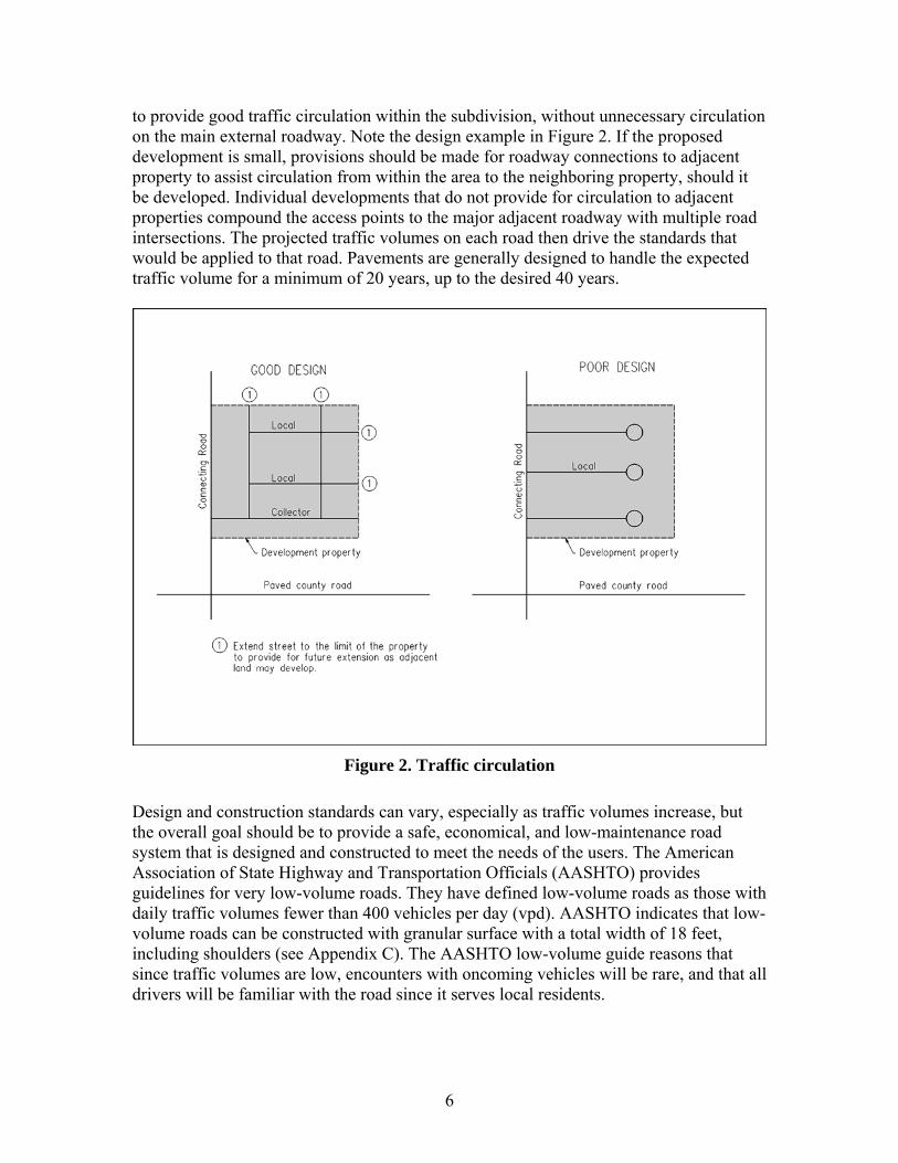
6
to provide good traffic circulation within the subdivision, without unnecessary circulation on the main external roadway. Note the design example in Figure 2. If the proposed development is small, provisions should be made for roadway connections to adjacent property to assist circulation from within the area to the neighboring property, should it be developed. Individual developments that do not provide for circulation to adjacent properties compound the access points to the major adjacent roadway with multiple road intersections. The projected traffic volumes on each road then drive the standards that would be applied to that road. Pavements are generally designed to handle the expected traffic volume for a minimum of 20 years, up to the desired 40 years.
Figure 2. Traffic circulation
Design and construction standards can vary, especially as traffic volumes increase, but the overall goal should be to provide a safe, economical, and low-maintenance road system that is designed and constructed to meet the needs of the users. The American Association of State Highway and Transportation Officials (AASHTO) provides guidelines for very low-volume roads. They have defined low-volume roads as those with daily traffic volumes fewer than 400 vehicles per day (vpd). AASHTO indicates that low-volume roads can be constructed with granular surface with a total width of 18 feet, including shoulders (see Appendix C). The AASHTO low-volume guide reasons that since traffic volumes are low, encounters with oncoming vehicles will be rare, and that all drivers will be familiar with the road since it serves local residents.

7
Counties across Iowa generally do not allow roadways to be constructed to these standards due to concerns for safety. Drivers who may be unfamiliar with the road or operators inexperienced in granular road driving could experience crashes as a result of these standards. As agencies look to establish appropriate standards based on traffic volumes, it is important to understand roadway standards and their objectives. Paved roads are provided as a means to serve users with an established travel path that is free of mud and dust, designed for the traffic volume involved, and safe at the operating speeds of the users. Unpaved roads do not meet those needs on a long-term basis, especially as traffic volumes increase. Roadway geometrics are the controls that create a well-designed facility and are established as a function of design speed. The design speed is determined by evaluating the use of the road, the use of the adjacent land, and the expected traffic volume on the road. Once the design speed is established, the roadway vertical and horizontal alignment are set to meet those characteristics necessary to travel safely at that speed. County roads are functionally classified in three groups: local, minor collector, and major collector. Local roads primarily provide access to private property and have the lowest daily volumes, usually fewer than 400 vehicles per day (vpd). Operating speeds on local roads are generally expected to be 25 miles per hour (mph); and the design speed would be 30 mph for urban cross-sections and 45 mph for rural cross-sections. Minor collector roads also provide access to private property, but have higher traffic volumes (generally more than 400 vpd, but fewer than 1500 vpd) because local road traffic accumulates as the drivers move through the area. The design speed for minor collector roads is slightly higher than for local roads, and is usually set at 35 mph for urban cross-sections and 50 to 55 mph for rural roads. Major collector roads are those that are used primarily for the movement of traffic and have a higher design speed of 60 mph; access to private property is less of a function due to safety considerations.
TYPICAL CROSS-SECTIONS
Roads are constructed to either a rural or urban cross-section. Each type of cross-section has specific characteristics that define what is included in the roadway. Rural cross-sections consist of a roadway surface of a defined width that includes the driving area and shoulders. The driving area and the shoulders can be granular or paved, or a combination of the two. Rural cross-sections include drainage ditches, which are adjacent to an elevated roadway and are designed to accommodate drainage from the roadway and adjacent properties. With 11-foot driving lanes, 4-foot shoulders, and adequate slopes and ditch width that can be appropriately maintained by adjacent property owners, the required land for the right-of-way of a local road with a rural cross-section will exceed 80 feet. The ditch foreslopes and backslopes (see Figure C.1) and ditch bottom can be made steeper and narrower as a means to construct the road in the

8
typical 66-foot right-of-way; however, the ability to properly maintain the slopes by the adjacent owner is compromised, as shown in Figure 3.
Figure 3. Steep slopes
Private property accesses most often involve use of culverts under the driveways to carry stormwater flow. Rural cross-sections do not typically provide a specific facility to address the needs of pedestrians and bicyclists due to low demand. Sidewalks and trails can be constructed with rural cross-sections; however, they most often will need to be located beyond the ditch slope area. The preferred location for the pedestrian facilities is within the right-of-way. Depending on the ditch slopes and width, the requirement for sidewalks in rural cross-section areas could make the right-of-way at least 10 feet wider. An alternative to the wider right-of-way is to place the sidewalks in an easement. The use of an easement provides less control than having the sidewalk in the right-of-way, but it does reduce the front yard requirements for the homeowner. Some rural paved roads have a wider (5-foot minimum) paved shoulder that can be designated as a bicycle facility. See Figure 4.
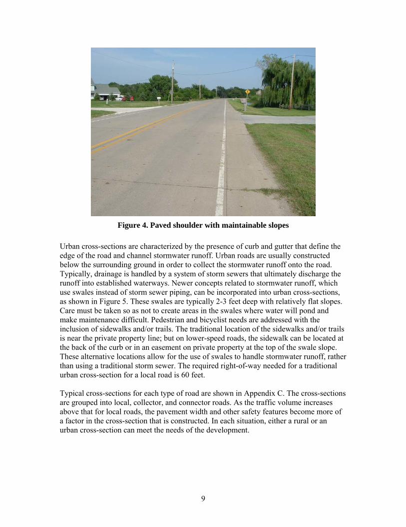
9
Figure 4. Paved shoulder with maintainable slopes
Urban cross-sections are characterized by the presence of curb and gutter that define the edge of the road and channel stormwater runoff. Urban roads are usually constructed below the surrounding ground in order to collect the stormwater runoff onto the road. Typically, drainage is handled by a system of storm sewers that ultimately discharge the runoff into established waterways. Newer concepts related to stormwater runoff, which use swales instead of storm sewer piping, can be incorporated into urban cross-sections, as shown in Figure 5. These swales are typically 2-3 feet deep with relatively flat slopes. Care must be taken so as not to create areas in the swales where water will pond and make maintenance difficult. Pedestrian and bicyclist needs are addressed with the inclusion of sidewalks and/or trails. The traditional location of the sidewalks and/or trails is near the private property line; but on lower-speed roads, the sidewalk can be located at the back of the curb or in an easement on private property at the top of the swale slope. These alternative locations allow for the use of swales to handle stormwater runoff, rather than using a traditional storm sewer. The required right-of-way needed for a traditional urban cross-section for a local road is 60 feet. Typical cross-sections for each type of road are shown in Appendix C. The cross-sections are grouped into local, collector, and connector roads. As the traffic volume increases above that for local roads, the pavement width and other safety features become more of a factor in the cross-section that is constructed. In each situation, either a rural or an urban cross-section can meet the needs of the development.

10
Figure 5. Urban cross-section without storm sewer
PAVED VERSUS UNPAVED ROADS
The most important decision to be made as agencies review subdivision development plans is not whether to use a rural or an urban cross-section, but whether to require paving or allow the construction of granular roads, as shown in Figure 6. The answer to that question will determine the long-term impact on generation of fugitive dust and escalating maintenance costs that the homeowners and the agency must deal with. This decision is particularly important when the development is within the designated growth area of a city. Allowing granular roads at a low initial developer cost will generate long-term problems due to the concerns that are raised by the homeowners for upgrades and/or maintenance. A portion of the costs will likely be placed on the public agency and thus the other citizens of the jurisdiction beyond the homeowners of the subdivision. Requiring an appropriate level of paving for the expected traffic volume and adjacent land use will initially cost the developer and the homeowners within the subdivision more, but will minimize long-term concerns for both the homeowners and the regulating agency. If roads are not paved, as traffic volumes increase, the generation of fugitive dust and the low level of service will become critical issues to the surrounding property owners. Concerns for environmental and health issues are then brought to the County Supervisors. An exception to this paving standard might be a short local road within a subdivision that cannot be extended because of a physical constraint, such as a river or steep bluff.

11
Figure 6. Unpaved local rural subdivision road
Technical Advisory Committee members felt that any currently unpaved road that connected the proposed development area to the paved county system should be paved if the proposed development created a projected traffic volume of 200 vehicles per day. At that level of traffic, it is very difficult to keep the crown of the road intact for drainage, and the driving surface becomes textured like a washboard in just a few days. Based on the traffic generation of eight trips per day for single family rural lots, the paving would be required if 25 lots were included in the development. The number of lots to trigger paving would be reduced by the pre-existing traffic volume on the granular road. The committee also felt that any road within the boundaries of the subdivision should be paved as a part of the development process. Groupings of developments that individually do not exceed 25 lots could present a problem because the paving threshold is not met as each of the developments is being reviewed; however, in aggregate, and over time, the area developments generate over 200 vehicles per day, causing roadway maintenance problems.
URBAN VERSUS RURAL ROADS
The use of a particular cross-section, either rural or urban, should be decided with consideration for the desires of the developer and the location of the road with respect to the designated growth area of the nearest urban area. Converting or reconstructing a rural roadway to an urban roadway as areas are annexed into the adjacent city is very difficult because of the characteristics related to the elevation of the road with respect to the surrounding properties and the drainage methods used. This is especially critical on

12
higher-volume roads that may be two-lane facilities in the rural area; however, as the land is annexed and urban growth occurs in the area, a multiple-lane road is needed to meet the traffic demands. Developers may prefer the use of an urban cross-section to minimize the amount of land that is needed for right-of-way, thus maximizing the land available for sale. Urban sections also provide property owners with lawn areas that are easier to maintain than steeper rural ditch slopes. Initial costs for urban pavements can be minimized through the use of swales to handle stormwater runoff, versus using complete storm sewer pipe systems. The swales also address the growing need to provide for stormwater quality issues in development areas.
RECOMMENDATIONS
Presently, there are many differences in the regulations for subdivisions and the required public improvements between most cities and counties in Iowa. The differences can be categorized by the size of lots and the public improvements required by the jurisdictions. Establishing a good set of zoning and subdivision regulations, and uniformly applying those regulations, is critical in addressing rural and suburban roadway standards. The zoning regulations establish the appropriate land use in a particular area and dictate the locations and size of developments; the subdivision regulations establish the public improvement requirements that must be part of the development. It is also critical for the county and adjacent city to cooperate and establish joint development requirements in the designated growth area of the city. The first step in that cooperation process is for the city to look closely at its land use policy plan and evaluate where and to what extent growth over a 20-year period is expected. From that review, a designated growth area should be established. The designated growth area then becomes the most critical area for jointly determining the type of developments that will be allowed and the public improvement regulations that govern the development. Although both jurisdictions are involved, by law, the city can impose its regulations directly on any developments within a two-mile radius of the city. If those requirements are perceived to be too onerous by area developers, they will move beyond the two-mile area and build their subdivisions based on county regulations only. Thus, to create the most efficient rural and suburban developments near city areas, it is critical to have reasonable development standards that are cost-efficient in the long run for the developers, the end users (homeowners), and the adjoining jurisdictions. It is recommended that developments within the designated growth area of a city use the roadway standards that include an urban cross-section with storm sewers. Once the roadways within the subdivision are properly-constructed to the appropriate local or collector standards, they should be dedicated as public right-of-way, and the county should accept them for maintenance. Although acceptance into the county road system brings increased costs, the properly constructed road with a design life of at least 40 years

13
will not create unusual problems in the future and will serve the adjacent homeowners. In addition, property values will be higher on a well-constructed road as opposed to a granular or substandard road. Also, the regulation of speeds and other regulatory elements, such as on-street parking, can be established and dealt with when the right-of-way and road, as noted in the cross-sections in Appendix C, are dedicated to the county. When public improvement requirements related to subdivision developments are implemented, the street improvements are likely to remain in place for more than 20 years. Thus, using the urban cross-sections within the designated growth area provides for smoother transitions as rural areas are annexed into the adjacent city. One potentially unfortunate result of accepting new, properly constructed roadways into the county system for maintenance is the likelihood that homeowners groups faced with maintaining older, substandard roadways may request that their roads be maintained by the county. The county Board of Supervisors will have to be strict about only accepting properly designed and constructed roads. An unpaved existing county road connecting a proposed development to a paved road is of particular concern. Since these roads are typically on one-mile spacing and are continuous throughout the county, they are considered the backbone of the area transportation system. As granular roads, they serve the needs of rural homesteads and agricultural traffic but may not be adequate once development takes place. In accordance with Chapter 311 of the 2007 Code of Iowa, counties are unable to initiate a special assessment project for the impacted property owners to pay for paving of an unpaved connecting road. Without a voluntary petition from at least 50% of the owners of the land in the assessment district that indicates that they will pay for at least 50% of the project costs, counties would have to pay for the paving project as a part of their secondary road program. A connecting road is a part of the county road network and is likely to become an important street as the area develops and the road is used by more traffic in the designated growth area of a city. Because of that importance and the long life of any pavement, the connecting road should be paved to an urban cross-section within the designated growth area of a city. It is very likely that this road will need to be widened to multiple lanes as the area grows in the future and is annexed into the nearby city. The urban cross-section will make any expansion of the road reasonably cost-effective, since the additional paving would consist only of widening. Conversely, converting a two-lane rural cross-section to a multi-lane urban facility would involve total removal of the paving and reconstruction to meet the urban requirements. For roads within developments outside of the designated growth area of a city, the selection of rural versus urban cross-section is not as critical. The option could be left to the developer to select the type they would like to propose, as long as good regulations were in place for both types. The amount of land required for right-of-way, the characteristics of the land (soils, slope, wooded area, etc.), and the type of drainage facilities to be used would be elements to consider in the decision. It is recommended that

14
the rural cross-sections be used as a default and the developers be allowed to propose other cross-sections, if they so desire. Each cross-section alternative in Appendix C has two possible layouts. The desirable cross-section should be used whenever possible. If a physical restriction prevents the implementation of the desirable cross-section, the county can use the minimum. Use of the minimum cross-section should only take place after adequate justification has been presented and approved. The geometrics for the different road cross-sections are summarized in the tables below.
Table 1. Rural subdivision cross-section geometrics Connector Collector Local Design
Elements Desirable Minimum Desirable Minimum Desirable MinimumDesign speed (mph) 60 60 55 50 45 45
Avg. daily traffic > 1500 >1500 400-1500 400-1500 <400 <400
Pavement width 24’ 24’-striped at 22’ 24’ 22’ 22’ 22’
Shoulder width 8’ 8’ 6’ 5’ 4’ 4’
Shoulder type 4’ paved/4’ rock rock rock rock rock earth
Right-of-way width 100’ 80’ 80’ 66’ 66’ 66’
Slopes 6:1 4:1 4:1 3:1 4:1 3:1 Parking allowed none none none none none none Stopping sight distance 570’ 570’ 495’ 425’ 360’ 360’
Horiz. curve (min)* 1340’ 1205’ 965’ 760’ 500’ 500’
Maximum grade 5% 8% 6% 8% 8% 10%
*Horizontal curve minimum values are based on 6% superelevation for desirable sections and 8% for minimum sections for connector and collector roads. The 8% superelevation will require special design elements. For grades greater than 3%, the stopping site distance is increased.

15
Table 2. Urban and suburban cross-section geometrics Connector Collector Local Design Elements
Desirable Minimum Desirable Minimum Desirable MinimumDesign speed (mph) 60 60 35 35 30 30 Avg. daily traffic > 1500 >1500 400-1500 400-1500 <400 <400 Pavement width 31’ 31’ 31’ 26’ 26’ 26’ Right-of-way width 100’ 80’ 80’ 66’ 66’ 60’ Parking allowed none none one side none one side one side Stopping sight distance 570’ 570’ 250’ 250’ 200’ 200’
Horiz. curve (min)* 1505’ 1505’ 420’ 420’ 300’ 300’ Maximum Grade 5% 8% 6% 10% 6% 10% *Horizontal curve minimums are based on 4% superelevation on connector and collector roads with no superelevation on local roads. It is recommended that these geometric tables and cross-sections be processed through the Statewide Urban Design and Specifications (SUDAS) review program of district meetings and action by the Board of Directors to include these geometric tables and typical cross-sections in the SUDAS Design Standards.

A-1
APPENDIX A: LITERATURE REVIEW
This literature search was conducted with the following resources:
• TRIS • Google • State and county websites
Keywords used:
• County • Design • Geometrics • Highway • Road • Roadway • Rural • Standards • Streets • Subdivision

A-2
Vermont State Design Standards: Chapter 6 Local Roads and Streets Vermont Agency of Transportation http://www.aot.state.vt.us/progdev/standards/06local.htm Design Speed
• Normally 25 to 50 mph • Normally equal to anticipated posted speed • Lower design speed may be considered to:
o Avoid and/or minimize impacts to historical, architectural, scenic, natural, or other resources
o Avoid excessive construction costs o Better comply with a town or regional plan
• Design speeds may be as much as 10 mph lower than legal speeds, provided appropriate warnings are posted
Minimum Stopping Sight Distance for Local Roads/Street (Wet Pavement) Rehabilitation, Reconstruction, or New Construction
Design Speed (mph) Stopping Sight Distance (ft)
K Value for Crest Vertical Curve
K Value for Sag Vertical Curve
25 150 20 30 30 200 30 40 35 225 40 50 40 275 60 60 45 325 80 70 50 400 110 90
Minimum Corner Sight Distances* For Local Roads & Streets Design Speed on Main Road (mph) Corner Sight Distance (ft)
25 275 30 330 35 385 40 440 45 495 50 550 55 605
* Corner sight distance is measured from a point on the intersecting road, at least 15 ft from the edge of traveled way on the main road

A-3
Vermont Agency of Transportation
Minimum Width of Lanes & Shoulders for Rural Local Roads Design Traffic Volume
ADT* 0-25
ADT 25-50
ADT 50-100
ADT 100-400
ADT 400-1500
ADT 1500-2000
ADT 2000+
Design Speed (mph) Width of Lane / Shoulder (ft)
25 7/0 8/0 9/0 9/2 9/2 10/3 11/3 30 7/0 8/0 9/0 9/2 9/2 10/3 11/3 35 7/0 8/0 9/0 9/2 9/2 10/3 11/3 40 7/0 8/0 9/2 9/2 9/2 10/3 11/3 45 --- --- 9/2 9/2 9/2 10/3 11/3 50 --- --- 9/2 9/2 10/2 10/3 11/3
*Minimum width of 8 / 0 wherever there is a guardrail Minimum Clear Zone Distances For Rural Principal Arterials (in ft from edge of traveled way)
Fill Slopes Cut Slopes Design Speed (mph)
Design ADT (VPD) 1:4 or flatter 1:3 1:3 1:4 or flatter <750 7 * 7 7
750-1500 12 * 10 10 1500-6000 14 * 12 12 45 or less
>6000 16 * 14 14 <750 12 * 8 8
750-1500 16 * 10 12 1500-6000 20 * 12 14 50
>6000 24 * 14 18 *Determination of recovery area width should take into consideration ROW availability, environmental concerns, cost, and safety Clear Zones
• Clear zones as narrow as 5 feet may be used to avoid and/or minimize disturbances • On high speed roads (50+ mph), clear zones may be limited to 10 ft • On low speed roads (< 45 mph), clear zones may be limited to 7 ft • On uncurbed local roads where speeds are 35+ mph, the clear zone may be limited to 5 ft • On curbed local roads, a 1.5 ft horizontal offset from face of curb should be provided
Alignment
• Alignment is normally designed in accordance to AASHTO values for design speed • Curves with design speed 20 mph below posted speed may be used to avoid and/or
minimize disturbances • Curves within 750 ft of a stop sign may have design speed up to 15 mph below posted
speed
A-4
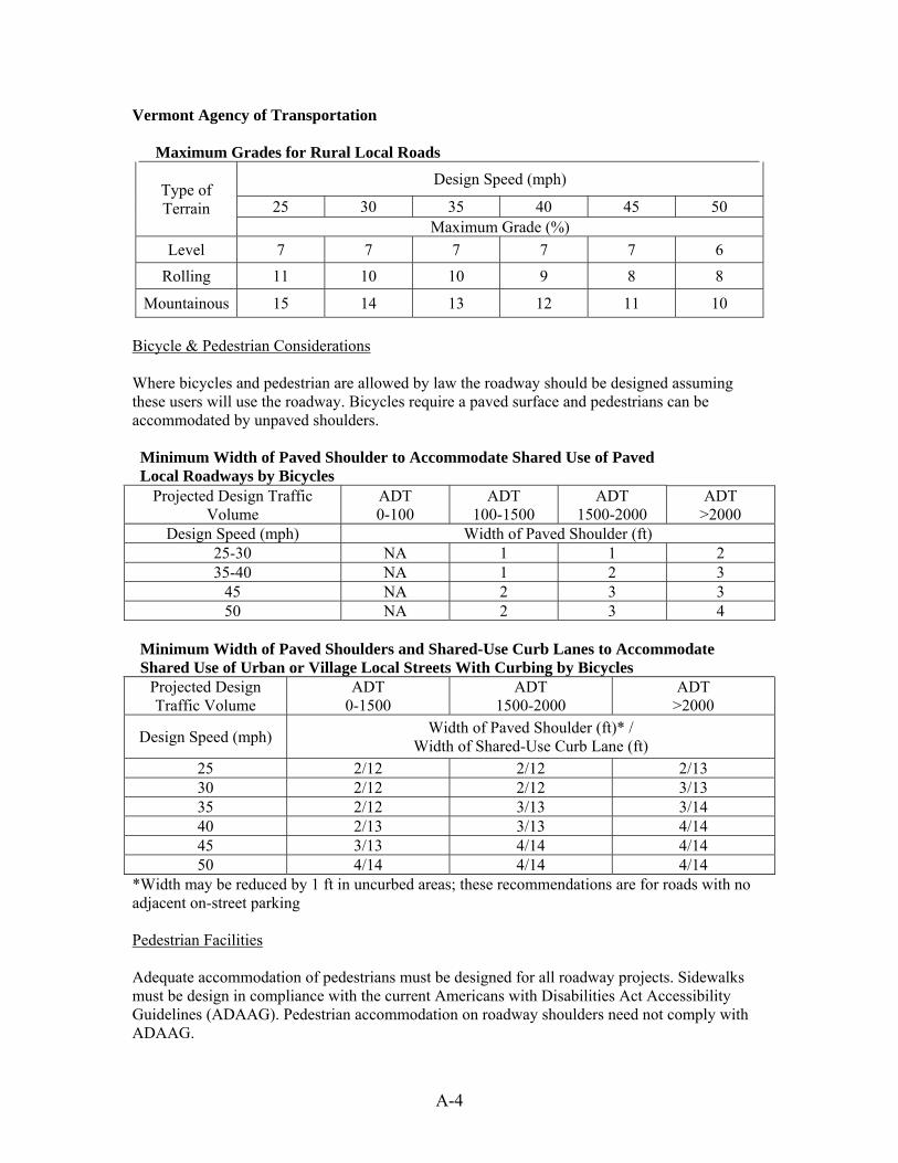
Vermont Agency of Transportation Maximum Grades for Rural Local Roads
Design Speed (mph)
25 30 35 40 45 50 Type of Terrain
Maximum Grade (%) Level 7 7 7 7 7 6
Rolling 11 10 10 9 8 8
Mountainous 15 14 13 12 11 10 Bicycle & Pedestrian Considerations Where bicycles and pedestrian are allowed by law the roadway should be designed assuming these users will use the roadway. Bicycles require a paved surface and pedestrians can be accommodated by unpaved shoulders. Minimum Width of Paved Shoulder to Accommodate Shared Use of Paved Local Roadways by Bicycles
Projected Design Traffic Volume
ADT 0-100
ADT 100-1500
ADT 1500-2000
ADT >2000
Design Speed (mph) Width of Paved Shoulder (ft) 25-30 NA 1 1 2 35-40 NA 1 2 3
45 NA 2 3 3 50 NA 2 3 4
Minimum Width of Paved Shoulders and Shared-Use Curb Lanes to Accommodate Shared Use of Urban or Village Local Streets With Curbing by Bicycles
Projected Design Traffic Volume
ADT 0-1500
ADT 1500-2000
ADT >2000
Design Speed (mph) Width of Paved Shoulder (ft)* / Width of Shared-Use Curb Lane (ft)
25 2/12 2/12 2/13 30 2/12 2/12 3/13 35 2/12 3/13 3/14 40 2/13 3/13 4/14 45 3/13 4/14 4/14 50 4/14 4/14 4/14
*Width may be reduced by 1 ft in uncurbed areas; these recommendations are for roads with no adjacent on-street parking Pedestrian Facilities Adequate accommodation of pedestrians must be designed for all roadway projects. Sidewalks must be design in compliance with the current Americans with Disabilities Act Accessibility Guidelines (ADAAG). Pedestrian accommodation on roadway shoulders need not comply with ADAAG.

A-5
Geometric Design Tables / Design Appendices Minnesota Department of Transportation http://www.dot.state.mn.us/tecsup/xyz/plu/desstand/highway/ Minimum Geometric Design Standards; Rural and Suburban Undivided; New or Reconstruction Projects
Projected ADT
Land Width,
ft
Shoulder Width, ft
In-Slope,
rise:run
Recovery Area, feet
Design Speed, mph
Surfacing
Structural Design
Strength, tons
Roadway Width C-
C, ft
0-49 11 1 1:3 7 30-60 Agg. 22 50-149 11 3 1:4 9 40-60 Agg. 22
150-749 12 4 1:4 15 40-60 Paved 9 28 750-1499 12 4 1:4 25 40-60 Paved 9 28
1500+ 12 6 1:4 30 40-60 Paved 10 30 Source: http://www.revisor.leg.state.mn.us/arule/8820/9920.html Minimum Geometric Design Standards; Rural and Suburban Undivided; Reconditioning Projects
Existing ADT Statutory or Regulatory Posted
Speed (mph)
Lane Width (Paved) Combined Lane (Paved) and Shoulder
Width 1-749 < 50 10 11 1-749 50+ 10 12 750+ < 50 10 12 750+ 50+ 11 14
Source: http://www.revisor.leg.state.mn.us/arule/8820/9926.html

A-6
Best Practices for Rural Entrance Policy Montebello, D.; Domres, T. SRF Consulting Group, Inc. Sponsored by the Minnesota Local Road Research Board The main reasons for managing rural access are safety and operational/maintenance issues:
• Protect the functional area of the intersections • Provide adequate sight distance • Avoid offset access points
Rural Private Entrance Spacing Guidelines Speed (mph) State <35 35 45 > 45
New York One access per parcel; 100’ from an intersecting roadway Iowa 100-200’
Wisconsin One access per parcel South Dakota 150-350’ 350’
Florida 125’ 440’ 660’ 1,320’ Oregon 160’ 330’ 660’ 660’ Maine 125’ 150’ 230’ 275’
Collector Roads 150-250’ 250’ 495’ 550-715’ Ohio Local Roads One access per parcel; stopping sight distance Private/Farm
Access One access per parcel
Low-Volume Entrance/Road One access per parcel; stopping sight distance Minnesota
High-Volume Entrance/Road One access per parcel by exception; stopping sight distance

A-7
Minnesota Local Research Board
Access Spacing Criteria for Unsignalized Roads (ft) Posted Speed (mph) Spacing Criteria Scenario 30 35 40 45 50 55
Right-Turn Conflict Overlap
Local roads & divided highways in rural areas 100 150 200 300
AASHTO Stopping Sight
Distance(1)
Local roads & collector roads in rural areas 200 250 305 360 425 495
Intersection Sight Distance
Local roads, collector & arterials in rural &
transition areas 325 400 475 550 650 725
Stopping Sight Distance(2)
Local roads, collectors & arterials in rural area types 275 350 435 530 640 750
Functional Intersection Area(3)
Local roads, collectors & arterials in rural area types 480 480 480 590 700 820
Maximum Egress Capacity
Collectors & arterials in rural area types 320 450 620 860 1125 1500
(1) 9 ft/s2 deceleration (2) 6 ft/s2 deceleration (3) Length of turn lane (480 ft min.) – turning traffic to leave through lane with a speed
differential less than or equal to 10 mph Entrance Design Guidelines for Rural Two-Lane Collectors & Local Roads
Residential Commercial, Industrial, Farm Local Roads & Collectors Design Criteria
Min Max Desired Min Max Desired Min Max Desired Entrance
Angle/Skew (degrees)
70 110 90 70 110 90 70 110 90
Width (ft) 18 24 24 24 32 32 24 32 24 Corner Clearance
(ft) 60 500+ 500+ 60 500+ 500+ 60 500+ 500+
Radius (ft) 5 25 25 25 40 25 25 60 35 Entrance Grade
(percent) 0 ±7 0 0 ±7 0 0 ±7 0
Landing (ft) 15 150 50 25 150 50 25 150 50 Side Slope (ft:ft) 1:4 1:6 1:6 1:4 1:6 1:6 1:4 1:6 1:6
Turn Lane* Width (ft) 12 14 12 12 14 12 12 14 12
* 480 feet in length

A-8
Growing Traffic in Rural America: Safety, Mobility and Economic Challenges in America’s Heartland The Road Information Program March 2005 http://www.tripnet.org/RuralRoads2005Report.pdf • Rural populations and rural road use has been increasing • The reliance of truck traffic on rural roads to move agricultural goods is expected to increase • Traffic fatalities occur on the nation’s rural roads at a rate 2.5 times greater than all other
roads • Inadequate roadway safety design and higher speeds on rural roadways are factors in the
higher fatality rate on non-interstate rural roads • Fatal crashes due to a vehicle leaving its lane is far more likely on rural roads than on urban
roads Safety improvements to consider:
o Rumble strips o Centerline rumble strips o Improved signage & pavement markings o Install lighting o Removing or shielding roadside obstacles o Upgrade or add guardrails o Chevrons and post-mounted delineators along curves o Install median barriers o Adding turn lanes at intersections o Resurfacing pavements o Add or pave shoulders o Improved highway alignment o Construct intermittent passing lanes or two-way left turn lanes o Widen lanes o Add lanes

A-9
Suggested Minimum Design Standards for Rural Subdivision Streets New Hampshire Department of Transportation December 2003 Intersection Angle ≥ 60 degrees (try for 90 degrees) Cul-de-Sacs
Length ≤ 1,000 ft Diameter ≥ 100 ft ROW Width ≥ 50 ft Horizontal Curvature ≥ 100 ft radius Grades ≥ 0.5 % and ≤ 10 % Gravel Base ≥ 12 inches Asphalt Surface
Traveled Way Width ≥ 20 ft (51-750 vpd) ≥ 22 ft (751-1500 vpd) ≥ 24 ft (1501+ vpd) Pavement Width 44 ft (parking on both sides) Gravel Shoulder Width 2 ft (51-200 vpd) 4 ft (201-1500 vpd) 8-10 ft (1500+ vpd) Gravel Surface ≤ 50 vpd, roadway width ≥ 22 ft Parking No angle parking Sidewalks (when deemed necessary)
Thickness 2 inches (asphalt) 4 inches (gravel base) Width ≥ 5 ft Distance from Centerline ≥ 22 ft Utility Poles Keep close to the ROW line; no closer than the ditch line

A-10
New Hampshire Department of Transportation Minimum Geometric & Structural Guides For Local Roads And Streets
ADT (vpd) 0-50 51-200 201-750 751-1500 1500+ Pavement Width 18’ min. 20’ 20’ 22’ 24’ Shoulder Width 2’ 2’ 4’ 4’ 8-10’
Center of Road to Ditch Line 15’ 16’ 18’ 19-21’ Varies
Pavement Type Gravel Asphalt Surface Treated
Hot Bituminous Hot Bituminous Hot
Bituminous
Slope of Roadway 4% 3% 2% 2% 2% Gravel 12” 12” 12” 12” 18” Base Course
Depth Cr. Gravel - - 4” 6” 6” Notes: 1. Gravel surface should be paved where steep grades occur 2. For ADT greater than 1000 vpd, paved shoulders should be considered 3. Base course depths may need to be increased in areas of poor soils
A-11
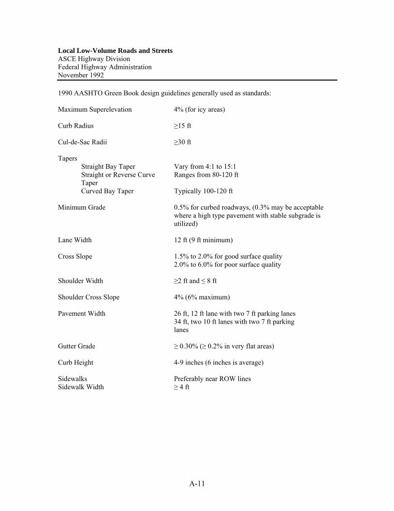
Local Low-Volume Roads and Streets ASCE Highway Division Federal Highway Administration November 1992 1990 AASHTO Green Book design guidelines generally used as standards: Maximum Superelevation 4% (for icy areas) Curb Radius ≥15 ft Cul-de-Sac Radii ≥30 ft Tapers
Straight Bay Taper Vary from 4:1 to 15:1 Straight or Reverse Curve Ranges from 80-120 ft Taper Curved Bay Taper Typically 100-120 ft
Minimum Grade 0.5% for curbed roadways, (0.3% may be acceptable
where a high type pavement with stable subgrade is utilized)
Lane Width 12 ft (9 ft minimum) Cross Slope 1.5% to 2.0% for good surface quality 2.0% to 6.0% for poor surface quality Shoulder Width ≥2 ft and ≤ 8 ft Shoulder Cross Slope 4% (6% maximum) Pavement Width 26 ft, 12 ft lane with two 7 ft parking lanes 34 ft, two 10 ft lanes with two 7 ft parking lanes Gutter Grade ≥ 0.30% (≥ 0.2% in very flat areas) Curb Height 4-9 inches (6 inches is average) Sidewalks Preferably near ROW lines Sidewalk Width ≥ 4 ft
A-12
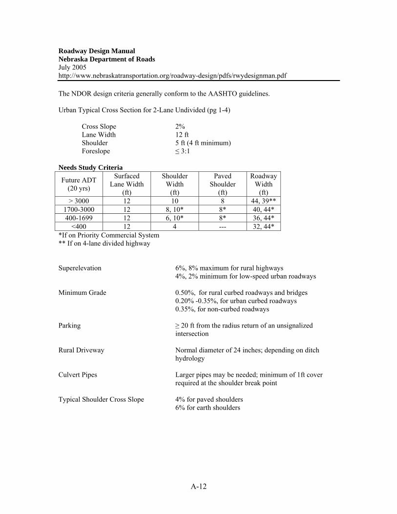
Roadway Design Manual Nebraska Department of Roads July 2005 http://www.nebraskatransportation.org/roadway-design/pdfs/rwydesignman.pdf The NDOR design criteria generally conform to the AASHTO guidelines. Urban Typical Cross Section for 2-Lane Undivided (pg 1-4) Cross Slope 2% Lane Width 12 ft Shoulder 5 ft (4 ft minimum) Foreslope ≤ 3:1 Needs Study Criteria
Future ADT (20 yrs)
Surfaced Lane Width
(ft)
Shoulder Width
(ft)
Paved Shoulder
(ft)
Roadway Width
(ft) > 3000 12 10 8 44, 39**
1700-3000 12 8, 10* 8* 40, 44* 400-1699 12 6, 10* 8* 36, 44*
<400 12 4 --- 32, 44* *If on Priority Commercial System ** If on 4-lane divided highway Superelevation 6%, 8% maximum for rural highways 4%, 2% minimum for low-speed urban roadways Minimum Grade 0.50%, for rural curbed roadways and bridges 0.20% -0.35%, for urban curbed roadways 0.35%, for non-curbed roadways Parking ≥ 20 ft from the radius return of an unsignalized
intersection Rural Driveway Normal diameter of 24 inches; depending on ditch
hydrology Culvert Pipes Larger pipes may be needed; minimum of 1ft cover
required at the shoulder break point Typical Shoulder Cross Slope 4% for paved shoulders 6% for earth shoulders

Rural G
eometric D
esign Standards M
arion County, O
regon http://publicw
orks.co.marion.or.us/engineering/engineeringstandards/Tables/TA
BLE%
202.pdf C
ited August 2006
Road
Classification
AD
T (vpd)
Minim
um
RO
W
Minim
um
Pavement
Width
Gravel
Shoulders 4 Parking
Terrain C
ross Slope
Design
Speed (m
ph)
Minim
um
Horizontal R
adius 1
Maxim
um
Superelevation (ft/ft)
Maxim
um
Grade (%
) 5
Arterial
1000-10000
66’ 28’
2’ N
one S < 5
5=S=15 S = 15
55 45 35
1035’ 660’ 380’
.06 6 8
10
Collector
500-1500
60’ 22’
5’ N
one S < 5
5=S=15 S = 15
55 45 35
1035’ 660’ 380’
.06 6 8
10 Local
(Through R
oad) 0-500
60’ 22’ 5
5’ O
n Shoulder
S < 5 5=S=15 S = 15
50 40 30
925’ 560’ 300’
.04 7 9
12 Local
(Subdivision of C
ul-de-sac = 1320’)
0-500 60’
22’ 5 5’
On
Shoulder
S < 5 5=S=15 S = 15
30 25 20
460’ 320’ 205’
Norm
al Crow
n 8
10 12
Cul-de-sac =
1320’ 0-500
60’ (50’ if =
500’ long)
22’ 5
(20’ if = 500’ long)
5’ O
n Shoulder
S < 5 5=S=15 S = 15
25 20 20
320’ 205’ 205’
Norm
al Crow
n 8
3
103
122,3
1. For minim
um (centerline) radius show
n, maxim
um superelevation m
ust be used. 2. G
rades of up to 15% m
ay be approved. They shall be located a distance of 200 feet or more from
and intersection with a m
ajor street or an intersection requiring a stop.
3. Maxim
um slope from
center of cul-de-sac to back of cul-de-sac shall not exceed 8%.
4. Roads that are designed as bike routes shall have paved shoulders.
5. For paving of existing gravel roads, the minim
um pavem
ent width should be 20’.
Note: A
t intersections, the maxim
um longitudinal slope of all non-through streets shall be 8%
for at least 50’ from the edge of the intersecting
pavement.
A-13

A-14
Chapter 11: Geometric Design of Highways Traffic Engineering Handbook Fifth Edition Institute of Transportation Engineers 1999 Recommended Range of Design Speeds by Location & Functional Classification, mph
Terrain Rural Collector & Local Roads Flat 35-60
Rolling 30-50 Recommended Design Levels of Service by Location & Functional Classification
Terrain Rural Collector & Local Roads Flat C
Rolling C-D Maximum Grades for Design of Highways and Streets
Rural Collector Design Speed (mph)
20 25 30 35 45 50 55 60 70 Type of Terrain
Grade (%) Level 7 7 7 7 7 6 6 5 4
Rolling 10 10 9 8 8 7 7 6 5
Rural Local Road Design Speed (mph)
20 25 30 35 45 50 55 60 Type of Terrain
Grade (%) Level 8 7 7 7 7 6 6 5
Rolling 11 11 10 10 8 7 7 6
Width of traveled way 18 ft min. (ADT <400, design speed 30 mph) (Local roads) 24 ft max. (ADT >2000, design speed 50 mph) Width of graded shoulder 2 ft min. (ADT <400) (Local roads) 8 ft max. (ADT >2000) Corner radii Should be determined using an appropriate design
vehicle Sidewalk width 4-6 ft are common Sidewalk setback ≥5 ft, and desirably up to 10 ft from traveled way Sidewalk grades <5 %
A-15
Sources
Best Practices for Rural Entrance Policy. 2002. Minnesota Local Road Research Board. Geometric Design Standards; Rural And Suburban Undivided; New Or Reconstruction Projects. Minnesota Department of Transportation. Cited December 2005. http://www.revisor.leg.state.mn.us/arule/8820/9920.html Geometric Design Standards; Rural And Suburban Undivided; Reconditioning Projects. Minnesota Department of Transportation. Cited December 2005. http://www.revisor.leg.state.mn.us/arule/8820/9926.html Growing Traffic in Rural America: Safety, Mobility and Economic Challenges in America’s Heartland. The Road Information Program. March 2005. http://www.tripnet.org/RuralRoads2005Report.pdf Local Low Volume Roads And Streets. 1992. American Society of Civil Engineers Highway Division. Federal Highway Administration. Marion County, Oregon Rural Geometric Design Standards. Cited August 2006. http://publicworks.co.marion.or.us/engineering/engineeringstandards/Tables/TABLE%202.pdf Roadway Design Manual. Nebraska Department of Roads. July 2005. http://www.nebraskatransportation.org/roadway-design/pdfs/rwydesignman.pdf Suggested Minimum Design Standards for Rural Subdivision Streets. 2003. New Hampshire Department of Transportation. Traffic Engineering Handbook 5th Edition. 1999. Institute of Transportation Engineers. Vermont State Design Standards: Chapter 6 Local Roads and Streets. Vermont Agency of Transportation. October 1997. http://www.aot.state.vt.us/progdev/standards/06local.htm

B-1
APPENDIX B: QUESTIONNAIRE RESULTS
Questionnaire To: (Name of County Engineer/Zoning Administrator) From: Paul Wiegand, SUDAS Transportation Research Engineer Subject: Roadway Design Standards for Rural and Suburban Subdivisions To address concerns raised by County Engineers and other staff members involved with development review, and through funding of the Iowa Highway Research Board, SUDAS staff is undertaking a research project to develop roadway design standards for rural and suburban residential subdivisions. As a part of that project, we would like to determine what existing standards are being used, as well as concerns you might have about the current standards, or lack thereof, in your jurisdiction. Your input will be very valuable as we pursue this project. Please complete the questionnaire at your earliest convenience. You may return it in the envelope we have provided or FAX it to my attention at the number below. If another department has authority for development regulations within your County, please forward this survey to them. If you have any questions about the project, please feel free to contact me at the address shown below. Paul Wiegand Center for Transportation Research and Education 2901 South Loop Drive, Ste 3100 Ames, IA 50010 [email protected] 515-294-7082 FAX 515-294-0467

B-2
QUESTIONNAIRE RELATED TO
ROADWAY DESIGN STANDARDS FOR RURAL AND SUBURBAN SUBDIVISIONS
Name of County: ________________________________ Person completing the survey (optional): ______________________
1. Within new subdivisions, how are the maintenance and ownership of the roadway area dealt with?
____ Required to be dedicated to the County in fee; County accepts maintenance ____ Dedicated as an easement for public use, but no County maintenance ____ Dedicated as an easement for public use, and County accepts maintenance ____ Designated as an outlot with Homeowners Association responsible for
maintenance ____ Designated as a private road with Homeowners Association responsible for
maintenance ____ Other (please explain) ______________________________________ ______________________________________
2. Does your county have warrants for paving internal subdivision roads? Yes: _____ No: ______
If No, go to question 3.
If Yes, please provide the following information: Roadway paving is a basic requirement of the platting and development of the subdivision? ______________ If warrant is based on estimated average daily traffic (ADT), what is the threshold for paving? __________________
If warrant is based on lot density (i.e. lots per acre; lots per mile), What is the density? _______________________
List other paving warrants: _______________________________

B-3
3. Does your County have design standards for new subdivision roads? Yes: ______ No: _______
If No, go to question 4. If Yes, please complete the questions below or forward a copy of your standards to me by email, letter, or FAX according to the applicable contact information shown on the cover letter. Roadway Design Standards: Design speed:___________ Right-of-way width:__________ Pavement width: ___________ Cul-de-sac radius: __________ Maximum grade:____________
Maximum length of cul-de-sac or dead end street: ________ List if different length based on different land uses Low density residential _________ High density residential _________ Commercial __________________ Industrial: ____________________
Pavement thickness: HMA: __________ PCC: __________ Shoulder width (if applicable): __________ Curb required: __________ If yes, intakes and storm sewer required: __________ On-street/shoulder parking allowed: __________ Ditch geometrics (if applicable): Fore slope: __________ Minimum width: __________ Minimum depth: __________ Back slope: __________ Storm sewer design frequency (if applicable): __________ Sidewalks required: No: _________ Yes: _________ One side: _________ Both sides: ________ Within the right-of-way: ________ Within easements on private property: __________ Driveways: Restrictions on access Number per mile __________
Width: Minimum: __________ Maximum: __________ Minimum culvert size (if applicable): _____________ Spacing requirement: To nearest intersection: __________ Between driveways: __________ Material requirement: ________________

B-4
Do your standards provide a specific location within the right-of-way for underground utilities, such as rural water and natural gas? Yes: ___________ No: ____________
4. Does your County have paving warrants for unpaved roads connecting the subdivision with a paved road?
Yes: _____ No: ______ If No, go to question 5. If yes, please provide the following information:
If warrant is based on average daily travel volume, what is the volume? __________
If warrant is based on density (i.e. lots per acre; lots per mile), what is the density? _____________
Other paving warrants: ___________________________________ 5. Comments and concerns about your regulations: _______________________________________________________________________________________________________________________________________________________________________________________________________________________________________________________________________________________________________________________________________________________________________________________

B-5
Questionnaire Responses Questions 1-3 (frequency indicated in parentheses)
Question
1* Question
2 Question
3 Question
4 ROW
Width, ft Pavement Width, ft Cul-de-sac Radius, ft
A (8) N (21) Y (25) N (33) 32 (1) 18-41 (1) 30 (1)
B (6) Y1 (13) N (13) Y1, Y3 (1) 42-80 (1) 20 (1) 35.5, 39.5 ROW (1)
C (6) Y3 (1) Y (1) 50 (3) 20-31 (1) 40 (1)
D (2) Y4 (1) 60 (3) 22 (6) 40-45 (1)
E (22) 60-80 (1) 22-31 (1) 42.5 (1)
Other (12) 66 (7) 24 (5) 45 (2)
66 min (1) 26 (1) 50 (1)
70 (1) 26-49 (1) 50 min (1)
80 (1) 30 incl. shoulders (1) 50, 60 ROW (1)
* Some Multiple
Responses depends
(1) depends (2) 50, 80 ROW (1)
N/A (1) 55 (1)
75 (1)
80 (1)
80, 120 ROW (1)
100 (1)
100 ROW, 80 turnaround (1)
100, 120 ROW (1)
120 (1)
132 (1)

B-6
Max.
Grade, % Max. Length of Cul-de-sac or
Dead End Street, ft Pavement Thickness HMA, in Pavement Thickness PCC, in
6 (1) 500 (2) 4 on 12 in. stone (1) 6 (9)
7 (6) 600 (7) 4 base, 1.5 wearing course (1) 6 min (1)
7-8 (1) 600, up to 1000 w/ approval (1) 6.5 w/ 4 in. rolled stone base (1) 7 (6)
8 rec (1) 750 (1) 6.5+ (1) 7 on 8 in. stone
9 (2) 800 (1) 7 (5) N/A (2)
10 (6) 1000 (2) 7 min (1)
11 (2) 1300 (1) 3-4 on 4 in. choke stone, 8 McCadem Stone (1)
12 (2) 4500 (1) 6 in. base, 4 in. subbase, 2 in. cover (1)
variable (1) 8 (1)
N/A (1) 8 w/ 5 in. rock base (1)
8.5 (2)
N/A (2)
Shoulder Width, ft Curb Required Intakes & Storm Sewer Req'd On Street / Shoulder Parking
Allowed?
2 min (1) Yes (5) Yes (8) Yes (8)
2 (1) No (10) Yes, if city design (1) Yes , on wider street (1)
3 (1) can use (1) No (1) No(4)
4 (8) urban sections (1) as engineered (1) 31' B-B (1-side), 39' B-B (both sides)
4 min (1) on island (1) where proper drainage facilities do not exist (1) N/A (2)
4-6 (1) optional (2) when curb is 31' B-B and storm sewer (1)
5 (1)
6 (1)
7 (1)
N/A (1)

B-7
Ditch Foreslope Ditch
Minimum Width, ft
Ditch Minimum Depth, ft
Ditch Backslope
Storm Sewer Design Frequency
Sidewalks Required
2:1 (4) 3 (1) 1 (1) 1.5:1 (1) 5 yr (1) Yes (3)
< 2:1 (1) 4 (3) 2 (8) 2:1 (4) 10 yr (1) No (18)
3:1 (10) 5 (1) 2.5 (2) < 2:1 (1) 25 yr (2) Depends (3)
< 3:1 (1) 6 (2) 3 (5) 2.5:1 (1) 50 yr (1)
4:1 (1) 9 (1) 3:1 (9) 100 yr (1)
6:1 w/ drainage structure, 10:1 w/ out 10 (2) < 3:1 (1) varies (1)
13 (1) N/A (4)
15 (1)
variable (1)
Driveways per
Mile Driveways
Min. Width, ft
Driveways Max. Width,
ft
Driveway Min. Culvert
Size, in
Driveway Spacing to Nearest Intersection,
ft
Spacing Between
Driveways, ft
12 (2) 16 (2) 24 (1) 12 (1) 150 (2) 100 (1)
30 (1) 18 (1) 36 (1) 15 (10) 75 (1) 250 (1)
1 per lot (2) 20 (4) 40 (2) 18 (6) 100 (1) 75 (1)
4 for ag. Zoned (1) 24 (5) 45 (1) 24 (1) 125 (1) N/A (4)
N/A (4) 40 (1) 50 (1) N/A (4) varies (1)
no restriction (1) N/A (1) N/A (1) 1 per lot (1)
Driveway Material Requirement Specific ROW
location for Utilities?
2 in. of 3/4 in. crushed rock (1) Yes (6)
4 in. rolled stone (1) No (17)
Class B gravel or Class A crushed stone (1)
CMP (2)
CMP or RCP (2)
concrete (1)
granular material (1)
N/A (1)
rock surface min. (1)
Steel or Concrete (2)
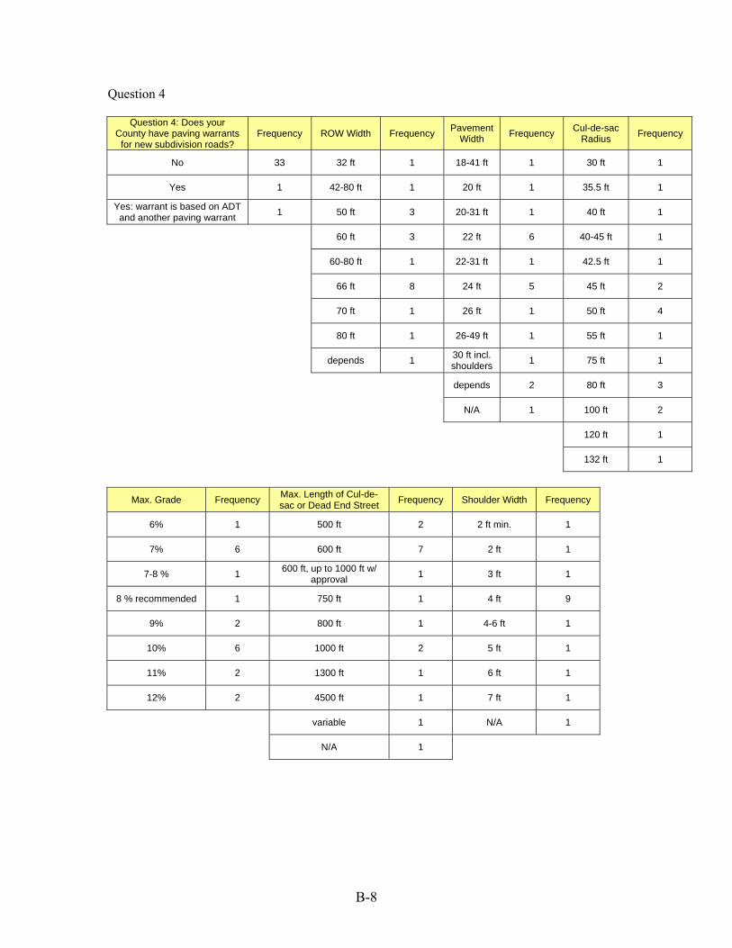
B-8
Question 4
Question 4: Does your County have paving warrants
for new subdivision roads? Frequency ROW Width Frequency Pavement
Width Frequency Cul-de-sac Radius Frequency
No 33 32 ft 1 18-41 ft 1 30 ft 1
Yes 1 42-80 ft 1 20 ft 1 35.5 ft 1
Yes: warrant is based on ADT and another paving warrant 1 50 ft 3 20-31 ft 1 40 ft 1
60 ft 3 22 ft 6 40-45 ft 1
60-80 ft 1 22-31 ft 1 42.5 ft 1
66 ft 8 24 ft 5 45 ft 2
70 ft 1 26 ft 1 50 ft 4
80 ft 1 26-49 ft 1 55 ft 1
depends 1 30 ft incl. shoulders 1 75 ft 1
depends 2 80 ft 3
N/A 1 100 ft 2
120 ft 1
132 ft 1
Max. Grade Frequency Max. Length of Cul-de-
sac or Dead End Street Frequency Shoulder Width Frequency
6% 1 500 ft 2 2 ft min. 1
7% 6 600 ft 7 2 ft 1
7-8 % 1 600 ft, up to 1000 ft w/ approval 1 3 ft 1
8 % recommended 1 750 ft 1 4 ft 9
9% 2 800 ft 1 4-6 ft 1
10% 6 1000 ft 2 5 ft 1
11% 2 1300 ft 1 6 ft 1
12% 2 4500 ft 1 7 ft 1
variable 1 N/A 1
N/A 1

B-9
Driveway Min. Culvert Size Frequency Specific ROW location For Utilities? Frequency
12 in 1 Yes 6
15 in 10 No 17
18 in 6
24 in 1

B-10
Does your county have warrants for paving internal subdivision roads?
0
5
10
15
20
25
No Yes: Roadway paving is a basicrequirement of the platting anddevelopment of the subdivision
Yes: Warrant is based on lotdensity
Yes: Other paving warrant
Res
pons
e Fr
eque
ncy
Within new subdivisions, how is the roadway area dealt with?
0
5
10
15
20
25
Required to bededicated to the
county fee
Dedicated as aneasement for publicuse, but no County
Maintenance
Dedicated as aneasement for public
use, and Countyaccepts maintenance
Designated as anOutlot with
HomeownersAssociation
responsible formaintenance
Designated as aprivate road with
HomeownersAssociation
responsible formaintenance
Other
Res
pons
e Fr
eque
ncy

B-11
Does your County have paving standards for new subdivision roads?
0
5
10
15
20
25
30
Yes No
Res
pons
e Fr
eque
ncy
Does your County have paving warrants for unpaved roads connecting the subdivision with a
paved road?
0
5
10
15
20
25
30
35
No Yes Yes: warrant is based on ADT and anotherpaving warrant
Res
pons
e Fr
eque
ncy

B-12
Pavement Width
0
1
2
3
4
5
6
7
18-41 ft 20 ft 20-31 ft 22 ft 22-31 ft 24 ft 26 ft 26-49 ft 30 ft incl.shoulders
depends N/A
Res
pons
e Fr
eque
ncy
ROW Width
0
1
2
3
4
5
6
7
8
9
32 ft 42-80 ft 50 ft 60 ft 60-80 ft 66 ft 70 ft 80 ft depends
Res
pons
e Fr
eque
ncy
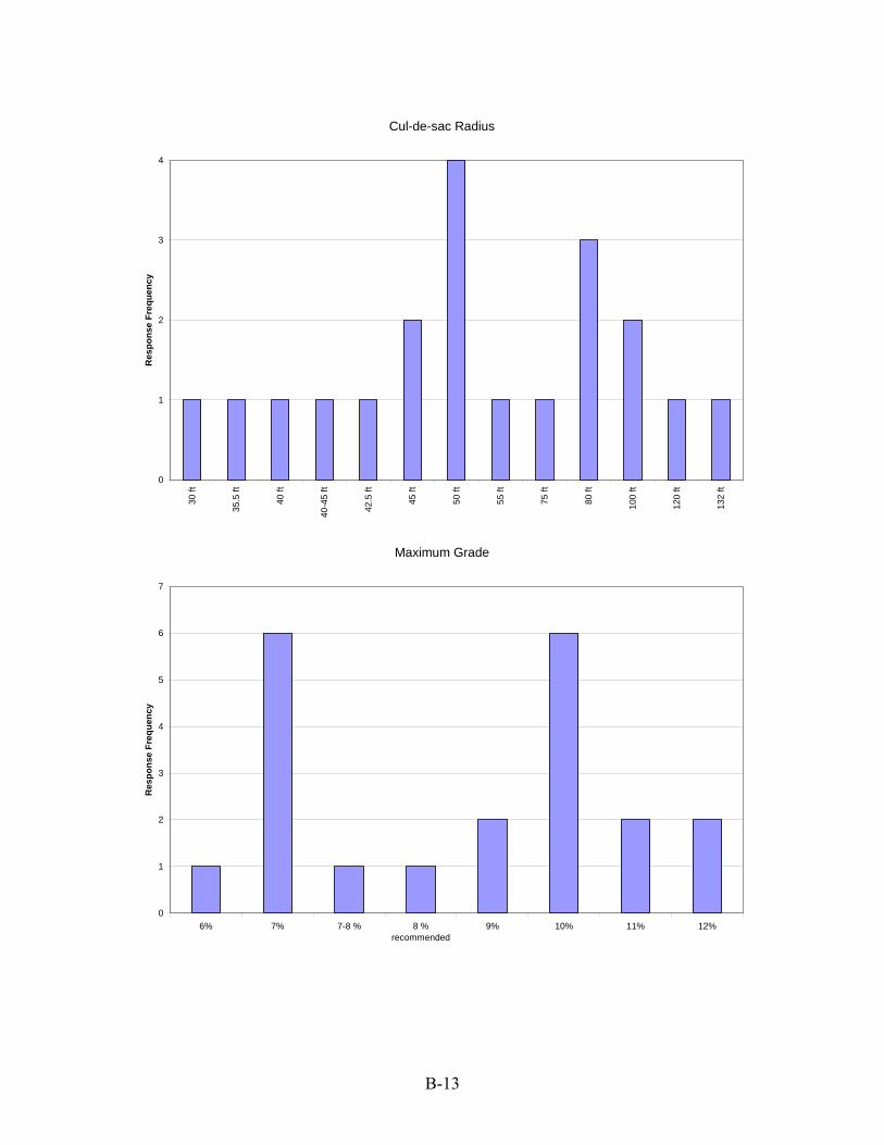
B-13
Cul-de-sac Radius
0
1
2
3
4
30 ft
35.5
ft
40 ft
40-4
5 ft
42.5
ft
45 ft
50 ft
55 ft
75 ft
80 ft
100
ft
120
ft
132
ft
Res
pons
e Fr
eque
ncy
Maximum Grade
0
1
2
3
4
5
6
7
6% 7% 7-8 % 8 %recommended
9% 10% 11% 12%
Res
pons
e Fr
eque
ncy

B-14
Maximum Length of Cul-de-sac or Dead End Street
0
1
2
3
4
5
6
7
8
500 ft 600 ft 600 ft, up to1000 ft w/approval
750 ft 800 ft 1000 ft 1300 ft 4500 ft variable N/A
Res
pons
e Fr
eque
ncy
Shoulder Width
0
1
2
3
4
5
6
7
8
9
10
2 ft min. 2 ft 3 ft 4 ft 4-6 ft 5 ft 6 ft 7 ft N/A
Res
pons
e Fr
eque
ncy
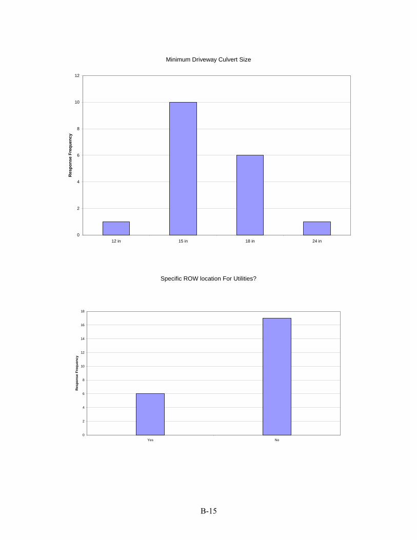
B-15
Minimum Driveway Culvert Size
0
2
4
6
8
10
12
12 in 15 in 18 in 24 in
Res
pons
e Fr
eque
ncy
Specific ROW location For Utilities?
0
2
4
6
8
10
12
14
16
18
Yes No
Res
pons
e Fr
eque
ncy

C-1
APPENDIX C: TYPICAL CROSS-SECTIONS
Figure C.1 Rural connector
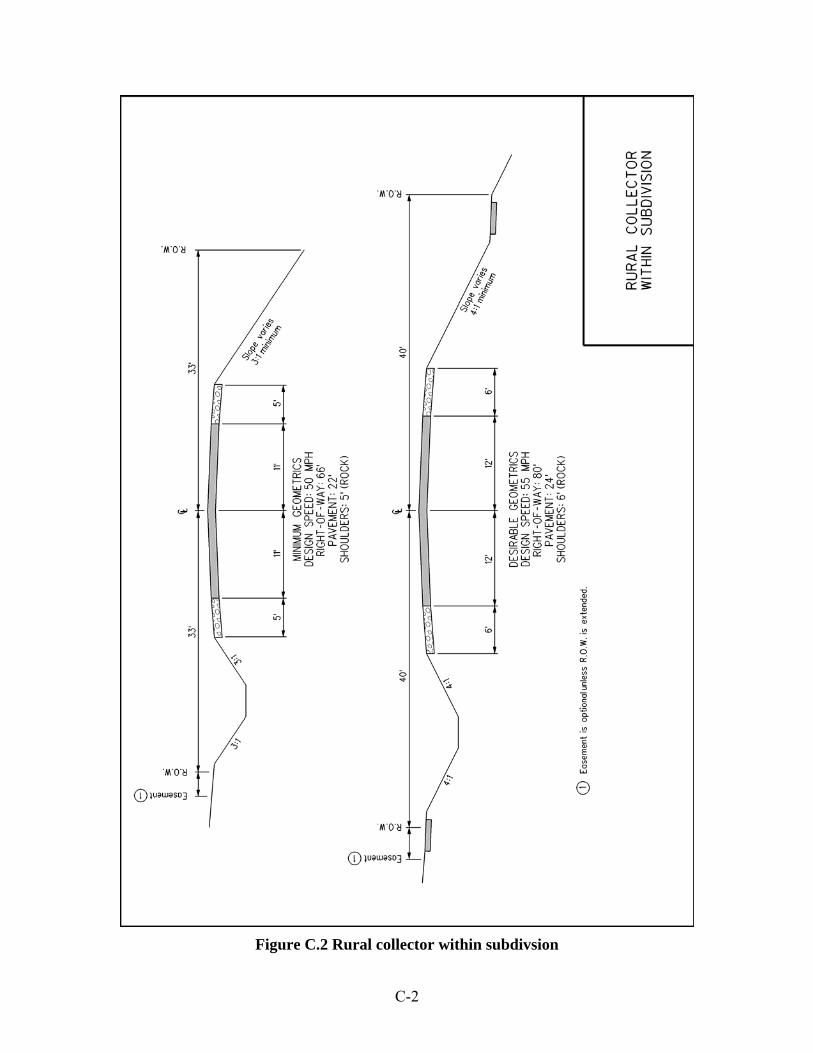
C-2
Figure C.2 Rural collector within subdivsion
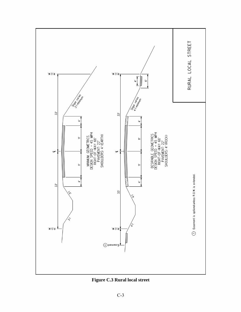
C-3
Figure C.3 Rural local street
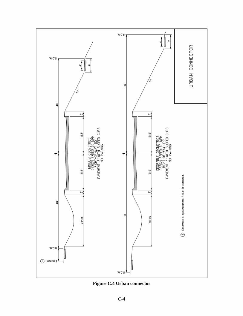
C-4
Figure C.4 Urban connector

C-5
Figure C.5 Urban collector within subdivision

C-6
Figure C.6 Urban local

C-7
Figure C.7 AASHTO low-volume road
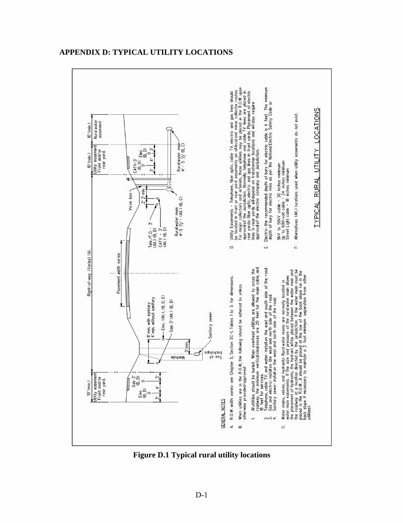
D-1
APPENDIX D: TYPICAL UTILITY LOCATIONS
Figure D.1 Typical rural utility locations

D-2
Figure D.2 Typical urban utility locations with sanitary outside of street

D-3
Figure D.3 Typical urban utility locations with sanitary under the street