Roadless Wilderness Area Determines Forest Elephant ...€¦ · Roadless Wilderness Area Determines...
9
Roadless Wilderness Area Determines Forest Elephant Movements in the Congo Basin Stephen Blake 1,2,3 *, Sharon L. Deem 2,4 , Samantha Strindberg 1 , Fiona Maisels 1 , Ludovic Momont 5 , Inogwabini-Bila Isia 6 , Iain Douglas-Hamilton 7,8 , William B. Karesh 1 , Michael D. Kock 1 1 Wildlife Conservation Society, Bronx, New York, United States of America, 2 Department of Biology and Whitney R. Harris World Ecology Center, University of Missouri - St. Louis, St. Louis, Missouri, United States of America, 3 Max Planck Institute for Ornithology, ‘Vogelwarte Radolfzell’, Radolfzell, Germany, 4 WildCare Institute, Saint Louis Zoo, St. Louis, Missouri, United States of America, 5 Muse ´ um National d’Histoire Naturelle, Me ´ nagerie du Jardin des Plantes, Laboratoire de Conservation des Espe ` ces, UMR 5173 Muse ´um-CNRS, 57, Paris, France, 6 The Durrell Institute of Conservation and Ecology, The University of Kent, Canterbury, Kent, United Kingdom, 7 Save the Elephants, Langata Link Complex, Langata, Nairobi, Kenya, 8 Department of Zoology, University of Oxford, Oxford, United Kingdom Abstract A dramatic expansion of road building is underway in the Congo Basin fuelled by private enterprise, international aid, and government aspirations. Among the great wilderness areas on earth, the Congo Basin is outstanding for its high biodiversity, particularly mobile megafauna including forest elephants (Loxodonta africana cyclotis). The abundance of many mammal species in the Basin increases with distance from roads due to hunting pressure, but the impacts of road proliferation on the movements of individuals are unknown. We investigated the ranging behaviour of forest elephants in relation to roads and roadless wilderness by fitting GPS telemetry collars onto a sample of 28 forest elephants living in six priority conservation areas. We show that the size of roadless wilderness is a strong determinant of home range size in this species. Though our study sites included the largest wilderness areas in central African forests, none of 4 home range metrics we calculated, including core area, tended toward an asymptote with increasing wilderness size, suggesting that uninhibited ranging in forest elephants no longer exists. Furthermore we show that roads outside protected areas which are not protected from hunting are a formidable barrier to movement while roads inside protected areas are not. Only 1 elephant from our sample crossed an unprotected road. During crossings her mean speed increased 14-fold compared to normal movements. Forest elephants are increasingly confined and constrained by roads across the Congo Basin which is reducing effective habitat availability and isolating populations, significantly threatening long term conservation efforts. If the current road development trajectory continues, forest wildernesses and the forest elephants they contain will collapse. Citation: Blake S, Deem SL, Strindberg S, Maisels F, Momont L, et al. (2008) Roadless Wilderness Area Determines Forest Elephant Movements in the Congo Basin. PLoS ONE 3(10): e3546. doi:10.1371/journal.pone.0003546 Editor: Craig R. McClain, Monterey Bay Aquarium Research Institute, United States of America Received July 28, 2008; Accepted September 29, 2008; Published October 28, 2008 Copyright: ß 2008 Blake et al. This is an open-access article distributed under the terms of the Creative Commons Attribution License, which permits unrestricted use, distribution, and reproduction in any medium, provided the original author and source are credited. Funding: This research was funded by the African Elephant Conservation Fund of the United States Fish and Wildlife Service (USFWS), the United States Agency for International Development (US-AID CARPE), Save the Elephants, The Espe `ces Phares Project and the Central African Protected Areas Network of the European Union, Wildlife conservation Society, WWF-US, Columbus Zoo and the Society for Conservation and Development. Richard Ruggiero of USFWS strongly supported this project. Competing Interests: The authors have declared that no competing interests exist. * E-mail: [email protected] Introduction Roadless wilderness is widely recognised for its high conservation value in terrestrial ecosystems [1], and therefore its preservation is frequently a primary goal of conservationists [2]. Conversely, developers and economists value roads as a cornerstone of efficient natural resource exploitation, and a prerequisite of economic development and poverty alleviation [3]. Roads improve access which facilitates resource extraction, human settlement and habitat degradation [4]. They fragment once contiguous habitats into smaller, isolated patches triggering numerous negative ecological consequences [5]. As road developments expand across the globe, understanding their impacts on ecosystems, populations, and individuals is increasingly important if ecologists, economists, and developers are to mitigate their negative ecological impacts while maintaining their socio-economic importance [2,6]. The Congo Basin is among the world’s great wilderness areas [7] containing the second largest rainforest block on earth, outstanding biological diversity, and its full complement of post- Pleistocene megafauna, including great apes and the forest elephant (Loxodonta africana cyclotis) [8]. It also contains globally important reserves of high quality timber, minerals, and other natural resources, critical to the economies of central African states [8]. Industrial-scale commercial exploitation of these natural resources is expanding dramatically and access to them relies on the proliferation of a network of public and private roads and rail infrastructure to supplement river transport[9]. International conservation efforts managed through the Congo Basin Forest Partnership (CBFP) focus on sustainable ecosystem management and the maintenance of wilderness and viable populations of apes, elephants, and other megavertebrates in 12 ‘‘conservation landscapes’’ centred around a network of protected areas [10]. Management of these landscapes is intended to promote sustainable natural resource exploitation practices to ensure the ecological integrity of priority areas of biodiversity conservation including the national park network. Landscape scale PLoS ONE | www.plosone.org 1 October 2008 | Volume 3 | Issue 10 | e3546
-
Upload
vuongtuong -
Category
Documents
-
view
218 -
download
0
Transcript of Roadless Wilderness Area Determines Forest Elephant ...€¦ · Roadless Wilderness Area Determines...

Roadless Wilderness Area Determines Forest ElephantMovements in the Congo BasinStephen Blake1,2,3*, Sharon L. Deem2,4, Samantha Strindberg1, Fiona Maisels1, Ludovic Momont5,
Inogwabini-Bila Isia6, Iain Douglas-Hamilton7,8, William B. Karesh1, Michael D. Kock1
1 Wildlife Conservation Society, Bronx, New York, United States of America, 2 Department of Biology and Whitney R. Harris World Ecology Center, University of Missouri -
St. Louis, St. Louis, Missouri, United States of America, 3 Max Planck Institute for Ornithology, ‘Vogelwarte Radolfzell’, Radolfzell, Germany, 4 WildCare Institute, Saint Louis
Zoo, St. Louis, Missouri, United States of America, 5 Museum National d’Histoire Naturelle, Menagerie du Jardin des Plantes, Laboratoire de Conservation des Especes, UMR
5173 Museum-CNRS, 57, Paris, France, 6 The Durrell Institute of Conservation and Ecology, The University of Kent, Canterbury, Kent, United Kingdom, 7 Save the
Elephants, Langata Link Complex, Langata, Nairobi, Kenya, 8 Department of Zoology, University of Oxford, Oxford, United Kingdom
Abstract
A dramatic expansion of road building is underway in the Congo Basin fuelled by private enterprise, international aid, andgovernment aspirations. Among the great wilderness areas on earth, the Congo Basin is outstanding for its highbiodiversity, particularly mobile megafauna including forest elephants (Loxodonta africana cyclotis). The abundance of manymammal species in the Basin increases with distance from roads due to hunting pressure, but the impacts of roadproliferation on the movements of individuals are unknown. We investigated the ranging behaviour of forest elephants inrelation to roads and roadless wilderness by fitting GPS telemetry collars onto a sample of 28 forest elephants living in sixpriority conservation areas. We show that the size of roadless wilderness is a strong determinant of home range size in thisspecies. Though our study sites included the largest wilderness areas in central African forests, none of 4 home rangemetrics we calculated, including core area, tended toward an asymptote with increasing wilderness size, suggestingthat uninhibited ranging in forest elephants no longer exists. Furthermore we show that roads outside protected areaswhich are not protected from hunting are a formidable barrier to movement while roads inside protected areas are not.Only 1 elephant from our sample crossed an unprotected road. During crossings her mean speed increased 14-foldcompared to normal movements. Forest elephants are increasingly confined and constrained by roads across the CongoBasin which is reducing effective habitat availability and isolating populations, significantly threatening long termconservation efforts. If the current road development trajectory continues, forest wildernesses and the forest elephants theycontain will collapse.
Citation: Blake S, Deem SL, Strindberg S, Maisels F, Momont L, et al. (2008) Roadless Wilderness Area Determines Forest Elephant Movements in the CongoBasin. PLoS ONE 3(10): e3546. doi:10.1371/journal.pone.0003546
Editor: Craig R. McClain, Monterey Bay Aquarium Research Institute, United States of America
Received July 28, 2008; Accepted September 29, 2008; Published October 28, 2008
Copyright: � 2008 Blake et al. This is an open-access article distributed under the terms of the Creative Commons Attribution License, which permitsunrestricted use, distribution, and reproduction in any medium, provided the original author and source are credited.
Funding: This research was funded by the African Elephant Conservation Fund of the United States Fish and Wildlife Service (USFWS), the United States Agencyfor International Development (US-AID CARPE), Save the Elephants, The Especes Phares Project and the Central African Protected Areas Network of the EuropeanUnion, Wildlife conservation Society, WWF-US, Columbus Zoo and the Society for Conservation and Development. Richard Ruggiero of USFWS strongly supportedthis project.
Competing Interests: The authors have declared that no competing interests exist.
* E-mail: [email protected]
Introduction
Roadless wilderness is widely recognised for its high conservation
value in terrestrial ecosystems [1], and therefore its preservation is
frequently a primary goal of conservationists [2]. Conversely,
developers and economists value roads as a cornerstone of efficient
natural resource exploitation, and a prerequisite of economic
development and poverty alleviation [3]. Roads improve access
which facilitates resource extraction, human settlement and habitat
degradation [4]. They fragment once contiguous habitats into
smaller, isolated patches triggering numerous negative ecological
consequences [5]. As road developments expand across the globe,
understanding their impacts on ecosystems, populations, and
individuals is increasingly important if ecologists, economists, and
developers are to mitigate their negative ecological impacts while
maintaining their socio-economic importance [2,6].
The Congo Basin is among the world’s great wilderness areas
[7] containing the second largest rainforest block on earth,
outstanding biological diversity, and its full complement of post-
Pleistocene megafauna, including great apes and the forest
elephant (Loxodonta africana cyclotis) [8]. It also contains globally
important reserves of high quality timber, minerals, and other
natural resources, critical to the economies of central African states
[8]. Industrial-scale commercial exploitation of these natural
resources is expanding dramatically and access to them relies on
the proliferation of a network of public and private roads and rail
infrastructure to supplement river transport[9].
International conservation efforts managed through the Congo
Basin Forest Partnership (CBFP) focus on sustainable ecosystem
management and the maintenance of wilderness and viable
populations of apes, elephants, and other megavertebrates in 12
‘‘conservation landscapes’’ centred around a network of protected
areas [10]. Management of these landscapes is intended to
promote sustainable natural resource exploitation practices to
ensure the ecological integrity of priority areas of biodiversity
conservation including the national park network. Landscape scale
PLoS ONE | www.plosone.org 1 October 2008 | Volume 3 | Issue 10 | e3546

management is an important conservation tool since protected
areas alone are frequently too small to ensure the survival of viable
populations of large-bodied, wide-ranging species such as top
carnivores [11], and savannah elephants [12], which routinely travel
outside park borders [13] into unprotected areas. In the Congo
Basin, forest elephant density in and around protected areas is
determined by the area of roadless wilderness rather than the size of
protected areas since illegal killing is concentrated close to roads [14],
particularly those that are afforded no protection [15].
As road infrastructure advances into remaining wilderness,
forest elephants face a choice between two broad behavioural
responses; reduce their home range size and become increasingly
restricted in order to avoid roads (termed a siege strategy here), or
continue to range widely, crossing roads despite the risk of
mortality (a skirmish strategy). Both courses of action are
detrimental to survival. It has been shown that home range
restriction by fencing in savannah elephants may lead to local
overpopulation, increased local feeding intensity and habitat
degradation [16], while continued wide ranging in the face of
human encroachment may dramatically increase direct mortality
from illegal killing [14].
In this paper we use the first GPS telemetry data from forest
elephants to evaluate which of our proposed strategies, ‘‘siege’’ or
‘‘skirmish’’, is adopted by forest elephants in response to roads by
examining two questions: 1) does the size of roadless wilderness
influence the size of forest elephant home range? and 2) do forest
elephants cross roads and if so do they differentiate between roads
inside and outside of protected areas? We then discuss the impact
of recent and current road encroachment in wilderness areas, and
finally, we propose two management actions to mitigate the
impact of roads on elephants and other mobile terrestrial species in
the Congo Basin.
Results
Roadless wilderness and forest elephant home rangeWe fitted GPS telemetry collars to a total of 28 forest elephants
living in six roadless wilderness areas located in priority
conservation areas [10] in Congo, Central African Republic,
and Gabon. The size of roadless wilderness ranged from 49 km2 at
the Loango site to 11,793 km2 at the Ndoki site (Table 1,
Figure 1a,b,c). We estimated four metrics to characterise forest
elephant home range: Minimum Convex Polygon (MCP) size,
Maximum Linear Displacement (MLD) defined as the longest axis
of the MCP, 95% Fixed Kernel Home Range (95%KHR) size,
and 50% Fixed Kernel Home Range (50%KHR) size which we
equated with the core home range area.
We used Generalized Additive Models (GAMs) [17] to investigate
the relationship between 4 home range metrics and roadless
wilderness area, and to assess the influence of several other
covariates, including Number of days collared, Site (the protected
areas in which the individuals were collared), Sex and Landscape
(landscape here refers to the priority conservation areas in which the
protected areas were embedded) (Table 1). Only roadless wilderness
area was consistently statistically significant in all the models,
explaining 51.7% (MCP), 38.9% (MLD), 36.1% (95%KHR), and
28.5% (50%KHR) of the deviance in the final models for each of
those metrics which included only that covariate. Of the remaining
covariates, only Site was significant for the models with response
MCP size and MLD (however, the Generalized Cross Validation
score indicated that the Site variable should not be included).
Including Number of days collared as an offset variable gave
improved models for the responses MCP size and 95%KHR size (see
supporting information for details of the model diagnostics).
We found a positive relationship between the estimated
conditional dependence of the four response variables and the
size of roadless wilderness (Figure 2). The relationship is very
similar for the first 3 response variables while MLD increases
linearly with roadless wilderness area. Thus not only did roadless
polygon area influence the extremes of ranging behaviour (MCP
and MLD) and normal patterns of movement (as indicated by the
95%KHR which is widely thought to exclude exploratory
movements and areas that an animal will never visit again [18])
but it also strongly affected the size of forest elephant core areas.
Road Crossing BehaviourCollared forest elephants routinely crossed protected roads that
were located inside protected areas. The four elephants collared in
Minkebe NP did not have the option to cross protected roads since
they did not exist at their site, but of the remaining 24 collared
elephants, 17 individuals crossed protected roads at least once, and
many crossed on tens of occasions. By contrast only one individual
called Mouadje, a female with dependent offspring, crossed an
unprotected road outside of a protected area, a striking result given
an accumulated total time of 28.5 years of telemetry data from 27
elephants (we excluded one elephant, Chloe, from this analysis due
to poor data quality). We investigated the potential that each
elephant had to cross unprotected roads by generating 1,000
correlated random walks (CRW) and calculated the proportion
that crossed an unprotected road at least once (Table 1 and
Figures S7, S8, S9, S10, S11, S12). The results of the simulations
showed that all but one of the elephants had the potential to cross
unprotected roads, in comparison to only one which actually did
so. The variation in the proportion of CRWs that crossed roads
was influenced by both the movement characteristics of each
individual elephant and the spatial distribution of the unprotected
roads in its neighbourhood.
The characteristics of Mouadje’s road crossings are spectacular.
On the three occasions when she traversed a road while collared,
she crossed at the point furthest from any village in her potential
range, which included 133 inter-village intervals over a total road
distance of ca. 250 km (Figure 3a). Her mean daily travel distance
during normal movements was 1.7 kmday21 (SD 2.4), but when
crossing an unprotected road this increased over 14 fold to a mean
of 24.1 kmday21 (SD 7.5) (Figure 3b). At the same site (Odzala)
two other collared elephants crossed a protected road within the
national park on 11 occasions, however travel speed was not
appreciably different than for movements which did not involve a
protected road crossing (Figure 3c,d). Tommy and Yango’s mean
speeds when crossing protected roads were 1.9 (SD 1.0) and 3.5
(SD 3.7) kmday21 compared to 1.0 (SD 1.9) and 2.5 (SD 2.0) for
other movements. While these data hint of an increase in speed
during protected road crossings they are within the norms of daily
travel speed of elephants across sites.
Discussion
We conclude that forest elephants adopt a siege strategy in the
face of road encroachment, rather than face the dangers associated
with skirmishing. The overwhelming importance of a single
variable, size of roadless wilderness, in defining home range size in
forest elephants is impressive since the human footprint stamp on
the telemetry sites is vastly more complex than our simplistic
definition of wilderness [7], the inter-site ecology is highly variable,
and elephants are an extremely adaptable species [19]. A priori, we
had expected a sigmoid curve to describe the relationship between
roadless wilderness size and home range size metrics, with home
range reaching an asymptote as roadless wilderness size increased
Forest Elephants
PLoS ONE | www.plosone.org 2 October 2008 | Volume 3 | Issue 10 | e3546

beyond a threshold after which ecological/physiological con-
straints alone would define home range characteristics. However,
none of the 4 metrics show any tendency toward an asymptote
over the range of wilderness size in this study, even though the
Ndoki and Minkebe wildernesses were the largest terra firma
roadless spaces in the entire Congo Basin at the time of collar
deployment. Our study indicates that unconfined forest elephants
may no longer exist anywhere in Africa.
The siege strategy may reduce the risk of mortality from poaching
compared to skirmishing, but as roadless space decreases, siege will
likely result in loss of access to widespread food resources, reduced
dietary quality and increased feeding competition promoting
aggressive social interactions with negative consequences for social
cohesion and reproductive success which ultimately reduces
population size [20]. The siege strategy may also increase the
isolation of small sub-populations and reduce the genetic fitness and
health status of small populations potentially increasing in the
probability of extinction [21]. Finally, the restricted movements of
besieged elephants may increase the destructive impacts of over-
browsing on local vegetation [22], and reduce the effectiveness of
forest elephant mediated seed-dispersal [23].
As roads in and of themselves are not a physical barrier to
movement, forest elephants may avoid roads for 2 principal
reasons; 1) roads may reduce resource quantity and quality, 2)
proximity to roads may represent an unacceptable risk to
elephants. The first can be discounted since in the absence of
human threats forest elephants can occur at higher densities in
logged and secondary forest than in primary forest due to an
Table 1. Basic ranging statistics for collared forest elephants. Note that values in all but the last column were generated from theraw collar data, while values in the final column (PRC) were the result of simulated trajectories (see Materials and Methods fordetails).
Name Sex SiteStart and End dates(monthyear)
N dayscollared
Roadlesspolygon (km22)
MCP1
(km2)MLD2
(km)95% KHR3
(km2)50% KHR4
(km2) PRC5
Kumu F Ndoki 0101-0302 415 11,793 1,570.3 57.4 346.3 42.0 51.9
Sparkey M Ndoki 0101-0601 130 11,793 1,117.9 104.1 461.3 59.4 15.4
Spikey F Ndoki 0101-1101 297 11,793 2,226.3 98.3 2,402.1 272.5 62.7
Sue M Ndoki 1000-0701 259 11,793 676.8 41.0 211.2 13.9 39.4
Chloe F Ndoki 1098-0199 60 11,793 824.8 59.9
Annelisa F Lope 0703-0804 390 1,152 36.9 8.7 8.4 0.7 83.4
Ernestine F Lope 0703-1104 489 1,152 555.6 41.1 161.2 15.3 94.7
Iona F Lope 0703-0205 573 1,152 957.3 44.8 539.6 45.7 97.2
Nuri F Lope 0703-0204 61 1,152 247.2 24.9 220.2 27.6 79.1
Africa F Ivindo 0803-0205 619 1,578 406.1 40.2 158.6 18.2 57.1
Ella F Ivindo 08-3-0205 560 1,578 496.8 38.1 164.9 18.4 66.3
Pfeffer M Ivindo 08-3-0205 569 1,578 324.4 30.7 40.7 8.0 76.8
Powel M Ivindo 0803-0804 383 1,578 1,265.5 52.8 106.7 26.6 74.3
Bambala F Loango 1103-0304 121 59 25.9 10.2 19.8 2.8 90.5
Iwolo F Loango 1203-0505 516 59 113.7 31.0 141.5 24.3 77.1
Lione F Loango 1103-0605 558 59 51.8 10.6 26.2 1.4 69.9
Malonge F Loango 1103-0505 541 59 52.7 14.9 12.8 2.5 78.3
Mireille F Loango 1203-1104 362 59 51.0 12.8 39.7 5.4 46.4
Nanou F Loango 1203-0705 587 59 158.3 29.9 92.9 12.1 78.1
Dieudonne M Odzala 0604-0305 270 4,896 291.5 31.7 267.5 22.3 39.4
Lango F Odzala 0604-0505 334 4,896 346.7 25.0 243.9 16.1 78.7
Moba F Odzala 0604-0505 334 4,896 119.0 17.4 31.7 5.5 14.1
Mouadje F Odzala 0604-0805 430 4,896 811.9 81.5 97.6 27.6 81.7
Tommy M Odzala 0604-0805 436 4,896 309.6 25.0 7.7 1.5 15.0
Madame Nguendi F Minkebe 0107-0108 351 9,514 319.0 38.9 158.4 29.0 34.2
Mossimbo M Minkebe 0107-0807 192 9,514 814.2 64.9 138.0 46.9 10.2
Mwasi a Mossimbo F Minkebe 0107-1007 260 9,514 36.2 8.6 19.8 1.7 0.0
Sharon F Minkebe 0107-1007 258 9,514 1,103.3 82.6 1,011.1 105.7 20.9
Mean 372.9 4,742.0 546.8 40.3 264.1 31.6 56.8
SD 154.2 4,566.0 539.2 26.7 477.8 53.3 29.1
1Minimum Convex Polygon Home Range.2Maximum Linear Displacement.395% Fixed Kernel Home Range.450% Fixed Kernel Home Range.5Proportion of 1000 correlated random walks which crossed an unprotected road.doi:10.1371/journal.pone.0003546.t001
Forest Elephants
PLoS ONE | www.plosone.org 3 October 2008 | Volume 3 | Issue 10 | e3546

abundance of preferred herbaceous food plants [24]. Risk avoidance
is the most compelling reason. Savannah elephants are known to
perceive risk and avoid exposure to it [25], chimpanzees alter their
behaviour depending on their risk assessment of forest roads [26], as
do less intelligent species such as moose [27]. Even in the depths of
the Congo forest the ranging behaviour of the largest extant
terrestrial mammal is driven by fear.
Since the telemetry data were collected, construction of
unprotected roads has caused an enormous loss of roadless
wilderness area to 3 of the 6 telemetry sites (Figure 1b). The Ndoki
wilderness has shrunk by over 11,000 km2 (288.9%) in 8 years,
the Ivindo wilderness by 940 km2 (259.6%) in 5 years, and the
Lope wilderness has disappeared within the last 5 years. In all
cases the roads were built to facilitate extractive industry, and were
accompanied by significant additional infrastructure including
logging towns, sawmills, and in the case of Ivindo, a hydroelectric
power station and accommodation for an estimated 2000
construction workers and associated infrastructure (roads, clinics,
etc.) will likely be built in the heart of Ivindo NP, as one
component of the massive Belinga Iron Mining Project. This
project will further affect regional elephant ranging through the
construction of additional roads, local housing, a railroad and
power transmission network, and will attract thousands of
immigrants seeking employment or to provide diverse services
and products, including bush meat and ivory. Two other regional
national parks (Minkebe and Mwagne) are indirectly threatened
by the potential impacts of the Belinga Project.
These are not isolated cases. The strategy of both the private
sector and the international aid community in Africa is focussed on
heavy investment in infrastructure, particularly roads [28]. Tens of
billions of dollars are spent per year on roads to access timber, iron
and other natural resources to supply global consumer demand,
grow national economies and reduce poverty [29,30], and meet the
self-interest of donor nations [3]. Today, as regional development
planning accelerates in the Congo Basin, human population density
remains relatively low and several large tracts of wilderness still exist,
and a last window of opportunity presents itself to implement a
coherent road strategy that achieves an optimal balance between
socio-economic development goals, efficient natural resource
extraction, and the preservation of large wilderness areas.
To maintain viable elephant populations composed of individ-
uals whose ranging behaviour is driven by ecological constraints
Figure 1. Study area, illustrating a, National parks in which collars were deployed and collaring locations. b, Change in roadless wilderness size collardeployment dates to the present. Note that total wilderness at the time of collar deployment is represented by red and black areas combined, whilered colour alone represents wilderness remaining in 2008 c, Bull forest elephant in Ivindo NP fitted with a GPS telemetry collar.doi:10.1371/journal.pone.0003546.g001
Forest Elephants
PLoS ONE | www.plosone.org 4 October 2008 | Volume 3 | Issue 10 | e3546

rather than by fear, at least two management policies must be
included and implemented in such a strategy. The first is to stop
new road encroachment into remaining large roadless wilderness-
es, and the second is to reduce the factors that promote elephant’s
fear of roads. No new permanent roads should be built either
around the peripheries of priority elephant conservation areas or
penetrating deeper into them. To access natural resources that
occur in or near to these areas, temporary exploitation roads
should be built from the permanent road network radially into the
wilderness interior which can be closed when the resource is
exhausted. Reducing fear associated with roads requires invest-
ment of money and political will in law enforcement for effective
anti-poaching, preventing settlement, mitigation of human-ele-
phant conflict, and sustainable livelihood development for forest
people. Key areas that provide connectivity between priority
elephant populations or that give elephants access to seasonally
important resources such as large swamps should either remain
roadless, or existing roads should be kept free of human settlement
and policed to reduce rates of poaching. National government,
international lending agencies and private industry which
promote, build and finance the infrastructure necessary to extract
resources must bear the responsibility for the costs of impact
Figure 2. Estimated Conditional Dependence of a, MCP size. b, 95%KHR size. c, 50% KHR size. d, MLD on roadless wilderness area. Estimates (solidlines) and confidence intervals (dashed lines), with a rug plot that displays a vertical line for each data point along the x-axis of the plot, are shown. Toavoid over-fitting, the degrees of freedom for these models were restricted to 2.doi:10.1371/journal.pone.0003546.g002
Forest Elephants
PLoS ONE | www.plosone.org 5 October 2008 | Volume 3 | Issue 10 | e3546
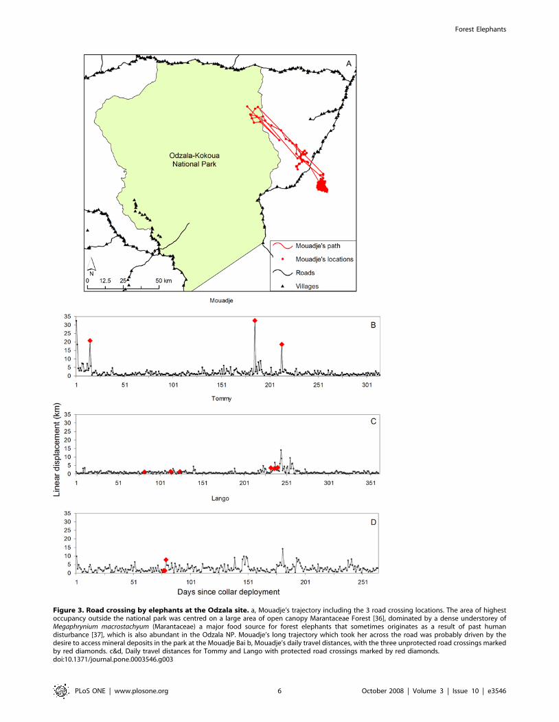
Figure 3. Road crossing by elephants at the Odzala site. a, Mouadje’s trajectory including the 3 road crossing locations. The area of highestoccupancy outside the national park was centred on a large area of open canopy Marantaceae Forest [36], dominated by a dense understorey ofMegaphrynium macrostachyum (Marantaceae) a major food source for forest elephants that sometimes originates as a result of past humandisturbance [37], which is also abundant in the Odzala NP. Mouadje’s long trajectory which took her across the road was probably driven by thedesire to access mineral deposits in the park at the Mouadje Bai b, Mouadje’s daily travel distances, with the three unprotected road crossings markedby red diamonds. c&d, Daily travel distances for Tommy and Lango with protected road crossings marked by red diamonds.doi:10.1371/journal.pone.0003546.g003
Forest Elephants
PLoS ONE | www.plosone.org 6 October 2008 | Volume 3 | Issue 10 | e3546
mitigation. The costs of wildlife protection are trivial compared to
the investments being made in resource extraction and the profits
they generate. For example, the Belinga iron mine project, 50 km
from the Minkebe wilderness in northeast Gabon will require at
least $3 billion of pre-production investment in infrastructure
alone [30]. This single enterprise budget is 34 times greater than
the annual investment required to effectively manage a network of
protected areas throughout the entire Niger Delta/Congo Basin
forest region [31]. If the development trajectory and management
of infrastructure of the Congo Basin continues without immedi-
ately ameliorating their negative ecological consequences, the last
forested wildernesses of Africa and the forest elephants living in
them may disappear.
Materials and Methods
Forest elephants were fitted with GPS collars under supervision
from the Field Veterinary Program of the Wildlife Conservation
Society following methods described by Blake et al. [32]. Roadless
wilderness areas were calculated using the Spatial Analyst extension
of ArcView 3.3 [33], based on data provided by Global Forest
Watch (GFW) supplemented with local knowledge for some recently
built road segments. A raster grid of ‘‘distance from nearest road’’
(DISTRD) values was generated across the entire study region with a
cell size of 1 km2. Grid cells were selected at increasing DISTRD
until a bounded polygon was produced at the site with the least
contiguous road network (Ndoki) which occurred at
DISTRD = 31 km. Roadless wilderness area was calculated at each
site as the number of cells at DISTRD$31 km, which provided a
comparative metric of relative roadless wilderness area by site rather
than the absolute area retained between the road network.
We estimated home range metrics from the GPS telemetry data
using the Animal Movement extension [34] for ArcView 3.3.
Minimum Convex Polygons were calculated using all location data
for each elephant, while fixed KHR estimates (using LSCV to
generate the smoothing parameter) were based on subsamples
consisting of 1 random fix per day to reduce the bias of variable
GPS fix regimes.
Generalized Additive Models [17] were used to investigate the
relationship between home range metrics and roadless wilderness
area, and to assess the influence of several other covariates,
including Number of days collared, Site, Sex and Landscape.
Given their flexibility GAMs are particularly suited to investigating
relationships in ecological data. GAMs were fitted in R [35] using
the mgcv package [16]. We initially assumed a Gaussian
distribution for all models. The standard diagnostic plots (Normal
Q-Q, residuals vs. linear predictor, histogram of residuals,
response vs. fitted values) used in model selection and assessment
of fit indicated that the models were consistently giving lower fitted
values when these were compared to the response values (Figures
S1 and S2). The high values of home range metrics for some
individuals at the Ndoki site, which are in contrast to the metrics at
other sites or within the same site, contribute to this problem.
These same diagnostics indicate some problems with model fit for
the models with 95% Kernel Home Range size and 50% Kernel
Home Range size as the response variable (Figures S3 and S4).
Alternative models with a Poisson distribution and log link give
mixed results (Figures S5 and S6). Although the deviance
explained increases to 41.8% for 95% Kernel Home Range size,
the diagnostics only improve marginally, whereas for 50% Kernel
Home Range size the diagnostics improved and the deviance
explained increased to 44.7%.
To assess possible differences in movement characteristics of
forest elephants in relation to road protection status, we classified
roads as either ‘‘unprotected’’ or ‘‘protected’’. Unprotected roads
were those roads in our dataset outside of protected areas, while
protected roads were located inside protected areas. We did not
have good information on either hunting levels or anti-poaching
effort on the road system throughout our study areas, thus a more
detailed assessment of the level of protection from hunting on
roads was not possible. In the Loango, Lope and Odzala sites
protected and unprotected roads were found in both dense forest
and forest savannah mosaics, while in the remaining site all roads
were in dense forest, with contiguous forest on both sides. The
swathe of cleared vegetation created by the roads varied between 4
and 15 metres and all road beds were lateritic. Vehicle traffic was
low on all roads throughout the region, with an estimated
maximum of 20 vehicles per day (usually logging trucks) on the
busiest sections. Data on actual traffic frequency by site or by road
section are not available. Human habitation and the intensity of
agriculture varied considerably across sites, though generally
unprotected roads had associated settlement and small-scale slash
and burn agricultural plots, while protected roads did not.
Low temporal resolution of the GPS data meant that we were
unable to provide detailed quantitative analysis of movement
behaviour of elephants when crossing protected roads. Correlated
Random Walks were generated in ArcView using the Animal
Movement extension. CRWs started at the arithmetic mean of the
daily random fix data for each elephant. Daily displacement
distances were resampled without replacement to preserve the
individual movement characteristics and total path length of each
elephant. We calculated a metric to reflect the potential of
elephants to cross unprotected roads called Proportion of Road
Crossings (PRC) (Table 1), as the proportion of 1000 randomly
generated CRWs that crossed an unprotected road. To ensure
biological reality the extent of the CRWs was limited to fall inside
a circular buffer region of 104 km radius corresponding to the
largest MLD recorded in the study, which biased our values
towards underestimation of actual road crossing potential. The
purpose of illustrating the unrestricted CRWs (Figures S7, S8, S9,
S10, S11, S12) was to demonstrate how conservative the restricted
CRWs were in evaluating road crossing potential.
Supporting Information
Figure S1 Diagnostic plots for the Gaussian distribution model
that included the Minimum Convex Polygon area as a response
and the covariate roadless wilderness area with the number of days
collared included as an offset value. To avoid over-fitting, the
degrees of freedom for this model were restricted to 2.
Found at: doi:10.1371/journal.pone.0003546.s001 (0.76 MB TIF)
Figure S2 Diagnostic plots for the Gaussian distribution model
that included the Maximum Linear Displacement distance as a
response and the covariate roadless wilderness area. To avoid over-
fitting, the degrees of freedom for this model were restricted to 2
Found at: doi:10.1371/journal.pone.0003546.s002 (0.75 MB TIF)
Figure S3 Diagnostic plots for the Gaussian distribution model
that included the 95% Kernel Home Range area as a response
and the covariate roadless wilderness area with the number of days
collared included as an offset value. To avoid over-fitting, the
degrees of freedom for this model were restricted to 2
Found at: doi:10.1371/journal.pone.0003546.s003 (0.75 MB TIF)
Figure S4 Diagnostic plots for the Gaussian distribution model
that included the 50% Kernel Home Range area as a response
and the covariate roadless wilderness area. To avoid over-fitting,
the degrees of freedom for this model were restricted to 2.
Found at: doi:10.1371/journal.pone.0003546.s004 (0.32 MB TIF)
Forest Elephants
PLoS ONE | www.plosone.org 7 October 2008 | Volume 3 | Issue 10 | e3546

Figure S5 (a) Estimated Conditional Dependence of 95%
Kernel Home Range area on roadless wilderness area. Estimates
(solid lines) and confidence intervals (dashed lines), with a rug plot
indicating observation density along the bottom of the plot, are
shown. (b) Diagnostic plots for this Poisson distribution with a log
link model. To avoid over-fitting, the degrees of freedom for this
model were restricted to 2.
Found at: doi:10.1371/journal.pone.0003546.s005 (0.56 MB TIF)
Figure S6 (a) Estimated Conditional Dependence of 50%
Kernel Home Range area on roadless wilderness area. Estimates
(solid lines) and confidence intervals (dashed lines), with a rug plot
indicating observation density along the bottom of the plot, are
shown. (b) Diagnostic plots for this Poisson distribution with a log
link model. To avoid over-fitting, the degrees of freedom for this
model were restricted to 2
Found at: doi:10.1371/journal.pone.0003546.s006 (0.53 MB TIF)
Figure S7 Figures S7, S8, S9, S10, S11, S12 show a sample of
correlated random walks (CRWs) showing raw elephant location
data, unrestricted CRWs, CRWs restricted to 104 km from the
arithmetic mean location of the MCP home range in relation to
unprotected roads and national parks
Found at: doi:10.1371/journal.pone.0003546.s007 (2.61 MB TIF)
Figure S8 Powel, collared in Ivindo NP, Gabon
Found at: doi:10.1371/journal.pone.0003546.s008 (4.08 MB TIF)
Figure S9 Mouadje, collared in Odzala NP, Congo
Found at: doi:10.1371/journal.pone.0003546.s009 (3.50 MB TIF)
Figure S10 Madame Nguendi, collared in Minkebe NP, Gabon
Found at: doi:10.1371/journal.pone.0003546.s010 (2.99 MB TIF)
Figure S11 Mireille, collared in Loango NP, Gabon
Found at: doi:10.1371/journal.pone.0003546.s011 (2.92 MB TIF)
Figure S12 Iona, collared in Lope NP, Gabon
Found at: doi:10.1371/journal.pone.0003546.s012 (4.15 MB TIF)
Acknowledgements
This paper is dedicated to Annelisa Kilbourn who died in a plane accident
at one of the telemetry sites, and to two forest elephants which died during
collaring operations in Minkebe NP. The research authorities and wildlife
departments from Congo, Gabon, and Central African Republic are
thanked for permissions and collaboration. This study could not have been
realised without the astonishing ecological knowledge and forest skills of
our tracking team, and particular thanks go to Gregoire Mambeleme, Eric
Mossimbo, Sylvan Imalimo and Mammadou Gassagna. Mike Fay, Bryan
Curran, Djoni-Djimbi Burgess, Lee White, Tommy Smith, Lisa Steel,
Allard Blom, Pauwel deWachter, Mark Ella Akou, and Patrick Koumbi
provided logistical assistance. Susan Minnemyer from Global Forest Watch
provided data on central African roads. The manuscript was improved by
the thoughtful comments of John Robinson, Kent Redford, David Wilkie,
Sally Lahm, James Gibbs, Bill Laurance, Vicki Fishlock, Rachel Atkinson,
Nicholas Georgiadis, and one anonymous reviewer.
Author Contributions
Conceived and designed the experiments: SB LM. Performed the
experiments: SB SLD FGM LM IBI WBK MDK. Analyzed the data:
SB SS. Contributed reagents/materials/analysis tools: IDH. Wrote the
paper: SB. Provided veterinary services during immobilisation of elephants:
SLD WBK MDK. Provided strong technical assistance throughout the
study: IDH.
References
1. Strittholt JR, Dellasala DA (2001) Importance of roadless areas in biodiversity
conservation in forested ecosystems: Case study of the Klamath-Siskiyou
ecoregion of the United States. Conservation Biology 15: 1742–1754.
2. Wilkie D, Shaw E, Rotberg F, Morelli G, Auzel P (2000) Roads, development,
and conservation in the Congo basin. Conservation Biology 14: 1614–1622.
3. Anon (2005) Our Common Interest: Report of the Commission for Africa
Commission for Africa. 453 p.
4. Laurance WF, Cochrane MA, Bergen S, Fearnside PM, Delamonica P, et al.
(2006) The future of the Brazilian Amazon. Science 291: 438–439.
5. Forman RTT, Alexander LE (1998) Roads and their major ecological effects.
Annual Review of Ecology and Systematics 29: 207–231+C202.
6. Forman RTT, Sperling D, Bissonette JA, Clevenger AP, Cutshall CD, et al.
(2003) Road Ecology: Science and Solutions. Washington, DC: Island Press.
7. Sanderson EW, Jaiteh M, Levy MA, Redford KH, Wannebo AV, et al. (2002)
The human footprint and the last of the wild. Bioscience 52: 891–904.
8. Kamdem-Toham A, Adeleke AW, Burgess ND, Carroll R, D’Amico J, et al.
(2003) Forest Conservation in the Congo Basin. Science 299: 346.
9. Laporte NT, Stabach JA, Grosch R, Lin TS, Goetz SJ (2007) Expansion of
industrial logging in Central Africa. Science 316: 1451–1451.
10. CBFP (2007) The Forests of the Congo Basin: The State of the Forest Congo
Basin Forest Partnership. 256 p.
11. Woodroffe R, Ginsberg JR (1998) Edge effects and the extinction of populations
inside protected areas. Science 280: 2126–2128.
12. Armbruster P, Lande R (1993) A population viability analysis for African
elephants (Loxodonta africana): how big should reserves be? Conservation Biology
7: 602–610.
13. Douglas-Hamilton I, Krink T, Vollrath F (2005) Movements and corridors of
African elephants in relation to protected areas. Naturwissenschaften 92:
158–163.
14. Blake S, Strindberg S, Boudjan P, Makombo C, Bila-Isia I, et al. (2007) Forest
Elephant Crisis in the Congo Basin. PLoS Biology 5: e111.
15. Laurance WF, Croes BM, Tchignoumba L, Lahm SA, Alonso A, et al. (2006)
Impacts of roads and hunting on central African rainforest mammals.
Conservation Biology 20: 1251–1261.
16. Whyte IJ, van Aarde RJ, Pimm SL (2003) Kruger’s elephant population: its size
and consequences for ecosystem heterogeneity. In: du Toit JT, Rogers KH,
Biggs HC, eds. The Kruger Experience: Ecology and Management of Savanna
Heterogeneity. Washington, DC: Island Press. pp 332–348.
17. Wood SN (2006) Generalized Additive Models: An Introduction with R. Boca
Raton Florida Chapman and Hall. 391 p.
18. Powell RA (2000) Animal home ranges and territories and home range
estimators. In: Boitani L, Fuller TK, eds. Research Techniques in AnimalEcology. New York: Columbia. pp 65–110.
19. Spinage CA (1994) Elephants. London: T and A D Poyser.
20. Wittemyer G, Getz WM, Vollrath F, Douglas-Hamilton I (2007) Socialdominance, seasonal movements, and spatial segregation in African elephants:
a contribution to conservation behavior. Behavioral Ecology and Sociobiology
61: 1919–1931.
21. Wilcox BA, Murphy DD (1987) Conservation strategy: the effects of
fragmentation on extinction. American Naturalist 125: 879–887.
22. Van Aarde R, Jackson TP (2007) Megaparks for metapopulations: Addressingthe causes of locally high elephant numbers in southern Africa. Biological
Conservation 134: 289–297.
23. Chapman CA, Onderdonk DA (1998) Forests without primates: Primate/plant
codependency. American Journal of Primatology 45: 127–141.
24. Barnes RFW, Barnes K, Alers M, Blom A (1991) Man determines the
distribution of elephants in the rain forests of northeastern Gabon. AfricanJournal of Ecology 29: 54–63.
25. Hoare RE (1999) Determinants of human-elephant conflict in a land use mosaic.Journal of Applied Ecology 36: 689–700.
26. Hockings KJ, Anderson JR, Matsuzawa T (2006) Road crossing in chimpanzees:A risky business. Current Biology 16: 668–670.
27. Berger J (2007) Fear, human shields and the redistribution of prey and predatorsin protected areas. Biology Letters 3: 620–623.
28. PBuys U, Deichmann U, Wheeler D (2006) Road network upgrading andoverland trade expansion in sub-Saharan Africa. Washington, DC: World Bank.
29. Chomitz KM, Buys P, De Luca G, Thomas TS, Wertz-Kanounnikoff S (2007)
At Loggerheads? Agricultural Expansion, Poverty Reduction, and Environment
in the Tropical Forests. Washington, D.C.: World Bank. 284 p.
30. Reed E, Miranda M (2007) Assessment of the Mining Sector and Infrastructure
Development in the Congo Basin Region. Washington DC, USA: WorldWildlife Fund, Macroeconomics for Sustainable Development Program Office.
27 p.
31. Blom A (2004) An estimate of the costs of an effective system of protected areas
in the Niger Delta - Congo Basin Forest Region. Biodiversity and Conservation13: 2661–2678.
32. Blake S, Douglas-Hamilton I, Karesh WB (2001) GPS telemetry of forest
elephants in Central Africa: results of a preliminary study. African Journal of
Ecology 39: 178–186.
33. ESRI (2002) ArcView. 3.3 ed. Redlands CA, USA: Environmental Systems
Research Institute.
Forest Elephants
PLoS ONE | www.plosone.org 8 October 2008 | Volume 3 | Issue 10 | e3546

34. Hooge PN, Eichenlaub B (1997) Animal movement extension to arcview. 1.1 ed.
Alaska Science Center - Biological Science Office, U.S. Geological Survey,
Anchorage, AK, USA.: USGS - BRD.
35. Team RDC (2008) R: A Language and Environment for Statistical Computing.
Vienna, Austria: R Foundation for Statistical Computing.
36. Letouzey R (1968) Etude phytogeographique du Cameroun. Paris: Paul
Lechevalier.37. White LJT (2001) Forest-savanna dynamics and the origins of Matantaceae
forest in central Gabon. In: Weber W, White LJT, Vedder A, Naughton-
Treves L, eds. African Rain Forest Ecology and Conservation. New Haven andLondon: Yale University Press.
Forest Elephants
PLoS ONE | www.plosone.org 9 October 2008 | Volume 3 | Issue 10 | e3546