ROAD SAFETY AUDIT - Abington MA · ROAD SAFETY AUDIT Route 18 at Route 139 Town of Abington July...
51
ROAD SAFETY AUDIT Route 18 at Route 139 Town of Abington July 2011 Prepared for: Massachusetts Department of Transportation Prepared by: Howard/Stein-Hudson Associates 38 Chauncy Street Boston, MA 02111
Transcript of ROAD SAFETY AUDIT - Abington MA · ROAD SAFETY AUDIT Route 18 at Route 139 Town of Abington July...

ROAD SAFETY AUDIT
Route 18 at Route 139
Town of Abington
July 2011
Prepared for: Massachusetts Department of Transportation
Prepared by: Howard/Stein-Hudson Associates
38 Chauncy Street Boston, MA 02111

Road Safety Audit Route 18 at Route 139, Abington Prepared by Howard/Stein-Hudson Associates, Inc.
Page 1
Table of Contents Background ................................................................................................................................. 2�
Project Data ................................................................................................................................. 2�
Project Location Description and Crash Summary ................................................................ 3�
Road Safety Audit Observations and Potential Enhancements ............................................. 5�Safety Issue #1.� Traffic Signal Indications, Phasing, and Clearance Intervals ............................. 5�Safety Issue #2.� Access Management ........................................................................................... 7�Safety Issue #3.� Pavement Markings and Signage ........................................................................ 9�Safety Issue #4.� Utility Pole Placement ...................................................................................... 11�Safety Issue #5.� Other General Observations .............................................................................. 12�
Recommendations ..................................................................................................................... 13�
List of Appendices
Appendix A.� RSA Meeting Agenda�Appendix B.� RSA Audit Team Contact List�Appendix C.� Detailed Crash Data�Appendix D.� Additional Information�
List of Figures
Figure 1.� Locus Map .............................................................................................................................. 4�
List of Tables
Table 1.� Participating Audit Team Members ....................................................................................... 2�Table 2.� Summary of Potential Safety Enhancements ....................................................................... 14�

Road Safety Audit Route 18 at Route 139, Abington Prepared by Howard/Stein-Hudson Associates, Inc.
Page 2
BackgroundThe intersection of Bedford Street (Route 18) and Randolph Street/North Avenue (Route 139) in the Town of Abington, Massachusetts is listed as #24 according to the Massachusetts Department of Transportation’s (MassDOT) 2006-2008 Statewide Top 200 Intersection Crash List. As such, the MassDOT conducted a Road Safety Audit (RSA) to identify the safety issues and potential safety enhancements.
Route 18 between Highland Avenue in Weymouth and Route 139 in Abington is currently in the preliminary design phase for a widening and reconstruction project (#601630), with construction anticipated to begin in Spring 2013. The RSA is intended to identify potential safety improvements that can either be evaluated and included as part of the current design process or considered as part of future reconstruction efforts at the intersection. The short-term, low-cost potential improvements could be considered by the responsible agency for implementation prior to reconstruction, as appropriate.
Project Data The audit team conducted an RSA for the intersection of Route 18 and Route 139 on Thursday, July 14, 2011. The RSA agenda appears in Appendix A. Table 1 lists the audit team members and their affiliations. Appendix B provides contact information for all team members.
Table 1. Participating Audit Team MembersAudit Team Member Agency/Affiliation Kenan Connell Abington Highway Department Jack Caine Abington Highway Department Bob O’Keefe Abington Police Department John Nuttall Abington Fire Department Bill McNulty Old Colony Planning Council Bruce Hughes Old Colony Planning Council Brian Ackley TetraTech J. Michael Garvin TetraTech John Romano MassDOT Municipal Liaison Donny Dailey MassDOT Municipal Public Affairs Edward Feeney MassDOT District 5 Traffic Alex Lovejoy MassDOT District 5 Traffic Barbara Lachance MassDOT District 5 Traffic Lisa Schletzbaum MassDOT Highway Division Safety Section Joe SanClemente Howard/Stein-Hudson Associates

Road Safety Audit Route 18 at Route 139, Abington Prepared by Howard/Stein-Hudson Associates, Inc.
Page 3
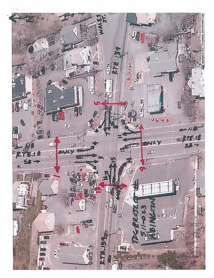
Project Location Description and Crash Summary The intersection of Bedford Street (Route 18) and Randolph Street/North Avenue (Route 139) is located in the Town of Abington, as shown in the aerial image in Figure 1. The intersection is located approximately four miles south of Route 3 (Exit 16). Commercial uses are located on all four corner of the intersection and the Abington Fire Department is located approximately 900 feet north of the intersection on Route 18.
Route 18 at Route 139 is a four-way signalized intersection. The Bedford Street (Route 18) eastbound approach consists of one shared left-turn/through lane, one through lane, and one dedicated right-turn lane. The North Avenue (Route 139) westbound approach consists of one shared left-turn/through lane and one shared through/right-turn lane. Wales Street intersects North Avenue from the northeast at an acute angle approximately 100 feet east of Route 18; Wales Street operates under yield control. The Bedford Street (Route 18) northbound and southbound approaches each consist of an exclusive left-turn lane, one through lane, and one shared through/right turn lane.
The intersection forms the junction of the following roadways, which are categorized according to MassDOT Office of Transportation Planning functional classifications:
Bedford Street (Route 18) is an urban principal arterial and falls under MassDOT jurisdiction. Bedford Street is a north–south roadway and is dedicated as Route 18. Within the vicinity of the intersection, Route 18 generally consists of one travel lane in each direction. The speed limit along Route 18 is 35 miles per hour (mph) per the speed regulations.
Randolph Street (Route 139) is an urban principal arterial and falls under Town jurisdiction. Randolph Street is an east–west roadway. Within the vicinity of the intersection, Randolph Street consists of one travel lane in each direction. The speed limit along Randolph Street is 30 mph per the speed regulations.
North Avenue (Route 139) is an urban minor arterial and falls under Town jurisdiction. North Avenue an east–west roadway. Within the vicinity of the intersection, North Avenue consists of one travel lane in each direction. The speed limit along North Avenue is 30 mph per the speed regulations.
Wales Street is a local roadway and falls under Town jurisdiction. Wales Street is an east–west roadway. Within the study area, Wales Street consists of 1 travel lane in each direction.
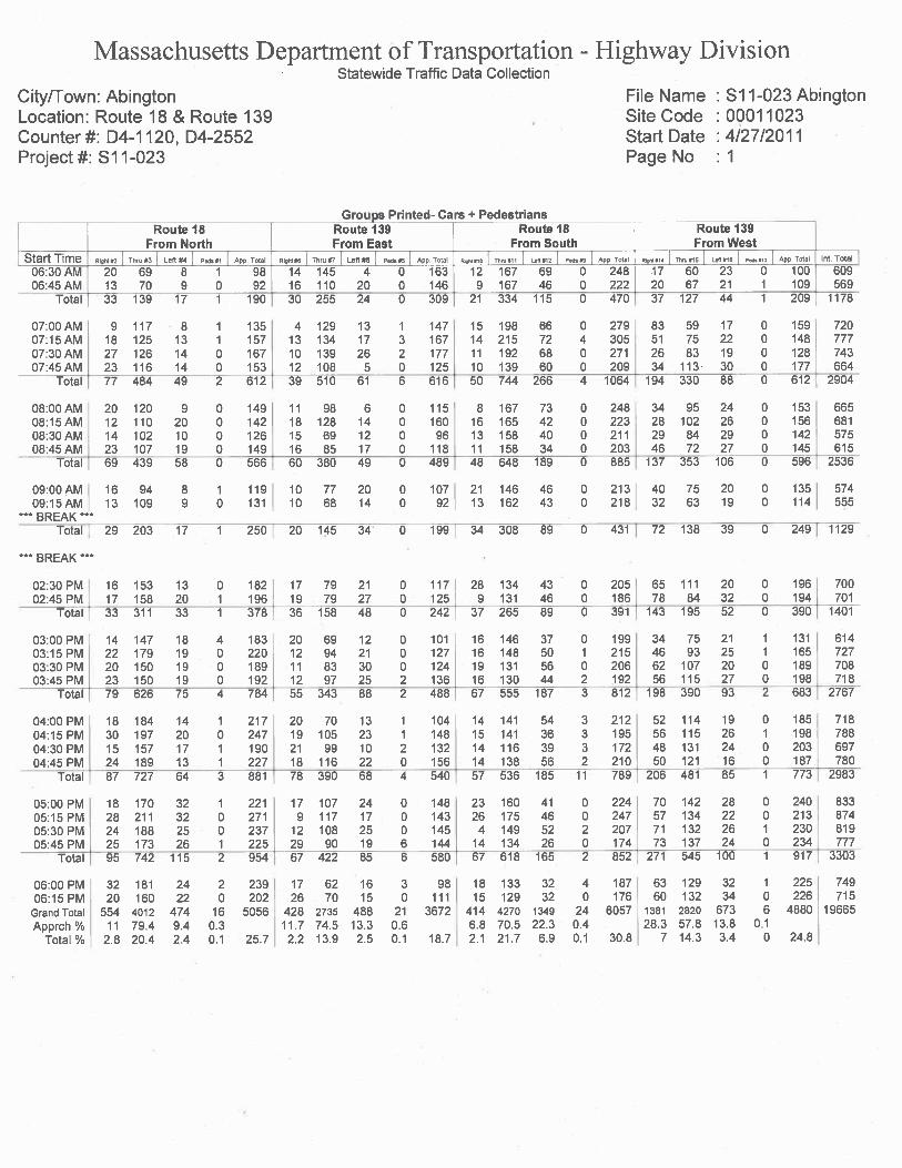
Prior to the RSA, in order to begin assessing possible safety issues, the team reviewed collision diagrams and a crash detail summary based on crash records supplied by the Abington Police Department and the Registry of Motor Vehicles. From January 2008 through December 2010, 79 crashes were reported at the intersection. Of the 79 crashes, a majority were angle type crashes (39 or approximately 49%), rear-end (20 or approximately 26%), and sideswipe same direction crashes (6 or approximately 8%). Crashes generally occurred on dry pavement (48, or nearly 61%) in clear weather conditions (41, or nearly 52%) and under good lighting conditions (daylight or lighted roadway) (65 or 82%). Approximately 24% of the crashes (or 19) occurred on wet or snow covered pavement. Appendix C provides the detailed crash data for the intersection. Speed regulations and traffic volume data are presented in Appendix D.

Figure 1. Locus Map
Road Safety AuditRoute 18 at Route 139, Abington
Howard/Stein-Hudson Associates, Inc.
Wales St.
Bed
ford
St.
(Rte
. 18)
Bed
ford
St.
(Rte
. 18)
Tem
ple
St.
North Ave. (Rte. 139)
Randolph St. (Rte. 139)
Bates St.
Dunkin’ Donuts/Subway
MobilGas Station
SunocoGas Station
CrownAuto Sales
N
Not to scale.
Not to scale.

Road Safety Audit Route 18 at Route 139, Abington Prepared by Howard/Stein-Hudson Associates, Inc.
Page 5
Road Safety Audit Observations and Potential Enhancements Based on field observations on Thursday, July 14, 2011, the RSA team determined that the intersection of Route 18 at Route 139 has the following issues that affect safety:
� Traffic signal indications, phasing, and clearance intervals; � Access management; � Pavement markings; � Signage;� Utility pole placement; and � Limited pedestrian accessibility.
The following sections describe in more detail the safety issues and enhancements determined during the RSA. Several of these issues require further study and engineering judgment to determine the feasibility of implementing enhancements to address them.
Safety Issue #1. Traffic Signal Indications, Phasing, and Clearance Intervals
Observations: The Route 139 eastbound and westbound approaches currently allow for permissive left turns only; protected left turns are not provided. RSA team members commented that it can be difficult for motorists to find an acceptable gap in the passing traffic stream to make a left-turn and noted that motorists do not have a dedicated left-turn lane.
According to the crash records, 12 of the crashes (or approximately 15%) involved motorists that failed to stop at the red light. Of these 12 crashes, 10 (or 83%) involved vehicles traveling along either the Route 139 eastbound or westbound approach. During field observations, the RSA team noted that vehicles making left-turns at the Route 139 eastbound and westbound approaches often queue in the middle of the intersection while waiting to find an acceptable gap in the passing traffic stream. Many of these
Left-turns from Route 139 eastbound.

Road Safety Audit Route 18 at Route 139, Abington Prepared by Howard/Stein-Hudson Associates, Inc.
Page 6
left-turning vehicles were observed traveling through the intersection during the red phase, which may have contributed to the crash experience at the intersection.
According to traffic volume data collected by MassDOT at the intersection during April 2011, left-turns at the Route 139 eastbound approach reach between approximately 100 and 120 vehicles per hour during the morning and evening peak periods– slightly above the 100 left-turns per hour minimum requirement for an exclusive left-turn lane per the MassDOT 2006 Project Development & Design Guide. Meanwhile, left turns at the Route 139 westbound approach are generally below the 100 left-turns per hour threshold during the peak periods.
Lastly, the RSA team also noted that some of the light emitting diodes (LED’s) are not working on several of the traffic signal indications making them less visible.
Enhancements:1. Evaluate clearance intervals at all of the intersection approaches per Institute of
Transportation Engineers (ITE) standards (short-term).
2. Consider the appropriateness of providing an advance left turn phase, and associated signal equipment upgrades, for the Route 139 eastbound approach to allow for a protected left-turn in addition to the permissive left-turn (short-term).
3. Review the safety and operational benefits/impacts of adding an exclusive left-turn lane for the Route 139 eastbound approach.
4. Maintain LED traffic signal indications to ensure visibility.

Road Safety Audit Route 18 at Route 139, Abington Prepared by Howard/Stein-Hudson Associates, Inc.
Page 7
Safety Issue #2. Access Management
Observations: The intersection of Route 18 at Route 139 currently has commercial uses located on each of the four corners of the intersection resulting in numerous curb cuts in the vicinity of the intersection. Of the 79 crashes reported at the intersection, 32 crashes (or nearly 41%) occurred at commercial driveways adjacent to the intersection. The RSA team noted the following with respect to access management at the Mobil and Sunoco gas station driveways:
Mobil Gas Station
The largest concentration of the crashes at the commercial driveways occurred at the intersection of the Mobil gas station driveway and Randolph Street (Route 139) with nine crashes reported between January 2008 and December 2010. Of these nine crashes, seven were angle type crashes involving eastbound through traffic and vehicles making left-turns out of the Mobil driveway onto Route 139.
Route 139 eastbound consists of one travel lane to the west of the intersection and widens to three lanes in the vicinity of the Mobil driveway to allow for one shared left-turn/through lane, one through lane, and an exclusive right-turn lane at the intersection with Route 18. Thus, motorists making the left turn out of the Mobil driveway onto Route 139 need to cross three travel lanes. According to RSA team members, a motorist traveling along Route 139 eastbound may stop to allow a vehicle to make the left-turn out of the Mobil driveway; however, a second or third vehicle traveling in one of the other eastbound lanes may not expect, or be able to perceive and react to, a left-turning vehicle exiting left from the driveway. Likewise, a motorist making a left-turn out of the Mobil driveway onto Route 139 may not be able to see vehicles traveling in all three of the eastbound lanes if a first vehicle stops to allow them to make the turn.
Wide cross-section on Route 139 adjacent to Mobil.

Road Safety Audit Route 18 at Route 139, Abington Prepared by Howard/Stein-Hudson Associates, Inc.
Page 8
Sunoco Gas Station
The Sunoco gas station, located on the southeast corner of the intersection, is constructed at a slightly higher elevation than Route 18 resulting in a fairly steep vertical grade change at the driveway accessing the site. The RSA team noted that the grade change at the driveways result in vehicles entering the gas station at a slower rate of speed in an effort to avoid scraping the bottom of their vehicle. Motorists, unfamiliar with the location, may not expect the need to slow down at the
driveway apron when trying to judge an adequate gap in the Route 18 northbound traffic stream (three lanes) to safely make a left-turn.
Enhancements: 1. The audit team was in agreement that this location warrants serious consideration of
restricting left-turns from the Mobil Driveway onto Randolph Street (Route 139).
2. Consider the safety benefits of restricting Route 18 southbound left-turns into the Sunoco Driveway if crash experience worsens/continues. Also consider any resulting impacts on heavy vehicle access (e.g., fuel deliveries).
Sunoco Driveway on Route 18

Road Safety Audit Route 18 at Route 139, Abington Prepared by Howard/Stein-Hudson Associates, Inc.
Page 9
Safety Issue #3. Pavement Markings and Signage
Observations: During field observations the RSA team noted that there is a crest vertical curve in the alignment of Route 18 just north of the intersection in the vicinity of where the roadway widens from one to three travel lanes in the southbound direction to allow for a turning lane and an additional turning lane at the intersection. As a result, the vertical curve reduces the visibility of the southbound vehicles queued for a red light.
An RSA team member also noted that the lane lines do not extend past the vertical curve. Thus, motorists unfamiliar with the intersection may not anticipate the need to change lanes, or that they are arriving at an intersection approach until they have already arrived. According to the crash records, there were eight rear-end crashes and four sideswipe (same direction) crashes reported involving vehicles at the Route 18 southbound approach. Unclear lane use designations may have contributed to these crashes. However, during field observations an RSA team member did note that a mandatory movement lane control sign indicating “Left Lane Must Turn Left” (R3-7) was posted. After the audit, a review of the original design plan shows a dotted white lane line (DWLL) proposed to delineate the left-turn only lane.
Lastly, each of the intersection departures has two receiving lanes that taper to one travel lane. The RSA team noted that the pavement markings in each of the merge areas are either worn or missing. In addition, no supplemental signage is provided warning motorists of the merge such as Lane Ends symbol signage (W4-2) and/or Right Lane Ends (W9-1) or Lane Ends Merge Left (W9-2).
Crest vertical curve limits sight lines of Route 18 southbound approach and lane designations.

Road Safety Audit Route 18 at Route 139, Abington Prepared by Howard/Stein-Hudson Associates, Inc.
Page 10
Enhancements:1. Add a DWLL, as originally designed, to provide delineation of the Route 18 southbound
left-turn lane.
2. Evaluate the feasibility of installing an Advance Intersection Lane Control (R3-8) sign along Route18 southbound to provide additional lane use information.
3. Evaluate the appropriateness/feasibility of installing broken white lane line pavement markings at each of the receiving lanes to delineate the two travel lanes.
4. Consider the appropriateness of installing warning signage (e.g., Lane Ends symbol signage (W4-2) and/or Right Lane Ends (W9-1) or Lane Ends Merge Left (W9-2)) at each of the receiving lanes to warn drivers of the lane reduction.

Road Safety Audit Route 18 at Route 139, Abington Prepared by Howard/Stein-Hudson Associates, Inc.
Page 11
Safety Issue #4. Utility Pole Placement
Observations: The RSA team noted that the utility poles located on the northeast, northwest, and southeast corners of the intersection are positioned close to the curbline. According to the crash records, there was one crash reported involving a motorist that hit the utility located on the southeast corner of the intersection.
During field observations, the RSA team also noted that the wiring on the utility poles (across the intersection) partially inhibits the view of the signal indications in the Route 18 northbound and southbound direction.
Finally, the team noted that the presence of a utility pole and a traffic signal foundation on the northwest corner of the intersection significantly reduces the effective width of the sidewalk.
Enhancements: 1. Relocate utility poles at intersection further away from the edge of the roadway if there is
space within the right-of-way and where feasible. Consider the placement of the utility lines and poles with respect to the visibility of the traffic signal indications and the impact on the effective width of the sidewalk.
Utility pole located close to the edge of the roadway on the southeast corner of the intersection.

Road Safety Audit Route 18 at Route 139, Abington Prepared by Howard/Stein-Hudson Associates, Inc.
Page 12
Safety Issue #5. Other General Observations
Observations: The RSA team also noted the following general observations with respect to overgrown vegetation and curb ramps:
Overgrown Vegetation – the RSA team noted that the visibility of the following signage was obstructed by overgrown vegetation:
� Route 18 guide signage along North Avenue (Route 139)/Wales Street westbound;
� Route 18 guide signage along Randolph Street (Route 139) eastbound; and
� Route 139 guide signage along Route 18 southbound.
Curb Ramps – an RSA team member noted that the curb ramps at the intersection do not have truncated dome tactile detectable warning surfaces.
Enhancements: 1. Maintain vegetation to improve visibility of guide signage along all approaches to the
intersection.
2. In stall truncated dome tactile detectable warning surfaces at all curb ramps per the MassDOT 2006 Project Development & Design Guide.
Overgrown vegetation obstructs view of guide signage at along the North Ave./Wales St. westbound approaches.

Road Safety Audit Route 18 at Route 139, Abington Prepared by Howard/Stein-Hudson Associates, Inc.
Page 13
RecommendationsBased on its observations and discussions, the RSA team identified the issues and possible enhancements that could improve safety at the intersection of Bedford Street (Route 18) and Randolph Street/North Avenue (Route 139) in the Town of Abington, Massachusetts. Further design work or consideration may be necessary to determine the feasibility of making some of the improvements.
Short-term enhancements include:
� Evaluate and adjust clearance intervals as appropriate;
� Add protected left-turn phasing;
� Improve access management by adding turn restrictions;
� Extend and improve lane markings;
� Improve signing;
� Replace LEDs on traffic signal indication; and
� Trim vegetation overgrowth.
To enhance the safety of the intersection, the long-term enhancements are to:
� Widen the Route 139 eastbound approach for an exclusive left-turn lane; and
� Relocate utility poles.
Table 2 summarizes these safety issues, possible enhancements, estimated safety payoff, time frame, cost, and responsibility. Safety payoff estimates are based on engineering judgment and are categorized as low, medium, and high. The time frame is categorized as short-term (<1 year), mid-term (1 to 3 years), or long-term (typically >3 years). Long-term improvements are typically considered to be substantial improvements with an expected time frame for implementation greater than 3 years. The costs are categorized as low (<$10,000), medium ($10,001 to $50,000), or high (>$50,000).
The RSA is intended to identify potential safety improvements that can either be evaluated and included as part of the current design process for the Route 18 widening project or considered as part of future reconstruction efforts at the intersection. The short-term, low-cost potential improvements could be considered by the responsible agency for implementation prior to reconstruction, as appropriate.

Roa
d S
afet
y A
udit
Rou
te 1
8 at
Rou
te 1
39, A
bing
ton
Pre
pare
d by
How
ard/
Ste
in-H
udso
n A
ssoc
iate
s, In
c.
Pag
e14
Tabl
e 2.
Sum
mar
y of
Pot
entia
l Saf
ety
Enh
ance
men
ts
Safe
ty Is
sue
Safe
ty E
nhan
cem
ent
Safe
ty
Payo
ff Ti
me
Fram
e C
ost
Res
pons
ible
Par
ty
Traf
fic S
igna
l In
dica
tions
, P
hasi
ng, a
nd
Cle
aran
ce
Inte
rval
s
Eva
luat
e cl
eara
nce
inte
rval
s at
all
of th
e in
ters
ectio
n ap
proa
ches
per
Inst
itute
of T
rans
porta
tion
Eng
inee
rs (I
TE)
stan
dard
s (s
hort-
term
). H
igh
Sho
rt-te
rm
Low
M
assD
OT
Con
side
r the
app
ropr
iate
ness
of p
rovi
ding
an
adva
nce
left
turn
ph
ase,
and
ass
ocia
ted
sign
al e
quip
men
t upg
rade
s, fo
r the
R
oute
139
eas
tbou
nd a
ppro
ach
to a
llow
for a
pro
tect
ed le
ft-tu
rn
in a
dditi
on to
the
perm
issi
ve le
ft-tu
rn (s
hort-
term
).
Hig
h S
hort-
term
M
ediu
m
Tow
n of
A
bing
ton/
Mas
sDO
T
Rev
iew
the
safe
ty a
nd o
pera
tiona
l ben
efits
/impa
cts
of a
ddin
g an
exc
lusi
ve le
ft-tu
rn la
ne fo
r the
Rou
te 1
39 e
astb
ound
ap
proa
ch.
Med
ium
Lo
ng-te
rm
Hig
h M
assD
OT
Mai
ntai
n LE
D tr
affic
sig
nal i
ndic
atio
ns to
ens
ure
visi
bilit
y.
Low
S
hort-
term
Lo
w
Mas
sDO
T
Acce
ss
Man
agem
ent
The
audi
t tea
m w
as in
agr
eem
ent t
hat t
his
loca
tion
war
rant
s se
rious
con
side
ratio
n of
rest
rictin
g le
ft-tu
rns
from
the
Mob
il D
rivew
ay o
nto
Ran
dolp
h St
reet
(Rou
te 1
39).
Hig
h S
hort-
term
Lo
w
Tow
n of
A
bing
ton/
Mas
sDO
T
Con
side
r the
saf
ety
bene
fits
of re
stric
ting
Rou
te 1
8 so
uthb
ound
le
ft-tu
rns
into
the
Sun
oco
Driv
eway
if c
rash
exp
erie
nce
wor
sens
/con
tinue
s. A
lso
cons
ider
any
resu
lting
impa
cts
on
heav
y ve
hicl
e ac
cess
(e.g
., fu
el d
eliv
erie
s).
Low
S
hort-
term
Lo
w
Tow
n of
A
bing
ton/
Mas
sDO
T
Pav
emen
tM
arki
ngs
and
Sig
nage
Add
a D
WLL
, as
orig
inal
ly d
esig
ned,
to p
rovi
de d
elin
eatio
n of
th
e R
oute
18
sout
hbou
nd le
ft-tu
rn la
ne.
Low
S
hort-
term
Lo
w
Mas
sDO
T
Eva
luat
e th
e fe
asib
ility
of in
stal
ling
an A
dvan
ce In
ters
ectio
n La
ne C
ontro
l (R
3-8)
sig
n al
ong
Rou
te18
sou
thbo
und
to p
rovi
de
addi
tiona
l lan
e us
e in
form
atio
n.
Low
S
hort-
term
Lo
w
Mas
sDO
T
Eva
luat
e th
e ap
prop
riate
ness
/feas
ibilit
y of
inst
allin
g br
oken
w
hite
lane
line
pav
emen
t mar
king
s at
eac
h of
the
rece
ivin
g la
nes
to d
elin
eate
the
two
trave
l lan
es.
Low
S
hort-
term
Lo
w
Mas
sDO
T
Con
side
r the
app
ropr
iate
ness
of i
nsta
lling
war
ning
sig
nage
(e
.g.,
Lane
End
s sy
mbo
l sig
nage
(W4-
2) a
nd/o
r Rig
ht L
ane
End
s (W
9-1)
or L
ane
End
s M
erge
Lef
t (W
9-2)
) at e
ach
of th
e re
ceiv
ing
lane
s to
war
n dr
iver
s of
the
lane
redu
ctio
n.
Low
S
hort-
term
Lo
w
Mas
sDO
T

Roa
d S
afet
y A
udit
Rou
te 1
8 at
Rou
te 1
39, A
bing
ton
Pre
pare
d by
How
ard/
Ste
in-H
udso
n A
ssoc
iate
s, In
c.
Pag
e15
Tabl
e 2.
Sum
mar
y of
Pot
entia
l Saf
ety
Enh
ance
men
ts (c
ontin
ued)
Safe
ty Is
sue
Safe
ty E
nhan
cem
ent
Safe
ty
Payo
ff Ti
me
Fram
e C
ost
Res
pons
ible
Par
ty
Util
ity P
ole
Pla
cem
ent
Rel
ocat
e ut
ility
pole
s at
inte
rsec
tion
furth
er a
way
from
the
edge
of
the
road
way
if th
ere
is s
pace
with
in th
e rig
ht-o
f-way
and
w
here
feas
ible
. C
onsi
der t
he p
lace
men
t of t
he u
tility
line
s an
d po
les
with
resp
ect t
o th
e vi
sibi
lity
of th
e tra
ffic
sign
al in
dica
tions
an
d th
e im
pact
on
the
effe
ctiv
e w
idth
of t
he s
idew
alk.
Low
Lo
ng-te
rm
Hig
h To
wn
of A
bing
ton/
M
assD
OT
Oth
er G
ener
al
Obs
erva
tions
Mai
ntai
n ve
geta
tion
to im
prov
e vi
sibi
lity
of g
uide
sig
nage
alo
ng
all a
ppro
ache
s to
the
inte
rsec
tion.
Lo
w
Sho
rt-te
rm
Low
To
wn
of A
bing
ton/
M
asD
OT
Inst
all t
runc
ated
dom
e ta
ctile
det
ecta
ble
war
ning
sur
face
s at
all
curb
ram
ps p
er th
e M
assD
OT
2006
Pro
ject
Dev
elop
men
t &
Des
ign
Gui
de.
Low
S
hort-
term
Lo
w
Mas
sDO
T
Road Safety Audit Route 18 at Route 139, Abington Prepared by Howard/Stein-Hudson Associates, Inc.
Appendix A. RSA Meeting Agenda

Road Safety Audit
Abington – Bedford St (Rt 18) and Randolph St (Rt 139)Meeting Location: Abington Police Dept.
215 Central Street, AbingtonThursday, July 14, 2011
10:00 AM – 12:00 PM
Type of meeting: Road Safety Audit Attendees: Invited Participants to Comprise a Multidisciplinary Team Please bring: Thoughts and Enthusiasm!!
10:00 AM Welcome and Introductions
10:15 AM Review of Site Specific Material � Crash & Volume Summaries and speed regulations
� Existing Geometries and Conditions
10:45 AM Visit the Site
� Drive to the intersection of Bedford Street (Rt 18) and Randolph Street/North Avenue (Rt 139)
� As a group, identify areas for improvement
11:30 AM Completion of RSA � Finalize discussion on all areas for improvement
� Discuss potential improvements with pros and cons and record possible countermeasures
12:00 PM Adjourn for the Day – but the RSA has not ended
Instructions for Participants: � Before attending the RSA on July 14th, participants are encouraged to drive / walk
through the intersection and complete/consider elements on the RSA Prompt List with a focus on safety.
� All participants will be actively involved in the process throughout. Participants are encouraged to come with thoughts and ideas, but are reminded that the synergy that develops and respect for others’ opinions are key elements to the success of the overall RSA process.
� After the RSA meeting, participants will be asked to comment and respond to the document materials to assure it is reflective of the RSA completed by the multidisciplinary team.

Road Safety Audit Route 18 at Route 139, Abington Prepared by Howard/Stein-Hudson Associates, Inc.
Appendix B. RSA Audit Team Contact List

Roa
d S
afet
y A
udit
Rou
te 1
8 at
Rou
te 1
39, A
bing
ton
Pre
pare
d by
How
ard/
Ste
in-H
udso
n A
ssoc
iate
s, In
c.
Par
ticip
atin
g A
udit
Team
Mem
bers
Dat
e:
Thur
sday
, Jul
y 14
, 201
1 Lo
catio
n:
Abi
ngto
n P
olic
e D
epar
tmen
t, 21
5 C
entra
l Stre
et, A
bing
ton,
MA
A
udit
Team
Mem
bers
A
genc
y/A
ffilia
tion
E-m
ail A
ddre
ss
Phon
e N
umbe
r K
enan
Con
nell
Abi
ngto
n K
Con
nell@
abin
gton
ma.
gov
(781
) 982
-211
5 Ja
ck C
aine
A
bing
ton
Hig
hway
JC
aine
@ab
ingt
onm
a.go
v (7
81) 3
89-6
820
Bob
O’K
eefe
A
bing
ton
Pol
ice
Dep
artm
ent
boke
efe@
abin
gton
polic
e.or
g (7
81) 8
78-3
232
John
Nut
tall
Abi
ngto
n Fi
re D
epar
tmen
t jn
utta
ll@ab
ingt
onm
a.go
v (7
81) 9
82-2
117
Bill
McN
ulty
O
ld C
olon
y P
lann
ing
Cou
ncil
wm
cnul
ty@
ocpc
rpa.
org
(508
) 583
-183
3 x2
07
Bru
ce H
ughe
s O
ld C
olon
y P
lann
ing
Cou
ncil
bhug
hes@
ocpc
rpa.
org
(508
) 583
-183
3 x2
03
Bria
n A
ckle
y Te
traTe
ch
Bria
n.ac
kley
@te
trate
ch.c
om
(508
) 903
-203
2 J.
Mic
hael
Gar
vin
Tetra
Tech
M
icha
el.g
arvi
n@te
trate
ch
(508
) 903
-200
0 Jo
hn R
oman
o M
assD
OT
Mun
icip
al L
iais
on
John
.rom
ano@
stat
e.m
a.us
(6
17) 9
73-7
028
Don
ny D
aile
y M
assD
OT
Mun
icip
al P
ublic
Affa
irs
'Don
ny.D
aile
y@st
ate.
ma.
us'
(617
) 945
-452
5 E
dwar
d Fe
eney
M
assD
OT
Dis
trict
5 T
raffi
c E
dwar
d.fe
eney
@st
ate.
ma.
us
(508
) 884
-424
2 A
lex
Love
joy
Mas
sDO
T D
istri
ct 5
Tra
ffic
Ale
x.lo
vejo
y@st
ate.
ma.
us
(774
) 219
-491
4 B
arba
ra L
acha
nce
Mas
sDO
T D
istri
ct 5
Tra
ffic
barb
ara.
lach
ance
@st
ate.
ma.
us
(508
) 884
-426
0 Li
sa S
chle
tzba
um
Mas
sDO
T H
ighw
ay D
ivis
ion
Saf
ety
Sec
tion
lisa.
schl
etzb
aum
@st
ate.
ma.
us
(617
) 973
-768
5 Jo
e S
anC
lem
ente
H
owar
d/S
tein
-Hud
son
Ass
ocia
tes
js@
hsha
ssoc
.com
(6
17) 3
48-3
334

Road Safety Audit Route 18 at Route 139, Abington Prepared by Howard/Stein-Hudson Associates, Inc.
Appendix C. Detailed Crash Data


#C
rash
Dat
eC
rash
Day
Tim
e of
Day
Com
men
ts
11/
6/08
Sun
day
12:1
2 P
MA
ngle
Day
light
Clo
udy
Dry
No
Impr
oper
Driv
ing
3633
Exi
ting
Dun
kin
Don
uts
21/
14/0
8M
onda
y8:
40 A
MR
ear-
end
Day
light
Sno
wS
now
No
Impr
oper
Driv
ing
6520
Slip
pery
sur
face
31/
19/0
8S
atur
day
11:1
4 A
MA
ngle
Day
light
Cle
arD
ryD
isre
gard
ed tr
affic
sig
ns, s
igna
ls, r
oad
mar
king
s54
58V
ehic
le fa
iled
to s
top
at re
d lig
ht
42/
1/08
Frid
ay6:
50 P
MR
ear-
end
Dar
k - l
ight
ed ro
adw
ayR
ain
Wat
er (s
tand
ing,
m
ovin
g)In
atte
ntio
n35
27E
nter
ing
Dun
kin
Don
uts
52/
8/08
Frid
ayU
nkno
wn
Unk
now
nU
nkno
wn
Unk
now
nU
nkno
wn
Ent
erin
g S
unoc
o G
as S
tatio
n6
2/11
/08
Mon
day
8:33
AM
Rea
r-en
dD
aylig
htC
lear
Dry
Follo
wed
too
clos
ely
4335
72/
12/0
8Tu
esda
y8:
07 A
MA
ngle
Day
light
Cle
arD
ryFa
iled
to y
ield
to ri
ght o
f wa y
5824
82/
25/0
8M
onda
y6:
34 P
MS
ides
wip
e, s
ame
dire
ctio
nD
aylig
htC
lear
Dry
No
Impr
oper
Driv
ing
5187
Faile
d to
yie
ld ri
ght o
f way
9
3/7/
08Fr
iday
4:09
PM
Ang
leD
aylig
htC
lear
Dry
Failu
re to
kee
p in
pro
per l
ane
or ru
nnin
g of
f roa
d20
36E
nter
ing
Mob
il G
as S
tatio
n10
3/13
/08
Thur
sday
8:27
PM
Sid
esw
ipe,
sam
e di
rect
ion
Day
light
Cle
arD
ryM
ade
an im
prop
er tu
rn22
17Le
ft la
ne s
ides
wip
ing
right
lane
113/
29/0
8S
atur
day
5:26
PM
Ang
leD
usk
Rai
nW
etFa
iled
to y
ield
to ri
ght o
f wa y
2626
124/
14/0
8M
onda
y7:
44 A
MA
ngle
Day
light
Cle
arD
ryIn
atte
ntio
n62
20V
ehic
le fa
iled
to s
top
at re
d lig
h t13
4/20
/08
Sun
day
Unk
now
nU
nkno
wn
Unk
now
nU
nkno
wn
Unk
now
nE
xitin
g D
unki
n D
onut
s14
4/20
/08
Sun
day
1:45
PM
Ang
leD
aylig
htC
lear
Dry
No
Impr
oper
Driv
ing
3217
Exi
ting
Mob
il G
as S
tatio
n15
4/26
/08
Sat
urda
y12
:00
AM
Rea
r-en
dD
ark
- lig
hted
road
way
Cle
arD
ryN
o Im
prop
er D
rivin
g23
unk
N.H
. pla
te, h
it an
d ru
n, L
eft l
ane
Sid
esw
ipin
g rig
ht la
ne
164/
29/0
8Tu
esda
y4:
10 P
MR
ear-
end
Day
light
Rai
nW
etIn
atte
ntio
n35
29O
pera
tor s
topp
ed s
hort
& re
fuse
d to
follo
w a
n un
iden
tifie
d ve
hicl
e th
at d
isre
gard
ed th
e re
d lig
ht17
5/28
/08
Wed
nesd
ayU
nkno
wn
Unk
now
nU
nkno
wn
Unk
now
nU
nkno
wn
186/
8/08
Sun
day
2:32
PM
Ang
leD
aylig
htC
loud
yD
ryIn
atte
ntio
n80
23V
ehic
le fa
iled
to s
top
at re
d lig
ht19
7/3/
08Th
ursd
ayU
nkno
wn
Unk
now
nU
nkno
wn
Unk
now
nU
nkno
wn
Exi
ting
Sun
oco
(907
Bed
ford
St.)
207/
7/08
Mon
day
2:54
PM
Sid
esw
ipe,
sam
e di
rect
ion
Day
light
Cle
arD
ryN
o Im
prop
er D
rivin
g43
43Fa
ilure
to u
se c
are
whe
n ch
angi
ng la
nes,
Rig
ht la
ne s
ides
wip
ing
left
lane
217/
24/0
8Th
ursd
ay8:
05 A
MA
ngle
Day
light
Clo
udy
Wet
Faile
d to
yie
ld to
righ
t of w
a y39
3722
7/24
/08
Thur
sday
6:16
PM
Ang
leD
aylig
htR
ain
Wet
No
Impr
oper
Driv
ing
5939
238/
3/08
Sun
day
1:12
PM
Ang
leD
aylig
htC
loud
yD
ryFa
iled
to y
ield
to ri
ght o
f wa y
1923
248/
19/0
8Tu
esda
y10
:30
PM
Sid
esw
ipe,
sam
e di
rect
ion
Dar
k - l
ight
ed ro
adw
ayR
ain
Wet
Failu
re to
kee
p in
pro
per l
ane
or ru
nnin
g of
f roa
d28
41E
nter
ing
Dun
kin
Don
uts
258/
22/0
8Fr
iday
11:3
8 A
MA
ngle
Day
light
Cle
arD
ryFa
iled
to y
ield
to ri
ght o
f way
4122
Exi
ting
Sun
oco
269/
8/08
Mon
day
7:25
AM
Ang
leD
aylig
htC
loud
yW
etN
o Im
prop
er D
rivin
g21
unk
Exi
ting
Mob
il, h
it an
d ru
n27
9/8/
08M
onda
y7:
03 P
MR
ear-
end
Day
light
Cle
arD
ryN
o Im
prop
er D
rivin
g25
unk
Hit
and
run
289/
16/0
8Tu
esda
yU
nkno
wn
Unk
now
nU
nkno
wn
Unk
now
nU
nkno
wn
3010
/21/
08Tu
esda
y7:
27 P
MR
ear-
end
Dar
k - l
ight
ed ro
adw
ayR
ain
Wet
Faile
d to
yie
ld to
righ
t of w
ay70
4354
Veh
icle
faile
d to
sto
p at
red
light
3110
/23/
08Th
ursd
ay4:
53 P
MS
ides
wip
e, o
ppos
ite d
irect
ion
Dus
kR
ain
Wet
Driv
ing
too
fast
for c
ondi
tions
5717
Wet
road
cau
sed
out o
f con
trol v
ehic
le32
10/2
3/08
Thur
sday
6:25
PM
Ang
leD
ark
- lig
hted
road
way
Cle
arD
ryFa
iled
to y
ield
to ri
ght o
f way
2328
Ent
erin
g M
obil
Gas
Sta
tion
3310
/31/
08Fr
iday
9:38
AM
Sin
gle
Veh
icle
Cra
shD
aylig
htC
lear
Dry
Mad
e an
impr
oper
turn
50D
ump
truck
w/ t
raile
r too
k to
o w
ide
of tu
rn in
to te
leph
one
pole
3411
/4/0
8Tu
esda
y10
:20
AM
Ang
leD
aylig
htC
lear
Dry
Faile
d to
yie
ld to
righ
t of w
ay45
21E
xitin
g S
unoc
o G
as S
tatio
n35
11/5
/08
Wed
nesd
ay7:
25 A
MR
ear-
end
Day
light
Cle
arD
ryN
o Im
prop
er D
rivin
g24
51S
top
shor
t afte
r uni
nvlo
ved
vehi
cle
exite
d D
unki
n D
onut
s36
11/1
7/08
Mon
day
2:52
PM
Rea
r-en
dD
aylig
htR
ain
Wet
Follo
wed
too
clos
ely
1926
23V
ehic
les
slid
on
wet
road
3711
/25/
08Tu
esda
y5:
51 P
MR
ear-
end
Dar
k - l
ight
ed ro
adw
ayR
ain
Wet
Inat
tent
ion
2034
3811
/30/
08S
unda
yU
nkno
wn
Unk
now
nU
nkno
wn
Unk
now
nU
nkno
wn
Exi
ting
Dun
kin
Don
uts
3912
/12/
08Fr
iday
7:58
PM
Ang
leD
ark
- lig
hted
road
way
Cle
arD
ryFa
iled
to y
ield
to ri
ght o
f way
1754
4012
/17/
08W
edne
sday
5:01
PM
Sid
esw
ipe,
sam
e di
rect
ion
Dar
k - l
ight
ed ro
adw
ayC
lear
Dry
No
Impr
oper
Driv
ing
2552
411/
2/09
Frid
ay6:
51 P
MR
ear-
end
Dar
k - l
ight
ed ro
adw
ayC
lear
Wet
Follo
wed
too
clos
ely
2546
4342
2/7/
09S
atur
day
8:46
PM
Ang
leD
ark
- lig
hted
road
way
Cle
arD
ryN
o Im
prop
er D
rivin
gun
k55
Hit
and
run
432/
25/0
9W
edne
sday
Unk
now
nU
nkno
wn
Unk
now
nU
nkno
wn
Unk
now
nA
ppro
x. 3
25 fe
et fr
om in
ters
ectio
n44
3/25
/09
Wed
nesd
ay4:
27 P
MR
ear-
end
Day
light
Cle
arD
ryD
isre
gard
ed tr
affic
sig
ns, s
igna
ls, r
oad
mar
king
s34
49Fa
iled
to s
top
at re
d lig
ht45
3/29
/09
Sun
day
12:0
0 A
MA
ngle
Dar
k - l
ight
ed ro
adw
ayC
lear
Dry
Inat
tent
ion
3244
unk
Driv
er C
ontr
ibut
ing
Cod
eA
ges
Roa
d Su
rfac
e
Cra
sh D
ata
Sum
mar
y Ta
ble
Man
ner o
f Col
lisio
nLi
ght C
ondi
tion
Wea
ther
Con
ditio
n
Janu
ary
2008
- Dec
embe
r 201
0In
ters
ectio
n of
Rt 1
8 an
d R
t 139
; Abi
ngto
n, M
A
1 of
2

#C
rash
Dat
eC
rash
Day
Tim
e of
Day
Com
men
tsD
river
Con
trib
utin
g C
ode
Age
sR
oad
Surf
ace
Man
ner o
f Col
lisio
nLi
ght C
ondi
tion
Wea
ther
Con
ditio
n46
4/6/
09M
onda
y6:
50 A
MA
ngle
Day
light
Cle
arD
ryFa
iled
to y
ield
to ri
ght o
f way
6139
474/
26/0
9S
unda
y10
:40
AM
Ang
leD
aylig
htC
lear
Dry
Faile
d to
yie
ld to
righ
t of w
ay22
38B
oth
vehi
cles
exi
ting
Dun
kin
Don
uts
485/
2/09
Sat
urda
y9:
15 A
MA
ngle
Day
light
Clo
udy
Dry
Mad
e an
impr
oper
turn
2920
496/
16/0
9Tu
esda
y4:
02 P
MA
ngle
Day
light
Clo
udy
Dry
Dis
rega
rded
traf
fic s
igns
, sig
nals
, roa
d m
arki
ngs
2954
Faile
d to
sto
p at
red
light
506/
29/0
9M
onda
y11
:34
AM
Rea
r-en
dD
aylig
htC
loud
yD
ryFo
llow
ed to
o cl
osel
y45
2851
7/25
/09
Sat
urda
y5:
05 P
MR
ear-
end
Day
light
Clo
udy
Dry
Inat
tent
ion
3152
528/
2/09
Sun
day
2:33
PM
Ang
leD
aylig
htC
lear
Dry
Unk
now
n19
1853
8/3/
09M
onda
y7:
18 P
MA
ngle
Day
light
Cle
arD
ryU
nkno
wn
28H
it an
d ru
n54
9/14
/09
Mon
day
8:56
PM
Ang
leD
ark
- lig
hted
road
way
Rai
nW
etD
isre
gard
ed tr
affic
sig
ns, s
igna
ls, r
oad
mar
king
s27
1933
Faile
d to
sto
p at
red
light
559/
28/0
9M
onda
y7:
21 A
MA
ngle
Day
light
Cle
arD
ryU
nkno
wn
2722
Failu
re to
mer
ge, l
eft l
ane
side
swip
ing
right
lane
569/
30/0
9W
edne
sday
10:1
1 A
MA
ngle
Day
light
Cle
arD
ryFa
iled
to y
ield
to ri
ght o
f way
4629
Exi
ting
Mob
il G
as S
tatio
n57
10/3
/09
Sat
urda
y12
:01
PM
Ang
leD
aylig
htR
ain
Wet
Faile
d to
yie
ld to
righ
t of w
ay21
2252
Ent
erin
g M
obil
Gas
Sta
tion
581/
6/10
Wed
nesd
ayU
nkno
wn
Unk
now
nU
nkno
wn
Unk
now
nU
nkno
wn
592/
1/10
Mon
day
9:25
AM
Ang
leD
aylig
htC
loud
yD
ryD
isre
gard
ed tr
affic
sig
ns, s
igna
ls, r
oad
mar
king
s41
46Fa
iled
to s
top
at re
d lig
ht60
2/9/
10Tu
esda
y2:
08 P
MS
ides
wip
e, s
ame
dire
ctio
nD
aylig
htC
lear
Dry
Unk
now
n58
43
613/
15/1
0M
onda
y10
:52
PM
Rea
r-en
dD
ark
- lig
hted
road
way
Rai
nW
etO
pera
ting
Veh
icle
in e
rrat
ic, r
eckl
ess,
car
eles
s,
negl
igen
t, or
agg
ress
ive
man
ner
2349
Hit
and
run
623/
30/1
0Tu
esda
y8:
37 A
MA
ngle
Day
light
Rai
nW
etFa
ilure
to k
eep
in p
rope
r lan
e or
runn
ing
off r
oad
4034
634/
4/10
Sun
day
10:4
4 A
MR
ear-
end
Day
light
Cle
arD
ryO
pera
ting
defe
ctiv
e eq
uipt
men
t44
2462
Def
ectiv
e B
rake
s64
4/13
/10
Tues
day
5:32
PM
Ang
leD
aylig
htC
lear
Dry
Faile
d to
yie
ld to
righ
t of w
ay51
37E
xitin
g M
obil
Gas
Sta
tion
654/
26/1
0M
onda
y8:
34 A
MA
ngle
Day
light
Cle
arD
ryU
nkno
wn
2233
Bot
h dr
iver
s cl
aim
to h
ave
gree
n lig
h t66
5/8/
2010
Sat
urda
y6:
21 P
MR
ear t
o R
ear
Day
light
Rai
nW
etIn
atte
ntio
n54
6567
5/17
/201
0M
onda
y7:
56 A
MA
ngle
Day
light
Cle
arD
ryD
isre
gard
ed tr
affic
sig
ns, s
igna
ls, r
oad
mar
king
s30
38Fa
iled
to s
top
at re
d lig
ht68
5/18
/201
0Tu
esda
y9:
09 A
MR
ear-
end
Day
light
Cle
arD
ryFo
llow
ed to
o cl
osel
y32
37D
river
took
eye
s of
f roa
d69
6/10
/201
0Th
ursd
ay12
:45
PM
Rea
r-en
dD
aylig
htC
lear
Dry
Follo
wed
too
clos
ely
5538
8770
7/18
/201
0S
unda
yU
nkno
wn
Unk
now
nU
nkno
wn
Unk
now
nU
nkno
wn
Veh
icle
exi
ted
Dun
kin
Don
uts
at a
hig
h ra
te o
f spe
ed71
8/6/
2010
Frid
ay1:
21 P
MA
ngle
Day
light
Cle
arD
ryD
isre
gard
ed tr
affic
sig
ns, s
igna
ls, r
oad
mar
king
s61
29Fa
iled
to s
top
at re
d lig
ht72
9/11
/201
0S
atur
day
3:43
PM
Rea
r-en
dD
aylig
htC
lear
Dry
Inat
tent
ion
2022
739/
16/2
010
Thur
sday
12:2
7 P
MR
ear-
end
Day
light
Cle
arD
ryN
o Im
prop
er D
rivin
g41
3874
11/2
9/20
10M
onda
yU
nkno
wn
Unk
now
nU
nkno
wn
Unk
now
nU
nkno
wn
7512
/9/2
010
Thur
sday
4:05
PM
Ang
leD
aylig
htC
lear
Dry
Faile
d to
yie
ld to
righ
t of w
ay59
1876
12/1
3/20
10M
onda
yU
nkno
wn
Unk
now
nU
nkno
wn
Unk
now
nU
nkno
wn
7712
/16/
2010
Thur
sday
6:52
PM
Ang
leD
ark
- lig
hted
road
way
Cle
arD
ryFa
iled
to y
ield
to ri
ght o
f wa y
2260
Exi
ting
Mob
il G
as S
tatio
n78
12/2
4/20
10Fr
iday
1:11
PM
Ang
leD
aylig
htC
lear
Dry
Faile
d to
yie
ld to
righ
t of w
ay32
2479
12/2
8/20
10Tu
esda
y2:
53 P
MA
ngle
Day
light
Cle
arS
now
Faile
d to
yie
ld to
righ
t of w
ayE
xitin
g M
obil
Gas
Sta
tion
Sum
mar
y ba
sed
on C
rash
Rep
orts
obt
aine
d fro
m th
e A
bing
ton
Pol
ice
Dep
artm
ent &
the
Reg
istry
of M
otor
Veh
icle
s
2 of
2

Crash Data Summary Tables and Charts
CRASH DAY OF WEEK
25%18%
11% 9% 11% 11%15%
0%5%
10%15%20%25%30%
Monday Tuesday Wednesday Thursday Friday Saturday Sunday
CRASH TIME OF DAY
22% 24% 27%
19%
5% 3%0%
10%
20%
30%
6 AM to 10 AM 10 AM to 2 PM 2 PM to 6 PM 6 PM to 10 PM 10 PM to 2 AM 2 AM to 6 AM
CRASH MANNER OF COLLISION
1%
25%
49%
8%1% 0% 1%
14%
0%10%20%30%40%50%60%
SingleVehicleCrash
Rear-end Angle Sideswipe,same
direction
Sideswipe,oppositedirection
Head on Rear toRear
Unknown
CRASH MONTH
8%
14%11%
15%
3%5%
8% 8%9% 9%
8%
3%
0%
5%
10%
15%
20%
J F M A M J J A S O N D
CRASH LIGHT CONDITION66%80%Crash Data Entry Abington 2008-2010 Rt 139 Rt18.xls 1 of 2 7/5/2011

Crash Data Summary Tables and Charts
CRASH WEATHER CONDITION54%
13% 18%
1% 0% 0% 0% 0% 0%
14%
0%10%20%30%40%50%60%
Cle
ar
Clo
udy
Rai
n
Snow
Sle
et, H
ail,
Free
zing
Rai
n
Fog,
Sm
og,
Smok
e
Seve
reC
ross
win
ds
Blo
win
gsa
nd, s
now
Oth
er
Unk
now
n
CRASH ROAD SURFACE62%
20%
3% 0% 0% 1% 0% 0% 0%0%
10%20%30%40%50%60%70%
Dry Wet Snow Ice Sand,mud, dirt,oil, gravel
Water(standing,moving)
Slush Other Unknown
CRASH DRIVER AGES
7%
35%
20%15% 15%
5%1% 2%
0%
10%
20%
30%
40%
15-20 21-29 30-39 40-49 50-59 60-69 70-79 80+
CRASH LIGHT CONDITION66%
0% 3%18%
0% 0% 0%14%
0%20%40%60%80%
Daylight Dawn Dusk Dark -Lighted
Roadway
Dark -Roadwaynot lighted
Dark -unknownroadwaylighting
Other Unknown
Crash Data Entry Abington 2008-2010 Rt 139 Rt18.xls 2 of 2 7/5/2011

Road Safety Audit Route 18 at Route 139, Abington Prepared by Howard/Stein-Hudson Associates, Inc.
Appendix D. Additional Information