Subwatershed Outlet (B1 project area) Hydrological Monitoring

B u r e a u o f E n v i r o n m e n t a l S e r v i c e s • C i t y o f P o r t l a n d
RiverviewSubwatershedImprovement
Strategies Report
2010
D a n S a l t z m a n , C o m m i s s i o n e r • D e a n M a r r i o t t , D i r e c t o r
WillametteWatershed
Team

Willamette Watershed TeamBureau of Environmental Services (BES)Paul Ketcham, Watershed ManagerKristen AcockMary BushmanJennifer GoodridgeColleen MitchellAnne NelsonMarc PetersNaomi TsurumiKatie Lethe, InternTanner Scrivens, InternErica Timm, GRA Intern
Riverview Improvement Strategies Project TeamMary Bushman, Project ManagerNaomi TsurumiMarc PetersColleen MitchellKatie Lethe
Riverview Improvement Strategies Technical Advisory TeamShannah Anderson, BES Grey to Green Initiative Nicole Blanchard, Portland Bureau of Transportation Mindy Brooks, Bureau of Planning and SustainabilityMichael Boyle, Portland Bureau of TransportationTom Caufield, Portland Bureau of TransportationCasey Cunningham, BES Sustainable StormwaterJennifer Devlin, BES Community StewardshipMarissa Dorais, Portland Parks & RecreationRyan Durocher, BES Revegetation Joe Dvorak, BES Wastewater MaintenanceSteve Hazzard, BES Wastewater MaintenanceClark Henry, BES Coordinated Site Analysis Dawn Hottenroth, BES Regulatory/PolicyDaniel Kapsch, BES Clean River RewardsTim Kurtz, BES Sustainable Stormwater Alicia Lanier, BES Engineering Systems Analysis Michael Pronold, BES Source Control Claire Puchy, BES Science, Fish, and WildlifeEmily Roth, Portland Parks & Recreation Darian Santner, BES RevegetationKelly Shephard, Portland Bureau of TransportationMichael Szwaya, BES Engineering Systems AnalysisChad Tippen, Portland Bureau of TransportationCherri Warnke, Portland Water BureauMark Wilson, Portland Parks & Recreation
June 2010
WS 1182

June 15, 2010 Dear Friends of Portland’s Watersheds: I am pleased to present this Riverview Subwatershed Improvement Strategies Report for the Willamette Watershed. This document helps guide the City of Portland’s ongoing efforts to manage stormwater runoff and protect and restore our waterways and natural areas. The report describes the current conditions of the Riverview subwatershed and identifies opportunities to protect and improve watershed health. In March 2006, City Council adopted the Portland Watershed Management Plan (PWMP). The plan describes the city’s comprehensive, strategic, and integrative approach to improving watershed conditions. It identifies watershed health goals in hydrology, physical habitat, water quality and biological communities and outlines strategies and actions to meet these goals. The Riverview Subwatershed Improvement Strategies Report builds upon the principles of the PWMP. Taking a watershed approach, we have identified opportunities to manage stormwater runoff, to protect and improve aquatic and terrestrial habitat and to revegetate our natural areas. This approach is based upon collaboration with landowners, neighborhood groups, non-profits and local agencies to achieve the greatest benefits from our collective actions. Currently, we are developing Improvement Strategies Reports for each of the Willamette watershed’s 27 subwatersheds. This report completes the Bureau of Environmental Services’ Improvement Strategies inventory for all of southwest Portland. The report includes a list of 60 prioritized projects and recommendations. Building upon our collective efforts, a number of these projects are slated to be implemented including: acquisition and revegetation on the River View Forest to protect and enhance the Westside Wildlife Corridor. In addition to guiding the work of our bureau, it is our hope that this report will provide residents and friends of the Riverview subwatershed an opportunity for community stewardship of their local stream basin. Together, we can work to improve water quality and watershed health, and to protect and restore our natural resources. Sincerely,
Paul Ketcham BES Willamette Watershed Manager

- 1 -
South Subwatersheds Improvement Strategies
Riverview Subwatershed Improvement Strategies Final Report
Final – June 15, 2010 Table of Contents ACRONYMS...................................................................................................................... 3 Executive Summary ............................................................................................................ 4 SECTION 1: PURPOSE..................................................................................................... 8 SECTION 2: BACKGROUND .......................................................................................... 9
Improvement Strategies Process ..................................................................................... 9 Characterization Overview ........................................................................................... 10
SECTION 3: SUBWATERSHED CONDITIONS........................................................... 16 Riverview Subwatershed Significant Asset Areas........................................................ 16 Riverview Subwatershed Significant Problem Conditions........................................... 20
SECTION 4: OPPORTUNITY SELECTION AND RANKING..................................... 29 SECTION 5: STRATEGIES AND ACTIONS................................................................. 32
Stormwater Management .............................................................................................. 33 Revegetation ................................................................................................................. 34 Aquatic and Terrestrial Enhancement........................................................................... 34 Protection and Policy .................................................................................................... 35 Operations and Maintenance......................................................................................... 35 Education, Involvement, and Stewardship.................................................................... 36
SECTION 6: PROJECT OPPORTUNITIES.................................................................... 37 Stormwater Management Opportunities ....................................................................... 37 Revegetation Opportunities .......................................................................................... 39 Aquatic and Terrestrial Enhancement Opportunities.................................................... 40 Protection and Policy Opportunities ............................................................................. 42 Operations and Maintenance Opportunities.................................................................. 45 Education, Involvement, and Stewardship Opportunities............................................. 46
SECTION 7: RECOMMENDATIONS............................................................................ 50 River View Cemetery Watershed Improvement Recommendations ............................ 50 Highway 43: Increase Connectivity between River and Uplands ................................ 54
Environmental Services City of Portland Watershed Services Group Willamette Watershed

- 2 -
South Portland Invasive Species Projects ..................................................................... 58 Powers Marine Park: Watershed Improvement ............................................................ 60
SECTION 8: REFERENCES ........................................................................................... 65 APPENDIX A................................................................................................................... 67 TABLES
1. Recommended Actions Grouped to Improve the Riverview Subwatershed 2. Improvement Strategies Process and Work Products 3. Outfall Summary Information for the Riverview Subwatershed 4. Results Ranking Process for South Subwatershed Objectives and Measures 5. Portland Watershed Management Plan Strategies and Actions 6. Riverview Subwatershed Stormwater Opportunities 7. Riverview Subwatershed Revegetation Opportunities 8. Riverview Subwatershed Aquatic and Terrestrial Enhancement Opportunities 9. Riverview Subwatershed Protection and Policy Opportunities 10. Riverview Subwatershed Operations and Maintenance Opportunities 11. Riverview Subwatershed Education, Involvement, and Stewardship
Opportunities FIGURES
1. Riverview Subwatershed Overview 2. Riverview Subwatershed Natural Resources 3. Riverview Subwatershed Infrastructure 4. Riverview Subwatershed Assets 5. Riverview Subwatershed Potential Projects 6. Riverview Subwatershed Concept Plan
APPENDICES
Appendix A: South Subwatersheds Improvement Strategies Technical Memorandum: Opportunities Ranking Process

- 3 -
ACRONYMS BMP best management practice BPS Bureau of Planning and Sustainability (formerly Bureau of Planning) BES Bureau of Environmental Services CWA Clean Water Act DEQ Oregon Department of Environmental Quality EIA effective impervious area EDRR Early Detection Rapid Response ESA Endangered Species Act GIS Geographic Information Systems IS Improvement Strategies MOU Memorandum of Understanding MS4 Municipal Separate Storm Sewer System NFWF National Fish and Wildlife Foundation NRI Natural Resources Inventory NPDES National Pollutant Discharge Elimination System ODFW Oregon Department of Fish and Wildlife ODOT Oregon Department of Transportation OWEB Oregon Watershed Enhancement Board PBOT Portland Bureau of Transportation PP&R Portland Parks and Recreation PWMP Portland Watershed Management Plan SHA Special Habitat Area SWMM Stormwater Management Manual TM technical memorandum TEES Terrestrial Ecology Enhancement Strategy TMDL Total Maximum Daily Loads WMSWCD West Multnomah Soil and Water Conservation District WRDA Water Resources Development Act

- 4 -
Executive Summary The Bureau of Environmental Services (BES) Willamette Watershed team has developed Improvement Strategies (IS) reports for the Willamette River watershed’s south subwatersheds. The reports identify and prioritize opportunities to protect and improve watershed conditions in the Riverview and Palatine subwatersheds. Improvement Strategies are groups of actions that individually and collectively improve watershed health. The actions are guided by the goals and objectives outlined in the Portland Watershed Management Plan (PWMP), a plan developed by the City of Portland in 2005 to improve watershed health and to protect and restore natural resources. The IS reports identify and rank recommended projects based on PWMP goals of improving hydrology, water quality, physical habitat, and biological communities. The purpose of the Riverview and Palatine subwatershed IS reports is to provide a guide for City staff as well as other interested stakeholders such as local agencies, non-profits, and volunteer citizen groups, to focus resources and efforts on actions that will best benefit watershed health. Projects are organized by the following strategies: Stormwater Management, Revegetation, Aquatic and Terrestrial Enhancement, Protection and Policy, Operations and Maintenance, and Education, Involvement, and Stewardship. The IS process is conducted at the subwatershed scale for a number of reasons. First, the subwatershed scale has been identified as the most effective for evaluating watershed improvements (Schueler and Holland 2000). Conditions that impact resources, such as impervious area, are more consistent and readily assessable at this scale. Second, it is more efficient to encourage and support community and individual stewardship at this scale (e.g., neighborhood groups are organized at a similar scale). Finally, this scale is fine enough to conduct thorough field assessments and allow accurate analysis of the extent to which the identified improvement opportunities can contribute to meeting each watershed objective. The reports identify recommended actions, grouped as geographic and/or programmatic clusters. The actions were assembled for their ability to address areas that have been identified as important assets to protect or problems to solve in order to improve local subwatershed conditions. Recommendations have been made for the following areas/programs in the Riverview subwatershed: River View Cemetery, Highway 43: Increase Connectivity between River and Uplands, Powers Marine Park, and South Portland Invasive Species Projects. Potential projects and programs for these areas include:

- 5 -
Table 1: Recommended Actions Grouped to Improve the Riverview Subwatershed
River View Cemetery Highway 43: Increase Connectivity between
River and Uplands
Powers Marine Park South Portland Invasive Species Projects
Stormwater Management Projects
Powers Marine Park Gravel Parking Lot Stormwater Project (20)
Aquatic and Terrestrial Enhancement Projects
River View Cemetery Forest Aquatic and Terrestrial Restoration and Enhancement (2)
River View Cemetery Aquatic and Terrestrial Restoration and Enhancement (13)
Stream 1 River View Cemetery/Powers Marine Park Stream Connectivity Enhancement (38)
Stream 2 River View Cemetery/Powers Marine Park Stream Connectivity Enhancement (28)
Stream 3 River View Cemetery/Powers Marine Park Stream Connectivity Enhancement (32)
Stream 4 River View Cemetery/Powers Marine Park Stream Connectivity Enhancement (34)
Stream 5 River View Cemetery/Powers Marine Park Stream Connectivity Enhancement (39)
Stream 6 River View
Stream 1 River View Cemetery/Powers Marine Park Stream Connectivity Enhancement (38)
Stream 2 River View Cemetery/Powers Marine Park Stream Connectivity Enhancement (28)
Stream 3 River View Cemetery/Powers Marine Park Stream Connectivity Enhancement (32)
Stream 4 River View Cemetery/Powers Marine Park Stream Connectivity Enhancement (34)
Stream 5 River View Cemetery/Powers Marine Park Stream Connectivity Enhancement (39)
Stream 6 River View Cemetery/Powers Marine Park Stream Connectivity Enhancement (27)
Stream 7 River View Cemetery/Powers Marine Park Stream Connectivity
Powers Marine Park Rock Outcrop Aquatic and Terrestrial Enhancement (9)
Powers Marine Park Beach and Slough Enhancement (14)
Powers Marine Park Alcove Habitat Creation (17)
Stream 1 River View Cemetery/Powers Marine Park Stream Connectivity Enhancement (38)
Stream 2 River View Cemetery/Powers Marine Park Stream Connectivity Enhancement (28)
Stream 3 River View Cemetery/Powers Marine Park Stream Connectivity Enhancement (32)
Stream 4 River View Cemetery/ Powers Marine Park Stream Connectivity Enhancement (34)
Stream 5 River View Cemetery/Powers Marine Park Stream Connectivity Enhancement (39)
Stream 6 River View

- 6 -
River View Cemetery Highway 43: Increase Connectivity between
River and Uplands
Powers Marine Park South Portland Invasive Species Projects
Cemetery/Powers Marine Park Stream Connectivity Enhancement (27)
Stream 7 River View Cemetery/Powers Marine Park Connectivity Enhancement (36)
Enhancement (36) Cemetery/Powers Marine Park Stream Connectivity Enhancement (27)
Stream 7 River View Cemetery/Powers Marine Park Connectivity Enhancement (36)
Revegetation Projects
River View Cemetery Forest South Revegetation (3)
River View Cemetery North Revegetation (8)
Powers Marine Park Riparian Enhancement (16)
Powers Marine Park Vegetation Enhancement—Uplands (31)
River View Cemetery Forest South Revegetation (3)
River View Cemetery North Revegetation (8)
Powers Marine Park Riparian Enhancement (16)
Powers Marine Park Vegetation Enhancement—Uplands (31)
Willamette Moorage Natural Area Vegetation Enhancement (35)
Protection and Policy Projects
River View Cemetery Acquisition (1)
River View Cemetery Acquisition (1)
Oregon Department of Transportation (ODOT) Coordination: Highway 43
Early Detection and Rapid Response Program (EDRR) Policy
Invasive Species Policy
Education, Involvement and Steward-ship Projects
River View Cemetery Stormwater Outreach (4)
River View Cemetery Main-tenance Practices Outreach (6)
Westside Wildlife Corridor Natural Area Coordination (18)
Powers Marine Park Education, Involvement and Stewardship (10)
Westside Wildlife Corridor Natural Area Coordination (18)
Invasive Species Outreach Naturescaping and Yard Tree Outreach Westside Wildlife Corridor
Natural Area Coordination (18)

- 7 -
River View Cemetery Highway 43: Increase Connectivity between
River and Uplands
Powers Marine Park South Portland Invasive Species Projects
Operations and Maintenance
Macadam Ditch to Swale (41)
Macadam Ditch to Swale (41)
Macadam Ditch to Swale (41) Maintenance Staff Best Management Practice (BMP) Program

- 8 -
SECTION 1: PURPOSE
This report summarizes the Improvement Strategies (IS) process to improve and protect watershed health in the Riverview subwatershed, which is located in the southwestern portion of the lower Willamette Watershed. Improvement Strategies are categories of actions that can be taken to improve watershed conditions. The main element of this report is Section 6, which lists and ranks specific projects that have been identified through the IS process to improve the health of the Riverview subwatershed. The IS process is guided by the 2005 Portland Watershed Management Plan (PWMP; City of Portland 2005a). The PWMP, adopted by Portland City Council in 2006, provides a long-term adaptive management approach for identifying, implementing, measuring, and evaluating improvements to watershed conditions. The PWMP uses a watershed approach to outline objectives and strategies for improving watershed health while meeting the City of Portland’s (City) and the Bureau of Environmental Services’ (BES) missions, BES service responsibilities, and environmental regulations. The watershed approach considers all activities that affect watershed conditions and maximizes the use of limited resources by looking for solutions that meet multiple objectives. This IS report provides the analysis necessary to identify implementation options and create recommendations that help to achieve these objectives in the Riverview subwatershed. The IS process is conducted at the subwatershed scale to identify opportunities that will contribute to cumulative improvements for Portland’s Willamette Watershed and the Willamette River channel as a whole. The subwatershed scale has been identified as the most effective for evaluating watershed improvements (Schueler and Holland 2000). Conditions that impact resources, such as impervious area, are more consistent and readily assessable at this scale. It is more efficient to encourage and support community and individual stewardship at this scale; citizens generally have higher levels of knowledge and interest in the conditions of their local area or stream basin. In addition, neighborhood associations are organized at a similar scale, providing stewardship opportunities for individual and community actions to improve watershed health. Finally, the subwatershed scale is fine enough to conduct thorough field assessments and allow accurate analysis of the extent to which the identified improvement opportunities can contribute to meeting each watershed objective. The Riverview IS objectives are built off of the specific conditions that were identified in the Riverview Subwatershed Characterization (City of Portland 2009a). Opportunities to improve watershed health have been identified through a comprehensive process that included data analysis, review of available information about current and historical subwatershed conditions, field assessments, stakeholder involvement, and City staff input. Potential opportunities are organized by the following strategies: stormwater management; revegetation; aquatic and terrestrial enhancement; protection and policy; operations and maintenance; and education, involvement, and stewardship.

- 9 -
SECTION 2: BACKGROUND
Improvement Strategies Process The purpose of the IS process is to identify specific project and program opportunities to protect and improve subwatershed health. These specific opportunities, called actions, are identified through a series of steps that collectively make up the IS process. These steps, and their supporting technical memoranda for the Riverview subwatershed, are: Table 2: Improvement Strategies Process and Work Products Step Technical Memoranda Description Project Management Plans, schedules, and coordinates
each step, and ensures they are completed in a satisfactory and timely manner.
Riverview Subwatershed Characterization Summary Technical Memorandum (TM) Riverview Subwatershed Stormwater and Sanitary Systems Characterization TM
Characterization
Riverview Subwatershed Data Analysis and Review TM
Reviews and documents existing subwatershed analysis, conditions data, and information on action opportunities.
Stakeholder Input Riverview Subwatershed Stakeholder Input Summary TM
Identifies all key stakeholders, keeps them informed, and obtains their input throughout the IS process.
IS Development Improvement Strategies Development TM
Identifies opportunities to apply strategies and implement specific actions. Identifies and ranks subwatershed objectives. Completes field work to identify on-the-ground actions.
IS Evaluation Improvement Strategies Evaluation TM
Prioritizes, maps, and evaluates actions identified in the IS Development step.
Reporting and Information Management
Riverview Subwatershed Improvement Strategies Report
Ensures all information collected is documented and shared appropriately to maximize the utility of the work.
Technical memoranda are available by contacting Anne Nelson of the Willamette Watershed Team at (503) 823-2584, or at [email protected].

- 10 -
Characterization Overview Riverview is a 353 acre subwatershed located in southwest Portland. The subwatershed extends from the ridgeline of Tryon Creek watershed east to the Willamette River. The northern extent begins north of the Sellwood Bridge. The southern extent is bounded by the Palatine subwatershed (Figure 1, at the end of this section). The typical range of slopes in the subwatershed is from 5 to 25 percent, with a small area exceeding 25 percent along one of the streams in the watershed area. Elevations in the watershed range from 10 feet at the Willamette River to approximately 545 feet along the western boundary of the watershed. Much of the watershed consists of large undeveloped open spaces within River View Cemetery (approximately 260 acres) and Powers Marine Park (approximately 14 acres). A small area of commercial zoning is located in the northern portion of the subwatershed (Macadam Bay and Staff Jennings). Residential zoning (single dwelling and institutional) makes up the remainder of the subwatershed. The residential property includes two small areas along the western and southwestern boundaries, and a portion of the Lewis and Clark College campus located at the southernmost boundary. Highway 43, which runs parallel to the Willamette River, is the only major transportation corridor in this subwatershed (Figure 2, at the end of this section). Riverview’s sanitary and stormwater sewer systems are separated (Figure 2). Sanitary wastewater from the River View Cemetery is served by a private septic system. Wastewater from the two small residential areas located on the western edge of the Riverview subwatershed is routed to the Tryon Creek Wastewater Treatment Plant. The treatment plant, located in Lake Oswego, is owned and operated by the City of Portland through an intergovernmental agreement with the City of Lake Oswego. The Lewis and Clark campus sanitary system, privately maintained by the institution, connects to the

- 11 -
Dunthorpe-Riverdale Sanitary Service District system before reaching the Tryon Creek Wastewater Treatment Plant. The Riverview subwatershed is one of the most intact (undeveloped) subwatersheds in the City of Portland. Impervious areas cover only 9 percent of the subwatershed. As a result, Riverview does not have extensive stormwater conveyance infrastructure. Natural drainageways and small streams running through the cemetery property carry the majority of stormwater flows. Stormwater from the developed, western portion of the subwatershed is conveyed through stormwater pipes and ditches to an unnamed stream that flows through the River View Cemetery to the Willamette River. Stormwater from the eastern portion of the subwatershed is generated primarily from Highway 43 and is conveyed through culverts to the Willamette River via unnamed streams. Stormwater from the northern portion of the subwatershed appears to flow either into a small unnamed stream, or to a storm pipe north of the Sellwood Bridge that discharges into the Willamette River. Stormwater that is transported through the City’s public storm infrastructure and discharged into a public water body is regulated under a permit issued by the Oregon Department of Environmental Quality (DEQ) under the federal Clean Water Act (CWA). The permit, called the Phase I National Pollutant Discharge Elimination System (NPDES) Municipal Separate Storm Sewer System (MS4) Permit, required the City to develop and implement a Stormwater Management Manual (SWMM) in order to control pollutants from entering stormwater to the maximum extent practicable. Many of the projects identified in this subwatershed IS report will help meet MS4 objectives. The Willamette River is the major public water body that receives stormwater drainage from the Riverview subwatershed. There are MS4 drainage basins associated with Highway 43, the roadways in the River View Cemetery, and with the developed area on the western edge of the subwatershed. The Oregon Department of Transportation (ODOT) holds the permit for MS4 outfalls related to Highway 43. There are thirteen MS4 basins that have been delineated in the Riverview subwatershed. Two of these basins are permitted by the City and the remaining basins are permitted by ODOT. All outfalls receive stormwater only (Table 3). Table 3: Outfall Summary Information for the Riverview Subwatershed MS4 Drainage Basin Acres Jurisdiction
ADE 209 0.9 ODOT
ADE 072 0.28 ODOT
ADE 068 5.04 ODOT
ADE 058 7.72 ODOT
ADE 054 5.27 ODOT ADE 043 28.37 City

- 12 -
MS4 Drainage Basin Acres Jurisdiction
DTW 020 2.62 ODOT DTW 021 22.87 ODOT
DTW 022 12.11 ODOT
DTW 019 1.76 ODOT
DTW 018 3.39 ODOT
ACY 414 13 ODOT ADE203 34.58 City
Six unnamed streams, some with small tributaries, flow toward the Willamette River in this subwatershed. These streams all have gradients greater than 30 percent, with some tributary gradients greater than 60 percent. Environmental zones are located on about one-half of the sub-watershed and are associated with the undeveloped portions of the River View Cemetery property. Protection (p) zones compose approximately 90 acres or 25 percent of the subwatershed. Conservation (c) zones compose approximately 100 acres or 30 percent of the subwatershed. Approximately 31 acres of the Riverview subwatershed are within the Willamette Greenway overlay zone. The Greenway overlay zones are intended to protect, conserve, enhance, and maintain the natural, scenic, historical, economic, and recreational qualities of lands along the Willamette River (Figure 3, at the end of this section).

- 13 -

- 14 -

- 15 -

- 16 -
SECTION 3: SUBWATERSHED CONDITIONS This section describes significant asset and problem areas in the Riverview subwatershed. These areas were identified during a detailed review of existing information on subwatershed conditions. This review and subsequent analysis are documented in the following technical memoranda (TM):
Riverview Subwatershed Characterization Summary TM Riverview Subwatershed Pipe System Data Analysis and Review TM Riverview Subwatershed Data Analysis and Review TM.
Technical memoranda are available by contacting Anne Nelson of the Willamette Watershed Team at (503) 823-2584, or at [email protected].
Riverview Subwatershed Significant Asset Areas For the purposes of this report, asset areas are areas that provide important or unique watershed benefits. Designation as an asset area generally follows recommendations made by two previous City efforts: 1) the City’s Draft Natural Resource Inventory: Riparian Corridors and Wildlife Habitat Project Report (NRI), a citywide project to revise and update existing information on natural resources in Portland [Bureau of Planning and Sustainability (BPS) 2007a] and 2) the City’s Terrestrial Ecology Enhancement Strategy (TEES), that identifies priority wildlife, plant species and terrestrial habitats for protection, conservation, and/or restoration. TEES prioritizes key management and control issues (City of Portland 2007b). Assets were also identified through internal and external stakeholder input. Sanitary and stormwater infrastructure is also an asset. The Riverview subwatershed has a separated sewer and stormwater system. The north and western portions of the subwatershed have storm pipes that total 3,141 feet in length, and thirty-three culverts totaling 1,943 feet. Sanitary pipes are located in the western portion of the subwatershed and total 7,033 feet in length. There are six asset areas identified in the Riverview subwatershed: the Willamette River and Shoreline, Willamette Moorage Park, Powers Marine Park, River View Cemetery, Lewis and Clark College, and the Westside Wildlife Corridor (Figure 4, at the end of this section).
Willamette River Channel and Shoreline The Willamette River in Portland has been designated as critical habitat for Chinook salmon and steelhead, which are provided protection under the Endangered Species Act (ESA). The designation is reflected in the Draft NRI, which identifies the river’s beaches and shallow water habitat as Special Habitat Areas (SHA). Special Habitat Areas contain sensitive or unique natural features that may support sensitive or threatened fish or wildlife species. The City’s TEES report identified the river corridor as a site with high restoration value.

- 17 -
The Ross Island to Sellwood reach of the river, the southern portion of which falls within the Riverview subwatershed, has been identified as an important rearing and refuge complex for juvenile salmonids as they migrate from spawning habitats in the upper Willamette and Clackamas rivers. The reach has diverse and abundant shoreline vegetation, gently sloping beaches, and a natural riverbed relative to other river reaches within the City. There are 31 acres of Willamette Greenway overlay areas in the Riverview subwatershed. Greenway regulations are intended to protect, conserve, enhance, and maintain the natural, scenic, historical, economic, and recreational qualities of lands along Portland’s rivers. The River General (g), River Recreational (r), and River Water Quality (q) zones apply to land along the Willamette River in the Riverview subwatershed (Figure 3).
Willamette Moorage Park The southern portion of Willamette Moorage Park is located in the Riverview subwatershed. The nearly 9-acre natural area is managed by Portland Parks and Recreation (PP&R). The Stephens Creek confluence with the Willamette River is found in the northern portion of the park (located in the Stephens subwatershed) and is the site of the City’s Stephens Creek Confluence Habitat Enhancement Project that was completed in 2008. Willamette Moorage Park provides opportunities to improve conditions in the Willamette River riparian zone, and volunteer groups have been actively restoring the area since 2006. Over the last two years, volunteer groups have removed over 2 acres of invasive species and planted more than 700 native plants.

- 18 -
Powers Marine Park Powers Marine Park is a 14-acre forested beach with rock outcrops along the Willamette River, south of the Sellwood Bridge. The park’s relatively intact floodplain1 serves as an important link between upland and aquatic habitats in the Willamette River corridor. Seven unnamed stream channels (six of which originate in the River View Cemetery and are in the Riverview subwatershed) meet the river in Powers Marine Park. The streams flow through a series of culverts beneath Highway 43, park trails, and the Willamette Shore Trolley railroad tracks that run through the park. A BES Watershed Group analysis identified these confluence sites as potential locations for off-channel habitat for fish and other aquatic organisms (City of Portland 2006a). The TEES report identifies the park as a restoration and management opportunity; a Habitat Anchor (an area with over 30 acres of contiguous natural habitat), a Habitat Connector (a linear vegetated feature that connects habitat areas), and as having species assemblages. The beach and mudflats of Powers Marine Park are designated SHAs in the City’s draft NRI (City of Portland 2007a). The unique features that resulted in this designation for Powers Marine Park are: Bottomland hardwood forest Migratory stopover habitat Corridor between patches or habitats Willamette River beaches
Powers Marine Park is the site of a 2007 PP&R restoration project that placed large wood along the banks of the river in order to improve the amount and quality of rearing and refuge habitat for native salmon, steelhead and lamprey. Since then, volunteer
1 Most of this park was inundated during the 1996 flood event according to Army Corps of Engineers flood mapping.

- 19 -
groups have been working in the park to remove invasive plants and establish native vegetation. Over the last two years, volunteers have removed over 30,000 square feet of invasive plant species, planted 800 native plants, and removed approximately 20 cubic yards of litter.
River View Cemetery The River View Cemetery property is approximately 222 acres. Approximately 37 acres of the property has developed gravesites, roadways, a mausoleum and other related structures. The remaining 185 acres has almost continuous forest cover. The area is part of the Westside Wildlife Corridor, providing a critical upland habitat connection between the natural areas of Forest Park, Washington Park, and Marquam Nature Park to the north and Tryon Creek State Natural Area to the south. The cemetery property contains forest, riparian and wetland complexes. Each of these habitat types supports a broad array of plant species and potential habitat for birds, reptiles, amphibians and small mammals. River View Cemetery is identified by TEES as a Habitat Anchor, a Habitat Connector, a Restoration Opportunity, and a Special Status Habitat (habitats that are critical to the health of a number of native wildlife and plant species, but have been identified as in severe decline). The Metro Combined Resource (Metro 2002) ranking for the property is Class I (highest value) for Riparian/Wildlife and Class A (highest value) for Upland Wildlife habitat. The City of Portland’s Draft NRI designates the property as a SHA. The unique features that resulted in this designation include: (m) migratory stopover habitat and (c) corridor between patches or habitats. Upland trees include Douglas fir, western red cedar and Pacific dogwood. City of Portland data indicate that the River View Cemetery contains a number of old trees exceeding 100 years in age (City of Portland 1992). Native understory species include snowberry, Indian plum, red elderberry, and cascara. Non-native understory species, including English ivy, English holly, English hawthorn, clematis and Himalayan blackberry, are expected to be common.

- 20 -
Six unnamed stream channels originate in River View Cemetery. The tributaries are relatively unaltered and occupy their historic channels until they flow through a series of culverts near their confluence with the Willamette River. Several of the streams supply year round cold water to the Willamette River. The riparian corridor within the cemetery property provides important ecological functions including: flood storage, organic inputs to the food web, microclimate and shade, and control/filtering of sediments, nutrients, and pollutants. The forested slopes and ravines, in proximity to the Willamette River, provide important food and forage, nesting and breeding, rest and cover, and movement corridors for wildlife.
Lewis & Clark College A portion (approximately 30 percent) of Lewis and Clark College’s 137-acre campus lies within the Riverview subwatershed. Forested ravines and ridges that form the headwaters of two small tributary streams are located on the Lewis and Clark campus and are part of the subwatershed to the south.
Westside Wildlife Corridor River View Cemetery is a critical element of the Westside Wildlife Corridor. The Westside Wildlife Corridor is conceived as the forested spine of the west hills that will help protect remnants of natural habitat and create a continuous corridor from Forest Park south to Tryon Creek State Park (City of Portland 2006b). The corridor has been identified by TEES as a critical passageway between anchor habitats.
Riverview Subwatershed Significant Problem Conditions For the purpose of this report, “problems” are defined as issues that will need to be resolved to a measured extent in order to achieve the watershed health objectives defined in the 2005 PWMP. The problems were identified through a review and analysis of Geographic Information Systems (GIS) data, planning documents, scientific research, stewardship activities, inventories, field assessments, and input from City staff, external stakeholders, and local residents. The problems described below are specific to the Riverview subwatershed, and are organized by their relationship to the citywide watershed health goals and objectives defined in the PWMP.
PWMP Objective: Terrestrial Habitat
Riverview Subwatershed Problem Condition: The watershed function and habitat value of the terrestrial areas in the River View Cemetery are largely unknown, but are assumed to be degraded based on perimeter reconnaissance, aerial photo interpretation, and extrapolation from adjacent areas with comparable natural resource characteristics.
Source of Problem Condition: The River View Cemetery, which makes up the majority of the Riverview subwatershed, is a large contiguous tract of forest. While the cemetary provides a large area for wildlife habitat, the quality of the habitat is likely in need of

- 21 -
enhancement and protection. It is assumed that invasive species such as English ivy, garlic mustard, Himalayan blackberry, clematis, and English laurel threaten watershed function and terrestrial habitat quality. Invasive plants are usually introduced into an environment (i.e., are not native) and can spread at such a rapid rate that they have great potential to harm human health, the environment, and/or the economy. They grow and reproduce quickly, out-compete native species, and reduce habitat diversity for biological communities. Many invasive plant species have shallow root systems that do little to hold the soil and control erosion, especially on stream banks. PP&R’s 2003-2008 Natural Area Parkland Vegetation Inventory quantified the extent of non-native species in similarly sized forests and rated most areas to be poor to severely degraded. Data gaps: The terrestrial habitat conditions of the River View Cemetery are largely unknown, and additional study is needed to determine the extent and quality of this resource.
PWMP Objective: Aquatic Habitat Problem conditions associated with this PWMP objective relate to both the mainstem Willamette River and its tributary streams within the Riverview subwatershed. Willamette River Problem Condition: The quality and quantity of aquatic habitats have been reduced. Historic off-channel and shallow water habitats have been reduced or eliminated. Source of Problem Condition: In the Riverview subwatershed, off-channel and shallow water habitat have been reduced by the placement of fill, and the construction associated with Highway 43 and the Willamette Shore Trolley line. Non-point source pollutants,

- 22 -
invasive plant species and overwater structures such as docks, marinas, and houseboats have further reduced habitat value. Riverview Subwatershed Streams Problem Condition: The habitat value of the streams in the River View Cemetery are largely unknown, but are assumed to be degraded based on sediment loads found downstream (City of Portland 1999). Culverts beneath Highway 43 and Willamette Shore Trolley tracks pose accessibility barriers to potential aquatic habitat in the upper subwatershed. Source of Problem Condition/Data Gaps: It is not known whether the subwatershed tributary streams support any fish communities or other aquatic organisms. Invasive plant species are believed to impact aquatic habitats. Additional study is needed to determine the conditions, extent, and type of aquatic habitat in the Riverview subwatershed, and the current use and extent of aquatic organisms.
PWMP Objective: Channel and Floodplain Function Problem conditions associated with this PWMP objective relate to both the mainstem Willamette River and its tributary streams within the Riverview subwatershed. Willamette River Problem Condition: The construction of Highway 43 and the Willamette Shore Trolley rail line that connects Lake Oswego to Portland has reduced floodplain area, function, and connectivity in the Riverview subwatershed. Source of Problem Condition: The Riverview floodplain has historically been limited by the steep slopes and general topography of the area. The public ownership of Powers Marine Park along the Willamette River shoreline provides for a limited floodplain along the length of the subwatershed, but the area, function and connectivity are further reduced by the fill associated with the construction of Highway 43 and the Willamette Shore Trolley, the infrastructure (culverts), and recreational uses (trails) associated with the park.

- 23 -
The reduced level of interaction between the river and the floodplain results in a reduction in attenuation and flood storage functions. The introduction and prevalence of invasive plant species coupled with the removal of native plant species and reduction of woody debris have also limited the function of the floodplain within the subwatershed. Riverview Subwatershed Streams Problem Condition: Floodplains associated with Riverview subwatershed streams are limited due to the steep channels and limited adjacent level ground along these waterways. Floodplain function is further constricted by the culverts between Highway 43 and the river. Source of Problem Condition/Data Gaps: Little is known about the conditions of the six stream reaches that flow through River View Cemetery. No records or indications of stream channel alteration have been identified in the upper subwatershed, but it is assumed that there is a high level of invasive plant species that limit floodplain function. In the lower subwatershed, the streams flow through a series of culverts and fill beneath Highway 43, the Greenway Trail, and the rail line before reaching the river.
PWMP Objective: Terrestrial Wildlife and Vegetation
Problem Condition: Native plant and wildlife communities have been greatly impacted by residential, commercial, and transportation development throughout the Willamette Watershed. In particular, Oregon white oak woodlands and savannahs, once a dominant habitat type in the Portland area, are now restricted to only 3 percent of their historic acreage. The proliferation of invasive species has further impacted these native communities.
Source of Problem Condition: The predominance of English ivy and other invasive plant species has likely simplified the forest understory and degraded habitat quality. PP&R’s 2003-2008 Natural Area Parkland Vegetation Inventory classified Powers Marine Park as

- 24 -
severely degraded due to a heavy level of invasive species and litter. Areas of Willamette Moorage Park were rated from poor to severely degraded due to a heavy level of invasive species and litter. The River View Cemetery property has not been assessed, but the problem of non-native invasive plants is assumed to be prevalent and persistent in the forested area. Highway 43, the major transportation corridor between the forested cemetery and the Willamette River, poses a significant wildlife habitat barrier. SW Terwilliger Boulevard impairs passage west to the Tryon Creek State Park Natural Area.
PWMP Objective: Fish and Other Aquatic Organisms Problem conditions associated with this PWMP objective relate to both the mainstem Willamette River and its tributary streams within the Riverview subwatershed.
Willamette River Problem Condition: Native fish and other aquatic biological communities in the Willamette River have been greatly altered due to impacts upon habitat and food web dynamics. Native fish species are in decline, and several invasive non-native species such as western mosquitofish, smallmouth bass and white crappie are established. Several salmonid species, including Chinook salmon and steelhead trout, are listed under the state and federal ESA as threatened or endangered.
Source of Problem Condition: The hydrology, habitat, and water quality problems listed in this section have contributed to adverse impacts on fish and other aquatic biota. The off-channel sites (alcoves, lagoons, backwaters, secondary channels) that historically would have been found in this stretch of the Willamette River have been eliminated by the construction of Highway 43 and the Willamette Shore Trolley rail line. Riverview Subwatershed Streams Problem Condition/Data gaps: The culverts beneath Highway 43 impede potential fish passage. It is not known whether any of the Riverview subwatershed streams support localized fish communities or other aquatic organisms. Data regarding amphibian and macroinvertebrate populations are not available. In-stream habitat in the tributaries should be evaluated to determine current and potential habitat quality.
PWMP Objective: Stream Flow and Hydrologic Complexity Problem conditions associated with this PWMP objective relate to the tributary streams within the Riverview subwatershed rather than the Willamette River.
Problem Condition: Stormwater runoff can impair water quality, degrade habitat quality, and cause flooding and erosion. Source of Problem Condition: Impervious surfaces cover only approximately 9 percent of the subwatershed. This includes Highway 43 that runs parallel to the river, a small

- 25 -
residential neighborhood on the western boundary, and the buildings and parking lots associated with Lewis and Clark College at the southernmost end of the subwatershed. Stormwater contributions from these areas increase flow and volume and cause stream incision, channel erosion, and additional pollutant and nutrient loading to the ecosystem. These conditions are exacerbated by natural conditions such as steep slopes and poorly-draining and eroding soils. The proliferation of invasive species, and the subsequent loss of native understory and canopy vegetation, also affects flow velocity and volume. Monocultures do not have the multistory layers that can enhance rainfall interception and evapotranspiration. Many invasives form monocultures in comparison to native multistory habitats, and therefore are presumed to provide less hydrologic control. Data gap: Stream flow and other stream function data are not available for the six stream reaches in the Riverview subwatershed.
PWMP Objective: Stream Temperature Problem conditions associated with this PWMP objective relate to the mainstem Willamette River. Willamette River Problem Condition: The lower Willamette River currently violates federal CWA temperature standards, placing it on the Oregon DEQ 303(d) list of water quality limited waters. When water quality standards are not met, the CWA requires DEQ to set total maximum daily loads (TMDLs) for the pollutant of concern. A TMDL is the calculated amount of a pollutant that a water body can receive and still meet Oregon water quality standards. The lower Willamette River has established a TMDL for temperature. Source of Problem Condition: The Willamette River channel and banks have been extensively filled, cleared and armored, reducing channel and riparian conditions, channel structure, complexity and sources of large woody debris. These activities and upstream hydrologic alterations have caused increased stream temperatures as well as other water quality impacts. Riverview Subwatershed Streams Problem Condition/Data gaps: Information on water quality, including temperature, in the upper subwatershed is not available.
PWMP Objective: Urban Pollutants and Human Pathogens
Riverview Subwatershed Problem Condition: The Willamette River currently violates federal CWA standards for a number of urban pollutants/human pathogens and has been placed on Oregon’s 303(d) list of water quality limited waters. Parameters/pollutants of concern are manganese, iron, dichlorodiphenyltrichloroethane/dichlorodiphenyldichloro-

- 26 -
ethylene (DDT/DDE), polychlorinated biphenyls (PCBs), aldrin and polycyclic aromatic hydrocarbons (PAHs). The Willamette River has established TMDLs for bacteria and mercury2.
Source of Problem Condition: Although monitoring data are not available for the subwatershed, studies have shown that land use (approximated by zoning) is a good indicator of potential pollutant loading from a given area. Given the large percentage of open space, it is expected that the pollutant load would be significantly lower in the Riverview subwatershed compared to other subwatersheds in the Willamette Plan area. A GIS-based pollutant loading model developed by BES has confirmed this expectation. Incorporating information on land use, impervious area, and vegetation into the GIS model found the Riverview subwatershed to have the lowest total suspended solids (TSS) loading of all of the Westside subwatersheds. Moderate TSS loading was found along the periphery, corresponding with Highway 43 and some residential areas (City of Portland 2003). The stormwater runoff from Highway 43 currently does not receive any treatment before reaching the Willamette River. Stormwater runoff from transportation corridors can contribute pollutants from vehicles, such as petroleum products, copper, lead, zinc, and chromium, to levels that impair water quality. Metals are present naturally, but human activities contribute to increased levels of these pollutants. Data Gaps: Monitoring and data analysis are needed to assess water quality in the Riverview subwatershed streams.
PWMP Objective: Stormwater Conveyance
Riverview Subwatershed Problem Condition: Natural drainageways and 14.5 miles of small streams running through the River View Cemetery carry stormwater flows to the
2 The mercury TMDL is a phased TMDL for which no load allocations for non-point sources or wasteload allocations for point sources were set; however, a reduction target was set in 2006 (City of Portland 2008).

- 27 -
Willamette River. Most of the culverts beneath Highway 43 are in substandard condition, exhibiting large sediment deposits and/or poor structural shape. Isolated flooding has occurred at the bottom of steep ravines where streams enter the culverts and the topography changes significantly (City of Portland 1999).
Source of Problem Condition/Data Gaps: Although the conditions of the streams that flow through the River View Cemetery property are unknown, it is assumed that landslides, erosion, and downcutting upstream are the cause of the large sediment deposits found downstream.

- 28 -

- 29 -
SECTION 4: OPPORTUNITY SELECTION AND RANKING The Willamette Watershed objectives were developed in coordination with the other BES watershed teams, and are documented in the PWMP. The objectives serve as a guide for identifying potential subwatershed actions for improvement strategies. A measure was developed for each objective in order to quantify the degree to which potential actions would provide benefit towards achieving the watershed objective. For the south subwatersheds, the PWMP objectives were reviewed and then ranked in order of importance relative to improving the current conditions in the project area. Results are shown in Table 4. The weights in Table 4 were calculated by applying a formula based upon the objectives’ assigned ranks, to refine the analysis for determining their benefits towards improving subwatershed conditions [i.e., River View Cemetery Acquisition (which is ranked number 1) is not necessarily twice as beneficial as River View Forest Aquatic and Terrestrial Restoration and Enhancement (which is ranked number 2)] in the subwatershed. The ranked objectives, their weights, and their associated measures were then used to prioritize specific subwatershed improvement opportunities, using a multi-attribute utility analysis (MUA) approach. Detailed information on how the PWMP objectives were ranked to produce the south subwatersheds objectives and on how the MUA was applied to the improvement opportunities can be found in the TM included in Appendix A. The results of the MUA assigned scores to each subwatershed improvement opportunity. The opportunities with the highest scores for the highest-ranking objectives were identified as priorities. More information about how the opportunities were identified for evaluation is described in detail in Section 5. Table 4: Results of Ranking Process for South Subwatersheds Objectives and Measures
Objective Measure Rank Weight Terrestrial Habitat: Protect and improve upland habitat extent, quality, and connectivity that support the persistence of native terrestrial communities and connectivity to aquatic and riparian habitat.
Terrestrial habitat protected/improved/restored/enhanced (acres)
1 0.193
Helpful Definitions Strategy: Broad categories of approaches to meet subwatershed objectives. There are six strategies in the PWMP. See Section 5 for more detail. Action: Finer scale than strategy. Actions are projects or programs that are implemented to meet the strategies and are not site-specific. Opportunity: Project or program that is site-specific. Opportunities are based on needs identified during the field assessments.

- 30 -
Objective Measure Rank Weight Aquatic Habitat: Protect and improve aquatic, riparian, and floodplain habitat extent, quality, and connectivity that supports the persistence of native fish and wildlife communities.
Aquatic habitat restored/enhanced/protected (linear feet)
2 0.153
Channel and Floodplain Function: Protect and restore the extent, connectivity, and function of streams, other open drainageways, wetlands, riparian areas, and floodplains to improve bank stability and natural hydrologic functions and reduce risk to development and human safety.
Channel/Floodplain Restored, protected, or enhanced (acres)
3 0.136
Terrestrial Wildlife and Vegetation: Implement watershed actions to restore populations of terrestrial organisms to healthy, self-sustaining levels, protect and restore the composition and structure of native vegetation communities, and reduce populations of non-native plants and organisms to levels that do not compete with native species.
Native/Invasive species ratio improved (Y/N)
4 0.134
Fish and Other Aquatic Organisms: Implement watershed actions to maximize the persistence of native Willamette and Columbia River fish and other aquatic organisms and assist with species recovery and potential population productivity by protecting and improving hydrology, habitat, and water quality.
Biotic measures improved (Y/N) 5 0.102
Education, Involvement and Stewardship: Implement and support watershed actions in a manner that utilizes community partnerships and provides education to the public about important watershed issues.
Opportunities for education, involvement, and stewardship (Y/N)
6 0.085
Stream Flow and Hydrologic Complexity: Protect and increase rainfall interception areas, create infiltration and detention areas to normalize stream hydrographs, reduce stormwater flow to sewer systems, and reduce basement flooding.
Effective Impervious Area (EIA) reduced (acres)
7 0.060

- 31 -
Objective Measure Rank Weight Human Pathogens: Maintain and manage sewer infrastructure and stormwater inputs and runoff to limit sewage overflow and the delivery of pathogens to waterways and achieve applicable water quality and sewer design manual standards.
Fecal inputs reduced (Y/N) 8 0.046
Urban Pollutants: Manage the sources and transport of urban stormwater and industrial pollutants and nutrients to limit surface water, groundwater, soil, and sediment contamination to levels that protect ecological and human health and achieve applicable water quality standards.
Urban pollutants reduced in soil or water (Y/N)
9 0.046
Stream Temperature: Protect and improve stream temperatures, dissolved oxygen, and pH levels that protect ecological health and achieve applicable water quality standards.
Stream temperature maintained/reduced (Y/N)
10 0.034
Stormwater Conveyance: Maintain stormwater collection and conveyance infrastructure capacity.
Stormwater infrastructure improved/protected/maintained (Y/N)
11 0.011

- 32 -
SECTION 5: STRATEGIES AND ACTIONS The watershed health objectives outlined in Section 4 describe the desired changes in watershed conditions and functions. The PWMP outlines six strategies to bring about those changes. Strategies are broad approaches that are used to help reach the City’s watershed goals and objectives. The six strategies are: Stormwater Management, Revegetation, Aquatic and Terrestrial Enhancement, Protection and Policy, Operations and Maintenance, and Education, Involvement, and Stewardship. Actions are general projects or programs implemented to achieve the strategies. Table 5 summarizes the watershed strategies and actions as outlined in the PWMP. Additional actions, specific to the Riverview subwatershed, were identified by a city-staffed technical advisory team (Appendix A) and external stakeholder input. This information is summarized in this section. Table 5: PWMP Strategies and Actions STRATEGIES ACTIONS
Modify the storm drainage system to increase infiltration and maximize evapotranspiration Modify the storm drainage system to increase reuse or detain stormwater Modify the storm drainage system to treat stormwater pollutants
Stormwater Management
Modify the storm drainage system to separate the flow from combined storm/sanitary sewer
Increase the extent of canopy and other vegetative cover Revegetation
Improve the quality and composition of vegetative cover Restore channel and floodplain function and stability
Restore or create river, stream, wetland, and terrestrial habitat structure and function
Restore habitat connectivity and access
Aquatic and Terrestrial
Enhancement
Manage for appropriate native species
Implement management of erosion, sediment, and pollutant discharge from construction sites Implement management of stormwater for all new and redevelopment projects Implement management of pollutant discharges for industrial and commercial sites
Protection and Policy
Protect sites and features with high watershed values and functions
Operate and maintain the storm sewer system, public rights-of-way, greenspaces and other city facilities and infrastructure to remove and prevent pollutant discharges
Operations and Maintenance
Reduce illicit and non-stormwater discharges

- 33 -
Maintain and repair sewer systems to ensure conveyance for current demand and future growth
Promote watershed awareness with city staff, schools, the business community, organizations, and general public
Provide pollutant prevention education to city staff, the business community, organizations, and general public
Education, Involvement and
Stewardship Provide technical assistance and incentives to city staff, schools, the business community, organizations, and general public
Once the actions were identified, they were evaluated for the Riverview subwatershed by conducting field assessments to develop opportunities, or site-specific projects and programs. The field assessments verified current subwatershed conditions (i.e., asset areas and problem conditions) and identified opportunities to address the problems or to protect assets. The field assessments involved an overview of all streams, resource areas, and developed and undeveloped upland areas within the subwatershed, and resulted in detailed documentation of all potential action sites (see Appendix A for more information). The summary is not intended to be exhaustive of opportunities to improve watershed health in the Riverview subwatershed, but rather to serve as an illustration of how the project team arrived at the specific action opportunities outlined in Section 6. Some potential actions address many watershed issues and could be included under more than one strategy, but to avoid duplication they are listed under only one strategy.
Stormwater Management Stormwater management is an essential component of watershed health improvements. Development, and the subsequent increase in impervious surfaces, increases the volume and velocity of stormwater runoff which can lead to flooding and erosion, habitat degradation, and impaired water quality. Managing stormwater runoff through site design or retrofits of existing development can reduce these effects. Directing runoff to natural systems like landscaped planters, swales, and rain gardens, or installing an ecoroof reduces and filters stormwater runoff. Consideration should be given to site constraints arising from geotechnical (e.g., soils/infiltration) and environmental issues (e.g., contamination). The following is a summary of potential stormwater management actions for the Riverview subwatershed:
Pursue stormwater retrofit opportunities on the Lewis and Clark College campus Evaluate ‘ditch to swale’ opportunities along Highway 43

- 34 -
Revegetation Removing non-native, invasive species and planting native vegetation is a key strategy to meet watershed health goals. Increasing the amount of canopy cover and native vegetation improves the physical-biological elements of the urban environment such as water quality, stream integrity, and fish and wildlife habitat. Vegetation intercepts, stores, and absorbs rainfall, as well as filters pollutants and nutrients from stormwater runoff. Revegetation efforts can also produce aesthetic, economic, and other community benefits. The following is a summary of potential revegetation actions for the Riverview subwatershed:
Revegetate the undeveloped portion of River View Cemetery property Revegetate the riparian areas in the developed portion of River View Cemetery
Aquatic and Terrestrial Enhancement Aquatic and terrestrial enhancements improve hydrology, physical habitat, water quality, and biological communities. Restoring channel complexity and increasing riparian vegetation helps normalize stream flows, provide flood storage, and recharge groundwater. Natural area enhancements can improve habitat and protect biodiversity.
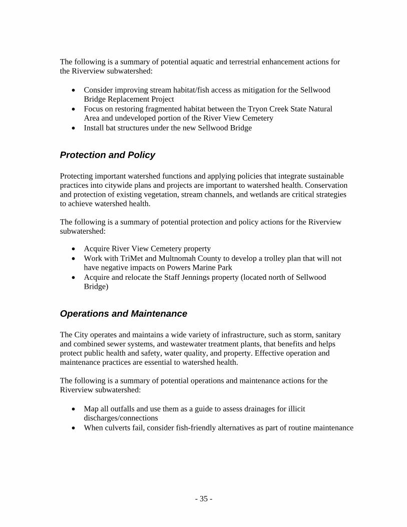
- 35 -
The following is a summary of potential aquatic and terrestrial enhancement actions for the Riverview subwatershed:
Consider improving stream habitat/fish access as mitigation for the Sellwood Bridge Replacement Project
Focus on restoring fragmented habitat between the Tryon Creek State Natural Area and undeveloped portion of the River View Cemetery
Install bat structures under the new Sellwood Bridge
Protection and Policy Protecting important watershed functions and applying policies that integrate sustainable practices into citywide plans and projects are important to watershed health. Conservation and protection of existing vegetation, stream channels, and wetlands are critical strategies to achieve watershed health. The following is a summary of potential protection and policy actions for the Riverview subwatershed:
Acquire River View Cemetery property Work with TriMet and Multnomah County to develop a trolley plan that will not
have negative impacts on Powers Marine Park Acquire and relocate the Staff Jennings property (located north of Sellwood
Bridge)
Operations and Maintenance The City operates and maintains a wide variety of infrastructure, such as storm, sanitary and combined sewer systems, and wastewater treatment plants, that benefits and helps protect public health and safety, water quality, and property. Effective operation and maintenance practices are essential to watershed health. The following is a summary of potential operations and maintenance actions for the Riverview subwatershed:
Map all outfalls and use them as a guide to assess drainages for illicit discharges/connections
When culverts fail, consider fish-friendly alternatives as part of routine maintenance

- 36 -
Education, Involvement, and Stewardship The Education, Involvement, and Stewardship strategy is integrated into all other strategies. Public involvement and stewardship encourage citizens to get involved in the work of protecting our natural resources. Raising awareness of watershed issues and fostering stewardship of city-owned natural areas promotes healthy watersheds. The following is a summary of potential education, involvement, and stewardship actions for the Riverview subwatershed:
Support South Portland Riverbank Planning Team restoration efforts in Powers Marine Park
Encourage Lewis and Clark College students to conduct environmental research in the Riverview subwatershed
Conduct outreach to Lewis and Clark College about their role in the habitat link between Tryon Creek State Park and River View Cemetery
Remove invasive plants along the Willamette River and throughout the subwatershed

- 37 -
SECTION 6: PROJECT OPPORTUNITIES This section describes specific opportunities that exist throughout the Riverview subwatershed to improve subwatershed health. They are geographically specific applications of the potential actions outlined in Section 5. Opportunities to improve watershed health were identified through a comprehensive process that included data analysis, review of available information of current and historical subwatershed conditions, field assessments, stakeholder involvement, and City staff input, and then scored and ranked according to the process described in Section 4. They are organized by the six PWMP strategies presented in Section 5 (Figures 5 and 6 at the end of this section). A single list of ranked projects was developed across all strategies. However, for descriptive purposes the projects are organized in the tables below by PWMP strategy. Therefore, the ranking is not sequential within each set of strategies. Citywide programmatic opportunities were not included in the subwatershed objective ranking process and did not receive a ranking; however, they are included in the tables in this section.
Stormwater Management Opportunities The specific stormwater projects and programs presented in Table 6 are designed to improve natural stormwater function, and are the foundation for all other watershed protection and improvement efforts. These projects help minimize the effects of development on watershed processes and natural conditions, providing water quality treatment, flow attenuation, interception and infiltration, reduced channel erosion, improved aquatic habitat conditions, and protection of downstream restoration projects. Projects include structural retrofits and other stormwater management measures that reduce effective impervious area (EIA) by promoting interception, infiltration, retention, and detention, as well as by collecting and limiting contaminant transport. Some potential project sites may be constrained by geotechnical concerns (soils/infiltration) and other environmental issues (contamination). Environmental site assessments will be conducted at a later planning stage. Education and outreach are critical elements of improving watershed health and will be incorporated into all stormwater management projects. Selection, design, and implementation of these projects will be coordinated with or rely directly on a variety of City partners and programs. Critical partners, programs, and associated regulatory requirements include: Portland Bureau of Transportation (PBOT), PBOT Maintenance Operations, ODOT, Urban Forestry, NPDES MS4 permit program, TMDLs, BES Clean River Rewards (stormwater discount) Program, BES Clean Rivers Education Program, BES Downspout Disconnect Program, BES Sustainable Stormwater Program, Community Watershed Stewardship Program, and the City’s 2008 Stormwater Management Manual (SWMM).

- 38 -
The process of identifying stormwater management opportunities through watershed field assessments included many internal and external stakeholders. The BES Asset Management System Analysis and Sustainable Stormwater groups were key players in this process. Staff from both groups took part in a mapping workshop and provided feedback that was used to guide the IS field assessments and the subsequent development of potential projects. Opportunities that have been identified on private properties will not be pursued without the consent and cooperation of affected property owners. Opportunities identified on property owned or managed by PP&R will follow the process established through a Memorandum of Understanding (MOU) between PP&R and BES. The MOU process will be used to guide the implementation of any opportunities selected for concept planning or design development. Table 6: Riverview Subwatershed Stormwater Opportunities Rank Project/Program Location Project/Program Description
12 Sellwood Bridge Stormwater Treatment Facility, Westside
Sellwood Bridge
Partner with ODOT, Multnomah County, and PBOT as part of the Sellwood Bridge Redevelopment project to design stormwater area(s) to pre-treat bridge and ramp stormwater runoff. Project is within an ODOT MS4 area. Good opportunity to educate public on stormwater issues at high visibility intersection.
20 Powers Marine Park Gravel Parking Lot Stormwater Project
Boat ramp at Powers Marine and Staff Jennings
Treat stormwater runoff at Powers Marine/Staff Jennings boatramp. Gravel parking lot, paved driveway and boat ramp runoff could be directed to a vegetated swale upland of the river, to pretreat sediment and vehicle deposited contaminants.
21 Hood/Riverside Curb Extension
SW Hood/SW Riverside
Install curb extensions on either side of SW Hood to detain and treat road runoff. SW Hood is a wide street in a MS4 drainage area.
22 Lewis & Clark Fir Acres Parking Lot A Vegetated Swale
Lewis and Clark College
Install a vegetated swale to slow and filter water before it enters the stream. Currently, stormwater is sheet-flowing off of the parking lot and eroding the streambank.
24 Staff Jennings Water Quality Facility
8240 SW Macadam (Staff Jennings)
Retrofit entrance to Staff Jennings to treat and detain Highway 43 runoff. Entrance is a large, wide driveway with landscaped area available. Project is within the ODOT MS4 drainage area.
25 Highway 43 Pullout Filter Strip
Highway 43 Pullout area
Install vegetative filter strip on the west side of Highway 43 to treat roadway runoff before it enters the Willamette River. Currently, road runoff flows untreated to the Willamette River. Project would entail partnering with ODOT.
29 Lewis and Clark Stadium Parking Lot Retrofit
Lewis and Clark College
Install a vegetated infiltration basin in the stadium parking lot to control and treat stormwater runoff. Project would entail removing five parking spaces and redirecting traffic.
30 Lewis and Clark North Drive Swale
Lewis and Clark College, SW North Drive
Add curb cuts and revegetate existing landscaped area to create a stormwater swale along SW North Drive.
33 Palatine South Campus Stormwater Swale
SW Palatine South Campus
Install vegetative swale on west side of SW Palatine Hill Road near Lewis and Clark South Campus entrance. Install interpretive signage to educate community on stormwater issues.
37 Staff Jennings Ecoroof 8240 SW Macadam (Staff Jennings)
Install an ecoroof on the Staff Jennings building. The project is adjacent to the Willamette River and in an ODOT MS4 drainage area.

- 39 -
Revegetation Opportunities Efforts to preserve native vegetation and prevent the establishment of invasive plants will increase the City’s ability to achieve and maintain healthy watersheds. Increasing canopy cover and native vegetation improves the physical-biological elements of the urban environment, such as water quality, stream integrity, and fish and wildlife habitat. Revegetation projects can also result in cost savings on infrastructure expenditures, as well as produce aesthetic, economic, and other community benefits. Removing invasive plant species is a critical element of the citywide revegetation strategy. Invasive plants impact watershed health by degrading water quality, increasing erosion, reducing biodiversity, altering habitat quality, reducing tree cover, and changing soil characteristics. The City of Portland has a number of plans and programs that support invasive plant removal including the PWMP, the City’s Invasive Plant Strategy, the BES Early Detection and Rapid Response Program (EDRR), and PP&R’s Protect the Best program. Selection, design, and implementation of revegetation opportunities will be coordinated with these plans and programs. The Willamette team worked closely with the BES Watershed Revegetation team, PP&R’s City Nature, and others to identify potential projects. Education and outreach is a critical element of improving watershed health and will be incorporated into all revegetation projects. Opportunities that have been identified on private properties will not be pursued without the consent and cooperation of affected property owners. Opportunities identified on property owned or managed by PP&R will follow the process established through a MOU between PP&R and BES. The MOU process will be used to guide the implementation of any opportunities selected for concept planning or design development. Table 7: Riverview Subwatershed Revegetation Opportunities Rank Project/Program Location Project/Program Description
3 River View Cemetery Forest South Revegetation
River View Cemetery South/Forested
Remove invasive plants; primarily ivy, clematis and EDRR species, in forested portion of South River View Cemetery. Replant with native vegetation as needed.
8 River View Cemetery North Revegetation
River View Cemetery
Remove invasives and plant natives in riparian stream corridors of currently developed portions of River View Cemetery. Riparian areas are reportedly overgrown with ivy, laurel, and clematis.
16 Powers Marine Park Riparian Enhancement
Powers Marine Park; adjacent to culvert #6
Protect/enhance high-value Pacific willow habitat along Willamette shoreline in Powers Marine Park and enhance beach/mud flat habitat by adding large wood. Reed canary grass may be preventing recruitment of willow. Remove invasive plants (purple loosestrife, yellow flag iris, blackberry and reed canary grass).
31 Powers Marine Park Vegetation Enhancement, Uplands
Powers Marine Park, Terrestrial
Enhance forest habitat with native shrubs and herbaceous plants. Enhance canopy where possible with native trees. Replace trees under powerlines with native trees and shrubs of appropriate size for location. Continue invasive species management. Create/protect snags especially adjacent to river for bird perches, bat and woodpecker nesting and foraging.

- 40 -
Rank Project/Program Location Project/Program Description
35 Willamette Moorage Natural Area Vegetation Enhancement
Willamette Moorage
Remove invasive plants that are encroaching on native trees, shrubs and wildflowers. A PP&R vegetation survey identified the area as in fair to poor condition.
Aquatic and Terrestrial Enhancement Opportunities The specific stream enhancement projects presented in Table 8 are designed to improve the amount and quality of important habitat in the Willamette River channel and its tributaries. The lower Willamette River functions as a critical salmonid migration corridor and rearing area, and the ecological effects of local conditions impact Chinook, coho, and steelhead populations throughout the entire Willamette subbasin. These projects will increase habitat extent and diversity by daylighting stream channels, improving streambank conditions, creating shallow water and off channel habitat, increasing tributary stream accessibility, adding channel complexity, and increasing channel stability. Examples of specific terrestrial enhancements to protect, restore, and enhance aquatic and terrestrial habitat conditions (as appropriate to the site) include:
Snag creations Seasonal ponds for amphibian breeding Bat or bird habitat artificial structures Oak replacement
Oregon white oak woodland habitat was once dominant in the Portland area, and is still important both locally and regionally. Many different wildlife species, such as neo-tropical birds and Western gray squirrels, utilize this valuable habitat type for nesting and foraging. Selection, design, and implementation of these projects will be coordinated with or rely directly on a variety of existing City and other agency programs. Critical programs, partners, and regulatory requirements include: the BES Science Fish and Wildlife Program, TEES, the ESA, Water Resource Development Act (WRDA), River Renaissance Program, BPS and Metro’s riparian corridor and wildlife habitat inventories, PP&R, Oregon Department of Fish and Wildlife (ODFW) Restoration and Enhancement Program, and Oregon Watershed Enhancement Board (OWEB). Education and outreach is a critical element of improving watershed health and will be incorporated into all aquatic and terrestrial enhancement projects. Opportunities that have been identified on private properties will not be pursued without the consent and cooperation of affected property owners. Opportunities identified on property owned or managed by PP&R will follow the process established through a MOU between PP&R and the BES. The MOU process will be used to guide the implementation of any opportunities selected for concept planning or design development.

- 41 -
Table 8: Riverview Aquatic and Terrestrial Enhancement Opportunities Rank Project/Program Location Project/Program Description
2 River View Cemetery Forest Aquatic and Terrestrial Restoration and Enhancement
River View Cemetery South Forested Portion
Enhance features supportive of special status species that may be in the area. Create or protect snags, and incorporate bat boxes and bird nest boxes. Enhance streams for amphibians and other aquatic organisms. Enhance access to streams for terrestrial wildlife.
9 Powers Marine Park Rock Outcrop Aquatic and Terrestrial Enhancement
Powers Marine Park Rivermile (RM) 17.2
Protect rock outcrop vegetation communities from human impacts at Powers Marine Park. Enhance portions of rock outcrop with "soft" materials, such as large wood.
13 River View Cemetery Aquatic and Terrestrial Restoration and Enhancement
River View Cemetery (North) Developed Cemetery
Enhance features supportive of TEES special status species. Create or protect snags, and incorporate bat boxes and bird boxes. Enhance streams for amphibians such as red legged frogs and chorus frogs.
14 Powers Marine Park Beach and Slough Enhancement
Powers Marine Park - RM 16.75-17.0
Continue to enhance Willamette River beach and shallow water habitats in Powers Marine Park. Add more large wood pieces, remove invasive species (purple loosestrife), restore and enhance native scrub/shrub along beach and in slough. Add Pacific willow and other willow species.
17 Powers Marine Park Alcove Habitat Creation
Powers Marine Park - RM 16.7-16.8
Remove fill material from Highway 43 and Willamette Shore Trolley; build off-channel habitat/cove for Willamette River salmonid habitat. Link to stream connectivity project at stream 2 and 3.
23 Willamette Moorage Natural Area Off-channel Habitat Enhancement
Willamette Moorage Park
Create/enhance off-channel habitat/alcove in natural drainage area that could serve as rearing habitat for juvenile salmonids, as well as potential cold water refugia.
27 Stream 6 River View Cemetery/Powers Marine Park Stream Connectivity Enhancement
Powers Marine Park - RM 17.1
Replace culvert with wildlife friendly structure. Consider bridging stream at Highway 43 for mammal passage. Enhance confluence at Willamette River for off-channel habitat. Enhance riparian vegetation.
28 Stream 2 River View Cemetery/Powers Marine Park Stream Connectivity Enhancement
Powers Marine Park - RM 16.75
Replace culvert under Highway 43 and Willamette Shore Trolley tracks with alternative that provides connectivity for fish and terrestrial wildlife. Stream from River View Cemetery currently flows under Highway 43 and trolley tracks into a culvert (culvert is not visible) and then drains to a beach where PP&R implemented a large wood installation project. Create off-channel habitat for salmonids at confluence. Remove fill. Install a bridge and daylight culverts in grassy area on east side of trolley tracks for off-channel habitat. Enhance riparian vegetation.
32 Stream 3 River View Cemetery/Powers Marine Park Stream Connectivity Enhancement
Powers Marine Park - RM 16.8
Replace culvert under Highway 43 and Willamette Shore Trolley tracks with an alternative that provides connectivity for fish and terrestrial wildlife. Remove Fill. Stream that originates in River View Cemetery currently flows into culvert under Highway 43 and trolley tracks. Pretreatment of roadway stormwater runoff also recommended. Enhance confluence at Willamette River for off-channel habitat. Enhance riparian vegetation.
34 Stream 4 River View Cemetery/Powers Marine Park Stream Connectivity Enhancement
Powers Marine Park - RM 16.9
Replace culvert under Highway 43 and Willamette Shore Trolley tracks with an alternative that provides connectivity for fish and terrestrial wildlife. Remove fill. Pretreatment of roadway stormwater runoff also recommended. Enhance confluence at Willamette River for off-channel habitat. Enhance riparian vegetation.
36 Stream 7 River View Cemetery/Powers Marine Park Stream Connectivity Enhancement
Powers Marine Park - RM 17.2
Replace culvert under Highway 43 and Willamette Shore Trolley tracks with wildlife friendly structure. Consider bridging stream at Highway 43 for mammal passage. Enhance confluence at Willamette River. Enhance riparian vegetation.

- 42 -
Rank Project/Program Location Project/Program Description
38 Stream 1 River View Cemetery/Powers Marine Park Stream Connectivity Enhancement
Powers Marine Park - RM 16.6
Replace culvert under Highway 43 and Willamette Shore Trolley tracks with an alternative that provides connectivity for fish and terrestrial wildlife. Remove fill. Pretreatment of stormwater runoff from Highway 43 is also recommended. Enhance confluence at Willamette River for off-channel habitat. Enhance riparian vegetation.
39 Stream 5 River View Cemetery/Powers Marine Park Stream Connectivity Enhancement
Powers Marine Park - RM 17.08
Replace culvert under Highway 43 and Willamette Shore Trolley tracks with an alternative that provides connectivity for fish and terrestrial wildlife. Remove fill. Pretreatment of roadway stormwater runoff is also recommended. Enhance confluence at Willamette River for off-channel habitat. Enhance riparian vegetation.
40 Willamette Moorage Natural Area Streambank Restoration and Enhancement
Willamette Moorage Natural Area Park
Implement strategies/practices to control and prevent streambank erosion, as well as to benefit riparian/aquatic habitat conditions. Active erosion and sloughing of the streambank is occurring along with the loss of riparian vegetation.
42 Lewis and Clark Stormwater Outfall Repair and Maintenance: Riverview
Lewis and Clark College
Improve conditions of stormwater outfalls to prevent and reduce erosion of Lewis and Clark College stream channels. A 2009 geotechnical report submitted to the City as part of the Campus Master Plan update identified 6 of 28 stormwater campus outfalls as in "urgent" or "important" need of repair; 7 outfalls could not be located.
Protection and Policy Opportunities Projects and programs in this category identify opportunities to protect and improve watershed function, habitat value, and connectivity through acquisition or easements, zoning overlays, resource tracts, Riverside Plan protections, development standards review, building code review, and other protection measures and programs. This approach strives to ensure that the highest quality areas are protected, and that development planned in or near resource areas is completed with the most environmentally sensitive design and minimal impact. Protection of areas with the highest remaining function and value has been identified as a cornerstone for effective watershed management (City of Portland 2004). Areas for which protection and policy actions could be pursued include:
Remaining forested areas, stream remnants, and associated ravines that serve as key habitat area anchors and connections between larger habitat areas.
Any area where vegetated floodplain is accessible to the river, or where natural, gently sloped streambanks are present.
Wetlands and forested areas, natural streambanks, and tributary confluences that provide high quality habitat and are the most sensitive portions of the watershed.
Citywide development issues related to the amount of hardened streambanks, shallow water habitat, and riparian or floodplain vegetation.
A number of policy and regulatory strategies have been effectively used by the City to protect watershed resources. Selection, design, and implementation of these projects will be coordinated with or rely directly on a variety of existing City programs. Critical partners and programs include: BPS Portland Plan and River Plan projects, Regulatory

- 43 -
Improvement Program, PBOT, Urban Forestry Program, SWMM, development standards review, building code review, environmental review, Metro natural resources planning, and Portland Development Commission.
Willamette Watershed Property Acquisition Program Private property acquisition is a tool under the Protection and Policy strategy of the PWMP. These projects are listed below in Table 9. Properties were chosen on the basis of their ability to protect watershed assets or to allow BES to implement an IS project that would be more appropriately located on public property. Properties identified for potential acquisitions in the Willamette Watershed in Portland will be managed through a “willing seller” approach. Through the program, willing sellers are offered fair market value for their property and are under no obligation to sell. If they choose to sell, the land acquired through the willing seller program will be managed to improve fish and wildlife habitat, restore wetlands, improve water quality, and may provide passive recreation activities. Some properties identified as potential acquisition sites may be constrained by contamination and/or other feasibility issues. These issues will be identified and addressed at a later planning stage. Land conservation easements may also work to achieve some of the PWMP protection and policy goals, and thus the IS goals. A conservation easement is a legally binding agreement made by the property owner not to develop part of a property, but to leave it permanently "natural". The landowner retains title to the property and the easement becomes part of the land deed, meaning that all future property owners will be bound by the terms of the easement. In November 2007, the City’s Grey to Green Initiative was launched to accelerate some principal elements of PWMP implementation. The Grey to Green Land Acquisition Program will build on previous and current efforts to permanently protect important natural resource areas by placing land in public ownership. Opportunities that have been identified on private properties will not be pursued without the consent and cooperation of affected property owners. Opportunities identified on property owned or managed by PP&R will follow the process established through a MOU between PP&R and BES. The MOU process will be used to guide the implementation of any opportunities selected for concept planning or design development. Some protection and policy projects/programs that have been identified are citywide opportunities and were not included in the subwatershed objective ranking process. However, they are included in the following table.

- 44 -
Table 9: Riverview Subwatershed Protection and Policy Opportunities Rank Project/Program Location Project/Program Description
1 River View Cemetery Acquisition
Undeveloped portion of cemetery - South Riverview
Acquire forested/undeveloped portion of River View Cemetery property. Acquisition objectives are to: Protect multiple habitats from urban development, protect for wildlife connectivity between westside wildlife corridor and Tryon Creek State Park, and provide opportunity for public involvement in restoration of degraded forest health and for stream enhancement.
11 Sellwood Bridge North Property Acquisition
North of Sellwood Bridge
Acquire property north of Sellwood Bridge. Acquisition is anticipated to provide space for Sellwood Bridge reconstruction. This project would reduce impacts to natural areas north and south of the reconstruction area.
15 Powers Marine Park Protection
Powers Marine Park Partner with PP&R to ensure protection of Powers Marine Park against future development that could impact the park area. Future actions include: Multnomah County Sellwood Bridge Replacement, TriMet proposed light rail service to Milwaukie, and expansion of the Lake Oswego streetcar/transit line.
26 Powers Marine North Aquatic Resource Protection
Powers Marine Park Protect aquatic resources where perennial flow is noted at base of River View Cemetery. Based on aerial photos and GIS, it does not appear that this flow comes from a stream, but from some sort of seep or road runoff. However, field observations have found it to be perennial flow.
Not ranked Environmental Land Use and Zoning Program
Citywide Participate in the City’s NRI update to protect high quality habitats and sensitive portions of the watershed. The update is needed to reflect recent science and better data and to enhance protections for streams and drainages, wetlands, riparian areas and upland wildlife habitat. As part of this update, the City will address compliance with Metro Title 13 Nature in Neighborhoods, and State Land Use Goals 5 (Significant Resources) and 6 (Air and Water Quality). The update will also inform potential changes to the environmental overlay zones.
Not ranked The Portland Plan Citywide Participate in the BPS’s planning process for the Portland Plan. The Portland Plan project will update Portland’s comprehensive plan, including policies and goals related to natural resources and watershed health.
Not ranked The River Plan Citywide Participate in BPS’s River Plan process. The River Plan project will address protection, conservation and restoration of natural resources in the Willamette River corridor east of Interstate5. Beginning in 2009, the River Plan will focus on the central and south reaches of the project area, which include portions of the south subwatersheds. As part of the project, previously adopted natural resource inventories and environmental overlay zoning will be updated as needed to address current natural resource information, City watershed goals and policies, and Metro Title 13 Nature in Neighborhoods requirements.
Not ranked NPDES Coordination Citywide Participate in NPDES permit-related efforts within the City to maximize opportunities for BES Watershed Services to provide input on future

- 45 -
Rank Project/Program Location Project/Program Description
modifications to the City’s NPDES permit, such as modifying the NPDES monitoring program to optimize data collection efforts, and allow earlier identification of potential impacts of permit modifications on watershed restoration planning.
Not ranked River Bank Treatment Policies
Citywide Participate in development of City policies pertaining to riverbanks to eliminate construction of new vertical walls, minimize use of pilings, encourage alternative and bio-engineered bank treatments, and protect existing beach, off-channel, vegetated, and shallow water habitats.
Not ranked Subwatershed-Specific Stormwater Management Manual
Citywide Develop subwatershed-specific SWMM guidelines for new and redevelopment sites with Bureau of Development Services. Develop EIA targets for new and existing development within each subwatershed. Pursue City policy and codes that would limit EIA to a maximum level.
Not ranked Tree Canopy Management
Citywide Support the Citywide Tree Urban Forest Plan and its implementation. Continue work on implementing the new consolidated City Tree Title (Title 11) and its associated administrative rules. Future work includes restructuring code; establishing a single point of contact to address tree-related inquiries and requests; consolidating permitting functions; and amending code to improve tree preservation, replacement, and protection during construction.
Not ranked ODOT Coordination Interstate-5 and Barbur Boulevard
Coordinate with ODOT on water quality issues to facilitate the treatment and detention of stormwater runoff from ODOT transportation corridors.
Not ranked Invasive Species Policy Citywide Support the Invasive Plant Strategy program that integrates invasive plant management into existing City programs and reduce invasive plant coverage within the City. Program elements include: Proposed policy changes, additional education and outreach programs, ways to improve interbureau and interagency coordination, assessment (inventory and control priorities), and invasive plant control methods and programs.
Not ranked Early Detection Rapid Response (EDRR) Policy
Citywide Support the Invasive Plant Strategy’s EDRR program to control less-common invasive plant species before they become widespread and difficult to manage. Program needs include resources for expanding citizen search networks, as well as management strategies for neighborhoods.
Operations and Maintenance Opportunities Maintaining a functional sewer infrastructure is a BES core charge. Opportunities in this category are broad undertakings that include citywide sewer maintenance actions related to the protection and improvement of watershed conditions. Selection, design, and implementation of these projects will be coordinated with or rely directly on a variety of existing City programs. Critical partners and programs include: PBOT Maintenance Operations, and the BES Wastewater Maintenance group, Spill Protection and Citizen Response Section, Illicit Discharge Controls, Industrial

- 46 -
Pretreatment Program, and the Industrial Stormwater Program. Opportunities that have been identified on private properties will not be pursued without the consent and cooperation of affected property owners. Opportunities identified on property owned or managed by PP&R will follow the process established through a MOU between PP&R and BES. The MOU process will be used to guide the implementation of any opportunities selected for concept planning or design development. Operations and maintenance projects that have been identified are citywide opportunities and were not included in the subwatershed objective ranking process. However, they are included in the following table.
Table 10: Riverview Subwatershed Operations & Maintenance Opportunities
Rank Project/Program Location Project/Program Description
41 Highway 43 Ditch to Swale
Highway 43, between Powers Marine and Riverview
Partner with ODOT to convert a stormwater conveyance ditch along Highway 43 into a swale that will filter roadway pollutants.
Not ranked
Outfall Assessment and Prioritization
Citywide Map all outfalls in the subwatershed. Use map as a guide to assess drainages for illicit discharges/connections. Develop a protocol for prioritizing repair/replacement of outfalls impairing watershed health.
Not ranked
Maintenance Staff BMP Program
Citywide Coordinate adoption of BMPs with Maintenance Operations staff in the interest of watershed health. Promote maintenance of trash racks and stormwater conveyance infrastructure adjacent to streams to improve stream channel functions and reduce invasive species transport.
Education, Involvement, and Stewardship Opportunities Education and outreach is a critical element of improving watershed health and will be incorporated into all Riverview IS projects. The following projects are solely focused on this strategy. Public and commercial education programs are necessary to reach out to watershed residents and businesses to help improve watershed conditions. Projects in this category relate to a range of issues, such as maintenance practices, commercial pollution control practices, public stormwater education, pet waste clean up, yard design and invasive species education, and dumping prevention outreach. Selection, design, and implementation of these projects will be coordinated with or rely directly on a variety of existing City programs. Leveraging existing resources and encouraging and supporting watershed improvement actions at the community level is a key factor in the Education, Involvement and Stewardship strategy. Critical existing programs include: Neighborhood groups and associations, local business groups, Friends groups, the Community Watershed Stewardship Program, Three Rivers Land Conservancy’s Backyard Habitat program, the West Willamette Restoration Partnership, Metro, and the West Multnomah Soil & Water Conservation District (WMSWCD).

- 47 -
Opportunities that have been identified on private properties will not be pursued without the consent and cooperation of affected property owners. Opportunities identified on property owned or managed by PP&R will follow the process established through a MOU between PP&R and BES. The MOU process will be used to guide the implementation of any opportunities selected for concept planning or design development. Most of the Education, Involvement, and Stewardship programs/projects that have been identified are citywide opportunities and were not included in the subwatershed objective ranking process. However, they are included in the following table.
Table 11: Riverview Education, Involvement, and Stewardship Opportunities Rank Project/Program Location Project/Program Description
4 River View Cemetery Stormwater Outreach
River View Cemetery, North
Conduct outreach to River View Cemetery to provide information on green stormwater management tools. Focus on erosion and groundwater discharge to surface streams. Promote "ditch to swale" program along access roads within the developed portion of cemetery to prevent sediment runoff to streams.
5 Lewis and Clark Stormwater Outreach
Lewis and Clark Campus
Conduct stormwater management outreach to Lewis and Clark College. Partner with college campus to implement actions that reduce stormwater volume and improve water quality. Focus on reducing erosion, improving slope stability, and stream protection.
6 River View Cemetery Maintenance Practices Outreach
River View Cemetery
Conduct outreach to River View Cemetery to provide information on managing invasive species. Actions should work to protect slope stability and tree canopy, and prevent encroachment of invasive species on adjacent properties with high value habitat.
7 Lewis and Clark Maintenance Practices Outreach
Lewis and Clark Campus
Conduct outreach to Lewis and Clark College on land management for healthy watersheds. Provide information on managing invasive species and landscaping practices that minimize chemical use. Actions should work to protect tree canopy, improve slope stability, and enhance riparian areas by managing invasive species on campus and adjacent properties with high value habitat.
10 Powers Marine Park Education, Involvement and Stewardship
Powers Marine Park
Work with PP&R to develop interpretive opportunities to encourage appropriate public use of this important riverside park. Encourage park users to understand the value of the habitat features of the park including large wood, snags, riparian vegetation, and rock outcrops. Also encourage park users to be aware of and protect wildlife and fish that live within the park. Provide information to the fishing community about safe fish consumption.
18 Westside Wildlife Corridor Natural Area Coordination
River View Cemetery
Coordinate with Tryon Creek State Park, PP&R (Powers Maine Park), and Lewis and Clark College on Westside Wildlife Corridor strategies. Strategies to coordinate include: invasive plant removal, wildfire prevention, climate change, and wildlife habitat and connectivity enhancement. These natural areas form a wildlife corridor, but each is managed individually.
19 Promote Fire Safe Landscaping
Wildfire Hazard Areas
Support education efforts to property owners in high fire hazard areas of the City. Help residents learn about fire safe methods of landscaping their property.
Not ranked
Illegal Dumping Outreach
Citywide Develop trash and yard debris disposal education for homeowners adjacent to natural areas. Install signs and fences where appropriate.
Not Invasive Species Citywide Support landowner education throughout the Willamette

- 48 -
Rank Project/Program Location Project/Program Description
ranked Outreach Watershed to control the spread of existing problem species, to prevent introduction of new invasive species, and to provide educational opportunities particularly in parks and other public and open spaces.
Not ranked
Early Detection Rapid Response (EDRR) Outreach
Citywide Support landowner education throughout the Willamette Watershed to control targeted less-common invasive species such as garlic mustard before they become widespread and difficult to manage.
Not ranked
Naturescaping and Yard Tree outreach
Citywide Support landowner education throughout the Willamette Watershed to encourage yard trees, naturescaping, and backyard habitat. Provide educational opportunities particularly in parks and other public and open spaces.
Not ranked
Residential Non-Point Source Pollution Outreach
Citywide Conduct outreach and education to reduce impacts of non- point source pollutants. Pollutant sources include: Washing activities, roof treatments, and pet waste. Install pet waste educational signs, bag stations, and trash bins in natural areas.
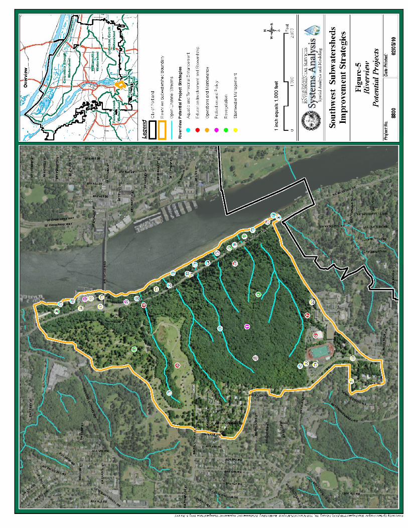
- 49 -

- 50 -
SECTION 7: RECOMMENDATIONS This report summarizes the Improvement Strategies (IS) process for the Riverview subwatershed and identifies opportunities, in the form of ranked site-specific projects, to protect and improve watershed health. This process is only one step in the larger watershed management process, a long-term adaptive management system that will include implementation, monitoring, evaluation, and improvement of projects and programs. The projects in this IS report were developed through the use of a rapid assessment process that is based on a well established science based method for identifying subwatershed improvements. The method was developed by the Center for Watershed Protection in Ellicott City, Maryland3. Selecting the Improvement Strategies involved the collaboration of various stakeholders including all relevant City bureaus, non-profit organizations, and subwatershed residents. The following recommended actions are the projects identified in Section 6, grouped relative to geographic and/or programmatic clusters. Actions in this section have been grouped and prioritized based on an integrated approach that addresses the watershed goals established in the Integrated Framework for Watershed Health (2005b): hydrology, physical habitat, water and sediment quality, and biological communities. The groups of actions are intended to protect areas that 1) have been identified in the IS process as assets, or 2) work toward improving local subwatershed conditions in problematic areas. The projects individually and collectively work toward achieving the goals and objectives identified in the Portland Watershed Management Plan (PWMP). The groupings are not intended to suggest an order of implementation or replace the project ranking process described in previous sections; rather they highlight areas based on the Technical team’s understanding of the subwatershed and opportunities that exist for funding, partnerships, and/or local support.
River View Cemetery Watershed Improvement Recommendations Background The Riverview subwatershed is one of the most intact subwatersheds in the City of Portland. Large open spaces, vacant land and parks represent 246 of 353 acres (70 percent) of the watershed in an undeveloped condition. Impervious areas in the subwatershed cover only 9 percent of the landscape. By comparison the Miller Creek
3 http://www.cwp.org/ - CWP provides training and technical resources to municipalities around the country to assist with assessing watershed conditions. The resources include evaluating local environmental ordinances and programs, field assessments and crafting restoration and protection strategies for small watersheds.

- 51 -
subwatershed has 6 percent, and the Balch Creek subwatershed has 22 percent impervious area. River View Cemetery is a unique asset to the City, suitably located to provide an upland corridor between natural areas in Forest Park, Washington Park, and Marquam Natural Park to the north, and Tryon Creek State Natural Area to the south and west. Known as the Westside Wildlife Corridor by Portland Parks and Recreation (PP&R), the Corridor is the forested spine of the west hills that provides natural habitat and creates a continuous vegetative connection for wildlife travel (City of Portland 2009b). The Cemetery functions as a crucial link in the Corridor with its open space designation due to extensive forest habitat and prime location near the Tryon Creek Watershed and the natural areas along the Willamette River at Powers Marine Park. Site Description River View Cemetery is in the southwest section of Portland. Founded in 1882, it is owned and operated by the River View Cemetery Association and governed by a volunteer Board of Trustees. The properties (individual taxlots) owned by River View Cemetery that are included in this report comprise approximately 260 total acres. Approximately 160 acres are forested and have not been developed, with the remaining 100 acres consisting of burial sites, mausoleums, and a funeral home. Terrestrial Habitat Conditions River View Cemetery is designated by the City of Portland Draft Natural Resources Inventory (NRI) as a Special Habitat Area (SHA) and as a Terrestrial Ecology Enhancement Strategy (TEES) habitat anchor, connector, and management opportunity. The criteria that resulted in the SHA designations are:
Migratory stopover habitat Corridor between patches or habitats
The high percent of encroachment by invasive ivy and other plants in the undeveloped portion of the cemetery indicates a need to control these invasive plants in order to protect the interior forest habitat. The undeveloped forested portion of the Cemetery is upland forest that includes areas dominated by native conifer and deciduous trees, with individual trees that are over 100 years old (City of Portland 2000). The tree canopy in the riparian area includes stands of western red cedar, Douglas fir and red alder. Aquatic Habitat Conditions There are seven streams that flow through the Cemetery as direct tributaries to the Willamette River. They are generally unaltered through much of their channels (WHPacific, Inc. 2008). The streams comprise 13,800 linear feet of tributary flow to the Willamette River. Powers Marine Park, located on the adjacent floodplain, serves as an important ecological link between the Cemetery property and aquatic habitats in the

- 52 -
Willamette River corridor. In 2007, the City invested in an aquatic habitat enhancement project in Powers Marine Park to benefit listed salmonids. Large wood installation has improved rearing and refuge habitat for native fish. The project is located at the confluence of the stream #2 emanating from River View Cemetery. Four of the seven streams are perennial and three are seasonal or intermittent (City of Portland 2009a). All are generally unaltered through much of their channels. Based on historic records, it is assumed these streams still occupy their historic channels. No public information about qualitative assessments for the streams is available to date. Existing and Potential Threats to the Asset The City of Portland received applications for site development plans for the forested (undeveloped) portion of River View Cemetery on two occasions. The proposals included plans for a 26-acre development that would be located just north of Lewis and Clark College and east of Palatine Hill Road. The proposed development would potentially have negative impacts on five of the streams in the subwatershed. The proposal would: Add impervious area in a large undisturbed area Yield a significant loss of tree canopy cover in areas with steep slopes Impair habitat connectivity for wildlife movement between the Westside Wildlife
Corridor and Tryon Creek State Natural Area. A recent assessment of the undeveloped River View Cemetery forest area indicates a threat to the long term health of the forest due to the high level of invasive plant species. 80 percent of the tree canopy was infested with ivy and or clematis. 90 percent of the understory ground cover consisted of invasive species.
The high percent cover of invasive plant species indicates that control should occur in the near term. Invasive plant removal is necessary to protect and enhance forest health as well as to protect native wildlife and aquatic habitats (City of Portland TEES Riverview Assessment 2009c). Protection and enhancement of stream quality is a priority for the River View property due to the proximity of the streams to critical habitat in the Willamette River and the relative intact nature of the streams. Enhancement opportunities identified in this assessment are indicated at the culverts and fill areas between the cemetery and the Willamette River on the Highway 43 and rail transportation corridors. While the aquatic improvements at the transportation corridor are not located on the River View Cemetery property, these enhancements would have a positive affect on aquatic habitats and organisms if implemented. Benefits The projects grouped below address aquatic and terrestrial enhancements, water quality and hydrology issues. River View Cemetery makes up 260 acres of the 353-acre subwatershed (73 percent). Improvements and enhancements on a property of this size

- 53 -
will have a substantial impact on the condition of the subwatershed and on the critical fish habitat in the adjacent Willamette River. Constraints The River View Cemetery property is privately owned. All recommendations will be pursued with full cooperation of the landowner. Acquisition opportunities will be pursued through a willing seller program and based on fair market values. Potential Partnerships Forging partnerships will be a critical component of project implementation in the River View Cemetery property, and the Cemetery Association will be a critical partner. The Willamette Watershed Team will also be partnering with staff from City bureaus, local/state/federal agencies, and citizens groups to protect the area’s natural resources, enhance critical ecosystems, and implement projects in this important habitat area. Other potential partners include PP&R, West Multnomah Soil and Water Conservation District (WMSWCD), Trust for Public Lands (TPL), Three Rivers Land Conservancy, Metro, and the Bonneville Power Administration (BPA). Potential Funding Sources BPA, TPL, Metro, Oregon Department of Agriculture, Oregon Watershed Enhancement Boart (OWEB), Oregon Department of Fish and Wildlife (ODFW), National Fish and Wildlife Foundation (NFWF), WMSWCD Opportunities for Potential Projects and Programs Opportunities are organized by the following improvement strategies: stormwater management, aquatic and terrestrial enhancements, revegetation, policy and protection, and education involvement and stewardship. The following potential projects and programs were identified for the River View Cemetery through an off site GIS analysis in consultation with several City of Portland bureaus. The projects and programs are conceptual and no design or in-depth project development was conducted during the field assessments and development of this IS report. Potential projects and programs for River View Cemetery include:
Stormwater Management Projects** All stormwater management projects will require agreements with property owners. Potential projects and their rankings are as follows:
Highway 43 Ditch to Swale (39)
Aquatic and Terrestrial Enhancement Projects** All aquatic and terrestrial enhancement projects will require agreements with property owners. Potential projects and their rankings are as follows:
Stream 1 River View Cemetery/Powers Marine Park Stream Connectivity Enhancement (36)

- 54 -
Stream 2 River View Cemetery/Powers Marine Park Stream Connectivity Enhancement (25)
Stream 3 River View Cemetery/Powers Marine Park Stream Connectivity Enhancement (30)
Stream 4 River View Cemetery/Powers Marine Park Stream Connectivity Enhancement (32)
Stream 5 River View Cemetery/Powers Marine Park Stream Connectivity Enhancement (37)
Stream 6 River View Cemetery/Powers Marine Park Stream Connectivity Enhancement (24)
Stream 7 River View Cemetery/Powers Marine Park Stream Connectivity Enhancement (34)
River View Cemetery Aquatic and Terrestrial Restoration and Enhancement (11) River View Cemetery Forest Aquatic and Terrestrial Restoration and
Enhancement (2)
Revegetation Projects All revegetation projects will require agreements with property owners. Potential projects and their rankings are as follows:
River View Cemetery North Revegetation (5) River View Cemetery Forest South Revegetation (3)
Protection and Policy Projects All protection and policy projects will require agreements with property owners. Potential projects and their rankings are as follows:
River View Cemetery Acquisition (1)
Education, Involvement and Stewardship Projects Education, involvement and stewardship projects will be accomplished through community partnerships. Potential projects and their rankings are as follows:
River View Cemetery Maintenance Practices Outreach (4) River View Cemetery Stormwater Outreach (9) River View Cemetery Adjacent Natural Area Coordination (16)
**Several stormwater and aquatic enhancement opportunities included in this recommendation are on property adjacent to the River View Cemetery. They are included here because they would enhance the ecological functions on the River View property.
Highway 43: Increase Connectivity between River and Uplands Background Seven streams, some with small tributaries, flow toward the Willamette River through the River View Cemetery forest lands and Powers Marine Park to the Willamette River. All

- 55 -
have stream gradients greater than 30 percent, with some tributary gradients greater than 60 percent. The streams vary in length and size, and some have perennial flow while others are more seasonal (field verified; City of Portland 2009). The streams are unique in the City of Portland reach of the Willamette River because impacts from urban inputs are low and they provide cold, clean water directly from the forested uplands directly to the Willamette River. The Willamette River is designated as critical habitat in the Riverview subwatershed reach for federally listed salmon and steelhead Evolutionarily Significant Units (ESUs), (Oregon Department of Fish and Wildlife 2005, 2006). The Willamette River has been impacted chemically and physically through urban and agricultural inputs throughout the river system. Impacts from these activities have led the Willamette River to violate state bacteria and temperature standards, placing it on the Oregon Department of Environmental Quality’s (DEQ) 303(d) list of impaired waterbodies. The seven Cemetery tributaries provide cool water to the river, which has important implications for fish habitat. Cold water refugia are quite limited along this reach of the Willamette River, but are greatly needed to offer migrating salmonids relief from the warmer river temperatures found in the summer months. In addition, the Ross Island to Sellwood Reach of the Willamette is an important rearing and refuge complex for juvenile salmonids as they migrate from spawning habitats in the upper reaches of the Willamette and Clackamas rivers. From 2000-2004, ODFW sampled for resident and anadromous fish in the lower Willamette River, including the shoreline of Powers Marine Park (Site 167W). ODFW characterized the park as "beach" habitat, and concluded that such habitats appear to be important for younger age classes of salmonids (particularly Chinook salmon). They also concluded that remaining beaches in the lower Willamette River represent relatively undisturbed habitats, and have important recreational and aesthetic value. Site Description There are seven streams that flow through the Cemetery as direct tributaries to the Willamette River, and are generally unaltered through much of their channels (WHPacific, Inc. 2008). The streams comprise 13,800 linear feet of tributary flow to the Willamette River. Powers Marine Park is located on the adjacent floodplain and serves as an important ecological link between the Cemetery property and aquatic habitats in the Willamette River corridor. The streams flow through a short section of culverts under Highway 43, the railroad corridor, and some of the Powers Marine Park pedestrian trail, all of which are parallel to each other and adjacent to the river. The culverts pass through these barriers on fill that was presumably placed in this location to build the transportation corridor. The culverts were assessed by BES Willamette Watershed team staff, and observed to be poorly functioning and in some cases, failing. These culverts are the only aquatic connectivity barriers for fish and other aquatic organisms in these streams.
- 56 -
Existing and Potential Threats to the Asset As development pressures in the transportation corridor increase, improvements to stormwater and stream channel functions need to be considered. Expansion of the transportation corridor is anticipated over the coming decades, including the near term replacement of the Sellwood Bridge, expanding the rail line between Lake Oswego and Portland, and the construction of a regional bike and pedestrian trail. To improve watershed functions, the transportation expansion work will need to include: Upgrades to stormwater infrastructure to improve floodplain function Removal of fill material to improve floodplain function Improvements to terrestrial and aquatic habitat connectivity between the
Willamette River and the uplands Upgrades to stormwater infrastructure to protect and enhance water quality and
hydrologic inputs to the Willamette River and tributaries Measures to protect City investments in aquatic habitat enhancement projects at
confluences to benefit listed salmonids. Benefits The projects grouped below address stormwater, aquatic and terrestrial enhancements, water quality and hydrology issues. The streams and the Willamette River in Powers Marine Park provide critical functions to ESA listed fish species. Connectivity between the uplands and the River also provide an important link in the Riverview subwatershed. Improvements and enhancements in this recommendation will have a substantial impact on the condition of the subwatershed and on the critical fish habitat in the adjacent Willamette River. Constraints Many interest groups are invested in the upcoming transportation expansions. These interest groups will play a large role in the process and should be encouraged to promote development in ways that will protect and improve the important natural resources of this area. Some of the proposed improvement projects/programs will have high costs associated with them. Some of the proposed improvement project/programs will be disruptive (at least temporarily) of the transportation corridors. Potential Partnerships Forging partnerships will be a critical component of project implementation. The Willamette Watershed Team will partner with staff from Oregon Department of Transportation (ODOT), City bureaus, local/state/federal agencies, and citizens groups to protect the area’s natural resources, enhance critical ecosystems, and implement culvert improvement protects. Other potential partners include PP&R, Metro, the City of Lake Oswego, and TriMet. Potential Funding Sources Metro, ODA, OWEB, ODFW, NFWF, TriMet, City of Lake Oswego

- 57 -
Opportunities for Potential Projects and Programs Opportunities are organized by the following improvement strategies: stormwater management, aquatic and terrestrial enhancements, revegetation, policy and protection, and education involvement and stewardship. The following potential projects and programs were identified for connectivity improvement through an off-site GIS analysis in consultation with several City of Portland bureaus. The projects and programs are conceptual and no design or project development was conducted during the field assessments and development of this IS report. Potential projects and programs for connectivity improvement include:
Stormwater Management Projects All stormwater management projects will require agreements with property owners. Potential projects and their rankings are as follows:
Highway 43 Ditch to Swale (39)
Aquatic and Terrestrial Enhancement Projects All aquatic and terrestrial enhancement projects will require agreements with property owners. Potential projects and their rankings are as follows:
Stream 1 River View Cemetery/Powers Marine Park Stream Connectivity Enhancement (36)
Stream 2 River View Cemetery/Powers Marine Park Stream Connectivity Enhancement (25)
Stream 3 River View Cemetery/Powers Marine Park Stream Connectivity Enhancement (30)
Stream 4 River View Cemetery/Powers Marine Park Stream Connectivity Enhancement (32)
Stream 5 River View Cemetery/Powers Marine Park Stream Connectivity Enhancement (37)
Stream 6 River View Cemetery/Powers Marine Park Stream Connectivity Enhancement (24)
Revegetation Projects All revegetation projects will require agreements with property owners. Potential projects and their rankings are as follows:
(No projects were identified)
Protection and Policy Projects All protection and policy projects will require agreements with property owners. Potential projects and their rankings are as follows:
River View Cemetery Acquisition (1) ODOT Coordination (Highway 43) *

- 58 -
Education, Involvement and Stewardship Projects Education, involvement and stewardship projects will be accomplished through community partnerships.
(No projects were identified) * Programmatic projects are not ranked
South Portland Invasive Species Projects Background Invasive plants and animals are species that spread so aggressively that they can harm human health and the environment. These species can become a serious problem that damage local biodiversity and economy. Invasives inflict damage by pushing out native plants and animals, reducing wildlife habitat, impairing water resources, increasing erosion, disabling public infrastructure such as water systems and dams, creating fire hazards, and degrading recreational opportunities. The ecological health of south and southwest Portland natural areas is threatened by several particularly virulent species that have gained a local foothold. Protection, enhancement and restoration of the natural areas are directly linked to treatment of these species. Project Description The City of Portland Invasive Plant Strategy calls for a program to provide technical assistance to gardeners, property owners and community groups for the control and removal of the top 15 invasive plant species in Portland. The program works to facilitate partnerships with other agencies and nonprofit entities to coordinate the City’s efforts. The South Portland Invasive Species project recommendations are grouped to present concepts to improve water quality, aquatic and terrestrial wildlife, fish, and vegetation communities in the Riverview subwatershed. Three programs are available to assist with implementation of specific projects.
City of Portland Watershed Revegetation Program Through the Watershed Revegetation Program, BES forms partnerships with public and private landowners to restore degraded streambank and upland areas. This restoration work improves water quality, controls erosion, reduces stormwater pollution, aids in long-term salmon recovery, and enhances wildlife habitat. Restoring native plants can also beautify and enhance natural areas, gardens and residential landscapes. Early Detection Rapid Response (EDRR) (City of Portland-BES) This program is working to control less-common invasive plant species within city limits before they become widespread and difficult to manage. The program provides resources for expanding citizen search networks, as well as management strategies for

- 59 -
neighborhoods. Information on the program is available by emailing [email protected]. EDRR (WMSWCD) The WMSWCD is a non-regulatory agency tasked with advising the public on a range of plant issues. In our area, they have taken on the EDRR responsibilities of unincorporated Multnomah County, although their jurisdiction does technically include all of Portland west of the Willamette. Information on the program is available by emailing [email protected]. Existing and Potential Threats to the Asset Recent surveys for EDRR species in the Riverview subwatershed indicate that there is a need to ramp up efforts to reduce the expansion of invasive plant species such as garlic mustard and knotweed. Reducing the spread of invasive species in the south subwatersheds is needed to protect the high value natural resources from degradation. Benefits Invasive plant management is an action that protects and improves aquatic and terrestrial habitat quality. Invasive plant removal and native revegetation within riparian areas improve stream temperature, which improves dissolved oxygen levels and protects ecological health. These actions also facilitate species recovery and sustainability of native fish and aquatic organisms as well as terrestrial wildlife and vegetation. Constraints Invasive species control projects may be constrained by a number of factors, 1) ability of agencies supporting the invasives work to reach landowners for participation, 2) willingness of the landowners to participate 3) where landowner cooperation agreements are feasible, restoration may be constrained by costs. Partnerships CWMA, WMSWCD, Three Rivers Land Conservancy, and Audubon Backyard Habitat Program Potential Funding Sources Community Watershed Stewardship Program (BES), EDRR program (BES), ODA weed board grants, WMSWCD, Metro Nature in Neighborhoods (NIN) grants Opportunities for Potential Projects and Programs (rank)
Revegetation Projects All revegetation projects will require agreements with property owners. Potential projects and their rankings are as follows:
Powers Marine Park Riparian Enhancement (14) Powers Marine Park Vegetation Enhancement—Uplands (29) River View Cemetery Forest South Revegetation (3) River View Cemetery North Revegetation (5)

- 60 -
Willamette Moorage Natural Area Vegetation Enhancement (33)
Protection & Policy Projects All protection and policy projects will require agreements with property owners. Potential projects and their rankings are as follows:
EDRR Policy * Invasive Species Policy *
Education, Involvement and Stewardship Projects Education, Involvement, and Stewardship projects are as follows (these projects have not been ranked):
Invasive Species Outreach - Citywide/Watershed Wide * Naturescaping and Yard Tree Outreach - Citywide/Watershed Wide * River View Cemetery Adjacent Natural Area Coordination (16)
Operations and Maintenance
Maintenance Staff Best Management Practices (BMP) Program * *Programmatic projects are not ranked
Powers Marine Park: Watershed Improvement Background The Riverview subwatershed is one of the most intact subwatersheds in the City of Portland. The large open spaces, vacant land, and parks represent 246 of 353 acres (70 percent) of the watershed in an undeveloped condition. Impervious areas in the subwatershed cover only 9 percent of the watershed. By comparison the Miller Creek subwatershed has 5.8 percent and Balch Creek subwatershed has 22 percent impervious area. Powers Marine Park represents the largest publicly owned portion of the subwatershed and captures the flow from seven streams that emanate from the River View Cemetery. It is located adjacent to the Cemetery and functions as a crucial link in the Westside Wildlife Corridor to the Tryon Creek watershed and the natural areas of the park along the Willamette River. Powers Marine Park serves as an important ecological link between the Cemetery property and aquatic habitats in the Willamette River corridor. The City has invested in aquatic habitat enhancement projects in Powers Marine Park to benefit listed salmonids. The projects are located at the confluences of several of the streams emanating from River View Cemetery to the Willamette River floodplain.

- 61 -
Site Description Powers Marine Park is a 15-acre park that includes nearly one linear mile of river shoreline along the banks of the Willamette River. It is located along Highway 43 just south of the Sellwood Bridge. The park is one of four natural areas along the Willamette River in Portland. Terrestrial Habitats The introduction and prevalence of invasive plant species and the removal of native plants and woody debris limit the function and diversity of the terrestrial habitat within the park. The park has been identified as a TEES habitat management opportunity area. Aquatic and Willamette River Flood Plain Habitats The park serves an important function as a relatively intact floodplain. According to Army Corps of Engineers flood mapping from the 1996 flood event, most of this park was inundated and functioning during the flood. The beach areas in Powers Marine Park are designated by the City’s Draft NRI as SHAs (City of Portland 2009d). The criteria that resulted in the SHA designations are: Corridor between patches or habitats Area critical to sensitive species life history, on more than an incidental basis;
includes critical habitat designated by National Marine Fisheries Service The Powers Marine Park Water Resources Development Act (WRDA) project highlights the opportunities for potential restoration in the park: Powers Marine Park has good bank and floodplain quality with shallow water
habitats. The natural areas in the riparian zone have good access to the West Hills’
uplands, and good connectivity with the intermittent streams entering the Willamette River.
Of the seven streams that flow to Powers Marine Park from the River View Cemetery, five are characterized as perennial, two are seasonal or intermittent (City of Portland 2009a). All are believed to be generally unaltered through much of their channels. No information is publicly available for qualitative evaluative assessments for the streams. Existing and Potential Threats to the Asset The location of Powers Marine Park and its proximity to primary transportation corridors produces ongoing development pressure. Plans are underway to widen the Willamette Shore Trolley line and to redevelop the Sellwood Bridge. These activities are anticipated to have significant impacts on the natural resource functions of the park’s floodplain and riparian areas. The management and/or development of the forested areas adjacent to the seven streams in the River View Cemetery could have adverse effects on the aquatic resources and salmonid habitat present in the park.

- 62 -
The streams and floodplain are currently impacted by numerous culverts under Highway 43, the trolley line, and in the park. Connectivity between the Willamette River and the cold, clean water of the streams is thought to be negatively impacted. Benefits The projects grouped below address aquatic and terrestrial enhancements, water quality and hydrology issues. Powers Marine Park covers 15 acres of the 353 acre subwatershed (4 percent). While the area is small relative to the watershed, its influence due to the location of the park at the confluence of the Willamette River floodplain and the 7 upland streams, place it in a highly ranked position for Willamette Watershed improvement projects. Improvements and enhancements on this property will have a substantial impact on the condition of the subwatershed and on the critical salmonid habitat in the adjacent Willamette River. Constraints There is a large quantity of fill in the floodplain of the park that is limiting the connectivity of the streams and the natural extent of the floodplain. There are multiple interests invested in expanding the transportation corridor including Metro, Multnomah County, and the ODOT. Potential Partnerships Forging partnerships will be a critical component of project implementation in Powers Marine Park, and foremost will be working with PP&R which owns and manages the property. The Willamette Watershed Team will partner with staff from City bureaus, local, state and federal agencies, and citizens groups to protect the area’s natural resources, enhance critical ecosystems, and implement enhancement/restoration projects in this important habitat area. Other potential partners include TPL, Three Rivers Land Conservancy, Metro, and the BPA. Potential Funding Sources BPA, TPL, Metro, ODA, OWEB, ODFW, NFWF Opportunities for Potential Projects and Programs Opportunities for improvements in the park are organized by the following PWMP strategies: stormwater management, aquatic and terrestrial enhancements, revegetation, policy and protection, and education involvement and stewardship. The location, current conditions and public ownership of the park suggest it is a high priority site for continued investment in the protection, enhancement and restoration of its aquatic and terrestrial habitats. The following potential projects and programs were identified for the Powers Marine Park through onsite assessments conducted by BES Willamette Watershed staff, the BES Science Fish and Wildlife team, as well as PP&R staff. The projects and programs are conceptual, and no design or project development was conducted during the assessments and development of this IS report. Potential projects and programs include:

- 63 -
Stormwater Management Projects All stormwater management projects will require agreements with property owners. Potential projects and their rankings are as follows:
Highway 43 Ditch to Swale (39) Powers Marine Park Gravel Parking Lot Stormwater Project (17)
Aquatic and Terrestrial Enhancement Projects All aquatic and terrestrial enhancement projects will require agreements with property owners. Potential projects and their rankings are as follows:
Stream 1 River View Cemetery/Powers Marine Park Stream Connectivity Enhancement (36)
Stream 2 River View Cemetery/Powers Marine Park Stream Connectivity Enhancement (25)
Stream 3 River View Cemetery/Powers Marine Park Stream Connectivity Enhancement (30)
Stream 4 River View Cemetery/Powers Marine Park Stream Connectivity Enhancement (32)
Stream 5 River View Cemetery/Powers Marine Park Stream Connectivity Enhancement (37)
Stream 6 River View Cemetery/Powers Marine Park Stream Connectivity Enhancement (24)
Stream 7 River View Cemetery/Powers Marine Park Stream Connectivity Enhancement (34)
Powers Marine Park Alcove Habitat Creation (15) Powers Marine Park Beach and Slough Enhancement (12) Powers Marine Park Rock Outcrop Aquatic and Terrestrial Enhancement (6)
Revegetation Projects All revegetation projects will require agreements with property owners. Potential projects and their rankings are as follows:
Powers Marine Park Riparian Enhancement (14) Powers Marine Park Vegetation Enhancement—Uplands (29)
Protection and Policy Projects All protection and policy projects will require agreements with property owners. Potential projects and their rankings are as follows:
(No projects were identified in Powers Marine Park)
Education, Involvement and Stewardship Projects Education, involvement and stewardship projects will be accomplished through community partnerships. Potential projects and their rankings are as follows:
Powers Marine Park Education, Involvement and Stewardship (7) Riverview Cemetery Adjacent Natural Area Coordination (16

- 64 -

- 65 -
SECTION 8: REFERENCES City of Portland, Bureau of Planning. 1992. Southwest Hills Resource Protection Plan. City of Portland, Bureau of Environmental Services. 1999. Public Facilities Plan. City of Portland, Bureau of Planning. 2000. Willamette River Inventory: Natural Resources. City of Portland, Bureau of Environmental Services. 2003. Willamette Watershed Characterization. http://www.portlandonline.com/bes/watershedapp/index.cfm?action= DisplayContent&SubWaterShedID=17&SubjectID=10&TopicID=50&SubTopicID=48&SectionID=1. City of Portland, Portland Parks and Recreation. 2003-2004. Portland Parks Natural Resources Inventory. City of Portland, Bureau of Environmental Services. 2004. Woods Outfall Restoration Grant to NOAA "South Waterfront Cove and Shallow Water Renaturalization Project". City of Portland, Bureau of Environmental Services. 2005a. Portland Watershed Management Plan. City of Portland, Bureau of Environmental Services. 2005b. Integrated Framework for Watershed Health. City of Portland, Bureau of Environmental Services. 2006a. Draft Conceptual Restoration Planning Maps for the Lower Willamette River Basin (Water Resources Development Act projects). City of Portland, Parks and Recreation. 2006b. Natural Area Acquisition Strategy. City of Portland, Bureau of Planning. 2007a. Draft Natural Resources Inventory. City of Portland, Bureau of Environmental Services, Science Fish and Wildlife Group. 2007b. Terrestrial Ecology Enhancement Strategy. August 2007. City of Portland, Bureau of Environmental Services. 2008. City of Portland Willamette River and Tributaries TMDL Implementation Plan. March 31, 2008. City of Portland, Bureau of Environmental Services, Willamette Watershed Group. 2009a. Characterization Summary Report, Riverview Subwatershed. City of Portland, Portland Parks and Recreation. 2009b. Natural Area Acquisition webpage at http://www.portlandonline.com/parks/index.cfm?c=44698&a=204516.

- 66 -
City of Portland, Bureau of Environmental Services. 2009c. Terrestrial Ecology Enhancement Strategy: Riverview Assessment. City of Portland, Bureau of Planning. 2009d. Draft Natural Resources Inventory – map updates. Metro. 2002. Metro’s Technical Report for Goal 5. Metro Regional Services, Portland, OR. 177 pp. Oregon Department of Fish and Wildlife. 2005. Biology, Behavior, and Resources of Resident and Anadromous Fish in the Lower Willamette River, Final Report of Research, 2000-2004. Oregon Department of Fish and Wildlife. 2006. Oregon Conservation Strategy. Oregon Department of Fish and Wildlife, Salem, Oregon. Schueler, Thomas R. and Heather K. Holland, Eds. 2000. Assessing the Potential for Urban Watershed Restoration, from The Practice of Watershed Protection. pp. 705 – 711. WH Pacific. 2008. Technical Memo: Data Analysis and Review for Riverview Subwatershed. Prepared for City of Portland Bureau of Environmental Services. The following technical memoranda were prepared for the purposes of developing this final report:
Subwatershed Data Analysis and Review Technical Memorandum 2.1 Subwatershed Pipe System Data Analysis and Review Technical Memorandum
2.2 Subwatershed Characterization Summary Technical Memorandum 2.3 Subwatershed Stakeholder Input Technical Memorandum 3.2 Subwatershed Improvement Strategies Development Technical Memorandum 4.5 Subwatershed Improvement Strategies Evaluation Technical Memorandum 5.5

- 67 -
APPENDIX A South Subwatersheds Improvement Strategies
Memo To: South Subwatershed Project Team From: Willamette Watershed Planning Team Task ID: IS Evaluation: Opportunities Ranking Process Date: 6/19/2009 Subject: Improvement Strategies Task 5.1 The subwatershed improvement strategy opportunity ranking process assigns a relative value to each opportunity (i.e., a project or program in a specific location) for improving subwatershed health conditions. The project opportunity rankings are assigned to inform the selection and implementation process and to guide which projects to pursue as opportunities become available.1 The following steps were used to complete the ranking of improvement strategy opportunities for the Riverview and Palatine subwatersheds in 2009, and can be replicated for future use: 1. Develop a list of assets and problem areas (Task 2 - Characterization) for the
subwatershed based on literature review, inventories, and stakeholder input. 2. Conduct field assessments to evaluate actions (Task 4 – Development) i.e.,
potential projects and programs, in areas identified above for watershed improvement strategies. The necessary information for each action is stored in a database maintained by Willamette Watershed staff. Information collected and recorded for each action includes: General information on the site assessed, staff involved, ownership, location,
zoning, etc. Description of the type of action proposed - size, location, potential actions etc. Implementation considerations – limitations, coordination factors, etc.
The field information documented for each site is used in the steps that follow to help quantify the degree to which potential actions will help improve watershed conditions.
3. Select opportunities from the identified actions based on the following objectives in the 2005 Portland Watershed Management Plan (PWMP):
1. Stream Flow and Hydrologic Complexity
1 The process does not take into consideration any feasibility or implementation factors. The rankings are not intended to represent a set order in which to implement projects or programs.

- 68 -
2. Channel and Floodplain Function 3. Stormwater Conveyance 4. Aquatic Habitat 5. Terrestrial Habitat 6. Stream Temperature 7. Human Pathogens 8. Urban Pollutants 9. Fish and Other Aquatic Organisms 10. Terrestrial Wildlife and Vegetation 11. Education, Stewardship and Involvement
4. Rank PWMP objectives (Task 5 – Evaluation) based on their contribution to
subwatershed health through a review of results in Steps 1-3, and the Willamette Watershed technical team’s best professional judgment. Use the following process to rank the PWMP objectives to show which are most important for improving subwatershed conditions. First, each team member assigns a grade for the current subwatershed condition associated with each PWMP objective. Five grade levels are possible low = 1 point low average = 2 points average = 3 points high average = 4 points high = 5 points Second, obtain a consensus grade based on group discussion for the current subwatershed condition associated with each objective. Some of the chief considerations leading to the graded results in the South subwatersheds include: These subwatersheds have a separated sanitary and stormwater infrastructure. The subwatersheds are the ‘greenest’ subwatersheds in the Willamette
Watershed plan area. Riverview has the greatest amount of Open Space (222-acre River View Cemetery) and Palatine has the most intact tree canopy (compared to other Willamette subwatersheds).
Assets include madrone habitat in Bishop’s Close, rare vegetation and nesting Peregrine Falcons in Peter Kerr Park, rare plant and animal associations and habitats on Elk Rock Island, Bald Eagle nest on private property near Elk Rock Island, willow habitat in Powers Marine Park, and a string of wetlands in Palatine subwatershed.
The natural areas are degraded by invasive plant species (Portland Parks and Recreation 2003-2008 Vegetation Survey and Multnomah County 2001 Inventory of Natural, Scenic and Open Space Resources).
This section of the Willamette River contains some of the most intact habitat for ESA listed salmonids in the Portland reach of the Willamette.
There is significant tree canopy in both subwatersheds due to low density residential development in Palatine and the undeveloped portion of River View Cemetery.

- 69 -
The streams in Riverview subwatersheds that reach the Willamette River originate in an undeveloped forested area and are presumed to be of high water quality (cold and clear), relative to other streams in the Willamette watershed in Portland.
Based on the conditions of the watershed natural areas, zoning and land use (considerations above) PWMP objectives are ranked. To allow the ranks to reflect the relative importance on a more refined scale (#1 is not necessarily twice as important as #2) weights are assigned based upon each objectives’ selected rank. A value based on a scale of 1 – 100 is used to refine the analysis for determining their benefits towards improving subwatershed conditions.
South Subwatersheds Objectives Ranking Results
South Subwatersheds Health Objectives Final Rank
Terrestrial Habitat: Protect and improve upland habitat extent, quality, and connectivity that support the persistence of native terrestrial communities and connectivity to aquatic and riparian habitat.
19.3182
Aquatic Habitat: Protect and improve aquatic, riparian, and floodplain habitat extent, quality, and connectivity that supports the persistence of native fish and wildlife communities.
15.3409
Channel and Floodplain Function: Protect and restore the extent, connectivity, and function of streams, other open drainage ways, wetlands, riparian areas and floodplains to improve bank stability and natural hydrologic functions and reduce risk to development and human safety.
13.6364
Terrestrial Wildlife and Vegetation: Implement watershed actions to restore populations of terrestrial organisms to healthy, self-sustaining levels, protect and restore the composition and structure of native vegetation communities, and reduce populations of non-native plants and organisms to levels that do not compete with native species.
13.3523
Fish and Other Aquatic Organisms: Implement watershed actions to maximize the persistence of native Willamette and Columbia River fish and other aquatic organisms and assist with species recovery and potential population productivity by protecting and improving hydrology, habitat, and water quality.
10.2273
Education, Involvement and Stewardship: Implement and support watershed actions in a manner that utilizes community partnerships and provides education to the public about important watershed issues.
8.5227
Stream Flow and Hydrologic Complexity: Protect and increase rainfall interception areas, create infiltration and detention areas to normalize stream hydrographs, reduce stormwater flow to sewer systems, and reduce basement flooding.
5.9659
Human Pathogens: Maintain and manage sewer infrastructure and stormwater inputs and runoff to limit sewage overflow and the delivery of pathogens to waterways and achieve applicable water quality and sewer design manual standards.
4.5455
Urban Pollutants: Manage the sources and transport of urban stormwater 4.5455

- 70 -
South Subwatersheds Health Objectives Final Rank
and industrial pollutants and nutrients to limit surface water, groundwater, soil, and sediment contamination to levels that protect ecological and human health and achieve applicable water quality standards. Stream Temperature: Protect and improve stream temperatures, dissolved oxygen, and pH levels that protect ecological health and achieve applicable water quality standards.
3.4091
Stormwater Conveyance: Maintain stormwater collection and conveyance infrastructure capacity.
1.1364
5. Assign a metric to each objective. Each PWMP objective listed in Step 3 is assigned a metric that, when measured, would indicate a positive improvement in subwatershed health. Metrics are chosen based on the assets and problems specific to the subwatershed. Metrics are assigned based on PWMP objectives. In the South subwatersheds the metrics have been assigned as follows: Objective: Metric 1. Terrestrial Habitat: Terrestrial Habitat protected/improved/enhanced (acres) 2. Aquatic Habitat: Aquatic habitat restored/enhanced/protected (linear feet) 3. Channel and Floodplain Function: Channel/Floodplain restored/protected/
enhanced (acres) 4. Terrestrial Wildlife and Vegetation: Native/Invasive ratio improved (Y/N) 5. Fish and Other Aquatic Organisms: Biotic measures improved (Y/N) 6. Education, Involvement and Stewardship: Opportunities for education,
involvement and stewardship (Y/N) 7. Stream Flow and Hydrologic Complexity: Effective impervious area (EIA)
reduced (acres) 8. Human Pathogens: Fecal inputs reduced (Y/N) 9. Urban Pollutants: Urban pollutants reduced in soils or water (Y/N) 10. Stream Temperature: Stream temperature maintained/reduced (Y/N) 11. Stormwater Conveyance: Stormwater infrastructure improved/protected
/maintained (Y/N)
Each objective is assigned at least one metric (i.e., there can be more than one) based on the predicted ability of the recommended action(s) to improve subwatershed health. As indicated above, metric can be based on acres, linear feet, or the detectable accomplishment (Y/N) for the recommended actions.
6. Analyze opportunity projects using a multi-attribute utility analysis tool.
Multi-Attribute Utility Analysis (MUA) is a formal, analytic approach for evaluating and comparing alternatives for decisions with multiple objectives. This decision-making tool allows the decision-maker to incorporate objectives that are measured on different scales, and to generate a prioritized list of alternatives based upon scores.

- 71 -
Scores are calculated using anticipated measurable improvements (i.e., metrics) for each opportunity, and the final ranks and weights assigned to each objective by the Project Team. Each action is first assigned a value for each measure.
For example:
Action: Create a vegetated stormwater infiltration facility that could receive water from a 0.5 acre catchment area
Measure: Reduce Effective Impervious Area (EIA) Value associated with one measure: 0.5 acres
The following formula is then applied:
m
iiiUkScore
1
where m = the initial value for the measure identified in Step 6 (in the example
above, 0.5 acres) k = the weight assigned to each objective U = the normalized value for the measure5
The final score for each opportunity (i.e., project or program in a specific location) demonstrates a relative value towards improving subwatershed health conditions and does not take into consideration any feasibility, implementation, or cost factors. The scores are not intended to represent a set order in which to implement opportunities. Rather, they will inform the selection and implementation processes to pursue as resources become available.
7. A draft version of the complete scored and prioritized list of opportunities is then
developed by Willamette Watershed staff and sent to the Technical Advisory Team for review. The team includes:
BES Clean River Rewards (Danny Kapsch) BES Communications Staff/Office of the Director BES Community Stewardship (Jennifer Devlin) BES Coordinated Sited Analysis (Clark Henry) BES Engineering Systems Analysis (Alicia Lanier/Dave Whitaker/Mike Szwaya) BES Grey to Green (Shannah Anderson) BES Maintenance (Joe Dvorak/Steve Hazzard) BES Regulatory/Policy (Dawn Hottenroth)
5 Values for the metrics associated with each action were normalized to a 0 to 1 scale using the following formula, where U is the action’s normalized score for each measure:
Worst
Worst
Best
XU

- 72 -
BES Revegetation (Ryan Durocher, Darian Santner) BES Science, Fish, and Wildlife (Claire Puchy) BES Source Control (Michael Pronold) BES Sustainable Stormwater (Tim Kurtz/Casey Cunningham) Bureau of Planning (Mindy Brooks) Portland Bureau of Transportation (Micheal Boyle, Tom Caufield, Kelly
Shepard, Chad Tippen) Portland Parks and Recreation (Mark Wilson, Emily Roth, Marissa
Dorais) Portland Water Bureau (Cherri Warnke)
The opportunities list is reviewed by city stakeholders and the Willamette Watershed Team, and is then finalized based on consideration of comments received.