Riverside Walk Enhancement Strategy · distinct environmental, social and economic characteristics....
82
RIVERSIDE WALK ENHANCEMENT STRATEGY JANUARY 2015
Transcript of Riverside Walk Enhancement Strategy · distinct environmental, social and economic characteristics....

RIVERSIDE WALK ENHANCEMENT STRATEGYJANUARY 2015
2RIVERSIDE WALK ENHANCEMENT STRATEGY
CITY OF LONDON CORPORATION
Contents
1. Introduction and Background 51.1 IntroductionandBackground 5
1.2 Area Enhancement Strategies 5
1.3 The Riverside Walk Enhancement Strategy 5
1.4 ObjectiveandVision 6
2. Historical Evolution 72.1 HistoricalEvolution 7
2.2 20th and 21st Centuries 9
3. Policy Context 113.1 Policy Context 11
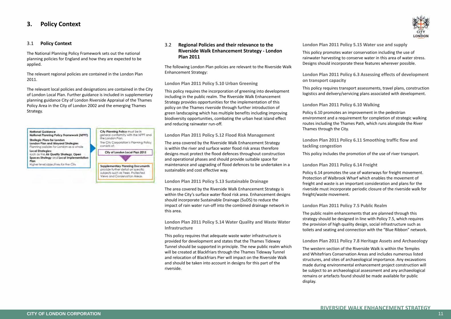
3.2 Regional Policies and their relevance to the Riverside Walk Enhancement Strategy - London Plan 2011 11
3.3 Local Policies and their relevance to the Riverside Walk Enhancement Strategy 13
3.4 Local Strategies 16
3.5 Supplementary Planning Guidance 17
4. Environmental Protection and Climate Change Adaptation 184.1 ClimateChangeMitigation 18
4.2 Impact of Climate Change 18
4.3 VulnerabilitiesontheCity’sRiverside 18
4.4 Solutions/Actions 20
4.5 Conclusion 21
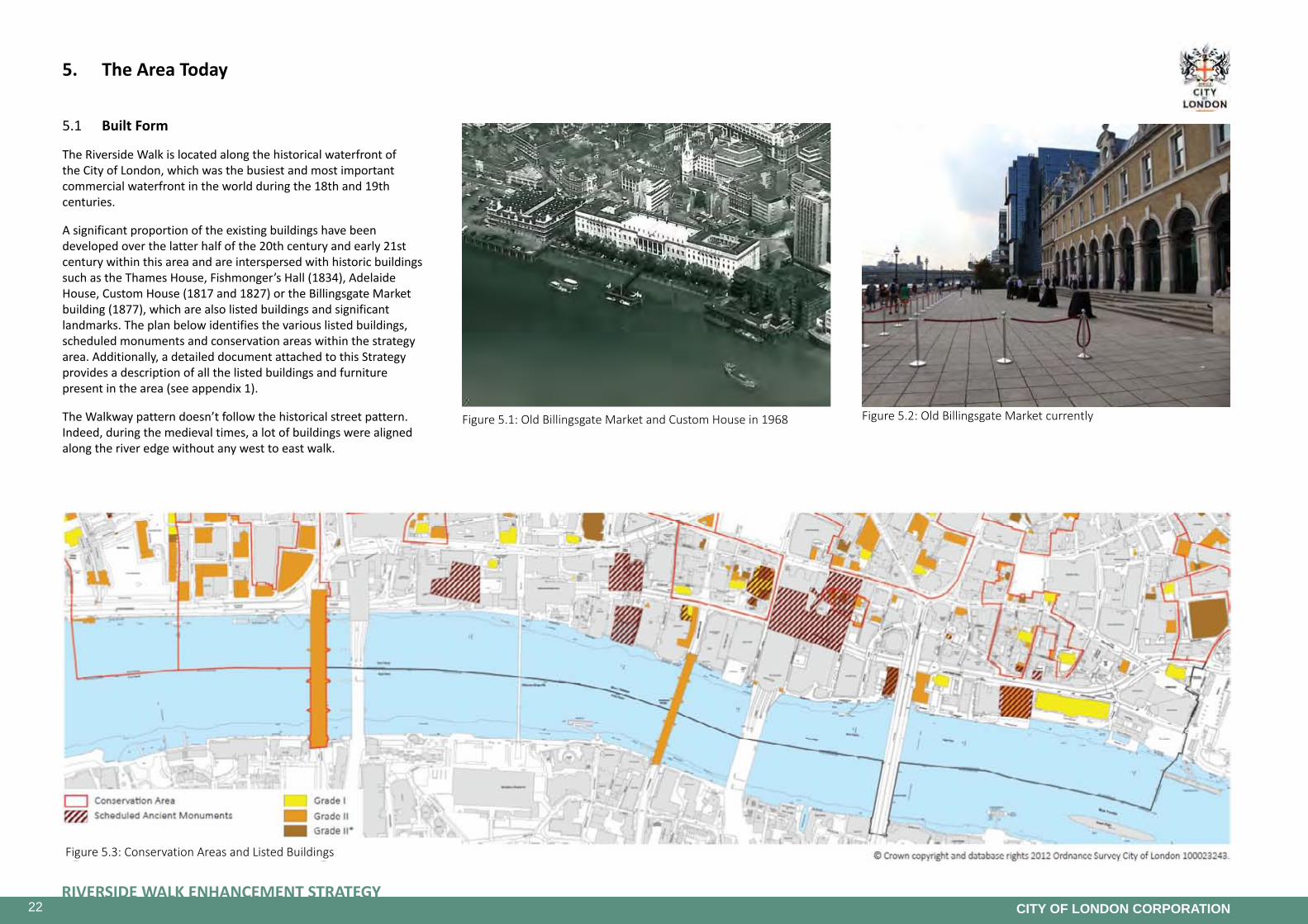
5. The Area Today 225.1 Built Form 22
5.2 Public Realm Analysis 23

3RIVERSIDE WALK ENHANCEMENT STRATEGY
CITY OF LONDON CORPORATION
5.3 Uses/Ownership 24
5.4 ConnectiontotheNorthandtheSouth 25
5.5 DevelopmentOpportunities 26
5.6 Current and Future Movement 27
5.7 Constraints of the Riverside Walk 27
5.8 Recently Completed Schemes 28
6. Riverside Walk User Survey 356.1 Assessment of users of the Riverside Walk 35
6.2 Feedback from the users of the Riverside Walk 35
6.3 Accessibilityforwheelchairusers 39
6.4 Conclusion 39
7. Public Consultation 407.1 SummaryoftheConsultation 40
7.2 Ways of engagement 40
7.3 Key Themes 40
8. Strategy 428.1 The Master Plan 42
8.2 OverallVision 44
8.3 Opportunity Areas 47
8.4 Themes 64
9. Delivery Plan 76
Appendices 78

4RIVERSIDE WALK ENHANCEMENT STRATEGY
CITY OF LONDON CORPORATION

5RIVERSIDE WALK ENHANCEMENT STRATEGY
CITY OF LONDON CORPORATION
Figure 1.1: City-wide Area Enhancement Strategies
1. Introduction and Background
1.1 IntroductionandBackground
The City of London or ‘Square Mile’ as it is known, is the historic core from which the modern city developed and is the heart of London’s international financial and business centre. It is a unique place with distinct environmental, social and economic characteristics. It is home to approximately 9,000 residents, provides employment for over 370,000 workers and attracts about 8.8 million visitors each year (Source: Visitor Strategy and Action Plan for the City of London 2013-2017).
The City needs to plan for future growth in order to ensure that it functions successfully, provides a suitable environment and maintains the City’s status as the world’s leading international financial/business centre. The challenge facing the City is to coordinate the delivery of sustainable long-term economic growth whilst at the same time providing for the population growth and protecting and improving the environment and quality of life. The City is expected to see continued growth in the medium to longer term with the working population anticipated to increase by 96,000 people to 466,000 between 2006 and 2026 with further increases beyond that date (Source: City of London Local Development Framework).
The City of London has a network of City walkways to provide pedestrian movement through a finer grain of routes than is provided even by the City’s dense network of public highways. City walkways, unlike other walkways, are specifically determined by the enabling legislation not to be public highways. They are constituted under section 6 of the City of London (Various Powers) Act 1967. Much of the City’s Riverside Walk is designated as City Walkway.
The Riverside Walk is part of the Thames Path, a National Trail footpath running for 180 miles along the banks of the River Thames. The Thames Path was submitted to the Secretary of State in 1989 for approval as a National Trail, and was officially opened in 1996. It is also part of the Transport for London’s “Walk London” Networks.
1.2 Area Enhancement Strategies
In order to deliver projects that support the objectives of the City of London Local Plan, the City has developed an area-based approach. The coverage of the City by Area Enhancement Strategies is shown on Figure 1. The strategies deal almost exclusively with the enhancement of highways and the public realm under the City’s stewardship, either as Highway Authority or Open Spaces. Area Strategies help to ensure that the City makes decisions transparently,
providing clarity for members of the public and giving more confidence to developers and property owners.
1.3 The Riverside Walk Enhancement Strategy
The area enhancement strategy for the Riverside Walk was first adopted in 2005 by City of London Corporation. The approval provides that projects in the Strategy are to be implemented in phases as funding becomes available.
Between 2005 and 2014, over 16 projects have been implemented and the Riverside Walk has been transformed into a greener, more accessible and more popular route. However there are still issues to be addressed and pressures for change in the area, as well
as opportunities for further enhancements to be realised. New developments in particular, provide opportunities for creating new public spaces, together with widened and direct sections of the Riverside Walk and should be encouraged to add entrances and active frontages on the Riverside and not turn their backs on the River.
The Riverside Walk Area Enhancement Strategy has been reviewed and updated in 2014 and the revised document addresses these remaining issues to propose an enhanced environment for the benefit of all users.

6RIVERSIDE WALK ENHANCEMENT STRATEGY
CITY OF LONDON CORPORATION
Figure 1.2: Policy Framework CS9: Thames and the Riverside
1.4 ObjectiveandVision
The objectives of the Strategy align with the Strategic Objectives of the City’s Local Plan, which are:
Local Plan Strategic Objective 1To maintain the City’s position as the world’s leading international financial and business centre.
Local Plan Strategic Objective 2To ensure that the challenges facing the five Key City Places are met, complementing the core business function of the City, contributing to its unique character and distinguishing it from other global financial districts.
Local Plan Strategic Objective 3To promote a high quality of architecture and street scene appropriate to the City’s position at the historic core of London, complementing and integrating the City’s heritage assets and supporting the continued development of the City as a cultural destination for its own communities and visitors.
Local Plan Strategic Objective 4To ensure that the City of London remains at the forefront of action in response to climate change and other sustainability challenges that face high density urban environments, aiming to achieve national and international recognition for its sustainability initiatives.
Local Plan Strategic Objective 5To ensure the provision of inclusive facilities and services that meet the high expectations of the City’s business, resident, student and visitor communities, aiming for continuous improvement in the City’s rating satisfaction and quality of life surveys.
The Riverside Walk Enhancement Strategy identifies current issues and pressures for change and sets out a framework for addressing them within the context of existing policies and guidance, based on clear evidence of need and the requirements for sustainable growth.
The objectives of the Riverside Walk Enhancement Strategy align with, and further develop, the Local Plan strategic objectives, in order to address the challenges that are specific to the Riverside Walk. The key objectives are as follows:
• The establishment of a fully accessible walkway which provides a direct route along the riverside with enhanced connections to the rest of the City,
• The creation of new and the redesign of existing green spaces for people to stop and enjoy the Thames, as well as to encourage the biodiversity, enhance the cultural heritage of the City riverside, and mitigate flood risk, and
• The improvement of the cohesion and vibrancy of the riverside by encouraging new developments to provide a spacious, accessible and better connected Riverside Walk with appropriate active frontages.

7RIVERSIDE WALK ENHANCEMENT STRATEGY
CITY OF LONDON CORPORATION
Figure 2.1: Engraving of the riverside in 1749
2. Historical Evolution
2.1 HistoricalEvolution
The history of the City waterfront defines much of the evolution of the City as a trading, commercial and financial centre of national and international importance. From Roman times the waterfront has been the focus for sea or river borne carriage and the trading of goods from Britain and abroad. Successive improvements to the wharves extended the waterfront incrementally further into the river – a process that created and extended the series of lanes and alleys running down to the river from the principal east-west routes. These provided access to and from the docks, wharves, rivers stairs and the water. They were the routes of conveyance of goods from vessels for immediate or more distant trade and disposal. Dating from Roman and Saxon periods this series of lanes is still apparent but many have been absorbed over time into larger sites.
Roman river frontage extended to the current south side of Upper and Lower Thames Street, with timber wharves backed by an extended City Wall from the third century. Major use was also made of the Fleet River in Roman commercial activity. The first bridge, in timber, over the narrowest part of the Thames established defensive, administrative and financial control and the basis of commercial wealth. Commercial river frontage formed the setting of several buildings of major importance, including the Forum and Basilica, Governor’s Palace and public and private baths. Investigation of waterfront sites in recent years has yielded much understanding of the quality and construction of Roman quays, and sites have also provided some of the most spectacular Roman finds. London’s commercial wealth has its foundation in this period, as does its importance in international trade and finance. The street network at this time directly formed or in many cases indirectly influenced the network characteristic of the city in the later history.
From the withdrawal of Rome in 410 AD, despite the foundation of St Paul’s in 604 AD, the centre of Saxon activity lay to the west towards the Strand. Queenhithe dock saw the re-establishment of the City as a Saxon focus with the arrival of Alfred in 886 AD. Royal influence then remained in the City until transferred to Westminster in 1060. The waterfront was comprehensively improved and built out as new streets and quays. Dowgate, Queenhithe and Bilingsgate emerged as the major harbours with Crown duties levied at the latter two Public beach markets were established and lasted until the early 13th century. The series of lanes running at right angles to the river, and linking the waterfront with markets on higher ground such as Cheapside and Eastcheap, are largely Saxon in origin.
The commercial water frontage was continually improved, with incremental encroachment upon the river from the 11th century.
The Tower was built to establish Norman presence, whilst the City Wall along the river was demolished by c. 1150 in the interests of the economic vitality of the waterfront. London Bridge was rebuilt in stone between 1176 and 1209 and remained the only stone bridge in London for 550 years until 1769.
The skyline of the City built upon its ecclesiastical origins and Saxon foundations, with a concentration of a total of 97 churches within the City walls. The skyline was dominated by the medieval Cathedral of St Paul’s with (at 485ft) the tallest spire ever to have been built. The skyline was transformed by Wren following the Great Fire in 1666, which led to the rebuilding of 51 of the City churches including St Paul’s Cathedral. Improvements were also made to the River Fleet and quays to the east.
Several major trading companies were formed in the City from the 16th century, leading to the creation of the Honourable East India Company in 1600. The increasing importance and dominance of international trade prompted supporting banking and insurance business.
From 1558 the administration of trade in the City was organised through 20 Legal Quays between London Bridge and the Tower, handling half of the nation’s trade. Supplemented by a few Sufferance Wharves, the Quays still controlled all trade in the late 18th century; a period which saw the volume of trade triple, to make London the world’s busiest port. Management of shipping increasingly involved the transfer of goods onto barges downstream, to ease the congestion in the Pool of London.
The river fulfilled a major ceremonial as well as transport role from the 15th century, with processions of the majestic barges of the Corporation and the City Livery Companies, together on occasion with royalty taking place. The water pageants staged by these colourful barges and attendant craft were likened at the time to Venice.

8RIVERSIDE WALK ENHANCEMENT STRATEGY
CITY OF LONDON CORPORATION
Figure 2.2: Panorama of the riverside in 1917
Figure 2.3: Panorama of the riverside in 1930
Figure 2.4: Panorama of the riverside in 1950
Figure 2.5: Panorama of the riverside in 1970
Figure 2.6: Panorama of the riverside in 1971
By the 18th century London was the world’s busiest port. From the early 19th century the construction of purpose-built docks downstream began to change the nature of the Thames waterfront and the control exercised by the City Corporation. Quays in the City handled more specialised and fresh produce, through a series of new warehouse and wharves. By the 1890s there were 50 working wharves on the City waterfront and many of the warehouse provided sales and auction services.
In the 1870s, the Victoria Embankment was created as a part of the sewer network designed by Sir Joseph Bazalgette that greatly improved sanitation and amenity in London. The ambitious public infrastructure project reclaimed an expanse of tidal mudflats to install a low level sewer, gas pipes and other utilities within a subway. Above this a public promenade was created and bordered with a river wall that is now a Grade II listed structure.
The 19th century saw the creation or rebuilding of the bridges. Southwark Bridge was built in 1819, London Bridge on its new alignment in 1869. Blackfriars Bridge was rebuilt in 1869, linked to major new Victorian streets, including Victoria Embankment providing in this case a new grand civic presence to the banks of the Thames. The sequence was completed by the Corporation with the opening of Tower Bridge, just outside the City, in 1894. The construction of the rail bridges at Blackfriars in 1864 and 1884 and at Cannon Street in 1866 added to this transformation. The railway stations were major landmarks and introduced a new “riverside” function indicative of the increasing business specialisation of the City and the decentralisation of the living quarters of its workforce.
Whilst most of the City’s waterfront remained a frenetic concentration of docks, quays, wharves, cranes and warehousing, accessed by a series of narrow lanes, the new Custom House, built in 1817 and 1827, Fishmongers’ Hall built in 1834 and the former Billingsgate Market building built in 1877, were constructed on the eastern City waterfront. Elsewhere, the associations of particular livery companies with the river, such as the Vintners, combined with a series of exchanges handling the market for certain imported goods.

9RIVERSIDE WALK ENHANCEMENT STRATEGY
CITY OF LONDON CORPORATION
Figure 2.7: Panorama of the riverside in 1976
Figure 2.8: Current and historic street pattern
2.2 20th and 21st Centuries
Although severe damage was caused in wartime bombing in the 1940s, the City’s waterfront retained its “hands on” role in shipping until the 1960s, at which point the revolution created by containerisation rapidly changed the character and function of the City waterfront. The most obvious recent change and last notable encroachment upon the river was the creation of a new river front and public walkway in association with major highway improvements between Trig Lane and Blackfriars Bridge. Most physical reference to the earlier waterfront in this location was removed in the process; original docks remaining in name only above ground. Queenhithe Dock remains one of the few physical references to the City’s commercial waterfront. Minor incursions into the water area have taken place with the building of Vintners Place alongside Southwark Bridge and the infilling of the dock at Walbrook.
The building regulations introduced to control the quality and scale of reconstruction after the Great Fire as a canvas for Wren’s redesign of the City skyline created one of the most memorable and beautiful urban compositions in the world. Despite gradual increase in building height and scale until 1930, Wren’s greatest masterpiece could still be appreciated. The relaxation of height restrictions in the building regulation at that time prompted the Surveyor to
the Fabric of St Paul’s to devise and promote the adoption of the system of height controls knows as St Paul’s Heights, which has been implemented by the City Corporation since 1938. The consistent application of this environmental standard has helped to protect views of both St Paul’s and many of the Wren church towers and spires across the City.
The St Paul’s Heights Policy Area from the City’s western boundary to just beyond Cannon Street Railway Station forms the foreground to the major series of views of St Paul’s from the area between Hungerford Bridge and London Bridge. The height restrictions have helped maintain views of a series of buildings of civic and architectural importance within the City and beyond its boundary. This gently rising and coherent plateau creates a sense of perspective and distance, and has ensured the relative importance of St Paul’s Cathedral across the City.
Across the eastern section of the City, the townscape rises more steeply towards the commercial office towers of the later post-war period, which are now seen in relation to some views of the Tower of London. Tightly glimpsed views of the Monument and St Magnus Church replace more open panoramas. Planning policy protecting Monument views identifies a series of views in the east.

10RIVERSIDE WALK ENHANCEMENT STRATEGY
CITY OF LONDON CORPORATION
Figure 2.9: Three Quays historic image (image: www.chevalresidences.com)
Figure 2.10: Sugar Quay and Three Quays proposed(image: Chevalresidences.com)
Figure 2.11: The new Blackfriars Station on top of the Victorian rail bridge fitted with over 4,400 solar panels on the roof, creating the biggest solar bridge in the world. (Image: Network Rail)
With the demise of the commercial use of the river and the post-war replacement of the warehousing with other uses, the emphasis, character and scale have changed dramatically. The introduction of telephone exchanges, school and office buildings, combined with highway improvements and the policy objective of a continuous riverside walkway have created a scale and emphasis, which is now large, linear and horizontal; a visual impression reinforced by buildings developed to a relatively consistent maximum height.
The creation of Upper and Lower Thames Street as a dual carriageway for through-traffic linking into the Victoria Embankment has created a significant barrier to public access between the river, river-frontage and the rest of the City. This segregation of a major of part of the area from the remainder of the City presents several problems in encouraging public use of the riverside, despite a number of recently added crossing points. A central objective of the City Corporation policies to which this Strategy relates is to achieve the reinstatement of the importance of the river in the identity of the City and in the everyday experience of the area.
In common with many other parts of London’s waterfront, but with much greater contrast, the relationship between the City and the Thames has been transformed. River-dependent and related uses have been almost entirely replaced by completely unrelated functions. Walbrook Wharf where the City’s municipal waste is taken to enable sustainable onward transport by river rather than road, and Blackfriars Pier remain the only river-dependent uses in the City.
Walbrook Wharf was opened as a waste transfer station for refuse from central London in 1963 and underwent major redevelopment in 1995. It currently handles about 30,000 tonnes of waste per year (4,000 domestic/street cleansing waste including 1500 recycling and about 24,000 tonnes commercial waste), which is loaded straight into 12 tonnes capacity shipping containers and delivered to the Energy from Waste plant at Belvedere in Bexley.
The Energy from Waste plant receives waste from 4 other London boroughs and will process enough non-recyclable residual waste each year to generate electricity to power around 100,000 homes.
The City Corporation’s non-recyclable waste is processed through the facility resulting in the City of London being one of the first Local Authorities in the country to achieve zero waste to landfill status.
The majority of waste is delivered by river to the Energy from Waste plant, removing substantial lorry movements from the capital’s congested roads each year.
Proximity to or situation on the riverside have, however, been factors influencing the recent creation of residential and hotel accommodation within the area. The encouragement of activities and uses on the river front, relating to its potential as an economic, transport and leisure resource will help to enhance the waterfront area of the City.
Two recent developments fronting the Hanseatic Walk and the Oystergate Walk are in commercial use however in the case of other upcoming and proposed developments on the riverfront, some office buildings are being redeveloped to provide residential, retail and hotel uses.
At Three Quays a former 1960s office building has been demolished to make way for new development that will include a hotel and serviced luxury apartments with views across the Thames and a number of retail outlets. The development was completed in 2014.
The seventies Tate & Lyle office building at Sugar Quay has recently been given planning permission to be redeveloped for residential use with 165 flats over 11 storeys.
Other projects that are changing the Riverside include the new Blackfriars Station that has transformed the Victorian railway bridge into the world’s biggest solar bridge, incorporating station platforms and providing the opportunity to revitalise the walkway at the base of the Blackfriars bridges and the future Thames Tideway Tunnel Blackfriars Bridge Foreshore that will provide a new open space on the west side of the bridge.
Through such developments the character of the Riverside Walk will continue to change, helping to create a more active front to northbank.
11RIVERSIDE WALK ENHANCEMENT STRATEGY
CITY OF LONDON CORPORATION
3. Policy Context
3.1 Policy Context
The National Planning Policy Framework sets out the national planning policies for England and how they are expected to be applied.
The relevant regional policies are contained in the London Plan 2011.
The relevant local policies and designations are contained in the City of London Local Plan. Further guidance is included in supplementary planning guidance City of London Riverside Appraisal of the Thames Policy Area in the City of London 2002 and the emerging Thames Strategy.
3.2 Regional Policies and their relevance to the Riverside Walk Enhancement Strategy - London Plan 2011
The following London Plan policies are relevant to the Riverside Walk Enhancement Strategy:
London Plan 2011 Policy 5.10 Urban GreeningThis policy requires the incorporation of greening into development including in the public realm. The Riverside Walk Enhancement Strategy provides opportunities for the implementation of this policy on the Thames riverside through further introduction of green landscaping which has multiple benefits including improving biodiversity opportunities, combating the urban heat island effect and reducing rainwater run-off.
London Plan 2011 Policy 5.12 Flood Risk ManagementThe area covered by the Riverside Walk Enhancement Strategy is within the river and surface water flood risk areas therefore designs must protect the flood defences throughout construction and operational phases and should provide suitable space for maintenance and upgrading of flood defences to be undertaken in a sustainable and cost effective way.
London Plan 2011 Policy 5.13 Sustainable DrainageThe area covered by the Riverside Walk Enhancement Strategy is within the City’s surface water flood risk area. Enhancement designs should incorporate Sustainable Drainage (SuDS) to reduce the impact of rain water run-off into the combined drainage network in this area.
London Plan 2011 Policy 5.14 Water Quality and Waste Water InfrastructureThis policy requires that adequate waste water infrastructure is provided for development and states that the Thames Tideway Tunnel should be supported in principle. The new public realm which will be created at Blackfriars through the Thames Tideway Tunnel and relocation of Blackfriars Pier will impact on the Riverside Walk and should be taken into account in designs for this part of the riverside.
London Plan 2011 Policy 5.15 Water use and supplyThis policy promotes water conservation including the use of rainwater harvesting to conserve water in this area of water stress. Designs should incorporate these features wherever possible.
London Plan 2011 Policy 6.3 Assessing effects of development on transport capacityThis policy requires transport assessments, travel plans, construction logistics and delivery/servicing plans associated with development.
London Plan 2011 Policy 6.10 WalkingPolicy 6.10 promotes an improvement in the pedestrian environment and a requirement for completion of strategic walking routes including the Thames Path, which runs alongside the River Thames through the City.
LondonPlan2011Policy6.11Smoothingtrafficflowandtackling congestionThis policy includes the promotion of the use of river transport.
London Plan 2011 Policy 6.14 FreightPolicy 6.14 promotes the use of waterways for freight movement. Protection of Walbrook Wharf which enables the movement of freight and waste is an important consideration and plans for the riverside must incorporate periodic closure of the riverside walk for freight/waste movement.
London Plan 2011 Policy 7.5 Public RealmThe public realm enhancements that are planned through this strategy should be designed in line with Policy 7.5, which requires the provision of high quality design, social infrastructure such as toilets and seating and connection with the “Blue Ribbon” network.
London Plan 2011 Policy 7.8 Heritage Assets and ArchaeologyThe western section of the Riverside Walk is within the Temples and Whitefriars Conservation Areas and includes numerous listed structures, and sites of archaeological importance. Any excavations made during environmental enhancement project construction will be subject to an archaeological assessment and any archaeological remains or artefacts found should be made available for public display.

12RIVERSIDE WALK ENHANCEMENT STRATEGY
CITY OF LONDON CORPORATION
LondonPlan2011Policy7.11LondonViewManagementFramework(LVMF)Parts of the Thames Riverside fall within the LVMF protected vista viewing corridors and wider setting consultation area. The riverside within the City is also within several river prospect views which are protected for the juxtaposition of elements including river frontages and key landmarks.
London Plan 2011 Policy 7.14 Improving Air QualityThe Riverside Walk is within an air quality management area for nitrogen dioxide and particulates. Policy 7.14 requires that developers minimise exposure to poor air quality, and reduce emissions associated with construction. This applies to public realm construction works where any opportunities to use the river for transport of construction materials and waste should be realised.
London Plan 2011 Policy 7.15 Reducing noise and enhancing soundscapesThis policy requires the minimisation of noise impacts from development and the separation of new noise sensitive uses from sources of noise. This is particularly important adjacent to the city of London School for Boys which is a noise sensitive area and adjacent to Walbrook Wharf which is an existing source of noise.
London Plan 2011 Policy 7.18 Protecting local open space and addressing local deficiencyThis policy supports the creation of new open space in areas of deficiency. The City has a target to maintain the current standard of 0.06 hectares of open space per 1000 weekday daytime population. The creation of new public open space along the riverside will contribute to this target.
London Plan 2011 Policy 7.19 Biodiversity and access to natureThe River Thames is a Site of Metropolitan Importance for Nature Conservation and is strongly protected by this policy which also aims to enhance opportunities for biodiversity. Green landscaping, installation of bird and bat boxes and the use of natural materials in public realm enhancement schemes will contribute to this objective.
LondonPlan2011Policy7.24TheBlueRibbonNetworkThis policy prioritises water space and the land alongside it for river related uses. The policy also refers to the Thames River Basin Management Plan which aims to improve the ecological status of the Thames. The Thames Tideway Tunnel will improve the ecological status of the river, creating additional open space at Blackfriars to accommodate the necessary infrastructure. Integration of this new public realm and the relocated Blackfriars Pier into the Riverside Walk will be a key challenge during the life time of this strategy.
London Plan 2011 Policy 7.25 Increasing the use of the Blue RibbonNetworkforpassengersandtourismThis policy requires the protection or re-provision of facilities for passenger transport. The Blackfriars Millennium Pier is due to be relocated as part of the Thames Tideway Tunnel project.
London Plan 2011 Policy 7.26 Increasing use of the Blue RibbonNetworkforfreighttransportThis policy requires the protection of river wharves including Walbrook Wharf in the City for waterborne freight handling. Development proposals close to navigable waterways should maximise their use for transport of bulk materials particularly during construction and demolition phases. The use of the river for transport of construction materials and waste associated with public realm improvements should be encouraged.
LondonPlan2011Policy7.27BlueRibbonNetwork:Supporting infrastructure and recreational useThis policy requires the protection and improvement of recreational infrastructure including, access points (steps), riverside paths, moorings and jetties.
London Plan 2011 Policy 7.28 Restoration of the Blue Ribbon NetworkThis policy requires that development and structures in the water space must have a river related use.
London Plan 2011 Policy 7.29 The River ThamesThis policy requires that development in the Thames Policy Area conforms to the relevant Riverside Strategy.
Other relevant regional strategies include:
• The Thames Estuary 2100 Plan – The Environment Agency’s plan for flood protection up to 2100,
• Port of London Authority Strategy – The Port of London Authority’s plan for a vibrant safe and sustainable River Thames,
• River Action Plan – Transport for London’s plan to improve river transport services, and
• Safeguarded Wharves review – Mayor of London’s review of the safeguarded Thames wharves including Walbrook Wharf.

13RIVERSIDE WALK ENHANCEMENT STRATEGY
CITY OF LONDON CORPORATION
Figure 3.1: Local Plan 2015 Policy CS 9 - Thames and the Riverside
3.3 Local Policies and their relevance to the Riverside Walk Enhancement Strategy
The following local policies are relevant to the Riverside Walk Enhancement Strategy:
CityofLondonLocalPlan(January2015)
LocalPlan2015PolicyCS9:ThamesandtheRiversideThis policy sets out the City’s intentions for the Thames Riverside within the City. It includes:
• ensuring that development on the riverside contributes to the aims of the Riverside Walk Enhancement Strategy,
• supporting the construction of the Thames Tideway Tunnel, and
• promoting functional uses of the river for transport, navigation and recreation.
To ensure that the City capitalises on its unique riverside location, sustaining the river’s functional uses in transport, navigation and recreation, whilst minimising risks to the City’s communities from flooding, by:
• Designating the Thames Policy Area and preparing and keeping under review an area appraisal which identifies the attributes of the area and gives guidance on development within this area,
• Ensuring that buildings and spaces on or near the riverside contribute to the aims of the Riverside Walk Enhancement Strategy, particularly through: (i) protecting public access and river views along the riverside walk and securing completion of the Riverside Walk at Queenhithe; (ii) improving access to the river and riverside walk from the rest of the City and the Thames bridges; (iii) improving the vibrancy of the riverside by encouraging a mix of appropriate commercial uses and promoting office led commercial development whilst preserving privacy, security and amenity for residents, businesses and other stakeholders; (iv) improving opportunities for biodiversity, in line with the City of London Habitat Action Plan for the Thames foreshore,
• Supporting and safeguarding sites for the construction of the Thames Tideway Tunnel, including connection of the Fleet combined sewer outflow, resulting in reduced storm water discharges into the River Thames and improved water quality, and
• Promoting the functional uses of the River Thames and its environs for transport, navigation and recreation particularly through: (i) retaining Walbrook Wharf for waterborne freight traffic; (ii) encouraging the use of the River Thames for the transport of construction and deconstruction materials and waste; (iii) retaining Blackfriars Pier and access to Tower Pier, and encouraging reinstatement of Swan Lane Pier and the use of these facilities for river transport. Applications to remove these facilities will be refused unless suitable replacement facilities of an equivalent or higher standard are provided; (iv) maintaining London Bridge, Tower Bridge, Blackfriars Bridge, Southwark Bridge and the Millennium Bridge; (v) refusing development
on or over the river except for structures which specifically require a waterside location for river-related uses; (vi)resisting the permanent mooring of vessels; if moored vessels are exceptionally permitted they must be of national importance, have a special connection with the City and the River Thames, be used for a river related purpose and not have a detrimental impact on navigation, river regime or environment; (vii) maintaining access points to the River Thames foreshore, from both land and water, for public or private use as appropriate, subject to health and safety and environmental safeguards.

14RIVERSIDE WALK ENHANCEMENT STRATEGY
CITY OF LONDON CORPORATION
Figure 3.2: Local Plan 2015 Policy CS 12 - Conservation areas
Figure 3.3: Local Plan 2015 Policy CS 13 - Protected Views
Local Plan 2015 Policy CS2 Utilities InfrastructureRequires the co-ordinated provision of necessary utility infrastructure for the City’s projected growth and requires that infrastructure providers minimise disruption during major infrastructure upgrades. Disruption to traffic and pedestrian movement in the Riverside Walk area must be minimised during the construction phase for environmental enhancement projects.
Local Plan 2015 Policy CS10 DesignPolicy CS10 sets out the design requirements for City development requiring high quality public realm in keeping with the surroundings providing an inclusive and attractive environment. As a key new area of public realm in a prominent location over the River Thames it is important that public realm enhancement conforms to the City’s rigorous design standards.
Local Plan 2015 Policy CS12 Historic EnvironmentThis policy sets out the requirements for protection and enhancement of the historic environment including conservation areas, listed buildings and structures and archaeological assets. The Temples and Whitefriars Conservation Areas, Baynard House and Queenhithe Dock Scheduled Ancient Monuments and numerous listed buildings & structures fall within the Thames Policy area.
LocalPlan2015PolicyCS13ProtectedViewsPolicy CS 13 protects strategic and local views of St Paul’s Cathedral, the Tower of London and the Monument. Also protects the setting of the Tower of London World Heritage Site.
Local Plan 2015 Policy CS15 Sustainable Development and Climate ChangeThis policy sets out the requirements for sustainable development and environmental protection including air quality, noise & light pollution and biodiversity enhancement. The construction phase of environmental enhancement projects has the potential to cause deterioration in local air quality and noise. Final designs should provide opportunities to enhance biodiversity and minimise light pollution minimising sky glow and illumination of the river environment.
15RIVERSIDE WALK ENHANCEMENT STRATEGY
CITY OF LONDON CORPORATION
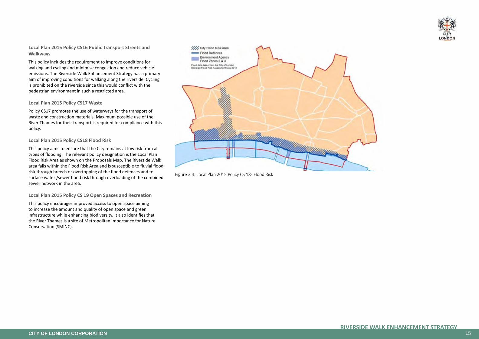
Figure 3.4: Local Plan 2015 Policy CS 18 - Flood Risk
Local Plan 2015 Policy CS16 Public Transport Streets and WalkwaysThis policy includes the requirement to improve conditions for walking and cycling and minimise congestion and reduce vehicle emissions. The Riverside Walk Enhancement Strategy has a primary aim of improving conditions for walking along the riverside. Cycling is prohibited on the riverside since this would conflict with the pedestrian environment in such a restricted area.
Local Plan 2015 Policy CS17 WastePolicy CS17 promotes the use of waterways for the transport of waste and construction materials. Maximum possible use of the River Thames for their transport is required for compliance with this policy.
Local Plan 2015 Policy CS18 Flood RiskThis policy aims to ensure that the City remains at low risk from all types of flooding. The relevant policy designation is the Local Plan Flood Risk Area as shown on the Proposals Map. The Riverside Walk area falls within the Flood Risk Area and is susceptible to fluvial flood risk through breech or overtopping of the flood defences and to surface water /sewer flood risk through overloading of the combined sewer network in the area.
Local Plan 2015 Policy CS 19 Open Spaces and RecreationThis policy encourages improved access to open space aiming to increase the amount and quality of open space and green infrastructure while enhancing biodiversity. It also identifies that the River Thames is a site of Metropolitan Importance for Nature Conservation (SMINC).

16RIVERSIDE WALK ENHANCEMENT STRATEGY
CITY OF LONDON CORPORATION
Figure 3.5: LOCAL PLAN - POLICIES MAP A December 2013
3.4 Local Strategies
CityofLondonJointHealthandWellbeingStrategy
Since April 2013, the Health and Wellbeing Board of the City of London Corporation has statutory responsibility for undertaking the annual Joint Strategic Needs Assessment (JSNA) exploring local health needs and the Joint Health and Wellbeing Strategy.
This strategy is intended to cover the three year period from 2012/13 to 2015/16. It will be refreshed annually to reflect changes that have taken place.
The City of London contains several populations in one space, with different needs and health issues. According to the Census (2011), about 9,000 people reside in the City and about 430,000 people have jobs here. There are also students, visitors and rough sleepers.
The health of residents and workers is influenced by social, cultural, economic, psychological and environmental factors, and these factors can have a cumulative effect throughout a person’s life (Marmot M (2010) Fair Society, Healthy Lives. University College London).
In surveys, the City scores highly as a place to live and work, and it has excellent transport links and cultural services. However it is an urban area, and suffers from poor air quality and noise issues. Particulate matter and nitrogen dioxide levels are both very high, whilst there were 706 noise complaints last year. There are numerous open spaces in the City but they tend to be very small.
This strategy aims to encourage services, organisations and individuals to work together to prevent problems, intervene early when problems do develop, and take steps to reduce the harms arising from behaviours or actions that cannot be prevented.
Professor Sir Michael Marmot has identified the creation and development of healthy and sustainable places and communities as a key priority area that has a huge impact on people’s lives and their health.
City of London Climate Change Mitigation Strategy, 2008This document is further explained in Section 4.
City of London Climate Change Adaptation Strategy, 2007 revised and updated 2010This document is further explained in Section 4.
CityofLondonNoiseStrategy2012-2016The City of London experiences relatively high levels of noise mainly from building works, street works, road traffic, leisure activities, and other commercial activities such as deliveries, plant and equipment. The City Corporation has a statutory responsibility to manage and minimise exposure to excessive and sometimes unnecessary noise, whilst ensuring that the City can continue to function as a modern world-class business centre.
The City of London Noise Strategy brings together and updates policies and programmes that are already in place to manage and mitigate noise. It also proposes additional measures which together with existing ones should improve the management of noise in the City. The City will identify opportunities for improving and enhancing the tranquility and soundscape of its open spaces during the planning of enhancements or new spaces including those on the riverside.
City of London Air Quality Strategy 2011- 2015The City’s Air Quality Strategy sets the strategic direction for air quality policy at the City of London from 2011 until 2015. It outlines steps that the City will take, and is already taking, to improve air quality in the City.
CityofLondonBiodiversityActionPlan(BAP)2010-2015This document is further explained in Section 4.
City of London Open Space Strategy 2015The Open Space Strategy sets out a vision for open space in the City based on the creation of a network of high quality and inspiring
open spaces which helps ensure an attractive, healthy, sustainable and socially cohesive place for all the City’s communities and visitors.
City of London Cultural Strategy 2012-2017The aims of this strategy are defined through three key strands of development:
• Sustaining Excellence in the Arts – developing our reputation for theatre, music, dance, festivals, literature and the visual arts,
• Animating the Heritage – increasingly helping people to discover our outstanding heritage assets, to bring history alive, and
• Breaking down Barriers – focusing on the importance of opening up in all directions, welcoming visitors to the Square Mile and taking the City’s cultural offer to all of London, engaging more effectively with our borough partners in particular.
The strategy focuses on two closely connected areas of the City to be developed and enhanced:
• The Guildhall Yard area will be developed as an increasingly attractive heritage offer, with its revived Guildhall Art Gallery, Roman amphitheatre, ancient buildings, and historic Guildhall Yard, which will be animated from time to time by new events and activity, pointing visitors towards the rich history of the Square Mile, and
• The area around the Barbican Centre, Guildhall School of Music & Drama and the Museum of London will continue to be developed as a Cultural Quarter to draw visitors to an ever wider range of cultural experiences and events.

17RIVERSIDE WALK ENHANCEMENT STRATEGY
CITY OF LONDON CORPORATION
Figure 3.6 Thames Policy Area
Figure 3.7: Distribution of existing trees
VisittheCity:VisitorStrategyandActionPlanfortheCityofLondon, 2013-17The strategy seeks to provide a framework for the delivery of the City Corporation’s visitor services. Through a clear statement of vision for the assets controlled by the City Corporation and areas over which the Corporation may have some influence within the City boundary, a series of strategic aims and priorities has been developed, these fall under five themes:
SA1. Product Development - To develop and maintain a compelling offer for all our visitors, celebrating the City’s unique heritage and cultural output, especially through the delivery of the City’s Visitor Trail, its Cultural Hub and its art-on-street initiatives,
SA2. Marketing - To vigorously promote the City as a world-class, must-see destination to all potential audience groups, focusing on those of the highest economic or strategic value to the City and the City Corporation,
SA3. Experience - To deliver enhancements to the City’s physical environment that are of mutual benefit to all of our communities so ensuring harmony, and to develop the City’s welcome for visitor audience groups, be they tourists, business travelers, or workers and residents in pursuit of leisure,
SA4. Support - To provide valued services to our City stakeholders, neighbours, London and the nation in the field of tourism and to maximise on the opportunities to play our part in local, London wide, national and international celebrations and events, and
SA5. Recognition - To derive recognition for the City Corporation in the execution of its visitor services activities and to tell the story of the City Corporation through its assets, both within and outside of the City, promoting the connectivity between these as appropriate.
The action plan, which will be updated annually, describes the headline activities that will be undertaken to achieve the aims of the strategy.
City of London Local Flood Risk Management StrategyThis document is further explained in Section 4.
City of London Contaminated Land StrategyIn order to fulfill the City of London’s obligations under the legislation, the City of London published a Contaminated Land Strategy in 2001, which was reviewed in 2004 and is currently undergoing further review.
As part of the City’s obligation to investigate whether there are areas within the City which require further analysis under part IIA of the Environmental Protection Act 1990, historic land uses, which may have given rise to contamination were identified using historic maps and mapped using GIS. Much of the historic land use along the River Thames could have given rise to contamination. This information should be borne in mind during the re-development of this area to ensure the land is suitable for use and any exposure to potential contamination is mitigated.
3.5 Supplementary Planning Guidance
City of London Riverside Appraisal of the Thames Policy Area in the City of London 2002This supplementary Planning Guidance identifies the characteristics of the Thames, and its setting, in the City which development within the Thames Policy Area should recognise, respect and enhance. It provides guidance as to what should be included in Design Statements. The aims of the guidance are to enhance the environmental quality, character and views of and across the River Thames, encourage more public activity and improve access between the City’s riverside and its hinterland, encouraging greater access to the river and increase transport use of the river.
This SPD includes an area character analysis of each section of the riverside. The important features of each area are identified and should be respected and enhanced through environmental enhancement projects.
This strategy is currently under review and will be published as the City of London Thames Strategy.
City of London Tree StrategyThis SPD provides guidance on the care and protection of existing trees and the choice and planting of new trees. Significant rows of mature trees on the riverside are present at Temples and on the south side of Custom House.
CityofLondonProtectedViewsSupplementaryPlanningDocument 2012Views of St. Paul’s Cathedral, the Monument, the Tower of London World Heritage Site and other historic landmarks and skyline features are protected and managed by planning policies in the City’s Local Plan 2015 and the Mayor’s London Plan 2011. The purpose of this Supplementary Planning Document is to provide further guidance to the public and developers on the operation of these view protection policies in the City of London.

18RIVERSIDE WALK ENHANCEMENT STRATEGY
CITY OF LONDON CORPORATION
4. Environmental Protection and Climate Change Adaptation
4.1 ClimateChangeMitigation
There is now wide consensus that climate change is happening and is caused by increased carbon emissions associated with the use of fossil fuels. Efforts to reduce carbon emissions associated with the built environment will go some way to mitigate extreme climate impacts therefore every effort must be made to reduce carbon emissions associated with the enhancement of the public realm. This could include the reuse of existing materials to reduce transport impacts and resource depletion associated with the use of virgin materials. Low energy lighting should be specified for illumination of the public realm and lighting should be limited so as not to increase sky glow or illumination of the water environment which could have detrimental impacts on river species. Good facilities for public transport, including river transport, along with a pleasant walking and cycling environment will enable minimisation of greenhouse gas emissions associated with transport. The use of the river for transport of freight, construction materials and waste will reduce carbon emissions compared with road transport. Greening of the public realm helps to mediate the urban heat island effect and reduce reliance on energy intensive air conditioning and fans. Greening can also provide shelter from cold wind reducing the need for outdoor space heating.
4.2 Impact of Climate Change
However in spite of all these efforts to reduce carbon emissions some level of climate change is now inevitable. The main impacts across the UK will be warmer and drier summers, milder and wetter winters and an increased frequency and intensity of extreme weather events. The impact of this greater uncertainty and more extreme weather events could include more intense rainfall and associated flooding, periods of drought and heat-waves which are more likely in the future. The UK Climate Projections 09 provide an indication of the probable climate change impacts in 2020, 2050 and 2080 based on current information and trends. Figure 18 shows the range of possible impacts for London by 2050, for four different parameters.
The uncertainty associated with these predictions dictates that the response to the predictions should be flexible.
The impact of these predictions could affect the riverside in a number of different ways:
• Increased winter mean temperature could result in the survival of different insect species which could form pests during subsequent seasons,
• Higher summer temperatures could result in overheating of the buildings and public realm on the City’s riverside particularly due to its south facing aspect,
• Higher summer temperatures could increase the attractiveness of the riverside, increasing pressure on the public spaces for recreation,
• Higher winter rainfall and more intense weather events could increase the chance of flooding from surface water and sewers,
• Lower summer rainfall could make some types of plants unviable with subsequent impacts on biodiversity and wildlife value and visual impact,
• Lower summer rainfall could result in drought conditions becoming more frequent with therefore water conservation will be required to keeping essential water supplies operational, and
• Sea level rise could increase the risk of flooding from the tidal River Thames.
4.3 VulnerabilitiesontheCity’sRiverside
FloodVulnerabilityDevelopment on the riverside has evolved over centuries with a significant encroachment into the natural river channel over that period. As a result the Riverside Walk and riverside properties need protection from potential river flooding through the flood defence walls which form a continuous barrier along the riverside.
The Environment Agency classifies land uses according to their vulnerability to flooding.
“Highly Vulnerable” uses include police stations, fire stations and command centres and telecommunications installations required to be operational during flooding. Dowgate Fire Station falls within the flood risk zone and there is some City of London Police vehicle maintenance at Walbrook Wharf. Telecommunications infrastructure is also located in a pipe-subway under the Riverside Walk.
“More Vulnerable” uses include residential dwellings, educational establishments, hotels, night clubs and drinking establishments.
The City of London Strategic Flood Risk Assessment provides details of which areas of the City are vulnerable to flooding from tidal and coastal, surface water and sewer, and ground water flooding. The City’s Local Flood Risk Management Strategy includes an action plan detailing the actions that should be taken to reduce flood risk, protect properties and develop resilience to flooding.
UK Climate Projections 09 - Key Findings for LondonThe government published climate projections in 2009 (UKCP09) looking forward to the 2020s, 2050s and 2080’s under a series of different emissions scenarios. The medium emission scenario assumes that we will be successful in reducing carbon emissions to some degree. The key findings for 2050 resulting from this medium emissions scenario are as follows:
Under medium emissions, the central estimate of increase in winter mean temperature is 2.2ºC; it is very unlikely to be less than 1.2ºC and is very unlikely to be more than 3.5ºC. A wider range of uncertainty is from 0.9ºC to 3.8ºC,
Under medium emissions, the central estimate of increase in summer mean temperature is 2.7ºC; it is very unlikely to be less than 1.3ºC and is very unlikely to be more than 4.6ºC. A wider range of uncertainty is from 1.1ºC to 5.2ºC,
Under medium emissions, the central estimate of change in winter mean precipitation is 14%; it is very unlikely to be less than 2% and is very unlikely to be more than 32%. A wider range of uncertainty is from 0% to 35%, and
Under medium emissions, the central estimate of change in summer mean precipitation is –19%; it is very unlikely to be less than –41% and is very unlikely to be more than 7%. A wider range of uncertainty is from –43% to 16%.

19RIVERSIDE WALK ENHANCEMENT STRATEGY
CITY OF LONDON CORPORATION
Figure 4.1: Flood Risk
For the Thames Riverside this includes the residential cluster of 700 flats at Queenhithe, the City of London School for Boys and several pubs, clubs and hotels and the proposed hotel and residential schemes at Three Quays and Sugar Quay.
“Less Vulnerable” uses include shops and offices and waste facilities. For the Thames Riverside this includes Walbrook Wharf and the majority of the other development along the riverside which is predominantly offices.
Environmental enhancement schemes along the riverside have a role to play in maintaining the integrity of flood defence walls, and in protecting access and egress routes, which will be used in the event of flooding, particularly from “highly vulnerable” and “more vulnerable” premises. Environmental enhancement schemes can also reduce vulnerability from flooding through designs which reduce rainwater run-off. For riverside environmental enhancement schemes, a flood risk assessment should be carried out taking account of climate change impacts and incorporating flood resistance and resilience measures where possible.
BiodiversityVulnerabilityThe River Thames is a Site of Metropolitan Importance for Nature Conservation (SMINC) and is identified in the Biodiversity Action Plan as one of the City’s important habitats. The Key Habitats that make up the City foreshore are:
• Artificial Structures in the channel, e.g. old pier structure in front of Customs House. These structures can provide roosting and nesting sites for birds. Bird species which have been recorded in the City stretch of the Thames are; Cormorant, Mallard, Herring and Lesser Black-backed gulls.
• Flood Walls: Vertical walls of concrete, in some areas, clad with timber, which can support a variety of plants and invertebrates
• Stretches of Littoral Foreshore, exposed at low tides. This environment helps to support over 350 invertebrate species. Fish species such as flounder, bass and smelt fry depend on the shingle foreshore as their feeding ground and as a refuge from the ebbing tide.
In the face of climate change and sea level rise, changes to the flood defence walls will be necessary by the 2060s. Designs for environmental enhancement will need to incorporate the recommendations of the River Thames Habitat Action Plan.
To act as a biodiversity corridor it is important that the riverside landscaped spaces are linked together and include a variety of nectar rich species to attract insects and birds. However the potential range of temperatures and rainfall levels may be greater in the future than it has been in the past therefore the choice of tolerant plants will be important to maintain the continuity of this green corridor.
Planting chosen in conjunction with the City Corporation’s Open Spaces Department will need to be resilient to as wide a range of conditions as is possible. For instance, when planning planting schemes landscape architects will need to choose plants that have a wide tolerance to a range of varying weather extremes since drought and flood conditions are both possible under the CP09 climate projections.
City of London Biodiversity Action Plan
Acoupleofgenerationsago,peopletalkedofʹcloudsofbatsʹrisingacrosstheThames-butnottoday.Batnumbersareindecline.Thisislinkedtoalossofroostsites,chemicaltreatmentofrooftimberswhicharetoxictobats,pesticideusedepletingtheirfoodsource,andadramaticlossoffeedingsites.ForthesereasonsallbatsareprotectedbylawundertheWildlife&CountrysideAct1981(asamended).Itisillegal to harm bats or disturb their roost sites.

20RIVERSIDE WALK ENHANCEMENT STRATEGY
CITY OF LONDON CORPORATION
Figure 4.2: SuDS Management Train
Overheating/DroughtVulnerabilityThe south east of England has been identified by the Environment Agency as an area of serious water stress. This means that during periods of low rainfall the area is more vulnerable to drought conditions resulting in restrictions on the use of water for irrigation, water features and vehicle washing. The open aspect of the Riverside Walk and the south facing orientation make this area particularly vulnerable to drought and overheating.
The CP09 climate projections predict a reduction in summer rainfall and an increase in summer temperatures with climate change. This brings advantages as well as disadvantages, for instance the greater opportunities to enjoy the outdoors may result in more pressure on the riverside for recreation with the potential for overcrowding and night time disturbance.
Note: In winter, the riverside walkway experiences freezing winds, which is desiccating and brutal to the planting, killing a great deal of planting when persistent, and so this area is not just about summer overheating. Furthermore, planting should not be placed adjacent to or near air conditioning units, as we have experienced that planting near vents suffer from desiccation.
Air Quality vulnerabilityThe whole of the City is an Air Quality Management Area for particulates and nitrogen dioxide. Any actions which will improve air quality, particularly in Thames Street, should be implemented. Greater use of river rather than road transport can contribute to improved air quality.
In addition to reducing air pollution it is important to minimise public exposure to poor air quality. Improving the riverside walkway will help to divert people away from Upper / Lower Thames Street which has highest levels of air pollution in the City.
4.4 Solutions/Actions
Fluvial Flood Risk The Thames Estuary 2100 Plan 2012 identifies protection of flood defence walls along the River Thames as a key action to prevent flooding. The proposed action in the City for the next 25 years includes an action “To maintain, enhance or replace the river defence walls and active structures through central London over the first 25 years of the Plan from 2010 to 2034”. This maintenance and replacement programmes continues to 2040. Beyond that date the TE2100 recommendation is “To implement a programme of defence raising through central London in 2065.” This will be required to protect the City from rising sea levels which will affect the tidal Thames.
Action: In designing Environmental Enhancement Schemes, the need for access to maintain the flood defences and the impact of flood defence raising in future should be factored into scheme design.
SurfaceWater/SewerFloodRiskThe area of the Thames Riverside covered by this enhancement strategy is at risk of surface water / sewer flooding, as a result of excess surface water overloading the drainage system in this area. In common with the rest of London the City has a “combined drainage system” where rainwater and surface water run off enters the same drainage network as foul sewage. During periods of heavy rainfall this can result in overloading of the sewer network and subsequent flooding with dilute sewage emerging from drainage manholes. The frequency of surface water / sewer flooding is likely to increase with climate change as extreme weather events increase. Any actions
which reduce amount of surface water entering the drainage system or slow down the rate of entry of rainwater into the drains will help to reduce this risk.
Sustainable Drainage systems (SuDS) introduce a variety of different elements such as rain gardens, green landscaping and attenuation tanks which result in lower levels and speeds of water entering the drainage network.
The Riverside Walk is mainly covered with impermeable surfaces such as Yorkstone or concrete. Projects developed in the Riverside Walk Strategy are introducing greenery such as St Magnus house, Dark House walk, White Lion Hill, St Paul’s Walk; and a main objective is to create coherently designed garden spaces along the walk; the introduction of SUDS incorporating this greening, provides an opportunity to absorb rainwater easily and tackle the flash flooding after sudden rain. Rainwater will therefore, by a natural system be cleaned and collected or released slowly back into the environment such as into the Thames.
SuDS Sustainable Drainage System will therefore be introduced along the Riverside Walk after the adoption of the Riverside Walk Strategy Review.
Action: Riverside Walk Enhancement schemes should incorporate SuDS into designs so as to prevent or slow down the rate of rainwater entering the drainage system.
Flood Resistance and Resilience MeasuresEvery effort will be made to prevent flooding however there remains a risk that this area will flood. Flood resistance measures can be employed to prevent flood waters reaching vulnerable areas. Flood resilience measures ensure that flood water causes minimal damage so that buildings and services can return to normal quickly.
Riverside Walk enhancement schemes should be designed so that, in the event of a flood, the flood water is contained within the public realm and does not enter buildings, utility infrastructure ducts or pipesubways. As far as possible utility infrastructure, street furniture and equipment such as disabled access lifts should be designed to be resilient to flooding so that they can function quickly, once flood waters subside.
Action: Design Riverside Environmental Enhancement Schemes so that they are flood resistant and resilient.
21RIVERSIDE WALK ENHANCEMENT STRATEGY
CITY OF LONDON CORPORATION
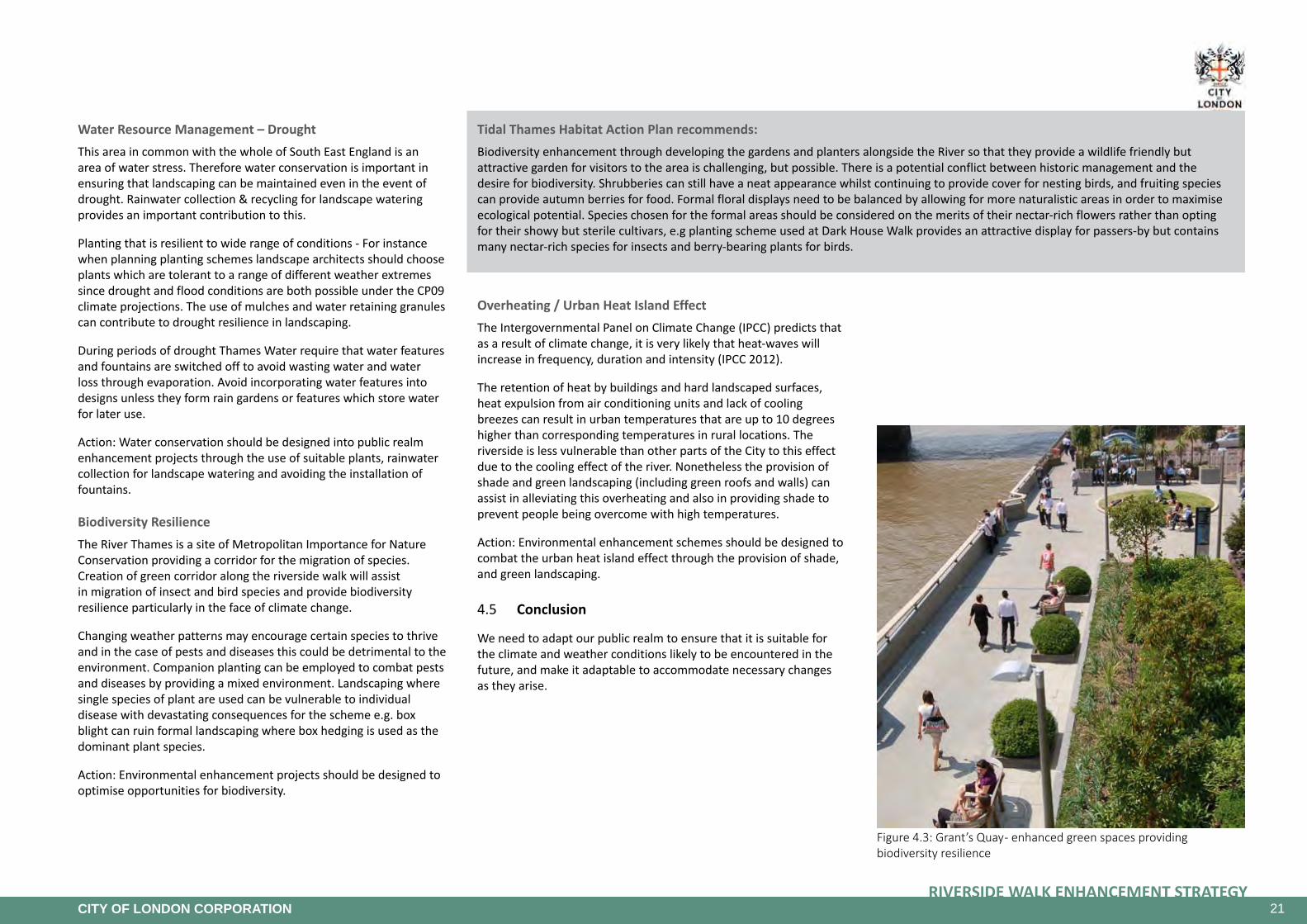
Figure 4.3: Grant’s Quay - enhanced green spaces providing biodiversity resilience
Water Resource Management – Drought This area in common with the whole of South East England is an area of water stress. Therefore water conservation is important in ensuring that landscaping can be maintained even in the event of drought. Rainwater collection & recycling for landscape watering provides an important contribution to this.
Planting that is resilient to wide range of conditions - For instance when planning planting schemes landscape architects should choose plants which are tolerant to a range of different weather extremes since drought and flood conditions are both possible under the CP09 climate projections. The use of mulches and water retaining granules can contribute to drought resilience in landscaping.
During periods of drought Thames Water require that water features and fountains are switched off to avoid wasting water and water loss through evaporation. Avoid incorporating water features into designs unless they form rain gardens or features which store water for later use.
Action: Water conservation should be designed into public realm enhancement projects through the use of suitable plants, rainwater collection for landscape watering and avoiding the installation of fountains.
Biodiversity ResilienceThe River Thames is a site of Metropolitan Importance for Nature Conservation providing a corridor for the migration of species. Creation of green corridor along the riverside walk will assist in migration of insect and bird species and provide biodiversity resilience particularly in the face of climate change.
Changing weather patterns may encourage certain species to thrive and in the case of pests and diseases this could be detrimental to the environment. Companion planting can be employed to combat pests and diseases by providing a mixed environment. Landscaping where single species of plant are used can be vulnerable to individual disease with devastating consequences for the scheme e.g. box blight can ruin formal landscaping where box hedging is used as the dominant plant species.
Action: Environmental enhancement projects should be designed to optimise opportunities for biodiversity.
Overheating/UrbanHeatIslandEffectThe Intergovernmental Panel on Climate Change (IPCC) predicts that as a result of climate change, it is very likely that heat-waves will increase in frequency, duration and intensity (IPCC 2012).
The retention of heat by buildings and hard landscaped surfaces, heat expulsion from air conditioning units and lack of cooling breezes can result in urban temperatures that are up to 10 degrees higher than corresponding temperatures in rural locations. The riverside is less vulnerable than other parts of the City to this effect due to the cooling effect of the river. Nonetheless the provision of shade and green landscaping (including green roofs and walls) can assist in alleviating this overheating and also in providing shade to prevent people being overcome with high temperatures.
Action: Environmental enhancement schemes should be designed to combat the urban heat island effect through the provision of shade, and green landscaping.
4.5 Conclusion
We need to adapt our public realm to ensure that it is suitable for the climate and weather conditions likely to be encountered in the future, and make it adaptable to accommodate necessary changes as they arise.
TidalThamesHabitatActionPlanrecommends:Biodiversity enhancement through developing the gardens and planters alongside the River so that they provide a wildlife friendly but attractive garden for visitors to the area is challenging, but possible. There is a potential conflict between historic management and the desire for biodiversity. Shrubberies can still have a neat appearance whilst continuing to provide cover for nesting birds, and fruiting species can provide autumn berries for food. Formal floral displays need to be balanced by allowing for more naturalistic areas in order to maximise ecological potential. Species chosen for the formal areas should be considered on the merits of their nectar-rich flowers rather than opting for their showy but sterile cultivars, e.g planting scheme used at Dark House Walk provides an attractive display for passers-by but contains many nectar-rich species for insects and berry-bearing plants for birds.
22RIVERSIDE WALK ENHANCEMENT STRATEGY
CITY OF LONDON CORPORATION
Figure 5.1: Old Billingsgate Market and Custom House in 1968 Figure 5.2: Old Billingsgate Market currently
Figure 5.3: Conservation Areas and Listed Buildings
5. The Area Today
5.1 Built Form
The Riverside Walk is located along the historical waterfront of the City of London, which was the busiest and most important commercial waterfront in the world during the 18th and 19th centuries.
A significant proportion of the existing buildings have been developed over the latter half of the 20th century and early 21st century within this area and are interspersed with historic buildings such as the Thames House, Fishmonger’s Hall (1834), Adelaide House, Custom House (1817 and 1827) or the Billingsgate Market building (1877), which are also listed buildings and significant landmarks. The plan below identifies the various listed buildings, scheduled monuments and conservation areas within the strategy area. Additionally, a detailed document attached to this Strategy provides a description of all the listed buildings and furniture present in the area (see appendix 1).
The Walkway pattern doesn’t follow the historical street pattern. Indeed, during the medieval times, a lot of buildings were aligned along the river edge without any west to east walk.

23RIVERSIDE WALK ENHANCEMENT STRATEGY
CITY OF LONDON CORPORATION
Figure 5.4: New high quality public realm at Paul’s Walk
Figure 5.5: Ownership
5.2 Public Realm Analysis
The strategy deals primarily with the enhancement of public realm under the City’s stewardship, both Highway and City Walkway.
However, due to the predominance of private land on the riverside, the Strategy also sets out proposals to enhance these private areas, to create a consistently high quality environment.
Since the Strategy was originally adopted in 2005, many public realm improvement schemes have been implemented along the Riverside Walk to provide some improved, high quality environments. These projects are further explained in section 5.8 of this report.
The enhanced sections of the walkway are mainly paved in Yorkstone. These surfaces are generally in reasonable condition but may require some further repair in places as a result of disturbance. The paving theme is developed further in this document, in section 8.4.
The Riverside Walk is well illuminated by column mounted lighting along the Thames to provide a good level of warm, white light across the area. However, some narrow passages under the bridges are not well illuminated and the lack of consistency in lighting unit design creates a disjointed appearance of the River Walk. The lighting strategy is developed further in this document in section 8.4.
The perception of the river from the rest of the City is very limited; the waterfront is not clearly visible, just glimpses of various parts of the river can be seen through the different narrow lanes and streets such as from Arthur Street through Swan Lane or from Dowgate Hill through Cousin Lane. The water of the Thames is visible only from some locations on Angel Lane and Cousin Lane.
The bridges crossing the River Thames (Blackfriars Bridge, Southwark Bridge, London Bridge and Millennium (pedestrian) Bridge are visible from parts of the City near to the river, enabling pedestrians to orient themselves. The bridges remain as main access points to the Riverside Walk for pedestrians.
For the 2012 Olympics, the bridges along the riverside were greatly enhanced with new lighting schemes. This has created a legacy that can be built upon by extending this theme to the riverside. This opportunity is being explored together with the GLA.
More needs to be done as the Riverside Walk remains disjointed and under utilised in places. Riverfront redevelopment projects provide good opportunities to enhance / improve the Riverside Walk such as successfully done in the Hanseatic Walk / Angel Lane / Oystergate Walk area. The City of London Corporation City Walkway Guidance Notes (see appendix 2) set out standards to guide future enhancement works along the Riverside Walk.

24RIVERSIDE WALK ENHANCEMENT STRATEGY
CITY OF LONDON CORPORATION
Figure 5.6: Uses
5.3 Uses/Ownership
The majority of the buildings along the waterfront are in commercial use. The walkway and street activity is therefore focused on the journeys to and from work, business servicing requirements and lunchtime/early evening leisure activity.
Retail uses are mainly concentrated on local groups of restaurants, pubs and bars with some outlets in Cannon Street Station that are not accessible from the Riverside Walk.
Some buildings are in use for leisure activities such as the Mermaid Conference Centre, the Vintners and Fishmongers’ Halls, a sports club under Cannon Street Station and the Little Ship Club but also livery Halls with the Old Billingsgate Market building often used for events.
Like in the rest of the City, there are religious archaeological remains on the Riverside Walk related to the two historic churches, St Benet Metropolitan Welsh Church and St Magnus the Martyr’s Church.
Residential properties are limited and mainly located in a cluster around Globe View and Queen’s Quay.
The City of London School for Boys located close to the Millennium Bridge is an important building for the Riverside Walk and creates activities around it.
Despite a fine urban grain and diversity of use along the Riverside Walk, the different uses are isolated and gathered by cluster, leaving some areas without amenities for the users and the residents. A mix of use within the same building is only present on Sunlight Wharf and Hanseatic and Oystergate Walk, with some retail units at ground level and offices or housing at upper level. However, a number of new developments are planned in the area, with the possibility to improve the quality and quantities of amenities along the Riverside Walk.

25RIVERSIDE WALK ENHANCEMENT STRATEGY
CITY OF LONDON CORPORATION
Figure 5.7: Connections to the north - improved pedestrian crossings
5.4 ConnectiontotheNorthandtheSouth
ConnectiontotheNorthUpper and Lower Thames Street is a major barrier between the Riverside Walk and the rest of the City. The environment on this part of the strategic road network through the City is dominated by traffic. However, a number of pedestrian crossings have been added in recent years, which has improved connectivity.
The City of London Corporation will continue to work with Transport for London, the Highway Authority for Upper and Lower Thames Street, on further improvements to existing pedestrian crossings and the introduction of new crossing facilities to further improve connectivity. The schemes that have recently been implemented are:
Blackfriars: A new pedestrian crossing was constructed in late 2011 together with the improvement of the Blackfriars Station,
QueenStreet/UpperThamesStreet: As part of the Queen Street Pilot Project the light controlled junction has been altered to have an all red phase, which allows pedestrians to cross in any direction across the junction whilst all traffic is stopped. This change facilitates the removal of the staggered pedestrian crossings and reduces the amount of time that pedestrians have to wait between light changes before being able to cross the road. This change is also combined with improved cycling facilities at this crossing, which is on the London Cycle Network,
Watermark Place: As part of the pedestrianisation and the landscaping enhancement of Angel Lane, this crossing together with the Swan Lane crossing has been improved in order to facilitate the access to the Riverside Walk,
SwanLane: As part of the pedestrianisation and the landscaping enhancement of Angel Lane, this crossing together with the Watermark Place crossing has been improved in order to facilitate the access to the Riverside Walk,
FishStreetHill/LowerThamesStreet: As part of the Monument Street Scene Challenge Scheme the light controlled junction has been altered to allow two-way working in Fish Street Hill and a left turn for vehicles from Fish Street Hill into Lower Thames Street. The opportunity was taken to upgrade the pedestrian facilities at this location at this time,
LowerThamesStreet: A new pedestrian crossing has been constructed to enable pedestrians to cross between St Mary at Hill and the Old Billingsgate Market, and
GreatTowerStreet/BywardStreet: A scheme to improve pedestrian crossing facilities and allow buses and cycles to turn right from Byward Street into Great Tower Street was approved by the Corporation and Transport for London and works are now complete.
Pedestrian bridges at various locations across Lower and Upper Thames Street provide connections from the City to the Riverside Walk. It has been the Corporation’s policy to seek the replacement of these bridges or to maintain connections to them on both sides of these streets as part of new developments. These bridges are poorly used because they are not universally accessible to the whole community and the cost of maintenance is considerable.

26RIVERSIDE WALK ENHANCEMENT STRATEGY
CITY OF LONDON CORPORATION
Figure 5.8: Connections to the south - view of the Thames bridges
Connection to the SouthThe connections between the Thames bridges and the Riverside Walk vary considerably in their quality, in terms of accessibility, legibility and the local environment. The Millennium Bridge has particularly good connections with the Riverside Walk. However, other bridges have quite poor access provision to the walkway, consisting of steps and staircases that are squeezed into the spaces between neighbouring buildings.
Blackfriars Bridge is connected with the Riverside Walk by a staircase on the east and a ramp on the west. Both are clearly visible and accessible from the bridge and in good condition.
A new connection might be introduced with the construction of the Thames Tideway Tunnel Blackfriars Bridge Foreshore project, which is developed further in this report in section 8.3.
Millennium Bridge is well connected with the Riverside Walk with wide steps as well as an inclinator. An enhancement scheme has been developed for a section of the Riverside Walk on either side of the bridge and this is detailed further in section 8.3 of this report.
Southwark Bridge is connected to the Riverside Walk by an enclosed staircase that is poor in terms of accessibility and environment and is not clearly identifiable along the route. A project for this area is developed in section 8.3.
London Bridge is connected to the Riverside Walk via an enclosed staircase that is poor in terms of its accessibility and legibility, and especially poor in terms of the local environment. This internalised staircase will be replaced by a new one that is more open and better linked to the walk. This project is further explained in section 8.3 of this report.
5.5 DevelopmentOpportunities
New developments can provide focal points of activity to further enhance the vibrancy of the Riverside Walk.
The presence of offices on the riverside makes a valuable contribution to the City’s varied office stock, which in turn contributes to the wider economic prosperity of London. The riverside also includes a cluster of residential development, adjacent to Queenhithe, as well as isolated residential developments at the eastern end.
Pedestrian surveys have shown that there is a desire for more café uses along the Riverside Walk to provide a valuable amenity and add vitality. Improving the vibrancy of the riverside by encouraging a mix of appropriate commercial uses and promoting office-led commercial development is a key objective of the City’s policies for the riverside.
Where re-development occurs, the unique riverside location offers opportunities for creating new public spaces, together with widened and direct sections of Riverside Walk. Developments should also consider adding entrances and active frontages on the riverside and not turning their backs on the river. New accessible connections to the City and bridges should also be secured through redevelopments as appropriate.
Developments should also take account of the need to integrate flood alleviation, resistance and resilience measures (see section 4).

27RIVERSIDE WALK ENHANCEMENT STRATEGY
CITY OF LONDON CORPORATION
Figure 5.9: Pedestrian movement along Dark House Walk / Old Billingsgate Walk
5.6 Current and Future Movement
The Riverside Walk is used by local workers, visitors, residents and school children. A significant number of joggers as well as a few cyclists are also using the area. However it must be noted that cycling is prohibited on the Riverside Walk.
Weather conditions greatly influence the use of the Riverside Walk particularly as a place for leisurely visits. The walkway is especially popular as a lunchtime destination during sunny and warm days for pedestrians as well as joggers. During summer months a greater number of people use the Riverside Walk throughout the day for various reasons such as walking to/from stations to places of work, relaxing or walking during the lunch hour, jogging and exercising or visiting for sightseeing. During the winter months and during wet weather days the Riverside Walk appears rather deserted with only a few City workers walking between stations and places of work during the peak commuter hours and some very dedicated joggers.
In general, the weekday morning period is largely dominated by commuters walking along the Riverside Walk to complete their journey to their place of work. The busiest section is between Cannon Bridge House and Sugar Quay with the heaviest flow entering from London Bridge due to the London Bridge Station across the bridge.
During the weekday lunchtime period, the users of the Riverside Walk are mainly workers from nearby offices and some visitors. The main entry points are distributed between Millennium Bridge, London Bridge and Tower Bridge. Some joggers are also using the Riverside Walk during the lunchtime period.
During the weekday evening period, the riverside is mainly used by commuters, joggers and visitors, with the section between Millennium Bridge and Dark House Wharf being the busiest. The main points of exit are the Millennium Bridge and Tower Bridge, both of which lead to tourist/visitor destinations and places to eat and drink.
During the weekend, family groups and younger people are using the Riverside Walk to undertake longer walk along the Thames and for sightseeing. The number of joggers is also quite significant. The main points of entry and exit are the same, Tower Bridge, Millennium Bridge and London Bridge.
More details about the use of the Riverside Walk and accessibility to it are given in section 6 of this document.
The new Crossrail connections and the additional commercial and retail space being provided through the various new developments especially the eastern cluster are intended to draw in more workers and visitors to the City. Enhancements to the Riverside Walk in particular through improved connections as well as high quality treatment of the public realm across the area and improved lighting, signing and way-finding measures will assist in encouraging these additional pedestrians to use the Riverside Walk.
5.7 Constraints of the Riverside Walk
A questionnaire survey of the users of the Riverside Walk was carried out in February/March 2013 to understand the type of users, use patterns and user views about the Riverside Walk in terms of quality of spaces / walkway, accessibility and other issues (refer to section 6).
Based on the outcome of the survey and a review of the various newly enhanced and other sections of the Riverside Walk, the main issue is that the walkway is not well connected. There are sections that are diverted away from the river and some sections are very narrow with twists and turns that disorientate users and do not make the walkway feel safe. Such conditions do not give users confidence that they will be able to continue. In addition, the Riverside Walk does not feel public in places.
The constraints of the Riverside Walk can be summarised as:
• Disparate character along the route, particularly in terms of the consistency of paving and riverside wall materials and design,
• Poor quality of connection to the riverside from the rest of the City, particularly across Upper and Lower Thames Street,
• Certain inaccessible sections forcing people to use inner/back routes with poor environments,
• Inconsistent quality, design, position and colour of lighting elements,
• Insufficient seating,
• Lack of features of interest along the walkway in terms of art-works, water features or architectural detail,
• Not enough green spaces or places to rest / play,
• Lack of public amenities - retailing (particularly catering facilities such as small cafés), and
• Illegal cycling on the Riverside Walk conflicting with pedestrian movement and safety.
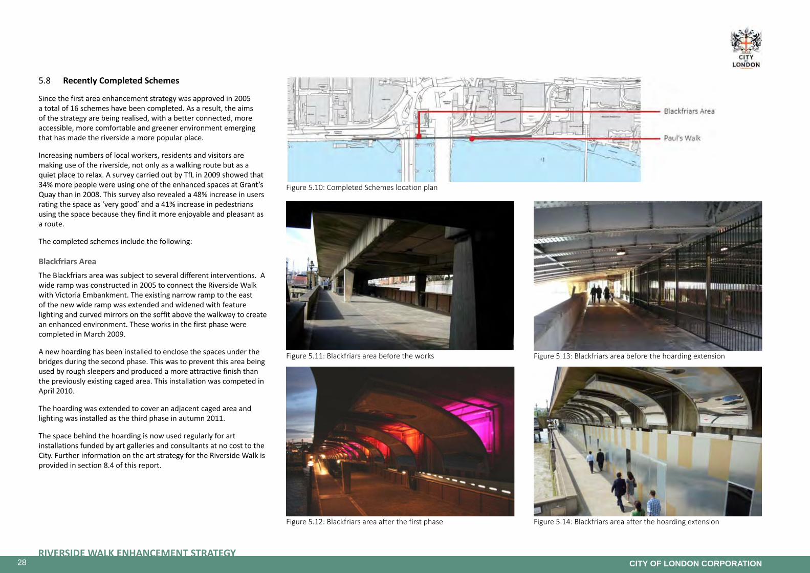
28RIVERSIDE WALK ENHANCEMENT STRATEGY
CITY OF LONDON CORPORATION
Figure 5.10: Completed Schemes location plan
Figure 5.11: Blackfriars area before the works
Figure 5.12: Blackfriars area after the first phase
Figure 5.13: Blackfriars area before the hoarding extension
Figure 5.14: Blackfriars area after the hoarding extension
5.8 Recently Completed Schemes
Since the first area enhancement strategy was approved in 2005 a total of 16 schemes have been completed. As a result, the aims of the strategy are being realised, with a better connected, more accessible, more comfortable and greener environment emerging that has made the riverside a more popular place.
Increasing numbers of local workers, residents and visitors are making use of the riverside, not only as a walking route but as a quiet place to relax. A survey carried out by TfL in 2009 showed that 34% more people were using one of the enhanced spaces at Grant’s Quay than in 2008. This survey also revealed a 48% increase in users rating the space as ‘very good’ and a 41% increase in pedestrians using the space because they find it more enjoyable and pleasant as a route.
The completed schemes include the following:
Blackfriars AreaThe Blackfriars area was subject to several different interventions. A wide ramp was constructed in 2005 to connect the Riverside Walk with Victoria Embankment. The existing narrow ramp to the east of the new wide ramp was extended and widened with feature lighting and curved mirrors on the soffit above the walkway to create an enhanced environment. These works in the first phase were completed in March 2009.
A new hoarding has been installed to enclose the spaces under the bridges during the second phase. This was to prevent this area being used by rough sleepers and produced a more attractive finish than the previously existing caged area. This installation was competed in April 2010.
The hoarding was extended to cover an adjacent caged area and lighting was installed as the third phase in autumn 2011.
The space behind the hoarding is now used regularly for art installations funded by art galleries and consultants at no cost to the City. Further information on the art strategy for the Riverside Walk is provided in section 8.4 of this report.

29RIVERSIDE WALK ENHANCEMENT STRATEGY
CITY OF LONDON CORPORATION
Figure 5.15: Paul’s Walk eastern section before improvements
Figure 5.16: Enhanced Paul’s Walk - eastern section
Figure 5.17: Paul’s Walk western section before improvements
Figure 5.18: Enhanced Paul’s Walk - western section
Paul’sWalkPaul’s Walk runs between the City of London School for Boys and Blackfriars Bridge. This section of Riverside Walk can be divided in two distinct areas:
• Western section between Blackfriars Bridge and the bottom of White Lion Hill. Completed in June 2013, and
• Eastern section along White Lion Hill. Completed in March 2010.
In the eastern section of the Paul’s Walk area, old timber planters and benches have been replaced with new more robust granite ones with enhanced planting, an irrigation system and lighting.
The scheme for the western section adjacent to Blackfriars Bridge included the re-landscaping of the existing public space that was in a poor condition and inaccessible for some users due to steps. The plans included the removal of the steps and new planting areas. Enhanced seating and lighting are included. To mitigate the impact of their prolonged occupation of the Riverside Walkway, Network Rail undertook these works at their cost to the City’s approved designs.

30RIVERSIDE WALK ENHANCEMENT STRATEGY
CITY OF LONDON CORPORATION
Figure 5.19: Completed Schemes location plan
Figure 5.21: High Timber Street with improvements Figure 5.20: New trees in High Timber Street
Figure 5.22: High Timber Street beforeFigure 5.23: Queenhithe Mosaic
High Timber StreetHigh Timber Street is the section of the Riverside Walk that diverts away from the river.
The aim of the proposal was to enhance the accessibility, appearance and legibility of the area by improving the pedestrian route between the completed sections of the Riverside Walk on either side of Queenhithe Dock and Sir John Lyon House by using high quality materials.
The High Timber Street paving was improved by replacing the mastic asphalt footway with York stone and by widening the footway. These works were completed in April 2007.
As part of a second phase, six trees were planted in association with footway widening in March 2012.
In the longer term, the completion of the Riverside Walk adjacent to the River is proposed. More details on this proposal are found in section 8.3.
Queenhithe MosaicThe project involved the creation of a new mosaic installation on a section of the Thames Path east tidal barrier wall at Queenhithe. The proposal was to create a ‘timeline’ mosaic of the River Thames and tell the story of the importance of the river to London, from Roman times to the Diamond Jubilee of Elizabeth II.
The 1m x 30m mosaic was developed and installed by Southbank Mosaics with a long list of experts and volunteers who contributed to the vision over a period of two years. The mosaic was completed in October 2014 and has improved the appearance of the concrete tidal barrier adjacent to the existing Riverside Walk. The completed art work is striking and brings to life the archaeological wealth of the nearby Scheduled Monument, combining legibility with opulence, and creating a distinct sense of place.

31RIVERSIDE WALK ENHANCEMENT STRATEGY
CITY OF LONDON CORPORATION
Figure 5.24: Completed Schemes location plan
Figure 5.25: Illegal motor cycle parking in Steelyard Passage
Figure 5.26 Enhanced Steelyard Passage with parking enforcement in place
Figure 5.27: Further enhancements including bin enclosure designed to reflect the historic use of the Riverside.
Steelyard PassageThis section of the walkway is concealed and runs under the Cannon Street railway bridge.
The Steelyard Passage project was divided in two phases. The aim was to create a safe and well-lit route that people would feel comfortable using. A key element was the removal of illegal motor cycle parking. This was achieved by declaring the land as public highway to enable parking tickets to be issued.
New lighting installations on the wall and arch draw attention to the quality of the brickwork. A delicate and playful reference to the river is achieved with blue LEDs in the floor, which has been enhanced with new Yorkstone paving. The first phase was completed in April 2007.
The second phase included installation of paved raised tables as enhanced gateways to the archway, further lighting improvements, a bin enclosure and a sound installation to remind users of the close proximity of the river with flowing water and harbour sounds. The project was completed in November 2012.
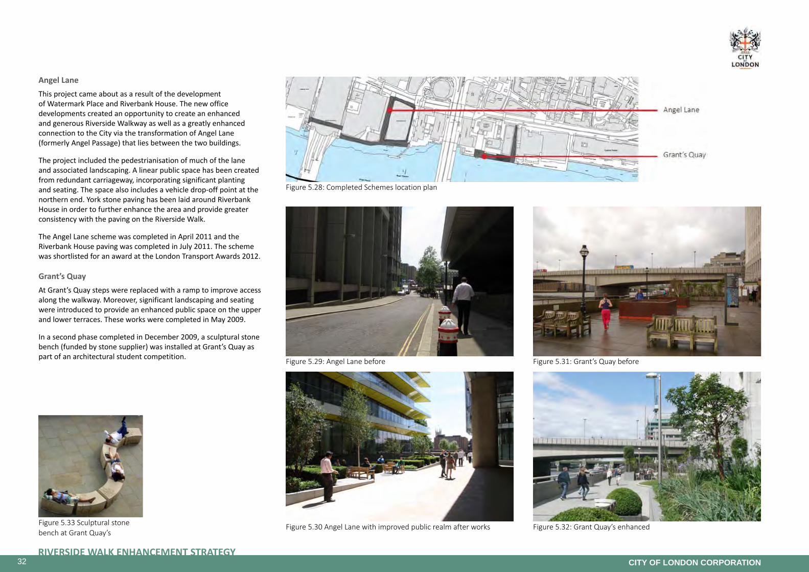
32RIVERSIDE WALK ENHANCEMENT STRATEGY
CITY OF LONDON CORPORATION
Figure 5.33 Sculptural stone bench at Grant Quay’s
Figure 5.28: Completed Schemes location plan
Figure 5.29: Angel Lane before
Figure 5.30 Angel Lane with improved public realm after works
Figure 5.31: Grant’s Quay before
Figure 5.32: Grant Quay’s enhanced
Angel LaneThis project came about as a result of the development of Watermark Place and Riverbank House. The new office developments created an opportunity to create an enhanced and generous Riverside Walkway as well as a greatly enhanced connection to the City via the transformation of Angel Lane (formerly Angel Passage) that lies between the two buildings.
The project included the pedestrianisation of much of the lane and associated landscaping. A linear public space has been created from redundant carriageway, incorporating significant planting and seating. The space also includes a vehicle drop-off point at the northern end. York stone paving has been laid around Riverbank House in order to further enhance the area and provide greater consistency with the paving on the Riverside Walk.
The Angel Lane scheme was completed in April 2011 and the Riverbank House paving was completed in July 2011. The scheme was shortlisted for an award at the London Transport Awards 2012.
Grant’sQuayAt Grant’s Quay steps were replaced with a ramp to improve access along the walkway. Moreover, significant landscaping and seating were introduced to provide an enhanced public space on the upper and lower terraces. These works were completed in May 2009.
In a second phase completed in December 2009, a sculptural stone bench (funded by stone supplier) was installed at Grant’s Quay as part of an architectural student competition.

33RIVERSIDE WALK ENHANCEMENT STRATEGY
CITY OF LONDON CORPORATION
Figure 5.34: Completed Schemes location plan
Figure 5.35: Dark House Walk before improvements
Figure 5.36: Dark House Walk improved
Figure 5.37: Sugar Quay ramp before
Figure 5.38: Sugar Quay ramp extended
Dark House Walk For this project, the existing planters at Dark House Walk were re-planted by the Open Spaces Department as part of a five year replacement planters scheme funded through the on street parking reserve.
These works were completed in March 2008.
Sugar Quay The existing steep ramp on the Riverside Walk Sugar Quay area was adjusted to make it shallower and create a more accessible connection. This ramp was paved with York stone to match the unifying quality along the Riverside Walk.
This work was completed in March 2009.

34RIVERSIDE WALK ENHANCEMENT STRATEGY
CITY OF LONDON CORPORATION
Figure 5.39: Connecting Spaces - Yorkstone paving in Cousin Lane
Figure 5.40: Connecting Spaces - Festoon lighting
Figure 5.41: Sport equipment on Dark House Walk Passage Figure 5.42: Lower Thames Street crossing near to Angel Lane in 2013
Connecting Spaces ProjectIt is important that the Riverside Walk is seen as a linear route in itself, and not just a string of individual and disparate sections of connected walkway. The completed walkway must be readable and easily understood as public walkway. The lack of a consistent approach to the design and materials of the walkway has resulted in the public feeling uncertain as to the public nature of some stretches.
The Connecting Spaces project was created to enhance the connectivity between the different spaces. The project is divided into three phases. The first year, completed in March 2012 included a series of paving, lighting and street furniture improvements with a particular focus on Dark House Walk Passage where sports equipment has also been installed.
The Connecting Spaces project for the Year 2 included paving, lighting and street furniture improvements. These primarily affect areas of the walkway that have not been addressed by previous schemes. There was also a need to add further signage on the walkway, including signs to discourage illegal cycling which has become a problem in recent years. This last theme will be discussed in the section 8.4 of this document.
The second phase (Year 2) was approved by Committees in September 2012 and works were completed in March 2013.
UpperandLowerThamesStreetSignificant changes have been made to improve pedestrian connections to the Riverside Walk since the original strategy was adopted. A number of pedestrian crossings on Upper and Lower Thames Street have either been improved or created in the last eight years.
Improved and safer crossings (with signals for pedestrians) have been installed at Queen Street, Byward Street and Swan Lane and new crossings have been provided at Angel Lane and Old Billingsgate.
City of London Corporation officers have worked closely with TfL to achieve these improvements. The changes so far made have greatly enhanced connections between the City and the Riverside Walk, in line with the objectives of the strategy.
The riverside environment has been significantly enhanced through the implementation of the above projects. As a result, the aims of the strategy are being realised, with a better connected, more comfortable and greener environment emerging.

35RIVERSIDE WALK ENHANCEMENT STRATEGY
CITY OF LONDON CORPORATION
Figure 6.1: Lunchtime use - Montague House garden
Figure 6.2: Lunchtime use - Grant’s Quay
6. Riverside Walk User Survey
The key aims of City of London’s Riverside Walk Enhancement Strategy in 2005 were to create universally accessible connections between the riverside and the rest of the City, to create new, and redesign existing, green spaces for people to stop and enjoy the Thames, and to encourage the biodiversity of the City riverside.
Over the last seven years, many changes and improvements have been implemented based on the recommendations set out in the Strategy. In February/March 2013 the impact of the changes and improvements on user experience was examined through analysis of information gathered by observation, surveys and interviews based on a questionnaire at various locations along the Riverside Walk at different times of the day and during week days and the weekend in order to gain a holistic impression and evidenced assessment of the usage.
The current condition of the Riverside Walk was also assessed to identify parts of the Riverside Walk that are less successful and the reasons why: e.g. too narrow, too confusing, not feeling public/safe, steps in the way, poor environment. Parts of the Riverside Walk not accessible for wheelchair users, current diversion routes and the condition of existing accessible connections were also observed.
The findings and analysis of this survey exercise have been documented in a report that is included in Appendix 3. A summary of the findings is given below:
6.1 Assessment of users of the Riverside Walk
People observed to be using the Riverside Walk were local workers, visitors, residents and school children. Joggers were a significant presence and a few illegal cyclists were observed. Wheelchair users were not seen to be using the Riverside Walk during the observation and survey periods.
As would be expected in February and March, weather conditions were a factor in the numbers using the Riverside Walk with less people using it during the cold and wet conditions that prevailed. During sunny weather, a great number of users were observed especially during the lunch hour.
Morning periods were largely dominated by commuters walking along the Riverside Walk to complete their journey to their place of work. London Bridge was the main point of entry with the heaviest flow of people heading east towards Custom House/Sugar Quay. Fewer people were walking in the Millennium Bridge/ Paul’s Walk area.
During weekday lunchtime periods in good weather, the Riverside Walk was found to be heavily used mainly by individuals or small groups of City workers engaged in leisure activities such as lunch break walks, sitting on benches to eat lunch, talk, smoke or use smart phones or to just enjoy the views and the sun. A notable number of joggers were using the Riverside Walk for more vigorous exercise. A number of visitors were walking along the route engaged in sightseeing activities. People were distributed fairly evenly along the route with the Millennium Bridge, London Bridge and Tower Bridge being the main points of entry/exit. Seating was found to be well used with some users saying the seating is insufficient during summer days.
Evening periods saw a mix of commuters making their way to tube/train stations in the vicinity, visitors on sight-seeing trips and some joggers. As per the questionnaire survey, many people were on their way to leisure/social/entertainment activities after work. This is reflected in the higher flows of pedestrians to Millennium Bridge and Tower Bridge leading to pubs and restaurants in the Southbank area.
During weekends the Riverside Walk was mainly used by visitors on sightseeing related activities, regular walkers and people living locally. The wet weather on the day of the survey did affect the number of people on the Riverside Walk and in particular the benches were unused. Many people found a lack of sheltered areas to offer respite from the rain. The sections by the Millennium Bridge and towards Tower Bridge were busiest and a number of users were undertaking longer walks along the Thames Path.
6.2 Feedback from the users of the Riverside Walk
Most users that responded to the questionnaire found the Riverside Walk to be a very good or fairly good public space and an enjoyable and pleasant route to use. The Riverside Walk is especially popular as a route between Underground and rail stations and places of work for commuters working in the area as it provides a quiet and scenic route away from traffic.
Most users seemed to appreciate the riverside setting and the views, the fact that the Riverside Walk was away from traffic routes along most of its length, the openness of the spaces and the green areas where they appeared. Some issues were highlighted, which included:
• disruptions along the route such as closed /diverted sections where construction sites and new developments front the riverside;
• dirt/litter/dog excrement/pigeons;
• quality of some public spaces along the walk is dull and boring with a lack of active frontages, not enough cafes/restaurants or public toilets;
• joggers conflicting with pedestrian movement;
• illegal cycling conflicting with pedestrian movement and safety;
• the Riverside Walk is not fully accessible.

36RIVERSIDE WALK ENHANCEMENT STRATEGY
CITY OF LONDON CORPORATION
Figure 6.3: Main points of entry and exit : AM figures
Figure 6.4: Main points of entry and exit : PM figures

37RIVERSIDE WALK ENHANCEMENT STRATEGY
CITY OF LONDON CORPORATION
Figure 6.5: Main points of entry and exit : Lunch time figures
Figure 6.6: Questionnaire query: Reason for walk

38RIVERSIDE WALK ENHANCEMENT STRATEGY
CITY OF LONDON CORPORATION
Figure 6.7: Questionnaire query: Reason for using the Riverside Walk
Figure 6.8: Commuters heading to work - Dark House Walk Figure 6.9: Commuters heading to work - Hanseatic Walk Figure 6.10: Commuters heading to work - diverted route via High Timber Street

39RIVERSIDE WALK ENHANCEMENT STRATEGY
CITY OF LONDON CORPORATION
Figure 6.11: Staircase connecting Riverside Walk to White Lion Hill - no signage to alternative accessible route
Figure 6.12: High Timber Street / Broken Wharf corner - pinch point on footway made worse by temporary fencing.
Figure 6.13: Steps at Fishmongers’ Hall Wharf
6.3 Accessibilityforwheelchairusers
Accessibility along the Riverside Walk is an issue in certain sections where there is no provision for wheelchair users and a general lack of good wayfinding for alternative accessible routes.
• Midway between Blackfriars and Millennium Bridge, a staircase connects the Riverside Walk to White Lion Hill, but no ramped access and no signage to indicate the closest alternative route (the inclinator at Millennium Bridge) exist,
• At Broken Wharf the footway by Broken Wharf House heading into High Timber Street is narrow with pinch points and is difficult for wheelchair users,
• Walbrook Wharf is closed during crane operations. There is an alternative accessible routes via Bell Wharf Lane but signage/wayfinding is inadequate,
• At Southwark Bridge a stepped link to Queen Street Place exists, but no alternative accessible route is available. The closest accessible routes are via Walbrook Wharf, Steelyard Passage and Angel Lane,
• At Fishmongers’ Hall Wharf, steps leading to the section under London Bridge block through route for wheelchair users,
• At London Bridge a staircase on the east side links the Riverside Walk to King William Street but no ramped access, lift or signage to indicate closest alternative route exist,
• Grants Quay links to Lower Thames Street via a stepped access through St Magnus Garden, which is private land, but no alternative step free access is provided, and
• There is level access from the Riverside Walk to the Water Lane carriageway which is in granite setts but no dropped kerbs to allow access to adjacent footway.
6.4 Conclusion
Observations and user feedback show the Riverside Walk to be in good condition and well used by visitors and people living or working locally with over 95% of users who responded to the questionnaire giving it a very good or fairly good quality of space rating. However, connections to the City are in need of improvement and the walkway remains inconsistent.
There are some sections that could benefit from further enhancements in lighting and public realm and/or the installation of public art or elements promoting active uses. Encouraging new developments to integrate active frontages along the walkway would also further enhance user experience and potentially encouraging greater use in the evening. Ensuring step free access wherever possible and/or improved wayfinding for alternative accessible routes would make the Riverside Walk fully accessible for all.

40RIVERSIDE WALK ENHANCEMENT STRATEGY
CITY OF LONDON CORPORATION
7. Public Consultation
7.1 SummaryoftheConsultation
The City is planning for the future by preparing a strategy for environmental enhancements along the Riverside Walk. The strategy objectives aim to create an attractive, vibrant, better connected and accessible walkway with improved public spaces for people to enjoy.
A ten week public consultation was undertaken from 19 May to 25 July 2014 focused on those people who live, work, study and regularly travel through the area. 450 consultation leaflets were posted to local residents and businesses in the area and a further 760 emails were sent to individuals with an interest in the area, containing a link to an online survey and the draft strategy on the City of London’s website. Exhibition displays, website information, articles in newspapers and magazines, social media, posters at strategic locations on the City’s Riverside Walk and pedestrian attitude surveys were all used to raise awareness of the consultation.
In total, 309 formal responses were received during the consultation, showing a general support and enthusiasm for the strategy.
Headline points of interest
A number of themes emerged from the responses, including:
• The importance of providing an accessible and direct route along the Riverside Walk,
• The importance of increased provision of, and enhanced open/green spaces, and
• The importance of achieving a good balance between vibrant and quiet areas.
The Public Consultation Results & Key Themes report outlines the different methods of consultation used, their effectiveness and an analysis of the key findings of the consultation. As well as analysing the formal responses to the consultation leaflet, emails, letters, online surveys and on-site attitude surveys, the report summarises feedback gathered informally during the consultation on social media and face-to-face discussions at exhibitions and meetings.
7.2 Ways of engagement
A variety of consultation methods were utilised to ensure a broad coverage including:
• Direct consultations with the main stakeholders, regulatory agencies and the Corporation’s statutory consultees,
• City of London website – webpage with a link to return comments on the draft strategy via e-mail,
• Online Survey (SNAP Survey),
• Stakeholder meetings,
• Pop-up exhibitions and events,
• Letters and consultation leaflets to all residents and businesses in the area,
• Emails and briefing sessions with Ward Members,
• City Resident article (hard copy, Issue 32 – summer 2014),
• City View article (hard copy, July 2014 edition),
• E-shots,
• Hard copies of the draft Strategy were provided for information in the Guildhall Library, and Guildhall North Wing (Planning reception) and Barbican Library,
• On-street information node signs throughout the Strategy area,
• On-street pedestrian attitude survey, and
• Door to door leaflet distribution.
This consultation was carefully targeted to ensure that the views of stakeholders were gathered including pedestrians, City of London Members, residents, local occupiers and businesses, workers, local churches, visitors, Transport for London, the Greater London Authority, Natural England, the Port of London Authority, the Environment Agency and London Boroughs that are part of the Cross River Partnership (Lambeth, Southwark, Tower & Hamlet and Westminster).
7.3 Key Themes
A number of key themes emerged from across all the consultation responses, including the comments from the online survey, emails, letters, leaflets and the on street survey. This section thematically addresses the qualitative responses received.
Overall there is strong support for change along the Riverside Walk. The majority of respondents support all the proposals developed in the strategy.
These key themes are detailed below.
Accessibility and connectivityWithin all the comments received during the public consultation, almost one third of respondents mentioned the diversion of the walkway from the river as the main problem of the Riverside Walk. The walkway being blocked off by current re-developments is also a key complaint.
A large proportion of responses expressed the need to improve the access to the Riverside Walk from the City, with pedestrian crossings and links to pedestrian bridges, as well as the connections to the different bridges linking to the Southbank.
Additionally a significant number of responses were received in relation to the narrow width of much of the Riverside Walkway, particularly at Custom House. The proposal of widening the footway where possible was therefore welcomed by the respondents.
Strong support was also noted for proposals to improver accessibility along the walkway, as well as highlighting the need to implement inclusive design into future schemes. This would be consistent with the recently completed environmental enhancement schemes, which were made fully accessible.
In response to the above points, the revised Draft Strategy emphasises the need to improve the accessibility and connectivity of the Riverside Walk as a main objective. It has been made clear in the document that all new developments should maximise the walkway and public space provision to ensure a comfortable and well-connected walkway.

41RIVERSIDE WALK ENHANCEMENT STRATEGY
CITY OF LONDON CORPORATION
Open spaces and greeneryThe consultation confirmed the importance of open and green spaces to the City community. 96 of the 116 respondents of the online survey mentioned that trees and planting were something that they wanted to see more of on the walkway.
Additionally, widespread support was received for the enhancement of the existing open spaces within the strategy area. The proposed greening and public space projects received strong encouragement, with 97% of respondents showing positive support for the Custom House proposal, 88% for White Lion Hill, 85% for the Blackfriars/Thames Tunnel spaces and 80% for the Dark House Walk improvements.
The recently completed schemes were also highly appreciated and respondents mentioned that they would like to see future projects having similar design elements.
In order to take those comments on board, the revised Draft Strategy has been amended to further emphasise the importance of green spaces along the Riverside Walk. The delivery plan of the strategy has also been updated to ensure that the greening projects are given greater priority.
Pedestrian experienceThe consultation confirmed that many respondents would like a good balance between vibrancy and quiet spaces. Several comments were received about not wanting the north bank to become like the Southbank in terms of the high levels of activity and crowds.
Additionally, 52 respondents to the online survey mentioned the importance of having active frontages on the walkway to develop the Riverside Walk as a destination rather than a route.
Specific comments were also raised about the nature of the amenities present on the walkway. Respondents mentioned the importance of promoting cafés and restaurants instead of retail use, as well as preferring independent traders rather than chains.
83 online survey respondents, as well as few emails and letters, raised comments regarding the lack of seating on the walkway, and would like to have seating raised up with views of the river, such as the one provided in the recently completed scheme at Paul’s Walk.
Finally, the integration of play equipment, artwork or events on the walkway was well received by the consultees.
The Draft Strategy has been re-worded to highlight the importance of proposing a good balance between vibrant and quiet spaces with appropriate amenities for people to enjoy the riverside. This feedback has been forwarded to the Policy and Planning teams at the City of London Corporation for information and will be reviewed as part of any relevant projects that arise from this revised Strategy, or any future re-developments on the Riverside Walk. The Draft Strategy has also been amended to highlight the importance of cultural connections to visitor destinations such as the Tower of London and St Paul’s Cathedral.
CyclingOne of the other main themes raised during the public consultation was regarding cycling.
A few respondents commented that the draft strategy did not account adequately for cycling needs, and proposed that the walkway be used as an alternative safer route for cyclists.
With a contrary view, 15 respondents raised concerns about the conflict between cyclists and pedestrians along the Riverside Walk and respondents were supportive of greater enforcement on the walkway.
In response to these points, it is important to recognise the nature of the Riverside Walk which has been designed as a relaxing walking route and forms part of the Thames Path National Trail. Bringing a vehicle (including a cycle) onto the City Walkway is a breach of the City Walkway Byelaws, liable to a fine of £20 upon conviction. A cycle superhighway is proposed on Upper and Lower Thames Street that aims to provide improved and safer facilities for cyclists. The hope is that this will mean fewer cyclists will use the walkway in the future. However, it is also acknowledged that there is an enforcement issue in respect to cycling on the Riverside Walk. It is intended for this to be the subject of a separate report, as it is outside of this strategy’s remit, concerning the possible introduction of Fixed Penalty Notices through collaboration with London Councils.
Historic Character and relationship to the riverSome comments about the historic character and the relationship to the river arose from this public consultation.
Indeed, 35 of the online survey respondents and 68 of the on-street respondents mentioned the proximity of the river and the view of the river as their favourite element of the walkway.
The consultation also confirmed the importance of maintaining the historic character of the area and ensuring a high quality built environment. The provision of more historical information boards were mentioned in a few responses.
These points will be taken on board in the development of the public realm schemes.
Other commentsThere were a few other comments on specific points, such as the lack of provision of public toilets, which were highlighted by a few respondents.
Similarly, 18 online survey respondents mentioned inadequate signage along the Riverside Walk, often relating to the unclear status of private areas.
Finally, value for money considerations were raised by a few respondents regarding the cost implications for the proposals.
In response to these points, there will be further consideration of the provision of public conveniences along the walkway, particularly in light of planned changes through the Thames Tideway Tunnel project. There are also opportunities for additional retail units to provide facilities through the community toilet scheme. Signage will be updated as projects are implemented and value for money will be addressed through individual project reports.

42RIVERSIDE WALK ENHANCEMENT STRATEGY
CITY OF LONDON CORPORATION
FIGURE8.1:RIVERSIDEWALKMASTERPLANWEST
8. Strategy
8.1 The Master Plan
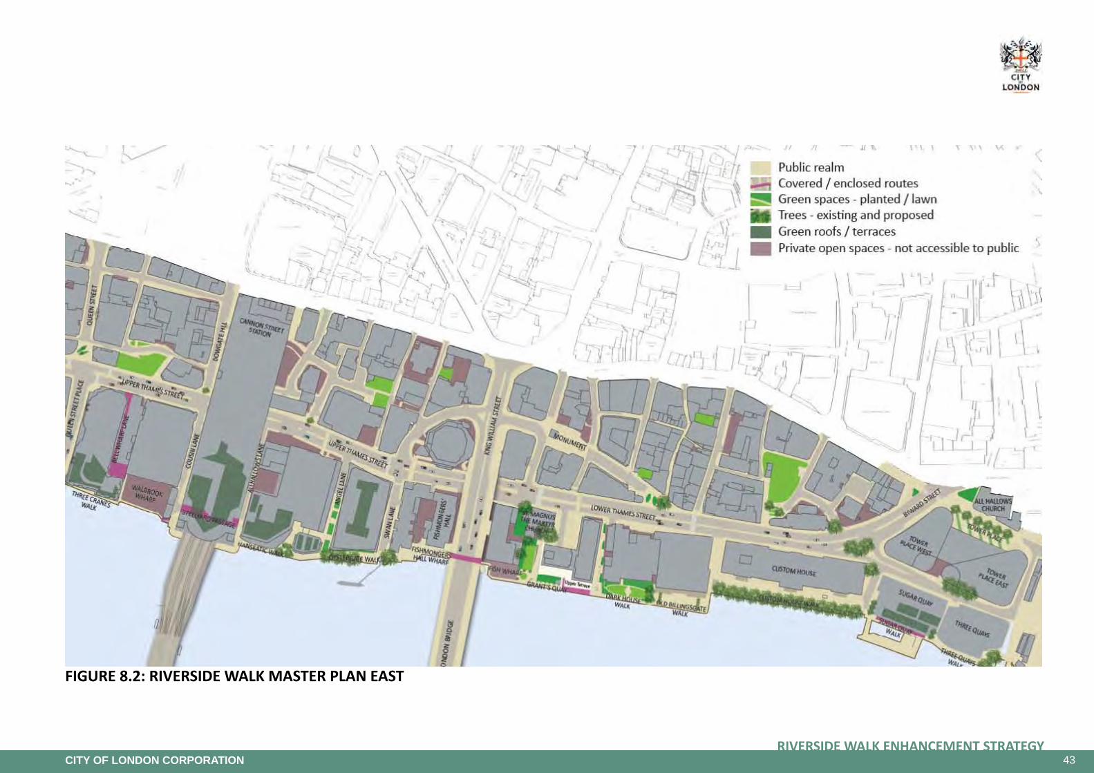
43RIVERSIDE WALK ENHANCEMENT STRATEGY
CITY OF LONDON CORPORATION
FIGURE8.2:RIVERSIDEWALKMASTERPLANEAST

44RIVERSIDE WALK ENHANCEMENT STRATEGY
CITY OF LONDON CORPORATION
8.2 OverallVision
Since the original Strategy was adopted in 2005, the Riverside Walk has become more popular with increasing numbers of local workers, residents and visitors making use of the riverside, not only as a walking route but as a quiet place to relax. The users of the walkway are changing too, with a wider variety of people including visitors, families and weekend users. The additional number of people using the walkway has also led to increased pressure on the available space, particularly as the walkway is used by a large number of joggers and an increasing number of illegal cyclists.
The implementation of the strategy has made the riverside greener, more comfortable, more popular and better connected to the rest of the City. However, the strategy is now over nine years old and the nature of the area and the people who use it has changed significantly in that time.
This update to the original strategy aims to bring the document in line with current policy, including the Local Plan, and ensure that it meets the changing needs of the area.
The vision for the updated strategy is to make the Riverside Walk better connected and accessible as a continuous walkway as well as a destination for people to enjoy. The vision also seeks to improve the quality of spaces and promote the creation of new spaces for people to enjoy, to increase greenery and to support biodiversity and incorporate SuDS to combat flooding. Additionally, the cohesion and vibrancy of the riverside will be increased through development opportunities along the river front.
A better connected and accessible Riverside Walk: The creation of universally accessible connections between the riverside and the rest of the City should be achieved through improved pedestrian crossings and an improved and comprehensive wayfinding system. The Riverside Walk itself should be made fully accessible by supporting stepped sections with ramps. In the case of sections of the walkway diverted away from the river’s edge, continuity along the riverside should be promoted where possible.
AhighqualityRiversideWalkwithmoreopen/greenspaces: Many sections of the Riverside Walk have been improved with high quality paving and streetscape elements and planting that can adapt to climate change. Such improvements should be extended to all sections of the Riverside Walk. Improving existing green areas to include river views, opportunities for sitting and relaxing, a variety of planting that supports biodiversity and SuDS to combat surface water flooding would encourage people to linger and enjoy the spaces.
The creation of new open/green spaces should be considered by opening up privately owned riverside open spaces for public use and encouraging new developments to create riverside open spaces.
A vibrant and cohesive Riverside Walk: Much of the Riverside Walk’s land is privately owned however, encouraging new developments to provide a spacious, accessible and better connected Riverside Walk would assist in the creation of a cohesive and continuous walkway. New developments also provide the opportunity to increase active uses and owners should be encouraged to provide cafés and restaurants along the Riverside Walk, adding to its vibrancy and helping to develop it as a destination. Other elements such as appropriately located public art, play areas and event spaces would further enhance the Riverside Walk. However the provision for such active uses will need to take into account the need to provide quiet areas for residents.
Promoting the Riverside Walk: Promoting the Riverside Walk to all audiences would help draw visitors. As an initial step, the Riverside Walk should be identified in City mapping and signage and as the provision of riverside activities through new developments come on stream, additional methods such as an exclusive ‘northside’ website should be considered to make known what is there based on the successful South bank initiatives.

45RIVERSIDE WALK ENHANCEMENT STRATEGY
CITY OF LONDON CORPORATION
Figure 8.3: Riverside Walk Developments and Projects
Re-developments In order to ensure continuity and high quality treatment of the Riverside Walk, future development will need to reflect the policies in the Local Plan and the Thames Estuary 2100 plan, including:
• Securing completion of the Riverside Walk - the route along the Riverside Walk is not direct currently, with a number of turns and diversions that make the journey difficult and discontinuous along the river edge for users. Future developments will be expected to allow for a publicly accessible riverside route / link to add to the continuity of the Riverside Walk in line with Policy CS9.2
• Ensuring new building frontages should be no further forward than existing and where the Riverside Walk is narrow, new buildings should be set back with the aim of achieving at least a recommended, minimum three metres wide, unobstructed setback between the building and the Riverside Wall in line with City Walkway Guidance Notes
• Making sure development allows for the inspection, repair and maintenance of flood defences, as well as ensuring that the flood defence level can be easily raised in the future in line with the TE2010 and Policy CS18.1
• Contribute towards improving the connection between the Riverside Walk and the rest of the City - for all future schemes, a key element of the development will be to promote better access to the Riverside from the City in line with Policy CS9.2
• Improve accessibility of the Riverside Walk: Future developments will be required to take into consideration the accessibility of the walkway and implement inclusive designs for the public realm in line with Policy CS10.4
• To create a better environment for the users of the Riverside Walk, the lighting and paving elements of any new sections of the Riverside Walk should be based on the lighting and paving strategies established in sections 8.4 and 8.4 of this Strategy
• The implementation of new public spaces will be promoted in the future developments in line with Policy CS19.1; where possible these could include rest places, terraces with al fresco dining, active frontages with cafés and restaurants, having regard to the need to protect the amenity of residents
• Particular attention will be required towards greening the area in order to make the Riverside Walk attractive and support biodiversity in line with policies CS9.2 and CS19.3. SUDs will be an important element of landscaping and trees and plant species should be chosen with consideration to climate change adaptation in line with Policies CS18.3 and CS15.5.

46RIVERSIDE WALK ENHANCEMENT STRATEGY
CITY OF LONDON CORPORATION

47RIVERSIDE WALK ENHANCEMENT STRATEGY
CITY OF LONDON CORPORATION
Figure 8.4: Commenced / recently approved schemes location plan
Figure 8.5: Existing walkway looking west-east Figure 8.6: Existing walkway looking east-west
8.3 Opportunity Areas
Schemes Commenced or Recently Approved
BlackfriarsBridgeWalkwaySignificant improvements have been made to this part of the Riverside Walk area in recent years, including refurbishment works to Blackfriars Railway Bridge and wider public realm enhancements to Paul’s Walk -Western End; however there is an opportunity to further enliven and enhance the area directly under the bridge, which is currently an underutilised space.
The construction of the Thames Tideway Tunnel (see section 8.3) is likely to create some physical disruption in the area in the medium term and may also create additional challenges to moving through the area.
The City of London now has funding in place to deliver tangible improvements to this space and create a significantly improved environment for residents, businesses and visitors to the City.
The City is looking at a number of possible approaches to deliver the aims of the project, including the installation of an art-work piece that will add interest and improve the levels of lighting within the space.
The aims of the project are, in the short term, to activate the space; in the medium term, to create an attractive space during Thames Tunnel construction; and in the long term, to deliver a vibrant and accessible Riverside Walk.

48RIVERSIDE WALK ENHANCEMENT STRATEGY
CITY OF LONDON CORPORATION
Figure 8.7: Commenced / recently approved schemes location plan
Figure 8.8: Millennium Bridge Approach - montage of proposalsFigure 8.9: Millennium Bridge Approach - area before works
Millennium Bridge AreaThis area provides one of the busiest pedestrian gateways into the City and offers a first impression of the City of London to the numerous visitors on this route. The decline in the quality of this area does not match with the environment that has been created around St. Paul’s Cathedral, and when combined together these two areas make a significant statement about the quality and values of the City in terms of its civic nature and position within the capital, effectively providing a quality branding for the City.
The area analysis has shown that there are two distinct functions within the public realm in this area:
• Paul’s Walk as part of the riverside promenade, and
• the space beneath the bridge being potentially used as a gathering area.
A project has been developed that proposes enhancements that accentuate and complement these functions and establish a pleasant and welcoming environment for the benefit of all users.
Millennium Bridge Approach - Proposals There is also a desire to remove the HSBC gates. The Culture, Heritage and Libraries Committee acknowledged that the gates do not work well in their current location. A separate submission outlining their market value and investigating potential disposal options, including relocation and resale, would need to be considered further by the City Arts Initiative Advisory Panel and the Culture, Heritage and Libraries Committee.
Improving the signage in this area to assist pedestrian navigation also forms part of the proposals. Worn out, damaged and missing signage will be replaced and updated to accord with the City standard. There is also a need to add signage for the newly refurbished Inclinator.

49RIVERSIDE WALK ENHANCEMENT STRATEGY
CITY OF LONDON CORPORATION
Figure 8.10: Globe View riverfront Figure 8.11: Plan of the proposed walkway
Figure 8.12 existing walkway (eastern end)
Figure 8.13: sketch of the proposed walkway (eastern end)
Figure 8.14: existing walkway (western end)
Figure 8.15: sketch of the proposed walkway (western end)
Paul’sWalk-ProposalsThe design concept for Paul’s Walk proposes a green planted border in front of the school, with spaces between the planting areas to accommodate building entrances and exits, together with seating on the outer edges. The broken concrete paving will be replaced with York stone flags to provide a more consistent finish. Lighting will also be enhanced. The existing stepped planter in front of Millennium Bridge House that is in a poor condition and a focus of anti-social gathering will be replaced with a more suitable design. As this is an area that is at risk of surface water flooding, a sustainable drainage system (SuDS) will also be introduced.
It is proposed that the area beneath the Millennium Bridge be enhanced to create a more welcoming space with a usable seating area and associated lighting.
This scheme began in July 2014 and is due for completion by autumn 2015.
GlobeViewWalkwayGlobe View is a residential block of flats with a restaurant/bar on part of the ground and first floors accessed via Stew Lane. The Riverside Walk in this area currently follows a long diversion route along High Timber Street (away from the river) which is confusing and frustrating for many users.
The main objective of this project is the opening of the Riverside Walk at Globe View which has been gated shut since 2003 due to problems of rough sleeping and fire lighting. The layout of this covered walkway has numerous twists and turns and hidden corners that encourage anti-social behaviour and ledges that can be used by rough sleepers. Introducing of monitored CCTV will be investigated to enable the opening-up of the covered walkway.
The covered walkway has narrow openings (only 900mm wide at the western end). It also has an enclosed feeling and users cannot see the river as they pass through, as the windows are very high up (about 7 feet above ground level). The layout of the eastern end of the walkway is particularly awkward as it forms a ‘dog-leg’ and and creates a blind corner. The environment of the walkway at Globe View is similar in many respects to the existing situation at London Bridge Staircase, which is plagued by anti-social behaviour and crime and is planned to be replaced with a new staircase in an open riverside location.
Options have been developed that include a new section of external walkway in this location and further consultation with residents will be undertaken in 2015. Works are expected to be completed to coincide with the opening of the walkway under the hotel development at Queenhithe.

50RIVERSIDE WALK ENHANCEMENT STRATEGY
CITY OF LONDON CORPORATION
Figure 8.16: Commenced / recently approved schemes location planFigure 8.17: Bell Wharf Lane as existing
Figure 8.18: Bell Wharf Lane aspirational scheme
Riverside Walk Diversion - QueenhitheThe completion of the Riverside Walk along the riverfront is a key element in its enhancement as a pedestrian route as part of the Thames Path natural trail and as an open space for public amenity.
The Riverside Walk currently diverts away from the river at High Timber Street. Pedestrians are directed onto Upper Thames Street, where the environment is dominated by the traffic and infrastructure associated with a major urban highway. In the short to medium term, enhancements have been implemented to High Timber Street. In the longer term, it is planned to continue the Riverside Walk adjacent to the river, under the buildings at Globe View, Queensbridge House and Queens Quay House. The proposals to enhance and open up the walkway at Globe View are set out in the previous paragraph. However, there is still a section of the Riverside Walk at Queensbridge House/Queens Quay House that is not yet complete.
The completion of the walkway at Queensbridge House is planned through the implementation of a planning permission for a hotel granted on 20 March 2012. The development agreement between the City and the developer includes the provision of a section of the Riverside Walk under the neighbouring residential building at Queens Quay. A planning application was submitted in July 2012 for this section of walkway as well as a restaurant use. Works on the hotel development will commence in 2015.
The development in this area provides the opportunity to introduce additional features such as feature lighting or some form of public art.
Bell Wharf LaneBell Lane Wharf provides an accessible connection from the Riverside Walk to Upper Thames Street and an alternative route when the walkway across Walbrook Wharf is gated during crane operations.
Bell Wharf Lane also provides a rear access to the Little Ship Club, which is located on the ground floor of the Thames Exchange Building as well as access to the NCP car park and Walbrook Wharf.
Bell Wharf Lane is largely enclosed under the Thames Exchange Building. There is no wayfinding signage to it from the Riverside Walk and once entered from the Riverside Walk it has the appearance of a service road.
In March 2014, a first phase of improvements was implemented to provide new feature lighting in the tunnel and bollards that were installed along the western footway.
A second phase of improvement is due to be implemented in January 2015, which will enhance the paving in Bell Wharf Lane footways, better organise the space around and the access to the depots. Wayfinding to the Riverside Walk is also to be installed and cycle racks will be relocated on the footway located at the eastern entrance of the lane. An experimental traffic order has been put in place to make the lane “Access Only” and is to be effective on 28th October 2014. All these enhancements will provide an improved connection to the Riverside Walk and encourage access to one of its quieter sections.

51RIVERSIDE WALK ENHANCEMENT STRATEGY
CITY OF LONDON CORPORATION
Figure 8.19: Commenced / recently approved schemes location plan
Figure 8.20: Fishmongers’ Hall area with proposed rampFigure 8.21: Fishmongers’ Hall area as existing with steps
Fishmongers’HallWharfThe existing steps at Fishmongers’ Hall Wharf are the only inaccessible part of the Riverside Walk in the City of London. This stretch of the Riverside Walk is private land owned by the Fishmongers’ Company and leased to the City. The steps to the foreshore are also privately owned and the Fishmongers Company is planning to restore them.
The current ‘step-free’ diversion route takes users on a long diversion away from the Riverside Walk via Swan Lane and Lower Thames Street and only re-joins further east at Dark House Walk. This diversion route is long and unpleasant and Lower Thames Street is very heavily trafficked, noisy and polluted.
The option of making this stepped section of the Riverside Walk accessible for all users is being explored. This accords with the main aims of the adopted Riverside Walk Enhancement Strategy.
The initiation of this project was approved by the committee in July 2013. The City of London together with Fishmongers’ Company have developed a design that will replace part of the steps with a gentle ramp along the River Wall, paved in York stone to match surrounding paving. The remaining steps will be re-configured to form a wider staircase alongside the slope that will incorporate the adjacent corner space that is currently under-utilised. The existing lighting columns will be replaced with historic sturgeon lights.
This design will maximise the flat surface in front of the Fishmongers’ Hall to enable events to take place, maintain the access around the Hall and provide a comfortable route for wheelchair users.
The works are expected to start on site in early 2015 and will be coordinated with the London Bridge Staircase project to minimise disruption to occupiers (see section 8.3).

52RIVERSIDE WALK ENHANCEMENT STRATEGY
CITY OF LONDON CORPORATION
Figure 8.22: Commenced / recently approved schemes location plan
Figure 8.23: Montage of the proposed new staircase
Figure 8.24: London Bridge - existing closed staircase to Riverside Walk within bridge structure
London Bridge to the Riverside WalkA new staircase to connect London Bridge to the Riverside Walk is a core project of the Strategy.
The connection between the upper level of London Bridge and the Riverside Walk is poor in terms of its accessibility and legibility, but is especially poor in terms of the local environment.
The existing staircase that links London Bridge to the Riverside Walk is located within the bridge structure adjacent to Adelaide House. The staircase is not clearly identifiable from street level or from the riverside, and once located, takes the pedestrian on a complex journey through enclosed spaces within the bridge abutment. Even though it is regularly washed down, disinfected and brightly lit, it retains a highly unpleasant environment where the public do not feel comfortable or safe, both during the day and at night. The space attracts anti-social behaviour and people have also been mugged and assaulted on this staircase.
The existing staircase will be demolished as part of the Riverside Walk Enhancement Strategy.
A new staircase is planned to be constructed on the Riverside Walk on the east side of London Bridge and cantilevered over the river. The staircase will have an open aspect whereby users will be overlooked from the bridge above and the walkway below. This natural surveillance will help ensure that users no longer feel uncomfortable or unsafe when walking between the bridge and the riverside and avoid the issues with the existing staircase.
The new staircase will be constructed from high quality materials, primarily stainless steel, will incorporate York stone treads and will be lit by LED lighting within the handrail. The new landing for the staircase will merge into a footbridge, which will replace the existing timber footbridge, and will be paved in York stone to match surrounding paving.
The construction of this staircase has been delayed due to licence agreement and agreement with neighbouring owners. The work will commence in late 2014.

53RIVERSIDE WALK ENHANCEMENT STRATEGY
CITY OF LONDON CORPORATION
Figure 8.25: Future schemes location plan
Figure 8.26: Proposed Blackfriars Bridge Foreshore
Figure 8.27 (above): Proposed Blackfriars Millennium Pier
Figure 8.28: Thames Tideway Tunnel Blackfriars Bridge Foreshore proposals
Blackfriars Bridge Foreshore
20
Figure 3A: Photo of the site – before the works
Figures 3A, 3B, 3C and 3D show the current site and provide illustrations of our design proposals. Further information on the development of our design can be found in the Design development report.
Related documents: Design
Figure 8.29: Existing former London Fire Brigade Pumphouse adjacent to Blackfriars Millennuim Pier
Future Schemes
ThamesTidewayTunnel,BlackfriarsBridgeForeshoreThe Thames Tideway Tunnel proposal has been designated as a Nationally Significant Infrastructure Project. It is a major new sewer that will tackle the problem of overflows from the capital’s Victorian sewers and will protect the River Thames from increasing pollution for at least the next 100 years.
A new foreshore structure will be built where the existing Pier is currently located, at the west of the Blackfriars bridges. A new Pier will be built at the east of Blackfriars bridges.
After the completion of the construction work, when the main tunnel will be in use, the new foreshore structure will become a large new public space on the west side of Blackfriars Bridge, which will add to the enhancement of the Riverside Walk in this area and provide the opportunity for new cafes / kiosks. A number of functional elements required for the tunnel operation and maintenance will be incorporated within the design of the structure and public space.
The proposal has received planning approval and is currently under development. Construction is planned to start in 2016.
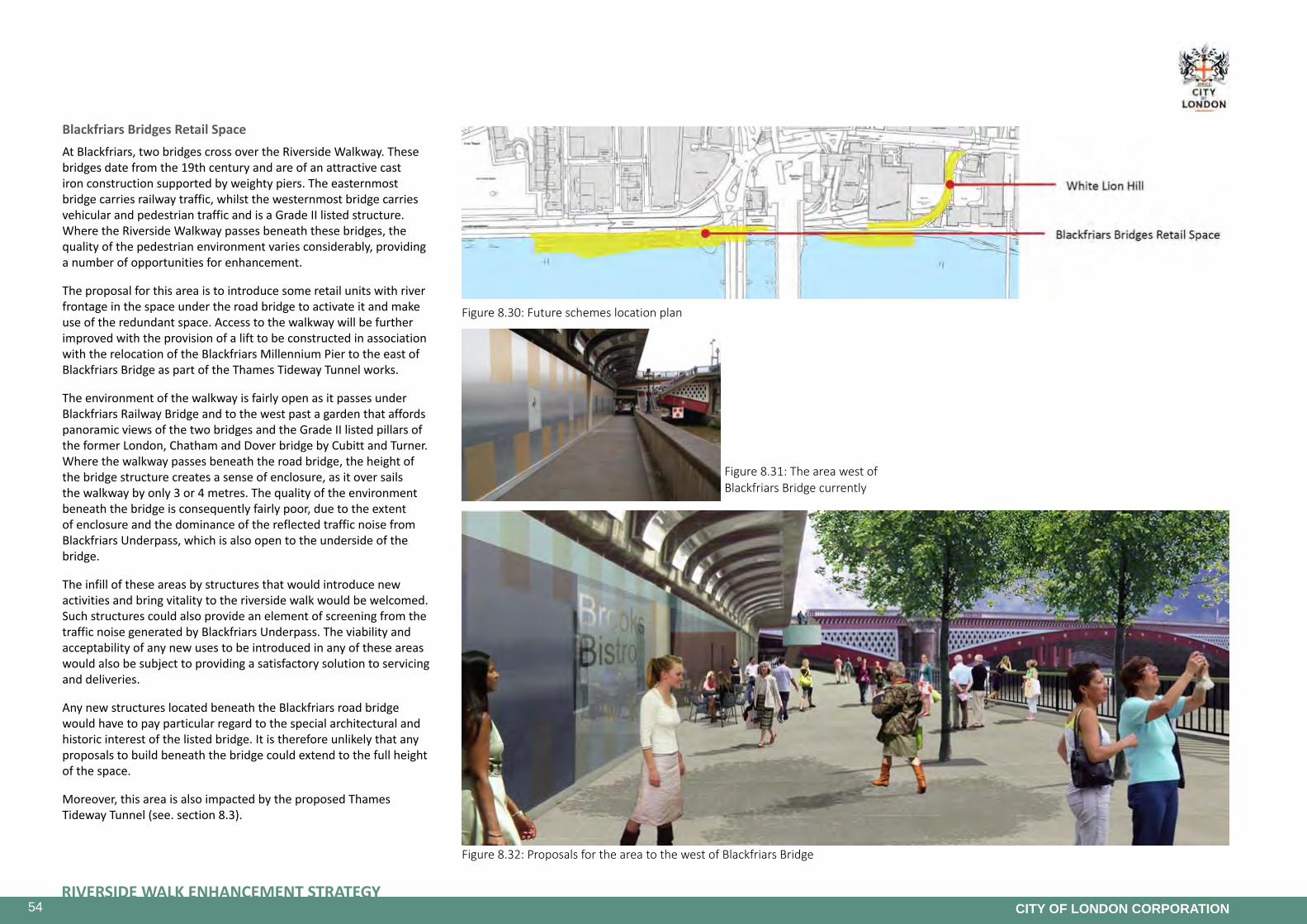
54RIVERSIDE WALK ENHANCEMENT STRATEGY
CITY OF LONDON CORPORATION
Figure 8.30: Future schemes location plan
Figure 8.31: The area west of Blackfriars Bridge currently
Figure 8.32: Proposals for the area to the west of Blackfriars Bridge
Blackfriars Bridges Retail SpaceAt Blackfriars, two bridges cross over the Riverside Walkway. These bridges date from the 19th century and are of an attractive cast iron construction supported by weighty piers. The easternmost bridge carries railway traffic, whilst the westernmost bridge carries vehicular and pedestrian traffic and is a Grade II listed structure. Where the Riverside Walkway passes beneath these bridges, the quality of the pedestrian environment varies considerably, providing a number of opportunities for enhancement.
The proposal for this area is to introduce some retail units with river frontage in the space under the road bridge to activate it and make use of the redundant space. Access to the walkway will be further improved with the provision of a lift to be constructed in association with the relocation of the Blackfriars Millennium Pier to the east of Blackfriars Bridge as part of the Thames Tideway Tunnel works.
The environment of the walkway is fairly open as it passes under Blackfriars Railway Bridge and to the west past a garden that affords panoramic views of the two bridges and the Grade II listed pillars of the former London, Chatham and Dover bridge by Cubitt and Turner. Where the walkway passes beneath the road bridge, the height of the bridge structure creates a sense of enclosure, as it over sails the walkway by only 3 or 4 metres. The quality of the environment beneath the bridge is consequently fairly poor, due to the extent of enclosure and the dominance of the reflected traffic noise from Blackfriars Underpass, which is also open to the underside of the bridge.
The infill of these areas by structures that would introduce new activities and bring vitality to the riverside walk would be welcomed. Such structures could also provide an element of screening from the traffic noise generated by Blackfriars Underpass. The viability and acceptability of any new uses to be introduced in any of these areas would also be subject to providing a satisfactory solution to servicing and deliveries.
Any new structures located beneath the Blackfriars road bridge would have to pay particular regard to the special architectural and historic interest of the listed bridge. It is therefore unlikely that any proposals to build beneath the bridge could extend to the full height of the space.
Moreover, this area is also impacted by the proposed Thames Tideway Tunnel (see. section 8.3).
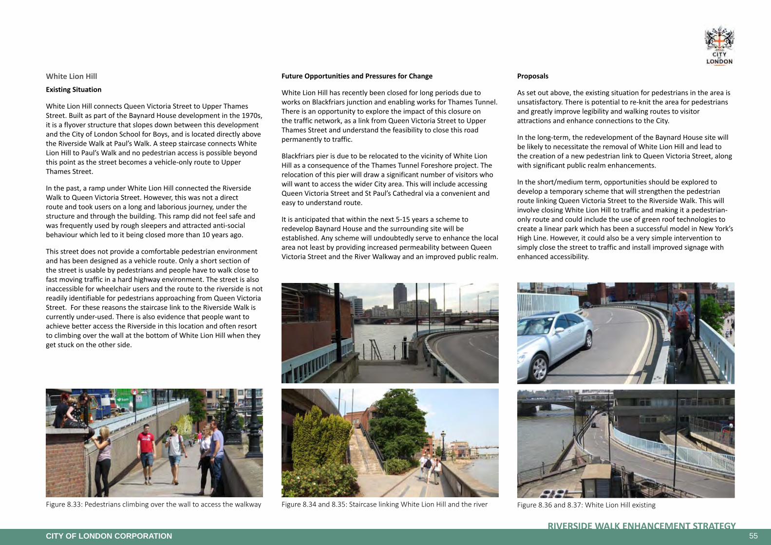
55RIVERSIDE WALK ENHANCEMENT STRATEGY
CITY OF LONDON CORPORATION
Figure 8.36 and 8.37: White Lion Hill existingFigure 8.33: Pedestrians climbing over the wall to access the walkway Figure 8.34 and 8.35: Staircase linking White Lion Hill and the river
White Lion HillExisting Situation
White Lion Hill connects Queen Victoria Street to Upper Thames Street. Built as part of the Baynard House development in the 1970s, it is a flyover structure that slopes down between this development and the City of London School for Boys, and is located directly above the Riverside Walk at Paul’s Walk. A steep staircase connects White Lion Hill to Paul’s Walk and no pedestrian access is possible beyond this point as the street becomes a vehicle-only route to Upper Thames Street.
In the past, a ramp under White Lion Hill connected the Riverside Walk to Queen Victoria Street. However, this was not a direct route and took users on a long and laborious journey, under the structure and through the building. This ramp did not feel safe and was frequently used by rough sleepers and attracted anti-social behaviour which led to it being closed more than 10 years ago.
This street does not provide a comfortable pedestrian environment and has been designed as a vehicle route. Only a short section of the street is usable by pedestrians and people have to walk close to fast moving traffic in a hard highway environment. The street is also inaccessible for wheelchair users and the route to the riverside is not readily identifiable for pedestrians approaching from Queen Victoria Street. For these reasons the staircase link to the Riverside Walk is currently under-used. There is also evidence that people want to achieve better access the Riverside in this location and often resort to climbing over the wall at the bottom of White Lion Hill when they get stuck on the other side.
Future Opportunities and Pressures for Change
White Lion Hill has recently been closed for long periods due to works on Blackfriars junction and enabling works for Thames Tunnel. There is an opportunity to explore the impact of this closure on the traffic network, as a link from Queen Victoria Street to Upper Thames Street and understand the feasibility to close this road permanently to traffic.
Blackfriars pier is due to be relocated to the vicinity of White Lion Hill as a consequence of the Thames Tunnel Foreshore project. The relocation of this pier will draw a significant number of visitors who will want to access the wider City area. This will include accessing Queen Victoria Street and St Paul’s Cathedral via a convenient and easy to understand route.
It is anticipated that within the next 5-15 years a scheme to redevelop Baynard House and the surrounding site will be established. Any scheme will undoubtedly serve to enhance the local area not least by providing increased permeability between Queen Victoria Street and the River Walkway and an improved public realm.
Proposals
As set out above, the existing situation for pedestrians in the area is unsatisfactory. There is potential to re-knit the area for pedestrians and greatly improve legibility and walking routes to visitor attractions and enhance connections to the City.
In the long-term, the redevelopment of the Baynard House site will be likely to necessitate the removal of White Lion Hill and lead to the creation of a new pedestrian link to Queen Victoria Street, along with significant public realm enhancements.
In the short/medium term, opportunities should be explored to develop a temporary scheme that will strengthen the pedestrian route linking Queen Victoria Street to the Riverside Walk. This will involve closing White Lion Hill to traffic and making it a pedestrian-only route and could include the use of green roof technologies to create a linear park which has been a successful model in New York’s High Line. However, it could also be a very simple intervention to simply close the street to traffic and install improved signage with enhanced accessibility.

56RIVERSIDE WALK ENHANCEMENT STRATEGY
CITY OF LONDON CORPORATION
Figure 8.38: Future schemes location plan
Figure 8.39: Aspirational picture - High Line, New York
Figure 8.40: Aspirational picture - High Line, New York Figure 8.41: Passage under Southwark Bridge, stairs to upper bridge level
Figure 8.42: Southwark Bridge passage south side
Figure 8.43: Passage enhancements in Westminster
Figure 8.44: Passage under Southwark Bridge
SouthwarkBridgeAreaThis is a complex section of the Riverside Walk due to the private / public nature of the area under the bridge and connection issues between the bridge level and the Riverside Walk and the sections of the walkway to the west and east of the bridge area.
The connection between the upper level of Southwark Bridge and the Riverside Walk is poor in terms of its accessibility and legibility.
The existing staircases that link Southwark Bridge to the Riverside Walk are located at both edges of the bridge structure. The staircases are not clearly identifiable from street level and very narrow, preventing two way flows. Moreover, these staircases are not welcoming for pedestrians.
The connection between the western section and the eastern section of the walkway beneath the bridge is an enclosed passage.
Redevelopment of the buildings will present opportunities for a better connection here in the long term. In the short/medium term, enhancements to the passageway could be implemented to make it more attractive and improve connections.

57RIVERSIDE WALK ENHANCEMENT STRATEGY
CITY OF LONDON CORPORATION
Figure 8.45: Future schemes location plan
Figure 8.46: Walkway link under Cannon Street Railway Bridge - proposed.
Figure 8.47: Plan of proposed walkway under Cannon Street Railway Bridge
Figure 8.48: Riverside Walk at Cannon Street Railway Bridge as existing
Figure 8.49: Existing condition of the underside of the Cannon Street Railway Bridge
Cannon Street Under BridgeThis is a proposal to create a walkway under the Cannon Street rail bridge as a riverside alternative to the Steelyard Passage. A number of options have been developed.
However, this project is on hold as the current operators of the waste transportation barges use that archway as their route from Walbrook Wharf. Agreement from current or future barge operators to use the adjacent archway would allow for the walkway to be built. Therefore, this is included in the strategy as a longer term aim.
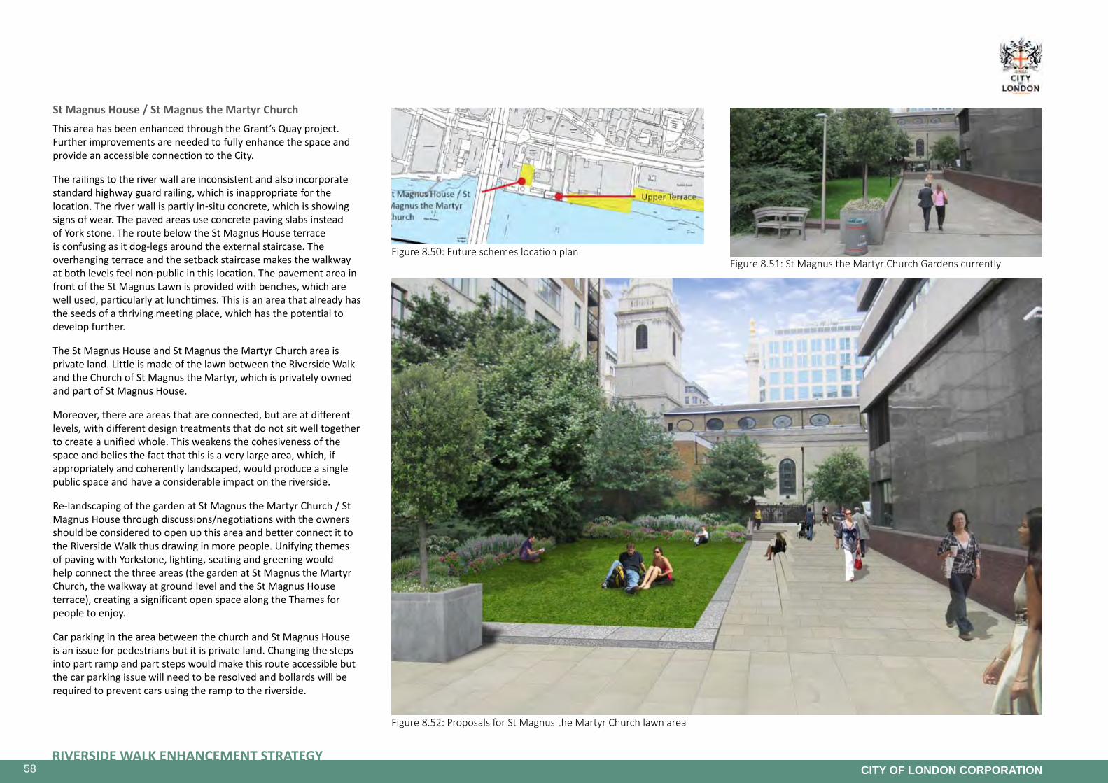
58RIVERSIDE WALK ENHANCEMENT STRATEGY
CITY OF LONDON CORPORATION
Figure 8.50: Future schemes location planFigure 8.51: St Magnus the Martyr Church Gardens currently
Figure 8.52: Proposals for St Magnus the Martyr Church lawn area
StMagnusHouse/StMagnustheMartyrChurchThis area has been enhanced through the Grant’s Quay project. Further improvements are needed to fully enhance the space and provide an accessible connection to the City.
The railings to the river wall are inconsistent and also incorporate standard highway guard railing, which is inappropriate for the location. The river wall is partly in-situ concrete, which is showing signs of wear. The paved areas use concrete paving slabs instead of York stone. The route below the St Magnus House terrace is confusing as it dog-legs around the external staircase. The overhanging terrace and the setback staircase makes the walkway at both levels feel non-public in this location. The pavement area in front of the St Magnus Lawn is provided with benches, which are well used, particularly at lunchtimes. This is an area that already has the seeds of a thriving meeting place, which has the potential to develop further.
The St Magnus House and St Magnus the Martyr Church area is private land. Little is made of the lawn between the Riverside Walk and the Church of St Magnus the Martyr, which is privately owned and part of St Magnus House.
Moreover, there are areas that are connected, but are at different levels, with different design treatments that do not sit well together to create a unified whole. This weakens the cohesiveness of the space and belies the fact that this is a very large area, which, if appropriately and coherently landscaped, would produce a single public space and have a considerable impact on the riverside.
Re-landscaping of the garden at St Magnus the Martyr Church / St Magnus House through discussions/negotiations with the owners should be considered to open up this area and better connect it to the Riverside Walk thus drawing in more people. Unifying themes of paving with Yorkstone, lighting, seating and greening would help connect the three areas (the garden at St Magnus the Martyr Church, the walkway at ground level and the St Magnus House terrace), creating a significant open space along the Thames for people to enjoy.
Car parking in the area between the church and St Magnus House is an issue for pedestrians but it is private land. Changing the steps into part ramp and part steps would make this route accessible but the car parking issue will need to be resolved and bollards will be required to prevent cars using the ramp to the riverside.

59RIVERSIDE WALK ENHANCEMENT STRATEGY
CITY OF LONDON CORPORATION
Figure 8.53: Upper Terrace and the staircase as seen from the enhanced walkway
Figure 8.54: Upper Terrace currently
Figure 8.55: Sign indicating public nature of terrace and entrance to staircase hidden behind planter and away from pedestrian approach
Upper Terrace
The high-level terrace in front of St Magnus House is not clearly delineated as a public space and is underused, despite the fact that it affords some of the best views of the Thames.
Possible improvements to increase footfall could include:
• Replacement of the existing staircase with a more open staircase leading directly from the Riverside Walk,
• Replacement of the high parapet walls with open railing/glass parapet, and
• Active frontage possibly including a café and roof garden to create an active space.

60RIVERSIDE WALK ENHANCEMENT STRATEGY
CITY OF LONDON CORPORATION
Figure 8.56: Future schemes location plan
Figure 8.57: Montague House green space currently Figure 8.58: Proposal for the enhancement of the Montague House green space
Montague House and Dark House Walk The green space in front of Montague House is maintained as a public amenity by the City Corporation and therefore accessible for public use. The space is set back from the main walking route along the edge of the river wall and includes benches and litter bins provided by the Corporation. It is already a very well used seating area, which illustrates how a garden approach to spaces on the Riverside Walk is popular with the public.
However, the enclosed nature of the space means that there is little relationship with the Thames and views of the river are cut off by the high planters that define the edges. The planters also disguise the access ramp at the western end of the space, which is the only way to avoid the steps that connect the two sections of Riverside Walk in front of Magnus House and Montague House. Opening up the garden along the southern edge, would allow views of the Thames from the seating area, whilst retaining the green character established by the existing garden.
This open space could be redesigned and de-cluttered to improve the connection to the Riverside Walk and open up views to the river whilst maintaining current levels of biodiversity. Accessibility could be improved by replacing the steps along the river wall by a ramp integrated within the design of the whole space. Improving the connection to the Billingsgate area would create a continuous sense of space along this section of the Riverside Walk while retaining character of the individual sections. In the long term, any redevelopment plans for Montague House would be encouraged to consider an active frontage to the open space.
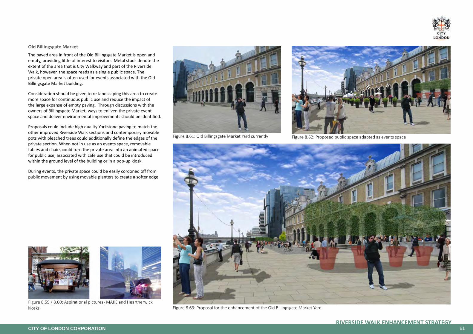
61RIVERSIDE WALK ENHANCEMENT STRATEGY
CITY OF LONDON CORPORATION
Figure 8.59 / 8.60: Aspirational pictures - MAKE and Heartherwick kiosks
Figure 8.61: Old Billingsgate Market Yard currently Figure 8.62: Proposed public space adapted as events space
Figure 8.63: Proposal for the enhancement of the Old Billingsgate Market Yard
Old Billingsgate MarketThe paved area in front of the Old Billingsgate Market is open and empty, providing little of interest to visitors. Metal studs denote the extent of the area that is City Walkway and part of the Riverside Walk, however, the space reads as a single public space. The private open area is often used for events associated with the Old Billingsgate Market building.
Consideration should be given to re-landscaping this area to create more space for continuous public use and reduce the impact of the large expanse of empty paving. Through discussions with the owners of Billingsgate Market, ways to enliven the private event space and deliver environmental improvements should be identified.
Proposals could include high quality Yorkstone paving to match the other improved Riverside Walk sections and contemporary movable pots with pleached trees could additionally define the edges of the private section. When not in use as an events space, removable tables and chairs could turn the private area into an animated space for public use, associated with cafe use that could be introduced within the ground level of the building or in a pop-up kiosk.
During events, the private space could be easily cordoned off from public movement by using movable planters to create a softer edge.

62RIVERSIDE WALK ENHANCEMENT STRATEGY
CITY OF LONDON CORPORATION
Figure 8.64: Future schemes location plan
Figure 8.65: Aspirational picture - Rhone riverbank, Lyon France
Figure 8.66: Aspirational picture - Granary Square, London
Figure 8.67 Riverwalk along Custom House currently Figure 8.68: Proposed enhanced Riverwalk and publicly accessible open space at Custom House
Custom HouseThe section of the Riverside Walk along Custom House is currently a two metre wide footpath. This confined nature of the walk is caused by the position of the railings alongside the adjoining car park.
This section of the walkway creates an unpleasant, often crowded environment for all users and there are only limited glimpses available of the impressive Grade I listed Custom House. The walkway along the embankment wall, which has scheduled monument status, is also flooded occasionally and unusable as the flood defence wall is located further back along the building edge.
Through discussions with current or future owners, the opportunity should be explored to bring the private forecourt entirely or in part (thus retaining some access for servicing) into public use, thus creating a continuous string of spaces for public use from Montague House to Sugar Quay.
Proposals could include creating a raised forecourt area that steps down to the current walkway level at the tree line. This would ensure the forecourt area remains dry and provides a continuous route on the days when the embankment is flooded. High quality paving, new railing to City standards, lighting, seating and public art as well as a cafe opening onto the forecourt area would help create an animated public space.
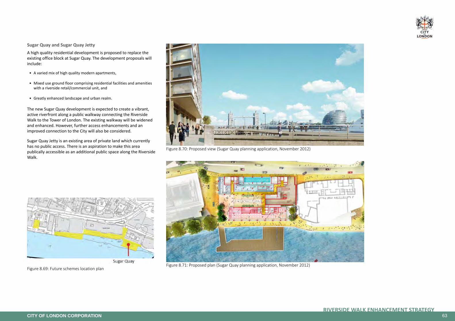
63RIVERSIDE WALK ENHANCEMENT STRATEGY
CITY OF LONDON CORPORATION
Figure 8.69: Future schemes location plan
97Sugar Quay Design and Access Statement
5.1
Figure 8.70: Proposed view (Sugar Quay planning application, November 2012)
100
Figure 8.71: Proposed plan (Sugar Quay planning application, November 2012)
SugarQuayandSugarQuayJettyA high quality residential development is proposed to replace the existing office block at Sugar Quay. The development proposals will include:
• A varied mix of high quality modern apartments,
• Mixed use ground floor comprising residential facilities and amenities with a riverside retail/commercial unit, and
• Greatly enhanced landscape and urban realm.
The new Sugar Quay development is expected to create a vibrant, active riverfront along a public walkway connecting the Riverside Walk to the Tower of London. The existing walkway will be widened and enhanced. However, further access enhancements and an improved connection to the City will also be considered.
Sugar Quay Jetty is an existing area of private land which currently has no public access. There is an aspiration to make this area publically accessible as an additional public space along the Riverside Walk.

64RIVERSIDE WALK ENHANCEMENT STRATEGY
CITY OF LONDON CORPORATION
Figure 8.72: New public space through private development at Hanseatic Walk
Figure 8.73: HafenCity Hamburg - Redevelopment of former port area for the new city district
8.4 Themes
Connecting Spaces Project Future YearsThe Connecting Spaces project is an ongoing project that includes paving, lighting and street furniture improvements on the Riverside Walk. Some improvements have been undertaken over the past three years but more are required to create an enhanced and better connected walkway.
The aim of the Connecting Spaces project is to create a walkway that is more coherent, better connected, more spacious and more vibrant.
More coherent: notwithstanding ownership issues, differing treatments to various sections of the Riverside Walk by some of the riverfront developments have created confusion with regards to public access through some of these sections. The use of a common language in terms of paving materials, lighting, street furniture and other streetscape elements throughout the Riverside Walk would make the walkway more coherent in terms of movement and appearance. Recent improvements to some sections of the walkway have started this process and encouraging future developments to adhere to the City Street Scene Manual guidance for works related to the Riverside Walk would ensure the creation of a truly coherent walkway.
Better connected: The Riverside Walk includes sections that create a disconnected feel such as the passages under bridges and the sections that divert away from the riverfront due to buildings extending to the water’s edge such as at Brook’s Wharf and Queen’s Quay. Creating lightweight, waterside walkway connections under bridges where feasible and opening up links along building edges would help create a continuous riverside walkway. Enhanced alternative routes that are clearly marked and easy to find are also important. Improving accessibility by introducing ramps and lifts where required would create a continuous walkway for all users. Connecting the Riverside Walk to the rest of the City is as important as having a continuous walkway and much has been done to improve pedestrian connections across the road that separates the Riverside from the rest of the City. Further improvements should consider the impact of the Cycle Superhighway planned as a segregated lane along this road. Signage and wayfinding should emphasise important links to the City and other destinations.
More spacious: Sections of the Riverside Walk are fairly narrow such as at Custom House Walk. Opening up adjacent private spaces for public use would help create a more spacious Riverside Walk. Future riverside developments should also be encouraged to deliver a comfortably wide riverside walkway as part of their development proposals.
More vibrant: Promoting active frontages along the Riverside Walk together with spaces for events, public art and play as well as well distributed sitting areas for lounging and relaxing along the waterfront will help make the Riverside Walk a vibrant destination. Future developments should consider active ground level uses along the riverfront . Active usage will however have to take account of the need to provide quiet areas for residents.
An art strategy (see section 8.4 and appendix 4) for the Riverside Walk looks at introducing public art in selected locations. Opening up some of the larger spaces such as Montague House gardens would help create spaces where annual events could be held, drawing more visitors on a yearly basis and in line with the City of London Corporation Cultural Strategy 2012 - 17.
The introduction of supporting infrastructure such as resting points and drinking fountains within the lanes and passages connecting to the Riverside Walk would also encourage more people to visit the Riverside Walk.
Many of the above mentioned interventions are currently being implemented or have been identified as possible future projects. The Connecting Spaces project will primarily address areas of the walkway that have not been included in previous and proposed schemes, in order to create a more attractive Riverside Walk that is better connected and more coherent for all users.

65RIVERSIDE WALK ENHANCEMENT STRATEGY
CITY OF LONDON CORPORATION
Figure 8.74: An inclinator by the Millennium Bridge steps
Figure 8.75: Ramped and stepped access in the Blackfriars Bridges area.
Access ImprovementsThe City of London is committed to creating an environment suitable for everyone and every opportunity should be taken to improve accessibility in ways that enhance the character and appearance of the Riverside Walkway. This should include improving the current provision of lighting and signage, treating footway surfaces in materials that are sympathetic to access and ensuring ramps and steps incorporate accessible features in their design such as corduroy tactile surfacing, handrails and highlighted tread nosing.
Much work has already been carried out to areas of the Walkway (i.e. ramps at Blackfriars and Sugar Quay) and to some of its approaches such as Angel Lane. However in order to provide a ‘seamless’ journey’ especially from many disabled peoples perspective, the strategy proposes to construct additional ramps in order to negate the need to divert away from the Walkway. Where possible ramps and steps should be provided adjacently as some people with an ambulant disability find ramps difficult to use.
A key objective is to produce a continuous accessible Riverside Walk that also includes accessible connections to the City toward the north and also to the bridges and Southbank beyond.
Addressing an inclusive design in the futures schemes
Any stepped flights should have tactile surfacing, correctly designed handrails and suitably highlighted tread nosing.
Both adequate and sufficient lighting, seating and signage along the Riverside Walkway are very important features, particularly for disabled people. It is often the case that people, especially with a visual impairment, feel vulnerable in poorly lit environments. Indeed good lighting in the pedestrian environment is important from several points of view – not only personal security and safety but the ability to reads signs as well as highlighting any potential hazards.
Well designed seating that is both accessible and inclusively positioned on the Walkway is fundamental if disabled people are using the area with relative ease. Traditional bench style seating (as in place elsewhere in the City) is a model example of accessibly and ideally all seating should have a seat height of approximately 500mm together with fitted armrests and backrests. Furthermore, seating should be arranged to ensure there is sufficient space to at least one side of a bench for a wheelchair user to park or an assistance dog to rest.
Signage too is an important element (both informational and directional) and the inclusion of distances into signage design should be considered. Self-propelled wheelchair users in particular have an innate need to conserve strength when necessary and good signage can help in this respect.
The use of Yorkstone paving extensively along the Riverside Walkway, will provide a relatively even, safe and comfortable surface for ambulant disabled people, together with wheelchair and mobility scooter users, to traverse.
Any children’s play equipment provided should be accessible to take into account the needs of disabled children. Public Art for the Riverside should also be considered from a disability perspective.

66RIVERSIDE WALK ENHANCEMENT STRATEGY
CITY OF LONDON CORPORATION
Figure 8.76: Proposed artworks for Grants Quay Figure 8.77: River Thames 1885 - Potential Interpretation Boards
Public Art and EventsThousands of City workers and tourists use the Riverside Walk throughout the year mainly as a route that links destinations rather than as a destination in itself. The City’s riverside is steeped in history, is on the sunny side of the river and has a wealth of public spaces to sit down, relax and enjoy views across the Thames. However many of the spaces are lacking in quality and stimulating elements such as public art to pique the interest of the passer-by into stopping to explore and enjoy the area.
The Riverside Walk Art Strategy
The Riverside Walk Art Strategy was developed in mid 2010 to support the Riverside Walk Enhancement Strategy in improving and uplifting the public realm along the embankment and creating spaces for people to stop and enjoy the Thames.
The Art Strategy looks at how public art could help establish the Riverside Walk as a key cultural route through the City. It provides suggested routes, possible artists and proposed artworks for the several identified sites along the Riverside Walk that would be visually arresting and popular amongst visitors whilst maintaining credibility as high quality and critically engaging works of contemporary art.
Two overarching themes have been suggested for the commissioning of artworks for the Riverside Walk. These include:
Interaction&Exploration: artworks that go beyond being stand-alone sculptural works, but that are embedded within the landscaping of the spaces they occupy, with semi-functional objectives such as seating, lighting or play-orientated works; all designed to encourage the public to use the spaces – to explore the artworks, discover their meaning in more depth and to have greater ownership of them.
History and Identity: artworks that draw on the rich history of the area and its relationship with the Thames and reflect the identity of the City of London.
When considering the form and sitting of public works of art their proximity to and impact on listed buildings must be considered. The advice of the City’s Historic Environment Officers should be sought as to the suitability of art works which may affect the setting of listed buildings. The impact of art works on riverside residents is also a consideration, particularly where works involve sound or light, or where the art work is likely to draw large numbers of visitors.
Sites identified for artwork installations and suggested routes include:
White Lion Hill
• landscaping to transform the site entirely,
• lighting to improve the existing streetlights, and
• water feature to highlight the playful character of the site and encourage play.
Paul’sWalk
• Lighting: a path of animated light-based works incorporated into the soft planting that activate the area at night,
• Embedded text: carved into the walls, paving and other surfaces referencing the route of the Thames, and
• Wayfinding / signage.
Peter’sHill:UnderMillenniumBridge
• Sculptural Marker: a bold work of scale to attract visitors,
• Lighting Project: interactive work under the bridge itself, and
• Paving Intervention: non-invasive work visible from street level and from the bridge itself.
Peter’sHill:MillenniumBridgeApproach
• Sound Installation: an invisible audio intervention or guide, and
• Seating Sculpture: a functional street furniture project.
Angel Lane
Expand upon the recent works using themes of visibility and participation:
• Freestanding structure: a sculptural project for staging events,
• Route making: architectural intervention leading visitors through the space, and
• Spatial awareness: a lighting project drawing attention to the space itself.
Grants Quay
Two existing works have been identified for the site:
• Seating Sculpture: Skystation by Peter Newman, and
• Exploration and play: View by Matts Leiderstam.

67RIVERSIDE WALK ENHANCEMENT STRATEGY
CITY OF LONDON CORPORATION
Figure 8.78: Ground lights at Steelyard Passage
Additional Suggestions for Public Art and Installations
With the extent of re-development taking place within the City, it is expected that over the years, the Riverside will have its fair share of re-development projects. This provides the opportunity to create more publicly accessible open spaces along the embankment by encouraging developers to follow the setback guidance set out within this document (see Section 8.1 Overall Vision).
Furthermore, a number of already accessible spaces have been identified for public realm enhancement through this strategy review. Also it is hoped that through discussions with owners of building such as Custom House and Old Billingsgate Market, the riverfront spaces associated with these buildings could be brought more into public use.
The above measures would bring forth a number of sizable spaces along the riverfront where public art could play an important role in helping draw people to linger and explore. The types of public art works / features could include:
• Sensory planting,
• Interactive lighting installations also assisting wayfinding,
• Interactive water features,
• Water features allowing multi-use of space,
• Static artworks as landmark features, and
• Temporary installations.
The larger spaces could also provide much needed venues for events related to the Thames Festival, the City of London Festival and other such happenings.
Possible additional open spaces for artworks include:
ThamesTidewayTunnelBlackfriarsBridgeForeshore: this new open space will provide opportunities for artwork installations. Those proposed include:
• Terraced rainwater gardens that would provide a sensory experience while adding to greenery and biodiversity along the Riverwalk,
• the line of the River Thames inscribed in the paving,
• bespoke circular seating elements that appear as stepping stones,
• five ventilation columns of 4 -5m heights disguised to appear as an art installation, and
• an ideal space for temporary art installations or events.
• St Magnus House Upper Terrace: sensory terrace garden adding to greenery and biodiversity along the Riverwalk.
Montague House: sensory green space with seating arranged to allow views across the Thames from varying angles. The space could accommodate a static art piece.
Old Billingsgate Market: the space in front of the building could be a space for temporary art installations or cultural events when not in use for private events.
Custom House: if the car park could be removed and the space opened up for public access, it could be designed to include artworks that reflect the symmetry of the facade. This would also be a significant opportunity for events or temporary art installations.
Alternative/deviatingsectionsofRiverwalk: Ground lighting installations similar to that within Steelyard Passage could be used to mark all alternative routes and sections that deviate away from the river path. The consistency of design would work as an indicator informing people that they would be moving away from the regular route at that point and the line of lights would act as a guide through the stretch of alternative / hidden route.
Events
There are clear synergies between the Riverside walk enhancement strategy and the City’s visitor and cultural strategies.
There is an opportunity to encourage the use of the Riverside walk in the City as more of a destination (audiences coming to it because of it, not on their way somewhere else). Events are seen as a key mechanism to encourage greater use of the area. The Riverside location could provide a dramatic stage for a variety of events. Furthermore, its separation from traffic and sunny outlook offers the ideal location for family orientated or small scale events. Consideration of any proposals will also need to take account of noise disturbance and residential amenity.
Examples of possible events, activities or experiences are:
• City of London Festival events (every summer),
• The Thames Festival events (every autumn),
• Special Riverside related events such as the Queen’s Jubilee Pageant or the Doggetts day race,
• A temporary beach or lawn,
• Temporary Lighting installations,
• Organised Walks and Talks,
• A temporary Outdoor theatre,
• Temporary Outdoor film screenings, and
• An outdoor art exhibition or sculpture trail.
The promotion of the area to all audiences is something that could also be promoted. There will, of course, be an element of discovery, but the identification and inclusion of the riverside walk in City mapping (across all outputs) and making known what is there through promotion opportunities and as developments come on stream should be addressed.

68RIVERSIDE WALK ENHANCEMENT STRATEGY
CITY OF LONDON CORPORATION
Figure 8.79: Street Lights along the Riverside Walk (west)
Lighting Strategy The light units along the Riverside Walk have been installed over time on separate wharfs as and when the opportunity presented itself. As a result there is little visual cohesion between the style of lighting elements used along the various sections of the Riverside Walk and the quality of the light produced. The lack of consistency in lighting unit design, quality, colour and height adds to the disjointed appearance of the Riverside Walk.
The existing lighting along the Riverside Walk does offers a good general level of lighting, providing a sense of safety for all members of the public using the walkway at night.
A lighting strategy for the Riverside Walk would be particularly helpful in ensuring that a consistent approach to lighting is achieved with the redevelopment of buildings on the riverside helping to co-ordinate the lighting of the public and privately owned areas.
The objective is to work on the different areas in order to offer a specific atmosphere that reflects the character of each area whilst providing a sense of continuity.
It is recommended that the lighting strategy developed for the Riverside Walk and the connections to it be based on the following principles:
• Retain the historical lighting columns on the Embankment,
• Provide a consistent level of white light for all parts of the walkway,
• Maintain a constant height of lighting units, whether they are mounted on free standing poles, on the river wall or on buildings,
• Use a constant design of lighting unit that is adaptable to all mounting locations,
• Lighting units should be suitable for use in the public realm around contemporary buildings as well as in areas with an historical character,
• The lighting units should be black to conform to the City’s street scene guidance on the colour of street furniture, which will help to unify not only the lighting on the Riverside Walk, but also with the rest of the City,
• Include a linear lighting feature, such as the festoon lighting used on the Embankment and the south bank. This would give a clear visual link between the various sections of the Riverside Walk, and help to lead people along the walk, especially at night when it can be at its most confusing,
• Illuminate the different trees within the area to enhance the Riverside Walk,
• Consider illuminating landmarks, buildings and points of interest on the river in a manner that is in keeping with their architectural and historic interest, such as Custom House Wharf, the scheduled monument at Queenhithe Dock, the river steps under London Bridge and also the various Thames bridges,
• Illuminate the Riverside Walk in a manner that has regard to the need to engender a sense of safety for all members of the public using the walkway at night,
• Illumination of the Riverside Walk should take account of the status of the river as a Site of Metropolitan Importance for Nature Conservation and thus not adversely affect the biodiversity in this area especially that related to the foreshore, and
• Ensure that any lighting does not have a detrimental impact on navigational safety or the ecology of the River Thames.
It must be noted that many of the Grade II listed Sturgeon lighting columns along the Riverside Walk are in poor condition and require refurbishing. Along some stretches the festoon lighting has had to be taken down due to the condition of the Sturgeon columns. They are costly to maintain and to replicate though replicas have been successfully made.
The lighting of the bridges for the Olympics has greatly improved the appearance of the bridges at night time. The opportunity to extend this to the riverside should be explored.
Current new technology is very advanced and cheaper depending on type of installations. For example, lighting can be regulated to deal with anti-social behaviour by remotely increasing level of light where and when required. The various possibilities available should be explored when choosing types of lighting for the Riverside Walk.

69RIVERSIDE WALK ENHANCEMENT STRATEGY
CITY OF LONDON CORPORATION
Figure 8.80: Street Lights along the Riverside Walk (east)
Figure 8.80: Street Lights along the Riverside Walk (east)

70RIVERSIDE WALK ENHANCEMENT STRATEGY
CITY OF LONDON CORPORATION
Figure 8.83: Types of paving along the Riverside Walk
Figure 8.82: Pavement material along the Riverside Walk (west)
Paving Strategy Unifying the Riverside Walk by means of the use of a limited palette of high quality materials and finishes will raise the overall quality of the walkway, whilst at the same time helping to promote a greater degree of continuity. One of the weaknesses of the walkway at the moment is that some areas have been separately themed with their own individual paving patterns and surface materials including:
• Purbeck stone,
• Pre-cast concrete paving slabs,
• Block paving,
• Brick paviors,
• Red & black asphalt, and
• Wooden decking.
The individual designs and finishing of areas or wharfs on the riverside should not continue as sections of the walkway are upgraded. Yorkstone is the paving material used in the City for high status areas. The Riverside Walk is one such area, where Yorkstone paving should be used as a matter of course.
Since the strategy was adopted in 2005, some parts of the walkway were paved with Yorkstone such as:
• The section of Paul’s Walk to the east of the Millennium Bridge,
• The section near Broken Wharf House,
• In the vicinity of Vintners’ House,
• Between Cannon Street railway bridge and Ebbgate House, and
• Outside Sugar Quay and Three Quays.
However, there are still parts of the walkway that do not feature York stone paving such as the section between Adelaide House and Billingsgate. It is recommended that these areas should be re-laid with Yorkstone paving.
All existing steps and staircases on or connecting to the Riverside Walk have, where technically possible, already been re-surfaced. All future steps and ramps on or connecting to the Riverside Walk should continue to be constructed with Yorkstone as the walking surface.
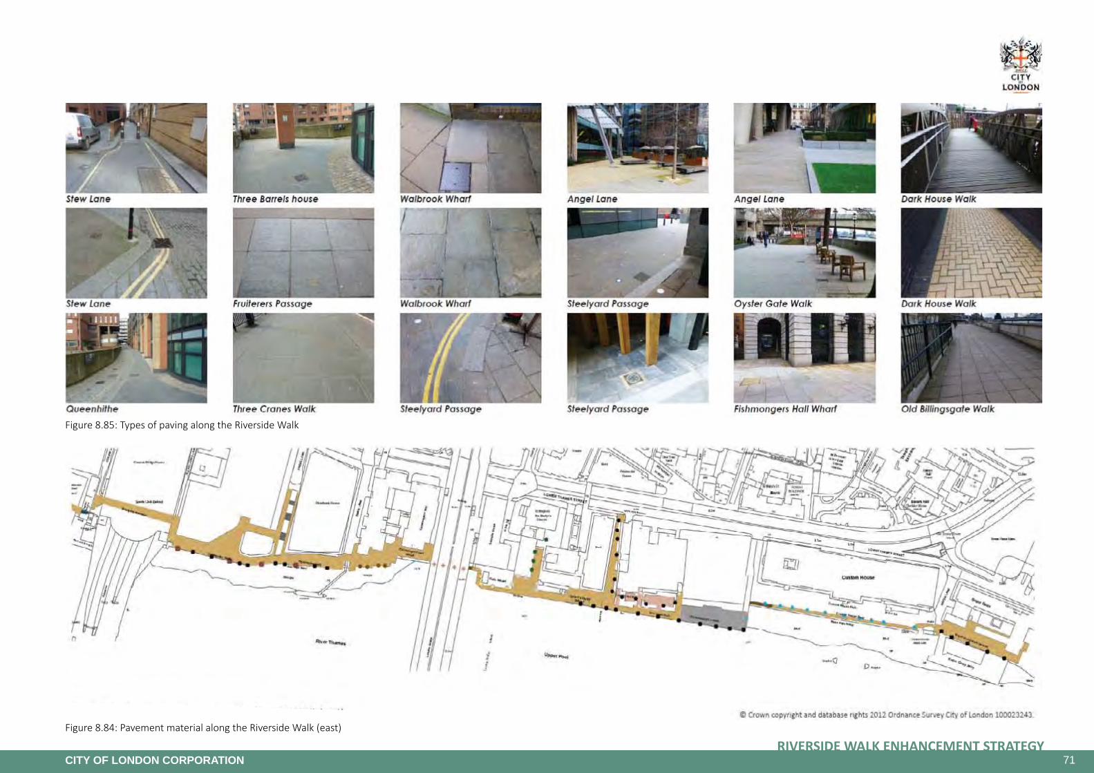
71RIVERSIDE WALK ENHANCEMENT STRATEGY
CITY OF LONDON CORPORATION
Figure 8.85: Types of paving along the Riverside Walk
Figure 8.84: Pavement material along the Riverside Walk (east)

72RIVERSIDE WALK ENHANCEMENT STRATEGY
CITY OF LONDON CORPORATION
Figure 8.86: Joggers use parapet walls for stretching exercise.
Figure 8.87: Outdoor fitness equipment
Figure 8.88: Existing exercise equipment highly popular as seating.
Figure 8.89: Existing exercise equipment highly popular as seating.
Figure 8.90: New public space by the Seine - climbing on the ancient bank walls (Eloise Bloit, Paris by the Seine, PlayScapes 27.09.2013)
Figure 8.91: New public space by the Seine - designs on the ground for play (Eloise Bloit, Paris by the Seine, PlayScapes 27.09.2013)
Figure 8.92: New public space by the Seine - small playground alluding to a busy waterfront environment (Eloise Bloit, Paris by the Seine, PlayScapes 27.09.2013)
Sport and PlayThe Riverside Walk is a popular route for joggers especially during lunchtime as well as in the evenings. A number of specially designed pieces of exercise equipment that double up as seating elements have been installed at Paul’s Walk and Dark House Walk Passage. These installations are however so popular as seating that joggers are not able to use them at most times. Rather, joggers appear to use parapet walls, steps and bollards to assist with stretching exercises.
Providing more of such elements or outdoor fitness equipment at other locations along the Riverside Walk together with additional seating and drinking water fountains may benefit joggers and encourage more people into exercise. Small graphics indicating possible exercise moves could be of help.
The Riverside Walk provides a safe environment away from traffic, which is ideal for small children. Play along the Riverside Walk should be provided for to encourage more families with children to spend quality time here. Playful elements can hold the interest of both children and adults and could help turn the Riverwalk into more than a walkway along the Thames. A good example of successfully integrating ‘play into path’ can be found along the Seine in Paris where a “new public space “les berges” offers a good insight into what’s current in designing a “promenade” as a spot to meet, play, or wander”(Eloise Bloit, Paris by the Seine, PlayScapes 27.09.2013).

73RIVERSIDE WALK ENHANCEMENT STRATEGY
CITY OF LONDON CORPORATION
Figure 8.93: Current signage to control illegal cycling on the Riverside Walk
Figure 8.94: Despite signage, cyclists continue to use the Riverside Walk
THE MAYOR’S VISION FOR CYCLING IN LONDONAn Olympic Legacy for all Londoners
Figure 8.95: The Mayour’s Vision for Cycling in London
Illegal CyclingIllegalcyclingontheCityWalkway
The Riverside Walk has been designed as a relaxing walking route and forms part of the Thames Path National Trail. Bringing a vehicle (including a cycle) onto City Walkway is a breach of the City Walkway Byelaws, liable to a fine of £20 upon conviction. A number of preventive measures have been developed as part of the Connecting Spaces project including new signs at every entrance and along the Riverside advising cyclists that they are not permitted on the walkway. However these measures do not appear to be a sufficient deterrent.
A cycle superhighway is proposed on Upper and Lower Thames Street that aims to provide improved and safer facilities for cyclists (see below). The hope is that this will mean fewer cyclists using the walkway in the future. However, it is also acknowledged that there is an enforcement issue in respect of cycling on the riverside walk. In the short term, more effective enforcement methods should be explored, such as information at the hire points for the Cycle Hire users or the possible introduction of Fixed Penalty Notices through collaboration with London Councils.
CycleSuperhighway
The Mayor of London launched his Vision for Cycling in London in March 2013 with one of the four key themes being the creation of a ‘tube network’ for the bike. The Mayor consulted the public in autumn 2014 on his proposals for two segregated Cycle Superhighways that run through the City. The proposed east-west route is on the Embankment and Upper and Lower Thames Street.
The City of London Corporation aims to work closely with TfL to ensure that the plans for the segregated cycle routes provide a balanced outcome for all road users and the opportunities for wider improvements need to be explored further.
Some key changes and agreed processes are required in order for the City to be able to support the proposals. These do not detract from the Mayor’s plan for the segregated cycle routes and should provide a better balanced outcome.
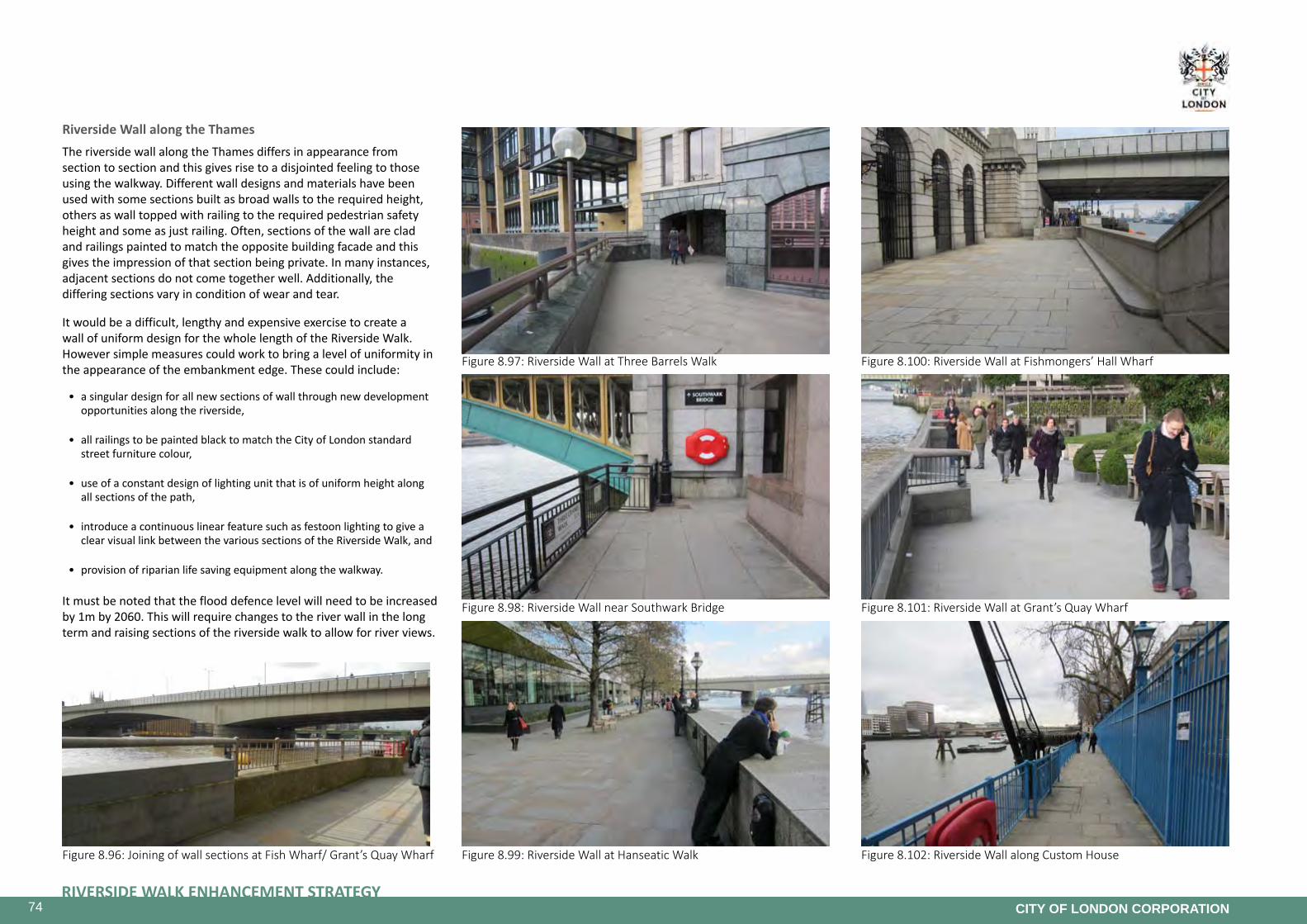
74RIVERSIDE WALK ENHANCEMENT STRATEGY
CITY OF LONDON CORPORATION
Figure 8.97: Riverside Wall at Three Barrels Walk
Figure 8.101: Riverside Wall at Grant’s Quay WharfFigure 8.98: Riverside Wall near Southwark Bridge
Figure 8.100: Riverside Wall at Fishmongers’ Hall Wharf
Figure 8.96: Joining of wall sections at Fish Wharf/ Grant’s Quay Wharf Figure 8.99: Riverside Wall at Hanseatic Walk Figure 8.102: Riverside Wall along Custom House
Riverside Wall along the ThamesThe riverside wall along the Thames differs in appearance from section to section and this gives rise to a disjointed feeling to those using the walkway. Different wall designs and materials have been used with some sections built as broad walls to the required height, others as wall topped with railing to the required pedestrian safety height and some as just railing. Often, sections of the wall are clad and railings painted to match the opposite building facade and this gives the impression of that section being private. In many instances, adjacent sections do not come together well. Additionally, the differing sections vary in condition of wear and tear.
It would be a difficult, lengthy and expensive exercise to create a wall of uniform design for the whole length of the Riverside Walk. However simple measures could work to bring a level of uniformity in the appearance of the embankment edge. These could include:
• a singular design for all new sections of wall through new development opportunities along the riverside,
• all railings to be painted black to match the City of London standard street furniture colour,
• use of a constant design of lighting unit that is of uniform height along all sections of the path,
• introduce a continuous linear feature such as festoon lighting to give a clear visual link between the various sections of the Riverside Walk, and
• provision of riparian life saving equipment along the walkway.
It must be noted that the flood defence level will need to be increased by 1m by 2060. This will require changes to the river wall in the long term and raising sections of the riverside walk to allow for river views.

75RIVERSIDE WALK ENHANCEMENT STRATEGY
CITY OF LONDON CORPORATION
Figure 8.103: New high quality green space at Paul’s Walk
Figure 8.104: Enhanced, high quality green space at Grant’s Quay
Greenery and BiodiversityThe River Thames is a designated Site of Metropolitan Importance for Nature Conservation and is identified in the Biodiversity Action Plan as one of the City’s important habitats.
The south facing aspect of the Riverside Walk makes it particularly suitable for having a strong element of planting as part of its character, making it an important part of the river related biodiversity corridor. However, excluding the new schemes recently completed, many of the wharfs on the riverside are landscaped and constructed using only hard-landscape materials, which can lead in some instances to an unfriendly and harsh environment and does nothing to accommodate the creation of a biodiverse city.
To act as a biodiversity corridor it is important that the riverside landscaped spaces are linked together and include a variety of nectar rich species to attract insects and birds. Sections of the Riverside Walk at Grant’s Quay, Paul’s Walk, Angel Lane and Dark House Walk have been recently enhanced with a particular treatment for the greenery and the planters that is consistent with the City’s approach to public realm enhancement schemes with the use of granite planters, lawns and planting appropriate to the space. It is recommended to create more coherently designed green spaces with appropriate plant species along the Riverside Walk to help increase biodiversity as well as draw visitors to the area and provide them with beautiful spaces in which to walk, sit or relax. There are a number of areas that present opportunities for such an approach, where green spaces, be they on public or private property, could be introduced.
The species of planting on the Riverside Walk needs to be carefully considered, and opportunities for the inclusion of native riverside plants should be investigated. This is an essential element in the creation of a more biodiversity riverside, as these native species are the best way of achieving an increase in the numbers and variety of riverside fauna, including insects and the birds that feed on them. Mediterranean style planting as at Grant’s Quay has also proven successful given the hot and exposed nature of the environment.
Planting will need to be chosen, in conjunction with the Open Spaces Department, that is resilient to as wide a range of conditions as is possible. For instance, when planning planting schemes landscape architects will need to choose plants that have a wide tolerance to a range of varying weather extremes since drought and flood conditions are both possible under the CP09 climate projections.
Planted areas should have irrigation systems incorporated at the design stage in order to reduce ongoing maintenance costs. It is particularly important to have a system of watering when considering small or shallow planting areas, such as associated with the river wall or narrow planting strips for climbing plants, which dry out quickly. Improvement works to the hard landscape can provide the opportunity to install such systems with the minimum of additional disturbance to the Walkway and this work could be linked to the provision of additional hydrant points for the use of Cleansing Services.
Further considerations may need to include the use of organic mulches for water retention, grit for effective drainage and, water retaining granules which could contribute to longevity in the planting if drought conditions persist. The planting palette chosen will need to reflect the size of the actual planting beds as larger beds provide greater plant choices and improved longevity. Furthermore, the soil depths and the exposure they experience to the prevailing weather conditions will inform the planting which could include trees, both single and multi-stemmed, robust evergreen and/or deciduous shrubs as well as perennials plants and grasses. Mown grassed areas could also be considered though these will need to be in larger areas to cope with the demand placed on them by users for recreation and which will require automatic irrigation if they are to be successful long term.
It is important to protect existing trees whilst providing additional tree planting where possible. New developments should be encouraged to incorporate green roofs and, where possible connect these to ground level green spaces by the use of green walls or other appropriate systems would strengthen the biodiversity corridor along the riverside.

76RIVERSIDE WALK ENHANCEMENT STRATEGY
CITY OF LONDON CORPORATION
9. Delivery Plan
The following project list identifies potential projects that would assist in delivering the objectives of the Riverside Walk Enhancement Strategy. Proposals have been identified and prioritised based on opportunities to achieve the objectives of the City’s Policies and Strategies, and provide maximum benefit to the City community.
The projects have been prioritised in the following categories:
High Priority: A high priority is given to proposals that will address road safety, encourage economic investment in the Strategy area, respond to the public consultation and offer significant opportunities towards achieving the objectives of the Area Enhancement Strategy, providing the most improvement to the City community.
Medium Priority: A medium priority is given to proposals that will improve movement throughout the Strategy area, increase sustainability and improve air quality, biodiversity and amenity for the City community. They will build upon the High Priority proposals providing continuity of treatment and further enhancements to the appearance and function of the Strategy area.
LowPriority: The remaining proposals are given a low priority. These proposals will help form a consistent appearance and function for the Strategy area and will include less significant environmental enhancements that, whilst adding value to the Strategy area, will be less urgent or significant in kind.

77RIVERSIDE WALK ENHANCEMENT STRATEGY
CITY OF LONDON CORPORATION
PROJECT FUNDINGSOURCES COST TARGET YEAR
LONDONBRIDGESTAIRCASE
• Demolition of the existing internalised staircase
• Construction of a new external staircase
CoL TfL £2.1 m 2014 - 2015
MILLENNIUMBRIDGEAREA
• Re-landscaping to introduce more greenery and seating
• Improving the lighting and paving
S106 £1 m 2014 - 2015
GLOBEVIEWWALKWAY
• Re-opening of the Riverside Walk at Globe View
• Possible creation of a new section of external walkway
S106 CIL TfL
£750K - 1.5 m 2017 - 2018
RIVERSIDEWALKDIVERSION–QUEENHITHE
• Re-opening the walkway under the building at Queen’s Quay and Queensbridge HousePrivate funding - 2017 - 2018
FISHMONGERS’HALLWHARF
• Replacement of the existing stairs by a ramp S106 TfL £400K 2015
BELLWHARFLANE–PHASE1
• Improvement of lighting, way-finding improvements
• Installation of bollards to prevent vehicle parking on the footway
• Traffic order to make the lane ‘access only’
• Paving and access improvements
CoL TfL £250K 2014 - 2016
BLACKFRIARS BRIDGE WALKWAY
• Activation of the space
• Opportunity for art
• Improvement of lighting
TfL £50K 2015

78RIVERSIDE WALK ENHANCEMENT STRATEGY
CITY OF LONDON CORPORATION
Appendices
PROJECT PRIORITY FUNDING SOURCES COST TARGET YEAR
BLACKFRIARSFORESHOREANDUNDERBRIDGERETAILSPACE
• Creation of a new public space
• Introduction of some retail units in the space under the bridges
• Paving and re landscaping of the area
HIGHPrivate funding
CoLdepending on Thames Tunnel 2022
STMAGNUSHOUSE/STMAGNUSTHEMARTYRCHURCH
• Replacement of the existing stairs by a ramp
• Re-landscaping of the garden
HIGH
S106 CIL TfL
Private funding
£500k - £750k 2015 - 2017
ACCESSIMPROVEMENTS
• Various improvements to make the walkway and connecting routes more accessible, including ramps, raised tables, wider footways, accessible seating and lighting
HIGH
S106 S278 CIL TfL
£300k - £750K 2015 - 2018
CONNECTINGSPACESPROJECT
• Street furniture improvements
• Way finding improvements
• Paving improvements
• Lighting improvements
HIGH
S106 S278 CIL TfL
£500k - £1.5 m 2015 - 2020
ENHANCEGREENERYANDBIODIVERSITY
• Plant trees and planting where possible
• Preserve and enhance the areas where planting is already in place
• Improve the irrigation systems and introduce SUDS systems where possible
• Incorporate green roofs and walls where appropriate
HIGH
S106 S278 CIL TfL
Private funding
£300k - £1 m 2015 - 2025
SUGARQUAYJETTY
• Open up private walkway to allow public access
• Implementation dependant on development
HIGH - - 2015 - 2020
WHITELIONHILL
• Installation of an accessible pedestrian route and possible green park using green roof technologies which will link Queen Victoria St with the riverside
• Temporary scheme that would be removed when site is redeveloped at which point replacement route would be designed in to new development
HIGH
S106 S278 CIL TfL
£500k - £750 2016 - 2020

79RIVERSIDE WALK ENHANCEMENT STRATEGY
CITY OF LONDON CORPORATION
PROJECT PRIORITY FUNDING SOURCES COST TARGET YEAR
SOUTHWARK BRIDGE AREA
• Enhancement of the passageway under the bridge
• Improving the connection to the City and continuity of the walkway MEDIUM
S106 S278 CIL TfL
Private funding
£500k - £1 m 2016 - 2022
MONTAGUEHOUSEANDDARKHOUSEWALK
• Improving accessibility
• Re landscaping of the area and new layout
MEDIUM
S106 S278 CIL TfL
Private funding
£1 - 2 m 2016 - 2020
OLDBILLINGSGATEMARKETWALKWAY
• Re-landscaping of the area and York Stone paving
• Provide planting to soften the area
• Providing tables and chairs
MEDIUM
S106 S278 CIL TfL
Private funding
£500k - £750k 2016 - 2020
CUSTOM HOUSE
• Removal of the railings to the car park
• Re-landscaping of the private area to create a new publically accessible space
• Provision of tables and chairs
MEDIUM
S106 S278 CIL TfL
Private funding
£1.5 - 3m 2017 - 2022
PUBLICARTANDEVENTS
• Encourage events, activities and experiences
• Installing artworks, including temporary installationsMEDIUM
S106 S278 CIL TfL
Private funding
£500k - £1 m 2015 - 2022
ENCOURAGESPORTANDPLAY
• Install play equipment, including temporary installations
• Encourage sport and play along the Riverside Walk
• Provide appropriate sports equipment or street furniture
MEDIUM
S106 S278 CIL TfL
£300k - £500K 2015 - 2025

80RIVERSIDE WALK ENHANCEMENT STRATEGY
CITY OF LONDON CORPORATION
PROJECT PRIORITY FUNDING SOURCES COST TARGET YEAR
BELLWHARFLANE–PHASE2
• Art and interpretation
• Ceiling lighting
• Re-cladding of the ceiling
LOW
S106 S278 CIL TfL
Private funding
£300k - £750 2016 - 2017
STMAGNUSHOUSE
• Replace the existing staircase to the upper terrace
• Activate the frontage and replacing the parapet of the upper terraceLOW
S106 S278 CIL TfL
Private funding
£500k - £750k 2018-2022
CANNONSTREETUNDERBRIDGE
• Creation of the pedestrian walkway under Cannon Street rail bridgeLOW
S106 S278 CIL TfL
Private funding
£4 - 5 m 2020 -2025
LIGHTINGSTRATEGY
• Implementing festoon lighting
• Retain historical lighting columns
• Maintain good quality of lighting along the riverside
LOW
S106 S278 CIL TfL
Private funding
£500k - £1 m 2016 - 2020
RIVERSIDEWALL
• Unifying the Riverside Wall and enhancing the quality of finishes
• Incorporating lighting where appropriateLOW
S106 S278 CIL TfL
Private funding
£2 m - £5 m 2017 - 2025