Riverbank Erosion and Channel Width Adjustments across … Riverbank Erosion and Channel Width...
18
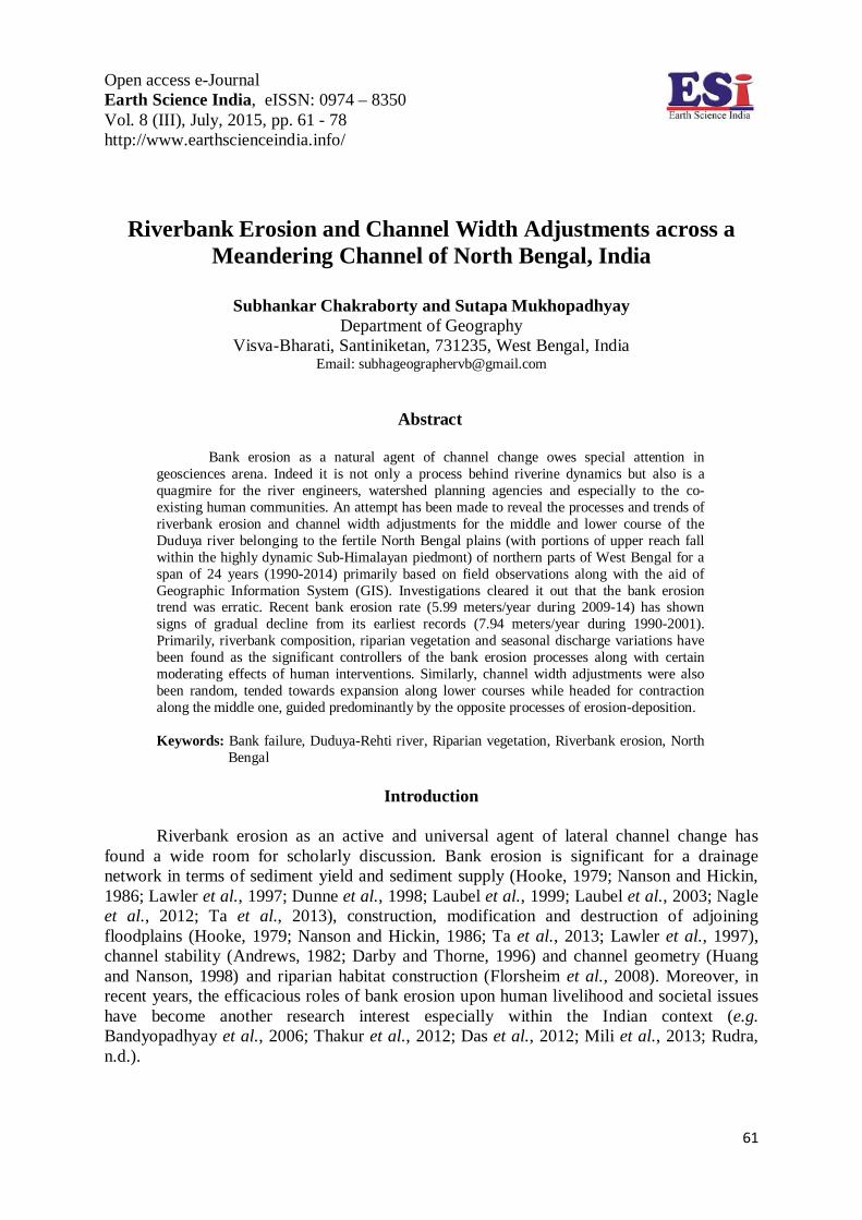
Open access e-Journal Earth Science India, eISSN: 0974 – 8350 Vol. 8 (III), July, 2015, pp. 61 - 78 http://www.earthscienceindia.info/ 61 Riverbank Erosion and Channel Width Adjustments across a Meandering Channel of North Bengal, India Subhankar Chakraborty and Sutapa Mukhopadhyay Department of Geography Visva-Bharati, Santiniketan, 731235, West Bengal, India Email: [email protected] Abstract Bank erosion as a natural agent of channel change owes special attention in geosciences arena. Indeed it is not only a process behind riverine dynamics but also is a quagmire for the river engineers, watershed planning agencies and especially to the co- existing human communities. An attempt has been made to reveal the processes and trends of riverbank erosion and channel width adjustments for the middle and lower course of the Duduya river belonging to the fertile North Bengal plains (with portions of upper reach fall within the highly dynamic Sub-Himalayan piedmont) of northern parts of West Bengal for a span of 24 years (1990-2014) primarily based on field observations along with the aid of Geographic Information System (GIS). Investigations cleared it out that the bank erosion trend was erratic. Recent bank erosion rate (5.99 meters/year during 2009-14) has shown signs of gradual decline from its earliest records (7.94 meters/year during 1990-2001). Primarily, riverbank composition, riparian vegetation and seasonal discharge variations have been found as the significant controllers of the bank erosion processes along with certain moderating effects of human interventions. Similarly, channel width adjustments were also been random, tended towards expansion along lower courses while headed for contraction along the middle one, guided predominantly by the opposite processes of erosion-deposition. Keywords: Bank failure, Duduya-Rehti river, Riparian vegetation, Riverbank erosion, North Bengal Introduction Riverbank erosion as an active and universal agent of lateral channel change has found a wide room for scholarly discussion. Bank erosion is significant for a drainage network in terms of sediment yield and sediment supply (Hooke, 1979; Nanson and Hickin, 1986; Lawler et al., 1997; Dunne et al., 1998; Laubel et al., 1999; Laubel et al., 2003; Nagle et al., 2012; Ta et al., 2013), construction, modification and destruction of adjoining floodplains (Hooke, 1979; Nanson and Hickin, 1986; Ta et al., 2013; Lawler et al., 1997), channel stability (Andrews, 1982; Darby and Thorne, 1996) and channel geometry (Huang and Nanson, 1998) and riparian habitat construction (Florsheim et al., 2008). Moreover, in recent years, the efficacious roles of bank erosion upon human livelihood and societal issues have become another research interest especially within the Indian context (e.g. Bandyopadhyay et al., 2006; Thakur et al., 2012; Das et al., 2012; Mili et al., 2013; Rudra, n.d.).
Transcript of Riverbank Erosion and Channel Width Adjustments across … Riverbank Erosion and Channel Width...
Open access e-Journal Earth Science India, eISSN: 0974 – 8350 Vol. 8 (III), July, 2015, pp. 61 - 78 http://www.earthscienceindia.info/
61
Riverbank Erosion and Channel Width Adjustments across a
Meandering Channel of North Bengal, India
Subhankar Chakraborty and Sutapa Mukhopadhyay Department of Geography
Visva-Bharati, Santiniketan, 731235, West Bengal, India Email: [email protected]
Abstract
Bank erosion as a natural agent of channel change owes special attention in geosciences arena. Indeed it is not only a process behind riverine dynamics but also is a quagmire for the river engineers, watershed planning agencies and especially to the co-existing human communities. An attempt has been made to reveal the processes and trends of riverbank erosion and channel width adjustments for the middle and lower course of the Duduya river belonging to the fertile North Bengal plains (with portions of upper reach fall within the highly dynamic Sub-Himalayan piedmont) of northern parts of West Bengal for a span of 24 years (1990-2014) primarily based on field observations along with the aid of Geographic Information System (GIS). Investigations cleared it out that the bank erosion trend was erratic. Recent bank erosion rate (5.99 meters/year during 2009-14) has shown signs of gradual decline from its earliest records (7.94 meters/year during 1990-2001). Primarily, riverbank composition, riparian vegetation and seasonal discharge variations have been found as the significant controllers of the bank erosion processes along with certain moderating effects of human interventions. Similarly, channel width adjustments were also been random, tended towards expansion along lower courses while headed for contraction along the middle one, guided predominantly by the opposite processes of erosion-deposition. Keywords: Bank failure, Duduya-Rehti river, Riparian vegetation, Riverbank erosion, North
Bengal
Introduction
Riverbank erosion as an active and universal agent of lateral channel change has found a wide room for scholarly discussion. Bank erosion is significant for a drainage network in terms of sediment yield and sediment supply (Hooke, 1979; Nanson and Hickin, 1986; Lawler et al., 1997; Dunne et al., 1998; Laubel et al., 1999; Laubel et al., 2003; Nagle et al., 2012; Ta et al., 2013), construction, modification and destruction of adjoining floodplains (Hooke, 1979; Nanson and Hickin, 1986; Ta et al., 2013; Lawler et al., 1997), channel stability (Andrews, 1982; Darby and Thorne, 1996) and channel geometry (Huang and Nanson, 1998) and riparian habitat construction (Florsheim et al., 2008). Moreover, in recent years, the efficacious roles of bank erosion upon human livelihood and societal issues have become another research interest especially within the Indian context (e.g. Bandyopadhyay et al., 2006; Thakur et al., 2012; Das et al., 2012; Mili et al., 2013; Rudra, n.d.).
Open access e-Journal Earth Science India, eISSN: 0974 – 8350 Vol. 8 (III), July, 2015, pp. 61 - 78 http://www.earthscienceindia.info/
62
Generally, if a river channel is in equilibrium state, then at undisturbed conditions lateral channel changes normally take place through bank erosion and bar deposition which leads to high sediment exchange rates between the river channel and the floodplains. These processes consequently control lateral channel shifts, downstream sediment supply and availability, and floodplain configurations. A certain rise in bank erosion rate either because of increasing activity of the forces operating on the river banks or a decrease in the bank resistance which is not balanced by sufficient sediment deposition can offer an increase in channel width enforcing disequilibrium in the river system (Madej et al., 1994).
The bank erosion is a very common process of change for all meandering rivers
(Madej et al., 1994) throughout the world. Being a natural riverine element, riverbanks can move away (erosion) or can advance (deposition), which can result in meander migration, channel avulsion and changes in channel width (Bartley et al., 2008). Geomorphologically, river bank is the landform discriminated by the topographic gradient from the river bed along the lateral land-water margin up to the highest stage of flow or up to the topographic edge where water begins to spread laterally over the floodplain and bank erosion is the erosion of sediment particles from this distinct landform which follow the topographic gradient horizontally toward the river channel or to downstream directions (Florsheim et al., 2008). Being a geomorphic-fluvial process, bank erosion is actually culminated through a series of processes which can be viewed through a set of three groups (Charlton, 2008). The first one covers the pre-weakening processes which prepare the set for bank erosion e.g. alternate cycles of wetting and drying; the second one assembles the direct fluvial entrainment processes and the third one includes the processes of bank failure.
Regarding the primary agents of bank erosion, Wolman (1959) picked peak river
discharge, rise in water stage, existing moisture conditions and precipitation, temperature and especially frost occurrences. Hooke (1979) has also asserted river discharge, rainfall and soil moisture conditions as the most significant variables of bank erosion while discussing river bank erosion across Devon, Great Britain. Similarly, riparian vegetal cover, its type, distribution and principally the root density have been believed to exert noteworthy impacts on bank stability and resistance (Hickin, 1984; Knighton, 1984; Madej et al., 1994; Beeson and Doyle, 1995; Millar, 2000; Micheli and Kirchner, 2002; Simon and Collison, 2002; Micheli et al., 2004; Pollen and Simon, 2005; Bartley et al., 2008; Florsheim et al., 2008; Harden, 2013; Rosgen, n.d.). It has been observed that, river banks with healthy riparian vegetation are less affected by bank erosion than those lacking sufficient vegetal cover. Micheli and Kirchner (2002) observed that, banks along a wet meadow reach were eroded six times slower than banks along a dry meadow reach along the central Sacramento river of California, United States of America. Bartley et al., (2008) during their study of the Daintree River, Australia have found that the mean bank erosion rates were 6.5 times (or 85%) lesser for the river banks with riparian vegetation than the banks devoid of it. Bank stratigraphy or composition is another important influent of river bank erosion as the stability of the banks is highly dependent upon bank resistance and cohesiveness of the bank materials. A number of studies have indicated the role of bank materials in governing river bank erosion particularly in connection with bank failure processes (e.g. Hooke, 1979; Madej et al., 1994; Darby and Thorne, 1996; Youdeowei, 1997; Kotoky et al., 2005; Wallick et al., 2006; Charlton, 2008; Thakur et al., 2012; Ta et al., 2013). In addition with these natural controlling factors, the
Open access e-Journal Earth Science India, eISSN: 0974 – 8350 Vol. 8 (III), July, 2015, pp. 61 - 78 http://www.earthscienceindia.info/
63
role of human interventions in the form of landuse alteration, agricultural expansion, flow regulation and channelization, alteration of bank materials have also been documented of exerting some moderating influences upon bank erosion (Murgatroyd and Ternan, 1983; Gregory et al., 1992; Madej et al., 1994; Wallick et al., 2007; Ahmed and Fawzi, 2011).
Instead of such vast dimensions, bank erosion processes and their controlling
variables still lack adequate documentation and mapping especially the small and medium scale rivers; this is a prominent case particularly in Indian context. In this connection, the authors have selected the northern part of West Bengal for this present study, the area which is famed for its notorious river channel dynamics and the vulnerabilities they culminate each year via bank erosion, floods and channel avulsions. Contextually, the present paper has gone through a significant portion of the Rehti-Duduya watershed (a sub-watershed of the Jaldhaka river basin) and tracked the main channel of Duduya for a 40 Km reach length (starting from the Angrabhasa-Duduya rivers’ confluence to the Duduya-Jaldhaka rivers’ confluence) aiming towards the understanding of the processes of bank erosion and channel width alterations over time along a medium-scale river channel. Comprehensively, focus has been devoted to (a) the mean bank erosion rates, processes of bank erosion and bankline movements for the concerned reach, and (b) channel width variations over space-time and their connections with bank erosion and areal changes (erosion-deposition) across the Duduya River valley.
Study Area
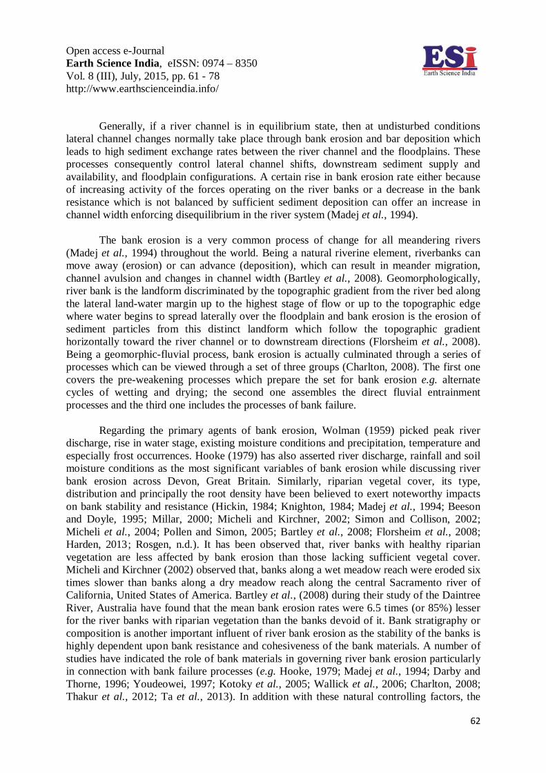
Spatially the entire area (around 445 Km2) falls within the northern districts of
Jalpaiguri, Alipurduar and Coochbehar of West Bengal. The area is nearly bounded within 26º28ʹ N to 26º52ʹ N latitudes and 88º56ʹ E to 89º12ʹ E longitudes (Fig. 1). The Duduya-Rehti river system is an assemblage of two distinct rivers namely Duduya and Rehti (also known as Sukreti or Rangati to local people) which flow through two different physiographic units until they meet each other at the plains of North Bengal also known as Teesta-Brahmaputra plains. The Duduya river owes its origin near the Totapara Tea Garden of Jalpaiguri district of West Bengal at an elevation of 131 meters above msl. This part of land forms the low altitudinal distal edges of the Sub-Himalayan piedmont fan surface composed of thick alluvia. The Duduya from its very beginning has developed a meandering channel pattern (Sinuosity-1.62) cut across 2-3 meter thick alluvia primarily composed of coarse sand and gravels (up to 1.5 cm in diameter). Downstreams near the Sonakhali forest area, a tributary known as Angrabhasa joins the Duduya from the left side at an elevation of 88 meters above msl. The negligible slope differences between these rivers have resulted in huge deposition of gravels-pebbles and coarse sands across the channel floor resulting in the formation of shoals and mid-channel bars along the Duduya river. At this section, the Duduya river channel is accompanied by 2-4 meters high alluvial terraces on either bank. Initially, the Duduya follows a N-E direction until it meets the Rehti river. The catchment area at this reach is typically occupied by moderately dense wet tropical forest covers and tea plantations. The perennial channel of the Duduya receives sole of its water from abundant rainfall besides fed by ample ground water.
Open access e-Journal Earth Science India, eISSN: 0974 – 8350 Vol. 8 (III), July, 2015, pp. 61 - 78 http://www.earthscienceindia.info/
64
Fig. 1: Spatial Reference Map of the Study Area.
Rehti River, on the other hand, rises at an altitude of 1148 meters along the southern faces of the eastern Himalayas of south-western part of Bhutan and enters into Indian Territory near the Chunabhati Tea Garden (mid-altitudinal proximal fan surface) of Jalpaiguri district at an elevation of 260 meters above msl. Deserting a south-westward flow in the Himalayas, the Rehti river took a sudden southward bend here following the fault lines to meet the Duduya river accompanied by the large alluvial fan of the Chamurchi river at its right side. The wide channel floor here is solely built on coarse sands, gravels and boulders (up to 0.5 m. in diameter). Channel is much flatter and the gradient decrease from 15 to 10 cm. /Km. As a consequence of it, huge deposition of mountainous detritus takes place across the channel floor resulting in quick changes in the channel width exactly at its southern bend. Within the mountain front section, the Rehti river develops a straight reach (Sinuosity-1.13) following the rectangular N-S and NNE-SSE directed faults (see Fig. 1). The corresponding channel width records an average width of around 750 meters here before joining its tributary Dimdima near Birpara of Alipurduar district. After this confluence, the fan surface becomes wider but the channel width declines (Starkel et al., 2008). The plentiful availability of fine sand and silt here has marked the beginning of a wandering channel. Before joining the Duduya, most parts of the Rehti remains dry even in early to mid-monsoon stages.
Open access e-Journal Earth Science India, eISSN: 0974 – 8350 Vol. 8 (III), July, 2015, pp. 61 - 78 http://www.earthscienceindia.info/
65
The meeting of Duduya and Rehti occurs near Malsagaon village of Alipurduar district at an elevation of 70 meters. This combined flow then develops a perfectly meandering river course (Sinuosity-1.51) which debouches into the Jaldhaka river (elevation 58 m. above msl) by following a SW direction (average channel gradient nearly 0.6 cm./Km.) through the alluvial plains.
The entire area falls under high to very high rainfall zone, the lower catchments
received an annual rainfall of 3000-3750 mm. while the mountainous and forested reaches recorded annual rainfalls as high as between 5000-7000 mm. (Starkel et al., 2008). Annual floods are very familiar to the area particularly along the lower courses which remained waterlogged for weeks during peak monsoons. Geomorphologically, the entire area is an ideal realm of active fluvial processes, and their spatio-temporal signatures can be traced through the dense network of palaeo-channels, neck cut-offs and swales. Lithostratigraphic units are prominently Quaternary floodplain and valley fill/fan deposits of unconsolidated and unoxidized sands, clay and silt in the middle and lower catchments along with the presence of hard crust laterites of Baikunthapur formation of Upper Pleistocene to lower Holocene ages in the higher reaches overlain by boulders, gravels and pebbles of Duars formation of recent origin (Jana and Bardhan, 2010; Geological Survey of India, 2013).
Landuse across the region has changed significantly since the beginning of the 20th
century particularly during the 1950’s because of the immense in-migration of huge population as a result of partition and communal issues. In their study of the upper and middle catchments of this watershed, Prokop and Sarkar (2012) have reported that during 1930-2010 around 12% and 15.9% of the forests and grasslands have been converted into croplands and tea gardens which have triggered the sediment supplies by increasing rates of sub-aerial and river bank erosion.
Materials and Methods
For this present work the authors have preferred a two-way approach, i.e. mapping of
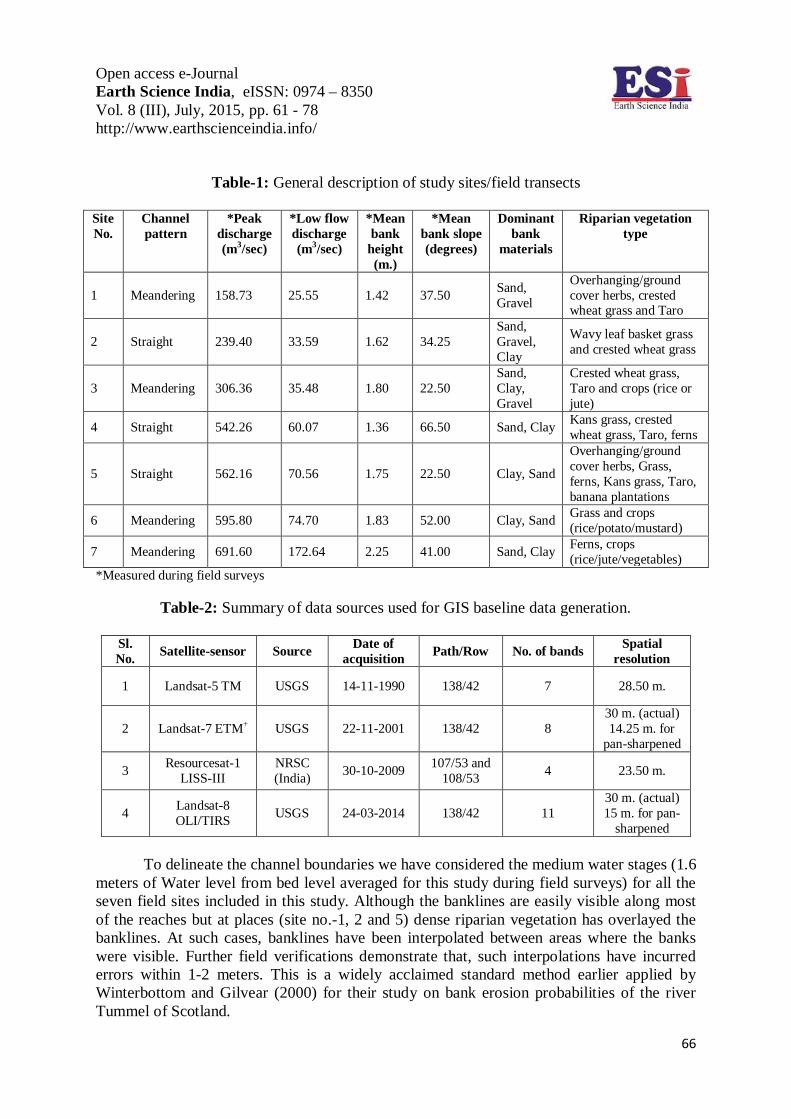
historical dataset within a Geographic Information System (GIS) environment and check out the ground truth through field verifications. Field works have been done in three successive phases during mid-May 2013 to late-July 2014 and specific importance has been devoted to the measurements of channel width, channel depth, planform features, bank heights, bank compositions and riparian vegetation coverage along with perception surveys among the local villagers regarding the observed channel changes in recent periods. As the river is an ungauged one, discharge values were measured for both dry-periods and monsoons for all the 7 sites included in this study. To reduce biasness in choosing field sites, locations ranging from both maximum and minimum changes have been considered along with both meandering and straight reaches (Table-1).
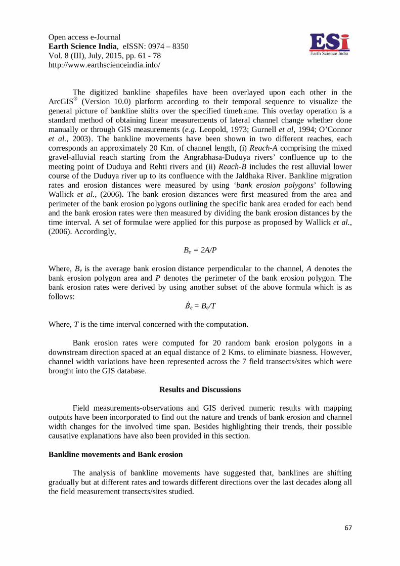
The baseline GIS data have been generated from the multi-temporal and multi-
spectral level-1 cloud-free Landsat and Resourcesat-I (also called IRS P6) satellite images for 24 years (1990-2014) of span (Table-2).
Open access e-Journal Earth Science India, eISSN: 0974 – 8350 Vol. 8 (III), July, 2015, pp. 61 - 78 http://www.earthscienceindia.info/
66
Table-1: General description of study sites/field transects
Site No.
Channel pattern
*Peak discharge (m3/sec)
*Low flow discharge (m3/sec)
*Mean bank
height (m.)
*Mean bank slope (degrees)
Dominant bank
materials
Riparian vegetation type
1 Meandering 158.73 25.55 1.42 37.50 Sand, Gravel
Overhanging/ground cover herbs, crested wheat grass and Taro
2 Straight 239.40 33.59 1.62 34.25 Sand, Gravel, Clay
Wavy leaf basket grass and crested wheat grass
3 Meandering 306.36 35.48 1.80 22.50 Sand, Clay, Gravel
Crested wheat grass, Taro and crops (rice or jute)
4 Straight 542.26 60.07 1.36 66.50 Sand, Clay Kans grass, crested wheat grass, Taro, ferns
5 Straight 562.16 70.56 1.75 22.50 Clay, Sand
Overhanging/ground cover herbs, Grass, ferns, Kans grass, Taro, banana plantations
6 Meandering 595.80 74.70 1.83 52.00 Clay, Sand Grass and crops (rice/potato/mustard)
7 Meandering 691.60 172.64 2.25 41.00 Sand, Clay Ferns, crops (rice/jute/vegetables)
*Measured during field surveys
Table-2: Summary of data sources used for GIS baseline data generation.
Sl. No. Satellite-sensor Source Date of
acquisition Path/Row No. of bands Spatial resolution
1 Landsat-5 TM USGS 14-11-1990 138/42 7 28.50 m.
2 Landsat-7 ETM+ USGS 22-11-2001 138/42 8 30 m. (actual) 14.25 m. for
pan-sharpened
3 Resourcesat-1 LISS-III
NRSC (India) 30-10-2009 107/53 and
108/53 4 23.50 m.
4 Landsat-8 OLI/TIRS USGS 24-03-2014 138/42 11
30 m. (actual) 15 m. for pan-
sharpened
To delineate the channel boundaries we have considered the medium water stages (1.6 meters of Water level from bed level averaged for this study during field surveys) for all the seven field sites included in this study. Although the banklines are easily visible along most of the reaches but at places (site no.-1, 2 and 5) dense riparian vegetation has overlayed the banklines. At such cases, banklines have been interpolated between areas where the banks were visible. Further field verifications demonstrate that, such interpolations have incurred errors within 1-2 meters. This is a widely acclaimed standard method earlier applied by Winterbottom and Gilvear (2000) for their study on bank erosion probabilities of the river Tummel of Scotland.
Open access e-Journal Earth Science India, eISSN: 0974 – 8350 Vol. 8 (III), July, 2015, pp. 61 - 78 http://www.earthscienceindia.info/
67
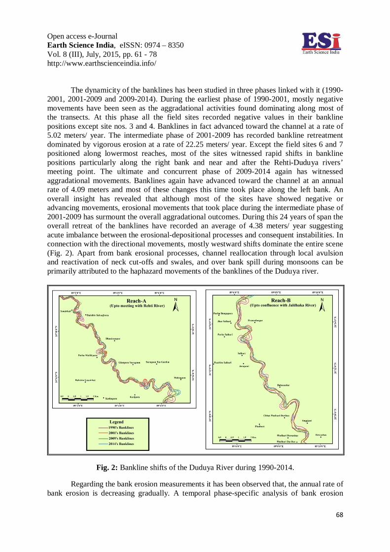
The digitized bankline shapefiles have been overlayed upon each other in the ArcGIS® (Version 10.0) platform according to their temporal sequence to visualize the general picture of bankline shifts over the specified timeframe. This overlay operation is a standard method of obtaining linear measurements of lateral channel change whether done manually or through GIS measurements (e.g. Leopold, 1973; Gurnell et al, 1994; O’Connor et al., 2003). The bankline movements have been shown in two different reaches, each corresponds an approximately 20 Km. of channel length, (i) Reach-A comprising the mixed gravel-alluvial reach starting from the Angrabhasa-Duduya rivers’ confluence up to the meeting point of Duduya and Rehti rivers and (ii) Reach-B includes the rest alluvial lower course of the Duduya river up to its confluence with the Jaldhaka River. Bankline migration rates and erosion distances were measured by using ‘bank erosion polygons’ following Wallick et al., (2006). The bank erosion distances were first measured from the area and perimeter of the bank erosion polygons outlining the specific bank area eroded for each bend and the bank erosion rates were then measured by dividing the bank erosion distances by the time interval. A set of formulae were applied for this purpose as proposed by Wallick et al., (2006). Accordingly,
Be = 2A/P
Where, Be is the average bank erosion distance perpendicular to the channel, A denotes the bank erosion polygon area and P denotes the perimeter of the bank erosion polygon. The bank erosion rates were derived by using another subset of the above formula which is as follows:
Ḃe = Be/T
Where, T is the time interval concerned with the computation.
Bank erosion rates were computed for 20 random bank erosion polygons in a downstream direction spaced at an equal distance of 2 Kms. to eliminate biasness. However, channel width variations have been represented across the 7 field transects/sites which were brought into the GIS database.
Results and Discussions
Field measurements-observations and GIS derived numeric results with mapping
outputs have been incorporated to find out the nature and trends of bank erosion and channel width changes for the involved time span. Besides highlighting their trends, their possible causative explanations have also been provided in this section. Bankline movements and Bank erosion
The analysis of bankline movements have suggested that, banklines are shifting gradually but at different rates and towards different directions over the last decades along all the field measurement transects/sites studied.
Open access e-Journal Earth Science India, eISSN: 0974 – 8350 Vol. 8 (III), July, 2015, pp. 61 - 78 http://www.earthscienceindia.info/
68
The dynamicity of the banklines has been studied in three phases linked with it (1990-2001, 2001-2009 and 2009-2014). During the earliest phase of 1990-2001, mostly negative movements have been seen as the aggradational activities found dominating along most of the transects. At this phase all the field sites recorded negative values in their bankline positions except site nos. 3 and 4. Banklines in fact advanced toward the channel at a rate of 5.02 meters/ year. The intermediate phase of 2001-2009 has recorded bankline retreatment dominated by vigorous erosion at a rate of 22.25 meters/ year. Except the field sites 6 and 7 positioned along lowermost reaches, most of the sites witnessed rapid shifts in bankline positions particularly along the right bank and near and after the Rehti-Duduya rivers’ meeting point. The ultimate and concurrent phase of 2009-2014 again has witnessed aggradational movements. Banklines again have advanced toward the channel at an annual rate of 4.09 meters and most of these changes this time took place along the left bank. An overall insight has revealed that although most of the sites have showed negative or advancing movements, erosional movements that took place during the intermediate phase of 2001-2009 has surmount the overall aggradational outcomes. During this 24 years of span the overall retreat of the banklines have recorded an average of 4.38 meters/ year suggesting acute imbalance between the erosional-depositional processes and consequent instabilities. In connection with the directional movements, mostly westward shifts dominate the entire scene (Fig. 2). Apart from bank erosional processes, channel reallocation through local avulsion and reactivation of neck cut-offs and swales, and over bank spill during monsoons can be primarily attributed to the haphazard movements of the banklines of the Duduya river.
Fig. 2: Bankline shifts of the Duduya River during 1990-2014.
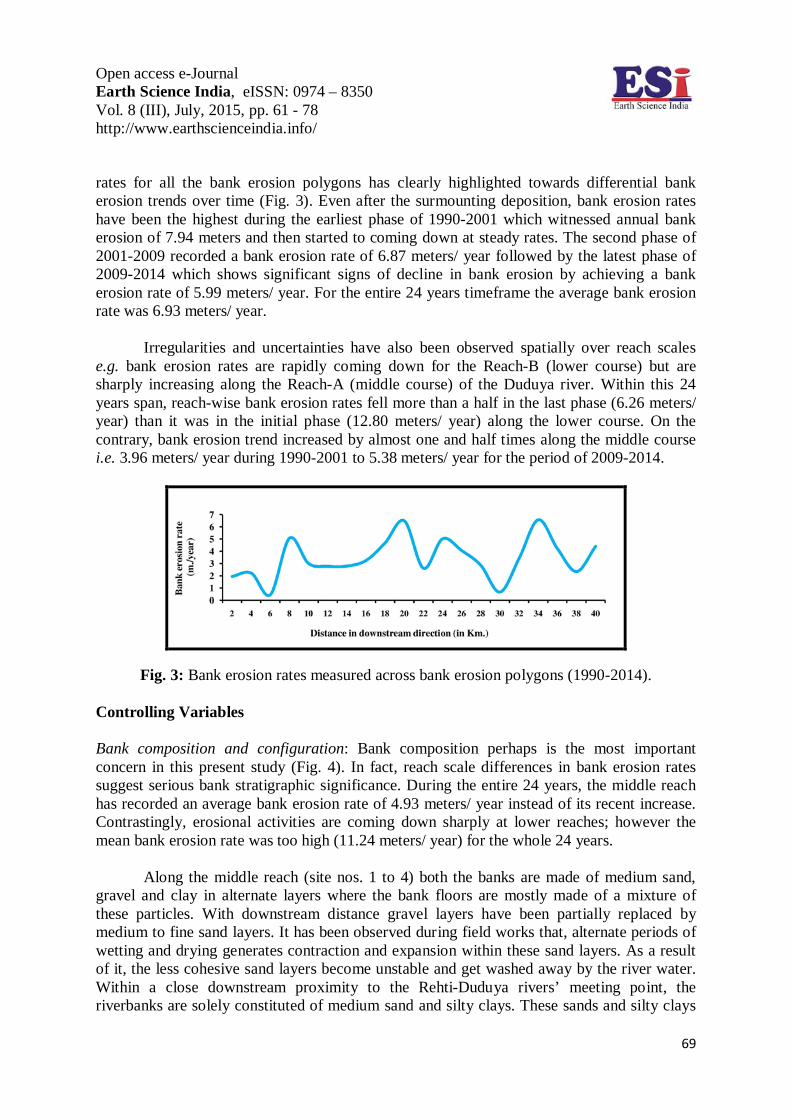
Regarding the bank erosion measurements it has been observed that, the annual rate of bank erosion is decreasing gradually. A temporal phase-specific analysis of bank erosion
Open access e-Journal Earth Science India, eISSN: 0974 – 8350 Vol. 8 (III), July, 2015, pp. 61 - 78 http://www.earthscienceindia.info/
69
rates for all the bank erosion polygons has clearly highlighted towards differential bank erosion trends over time (Fig. 3). Even after the surmounting deposition, bank erosion rates have been the highest during the earliest phase of 1990-2001 which witnessed annual bank erosion of 7.94 meters and then started to coming down at steady rates. The second phase of 2001-2009 recorded a bank erosion rate of 6.87 meters/ year followed by the latest phase of 2009-2014 which shows significant signs of decline in bank erosion by achieving a bank erosion rate of 5.99 meters/ year. For the entire 24 years timeframe the average bank erosion rate was 6.93 meters/ year.
Irregularities and uncertainties have also been observed spatially over reach scales e.g. bank erosion rates are rapidly coming down for the Reach-B (lower course) but are sharply increasing along the Reach-A (middle course) of the Duduya river. Within this 24 years span, reach-wise bank erosion rates fell more than a half in the last phase (6.26 meters/ year) than it was in the initial phase (12.80 meters/ year) along the lower course. On the contrary, bank erosion trend increased by almost one and half times along the middle course i.e. 3.96 meters/ year during 1990-2001 to 5.38 meters/ year for the period of 2009-2014.
Fig. 3: Bank erosion rates measured across bank erosion polygons (1990-2014).
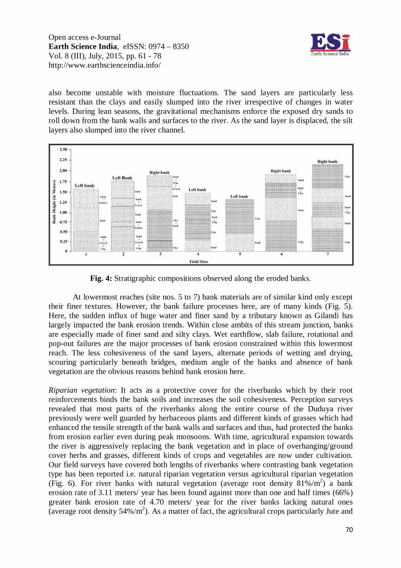
Controlling Variables Bank composition and configuration: Bank composition perhaps is the most important concern in this present study (Fig. 4). In fact, reach scale differences in bank erosion rates suggest serious bank stratigraphic significance. During the entire 24 years, the middle reach has recorded an average bank erosion rate of 4.93 meters/ year instead of its recent increase. Contrastingly, erosional activities are coming down sharply at lower reaches; however the mean bank erosion rate was too high (11.24 meters/ year) for the whole 24 years.
Along the middle reach (site nos. 1 to 4) both the banks are made of medium sand, gravel and clay in alternate layers where the bank floors are mostly made of a mixture of these particles. With downstream distance gravel layers have been partially replaced by medium to fine sand layers. It has been observed during field works that, alternate periods of wetting and drying generates contraction and expansion within these sand layers. As a result of it, the less cohesive sand layers become unstable and get washed away by the river water. Within a close downstream proximity to the Rehti-Duduya rivers’ meeting point, the riverbanks are solely constituted of medium sand and silty clays. These sands and silty clays
Open access e-Journal Earth Science India, eISSN: 0974 – 8350 Vol. 8 (III), July, 2015, pp. 61 - 78 http://www.earthscienceindia.info/
70
also become unstable with moisture fluctuations. The sand layers are particularly less resistant than the clays and easily slumped into the river irrespective of changes in water levels. During lean seasons, the gravitational mechanisms enforce the exposed dry sands to roll down from the bank walls and surfaces to the river. As the sand layer is displaced, the silt layers also slumped into the river channel.
Fig. 4: Stratigraphic compositions observed along the eroded banks.
At lowermost reaches (site nos. 5 to 7) bank materials are of similar kind only except their finer textures. However, the bank failure processes here, are of many kinds (Fig. 5). Here, the sudden influx of huge water and finer sand by a tributary known as Gilandi has largely impacted the bank erosion trends. Within close ambits of this stream junction, banks are especially made of finer sand and silty clays. Wet earthflow, slab failure, rotational and pop-out failures are the major processes of bank erosion constrained within this lowermost reach. The less cohesiveness of the sand layers, alternate periods of wetting and drying, scouring particularly beneath bridges, medium angle of the banks and absence of bank vegetation are the obvious reasons behind bank erosion here.
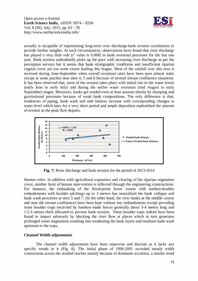
Riparian vegetation: It acts as a protective cover for the riverbanks which by their root reinforcements binds the bank soils and increases the soil cohesiveness. Perception surveys revealed that most parts of the riverbanks along the entire course of the Duduya river previously were well guarded by herbaceous plants and different kinds of grasses which had enhanced the tensile strength of the bank walls and surfaces and thus, had protected the banks from erosion earlier even during peak monsoons. With time, agricultural expansion towards the river is aggressively replacing the bank vegetation and in place of overhanging/ground cover herbs and grasses, different kinds of crops and vegetables are now under cultivation. Our field surveys have covered both lengths of riverbanks where contrasting bank vegetation type has been reported i.e. natural riparian vegetation versus agricultural riparian vegetation (Fig. 6). For river banks with natural vegetation (average root density 81%/m2) a bank erosion rate of 3.11 meters/ year has been found against more than one and half times (66%) greater bank erosion rate of 4.70 meters/ year for the river banks lacking natural ones (average root density 54%/m2). As a matter of fact, the agricultural crops particularly Jute and
Open access e-Journal Earth Science India, eISSN: 0974 – 8350 Vol. 8 (III), July, 2015, pp. 61 - 78 http://www.earthscienceindia.info/
71
the vegetables failed to provide solid tensile strength to the bank soil matrix because of low root length and less root density. Besides this, these introduced plants cannot grow on bank walls like grasses, overhanging/groundcover herbs and thus, at most places bank walls remain exposed to fluvial and sub-aerial erosion.
Fig. 5: Observed riverbank failure mechanisms along the lower course of the Duduya river.
Fig. 6: Riverbank erosion panoramas under natural bank vegetation cover versus agricultural crops cover.
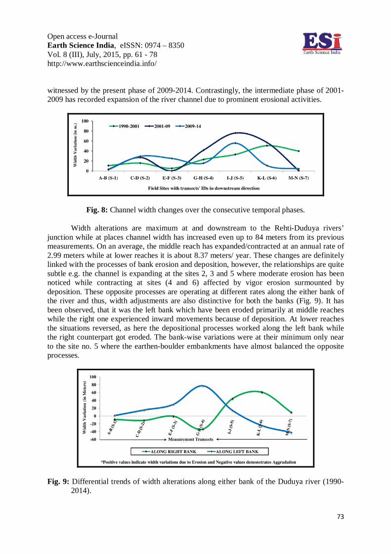
River Discharge: Although, river discharge has been asserted as the single-most significant factor for accelerating bank erosion (Wolman, 1959; Hooke, 1979; Youdeowei, 1997; Bartley et al., 2008), in this study a very little correlation has been found between river discharge and bank erosion rates (Fig. 7). The discharge data which have been computed from field studies during May, 2013 to July 2014 were correlated with the measured bankline distances for 14 months of timeframe. As the measured discharge dataset lack adequate temporal coverage, it
Open access e-Journal Earth Science India, eISSN: 0974 – 8350 Vol. 8 (III), July, 2015, pp. 61 - 78 http://www.earthscienceindia.info/
72
actually is incapable of representing long-term river discharge-bank erosion correlations to provide further insights. At such circumstances, observations have found that river discharge has played a very little role (r2 value is 0.068) in bank erosional processes for the last one year. Bank erosion undoubtedly picks up the pace with increasing river discharge as per the perception surveys but it seems that bank stratigraphic conditions and insufficient riparian vegetal cover are too some extent leading this league. Most of the rainfall over this area is received during June-September when overall erosional rates have been seen almost static except at some patches near sites 4, 5 and 6 because of several stream confluence situations. It has been observed that, most of the erosion takes place with initial rise in the water levels (early June to early July) and during the earlier water recession (mid August to early September) stages. Moreover, banks get eroded even at lean seasons mostly by slumping and gravitational processes because of weak bank compositions. The only difference is that, tendencies of piping, bank wash and slab failures increase with corresponding changes in water level which lasts for a very short period and ample deposition replenished the amount of erosion as the peak flow departs.
Fig. 7: River discharge and bank erosion for the period of 2013-2014
Human roles: In addition with agricultural expansion and clearing of the riparian vegetation cover, another facet of human intervention is reflected through the engineering constructions. For instance, the embanking of the flood-prone lower course with earthen-boulder embankments with boulder pitchings up to 3 meters has neutralized the bank collapse and bank wash processes at sites 5 and 7. On the other hand, the river banks at the middle course and near the stream confluences have been kept without any embankments except providing some boulder traps encircled by bamboo-made fences generally about 3-4 meters long and 1.5-3 meters thick allocated to prevent bank erosion. These boulder traps indeed have been found to impact adversely by blocking the river flow at places which in turn generates prolonged water stagnations resulting into weakening the bank layers and resultant bank wash upstream to the traps. Channel Width adjustments
The channel width adjustments have been imprecise and discreet as it lacks any specific trends in it (Fig. 8). The initial phase of 1990-2001 recorded mostly width contractions across the studied reaches mainly because of dominant accretion, a similar trend
Open access e-Journal Earth Science India, eISSN: 0974 – 8350 Vol. 8 (III), July, 2015, pp. 61 - 78 http://www.earthscienceindia.info/
73
witnessed by the present phase of 2009-2014. Contrastingly, the intermediate phase of 2001-2009 has recorded expansion of the river channel due to prominent erosional activities.
Fig. 8: Channel width changes over the consecutive temporal phases.
Width alterations are maximum at and downstream to the Rehti-Duduya rivers’ junction while at places channel width has increased even up to 84 meters from its previous measurements. On an average, the middle reach has expanded/contracted at an annual rate of 2.99 meters while at lower reaches it is about 8.37 meters/ year. These changes are definitely linked with the processes of bank erosion and deposition, however, the relationships are quite subtle e.g. the channel is expanding at the sites 2, 3 and 5 where moderate erosion has been noticed while contracting at sites (4 and 6) affected by vigor erosion surmounted by deposition. These opposite processes are operating at different rates along the either bank of the river and thus, width adjustments are also distinctive for both the banks (Fig. 9). It has been observed, that it was the left bank which have been eroded primarily at middle reaches while the right one experienced inward movements because of deposition. At lower reaches the situations reversed, as here the depositional processes worked along the left bank while the right counterpart got eroded. The bank-wise variations were at their minimum only near to the site no. 5 where the earthen-boulder embankments have almost balanced the opposite processes.
Fig. 9: Differential trends of width alterations along either bank of the Duduya river (1990-
2014).
Open access e-Journal Earth Science India, eISSN: 0974 – 8350 Vol. 8 (III), July, 2015, pp. 61 - 78 http://www.earthscienceindia.info/
74
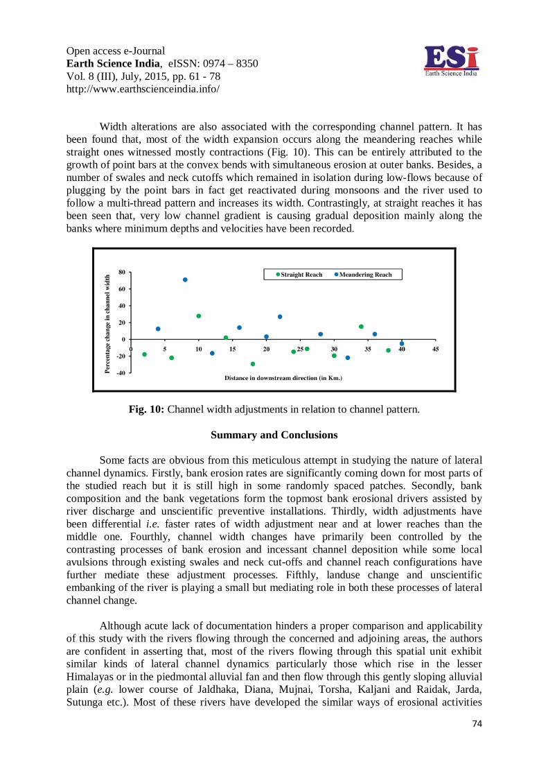
Width alterations are also associated with the corresponding channel pattern. It has been found that, most of the width expansion occurs along the meandering reaches while straight ones witnessed mostly contractions (Fig. 10). This can be entirely attributed to the growth of point bars at the convex bends with simultaneous erosion at outer banks. Besides, a number of swales and neck cutoffs which remained in isolation during low-flows because of plugging by the point bars in fact get reactivated during monsoons and the river used to follow a multi-thread pattern and increases its width. Contrastingly, at straight reaches it has been seen that, very low channel gradient is causing gradual deposition mainly along the banks where minimum depths and velocities have been recorded.
Fig. 10: Channel width adjustments in relation to channel pattern.
Summary and Conclusions
Some facts are obvious from this meticulous attempt in studying the nature of lateral channel dynamics. Firstly, bank erosion rates are significantly coming down for most parts of the studied reach but it is still high in some randomly spaced patches. Secondly, bank composition and the bank vegetations form the topmost bank erosional drivers assisted by river discharge and unscientific preventive installations. Thirdly, width adjustments have been differential i.e. faster rates of width adjustment near and at lower reaches than the middle one. Fourthly, channel width changes have primarily been controlled by the contrasting processes of bank erosion and incessant channel deposition while some local avulsions through existing swales and neck cut-offs and channel reach configurations have further mediate these adjustment processes. Fifthly, landuse change and unscientific embanking of the river is playing a small but mediating role in both these processes of lateral channel change.
Although acute lack of documentation hinders a proper comparison and applicability of this study with the rivers flowing through the concerned and adjoining areas, the authors are confident in asserting that, most of the rivers flowing through this spatial unit exhibit similar kinds of lateral channel dynamics particularly those which rise in the lesser Himalayas or in the piedmontal alluvial fan and then flow through this gently sloping alluvial plain (e.g. lower course of Jaldhaka, Diana, Mujnai, Torsha, Kaljani and Raidak, Jarda, Sutunga etc.). Most of these rivers have developed the similar ways of erosional activities
Open access e-Journal Earth Science India, eISSN: 0974 – 8350 Vol. 8 (III), July, 2015, pp. 61 - 78 http://www.earthscienceindia.info/
75
particularly the failure mechanisms. In a previous study of the Diana river, the authors have found almost similar processes of bank erosion at its lower courses (Chakraborty and Mukhopadhyay, 2014). At a regional scale the observed bank erosion processes are more or less similar to the processes of bank failure documented along the Brahmaputra river (Kotoky et al., 2005; Dutta et al., 2010; Sarma and Acharjee, 2012) and Ganga river (Thakur et al., 2012); while at broad global scales this resembles although to a little extent to the processes operating along the Devonian streams (Hooke, 1979), the Swale-Ouse river system (Lawler et al., 1999), and the Nile river (Ahmed and Fawzi, 2011) etc. More or less similar effects of riparian vegetation on bank erosion of the Duduya river makes us capable of connecting it to the Central Sacramento River of California (Micheli et al., 2004) and to the Daintree and other tropical rivers of Queensland, Australia (Bartley et al., 2008).
There is a wide urgency to map and document the processes engaged in channel dynamics of the Sub-Himalayan piedmont and of the alluvial North Bengal Plains-collectively famed for their active geomorphic-geotectonic activities and resultant catastrophic channel dynamics. These channel changes are of no doubt associated with the medium to large scale vulnerabilities which are hampering the human lives and properties each year. The present paper has presented not only the results of field and GIS based measurements of lateral channel dynamics for the middle and lower reaches of the Duduya river but in fact begins the pioneering endeavor of studying the riverine changes of this transitional landscape. Each of the dataset derived from the either technique of GIS-based and field-based measurements provided ample insights into the nature of the processes behind lateral channel dynamics. It has been found, these changes were discreet and different over the three consecutive temporal phases. Each of these phase witnessed the domination of differential processes in their purviews. However, it can be said that, these changes are not static but are dynamic; in fact in a natural system e.g. in a drainage system trends may reverse at any moment. Actually, it depends on the activity of the controlling drivers-a certain rise or fall in anyone of it may fetch sudden but comprehensive changes in the system eliminating or proving any predictive statements, particularly the systems situated at such kind of geographic setting. Hence, the authors suggest further researches not only for the concerned river channel but for all the rivers flowing through this densely populated and highly agricultural area before making any predictive statements about future changes in these river systems. Acknowledgements: The authors are grateful to Saikat Chakraborty, Abhijit Kundu, Subhajit Chakraborty and Prabir Roy for their helping hands during field surveys. We humbly thank the local residents of the study area for their guidance and important suggestions during field studies and perception surveys.
References
Ahmed, A.A. and Fawzi, A. (2011) Meandering and bank erosion of the river Nile and its environmental impact on the area between Sohag and El-Minia, Egypt. Arabian Journal of Geosciences, v. 4, pp.1-11. doi: 10.1007/s12517-009-0048-y
Andrews, A.D. (1982) Bank stability and channel width adjustment, East Fork River, Wyoming. Water Resources Research, v. 18 (4), pp. 1184-1192
Bandyopadhyay, K., Ghosh, S. and Dutta N. (2006) Eroded lives. Retrieved from http://www.mcrg.ac.in/eroded_lives.pdf
Open access e-Journal Earth Science India, eISSN: 0974 – 8350 Vol. 8 (III), July, 2015, pp. 61 - 78 http://www.earthscienceindia.info/
76
Bartley, R., Keen, R.J., Hawdon, A.A., Hairsine, P.B., Disher, M.G. and Kinsey-Henderson, A.E. (2008) Bank erosion and channel width change in a tropical catchment. Earth Surface Process and Landforms, v. 33, pp. 2174-2200. doi: 10.1002/esp
Beeson, C.E. and Doyle P.F. (1995) Comparison of bank erosion at vegetated and non-vegetated channel bends. Water Resources Bulletin, v. 31(6), pp. 983-990.
Chakraborty, S. and Mukhopadhyay, S. (2014) An assessment on the nature of channel migration of river Diana of the sub-Himalayan West Bengal using field and GIS techniques. Arabian Journal of Geosciences, Online first article. doi: 10.1007/s12517-014-1594-5
Charlton, R. (2008) Fundamentals of fluvial geomorphology. Routledge, London and New York. pp. 97-98 Darby, S.E. and Thorne, C.R. (1996) Development and testing of riverbank-stability analysis. Journal of
Hydraulic Engineering, v. 122(8), pp. 443-454. Das, A.K., Sah, R.K. and Hazarika, N. (2012) Bankline change and the facets of riverine hazards in the
floodplain of Subansiri–Ranganadi Doab, Brahmaputra Valley, India. Natural Hazards, v. 64, pp. 1015-1028. doi: 10.1007/s11069-012-0283-5
Dunne, T., Mertes, L.A.K., Meade, R.H., Richey, J.E. and Forsberg, B.R. (1998) Exchanges of sediment between the floodplain and channel of the Amazon river in Brazil. Geological Society of America Bulletin, v. 110, pp. 450-467.
Dutta, M.K., Barman, S. and Aggarwal, S.P. (2010) A study of erosion-deposition processes around Majuli Island, Assam. Earth Science India, v. 3(4), pp. 206-216.
Florsheim, J.L., Mount, J.F. and Chin, A. (2008) Bank erosion as a desirable attribute of rivers. BioScience, v. 58(6), pp. 519-529.
Geological Survey of India (2013) Geology and mineral resources of West Bengal. Geological Survey of India (Miscellaneous Publication), v. 30(1), pp. 4-9
Gregory, K.J., Davis, R.J. and Downs, P.W. (1992) Identification of river channel change due to urbanization. Applied Geography, v. 12, pp. 299-318
Gurnell, A.M., Downward, S.R. and Jones, R. (1994) Channel planform change on the river Dee meanders, 1876-1992, Regulated Rivers: Research & Management, v. 9, pp.187-204.
Harden, C.P. (2013) Impacts of vegetation clearance on channel change: historical perspective. In: J. Shroder (ed.) Treatise on geomorphology. Academic Press, San Diego, v. 13, pp. 14-27.
Hickin, E.J. (1984) Vegetation and river channel dynamics. Canadian Geographer, v. 28(2), pp. 111-126. Hooke, J.M. (1979) An analysis of the processes of river bank erosion. Journal of Hydrology, v. 42, pp. 39-62. Huang, H.Q. and Nanson, G.C. (1998) The influence of bank strength on channel geometry: an integrated
analysis of some observations. Earth Surface Processes and Landforms, v. 23, pp. 865-876. Jana, P. and Bardhan, S. (2010) Active fault studies in parts of piedmont belt in Nagrakata- Rajabhatkhawa
sector, Jalpaiguri and Coochbehar district, West Bengal. Records of the Geological Survey of India (Eastern Region), v. 142(3), pp. 2-6.
Kotoky, P., Bezbaruah, D., Baruah, J. and Sarma, J.N. (2005) Nature of bank erosion along the Brahmaputra river channel, Assam, India. Current Science, v. 88(4), pp. 634-640.
Knighton, D. (1984) Fluvial forms and processes. Edward Arnold, Baltimore, 218 p. Laubel, A., Svendsen, L.M., Kronvang, B. and Larsen, S.E. (1999) Bank erosion in a Danish lowland stream
system. Hydrobiologia, v. 410, pp. 279-285. Laubel, A., Kronvang, B., Hald, A.B. and Jensen, C. (2003) Hydromorphological and biological factors
influencing sediment and phosphorus loss via bank erosion in small lowland rural streams in Denmark. Hydrological Processes, v. 17, pp. 3443-3463.
Lawler, D.M., Couperthwaite, J., Bull, L.J. and Harris N.M. (1997) Bank erosion events and processes in the upper Severn basin. Hydrology and Earth System Sciences, v. 1, pp. 523-534.
Lawler, D.M., Grove, J.R., Couperthwaite, J.S. and Leeks, G.J.L. (1999) Downstream change in river bank erosion rates in the Swale-Ouse system, Northern England. Hydrological Processes, v. 13, pp. 977-992.
Leopold, L.B. (1973) River channel change with time: an example. Geological Society of America Bulletin, v. 84, pp. 1845-1860.
Madej, M.A., Weaver, W.E. and Hagans, D.K. (1994) Analysis of bank erosion on the Merced river, Yosemite Valley, Yosemite National Park, California, USA. Environmental Management, v. 18(2), pp. 235-250.
Open access e-Journal Earth Science India, eISSN: 0974 – 8350 Vol. 8 (III), July, 2015, pp. 61 - 78 http://www.earthscienceindia.info/
77
Micheli, E.R. and Kirchner, J.W. (2002) Effects of wet meadow riparian vegetation on streambank erosion. 2. measurements of vegetated bank strength and consequences for failure mechanics. Earth Surface Processes and Landforms, v. 27, pp. 687-697. doi: 10.1002/esp.340
Micheli, E.R., Kirchner, J.W. and Larsen, E.W. (2004) Quantifying the effect of riparian forest versus agricultural vegetation on river meander migration rates, Central Sacramento river, California, USA. River Research and Applications, v. 20, pp. 537-548. doi: 10.1002/rra.756
Mili, N., Acharjee, S. and Konwar, M. (2013) Impact of flood and river bank erosion on socio-economy: a case study of Golaghat Revenue Circle of Golaghat district, Assam. International Journal of Geology, Earth and Environmental Sciences, v. 3(3), pp. 180-185.
Millar, R.G. (2000) Influence of bank vegetation on alluvial channel patterns. Water Resources Research, v. 36(4), pp. 1109-1118.
Murgatroyd, A.L. and Ternan, J.L. (1983) The impact of afforestation on stream bank erosion and channel form. Earth Surface Processes and Landforms, v. 8, pp. 357-369.
Nagle, G.N., Fahey, T.J., Woodbury, P.B. and Ritchie, J.C. (2012) Bank erosion in fifteen tributaries in the glaciated upper Susquehanna basin of New York and Pennsylvania. Physical Geography, v. 33(3), pp. 229-251. doi:10.2747/0272-3646.33.3.229
Nanson, G.C. and Hickin, E.J. (1986) A statistical analysis of bank erosion and channel migration in western Canada. Geological Society of America Bulletin, v. 97, pp. 497-504
O’Connor, J.E., Jones, M.A. and Haluska, T.L. (2003) Floodplain and channel dynamics of the Quinault and Queets rivers, Washington, USA. Geomorphology, v. 51, pp. 31-59.
Pollen, N. and Simon, A. (2005) Estimating the mechanical effects of riparian vegetation on stream bank stability using a fiber bundle model. Water Resources Research, v. 41, W07025. doi: 10.1029/2004WR003801
Prokop, P. and Sarkar, S. (2012) Natural and human impact on landuse change of the Sikkimese-Bhutanese Himalayan piedmont, India. Quaestiones Geographicae, v. 31(3), pp. 61-75. doi: 10.2478/v10117-012-0010-z
Rosgen, D.L. (n.d.) A Practical method of computing streambank erosion rate. Retrieved from http://www.wildlandhydrology.com/assets/Streambank_erosion_paper.pdf
Rudra, K. (n.d.) The encroaching Ganga and social conflicts: The case of West Bengal, India. Retrieved from http://www.gangapedia.iitk.ac.in/sites/default/files/Rudra.pdf
Sarma, J.N. and Acharjee, S. (2012) A GIS based study on bank erosion by the river Brahmaputra around Kaziranga National Park, Assam, India, Earth System Dynamics, v. 3, pp. 1085-1106. doi:10.5194/esdd-3-1085-2012.
Simon, A. and Collison, A.J.C. (2002) Quantifying the mechanical and hydrologic effects of riparian vegetation on streambank stability. Earth Surface Processes and Landforms, v. 27, pp. 527-546. doi: 10.1002/esp.325
Starkel, L., Sarkar, S., Soja, R. and Prokop, P. (2008) Present-day evolution of the Sikkimese-Bhutanese Himalayan Piedmont (NR 219), Prace Geograficzne, Polska Akademia Naukinstytut Geografii I Przestrzennego Zagospodarowania, Warszawa, 148 p.
Ta, W., Jia, X. and Wang, H. (2013) Channel deposition induced by bank erosion in response to decreased flows in the sand-banked reach of the upstream Yellow river. Catena, v.105, pp. 62-68. doi: 10.1016/j.catena.2013.01.007
Thakur, P.K., Laha, C. and Aggarwal, S.P. (2012) River bank erosion hazard study of river Ganga, upstream of Farakka barrage using remote sensing and GIS. Natural Hazards, v. 61, pp. 967-987. doi: 10.1007/s11069-011-9944-z
Wallick, J.R., Lancaster, S.T. and Bolte, J.P. (2006) Determination of bank erodibility for natural and anthropogenic bank materials using a model of lateral migration and observed erosion along the Willamette river, Oregon, USA. River Research and Application, v. 22, pp. 631-649. doi:10.1002/rra.925
Wallick, J.R., Grant, G.E., Lancaster, S.T., Bolte, J.P. and Denlinger, R.P. (2007) Patterns and controls on historical channel change in the Willamette river, Oregon, USA. In: A. Gupta (ed.) Large rivers: geomorphology and management. John Wiley & Sons, West Sussex, England, pp. 492-516.
Winterbottom, S.J. and Gilvear, D.J. (2000) A GIS-based approach to mapping probabilities of river bank erosion: regulated river Tummel, Scotland. Regulated Rivers: Research and Management, v. 16, pp. 127-140.
Open access e-Journal Earth Science India, eISSN: 0974 – 8350 Vol. 8 (III), July, 2015, pp. 61 - 78 http://www.earthscienceindia.info/
78
Wolman, M.G. (1959) Factors influencing erosion of a cohesive river bank. American Journal of Science, v. 257, pp. 204-216.
Youdeowei, P.O. (1997) Bank collapse and erosion at the upper reaches of the Ekole creek in the Niger delta area of Nigeria, Bulletin of Engineering Geology and the Environment, v. 55, pp. 167-172.
(Received: 04.04.2015; Accepted: 28.07.2015)