River Tweed Wetland Strategy - Tweed Forum
68
Tweed Wetland Strategy 2010
Transcript of River Tweed Wetland Strategy - Tweed Forum
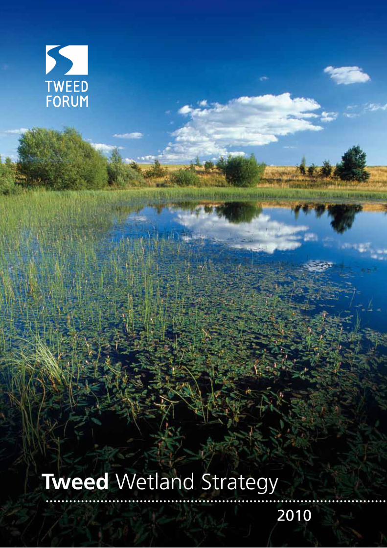
Tweed Wetland Strategy
2010

printed on 100% recycled material
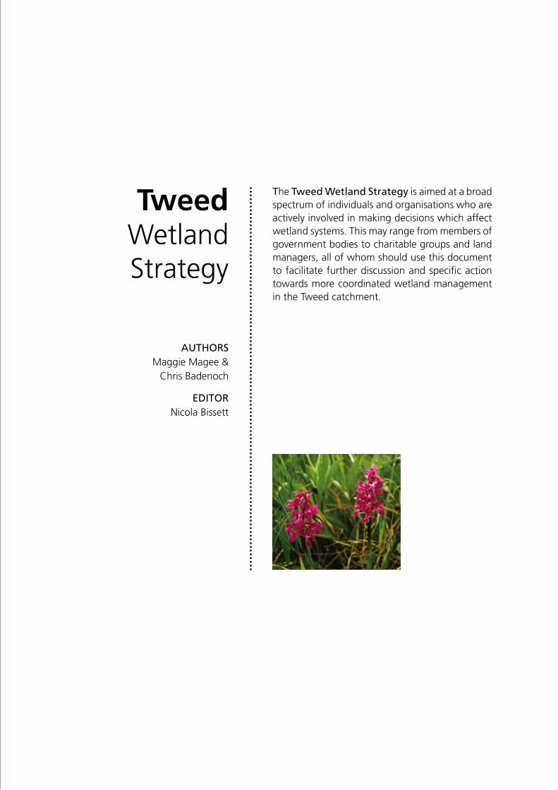
The Tweed Wetland Strategy is aimed at a broad spectrum of individuals and organisations who are actively involved in making decisions which affect wetland systems. This may range from members of government bodies to charitable groups and land managers, all of whom should use this document to facilitate further discussion and specific action towards more coordinated wetland management in the Tweed catchment.
Tweed Wetland Strategy
AuThorS Maggie Magee &
Chris Badenoch
EdiTor Nicola Bissett
p2
USER GUIDE .........................................................................................................................5
1 AIMS OF THE TWEED WETLAND STRATEGY .............................................................6
2 INTRODUCTION ...............................................................................................................8
2.1 Why Are Wetlands Important Habitats? ...................................................................................... 8 Figure 1 Wetland ecosystem services .......................................................................................... 8 2.2 Tweed Wetlands ......................................................................................................................... 9 2.2.1 Definitions .......................................................................................................................... 9 2.2.2 Classification of Tweed Wetlands ...................................................................................... 10 Table 1 Main characteristics of wetland types, as defined in this Strategy ....................................... 10 2.2.3 Key Tweed Wetlands ......................................................................................................... 11 Table 2 Key designation types for Tweed Wetlands ..................................................................... 11 Figure 2 Key (designated) wetlands of the Tweed catchment ........................................................ 12 2.2.4 How does the strategy link with current legislation and other related work? .................... 12 Figure 3 Legislation plans and processes relevant to the Tweed Wetland Strategy ............................ 13
3 HOW DO WE ACHIEVE THE AIMS? ..........................................................................14
3.1 Create an adaptable framework to enable integrated management of wetland sites ..................14
Figure 4 An adaptable framework for integrated wetland management in the Tweed catchment ...... 15 3.2 To identify and assess the potential for wetland creation ........................................................... 15 3.3 To identify existing or potential threats to wetland habitats and actions
to reduce these ......................................................................................................................... 16 3.3.1 Pollution ........................................................................................................................... 16 3.3.2 Water Abstraction ............................................................................................................ 18 3.3.3 Loss of Habitats and Species ............................................................................................. 20 3.3.4 Pressures from Tourism and Recreation ............................................................................. 22 3.4 To identify the benefits and opportunities that wetlands can bring to
landowners and communities and possible actions to achieve these .......................................... 24 3.4.1 Safeguarding and Enhancing Water Quality ...................................................................... 24 3.4.2 Sustainable Water Resources ............................................................................................. 25 3.4.3 Safeguarding and Enhancing Biodiversity .......................................................................... 26 3.4.4 Flood Alleviation ............................................................................................................... 27 3.4.5 Tourism and Recreation ..................................................................................................... 28 3.5 To raise awareness of wetlands as an important natural resource .............................................. 29 3.6 To prioritise actions ................................................................................................................... 30
4 CONCLUSIONS ..............................................................................................................31
GLOSSARY AND LIST OF ACRONYMS ..........................................................................32
conTEnTS
APPENDIX
1 Classification of Major Wetland Types ......................... A1
2 Plant Communities ..................................................... A10
3 Rare and Endangered Species .................................... A15
4 Designated Sites ........................................................ A20
5 Bird Species associated with the Wetland Sites ........... A23
6 Links to Biodiversity Action Plans ................................ A25
7 Useful Links ............................................................... A25
8 Invasive Alien Naturalised Flowering Plant Species List .. A27
9 Bibliography ............................................................... A29
p4
The need for integrated wetland management is clearly acknowledged by many organisations,
legislation, plans and processes. The need for a freshwater wetland strategy for the Tweed
catchment was highlighted during a recent review of the Tweed Catchment Management Plan
in 2009-10, where gaps in the relevant national legislative framework and a need for greater
coordination of local wetland conservation activity were identified. The three major EU Directives
(Water Framework, Floods and Habitats), and the cascade of legislation that flows from them,
address wetlands to varying degrees. However, a strategic document that explores the multi-
functionality of wetlands (and the need to balance these multiple functions), values smaller scale
wetland features (which are often overlooked), and crucially, provides strategic focus for future
practical work at the local level was clearly required. The Tweed catchment enjoys a long history
of partnership working, through the work of the Tweed Forum1 and it is by the consensus of this
group of stakeholders that this Strategy has finally come to fruition.
1 Tweed Forum is Borders Forest Trust, Environment Agency, Federation of Border Angling Associations, Forestry Commission Scotland, Natural England, Northumberland County Council, Northumberland National Park Authority, Northumbrian Water, Northumberland Wildlife Trust, Royal Society for the Protection of Birds, River Tweed Commission, Scottish Agricultural College, Scottish Borders Council, Scottish Environment Protection Agency, Scottish Government, Scottish Natural Heritage, Scottish Rural Property & Business Association, Scottish Water, Southern Upland Partnership, Tweed Foundation, Visit Scotland Borders
2 Wetlands will often naturally progress over time from one wetland habitat type to another due to vegetation growth and changes in water levels. This process is called hydroseral succession and is an important concept in wetland management. See section 2.1 and the glossary for further information
The broad aims of this Strategy are to:
• Protect,enhanceand,whereappropriaterestore
wetland habitats across the Tweed catchment
• Promotehabitatconnectivitytosupportthe
spread of species between wetlands at different
hydroseral stages2
• Identifyanyexistingorpotentialthreatstowetland
habitats and possible actions to reduce these
• Identifythebenefitsandopportunitiesthatwetlands
can bring to landowners and communities and
possible actions to achieve these
• Supportsustainablewetlandusebyacknowledging
the need to balance negative impacts against
derived benefits
• Illustratelinkagesbetweenwetlandhabitat
management and current legislative processes
The aims of the Strategy will be supported by a central information source which will include:
• Alive‘inventory’ofTweedwetlandswhichcanbe
reviewed and updated and is accessible by all land
users, legislators, and managers
• Acentraldatabaseofwetlandrelatedinformation,
e.g. species lists
• Aclearstatementofthemajorthreatsand
opportunities for wetland habitats
• Aprioritisedactionplan,includingthoseactionsset
out within this document, which will be prioritised
by stakeholders
This Strategy is seen as an integral part of the
future management process for Tweed wetlands
SummAry
p5User Guide
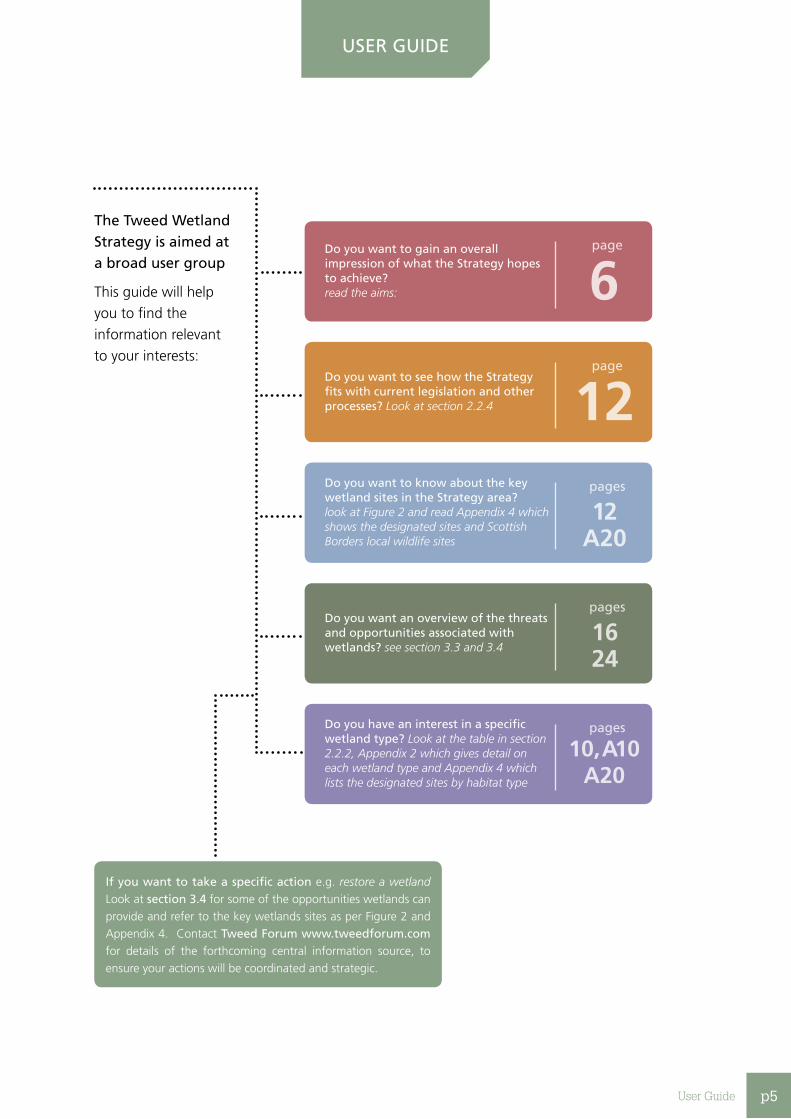
do you want to gain an overall impression of what the Strategy hopes to achieve? read the aims:
do you want to see how the Strategy fits with current legislation and other processes? Look at section 2.2.4
do you want to know about the key wetland sites in the Strategy area? look at Figure 2 and read Appendix 4 which shows the designated sites and Scottish Borders local wildlife sites
do you want an overview of the threats and opportunities associated with wetlands? see section 3.3 and 3.4
do you have an interest in a specific wetland type? Look at the table in section 2.2.2, Appendix 2 which gives detail on each wetland type and Appendix 4 which lists the designated sites by habitat type
6
12
12 A20
1624
10, A10A20
page
page
pages
pages
pages
The Tweed Wetland
Strategy is aimed at
a broad user group
This guide will help
you to find the
information relevant
to your interests:
if you want to take a specific action e.g. restore a wetland
Look at section 3.4 for some of the opportunities wetlands can
provide and refer to the key wetlands sites as per Figure 2 and
Appendix 4. Contact Tweed Forum www.tweedforum.com
for details of the forthcoming central information source, to
ensure your actions will be coordinated and strategic.
uSEr guidE
p6
THE SPECIFIC AIMS OF THIS STRATEGY ARE TO:
n create an adaptable framework to enable integrated management of wetland sites
This will bring together available data on wetland habitats, legislation, initiatives, projects and the
organisations involved in these activities to work together towards agreed targets. This will facilitate
discussion on the main issues, enable those involved in wetland management to make informed decisions
and lead to increased opportunities for creating, maintaining and enhancing wetland habitat networks.
An integral part of this will be to identify/quantify the water resource of Tweed and identify any special
features and their contribution to the water resource as a whole.
n To identify and assess the potential for wetland creation
The Borders Wetland Vision and the North East Wetland Feasibility Study have assessed the potential
for wetland creation through habitat modelling techniques. Phase 1 habitat survey work has provided
practical complementary information but there is potential to apply Phase 1 surveys to all wetlands and
further develop the available data to provide practical advice on the best sites for wetland creation.
n To identify existing or potential threats to wetland habitats and actions to reduce these
Human activity, through agriculture, forestry, industry and development, represents the main threat to
wetland habitats, though it should be noted that there are various mechanisms in place to regulate much
of this activity e.g. the Controlled Activities Regulations (CAR) in Scotland. These activities may affect
water quality through pollution and sediment load and habitats and species are affected by changes to
drainage, grazing management or by development and infill. Natural hydroseral succession (see glossary)
will lead to a loss in diversity of wetland species as will fragmentation of wetland sites if species cannot
move to or colonise other sites. Invasive species are problematic and may increase in range with climate
change effects. Abstraction for public water supply, agriculture or industry may deplete the resource and
increased tourism and recreation may be a threat if the resource is overused and ill managed. There is
a general lack of awareness of the importance of wetlands and this can result in decisions being taken
which are detrimental to the habitat. Actions to address these threats will be presented, however, it
should be noted that these will, of necessity reflect current knowledge and management trends.
n To identify the benefits and opportunities that wetlands can bring to landowners and communities and possible actions to achieve these
Wetlands are one of our most diverse habitats and are home to many rarer species as well as providing
a wide range of benefits to society i.e. ecosystem services. These include the ability to filter dirty water
through the action of vegetation in reedbeds or other wetland systems, blanket bog acting as a carbon
sink and also slowly releasing water from the hills and flood plain wetlands thereby alleviating flooding
downstream. These properties are particularly important in relation to potential effects of climate change
with increased rainfall and storms. Wetlands can also be an attraction for recreation and tourism, if well
managed to avoid overuse as noted above. It is this multiple range of benefits that wetlands have the
potential to provide that must be highlighted.
1. Aims of the Tweed Wetland Strategy
TWS AimS
p7TWS Aims
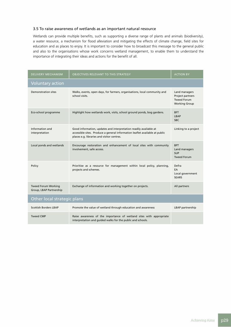
n To raise awareness of wetlands as an increasingly important natural resource
Key decision-makers, land managers, organisations, schools and the public should have access to
information and interpretation on wetlands, highlighting the importance of wetlands as a resource to
be protected, restored and expanded. This information and interpretation could be used, for example, in
the development of demonstration sites, targeted farm walks, publications and in the school curriculum.
Access to an updated database which identifies wetlands and potential sites for wetland creation would
be an asset for local policymakers, projects and schemes to ensure integrated management.
n To prioritise action
Stakeholders from across the Tweed catchment will be asked to prioritise a set of actions, including those
described within this Strategy, though it will be important to ensure that the actions remain current
and relevant. Priorities will likely include actions to safeguard the condition of existing sites, integrate
modelled data with actual data (e.g. Borders Wetland Vision) and expand wetlands. These actions should
support the creation of a series of linked habitat networks, a clear priority, as it is widely acknowledged
that habitat networks provide a more robust system able to cope with and adapt to demands from users
and a changing climate. Where possible, a comparison of the costs of wetland loss/absence, and the
associated decline in ecosystem services, against the costs of effective conservation/reinstatement and
sustainable use will assist in determining where priorities lie.
Everett moss
p8
inTroducTion
2. Introduction
2.1 Why are wetlands important habitats?
Wetlands, including springs, ponds, mires, swamps, burns and rivers, have for centuries been an essential resource; supplying clean water for human consumption and meeting the needs of agriculture, forestry and industry.
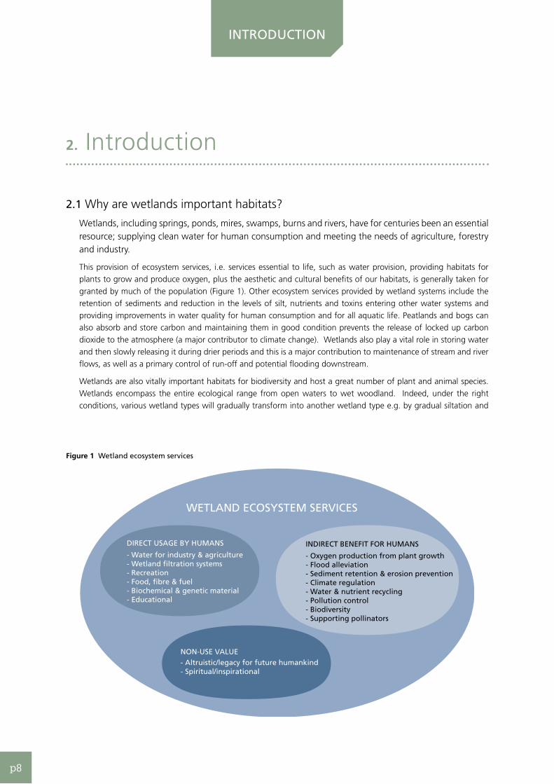
This provision of ecosystem services, i.e. services essential to life, such as water provision, providing habitats for
plants to grow and produce oxygen, plus the aesthetic and cultural benefits of our habitats, is generally taken for
granted by much of the population (Figure 1). Other ecosystem services provided by wetland systems include the
retention of sediments and reduction in the levels of silt, nutrients and toxins entering other water systems and
providing improvements in water quality for human consumption and for all aquatic life. Peatlands and bogs can
also absorb and store carbon and maintaining them in good condition prevents the release of locked up carbon
dioxide to the atmosphere (a major contributor to climate change). Wetlands also play a vital role in storing water
and then slowly releasing it during drier periods and this is a major contribution to maintenance of stream and river
flows, as well as a primary control of run-off and potential flooding downstream.
Wetlands are also vitally important habitats for biodiversity and host a great number of plant and animal species.
Wetlands encompass the entire ecological range from open waters to wet woodland. Indeed, under the right
conditions, various wetland types will gradually transform into another wetland type e.g. by gradual siltation and
WETLAND ECOSYSTEM SERVICES
NON-USE VALUE
- Altruistic/legacy for future humankind- Spiritual/inspirational
DIRECT USAGE BY HUMANS
- Water for industry & agriculture- Wetland filtration systems- Recreation- Food, fibre & fuel- Biochemical & genetic material- Educational
INDIRECT BENEFIT FOR HUMANS
- Oxygen production from plant growth- Flood alleviation- Sediment retention & erosion prevention- Climate regulation- Water & nutrient recycling- Pollution control- Biodiversity- Supporting pollinators
Figure 1 Wetland ecosystem services

p9Introduction
vegetative growth before perhaps completely drying out i.e. hydroseral succession. This variety/mosaic of habitat
types and associated flora and fauna constitutes a major genetic resource, but one that is highly susceptible to
detrimental impacts from human activity such as drainage, water abstraction and cultivation activities.
Wetlands feature strongly in the landscape of the Tweed catchment, particularly larger open waters and fenland
e.g. St Mary’s Loch and Loch of the Lowes, Yetholm Loch, Threepwood and Whim mosses. They create many
opportunities for recreational activities, including many that are economically important. There can also be strong
historical and social connections with wetlands, where past communities used them as a natural resource for
building materials and fuel, making them rich in archaeological finds such as plant remains, molluscs, fish, bird and
mammal skeletons and pollen records, all of which may provide information on climate change when analysed.
Climate change and the related issues of global drought, increasing demand for water in tandem with a potentially
increasing human population and more frequent flash floods during periods of rainfall, all point to wetlands as an
increasingly important component of ecosystem services vital to human needs.
2.2 Tweed Wetlands
2.2.1 definitions
This strategy encompasses the cross-border Tweed catchment plus the Eye Water catchment in Berwickshire
(see Figure 2). The Eye Water catchment has been included as it has been historically incorporated into previous
catchment-wide initiatives such as the Tweed Catchment Management Plan and therefore, where the term “Tweed
catchment” is used, inclusion of the Eye should be assumed. Some data for the Liddel Water catchment has been
collated during the preparation of the wetland site inventory and this will be located in the Tweed wetlands central
information source.
The definition of wetland under the Convention on Wetlands (Ramsar, Iran, 1971) states:
“Wetlands are areas of marsh, fen, peatland or water, whether natural or artificial, permanent or
temporary, with water that is static or flowing, fresh, brackish or salt,including areas of marine water,
the depth of which at low tide does not exceed six metres.”
The following wetland types are acknowledged to exist within the Tweed catchment3 :
This strategy will not include marine elements or the main river systems, the latter of which features heavily within
the Tweed Catchment Management Plan, Solway Tweed River Basin Management Plan and Local Biodiversity Action
Plan processes. Some types such as the underground resource are not technically wetlands, but as an important
resource should be borne in mind throughout.
This strategy will focus mainly on 1-8 above, marked in bold
1 Blanket bog
2 Raised bog
3 Fens and basin mires
4 Flushes
5 ’Schwingmoor’/floatingmire
6 Swamp
7 Open waters (ponds, lochans, lochs, lakes,
reservoirs – natural, impounded, excavated)
8 Wet soils
9 Rivers and burns
10 Underground rock basin reservoirs, water in
rock strata, water layers between underlying
rock and soil, groundwater
11 Coastal lagoons, rock pools, bays and
estuaries, salt marsh
12 Temporary or seasonal wetlands
3 For the purposes of this strategy, a full spectrum of wetland sites are included, from permanently open or standing waters (which have submerged vegetation) through to land where the water table is at (or around) the soil surface, to peats which are dependent on incoming precipitation.
p10
2.2.2 classification of Tweed Wetlands
The classification methodology for wetlands can vary enormously according to current technical knowledge, as
well as the aims of the classifiers. In this Strategy a deliberate decision was made to refer to the ecological status
of wetlands, as defined by their vegetation and nutrient status. Therefore, the wetland types considered here may
not fit directly with other classifications, developed for other purposes, e.g. the current SEPA “A Functional Wetland
Typology for Scotland” which allows SEPA staff (who may be non-ecologists) to “identify different wetland types
quickly and accurately to provide general risk screening”. However, as the SEPA typology will be used in building a
national inventory of Scottish wetlands, we have mapped the main wetland types used in this Strategy against those
of the SEPA typology; this information may be found in Appendix 1. A full technical description of the classification
methodology used for the major wetland types in the Tweed Wetland Strategy is also given in Appendix 1. Table 1
below summarises the main characteristics of the Strategy wetland types:
Appendix 2 lists the plant communities present in Tweed catchment wetlands as well as diagrams showing the
relationships between the main community types.
WETlAnd TypE chArAcTEriSTicS
Blanket Bog Dependent upon incoming precipitation falling, in a cooler climate, on level or gently sloping ground at levels which engender wet vegetation and the accumulation of Sphagnum, bog mosses and their associates. In the flat-summits plateaux of the Tweed catchment these conditions tend to occur above approx. 500m.
Raised Bog Development of Sphagnum vegetation, as for blanket bog, but usually developed upon sedge swamp or fen peats, raised above surrounding groundwater in discrete topographic hollows.
Fens & basin mires Found in topographic hollows; peat accumulation may be variable. Vegetation depends upon current and past uses.
Flushes Soligenous mires of all types which depend upon a throughput of water.
Schwingmoor/Floating mire Raftoffloatingmossandshortsedgebasedvegetation,‘quaking’whenwalkingacrossit.
Swamps Usually situated between open-water and mire with standing water less than 15 cm and emergent vegetation present.
Open Water Permanent static (without flow) water bodies.
Wet Soils Contains standing water, at least seasonally. Upper soil layers saturated or imperfectly draining. Occurs under a range of habitats including grazed grasslands with common grass species often present (e.g. creeping bent) and with/without rush, poor arable ground, woodland and plantations.
Table 1 main characteristics of wetland types, as defined in this Strategy
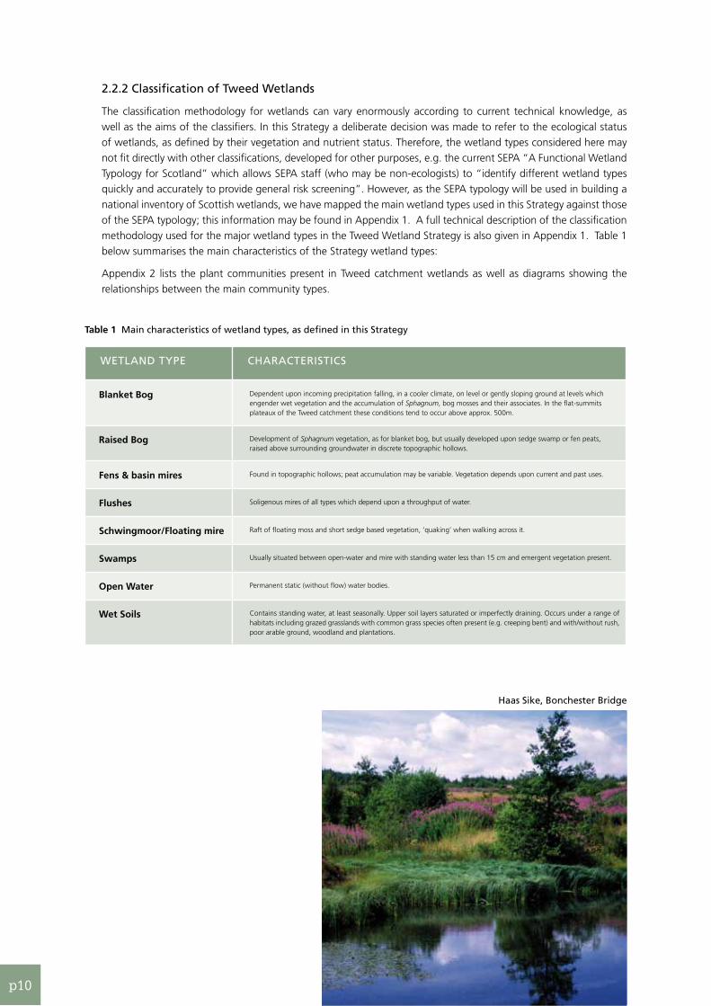
haas Sike, Bonchester Bridge
p11Introduction
2.2.3 Key Tweed Wetlands
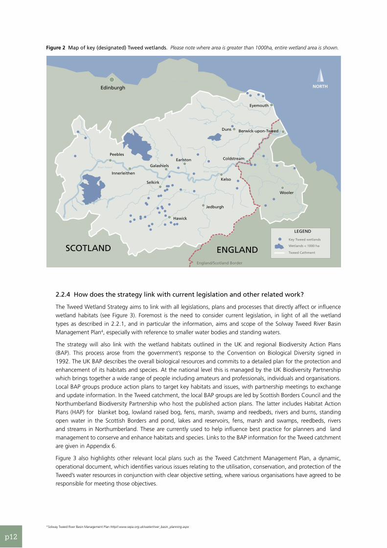
There are a number of important designated wetland sites within the Tweed catchment (Figure 2 and Appendix
4). These include the Central Borders basin mires e.g. the Whitlaw Mosses National Nature Reserve (NNR). There
are a greater proportion of basin mires in the Tweed area than in any other area of comparative rainfall in Scotland
and Northern England with over 200 sites identified, though not all designated sites, some small in scale although
located in close proximity and ranging in type from nutrient poor to nutrient rich. This makes them a distinctive
feature of the area.
The Tweed wetland sites are designated for their diverse habitats and plants (Appendix 3) and the presence of
breeding and overwintering birds (Appendix 5). These designations may be for regional, national or international
importance (see Table 2). For example, Hoselaw Loch-Din Moss, is a designated Site of Special Scientific Interest (SSSI)
as a natural open water body, with associated fen and relatively unmodified raised bog, used by breeding, passage
and wintering wildfowl. This site is also designated a Special Protection Area (SPA) under the Wild Birds Directive and
RAMSAR as an internationally important site for greylag and pink-footed geese. Dodgen and Threepwood mosses
are also internationally important designated sites, each a Special Area of Conservation (SAC) for active raised bogs.
Designated sites should have monitoring and management plans in place that include operations requiring consent
to ensure their continued good or improving condition. Outwith the designated sites there are many wetlands that
have not been subject to recent management or maintenance grants through government schemes. These may be
rareordegradedwetlandhabitatswhichcouldbenefitfromworktorestoreorimprovethem.‘ABordersWetland
Vision’(2006) identifiedsiteswheretherewaspotentialforwetlandrestorationorcreation.Someofthesemay
have historical and social associations e.g. at Philhope where wetland was created as a reservoir of water to power
several mills downstream in Hawick. Other sites may be fragmented or of small size and an integrated approach
with landowners on a wider catchment scale would help create a network of linked wetlands to achieve some of
the benefits described in section 2.1 i.e. biodiversity, water quality, flood management, recreational opportunities.
*Soon to be redesignated as “local Biodiversity Sites”
dESignATion lEvEl dEScripTion
SAC Eu, statutory • designatedundertheHabitatsDirective
• bestrepresenttherangeandvariety,withintheEuropeanUnion,ofhabitatsand(non-bird)specieslistedonAnnexes I and II to the Directive
• terrestrialareasandterritorialmarinewatersoutto12nauticalmilesareincluded
SPA Eu, statutory • designatedundertheBirdsDirective
• identifyandclassifythemostsuitableterritories,insizeandnumber,forcertainrareorvulnerablespecies(listedin Annex I of the Directive) and for regularly occurring migratory species
• safeguardthehabitatsofthespeciesforwhichtheyareselectedandprotectbirdsfromsignificantdisturbance
RAMSAR international, statutory
• designatedundertheConventionofWetlandsofInternationalImportance
• conservation and wise use of wetlands of international importance by national action and internationalcooperation as a means to achieving sustainable development throughout the world
SSSI national, statutory
• ‘special’fortheirplants,animalsorhabitats,theirrocksorlandforms,oracombinationofsuchnaturalfeatures
• anetworkofthebestexamplesofnaturalfeaturesthroughoutUK,andsupportawidernetworkacrosstheEU
NNR national, statutory
• importantnaturalandsemi-naturalterrestrialandcoastalecosystems
• conservehabitatsorprovidespecialopportunitiesforscientificstudyofthehabitatscommunitiesandspeciesrepresented within them
Local Wildlife Sites*
local • significantsiteforlocalwildlifefeatures
• criteria for designation include habitat and species diversity, habitat and species rarity, naturalness andtypicalness and size
Table 2 Key designation types for Tweed Wetlands
p12
NORTHRiver Tweed
River Tweed
River Tweed
LEGEND
Key Tweed wetlands
Wetlands < 1000 ha
Tweed Cathment
Peebles
Innerleithen
Edinburgh
Selkirk
Galashiels
Earlston
Hawick
Jedburgh
Kelso
Coldstream
Duns Berwick-upon-Tweed
Eyemouth
Wooler
ENGLANDSCOTLAND
England/Scotland Border
Figure 2 map of key (designated) Tweed wetlands. Please note where area is greater than 1000ha, entire wetland area is shown.
2.2.4 how does the strategy link with current legislation and other related work?
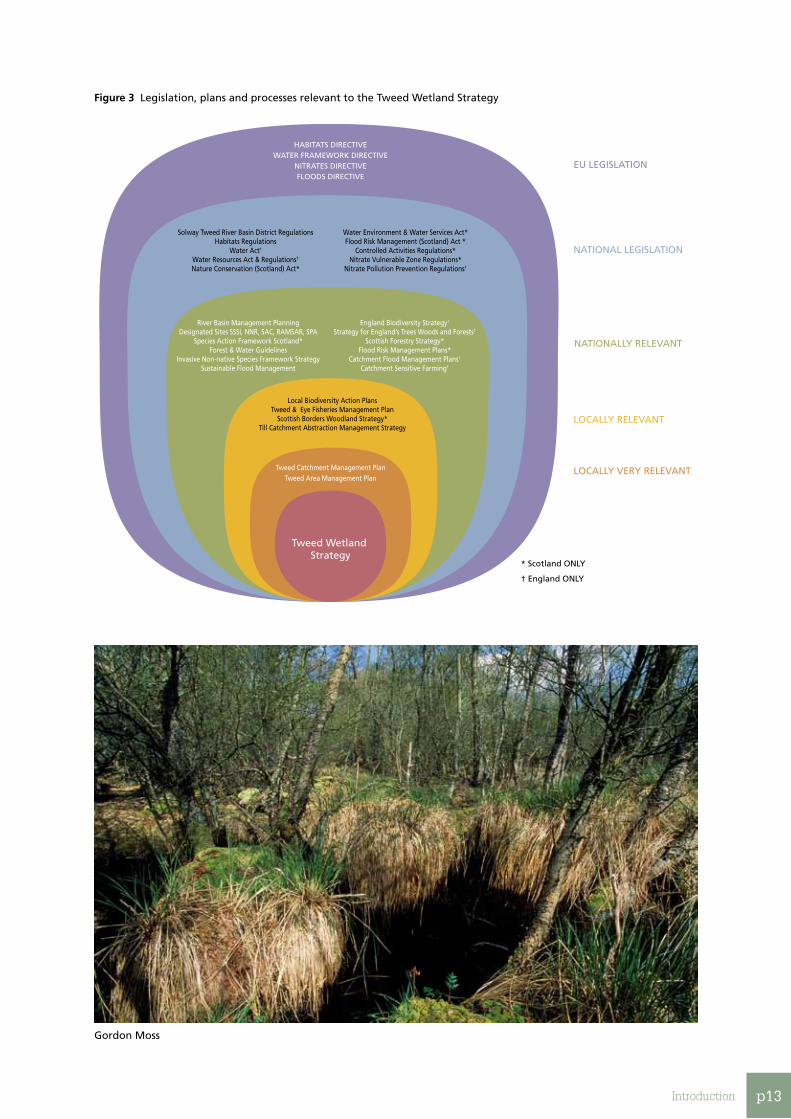
The Tweed Wetland Strategy aims to link with all legislations, plans and processes that directly affect or influence
wetland habitats (see Figure 3). Foremost is the need to consider current legislation, in light of all the wetland
types as described in 2.2.1, and in particular the information, aims and scope of the Solway Tweed River Basin
Management Plan4, especially with reference to smaller water bodies and standing waters.
The strategy will also link with the wetland habitats outlined in the UK and regional Biodiversity Action Plans
(BAP). This process arose from the government’s response to the Convention on Biological Diversity signed in
1992. The UK BAP describes the overall biological resources and commits to a detailed plan for the protection and
enhancement of its habitats and species. At the national level this is managed by the UK Biodiversity Partnership
which brings together a wide range of people including amateurs and professionals, individuals and organisations.
Local BAP groups produce action plans to target key habitats and issues, with partnership meetings to exchange
and update information. In the Tweed catchment, the local BAP groups are led by Scottish Borders Council and the
Northumberland Biodiversity Partnership who host the published action plans. The latter includes Habitat Action
Plans (HAP) for blanket bog, lowland raised bog, fens, marsh, swamp and reedbeds, rivers and burns, standing
open water in the Scottish Borders and pond, lakes and reservoirs, fens, marsh and swamps, reedbeds, rivers
and streams in Northumberland. These are currently used to help influence best practice for planners and land
management to conserve and enhance habitats and species. Links to the BAP information for the Tweed catchment
are given in Appendix 6.
Figure 3 also highlights other relevant local plans such as the Tweed Catchment Management Plan, a dynamic,
operational document, which identifies various issues relating to the utilisation, conservation, and protection of the
Tweed’swaterresourcesinconjunctionwithclearobjectivesetting,wherevariousorganisationshaveagreedtobe
responsible for meeting those objectives.
4 Solway Tweed River Basin Management Plan http//:www.sepa.org.uk/water/river_basin_planning.aspx
p13Introduction
Tweed Wetland Strategy
Tweed Catchment Management PlanTweed Area Management Plan
Local Biodiversity Action PlansTweed & Eye Fisheries Management Plan
Scottish Borders Woodland Strategy*Till Catchment Abstraction Management Strategy
River Basin Management PlanningDesignated Sites SSSI, NNR, SAC, RAMSAR, SPA
Species Action Framework Scotland*Forest & Water Guidelines
Invasive Non-native Species Framework StrategySustainable Flood Management
England Biodiversity Strategy†
Strategy for England’s Trees Woods and Forests†
Scottish Forestry Strategy*Flood Risk Management Plans*
Catchment Flood Management Plans†
Catchment Sensitive Farming†
Solway Tweed River Basin District RegulationsHabitats Regulations
Water Act†
Water Resources Act & Regulations†
Nature Conservation (Scotland) Act*
Water Environment & Water Services Act*Flood Risk Management (Scotland) Act *
Controlled Activities Regulations*Nitrate Vulnerable Zone Regulations*
Nitrate Pollution Prevention Regulations†
HABITATS DIRECTIVEWATER FRAMEWORK DIRECTIVE
NITRATES DIRECTIVEFLOODS DIRECTIVE
EU LEGISLATION
NATIONAL LEGISLATION
NATIONALLY RELEVANT
LOCALLY RELEVANT
LOCALLY VERY RELEVANT
* Scotland ONLY
† England ONLY
Figure 3 legislation, plans and processes relevant to the Tweed Wetland Strategy
gordon moss
p14
3. How do we Achieve These Aims?
3.1 Create an adaptable framework to enable integrated management of wetland sites
There are various mechanisms through which wetland habitats may be recorded, assessed or enter a management
scheme. These include:
• statutoryprocessese.g.ControlledActivitiesRegulations(CAR)
• monitoringofthedesignatedsites(SSSI,SAC,NNR,RAMSAR)
• projectworksuchasPondsforBiodiversityandWetlandFiltrationSystems(TweedForum,FWAG,SNH)
• ScottishWildlifeTrustandNorthumberlandWildlifeTrustwork
• agri-environmentschemeapplications
• recordsfromindividualssenttotheBiologicalRecordsCentreandBSBIsurveys
• farmconservationplans
• SEPAWetlandInventory(forthcoming)
In addition there have been other actions which have highlighted the importance of Tweed wetlands and made
recommendations on future work programmes:
• ScottishBordersandNorthumberlandBiodiversityActionPlansandspecificHabitatActionPlans
• TweedCatchmentManagementPlan
• TheBordersWetlandVision
• TheNorthEastWetlandFeasibilityStudy
• Phase1habitatsurvey
The Wetland Strategy Working group is currently preparing a full inventory and database of wetland sites at the
local scale as this is an essential element of integrated management. The identification of wetland sites can be
brought together through the different agencies noted above. The total water resource of Tweed is more difficult
to quantify due to the many small wetlands which, whilst individually small, still have a large capacity to store and
slowly discharge water into the main systems downstream (a particularly important point for flood alleviation).
The mires and peatlands, which occur in relatively discrete sub-catchment areas like lower Ettrick–Teviot, and the
vast areas of blanket peats which occur on the high ground of Tweedsmuir, Ettrickhead, Teviothead, Moorfoots,
Lammermuir and the Border ridge contribute to this resource. There is a deficiency of data on water volumes, return
times, and discharge rates for open water bodies and other wetlands over the whole Tweed catchment. This may
have relevance for future water resource management if demand increases. A baseline figure would be a useful tool
in determining where over abstraction would be detrimental to the ecosystem and will ultimately be required from
2027 onwards to properly fulfil the requirements of the WFD.
Nationally, the Scotland & Northern Ireland Forum for Environmental Research (SNIFFER) WFD 95 project has
produced a basic wetland typology “A Functional Wetland Typology for Scotland” as described in 2.2.2 to enable
non ecologists to identify wetland categories in the field in order to determine the risk from proposed regulated
activities. The typology is required to support SEPA and the Environment Agency in their regulatory duties under the
AchEiving AimS

p15Achieving Aims
Water Environment (Water Framework Directive) (Solway Tweed River Basin District) Regulations. See Appendix 7
for links to many of the documents and processes mentioned above.
An adaptable framework is required to enable integrated wetland management in the Tweed catchment, including
a facility for individuals and organisations to provide and gain access to a central information source. Figure 4
outlines such a framework and this will support integrated wetland management in the Tweed catchment, following
the publication of this Strategy. It is likely that this central information source will include:
• a live“inventory”ofTweedwetlandswhichcanbereviewedandupdatedand isaccessiblebyall landusers,
legislators and managers
• acentraldatabaseofwetlandrelatedinformation,e.g.specieslists
• aclearstatementofthemajorthreatsandopportunitiesforwetlandhabitats
• aprioritisedactionplan,includingthoseactionssetoutwithinthisdocument
3.2 To identify and assess the potential for wetland creation
The Borders Wetland Vision and North East Wetland Feasibility Study have provided planning tools for identifying
potential wetland creation sites. These studies have taken into account available information on hydrology, geology
and wet soil types i.e. restricted drainage, peat or gleyed soils, boulder clay and on site topography and vegetation
type. The vision maps show potential for wetland sites by habitat type which can be verified by Phase 1 survey work.
Current land management must be considered, as many of the potential sites will be on historic wetland sites. Many
wetlands were drained with the push for agricultural improvements in the 18th century. This, combined with the
gradual silting-up of natural wetlands, contributed to the decline in many sites. It is evident from common farm or
field names still in use e.g. Billiemire, Cowbog, the bog or pond field where neither habitat now exists, that wetlands
wereoncemorewidelydistributed.The‘mosstroopers’(orreivers)oftheBordercountryfromthe17thcenturyalso
give an indication of the territory they occupied, moss being a broad description for any wet place. As these historic
wetland sites may have produced some of the best fields on a farm holding, it may be challenging to promote
wetland(re-)creationhere,especiallyifcombinedwithareluctanceto‘turntheclockback’amongstfarmersand
LAND MANAGERSORGANISATIONSGENERAL PUBLIC
INTEGRATED & STRATEGIC ACTION
CENTRAL INFORMATION
SOURCE4
for Tweed wetlands
TWEED FORUM WORKING GROUP
Provide info toAND
Use to inform action on the ground
Provide info toAND
Use to inform action on the ground
Informationfor
Undertake
Undertake AND
promote
Figure 4 An adaptable framework for integrated wetland management in the Tweed catchment
4 Please contact Tweed Forum for details of this “central information source”, [email protected], 01896 849723, www.tweedforum.com
p16
landowners. However, if climate change, water quantity and flooding concerns continue to be of prime importance,
wetland creation may receive much more attention and support than it has to date, even in the face of increasing
concerns regarding food security.
Wetland creation sites may also be chosen for their proximity to existing “good quality” wetlands. These sites will
have greater value, in biodiversity terms, by potentially expanding the “good quality” habitat for rare or endangered
species, thereby creating habitat networks. Another consideration for wetland creation might be whether the
new wetland creates a more suitable habitat for an important species than the habitat it currently resides in, due
to changes, natural (hydroseral succession) or artificial, in that existing habitat. Indeed, this natural succession
of wetlands from one type to another, as vegetation takes hold, is a major consideration in strategic wetland
management at both a local and regional scale – see section 3.3.3.
An assessment of ecosystem services, where appropriate, may also inform wetland creation site selection in
incorporating many of the issues outlined above.
3.3 To identify existing or potential threats to wetland habitats and actions to reduce these
3.3.1 pollution
For wetlands, pollution from farming, forestry, land development and industry is the main cause of reduced water
quality. The addition of excess nutrients, mainly nitrogen and phosphorous from livestock grazing (in or by wetland
sites) and silage or slurry run-off, can cause increased nutrient concentrations, or eutrophication, which leads to
many negative impacts such as increased algal growth and a lowering of available oxygen. This can be highly
detrimental to aquatic life and drinking waters. Sewage or septic tank run-off from development and housing sites
can similarly increase nutrient levels in wetlands. Application of pesticides to crops and application of manures, slurry
and artificial fertilisers in farming and forestry surrounding wetlands can all potentially cause pollution. Industrial
processes in electronics or, for example, wood tanalising may release heavy metals into wetland systems.
Field drainage, infill and erosion are activities which can have a negative impact on water quality. Drainage and
infill can directly reduce the ability of the wetland to function. Infill is less likely to occur due to regulatory control
of waste products during developments or old style farm tips but some sites will have been lost or are now in
poor condition. Drainage affects the water levels in wetlands and leads to succession of species and a reduction in
diversity over time. Erosion can begin as a result of drying of the soil surface due to drainage or road building, on
peat bogs for example. This may increase the volume of sediment reaching open waters and be detrimental to water
quality as described earlier.
Other activities may affect water quality indirectly such as ploughing, harvesting and development activities, which
cause erosion on susceptible soil types and increase the amount of silt reaching open waters. Acid rain (acidification)
industrial outputs of sulphates and nitrates in cloud droplet form, is most damaging around afforested sites
and affects water chemistry, plant and animal life and drinking water quality. Climate change effects, if higher
temperatures are realised, could increase surface evaporation and thereby reduce the volume of water in wetlands,
potentially accentuating pollution inputs. The key catchments affected by pollution in the Tweed catchment are the
Till, Leet and Eye Water, mainly through diffuse pollution from land use activities.
p17Achieving Aims
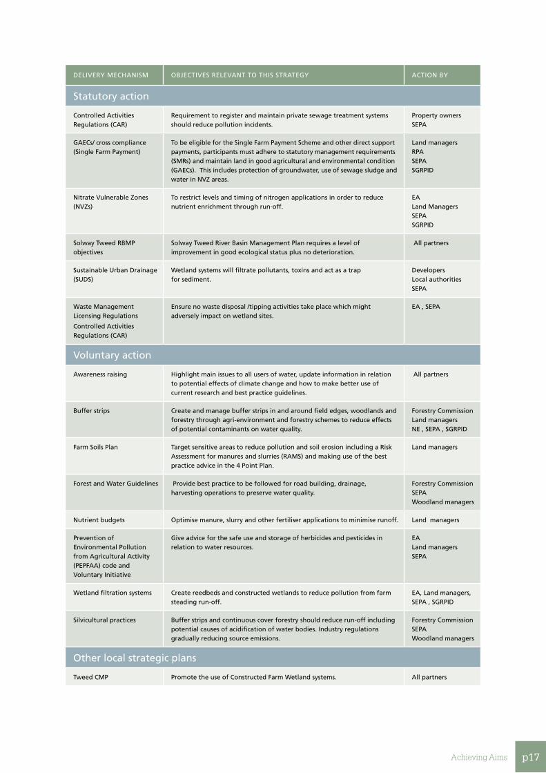
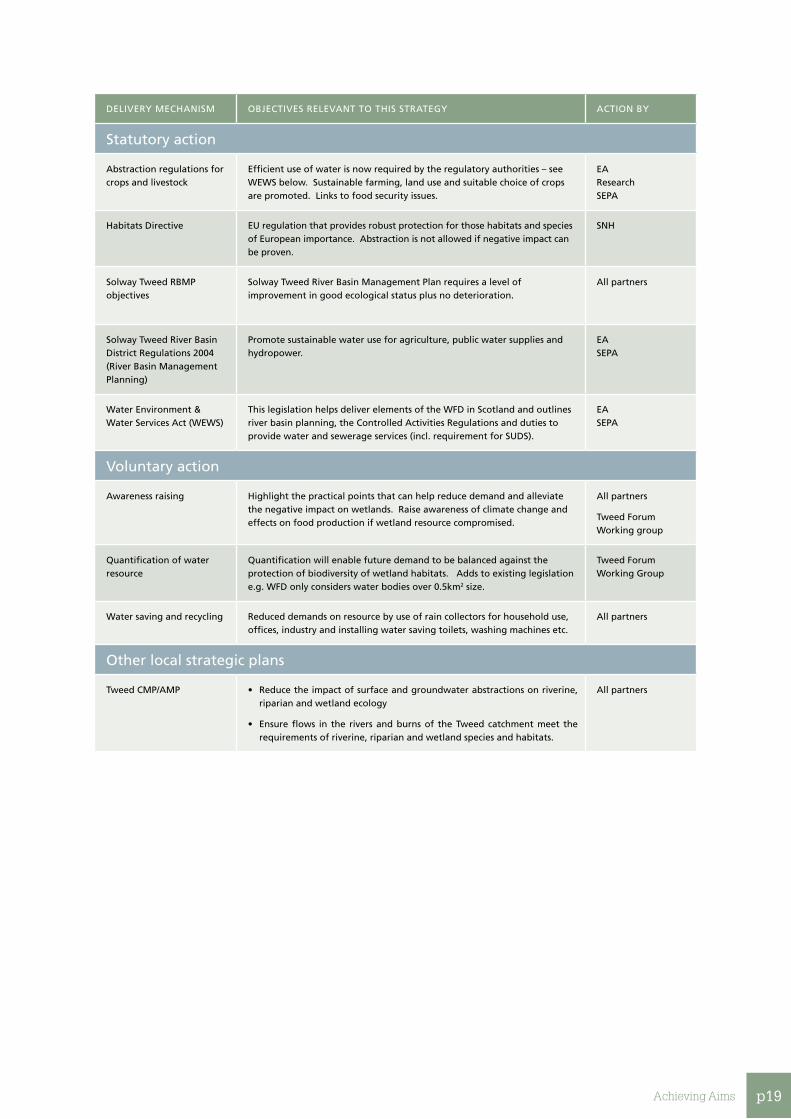
dElivEry mEchAniSm oBjEcTivES rElEvAnT To ThiS STrATEgy AcTion By
Statutory action
controlled Activities regulations (cAr)
requirement to register and maintain private sewage treatment systems should reduce pollution incidents.
property owners SEpA
gAEcs/ cross compliance (Single Farm payment)
To be eligible for the Single Farm payment Scheme and other direct support payments, participants must adhere to statutory management requirements (Smrs) and maintain land in good agricultural and environmental condition (gAEcs). This includes protection of groundwater, use of sewage sludge and water in nvZ areas.
land managers rpA SEpA Sgrpid
nitrate vulnerable Zones (nvZs)
To restrict levels and timing of nitrogen applications in order to reduce nutrient enrichment through run-off.
EA land managers SEpA Sgrpid
Solway Tweed rBmp objectives
Solway Tweed river Basin management plan requires a level of improvement in good ecological status plus no deterioration.
All partners
Sustainable urban drainage (SudS)
Wetland systems will filtrate pollutants, toxins and act as a trap for sediment.
developers local authorities SEpA
Waste management licensing regulations
controlled Activities regulations (cAr)
Ensure no waste disposal /tipping activities take place which might adversely impact on wetland sites.
EA , SEpA
voluntary action
Awareness raising highlight main issues to all users of water, update information in relation to potential effects of climate change and how to make better use of current research and best practice guidelines.
All partners
Buffer strips create and manage buffer strips in and around field edges, woodlands and forestry through agri-environment and forestry schemes to reduce effects of potential contaminants on water quality.
Forestry commission land managers nE , SEpA , Sgrpid
Farm Soils plan Target sensitive areas to reduce pollution and soil erosion including a risk Assessment for manures and slurries (rAmS) and making use of the best practice advice in the 4 point plan.
land managers
Forest and Water guidelines provide best practice to be followed for road building, drainage, harvesting operations to preserve water quality.
Forestry commission SEpA Woodland managers
nutrient budgets optimise manure, slurry and other fertiliser applications to minimise runoff. land managers
prevention of Environmental pollution from Agricultural Activity (pEpFAA) code and voluntary initiative
give advice for the safe use and storage of herbicides and pesticides in relation to water resources.
EA land managers SEpA
Wetland filtration systems create reedbeds and constructed wetlands to reduce pollution from farm steading run-off.
EA, land managers, SEpA , Sgrpid
Silvicultural practices Buffer strips and continuous cover forestry should reduce run-off including potential causes of acidification of water bodies. industry regulations gradually reducing source emissions.
Forestry commission SEpA Woodland managers
other local strategic plans
Tweed cmp promote the use of constructed Farm Wetland systems. All partners
p18
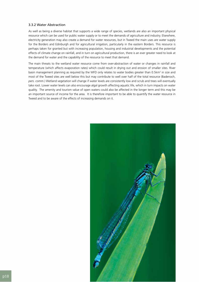
3.3.2 Water Abstraction
As well as being a diverse habitat that supports a wide range of species, wetlands are also an important physical
resource which can be used for public water supply or to meet the demands of agriculture and industry. Elsewhere,
electricity generation may also create a demand for water resources, but in Tweed the main uses are water supply
for the Borders and Edinburgh and for agricultural irrigation, particularly in the eastern Borders. This resource is
perhaps taken for granted but with increasing population, housing and industrial developments and the potential
effects of climate change on rainfall, and in turn on agricultural production, there is an ever greater need to look at
the demand for water and the capability of the resource to meet that demand.
The main threats to the wetland water resource come from over-abstraction of water or changes in rainfall and
temperature (which affects evaporation rates) which could result in drying out and erosion of smaller sites. River
basin management planning as required by the WFD only relates to water bodies greater than 0.5km2 in size and
most of the Tweed sites are well below this but may contribute to well over half of the total resource (Badenoch,
pers. comm.) Wetland vegetation will change if water levels are consistently low and scrub and trees will eventually
take root. Lower water levels can also encourage algal growth affecting aquatic life, which in turn impacts on water
quality. The amenity and tourism value of open waters could also be affected in the longer term and this may be
an important source of income for the area. It is therefore important to be able to quantify the water resource in
Tweed and to be aware of the effects of increasing demands on it.
p19Achieving Aims
dElivEry mEchAniSm oBjEcTivES rElEvAnT To ThiS STrATEgy AcTion By
Statutory action
Abstraction regulations for crops and livestock
Efficient use of water is now required by the regulatory authorities – see WEWS below. Sustainable farming, land use and suitable choice of crops are promoted. links to food security issues.
EA research SEpA
habitats directive Eu regulation that provides robust protection for those habitats and species of European importance. Abstraction is not allowed if negative impact can be proven.
Snh
Solway Tweed rBmp objectives
Solway Tweed river Basin management plan requires a level of improvement in good ecological status plus no deterioration.
All partners
Solway Tweed river Basin district regulations 2004 (river Basin management planning)
promote sustainable water use for agriculture, public water supplies and hydropower.
EA SEpA
Water Environment & Water Services Act (WEWS)
This legislation helps deliver elements of the WFd in Scotland and outlines river basin planning, the controlled Activities regulations and duties to provide water and sewerage services (incl. requirement for SudS).
EA SEpA
voluntary action
Awareness raising highlight the practical points that can help reduce demand and alleviate the negative impact on wetlands. raise awareness of climate change and effects on food production if wetland resource compromised.
All partners
Tweed Forum Working group
Quantification of water resource
Quantification will enable future demand to be balanced against the protection of biodiversity of wetland habitats. Adds to existing legislation e.g. WFd only considers water bodies over 0.5km2 size.
Tweed Forum Working group
Water saving and recycling reduced demands on resource by use of rain collectors for household use, offices, industry and installing water saving toilets, washing machines etc.
All partners
other local strategic plans
Tweed cmp/Amp • Reducetheimpactofsurfaceandgroundwaterabstractionsonriverine,riparian and wetland ecology
• Ensureflows in the riversandburnsof theTweedcatchmentmeet therequirements of riverine, riparian and wetland species and habitats.
All partners

p20
3.3.3 loss of habitats and Species
Wetlands are one of our most diverse habitats, supporting a wide range of species including rare and endangered
plants and wildlife (Appendices 3 and 5). Wetlands are vulnerable to changes in management and in the past, as
well as being used as a source of grazing, late-hay and animal bedding, wetlands have been drained, infilled and
improved for more intensive agricultural use. Wetlands were seen in the past as hosts for diseases of humans and
livestock and as hazardous places. Indeed, even in modern times, the potential for increased incidences of liver
fluke, foot rot in sheep, clostridial disease and the potential for insects carrying the Bluetongue virus can cause
negative feelings from farmers with regards to wetland conservation and restoration. Grazing in particular can be
important in maintaining wetland sites in good condition and changes in farming practice can have detrimental
effects. Overgrazing can cause damage by poaching, while undergrazing allows the more competitive plant species
to dominate at the expense of species which require a short grass sward to thrive. Inputs of nutrients from any of
the same sources that affect water quality will also affect plants and wildlife. Removal of a proportion of the annual
vegetation production by mowing or grazing was advantageous in fens, swamps and wet-grassland in reducing the
overall nutrient “store”. Coarse grasses (Common reed, Creeping Bent, Canary Grass) will come to dominate the
sward, along with nettles and docks, in areas with higher nitrogen and phosphorous content, whereas open waters
will experience eutrophication, which may lead to loss of diversity in aquatic life.
A “wetland” exists only as a point in the ecological journey of succession between open water and wet woodland
(hydroseral succession). Raised bogs are particularly susceptible to changes in water levels which allow the peat to
dry and colonisation by birch, willow and Scots pine to occur. Drying and erosion of peatlands may also lead to a
reduction in the ability of the bog to retain water and slowly release it to the downstream system, in turn leading
to a reduction in flood alleviation. Small ponds and mires may gradually fill in towards the centre with vegetation,
particularly if species such as Phragmites (common reed) are present, however these situations may be reversed by
appropriate management, where wetland retention is intended.
The management of wetlands may include the creation or restoration of habitats for flood alleviation, however, in
some situations there may be conflicts with existing habitats, for example, tree planting on wet soils in the flood
plain which may useful habitat for birds, or the creation of wetlands on fields that are well used in-bye fields for
livestock.
One of the main threats to Tweed wetlands, which cannot be over-emphasised, is their small size and fragmentation,
e.g. the Central Border mire sites. This makes them extremely vulnerable to changes in surrounding farming or
forestry practice and reduces the likelihood of species (genetic) exchange and colonisation between wetlands.
Identifying Tweed wetlands down to this scale will allow them to be linked into a series of habitat networks,
creating connections between different habitats and species in an ecosystem or across landscapes. This benefits the
movement of species between sites and maintains genetic variability. This approach can help link wetlands and the
major river systems, e.g. the Ettrick Habitat Restoration project, which also serves as an educational resource.
There are a number of non-native species of plants and animals which are invasive in the Tweed wetlands and can
lead to a reduction in wetland diversity and function. Invasive species will out-compete, due to the absence of any
predator to control their growth and, in the case of invasive animals, may directly consume native species. Invasive
plant species are listed in Appendix 8 and include Japanese knotweed or Giant Hogweed, both of which form dense
clumps that shade out the existing flora and exacerbate soil erosion. Canadian pondweed and New Zealand Pygmy
Weed are submerged pond plants which can rapidly take over, smothering more desirable water plants. Some non-
natives originate in gardens and can be spread by indiscriminate dumping of waste. The main animal threat is from
American Signal Crayfish whose presence is a serious threat to freshwater systems such as ponds, open water, rivers
and burns. This alien species will consume juvenile fish and eggs, beetles, amphibians and is very destructive to
nativespeciesaswellasathreattotheregion’sworldrenownedsalmonfisheries.Raisingawarenessofthisproblem
and work to eliminate invasive species is ongoing.
p21Achieving Aims
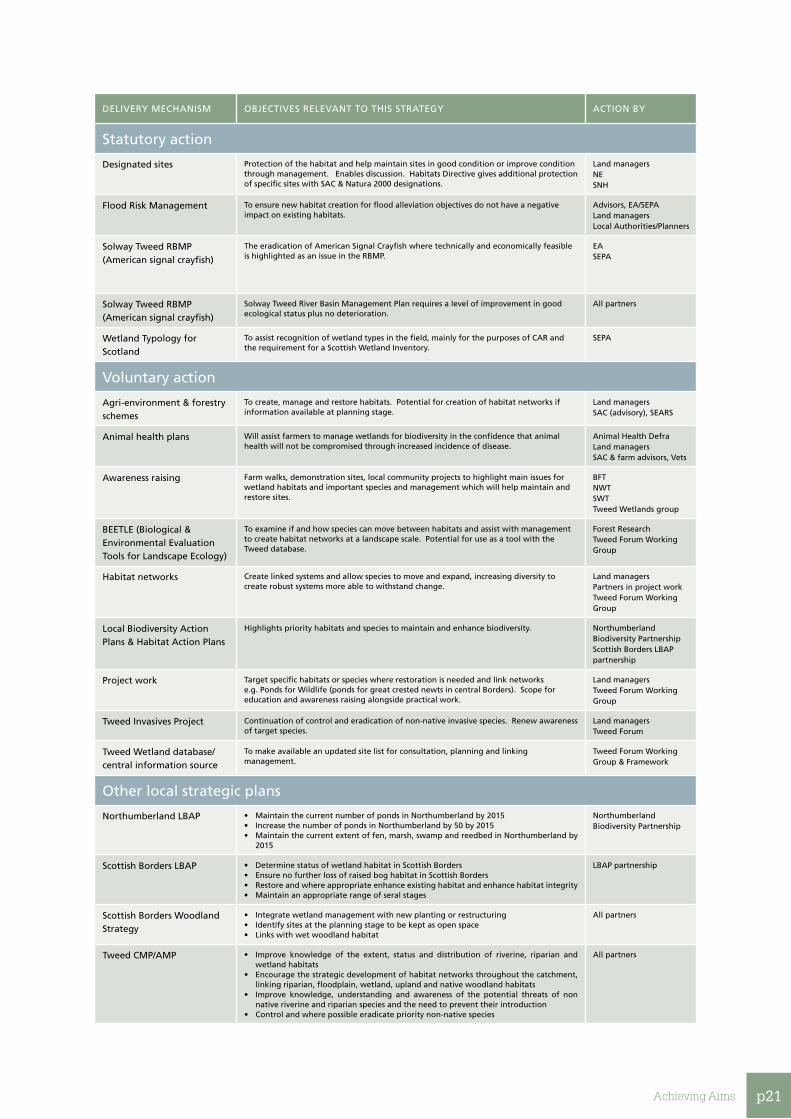
dElivEry mEchAniSm oBjEcTivES rElEvAnT To ThiS STrATEgy AcTion By
Statutory action
designated sites protection of the habitat and help maintain sites in good condition or improve condition through management. Enables discussion. habitats directive gives additional protection of specific sites with SAc & natura 2000 designations.
land managers nE Snh
Flood risk management Toensurenewhabitatcreationforfloodalleviationobjectivesdonothaveanegativeimpact on existing habitats.
Advisors, EA/SEpA land managers local Authorities/planners
Solway Tweed rBmp (American signal crayfish)
The eradication of American Signal crayfish where technically and economically feasible is highlighted as an issue in the rBmp.
EA SEpA
Solway Tweed rBmp (American signal crayfish)
Solway Tweed river Basin management plan requires a level of improvement in good ecological status plus no deterioration.
All partners
Wetland Typology for Scotland
To assist recognition of wetland types in the field, mainly for the purposes of cAr and the requirement for a Scottish Wetland inventory.
SEpA
voluntary action
Agri-environment & forestry schemes
To create, manage and restore habitats. potential for creation of habitat networks if information available at planning stage.
land managers SAc (advisory), SEArS
Animal health plans Will assist farmers to manage wetlands for biodiversity in the confidence that animal health will not be compromised through increased incidence of disease.
Animal health defra land managers SAc & farm advisors, vets
Awareness raising Farm walks, demonstration sites, local community projects to highlight main issues for wetland habitats and important species and management which will help maintain and restore sites.
BFT nWT SWT Tweed Wetlands group
BEETlE (Biological & Environmental Evaluation Tools for landscape Ecology)
To examine if and how species can move between habitats and assist with management to create habitat networks at a landscape scale. potential for use as a tool with the Tweed database.
Forest research Tweed Forum Working group
habitat networks create linked systems and allow species to move and expand, increasing diversity to create robust systems more able to withstand change.
land managers partners in project work Tweed Forum Working group
local Biodiversity Action plans & habitat Action plans
highlights priority habitats and species to maintain and enhance biodiversity. northumberland Biodiversity partnership Scottish Borders lBAp partnership
project work Target specific habitats or species where restoration is needed and link networks e.g. ponds for Wildlife (ponds for great crested newts in central Borders). Scope for education and awareness raising alongside practical work.
land managers Tweed Forum Working group
Tweed invasives project continuation of control and eradication of non-native invasive species. renew awareness of target species.
land managers Tweed Forum
Tweed Wetland database/central information source
To make available an updated site list for consultation, planning and linking management.
Tweed Forum Working group & Framework
other local strategic plans
northumberland lBAp • MaintainthecurrentnumberofpondsinNorthumberlandby2015• IncreasethenumberofpondsinNorthumberlandby50by2015• Maintainthecurrentextentoffen,marsh,swampandreedbedinNorthumberlandby
2015
northumberland Biodiversity partnership
Scottish Borders lBAp • DeterminestatusofwetlandhabitatinScottishBorders• EnsurenofurtherlossofraisedboghabitatinScottishBorders• Restoreandwhereappropriateenhanceexistinghabitatandenhancehabitatintegrity• Maintainanappropriaterangeofseralstages
lBAp partnership
Scottish Borders Woodland Strategy
• Integratewetlandmanagementwithnewplantingorrestructuring• Identifysitesattheplanningstagetobekeptasopenspace• Linkswithwetwoodlandhabitat
All partners
Tweed cmp/Amp • Improve knowledge of the extent, status and distribution of riverine, riparian andwetland habitats
• Encouragethestrategicdevelopmentofhabitatnetworksthroughoutthecatchment,linkingriparian,floodplain,wetland,uplandandnativewoodlandhabitats
• Improve knowledge, understanding and awareness of the potential threats of nonnative riverine and riparian species and the need to prevent their introduction
• Controlandwherepossibleeradicateprioritynon-nativespecies
All partners
p22
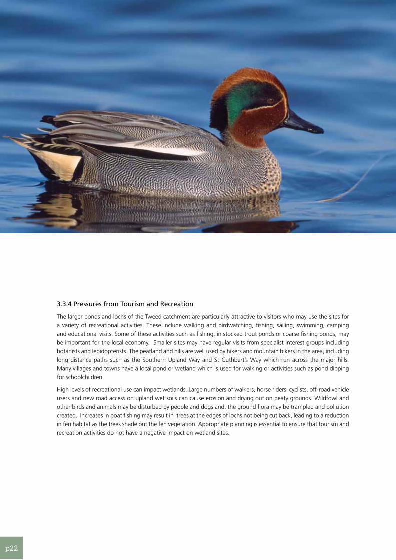
3.3.4 pressures from Tourism and recreation
The larger ponds and lochs of the Tweed catchment are particularly attractive to visitors who may use the sites for
a variety of recreational activities. These include walking and birdwatching, fishing, sailing, swimming, camping
and educational visits. Some of these activities such as fishing, in stocked trout ponds or coarse fishing ponds, may
be important for the local economy. Smaller sites may have regular visits from specialist interest groups including
botanists and lepidopterists. The peatland and hills are well used by hikers and mountain bikers in the area, including
longdistancepaths suchas theSouthernUplandWayandStCuthbert’sWaywhich runacross themajorhills.
Many villages and towns have a local pond or wetland which is used for walking or activities such as pond dipping
for schoolchildren.
High levels of recreational use can impact wetlands. Large numbers of walkers, horse riders cyclists, off-road vehicle
users and new road access on upland wet soils can cause erosion and drying out on peaty grounds. Wildfowl and
other birds and animals may be disturbed by people and dogs and, the ground flora may be trampled and pollution
created. Increases in boat fishing may result in trees at the edges of lochs not being cut back, leading to a reduction
in fen habitat as the trees shade out the fen vegetation. Appropriate planning is essential to ensure that tourism and
recreation activities do not have a negative impact on wetland sites.
p23Achieving Aims
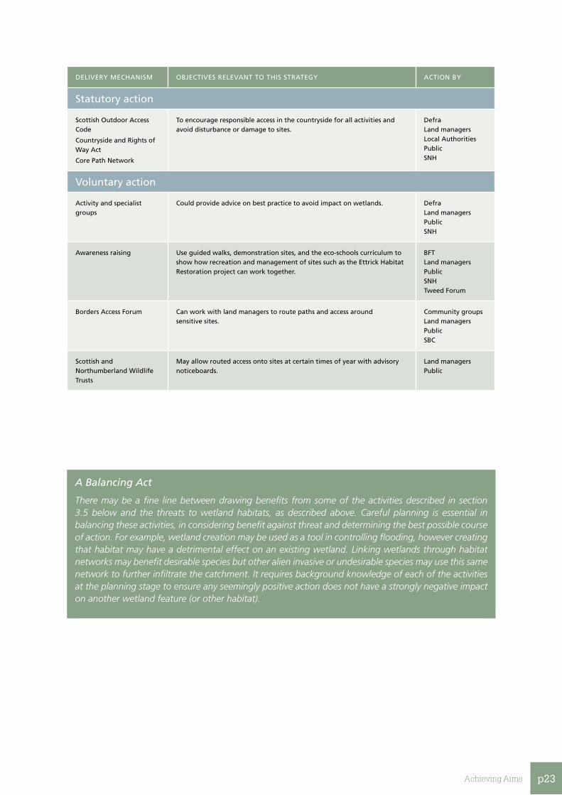
dElivEry mEchAniSm oBjEcTivES rElEvAnT To ThiS STrATEgy AcTion By
Statutory action
Scottish outdoor Access code
countryside and rights of Way Act
core path network
To encourage responsible access in the countryside for all activities and avoid disturbance or damage to sites.
defra land managers local Authorities public Snh
voluntary action
Activity and specialist groups
could provide advice on best practice to avoid impact on wetlands. defraland managerspublic Snh
Awareness raising use guided walks, demonstration sites, and the eco-schools curriculum to show how recreation and management of sites such as the Ettrick habitat restoration project can work together.
BFTland managerspublicSnhTweed Forum
Borders Access Forum can work with land managers to route paths and access around sensitive sites.
community groupsland managerspublicSBc
Scottish and northumberland Wildlife Trusts
may allow routed access onto sites at certain times of year with advisory noticeboards.
land managerspublic
A Balancing Act
There may be a fine line between drawing benefits from some of the activities described in section 3.5 below and the threats to wetland habitats, as described above. Careful planning is essential in balancing these activities, in considering benefit against threat and determining the best possible course of action. For example, wetland creation may be used as a tool in controlling flooding, however creating that habitat may have a detrimental effect on an existing wetland. Linking wetlands through habitat networks may benefit desirable species but other alien invasive or undesirable species may use this same network to further infiltrate the catchment. It requires background knowledge of each of the activities at the planning stage to ensure any seemingly positive action does not have a strongly negative impact on another wetland feature (or other habitat).

p24
3.4 To identify the benefits and opportunities that wetlands can bring to landowners and communities and possible actions to achieve these
One of the key properties of wetlands is their ability to provide multiple benefits from the same resource. For
example, the action of reedbeds can provide improved water quality as well as wildlife habitat; lochs may act as a
public water supply and also a popular recreational area. This is where integrated management of differing interests
is needed to maintain a balanced approach. This is particularly true when considering the potential impact of climate
change and the potential for damaging storms and heavier rainfall. Raised bogs and blanket bog have an enormous
capacity within the peat layers to store water. Within Tweed this is a huge resource and, if maintained in good
ecological condition, could have valuable benefits to the human population in flood alleviation whilst enhancing the
habitat for plant communities and associated birds and wildlife. In contrast, climate change could also lead to issues
of water shortage and wetlands could become a much needed water storage resource.
3.4.1 Safeguarding and Enhancing Water Quality
Good water quality is important for human health as well as aquatic life. Drinking water, in some cases, can be
treated at source and dirty water may be addressed by septic tanks, SUDs, constructed wetlands and the use of best
practice guidelines for agriculture, forestry and renewable energy. Reducing potential pollutants brings benefits to
all, either by reducing the costs involved in treating the water or by improving the habitat for plants and wildlife and
thereby maintaining and enhancing biodiversity.
dElivEry mEchAniSm oBjEcTivES rElEvAnT To ThiS STrATEgy AcTion By
voluntary action
Awareness raising Further highlight the importance of good water quality (incl. cost savings) and practical methods of how to achieve this through demonstration and site visits.
Tweed Forum Working group
catchment Sensitive Farming delivery initiative (England)
highlight economic savings to be made in reductions in diffuse water pollution from agriculture by encouraging catchment Sensitive Farming.
cSF partnership (defra, EA, nE)
Wetland filtration systems and reedbeds
habitat creation and enhancement of biodiversity, cleaner water for use by agriculture/industry, lower tech/lower cost solution.
EAhouseholdersindustryland managersSEArSSEpA (SudS)
other local strategic plans
Tweed cmp/Amp objectives • PromotetheuseofConstructedFarmWetlandsystems
• Increaseawarenessandpromoteactionamongstfarmersofpracticalways to reduce diffuse pollution, highlighting the potential economic savings that can be made
• Continuetoaddressprioritycatchmentsandencouragetake-upofrelevant rural development contracts
All partners
p25Achieving Aims
dElivEry mEchAniSm oBjEcTivES rElEvAnT To ThiS STrATEgy AcTion By
voluntary action
Awareness raising illustrate connection between wetlands and water we use. opportunities within schools and eco-school programme.
Tweed Forum Working group
hydropower renewable energy projects may lead to habitat creation, in addition to income generation, decreasing reliance on fossil fuels etc.
EAhouseholdersindustrySEpA
Sustainable farming optimising use of water for food production and livestock which may lead to different crops and land uses in future, if climate change results in less rainfall. Water and food security easier to achieve.
land managers researchers
Sustainable water use by households and industry
recycling, minimising use and promotion of water as a resource not to be taken for granted.
householdersindustry
Availability of fire ponds locally important water resource in conjunction with habitat creation. householdersindustryland managers
3.4.2 Sustainable Water resources
Wetlands may become even more important as a water resource with an increasing human population and demands
for agricultural irrigation due to climate change. Maintaining water quantity as well as quality is important. There
may be scope for the creation of new wetland sites to meet these demands or act as back-up, though the ultimate
volume available will partly depend on rainfall. Recycling of water in households and industry and optimal use of
water for food production/livestock may become more critical. Many of the Tweed wetlands are small in scale but
form a large part of the total water resource for the catchment and there is potential to increase and link these sites
with new wetlands across the catchment thereby providing local water supplies. Peatlands and bogs also provide
a large water and carbon storage system and there is an opportunity to restore sites to improve their capacity
with benefits for associated plants and wildlife. Hydropower, especially small scale, is also gaining in popularity
with a clear steer from government towards renewable energy generation from the water resource. SEPA and
the EA have individually produced guidance for small-scale hydropower schemes recognising “the importance of
renewable energy generation as a contribution to reducing global warming. They can, however, have a significant
impact on the water environment if not managed properly” (SEPA) and that whilst “hydropower schemes can help
meet renewable energy and greenhouse gas reduction targets… …we have to ensure that hydropower schemes do
not increase flood risk, damage ecology, damage the fish population or obstruct fish migration” (EA).
p26
3.4.3 Safeguarding and Enhancing Biodiversity
Wetlands are some of our most diverse habitats and are important for species conservation and maintaining genetic
diversity, indeed many of our rarest species in Tweed are found in wetlands. If the wetland habitat is in good
condition then it is more robust and better able to adapt to a changing environment, including climate change.
The diversity of wetlands attracts visitors with an interest in wildlife and they are places which people are drawn to
for aesthetic reasons. There is also potential for the creation and restoration of wetlands where appropriate. Agri-
environment and project funding can help land managers create ponds and scrapes or manage existing wetlands
to benefit plants and wildlife.
dElivEry mEchAniSm oBjEcTivES rElEvAnT To ThiS STrATEgy AcTion By
voluntary action
Agri-environment and forestry grant schemes
create new wetlands. positive management of existing sites. Farm advisersland managersnESEArS
Awareness raising The importance of all wetlands, how they maintain biodiversity and provide further benefits (e.g. ecosystem services). Encourage local interest.
All partners
Borders Wetland vision;
nE Wetland Feasibility Study
phase 1 habitat inventory
Will assist with project planning and information needs. EArSpBSBc
Forest restructuring management of wetland open space within woodland. leave unplanted with a buffer area to benefit wetland sites and species.
Forestry commissionWoodland managers
projects To target specific species, habitat types or geographical area for biodiversity gains. Work with communities, farmers and other land managers.
BFTFWAg Englandland managersSEArSSupTweed Forum
Tweed Forum Working group and cross Border Wetlands group
Enable further discussion and progression of wetland habitat creation projects and methods to integrate management and support biodiversity.
All partners
Tweed Wetlands database and inventory
Will inform land managers and partner organisations to help target project work and create habitat networks. receive updates and information from individuals and organisations for practical use.
Alldatabase host to update database
other local strategic plans
Tweed cmp/Amp • Encouragetheretentionandexpansionofwetlandsandnaturalpondsto safeguard and enhance ecosystem services
• Promoteandencourageagriculturalpractices,whichmaintain,enhanceand create wetland areas and ponds
• Continuetoaddressprioritycatchmentsandencouragetake-upofrelevant rural development contracts
• Encouragethestrategicdevelopmentofhabitatnetworksthroughoutthecatchment,linkingriparian,floodplain,wetland,uplandandnativewoodland habitats;
All partners
p27Achieving Aims
3.4.4 Flood Alleviation
One of the wider public benefits of wetlands is their increasingly important role in flood alleviation. Natural wetland
habitats, including peatlands, ponds and other wet soils, have the potential to store water and release it slowly into
the system, thereby reducing immediate flooding effects after heavy rainstorms as well as sustaining flow through
the year. Strategic siting of wet woodlands on flood plains can also be beneficial through the action of physically
blocking and slowing the flow of water.
For example, the Till Wetland Restoration Project has been working on the creation and restoration of wetland
habitats in the Wooler area since 2003, in order to reconnect the River Till with its natural floodplain and create a
series of interconnected habitats. This has involved the removal of built flood defences to allow the river to inundate
adjacent fields at high flows. There will be great benefits for the species associated with the wetland habitats and
also as a demonstration site to inform sustainable flood management best practice. Another example, the Craik
Natural Flood Management Demonstration Project is looking at remedial techniques to help increase flood storage
and slow the rate of run-off via habitat creation and restoration at Craik in the upper Borthwick catchment.
The Floods Risk Management (Scotland) Act 2009 and Catchment Flood Management Plans in England seek to
bring together all organisations involved in flood management to cooperate and coordinate their work. Sustainable
flood management was adopted within the Water Environment & Water Services Act 2003 and encourages the
use of natural flood management techniques to reduce flood risks in the future. It is likely that the Floods Act will
become a significant driver for wetland work in Scotland in the future.
dElivEry mEchAniSm oBjEcTivES rElEvAnT To ThiS STrATEgy AcTion By
Statutory action
Flood risk management (Scotland ) Act 2009
Encourageadoptionofsustainablefloodmanagementwhichincludescreation and restoration of wetland habitats. craik and Till projects as working examples for demonstration.
EAnatural Englandproject partnersSBcSEArSSEpA
voluntary action
habitat management Ponds,fens,floodplainwetlands,uplandpeatlands,wetwoodlands,otherwet soils – encourage further creation and management in upper regions withinfloodriskcatchments.
land managersnatural EnglandSEArS
Borders Wetland vision Mapssitesforpotentialwetlandexpansionandtargetnaturalfloodmanagementhabitatcreationforcatchmentswherefloodriskishighest.
Tweed Forum Working group
other local strategic plans
Tweed cmp disseminate and, where appropriate, implement nFm approaches that exploit rather than resist the natural dynamics of rivers and wetlands.
cmp partnership
p28
3.4.5 Tourism and recreation
The diversity of wetlands and the aesthetics of ponds and lochs make them attractive places for visitors undertaking
a range of activities from walking and wildlife tourism to fishing and sailing. Wetlands can also be a place to teach
people about social and rural history, e.g. peat would have been cut from bogs for fuel and ponds would have
supplied the power for mill wheels. These activities may have prevented some wetlands from becoming woodlands
and preserved their diversity for several centuries. Historical interpretation and information on the plants and
wildlife of wetlands can be of interest to specialist groups as well as the general public. Local communities can
become involved in wetland restoration, e.g. reedbed planting by Glendale school pupils at Fenton as part of the
Till Wetland Restoration Project. Other sites have recreational potential such as the Ettrick Marshes, enhanced
through management work between Borders Forest Trust, Forestry Commission and the local community, which is
a popular orienteering site. It is the varied landscape and range of outdoor activities that brings many visitors to the
area and wetlands may play an important role in the local tourism economy. As with all potential benefits derived
from wetlands, it requires careful planning to ensure recreational wetland use does not have a negative impact on
the wetland itself.
dElivEry mEchAniSm oBjEcTivES rElEvAnT To ThiS STrATEgy AcTion By
voluntary action
Fishing practices management of existing or new fishing ponds within larger wetland systems.
Fishing associationsland managersrAFTS
Sport and recreation Training courses, schools, clubs , associations - liaison through a project officer to encourage feedback and beneficial management through users of wetland for recreation.
local initiatives
Wetland visitor sites For demonstration, education, recreation with funded support. local businessland managerspublic
Wildlife tourism Focus on organised site visits and specialist input. local businessland managerspublic
Tourism datasets Assess current value of wetland recreation to local economy Tweed Forum Working group
other local strategic plans
Tweed cmp conserve and enhance the fisheries of the Tweed catchment. cmp partnership
p29Achieving Aims
dElivEry mEchAniSm oBjEcTivES rElEvAnT To ThiS STrATEgy AcTion By
voluntary action
demonstration sites Walks, events, open days, for farmers, organisations, local community and school visits.
land managersproject partnersTweed Forum Working group
Eco-school programme highlight how wetlands work, visits, school ground ponds, bog gardens. BFTlBApSBc
information and interpretation
good information, updates and interpretation readily available at accessiblesites.Produceageneralinformationleafletavailableatpublicplaces e.g. libraries and visitor centres.
linking to a project
local ponds and wetlands Encourage restoration and enhancement of local sites with community involvement, safe access.
BFT land managersSupTweed Forum
policy prioritise as a resource for management within local policy, planning, projects and schemes.
defraEAlocal governmentSEArS
Tweed Forum Working group, lBAp partnership
Exchange of information and working together on projects. All partners
other local strategic plans
Scottish Borders lBAp promote the value of wetland through education and awareness lBAp partnership
Tweed cmp raise awareness of the importance of wetland sites with appropriate interpretation and guided walks for the public and schools.
3.5 To raise awareness of wetlands as an important natural resource
Wetlands can provide multiple benefits, such as supporting a diverse range of plants and animals (biodiversity),
a water resource, a mechanism for flood alleviation and mitigating the effects of climate change, field sites for
education and as places to enjoy. It is important to consider how to broadcast this message to the general public
and also to the organisations whose work concerns wetland management, to enable them to understand the
importance of integrating their ideas and actions for the benefit of all.
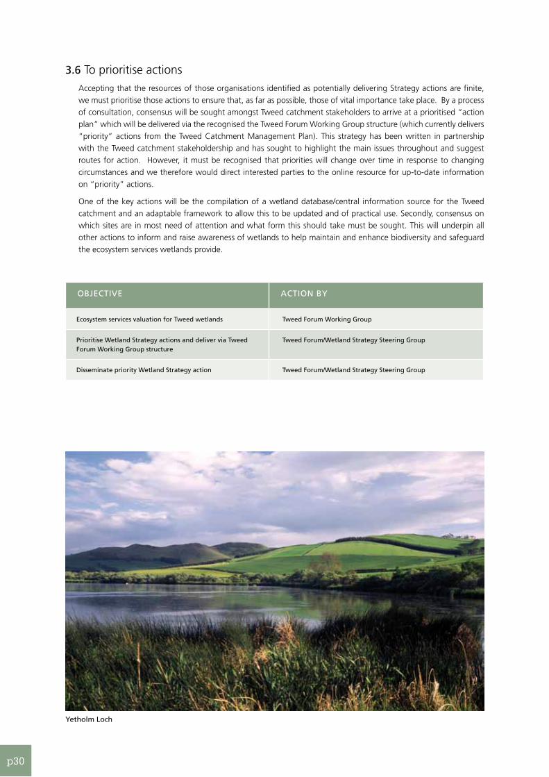
p30
3.6 To prioritise actions
Accepting that the resources of those organisations identified as potentially delivering Strategy actions are finite,
we must prioritise those actions to ensure that, as far as possible, those of vital importance take place. By a process
of consultation, consensus will be sought amongst Tweed catchment stakeholders to arrive at a prioritised “action
plan” which will be delivered via the recognised the Tweed Forum Working Group structure (which currently delivers
“priority” actions from the Tweed Catchment Management Plan). This strategy has been written in partnership
with the Tweed catchment stakeholdership and has sought to highlight the main issues throughout and suggest
routes for action. However, it must be recognised that priorities will change over time in response to changing
circumstances and we therefore would direct interested parties to the online resource for up-to-date information
on “priority” actions.
One of the key actions will be the compilation of a wetland database/central information source for the Tweed
catchment and an adaptable framework to allow this to be updated and of practical use. Secondly, consensus on
which sites are in most need of attention and what form this should take must be sought. This will underpin all
other actions to inform and raise awareness of wetlands to help maintain and enhance biodiversity and safeguard
the ecosystem services wetlands provide.
oBjEcTivE AcTion By
Ecosystem services valuation for Tweed wetlands Tweed Forum Working group
prioritise Wetland Strategy actions and deliver via Tweed Forum Working group structure
Tweed Forum/Wetland Strategy Steering group
disseminate priority Wetland Strategy action Tweed Forum/Wetland Strategy Steering group
yetholm loch
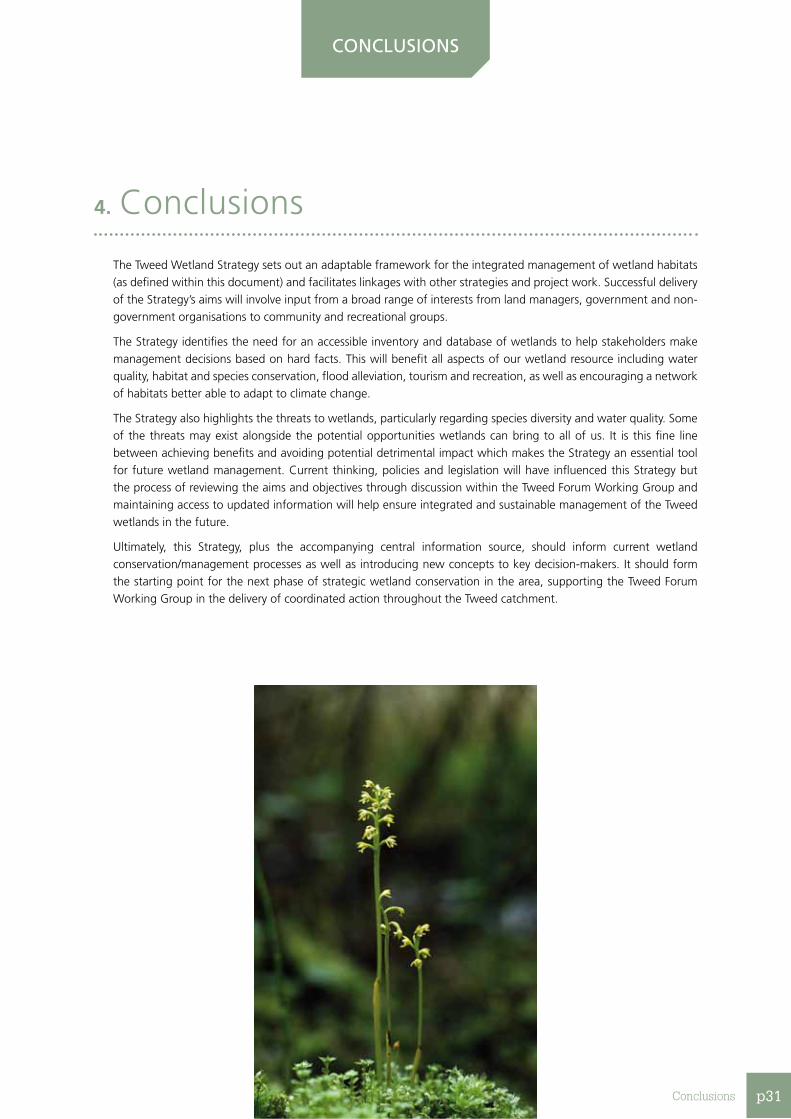
p31Conclusions
4. Conclusions
The Tweed Wetland Strategy sets out an adaptable framework for the integrated management of wetland habitats
(as defined within this document) and facilitates linkages with other strategies and project work. Successful delivery
oftheStrategy’saimswillinvolveinputfromabroadrangeofinterestsfromlandmanagers,governmentandnon-
government organisations to community and recreational groups.
The Strategy identifies the need for an accessible inventory and database of wetlands to help stakeholders make
management decisions based on hard facts. This will benefit all aspects of our wetland resource including water
quality, habitat and species conservation, flood alleviation, tourism and recreation, as well as encouraging a network
of habitats better able to adapt to climate change.
The Strategy also highlights the threats to wetlands, particularly regarding species diversity and water quality. Some
of the threats may exist alongside the potential opportunities wetlands can bring to all of us. It is this fine line
between achieving benefits and avoiding potential detrimental impact which makes the Strategy an essential tool
for future wetland management. Current thinking, policies and legislation will have influenced this Strategy but
the process of reviewing the aims and objectives through discussion within the Tweed Forum Working Group and
maintaining access to updated information will help ensure integrated and sustainable management of the Tweed
wetlands in the future.
Ultimately, this Strategy, plus the accompanying central information source, should inform current wetland
conservation/management processes as well as introducing new concepts to key decision-makers. It should form
the starting point for the next phase of strategic wetland conservation in the area, supporting the Tweed Forum
Working Group in the delivery of coordinated action throughout the Tweed catchment.
concluSionS
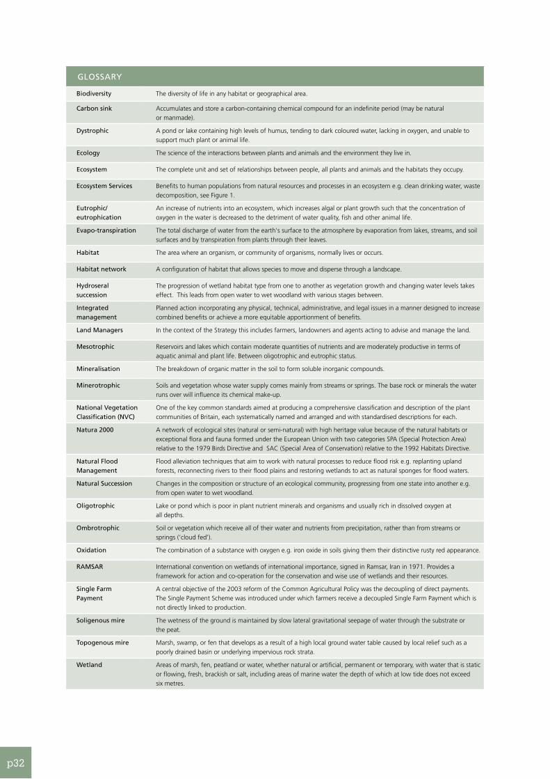
p32
gloSSAry
Biodiversity The diversity of life in any habitat or geographical area.
carbon sink Accumulates and store a carbon-containing chemical compound for an indefinite period (may be natural
or manmade).
dystrophic A pond or lake containing high levels of humus, tending to dark coloured water, lacking in oxygen, and unable to
support much plant or animal life.
Ecology The science of the interactions between plants and animals and the environment they live in.
Ecosystem The complete unit and set of relationships between people, all plants and animals and the habitats they occupy.
Ecosystem Services Benefits to human populations from natural resources and processes in an ecosystem e.g. clean drinking water, waste
decomposition, see Figure 1.
Eutrophic/eutrophication
An increase of nutrients into an ecosystem, which increases algal or plant growth such that the concentration of
oxygen in the water is decreased to the detriment of water quality, fish and other animal life.
Evapo-transpiration The total discharge of water from the earth's surface to the atmosphere by evaporation from lakes, streams, and soil
surfaces and by transpiration from plants through their leaves.
habitat The area where an organism, or community of organisms, normally lives or occurs.
habitat network A configuration of habitat that allows species to move and disperse through a landscape.
hydroseral succession
The progression of wetland habitat type from one to another as vegetation growth and changing water levels takes
effect. This leads from open water to wet woodland with various stages between.
integrated management
Planned action incorporating any physical, technical, administrative, and legal issues in a manner designed to increase
combined benefits or achieve a more equitable apportionment of benefits.
land managers In the context of the Strategy this includes farmers, landowners and agents acting to advise and manage the land.
mesotrophic Reservoirs and lakes which contain moderate quantities of nutrients and are moderately productive in terms of
aquatic animal and plant life. Between oligotrophic and eutrophic status.
mineralisation The breakdown of organic matter in the soil to form soluble inorganic compounds.
minerotrophic Soils and vegetation whose water supply comes mainly from streams or springs. The base rock or minerals the water
runs over will influence its chemical make-up.
national vegetation classification (nvc)
One of the key common standards aimed at producing a comprehensive classification and description of the plant
communities of Britain, each systematically named and arranged and with standardised descriptions for each.
natura 2000 A network of ecological sites (natural or semi-natural) with high heritage value because of the natural habitats or
exceptional flora and fauna formed under the European Union with two categories SPA (Special Protection Area)
relative to the 1979 Birds Directive and SAC (Special Area of Conservation) relative to the 1992 Habitats Directive.
natural Flood management
Flood alleviation techniques that aim to work with natural processes to reduce flood risk e.g. replanting upland
forests, reconnecting rivers to their flood plains and restoring wetlands to act as natural sponges for flood waters.
natural Succession Changes in the composition or structure of an ecological community, progressing from one state into another e.g.
from open water to wet woodland.
oligotrophic Lake or pond which is poor in plant nutrient minerals and organisms and usually rich in dissolved oxygen at
all depths.
ombrotrophic Soil or vegetation which receive all of their water and nutrients from precipitation, rather than from streams or
springs(‘cloudfed’).
oxidation The combination of a substance with oxygen e.g. iron oxide in soils giving them their distinctive rusty red appearance.
rAmSAr International convention on wetlands of international importance, signed in Ramsar, Iran in 1971. Provides a
framework for action and co-operation for the conservation and wise use of wetlands and their resources.
Single Farm payment
A central objective of the 2003 reform of the Common Agricultural Policy was the decoupling of direct payments.
The Single Payment Scheme was introduced under which farmers receive a decoupled Single Farm Payment which is
not directly linked to production.
Soligenous mire The wetness of the ground is maintained by slow lateral gravitational seepage of water through the substrate or
the peat.
Topogenous mire Marsh, swamp, or fen that develops as a result of a high local ground water table caused by local relief such as a
poorly drained basin or underlying impervious rock strata.
Wetland Areas of marsh, fen, peatland or water, whether natural or artificial, permanent or temporary, with water that is static
or flowing, fresh, brackish or salt, including areas of marine water the depth of which at low tide does not exceed
six metres.
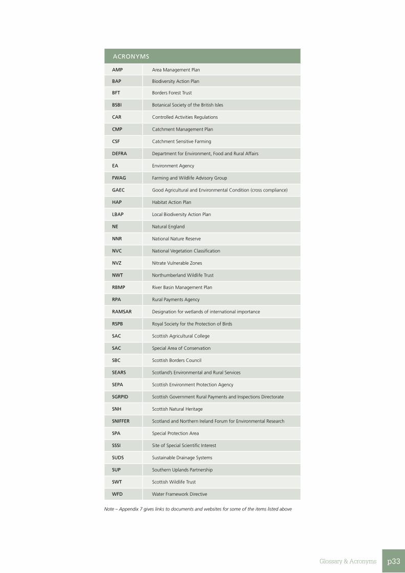
p33Glossary & Acronyms
AcronymS
Amp Area Management Plan
BAp Biodiversity Action Plan
BFT Borders Forest Trust
BSBi Botanical Society of the British Isles
cAr Controlled Activities Regulations
cmp Catchment Management Plan
cSF Catchment Sensitive Farming
dEFrA Department for Environment, Food and Rural Affairs
EA Environment Agency
FWAg Farming and Wildlife Advisory Group
gAEc Good Agricultural and Environmental Condition (cross compliance)
hAp Habitat Action Plan
lBAp Local Biodiversity Action Plan
nE Natural England
nnr National Nature Reserve
nvc National Vegetation Classification
nvZ Nitrate Vulnerable Zones
nWT Northumberland Wildlife Trust
rBmp River Basin Management Plan
rpA Rural Payments Agency
rAmSAr Designation for wetlands of international importance
rSpB Royal Society for the Protection of Birds
SAc Scottish Agricultural College
SAc Special Area of Conservation
SBc Scottish Borders Council
SEArS Scotland’sEnvironmentalandRuralServices
SEpA Scottish Environment Protection Agency
Sgrpid Scottish Government Rural Payments and Inspections Directorate
Snh Scottish Natural Heritage
SniFFEr Scotland and Northern Ireland Forum for Environmental Research
SpA Special Protection Area
SSSi Site of Special Scientific Interest
SudS Sustainable Drainage Systems
Sup Southern Uplands Partnership
SWT Scottish Wildlife Trust
WFd Water Framework Directive
Note – Appendix 7 gives links to documents and websites for some of the items listed above
p34

A1
App
End
ix
Appendix 1
AppEndix
Appendix 1. classification and description of major wetland types
Wetlands types are dictated by their water levels, their water throughput, their water origins and chemistry, and the impingent climatic regimen (rainfall, evapo-transpiration etc.)
The main focus is on the 8 types listed in section 2.2.1 which are:
1. Blanket bog2. Raised bog 3. Fens and basin mires 4. Flushes5.’Schwingmoor’/floatingmire6. Swamp7. Open waters (ponds, lochans, lochs, lakes, reservoirs ––natural, impounded, excavated)8. Wet soils
classification Within the major Types
The most meaningful way of classifying wetlands, so that they can be compared is probably by their fundamental chemical character. Such a classification affects the primary (vegetation) production as well as determining what dependent animals, invertebrates, fish and, to a much lesser extent, birds, mammals, will occur.
Within the major types, the simplest basic classification must be made on water chemistry. This relates to:
• theindividualwatersource• upperlayersofmuds/sands/gravels• chemistryoftheunderlyingwatercapsule,andthedegreetowhichitaffectsverticallayersandvegetation• organismsinthebottomsoillayer• microscopicaquaticorganisms• submerged/floating/emergent/banksidevegetation• invertebrates,amphibiansandbirdswhichduringatleastpartoftheirlifecycleleavethewetlandoftheiroriginandfly/crawl/
swim to other wetlands, including the sea, taking with them some chemical components. (This may seem to be extreme but in the case of open waters and mires with a very slow return time, i.e. where incoming water is held for a long period, Chironimids and Oligochaetes, for example, may account for the main loss of available phosphate, which is, with silicate and nitrate one of three usually limiting chemical components in wetland systems. A local example of this would be Coldingham Loch which has a return time in excess of three years).
Subsets within this chemical classification are :
• whollynaturalwetlandsatanystagefromopenwatertowetwoodland–inTweedprobablynoopenwaterexceptremotesitessuch as Gameshope Loch is fully “natural”.
• wetlandsalteredbynaturalevents–rivercapture;landslip,channelchangese.g.YetholmLoch,BillieMire• wetlandspartiallyalteredbyhumanactivitytoraisewaterlevelsbydamminge.g.HoselawLoch,LindeanReservoir• wetlandspartiallyalteredbyanthropogenicactivitiestolowerwatertablessuchasdrainage/peatdigging/marlinge.g.Lindean
Reservoir, Linton Loch• wetlandswhicharealmostentirelyartificiale.g.TheHirsel,MeggetandTallaReservoirs• wetlandswhichremainafterdrainage/damremovale.g.PhilhopeReservoir• wetlands routinelyusedby largequantitiesofwinteringorbreedingwildfowl/gulls as adaytime roost,night-time roostor
feeding site which significantly changes total and available phosphorus and other chemical values e.g. Hoselaw Loch, The Hirsel • open-waterswhichareofavolumeandconformationtoroutinelystratifyinwintere.g.ColdinghamLoch• wetlandswhichhavesufferedsuchserious19th/20thcenturyenrichment,usuallybyagricultural fertilisers,as toalter their
nutrient state and typical flora/fauna e.g. Yetholm Loch, Hirsel, Coldingham Loch
Within individual habitats there may be variations in water chemistry due to, for example, flushes from other habitats or mineral sourcesor‘well-eyes’(upwellingspringsfromunderlyingtillandrocksuchasattheWhitlawMosses).
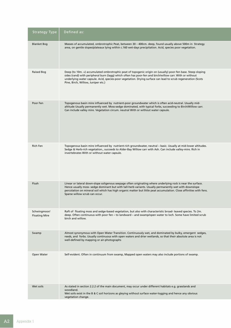
Appendix 1A2
Strategy Type defined as: SEpA Type Typologytypes which may occur within (W) or merge (m) with strategy types
Blanket Bog masses of accumulated, ombrotrophic peat, between 30 – 400cm. deep, found usually above 500m in Strategy area, on gentle slopes/plateaux lying within c.160 wet-days precipitation. Acid, species poor vegetation.
8a- peat Bog 2a - Wet grassland (m)2b - montane grassland (W/m)3a-Montaneflushes(W/M)3c - other springs (W/m)3d-Seepage/flushes(W/M)4 - poor fen5 - Sedge swamp7 - Wet heath
raised Bog deep (to 10m. +) accumulated ombrotrophic peat of topogenic origin on (usually) poor-fen base. Steep sloping sides (rand) with peripheral burn (lagg) which often has poor-fen and birch/willow carr. With or without underlying water capsule. Acid, species-poor vegetation. drying surface can lead to scrub regeneration (Scots pine, Birch, Willow, juniper etc.)
8b peat bog 1a - Bog Woodland (W)2a - marshy grassland (m)3c - other springs (m)3d-Seepageflushes(M)4 - poor fen (W/m)5 - Swamp (m)6 - reedbed (m)7 - Wet heath (m)8 - Schwingmoor (W/m)
poor Fen Topogenousbasinmireinfluencedbynutrient-poorgroundwaterwhichisoftenacid-neutral.Usuallymid-altitude usually permanently wet. moss-sedge dominated, with typical forbs, succeeding to Birch/Willow carr. can include valley mire. vegetation circum. neutral With or without water capsule.
4 Fen 1b - other wet woodland/carr (W/m)2a - marshy grassland (W/m)3a-Montaneflushes/seepages3c - other springs (W/m)3d-Seepages/flushes(W/M)4 - rich fen (m)5 - Swamp (W/m)6 - reedbed (W/m)7 - Wet heath (m)8a - raised Bog/Blanket Bog (m)8b - Schwingmoor
rich Fen Topogenousbasinmireinfluencedbynutrient-richgroundwater,neutral–basic.Usuallyatmid-loweraltitudes.Sedge & herb-rich vegetation., succeeds to Alder-Bay Willow carr with Ash. can include valley-mire. rich in invertebrates With or without water capsule.
4 Fen 1b – other wet woodland/carr(W/m)2a - marshy grassland (W/m)3a-Montaneflushes/seepages3b - Tufa (W/m)3c - other springs (W/m)4 - poor fen (m)5 - Swamp (W/m)6 - reedbed (W/m)7 - Wet heath (m)8a - raised Bog/Blanket Bog (m)8b - Schwingmoor (W/m)
Flush linear or lateral down-slope soligenous seepage often originating where underlying rock is near the surface. hence usually moss- sedge dominant but with tall-herb variants. usually permanently wet with downslope percolation on mineral soil which has high organic matter but little peat accumulation. close affinities with fens. Sparse willow scrub can occur.
3Springs/flushes& seepages.
1b - other wet woodland/carr (m)2a - marshy grassland (m)2b - montane grassland (m)4 - rich and poor Fen (W/m)5 - Swamp (W/m)6 - reedbed (rarely) (m)7 - Wet heath (m)8 - peat bog (m)
Schwingmoor/
Floating mire
Raftoffloatingmossandsedge-basedvegetation,butalsowithcharacteristicbroad-leavedspecies.To2m.deep. often continuous with poor fen – to landward – and swamp/open water to loch. Some have limited scrub birch and willow.
8b Quaking Bog 2a - marshy grassland(m)3 - Flushes (rarely) (m)4 - poor fen (m)5 - Swamp (m)6 - reedbed (rarely) (m)8 - peat bog ( if water-level rise)(m)
Swamp Almost synonymous with open Water Transition. continuously wet, and dominated by bulky, emergent sedges, reeds, and forbs. usually continuous with open waters and drier wetlands, so that their absolute area is not well-defined by mapping or air-photographs
5 Swamp
6 reedbed
1b - other wet woodland/carr2a - marshy grassland3-Springs/flushes/seepages(rarely)4 - poor and rich Fen7 - Wet heath (rarely)8b - Schwingmoor (rarely)
open Water Self-evident. often in continuum from swamp, mapped open waters may also include portions of swamp. 1b - other wet woodland/carr (m)2a - marshy grassland (m)3 - Flushes etc. – impingent (m)4 - poor and rich Fen (m)5 - Swamp/open-water transition (m)6 - reedbed (m)7 - Wet heath (rarely after water level rise)(m)8a - peat Bog (if water level rise)(m)8b - Schwingmoor
Wet soils As stated in section 2.2.2 of the main document, may occur under different habitats e.g. grasslands and woodland. Wet soils exist in the B & c soil horizons as gleying without surface water-logging and hence any obvious vegetation change.
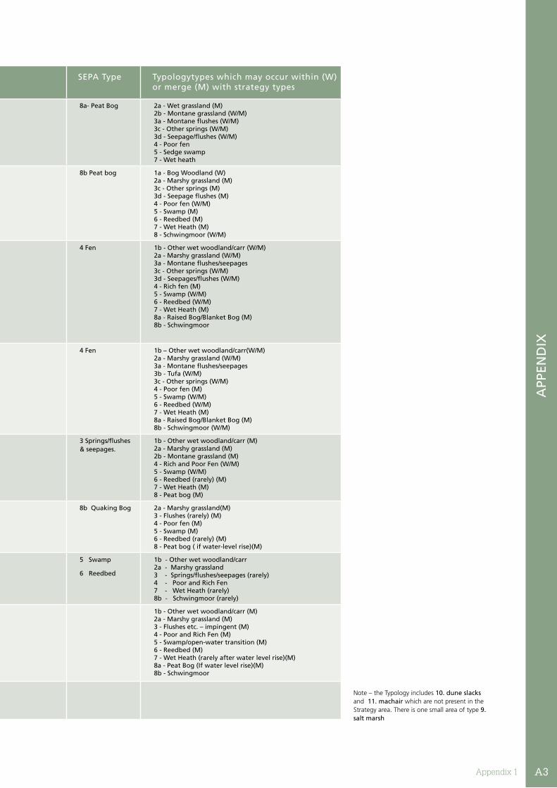
A3
App
End
ix
Appendix 1
Strategy Type defined as: SEpA Type Typologytypes which may occur within (W) or merge (m) with strategy types
Blanket Bog masses of accumulated, ombrotrophic peat, between 30 – 400cm. deep, found usually above 500m in Strategy area, on gentle slopes/plateaux lying within c.160 wet-days precipitation. Acid, species poor vegetation.
8a- peat Bog 2a - Wet grassland (m)2b - montane grassland (W/m)3a-Montaneflushes(W/M)3c - other springs (W/m)3d-Seepage/flushes(W/M)4 - poor fen5 - Sedge swamp7 - Wet heath
raised Bog deep (to 10m. +) accumulated ombrotrophic peat of topogenic origin on (usually) poor-fen base. Steep sloping sides (rand) with peripheral burn (lagg) which often has poor-fen and birch/willow carr. With or without underlying water capsule. Acid, species-poor vegetation. drying surface can lead to scrub regeneration (Scots pine, Birch, Willow, juniper etc.)
8b peat bog 1a - Bog Woodland (W)2a - marshy grassland (m)3c - other springs (m)3d-Seepageflushes(M)4 - poor fen (W/m)5 - Swamp (m)6 - reedbed (m)7 - Wet heath (m)8 - Schwingmoor (W/m)
poor Fen Topogenousbasinmireinfluencedbynutrient-poorgroundwaterwhichisoftenacid-neutral.Usuallymid-altitude usually permanently wet. moss-sedge dominated, with typical forbs, succeeding to Birch/Willow carr. can include valley mire. vegetation circum. neutral With or without water capsule.
4 Fen 1b - other wet woodland/carr (W/m)2a - marshy grassland (W/m)3a-Montaneflushes/seepages3c - other springs (W/m)3d-Seepages/flushes(W/M)4 - rich fen (m)5 - Swamp (W/m)6 - reedbed (W/m)7 - Wet heath (m)8a - raised Bog/Blanket Bog (m)8b - Schwingmoor
rich Fen Topogenousbasinmireinfluencedbynutrient-richgroundwater,neutral–basic.Usuallyatmid-loweraltitudes.Sedge & herb-rich vegetation., succeeds to Alder-Bay Willow carr with Ash. can include valley-mire. rich in invertebrates With or without water capsule.
4 Fen 1b – other wet woodland/carr(W/m)2a - marshy grassland (W/m)3a-Montaneflushes/seepages3b - Tufa (W/m)3c - other springs (W/m)4 - poor fen (m)5 - Swamp (W/m)6 - reedbed (W/m)7 - Wet heath (m)8a - raised Bog/Blanket Bog (m)8b - Schwingmoor (W/m)
Flush linear or lateral down-slope soligenous seepage often originating where underlying rock is near the surface. hence usually moss- sedge dominant but with tall-herb variants. usually permanently wet with downslope percolation on mineral soil which has high organic matter but little peat accumulation. close affinities with fens. Sparse willow scrub can occur.
3Springs/flushes& seepages.
1b - other wet woodland/carr (m)2a - marshy grassland (m)2b - montane grassland (m)4 - rich and poor Fen (W/m)5 - Swamp (W/m)6 - reedbed (rarely) (m)7 - Wet heath (m)8 - peat bog (m)
Schwingmoor/
Floating mire
Raftoffloatingmossandsedge-basedvegetation,butalsowithcharacteristicbroad-leavedspecies.To2m.deep. often continuous with poor fen – to landward – and swamp/open water to loch. Some have limited scrub birch and willow.
8b Quaking Bog 2a - marshy grassland(m)3 - Flushes (rarely) (m)4 - poor fen (m)5 - Swamp (m)6 - reedbed (rarely) (m)8 - peat bog ( if water-level rise)(m)
Swamp Almost synonymous with open Water Transition. continuously wet, and dominated by bulky, emergent sedges, reeds, and forbs. usually continuous with open waters and drier wetlands, so that their absolute area is not well-defined by mapping or air-photographs
5 Swamp
6 reedbed
1b - other wet woodland/carr2a - marshy grassland3-Springs/flushes/seepages(rarely)4 - poor and rich Fen7 - Wet heath (rarely)8b - Schwingmoor (rarely)
open Water Self-evident. often in continuum from swamp, mapped open waters may also include portions of swamp. 1b - other wet woodland/carr (m)2a - marshy grassland (m)3 - Flushes etc. – impingent (m)4 - poor and rich Fen (m)5 - Swamp/open-water transition (m)6 - reedbed (m)7 - Wet heath (rarely after water level rise)(m)8a - peat Bog (if water level rise)(m)8b - Schwingmoor
Wet soils As stated in section 2.2.2 of the main document, may occur under different habitats e.g. grasslands and woodland. Wet soils exist in the B & c soil horizons as gleying without surface water-logging and hence any obvious vegetation change.
Note – the Typology includes 10. dune slacks and 11. machair which are not present in the Strategy area. There is one small area of type 9. salt marsh
Appendix 1A4
Overview Descriptions of Wetland Types Within the Strategy Area
1. Blanket Bog
Blanket Bog is dependent upon incoming precipitation, such as snow, hail, rain, mist or haar, a cooler climate, level or gently sloping ground at altitudes which engender wet vegetation and the accumulation of Sphagnum, bog mosses and their associates. In the flat-summits plateaux of the Strategy area these conditions tend to occur above approx. 500m. Blanket Bogs are therefore both topogenic and ombrotrophic, relying little upon mineral groundwater. The origins of such bogs give rise to continued argument. They may have arisen as the climate cooled and precipitation increased during the Atlantic period, when tree and scrub growth became more limited, and this development may have been confounded by the concomitant effects of deforestation through grazing and burning by early settlers who undoubtedly utilised the more lightly-wooded Southern Upland hill ridges, as opposed to the dense wet woodland of the valleys.
It is important to realise that Raised Bog and Basin Mire elements occur within Blanket Bog, since bog and fen lenses developed to varying extents in uneven hollows of the glacial till, prior to the spread or coalescence of Blanket Bog. Except where these are still at the surface, such lenses are usually completely obscured by overlying blanket peat. Equally, the issue of more nutrient-rich and basic water from underground springs in underlying rock, often result in more basic Flush communities. But the essence of active Blanket Bog is ombrotrophic.
The prevalence of Blanket Bog on the hill ridges, spurs and plateaux of the Tweed catchment is evident, despite linguistic differences across the Strategy area, by names on the upper ridges and slopes such as Peat Hill, Peat Rig, Hag Dod, Haggie Slack, Haggie Knowe,BlackHagg,BurrowstownMoss,DinleyMoss,DunMoss,ByhassFell,Hawkshass,MossLaw,theQueen’sMire,FoulmireHeights, Reedy Edge, etc. Such Blanket Bog has been an evolving part of the hill landscape of the Strategy area for at least 3500 years, accumulating between one and twelve centimetres of peat depth per hundred years (Tallis, 1995). Always subject to climatic change, the hill peats of the Border were, in many cases, too far removed from centres of human settlement to have been much used as fuel although few escaped the prevalent heather burning and extensive grazing. Most are now degraded and damaged to a greater or lesser extent with gully and edge erosion widespread.
Blanket Bog can be prone to over-saturation by incoming deluge whereupon they “flow”, an eponymous title found elsewhere in the U.K. but seldom in Tweed catchment, probably due to the relatively dry climate. But there are Hobbs Flow; Roan Fell Flow; Flowesware Rig, Hartsgarth Flow, Sundhope Flow, Hawklee Flow, Broad Flow and other similar names scattered especially across the south and west of the area. Such “flowing” occurred after a cloud-burst at Tudhope in Liddesdale and towards Great Moor in upper Teviotdale in the 1980s. Increasing rainfall events as a result of climatic change may increase the frequency of such “flows”.
Blanket Bogs play a highly significant role in water quantity, its absorption, storage and seasonal release. They absorb a degree of incoming precipitation on the hill summits and plateaux, modifying run-off and so reducing downstream flooding. Their peat-mass is raised above the level of the rock/drift/mineral substrate and so a considerable volume of water is held which would not otherwise be there. Thus they provide steady release of drainage-water from the mass. Blanket Bog peat is of considerable importance in maintaining adequate discharge to stream headwaters throughout the season. Blanket Bogs also have a peat mass which lends itself to stratigraphical studies, although most stratigraphy in the Strategy area has been carried out on Raised Bogs (see below).
The species of Blanket Bog in the Strategy area are not usually atypical or rare. They share many invertebrate and plant communities with adjacent wet heaths, flushes and peaty podsols, as well as with Raised Mosses (which are usually at lower levels). The peat of such blanket mire, grades in thickness gradually into adjacent minerotrophic soils (wet heaths, wet and flushed grassland etc.) which have a greater or lesser degree of peaty top. Centuries of burning and grazing has oxidised and re-distributed peat round the edges of eroding Blanket Bogs, especially obvious in the drier hills of the Moorfoots, Lammermuir and Cheviots, and this is invaded by forms of Nardetum sub-alpinum, first recorded in the Moorfoot Hills by Smith, (1918). The burning and grazing of the last four hundred years or so has also changed the dominance of much of the Scottish Borders Blanket mire from one dominated by Sphagnum species, Calluna, Erica tetralix etc. to a co-dominance of Eriophorum vaginatum (towards the “Pennine Bog” of Tansley), and severe reduction of active Sphagnum, its place being taken in large parts by Polytrichum commune.

A5
App
End
ix
Appendix 1
characteristic Species:
Sphagnum compactum Sphagnum imbricatum Sphagnum magellanicum
Sphagnum russoweii Rubus chamaemorus Erica tetralix
Calluna vulgaris Vaccinium uliginosum (Liddesdale only) Eriophorum angustifolium
Trichophorum caespitosum Eriophorum vaginatum
Dunlin Fox Moth
Golden Plover Oak Eggar
Black Grouse Golden Ringed Dragonfly
Table 1 gives a breakdown of the areas of Blanket Bog in the Strategy Area. These are taken from Soils Survey Scotland maps: Muir (1956); Ragg (1960); Ragg & Futty (1965); Bown (1985 ) and Soils Survey and Land Research Centre (1984). “Hill Peat”, the classification for mapping, has been taken as ca. 30 cm and above. The depths are variable depending upon the underlying topography with depths of up to 4m in the Moorfoots. More usually it is between 1- 2m although erosion (hagging) at the edges, oxidation due to bad muirburn practice and surface wind-blow alters depths considerably, as has previous peat-cutting and turf removal for fuel and roofing material.
Most Blanket Bog in the Strategy area has had its hydrological integrity broken by drainage, bad muirburn practice, bad winter-feeding practice, sheep lair “scars” and by major damage such as road cutting and celebration bonfires. Peat cutting did occur in places, e.g. Lauder Common, Roan Fell, but this traditionally has been done by cutting and removing the surface vegetation to one side of the peat extraction and then replacing the turf so that active bog growth could continue.
Within the Strategy area Blanket Bogs are usually either inactive, i.e. without an actively accumulating Sphagnum complex due to drainage or fragmentation of the hydrological unit, and/or still subject to in inimical management, i.e.
• muirburnabove600m,leadingtoedgeandsurfaceoxidation/erosion;
• excessivegrazingandlocalisedtrampling/sheep“lairs”leadingtoerosionproblemsasinmuirburn;
• repeatedsurface,“sheep”drainage/“gripping”;
• forestrydrainage;
• forestryploughing;
• forestryplanting;
• progressiveerosionfromrecreationalaccess;
• progressiveerosionfromvehiculartracks/forestryextraction/roading.;
• poorlyexecutedpeatcutting(verylocal);
• windfarm/electricityaccessroading/cablelaying/pylonbasesetc.
All these can apply to any Blanket Bog unit, to varying degrees. They are likely to be exacerbated by changes in climate (increasing rain events; rainfall droplet size; impact strength; wind speeds etc.). Massive peat slips occurred, as at Duntae, Kielderhead in the early part of the millennium as progressive isolation of peat areas takes place.
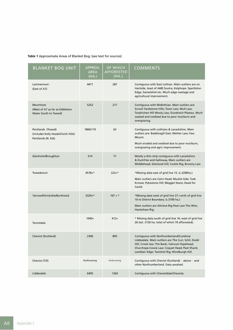
Appendix 1A6
BlAnKET Bog uniT Approx.ArEA (hA.)
oF WhichAFForESTEd
(hA.)
commEnTS
lammermuir:
(East of A7)
4471 287 contiguous with East lothian. main outliers are on hartside, (east of A68) Soutra, Kelphope. Spartleton Edge; gamelshiel etc. much edge wastage and agricultural improvement.
moorfoots
(West of A7 as far as Eddleston Water South to Tweed)
5252 217 contiguous with midlothian. main outliers are: Scroof-yardsstone hills; Town law; Wull law; Torphichen hill Wooly law; dundreich plateau. much wasted and oxidised due to poor muirburn and overgrazing.
pentlands (Tweed)
(includes Kelly heads/cloich hills)
pentlands (n. Esk)
1806/119 63 contiguous with lothians & lanarkshire. main outliers are: Baddinsgill East; Wether law; Faw mount.
much eroded and oxidised due to poor muirburn, overgrazing and agric improvement.
glenholm/Broughton 514 71 mostly a thin strip contiguous with lanarkshire & dumfries and galloway. main outliers are middlehead; glenlood hill; cockle rig; Broomy law
Tweedsmuir 4578+* 222+* *missing data east of grid line 15. (c.3200ha.)
main outliers are cairn head; muckle Side; Tods Knowe; pykestone hill; megget Stane; dead for cauld.
yarrow/Ettrick/Ale/Borthwick 3329+* 107 + * *missing data west of grid line 27; north of grid line 16 to district Boundary. (c.5700 ha.)
main outliers are Altrieve rig-peat law-The Wiss; hawkshaw rig;
Teviotdale
1040+ 412+ * missing data south of grid line 16; west of grid line 26 (est. 2150 ha. total of which 70 afforested).
cheviot (Scotland) 2300 893 contiguous with northumberland/cumbria/liddesdale. main outliers are The curr, Schil, dodd hill, crook law; The Bank; calroust hopehead; churchope-cowie law; coquet head; peat Shank; lamblair Edge; Tamshiel rig; Windburgh hill.
cheviot (Till) forthcoming forthcoming contiguous with cheviot (Scotland) - above - and other northumberland. data awaited.
liddesdale 6495 1363 contiguous with cheviotdale/cheviots.
Table 1 Approximate Areas of Blanket Bog: (see text for sources)
A7
App
End
ix
Appendix 1
The long-term prognosis for such mires is largely unknown since they have been severely modified by surface “sheep” drains extensive grazing and, more importantly by burning, and have developed open peat edges currently susceptible to winter frost-heave and summer oxidation of their eroding edges, exacerbated now by the developing pattern of increased heavy rainfall events.
2. raised Bog
As for Blanket Bog, Raised Bog is dependent upon the ombrotrophic growth of Sphagnum mosses which have developed usually upon sedge swamp or fen peats in discrete topographic hollows. They have developed at any altitude, their requirement being a suitable basin and moderate precipitation, but they remain more obvious within lowland areas since they have generally resisted agricultural improvement. Indeed in some examples in the catchment the “residual” originating fen vegetation is sometimes apparent in what has been termed “ecological lag” e.g. at Wester Branxholme Loch Bog.
It is estimated from the summarised wetland inventory (prepared for the Tweed CMP in 2006) that there are around 42 remaining Raised Bog lenses within the Strategy area, ignoring those which have been partly or wholly occluded by overlying Blanket Mire. At least 40 of these are estimated to be over 2 ha and so demand management attention within this Strategy. Their shape is defined by their topographic origins (see for example Ingram, 1982) and they will expand to fill the available basin, until of such a height as to physically limit their growth, the surface in apparent equilibrium with the evapo-transpiration, when they are often invaded by scrub, or else “flow” beyond their topographic boundaries as with Blanket Bogs. In contrast to Blanket Bog (see above) there are no recorded instances of Raised Bog “flows” in the Strategy area.
A peculiarity within the Strategy area is the common occurrence of Raised Bog and intermediate Blanket Bog to the east of Berwickshire (Drone Moss, Old Cambus Moss, Penmanshiel Moss, Broad Bog, Coldingham Common, Lamberton Moor etc.) where the rainfall at around 650mm is less than would normally be associated with ombrotrophic development. Snowfall along this coast is more common than elsewhere in the lowlands but there is still not enough to explain such Sphagnum growth. It is now suggested that this oddity is due to the phenomenon of North Sea “haar”, when onshore winds carry heavy mist onto this part of the country during May and June, when otherwise evapo-transpiration would be at its annual highest.
As with Blanket Bog, Raised Bogs are then both topogenic and ombrotrophic, little influenced by mineral groundwater, except around their periphery where the peat dome steeply descends (the rand) to a circumferential flush (the lagg burn) in which there is often poor, but sometimes rich fen, and Alder or Willow carr. Such carr development is often obscured by peat-cutting or later landuse, but vestigial examples occur at Drone Moss, Din Moss and Threepwood Moss. Occasionally there are more basic flushes emanating, presumably from buried springs, within Raised Bogs and, as with Fen, peripheral springs may result in “well eyes” on parts of the lagg burn (e.g. at Wester Branxholme Loch Moss). Crucially, in terms of their water-holding capacity, because they are “raised” above the surrounding groundwater, the water-content (of the Sphagnum dome), the ellipsoid “acrotelm” is considerably greater than the mere volume of their containing basin (“catotelm”). This means, of course, that their discharge rate for downstream stream channels is of considerable importance during low summer/drought flows.
characteristic Species
The basis of the Raised Bog are Sphagnum species, the predominant types shared with Blanket Bog, although more lowland/minerotrophic species occur:- • Sphagnum imbricatum • Sphagnumpapillosum • Sphagnum palustre (increasing groundwater influence/ basicity and often under carr)• Sphagnummagellanicum• Sphagnum squarrosum (as for S. palustre)• Sphagnum capillefolium• Sphagnumfuscum• DwarfshrubsandCotton-grassesasforBlanketMire• Adder• LargeHeathbutterfly• SmallCopperbutterfly
There are several well tried and successful regeneration schemes for the recovery of active Sphagnum growth and retention of the acrotelm. In the Strategy area Threepwood Moss has shown the best recovery (A. J. Panter, pers comm.) and within Blawhorn Moss, West Lothian Management Plan, SNH; also see Brookes and Stoneman (1997). These usually depend upon stopping excessive drainage from the surface, slowing peripheral drainage, and in reducing erosion from bare peat faces and from peripheral lagg streams.
3. Fens
It is estimated from the summarised wetland inventory (Tweed CMP) that there are around 214 remaining identifiable fens within the Strategy Area, ignoring those which are partly or wholly included within overlying Blanket Mire. Of these some 130 are over 2 ha and must represent a considerable volume of water. With “schwingmoor” they are perhaps the most difficult wetlands to manage since the quantity, quality and directional throughput of water-supply is sourced from their topographic basin with its springs and flushes and is subject to all the impingent chemical changes undertaken within the catchment.
Changes have occurred via general agricultural improvement throughout the last three centuries. Differences in productivity and composition of fen vegetation can be related to the amounts of, especially, nitrogen and phosphorous taken up by the vegetation. Differences in the mineralization of the upper peat layer are responsible. Groundwater upwelling from the mineral substrate (rock, boulder clay or later fluvial deposition) is often influenced by incoming water from the catchment. Werhoeven et al. (1983) noted

Appendix 1A8
increasing concentrations of ammonia (at 3-5ppm) in such upwellings, and suggested that there was considerable evidence of a build-up of nitrogen between the mineral substrate and the peat, not always evident in the vegetation, i.e. below rooting depths. They go on to say, “within a period of decades however, the continuous inflow of ammonia may eventually cause an increase in the productivity and a change in the species composition of the fens.” Wheeler (pers comm.) has suggested that this may also be true of other ions and nutrients, e.g. phosphate. If these are “trapped” in the topography of the basin, with limited sub-fen throughput to the outflow streams, then the prognosis for the long-term maintenance of critical communities and species of fen vegetation is bleak, and will demand extreme care in any major excavation works which might otherwise have restored the hydrosere to an earlier phase.
Crucially, a management distinction has to be made between fen left to its own devices, which will proceed successionally though tall-herb fen to a type of Carr woodland, and fen which is regularly cut and/or grazed. Many of the fens in the area have also been used for “deal” (small timber supply), turf (building and fuel) as well as for the more usual turbary or peat-cutting (fuel). These show a definite “hiatus” in the peat column, picked up in stratigraphical studies. The cutting of peat has been variably documented in the area and is characterised by the surrounding area, carefully designated in rentals and permissions, termed the “spreading ground”.
The main environmental parameters are given by Fojt (1993) and these set desirable limits for each fen type. It should be noted that within these, the same author has also identified environmental variables which are present in some 18 of the fen vegetation communitiespresentintheStrategyarea.Table2setsoutFojt’svalueswhichhavebeenobtainedfromoverthreehundredfenssampled across the U.K. They illustrate the real differences between “poor” and “rich” fen separated originally by their vegetation types alone. They also give defined “limits” towards which fen management should be aimed.
The above complexities of water chemistry raise many problems in arriving at a suitable management regime. Catchment size, however, may also add to this complexity since the actual topographic catchment, which has been used in the preparation of the CMP inventory, may only be an indicator of a far wider or more complicated drainage and seepage regime. Hence the existing wetland size may not relate clearly to a catchment which has been successively modified in these ways. Obvious topographic catchment size assessment is therefore not usually possible for spring fed mires, soligenous flushes nor for (most) floodplain/valley mire systems. Many of the open waters, basin and valley mires in the Scottish Borders are known to be spring-fed. This is apparent in non-freezing holes, (e.g. Yetholm, Lindean, Easter Branxholme), disturbance up-welling in softer peats/sediments (locally known as “well eyes”) (as at Alemoor, Boghall Moss, Hummelknowes and the Whitlaw Mosses) and by the presence of invertebrate communities characteristic of running-water in otherwise still-water fen pools (e.g. Wester Branxholme). This groundwater often may be additional to that of the apparent topographic catchment and may “muddy” the effects of the landuse in the immediate catchment. Given the present state of local hydrogeological detail, it is considered that pragmatism should prevail in basin mire management, and the effects of the immediate visible catchment be addressed as an important first stage.
This also applies where there has been modification of drainage either by fairly major mining/tunnelling, which was relatively commonplace at the time of agricultural improvement around 1800, (e.g. at Woolaw Moss; Lindean Reservoir; Whitrig Bog) or by successive generations of quite deep agricultural under-drainage, e.g. in the drumlin field of the Merse of Berwickshire round Swinton. This is a rather different problem which under considered management may be reversed, wholly or partly.
4. Flush
This term embraces all soligenous mires which depend upon some water-movement through their peat/mineral rooting layer. As such it is widely variable covering everything from minor spring heads upwelling into basin mires or blanket bog, to long linear systems following declivities and water-flow through other, non-wetland habitats, dwarf-shrub heath, acid and neutral grassland, tall-herb cliff grasslands etc. The most extensive areas of flush also occur beneath water seepage from outcropping or thinly buried horizontal rock strata and these may affect whole hillsides. Such seepage lines are common in the Ordovician and Silurian shales, as well as locally in the sediments of the Old Red Sandstone and Carboniferous eras. There are over 80 flushes recorded in the CMP inventory however, this figure is a grossly misleading underestimate which will demand aerial and ground truth surveys to adequately record this habitat for the Strategy area.
5. Schwingmoor/Floating mire
This category was not picked up in the Tweed CMP inventory, since it demands a ground survey of sites. Floating mire consists of a raft of floating moss, sedges, cottongrass and characteristic broadleaved species with a depth of up to 2m. It can merge with poor fen on the landward side of a site or into swamp and open water. Limited amounts of scrub birch and willow are occasionally present.
6. Swamp/open water Transition
The CMP inventory has recorded over fifty-four of these emergent communities in the Strategy area, with some 20 over 2 ha. There will undoubtedly be some overlap with floating vegetation rafts of “schwingmoor” and also minor areas may be have been missed and grouped within Open Waters.
7. open Water
The provisional inventory of open water sites is not yet completed for the Tweed CMP database. For those of any size there is a strong clustering, which mirrors that of basin mires, especially north and west of Hawick, and on the corrugated hills of the Ettrick plateau.
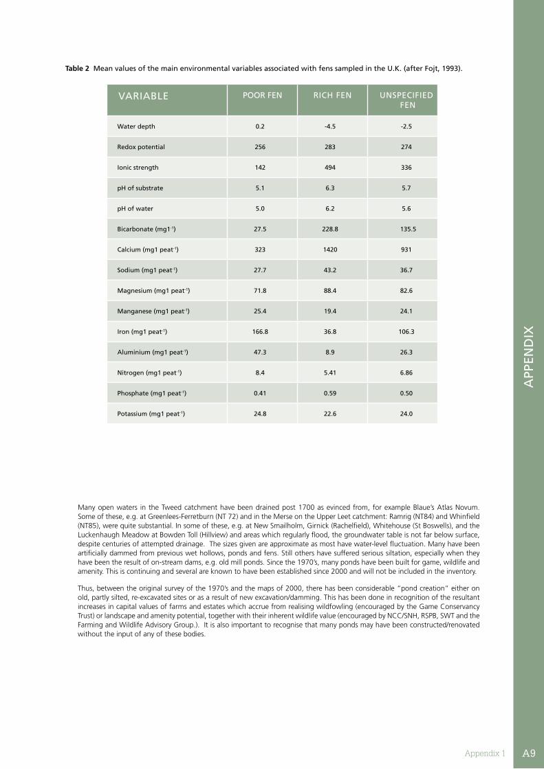
A9
App
End
ix
Appendix 1
vAriABlE poor FEn rich FEn unSpEciFiEd FEn
Water depth 0.2 -4.5 -2.5
redox potential 256 283 274
ionic strength 142 494 336
ph of substrate 5.1 6.3 5.7
ph of water 5.0 6.2 5.6
Bicarbonate (mg1-1) 27.5 228.8 135.5
calcium (mg1 peat-1) 323 1420 931
Sodium (mg1 peat-1) 27.7 43.2 36.7
magnesium (mg1 peat-1) 71.8 88.4 82.6
manganese (mg1 peat-1) 25.4 19.4 24.1
iron (mg1 peat-1) 166.8 36.8 106.3
Aluminium (mg1 peat-1) 47.3 8.9 26.3
nitrogen (mg1 peat-1) 8.4 5.41 6.86
phosphate (mg1 peat-1) 0.41 0.59 0.50
potassium (mg1 peat-1) 24.8 22.6 24.0
Table 2 mean values of the main environmental variables associated with fens sampled in the u.K. (after Fojt, 1993).
Manyopenwaters intheTweedcatchmenthavebeendrainedpost1700asevincedfrom,forexampleBlaue’sAtlasNovum.Some of these, e.g. at Greenlees-Ferretburn (NT 72) and in the Merse on the Upper Leet catchment: Ramrig (NT84) and Whinfield (NT85), were quite substantial. In some of these, e.g. at New Smailholm, Girnick (Rachelfield), Whitehouse (St Boswells), and the Luckenhaugh Meadow at Bowden Toll (Hillview) and areas which regularly flood, the groundwater table is not far below surface, despite centuries of attempted drainage. The sizes given are approximate as most have water-level fluctuation. Many have been artificially dammed from previous wet hollows, ponds and fens. Still others have suffered serious siltation, especially when they havebeentheresultofon-streamdams,e.g.oldmillponds.Sincethe1970’s,manypondshavebeenbuiltforgame,wildlifeandamenity. This is continuing and several are known to have been established since 2000 and will not be included in the inventory.
Thus,betweentheoriginalsurveyofthe1970’sandthemapsof2000,therehasbeenconsiderable“pondcreation”eitheronold, partly silted, re-excavated sites or as a result of new excavation/damming. This has been done in recognition of the resultant increases in capital values of farms and estates which accrue from realising wildfowling (encouraged by the Game Conservancy Trust) or landscape and amenity potential, together with their inherent wildlife value (encouraged by NCC/SNH, RSPB, SWT and the Farming and Wildlife Advisory Group.). It is also important to recognise that many ponds may have been constructed/renovated without the input of any of these bodies.
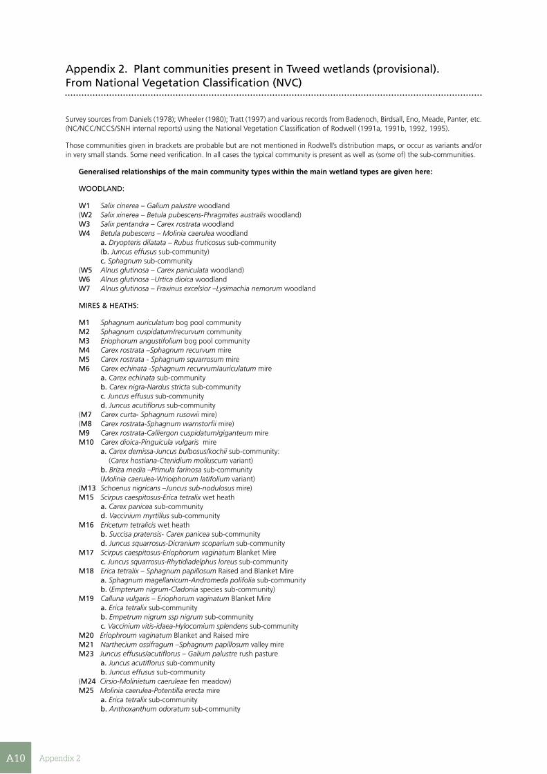
Appendix 2A10
Appendix 2. plant communities present in Tweed wetlands (provisional). From national vegetation classification (nvc)
Survey sources from Daniels (1978); Wheeler (1980); Tratt (1997) and various records from Badenoch, Birdsall, Eno, Meade, Panter, etc. (NC/NCC/NCCS/SNH internal reports) using the National Vegetation Classification of Rodwell (1991a, 1991b, 1992, 1995).
ThosecommunitiesgiveninbracketsareprobablebutarenotmentionedinRodwell’sdistributionmaps,oroccurasvariantsand/orin very small stands. Some need verification. In all cases the typical community is present as well as (some of) the sub-communities.
Generalised relationships of the main community types within the main wetland types are given here:
WoodlAnd:
W1 Salix cinerea – Galium palustre woodland(W2 Salix xinerea – Betula pubescens-Phragmites australis woodland)W3 Salix pentandra – Carex rostrata woodlandW4 Betula pubescens – Molinia caerulea woodland a. Dryopteris dilatata – Rubus fruticosus sub-community (b. Juncus effusus sub-community) c. Sphagnum sub-community(W5 Alnus glutinosa – Carex paniculata woodland)W6 Alnus glutinosa –Urtica dioica woodlandW7 Alnus glutinosa – Fraxinus excelsior –Lysimachia nemorum woodland
mirES & hEAThS:
m1 Sphagnum auriculatum bog pool communitym2 Sphagnum cuspidatum/recurvum communitym3 Eriophorum angustifolium bog pool communitym4 Carex rostrata –Sphagnum recurvum mirem5 Carex rostrata - Sphagnum squarrosum mirem6 Carex echinata -Sphagnum recurvum/auriculatum mire a. Carex echinata sub-community b. Carex nigra-Nardus stricta sub-community c. Juncus effusus sub-community d. Juncus acutiflorus sub-community (m7 Carex curta- Sphagnum rusowii mire)(m8 Carex rostrata-Sphagnum warnstorfii mire)m9 Carex rostrata-Calliergon cuspidatum/giganteum mirem10 Carex dioica-Pinguicula vulgaris mire a. Carex demissa-Juncus bulbosus/kochii sub-community:
(Carex hostiana-Ctenidium molluscum variant) b. Briza media –Primula farinosa sub-community (Molinia caerulea-Wrioiphorum latifolium variant)(m13 Schoenus nigricans –Juncus sub-nodulosus mire)m15 Scirpus caespitosus-Erica tetralix wet heath a. Carex panicea sub-community d. Vaccinium myrtillus sub-communitym16 Ericetum tetralicis wet heath b. Succisa pratensis- Carex panicea sub-community d. Juncus squarrosus-Dicranium scoparium sub-communitym17 Scirpus caespitosus-Eriophorum vaginatum Blanket Mire c. Juncus squarrosus-Rhytidiadelphus loreus sub-communitym18 Erica tetralix – Sphagnum papillosum Raised and Blanket Mire a. Sphagnum magellanicum-Andromeda polifolia sub-community b. (Empterum nigrum-Cladonia species sub-community)m19 Calluna vulgaris – Eriophorum vaginatum Blanket Mire a. Erica tetralix sub-community b. Empetrum nigrum ssp nigrum sub-community c. Vaccinium vitis-idaea-Hylocomium splendens sub-communitym20 Eriophroum vaginatum Blanket and Raised mirem21 Narthecium ossifragum –Sphagnum papillosum valley mirem23 Juncus effusus/acutiflorus – Galium palustre rush pasture a. Juncus acutiflorus sub-community b. Juncus effusus sub-community(m24 Cirsio-Molinietum caeruleae fen meadow)m25 Molinia caerulea-Potentilla erecta mire a. Erica tetralix sub-community b. Anthoxanthum odoratum sub-community
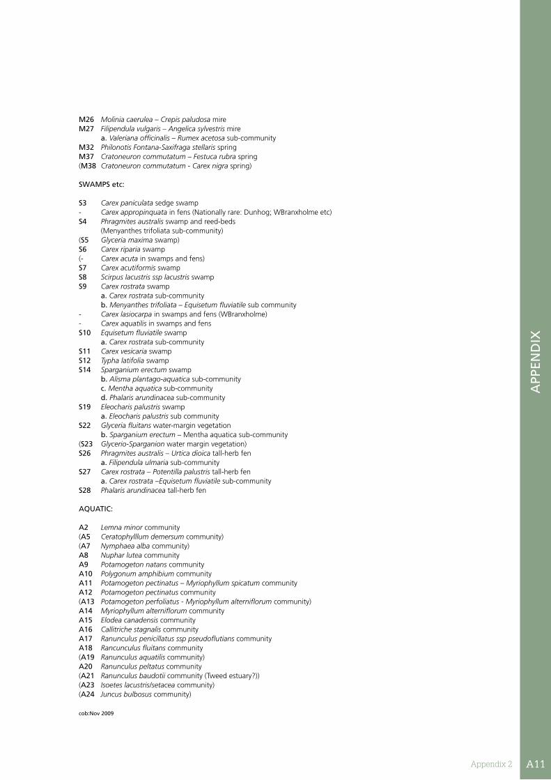
A11
App
End
ix
Appendix 2
m26 Molinia caerulea – Crepis paludosa mirem27 Filipendula vulgaris – Angelica sylvestris mire a. Valeriana officinalis – Rumex acetosa sub-communitym32 Philonotis Fontana-Saxifraga stellaris springm37 Cratoneuron commutatum – Festuca rubra spring(m38 Cratoneuron commutatum - Carex nigra spring)
SWAmpS etc:
S3 Carex paniculata sedge swamp- Carex appropinquata in fens (Nationally rare: Dunhog; WBranxholme etc)S4 Phragmites australis swamp and reed-beds (Menyanthes trifoliata sub-community)(S5 Glyceria maxima swamp)S6 Carex riparia swamp(- Carex acuta in swamps and fens)S7 Carex acutiformis swampS8 Scirpus lacustris ssp lacustris swampS9 Carex rostrata swamp a. Carex rostrata sub-community b. Menyanthes trifoliata – Equisetum fluviatile sub community- Carex lasiocarpa in swamps and fens (WBranxholme)- Carex aquatilis in swamps and fensS10 Equisetum fluviatile swamp a. Carex rostrata sub-communityS11 Carex vesicaria swampS12 Typha latifolia swampS14 Sparganium erectum swamp b. Alisma plantago-aquatica sub-community c. Mentha aquatica sub-community d. Phalaris arundinacea sub-communityS19 Eleocharis palustris swamp a. Eleocharis palustris sub communityS22 Glyceria fluitans water-margin vegetation b. Sparganium erectum – Mentha aquatica sub-community(S23 Glycerio-Sparganion water margin vegetation)S26 Phragmites australis – Urtica dioica tall-herb fen a. Filipendula ulmaria sub-communityS27 Carex rostrata – Potentilla palustris tall-herb fen a. Carex rostrata –Equisetum fluviatile sub-communityS28 Phalaris arundinacea tall-herb fen
AQuATic:
A2 Lemna minor community(A5 Ceratophylllum demersum community)(A7 Nymphaea alba community)A8 Nuphar lutea communityA9 Potamogeton natans communityA10 Polygonum amphibium communityA11 Potamogeton pectinatus – Myriophyllum spicatum communityA12 Potamogeton pectinatus community(A13 Potamogeton perfoliatus - Myriophyllum alterniflorum community)A14 Myriophyllum alterniflorum communityA15 Elodea canadensis communityA16 Callitriche stagnalis communityA17 Ranunculus penicillatus ssp pseudoflutians communityA18 Rancunculus fluitans community(A19 Ranunculus aquatilis community)A20 Ranunculus peltatus community(A21 Ranunculus baudotii community (Tweed estuary?))(A23 Isoetes lacustris/setacea community)(A24 Juncus bulbosus community)
cob:nov 2009
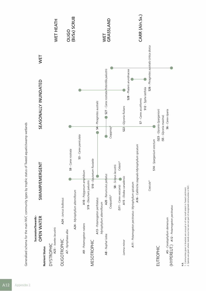
Appendix 2A12
WET
hEA
Th
oli
go
(Bi/S
x) S
cr
uB
WET
gr
ASS
lAn
d
cA
rr
(A
ln.S
x.)
n.B
. 1.
Com
mun
ities
giv
en in
bra
cket
s ar
e un
usua
l or
of v
ery
smal
l ext
ent
in T
wee
d ca
tchm
ent.
2. S
peci
es a
re g
iven
whe
re s
tand
s oc
cur
but
are
not
part
of
reco
gnis
ed c
omm
uniti
es in
NV
C.
Gen
eral
ised
sch
ema
for
the
mai
n N
VC
com
mun
ity t
ypes
by
trop
hic
stat
us o
f Tw
eed
aqua
tic/s
wam
p w
etla
nds
Su
cces
sio
nTo
war
ds:
-
o
pEn
WA
TEr
S
WA
mp/
EmEr
gEn
T SE
ASo
nA
lly
inu
nd
ATE
d
WET
Nu
trie
nt
Stat
us
D
YST
ROPH
IC
A23
- I
soet
es la
cust
ris
OLI
GO
TRO
PHIC
A
24 -
Jun
cus
bulb
osus
A
7 -
Nym
phae
a al
ba
S9 -
Car
ex r
ostr
ata
A
24 -
Myr
ioph
yllu
m a
ltern
iflor
um
S3 -
Car
ex p
anic
ulat
a
A
9 -
Pota
mog
eton
nat
ans
A10
- P
olyg
onum
am
phib
ium
S
19 -
Ele
ocha
ris p
alus
tris
MES
OTR
OPH
IC
S1
0 -
Equi
setu
m fl
uvia
tile
A
13 -
Pot
amog
eton
per
folia
tus
S4 -
Phr
agm
ites
aust
ralis
M
yrio
phyl
lum
alte
rnifl
orum
A
8 -
Nup
har
lute
a A
20 -
Ran
uncu
lus
pelta
tus
S27
- C
arex
ros
trat
a-Po
tent
illa
palu
stris
Cxa
quat
ilis*
C
xapp
roq*
S8 -
Sci
rpus
lacu
stris
(S11
- C
arex
ves
icar
ia)
Cxl
asio
*
Le
mna
min
or
A15
- E
lode
a ca
nade
nsis
S
22 -
Gly
ceria
flui
tans
S2
8 -
Phal
aris
aru
ndin
acea
A
11 -
Pot
amog
eton
pec
tinat
us-
Myr
ioph
yllu
m s
pica
tum
A16
- C
allit
riche
sta
gnal
is-M
yrio
phyl
lum
spi
catu
m
S7
- C
arex
acu
tifor
mis
S1
2 -
Typh
a la
tifol
ia
Cxa
cuta
* S2
6 -
Phra
gmite
s au
stra
lis-U
rtic
a di
oica
S14
- Sp
arga
nium
ere
ctum
EUTR
OPH
IC
(S23
- G
lyce
rio-S
parg
anio
n)
(S
5 -
Gly
ceria
max
ima)
A
5 -
Cer
atop
hyllu
m d
emer
sum
S6 -
Car
ex r
ipar
ia
(HY
PERE
UT.
) A
12 -
Pot
amog
eton
pec
tinat
us
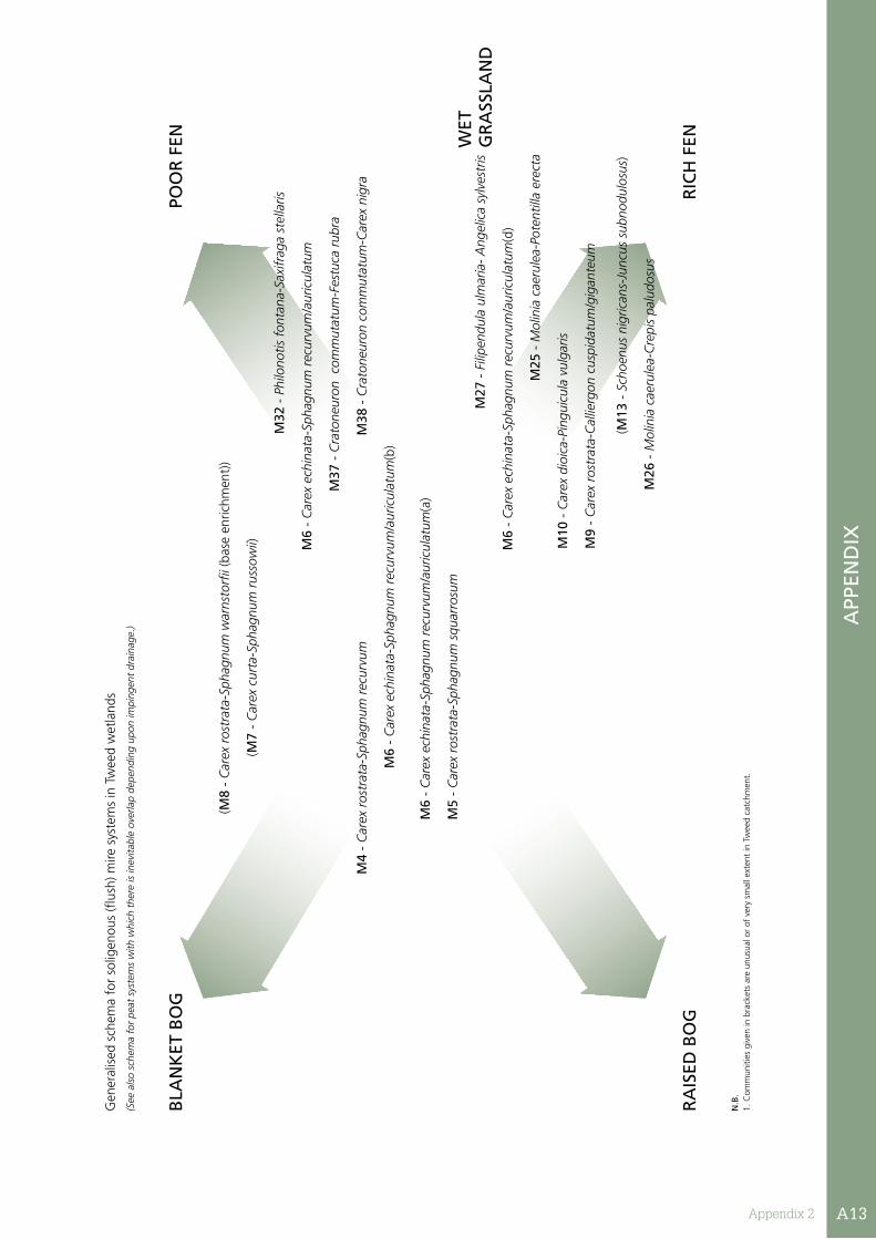
A13
App
End
ix
Appendix 2
(m
8 -
Car
ex r
ostr
ata-
Spha
gnum
war
nsto
rfii (
base
enr
ichm
ent)
)
(m
7 -
Car
ex c
urta
-Sph
agnu
m r
usso
wii)
m
32 -
Phi
lono
tis f
onta
na-S
axifr
aga
stel
laris
m
6 -
Car
ex e
chin
ata-
Spha
gnum
rec
urvu
m/a
uric
ulat
um
m
37 -
Cra
tone
uron
com
mut
atum
-Fes
tuca
rub
ra
m4
- C
arex
ros
trat
a-Sp
hagn
um r
ecur
vum
m
38 -
Cra
tone
uron
com
mut
atum
-Car
ex n
igra
m
6 -
Car
ex e
chin
ata-
Spha
gnum
rec
urvu
m/a
uric
ulat
um(b
)
m
6 -
Car
ex e
chin
ata-
Spha
gnum
rec
urvu
m/a
uric
ulat
um(a
)
m
5 -
Car
ex r
ostr
ata-
Spha
gnum
squ
arro
sum
m
27 -
Fili
pend
ula
ulm
aria
- A
ngel
ica
sylv
estr
is
m
6 -
Car
ex e
chin
ata-
Spha
gnum
rec
urvu
m/a
uric
ulat
um(d
)
m
25 -
Mol
inia
cae
rule
a-Po
tent
illa
erec
ta
m
10 -
Car
ex d
ioic
a-Pi
ngui
cula
vul
garis
m
9 -
Car
ex r
ostr
ata-
Cal
lierg
on c
uspi
datu
m/g
igan
teum
(m
13 -
Sch
oenu
s ni
gric
ans-
Junc
us s
ubno
dulo
sus)
m
26 -
Mol
inia
cae
rule
a-C
repi
s pa
ludo
sus
BlA
nK
ET B
og
poo
r F
En
rA
iSEd
Bo
gr
ich
FEnW
ET
gr
ASS
lAn
d
Gen
eral
ised
sch
ema
for
solig
enou
s (fl
ush)
mire
sys
tem
s in
Tw
eed
wet
land
s
(See
als
o sc
hem
a fo
r pe
at s
yste
ms
with
whi
ch t
here
is in
evita
ble
over
lap
depe
ndin
g up
on im
ping
ent
drai
nage
.)
n.B
. 1.
Com
mun
ities
giv
en in
bra
cket
s ar
e un
usua
l or
of v
ery
smal
l ext
ent
in T
wee
d ca
tchm
ent.
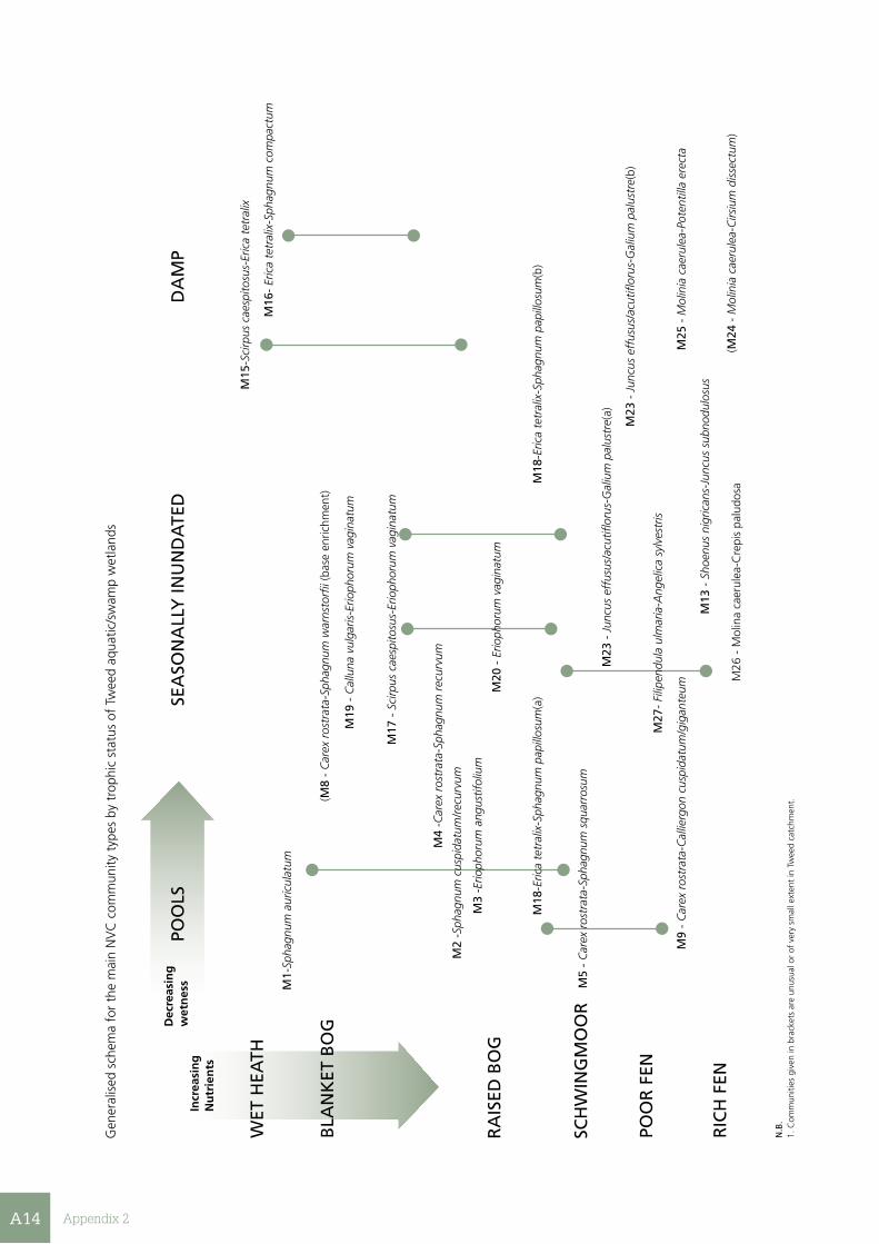
Appendix 2A14
m15
-Sci
rpus
cae
spito
sus-
Eric
a te
tral
ix
m16
- Er
ica
tetr
alix
-Sph
agnu
m c
ompa
ctum
(m8
- C
arex
ros
trat
a-Sp
hagn
um w
arns
torfi
i (ba
se e
nric
hmen
t)
m19
- C
allu
na v
ulga
ris-E
rioph
orum
vag
inat
um
m18
-Eric
a te
tral
ix-S
phag
num
pap
illos
um(b
)
m5
- C
arex
ros
trat
a-Sp
hagn
um s
quar
rosu
m
m23
- J
uncu
s ef
fusu
s/ac
utifl
orus
-Gal
ium
pal
ustr
e(b)
m25
- M
olin
ia c
aeru
lea-
Pote
ntill
a er
ecta
m9
- C
arex
ros
trat
a-C
allie
rgon
cus
pida
tum
/gig
ante
um
m13
- S
hoen
us n
igric
ans-
Junc
us s
ubno
dulo
sus
M26
- M
olin
a ca
erul
ea-C
repi
s pa
ludo
sa(m
24 -
Mol
inia
cae
rule
a-C
irsiu
m d
isse
ctum
)
m23
- J
uncu
s ef
fusu
s/ac
utifl
orus
-Gal
ium
pal
ustr
e(a)
po
olS
S
EASo
nA
lly
inu
nd
ATE
d
dA
mp
Incr
easi
ng
Nu
trie
nts
n.B
. 1.
Com
mun
ities
giv
en in
bra
cket
s ar
e un
usua
l or
of v
ery
smal
l ext
ent
in T
wee
d ca
tchm
ent.
Gen
eral
ised
sch
ema
for
the
mai
n N
VC
com
mun
ity t
ypes
by
trop
hic
stat
us o
f Tw
eed
aqua
tic/s
wam
p w
etla
nds
WET
hEA
Th
BlA
nK
ET B
og
rA
iSEd
Bo
g
Sch
Win
gm
oo
r
poo
r F
En
ric
h F
En
m1-
Spha
gnum
aur
icul
atum
Dec
reas
ing
w
etn
ess
m20
- E
rioph
orum
vag
inat
um
m27
- Fi
lipen
dula
ulm
aria
-Ang
elic
a sy
lves
tris
m17
- S
cirp
us c
aesp
itosu
s-Er
ioph
orum
vag
inat
um
m4
-Car
ex r
ostr
ata-
Spha
gnum
rec
urvu
m
m2
-Sph
agnu
m c
uspi
datu
m/r
ecur
vum
m3
-Erio
phor
um a
ngus
tifol
ium
m18
-Eric
a te
tral
ix-S
phag
num
pap
illos
um(a
)
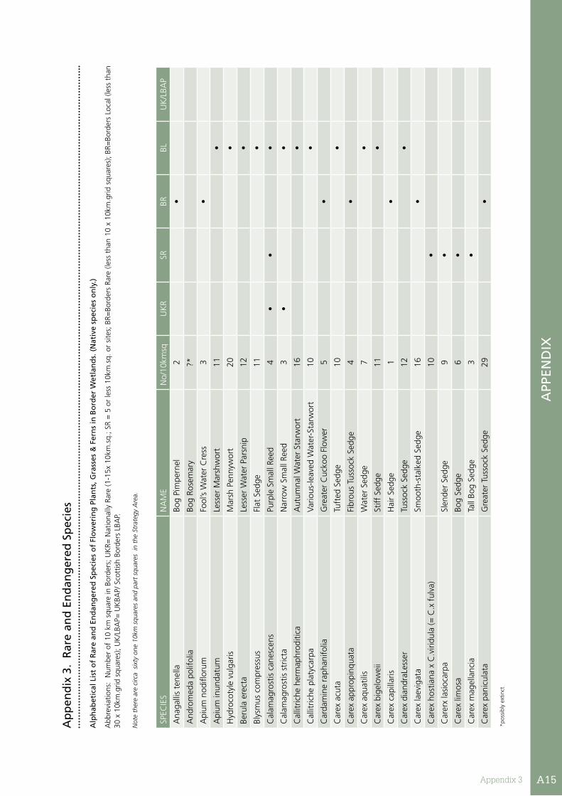
A15
App
End
ix
Appendix 3
SPEC
IES
NA
ME
No/
10km
sqU
KR
SRBR
BLU
K/L
BAP
Ana
galli
s te
nella
Bog
Pim
pern
el
2•
And
rom
eda
polif
olia
Bog
Rose
mar
y?*
Api
um n
odifl
orum
Fool
’sW
ater
Cre
ss3
•
Api
um in
unda
tum
Less
er M
arsh
wor
t11
•
Hyd
roco
tyle
vul
garis
Mar
sh P
enny
wor
t20
•
Beru
la e
rect
a Le
sser
Wat
er P
arsn
ip12
•
Blys
mus
com
pres
sus
Flat
Sed
ge11
•
Cal
amag
rost
is c
anes
cens
Pu
rple
Sm
all R
eed
4•
••
Cal
amag
rost
is s
tric
taN
arro
w S
mal
l Ree
d3
••
Cal
litric
he h
erm
aphr
oditi
caA
utum
nal W
ater
Sta
rwor
t16
•
Cal
litric
he p
laty
carp
aVa
rious
-leav
ed W
ater
-Sta
rwor
t 10
•
Car
dam
ine
raph
anifo
lia
G
reat
er C
ucko
o Fl
ower
5•
Car
ex a
cuta
Tuft
ed S
edge
10
•
Car
ex a
ppro
pinq
uata
Fibr
ous
Tuss
ock
Sedg
e4
•
Car
ex a
quat
ilis
Wat
er S
edge
7•
Car
ex b
igel
owei
iSt
iff S
edge
11•
Car
ex c
apill
aris
Hai
r Se
dge
1•
Car
ex d
iand
raLe
sser
Tu
ssoc
k Se
dge
12•
Car
ex la
evig
ata
Smoo
th-s
talk
ed S
edge
16•
Car
ex h
ostia
na x
C.v
iridu
la (=
C.x
ful
va)
10•
Car
erx
lasi
ocar
paSl
ende
r Se
dge
9•
Car
ex li
mos
aBo
g Se
dge
6•
Car
ex m
agel
lanc
iaTa
ll Bo
g Se
dge
3•
Car
ex p
anic
ulat
aG
reat
er T
usso
ck S
edge
29•
*po
ssib
ly e
xtin
ct
Ap
pen
dix
3.
rar
e an
d E
nd
ang
ered
Sp
ecie
s
Alp
hab
etic
al l
ist
of
rar
e an
d E
nd
ang
ered
Sp
ecie
s o
f Fl
ow
erin
g p
lan
ts, g
rass
es &
Fer
ns
in B
ord
er W
etla
nd
s. (
nat
ive
spec
ies
on
ly.)
Abb
revi
atio
ns:
Num
ber
of 1
0 km
squ
are
in B
orde
rs;
UK
R= N
atio
nally
Rar
e (1
-15x
10k
m.s
q.;
SR =
5 o
r le
ss 1
0km
.sq.
or
site
s; B
R=Bo
rder
s Ra
re (
less
tha
n 10
x 1
0km
.grid
squ
ares
); BR
=Bo
rder
s Lo
cal (
less
tha
n 30
x 1
0km
.grid
squ
ares
); U
K/L
BAP=
UK
BAP/
Sco
ttis
h Bo
rder
s LB
AP.
Not
e th
ere
are
circ
a s
ixty
one
10k
m s
quar
es a
nd p
art
squa
res
in t
he S
trat
egy
Are
a.
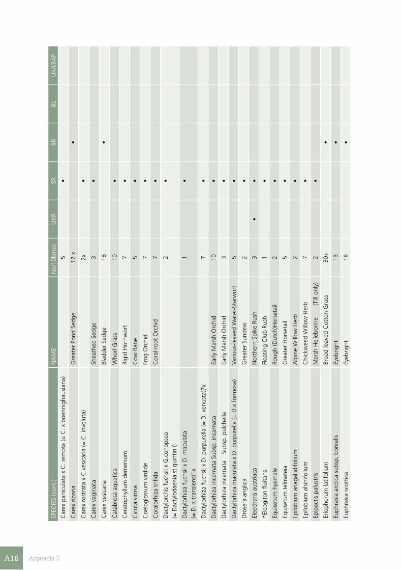
Appendix 3A16
SPEC
IES
(con
t.)
NA
ME
No/
10km
sqU
KR
SRBR
BLU
K/L
BAP
Car
ex p
anic
ulat
a x
C. r
emot
a (=
C. x
boe
nnig
haus
iana
)5
•
Car
ex r
ipar
iaG
reat
er P
ond
Sedg
e12
x•
Car
ex r
ostr
ata
x C
.ves
icar
ia (=
C. i
nvol
uta)
2x•
Car
ex v
agin
ata
Shea
thed
Sed
ge3
•
Car
ex v
esic
aria
Blad
der
Sedg
e18
•
Cat
abro
sa a
quat
ica
Who
rl G
rass
10•
Cer
atop
hyllu
m d
emer
sum
Ri
gid
Hor
nwor
t7
•
Cic
uta
viro
saC
ow B
ane
5•
Coe
logl
ossu
m v
irdid
eFr
og O
rchi
d7
•
Cor
alor
hiza
trifi
daC
oral
-roo
t O
rchi
d7
•
Dac
tylo
rchi
s fu
chsi
i x G
.con
opse
a
(= D
acty
loda
enia
st.
quin
tinii)
2•
Dac
tylo
rhiz
a fu
chsi
i x D
. mac
ulat
a
(= D
. x t
rans
iens
)1x
1•
Dac
tylo
rhiz
a fu
chsi
i x D
. pur
pure
lla (=
D. v
enus
ta)7
x7
•
Dac
tylo
rhiz
a in
carn
ata
Subs
p. in
carn
ata
Early
Mar
sh O
rchi
d10
•
Dac
tylo
rhiz
a in
carn
ata
Su
bsp.
pul
chel
la
Early
Mar
sh O
rchi
d3
•
Dac
tylo
rhiz
a m
acul
ata
x D
. pur
pure
lla (=
D.x
for
mos
a)Va
rious
-leav
ed W
ater
-Sta
rwor
t 5
•
Dro
sera
ang
lica
Gre
ater
Sun
dew
2•
Eleo
char
is a
ustr
iaca
Nor
ther
n Sp
ike
Rush
3 •
•
*Ele
ogito
n flu
itans
Floa
ting
Clu
b Ru
sh1
•
Equi
setu
m h
yem
ale
Roug
h (D
utch
)Hor
seta
il2
•
Equi
setu
m t
elm
atei
aG
reat
er H
orse
tail
5•
Epilo
bium
ana
galli
difo
lium
Alp
ine
Will
ow H
erb
2
•
Epilo
bium
als
inifo
lium
Chi
ckw
eed
Will
ow H
erb
7•
Epip
actis
pal
ustr
isM
arsh
Hel
lebo
rine
(Till
onl
y)2
•
Erio
phor
um la
tifol
ium
Broa
d-le
aved
Cot
ton
Gra
ss30
+•
Euph
rasi
a ar
ctic
a su
bsp,
bor
ealis
Ey
ebrig
ht13
•
Euph
rasi
a sc
ottic
a Ey
ebrig
ht18
•
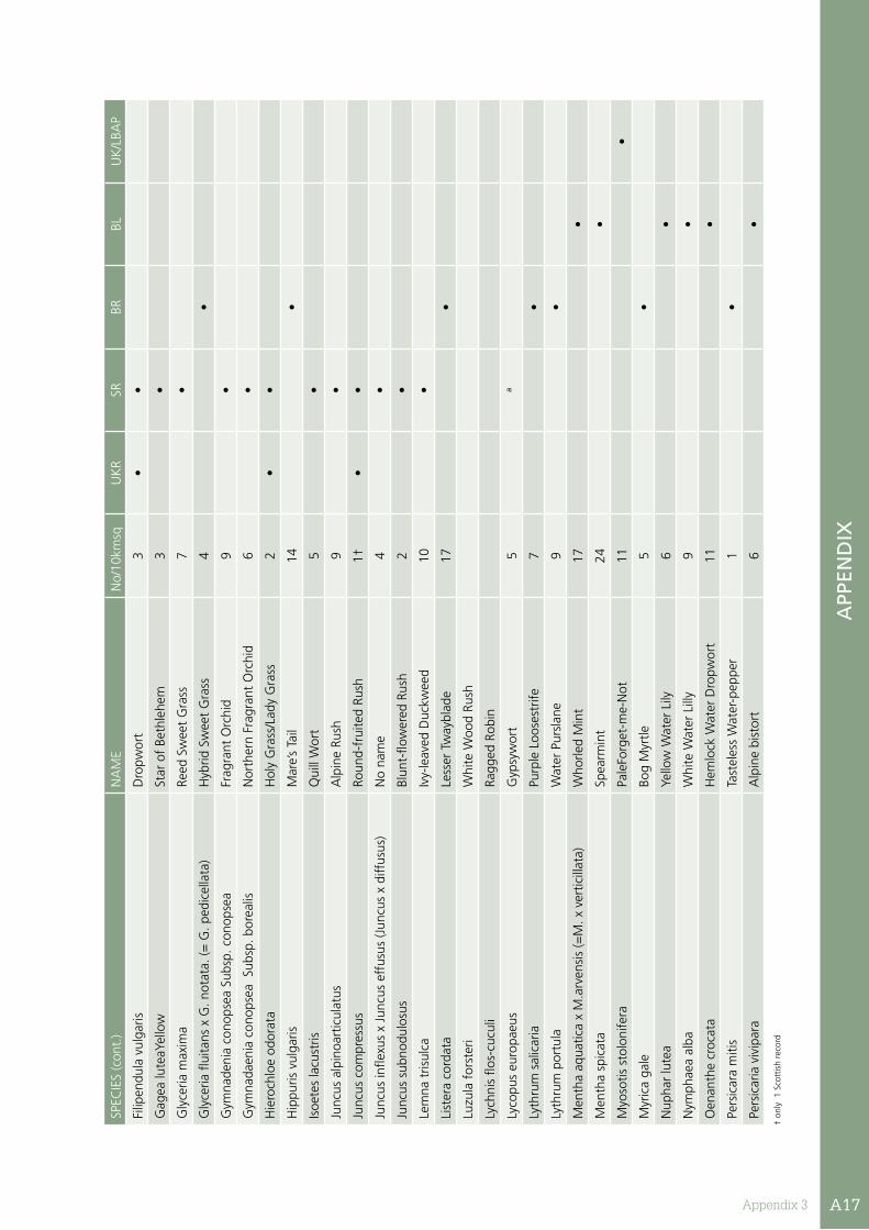
A17
App
End
ix
Appendix 3
SPEC
IES
(con
t.)
NA
ME
No/
10km
sqU
KR
SRBR
BLU
K/L
BAP
Filip
endu
la v
ulga
risD
ropw
ort
3•
•
Gag
ea lu
teaY
ello
w
Star
of
Beth
lehe
m3
•
Gly
ceria
max
ima
Reed
Sw
eet
Gra
ss7
•
Gly
ceria
flui
tans
x G
. not
ata.
(= G
. ped
icel
lata
) H
ybrid
Sw
eet
Gra
ss4
•
Gym
nade
nia
cono
psea
Sub
sp. c
onop
sea
Frag
rant
Orc
hid
9•
Gym
nada
enia
con
opse
a S
ubsp
. bor
ealis
Nor
ther
n Fr
agra
nt O
rchi
d6
•
Hie
roch
loe
odor
ata
Hol
y G
rass
/Lad
y G
rass
2•
•
Hip
puris
vul
garis
Mar
e’s
Tail
14•
Isoe
tes
lacu
stris
Qui
ll W
ort
5•
Junc
us a
lpin
oart
icul
atus
Alp
ine
Rush
9•
Junc
us c
ompr
essu
sRo
und-
frui
ted
Rush
1†•
•
Junc
us in
flexu
s x
Junc
us e
ffus
us (J
uncu
s x
diff
usus
)N
o na
me
4•
Junc
us s
ubno
dulo
sus
Blun
t-flo
wer
ed R
ush
2•
Lem
na t
risul
caIv
y-le
aved
Duc
kwee
d10
•
List
era
cord
ata
Less
er T
way
blad
e17
•
Luzu
la f
orst
eri
Whi
te W
ood
Rush
Lych
nis
flos-
cucu
li Ra
gged
Rob
in
Lyco
pus
euro
paeu
sG
ypsy
wor
t5
ª
Lyth
rum
sal
icar
iaPu
rple
Loo
sest
rife
7•
Lyth
rum
por
tula
Wat
er P
ursl
ane
9•
Men
tha
aqua
tica
x M
.arv
ensi
s (=
M. x
ver
ticill
ata)
Who
rled
Min
t17
•
Men
tha
spic
ata
Spea
rmin
t24
•
Myo
sotis
sto
loni
fera
Pale
Forg
et-m
e-N
ot11
•
Myr
ica
gale
Bog
Myr
tle5
•
Nup
har
lute
a Ye
llow
Wat
er L
ily
6
•
Nym
phae
a al
baW
hite
Wat
er L
illy
9•
Oen
anth
e cr
ocat
aH
emlo
ck W
ater
Dro
pwor
t11
•
Pers
icar
a m
itis
Tast
eles
s W
ater
-pep
per
1•
Pers
icar
ia v
ivip
ara
Alp
ine
bist
ort
6•
† on
ly 1
Sco
ttis
h re
cord
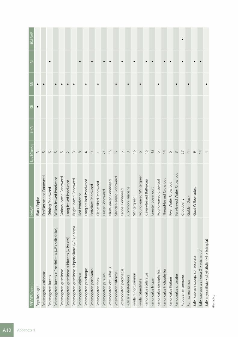
Appendix 3A18
SPEC
IES
(con
t.)
NA
ME
No/
10km
sqU
KR
SRBR
BLU
K/L
BAP
Popu
lus
nigr
a Bl
ack
Popl
ar3
••
Pota
mog
eton
col
orat
usFe
n/N
et-v
eine
d Po
ndw
eed
5
•
Pota
mog
eton
luce
nsSh
inin
g Po
ndw
eed
6
•
Pota
mog
eton
luce
ns x
P.p
erfo
liatu
s (=
P.x
salic
ifoliu
s)
Will
ow-le
aved
Pon
dwee
d5
•
Pota
mog
eton
gra
min
eus
Vario
us-le
aved
Pon
dwee
d5
•
Pota
mog
eton
gra
min
eus
x P.
luce
ns (=
P.x
ziz
ii)
Long
-leav
ed P
ondw
eed
2•
Pota
mog
eton
gra
min
eus
x P.
perf
olia
tus
(=P.
x n
itens
) Br
ight
-leav
ed P
ondw
eed
3•
Pota
mog
eton
alp
imus
Red
Pond
wee
d8
•
Pota
mog
eton
pra
elon
gus
Long
-sta
lked
Pon
dwee
d4
•
Pota
mog
eton
per
folia
tus
Perf
olia
te P
ondw
eed
11•
Pota
mog
eton
frie
sii
Flat
-sta
lked
Pon
dwee
d1
•
Pota
mog
eton
pus
illus
Less
er P
ondw
eed
21•
Pota
mog
eton
obt
usifo
lius
Blun
t-le
aved
Pon
dwee
d15
•
Pota
mog
eton
filif
orm
isSl
ende
r-le
aved
Pon
dwee
d6
•
Pota
mog
eton
pec
tinat
usFe
nnel
Pon
dwee
d5
•
Pulic
aria
dys
tent
eric
aC
omm
on F
leab
ane
3•
Pyro
la m
inor
Com
mon
W
inte
rgre
en16
•
Pyro
la r
otun
difo
liaRo
und-
leav
ed W
inte
rgre
en
6•
Ranu
ncul
us s
cele
ratu
sC
eler
y-le
aved
But
terc
up15
•
Ranu
ncul
us li
ngua
Gre
ater
Spe
arw
ort
1
3•
Ranu
ncul
us o
mio
phyl
lus
Roun
d-le
aved
Cro
wfo
ot
5•
Ranu
ncul
us t
richo
phyl
lus
Thre
ad-le
aved
Cro
wfo
ot
14•
Ranu
ncul
us fl
uita
nsRi
ver
Wat
er C
row
foot
6•
Ranu
cnul
us c
ircin
atus
Fan-
leav
ed W
ater
Cro
wfo
ot3
•
Rubu
s ch
amae
mor
usC
loud
berr
y27
••†
Rum
ex m
ariti
mus
Gol
den
Doc
k4
•
Salix
cap
raea
sub
sp, s
phae
cela
ta
Goa
t W
illow
sub
sp.
9•
Salix
cap
raea
x c
iner
ea (S
.x r
eich
ardt
ii)
14•
Salix
myr
sini
floia
x p
hylic
ifolia
(=S.
x te
trap
la)
4•
†Bla
nket
bog
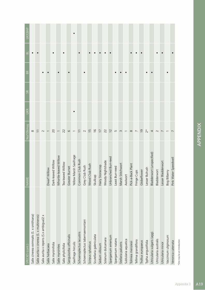
A19
App
End
ix
Appendix 3
SPEC
IES
(con
t.)
NA
ME
No/
10km
sqU
KR
SRBR
BLU
K/L
BAP
Salix
cin
erea
xvi
mna
lis (S
. x s
mith
iana
) 8
•
Salix
aur
ita x
cin
erea
(S. x
mul
tiner
vis)
11•
Salix
aur
ita x
rep
ens
(S.x
am
bigu
a)2
x2
•
Salix
her
baca
eaD
war
f W
illow
1•
Salix
myr
sini
folia
Dar
k-le
aved
Will
ow20
•
Salix
myr
sini
tes
Who
rtle
-leav
ed W
illow
1•
Salix
phy
licifo
liaTe
a-le
aved
Will
ow22
•
Sang
uiso
rba
offic
inal
isG
reat
er B
urne
t
6•
Saxi
frag
a hi
rcul
isYe
llow
Mar
sh S
axifr
age
1•
•
Scho
enop
lect
us la
cust
risC
omm
on C
lub
Rush
11•
Scho
enop
lect
us t
aber
naem
onta
niG
rey
Clu
b Ru
sh2
•
Scirp
us s
ylva
ticus
Woo
d C
lub
Rush
15•
Scut
ella
ria g
aler
icul
ata
Skul
lcap
16•
Sedu
m v
illos
umH
airy
Sto
necr
op17
•
Sola
num
dul
cam
ara
Woo
dy N
ight
shad
e22
•
Spar
gani
um e
mer
sum
Unb
ranc
hed
Burr
-ree
d12
•
Spar
gani
um n
atan
sLe
ast
Burr
-ree
d5
•
Stel
laria
pal
ustr
isM
arsh
Stit
chw
ort
3•
Subl
ular
ia a
quat
ica
Aw
lwor
t1
•
Tolm
iea
men
zies
iiPi
ck-a
-Bac
k Pl
ant
8•
Telli
ma
gran
diflo
raFr
inge
Cup
s 7
•
Trol
lius
euro
paeu
sG
lobe
flow
er19
•
Typh
a an
gust
ifolia
Less
er B
ulru
sh2*
•
Utr
icul
aria
vul
garis
(agg
).Bl
adde
rwor
t (u
nspe
cifie
d)
4•
Utr
icul
aria
aus
tral
isBl
adde
rwor
t 2
•
Utr
icul
aria
min
orLe
sser
Bla
dder
wor
t
7•
Vacc
iniu
m u
ligin
osum
Bog
Bilb
erry
1•
Vero
nica
cat
enat
aPi
nk W
ater
Spe
edw
ell
7•
*One
may
be
an in
trod
uctio
n
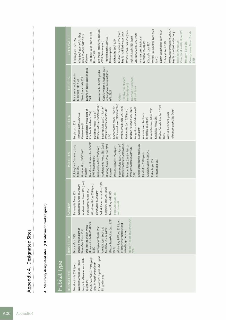
Appendix 4A20
Hab
itat
Type
BLA
NK
ET B
OG
RAIS
ED B
OG
SWA
MP
POO
R FE
NRI
CH
FEN
FLU
SHES
OPE
N W
ATE
R
Moo
rfoo
t H
ills
SSSI
(par
t)
Twee
dsm
uir
Hill
s SS
SI (p
art)
Lang
holm
-New
cast
leto
n H
ills
SSSI
(par
t)
Kie
lder
head
Moo
rs S
SSI (
part
) (S
AC
in N
orth
umbe
rland
)
Che
viot
SSS
I & p
art
NN
P (
part
Ti
ll ca
tchm
ent
)
Dro
ne M
oss
SSSI
Dog
den
Mos
s (p
art
of
Gre
enla
w M
oor
SSSI
)
Din
Mos
s (p
art
Din
Mos
s -
Hos
elaw
Loc
h RA
MSA
R SP
A
SSSI
)
Thre
epw
ood
Mos
s SS
SI
Ale
mui
r W
est
Loch
and
M
eado
w S
SSI (
2 pa
rts)
Wes
ter
Bran
xhol
me
Loch
SSS
I (p
art)
Whi
m B
og &
Woo
d SS
SI (p
art
of la
rger
inte
rmed
iate
bog
–
rais
ed b
og c
ompl
ex.)
ho
lbo
rn m
oss
SSS
i rA
mSA
r
SpA
Bem
ersy
de M
oss
SSSI
Gat
tons
ide
Mos
s SS
SI (p
art)
Add
erst
onle
e M
oss
SSSI
(par
t)
Buck
stru
ther
Mos
s SS
SI
Woo
dhea
d M
oss
SSSI
(par
t)
Blin
d M
oss
SSSI
(par
t)
Selk
irk R
acec
ours
e M
oss
SSSI
Kin
gsid
e Lo
ch S
SSI (
part
)
Mou
nt B
og N
NR
SSSI
Ford
mo
ss S
SSi (
Till
catc
hm
ent)
Col
ding
ham
Com
mon
, Lon
g M
oss
SSSI
Gor
don
Mos
s SS
SI/ S
WT
Rese
rve
Din
Mos
s -
Hos
elaw
Loc
h SS
SI/
SWT
Rese
rve
(par
t)
Gat
tons
ide
Mos
s SS
SI (p
art)
Add
erst
onle
e M
oss
SSSI
(par
t)
Dun
hog
Mos
s SS
SI/ P
art
SWT
Rese
rve
Woo
dhea
d M
oss
SSSI
(par
t)
Bean
rig M
oss
(par
t) –
Par
t of
W
hitla
w M
osse
s SS
SI/N
NR/
SAC
Mur
der
Mos
s (p
art)
– P
art
of
Whi
tlaw
Mos
ses
SSSI
/NN
R/SA
C
Selk
irk R
acec
ours
e M
oss
SSSI
Blin
d M
oss
SSSI
(par
t)
Slai
dhill
s M
oss
SSSI
/SA
C
Risk
enho
pe S
SSI
Mou
nt B
og S
SSI
Lurg
ie L
och
SSSI
Yeth
olm
Loc
h SS
SI/ S
WT
Rese
rve
(par
t)
Blac
kche
ster
Mos
s (p
art
of
Cla
rilaw
Gra
ssla
nds
SSSI
)
Blac
kpoo
l Mos
s– P
art
of
Whi
tlaw
Mos
ses
SSSI
/NN
R/SA
C
Bean
rig M
oss
(par
t) –
Par
t of
W
hitla
w M
osse
s SS
SI/N
NR/
SAC
Mur
der
Mos
s (p
art)
– P
art
of
Whi
tlaw
Mos
ses
SSSI
/NN
R/SA
C
Whi
tmui
rhal
l Loc
h SS
SI (p
art)
Fald
onsi
de L
och
SSSI
(par
t)
Lind
ean
Rese
rvoi
r SS
SI (p
art)
Long
Mos
s –
Drin
ksto
ne H
ill
SSSI
(par
t)
Ale
mui
r W
est
Loch
and
M
eado
w S
SSI (
part
)
Hum
mel
know
es M
oss
SSSI
Kip
piel
aw M
oss
SSSI
Wes
ter
Bran
xhol
me
Loch
SSS
I (p
art)
Ash
kirk
Loc
h SS
SI (p
art)
Ake
rmoo
r Lo
ch S
SSI (
Part
)
Man
y sm
all i
nclu
sion
s in
: M
oorf
oot
Hill
s SS
SI
Twee
dsm
uir
Hill
s SS
SI
Lang
holm
New
cast
elto
n H
ills
SSSI
.
Ake
rmoo
r Lo
ch S
SSI (
part
s)
Cop
shaw
holm
Mea
dow
s (p
art
of L
angh
olm
New
cast
elto
n H
ills
SSSI
)
oth
er:
Till
riv
er B
anks
SSS
i (r
efl
oo
dp
lain
)
har
tho
pe
Bu
rn S
SSi
(flo
od
pla
in)
Col
ding
ham
Loc
h SS
SI
Mire
Loc
h (p
art
of S
t A
bbs
Hea
d SS
SI/S
AC
/SW
T&N
TS
Rese
rve.
The
Hirs
el L
ake
(par
t of
The
H
irsel
SSS
I)
Din
Mos
s -
Hos
elaw
Loc
h SS
SI
/SW
T Re
serv
e (p
art)
Yeth
olm
Loc
h SS
SI/ S
WT
Rese
rve
(par
t)
Fald
onsi
de L
och
SSSI
Lind
ean
Rese
rvoi
r SS
SI (p
art)
hi
ghly
mod
ified
wat
er b
ody
Whi
tmui
rhal
l Loc
h SS
SI (p
art)
Ash
kirk
Loc
h SS
SI (p
art)
Ake
rmoo
r Lo
ch S
SSI (
Part
)
Ale
mui
r W
est
Loch
and
M
eado
w S
SSI (
part
)
Kin
gsid
e Lo
ch S
SSI
Wes
ter
Bran
xhol
me
Loch
SSS
I (p
art)
East
er B
ranx
holm
e Lo
ch S
SSI
StM
ary’
sLo
chS
SSI
Wes
twat
er R
eser
voir
SSSI
/SPA
hi
ghly
mod
ified
wat
er b
ody
Bar
elee
s po
nd
SSS
i c
amp
fiel
d K
ettl
e h
ole
SSS
i
ho
lbo
rn l
ake
SSSi
Qu
arry
ho
use
mo
or
pon
ds
SSSi
A.
Stat
uto
rily
des
ign
ated
sit
es
(Till
cat
chm
ent
mar
ked
gre
en)
Ap
pen
dix
4.
des
ign
ated
Sit
es
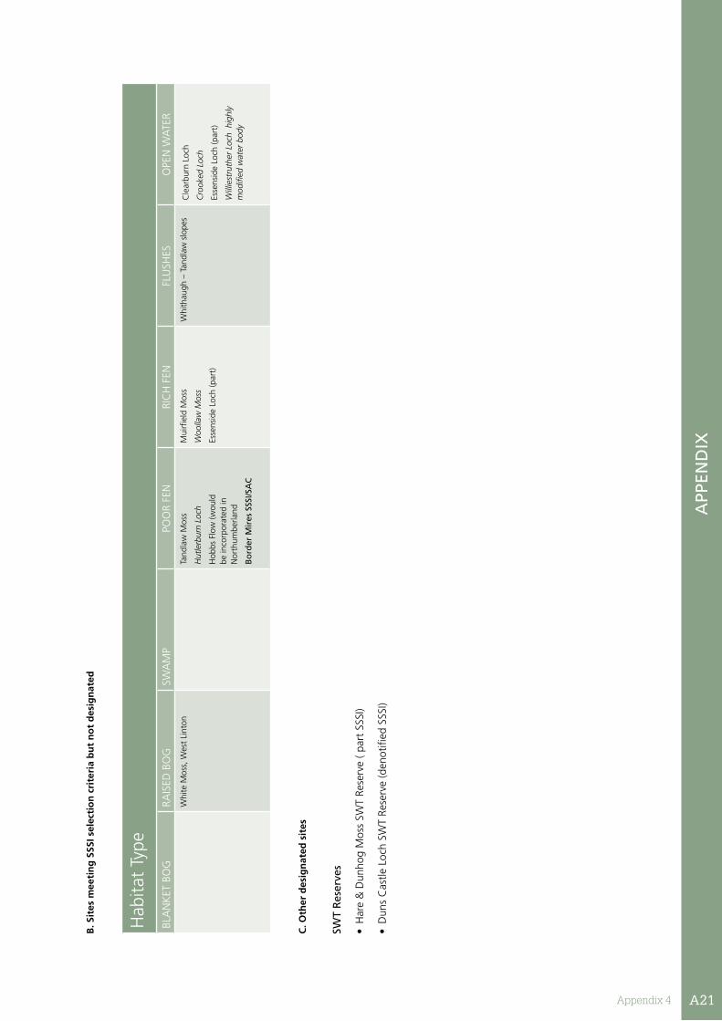
A21
App
End
ix
Appendix 4
Hab
itat
Type
BLA
NK
ET B
OG
RAIS
ED B
OG
SWA
MP
POO
R FE
NRI
CH
FEN
FLU
SHES
OPE
N W
ATE
R
Whi
te M
oss,
Wes
t Li
nton
Tand
law
Mos
s
Hut
lerb
urn
Loch
Hob
bs F
low
(wou
ld
be in
corp
orat
ed in
N
orth
umbe
rland
Bo
rder
mir
es S
SSi/S
Ac
Mui
rfiel
d M
oss
Woo
llaw
Mos
s
Esse
nsid
e Lo
ch (p
art)
Whi
thau
gh –
Tan
dlaw
slo
pes
Cle
arbu
rn L
och
Cro
oked
Loc
h
Esse
nsid
e Lo
ch (p
art)
Will
iest
ruth
er L
och
hig
hly
mod
ified
wat
er b
ody
B. S
ites
mee
tin
g S
SSI s
elec
tio
n c
rite
ria
bu
t n
ot
des
ign
ated
C. O
ther
des
ign
ated
sit
es
SWT
res
erve
s
•H
are
&D
unho
gM
oss
SWT
Rese
rve
(par
tSS
SI)
•D
uns
Cas
tleL
och
SWT
Rese
rve
(den
otifi
edS
SSI)
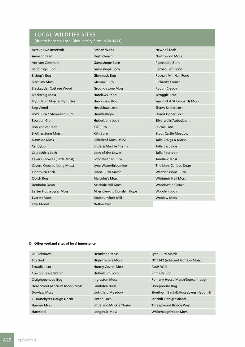
Appendix 4A22
locAl WildliFE SiTES (due to become local Biodiversity Sites in 2010/11)
Acreknowe reservoir Fethan Wood newhall loch
Amazondean Flesh cleuch northwood moss
Ancrum common gameshope Burn pipershole Burn
Baddinsgill Bog gameshope loch rachan Fish pond
Bishop's Bog glenmuck Bog rachan mill hall pond
Bitchlaw moss glensax Burn richard's cleuch
Blackadder cottage Wood groundistone moss rough cleuch
Blackcraig moss harelaws pond Scroggie Brae
Blyth muir moss & Blyth dean hawkshaw Bog Seacroft & St leonards moss
Bog Wood headshaw loch Shaws under loch
Bold Burn / glenmead Burn hundleshope Shaws upper loch
Bowden glen hutlerburn loch Silverwells/Abbeyburn
Brockholes dean Kill Burn Stichill linn
Brotherstone moss Kiln Burn Stobs castle meadow
Burnside moss lilliesleaf moss dSSSi Talla craigs & marsh
candyburn little & muckle Thairn Talla East Side
cauldshiels loch loch of the lowes Talla reservoir
cavers Knowes (little moss) longstruther Burn Tandlaw moss
cavers Knowes (long moss) lyne Water/Broomlee The linn, carlops dean
clearburn loch lynne Burn marsh Waddenshope Burn
cloich Bog malcolm's moss Whitmuir hall moss
denholm dean marlside hill moss Woodcastle cleuch
Easter housebyres moss moss cleuch / dunslair hope Wooden loch
Everett moss mossburnford mill Woolaw moss
Faw mount nether pirn
Baillieknowe hermiston moss lyne Burn marsh
Big dod highchesters moss nT 6242 (adjacent gordon moss)
Broadlee loch huntly covert moss pauls Well
cowbog-Kale Water hutlerburn loch primside Bog
craighopehead Bog ingraston moss romany house marsh/duncanhaugh
dere Street (Ancrum moor) moss lambden Burn Sheephouse Bog
dowlaw moss lightfield meadow Sloethorn Bank/E.housebyres haugh St
E.housebyres haugh north linton loch Stitchill linn grassland
harden moss little and muckle Thairn Threepwood Bridge West
hareford longmuir moss Whitehaughmoor moss
D. Other wetland sites of local importance
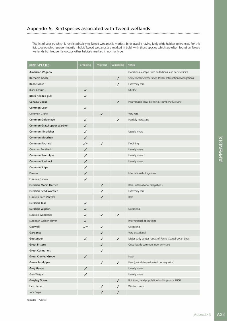
A23
App
End
ix
Appendix 5
Bird SpEciES Breeding migrant Wintering notes
American Wigeon Occasional escape from collections; esp Berwickshire
Barnacle goose 3 Some local increase since 1990s. International obligations
Bean goose 3 Extremely rare
Black Grouse 3 UK BAP
Black-headed gull 3
canada goose 3 Plus variable local breeding. Numbers fluctuate
common coot 3
Common Crane 3 Very rare
common goldeneye 3 3 Possibly increasing
common grasshopper Warbler 3
common Kingfisher 3 Usually rivers
common moorhen 3
common pochard 3* 3 Declining
Common Redshank 3 Usually rivers
common Sandpiper 3 Usually rivers
common Shelduck 3 Usually rivers
common Snipe 3
dunlin 3 International obligations
Eurasian Curlew 3
Eurasian marsh harrier 3 Rare. International obligations
Eurasian reed Warbler 3 Extremely rare
Eurasian Reed Warbler 3 Rare
Eurasian Teal 3
Eurasian Wigeon 3 Occasional
Eurasian Woodcock 3 3 3
European Golden Plover 3 International obligations
gadwall 3† 3 Occasional
garganey 3 Very occasional
goosander 3 3 3 Major early winter roosts of Fenno-Scandinavian birds
great Bittern 3 Once locally common; now very rare
great cormorant 3
great crested grebe 3 Local
green Sandpiper 3 3 Rare (probably overlooked on migration)
grey heron 3 Usually rivers
Grey Wagtail 3 Usually rivers
greylag goose 3 But local, feral population building since 2000
Hen Harrier 3 3 Winter roosts
Jack Snipe 3 3
Appendix 5. Bird species associated with Tweed wetlands
The list of species which is restricted solely to Tweed wetlands is modest, birds usually having fairly wide habitat tolerances. For this list, species which predominantly inhabit Tweed wetlands are marked in bold, with those species which are often found on Tweed wetlands but frequently occupy other habitats marked in normal type.
†possible *unsure
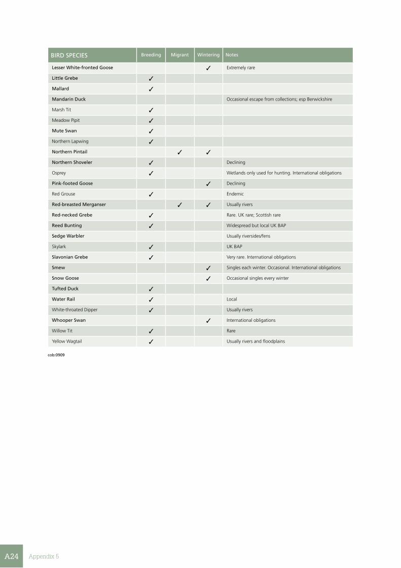
Appendix 5A24
Bird SpEciES Breeding migrant Wintering notes
lesser White-fronted goose 3 Extremely rare
little grebe 3
mallard 3
mandarin duck Occasional escape from collections; esp Berwickshire
Marsh Tit 3
Meadow Pipit 3
mute Swan 3
Northern Lapwing 3
northern pintail 3 3
northern Shoveler 3 Declining
Osprey 3 Wetlands only used for hunting. International obligations
pink-footed goose 3 Declining
Red Grouse 3 Endemic
red-breasted merganser 3 3 Usually rivers
red-necked grebe 3 Rare. UK rare; Scottish rare
reed Bunting 3 Widespread but local UK BAP
Sedge Warbler Usually riversides/fens
Skylark 3 UK BAP
Slavonian grebe 3 Very rare. International obligations
Smew 3 Singles each winter. Occasional. International obligations
Snow goose 3 Occasional singles every winter
Tufted duck 3
Water rail 3 Local
White-throated Dipper 3 Usually rivers
Whooper Swan 3 International obligations
Willow Tit 3 Rare
Yellow Wagtail 3 Usually rivers and floodplains
cob:0909
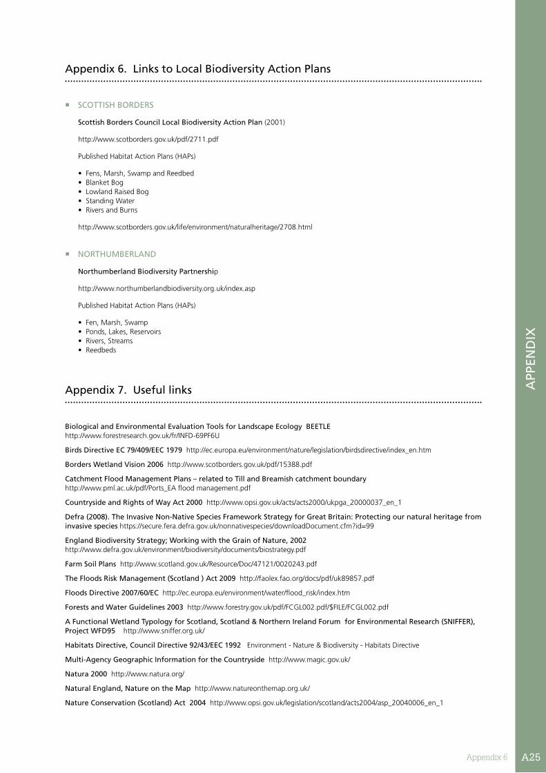
A25
App
End
ix
Appendix 6
Appendix 6. links to local Biodiversity Action plans
¡ ScoTTiSh BordErS
Scottish Borders council local Biodiversity Action plan (2001)
http://www.scotborders.gov.uk/pdf/2711.pdf
Published Habitat Action Plans (HAPs)
• Fens,Marsh,SwampandReedbed • BlanketBog • LowlandRaisedBog • StandingWater • RiversandBurns
http://www.scotborders.gov.uk/life/environment/naturalheritage/2708.html
¡ norThumBErlAnd
northumberland Biodiversity partnership
http://www.northumberlandbiodiversity.org.uk/index.asp
Published Habitat Action Plans (HAPs)
• Fen,Marsh,Swamp • Ponds,Lakes,Reservoirs • Rivers,Streams • Reedbeds
Appendix 7. useful links
Biological and Environmental Evaluation Tools for landscape Ecology BEETlE http://www.forestresearch.gov.uk/fr/INFD-69PF6U
Birds directive Ec 79/409/EEc 1979 http://ec.europa.eu/environment/nature/legislation/birdsdirective/index_en.htm
Borders Wetland vision 2006 http://www.scotborders.gov.uk/pdf/15388.pdf
catchment Flood management plans – related to Till and Breamish catchment boundary http://www.pml.ac.uk/pdf/Ports_EA flood management.pdf
countryside and rights of Way Act 2000 http://www.opsi.gov.uk/acts/acts2000/ukpga_20000037_en_1
defra (2008). The invasive non-native Species Framework Strategy for great Britain: protecting our natural heritage from invasive species https://secure.fera.defra.gov.uk/nonnativespecies/downloadDocument.cfm?id=99
England Biodiversity Strategy; Working with the grain of nature, 2002 http://www.defra.gov.uk/environment/biodiversity/documents/biostrategy.pdf
Farm Soil plans http://www.scotland.gov.uk/Resource/Doc/47121/0020243.pdf
The Floods risk management (Scotland ) Act 2009 http://faolex.fao.org/docs/pdf/uk89857.pdf
Floods directive 2007/60/Ec http://ec.europa.eu/environment/water/flood_risk/index.htm
Forests and Water guidelines 2003 http://www.forestry.gov.uk/pdf/FCGL002.pdf/$FILE/FCGL002.pdf
A Functional Wetland Typology for Scotland, Scotland & northern ireland Forum for Environmental research (SniFFEr), project WFd95 http://www.sniffer.org.uk/
habitats directive, council directive 92/43/EEc 1992 Environment - Nature & Biodiversity - Habitats Directive
multi-Agency geographic information for the countryside http://www.magic.gov.uk/
natura 2000 http://www.natura.org/
natural England, nature on the map http://www.natureonthemap.org.uk/
nature conservation (Scotland) Act 2004 http://www.opsi.gov.uk/legislation/scotland/acts2004/asp_20040006_en_1

Appendix 7A26
Appendix 7. useful links (cont.)
nitrate vulnerable Zones (England) http://www.defra.gov.uk/environment/quality/water/waterquality/diffuse/nitrate/help-for-farmers.htm
nitrate vulnerable Zones (Scotland) http://www.oqps.gov.uk/legislation/ssi/ssi2008/ssi_20080298_en_1
north East Wetland Feasibility Study 2007 http://www.nebiodiversity.org.uk/docs/170.pdf
northumberland Biodiversity partnership http://www.northumberlandbiodiversity.org.uk/
prevention of Environmental pollution from Agricultural Activity - pEpFAA code http://www.scotland.gov.uk/Publications/2005/03/20613/51366
river Basin management planning – Solway Tweed http://www.sepa.org.uk/water/river_basin_planning/early_basin_planning_work.aspx
rivers and Fisheries Trusts of Scotland – rAFTS http://www.rafts.org.uk/home/home.asp
Scottish Advisory & implementation Forum on Flooding – SAiFF http://www.scotland.gov.uk/Topics/Environment/Water/Flooding/advisory-groups/saif
Scottish Borders Woodland Strategy 2005 http://www.scotborders.gov.uk/life/planningandbuilding/plansandresearch/5660.html
Scottish Forestry Strategy and implementation plan 2009-12 http://www.forestry.gov.uk/forestry/INFD-6AGGZW
Scottish outdoor Access code Scottish outdoor Access code http://www.outdooraccess-scotland.com/default.asp
Snh Sitelink http://www.snh.org.uk/snhi
Species Action Framework Scotland http://www.snh.org.uk/speciesactionframework
Strategy for England’s Trees, Woods and Forests 2008-12 http://www.forestry.gov.uk/pdf/eng-etwf-delivery-plan.pdf/$FILE/eng-etwf-delivery-plan.pdf
Sustainable drainage Systems – SudS http://www.environment-agency.gov.uk/business/sectors/36998.aspx
The rAmSAr convention on Wetlands http://www.ramsar.org/
Till & Breamish cAmS http://publications.environment-agency.gov.uk/pdf/GENE1109BRCI-e-e.pdf
The Till Wetland restoration project http://www.tweedforum.com/projects
Tweed catchment management plan 2003 http://www.tweedforum.com/cmp
uK climate impacts programme – uKcip http://www.ukcip.org.uk/
uK Forestry Standards 2004 http://www.forestry.gov.uk/pdf/fcfc001.pdf/$FILE/fcfc001.pdf
voluntary initiative http://www.voluntaryinitiative.org.uk/
The Water Environment (controlled Activities) (Scotland) regulations 2005 (cAr) http://www.opsi.gov.uk/legislation/scotland/ssi2005/20050348.htm
The Water Environment and Water Services (Scotland) Act 2003 (WEWS) http://www.scotland.gov.uk/Topics/Environment/Water/WFD/WEWSAct
Water Framework directive 2000/60/Ec http://ec.europa.eu/environment/water/water-framework/index_en.html
Wildlife and countryside Act 1981 http://www.jncc.gov.uk/page-3614
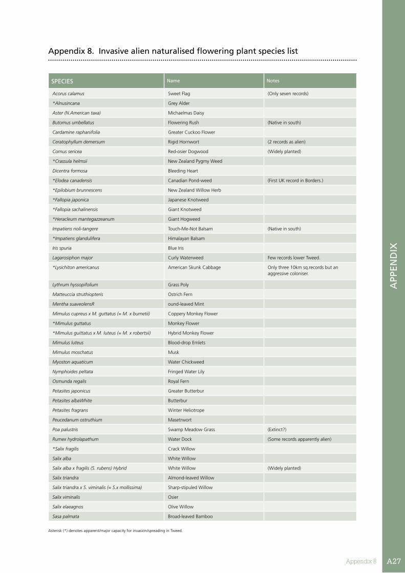
A27
App
End
ix
Appendix 8
Appendix8.Invasivealiennaturalisedfloweringplantspecieslist
SpEciES name notes
Acorus calamus Sweet Flag (Only seven records)
*Alnusincana Grey Alder
Aster (N.American taxa) Michaelmas Daisy
Butomus umbellatus Flowering Rush (Native in south)
Cardamine raphanifolia Greater Cuckoo Flower
Ceratophyllum demersum Rigid Hornwort (2 records as alien)
Cornus sericea Red-osier Dogwood (Widely planted)
*Crassula helmsii New Zealand Pygmy Weed
Dicentra formosa Bleeding Heart
*Elodea canadensis Canadian Pond-weed (First UK record in Borders.)
*Epilobium brunnescens New Zealand Willow Herb
*Fallopia japonica Japanese Knotweed
*Fallopia sachalinensis Giant Knotweed
*Heracleum mantegazzeanum Giant Hogweed
Impatiens noli-tangere Touch-Me-Not Balsam (Native in south)
*Impatiens glandulifera Himalayan Balsam
Iris spuria Blue Iris
Lagarosiphon major Curly Waterweed Few records lower Tweed.
*Lysichiton americanus American Skunk Cabbage Only three 10km sq.records but an aggressive coloniser.
Lythrum hyssopifolium Grass Poly
Matteuccia struthiopteris Ostrich Fern
Mentha suaveolensR ound-leaved Mint
Mimulus cupreus x M. guttatus (= M. x burnetii) Coppery Monkey Flower
*Mimulus guttatus Monkey Flower
*Mimulus guittatus x M. luteus (= M. x robertsii) Hybrid Monkey Flower
Mimulus luteus Blood-drop Emlets
Mimulus moschatus Musk
Myoston aquaticum Water Chickweed
Nymphoides peltata Fringed Water Lily
Osmunda regalis Royal Fern
Petasites japonicus Greater Butterbur
Petasites albaWhite Butterbur
Petasites fragrans Winter Heliotrope
Peucedanum ostruthium Masetrwort
Poa palustris Swamp Meadow Grass (Extinct?)
Rumex hydrolapathum Water Dock (Some records apparently alien)
*Salix fragilis Crack Willow
Salix alba White Willow
Salix alba x fragilis (S. rubens) Hybrid White Willow (Widely planted)
Salix triandra Almond-leaved Willow
Salix triandra x S. viminalis (= S.x mollissima) Sharp-stipuled Willow
Salix viminalis Osier
Salix elaeagnos Olive Willow
Sasa palmata Broad-leaved Bamboo
Asterisk (*) denotes apparent/major capacity for invasion/spreading in Tweed.

Appendix 9A28
Appendix 9. Bibliography
Specific Tweed (Borders) References & Bibliography:
Ball, j, cummins, r., mcKeen m., lilly.A.
(2006) A Borders Wetland Vision: Development of a Strategic Planning Tool for Wetland Biodiversity Conservation. The Macaulay Land Use research Institute. Craigiebuckler. Aberdeen.
Bown, c.j. (1985) Provisional Soil Map: Upper Clyde Valley, Galashiels and Ettrick Forest. Dyeline. (Part O.S. Map Sheets 72 and 73.) 1:50,000. Macaulay Institute for Soil Research. Craigiebuckler, Aberdeen.
Braithwaite, m.E.B. (2002) Berwickshire Rare Plant Register. Private Publication. Berwickshire Naturalists Club. Hawick.
corner, r.W.m. (1985) Flowering Plants & Ferns of Selkirkshire & Roxburghshire. Botanical Society of the British Isles at University of Lancaster. Lancaster.
corner, r.W.m. (1992) Additions & Amendments to the Flowering Plants & Ferns of Selkirkshire & Roxburghshire. Unpublished typescript. Penrith.
daniels, r.E. (1978) Floristic Analyses of British Mires and Mire Communities. Journal of Ecology ,66 pp 773-802.
Foster, g.n. (1976) Survey of Aquatic Coleoptera in some Border Mosses. South-east Region Research & Survey Report. Nature Conservancy Council. Edinburgh.
harris, l. (2007) North-east England Wetland Feasibility Study. Environment Agency & RSPB. Newcastle Upon Tyne.
haslam, S.m. (1978) River Plants. Cambridge University Press.
haslam, S.m., & Wolseley, p.A. (1981) River Vegetation: Its Identification and Management. Cambridge University Press
hill, m.o., preston, c.d. & Smith, A.j.E.
(1991) Atlas of the Bryophytes of Britain & Ireland. (1992) Vol 1. - Liverworts. Vols. 2-3. – Mosses. (1994) Harley Books. Colchester.
ingram, h.A.p. (1982) Size and Shape in Raised Mire Ecosystems: a Geophysical Model. Nature 297. pp. 300-302.
jermy, A.c., chater, A.o. & david, r.W.
(1982) Sedges of the British Isles. BSBI Handbook No. 1 Botanical Society of the British Isles. London.
muir, j. W. (1956) Soils of the Country Round Jedburgh and Morebattle. Soil Survey of Scotland (Map sheets 17 & 18) 1;63,360. Macaulay Institute for Soil Research. Craigiebuckler Aberdeen. HMSO.
ragg, j.m. (1960) Soils of the Country Round Kelso and Lauder.Soil Survey of Scotland (Map sheets 25 & 26) 1;63,360. Macaulay Institute for Soil Research. Craigiebuckler Aberdeen. HMSO.
ragg, j.m. & Futty, d.W (1967) Soils of the Country Round Haddington and Eyemouth. Soil Survey of Scotland (Map sheets 33, 34 & part 41) 1;63,360. Macaulay Institute for Soil Research. Craigiebuckler Aberdeen. HMSO.
ragg, j.m. , Bibby, j.S., orbell, g.E, & duncan n.A.,
(1971) Soil Survey of Scotland: Map sheets 24 & part 32.1;63, 360. Macaulay Institute for Soil Research. Craigiebuckler Aberdeen
Soils Survey and land research centre
(1984) Soils of the Alnwick & Rothbury District. Ordnance Survey Sheet 81. 1:50,000. Soils Survey and Land Research Centre
lindsay, r. (1995) Bogs: The Ecology, Classification & Conservation of Ombrotrophic Mires. Scottish Natural Heritage. Edinburgh.
A29
App
End
ix
Appendix 9
maitland, p.S. Boon, p.j., mclusky d.S.
(1994) The Freshwaters of Scotland: A Resource of International Significance. John Wiley & Sons. Chichester.
palmer, m. (1992) A Botanical Classification of Standing Waters In Great Britain: A Method for the use of Macrophyte Flora in Assessing Change in Water Quality. Research & Survey in Nature Conservation Series No. 19. Nature Conservancy Council. Peterborough.
palmer, m., & newbold, c. (1983) Wetland and Riparian Plants in Britain. Focus on Nature Conservation Series, No 1. Nature Conservancy Council. Huntingdon.
preston, c.d. (1995) Pondweeds of Gt. Britain & Ireland. BSBI Handbook No. 8. Botanical Society of the British Isles. London.
preston, c.d. pearman, d.A., dines, T.d.
(2002) New Atlas of the British & Irish Flora. Botanical Society of the British Isles. Oxford University Press. Oxford.
ratcliffe, d.A. (1964) Mires and Bogs In: Burnett, J.H. (ed.) The Vegetation of Scotland. Oliver & Boyd. Edinburgh.
Scottish Environment protection Agency
(2009) Environmental Supporting Conditions for Scottish Wetlands. Report of Project WFD 35 under SNIFFER. Editor Johan Schutte. Scottish Environment Protection Agency. Stirling.
Scottish Executive (undated) The Muirburn Code: AS Guide to Best Practice. Scottish Executive. Edinburgh
Scottish Executive (undated) Prescribed Burning on Moorland: Supplement To the Muirburn Code. Scottish Executive. Edinburgh
Scottish government & Forestry commission
(2006) The Scottish Forestry Strategy. Forestry Commission. Edinburgh.
Smith, W.g. (1918) Distribution of Nardus in Relation to Peat. J. Ecol. 6: pp 1 – 13.
Tallis, j.h. (1995) Blanket Mire in the Upland Landscape. In: Wheeler & Shaw (1995) Restoration of Damaged Peatlands. (q.v.)
Tansley, A. (1939) The British Islands and Their Vegetation.2 vols. Cambridge University Press. Cambridge.
Tratt, r. (1997) The Scottish Border Fens: Controls on Vegetation Development & Composition. Unpublished Ph.D. Thesis. University of Sheffield, Sheffield.
Wheeler, B.d. (1980) Plant Communities of Rich-Fen Systems in England and Wales. Journal of Ecology:68 I – pp. 365-395 II – pp. 405-420 III – pp. 761-788.
Wheeler, B.d., Shaw, S.c., Fojt, W.j. & robertson, r.A. (eds.)
(1995) Restoration of Temperate Peatlands. John Wiley & Sons. Chichester.
Specific Tweed (Borders) References & Bibliography (cont.)

Appendix 9A30
General References & Bibliography:
clegg, j. (1965) Freshwater Life. Frederick Warne & Co. Ltd. London
Brooks, S. & Stoneman, r. (1997) Conserving Bogs: A Management Handbook. The Stationery Office. Edinburgh.
Fojt, W.j. (1991) Guidelines for Fen Survey. Chief Scientists Directorate Note No. 59. Nature Conservancy Council. Peterborough.
Fojt, W.j. (1993) Update to Quick Guide to Fens. Research report No 21. English Nature. Peterborough.
Fojt, W. j. & meade, r. (eds.)
(1989) Cut-over Lowland Raised Bogs. Proceedings of a Conference Held at Doncaster 4-8th October 1988. Research & Survey in Nature Conservation. Series No 24. Nature Conservancy Council. Peterborough.
goulder, r. (2008) Checklists and their Importance for Recording Freshwater Vascular Plants. Freshwater Reviews I: Issue No 2. pp. 205-225. Dec.2008.
lindsay, r. (1995) Bogs: The Ecology, Classification and Conservation of Ombrotrophic Mires.Scottish Natural Heritage. Edinburgh.
preston, c.d., pearman, d.A., dines, T.d.
(2002) New Atlas of the British & Irish Flora. Botanical Society of the British Isles. Oxford University Press. Oxford.
richards, j. r. A, Wheeler, B.d. & Willis, A.j.
(1995) The Growth and Value of Eriophorum angustifolium Honck. In Relation to the Revegetation of Eroding Blanket Peat. In: Wheeler & Shaw (1995) Restoration of Damaged Peatlands. (q.v.)
Shaw, S.c. & money, r.p. (1999) Scoping a Fen Directory for Scotland. Draft report to SNH. Environmental Consultancy. University of Sheffield. Sheffield.
Sjors, j. (1950) On the relation between Vegetation and Electrolytes In North Swedish Mire Waters. Oikos 2: pp. 241-258.
Sommerville, A. (ed.) (1983) Managing Marshes and Mosses. Wildlife Workshop No.1. Scottish Wildlife Trust. Edinburgh.
Werhoeven, S, van Beek, S., dekker, m., & Storm, W.
(1983) Nutrient Dynamics in small Mesotrophic Fens Surrounded by Cultivated Land. Oecologi 60: pp. 25-33. Berlin.
Wheeler, B.d. (1995) Restoration and Wetlands. In: Wheeler & Shaw (1995) Restoration of Damaged Peatlands. (q.v.)
Wheeler, B.d. & Shaw S.c. (eds.) (1995) Restoration of Damaged Peatlands. University of Sheffield and Department of the Environment. HMSO. London.

Acknowledgments: We would like to thank members of the Wetland Strategy Steering Group (Anne Lewis, Environment Agency; Andy Tharme, Scottish Borders Council; Andrew MacBride & Andrew Panter, Scottish Natural Heritage; Anna Griffin & Lorna Harris, SEPA; Hugh Chalmers, Luke Comins, Alastair Laverty & Jan Landells, Tweed Forum; Chris Spray, UNESCO Centre/University of Dundee) for helpful comments on earlier drafts of the Strategy; Laurie Campbell for his wonderful photography; Ed Hudspeth (NNPA); National Library of Scotland; John Lowe (University of London); A. Mannion (formerly at University of Reading); Richard Tipping (University of Stirling); Susan Shaw (University of Sheffield) and BSBI recorders for the Border counties and Northumberland.
This publication was produced with support from SNH
River Till
Ettrick & Yarrow
River Teviot
Gala Water
Leader Water
Blackadder Water
Whiteadder Water
Source of the Tweed
Tweed Forum South Court Drygrange Steading Melrose TD6 9DJ
T 01896 849723 F 01896 849129 E [email protected] www.tweedforum.com