Daniel M. Gurtner (2007). the Torn Veil (SNTSMS 139) Cambridge, UK, CUP.
RINEX
The Receiver Independent Exchange Format
Version 3.00
Werner Gurtner Astronomical Institute
University of Bern
Lou Estey UNAVCO
Boulder, Co.
February 1st, 2006
RINEX Version 3.00 Contents I
rinex300.doc 10.08.2006 12:24
Table of Contents 0. REVISION HISTORY.................................................................................................................................. 1 1. THE PHILOSOPHY AND HISTORY OF RINEX...................................................................................... 1 2. GENERAL FORMAT DESCRIPTION........................................................................................................ 2 3. BASIC DEFINITIONS ................................................................................................................................. 3
3.1 Time........................................................................................................................................................ 3 3.2 Pseudo-Range: ........................................................................................................................................3 3.3 Phase ....................................................................................................................................................... 3 3.4 Doppler ................................................................................................................................................... 4 3.5 Satellite numbers..................................................................................................................................... 4
4. THE EXCHANGE OF RINEX FILES: ........................................................................................................ 4 5. RINEX VERSION 3 FEATURES ................................................................................................................ 6
5.1 Observation codes................................................................................................................................... 6 5.2 Satellite system-dependent list of observables ....................................................................................... 8 5.3 Marker type............................................................................................................................................. 8 5.4 Half-wavelength observations ................................................................................................................ 8 5.5 Scale factor ............................................................................................................................................. 8 5.6 Information about receivers on a vehicle................................................................................................ 9 5.7 Signal strengths....................................................................................................................................... 9 5.8 Date/time format in the PGM / RUN BY / DATE header record...................................................... 9 5.9 Antenna phase center header record ..................................................................................................... 10 5.10 Antenna orientation............................................................................................................................. 10 5.11 Observation data records .................................................................................................................... 10 5.12 Ionosphere delay as pseudo-observables ............................................................................................ 10 5.13 Channel numbers as pseudo-observables............................................................................................ 11 5.14 Corrections of differential code biases (DCBs).................................................................................. 11
6. ADDITIONAL HINTS AND TIPS ............................................................................................................ 11 6.1 Versions ................................................................................................................................................ 11 6.2 Leading blanks in CHARACTER fields............................................................................................... 12 6.3 Variable-length records......................................................................................................................... 12 6.4 Blank fields........................................................................................................................................... 12 6.5 Order of the header records, order of data records ............................................................................... 12 6.6 Missing items, duration of the validity of values.................................................................................. 12 6.7 Unknown / Undefined observation types and header records............................................................... 12 6.8 Event flag records ................................................................................................................................. 14 6.9 Receiver clock offset ............................................................................................................................ 14 6.10 Two-digit years ................................................................................................................................... 14 6.11 Fit interval (GPS navigation message file) ......................................................................................... 14 6.12 Satellite health (GPS navigation message file)................................................................................... 14 6.13 Transmission time of message (GPS navigation message file) .......................................................... 14 6.14 Antenna references ............................................................................................................................. 15
7. RINEX UNDER ANTISPOOFING (AS) ................................................................................................... 15 8. DEALING WITH DIFFERENT SATELLITE SYSTEMS ........................................................................ 16
8.1 RINEX observation files....................................................................................................................... 16 8.1.1 Time system identifier................................................................................................................... 16 8.1.2 Pseudorange definition .................................................................................................................. 17
8.2 RINEX navigation message files for GLONASS................................................................................. 17 8.3 RINEX navigation message files for Galileo........................................................................................ 18 8.4 RINEX observation files for GEO satellites......................................................................................... 18 8.5 RINEX navigation message files for GEO satellites ............................................................................ 18
REFERENCES................................................................................................................................................ 20

RINEX Version 3.00 Contents II
rinex300.doc 10.08.2006 12:24
APPENDIX: RINEX FORMAT DEFINITIONS AND EXAMPLES.............................................................. 1
A 1 GNSS Observation Data File - Header Section Description ........................................................... 1 A 2 GNSS Observation Data File - Data Record Description................................................................ 4 A 3 GNSS Observation Data File - Example ......................................................................................... 6 A 4 GPS Navigation Message File - Header Section Description.......................................................... 7 A 5 GPS Navigation Message File - Data Record Description .............................................................. 7 A 6 GPS Navigation Message File – Example....................................................................................... 8 A 7 GLONASS Navigation Message File - Header Section Description............................................... 9 A 8 GLONASS Navigation Message File - Data Record Description ................................................... 9 A 9 GLONASS Navigation Message File – Example.......................................................................... 10 A10 SBAS Navigation Message File - Header Section Description ..................................................... 10 A11 SBAS Navigation Message File - Data Record Description ......................................................... 11 A12 SBAS Navigation Message File - Example................................................................................... 12 A13 Meteorological Data File - Header Section Description................................................................ 12 A14 Meteorological Data File - Data Record Description .................................................................... 13 A15 Meteorological Data File - Example.............................................................................................. 14

RINEX Version 3.00 Description 1
rinex300.doc 10.08.2006 12:24
0. REVISION HISTORY 02 Feb 2006: A few typos and obsolete paragraphs removed. 08-Mar-2008: Epochs of met data of met files version 2.11 are in GPS time only (Table A14) 31-Mar-2006: DCB header record label corrected in Table A3: SYS / DCBS APPLIED June 2006: Filenames for mixed GNSS nav mess files 10-Aug-2006: Table A2: Error in format of EPOCH record: One 6X removed. Trailing 3X removed. 1. THE PHILOSOPHY AND HISTORY OF RINEX The first proposal for the Receiver Independent Exchange Format RINEX was developed by the Astro-nomical Institute of the University of Berne for the easy exchange of the GPS data to be collected during the first large European GPS campaign EUREF 89, which involved more than 60 GPS receivers of 4 different manufacturers. The governing aspect during the development was the following fact: Most geodetic processing software for GPS data use a well-defined set of observables:
- the carrier-phase measurement at one or both carriers (actually being a measurement on the beat fre-quency between the received carrier of the satellite signal and a receiver-generated reference fre-quency).
- the pseudorange (code) measurement, equivalent to the difference of the time of reception (ex-
pressed in the time frame of the receiver) and the time of transmission (expressed in the time frame of the satellite) of a distinct satellite signal.
- the observation time being the reading of the receiver clock at the instant of validity of the carrier-
phase and/or the code measurements. Usually the software assumes that the observation time is valid for both the phase and the code measure-ments, and for all satellites observed. Consequently all these programs do not need most of the information that is usually stored by the receivers: They need phase, code, and time in the above mentioned definitions, and some station-related in-
formation like station name, antenna height, etc. Up till now two major format versions have been developed and published:
- The original RINEX Version 1 presented at and accepted by the 5th International Geodetic Sympo-sium on Satellite Positioning in Las Cruces, 1989. [Gurtner et al. 1989], [Evans 1989]
- RINEX Version 2 presented at and accepted by the Second International Symposium of Precise Po-sitioning with the Global Positioning system in Ottawa, 1990, mainly adding the possibility to in-clude tracking data from different satellite systems (Glonass, SBAS). [Gurtner and Mader 1990a, 1990b], [Gurtner 1994].
Several subversions of RINEX Version 2 have been defined:
- Version 2.10: Among other minor changes allowing for sampling rates other than integer seconds and including raw signal strengths as new observables. [Gurtner 2002]
- Version 2.11: Includes the definition of a two-character observation code for L2C pseudoranges and some modifications in the GEO NAV MESS files [Gurtner and Estey 2005]
- Version 2.20: Unofficial version used for the exchange of tracking data from spaceborne receivers within the IGS LEO pilot project [Gurtner and Estey 2002]

RINEX Version 3.00 Description 2
rinex300.doc 10.08.2006 12:24
As spin-offs of this idea of a receiver-independent GPS exchange format other RINEX-like exchange file formats have been defined, mainly used by the International GNSS Service IGS:
- Exchange format for satellite and receiver clock offsets determined by processing data of a GNSS tracking network [Ray and Gurtner 1999]
- Exchange format for the complete broadcast data of space-based augmentation systems SBAS. [Suard et al. 2004]
- IONEX: Exchange format for ionosphere models determined by processing data of a GNSS track-ing network [Schaer et al. 1998]
- ANTEX: Exchange format for phase center variations of geodetic GNSS antennae [Rothacher and Schmid 2005]
The upcoming European Navigation Satellite System Galileo and the enhanced GPS with new frequencies and observation types, especially the possibility to track frequencies on different channels, ask for a more flexible and more detailed definition of the observation codes. To improve the handling of the data files in case of “mixed” files, i.e. files containing tracking data of more than one satellite system, each one with different observation types, the record structure of the data record has been modified significantly and, following several requests, the limitation to 80 characters length has been removed. As the changes are quite significant, they lead to a new RINEX Version 3. The new version also includes the unofficial Version 2.20 definitions for space-borne receivers. The current RINEX definition version 3.00 keeps the format of the existing navigation and meteorologi-cal files as they were in version 2.10 (or 2.11, respectively). The Galileo navigation message file definition can only be done when the Galileo broadcast message contents is made available to the public. It is possi-ble that adjustments to the GPS RINEX navigation message file will have to be performed to account for the GPS enhancements. 2. GENERAL FORMAT DESCRIPTION Currently the RINEX format consists of five ASCII file types:
1. Observation Data File 2. GPS Navigation Message File 3. Meteorological Data File 4. GLONASS Navigation Message File 5. SBAS1 Geostationary Navigation Message File
The Galileo Navigation Message File will be defined as soon as the contents of the Galileo Navigation Mes-sage has been published. Each file type consists of a header section and a data section. The header section contains global information for the entire file and is placed at the beginning of the file. The header section contains header labels in columns 61-80 for each line contained in the header section. These labels are mandatory and must appear exactly as given in these descriptions and examples. The format has been optimized for minimum space requirements independent from the number of different observation types of a specific receiver or satellite system by indicating in the header the types of observa-tions to be stored for this receiver and the satellite systems having been observed. In computer systems al- 1 SBAS: Satellite-Based Augmentation System

RINEX Version 3.00 Description 3
rinex300.doc 10.08.2006 12:24
lowing variable record lengths the observation records may be kept as short as possible. Trailing blanks can be removed from the records. There is no maximum record length limitation for the observation records. Each Observation file and each Meteorological Data file basically contain the data from one site and one session. Starting with Version 2 RINEX also allows to include observation data from more than one site subsequently occupied by a roving receiver in rapid static or kinematic applications. Although Version 2 and higher allow to insert header records into the data field it is not recommended to concatenate data of more than one receiver (or antenna) into the same file, even if the data do not overlap in time. If data from more than one receiver have to be exchanged it would not be economical to include the identical satellite messages collected by the different receivers several times. Therefore the Navigation Message File from one receiver may be exchanged or a composite Navigation Message File created containing non-redundant information from several receivers in order to make the most complete file. The format of the data records of the RINEX Version 1 Navigation Message file was identical to the former NGS exchange format. The actual format descriptions as well as examples are given in the Tables at the end of the paper. 3. BASIC DEFINITIONS GPS observables include three fundamental quantities that need to be defined: Time, Phase, and Range. 3.1 Time The time of the measurement is the receiver time of the received signals. It is identical for the phase and range measurements and is identical for all satellites observed at that epoch. By default it is expressed in GPS time for GPS data files (i.e., not Universal Time). For Glonass files or mixed files the actual time sys-tem can be indicated in the Start Time header record. 3.2 Pseudo-Range: The pseudo-range (PR) is the distance from the receiver antenna to the satellite antenna including receiver and satellite clock offsets (and other biases, such as atmospheric delays):
PR = distance + c * (receiver clock offset - satellite clock offset + other biases)
so that the pseudo-range reflects the actual behavior of the receiver and satellite clocks. The pseudo-range is stored in units of meters. See also clarifications for pseudoranges in mixed GPS/GLONASS files in chapter 8.1. 3.3 Phase The phase is the carrier-phase measured in whole cycles. The half-cycles measured by squaring-type receiv-ers must be converted to whole cycles and flagged by the wavelength factor in the header section (GPS only). The phase changes in the same sense as the range (negative doppler). The phase observations between ep-ochs must be connected by including the integer number of cycles.

RINEX Version 3.00 Description 4
rinex300.doc 10.08.2006 12:24
The observables are not corrected for external effects like atmospheric refraction, satellite clock offsets, etc. Phase shifts between phases of the same frequency but tracked on a different carrier channel (I vs. Q, or A vs. B vs. C, Galileo, modernized GPS) are not corrected. If the receiver or the converter software adjusts the measurements using the real-time-derived receiver clock offsets dT(r), the consistency of the 3 quantities phase / pseudo-range / epoch must be maintained, i.e. the receiver clock correction should be applied to all 3 observables:
Time(corr) = Time(r) - dT(r) PR(corr) = PR(r) - dT(r)*c phase(corr) = phase(r) - dT(r)*freq
3.4 Doppler The sign of the doppler shift as additional observable is defined as usual: Positive for approaching satellites. 3.5 Satellite numbers Starting with RINEX Version 2 the former two-digit satellite numbers nn are preceded by a one-character system identifier s:
snn || |+-- nn: PRN (GPS, Galileo) | slot number (GLONASS) | PRN-100 (SBAS Geostationary) | +--- s: satellite system identifier G : GPS R : GLONASS S : SBAS payload E : Galileo SBAS: Satellite-Based Augmentation System
Table 1: Satellite numbers
The same satellite system identifiers are also used in all header records when appropriate. 4. THE EXCHANGE OF RINEX FILES: We recommend using the following naming convention for RINEX files:
ssssdddf.yyt | | | | | | | | | +-- t: file type: | | | | O: Observation file | | | | N: GPS Navigation file | | | | M: Meteorological data file | | | | G: GLONASS Navigation file | | | | L: Galileo Navigation file | | | | P: Mixed GNSS Navigation file | | | | H: SBAS payload navigation message file

RINEX Version 3.00 Description 5
rinex300.doc 10.08.2006 12:24
| | | | B: SBAS broadcast data file | | | | (separate documen tation) | | | | C: Clock file (separate documentation) | | | | S: Summary file (used e.g., by IGS, not a standard!) | | | +--- yy: two-digit year | | +----- f: file sequence number/character within day. | | daily file: f = 0 (zero) | | hourly files: | | a = 1st hour: 00h-01h; b = 2nd hour: 01h-02h; | | . . . x = 24th hour: 23h-24h | +------- ddd: day of the year of first record +----------- ssss: 4-character station name design ator
Table 2: Recommended filenames: General, daily, hourly files
For 15-minutes high-rate tracking data we recommend the following extended filenames:
ssssdddhmm.yyO | | || | | | | || | +- O: observation file | | || +--- yy: two-digit year | | |+------ mm: starting minute within the hour ( 00, 15, 30, 45) | | +------- h: character for the n-th hour in the day | | a = 1st hour: 00h-01h; b = 2nd hour: 01h-02h; | | . . . x = 24th hour: 23h-24h. | +--------- ddd: day of the year +------------ ssss: 4-char station ID or ID for the LEO receiver/antenna
Table 3: Recommended filenames: High-rate data files
When data transmission times or storage volumes are critical we recommend compressing the files prior to storage or transmission. IGS currently uses the UNIX "compress" und "uncompress" programs. Compatible routines are available on VAX/VMS and PC/DOS systems, as well. Proposed file name extensions for the compressed files:
+-------------------------------------------------- --------------------+ | File Types All platforms UNIX VMS DOS | | uncompressed compressed | +-------------------------------------------------- --------------------+ | Obs Files .yy O .yy O.Z .yy O_Z .yy Y | | Obs Files (Hatanaka compressed) .yy D .yy D.Z .yy D_Z .yy E | | GPS Nav Message Files .yy N .yy N.Z .yy N_Z .yy X | | GLONASS Nav Message File .yy G .yy G.Z .yy G_Z .yy V | | Galileo Nav Message File .yy L .yy L.Z .yy L_Z .yy T | | Mixed GNSS Nav Message File .yy P .yy P.Z .yy P_Z .yy Q || | GEO SBAS Nav Message Files .yy H .yy H.Z .yy H_Z .yy U | | GEO SBAS Broadcast Files (sep. doc.) .yy B .yy B.Z .yy B_Z .yy A | | Met Data Files .yy M .yy M.Z .yy M_Z .yy W | | Clock Files (see sep.doc.) .yy C .yy C.Z .yy C_Z .yy K | +-------------------------------------------------- --------------------+
Table 4: Recommended filename extensions for compressed files
In order to additionally reduce the size of observation files Yuki Hatanaka developed a special compression scheme that takes advantage of the structure of the RINEX observation data by forming higher-order differ-
RINEX Version 3.00 Description 6
rinex300.doc 10.08.2006 12:24
ences in time between observations of the same type and satellite. This compressed file is also an ASCII file that is subsequently compressed again using the above mentioned standard compression programs. References for the Hatanaka compression scheme: See e.g.
- ftp://terras.gsi.go.jp/software - IGSMails 1525,1686,1726,1763,1785,4967,4969,4975
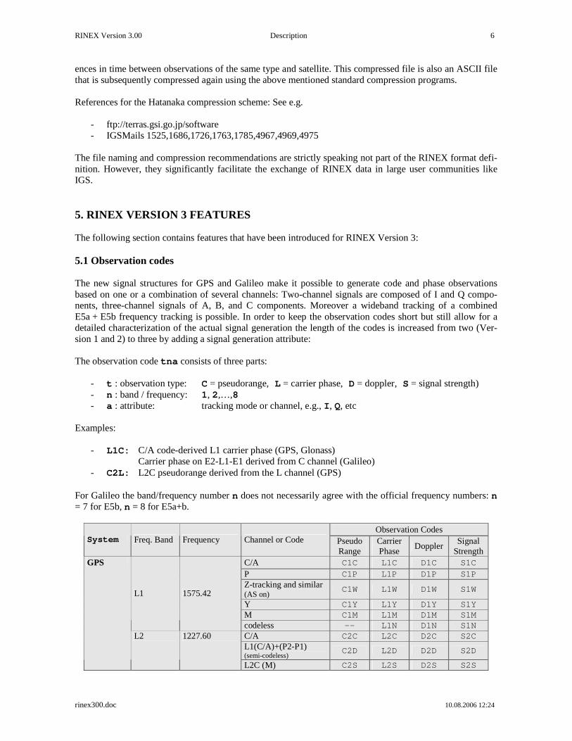
The file naming and compression recommendations are strictly speaking not part of the RINEX format defi-nition. However, they significantly facilitate the exchange of RINEX data in large user communities like IGS. 5. RINEX VERSION 3 FEATURES The following section contains features that have been introduced for RINEX Version 3: 5.1 Observation codes The new signal structures for GPS and Galileo make it possible to generate code and phase observations based on one or a combination of several channels: Two-channel signals are composed of I and Q compo-nents, three-channel signals of A, B, and C components. Moreover a wideband tracking of a combined E5a + E5b frequency tracking is possible. In order to keep the observation codes short but still allow for a detailed characterization of the actual signal generation the length of the codes is increased from two (Ver-sion 1 and 2) to three by adding a signal generation attribute: The observation code tna consists of three parts:
- t : observation type: C = pseudorange, L = carrier phase, D = doppler, S = signal strength) - n : band / frequency: 1, 2,…,8 - a : attribute: tracking mode or channel, e.g., I, Q, etc
Examples:
- L1C: C/A code-derived L1 carrier phase (GPS, Glonass) Carrier phase on E2-L1-E1 derived from C channel (Galileo)
- C2L: L2C pseudorange derived from the L channel (GPS) For Galileo the band/frequency number n does not necessarily agree with the official frequency numbers: n = 7 for E5b, n = 8 for E5a+b.
Observation Codes System Freq. Band Frequency Channel or Code Pseudo
Range Carrier Phase
Doppler Signal
Strength C/A C1C L1C D1C S1C
P C1P L1P D1P S1P Z-tracking and similar (AS on)
C1W L1W D1W S1W
Y C1Y L1Y D1Y S1Y M C1M L1M D1M S1M
L1 1575.42
codeless -- L1N D1N S1N C/A C2C L2C D2C S2C L1(C/A)+(P2-P1) (semi-codeless) C2D L2D D2D S2D
GPS
L2 1227.60
L2C (M) C2S L2S D2S S2S

RINEX Version 3.00 Description 7
rinex300.doc 10.08.2006 12:24
L2C (L) C2L L2L D2L S2L L2C (M+L)2 C2X L2X D2X S2X P C2P L2P D2P S2P Z-tracking and similar (AS on)
C2W L2W D2W S2W
Y C2Y L2Y D2Y S2Y M C2M L2M D2M S2M
codeless -- L2N D2N S2N I C5I L5I D5I S5I Q C5Q L5Q D5Q S5Q
L5 1176.45 I+Q C5X L5X D5X S5X
C/A C1C L1C D1C S1C G1 1602+k*9/16
k=0…13 or -7...+6 P C1P L1P D1P S1P C/A (Glonass M) C2C L2C D2C S2C
Glonass G2 1246+k*7/16
P C2P L2P D2P S2P
A PRS C1A L1A D1A S1A
B I/NAV OS/CS/SoL C1B L1B D1B S1B
C no data C1C L1C D1C S1C
B+C C1X L1X D1X S1X
E1 1575.42
A+B+C C1Z L1Z D1Z S1Z
I F/NAV OS C5I L5I D5I S5I
Q no data C5Q L5Q D5Q S5Q E5a 1176.45
I+Q C5X L5X D5X S5X
I I/NAV OS/CS/SoL C7I L7I D7I S7I
Q no data C7Q L7Q D7Q S7Q E5b 1207.140
I+Q C7X L7X D7X S7X
I C8I L8I D8I S8I
Q C8Q L8Q D8Q S8Q E5 (E5a+E5b)
1191.795
I+Q C8X L8X D8X S8X
A PRS C6A L6A D6A S6A
B C/NAV CS C6B L6B D6B S6B
C no data C6C L6C D6C S6C
B+C C6X L6X D6X S6X
Galileo
E6 1278.75
A+B+C C6Z L6Z D6Z S6Z
L1 1575.42 C/A C1C L1C D1C S1C
I C5I L5I D5I S5I
Q C5Q L5Q D5Q S5Q SBAS
L5 1176.45
I+Q C5X L5X D5X S5X
Table 5: RINEX Version 3 observation codes
Antispoofing (AS) of GPS: True codeless GPS receivers (squaring-type receivers) use the attribute N. Semi-codeless receivers tracking the first frequency using C/A code and the second frequency using some codeless options use attribute N. Z-tracking under AS or similar techniques to recover pseudorange and phase on the “P-code” band use attribute W. Y-code tracking receivers use attribute Y. As all observations affected by “AS on” get now their own attribute (codeless, semi-codeless, Z-tracking and similar) the Antispoofing flag introduced into the observation data records of RINEX Version 2 has become obsolete. 2 Example: Trimble NetRS and Septentrio PolaRx2C track L2C on the combined code M+L, therefore attribute X has to be used for these observables.
RINEX Version 3.00 Description 8
rinex300.doc 10.08.2006 12:24
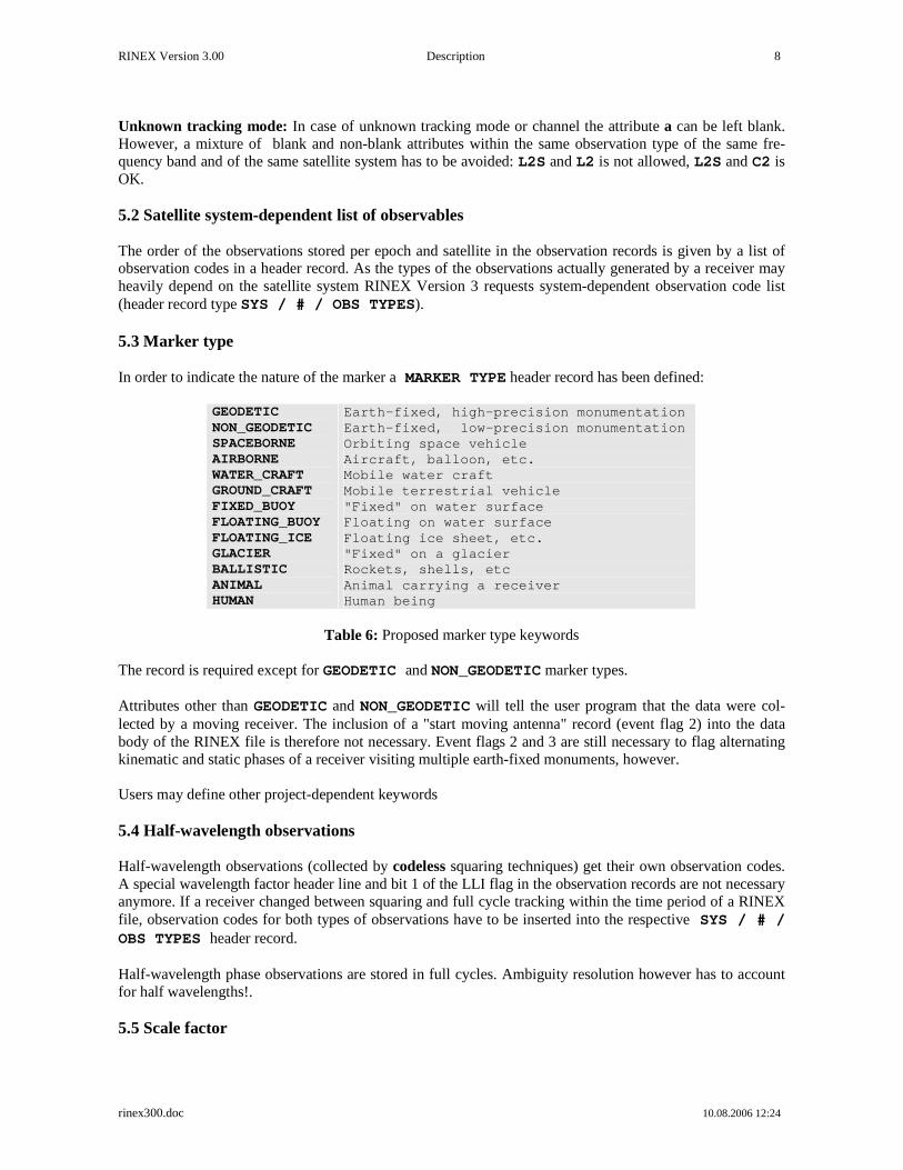
Unknown tracking mode: In case of unknown tracking mode or channel the attribute a can be left blank. However, a mixture of blank and non-blank attributes within the same observation type of the same fre-quency band and of the same satellite system has to be avoided: L2S and L2 is not allowed, L2S and C2 is OK. 5.2 Satellite system-dependent list of observables The order of the observations stored per epoch and satellite in the observation records is given by a list of observation codes in a header record. As the types of the observations actually generated by a receiver may heavily depend on the satellite system RINEX Version 3 requests system-dependent observation code list (header record type SYS / # / OBS TYPES). 5.3 Marker type In order to indicate the nature of the marker a MARKER TYPE header record has been defined:
GEODETIC NON_GEODETIC SPACEBORNE AIRBORNE WATER_CRAFT GROUND_CRAFT FIXED_BUOY FLOATING_BUOY FLOATING_ICE GLACIER BALLISTIC ANIMAL HUMAN
Earth-fixed, high-precision monumentation Earth-fixed, low-precision monumentation Orbiting space vehicle Aircraft, balloon, etc. Mobile water craft Mobile terrestrial vehicle "Fixed" on water surface Floating on water surface Floating ice sheet, etc. "Fixed" on a glacier Rockets, shells, etc Animal carrying a receiver Human being
Table 6: Proposed marker type keywords
The record is required except for GEODETIC and NON_GEODETIC marker types. Attributes other than GEODETIC and NON_GEODETIC will tell the user program that the data were col-lected by a moving receiver. The inclusion of a "start moving antenna" record (event flag 2) into the data body of the RINEX file is therefore not necessary. Event flags 2 and 3 are still necessary to flag alternating kinematic and static phases of a receiver visiting multiple earth-fixed monuments, however. Users may define other project-dependent keywords 5.4 Half-wavelength observations Half-wavelength observations (collected by codeless squaring techniques) get their own observation codes. A special wavelength factor header line and bit 1 of the LLI flag in the observation records are not necessary anymore. If a receiver changed between squaring and full cycle tracking within the time period of a RINEX file, observation codes for both types of observations have to be inserted into the respective SYS / # / OBS TYPES header record. Half-wavelength phase observations are stored in full cycles. Ambiguity resolution however has to account for half wavelengths!. 5.5 Scale factor

RINEX Version 3.00 Description 9
rinex300.doc 10.08.2006 12:24
The optional SYS / SCALE FACTOR record allows e.g., to store phase data with 0.0001 cycles resolution if the data was multiplied by a scale factor of 10 before being stored into RINEX file. Used to increase reso-lution by 10, 100, etc only. It is a modification of the Version 2.20 OBS SCALE FACTOR record. 5.6 Information about receivers on a vehicle For the processing of data collected by receivers on a vehicle the following additional information can be provided by special header records:
- Antenna position (position of the antenna reference point) in a body-fixed coordinate system: AN-TENNA: DELTA X/Y/Z
- Bore-sight of antenna: The unit vector of the direction of the antenna axis towards the GNSS satel-lites. It corresponds to the vertical axis on earth-bound antenna: ANTENNA: B.SIGHT XYZ
- Antenna orientation: Zero-direction of the antenna. Used for the application of “azimuth”-dependent phase center variation models (see 6.14 below). ANTENNA: ZERODIR XYZ
- Current center of mass of the vehicle (for spaceborne receivers): CENTER OF MASS: XYZ - Average phase center position: ANTENNA: PHASECENTER (see below)
All three quantities have to be given in the same body-fixed coordinate system. The attitude of the vehicle has to be provided by separate attitude files in the same body-fixed coordinate system. 5.7 Signal strengths The generation of the RINEX signal strength indicators sn_rnx in the data records (1 = very weak,…,9 = very strong) are standardized in case the raw signal strength3 sn_raw is given in dbHz: sn_rnx = MIN(MAX(INT(sn_raw/6),1),9)
S/N (dbHz) S/N (RINEX) <12 1
12-17 2 18-23 3 24-29 4 30-35 5 36-41 6 42-47 7 48-53 8 ≥54 9
Table 7: Standardized S/N indicators
The raw signal strengths optionally stored as Sna observations in the data records should be stored in dbHz if possible. The new SIGNAL STRENGTH UNIT header record can be used to indicate the units of these observations. 5.8 Date/time format in the PGM / RUN BY / DATE header record The format of the generation time of the RINEX files stored in the second header record PGM / RUN BY / DATE is now defined to be yyyymmdd hhmmss zone 3 S/N is the raw S/N at the output of the correlators, without attempting to recover any correlation losses
RINEX Version 3.00 Description 10
rinex300.doc 10.08.2006 12:24
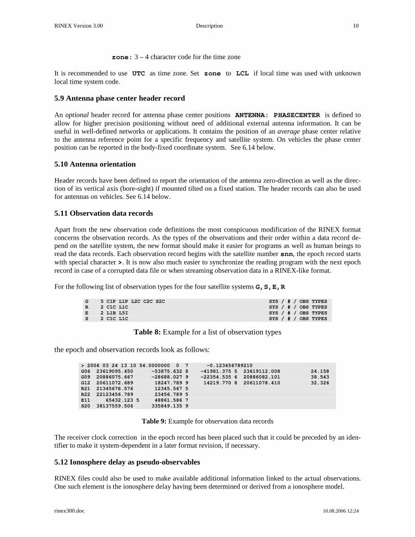
zone: 3 – 4 character code for the time zone It is recommended to use UTC as time zone. Set zone to LCL if local time was used with unknown local time system code. 5.9 Antenna phase center header record An optional header record for antenna phase center positions ANTENNA: PHASECENTER is defined to allow for higher precision positioning without need of additional external antenna information. It can be useful in well-defined networks or applications. It contains the position of an average phase center relative to the antenna reference point for a specific frequency and satellite system. On vehicles the phase center position can be reported in the body-fixed coordinate system. See 6.14 below. 5.10 Antenna orientation Header records have been defined to report the orientation of the antenna zero-direction as well as the direc-tion of its vertical axis (bore-sight) if mounted tilted on a fixed station. The header records can also be used for antennas on vehicles. See 6.14 below. 5.11 Observation data records Apart from the new observation code definitions the most conspicuous modification of the RINEX format concerns the observation records. As the types of the observations and their order within a data record de-pend on the satellite system, the new format should make it easier for programs as well as human beings to read the data records. Each observation record begins with the satellite number snn, the epoch record starts with special character >. It is now also much easier to synchronize the reading program with the next epoch record in case of a corrupted data file or when streaming observation data in a RINEX-like format. For the following list of observation types for the four satellite systems G,S,E,R
G 5 C1P L1P L2C C2C S2C SYS / # / OBS TYPES R 2 C1C L1C SYS / # / OBS TYPES E 2 L1B L5I SYS / # / OBS TYPES S 2 C1C L1C SYS / # / OBS TYPES
Table 8: Example for a list of observation types the epoch and observation records look as follows:
> 2006 03 24 13 10 54.0000000 0 7 -0.123456789210 G06 23619095.450 -53875.632 8 -41981.375 5 23619112.008 24.158 G09 20886075.667 -28688.027 9 -22354.535 6 20886082.101 38.543 G12 20611072.689 18247.789 9 14219.770 8 20611078.410 32.326 R21 21345678.576 12345.567 5 R22 22123456.789 23456.789 5 E11 65432.123 5 48861.586 7 S20 38137559.506 335849.135 9
Table 9: Example for observation data records
The receiver clock correction in the epoch record has been placed such that it could be preceded by an iden-tifier to make it system-dependent in a later format revision, if necessary. 5.12 Ionosphere delay as pseudo-observables RINEX files could also be used to make available additional information linked to the actual observations. One such element is the ionosphere delay having been determined or derived from a ionosphere model.

RINEX Version 3.00 Description 11
rinex300.doc 10.08.2006 12:24
We add the ionosphere phase delay expressed in full cycles of the respective satellite system-dependent wavelength as pseudo-observable to the list of the RINEX observables.
- t : observation type: I = Ionosphere phase delay - n : band / frequency: 1, 2,…,8 - a : attribute: blank
The ionosphere pseudo-observable has to be included into the list of observables of the respective satellite system. Only one ionosphere observable per satellite has to be included. The user adds the ionosphere delay to the raw phase observation of the same wavelength and converts it to other wavelengths and to pseudorange corrections in meters: corr_phase(fi) = raw_phase(fi) + d_ion(fi) corr_prange(fi) = raw_prange(fi) - d_ion(fi) ⋅ c/fi d_ion(fk) = d_ion(fi) ⋅ (fi/fk)
2 (accounting for 1st order effects only) d_ion(fi): Given ionospheric phase correction for frequency fi
5.13 Channel numbers as pseudo-observables For special applications it might be necessary to know the receiver channel numbers having been assigned by the receiver to the individual satellites. We may include this information as another pseudo-observable:
- t : observation type: X = Receiver channel number - n : band / frequency : 0 - a : attribute: blank
Lowest channel number allowed is 1 (re-number channels beforehand, if necessary). In case of a receiver using multiple channels for one satellite the channels could be packed with two digits each right-justified into the same data field, order corresponding to the order of the observables concerned. Format F14.3 ac-cording to (<5-nc>(2X),<nc>I2.2,'.000' ), nc being the number of channels. Restriction: Not more than 5 channels and channel numbers <100. Examples: 0910.000 for channels 9 and 10 010203.000 for channels 1, 2, and 3 -----F14.3---- 5.14 Corrections of differential code biases (DCBs) For high-precision applications there are programs available to correct the observations in RINEX files for differential code biases (e.g., cc2noncc, J. Ray 2005). We introduce a header record SYS / DCBS AP-PLIED to flag files with corrected observations. 6. ADDITIONAL HINTS AND TIPS 6.1 Versions Programs developed to read RINEX files have to verify the version number. Files of newer versions may look different even if they do not use any of the newer features
RINEX Version 3.00 Description 12
rinex300.doc 10.08.2006 12:24
6.2 Leading blanks in CHARACTER fields We propose that routines to read files automatically delete leading blanks in any CHARACTER input field. Routines creating RINEX files should also left-justify all variables in the CHARACTER fields. 6.3 Variable-length records ASCII files usually have variable record lengths, so we recommend to first read each observation record into a blank string long enough to accommodate the largest possible observation record4 and decode the data afterwards. In variable length records, empty data fields at the end of a record may be missing, especially in the case of the optional receiver clock offset. 6.4 Blank fields In view of future modifications we recommend to carefully skip any fields currently defined to be blank (format fields nX), because they may be assigned to new contents in future versions. 6.5 Order of the header records, order of data records As the record descriptors in columns 61-80 are mandatory, the programs reading a RINEX Version 3 header are able to decode the header records with formats according to the record descriptor, provided the records have been first read into an internal buffer. We therefore propose to allow free ordering of the header records, with the following exceptions:
- The RINEX VERSION / TYPE record must be the first record in a file - The SYS / # / OBS TYPES record(s) should precede any SYS / DCBS APPLIED and
SYS / SCALE FACTOR records.
- The # OF SATELLITES record (if present) should be immediately followed by the correspond-ing number of PRN / # OF OBS records. (These records may be handy for documentary pur-poses. However, since they may only be created after having read the whole raw data file we define them to be optional.
- The END OF HEADER of course is the last header in the record
6.6 Missing items, duration of the validity of values Items that are not known at the file creation time can be set to zero or blank or the respective record may be completely omitted. Consequently items of missing header records will be set to zero or blank by the pro-gram reading RINEX files. Trailing blanks may be truncated from the record. Each value remains valid until changed by an additional header record. 6.7 Unknown / Undefined observation types and header records It is a good practice for a program reading RINEX files to make sure that it properly deals with unknown observation types, header records or event flags by skipping them and/or reporting them to the user. The program should also check the RINEX version number in the header record and take proper action if it can-not deal with it.
4 Defined by the satellite system with the largest number of possible observables plus any “pseudo-observables” like S/N, ionosphere, etc.

RINEX Version 3.00 Description 13
rinex300.doc 10.08.2006 12:24

RINEX Version 3.00 Description 14
rinex300.doc 10.08.2006 12:24
6.8 Event flag records The "number of satellites" also corresponds to the number of records of the same epoch following the EP-OCH record.. Therefore it may be used to skip the appropriate number of data records if certain event flags are not to be evaluated in detail. 6.9 Receiver clock offset A receiver-derived clock offset can optionally be reported in the RINEX observation files. In order to re-move uncertainties if the data (epoch, pseudorange, phase) have been previously corrected or not by the reported clock offset, RINEX Versions 2.10 onwards requests a clarifying header record: RCV CLOCK OFFS APPL. It would then be possible to reconstruct the original observations, if necessary. 6.10 Two-digit years RINEX version 2 stores the years of data records with two digits only. The header of observation files con-tains a TIME OF FIRST OBS record with the full four-digit year, the GPS nav messages contain the GPS week numbers. From these two data items the unambiguous year can easily be reconstructed. A hundred-year ambiguity occurs in the met data and GLONASS and GEO nav messages: Instead of intro-ducing a new TIME OF FIRST OBS header line it is safe to stipulate that any two-digit years in RINEX Version 1 and Version 2.xx files are understood to represent
80-99: 1980-1999 00-79: 2000-2079
Full 4-digit year fields are/will be defined in the RINEX version 3 files. 6.11 Fit interval (GPS navigation message file) Bit 17 in word 10 of subframe 2 is a "fit interval" flag which indicates the curve-fit interval used by the GPS Control Segment in determining the ephemeris parameters, as follows (see ICD-GPS-200, 20.3.3.4.3.1):
0 = 4 hours 1 = greater than 4 hours.
Together with the IODC values and Table 20-XII the actual fit interval can be determined. The second value in the last record of each message shall contain the fit interval in hours determined using IODC, fit flag, and Table 20-XII, according to the Interface Document ICD-GPS-200. 6.12 Satellite health (GPS navigation message file) The health of the signal components (bits 18 to 22 of word three in subframe one) are included from version 2.10 on into the health value reported in the second field of the sixth nav mess records. A program reading RINEX files could easily decide if bit 17 only or all bits (17-22) have been written:
RINEX Value: 0 Health OK RINEX Value: 1 Health not OK (bits 18-22 not stored) RINEX Value: >32 Health not OK (bits 18-22 stored)
6.13 Transmission time of message (GPS navigation message file)

RINEX Version 3.00 Description 15
rinex300.doc 10.08.2006 12:24
The transmission time of message can be shortly before midnight Saturday/Sunday, the ToE and ToC of the message already in the next week. As the reported week in the RINEX nav message (BROADCAST ORBIT - 5 record) goes with ToE (this is different from the GPS week in the original satellite message!), the transmission time of message should be reduced by 604800 (i.e., will become negative) to also refer to the same week. 6.14 Antenna references We distinguish between
- The marker, i.e. the geodetic reference monument, on which an antenna is mounted directly with forced centering or on a tripod.
- The antenna reference point (ARP), i.e., a well-defined point on the antenna, e.g., the center of the
bottom surface of the preamplifier. The antenna height is measured from the marker to the ARP and reported in the ANTENNA: DELTA H/E/N header record. Small horizontal eccentricities of the ARP w/r to the marker can be reported in the same record. On vehicles the position of the ARP is reported in the body-fixed coordinate system in an ANTENNA: DELTA X/Y/Z header record.
- The average phase center: A frequency- and minimum elevation-dependent position of the average
phase center above the antenna reference point. It’s position is important to know in mixed-antennae networks. It can be given in an absolute sense or relative to a reference antenna. Optional header re-cord: ANTENNA: PHASECENTER. For fixed stations the components are in north/east/up direc-tion, on vehicles the position is reported in the body-fixed system X,Y,Z. For more precise applications an elevation- or elevation and azimuth-dependent phase center varia-tion model for the antenna (referring to the agreed-upon ARP) should be used.
- The orientation of the antenna: The “zero direction” is usually oriented towards north on fixed sta-
tions. Deviations from the north direction can be reported with the azimuth of the zero-direction in an ANTENNA: ZERODIR AZI header record. On vehicles the zero-direction is reported as a unit vector in the body-fixed coordinate system in an ANTENNA: ZERODIR XYZ header record. The zero direction of a tilted antenna on a fixed station can be reported as unit vector in the left-handed north/east/up local coordinate system in an ANTENNA: ZERODIR XYZ header record.
- The bore-sight direction of an antenna on a vehicle: The “vertical” symmetry axis of the antenna pointing towards the GNSS satellites. It can be reported as unit vector in the body-fixed coordinated system in the ANTENNA: B.SIGHT XYZ record. A tilted antenna on a fixed station could be re-ported as unit vector in the left-handed north/east/up local coordinate system in the same header re-cord.
To be able to interpret the various positions correctly it is important that the MARKER TYPE record is included in the RINEX header. 7. RINEX UNDER ANTISPOOFING (AS) Some receivers generate code (pseudorange) delay differences between the first and second frequency using cross-correlation techniques when AS is on and may recover the phase observations on L2 in full cycles. Using the C/A code delay on L1 and the observed difference it is possible to generate a code delay observa-tion for the second frequency. Other receivers recover P code observations by breaking down the Y code into P and W code.

RINEX Version 3.00 Description 16
rinex300.doc 10.08.2006 12:24
Most of these observations may suffer from an increased noise level. In order to enable the post-processing programs to take special actions, such AS-infected observations have been flagged in RINEX Version 2 using bit number 2 of the Loss of Lock Indicators (i.e. their current values are increased by 4). In Version 3 there are special attributes for the observation type to more precisely characterize the observable (codeless, semi-codeless, Z-tracking or similar techniques when AS on, L2C, P-code when AS off, Y-code tracking), making the AS flag obsolete. 8. DEALING WITH DIFFERENT SATELLITE SYSTEMS 8.1 RINEX observation files 8.1.1 Time system identifier GLONASS is basically running on UTC (or, more precisely, GLONASS system time linked to UTC(SU)), i.e. the time tags are given in UTC and not GPS time. Galileo runs on Galileo System Time, which is, apart from small differences < 50ns, identical to TAI (International Atomic Time). In order to remove possible misunderstandings and ambiguities, the header records TIME OF FIRST OBS and (if present) TIME OF LAST OBS in pure GPS, GLONASS or Galileo observation files can, in mixed GPS/GLONASS/Galileo observation files must contain a time system identifier defining the system that all time tags in the file are referring to:
• GPS to identify GPS time, • GLO to identify the GLONASS UTC time system • GAL to identify Galileo system time.
Pure GPS files default to GPS, pure GLONASS files default to GLO, pure Galileo files default to GAL. Format definitions see Table A1. Apart from the small errors in the realizations of the different time systems, the relations between the sys-tems are: GLO = UTC = GPS - ∆tLS
GAL = TAI = GPS + 19 GAL = TAI = UTC + ∆tLS + 19 = UTC + nleap nleap = ∆tLS + 19
∆tLS: Delta time between GPS and UTC due to leap seconds, as transmitted by the GPS satellites
in the almanac nleap: Number of leap seconds introduced between UTC and TAI (2005: nleap =32, 2006: nleap =33)
In order to have the current number of leap seconds available we recommend to include ∆tLS by a LEAP SECOND line into the RINEX file headers. If there are known non-integer biases between "GPS receiver clock", "GLONASS receiver clock" or “Gali-leo receiver clock” in the same receiver, they should be applied in the process of RINEX conversion. In this case the respective code and phase observations have to be corrected, too (c * bias if expressed in meters). Unknown such biases will have to be solved for during the post processing
RINEX Version 3.00 Description 17
rinex300.doc 10.08.2006 12:24
The small differences (modulo 1 second) between Galileo system time, TAI, GLONASS system time, UTC(SU), UTC(USNO) and GPS system time have to be dealt with during the post-processing and not be-fore the RINEX conversion. It may also be necessary to solve for remaining differences during the post-processing. 8.1.2 Pseudorange definition The pseudorange (code) measurement is defined to be equivalent to the difference of the time of reception (expressed in the time frame of the receiver) and the time of transmission (expressed in the time frame of the satellite) of a distinct satellite signal. If a mixed-mode GPS/GLONASS/Galileo receiver refers all pseudorange observations to one receiver clock only,
- the raw GLONASS pseudoranges will show the current number of leap seconds between GPS time and GLONASS time if the receiver clock is running in the GPS time frame
- the raw GPS pseudoranges will show the negative number of leap seconds between GPS time and
GLONASS time if the receiver clock is running in the GLONASS time frame
- the raw Galileo pseudoranges will show an offset of – 19 seconds if the receiver clock is running in the GPS rime frame
- etc.
In order to avoid misunderstandings and to keep the code observations within the format fields, the pseudo-ranges must be corrected in this case as follows: PR(GPS) := PR(GPS) + c * ∆tLS if generated with a receiver clock running in the GLON-
ASS time frame PR(GLO) := PR(GLO) - c * ∆tLS if generated with a receiver clock running in the GPS
time frame PR(GAL) := PR(GAL) + 19 s if generated with a receiver clock running in the GPS
time frame etc. to remove the contributions of the leap seconds from the pseudoranges. ∆tLS is the actual number of leap seconds between GPS and GLONASS (UTC) time, as broadcast in the GPS almanac and distributed in Circular T of BIPM. 8.2 RINEX navigation message files for GLONASS As the GLONASS navigation message differs in contents from the GPS message too much, a special GLONASS navigation message file format has been defined. The header section and the first data record (epoch, satellite clock information) is similar to the GPS naviga-tion file. The following records contain the satellite position, velocity and acceleration, the clock and fre-quency biases as well as auxiliary information as health, satellite frequency (channel), age of the informa-tion. The corrections of the satellite time to UTC are as follows: GPS: Tutc = Tsv - af0 - af1 *(Tsv-Toc) - ... - A0 - ... - ∆tLS

RINEX Version 3.00 Description 18
rinex300.doc 10.08.2006 12:24
GLONASS: Tutc = Tsv + TauN - GammaN*(Tsv-Tb) + TauC
In order to use the same sign conventions for the GLONASS cor-rections as in the GPS navigation files, the broadcast GLONASS values are stored as
-TauN, +GammaN, -TauC. The time tags in the GLONASS navigation files are given in UTC (i.e. not Moscow time or GPS time). File naming convention: See above. 8.3 RINEX navigation message files for Galileo Currently the format and the contents of the Galileo broadcast navigation message are unknown. A Galileo RINEX navigation file definition will follow later. 8.4 RINEX observation files for GEO satellites A separate satellite system identifier has been defined for the Space-Based Augmentation System (SBAS) payloads: S, to be used in the RINEX VERSION / TYPE header line and in the satellite identifier snn, nn being the GEO PRN number minus 100.
e.g.: PRN = 120 ⇒ snn = S20 In mixed dual frequency GPS satellite / single frequency GEO payload observation files the fields for the second frequency observations of SBAS satellites remain blank, are set to zero values or (if last in the re-cord) can be truncated. The time system identifier of GEO satellites generating GPS signals defaults to GPS time. 8.5 RINEX navigation message files for GEO satellites As the GEO broadcast orbit format differs from the GPS message a special GEO navigation message file format has been defined which is nearly identical with the GLONASS navigation message file format. The header section contains information about the generating program, comments, and the difference be-tween the GEO system time and UTC. The first data record contains the epoch and satellite clock information, the following records contain the satellite position, velocity and acceleration and auxiliary information such as health, age of the data, etc. The time tags in the GEO navigation files are given in the GPS time frame, i.e. not UTC. The corrections of the satellite time to UTC are as follows: GEO: Tutc = Tsv - aGf0 - aGf1 *(Tsv-Toe) - W0 - ∆tLS W0 being the correction to transform the GEO system time to UTC. Toe, aGf0, aGf1 see below in the format definition tables. The Transmission Time of Message (PRN / EPOCH / SV CLK header record) is expressed in GPS sec-onds of the week. It marks the beginning of the message transmission. It has to refer to the same GPS week as the Epoch of Ephemerides. It has to be adjusted by - or + 604800 seconds, if necessary (which would

RINEX Version 3.00 Description 19
rinex300.doc 10.08.2006 12:24
make it lower than zero or larger than 604800, respectively). It is a redefinition of the Version 2.10 Message frame time. Health shall be defined as follows:
- bits 0 to 3 equal to health in Message Type 17 (MT17) - bit 4 is set to 1 if MT17 health is unavailable - bit 5 is set to 1 if the URA index is equal to 15
In the SBAS message definitions bit 3 of the health is currently marked as reserved. In case of bit 4 set to 1, it is recommended to set bits 0,1,2,3 to 1, too. User Range Accuracy (URA): The same convention for converting the URA index to meters is used as with GPS. Set URA = 32767 meters if URA index = 15. Issue Of Data Navigation (IODN) The IODN is defined as the 8 first bits after the message type 9, called IODN in RTCA DO229, Annex A and Annex B and called spare in Annex C. The CORR TO SYSTEM TIME header record has been replaced by the more general record D-UTC A0,A1,T,W,S,U in Version 2.11.

RINEX Version 3.00 Description 20
rinex300.doc 10.08.2006 12:24
REFERENCES Evans, A. (1989): "Summary of the Workshop on GPS Exchange Formats." Proceedings of the Fifth Interna-tional Geodetic Symposium on Satellite Systems, pp. 917ff, Las Cruces. Gurtner, W., G. Mader, D. Arthur (1989): "A Common Exchange Format for GPS Data." CSTG GPS Bulle-tin Vol.2 No.3, May/June 1989, National Geodetic Survey, Rockville. Gurtner, W., G. Mader (1990a): "The RINEX Format: Current Status, Future Developments." Proceedings of the Second International Symposium of Precise Positioning with the Global Positioning system, pp. 977ff, Ottawa. Gurtner, W., G. Mader (1990b): "Receiver Independent Exchange Format Version 2." CSTG GPS Bulletin Vol.3 No.3, Sept/Oct 1990, National Geodetic Survey, Rockville. Gurtner, W. (1994): "RINEX: The Receiver-Independent Exchange Format." GPS World, Volume 5, Num-ber 7, July 1994. Gurtner, W. (2002): "RINEX: The Receiver Independent Exchange Format Version 2.10". ftp://igscb.jpl.nasa.gov/igscb/data/format/rinex210.txt Gurtner, W., L. Estey (2002),: "RINEX Version 2.20 Modifications to Accommodate Low Earth Orbiter Data". ftp://ftp.unibe.ch/aiub/rinex/rnx_leo.txt Gurtner, W., L. Estey (2005): "RINEX: The Receiver Independent Exchange Format Version 2.11". ftp://igscb.jpl.nasa.gov/igscb/data/format/rinex211.txt Ray, J., W. Gurtner (1999): "RINEX Extensions to Handle Clock Information". ftp://igscb.jpl.nasa.gov/igscb/data/format/rinex_clock.txt. Ray, J. (2005): “Final update for P1-C1 bias values & cc2noncc”. IGSMail 5260 Rothacher, M., R. Schmid (2005): "ANTEX: The Antenna Exchange Format Version 1.3". ftp://igscb.jpl.nasa.gov/pub/station/general/antex13.txt. Schaer, S., W. Gurtner, J. Feltens (1998): “IONEX: The Ionosphere Map Exchange Format Version 1“. ftp://igscb.jpl.nasa.gov/igscb/data/format/ionex1.pdf Suard, N., W. Gurtner, L. Estey (2004): "Proposal for a new RINEX-type Exchange File for GEO SBAS Broadcast Data". ftp://igscb.jpl.nasa.gov/igscb/data/format/geo_sbas.txt Document RTCA DO 229, Appendix A

RINEX Version 3.00 Appendix A1
rinex300.doc 10.08.2006 12:24
APPENDIX: RINEX FORMAT DEFINITIONS AND EXAMPLES
A 1 GNSS Observation Data File - Header Section Description
+------------------------------------------------- ---------------------------+ | TABLE A1 | | GNSS OBSERVATION DATA FILE - HEADER SECTION DESCRIPTION | +--------------------+---------------------------- --------------+------------+ | HEADER LABEL | DESCRIPTION | FORMAT | | (Columns 61-80) | | | +--------------------+---------------------------- --------------+------------+ | RINEX VERSION / TYPE| - Format version : 3.00 | F9.2,11X, | | | - File type: O for Observation Data | A1,19X, | | | - Satellite System: G: GPS | A1,19X | | | R: GLONASS | | | | E: Galileo | | | | S: SBAS payload | | | | M: Mixed | | +--------------------+---------------------------- --------------+------------+ | PGM / RUN BY / DATE | - Name of program creating current file | A 20, | | | - Name of agency creating current file | A20, | | | - Date and time of file cre ation | | | | Format: yyyymmdd hhmmss z one | A20 | | | zone: 3-4 char. code fo r time zone. | | | | UTC recommended! | | | | LCL if local time with unknown | | | | local time sy stem code | | +--------------------+---------------------------- --------------+------------+ *| COMMENT | Comment line(s) | A60 |* +--------------------+---------------------------- --------------+------------+ | MARKER NAME | Name of antenna marker | A60 | +--------------------+---------------------------- --------------+------------+ *| MARKER NUMBER | Number of antenna marker | A2 0 |* +--------------------+---------------------------- --------------+------------+ | MARKER TYPE | - Type of the marker. | A20,40X | | | | | | | GEODETIC : Earth-fixed, high- | | | | precision mo numentation | | | | NON_GEODETIC : Earth-fixed, low- | | | | precision mo numentation | | | | SPACEBORNE : Orbiting space vehicle | | | | AIRBORNE : Aircraft, balloon, etc. | | | | WATER_CRAFT : Mobile water craft | | | | GROUND_CRAFT : Mobile terrestrial vehicle| | | | FIXED_BUOY : "Fixed" on water surface | | | | FLOATING_BUOY: Floating on water surface | | | | FLOATING_ICE : Floating ice sheet, etc. | | | | GLACIER : "Fixed" on a glacier | | | | BALLISTIC : Rockets, shells, etc | | | | ANIMAL : Animal carrying a receiver| | | | HUMAN : Human being | | | | | | | | Record required except for GEODETIC | | | | and NON_GEODETIC marker types. | | | | | | | | Users may define other proj ect-dependent | | | | keywords. | | +--------------------+---------------------------- --------------+------------+ | OBSERVER / AGENCY | Name of observer / agency | A 20,A40 | +--------------------+---------------------------- --------------+------------+ | REC # / TYPE / VERS | Receiver number, type, and version | 3A 20 | | | (Version: e.g. Internal Sof tware Version)| | +--------------------+---------------------------- --------------+------------+ | ANT # / TYPE | Antenna number and type | 2A20 | +--------------------+---------------------------- --------------+------------+ | APPROX POSITION XYZ | Geocentric approximate marker position | 3F1 4.4 | | | (Units: Meters, System: ITR S recommended)| | | | Optional for moving platfor ms | | +--------------------+---------------------------- --------------+------------+

RINEX Version 3.00 Appendix A2
rinex300.doc 10.08.2006 12:24
| ANTENNA: DELTA H/E/N| - Antenna height: Height of the antenna | F14 .4, | | | reference point (ARP) abo ve the marker | | | | - Horizontal eccentricity o f ARP | 2F14.4 | | | relative to the marker (e ast/north) | | | | All units in meters | | +--------------------+---------------------------- --------------+------------+ *| ANTENNA: DELTA X/Y/Z| Position of antenna reference point for | 3F14 .4 |* | | antenna on vehicle (m): | | | | XYZ vector in body-fixed co ord. system | | +--------------------+---------------------------- --------------+------------+ *| ANTENNA: PHASECENTER| Average phase center position w/r to | |* | | antenna reference point (m) | | | | - Satellite system ( G/ R/ E/ S) | A1, | | | - Observation code | 1X,A3, | | | - North/East/Up (fixed stat ion) or | F9.4, | | | X/Y/Z in body-fixed syste m (vehicle) | 2F14.4 | +--------------------+---------------------------- --------------+------------+ *| ANTENNA: B.SIGHT XYZ| Direction of the “vertical” antenna axis | 3F14 .4 |* | | towards the GNSS satellites . | | | | Antenna on vehicle: | | | | Unit vector in body-fixed coord. system | | | | Tilted antenna on fixed sta tion: | | | | Unit vector in N/E/Up left -handed system| | +--------------------+---------------------------- --------------+------------+ *| ANTENNA: ZERODIR AZI| Azimuth of the zero-direction of a | F14 .4 |* | | fixed antenna (degrees, fro m north) | | +--------------------+---------------------------- --------------+------------+ *| ANTENNA: ZERODIR XYZ| Zero-direction of antenna | 3F14 .4 |* | | Antenna on vehicle: | | | | Unit vector in body-fixed coord. system | | | | Tilted antenna on fixed sta tion: | | | | Unit vector in N/E/Up left -handed system| | +--------------------+---------------------------- --------------+------------+ *| CENTER OF MASS: XYZ | Current center of mass (X,Y,Z, meters) of| 3F1 4.4 |* | | vehicle in body-fixed coord inate system. | | | | Same system as used for att itude. | | +--------------------+---------------------------- --------------+------------+ | SYS / # / OBS TYPES | - Satellite system code ( G/ R/ E/ S) | A1, | | | - Number of different obser vation types | 2X,I3, | | | for the specified satelli te system | | | | - Observation descriptors: | 13(1X,A3) | | | - Type | | | | - Band | | | | - Attribute | | | | | | | | Use continuation line(s) fo r more than | 6X, | | | 13 observation descriptors. | 13(1X,A3) | | | | | | | In mixed files: Repeat for each | | | | satellite system. | | | | | | | | These records should preced e any | | | | SYS / DCBS APPLIED or | | | | SYS / SCALE FACTOR records (see below). | | | | | | | | The following observation d escriptors | | | | are defined in RINEX Versio n 3.00: | | | | | | | | Type: C = Code / Pseudorange | | | | L = Phase | | | | D = Doppler | | | | S = Raw signal strength | | | | I = Ionosphere phase delay | | | | X = Receiver channel numbers | | | | Band: 1 = L1 (GPS,SBAS) | | | | G1 (GLO) | | | | E2-L1-E1 (GAL) | | | | 2 = L2 (GPS) | | | | G2 (GLO) | | | | 5 = L5 (GPS,SBAS) | | | | E5a (GAL) | |

RINEX Version 3.00 Appendix A3
rinex300.doc 10.08.2006 12:24
| | 6 = E6 (GAL) | | | | 7 = E5b (GAL) | | | | 8 = E5a+b (GAL) | | | | 0 for type X (all) | | | | Attribute: | | | | P = P code-based (GPS,GLO) | | | | C = C code-based (SBAS,GPS,GLO) | | | | Y = Y code-based (GPS) | | | | M = M code-based (GPS) | | | | A = A channel (GAL) | | | | B = B channel (GAL) | | | | C = C channel (GAL) | | | | I = I channel (GPS,GAL) | | | | Q = Q channel (GPS,GAL) | | | | S = M channel (L2C GPS) | | | | L = L channel (L2C GPS) | | | | X = B+C channels (GAL) | | | | I+Q channels (GPS,GAL) | | | | M+L channels (GPS) | | | | W = based on Z-tracking (GPS) | | | | (see text) | | | | Z = A+B+C channels (GAL) | | | | blank : for types I and X (all) | | | | or unknown tracki ng mode | | | | | | | | All characters in uppercase only! | | | | | | | | Units : Phase : full cycles | | | | Pseudorange : meter s | | | | Doppler : Hz | | | | SNR etc : recei ver-dependent | | .| | Ionosphere : full cycles | | | | Channel # : See t ext | | | | | | | | Sign definition: See text. | | | | | | | | The sequence of the observa tions in the | | | | observation records has to correspond to | | | | the sequence of the types i n this record | | | | of the respective satellite system. | | | | | | | | The attribute can be left b lank if not | | | | known. See text! | | +--------------------+---------------------------- --------------+------------+ *| SIGNAL STRENGTH UNIT| - Unit of the signal strength | A20, 40X |* | | observables Snn (if present) | | | | | | | | DBHZ : S/N given in dbHz | | | | ... | | +--------------------+---------------------------- --------------+------------+ *| INTERVAL | Observation interval in seconds | F10. 3 |* +--------------------+---------------------------- --------------+------------+ | TIME OF FIRST OBS | - Time of first observation record | 5I6 ,F13.7, | | | (4-digit-year, month,day, hour,min,sec) | | | | - Time system: GPS (=GPS time system) | 5X,A3 | | | GLO (=UTC time system) | | | | GAL (=Galileo System Time)| | | | Compulsory in mixed GNSS files | | | | Defaults: GPS for pure GPS files | | | | GLO for pure GLONASS files | | | | GAL for pure Galileo files | | +--------------------+---------------------------- --------------+------------+ *| TIME OF LAST OBS | - Time of last observation record | 5I 6,F13.7, |* | | (4-digit-year, month,day, hour,min,sec) | | | | - Time system: Same value a s in | 5X,A3 | | | TIME OF FIRST OBS record | | +--------------------+---------------------------- --------------+------------+ *| RCV CLOCK OFFS APPL | Epoch, code, and phase are corrected by | I 6 |* | | applying the realtime-deriv ed receiver | | | | clock offset: 1=yes, 0=no; default: 0=no | | | | Record required if clock of fsets are | |
RINEX Version 3.00 Appendix A4
rinex300.doc 10.08.2006 12:24
| | reported in the EPOCH/SAT records | | +--------------------+---------------------------- --------------+------------+ *| SYS / DCBS APPLIED | - Satellite system ( G/ R/ E/ S) | A1, |* | | - Observ. code of affected observable | A3, | | | - Satellite system ( G/ R/ E/ S) and | 1X,A1, | | | - Observ. code of reference observable | A3, | | | - Correction to pseudorange (m) | F8.3, | | | - Corrections applied: 1 = yes, 0 = no | 1X,I1, | | | - Source of corrections | 1X,A20, | | | - Program name used to appl y corrections | A20 | | | | | | | Repeat for each observable if necessary. | | +--------------------+---------------------------- --------------+------------+ *| SYS / SCALE FACTOR | - Satellite system ( G/ R/ E/ S) | A1, |* | | - Factor to divide stored o bservations | 1X,I4, | | | with before use (1,10,100 ,1000) | | | | - Number of observation typ es involved. | 2X,I2, | | | 0 or blank: All observati on types | | | | - List of observation types | 12(1X,A3) | | | | | | | Use continuation line(s) fo r more than | 10X, | | | 12 observation types. | 12(1X,A3) | | | | | | | Repeat record if different factors are | | | | applied to different observ ation types. | | | | | | | | A value of 1 is assumed if record is | | | | missing. | | +--------------------+---------------------------- --------------+------------+ *| LEAP SECONDS | Number of leap seconds since 6-Jan-1980 | I6 |* | | as transmitted by the GPS a lmanac. | | | | Recommended for mixed GLONA SS files | | +--------------------+---------------------------- --------------+------------+ *| # OF SATELLITES | Number of satellites, for which | I6 |* | | observations are stored in the file | | +--------------------+---------------------------- --------------+------------+ *| PRN / # OF OBS | Satellite numbers, number of observations| 3X, |* | | for each observation type i ndicated | A1,I2.2, | | | in the SYS / # / OBS TYPES record. | 9I6 | | | | | | | If more than 9 observatio n types: | | | | Use continuation line(s) | 6X,9I6 | | | | | | | This record is (these recor ds are) | | | | repeated for each satellite present in | | | | the data file | | +--------------------+---------------------------- --------------+------------+ | END OF HEADER | Last record in the header section. | 60X | +--------------------+---------------------------- --------------+------------+
Records marked with * are optional
A 2 GNSS Observation Data File - Data Record Description
+------------------------------------------------- ---------------------------+ | TABLE A2 | | GNSS OBSERVATION DATA FILE - DATA RECORD DESCRIPTION | +------------------------------------------------- --------------+------------+ | DESCRIPTION | FORMAT | +------------------------------------------------- --------------+------------+ | | | | EPOCH record | | | | | | - Record identifier : > | A1, | | - Epoch : | | | - year (4 digits) | 1X,I4, | | - month,day,hour,min (two digits) | 4(1X,I2.2),| | - sec | F11.7, | | - Epoch flag | 2X,I1, | | 0: OK | |

RINEX Version 3.00 Appendix A5
rinex300.doc 10.08.2006 12:24
| 1: power failure between previous and c urrent epoch | | | >1: Special event | | | - Number of satellites observed in current epoch | I3, | | (reserved) | 6X, | | - Receiver clock offset (seconds, optional) | F15.12, || +------------------------------------------------- --------------+------------+ | | | | Epoch flag = 0 or 1: OBSERVATION records follow | | | | | | - Satellite number | A1,I2.2, | | | | | - Observation | repeat within record for ea ch observation| m(F14.3, | | - LLI | type (same sequence as give n in the | I1, | | - Signal strength | respective SYS / # / OBS TYPES record) | I1) | | | | | This record is repeated for each satellite havin g been | | | observed in the current epoch. The record length is given by | | | number of observation types for this satellite. | | | | | | Observations: Definition see text. | | | Missing observations are written as 0.0 or blank s | | | | | | Phase values overflowing the fixed format F14.3 have to be | | | clipped into the valid interval (e.g add or subt ract 10**9), | | | set LLI indicator. | | | | | | Loss of lock indicator (LLI). | | | 0 or blank: OK or not known | | | Bit 0 set : Lost lock between previous and curr ent | | | observation: Cycle slip possible. | | | For phase observations only. | | | | | | Signal strength projected into interval 1-9: | | | 1: minimum possible signal strength | | | 5: average S/N ratio | | | 9: maximum possible signal strength | | | 0 or blank: not known, don't care | | | Standardization for S/N values given in dbHz: S ee text. | | | | | +------------------------------------------------- --------------+------------+ | | | | Epoch flag 2-5: EVENT: Special records may follow | | | | | | - Epoch flag | [2X,I1] | | 2: start moving antenna | | | 3: new site occupation (end of kinem. data) | | | (at least MARKER NAME record follows) | | | 4: header information follows | | | 5: external event (epoch is significant, | | | same time frame as observation time tags) | | | | | | - "Number of satellites" contains number of sp ecial records | [I3] | | to follow. 0 if no special records follow. | | | Maximum number of records: 999 | | | | | | For events without significant epoch the epoch fields in | | | the EPOCH RECORD can be left blank | | +------------------------------------------------- --------------+------------+ | | | | Epoch flag = 6: EVENT: Cycle slip records follow | | | | | | - Epoch flag | [2X,I1] | | 6: cycle slip records follow to optionally r eport | | | detected and repaired cycle slips (same f ormat as | | | OBSERVATIONS records; | | | - slip instead of observation; | | | - LLI and signal strength blank or zero) | | +------------------------------------------------- --------------+------------+
RINEX Version 3.00 Appendix A6
rinex300.doc 10.08.2006 12:24
A 3 GNSS Observation Data File - Example
+-------------------------------------------------- ----------------------------+ | TABLE A3 | | GNSS OBSERVATION DATA FILE - EXAMPLE | +-------------------------------------------------- ----------------------------+ ----|---1|0---|---2|0---|---3|0---|---4|0---|---5|0 ---|---6|0---|---7|0---|---8|0- 3.00 OBSERVATION DATA M RINEX VERSION / TYPE G = GPS R = GLONASS E = GALILEO S = GEO M = MIX ED COMMENT XXRINEXO V9.9 AIUB 20060324 14 4333 UTC PGM / RUN BY / DATE EXAMPLE OF A MIXED RINEX FILE VERSIOIN 3.00 COMMENT The file contains L1 pseudorange and phase data of the COMMENT geostationary AOR-E satellite (PRN 120 = S20) COMMENT A 9080 MARKER NAME 9080.1.34 MARKER NUMBER BILL SMITH ABC INSTITUTE OBSERVER / AGENCY X1234A123 GEODETIC 1.3.1 REC # / TYPE / VERS G1234 ROVER ANT # / TYPE 4375274. 587466. 4589095. APPROX POSITION XYZ .9030 .0000 .0000 ANTENNA: DELTA H/E/N 0 RCV CLOCK OFFS APPL G 5 C1C L1W L2W C1W S2W SYS / # / OBS TYPES R 2 C1C L1C SYS / # / OBS TYPES E 2 L1B L5I SYS / # / OBS TYPES S 2 C1C L1C SYS / # / OBS TYPES 18.000 INTERVAL GC1C GC1P -0.123 1 CODE P1-C1 082-2006 CC2NONCC SYS / DCBS APPLIED DBHZ SIGNAL STRENGTH UNIT 2006 03 24 13 10 36.0000000 GPS TIME OF FIRST OBS END OF HEADER > 2006 03 24 13 10 36.0000000 0 5 -0.1234567 89012 G06 23629347.915 .300 8 -.353 4 23629347.158 24.158 G09 20891534.648 -.120 9 -.358 6 20891545.292 38.123 G12 20607600.189 -.430 9 .394 5 20607600.848 35.234 E11 .324 8 .178 7 S20 38137559.506 335849.135 9 > 2006 03 24 13 10 54.0000000 0 7 -0.1234567 89210 G06 23619095.450 -53875.632 8 -41981.375 4 23619095.008 25.234 G09 20886075.667 -28688.027 9 -22354.535 7 20886076.101 42.231 G12 20611072.689 18247.789 9 14219.770 6 20611072.410 36.765 R21 21345678.576 12345.567 5 R22 22123456.789 23456.789 5 E11 65432.123 5 48861.586 7 S20 38137559.506 335849.135 9 > 2006 03 24 13 11 12.0000000 2 1 > 4 1 *** FROM NOW ON KINEMATIC DATA! *** COMMENT > 2006 3 24 13 11 12.0000000 0 4 -0.1234567 89876 G06 21110991.756 16119.980 7 12560.510 4 21110991.441 25.543 G09 23588424.398 -215050.557 6 -167571.734 6 23588424.570 41.824 G12 20869878.790 -113803.187 8 -88677.926 6 20869878.938 36.961 G16 20621643.727 73797.462 7 57505.177 2 20621644.276 15.368 > 3 4 A 9081 MARKER NAME 9081.1.34 MARKER NUMBER .9050 .0000 .0000 ANTENNA: DELTA H/E/N --> THIS IS THE START OF A NEW SITE <-- COMMENT > 2006 03 24 13 12 6.0000000 0 4 -0.1234569 87654 G06 21112589.384 24515.877 6 19102.763 4 21112589.187 25.478 G09 23578228.338 -268624.234 7 -209317.284 6 23578228.398 41.725 G12 20625218.088 92581.207 7 72141.846 5 20625218.795 35.143 G16 20864539.693 -141858.836 8 -110539.435 2 20864539.943 16.345 > 2006 03 24 13 13 1.2345678 5 0 > 4 2 AN EVENT FLAG 5 WITH A SIGNIFICANT EPOCH COMMENT AND AN EVENT FLAG 4 TO ESCAPE FOR THE TWO COMMENT LINES COMMENT > 2006 03 24 13 14 12.0000000 0 4 -0.1234560 12345 G06 21124965.133 0.30253 -0.62614 21124965.275 27.528

RINEX Version 3.00 Appendix A7
rinex300.doc 10.08.2006 12:24
G09 23507272.372 -212616.150 7 -165674.789 7 23507272.421 42.124 G12 20828010.354 -333820.093 6 -260119.395 6 20828010.129 37.002 G16 20650944.902 227775.130 7 177487.651 3 20650944.363 18.040 > 4 1 *** ANTISPOOFING ON G 06 AND LOST LOCK COMMENT . . . > 4 1 END OF FILE COMMENT ----|---1|0---|---2|0---|---3|0---|---4|0---|---5|0 ---|---6|0---|---7|0---|---8|0-
A 4 GPS Navigation Message File - Header Section Description
+------------------------------------------------- ---------------------------+ | TABLE A4 | | GPS NAVIGATION MESSAGE FILE - HEADER SECTION DESCRIPTION | +--------------------+---------------------------- --------------+------------+ | HEADER LABEL | DESCRIPTION | FORMAT | | (Columns 61-80) | | | +--------------------+---------------------------- --------------+------------+ | RINEX VERSION / TYPE| - Format version : 2.10 | F9.2,11X, | | | - File type: N for Navigation data) | A1,19X | +--------------------+---------------------------- --------------+------------+ | PGM / RUN BY / DATE | - Name of program creating current file | A 20, | | | - Name of agency creating current file | A20, | | | - Date of file creation | A20 | +--------------------+---------------------------- --------------+------------+ *| COMMENT | Comment line(s) | A60 |* +--------------------+---------------------------- --------------+------------+ *| ION ALPHA | Ionosphere parameters A0-A3 of almanac | 2X,4D12.4 |* | | (page 18 of subframe 4) | | +--------------------+---------------------------- --------------+------------+ *| ION BETA | Ionosphere parameters B0-B3 of almana c | 2X,4D12.4 |* +--------------------+---------------------------- --------------+------------+ *| DELTA-UTC: A0,A1,T,W| Almanac parameters to compute time in UTC| 3X,2D1 9.12,|* | | (page 18 of subframe 4) | 2I9 | | | A0,A1: terms of polynomial | | | | T : reference time for U TC data | *) | | | W : UTC reference week n umber. | | | | Continuous number, n ot mod(1024)! | | +--------------------+---------------------------- --------------+------------+ *| LEAP SECONDS | Delta time GPS-UTC due to leap seconds | I6 |* +--------------------+---------------------------- --------------+------------+ | END OF HEADER | Last record in the header section. | 60X | +--------------------+---------------------------- --------------+------------+
Records marked with * are optional
A 5 GPS Navigation Message File - Data Record Description
+------------------------------------------------- ---------------------------+ | TABLE A5 | | GPS NAVIGATION MESSAGE FILE - DATA RECORD DESCRIPTION | +--------------------+---------------------------- --------------+------------+ | OBS. RECORD | DESCRIPTION | FORMAT | +--------------------+---------------------------- --------------+------------+ | PRN / EPOCH / SV CLK| - Satellite PRN number | I2 , | | | - Epoch: Toc - Time of Cloc k | | | | year (2 digits, pa dded with 0 | | | | if necessary ) | 1X,I2.2, | | | month | 1X,I2, | | | day | 1X,I2, | | | hour | 1X,I2, | | | minute | 1X,I2, | | | second | F5.1, | | | - SV clock bias (se conds) | 3D19.12 | | | - SV clock drift (se c/sec) | | | | - SV clock drift rate (se c/sec2) | *) | +--------------------+---------------------------- --------------+------------+
RINEX Version 3.00 Appendix A8
rinex300.doc 10.08.2006 12:24
| BROADCAST ORBIT - 1| - IODE Issue of Data, Ephemeris | 3X,4D1 9.12 | | | - Crs (me ters) | | | | - Delta n (ra dians/sec) | | | | - M0 (ra dians) | | +--------------------+---------------------------- --------------+------------+ | BROADCAST ORBIT - 2| - Cuc (radians) | 3X,4D1 9.12 | | | - e Eccentricity | | | | - Cus (ra dians) | | | | - sqrt(A) (sq rt(m)) | | +--------------------+---------------------------- --------------+------------+ | BROADCAST ORBIT - 3| - Toe Time of Ephemeris (sec of GPS week)| 3X,4D1 9.12 | | | - Cic (ra dians) | | | | - OMEGA (ra dians) | | | | - CIS (ra dians) | | +--------------------+---------------------------- --------------+------------+ | BROADCAST ORBIT - 4| - i0 (radians) | 3X,4D1 9.12 | | | - Crc (me ters) | | | | - omega (ra dians) | | | | - OMEGA DOT (ra dians/sec) | | +--------------------+---------------------------- --------------+------------+ | BROADCAST ORBIT - 5| - IDOT (radians/sec) | 3X,4D1 9.12 | | | - Codes on L2 channel | | | | - GPS Week # (to go with TO E) | | | | Continuous number, not mo d(1024)! | | | | - L2 P data flag | | +--------------------+---------------------------- --------------+------------+ | BROADCAST ORBIT - 6| - SV accuracy (meters) | 3X,4D1 9.12 | | | - SV health (bits 1 7-22 w 3 sf 1)| | | | - TGD (se conds) | | | | - IODC Issue of Data, Clock | | +--------------------+---------------------------- --------------+------------+ | BROADCAST ORBIT - 7| - Transmission time of message **) | 3X,4D1 9.12 | | | (sec of GPS week, d erived e.g. | | | | from Z-count in Hand Ove r Word (HOW) | | | | - Fit interval (ho urs) | | | | (see ICD-GPS-200, 2 0.3.4.4) | | | | Zero if not known | | | | - spare | | | | - spare | | +--------------------+---------------------------- --------------+------------+
*) In order to account for the various compilers, E,e,D, and d are allowed letters between the frac-tion and exponent of all floating point numbers in the navigation message files. Zero-padded two-digit exponents are required, however. **) Adjust the Transmission time of message by -604800 to refer to the reported week, if necessary.
A 6 GPS Navigation Message File – Example
+-------------------------------------------------- ----------------------------+ | TABLE A6 | | GPS NAVIGATION MESSAGE FILE - EXAMPLE | +-------------------------------------------------- ----------------------------+ ----|---1|0---|---2|0---|---3|0---|---4|0---|---5|0 ---|---6|0---|---7|0---|---8| 2.10 N: GPS NAV DATA RINEX VERSION / TYPE XXRINEXN V3 AIUB 1999-09-02 19:22:36 PGM / RUN BY / DATE EXAMPLE OF VERSION 2.10 FORMAT COMMENT .1676D-07 .2235D-07 -.1192D-06 -.1192D-06 ION ALPHA .1208D+06 .1310D+06 -.1310D+06 -.1966D+06 ION BETA .133179128170D-06 .107469588780D-12 552960 1025 DELTA-UTC: A0,A1,T,W 13 LEAP SECONDS END OF HEADER 6 99 9 2 17 51 44.0 -.839701388031D-03 -.1659827 83074D-10 .000000000000D+00 .910000000000D+02 .934062500000D+02 .1160405 47840D-08 .162092304801D+00 .484101474285D-05 .626740418375D-02 .6521120 66746D-05 .515365489006D+04 .409904000000D+06 -.242143869400D-07 .3292370 03460D+00 -.596046447754D-07

RINEX Version 3.00 Appendix A9
rinex300.doc 10.08.2006 12:24
.111541663136D+01 .326593750000D+03 .2069587 26335D+01 -.638312302555D-08 .307155651409D-09 .000000000000D+00 .1025000 00000D+04 .000000000000D+00 .000000000000D+00 .000000000000D+00 .0000000 00000D+00 .910000000000D+02 .406800000000D+06 .000000000000D+00 13 99 9 2 19 0 0.0 .490025617182D-03 .2046363 07899D-11 .000000000000D+00 .133000000000D+03 -.963125000000D+02 .1469704 07622D-08 .292961152146D+01 -.498816370964D-05 .200239347760D-02 .9281560 77862D-05 .515328476143D+04 .414000000000D+06 -.279396772385D-07 .2430319 39942D+01 -.558793544769D-07 .110192796930D+01 .271187500000D+03 -.2327579 15425D+01 -.619632953057D-08 -.785747015231D-11 .000000000000D+00 .1025000 00000D+04 .000000000000D+00 .000000000000D+00 .000000000000D+00 .0000000 00000D+00 .389000000000D+03 .410400000000D+06 .000000000000D+00 ----|---1|0---|---2|0---|---3|0---|---4|0---|---5|0 ---|---6|0---|---7|0---|---8|
A 7 GLONASS Navigation Message File - Header Section Description
+------------------------------------------------- ---------------------------+ | TABLE A7 | | GLONASS NAVIGATION MESSAGE FILE - HEADER SECTION DESCRIPTION | +--------------------+---------------------------- --------------+------------+ | HEADER LABEL | DESCRIPTION | FORMAT | | (Columns 61-80) | | | +--------------------+---------------------------- --------------+------------+ | RINEX VERSION / TYPE| - Format version : 2.10 | F9.2,11X, | | | - File type: G = GLONASS nav mess data) | A1,39X | +--------------------+---------------------------- --------------+------------+ | PGM / RUN BY / DATE | - Name of program creating current file | A 20, | | | - Name of agency creating current file | A20, | | | - Date of file creation | A20 | +--------------------+---------------------------- --------------+------------+ *| COMMENT | Comment line(s) | A60 |* +--------------------+---------------------------- --------------+------------+ *| CORR TO SYSTEM TIME | - Time of reference for system time corr | |* | | (year, month, day) | 3I6, | | | - Correction to system time scale (sec) | 3X,D19.12 | | | to correct GLONASS system time to | | | | UTC(SU) (-TauC)| *) | +--------------------+---------------------------- --------------+------------+ *| LEAP SECONDS | Number of leap seconds since 6-Jan-1980 | I6 |* +--------------------+---------------------------- --------------+------------+ | END OF HEADER | Last record in the header section. | 60X | +--------------------+---------------------------- --------------+------------+
Records marked with * are optional
A 8 GLONASS Navigation Message File - Data Record Description
+------------------------------------------------- ---------------------------+ | TABLE A8 | | GLONASS NAVIGATION MESSAGE FILE - DATA RECORD DESCRIPTION | +--------------------+---------------------------- --------------+------------+ | OBS. RECORD | DESCRIPTION | FORMAT | +--------------------+---------------------------- --------------+------------+ | PRN / EPOCH / SV CLK| - Satellite number: | I2 , | | | Slot number in sat. c onstellation | | | | - Epoch of ephemerides (UTC) | | | | - year (2 digits, padde d with 0, | 1X,I2.2, | | | if necessary ) | | | | - month,day,hour,minute , | 4(1X,I2), | | | - second | F5.1, | | | - SV clock bias (sec) (-TauN)| D19.12, | | | - SV relative frequency bia s (+GammaN)| D19.12, | | | - message frame time (tk)| D19.12 | | | (0 .le. tk .lt. 86400 sec of day UTC) | | | | | *) | | | The 2-digit years in RINE X 1 and 2.xx | | | | files are understood to r epresent | | | | 80-99: 1980-1999 and 00 -79: 2000-2079| | +--------------------+---------------------------- --------------+------------+
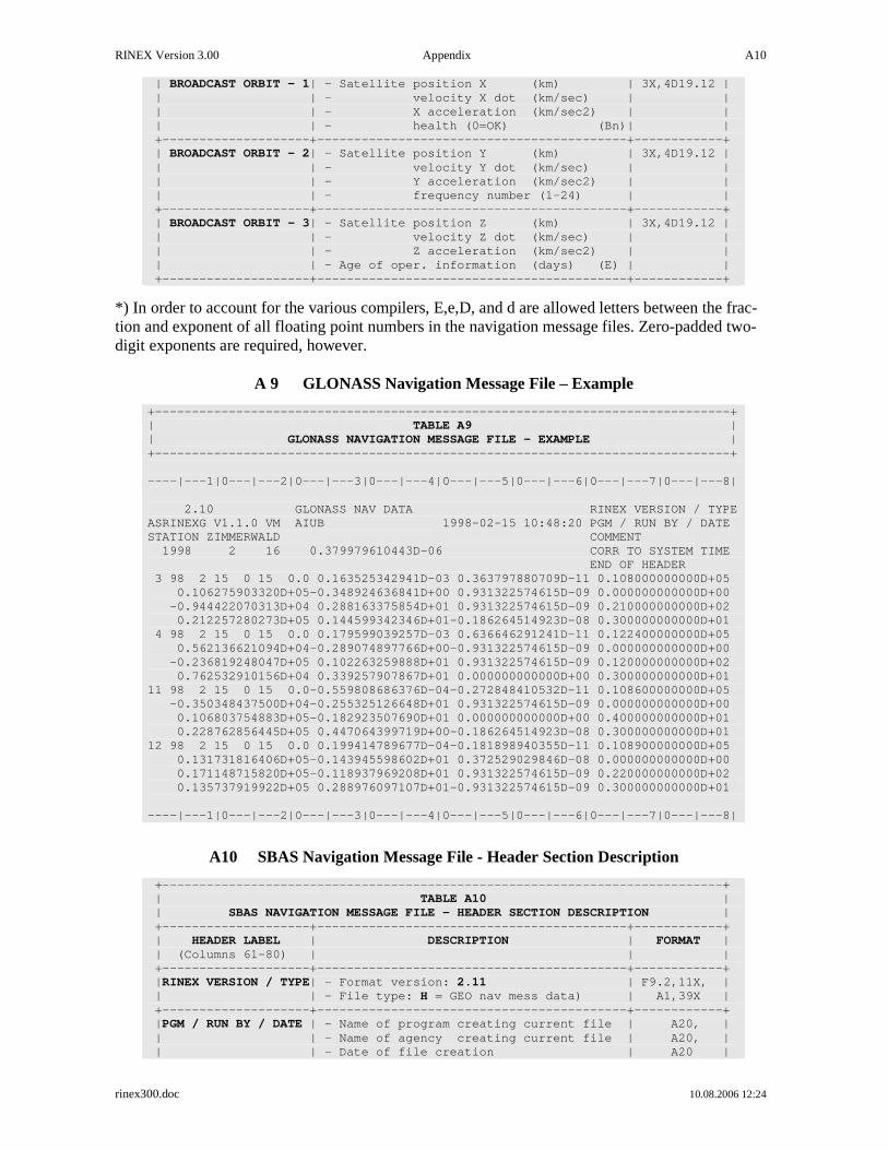
RINEX Version 3.00 Appendix A10
rinex300.doc 10.08.2006 12:24
| BROADCAST ORBIT - 1| - Satellite position X (km) | 3X,4D1 9.12 | | | - velocity X dot (km/sec) | | | | - X acceleration (km/sec2) | | | | - health (0=OK) (Bn)| | +--------------------+---------------------------- --------------+------------+ | BROADCAST ORBIT - 2| - Satellite position Y (km) | 3X,4D1 9.12 | | | - velocity Y dot (km/sec) | | | | - Y acceleration (km/sec2) | | | | - frequency numbe r (1-24) | | +--------------------+---------------------------- --------------+------------+ | BROADCAST ORBIT - 3| - Satellite position Z (km) | 3X,4D1 9.12 | | | - velocity Z dot (km/sec) | | | | - Z acceleration (km/sec2) | | | | - Age of oper. information (days) (E) | | +--------------------+---------------------------- --------------+------------+
*) In order to account for the various compilers, E,e,D, and d are allowed letters between the frac-tion and exponent of all floating point numbers in the navigation message files. Zero-padded two-digit exponents are required, however.
A 9 GLONASS Navigation Message File – Example
+-------------------------------------------------- ----------------------------+ | TABLE A9 | | GLONASS NAVIGATION MESSAGE FILE - EXAMPLE | +-------------------------------------------------- ----------------------------+ ----|---1|0---|---2|0---|---3|0---|---4|0---|---5|0 ---|---6|0---|---7|0---|---8| 2.10 GLONASS NAV DATA RINEX VERSION / TYPE ASRINEXG V1.1.0 VM AIUB 1998-02-15 10:48:20 PGM / RUN BY / DATE STATION ZIMMERWALD COMMENT 1998 2 16 0.379979610443D-06 CORR TO SYSTEM TIME END OF HEADER 3 98 2 15 0 15 0.0 0.163525342941D-03 0.3637978 80709D-11 0.108000000000D+05 0.106275903320D+05-0.348924636841D+00 0.9313225 74615D-09 0.000000000000D+00 -0.944422070313D+04 0.288163375854D+01 0.9313225 74615D-09 0.210000000000D+02 0.212257280273D+05 0.144599342346D+01-0.1862645 14923D-08 0.300000000000D+01 4 98 2 15 0 15 0.0 0.179599039257D-03 0.6366462 91241D-11 0.122400000000D+05 0.562136621094D+04-0.289074897766D+00-0.9313225 74615D-09 0.000000000000D+00 -0.236819248047D+05 0.102263259888D+01 0.9313225 74615D-09 0.120000000000D+02 0.762532910156D+04 0.339257907867D+01 0.0000000 00000D+00 0.300000000000D+01 11 98 2 15 0 15 0.0-0.559808686376D-04-0.2728484 10532D-11 0.108600000000D+05 -0.350348437500D+04-0.255325126648D+01 0.9313225 74615D-09 0.000000000000D+00 0.106803754883D+05-0.182923507690D+01 0.0000000 00000D+00 0.400000000000D+01 0.228762856445D+05 0.447064399719D+00-0.1862645 14923D-08 0.300000000000D+01 12 98 2 15 0 15 0.0 0.199414789677D-04-0.1818989 40355D-11 0.108900000000D+05 0.131731816406D+05-0.143945598602D+01 0.3725290 29846D-08 0.000000000000D+00 0.171148715820D+05-0.118937969208D+01 0.9313225 74615D-09 0.220000000000D+02 0.135737919922D+05 0.288976097107D+01-0.9313225 74615D-09 0.300000000000D+01 ----|---1|0---|---2|0---|---3|0---|---4|0---|---5|0 ---|---6|0---|---7|0---|---8|
A10 SBAS Navigation Message File - Header Section Description
+------------------------------------------------- ---------------------------+ | TABLE A10 | | SBAS NAVIGATION MESSAGE FILE - HEADER SECTION DESCRIPTION | +--------------------+---------------------------- --------------+------------+ | HEADER LABEL | DESCRIPTION | FORMAT | | (Columns 61-80) | | | +--------------------+---------------------------- --------------+------------+ | RINEX VERSION / TYPE| - Format version: 2.11 | F9.2,11X, | | | - File type: H = GEO nav mess data) | A1,39X | +--------------------+---------------------------- --------------+------------+ | PGM / RUN BY / DATE | - Name of program creating current file | A 20, | | | - Name of agency creating current file | A20, | | | - Date of file creation | A20 |

RINEX Version 3.00 Appendix A11
rinex300.doc 10.08.2006 12:24
+--------------------+---------------------------- --------------+------------+ *| COMMENT | Comment line(s) | A60 |* +--------------------+---------------------------- --------------+------------+ *| D-UTC A0,A1,T,W,S,U | Corrections to transform the system time | |* | | to UTC | | | | A0,A1 Coefficients of 1-deg polynomial | 2D19.12, | | | A0 sec, A1 sec/sec | | | | CORR(s) = A0 + A1*DE LTAT | | | | T Reference time for polyn omial | I7, | | | (Seconds into GPS we ek) | | | | W Reference week number | I5, | | | (GPS week, continuou s number) | | | | S EGNOS, WAAS, or MSAS ... | X,A5,X | | | (left-justified) | | | | Derived from MT17 servic e provider. | | | | If not known: Use Snn wi th | | | | nn = PRN-100 of satell ite | | | | broadcasting the MT12 | | | | U UTC Identifier (0 if unk nown) | I2,2X | | | 1=UTC(NIST), 2=UTC(USNO), 3=UTC(SU), | | | | 4=UTC(BIPM), 5=UTC(Europe Lab), | | | | 6=UTC(CRL), >6 = reserved for future | | | | | | | | Omit record if corrections not provided. | | | | | | | | Replaces CORR TO SYSTEM TIME ! | | +--------------------+---------------------------- --------------+------------+ *| LEAP SECONDS | Number of leap seconds since 6-Jan-1980 | I6 |* +--------------------+---------------------------- --------------+------------+ | END OF HEADER | Last record in the header section. | 60X | +--------------------+---------------------------- --------------+------------+
Records marked with * are optional
A11 SBAS Navigation Message File - Data Record Description
+------------------------------------------------- ---------------------------+ | TABLE A11 | | SBAS NAVIGATION MESSAGE FILE - DATA RECORD DESCRIPTION | +--------------------+---------------------------- --------------+------------+ | OBS. RECORD | DESCRIPTION | FORMAT | +--------------------+---------------------------- --------------+------------+ | PRN / EPOCH / SV CLK| - Satellite number (PRN - 100) | I2 , | | | - Epoch of ephemerides (GPS ) (Toe) | | | | - year (2 digits, padde d with 0 | | | | if necessary ) | 1X,I2.2, | | | - month,day,hour,minute , | 4(1X,I2), | | | - second | F5.1, | | | - SV clock bias (sec) (aGf0)| D19.12, | | | - SV relative frequency bia s (aGf1)| D19.12, | | | - Transmission time of mess age | D19.12 | | | (start of the message) | | | | in GPS seconds of the w eek | | +--------------------+---------------------------- --------------+------------+ | BROADCAST ORBIT - 1| - Satellite position X (km) | 3X,4D1 9.12 | | | - velocity X dot (km/sec) | | | | - X acceleration (km/sec2) | *) | | | - health (0=OK) | | +--------------------+---------------------------- --------------+------------+ | BROADCAST ORBIT - 2| - Satellite position Y (km) | 3X,4D1 9.12 | | | - velocity Y dot (km/sec) | | | | - Y acceleration (km/sec2) | | | | - Accuracy code (URA, meters)| | +--------------------+---------------------------- --------------+------------+ | BROADCAST ORBIT - 3| - Satellite position Z (km) | 3X,4D1 9.12 | | | - velocity Z dot (km/sec) | | | | - Z acceleration (km/sec2) | | | | - IODN (Issue of Data Navig ation, DO229, | | | | 8 first bits after Message Type if MT9) | | +--------------------+---------------------------- --------------+------------+
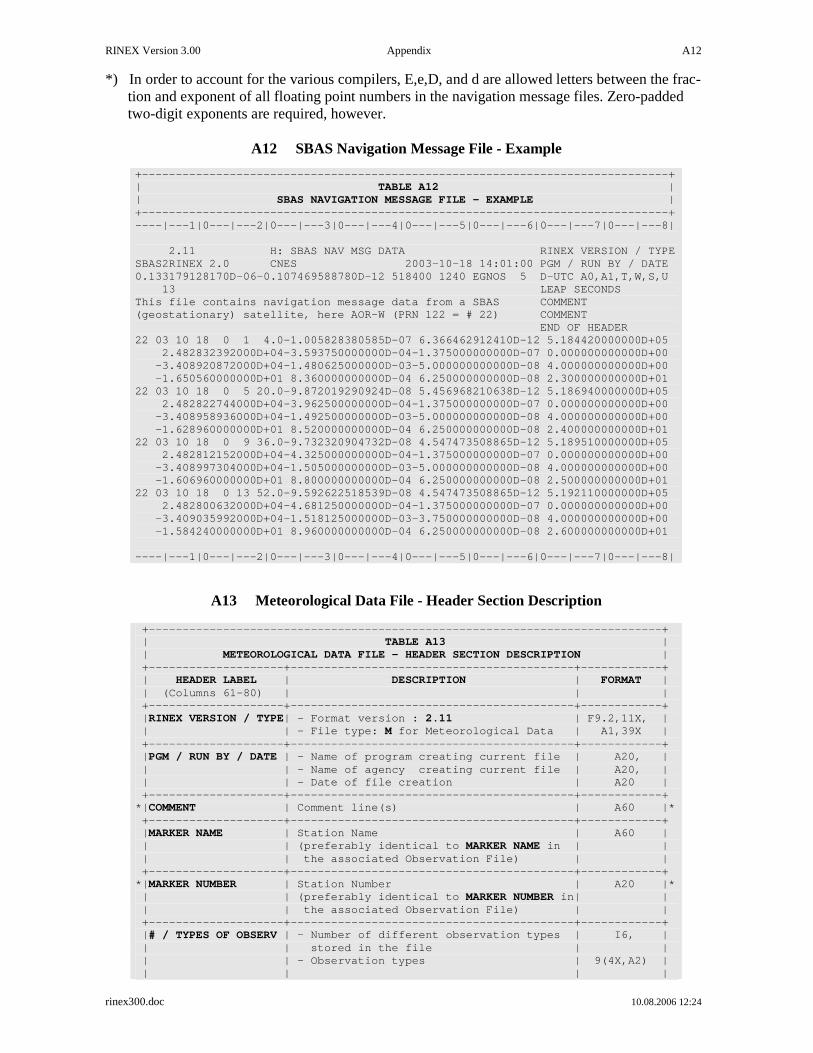
RINEX Version 3.00 Appendix A12
rinex300.doc 10.08.2006 12:24
*) In order to account for the various compilers, E,e,D, and d are allowed letters between the frac-tion and exponent of all floating point numbers in the navigation message files. Zero-padded two-digit exponents are required, however.
A12 SBAS Navigation Message File - Example
+-------------------------------------------------- ----------------------------+ | TABLE A12 | | SBAS NAVIGATION MESSAGE FILE - EXAMPLE | +-------------------------------------------------- ----------------------------+ ----|---1|0---|---2|0---|---3|0---|---4|0---|---5|0 ---|---6|0---|---7|0---|---8| 2.11 H: SBAS NAV MSG DATA RINEX VERSION / TYPE SBAS2RINEX 2.0 CNES 2003-10-18 14:01:00 PGM / RUN BY / DATE 0.133179128170D-06-0.107469588780D-12 518400 1240 E GNOS 5 D-UTC A0,A1,T,W,S,U 13 LEAP SECONDS This file contains navigation message data from a S BAS COMMENT (geostationary) satellite, here AOR-W (PRN 122 = # 22) COMMENT END OF HEADER 22 03 10 18 0 1 4.0-1.005828380585D-07 6.3664629 12410D-12 5.184420000000D+05 2.482832392000D+04-3.593750000000D-04-1.3750000 00000D-07 0.000000000000D+00 -3.408920872000D+04-1.480625000000D-03-5.0000000 00000D-08 4.000000000000D+00 -1.650560000000D+01 8.360000000000D-04 6.2500000 00000D-08 2.300000000000D+01 22 03 10 18 0 5 20.0-9.872019290924D-08 5.4569682 10638D-12 5.186940000000D+05 2.482822744000D+04-3.962500000000D-04-1.3750000 00000D-07 0.000000000000D+00 -3.408958936000D+04-1.492500000000D-03-5.0000000 00000D-08 4.000000000000D+00 -1.628960000000D+01 8.520000000000D-04 6.2500000 00000D-08 2.400000000000D+01 22 03 10 18 0 9 36.0-9.732320904732D-08 4.5474735 08865D-12 5.189510000000D+05 2.482812152000D+04-4.325000000000D-04-1.3750000 00000D-07 0.000000000000D+00 -3.408997304000D+04-1.505000000000D-03-5.0000000 00000D-08 4.000000000000D+00 -1.606960000000D+01 8.800000000000D-04 6.2500000 00000D-08 2.500000000000D+01 22 03 10 18 0 13 52.0-9.592622518539D-08 4.5474735 08865D-12 5.192110000000D+05 2.482800632000D+04-4.681250000000D-04-1.3750000 00000D-07 0.000000000000D+00 -3.409035992000D+04-1.518125000000D-03-3.7500000 00000D-08 4.000000000000D+00 -1.584240000000D+01 8.960000000000D-04 6.2500000 00000D-08 2.600000000000D+01 ----|---1|0---|---2|0---|---3|0---|---4|0---|---5|0 ---|---6|0---|---7|0---|---8|
A13 Meteorological Data File - Header Section Description
+------------------------------------------------- ---------------------------+ | TABLE A13 | | METEOROLOGICAL DATA FILE - HEADER SECTION DESCRIPTION | +--------------------+---------------------------- --------------+------------+ | HEADER LABEL | DESCRIPTION | FORMAT | | (Columns 61-80) | | | +--------------------+---------------------------- --------------+------------+ | RINEX VERSION / TYPE| - Format version : 2.11 | F9.2,11X, | | | - File type: M for Meteorological Data | A1,39X | +--------------------+---------------------------- --------------+------------+ | PGM / RUN BY / DATE | - Name of program creating current file | A 20, | | | - Name of agency creating current file | A20, | | | - Date of file creation | A20 | +--------------------+---------------------------- --------------+------------+ *| COMMENT | Comment line(s) | A60 |* +--------------------+---------------------------- --------------+------------+ | MARKER NAME | Station Name | A60 | | | (preferably identical to MARKER NAME in | | | | the associated Observation File) | | +--------------------+---------------------------- --------------+------------+ *| MARKER NUMBER | Station Number | A20 |* | | (preferably identical to MARKER NUMBER in| | | | the associated Observation File) | | +--------------------+---------------------------- --------------+------------+ | # / TYPES OF OBSERV | - Number of different observation types | I 6, | | | stored in the file | | | | - Observation types | 9(4X,A2) | | | | |

RINEX Version 3.00 Appendix A13
rinex300.doc 10.08.2006 12:24
| | The following meteorologica l observation | | | | types are defined in RINEX Version 2: | | | | PR : Pressure (mbar) | | | | TD : Dry temperature (deg Celsius) | | | | HR : Relative humidity (percent) | | | | ZW : Wet zenith path delay (mm) | | | | (for WVR data) | | | | ZD : Dry component of zenith path delay | | | | ZT : Total zenith path delay (mm) | | | | WD : Wind azimuth (deg) | | | | from where the wind bl ows | | | | WS : Wind speed (m/s) | | | | RI : "Rain increment" (1/10 mm): Rain | | | | accumulation since las t measurement | | | | HI : Hail indicator | | | | non-zero: Hail detecte d since last | | | | measurement | | | | | | | | The sequence of the types i n this record | | | | must correspond to the sequ ence of the | | | | measurements in the data re cords | | | | | | | | If more than 9 observation types are | | | | being used, use continuatio n lines with | | | | format (6X,9(4X,A2)) | | +--------------------+---------------------------- --------------+------------+ | SENSOR MOD/TYPE/ACC | Description of the met sensor | | | | - Model (manufacturer) | A20, | | | - Type | A20,6X, | | | - Accuracy (same units as o bs values) | F7.1,4X, | | | - Observation type | A2,1X | | | Record is repeated for each observation | | | | type found in # / TYPES OF OBSERV record | | +--------------------+---------------------------- --------------+------------+ | SENSOR POS XYZ/H | Approximate position of the met sensor | | | | - Geocentric coordinates X, Y,Z (ITRF | 3F14.4, | | | - Ellipsoidal height H or WGS-84)| 1F14.4, | | | - Observation type | 1X,A2,1X | | | Set X,Y,Z to zero if not kn own. | | | | Make sure H refers to ITRF or WGS-84! | | | | Record required for baromet er, | | | | recommended for other senso rs. | | +--------------------+---------------------------- --------------+------------+ | END OF HEADER | Last record in the header section. | 60X | +--------------------+---------------------------- --------------+------------+
Records marked with * are optional
A14 Meteorological Data File - Data Record Description
+------------------------------------------------- ---------------------------+ | TABLE A14 | | METEOROLOGICAL DATA FILE - DATA RECORD DESCRIPTION | +-------------+----------------------------------- --------------+------------+ | OBS. RECORD | DESCRIPTION | FORMAT | +-------------+----------------------------------- --------------+------------+ | EPOCH / MET | - Epoch in GPS time (not local time!) | | | | year (2 digits, padded with 0 if necessary) | 1X,I2.2, | | | month,day,hour,min,sec | 5(1X,I2), | | | | | | | The 2-digit years are understood to represent | | | | 80-99: 1980-1999 and 00-79: 2000-2079 | | | | | | | | - Met data in the same sequence as given in the | mF7.1 | | | header | | | | | | | | More than 8 met data types: Use co ntinuation |4X,10F7.1,3X| | | lines | | +-------------+----------------------------------- --------------+------------+
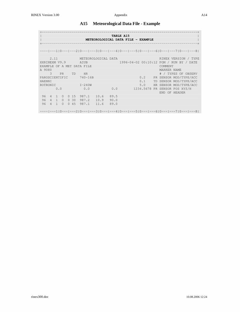
RINEX Version 3.00 Appendix A14
rinex300.doc 10.08.2006 12:24
A15 Meteorological Data File - Example
+-------------------------------------------------- ----------------------------+ | TABLE A15 | | METEOROLOGICAL DATA FILE - EXAMPLE | +-------------------------------------------------- ----------------------------+ ----|---1|0---|---2|0---|---3|0---|---4|0---|---5|0 ---|---6|0---|---7|0---|---8| 2.11 METEOROLOGICAL DATA RINEX VERSION / TYPE XXRINEXM V9.9 AIUB 1996-04-02 00:10:12 PGM / RUN BY / DATE EXAMPLE OF A MET DATA FILE COMMENT A 9080 MARKER NAME 3 PR TD HR # / TYPES OF OBSERV PAROSCIENTIFIC 740-16B 0 .2 PR SENSOR MOD/TYPE/ACC HAENNI 0 .1 TD SENSOR MOD/TYPE/ACC ROTRONIC I-240W 5 .0 HR SENSOR MOD/TYPE/ACC 0.0 0.0 0.0 1234 .5678 PR SENSOR POS XYZ/H END OF HEADER 96 4 1 0 0 15 987.1 10.6 89.5 96 4 1 0 0 30 987.2 10.9 90.0 96 4 1 0 0 45 987.1 11.6 89.0 ----|---1|0---|---2|0---|---3|0---|---4|0---|---5|0 ---|---6|0---|---7|0---|---8|