Richards_2007A Slab in Depth_Three-Dimensional Geometry
11
A slab in depth: Three-dimensional geometry and evolution of the Indo-Australian plate Simon Richards, Gordon Lister, and Brian Kennett Research School of Earth Sciences, Australian National University, Building 61, Mills Road, Canberra, ACT 0200, Australia (simon.richards@ anu.edu.au) [1] Geoscientists use plate tectonics to explain many aspects of both continental evolution and evolution of the planet as a whole. The subduction of material at convergent plate boundaries forms a fundamental compo nent to the theory of plate tectonics. Plates, conti nents, subd uction zones, and spreadi ng center s all exhibit motion and geometric evolution, so to try and resolve the past geometries of the planet, geologists have utilized plate tectonic reconstructions. Here we present a three-dimensional image of the subducted Indo-Australian plate below southeast Asia and show that the geometry of the subducted slab at depth is intimately related to the geometric evolution of SE Asia over the past 50 Ma, including the collision of India with the Asian continent. We show how the once semicontinuous subducting Indo-Australian plate has been segmented during collision between India, Australian, and the subduction margin to the north. Thu s we hav e fou nd that the geome try of the subdu cted plat e should form a key compo nen t to the interp retati on of the evolutio n of Earth’s surface, as complexiti es and evolutio n of the subducted plate are manifest in the evolution of the overriding plate. Components: 605 0 words, 5 figure s. Keywords: plate tectonics; slab; subduction; tomography; Australia; Sumatra. Index Terms: 3040 Marine Geolo gy and Geop hysi cs: Plate tecto nics (81 50, 8155, 815 7, 8158 ); 724 0 Seismolog y: Subduction zones (1207, 1219, 1240); 7230 Seismology: Seismicity and tectonics (1207, 1217, 1240, 1242). Received 10 April 2007; Revised 27 July 2007; Accepted 28 September 2007; Published 14 December 2007. Richards, S., G. Lister, and B. Kennett (2007), A slab in depth: Three-dimensional geometry and evolution of the Indo- Australian plate, Geochem. Geophys. Geosyst. , 8, Q12003, doi:10.10 29/2007G C001657. 1. Introduction [2] Since the fo rmulat ion of the idea th at the planet was characterized by individual tectonic plates by Alfred Wegn er in 1958, geolo gists have realize d that the array of physiochemical mechanisms as- sociated with plate tectonics is fundamental to the Earth’ s orogen ic histo ry . Conseq uentl y , plate tec- tonics remain the foundation of geosciences. In this pa per we pre sent the fir st det aile d region al- scal e three-dimensional (3-D) interpretation of the sub- ducted Indo-Australian plate below India and SE Asia (Fi gur e 1). We also discuss some of the imp lica tions tha t the der ived pla te geo metr y has on the evolution of the Indo-Australian plate margin over the past 50 Ma. [3] Subd uctio n zones form a fundamental compo - nent of our concept of plate tectonics. They typi call y occu r at conv erge nt plat e boundar ies, where oceanic crust and lithosphere dips into the mantle below an overriding plate, for example, the Aleu tia n Isl ands, Japan, the wes tern mar gin of Sou th G 3 G 3 Geochemistry Geophysics Geosystems Published by AGU and the Geochemical Society AN ELECTRONIC JOURNAL OF THE EARTH SCIENCES Geochemistry Geophysics Geosystems Article Volume 8, Number 12 14 December 2007 Q12003, doi:10.1029/2007GC001657 ISSN: 1525-2 027 Click Here for Full Article Copyright 2007 by the American Geophysical Union 1 of 11
-
Upload
fiore-fumo -
Category
Documents
-
view
217 -
download
0
Transcript of Richards_2007A Slab in Depth_Three-Dimensional Geometry

8/4/2019 Richards_2007A Slab in Depth_Three-Dimensional Geometry
http://slidepdf.com/reader/full/richards2007a-slab-in-depththree-dimensional-geometry 1/11
A slab in depth: Three-dimensional geometry and evolutionof the Indo-Australian plate
Simon Richards, Gordon Lister, and Brian Kennett Research School of Earth Sciences, Australian National University, Building 61, Mills Road, Canberra, ACT 0200, Australia ([email protected])
[1] Geoscientists use plate tectonics to explain many aspects of both continental evolution and evolution of
the planet as a whole. The subduction of material at convergent plate boundaries forms a fundamentalcomponent to the theory of plate tectonics. Plates, continents, subduction zones, and spreading centers allexhibit motion and geometric evolution, so to try and resolve the past geometries of the planet, geologistshave utilized plate tectonic reconstructions. Here we present a three-dimensional image of the subductedIndo-Australian plate below southeast Asia and show that the geometry of the subducted slab at depth isintimately related to the geometric evolution of SE Asia over the past 50 Ma, including the collision of India with the Asian continent. We show how the once semicontinuous subducting Indo-Australian platehas been segmented during collision between India, Australian, and the subduction margin to the north.Thus we have found that the geometry of the subducted plate should form a key component to theinterpretation of the evolution of Earth’s surface, as complexities and evolution of the subducted plate aremanifest in the evolution of the overriding plate.
Components: 6050 words, 5 figures.
Keywords: plate tectonics; slab; subduction; tomography; Australia; Sumatra.
Index Terms: 3040 Marine Geology and Geophysics: Plate tectonics (8150, 8155, 8157, 8158); 7240 Seismology:
Subduction zones (1207, 1219, 1240); 7230 Seismology: Seismicity and tectonics (1207, 1217, 1240, 1242).
Received 10 April 2007; Revised 27 July 2007; Accepted 28 September 2007; Published 14 December 2007.
Richards, S., G. Lister, and B. Kennett (2007), A slab in depth: Three-dimensional geometry and evolution of the Indo-
Australian plate, Geochem. Geophys. Geosyst., 8, Q12003, doi:10.1029/2007GC001657.
1. Introduction
[2] Since the formulation of the idea that the planet was characterized by individual tectonic plates byAlfred Wegner in 1958, geologists have realizedthat the array of physiochemical mechanisms as-sociated with plate tectonics is fundamental to theEarth’s orogenic history. Consequently, plate tec-tonics remain the foundation of geosciences. In this
paper we present the first detailed regional-scalethree-dimensional (3-D) interpretation of the sub-
ducted Indo-Australian plate below India and SEAsia (Figure 1). We also discuss some of the
implications that the derived plate geometry hason the evolution of the Indo-Australian plate marginover the past 50 Ma.
[3] Subduction zones form a fundamental compo-nent of our concept of plate tectonics. Theytypically occur at convergent plate boundaries,where oceanic crust and lithosphere dips into themantle below an overriding plate, for example, theAleutian Islands, Japan, the western margin of South
G3
G3Geochemistry
GeophysicsGeosystems
Published by AGU and the Geochemical Society
AN ELECTRONIC JOURNAL OF THE EARTH SCIENCES
GeochemistryGeophysicsGeosystems
Article
Volume 8, Number 12
14 December 2007
Q12003, doi:10.1029/2007GC001657
ISSN: 1525-2027
ClickHere
for
Full Article
Copyright 2007 by the American Geophysical Union 1 of 11
8/4/2019 Richards_2007A Slab in Depth_Three-Dimensional Geometry
http://slidepdf.com/reader/full/richards2007a-slab-in-depththree-dimensional-geometry 2/11
America and Scotia. These zones, which dominatethe rim of the eastern and western Pacific plates,and have so for millions of yeas, are also some of the most complex geosystems on the planet.
Developing a comprehensive understanding of their geodynamic evolution is key to understandingthe evolution and geodynamics of the planet as a whole. Rapid advances in high-performance com-
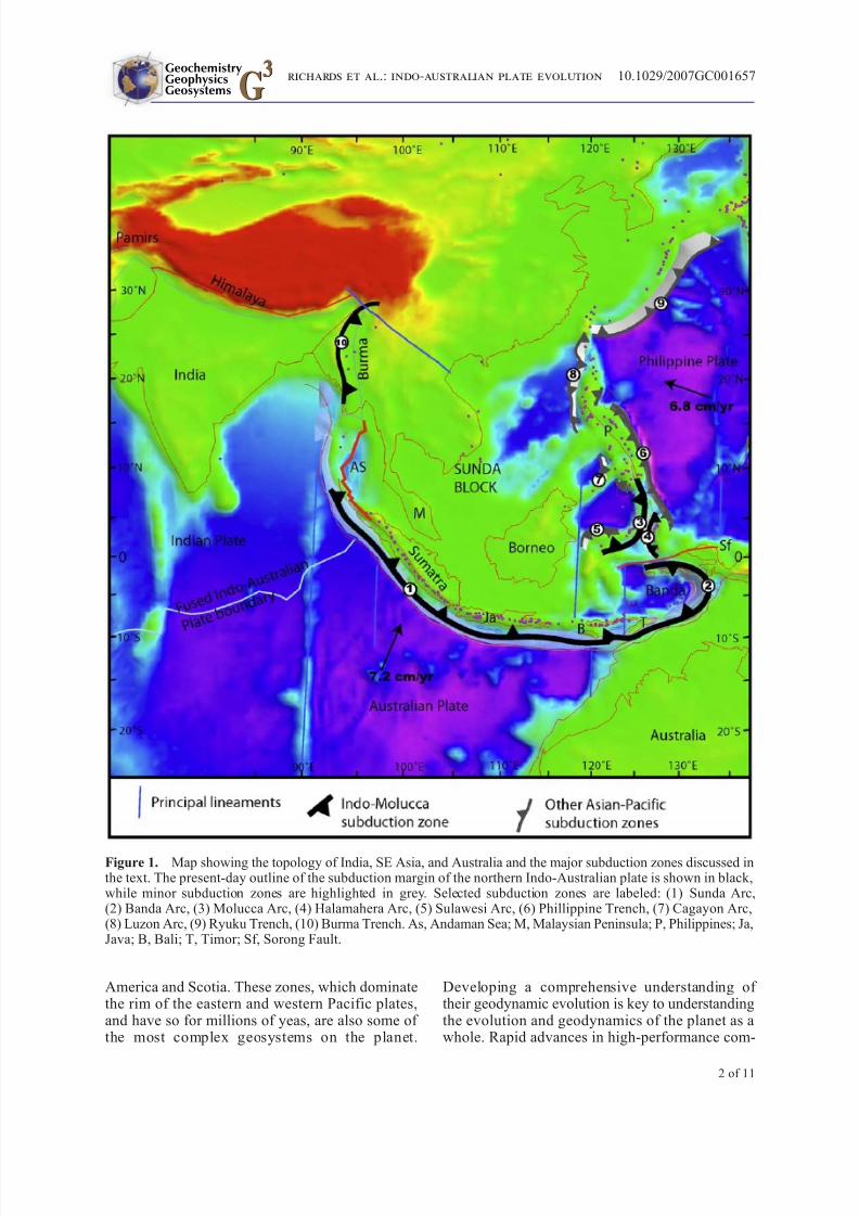
Figure 1. Map showing the topology of India, SE Asia, and Australia and the major subduction zones discussed inthe text. The present-day outline of the subduction margin of the northern Indo-Australian plate is shown in black,while minor subduction zones are highlighted in grey. Selected subduction zones are labeled: (1) Sunda Arc,(2) Banda Arc, (3) Molucca Arc, (4) Halamahera Arc, (5) Sulawesi Arc, (6) Phillippine Trench, (7) Cagayon Arc,(8) Luzon Arc, (9) Ryuku Trench, (10) Burma Trench. As, Andaman Sea; M, Malaysian Peninsula; P, Philippines; Ja,Java; B, Bali; T, Timor; Sf, Sorong Fault.
GeochemistryGeophysicsGeosystems G
3
G3
richards et al.: indo-australian plate evolution 10.1029/2007GC001657
2 of 11

8/4/2019 Richards_2007A Slab in Depth_Three-Dimensional Geometry
http://slidepdf.com/reader/full/richards2007a-slab-in-depththree-dimensional-geometry 3/11
puter processing and 3-D visualization softwarehave enabled us to begin creating a 3-D interactivedigital model of the Earth below its surface byincorporating multiple geoscience-based data
resources. The multiplicity of 3-D and 4-D geo-logical and geophysical data sets has also allowedus to create digital models of the internal structureof the planet, which at this stage is focused onsubduction zone geometries and dynamics. Wethen use these interpreted mantle geometries tomake inferences and interpretations about the geo-dynamic evolution of a particular subduction zone or region through time, i.e., when plates and their respective margins had significantly different geom-etries than they do today.
[4] In this paper we present an interpreted geom-
etry of the subducted Indo-Australian slab. Toachieve this we use earthquake hypocenter data from the EHB hypocenter catalogue [ Engdahl et al., 1998] as well as comparing results with theUSGS NEIC earthquake database for the period
between 1990 and 2005. Location errors associatedwith individual earthquake hypocenters are not included; however, we have applied a constant error for each hypocenter by using a sphere sizethat is equal to ±15 km in X, Y and Z.
[5] Within the Sumatra, Banda and Molucca regions, earthquake hypocenters are recorded tomaximum depths of up to 650 to 670 km. Accord-ingly, both earthquake hypocenters and tomogra-
phy are used to interpret the slab geometry to thisdepth. In the interpretation presented here, weassume that the earthquake hypocenters that occur
below approximately 100 km depth represent inter-slab seismicity, whereas those that occur above100 km depth may be, at least in part, caused bydeformation associated with partial coupling be-tween the subducting and overlying plates or theresult of fluid and magma migration within thesubvolcanic mantle wedge (e.g., between southernJava and Flores). To define the 3-D geometry of
the upper surface (top) of the subducted slab, a triangulated mesh is created using the Gocad(EarthDecisionSuite2) software. The initial meshis a course, 360-point (node) surface (Figure 2b) inwhich each individual nodes can be manipulatedand moved until the final mesh surface conforms tothe upper limit of the hypocenter clusters (Figures 2a and 2b). The ability to incrementally manipulate themesh in three dimensions allows complex geome-tries to be constructed. Regions where there is anabundance of earthquake hypocenters and well-defined tomography are typically interpreted with
a high-resolution (increased mesh nodes) meshsurface. Mesh construction and modificationwas undertaken using a flat earth model in a Mercator projection before being imported into
spherical Virtual Earth models. The interpretedIndo-Australian slab presented here is extractedfrom the flat earth model but it exhibits minimaldistortion due to its position at low latitudes.
[6] Above approximately 660 km depth, the meshis modified so that it conforms to both the hypo-center data and tomography. Below the maximumdepth of hypocenters, P wave tomography is usedto determine the slab geometry. Four regional Pwave tomographic models were used in the inter-
pretation of the slab surface displayed in Figures 2and 3: Australia, Indonesia, China and India. The P
wave models are from Sri Widiyantoro and pre-sented by van der Hilst et al. [1991]. Wave speedvariations are relative to ak135 [ Kennett et al.,1995]. The models are defined by a total velocity
perturbation range of À1.332 to +1.216. Fast andslow velocities are illustrated by variations in a color gradient corresponding to blue and red col-ors, respectively; white is equal to values of 0(Figures 2b and 2c). Surfaces derived using iso-velocities for wave speed perturbations of between+0.4 and +0.9 were initially used to define regionsof relatively fast mantle material which, for theregion below Sumatra for example, we interpreted
as representing subducted oceanic slab geometries.However, the potential complexity exhibited bymantle structure below SE Asia as inferred fromcomplex plate tectonic reconstructions is inter-
preted to have contributed to the complexity ob-served in the tomography data at depths belowaround 600 km depth.
[7] The interpreted position of the slab surfaceusing P wave tomography was created by manuallymoving mesh nodes so that the surface fell on or close to the point where the gradient between fast and slow wave speeds was greatest (Figures 2b, 2c,
and 3). Regions within the tomographic model that are characterized by a distinctive ‘‘thinning’’ of thefast-wave speed anomaly and where there is reducedor no hypocenter data recorded (e.g., Figure 3) can
be interpreted as regions where subducted slabmight be missing or significantly thinned and may
be interpreted as highlighting the location of gaps or tears in the subducting slab. We have not includedalternate interpretations showing relatively smallhorizontal or subhorizontal slab tears in this modelat this time. Nevertheless, on the basis of our analysis and interpretation of both the tomography
GeochemistryGeophysicsGeosystems G
3
G3
richards et al.: indo-australian plate evolution 10.1029/2007GC001657richards et al.: indo-australian plate evolution 10.1029/2007GC001657
3 of 11

8/4/2019 Richards_2007A Slab in Depth_Three-Dimensional Geometry
http://slidepdf.com/reader/full/richards2007a-slab-in-depththree-dimensional-geometry 4/11
and hypocenter information, we would suggest that both horizontal and vertical tears in the slab are not only possible but probable; however, higher-resolutionmodels are required to resolve this issue.
[8] To better constrain our interpretations, platetectonic reconstructions of Hall [1996], Hall and
Spakman [2002], Heine et al. [2004], Stampfli and Borel [2002], Scotese et al. [1988], and Replumaz et al. [2004] were used to evaluate the platetectonic history of SE Asia including plate positionand the location and longevity of subduction zones.The reconstructions show that SE Asia is character-ized by a complex plate tectonic history including
Figure 2. Vertical sections through two regions of the interpreted Indo-Australian slab showing the correlation between the interpreted shape and position of the mesh surface with respect to the two principal data sets used toconstrain its geometry, namely, earthquake hypocenters and tomography. Figure 2a shows the upper 800 km of aninterpreted section of the slab section illustrated in Figure 2b. The surface is constructed so that it conforms to theouter limit of the earthquake hypocenters as well as being constrained by the location of the fast anomaly highlighted
in the tomography. Triangulated mesh surface together with tomography and earthquake hypocenters is shown inFigure 2b. Figure 2c is an east-west oriented section through the west-dipping Molucca Slab and the north-dippingIndo-Australian slab below Sumatra. The geometry of the slab below 600 km depth is shown relative to the locationof the high wave speed anomaly.
GeochemistryGeophysicsGeosystems G
3
G3
richards et al.: indo-australian plate evolution 10.1029/2007GC001657
4 of 11

8/4/2019 Richards_2007A Slab in Depth_Three-Dimensional Geometry
http://slidepdf.com/reader/full/richards2007a-slab-in-depththree-dimensional-geometry 5/11
multiple short- and long-lived subduction zones.Additionally, 3-D analysis of the tomographic data shows that the mantle structure below SE Asia isextremely complex and, although we have inter-
preted several segments of slab from the tomogra- phy, in this paper we have focused on presenting theinterpreted 3-D geometry of the Molucca Sea slaband the Indo-Australian slab.
[9] The present-day limit of the northwestern Indo-Australian plate extends from the Banda Arc in the east and continuing to the west along the southern marginof Java and Sumatra. The northern limit of thesubduction margin terminates at the plate suture
between India and Eurasia in central Burma (Figure 1). Over $50 Ma ago, prior to the closureof the Tethys Ocean and collision between continen-tal India and Asia, this subduction zone had a vastly
different morphology and extent than it does today.The Molucca subduction zone and the associatedMolucca Sea slab (Figure 1) lies to the north of Banda and is included as part of the Australian plateas discussed below.
[10 ] The present-day geomorphology of theMolucca Sea Trench is defined by an approximately1100 km wide, laterally discontinuous arcuate sub-duction zone where the oceanic crust of the Molucca Sea is interpreted to be subducting to the west belowthe Celebes Basin (Sea) and Northern Sulawesi. Awell-defined Wadati-Benioff zone highlights the
west-dipping Molucca Sea slab to depths of around300 km [ McCaffrey et al., 1980] and in our model to550 km depth. A west-dipping high-wave speedanomaly is evident in the P wave tomography that
parallels the hypocenter data (Figure 2); however,unlike the limited depth of the hypocenters, theanomaly extends to over 1300 km deep. The inter-
preted slab geometry is presented in Figures 2a and2b. Between the surface and 600 km depth we haveinterpreted the lithospheric slab as a relativelysimple, curvi-planar sheet (Figure 2). Below600 km depth, however, the angle of the interpretedslab changes from steep to relatively shallow atti-
tudes (Figure 2). Below 800 km depth, the high-velocity domain that defined the 1100 km widesubducted Molucca Sea Slab continues to the west where it links with the fast wave speed anomaly that defines the base (>800 km) of the Indo-Australian
plate discussed below. Accordingly, this interpreta-tion implies that, at depth, the Molucca Sea andIndo-Australian slabs from part of the same contin-uous section of subducted plate that were separated/ torn during the evolution of the subduction zone.
Figure 3. A north-south oriented vertical cross sectionthrough the P wave tomography model below Java and
Northern Borneo. This cross section highlights thevariability in the thickness of the fast wave speedanomaly with depth, but similar variability exists alongthe strike length of the plate boundary. Earthquakehypocenters extend to 660 km depth. The interpretedupper and lower surface of the slab is shown. The well-defined narrowing of the fast wave speed anomaly at 410 km depth may indicate thinning or tearing of theslab there.
Figure 4. Interpreted geometry of the Indo-Australian slab below India and southeast Asia. Figure 4a is a view
looking from above at the same region of SE Asia illustrated in Figure 1 but with the topology of the crust removed.Some crustal regions are shown as transparent green for geographic reference. The interpreted geometry of thesubducted Indo-Australian slab is shown as a contoured and colored surface or sheet, which projects from the surface(i.e., trench) to 1300 km depth in the mantle. The color gradient applied to the slab shows orange and blue colorscorresponding with shallow and deep slab material, respectively. The principal features of the interpreted slab are(1) the presence of a subvertical tear separating the Banda Arc (2) from the Molucca Sea slab (3). The two slabsegments connect at depth (>800 km), suggesting that, in the past, the now separate slabs formed part of the samecontinuous subducting plate. The location of the northern Indio-Australian subduction margin, prior to collision
between India and Asia, is evident as an anomaly interpreted as slab material located between 800 and 1300 km depth below India. Figure 4b is an oblique view of the same interpreted slab surface presented in Figure 4a. The image istaken looking to the southeast across India toward NW Australia so that the shape of the vertical tear separating theBanda Slab from the Molucca Sea Slab can bee seen. Also evident is the subhorizontal tear separating the upper part of the Indo-Australian Slab from the older, remnant slab below India.
GeochemistryGeophysicsGeosystems G
3
G3
richards et al.: indo-australian plate evolution 10.1029/2007GC001657
5 of 11

8/4/2019 Richards_2007A Slab in Depth_Three-Dimensional Geometry
http://slidepdf.com/reader/full/richards2007a-slab-in-depththree-dimensional-geometry 6/11
Figure 4
GeochemistryGeophysicsGeosystems G
3
G3
richards et al.: indo-australian plate evolution 10.1029/2007GC001657
6 of 11

8/4/2019 Richards_2007A Slab in Depth_Three-Dimensional Geometry
http://slidepdf.com/reader/full/richards2007a-slab-in-depththree-dimensional-geometry 7/11
The interpreted 3-D geometry of the slab illustrated inFigures 2a and 2b shows the formation of a sub-vertical tear between the western edge of the Molucca Sea slab and the northeastern edge of the Banda Arc.
The base of the tear between the two slab segments islocated at around 800 km depth (Figures 2 and 4).
[11] Like the Molucca slab, the distinctive, concaveshape of the Banda Arc is mimicked by thegeography of the trench and island arc at thesurface. Our interpretations of the tomographyand hypocenter data show that the subductedsection of the Indo-Australian plate is a west-dipping sheet that is also concave to the west (Figures 2 and 4). The northern terminus of the
present-day Banda subduction zone abuts the E-Woriented Sorong Fault and at depth is marked by a
lack of a Wadati-Benioff zone. A cessation involcanism in the overriding plate also occurs wherethe subducted plate ends. With increasing depth(>400 km), the distinctive concave shape of theslab is progressively lost and a planar, northwest-dipping sheet-like morphology is revealed (Figures 2and 4). Between 800 km and 1000 km depth, the slabexhibits a distinctive shallow NW-dipping mor-
phology. Such subhorizontal anomalies (transient shallow/flat slab) are more commonly imaged at,or slightly above the 660 km discontinuity [Wortel and Spakman, 2000; Lallemand et al., 2001;Widiyantoro et al., 1999] where subducted litho-
sphere is interpreted to reside at density contrast defined by the ringwoodite to perovskite and mag-nesiowustite phase transition [e.g., Lebedev et al.,2002; Shearer and Flanagan, 1999; Bina et al.,2001; Ito and Takahashi, 1989]. The reasons for theuncharacteristic change in morphology of the sub-ducted Indo-Australian slab at 800–1000 km depthare less certain; however, we would suggest that it isindicative of the change in subduction zone dynam-ics (i.e., increased rates of hinge rollback) at thetime the slab was nearer to the Earth’s surface. Theevolution of this subduction system in SE Asia isdiscussed below. Below this shallow-dipping sec-
tion, the slab exhibits a relatively consistent, north-dipping geometry, an almost east-to-west orientedtrend and is continuous with the base of the aforemen-tioned Molucca slab (Figures 2 and4). The contrastinggeometry of the semiplanar Molucca Sea slab and thearcuate Banda slab suggests that, after initial develop-ment of the subvertical tear of the once laterallycontinuous Indo-Australian plate, the two slabs haveevolved independently with the Banda arc attaining a higher degree of curvature relative to the adjacent Molucca Sea slab.
[12] The interpreted 3-D geometry of the Indo-Australian slab below central and southern Sumatra appears relatively simple dipping steeply to over 1000 km below the island chain (Figures 2 and 4),
which is consistent with the cross-section interpre-tations of Replumaz et al. [2004]. At 800 km depth
below the Andaman Sea, the slab exhibits a shal-low dip, which is not apparent some 1000 kmsouth below southern Sumatra. A subhorizontal,laterally extensive ‘‘gap’’ in the fast velocity anom-aly at around 500–600 km depth below Sumatra isinterpreted as a subhorizontal tear; however, wehave not included this in our interpretation. Nev-ertheless, a notable feature is that the relative slowanomaly extends laterally for less than 500 kmsuggesting that the ‘‘tear’’ is only locally devel-oped in the section of slab below central Sumatra.
[13] To the north of Sumatra the geometry of theslab changes dramatically. The Indo-Australian
plate no longer forms a single continuous sheet to 1300 km depth, as is evident further south. Here,no earthquake hypocenters are recorded below250 km, whereas further south, hypocenters arerecorded as deep as 600 km. In addition, therelatively fast wave speed anomaly defining theslab appears to also terminate at 500 km depth. Onthe basis of this evidence, we would suggest that the subducted slab to the north of Sumatra termi-nates at approximately 500 km depth below the
Malay Peninsula (Figures 2 and 4).
[14] Approximately 400 km below the base of thissection of slab, and some 800 km below northernSumatra, occurs a distinctly linear fast wave speedanomaly in the P wave tomography data set. Theanomaly is continuous between 800 km depth andthe base of the tomography model at 1300 kmdepth. This anomaly is continuous with the base of the interpreted Indo-Australian slab imaged further south and the basal section of the Molucca Sea Slab (Figures 2 and 4). Thus the anomaly, and theinterpreted lithospheric slab that it represents, con-
tinues as a relatively linear zone between 800 kmand 1200 km depth from below northern Sumatra toward the northeast and below central India (Figures 2 and 4). The anomaly was interpreted
by Replumaz et al. [2004] as defining the locationof the subduction margin prior to collision betweenIndia and Asia. We would also suggest that the slabis the relict Neo-Tethyn oceanic crust that, prior tocirca 55 Ma [Stampfli and Borel , 2002; Sengor and
Natal’in, 1996; Dercourt et al., 1993; van der Vooet al., 1999] underwent north-directed subduction.The 3-D images presented in Figures 2 and 4 show
GeochemistryGeophysicsGeosystems G
3
G3
richards et al.: indo-australian plate evolution 10.1029/2007GC001657
7 of 11

8/4/2019 Richards_2007A Slab in Depth_Three-Dimensional Geometry
http://slidepdf.com/reader/full/richards2007a-slab-in-depththree-dimensional-geometry 8/11
that the Neo-Tethyn slab as continuous with the baseof the Indo-Australian plate below southern Suma-tra. Further, the anomaly and (slab) is also contin-uous with the base of the Molucca Slab to the east.
This implies that, prior to the collision betweenIndia and Asia, the region was characterized by a single continuous, NE trending subduction zone,which included the Molucca slab to the north.
[15] North of Sumatra and to the north and east of the Andaman Sea, the upper section of the Indo-Australian slab continues toward northern Burma.Earthquake hypocenter data as well as a well-defined domain characterized by fast P wavevelocities exists below Burma, which is interpretedas a section of lithospheric slab there. We wouldsuggest that the slab must be the northern termi-
nation of the Indo-Australia plate. At the surface,the subduction margin is arcuate, concave to theeast. Here, the overriding Asian continental crust ischaracterized by west-directed extension that formsthe Arakan Yoma. The plate exhibits a relativelyshallow angle of subduction to around 120 kmdepth where it steepens and continues to a depth of approximately 300 km. In the interpretation that wehave presented here, we have not included theinterpreted slab geometry of this slab below this300 km depth, but preliminary interpretations sug-gest that the slab may continue as an east-dippingsheet (slab) below southern Asia.
[16] Between latitudes 14° N and 17° N, correspondingwith the Northern Andaman Sea, no hypocenters arerecorded. This seismogenic quiet domain separates thewell-defined sections of subducted slab to the north andsouth, as described above. A lack of arc-related volca-nism characterizes the overriding plate in this zone.Finally, the section does not exhibit a high-wave speed
perturbation in the P wave tomography despite the ageof the crust at the subduction zone being of similar ageto the north and south where the same tomographymodel exhibits a well-defined anomaly. We wouldsuggest that the region of plate convergence to the
northwest of the Andaman Sea (i.e., below 14° N and17° N latitude) represents a region that contains no
actively subducting. This lack of slab maybe accountedfor if we consider the formation of a tear between thenorthern Burmese section of slab and the Sumatransection to the south.
2. Discussion
[17] Reconstructions of the Neo-Tethyn Arc prior to the collision between India and Eurasia show the
primary subduction zone trending NW where it is
continuous with the southern margin of Pakistan[e.g., Replumaz et al., 2004; Sengor and Natal’in,1996] (see Figure 5a). The subduction margin
between the Paleo-Banda Sea and southeastern
Pakistan had an estimated length of around8000 km, but its present-day length, i.e., after collision between India and Asia is over 12,000 km.Mechanisms must be considered that can accommo-date $50% of extension of the orogenic margin
between circa 50 Ma and present.
[18] To accommodate the increase in length of theeastern part of the subduction margin betweennorthern Burma and northeastern Molucca, wewould suggest that the once continuous slab, asimaged in the tomography below 800 km depth,formed a tear in the slab near the western margin of
the subduction zone. The tear separated the slabinto the Banda and Molucca sections. The timingof formation and the location of the tear can bereconciled with plate tectonic reconstructions(Figure 4). The position of the initial tear and thetiming of its formation is consistent with thecollision between the western Papua New Guinea and the proto-Sorong Fault with the northernAustralian arc at approximately 25 Ma (Figure 5b),
but following collision, the Banda and the Molucca Arcs evolved independently (Figures 5c– 5e).
[19] The change in morphology of the slab at 800 kmdepth below the Banda Arc, i.e., switch frommoderately dipping to shallow dipping, can be alsoexplained in a reconstruction framework. To pin-
point the timing of the initiation of the subverticaltear that now separates the two slab sections, whichalso coincides with the location of the shallowsection of slab, we have compared the rate of subduction with the depth at which the tear occurson the subducted slab. To estimate the total lengthof subducted slab of subduction and therefore theage of the slab at depth we have estimated that approximately 1500 km of crust was produced at the Australia-Antarctic rift during 50 Ma of north-
ward motion of Australia. Accordingly, approxi-mately 1500 km of crust must have been consumed(subducted) at the northern Australian plate bound-ary between 50 Ma and present. The tear in the slabinitiates at just below 800 km depth. Here the slabmust be around 25 Ma old. This age correspondswith the reconstructions, which show the time of impact between the NE continental fragments onthe Australian plate with the subduction zone near Banda to be at circa 25 Ma (Figure 5b).
[20] Immediately above the nick point of the tear (800 km depth), the Indo-Australian section of the
GeochemistryGeophysicsGeosystems G
3
G3
richards et al.: indo-australian plate evolution 10.1029/2007GC001657
8 of 11

8/4/2019 Richards_2007A Slab in Depth_Three-Dimensional Geometry
http://slidepdf.com/reader/full/richards2007a-slab-in-depththree-dimensional-geometry 9/11
slab exhibits a shallow angle of subduction as de-scribed above. Following tearing at circa 25 Ma, it isenvisaged that the Banda section of the subductionzone experienced increased rates of rollback, facil-
itated by toroidal flow of the mantle around thenewly developed plate edges. Rapid hinge retreat resulted in shallow-slab subduction angles [Stegmanet al., 2006; Christensen, 1996]. Rapid rollback of
the eastern part of the Indo-Australian plate canexplain the development of flatter slab after tearingat 25 Ma. The characteristic curvature exhibited bythe Banda Arc initiates at a depth of approximately400 km. On the basis of the calculated age of theslab with depth, this would imply initial formationof the arcuate geometry at around 12–15 Ma ago.
[21] The major subhorizontal tear between the Indo-Australian slab below Sumatra and the lower, NW-trending Neo-Tethyn slab is centered at around800 km depth, suggesting it also initiated at around25 Ma; however, the maximum depth of the inter-
preted break between the upper and lower platesegments lies at around 1000 km depth, so the tear may have initiated as early as 32–33 Ma ago if slightly slower rates of northward plate motion after 55–60 Ma are employed [e.g., Dewey et al., 1989].
[22] The base of our tomographic model data lies at a depth around 1340 km; however, due to variationin the angle in the dip of the slab, the interpreteddown-dip length of subducted slab below centralJava and Borneo is approximately 1600 km. Some1500 km of crust (Australian oceanic plate) has
been generated at the oceanic ridge between Ant-
Figure 5. Schematic reconstructions focused on thegeometric evolution of the northern Indo-Australian
plate subduction margin (red and yellow line) between45 Ma and present. Reconstructions are modified fromthose presented by Hall [1996]. In Figure 5a the NW-trending subduction margin is shown immediately prior to collision between greater continental India and thesubduction zone. Black arrows show the direction of thefuture migration of the subduction zone. By circa 35 Ma,India collided with the subduction zone to the north. At 25 Ma (Figure 5b) the continued northward motion of India resulted in the continent overriding the subducted
plate, causing subhorizontal tearing between the upper and lower sections of plate. At the same time, fragmentsof continental Australia (western Papua New Guinea asmarked in Figure 5b as point 1) collided with the central
part of the semicontinuous subduction margin, therebytriggering tearing of the subduction zone at that point.Figures 5c and 5d show the continued northward motionof India and subsequent formation and evolution of theeast-dipping Burma Arc as well as the segmentation andindependent evolution of the proto-Molucca Sea Slaband proto-Banda Arc to the north of continentalAustralia. Figure 5e shows the present-day geometryof the subduction zone. Purple circles represent activevolcanism for the different times shown.
GeochemistryGeophysicsGeosystems G
3
G3
richards et al.: indo-australian plate evolution 10.1029/2007GC001657
9 of 11
8/4/2019 Richards_2007A Slab in Depth_Three-Dimensional Geometry
http://slidepdf.com/reader/full/richards2007a-slab-in-depththree-dimensional-geometry 10/11
arctica and Australia (SE Indian Ridge) since 50 Ma ago. The north-directed motion of the Australian
plate and concomitant subduction along its north-ern margin in part, controls the production of new
oceanic crust at the ridge. Accordingly, approxi-mately 1500 km of crust must have been subductedsince 50 Ma. Motion exhibited by the subductionmargin and ocean ridge are relatively minor and arenot considered for this simple calculation. Never-theless, the base of the interpreted slab must beover 50 Ma old and potentially up to 70 Ma old.
No gap in the tomography exists that might beexpected if subduction had ceased for a period of time and, furthermore, the anomaly continues un-
broken to 1340 km depth (Figures 2 and 3) and inmodels presented by Replumaz et al. [2004] theanomaly extend to over 1500 km depth. The rela-
tively voluminous region of the mantle characterized by faster than average wave speeds between 1000and 1300 km depth (Figure 3) may indicate that accumulation of slab material may have occurred at this depth and that subduction of oceanic crust andlithosphere may have been ongoing for over 100 Ma.
[23] To further accommodate the increased lengthof the subduction margin, a near subvertical tear developed between the Indo-Burma subductionzone and the subduction along northern Sumatra
below the southern Burma platelet. The subductedslab beneath Burma (the northern Burma platelet)
is interpreted to have initially formed as the N-dipping subducted Indian plate during closure of the Neo-Tethys and prior to the collision betweenthe Indian continent and the NW-trending Tethynsubduction front. During collision between India and Asia, the Indian continental landmass overrodethe Tethyn subduction zone (Figures 5b–5e). Theupper section of the eastern Tethyn-Indo-Australianslab was detached (torn) from the underlying sub-ducted slab along a horizontal tear essentially cut-ting the once continuous slab into its upper andlower sections. The upper section of the slab under-went clockwise rotation about a point near northern
Sumatra (close to the intersection between the fusedIndo-Australian plate boundary and the Sunda Trench) and to the east toward the Asian continentallandmass (Figures 5c– 5e). The detached lower section of subducted Indo-Australian plate (Neo-Tethyn Slab) remained close to the position andorientation of the Tethyn subduction zone prior to it
being overridden by the Indian continent.
[24] The N-S directed extension between the slabsegments is manifest and accommodated by exten-sion at the surface as spreading along the Andaman
Sea rift at a half rate of approximately 2 cm a À1
[Curray et al., 1979; Raju, 2005]. We envisage theAndaman Sea to have developed in response totwo factors: (1) the west-directed rollback and
retreat of the Indo-Burma Slab and (2) the south-and southwest-directed rollback of the Indo-Australian plate from below Sunda. The latter motion is also driven in part by the counterclock-wise torsion associated with the north and NE-directed advance of the Australian plate and thesouth-directed resistive torque imposed by colli-sion between India and the Asian plate [e.g.,Sandiford et al., 2004].
[25] The lack of seismicity and volcanism in theregion to the NNW of the Andaman Sea is due tothe formation of a complex, but near-vertical tear in
the Indo-Australian plate that has formed in responseto the overall N-S directed extension on the platethere. The north-directed motion of India, the tordoi-dal ‘‘flow’’ of crustal material around the easternIndian syntaxis (see models by Shen et al. [2001] andTapponnier et al., 1982]) and the west- and south-west-directed rollback of the Sumatra section of theIndo-Australian plate [Sandiford et al., 2005] caused
N-S directed extension of the Indo-Australian plate at depth while extension at the surface is manifest as N-S directed extension and plate spreading in the Anda-man Sea since $18 Ma ago. The location of thisdetachment is also coincident with the point of
subduction of the eastern 90°
E ridge, which mayalso act as a pinning point separating the Indo-Burma Subduction system to the north from the Sunda andIndonesian Subduction systems to the south.
Acknowledgments
[26] This project was funded through the ARC project
DP0343646 ‘‘Tectonic Reconstruction of the Alpine’’ and
the ACcESS MNRF project P14. The authors thank Sri
Widiyantoro for providing the tomographic data. Discussion
and reviews by Dietmar Muller and two anonymous reviewers
improved the overall focus of the manuscript.
References
Bina, C. R., S. Stein, F. C. Marton, and E. M. Van Ark (2001),Implications of slab mineralogy for subduction dynamics, Phys. Earth Planet. Inter., 127 , 51–66.
Christensen, U. R. (1996), The influence of trench migrationon slab penetration into the lower mantle, Earth Planet. Sci. Lett., 140, 27– 39.
Curray, J. R., D. G. Moore, L. A. Lawver, F. J. Emmel, R. W.Raitt, M. Henry, and R. Kieckhefer (1979), Tectonics of theAndaman Sea and Burma, AAPG Mem., 29, 189– 198.
Dewey, J. F., S. Cande, and W. C. I. Pitman (1989), Tectonicevolution of the India/Eurasia collision zone, Eclogae Geol. Helv., 82(3), 717–734.
GeochemistryGeophysicsGeosystems G
3
G3
richards et al.: indo-australian plate evolution 10.1029/2007GC001657
10 of 11

8/4/2019 Richards_2007A Slab in Depth_Three-Dimensional Geometry
http://slidepdf.com/reader/full/richards2007a-slab-in-depththree-dimensional-geometry 11/11
Dercourt, J., L. E. Ricou, and B. Vrielynck (1993), Atlas of Tethys Paleoenvironmental Maps, 14 maps, 1 plate, 307 pp.,Gauthier-Villars, Paris.
Engdahl, E., R. D. van der Hilst, and R. Buland (1998), Globalteleseismic earthquake relaocation with improved travel time
procedures for depth determination, Bull. Seismol. Soc. Am.,88, 722– 743.
Hall, R. (1996), Reconstructing Cenozoic SE Asia, in Tectonic Evolution of SE Asia, edited by R. Hall and D. J. Blundell,Geol. Soc. Spec. Publ., 106 , 153– 184.
Hall, R., and W. Spakman (2002), Subducted slabs beneath theeastern Indonesia-Tonga region: Insights from tomography, Earth Planet. Sci. Lett., 110, 235– 246.
Heine, C., D. Muller, and C. Gaina (2004), Reconstructing thelost eastern Tethys Ocean Basin: Convergence history of theSE Asian margin and marine gateways, in Continent -Ocean Interactions in Southeastern Asia, Geophys. Monogr. Ser.,vol. 149, edited by P. Clift et al., pp. 37–54, AGU,Washington, D. C.
Ito, E., and E. Takahashi (1989), Postspinel transformations in
the system Mg2
SiO4
–Fe2
SiO4
and some geophysical impli-cations, J. Geophys. Res., 94, 10,637– 10,646.Kennett, B. L. N., E. R. Engdahl, and R. Buland (1995), Con-
straints on seismic velocities in the Earth from travel times,Geophys. J. Int., 122, 108–124.
Lallemand, S., Y. Font, H. Bijwaard, and H. Kao (2001), Newinsights on 3-D plate interaction near Taiwan from tomogra- phy and tectonic implications, Tectonophysics, 335, 229– 253.
Lebedev, S., S. Chevrot, and R. D. van der Hilst (2002), Seis-mic evidence for olivine phase changes at the 410- and660-kilometer discontinuity, Science, 285, 1300–1302,doi:10.1126/science.1069407.
McCaffrey, R., E. A. Silver, and R. W. Raitt (1980), Crustalstructure of the Molucca Sea collision zone, Indonesia, inThe Tectonic and Geologic Evolution of Southeast Asian
Seas and Islands, Part 1, Geophys. Monogr. Ser., vol. 23, pp. 161– 177, editedby D. E. Hayes,AGU, Washington, D. C.
Raju, K. A. (2005), Three-phase tectonic evolution of theAndaman backarc basin, Curr. Sci., 88(11), 1932–1937.
Replumaz, A., H. Karason, R. D. van der Hilst, J. Besse, andP. Tapponnier (2004), 4-D evolution of SE Asia’s mantlefrom geological reconstructions and seismic tomography, Earth Planet. Sci. Lett., 221, 103–115.
Sandiford, M., M. Wallace, and D. Coblentz (2004), Origin of the in-situ stress field in southeastern Australia, Basin Res.,16 , 325– 338.
Sandiford, M., D. Coblentz, and W. P. Schellart (2005), Eval-uating slab-plate coupling in the Indo-Australian plate, Geol-
ogy, 33, 113–116.Scotese, C. R., L. M. Gahagan, and R. L. Larson (1988), Plate
tectonic reconstructions of the Cretaceous and Cenozoicocean basins, Tectonophysics, 155, 27–48.
Sengor, A. M. C., and B. A. Natal’in (1996), Paleotectonics of Asia: Fragments of a synthesis, in The Tectonic Evolution of Asia, edited by A. Yin and T. M. Harrison, pp. 486–640,Cambridge Univ. Press, New York.
Shearer, P. M., and M. P. Flanagan (1999), Seismic velocityand density jumps across the 410- and 660-kilometer discon-tinuity, Science, 285, 1545–1548.
Shen, F., L. H. Royden, and B. C. Burchfiel (2001), Large-scale crustal deformation of the Tibetan Plateau: Large-scalecrustal deformation of the Tibetan Plateau, J. Geophys. Res.,106 , 6793–6816.
Stampfli, G. M., and G. D. Borel (2002), A plate tectonicmodel for the Paleozoic and Mesozoic constrained bydynamic plate boundaries and restored synthetic iso-chrons, Earth Planet. Sci. Lett., 196 , 17– 33.
Stegman, D. R., J. Freeman, W. P. Schellart, L. Moresi, andD. May (2006), Influence of trench width on subductionhinge retreat rates in 3-D models of slab rollback, Geo-chem. Geophys. Geosyst., 7 , Q03012, doi:10.1029/ 2005GC001056.
Tapponnier, P., G. Peltzer, A. Y. Le Dain, R. Armijo, andP. Cobbold (1982), Propagating extrusion tectonics in Asia: New insights from simple experiments with plasticine, Geol-ogy, 10, 611– 616.
van der Hilst, R. D., S. Widiyantoro, and E. R. Engdahl(1991), Evidence for deep mantle circulation from globaltomography, Nature, 386 , 578– 584.
van der Voo, R., W. Spakman, and H. Bijwaard (1999), Teth-yan subducted slabs under India, Earth Planet. Sci. Lett.,171, 7–20.
Widiyantoro, S., B. L. N. Kennett, and R. D. van der Hilst (1999), Seismic tomography with P and S data reversalslateral variations in the rigidity of deep slabs, Earth Planet.Sci. Lett., 120, 97–100.
Wortel, M. J. R., and W. Spakman (2000), Subduction and slabdetachment in the Mediterranean-Carpathian region, Science,290, 1910–1917.
GeochemistryGeophysicsGeosystems G
3
G3
richards et al.: indo-australian plate evolution 10.1029/2007GC001657
11 f 11