RFC Summary - external.opengis.orgexternal.opengis.org/twiki_public/pub/CDBswg/... · Web...
65
16-112 OGC CDB 1.0 2016 RFC Comment Resolution Table of Contents 1. RFC Summary..................................................................3 2. General Comments.............................................................3 a) CDB SWG Approved Charter................................................... 3 b) Future Work................................................................ 4 c) Proprietary Formats........................................................ 5 d) Source Data Formats........................................................ 5 e) Run-Time Performance....................................................... 6 f) Feature Data Dictionary / FACC............................................. 8 g) Links to presentations, documents, other resources.........................8 i. Alternate / Multiple Feature Data Dictionaries in CDB.....................8 ii. Perspective of CDB; investigation of other OGC standards..................8 3. Individual RFC Comments and Resolution.......................................8 1) Tracking Number: RFC 001-B01.............................................. 9 2) Tracking Number: RFC 002-B01............................................. 10 3) Tracking Number: RFC 003-B01............................................. 11 4) Tracking Number: RFC 004-B01............................................. 12 5) Tracking Number: RFC 005-B01............................................. 13 6) Tracking Number: RFC 005-B02............................................. 14 7) Tracking Number: RFC 005-B03............................................. 15 8) Tracking Number: RFC 005-B04............................................. 17 9) Tracking Number: RFC 005-B05............................................. 18 10) Tracking Number: RFC 005-B06............................................19 11) Tracking Number: RFC 005-B07............................................20 12) Tracking Number: RFC 005-B08............................................21 13) Tracking Number: RFC 005-B09............................................22 14) Tracking Number: RFC 005-B10............................................23 15) Tracking Number: RFC 005-B11............................................24 OGC Document 16-112OGC CDB 1.0 2016 RFC Comment Resolution Page 1
Transcript of RFC Summary - external.opengis.orgexternal.opengis.org/twiki_public/pub/CDBswg/... · Web...

16-112 OGC CDB 1.0 2016 RFC Comment Resolution
Table of Contents
1. RFC Summary................................................................................................................................................................3
2. General Comments........................................................................................................................................................3
a) CDB SWG Approved Charter......................................................................................................................................3
b) Future Work..............................................................................................................................................................4
c) Proprietary Formats..................................................................................................................................................5
d) Source Data Formats.................................................................................................................................................5
e) Run-Time Performance.............................................................................................................................................6
f) Feature Data Dictionary / FACC.................................................................................................................................8
g) Links to presentations, documents, other resources.................................................................................................8
i. Alternate / Multiple Feature Data Dictionaries in CDB..........................................................................................8
ii. Perspective of CDB; investigation of other OGC standards...................................................................................8
3. Individual RFC Comments and Resolution.....................................................................................................................8
1) Tracking Number: RFC 001-B01................................................................................................................................9
2) Tracking Number: RFC 002-B01..............................................................................................................................10
3) Tracking Number: RFC 003-B01..............................................................................................................................11
4) Tracking Number: RFC 004-B01..............................................................................................................................12
5) Tracking Number: RFC 005-B01..............................................................................................................................13
6) Tracking Number: RFC 005-B02..............................................................................................................................14
7) Tracking Number: RFC 005-B03..............................................................................................................................15
8) Tracking Number: RFC 005-B04..............................................................................................................................17
9) Tracking Number: RFC 005-B05..............................................................................................................................18
10) Tracking Number: RFC 005-B06..........................................................................................................................19
11) Tracking Number: RFC 005-B07..........................................................................................................................20
12) Tracking Number: RFC 005-B08..........................................................................................................................21
13) Tracking Number: RFC 005-B09..........................................................................................................................22
14) Tracking Number: RFC 005-B10..........................................................................................................................23
15) Tracking Number: RFC 005-B11..........................................................................................................................24
16) Tracking Number: RFC 005-B12..........................................................................................................................25
17) Tracking Number: RFC 005-B13..........................................................................................................................26
18) Tracking Number: RFC 006-B01..........................................................................................................................27
OGC Document 16-112 OGC CDB 1.0 2016 RFC Comment Resolution Page 1

19) Tracking Number: RFC 007-B01..........................................................................................................................28
20) Tracking Number: RFC 007-B02..........................................................................................................................29
21) Tracking Number: RFC 007-B03..........................................................................................................................30
22) Tracking Number: RFC 007-B04..........................................................................................................................31
23) Tracking Number: RFC 008-B01..........................................................................................................................32
24) Tracking Number: RFC 009-B01..........................................................................................................................33
25) Tracking Number: RFC 009-B02..........................................................................................................................34
26) Tracking Number: RFC 009-B03..........................................................................................................................36
27) Tracking Number: RFC 009-B04..........................................................................................................................37
28) Tracking Number: RFC 010-B01..........................................................................................................................38
29) Tracking Number: RFC 011-B01..........................................................................................................................39
30) Tracking Number: RFC 011-B02..........................................................................................................................40
31) Tracking Number: RFC 011-B03..........................................................................................................................41
32) Tracking Number: RFC 011-B04..........................................................................................................................42
33) Tracking Number: RFC 011-B05..........................................................................................................................43
34) Tracking Number: RFC 011-B06..........................................................................................................................44
35) Tracking Number: RFC 011-B07..........................................................................................................................45
36) Tracking Number: RFC 011-B08..........................................................................................................................46
37) Tracking Number: RFC 011-B09..........................................................................................................................47
38) Tracking Number: RFC 012-B01..........................................................................................................................48
39) Tracking Number: RFC 012-B02..........................................................................................................................49
40) Tracking Number: RFC 012-B03..........................................................................................................................50
41) Tracking Number: RFC 012-B04..........................................................................................................................51
42) Tracking Number: RFC 012-B05..........................................................................................................................52
43) Tracking Number: RFC 012-B06..........................................................................................................................53
44) Tracking Number: RFC 012-B07..........................................................................................................................54
45) Tracking Number: RFC 012-B08..........................................................................................................................55
46) Tracking Number: RFC 013-B01..........................................................................................................................56
47) Tracking Number: RFC 013-B02..........................................................................................................................57
48) Tracking Number: RFC 013-B03..........................................................................................................................58
49) Tracking Number: RFC 013-B04..........................................................................................................................59
50) Tracking Number: RFC 013-B05..........................................................................................................................60
51) Tracking Number: RFC 013-B06..........................................................................................................................61
OGC Document 16-112 OGC CDB 1.0 2016 RFC Comment Resolution Page 2

1. RFC Summary
The RFC was announced and opened in an OGC Press Release on 12 April 2016: http://www.opengeospatial.org/pressroom/pressreleases/2415
The RFC comment period was 45 days, and it closed on May 27, 2016.
The SWG voted to request a 45-day RFC period due to the number and complexity of draft documents comprising the candidate standard.
13 submissions were received from 10 submitters (some submitters made more than one submission); many submissions contained more than one ‘Part B’ comment.
A public Google ‘Sheets’ spreadsheet has been used throughout this RFC period to record the received comments and track actions and comment resolution by the document editors and the CDB SWG:
https://docs.google.com/spreadsheets/d/18qAZT70TUMCsJLiJjg_PLzFLl0q2LeLKeo4rRryyA6c/edit?usp=sharing
A tracking number was generated by the SWG; there are two parts to the tracking number. The first part is a simple number sequence assigned in the order the comment was received at the OGC ‘requests’ email/archive. The second part of the tracking number represents a 01-to-n sequential number of one or more ‘Part B’ comment components in the RFC submission as received.
2. General Comments
a) CDB SWG Approved Charter
The formation of the CDB Standards Working Group was approved by a full electronic vote of the OGC Technical Committee with the following SWG Charter: https://portal.opengeospatial.org/files/?artifact_id=64279
The following is excerpted from the approved SWG charter under section 4. Scope of Work:
The SWG will actively investigate the use of existing OGC standards such as GML, CityGML, IndoorGML and others as potential source data components of any proposed OGC CDB standard(s), so long as incorporating those components is not out of scope (see 4.2 below).
The following is excerpted from the approved SWG charter under section 4.2 What is Out of Scope?
This SWG will not work on any change requests to the existing Common DataBase specification beyond those submitted during the 30 day public comment period.
The Charter Members of the SWG, and the OGC TC voting members accepted the constraint that Version 1.0 of the CDB SWG would represent the translation of the legacy CDB 3.2 specification into the modular specification and document templates of the OGC, along with alignment of terminology whenever possible, and any major/substantive changes to the standard would be reserved for future work. The resultant candidate standard separates the Core Standard from other material that is optional or represents implementation guidelines, and establishes a clear basis for evaluating alternative encodings and datasets within the next version of the OGC CDB standard.
OGC Document 16-112 OGC CDB 1.0 2016 RFC Comment Resolution Page 3

See the link [Perspective of CDB; investigation of other OGC standards.] below to work products developed and presented by the SWG related the investigation of other OGC standards as potential components of CDB. Some existing OGC standards are implemented in conversion tools currently available that support conversion into formats that are required or optional datasets in OGC CDB 1.0
The formal electronic votes of the OGC Technical Committee to approve the OGC CDB SWG Charter (excerpts above) and approve the formation of the OGC CDB Standards Working Group document the official position of the OGC that the CDB Specification (as approved in separate electronic TC voting) is considered a technical position of the OGC and the SWG is approved, including its charter to re-cast the current Best Practices documents as OGC CDB 1.0, and consider closer alignment with other OGC standards as future work.
b) Future Work
The CDB community anticipates that additional standardization will be required to prescribe content appropriate to targeted simulation applications. In its current form, the CDB standard does not mandate synthetic environmental richness, quality and resolution.
The CDB SWG members understand there is a requirement for eventual alignment of the CDB standard with the OGC/ISO standards baseline. In this version, effort was invested to begin aligning terminology and concepts, specifically in the coordinate reference system discussions and requirements.
The current version of the CDB standard is fully backwards compatible with version 3.2 of the CDB specification as defined and implemented by the current CDB implementer and user community. The requirements for a CDB data store are focused on the ability to store, manage, and access extremely large volumes of geographic content. In this version of
OGC Document 16-112 OGC CDB 1.0 2016 RFC Comment Resolution Page 4

the standard, initial harmonization with the OGC and ISO standards baseline has begun. For example, where appropriate, the CDB simulation community terms and definitions have been replaced with OGC/ISO terms and definitions. Further, the standards documents have been reorganized and structured to be consistent with the OGC Modular Specification Policy. However, the CDB SWG and community recognize the need to further harmonize and align this standard with the OGC baseline and other IT best practices. There has already been considerable discussion in this regard.
Based on such discussions, the following future work tasks are envisioned:
1. Describe explicitly how the CDB model aligns with the OGC DGGS standard;2. Provide best practice details on how to use WMS, WFS, and WCS to access existing CDB data stores. This work
may require Interoperability Experiments to better understand the implications of these decisions;3. Enhance the supported encodings and formats for a CDB database to include the use of GeoPackage, CityGML,
InDoorGML, GML and other OGC standards. This work may require Interoperability Experiments to better understand the implications of these decisions.
4. Further align CDB terminology to be fully consistent with OGC/ISO terminology.5. Consider replacement(s) for the (deprecated) FACC Feature Attribution Dictionary.6. Consiider an extension to the current CDB Core standard which allows the supply of Dataset metadata within a
CDB that describes the overall CDB.
c) Proprietary FormatsThe OGC Architecture Board and multiple RFC evaluators mentioned the presence of proprietary formats in the candidate standards requirements. The SWG accepted direction from the OAB and helpful specific comments from the RFC evaluators. The resolution of the problem consists of making the encodings using Shapefiles, Openflight, and dbf optional and moving the specification of these encodings to Best Practices documents. This approach provides a path for backwards compatibility with the industry specification and supports future work to propose and investigate other encodings using OGC (and potentially other) open standards.
d) Source Data FormatsMultiple evaluators commented on the choice of one or more of the formats used in CDB. The original CDB requirements from U.S. Special Operations Command had a heavy emphasis on the choice of formats in which source data is commonly supplied for use in creating simulation databases, and formats in-common use with commercially available toolsets.
This table represents the source data formats in use by interoperability initiatives established in the U.S. Department of Defence circa 2012:
OGC Document 16-112 OGC CDB 1.0 2016 RFC Comment Resolution Page 5
1 Graphic source: U.S. Air Force

e) Run-Time PerformanceCDB began as a competitive requirement from U.S. Special Operations Command to create a common repository of terrain, built environment, and moving model data that could be used directly, at simulation run-time, by multiple simulation clients and multiple simulation entities from a network server.
The graphic below represents examples of multiple simulation clients that need to be rendered in high performance simulation run-time:
SAR (Synthetic Aperture Radar) represents a non-visual spectrum sensor Image Generator (IG) is used to render and fill multiple displays in a simulation virtual reality
environment FLIR (Forward Looking Infra Red) represents another typical sensor rendering requirement IOS (Instructor Operating Station) and CGF (Computer Generated Forces) are common components of
simulations that require 2D and 3D database support RBGM (Real Beam Ground Map) is a common ‘plan-position-indicator’ radar display
Many of the design requirements for CDB result from the immersive, virtual reality ‘determinism’ necessary to support these multiple simultaneous renderings from different spectra as well as hundreds, sometimes thousands, of line-of-site calculations between simulation entities and the terrain representation…in each deterministic cycle of the simulation run-time environment.
OGC Document 16-112 OGC CDB 1.0 2016 RFC Comment Resolution Page 6

The graphics below are captures of a CDB datastore providing the underlying data for rendering the clients above, noting different clients operating at different ranges, sensor viewpoint, geographic coverage, and level-of-detail:
OGC Document 16-112 OGC CDB 1.0 2016 RFC Comment Resolution Page 7

f) Feature Data Dictionary / FACCSee the SWG work artifact presentation below on alternate/multiple Feature Data Dictionaries. See Alternate / Multiple Feature Data Dictionaries in CDB
g) Links to presentations, documents, other resources
i. Alternate / Multiple Feature Data Dictionaries in CDB
These slides presented in the "96th OGC Technical Committee, Nottingham, UK, 2015", describe the methods for extending the existing CDB specification to provide for alternate/multiple feature data dictionaries that are possible now with the existing technical content in the OGC CDB 1.0 candidate standard.
ii. Perspective of CDB; investigation of other OGC standards.
These slides which were presented in the "98th OGC Technical Committee, Washington, DC USA, 2016", describe the perspective for OGC CDB 2.0 and interoperability between OGC CDB and Baseline Standards such as CityGML, GeoPackage, OWS and other OGC standards.
These slides also specifically discuss the tradeoffs in using the currently specified Shapefile format or updating to using OGC GEOPackage format for storing vector information in CDB.
3. Individual RFC Comments and Resolution
OGC Document 16-112 OGC CDB 1.0 2016 RFC Comment Resolution Page 8
https://docs.google.com/presentation/d/1N8cI6n-wgF59jG1KNLCi9QpZ_OVcvc3stR52epUv1Aw/edit?usp=sharing

1) Tracking Number: RFC 001-B01 Evaluator Submission
DocumentRequirement
TypeSection Number
Criticality
David Graham, CAE Inc. All 12 Volumes General Preface Editorial
RFC Comment as submitted by Evaluator OGC CDB SWG Response / Comment(s) / Modification(s) / Reason(s)Editorial; accepted; action completed
Each of the candidate standards documents in this package contains a version of this statement in the preface / front matter:For ease of editing and review, the standard has been separated into 12 Volumes, one of which is a schema repository.Recommended change:For ease of editing and review, the standard has been separated into 12 Volumes and a schema repository.Justification:There are, in fact, 12 Volumes AND a schema repository. The submitter of this comment wishes to apologize to the document editor, who correctly stated the volume count, only to have the statement made incorrect by an editorial review of and change by the SWG Chair whose education temporarily caused him to NOT account for the concept of “Volume 0”.
2) Tracking Number: RFC 002-B01 Evaluator Submission
DocumentRequirement
TypeSection Number
Criticality
Bernard Leclerc, CAE Inc.
15-113 Volume 1 General 5.6.1.8 Major
OGC Document 16-112 OGC CDB 1.0 2016 RFC Comment Resolution Page 9
SWG RFC Resolution CategoriesX Accepts
Accepts with ModificationsAccepts as Future WorkRejects with ReasonsRFC submission is a comment or question with no call for Candidate Standard modification
SWG RFC Resolution CategoriesX Accepts
Accepts with ModificationsAccepts as Future WorkRejects with ReasonsRFC submission is a comment or question with no call for Candidate Standard modification

RFC Comment as submitted by Evaluator OGC CDB SWG Response / Comment / Modifications / ReasonsPresented and discussed in CDB SWG meetings; language modified slightly; modified change approved by unanimous consent.
As formulated today, the description of the Bathymetry component suggest that it is possible to determine precisely the location of the shoreline of water bodies because of the presence of positive and negative values; the shoreline being defined as the isoline where B – the value of the bathymetry component – is zero. It turns out that it is not possible to provide negative values of (depth) bathymetry as explained in the annotated document that is attached.In short, the bathymetry component is defined as a grid providing the depth of water when the grid element is submerged. As such, only positive values makes sense; as other values indicate that the grid element is NOT submerged. This fact is reinforced by Equation 5-3 where only the positive bathymetry values are used to determine the elevation of the Earth’s crust.Note that correction to Figures 5-20 and 5-22 will also be required to match the corrected text.As a side note, I’d like to mention that this error has been reported by our developers trying to support and implement the bathymetry component of the CDB Specification into their applications. At that moment, they noticed the ambiguity of the text where a negative bathymetry value is defined relative to a “nearby” water body. The problem arise when you have two or more “nearby” water bodies of different water level.Bernard Leclerc submitted an annotated version of the candidate 15-113 which has been uploaded here: https://portal.opengeospatial.org/files/?artifact_id=68723https://docs.google.com/document/d/1ivnV-G8ymLySJlT5m5ce0eGJVV7u_skD6DiQyV3hH7E/edit?usp=sharing
OGC Document 16-112 OGC CDB 1.0 2016 RFC Comment Resolution Page 10

3) Tracking Number: RFC 003-B01 Evaluator Submission
DocumentRequirement
TypeSection Number
Criticality
Marten Hogeweg, Project Manager, Esri, California, USA
15-113 Volume 1 N/A 5.7.5.1 Minor
RFC Comment as submitted by Evaluator OGC CDB SWG Response / Comment / Modifications / ReasonsThe Document editors have undertaken an action to review all figures, charts, and tables, and seek original art where necessary; see RFC 004-B01 below
- Figure 5-33 caption suggests example of international boundaries, but the arrows point to countries, not boundaries.- Figure 5-34 caption suggests city locations, but the map mainly shows streams and arrows point to arbitrary locations, not cities.- Figure 5-35 caption suggests a map of state capital locations and time zone boundaries. the map shows major cities, not state capitals.
4) Tracking Number: RFC 004-B01 Evaluator Submission
DocumentRequirement Type
Section Number
Criticality
Carl Reed, Carl Reed and Associates
15-113 Volume 1
N/A Many Editorial but important
RFC Comment as submitted by Evaluator OGC CDB SWG Response / Comment / Modifications / ReasonsCarl Reed is working with CAE Inc. (Bernard Leclerc) to identify and obtain
OGC Document 16-112 OGC CDB 1.0 2016 RFC Comment Resolution Page 11
SWG RFC Resolution CategoriesX Accepts
Accepts with ModificationsAccepts as Future WorkRejects with ReasonsRFC submission is a comment or question with no call for Candidate Standard modification
SWG RFC Resolution CategoriesX Accepts
Accepts with ModificationsAccepts as Future WorkRejects with ReasonsRFC submission is a comment or question with no call for Candidate Standard modification

necessary original art.I reviewed all the figures and tables in Volume 1 for "readability". The attached document lists all the Figures and Tables and notes whether the graphics need to be improved. This review was triggered by Chris Little's and Marten Hogeweg's comments on some of the graphics.[the attached document link is here:] https://portal.opengeospatial.org/files/?artifact_id=68722A possible solution is to get the original graphics and make sure they are available for publication as HTML. Inserting in the actual Word (or Google Doc) document may not be appropriate for some of the graphics as they are so dense.
5) Tracking Number: RFC 005-B01 Evaluator Submission
DocumentRequirement
TypeSection Number
Criticality
Volker Coors, Fraunhofer IGD / HFT Stuttgart
15-113 Volume 1
General 4 major
RFC Comment as submitted by Evaluator OGC CDB SWG Response / Comment / Modifications / Reasons
1. The formats for CDB compliant data bases are listed explicitly in the specification (ESRI Shapefile, OpenFlight, …). Some of them are proprietary. This raises some issues:
The SWG accepted direction from the OAB to make the requirements related to Shapefiles and Openflight optional and removed those requirements from the Volume 1 Core standard document.
- Are the proposed formats open? The OpenFlight specification, for example, is only partially open and has many reserved/unspecified data fields. Will the proprietary parts be opened by Presagis/CAE if it is part of that standard?- There are OGC standards with identical (or wider) scope and application area. The SWG followed its charter to not investigate or make major changes during
OGC Document 16-112 OGC CDB 1.0 2016 RFC Comment Resolution Page 12
SWG RFC Resolution CategoriesAcceptsAccepts with Modifications
X Accepts as Future WorkRejects with ReasonsRFC submission is a comment or question with no call for Candidate Standard modification

Such standards could perfectly replace the proprietary standards in CDB: GML application models could replace 2D Shapefiles, CityGML could replace 3D Shapefiles (in particular, the CityGML concept of implicit geometries can be used for geotypical models), OpenFlight can partially be replaced by CityGML or an extension (ADE) of CityGML, and digital elevation models (Requirement 88) could be represented by GML rectified grids. The use of proprietary standards as part of an OGC standard (if corresponding OGC standards are available) would be a huge step backwards for interoperability.
the first conversion from the legacy, industry led specification to the OGC Candidate Standard. [See CDB SWG Approved Charter in General Comments]
The SWG fully intends to investigate and propose alternate encodings for vector datasets and 3D datasets, based on existing OGC standards whenever possible, while still meeting the run-time performance and backwards compatibility requirements of CDB. [See Future Work in General Comments]
- CDB data can also be obtained by using other OGC standards: WFS for vector data, WFS/T for transactions on vector data (sec. 3.2.3), WCS for digital elevation models, WMS for images, CSW for metadata. Why are such standards not used in CDB?
WFS, WCS, WMS, etc. are primarily transmission standards. CDB is a data repository format
6) Tracking Number: RFC 005-B02 Evaluator Submission
DocumentRequirement
TypeSection Number Criticalit
yVolker Coors, Fraunhofer IGD / HFT Stuttgart
15-113 Volume 1
8, 65, 66, 109, 111
1.7.3, 1.7.4, 3.6.2.1, 5.7.1.1.2 major
RFC Comment as submitted by Evaluator OGC CDB SWG Response / Comment / Modifications / Reasons
- The WGS84 Coordinate Reference System is just one among others. The is no need to make the use of it obligatory – especially as it contradicts Requirement 7, which requires meters as the measurement unit.
The SWG accepts as Future Work the investigation of alternate and/or multiple coordinate reference systems.
The original requirements for which CDB was developed, including the required run-time performance and source-level correlation, led to the decision to require a single coordinate reference system. WGS-84 was the required single coordinate reference system in the U.S. Special Operations Command requirements.
WGS84 is used as a common coordinate system for the CDB repository. A client can use the CDB and present the data in any Coordinate Reference System it wishes; it is not limited to WGS84.
- With that, a standardized way of tiling datasets which do not use WGS84 The SWG accepts as Future Work modification to the file structure if
OGC Document 16-112 OGC CDB 1.0 2016 RFC Comment Resolution Page 13
SWG RFC Resolution CategoriesAcceptsAccepts with Modifications
X Accepts as Future WorkRejects with ReasonsRFC submission is a comment or question with no call for Candidate Standard modification

and in particular a proposal for the file structure for such datasets is required alternative or multiple coordinate reference systems are incorporated.
7) Tracking Number: RFC 005-B03 Evaluator Submission
DocumentRequirement
TypeSection Number
Criticality
Volker Coors, Fraunhofer IGD / HFT Stuttgart
15-113 Volume 1
11 et seq., 65, 66
2.1.1, 3.6.2.1, 3.6.2.2 major
RFC Comment as submitted by Evaluator OGC CDB SWG Response / Comment / Modifications / ReasonsCDB does not have a regular or fixed tile size; tile size varies with LOD and dataset.
- The tiling and the size of the tiles have to follow the needs of the dataset. The Level of Detail and the amount of objects varies strongly depending on the purpose of the data. As the tile size of at least one degree may be suitable for flight simulators, it is by far too large for any combat training in any kind of city model
Table 2-4, describing variable tile size at variable LODs is attached below:
- With that, a standardized way of tiling other datasets and a proposal for the file structure is required (e.g. for datasets with sizes smaller than 1 degree in square)
CDB Tiles vary in size with their LOD specifically to address the need for variable dataset content. Table 3-1, CDB LOD vs. Model Resolution, also addresses the need to store various types of contents (3D, raster, vector) into tiles of varying sizes.
- In general: regular tiles are suited for images and height fields, but have limitations in full 3D data sets (see examples in presentation of Patrick Cozzi at closing plenary at Washington TC meeting)
Table 2-4: CDB LOD versus Tile and Grid Size
CDB LOD Grid Size(n × n)
Approximate Tile Edge Size(meters)
Approximate Grid Spacing(meters)
-10 1 1.11319 × 10+05 1.11319 × 10+05
-9 2 1.11319 × 10+05 5.56595 × 10+04
OGC Document 16-112 OGC CDB 1.0 2016 RFC Comment Resolution Page 14
SWG RFC Resolution CategoriesAcceptsAccepts with ModificationsAccepts as Future Work
X Rejects with ReasonsRFC submission is a comment or question with no call for Candidate Standard modification

-8 4 1.11319 × 10+05 2.78298 × 10+04
-7 8 1.11319 × 10+05 1.39149 × 10+04
-6 16 1.11319 × 10+05 6.95744 × 10+03
-5 32 1.11319 × 10+05 3.47872 × 10+03
-4 64 1.11319 × 10+05 1.73936 × 10+03
-3 128 1.11319 × 10+05 8.69680 × 10+02
-2 256 1.11319 × 10+05 4.34840 × 10+02
-1 512 1.11319 × 10+05 2.17420 × 10+02
0 1024 1.11319 × 10+05 1.08710 × 10+02
1 1024 5.56595 × 10+04 5.43550 × 10+01
2 1024 2.78298 × 10+04 2.71775 × 10+01
3 1024 1.39149 × 10+04 1.35887 × 10+01
4 1024 6.95744 × 10+03 6.79437 × 10+00
5 1024 3.47872 × 10+03 3.39719 × 10+00
6 1024 1.73936 × 10+03 1.69859 × 10+00
7 1024 8.69680 × 10+02 8.49297 × 10-01
8 1024 4.34840 × 10+02 4.24648 × 10-01
9 1024 2.17420 × 10+02 2.12324 × 10-01
10 1024 1.08710 × 10+02 1.06162 × 10-01
11 1024 5.43550 × 10+01 5.30810 × 10-02
12 1024 2.71775 × 10+01 2.65405 × 10-02
13 1024 1.35887 × 10+01 1.32703 × 10-02
14 1024 6.79437 × 10+00 6.63513 × 10-03
15 1024 3.39719 × 10+00 3.31756 × 10-03
16 1024 1.69859 × 10+00 1.65878 × 10-03
17 1024 8.49297 × 10-01 8.29391 × 10-04
18 1024 4.24648 × 10-01 4.14696 × 10-04
19 1024 2.12324 × 10-01 2.07348 × 10-04
20 1024 1.06162 × 10-01 1.03674 × 10-04
21 1024 5.30810 × 10-02 5.18369 × 10-05
22 1024 2.65405 × 10-02 2.59185 × 10-05
23 1024 1.32703 × 10-02 1.29592 × 10-05
8) Tracking Number: RFC 005-B04 Evaluator Submission
DocumentRequirement
TypeSection Number
Criticality
Volker Coors, Fraunhofer IGD / HFT Stuttgart 15-113 Volume 1 40 1. 3.3.5 normal
OGC Document 16-112 OGC CDB 1.0 2016 RFC Comment Resolution Page 15
SWG RFC Resolution CategoriesX Accepts
Accepts with ModificationsX Accepts as Future Work
Rejects with ReasonsRFC submission is a comment or question with no call for Candidate Standard modification

RFC Comment as submitted by Evaluator OGC CDB SWG Response / Comment / Modifications / ReasonsSee Alternate / Multiple Feature Data Dictionaries in CDB; see Feature Data Dictionary / FACC in General Comments
- FACC focuses mainly on military applications. Is the FACC-Code sufficient for describing objects in a civil context as well? A simulation database may be used in driving simulations (taxis, busses, trains…).
One of the CDB SWG observers from NGA explained in an early CDB SWG meeting that FACC is a deprecated standard; the SWG explored the capability to use the existing extension and XML/metadata in the specification to support alternate and possibly multiple Feature Data Dictionaries. [
Dealing with an alternative to FACC is accepted by the CDB SWG as a priority in Future Work.
- By the way FACC is not defined in Volume 3: OGC CDB Terms and Definitions Accepts; action to add to Terms and Definitions
9) Tracking Number: RFC 005-B05 Evaluator Submission
DocumentRequirement
TypeSection Number
Criticality
Volker Coors, Fraunhofer IGD / HFT Stuttgart 15-113 Volume 1 86/87 5.6 normal
RFC Comment as submitted by Evaluator OGC CDB SWG Response / Comment / Modifications / ReasonsThe SWG accepts as Future work the evaluation of potential alternate Coordinate Reference Systems and the impact on run-time performance and backwards compatibility
- Concept for other Coordinate Reference Systems required [see RFC 005-B02, above]
OGC Document 16-112 OGC CDB 1.0 2016 RFC Comment Resolution Page 16
SWG RFC Resolution CategoriesAcceptsAccepts with Modifications
X Accepts as Future WorkRejects with ReasonsRFC submission is a comment or question with no call for Candidate Standard modification

10) Tracking Number: RFC 005-B06 Evaluator Submission
DocumentRequirement
TypeSection Number
Criticality
Volker Coors, Fraunhofer IGD / HFT Stuttgart 15-113 Volume 1 60 3.5.2, 4 normal
RFC Comment as submitted by Evaluator OGC CDB SWG Response / Comment / Modifications / Reasons
- Silicon graphics image data format (.rgb) version 1.0, latest release is from 1996 (20 years ago) – is it still maintained? In contrast to other image formats it does not support alpha channel, but alpha channel is quite useful for visualization of trees based on texture maps (Fan geometry in ESRI terms).
SGI image format does support alpha, one of the few formats that does so easily.
- In general: Material and Texture definitions shall be in line with ISO Standards as X3D (web3D consortium) or Khronos Group standards.
The SWG accepts as Future Work evaluation of alternative representations / encodings / formats for raster material and texture datasetsthe SGI format supports an alpha channel. The reader is probably misled by the fact that the file extension (.rgb) suggests 3 channels, but it's not the case. Refer to point 3 in chapter 4, CDB File Formats, for details about the SGI format.
OGC Document 16-112 OGC CDB 1.0 2016 RFC Comment Resolution Page 17
SWG RFC Resolution CategoriesAcceptsAccepts with Modifications
X Accepts as Future WorkRejects with ReasonsRFC submission is a comment or question with no call for Candidate Standard modification

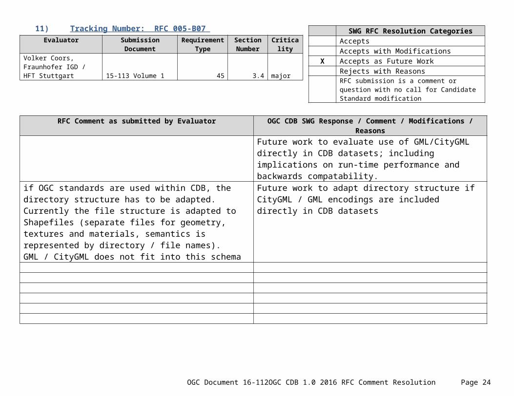
11) Tracking Number: RFC 005-B07 Evaluator Submission
DocumentRequirement
TypeSection Number
Criticality
Volker Coors, Fraunhofer IGD / HFT Stuttgart 15-113 Volume 1 45 3.4 major
RFC Comment as submitted by Evaluator OGC CDB SWG Response / Comment / Modifications / ReasonsFuture work to evaluate use of GML/CityGML directly in CDB datasets; including implications on run-time performance and backwards compatability.
if OGC standards are used within CDB, the directory structure has to be adapted. Currently the file structure is adapted to Shapefiles (separate files for geometry, textures and materials, semantics is represented by directory / file names). GML / CityGML does not fit into this schema
Future work to adapt directory structure if CityGML / GML encodings are included directly in CDB datasets
12) Tracking Number: RFC 005-B08 Evaluator Submission
DocumentRequirement
TypeSection Number
Criticality
Volker Coors, Fraunhofer IGD / HFT Stuttgart 15-113 Volume 1 general 3.3.8.3 normal
RFC Comment as submitted by Evaluator OGC CDB SWG Response / Comment / Modifications / Reasons
OGC Document 16-112 OGC CDB 1.0 2016 RFC Comment Resolution Page 18
SWG RFC Resolution CategoriesAcceptsAccepts with Modifications
X Accepts as Future WorkRejects with ReasonsRFC submission is a comment or question with no call for Candidate Standard modification
SWG RFC Resolution CategoriesAcceptsAccepts with ModificationsAccepts as Future Work
X Rejects with ReasonsRFC submission is a comment or question with no call for Candidate Standard modification

Is it suitable to focus on a single standard for distributed simulation (DIS)? There are other standards like HLA (High Level Architecture), which is mentioned in the preface and should be supported as well.
An approved standard from the Simulation Interoperability Standards Organization, SISO-STD-001.1-2015 defines a hierarchy of object and interaction classes for the High Level Architecture (HLA) that provides the capabilities defined in IEEE Std 1278.1TM-1995, IEEE Standard for Distributed Interactive Simulation.
The “RPR FOM”, described above, is widely used in the M&S industry to provide for DIS enumerations and other attributes within an HLA federation.
The CDB does not dictate any distributed simulation standard. It simply uses DIS schemas to apply standard attributes to moving models.
13) Tracking Number: RFC 005-B09 Evaluator Submission
DocumentRequirement
TypeSection Number
Criticality
Volker Coors, Fraunhofer IGD / HFT Stuttgart 15-113 Volume 1 115 5.7.1.2.7.1 normal
RFC Comment as submitted by Evaluator OGC CDB SWG Response / Comment / Modifications / Reasons
- The issues with the representation of attributes would be solved, if GML / CityGML would be used instead of Shapefiles.
The SWG accepts as Future Work investigation of alternate encodings for vector data, including the use of other OGC standards including CityGML.
OGC Document 16-112 OGC CDB 1.0 2016 RFC Comment Resolution Page 19
SWG RFC Resolution CategoriesAcceptsAccepts with Modifications
X Accepts as Future WorkRejects with ReasonsRFC submission is a comment or question with no call for Candidate Standard modification

14) Tracking Number: RFC 005-B10 Evaluator Submission
DocumentRequirement
TypeSection Number
Criticality
Volker Coors, Fraunhofer IGD / HFT Stuttgart 15-113 Volume 1 120 5.7.5.2 minor
RFC Comment as submitted by Evaluator OGC CDB SWG Response / Comment / Modifications / Reasons
- Does the CDB include runtime components or is it a dataset/database? Req. 120 gives directions for runtime components.
A CDB dataset does not include runtime components.
The specification of some CDB datasets may contain information that informs the behavior of runtime implementations of the data. Compliant run-time implementations are required to conform to these requirements in support of source-level and “fair fight” correlation requirements.
15) Tracking Number: RFC 005-B11 Evaluator Submission
DocumentRequirement
TypeSection Number
Criticality
Volker Coors, Fraunhofer IGD / HFT Stuttgart 15-113 Volume 1 2/4/2016 1.7 et seq. minor
OGC Document 16-112 OGC CDB 1.0 2016 RFC Comment Resolution Page 20
SWG RFC Resolution CategoriesX Accepts
Accepts with ModificationsAccepts as Future WorkRejects with ReasonsRFC submission is a comment or question with no call for Candidate Standard modification
SWG RFC Resolution CategoriesX Accepts
Accepts with ModificationsAccepts as Future WorkRejects with ReasonsRFC submission is a comment or question with no call for Candidate Standard modification

RFC Comment as submitted by Evaluator OGC CDB SWG Response / Comment / Modifications / ReasonsRemove explicit requirements; move text/explanations to implementation guidance.
- What is the purpose of many of the minimal requirements for hardware and operating systems (2GB address space, memory paging, ...)?
16) Tracking Number: RFC 005-B12 Evaluator Submission
DocumentRequirement
TypeSection Number
Criticality
Volker Coors, Fraunhofer IGD / HFT Stuttgart 15-113 Volume 1 N/A 3.2.3 normal
RFC Comment as submitted by Evaluator OGC CDB SWG Response / Comment / Modifications / Reasons
- The OGC provides the technique of transactional Web Feature Services (WFS/T) for transactions on vector data. If GML is used as data format, transactions should be performed by WFS/T.
CDB is primarily a data repository; it doesn’t by itself support transactions on data. A CDB producer could create transactional software to update a CDB. Transaction services can be used now in the creation of a CDB data store
OGC Document 16-112 OGC CDB 1.0 2016 RFC Comment Resolution Page 21
SWG RFC Resolution CategoriesAcceptsAccepts with ModificationsAccepts as Future Work
X Rejects with ReasonsRFC submission is a comment or question with no call for Candidate Standard modification

17) Tracking Number: RFC 005-B13 Evaluator Submission
DocumentRequirement
TypeSection Number
Criticality
Volker Coors, Fraunhofer IGD / HFT Stuttgart 15-113 Volume 1 75 5.1.7 normal
RFC Comment as submitted by Evaluator OGC CDB SWG Response / Comment / Modifications / Reasons
OGC standards provide standardized concepts for representing metadata (in particular for attributes) which should be used.
The SWG accepts as future work the investigation of alternative and additional representations of metadata.
18) Tracking Number: RFC 006-B01 Evaluator Submission
DocumentRequirement
TypeSection Number
Criticality
Egbert Casper, Chair of Special Interest Group 3D (SIG 3D) of GDI-DE 15-113 Volume 1 General, 45 4.3.4 Major
RFC Comment as submitted by Evaluator OGC CDB SWG Response / Comment / Modifications / ReasonsSee Proprietary Formats in General Comments
OGC Document 16-112 OGC CDB 1.0 2016 RFC Comment Resolution Page 22
SWG RFC Resolution CategoriesX Accepts
Accepts with ModificationsX Accepts as Future Work
Rejects with ReasonsRFC submission is a comment or question with no call for Candidate Standard modification
SWG RFC Resolution CategoriesAcceptsAccepts with Modifications
X Accepts as Future WorkRejects with ReasonsRFC submission is a comment or question with no call for Candidate Standard modification

The CBD candidate standard defines a directory / file structure for data for simulation applications, and defines the formats for CDB compliant data bases. For 3D features, ESRI Shapefiles are prescribed as data format (besides OpenFlight). Since shapefile is a proprietary, vendor specific data format, interoperability is affected. The OGC standard CityGML is at least as powerful as the shapefile format. CityGML has been widely adopted and is used throughout the world as a data model and exchange format for virtual 3D city and landscape models. The number of CityGML data sets and tools supporting CityGML is steadily increasing. Hence, CityGML should be used instead of shapefiles for representing 3D features in CDB , or should at least be used predominantly.The directory/file structure defined in Requirement 45 (section 3.4) is tailored to shapefiles, since separate files for outer geometry, interior geometry, outer textures, interior textures, materials etc. are used; semantics is represented by directory or file names. For CityGML or for GML application schemas in general, this structure is not suitable. Hence, this structure has to be modified in order to accommodate GML / CityGML.
Future work to evaluate use of CityGML directly in one or more CDB datasets, and to investigate the impact on run-time performance and backwards compatability.
19) Tracking Number: RFC 007-B01 Evaluator Submission
DocumentRequirement Type Section
NumberCriticalit
yBernard Leclerc, Senior Technical Specialist, CAE, Montreal, Canada
Document 16-009r1 - Volume 6: OGC CDB Rules for Encoding Data using OpenFlight
T2DModel Tree Structure Restrictions 6.2.2.1 Major
RFC Comment as submitted by Evaluator OGC CDB SWG Response / Comment / Modifications / ReasonsDiscussed in SWG meeting; approved by unanimous consent
OGC Document 16-112 OGC CDB 1.0 2016 RFC Comment Resolution Page 23
SWG RFC Resolution CategoriesX Accepts
Accepts with ModificationsAccepts as Future WorkRejects with ReasonsRFC submission is a comment or question with no call for Candidate Standard modification
During the implementation of T2DModels in applications such as the Image Generator, the Radar, and the Terrain Server, it has been found that the restriction that “Each layer SHALL be composed of exactly one OpenFlight Object node” is too restrictive and unnecessary. We ran into cases where multiple object nodes were necessary to represent a single layer. The restriction forces the creation of multiple layers, each having a single object node. However, these layers are disjoint (not overlapping) and, consequently, could have been processed all at once instead of in sequence.The proposed text to replace the stated restriction in Requirement 4 is that “Each layer SHALL be composed of zero, one, or more OpenFlight Object nodes”.
[Document attached by Bernard to the RFC comment submission has been uploaded to the OGC CDB SWG files here: https://portal.opengeospatial.org/files/?artifact_id=68803]
20) Tracking Number: RFC 007-B02 Evaluator Submission
DocumentRequirement Type Section
NumberCriticalit
yBernard Leclerc, Senior Technical Specialist, CAE, Montreal, Canada 16-009r1
Internal Structure of T2DModels
Figure 6-3 Major
RFC Comment as submitted by Evaluator OGC CDB SWG Response / Comment / Modifications / ReasonsDiscussed in SWG meeting; approved by unanimous consent
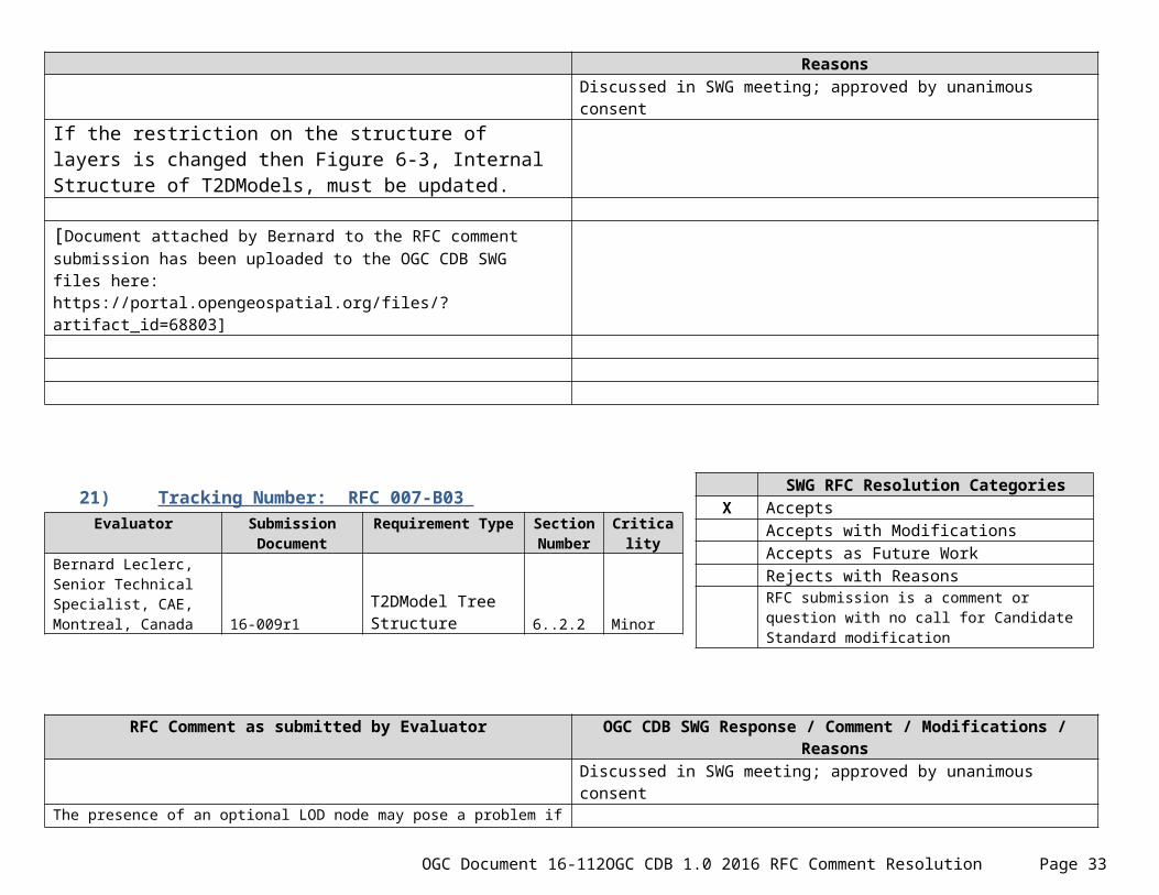
If the restriction on the structure of layers is changed then Figure 6-3, Internal Structure of T2DModels, must be updated.
[Document attached by Bernard to the RFC comment submission has been uploaded to the OGC CDB SWG files here:
OGC Document 16-112 OGC CDB 1.0 2016 RFC Comment Resolution Page 24
SWG RFC Resolution CategoriesX Accepts
Accepts with ModificationsAccepts as Future WorkRejects with ReasonsRFC submission is a comment or question with no call for Candidate Standard modification

https://portal.opengeospatial.org/files/?artifact_id=68803]
21) Tracking Number: RFC 007-B03 Evaluator Submission
DocumentRequirement Type Section
NumberCriticalit
yBernard Leclerc, Senior Technical Specialist, CAE, Montreal, Canada 16-009r1
T2DModel Tree Structure 6..2.2 Minor
RFC Comment as submitted by Evaluator OGC CDB SWG Response / Comment / Modifications / ReasonsDiscussed in SWG meeting; approved by unanimous consent
The presence of an optional LOD node may pose a problem if multiple object nodes per layer are allowed. The problem is related to the fact that sibling LOD nodes are mutually exclusive (as specified in requirement 26). Accordingly, a layer cannot have multiple LOD nodes as its immediate children; a group node would be necessary to isolate a LOD node from its siblings. However, to keep the structure of T2DModels as simple as possible, and since the LOD node is optional, I would recommend that no LOD node be used when multiple object nodes are necessary to represent a layer.
[Document attached by Bernard to the RFC comment submission has been uploaded to the OGC CDB SWG files here: https://portal.opengeospatial.org/files/?artifact_id=68803]
OGC Document 16-112 OGC CDB 1.0 2016 RFC Comment Resolution Page 25
SWG RFC Resolution CategoriesX Accepts
Accepts with ModificationsAccepts as Future WorkRejects with ReasonsRFC submission is a comment or question with no call for Candidate Standard modification

22) Tracking Number: RFC 007-B04 Evaluator Submission
DocumentRequirement Type Section
NumberCriticalit
yBernard Leclerc, Senior Technical Specialist, CAE, Montreal, Canada 16-009r1
T2DModel Tree Structure 6.2.2 Editorial
RFC Comment as submitted by Evaluator OGC CDB SWG Response / Comment / Modifications / ReasonsDiscussed in SWG meeting; approved by unanimous consent
The last sentence of the section is “Each layer has an optional LOD node followed by a fixed hierarchy of regular OpenFlight Object, Face, and Mesh nodes.” It is suggested to remove two words, fixed and regular, to simplify the sentence; especially if the above proposed changes are accepted. The resulting sentence would then be “Each layer has an optional LOD node followed by a hierarchy of OpenFlight Object, Face, and Mesh nodes.”
[Document attached by Bernard to the RFC comment submission has been uploaded to the OGC CDB SWG files here: https://portal.opengeospatial.org/files/?artifact_id=68803]
23) Tracking Number: RFC 008-B01 Evaluator Submission
DocumentRequirement
TypeSection Number
Criticality
David Graham, CAE Inc. Volume 9: schemas metadata/schemas Minor
RFC Comment as submitted by Evaluator OGC CDB SWG Response / Comment / Modifications / ReasonsDiscussed in SWG meeting; approved by unanimous consent
The candidate standard documents reference Volume 9: OGC CDB
OGC Document 16-112 OGC CDB 1.0 2016 RFC Comment Resolution Page 26
SWG RFC Resolution CategoriesX Accepts
Accepts with ModificationsAccepts as Future WorkRejects with ReasonsRFC submission is a comment or question with no call for Candidate Standard modification
SWG RFC Resolution CategoriesX Accepts
Accepts with ModificationsAccepts as Future WorkRejects with ReasonsRFC submission is a comment or question with no call for Candidate Standard modification

Schema Package. A link to the OGC CDB 1.0 Candidate Standard schema package was not provided in the RFC requests page, however, a schema package was provided to the OGC staff in February 2016 for consideration as a normative part of the candidate standard. (A link to the submitted schema is on the OGC portal here: https://portal.opengeospatial.org/files/?artifact_id=67106In the normal course of maintaining the CDB as part of an industry-led governance group, CAE/Presagis/FSI have routinely updated the schemas to make corrections and additions. We recommend that the schema that has been previously provided in the link above, be replaced with the schema that is also on the CDB SWG project in the OGC portal in this file: https://portal.opengeospatial.org/files/?artifact_id=67432These are the specific changes to the metadata/schemas that will become part of the normative CDB candidate standard if this recommended change is accepted:Correction to the Feature Data Dictionary • The name of FACC code UF002-000 exceeded 32 characters. • Building_Component_Entrance_Or_Exit has been changed to Building_Component_Entrance_Exit
Additional Base Materials added for use with building interiors: BM_AIR BM_FOAMBOARD BM_GLASSWOOL BM_SPRAYFOAM BM_VACUUMCDB_Attributes.xml modified to correctly reflect Table 5-27
24) Tracking Number: RFC 009-B01 Evaluator Submission
DocumentRequirement
TypeSection Number
Criticality
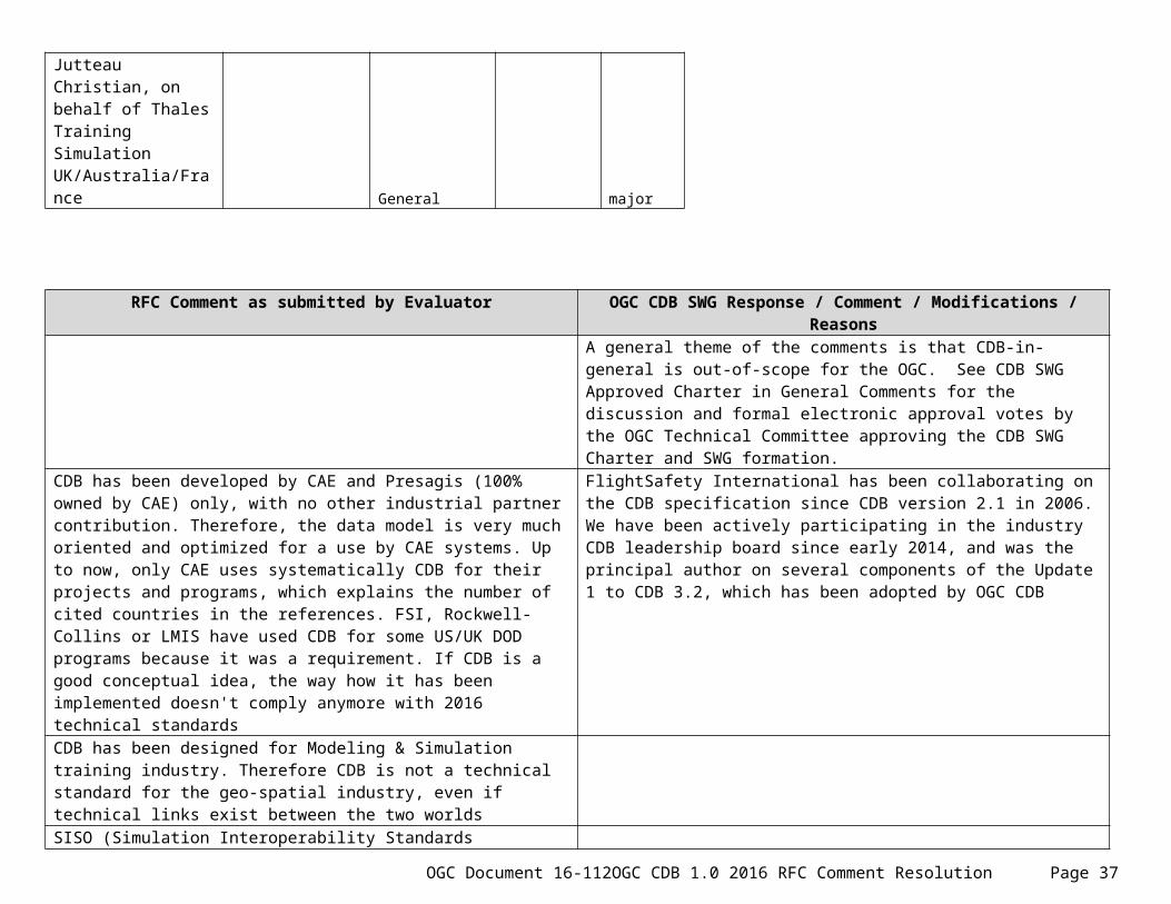
Jutteau Christian, on behalf of Thales Training Simulation UK/Australia/France General major
RFC Comment as submitted by Evaluator OGC CDB SWG Response / Comment / Modifications / ReasonsA general theme of the comments is that CDB-in-general is out-of-scope for the OGC. See CDB SWG Approved Charter in General Comments for the
OGC Document 16-112 OGC CDB 1.0 2016 RFC Comment Resolution Page 27
SWG RFC Resolution CategoriesAcceptsAccepts with ModificationsAccepts as Future WorkRejects with Reasons
X RFC submission is a comment or question with no call for Candidate Standard modification

discussion and formal electronic approval votes by the OGC Technical Committee approving the CDB SWG Charter and SWG formation.
CDB has been developed by CAE and Presagis (100% owned by CAE) only, with no other industrial partner contribution. Therefore, the data model is very much oriented and optimized for a use by CAE systems. Up to now, only CAE uses systematically CDB for their projects and programs, which explains the number of cited countries in the references. FSI, Rockwell-Collins or LMIS have used CDB for some US/UK DOD programs because it was a requirement. If CDB is a good conceptual idea, the way how it has been implemented doesn't comply anymore with 2016 technical standards
FlightSafety International has been collaborating on the CDB specification since CDB version 2.1 in 2006. We have been actively participating in the industry CDB leadership board since early 2014, and was the principal author on several components of the Update 1 to CDB 3.2, which has been adopted by OGC CDB
CDB has been designed for Modeling & Simulation training industry. Therefore CDB is not a technical standard for the geo-spatial industry, even if technical links exist between the two worldsSISO (Simulation Interoperability Standards Organization) is supposed to manage the standards for training Industry. CAE proposed CDB at SISO first as a shared specification and then withdrew it to be processed through OGC as a best practice. The fact that CDB is public is fine, but why OGC should go further with a 1000 pages specification which nobody read totally?As it doesn’t rely on up-to-date formats and data structures, and is not flexible at all, CDB doesn’t favor innovation. CDB is behind what alternate visual technologies can provide (e.g. "point cloud" instead of polygons, …)
The previous industry board was, and the current CDB SWG is open to proposals to add new capabilities into the CDB
25) Tracking Number: RFC 009-B02 Evaluator Submission
DocumentRequirement
TypeSection Number
Criticality
Jutteau Christian, on behalf of Thales Training Simulation UK/Australia/France
Technical general major
RFC Comment as submitted by Evaluator OGC CDB SWG Response / Comment / Modifications / Reasons
OGC Document 16-112 OGC CDB 1.0 2016 RFC Comment Resolution Page 28
SWG RFC Resolution CategoriesAcceptsAccepts with ModificationsAccepts as Future Work
X Rejects with ReasonsX RFC submission is a comment or question with no call
for Candidate Standard modification

CDB has been designed for Air applications (commercial aircrafts, fast jets, helicopters) but is not suited for ground warfare applications, because of the terrain database complexity which is unmanageable through CDB structure (numerous buildings, streets, pavements with kerbs, …
Several new datasets were added in CDB 3.2 to support ground simulation
CDB is based on old-fashioned formats (Shapefile, Open Flight, RGB, …) which are not necessarily opened. On the other hand, Open Street Map is not supported while it is very commonly used.
OpenStreetMap data can (and has) been imported into CDB
CDB structure relies on a huge collection of files while it should be managed with POST-GIS tables (Postgres SQL DBMS). Therefore, the coverage/accuracy of a given area are limited by file system capabilities. All levels of detail on imagery and terrain are kept in the CDB data which makes version control and distribution of large datasets more time consuming.Cartography requirements such as symbology are not managed by CDB
Symbology is location and device dependent. Having symbology in CDB is counter to the purpose of a client independent data set.
Independent layers at raw data level are no more once in CDB structure. Imagery content is linked to the 3D representation (TTS has produced CDB for CAE IG, for which “baking” the image of the 3D airport in the imagery was required, making the imagery depending on 3D model.There is a strong dependency between GTModelInteriorGeometry and GTModelGeometry as they have to be perfectly correlated. Splitting models into those two dataset is completely specific to CDB and not representative of usual practices.).
FlightSafety has no such baking requirements; therefore this isn’t a CDB attribute.Model geometry is split to allow CDB to apply efficiently to multiple domains. For example, interiors in flight simulation would degrade performance without benefit, but are critical for ground simulation.
Recovering source data from a CDB database is complex and doesn’t guarantee its completenes. For example, we could miss multi-texturing uv for apron light illumination, detail texture, animation, procedural position of vegetation, runway contaminations
This is more of a technique issue. Tiled2D can keep a lot of model content together without splitting it into different datasets. Animation is not a part of CDB. Procudural positioning of vegetation can be done, but at the loss of correlation when used across different devices.
Moreover, from a shared training Industry point of view, CDB specification specifically warns against procedural improvement of terrain features, because it (obviously) breaks correlation. Procedural improvement means adding additional terrain fidelity that may not exist in the source data, for example improving ground clutter, adding detailed folds in the ground or adding traffic lights or road barriers. CDB (and any other mandated run-time terrain format) limits the ability of engine developers to innovate in their representation of terrain. For example, if CDB doesn't support definition for destructible tunnels, then the format either needs to be customized for the specific run-time (breaking the standard) or the standard has to be updated and this won't happen quickly
The CDB specification doesn’t limit what you can do with the data. Procedural improvements are allowed by a client device, and have been performed by CAE (SEGen). Obviously, procedural content would break correlation between devices, and wouldn’t be useful in all cases.
OGC Document 16-112 OGC CDB 1.0 2016 RFC Comment Resolution Page 29

26) Tracking Number: RFC 009-B03 Evaluator Submission
DocumentRequirement
TypeSection Number
Criticality
Jutteau Christian, on behalf of Thales Training Simulation UK/Australia/France
CDB Specification Volume 1 § 5.7.1; p359, § 6.5.1 major
RFC Comment as submitted by Evaluator OGC CDB SWG Response / Comment / Modifications / ReasonsThe present CDB candidate standard has specific, extensive Best Practices documents describing the use of Shapefiles and OpenFlight.
Present CDB doesn’t comply with Shapefile specifications (Features attributes are supported through shapefile with two dbf rather than one
These exist for backwards compatibility with CDB 3.2. Fixing these issues (or replacing these formats) are future work.
There is no standard for OpenFlight format, and some comments attributes have been assigned to a given meaning specific to CDB (For example, Model zones is encoded in the comments)
27) Tracking Number: RFC 009-B04 Evaluator Submission
DocumentRequirement
TypeSection Number
Criticality
Jutteau Christian, on behalf of Thales Training Simulation UK/Australia/France
Tentative proposal
OGC Document 16-112 OGC CDB 1.0 2016 RFC Comment Resolution Page 30
SWG RFC Resolution CategoriesAcceptsAccepts with Modifications
X Accepts as Future WorkRejects with ReasonsRFC submission is a comment or question with no call for Candidate Standard modification
SWG RFC Resolution CategoriesAcceptsAccepts with ModificationsAccepts as Future WorkRejects with Reasons
X RFC submission is a comment or question with no call for Candidate Standard modification

RFC Comment as submitted by Evaluator OGC CDB SWG Response / Comment / Modifications / ReasonsEvaluator and Thales Training have been invited to present their ideas to the OGC 3DIM DWG
Rather than looking for a universal 3D terrain format (for a real-time use or not), the future is certainly to use a complete “real 3D geographical format” at a source level which allowed to share, exchange, update and extend 3D terrain source data for various applications (e.g. Visual, CGF simulation, Cartographic display). As an example, nowhere we can get a complete attribution on the tarmac features for an airport.In conclusion, a better solution would be to manage source at true GIS and Gaming format level to allow models and geospatial data to be updated or supplied from any number of sources
28) Tracking Number: RFC 010-B01 Evaluator Submission
DocumentRequirement
TypeSection Number
Criticality
Bernard Leclerc, Senior Technical Specialist, CAE, Montreal, Canada 15-113r1 Volume 1 74 5.1.6 Major
RFC Comment as submitted by Evaluator OGC CDB SWG Response / Comment / Modifications / ReasonsDiscussed in SWG meeting; approved by unanimous consent
The requirement refers to version 3.0, 3.1, and 3.2 of the original CDB Specification from the industry. In the context of the current effort to create version 1.0 of the OGC CDB Standard, I propose the addition of an XML attribute to the Specification element to include the name of the organization that has authority over the standard, that is OGC. This would allow the version number to be reset to 1.0 and still provide a form of compatibility
OGC Document 16-112 OGC CDB 1.0 2016 RFC Comment Resolution Page 31
SWG RFC Resolution CategoriesX Accepts
Accepts with ModificationsAccepts as Future WorkRejects with ReasonsRFC submission is a comment or question with no call for Candidate Standard modification

with previous version of the standard. The presence of this new XML attribute would allow an application that is developed for OGC CDB 1.0 to distinguish between CDB Versions that are OGC-compliant and CDB Versions created at the time of the CDB Specification (3.2, 3.1 or 3.0).The proposed changed is as follow: <Specification authority="OGC" version="1.0"/>The rest of the text of section 5.1.6 will need to reflect the proposed change… if accepted.
29) Tracking Number: RFC 011-B01 Evaluator Submission
DocumentRequirement
TypeSection Number
Criticality
Gregory Peele, Jr. / Applied Research Associates, Inc. General
Optional encodings using Shapefiles and Openflight Major
RFC Comment as submitted by Evaluator OGC CDB SWG Response / Comment / Modifications / Reasons
Is it theoretically possible to instantiate a compliant CDB without using the current format encodings? I don’t believe so - Section 4 appears to assert that all current encodings are normative. It mostly defers to the Best Practices documents to specify the Shapefile and OpenFlight encoding requirements. GeoTIFF and JPEG-2000 encodings remain core requirements. That makes sense if the objection to the others is purely about lack of open standards. Those raster choices force specific performance tradeoffs on CDB runtime clients though - JPEG-2000 is very CPU intensive in exchange for its compression level, and heightmap compression is an interestingly complicated discussion. Also, there are still requirements in this document that explicitly reference the encodings, for
A CDB containing elevation and VSTI imagery is a valid CDB.
Greg’s email comment: – (Resolved) The new language suggesting that future encodings are planned and the generalization of the requirements language to not reference format other than as examples is a reasonable compromise. I’d prefer a forward-compatible way to develop these new encodings but can accept that this is out of scope and will be considered in next version. Looks like Carl has left comments on remaining places where this still needs to be worked on.
OGC Document 16-112 OGC CDB 1.0 2016 RFC Comment Resolution Page 32
SWG RFC Resolution CategoriesAcceptsAccepts with Modifications
X Accepts as Future WorkRejects with ReasonsRFC submission is a comment or question with no call for Candidate Standard modification
example #63. I know that backward compatibility with fielded systems is a goal for those who make or use said systems (less so competing vendors, I’m sure) and that addressing the general format question is a priority for CDB 2.0, so I appreciate the difficulty of reconciling the tension between short-term vs. long-term goals. That said, I have to ask why the Shapefile and OpenFlight encodings are Best Practices if they are mandatory to conform to the standard – as I read it, if you do not use these encodings, there is no conformant way to implement vector or model layers.
30) Tracking Number: RFC 011-B02 Evaluator Submission
DocumentRequirement
TypeSection Number
Criticality
Gregory Peele, Jr. / Applied Research Associates, Inc. General Extensions Major
RFC Comment as submitted by Evaluator OGC CDB SWG Response / Comment / Modifications / Reasons
There does not appear to be a standard way to add or extend the available layers other than modifying the standard itself. All extensions of CDB must use the Extension mechanism which is completely freeform and unstructured. Being able to define new layers in a structured way by analogy to existing standard layers would improve the likelihood of interoperability of extensions and ease integration of them into future standard versions. This would probably require metadata to describe the current layers in terms of encoding, content, and role to pull off.
Extensibility should be a topic for future discussion and/or work
Greg’s email comment: Will accept deferral to next version) I think not having a more structured extension mechanism will make experimentation and forward compatibility much harder, but I’d accept that this is out of scope and a commitment to consider this in the next version.
OGC Document 16-112 OGC CDB 1.0 2016 RFC Comment Resolution Page 33
SWG RFC Resolution CategoriesAcceptsAccepts with Modifications
X Accepts as Future WorkRejects with ReasonsRFC submission is a comment or question with no call for Candidate Standard modification

31) Tracking Number: RFC 011-B03 Evaluator Submission
DocumentRequirement
TypeSection Number
Criticality
Gregory Peele, Jr. / Applied Research Associates, Inc. Volume 1 3 1.7.1.2 Minor
RFC Comment as submitted by Evaluator OGC CDB SWG Response / Comment / Modifications / ReasonsRequirements to be removed from Volume 1 and moved to Volume 10: Implementation Guidance
What is the basis for the minimum OS requirements? Mobile and constrained devices may not necessarily meet all of these requirements. It would be possible, for example, to use a compliant CDB repository on a 16-bit processor lacking hardware IEEE 754 FPU support, with less than 2 GB address space, without network communication or virtual memory. It wouldn’t be very pleasant to program or use, but it could be made to work for specific use cases. So I’m unclear how these requirements apply to a file repository standard.
Greg’s email comment: (Resolved) Moving to implementation guidance is good.
32) Tracking Number: RFC 011-B04 Evaluator Submission
DocumentRequirement
TypeSection Number
Criticality
OGC Document 16-112 OGC CDB 1.0 2016 RFC Comment Resolution Page 34
SWG RFC Resolution CategoriesX Accepts
Accepts with ModificationsAccepts as Future WorkRejects with ReasonsRFC submission is a comment or question with no call for Candidate Standard modification
SWG RFC Resolution CategoriesX Accepts
Accepts with ModificationsAccepts as Future WorkRejects with ReasonsRFC submission is a comment or question with no call for Candidate Standard modification

Gregory Peele, Jr. / Applied Research Associates, Inc. Volume 1 4 1.7.1.4 Minor
RFC Comment as submitted by Evaluator OGC CDB SWG Response / Comment / Modifications / ReasonsRequirement removed; moved to implementation guidance.
What are the basis for the minimum memory representation requirements? It would be theoretically possible, for example, to use a compliant CDB repository on hardware that lacked any of the listed capabilities and software-emulated every integer and floating point type without virtual memory support. Mobile and constrained devices may not meet every requirement point, though this is becoming rarer. A pure 64-bit system that lacked 32-bit addressing mode would not meet the requirement on technicality, though that’s just being pedantic. I am unclear why these requirements apply to CDB as a file repository at all.
(Resolved) Moving to implementation guidance is good.
33) Tracking Number: RFC 011-B05 Evaluator Submission
DocumentRequirement
TypeSection Number
Criticality
Gregory Peele, Jr. / Applied Research Associates, Inc. Volume 1
8, 10, 13, 14, 65, 66, 67 1.7.2, 3.6.2 Major
RFC Comment as submitted by Evaluator OGC CDB SWG Response / Comment / Modifications / ReasonsRelates to Future work on alternative/multiple Coordinate Reference Systems
OGC Document 16-112 OGC CDB 1.0 2016 RFC Comment Resolution Page 35
SWG RFC Resolution CategoriesAcceptsAccepts with Modifications
X Accepts as Future WorkRejects with ReasonsRFC submission is a comment or question with no call for Candidate Standard modification

The strict requirements for the WGS-84 horizontal datum and vertical datum, plate carrée map projection, and specific tile and LOD layout present a variety of limitations that I’m sure have already extensively been discussed in the SWG. To present a few that have come up in my actual simulation experience: it would be difficult, for example, to instantiate a compliant CDB of any planetary body other than Earth, ruling out space exploration domain despite its similarities to the aviation domain. The tile scheme is also not well suited for polar simulation due to the singularities it induces. I’m aware that generalized tiling is an open discussion across multiple SWGs so I won’t belabor the point.
CDB explicitly refers only to representing Earth. Expanding to other heavenly bodies would be future work.
Better polar cap representations should be future work.
Greg’s email comment: (Will accept deferral to next version) I knew this was impractical for this version, just making a point and I know you will consider in next version.
34) Tracking Number: RFC 011-B06 Evaluator Submission
DocumentRequirement
TypeSection Number
Criticality
Gregory Peele, Jr. / Applied Research Associates, Inc. Volume 1 15 2.1.5 Minor
RFC Comment as submitted by Evaluator OGC CDB SWG Response / Comment / Modifications / Reasons
If I interpret this correctly, it is not possible to omit intermediate LODs – for example, to have data for LOD 0 and LOD 6, but omit LODs 1-5. If correct, this would not be ideal for ground combat simulation and gaming use cases, where typically LOD 5-7 would be used for first-person views and LOD 0-1 might be appropriate for a map level view, but the intermediate LODs are not always useful to the client despite requiring disk space and
Yes, you are correct. CDB is meant to work across a range of systems and simulators, and as such needs to support more than one use case.
Greg’s email comment: *(Partially resolved) The comment sheet explains that I understood correctly, so that’s good. Can the language for Requirement 15 be expanded to explain what “complete” means? Also, aside from compatibility with the existing implementations, is this a requirement that
OGC Document 16-112 OGC CDB 1.0 2016 RFC Comment Resolution Page 36
SWG RFC Resolution CategoriesAcceptsAccepts with ModificationsAccepts as Future WorkRejects with Reasons
X RFC submission is a comment or question with no call for Candidate Standard modification
terrain generation time. If I am misunderstanding the requirement, clarification on what is meant by “complete” would be helpful.
can be dropped in this version or the next version?
The evaluator interprets requirement 15 correctly; all tiles from the finest LOD provided by the modeler to the coarsest CDB LOD (i.e. LOD -10) must be provided.
35) Tracking Number: RFC 011-B07 Evaluator Submission
DocumentRequirement
TypeSection Number
Criticality
Gregory Peele, Jr. / Applied Research Associates, Inc. Volume 1 38 3.2.5 Major
RFC Comment as submitted by Evaluator OGC CDB SWG Response / Comment / Modifications / ReasonsRequirement removed; section moved to implementation guidance
I understand why the current versioning mechanism is not very efficient, but the version limit numbers seem arbitrary at first glance. Is there a specific rationale for these values? This restriction eliminates CDB from consideration for the iterative incremental update use case. Scaling to arbitrary revision counts and finer-grained revisioning should be a long-term goal.
The limit is there for run-time performance for clients. Perhaps we can remove the limit in future versions that aren’t targeted toward realtime simulation.
Greg’s email response: * (Partially resolved) The comment sheet provides a great answer. If this can be turned from a requirement into an implementation guideline, that’s great. The footnote 16 is definitely helpful.
The rationale for the choice of 8 versions max is provided in footnote 16
OGC Document 16-112 OGC CDB 1.0 2016 RFC Comment Resolution Page 37
SWG RFC Resolution CategoriesX Accepts
Accepts with ModificationsAccepts as Future WorkRejects with ReasonsRFC submission is a comment or question with no call for Candidate Standard modification

36) Tracking Number: RFC 011-B08 Evaluator Submission
DocumentRequirement
TypeSection Number
Criticality
Gregory Peele, Jr. / Applied Research Associates, Inc. Volume 1 40 3.3.5 Major
RFC Comment as submitted by Evaluator OGC CDB SWG Response / Comment / Modifications / Reasons
What happens if a geospecific model spans multiple tiles? It is stored in all tiles duplicated? Is it clipped to tile boundaries? Does the anchor point determine which tile it lands in, and if so how is it determined that it intersects the other tiles? This situation comes up a lot in applying AI behaviors to ground combat, particularly for geospecific building and tunnel models. If this is covered by any other section, I missed it.
It is stored in a single tile, where the location of the model origin occurs. There is a limit to how much a model can overlap another tile within the CDB. This could use some improvement in future versions.
Greg’s email response: * (Partially resolved) The comment sheet mentions that the anchor point determines tile. This presents some runtime issues for large tile-spanning models vs. ground simulation, but is well-defined and I can work around that. Can Requirement 40 be tweaked to explicitly say “anchor point position” instead of just “position?” to make this completely clear?
A model is never duplicated; it appears in one tile based on its anchor point (its origin). The model is not clipped to the tile boundaries.
37) Tracking Number: RFC 011-B09 Evaluator Submission Requirement Section Criticality
OGC Document 16-112 OGC CDB 1.0 2016 RFC Comment Resolution Page 38
SWG RFC Resolution CategoriesAcceptsAccepts with Modifications
X Accepts as Future WorkRejects with ReasonsRFC submission is a comment or question with no call for Candidate Standard modification
SWG RFC Resolution CategoriesX Accepts
Accepts with ModificationsAccepts as Future WorkRejects with ReasonsRFC submission is a comment or question with no call for Candidate Standard modification

Document Type NumberGregory Peele, Jr. / Applied Research Associates, Inc. Volume 1 90 5.6.1.4.1 Editorial
RFC Comment as submitted by Evaluator OGC CDB SWG Response / Comment / Modifications / ReasonsAction for volume editor to correct
The requirement misspells “Mesh Type” as “Mest Type”
38) Tracking Number: RFC 012-B01 Evaluator Submission
DocumentRequirement
TypeSection Number
Criticality
David Graham, CAE Inc. Volume 1 5.8.1 Minor
RFC Comment as submitted by Evaluator OGC CDB SWG Response / Comment / Modifications / ReasonsDiscussed in SWG meeting; approved by unanimous consent
Recommend add new section 5.8.1.1 GSModel Archive Size Limit. The size of any GSModel archive is limited to 32 MB to permit reading, processing and writing the file at runtime.Implementers have encountered GSModel Archives with sizes approaching 2GB; this limit is proposed for run-time performance reasons.[Note: this recommendation has been incorporated into the r1 draft of Volume 1]
This comment is part of the Industry recommended ‘Update 1 to CDB V3.2’..
OGC Document 16-112 OGC CDB 1.0 2016 RFC Comment Resolution Page 39
SWG RFC Resolution CategoriesX Accepts
Accepts with ModificationsAccepts as Future WorkRejects with ReasonsRFC submission is a comment or question with no call for Candidate Standard modification

This package of recommendations is available in its original version on the OGC portal here: https://portal.opengeospatial.org/index.php?m=projects&a=view&project_id=466&tab=2&artifact_id=67429
39) Tracking Number: RFC 012-B02 Evaluator Submission
DocumentRequirement
TypeSection Number
Criticality
David Graham, CAE Inc. Volume 1 5.8.1, 5.8.2 Minor
RFC Comment as submitted by Evaluator OGC CDB SWG Response / Comment / Modifications / ReasonsDiscussed in SWG meeting; approved by unanimous consent
Recommended updates/changes to Dataset 308, 309, 310, 311, and 312; tables incorporating recommended changes follow:
OGC Document 16-112 OGC CDB 1.0 2016 RFC Comment Resolution Page 40
SWG RFC Resolution CategoriesX Accepts
Accepts with ModificationsAccepts as Future WorkRejects with ReasonsRFC submission is a comment or question with no call for Candidate Standard modification

Editor note: the text 'explained in Chapter 6' needs to be changed to 'explained in Volume 6'....the appropriate reference to the right place in what 'used-to-be' Chapter 6 in the BP Volume 1https://portal.opengeospatial.org/index.php?m=projects&a=view&project_id=466&tab=2&artifact_id=67429
40) Tracking Number: RFC 012-B03 Evaluator Submission
DocumentRequirement
TypeSection Number
Criticality
David Graham, CAE Inc. Volume 6 6.8 Minor
RFC Comment as submitted by Evaluator OGC CDB SWG Response / Comment / Modifications / ReasonsDiscussed in SWG meeting; approved by unanimous consent
Recommend replacing the textual description of the concept of ‘Significant Size’ with new text from the Update 1 reference on the OGC portal. The concept of Significant Size has been simplified and better described.
Editor note: The new 'Significant Size' material to be used for the replacement in Volume 6 is in the CDB 3.2 Volume 1 Chapter 6; this entire Chapter was moved out of OGC CDB 1.0 Volume 1 and into a new Volume 6
This comment is part of the Industry recommended ‘Update 1 to CDB V3.2’.. This package of recommendations is available in its original version on the OGC portal here: https://portal.opengeospatial.org/index.php?m=projects&a=view&project_id=466&tab=2&artifact_id=67429
41) Tracking Number: RFC 012-B04 Evaluator Submission
DocumentRequirement
TypeSection Number
Criticality
David Graham, CAE Inc.
Volume 1
Handling of Topological Networks 5.7.1 Minor
OGC Document 16-112 OGC CDB 1.0 2016 RFC Comment Resolution Page 41
SWG RFC Resolution CategoriesX Accepts
Accepts with ModificationsAccepts as Future WorkRejects with ReasonsRFC submission is a comment or question with no call for Candidate Standard modification
SWG RFC Resolution CategoriesX Accepts
Accepts with ModificationsAccepts as Future WorkRejects with ReasonsRFC submission is a comment or question with no call for Candidate Standard modification

RFC Comment as submitted by Evaluator OGC CDB SWG Response / Comment / Modifications / ReasonsDiscussed in SWG meeting; approved by unanimous consent
Full text of recommended changes are in:https://portal.opengeospatial.org/index.php?m=projects&a=view&project_id=466&tab=2&artifact_id=67429· Addition of Section 5.7.1.6.4, Network Vector Priority· Addition of Section 5.7.1.9, Vector Significant Size and Spatial Significance Criteria· Addition of new text, Vector Priority Tile-LOD Generation
This comment is part of the Industry recommended ‘Update 1 to CDB V3.2’.. This package of recommendations is available in its original version on the OGC portal here: https://portal.opengeospatial.org/index.php?m=projects&a=view&project_id=466&tab=2&artifact_id=67429
42) Tracking Number: RFC 012-B05 Evaluator Submission
DocumentRequirement
TypeSection Number
Criticality
David Graham, CAE Inc. Volume 9 Metadata/schema
RFC Comment as submitted by Evaluator OGC CDB SWG Response / Comment / Modifications / Reasons
The FDD is stored in Feature_Data_Dictionary.xmlFACC codes recommended additions for Lineal Vector DatasetsPriority field in FDD is referred to in the new textual material recommended above in ‘Vector Priority Tile-LOD Generation’
[Note: included here for traceability to the RFC on the OGC 'requests' archive; this metadata change was separately recommended in a separate comment (see RFC 008-B01) (above), and the aggregate change to the metadata schema was approved by unanimous consent in the OGC CDB SWG online meeting 05/27/2016]
OGC Document 16-112 OGC CDB 1.0 2016 RFC Comment Resolution Page 42
SWG RFC Resolution CategoriesX Accepts
Accepts with ModificationsAccepts as Future WorkRejects with ReasonsRFC submission is a comment or question with no call for Candidate Standard modification

This comment is part of the Industry recommended ‘Update 1 to CDB V3.2’.. This package of recommendations is available in its original version on the OGC portal here: https://portal.opengeospatial.org/index.php?m=projects&a=view&project_id=466&tab=2&artifact_id=67429
43) Tracking Number: RFC 012-B06 Evaluator Submission
DocumentRequirement
TypeSection Number
Criticality
David Graham, CAE Inc. Addition to Countries List Minor
RFC Comment as submitted by Evaluator OGC CDB SWG Response / Comment / Modifications / Reasons
· 337 – Serbia· 338 – Montenegro· 339 – South Sudan
This comment is part of the Industry recommended ‘Update 1 to CDB V3.2’.. This package of recommendations is available in its original version on the OGC portal here: https://portal.opengeospatial.org/index.php?m=projects&a=view&project_id=466&tab=2&artifact_id=67429
44) Tracking Number: RFC 012-B07 Evaluator Submission
DocumentRequirement Type Section
NumberCriticality
David Graham, CAE Inc. Addition of new Airliner Codes 287-297 Minor
OGC Document 16-112 OGC CDB 1.0 2016 RFC Comment Resolution Page 43
SWG RFC Resolution CategoriesX Accepts
Accepts with ModificationsAccepts as Future WorkRejects with ReasonsRFC submission is a comment or question with no call for Candidate Standard modification
SWG RFC Resolution CategoriesX Accepts
Accepts with ModificationsAccepts as Future WorkRejects with ReasonsRFC submission is a comment or question with no call for Candidate Standard modification

RFC Comment as submitted by Evaluator OGC CDB SWG Response / Comment / Modifications / Reasons
287 CJR Caverton Helicopters288 KZR Air Astana289 ROU Air Canada Rouge290 DWT Darwin Airline291 UTA UTair Aviation292 AZN Amaszonas293 FDB Flydubai294 UZB Uzbekistan Airways295 PGT Pegasus Airlines296 ABY Air Arabia297 AXB Air India Express
This comment is part of the Industry recommended ‘Update 1 to CDB V3.2’.. This package of recommendations is available in its original version on the OGC portal here: https://portal.opengeospatial.org/index.php?m=projects&a=view&project_id=466&tab=2&artifact_id=67429
45) Tracking Number: RFC 012-B08 Evaluator Submission
DocumentRequirement
TypeSection Number
Criticality
David Graham, CAE Inc.
Volume 9 Metadata/schema
Version.xml [described in section 5.1.6] Major
RFC Comment as submitted by Evaluator OGC CDB SWG Response / Comment / Modifications / ReasonsThis comment recommending a change to 'version.xml' is superseded by a separate more-comprehensive comment submitted by Bernard Leclerc (see RFC 010-B01 above), and which was accepted by unanimous consent
OGC Document 16-112 OGC CDB 1.0 2016 RFC Comment Resolution Page 44
SWG RFC Resolution CategoriesAccepts
X Accepts with ModificationsAccepts as Future WorkRejects with ReasonsRFC submission is a comment or question with no call for Candidate Standard modification

05/27/16: Recommend an optional XML attribute for ‘org’ be added to Version.xml. The optional ‘org’ attribute can be set to value “OGC” to clearly differentiate between legacy CDB versions (ranging from 1.0 to 3.2 Update 1) and OGC CDB versions
This comment is part of the Industry recommended ‘Update 1 to CDB V3.2’.. This package of recommendations is available in its original version on the OGC portal here: https://portal.opengeospatial.org/index.php?m=projects&a=view&project_id=466&tab=2&artifact_id=67429
46) Tracking Number: RFC 013-B01 Evaluator Submission
DocumentRequirement
TypeSection Number
Criticality
Gregory Peele, Jr. / Applied Research Associates, Inc. Volume 1 General Other
RFC Comment as submitted by Evaluator OGC CDB SWG Response / Comment / Modifications / ReasonsSWG Discussion
Is the target for this version of the CDB standard explicitly aviation simulation? Or is it intended to address the full breadth of interoperable 3D synthetic environments for simulation across ground, underground, urban, sea, undersea, aviation, arctic, space, etc.? Understanding the target domain(s) helps frame how to approach the standard and decide questions of scope and completeness.
OGC Document 16-112 OGC CDB 1.0 2016 RFC Comment Resolution Page 45
SWG RFC Resolution CategoriesAcceptsAccepts with ModificationsAccepts as Future WorkRejects with Reasons
X RFC submission is a comment or question with no call for Candidate Standard modification

47) Tracking Number: RFC 013-B02 Evaluator Submission
DocumentRequirement
TypeSection Number
Criticality
Gregory Peele, Jr. / Applied Research Associates, Inc. Volume 1 2 1.7.1.1 Minor
RFC Comment as submitted by Evaluator OGC CDB SWG Response / Comment / Modifications / Reasonson 5/27/16 the SWG unanimously approved a motion to move the requirements related to OS, hardware, and file system 'out' of Volume 1 (normative) and into Volume 10, Implementation Guidance.
Are the filesystem requirements the minimum necessary to represent a minimal CDB? Or do they represent the requirements for representing a CDB that has all possible layers, tiles, and LODs? The latter perspective makes more sense for the specific numeric limits documented so ideally that should be clarified. I’m not sure how points 5 (removable media) and 6 (bootable/non-bootable volume) apply to the CDB standard at all. In many cases, a small area or coarse-resolution CDB could be instantiated without meeting any of the filesystem requirements.
Greg’s email response: (Resolved) Moving to implementation guidance is good
48) Tracking Number: RFC 013-B03 Evaluator Submission Requirement Section Criticality
OGC Document 16-112 OGC CDB 1.0 2016 RFC Comment Resolution Page 46
SWG RFC Resolution CategoriesX Accepts
Accepts with ModificationsAccepts as Future WorkRejects with ReasonsRFC submission is a comment or question with no call for Candidate Standard modification
SWG RFC Resolution CategoriesX Accepts
Accepts with ModificationsAccepts as Future WorkRejects with ReasonsRFC submission is a comment or question with no call for Candidate Standard modification

Document Type NumberGregory Peele, Jr. / Applied Research Associates, Inc. Volume 1 8 1.7.3 Minor
RFC Comment as submitted by Evaluator OGC CDB SWG Response / Comment / Modifications / Reasons
Is it explicitly stated which vertical datum is in use? I assumed ellipsoid-relative altitude based the reference to EPSG 4979, and various other sections appear to be consistent with that. It might be good to explicitly clarify that all altitudes are ellipsoid-relative rather than geoid-relative to (for example) EGM-96. Altimetry source data that terrain production tools like RUGUD or TerraTools would use to build a CDB is frequently geoid-relative and not performing the vertical datum conversion has been a major source of correlation error between source data and output simulation products in the past.
Making this explicit sounds like a good change, elevation is relative to the WGS84 ellipsoid.
Greg’s email response: * (Unresolved) Explicitly stating the vertical datum for altitudes is important for correlation. Source data producers are not always good about this and often inconsistently (and incorrectly) assume lack of mention means geoid-relative.
49) Tracking Number: RFC 013-B04 Evaluator Submission
DocumentRequirement
TypeSection Number
Criticality
Gregory Peele, Jr. / Applied Research Associates, Inc. Volume 1 9 1.7.3 Minor
OGC Document 16-112 OGC CDB 1.0 2016 RFC Comment Resolution Page 47
SWG RFC Resolution CategoriesX Accepts
Accepts with ModificationsAccepts as Future WorkRejects with ReasonsRFC submission is a comment or question with no call for Candidate Standard modification

RFC Comment as submitted by Evaluator OGC CDB SWG Response / Comment / Modifications / Reasons
How is standardizing the runtime projection of a client device within scope of the CDB standard? Is the intent of this requirement instead to capture that all coordinates in the CDB repository conform to the WGS-84 horizontal datum and plate carree map projection?
A client can use any projection that it wants to. The intent is that the CDB is consistent with itself, so it uses a single geographic projection.
Seems to duplicate Requirement #8 if you take out the run-time compliance.Greg’s email response: * – The language is normative against the runtime client software, not the file repository. Can it be dropped since it seems redundant with Requirement 8?
50) Tracking Number: RFC 013-B05 Evaluator Submission
DocumentRequirement
TypeSection Number
Criticality
Gregory Peele, Jr. / Applied Research Associates, Inc. Volume 1 101 5.6.2.3.1 Minor
RFC Comment as submitted by Evaluator OGC CDB SWG Response / Comment / Modifications / Reasons
Is there any provision for representing NODATA pixels where the VSTI imagery content is absent, unknown, or redacted? Or is the expectation that the terrain producer will fill these pixels with geotypical data or a desired sentinel color? Some users in the geo-intelligence domain only wish to see and use data if it is known to be present and geospecific.
There is no NODATA value for Jpeg2000. The VSTI imagery has to have some data there.
Marking areas as geospecific vs something else would be future work using metadata to describe the characteristics of the CDB.
Greg’s email response: (Informational) Just curious. I assume the answer is
OGC Document 16-112 OGC CDB 1.0 2016 RFC Comment Resolution Page 48
SWG RFC Resolution CategoriesAcceptsAccepts with ModificationsAccepts as Future WorkRejects with Reasons
X RFC submission is a comment or question with no call for Candidate Standard modification

no. Something to consider for next version.
51) Tracking Number: RFC 013-B06 Evaluator Submission
DocumentRequirement
TypeSection Number
Criticality
Gregory Peele, Jr. / Applied Research Associates, Inc. Volume 1 5.6.3 Minor
RFC Comment as submitted by Evaluator OGC CDB SWG Response / Comment / Modifications / Reasons
I don’t see any requirements defining that the number of material raster layers is limited to 256 and the number of mixture layers must be one less than the number of material layers. I feel the text explains the material layers concept pretty well, but this should probably be a requirement if it needs to be enforced. Also, is there a specific reason for the limit of 256 material layers? In practice, I imagine most real data sets would not have nearly so many layers (runtime performance would likely not be so great if you have to mix 256 layers on each material texel sample query) but the rationale for a specific limit should be documented.
256 is a practical limit. In the future, we can remove this limitation.
Greg’s email response: * I did see Carl leave a number of comments about items in the material section that should be requirements. If there needs to be a hard limit on material layers, that should be captured as a requirement with an explanation on why the limit was chosen.
OGC Document 16-112 OGC CDB 1.0 2016 RFC Comment Resolution Page 49
SWG RFC Resolution CategoriesAcceptsAccepts with ModificationsAccepts as Future WorkRejects with Reasons
X RFC submission is a comment or question with no call for Candidate Standard modification
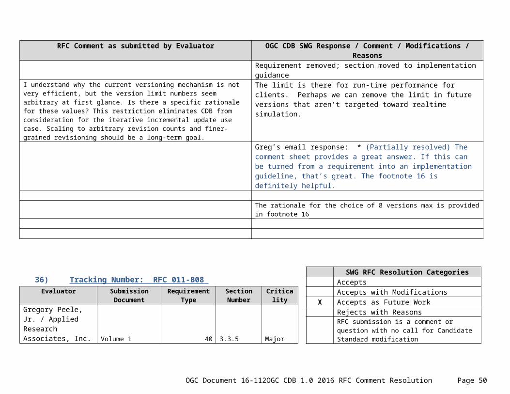
OGC Document 16-112 OGC CDB 1.0 2016 RFC Comment Resolution Page 50