REVISED ZONING ORDINANCES - North Dakota
74
OLIVER COUNTY, NORTH DAKOTA REVISED ZONING ORDINANCES Revised 2016 Prepared by: The Oliver County Planning and Zoning Commission Approved by the Board of County Commissioners for Oliver County, North Dakota on the 7th day of April, 2016
Transcript of REVISED ZONING ORDINANCES - North Dakota
OLIVER COUNTY, NORTH DAKOTA
REVISED ZONING ORDINANCES
Revised 2016
Prepared by:
The Oliver County Planning and Zoning Commission
Approved by the Board of County Commissioners for Oliver County, North Dakota on the 7th day of April, 2016
i
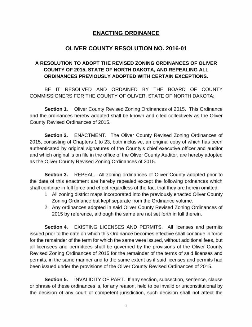
ENACTING ORDINANCE
OLIVER COUNTY RESOLUTION NO. 2016-01
A RESOLUTION TO ADOPT THE REVISED ZONING ORDINANCES OF OLIVER
COUNTY OF 2015, STATE OF NORTH DAKOTA, AND REPEALING ALL
ORDINANCES PREVIOUSLY ADOPTED WITH CERTAIN EXCEPTIONS.
BE IT RESOLVED AND ORDAINED BY THE BOARD OF COUNTY
COMMISSIONERS FOR THE COUNTY OF OLIVER, STATE OF NORTH DAKOTA:
Section 1. Oliver County Revised Zoning Ordinances of 2015. This Ordinance
and the ordinances hereby adopted shall be known and cited collectively as the Oliver
County Revised Ordinances of 2015.
Section 2. ENACTMENT. The Oliver County Revised Zoning Ordinances of
2015, consisting of Chapters 1 to 23, both inclusive, an original copy of which has been
authenticated by original signatures of the County’s chief executive officer and auditor
and which original is on file in the office of the Oliver County Auditor, are hereby adopted
as the Oliver County Revised Zoning Ordinances of 2015.
Section 3. REPEAL. All zoning ordinances of Oliver County adopted prior to
the date of this enactment are hereby repealed except the following ordnances which
shall continue in full force and effect regardless of the fact that they are herein omitted:
1. All zoning district maps incorporated into the previously enacted Oliver County
Zoning Ordinance but kept separate from the Ordinance volume.
2. Any ordinances adopted in said Oliver County Revised Zoning Ordinances of
2015 by reference, although the same are not set forth in full therein.
Section 4. EXISTING LICENSES AND PERMITS. All licenses and permits
issued prior to the date on which this Ordinance becomes effective shall continue in force
for the remainder of the term for which the same were issued, without additional fees, but
all licensees and permittees shall be governed by the provisions of the Oliver County
Revised Zoning Ordinances of 2015 for the remainder of the terms of said licenses and
permits, in the same manner and to the same extent as if said licenses and permits had
been issued under the provisions of the Oliver County Revised Ordinances of 2015.
Section 5. INVALIDITY OF PART. If any section, subsection, sentence, clause
or phrase of these ordinances is, for any reason, held to be invalid or unconstitutional by
the decision of any court of competent jurisdiction, such decision shall not affect the

ii
validity of any other section, subsection, sentence, clause, phrase or portion thereof. The
Board of Commissioners of Oliver County hereby declares that it would have passed
these ordinances and each section, subsection, sentence, clause or phrase thereof,
irrespective of the fact that any one or more other sections, subsections, sentences,
clauses or phrases may be declared invalid or unconstitutional.
Section 6. EFFECTIVE DATE. This Resolution and Ordinance shall be in full
force and effect from and after its final passage and approval, publication of notice of the
Ordinance, and, if no petition for separate hearing is filed pursuant to Section 11-33-10
of the North Dakota Century Code, shall take effect upon the expiration of the time for
filing said petition. If a petition for a separate hearing is filed pursuant to section 11-33-
10, the Ordinance shall take effect at such time as the Oliver County Board of County
Commissioners has affirmed the Resolution and Ordinance in accordance with the
procedures of section 11-33-10.
Adoption of the foregoing Resolution and Ordinance was moved by Darrell Berger,
seconded by Blake Wilkens; the following Commissioners voting for: Darrell Berger, Blake
Wilkens, and Lee Husfloen, and none voting against, the Resolution and Ordinance was
approved and duly adopted the 7th day of April, 2016.
OLIVER COUNTY, NORTH DAKOTA
By: Lee Husfloen, Chairman Board of County Commissioners ATTEST: Judith Hintz
County Auditor
1
1. INTRODUCTION 1.1 AUTHORITY
This ordinance is adopted under authority granted by chapter 11-33 of the North Dakota
Century Code. The Board of County Commissioners of Oliver County, North Dakota, does ordain as follows: 1.2 TITLE
This Ordinance, its regulations, and the District Zoning Map shall constitute and be known as
the Oliver County Zoning Ordinance and hereinafter referred to as the "Ordinance". 1.3 EFFECTIVE DATE
This Ordinance shall be effective from this 7th day of April , 2016.
1.4 JURISDICTION
This Ordinance shall apply to the area of Oliver County, exclusive of the incorporated cities or
adjacent areas under their zoning jurisdiction. 1.5 PURPOSE
It is the purpose of this Ordinance to promote the health, safety, and general welfare of the
citizens of Oliver County. It is the specific intent of this Ordinance to: a) Regulate the use of all structures and land, with the exception of agricultural use
except as hereafter noted, within Oliver County; b) Regulate lot coverage, population density and distribution, and the location and size
of all non-agricultural structures in Oliver County; c) Provide regulations for the subdivision of land; d) Secure safety from fire, flooding, and other dangers; e) Provide adequate light, air, sanitation, and drainage; f) Further the appropriate use of land and conservation of natural resources; g) Stabilize and protect the natural beauty and property values of Oliver County; h) Lessen congestion in and promote safety and efficiency of streets and highways; i) Facilitate the adequate provision of public facilities and utilities; j) Lessen governmental expenditures; k) Secure the orderly development of Oliver County; l) Provide for the administration and enforcement of this Ordinance and penalties for its
violation. 1.6 ABROGATION AND GREATER RESTRICTIONS
It is not the intent of this Ordinance to repeal, abrogate, annul, impair, or interfere with any existing easements, covenants, deed restrictions, agreements, ordinances, rules, regulations, or permits previously adopted or issued pursuant to law. However, whenever this Ordinance imposes greater restrictions, the provisions of this Ordinance shall govern.
2
1.7 INTERPRETATION
In their interpretation and application, the provisions of this Ordinance shall be liberally construed in favor of the County and shall not be construed to be a limitation or repeal of any other power granted by the North Dakota Century Code. 1.8 SEVERABILITY
If any part or provision of this Ordinance or the application thereof to any person, property, or circumstance is adjudged invalid by any court of competent jurisdiction, such judgment shall be confined in its effect to the part, provision, section, or application expressly involved in the controversy and shall not affect or impair the integrity or validity of the remainder of the Ordinance or its application to other persons, property, or circumstances.
If any application of this Ordinance to a particular structure, land, or water is adjudged unconstitutional or invalid by a court of competent jurisdiction, such judgment shall not be applicable to any other structure, land, or water not specifically included in said judgment. 1.9 REPEAL
All regulations, parts of County regulations, existing ordinances, or resolutions in conflict with this Ordinance and its provisions are hereby repealed and superseded.
2. GENERAL PROVISIONS 2.1 INTRODUCTION The proper regulation of the use of certain structures and lands only through the use of the district regulations set forth in this Ordinance is neither feasible nor adequate. Therefore, the following regulations, which shall be applied in addition to the district regulations, are necessary to accomplish the intent of this Ordinance. 2.2 ZONE OF COORDINATION Municipalities may, by ordinance, extend application of their zoning regulations to unincorporated territory located outside municipal limits. It is the intent of this Ordinance that the City of Center, which has exercised authority for city zoning under N.D.C.C. §40-47-01.1, extend the application of the City’s zoning regulations to any quarter quarter section of unincorporated territory if the majority of the quarter quarter section is located within one (1) mile distance from the exterior city limits of the City of Center. 2.3 COMPLIANCE No structure, land, water or air shall hereafter be used and no structure or part thereof shall hereafter be located, erected, moved, reconstructed, extended, enlarged, converted, or structurally altered without a building permit except minor structures, and without full compliance with the provisions of this Ordinance and all other applicable local, county, and state regulations. No regulation or restriction, however, shall prohibit or prevent the use of land or buildings for farming or any of the normal incidents of farming.
3
2.4 USES Only the following uses and their essential services shall be allowed in any district: Permitted Uses – Specified for each district. Accessory Uses –
1. Shall be clearly incidental and customarily associated with the operation of a permitted use. 2. Shall be operated and maintained under the same ownership and on the same lot as the permitted use. 3. Shall not contain structures or structural features inconsistent with the permitted use. 4. Shall include residential occupancy only with the approval of the Planning and Zoning Commission. 5. Shall be allowed once permitted use is present or under construction. 6. Shall not involve the conduct of any business, trade, or industry, except for home and professional occupations as defined herein, when accessory to residential district permitted uses.
Conditional Uses – Along with their accessory uses, conditional uses shall be allowed in specific districts after review, public hearings, and approval by the Planning and Zoning Commission and the Board of Commissioners in accordance with district regulations and procedures established in Section 17.3 of this Ordinance. Temporary Uses - May be allowed in districts with the approval of the Planning and Zoning Commission and in accordance with procedures established in Section 17.3 of this Ordinance. Uses Not Specified – May be allowed in districts with the approval of the Planning and Zoning Commission following careful review and provided that such uses are similar in character to the permitted uses in the district. 2.5 EXISTING LOTS OF RECORD Any lot of record existing at the effective date of this Ordinance and held in separate ownership different from the ownership of adjoining lots may be used for the erection of a structure conforming to the use regulations of the district in which it is located with the approval of the Planning and Zoning Commission, even though its dimensions are less than the minimum requirements of this Ordinance, except as set forth hereafter. Where two (2) or more adjacent lots of record exist under the same ownership with one (1) or more having less than the needed area and width, the request for a permit shall be referred to the Planning and Zoning Commission, which may require combining the lots, thereby complying with the minimum requirements of this Ordinance.

4
2.6 NON-CONFORMING USES AND STRUCTURES The lawful non-conforming use of a structure, land, or water existing at the time of the adoption or amendment of this Ordinance may be continued although the use does not conform with the provisions of this Ordinance, except that:
1. Extension - Only that portion of the land or water in actual use may be so continued and a non-
conforming use may not be extended, enlarged, substituted, or moved.
2. Damage or Destruction - If any building in which there is a non-conforming use is damaged by fire, flood,
explosion, wind, or other calamity, to the extent of more than fifty (50) per cent of its current assessed value, it shall not be restored except so as to comply with the provisions of this Ordinance.
3. Repairs or Alterations -
Total lifetime structural repairs or alterations to a structure containing a non-conforming use shall not exceed fifty (50) per cent of the assessed value of the structure at the time of its becoming a non-conforming structure unless it is permanently changed to conform with the provisions of this Ordinance.
4. Discontinuance - In the event any non-conforming use ceases, for whatever reason, for one (1) year,
any future use of land, structure, or water shall be in conformity with the provisions of this Ordinance. 5. Moving Building -
Should any building containing a non-conforming use be moved any distance whatsoever, the building shall thereafter be used only in conformity with the provisions of this Ordinance.
6. Change - A non-conforming use shall not be changed to any use other than those permitted
within the district in which the building is located. Once so changed, it shall not revert back to a non-conforming use.
7. Current File - A current file of all non-conforming uses and structures shall be maintained by the
Land Use Administrator listing the following: location, use, and assessed value of structures at the time they became non-conforming uses. 2.7 HEIGHT REGULATION EXCEPTIONS The following shall be exempt from the maximum height regulations in all districts:
Antennas, belfries, chimneys, cupolas, flag poles, ventilators, water tanks, windmills, or other appurtenances usually required to be placed above roof level and not intended for human occupancy. 2.8 SETBACK AND YARD REGULATION EXCEPTIONS Unwalled porches, terraces, balconies, and exterior stairways may project five (5) feet into front and rear setback and yard spaces. Sills, exterior columns, chimneys, and building accessories may project eighteen (18) inches into all setback and yard spaces.

5
2.9 EROSION AND SEDIMENT CONTROL An erosion and sediment control plan may be requested by the Planning and Zoning Commission for those uses requiring substantial land modification or earth movement and said plan shall be submitted before a building permit is granted. These plans are to be developed with the Oliver County Soil Conservation District and must have their written approval. A performance bond may be required by the Oliver County Board of County Commissioners, the amount thereof based on the complexity of control measures as determined by the Soil Conservation District. The performance bond shall be filed with the County Auditor.
3. DISTRICTS AND BOUNDARIES 3.1 DISTRICT CLASSIFICATIONS In order to classify, regulate, and restrict the location of businesses, industries, residences, and the location of buildings designed for specific uses; to regulate and limit the weight and bulk of buildings; to regulate and limit the intensity of the use of lots; to regulate and determine the area of yards and other open spaces surrounding buildings; and to regulate and restrict the density of population; unincorporated areas under the zoning jurisdiction of Oliver County may be divided into any of the following districts, said districts being known as:
A - AGRICULTURAL DISTRICT R-1 - RESIDENTIAL DISTRICT 1 R-2 - RESIDENTIAL DISTRICT 2 MH - MOBILE HOME DISTRICT C - COMMERCIAL DISTRICT I - INDUSTRIAL DISTRICT PUD - PLANNED UNIT DEVELOPMENT RC - RECREATION DISTRICT CS - CONSERVATION DISTRICT
3.2 DISTRICT ZONING MAP The boundaries of the zoning districts appear on the map designated as the District Zoning Map. The District Zoning Map and all notations, references, and other information shown thereon are part of this Ordinance and have the same force and effect as if said map and all notations, references, and other information shown thereon were fully set forth and described herein. An attested copy of the District Zoning Map is on file with the Oliver County Auditor. 4. AGRICULTURAL DISTRICT (A) It is the intent of these district regulations to protect the area's most valuable resource--its agricultural soils, and to limit uses to agriculture and those compatible with agriculture. Land with potentially irrigable soils or prime productive soils, as identified by the Oliver County Soil Conservation District, shall be reserved for agricultural activity whenever possible.
6
4.1 USE REGULATIONS
Permitted Uses – 1. Usual buildings, structures, and uses incidental to farm or ranch operations. 2. Churches, cemeteries. 3. Public and private schools. 4. Greenhouses and nurseries. 5. Animal hospitals and clinics. 6. Local government facilities. 7. Public and private conservation areas. 8. Recreation activities that do not disturb the land or agricultural activities.
Accessory Uses – Accessory uses customarily incidental to the permitted uses in compliance with Section 2.4. Conditional Uses -
1. Non-Farm Residences
The following minimum conditions shall apply: a. The applicant shall submit written evidence of approval of the proposed sanitary
disposal system by the Custer Health District. b. Minimum lot area shall be determined by site and soil capability regulations (see
Section 13). Under no circumstances shall a lot area be less than 20,000 square feet. c. The applicant shall provide any reasonable information the Planning and Zoning
Commission deems necessary.
2. Electrical Power Transmission Lines The following minimum conditions shall apply: a. Transmission line sitings shall have minimal interference with farming and irrigation
operations, following quarter or section lines if possible. b. Written evidence of said approval by the landowner shall be submitted with the
application for approval of a conditional use. c. The applicant shall provide any reasonable information the Planning Zoning
Commission deems necessary.
3. Industrial, Municipal, and Commercial Pipelines The following minimum conditions shall apply: a. Written evidence of approval by the landowner shall be submitted with the application
for approval of a conditional use. b. The applicant shall provide any reasonable information the Planning and Zoning
Commission deems necessary.
4. Radio, Television, and /or Telephone Microwave Transmitting Stations The following minimum conditions shall apply: a. Written evidence of approval by the landowner shall be submitted with the application
for approval of a conditional use. b. The applicant shall provide any reasonable information the Planning and Zoning
Commission deems necessary.

7
5. Water Reservoirs, Water Storage Tanks, Water Pumping Stations, and Sewer Lift Stations The following minimum conditions shall apply: a. Written evidence of approval by the landowner shall be submitted with the application
for approval of a conditional use. b. The applicant shall provide any reasonable information the Planning and Zoning
Commission deems necessary.
6. Gas and Oil Exploration The provisions of this section shall not apply to any digging, drilling or excavation for
agricultural purposes or to any coal mining activity. The provisions of this section shall not apply to any oil or gas exploration and production by Oliver County or any of its incorporated cities. The operators must furnish the following to the Land Use Administrator: a. Evidence of compliance with Section 38-08.1-04 N.D.C.C., "Filing of notice of intention
to engage in drilling". b. Plan drawn to scale showing location of lines to be explored. c. Schedule of commencement and completion of operations. d. Upon completion of operations, a final plan drawn to scale, showing the actual survey
location of all seismic exploration lines, and if applicable, the location of all shot holes. e. Evidence that the surface owner has been notified in writing of the operator's activity. f. Notification that all wire flags and/or other objects related to exploration activities have
been removed. g. Evidence that permission for use of water has been obtained from surface owner
before exploration activity begins; this information shall be shown on a map as to where the water will be drawn from.
h. A seismograph survey shot hole shall be no closer than one thousand (1000) feet to any buildings, water wells, developed springs, and/or other water structures, i.e. dams, dugouts, etc., unless such site is mutually agreeable between the surface owner and the mineral operator.
i. No explosive mineral operation shall take place on any section line, public road or public right-of-way.
j. Evidence that the operator has posted bond as required by Chapter 38-08, N.D.C.C. and the rules and regulations of the North Dakota Industrial Commission.
k. All holes shall be plugged the full length with Bentonic clay and surface damage shall be repaired.
7. Coal Excavation and Mining
The following minimum conditions shall apply: a. A preliminary public hearing shall be conducted in the county concerning site location,
needs of operation, and company employees concerning roads, housing, community facilities, and county and community services.
b. The applicant shall provide to the Planning and Zoning Commission a copy of all information submitted to the North Dakota Public Service Commission concerning site reclamation.
c. The applicant shall provide written evidence of approval by the Public Service Commission for operation of the mine.
d. No excavation or mine operation shall take place within three hundred (300) feet of an adjacent property line unless written agreement is made with the owners of said property. Written evidence of said agreement shall be submitted to the Planning and Zoning Commission. The Planning and Zoning Commission reserves the right to increase the three hundred (300) foot minimum setback from adjacent property lines if deemed necessary.
8
e. No excavation or mine operation shall take place within five hundred (500) feet of an existing residence unless a written agreement is made with the owner of said residence. Evidence of said agreement shall be submitted to the Planning and Zoning Commission.
f. The applicant shall conform to all state and federal laws relating to preservation, removal, or relocation of historical or archeological artifacts, and to the reclamation of strip-mined lands.
g. The applicant shall post with the County Auditor a performance bond for reclamation of the site if not already posted with the State. The amount of the bond shall be determined by the Oliver County Board of County Commissioners.
h. The applicant shall provide any reasonable information the Planning and Zoning Commission deems necessary.
8. Rock Crushers, Concrete and Asphalt Mixing Plants, Sand and Gravel Pits
The following minimum conditions shall apply: a. Written evidence of approval of the landowner shall be submitted with the application
for approval of a conditional use. b. Written evidence of a reclamation agreement with the landowner shall be submitted
with the application for approval of a conditional use. c. No excavation or processing shall take place within three hundred (300) feet of an
adjacent property line or within five hundred (500) feet of an existing residence, unless a written agreement is made with the owner of said property or residence. Evidence of said agreement shall be submitted to the Planning Commission.
d. The applicant shall conform to all requirements regarding preservation, removal, or relocation of historical or archeological artifacts.
e. The applicant shall provide any other reasonable information the Planning and Zoning Commission deems necessary.
9. Livestock Auction Rings
The following minimum conditions apply: a. Off-street parking for motor vehicles and for storage of farm implements associated
with the operation of said livestock auction shall be provided. b. Sufficient space for truck maneuvering shall be provided off-street. c. Use of a building or structure for restaurant or coffee shop purposes shall be permitted
upon written evidence of approval of the North Dakota Department of Health and the Custer Health District.
d. The applicant shall provide any reasonable information the Planning Commission deems necessary.
10. Railroad Trackage and Spurs
The following minimum conditions shall apply: a. No trackage shall be placed within one hundred twenty-five (125) feet of an existing
residence unless a written agreement is made with the owner of said residence. Evidence of said agreement shall be submitted to the Planning and Zoning Commission.
b. The applicant shall conform to all requirements regarding the preservation, removal, or relocation of historical or archeological artifacts.
c. The applicant shall provide any reasonable information the Planning and Zoning Commission deems necessary.
11. Electrical Substations
The following minimum conditions shall apply:

9
a. Written evidence of approval by the landowner shall be submitted with the application for approval of a conditional use.
b. The applicant shall provide any reasonable information the Planning and Zoning Commission deems necessary.
12. Anhydrous Ammonia Distribution Facilities
The following minimum conditions shall apply: a. Written evidence of approval by the landowner shall be submitted with the application
for approval of a conditional use. b. The applicant shall provide any reasonable information the Planning and Zoning
Commission deems necessary.
13. Concentrated Animal Feeding Operations The following regulations shall apply with regard to Animal Feeding Operations:
a. Authority: Notwithstanding the exemption for farming and ranching in Section 4, animal feeding operations are subject to the provisions of this code, as authorized by NDCC Section 11-33-02.1. No regulation contained herein should be interpreted to preclude the development of animal feeding operations from Oliver County.
b. Permitted Districts: The districts within which an animal feeding operation is permitted are determined by the number of Animal Units capable of being handled by the operation, as designed. (1) A minor animal feeding operation, meaning an operation capable of handling less than 1,000 Animal Units, may be permitted in an Agriculture (A) District by right, subject to additional standards in this section. (2) A major animal feeding operation, meaning an operation capable of handling 1,000 Animal Units or greater, may be permitted in an Agriculture (A) District with a special use permit, subject to additional standards in this section. (3) An existing animal feeding operation that expands to handle more than 1,000 animal units shall receive a special use permit to continue operation as a major animal feeding operation. Whenever the capacity of an animal feeding operation is expanded to handle more than 2,000 or 5,000 animal units, the operator shall apply for a new special use permit to continue operation at the expanded capacity.
c. Environmental Protection: The operator of an animal feeding operation shall locate, construct, operate and
maintain the facility so as to minimize, reduce or abate effects of pollution on environmental resources and on public safety and health. The operator of an existing facility shall operate and maintain the facility so as to minimize, reduce or abate effects of pollution on environmental resources and on public safety and health. Each operator shall comply with applicable state laws and rules, including the laws and rules administered by the North Dakota Department of Health and with any permits granted by that department.
d. Water Resource Setbacks: The operator of a new major animal feeding operation that has more than 1,000 animal
units shall not locate or establish that operation: (1) Within a delineated source water protection area for a public water
system. The source water protection areas for water supply wells include the entire wellhead protection area, as determined by the North Dakota Department of Health. For the surface-water intakes of public water systems, the source water protection area includes all or a portion of the surface water that supplies the water for the public water system, including all or a portion of the surface-water’s shoreline

10
(2) Within 1,200 feet of a private ground water well which is not owned by the operator or within 1,500 feet of a public ground water well which does not have a delineated source water protection area.
(3) Within 1,000 feet of surface water which is not included in a source water protection area.
e. Odor Setbacks: (1) The operator of a new animal feeding operation, whether major or
minor, shall locate the site of that operation from existing residence, businesses, churches, schools, public parks and areas of property that are zoned residential so as to exceed the corresponding setback listed in any Odor Setback Tables that may be adopted hereinafter from these places.
(2) The Board of County Commissioners may increase or decrease a setback distance for a new animal feeding operation after consideration of the proposed operation’s plans, if it determines that a greater of lesser setback distance is necessary or acceptable, respectively, based upon site conditions or demonstrable safety, health, environmental or public welfare concerns.
f. Additional Procedures: In addition to the general procedures for special use permit applications as stated herein, the following provisions shall be practiced: (1) The Planning and Zoning Administrator shall notify the North Dakota Department of Health that the County has received an application for an animal feeding operation. (2) After receiving approval of a special use permit for an animal feeding operation from the Oliver County Board of County Commissioners, the applicant shall then forward the application for a special use permit, together with the approval by Oliver County, to the North Dakota Department of Health. (3) Following a review by the North Dakota Department of Health of the operator’s application for a state permit, the North Dakota Department of Health will notify Oliver County of its decision. (4) The special use permit will become final following the granting of a permit by the North Dakota Department of Health.
g. Additional Application Requirements: In addition to the general materials required to be submitted with a special use permit application as stated herein, the following materials are required: (1) Proposed maximum capacity of animal feeding operation, in terms of the number of animal units. (2) Total acreage of the site of the facility. (3) Existing and proposed roads and access ways within and adjacent to the site of the facility. (4) Surrounding land uses and ownership. (5) A copy of any permit application submitted by the applicant to the North Dakota Department of Health.
h. Ownership Change: An owner of a facility that includes an animal feeding operation having a conditional
use permit granted according to this section shall notify the Planning and Zoning Administrator of the sale, or the transfer of the ownership of that operation within thirty (30) days of such sale or transfer.
i. Operating Change: An operator of a facility that includes an animal feeding operation having a conditional use permit granted according to this section shall notify the local unit of government of intent to include an alternate livestock type. The notice shall be given at least 120 days prior to the anticipated date of the change.

11
14. Wind Energy Facilities The following regulations shall apply with regard to Wind Energy Facilities:
A. Standards. A wind energy facility shall meet the following standards:
1. Appearance Standards: a. Turbines shall be installed on tubular, monopole-type towers. b. Wind turbines and related towers shall be painted a non-reflective, nonobtrusive color. c. Wind turbines and related towers shall not be used for displaying any advertising
except for reasonable identification of the manufacturer or operator of the wind energy facility.
d. The design of buildings and related structures at wind energy facility sites shall, to the extent reasonably possible, use materials colors, textures and location that will blend the wind energy facility to the natural setting and existing environment.
e. Wind turbines shall not be artificially lighted, except to the extent required by Federal Aviation Administration (FAA) or other applicable authority.
2. Construction and Maintenance Standards: a. At wind energy facility sites, the location and construction of access roads and other
infrastructure shall, to the extent reasonably possible, minimize disruption to farmland, the landscape and agricultural operations within Oliver County.
b. The applicant shall promptly replace or repair all fences or gates removed or damaged during all phases of the wind energy facility’s life, unless otherwise negotiated with the affected landowner. When the permittee installs a gate where electric fences are present, the permittee shall provide for continuity in the electric fence circuit.
c. The applicant shall ensure that, following completion of construction of a wind energy facility, all county roads will be repaired or restored to a condition at least equal to the condition prior to construction of such facility, as inspected and approved by the County Engineer.
d. The applicant is responsible for abiding by the state and local overweight load permitting process in accordance with NDCC Chapter 39-12. A conditional use permit issued under this ordinance to erect a wind turbine facility does not negate a hauler’s obligation to obtain overweight load permits for hauling.
e. The applicant shall take into account, avoid, promptly repair or replace all drainage tiles broken or damaged during all phases of project life unless otherwise negotiated with the affected landowner.
f. The applicant shall minimize the removal of trees and shall not remove groves of trees or shelter belts without the written approval of the affected landowner. Trimming or removal of trees within the public right-of-way to allow for safe construction of power lines shall be allowed.
3. Public Safety Standards: a. Prior to construction, the applicant shall prepare fire protection and medical emergency
plans in consultation with the rural fire district, Sheriff’s Department, Emergency Management, and local emergency medical service provider having jurisdiction over the area.
b Each wind tower shall be marked with a visible identification number to assist with provision of emergency services, and the permittee shall file with the Oliver County Emergency Manager a wind energy facility map identifying wind turbine locations and numbers.
c. The applicant is encouraged to provide educational material to landowners within the site boundaries and, upon request, to interested persons about the project and any restrictions or dangers associated with the project. The applicant is encouraged to also

12
provide any necessary safety measures, such as warning signs and gates for traffic control or to restrict public access to turbine access roads, substations, and wind turbines. The applicant shall comply with provisions outlined in their public safety plan.
d. Within twenty-four (24) hours of an occurrence, the applicant shall notify the Oliver County Emergency Manager of any extraordinary event. Extraordinary events include, but shall not be limited to, fires, tower collapse, thrown blade, collector or feeder line failure, or injured wind turbine facility worker or private person. The applicant shall, within thirty (30) calendar days of the occurrence, submit a report to the County Emergency Manager describing the cause of the occurrence and the steps taken to avoid future occurrences.
4. Collector System Standards:
a. The permittee shall place electrical lines, known a collectors, and communication cables underground to a depth of at least four (4) feet when located on private property. Collectors and cables shall also be placed within or adjacent to the land necessary for wind turbine access roads unless otherwise negotiated with the affected landowner. Overhead collection facilities may be permitted where necessary.
b. The permittee shall not place overhead feeder lines on public road or drainage easement rights-of-way. When placing feeders on private property, the permittee shall place the feeder in accordance with the easement negotiated with the affected landowner. If the permittee cannot place overhead feeder lines on private property a request may be made to place feeder lines on public rights-of-way with approval from the governmental unit responsible for the affected right-of-way.
c. The applicant shall be responsible for compliance with all federal, state, and local laws applicable to the generation, storage, transportation, clean-up, and disposal of hazardous wastes generated during any phase of the project’s life.
5. Turbine Setback Standards: Setbacks shall be measured as the horizontal distance
between the monopole of the turbine and any object. a. Each wind turbine shall be set back from the nearest occupied dwelling, commercial
building, publicly used structure or facility, or state and county park a distance not less than one and a quarter (1¼) times the height of the turbine or 1,320 feet, whichever is greater.
b. Each wind turbine shall be set back from the nearest interstate, state, or county road or above ground communication or electrical lines or railroad right-of-way a distance not less than 1.1 times the height of the turbine plus seventy-five (75) feet from the centerline of the existing right-of-way or object.
c. Each wind turbine shall be set back from all section lines a distance not less than one hundred (100) feet.
d. Each wind turbine shall be set back from the wind energy facility perimeter a distance not less than one and a half (1 ½) times the height of the wind turbine. A variance may be granted if an authorized representative or agent of the applicant and those affected parties of adjoining properties with associated wind rights sign a formal and binding agreement expressing all parties’ support for a variance that may reduce the setback requirements.
e. Oliver County has many sensitive sites, and the Board of County Commissioners may ask the permittee to avoid these sites in granting a conditional use permit.
B. Minimum Ground Clearance. The blade tip of any wind turbine shall, at its lowest point, have
ground clearance of no less than seventy (70) feet.
13
C. Additional Application Requirements. In addition to the general materials required to be submitted with a special use permit application pursuant to the application process stated in this Ordinance, the following materials are required:
1. Electromagnetic Interference Assessment: The applicant shall submit an assessment of microwave signal patterns in the project area prior to commencement of construction of the project.
a. The assessment shall be designed to provide data that can be used in the future to determine whether the turbines and associated facilities are the cause of disruption or interference of microwave patterns in the event residents complain about such disruption or interference after the turbines are placed in operation. The assessment shall be completed prior to operation of the turbines.
b. The applicant shall be responsible for alleviating any disruption or interference caused by the turbines or any associated facilities of cell phone, television, radio, computer, satellite or other electronic transmissions, receptions, or services.
c. The applicant shall not operate the wind turbine facility so as to cause microwave, television, radio, telecommunications or navigation interference contrary to Federal Communications Commission (FCC) regulations or federal, state or local laws.
d. In the event the wind turbine facility or its operations cause such interference as described in this section, the applicant shall take measures necessary to correct the problem within thirty (30) calendar days.
2. Archeological Resource Survey and Consultation: Unless the project is under the purview of the North Dakota Public Service Commission (PSC), and an Archeological Resource Survey is being prepared as part of that process, the applicant shall work with the State Historic Preservation Office (SHPO) at the State Historical Society of North Dakota at the beginning of the planning process for the wind energy facility to determine whether an archaeological survey is recommended for any part of the proposed project.
a. If recommended, the applicant shall contract with a qualified archaeologist to complete such surveys, and shall submit the results to the Zoning Administrator and the SHPO. The SHPO will make recommendations for the treatment of any significant archaeological sites which are identified. Any issues in the implementation of these recommendations will be resolved by Oliver County Board of Commissioners in consultation with the SHPO. All information submitted under this provision is subject to NDCC Section 55-02-07.1.
b. If any archaeological sites or human remains are found during construction, the applicant shall follow standard operating procedures as established by the SHPO and in accordance with NDCC Section 23-06- 27 and associated North Dakota Administrative Code 40-02-03.
3. Biological Resources Survey: The applicant, in consultation with the US Fish & Wildlife Service - Ecological Services Office (USFWS) and the North Dakota Department of Game and Fish (NDGF) shall, for the project site, conduct a preconstruction inventory of existing wildlife management areas, scientific and natural areas, recreation areas, native prairies and forests, wetlands, and any other biologically sensitive areas and wildlife resources, particularly birds and bats, within the site and assess the presence of state- or federally-listed or threatened species, and other protected species, such as migratory birds. The results of the survey shall be submitted to the Zoning Administrator, USFWS and NDGF.
D. Road Use Arrangements: Prior to construction, the applicant shall make satisfactory arrangements (including obtaining permits) for road use, access roads, intersections, maintenance
14
and repair of damages with the governmental jurisdiction with authority over each road. The applicant shall notify the County Road Superintendant of such arrangements upon request.
D. Restoration of Property: Within six (6) months of termination or abandonment of leases or
easements for a wind energy facility in Oliver County, the current permitee shall cause, at its own expenses, removal of all structures to a depth of three (3) feet below pre-construction grade. Underground collection cables do not have to be removed, but any easements of record must be released.
E. Changes to Permit: After a conditional use permit has been granted, any minor changes in
the location or character of wind turbine facilities and structures may be authorized in writing by the Zoning Administrator. All other changes shall require approval of an amended special use permit under these same ordinance requirements.
F. Changes of Ownership: An owner of, or possessor of any controlling interest in, a wind energy facility permitted in Oliver County according to this section shall notify the Planning and Zoning Administrator of the sale or transfer of the ownership of or interest in that operation within thirty (30) days of such sale or transfer. 4.2 YARD REGULATIONS
When a lot abuts a road or highway, the minimum building setback measured from the center line shall be:
Minor Arterial 200 feet Major and Minor
Collectors 200 feet
Local Roads 200 feet
Lots having double frontage must provide the required setbacks from both frontages. 4.3 FENCE REGULATIONS
No fences allowed in sightline which would obstruct view and/or create a safety hazard for traffic on adjacent roadways. 4.4 HIGHWAY ACCESS REGULATIONS
When a lot abuts state or federal highways: 1. Access shall be limited to one per quarter mile.
2. The landowner shall provide for frontage road or deed to nearest quarter mile access point to a public highway. 3. Written evidence of approval by appropriate highway authorities shall be provided to the Planning Commission. 4.5 PARKING REGULATIONS See Chapter 14. 4.6 SIGN REGULATIONS See Chapter 16.

15
5. RESIDENTIAL DISTRICT 1 (R-1) It is the intent of these district regulations to provide for the orderly development of low density residential uses. 5.1 USE REGULATIONS
Permitted Uses – 1. Single-family dwellings 2. Churches 3. Public and Private Schools 4. Public Park or Playground 5. Community Center, public or private 6. Essential public facilities to serve the immediate area
Accessory Uses – Accessory uses customarily incidental to permitted uses in compliance with Section 2.4.
5.2 AREA REGULATIONS 1. Minimum single-family residential lot size -
a. Lots served by public water supply and public sanitary sewer system: 1. Minimum width - sixty (60) feet 2. Minimum area - seven thousand five hundred (7,500) square feet. b. Lots not served by either a public water supply or public sanitary sewer system
(for description of Soil Divisions see Section 13): 1. Soil Division I
See Section 13. 2. Soil Division II a. Minimum width - one hundred (100) feet b. Minimum area - twenty thousand (20,000) square feet 3. Soil Division III a. Minimum width - one hundred fifty (150) feet b. Minimum area - forty thousand (40,000) square feet
2. Intensity – The principle building and all accessory buildings shall not cover more than forty (40) per cent of the lot. 5.3 YARD REGULATIONS
1. Front Yard - Each lot or premises shall have a front yard of not less than twenty-five (25) feet in
depth. When a lot abuts a road or highway, the minimum building setback measured from the center line shall be:
Minor Arterial 200 feet Major or Minor
Collectors 200 feet Local Roads 200 feet

16
Lots having double frontage must provide the required front yards or setbacks on both
frontages.
2. Side Yards - Each lot or premises shall have two side yards, one on each side of the principle
building. Each side yard shall not be less than ten (10) feet in width. 3. Rear Yard -
Each lot or premises shall have a rear yard with a depth of not less than thirty (30) feet. 5.4 HEIGHT REGULATIONS
No single-family dwelling shall exceed two and one-half (2 1/2) stories, nor shall it exceed thirty-five (35) feet in height. 5.5 FENCE REGULATIONS
No fences allowed in sightline which would obstruct view and/or create a safety hazard for traffic on adjacent roadways. 5.6 HIGHWAY ACCESS REGULATIONS
When a lot abuts state or federal highways: 1. Access shall be limited to one per quarter mile. 2. The landowner shall provide for frontage road or deed to nearest quarter mile access point to a public highway. 3. Written evidence of approval by appropriate highway authorities shall be provided to the Planning Commission.
5.7 PARKING REGULATIONS
See Chapter 14.
5.8 SIGN REGULATIONS
See Chapter 16.
6. RESIDENTIAL DISTRICT 2 (R-2)
It is the intent of these district regulations to provide for multiple-family dwellings and higher-density residential uses. 6.1 USE REGULATIONS
Permitted Uses – 1. Single-family dwellings 2. Multi-family dwellings 3. Churches 4. Public and Private Schools 5. Public Park or Playground 6. Community Center, public or private 7. Essential public facilities to serve the immediate area

17
Accessory Uses – Accessory uses customarily incidental to permitted uses in compliance with Section 2.4.
6.2 AREA REGULATIONS
1. Minimum single-family residential lot size - a. Lots served by public water supply and public sanitary sewer system:
1. Minimum width - sixty (60) feet 2. Minimum area - seven thousand five hundred (7,500) square feet
b. Lots not served by either a public water supply or public sanitary sewer system (for description of Soil Divisions see Section 13): 1. Soil Division I
See Section 13. 2. Soils Division II
a. Minimum width - one hundred (100) feet b. Minimum area - twenty thousand (20,000) square feet
3. Soil Division III a. Minimum width - one hundred fifty (150) feet b. Minimum area - forty thousand (40,000) square feet
2. Minimum multiple-family residential lot size (all multiple-family dwellings shall be served by public water supply and public sanitary sewer system): a. Minimum width - one hundred (100) feet b. Minimum area - ten thousand (10,000) square feet plus two thousand five
hundred (2,500) square feet for each additional unit over two (2).
3. Intensity - a. Single-family dwellings - the principle building and all accessory buildings shall
not occupy more than forty (40) per cent of the lot. b. Multiple-family dwellings - the principle building and all accessory buildings
shall not cover more than fifty (50) per cent of the lot. Buildings of three (3) or more stories shall not cover more than forty (40) per cent of the lot.
6.3 YARD REGULATIONS
1. Front Yard - Each lot or premises shall have a front yard not less than twenty-five (25) feet in depth,
thirty (30) feet for multiple-family dwellings. When a lot abuts a road or highway, the minimum building setback measured from the center line shall be: Minor Arterial 200 feet Major or Minor
Collectors 200 feet Local Roads 200 feet
Lots having double frontage must provide the required front yards or setbacks on
both frontages. 2. Side Yards -
Each lot or premises shall have two side yards, one on each side of the principle building. Each side yard shall not be less than ten (10) feet in width, fifteen (15) feet for multiple-family dwellings.
18
3. Rear Yard - Each lot or premises shall have a rear yard with a depth of not less than thirty (30) feet, thirty-five (35) feet for multiple-family dwellings.
6.4 HEIGHT REGULATIONS
1. Single-family dwelling – No single-family dwelling shall exceed two and one-half (2 1/2) stories, nor shall it exceed thirty-five (35) feet in height. 2. Multiple-family dwelling -
a. Principle structures shall not exceed fifty (50) feet b. Accessory structures shall not exceed twenty-five (25) feet
6.5 FENCE REGULATIONS No fences allowed in sightline which would obstruct view and/or create a safety hazard for traffic on adjacent roadways. 6.6 HIGHWAY ACCESS REGULATIONS When a lot abuts state or federal highways:
1. Access shall be limited to one per quarter mile. 2. The landowner shall provide for frontage road or deed to nearest quarter mile access
point to a public highway. 3. Written evidence or approval by appropriate highway authorities shall be provided
to the Planning Commission. 6.7 PARKING REGULATION See Chapter 14. 6.8 SIGN REGULATIONS See Chapter 16. 7. MOBILE HOME PARK DISTRICT (MH) It is the intent of these district regulations to encourage both suitable and proper development of mobile home parks and the placement of single-family mobile home dwellings within these parks. 7.1 USE REGULATIONS
Permitted Uses - 1. Mobile homes with permanent foundation stands 2. Community recreation facilities 3. Parks and playgrounds
Accessory Uses – Accessory uses customarily incidental to permitted uses in compliance with Section 2.4.

19
7.2 AREA REGULATIONS
1. Minimum park size - four (4) acres 2. Minimum lot size for single-wide mobile home dwelling units -
a. Minimum width - fifty (50) feet b. Minimum area - five thousand (5000) square feet
3. Minimum lot size for double-wide mobile home dwelling units - a. Minimum width - sixty (60) feet b. Minimum area - six thousand (6000) square feet
4. Intensity - Mobile home lot - the ground area occupied by a mobile home dwelling, attached storm shed, patio, storage building, and off-street parking spaces shall not exceed fifty (50) per cent of the total area of the lot. In compiling the ground coverage, three hundred sixty (360) square feet shall be added to the actual area of the mobile home dwelling and accessory buildings for the two (2) required off-street parking spaces. This provision limits a lot to one (1) storm shed not over one hundred twenty (120) square feet in area, and said building shall be placed on a proper foundation.
7.3 YARD REGULATIONS
1. Front Yard - a. Mobile home park - When a park abuts a road or highway, the minimum building setback measured from the center line shall be:
Minor Arterial 200 feet Major and Minor Collectors 200 feet Local Roads 200 feet
c. Mobile home lot - Each lot or premises shall have a front yard not less than twenty-five
(25) feet in depth. The setback line shall be uniform for all mobile homes facing the same street. Lots having double frontage must provide the required front yards on both frontages.
2. Side Yards -
No mobile home shall be located less than ten (10) feet from a side lot line. Permitted encroachments on side yard setback space as follows:
a. Outdoor terraces or patios without roofs or walls may project five (5) feet into any setback space. b. Outdoor steps or stairs may project three (3) feet into any setback space. c. Window canopies may project into any setback space.
3. Rear Yard -
Each lot or premises shall have a rear yard with a depth of not less than ten (10) feet. 7.4 HEIGHT REGULATIONS No mobile home or other structure shall exceed thirty-five (35) feet in height
20
7.5 SPECIAL MOBILE HOME PARK REGULATIONS
1. Dedicated Streets - Where the individual mobile home units in a mobile home park district are served by dedicated public streets, those public streets shall be platted and constructed according to applicable street standards of Oliver County.
2. Private Streets - Private streets or roadways shall be at least thirty (30) feet from curb-to-curb in width if automobile parking is limited to one side, and forty (40) feet from curb-to-curb if automobile parking is allowed on both sides. Dead-end streets shall not exceed one hundred seventy-five (175) feet in length. Turning circles shall be at least eighty (80) feet in diameter. Roadways within the parks shall be hard-surfaced, either concrete bituminous.
3. Entrances, Exits, and Driveways - All entrances, exits, and driveways between rows of mobile homes shall be lighted to provide an intensity of 0.3 footcandles.
4. Walkways - Mobile home parks shall be provided with hard-surfaced walkways at least 3 1/2 feet wide between each mobile home lot and service building and other parts of said park.
5. Recreation Areas - Recreation areas shall be provided in each mobile home park for the exclusive use of the park occupants. Such recreation site or sites shall have a minimum area in aggregate of ten (10) per cent of the total area of said park. The recreational site(s) shall be of appropriate design and provided with adequate and permanent equipment.
6. Buffer Strip - All mobile home parks must provide a completely and permanently landscaped buffer area of at least twenty (20) feet in width around those portions of the park perimeter which border public right-of-way or adjoining residential property. Such areas may contain trees, shrubbery, grass, benches, fences, etc. Setback areas not bordering public rights-of-way may be used to fulfill the recreation area requirements of the preceding paragraph.
7. Water and Sewer - All mobile home park lots shall be served by a North Dakota State Health Department approved central water and sewer system.
8. Safety - All provisions of water supply, laundry, sewage, and fire protection to be provided in any mobile home park shall have been approved by the appropriate county and state departments. Tiedowns shall be provided and properly installed.
9. Electrical Service - At least one electrical service outlet supplying at least one hundred twenty (120) volts, and at least one electrical service outlet supplying at least two hundred forty (240) volts, shall be provided for each mobile home space.
10. Park Office - All mobile home parks shall have near their main entrance a park office in which there shall be an up-to-date list of all park residents along with their addresses and a diagram of the park layout.
11. Lawns - All lawns within the mobile home park shall be seeded or sodded within one year of the issuance of an occupancy permit unless an extension is granted by the Planning Commission.

21
7.6 SPECIAL MOBILE HOME REGULATIONS
1. Foundation Skirts - All mobile homes shall be equipped with compatible skirts to completely enclose the underside of the mobile home.
2. Permanent Foundation Stand - All mobile homes shall have permanent foundation stands providing adequate support and a means of anchoring the mobile home structure. The foundation stand shall not heave, shift, or settle unevenly under the weight of the mobile home due to frost action, inadequate drainage, vibration, wind, or other forces acting on the structure. Anchors or tie-downs if provided, such as cast in concrete "deadmen" eyelets, embedded in concrete screw augers or arrowhead anchors, shall be placed at each corner of the stand and at intervals of at least twenty (20) feet. Each device shall be able to sustain a minimum load of four thousand eight hundred (4,800) pounds.
7.7 FENCE REGULATIONS No fences allowed in sightline which would obstruct view and/or create a safety hazard for traffic on adjacent roadways. 7.8 HIGHWAY ACCESS REGULATIONS When a lot abuts state or federal highways:
1. Access shall be limited to one per quarter mile. 2. The landowner shall provide for frontage road or deed to nearest quarter mile access
point to a public highway. 3. Written evidence of approval by appropriate highway authorities shall be provided to
the Planning and Zoning Commission. 7.9 PARKING REGULATIONS See Chapter 14. 7.10 SIGN REGULATIONS See Chapter 16. 8. COMMERCIAL DISTRICT (C) It is the intent of these regulations to provide for grouping of retail merchandising, light industry, and service activity into central areas. The Board of County Commissioners recognizes the importance of these activities to various cities within the County and therefore shall seek views and advice of the city councils or commissions when an amendment for this district is sought. 8.1 USE REGULATIONS
Permitted Uses – 1. Appliance stores 2. Auditoriums and similar places of public assembly 3. Automobile sales, service, and repair 4. Banks and other saving and lending institutions 5. Barber shops, beauty shops, and similar personal services 6. Bowling alleys and other recreational buildings

22
7. Clothing stores and Department stores 8. Drug stores 9. Farm implement/heavy equipment sales, storage, service 10. Furniture and home furnishing stores 11. Governmental facilities 12. Grocery stores 13. Hardware stores 14. Hospitals 15. Hotels and Motels 16. Libraries and museums (public) 17. Lumber yard 18. Medical, dental, and health clinics 19. Office and office buildings 20. Service Stations, parking lots and garages 21. Restaurants and cafes 22. Taverns 23. Theaters 24. Other similar uses which will be considered on a case by case basis. Accessory Uses – Accessory uses customarily incidental to permitted uses in compliance with Section 2.4.
8.2 AREA REGULATIONS
1. Minimum commercial lot size - a. Lots served by public water supply and public sanitary sewer system:
1. Minimum width - sixty (60) feet 2. Minimum area - seven thousand five hundred (7,500) square feet
b. Lots not served by either a public water supply or public sanitary sewer system (for description of Soil Divisions see Section 13): 1. Soil division I - See Section 13. 2. Soil Division II -
a. Minimum width - one hundred (100) feet b. Minimum area - twenty thousand (20,000) square feet 3. Soil Division III - a. Minimum width - one hundred fifty (150) feet b. Minimum area - Forty thousand (40,000) square feet 2. Intensity - no requirements
8.3 YARD REGULATIONS
1. Front yard - When a lot abuts a road or highway, the minimum building setback measured from the center line shall be:
Minor Arterial 200 feet Major and Minor Collectors 200 feet Local Roads 200 feet Lots having double frontage must provide the required front yards or setbacks on both
frontages.
23
2. Side Yards - Each lot or premises shall have two side yards, one on each side of the principle building. Minimum side yards shall measure ten (10) feet in width, or fifty (50) feet in width when adjacent to a residential district.
3. Rear Yard -
Each lot or premises shall have a rear yard with a depth of ten (10) feet, or a depth of fifty (50) feet when adjacent to a residential district.
4. Buffer Strip - A buffer strip of trees or other natural growth of at least thirty (30) feet in width, located on enlarged side or rear yards, shall provide a sight and sound barrier when a commercial use is adjacent to a residential district. The buffer strip shall meet with the approval of the Planning Commission.
8.4 HEIGHT REGULATIONS No commercial structures containing a permitted use shall exceed sixty (60) feet. 8.5 FENCE REGULATIONS No fences allowed in sightline which would obstruct view and/or create a safety hazard for traffic on adjacent roadways. 8.6 HIGHWAY ACCESS REGULATIONS When a lot abuts state or federal highways:
1. Access shall be limited to one per quarter mile. 2. The landowner shall provide for frontage road or deed to nearest quarter mile access
point to a public highway. 3. Written evidence of approval by appropriate highway authorities shall be provided to
the Planning Commission. 8.7 PARKING REGULATIONS
See Chapter 14. 8.8 LOADING AND UNLOADING REGULATIONS
See Chapter 15. 8.9 SIGN REGULATIONS
See Chapter 16. 9. INDUSTRIAL DISTRICT (I) It is the intent of these district regulations to provide for the most practical location for heavy commercial and industrial uses, generally not compatible with normal residential or commercial activity. Certain extremely obnoxious or hazardous uses will require conditional use permits before locating in this district.
24
9.1 USE REGULATIONS
Permitted Uses – 1. Animal kennel, animal hospital, and animal clinic 2. Automobile sales, service, and repair 3. Bottling plant 4. Cement mixing plant 5. Grain and feed mill 6. Grain elevators 7. Lumber yard 8. Manufacturing or fabricating establishments which are not noxious or offensive by
reason of vibration, noise, dust, fumes, gas, odor, or smoke 9. Sewage disposal plants 10. Service stations 11. Trucking or freight terminal 12. Warehouses 13. Welding 14. Any other commercial or industrial use which the Planning and Zoning Commission
and Board of County Commissioners finds in conformance with the intents hereof, which will be considered on a case by case basis.
Accessory Uses – Accessory uses customarily incidental to the permitted uses in compliance with Section 2.4
and provided said uses do not occupy a floor area of over ten (10) percent of the gross floor area occupied by the permitted use if operated in the same structure as the permitted use.
Conditional Uses – 1. Chemical Fertilizer Plants 2. Coal Gasification Plants 3. Electric Power Generation Plants 4. Refineries and Petro-Chemical Plants
NOTE: The following minimum conditions shall apply to the above conditional uses numbers 1 through 4: a. A preliminary public hearing shall be conducted in the county concerning site location, needs of the plant, construction crews, employees, roads, housing, community facilities, and county and community services. b. Applicant shall provide 12 copies of an environmental impact statement to the Planning Commission for distribution to the appropriate agencies. c. The applicant shall provide written evidence of approval of the State Department of Health on pollution controls. d. The applicant shall provide written evidence of approval for a water permit, if necessary, from the State Water Commission. e. The applicant shall conform to all requirements regarding preservation, removal, or relocation of historical or archeological artifacts. f. The applicant shall provide any reasonable information the Planning and Zoning Commission deems necessary.
5. Airports The following minimum conditions shall apply:

25
a. Written evidence of approval by the Federal Aeronautics Administration and North Dakota Aeronautics Commission shall be provided to the Planning and Zoning Commission. b. The applicant shall provide any reasonable information the Planning and Zoning Commission deems necessary.
6. Salvage and Junk Yards The following minimum conditions shall apply: a. All salvage and /or junk yards shall be screened by plantings or solid fences approved by the Planning and Zoning Commission. b. No burning of salvaged material and/or junk shall be permitted. c. The applicant shall provide any additional information the Planning and Zoning Commission deems necessary.
7. Fuel Storage Tanks and Terminals The following minimum conditions shall apply: a. Written evidence of approval by the State Fire Marshall and/or respective fire districts shall be submitted to the Planning Commission. b. The applicant shall provide any information the Planning Commission deems necessary.
8. Railroad Trackage and Spurs The following minimum conditions shall apply: a. No trackage shall be placed within one hundred twenty-five (125) feet of an existing residence unless a written agreement is made with the owner of said residence. Evidence of said agreement shall be submitted to the Planning and Zoning Commission. b. The applicant shall conform to all requirements regarding the preservation, removal, or relocation of historical or archeological artifacts. c. The applicant shall provide any reasonable information the Planning and Zoning Commission deems necessary.
9. Solid Waste Landfill Center and/or Solid Waste Recycling Center a. Written evidence of approval by the North Dakota State Health Department for operation of such center shall be provided prior to the issuance of a certificate of Zoning Compliance. b. A to-scale site plan shall be provided prior to the issuance of a certificate of Zoning Compliance, and all development within the approved site shall be in accordance with such site plan. The site plan shall be at a scale of not less than 1:3600, and shall show excavation and storage areas and the location and size of buildings and structures.
9.2 AREA REGULATIONS
1. Minimum industrial lot size - a. Lots served by public water supply and public sanitary sewer system: 1. Minimum width - sixty (60) feet 2. Minimum area - seven thousand five hundred (7,500) square feet b. Lots not served by either a public water supply or public sanitary sewer
system (for description of Soil Divisions see Section 13): 1. Soil Division I - See Section 13. 2. Soil Division II a. Minimum width - one hundred (100) feet b. Minimum area - twenty thousand (20,000) square feet
3. Soil Division III a. Minimum width - one hundred fifty (150) feet b. Minimum area - forty thousand (40,000) square feet

26
2. Intensity - No requirements.
9.3 YARD REGULATIONS
1. Front Yard - When a lot abuts a road or highway, the minimum building setback measured from the center line shall be:
Minor Arterial 200 feet Major and Minor Collectors 200 feet Local Roads 200 feet
Lots having double frontage must provide the required front yards or setbacks on
both frontages. 2. Side Yards -
Each lot or premises shall have two side yards, one on each side of the principle building. Minimum side yards shall measure ten (10) feet in width, or fifty (50) feet in width when adjacent to a residential district.
3. Rear Yard - Each lot or premises shall have a rear yard with a depth of ten (10) feet, or a depth of fifty (50) feet when adjacent to a residential district.
4. Buffer Strip - A buffer strip of trees or other natural growth of at least thirty (30) feet in width, located on enlarged side or rear yards, shall provide a sight and sound barrier when an industrial use is adjacent to a residential district. The buffer strip shall meet with the approval of the Planning Commission.
9.4 HEIGHT REGULATIONS None.
9.5 SPECIAL INDUSTRIAL REGULATIONS
1. Rail Facilities - No trackage or railroad facilities of any kind shall be located on the street side of any
building nor in any minimum side yard, but if located at the side of a building, the area devoted to such use shall be obscured from view from any bounding street or highway by a fence or wall or screen plantings.
2. Outdoor Material Storage - Outdoor storage of material shall be confined to screened locations and obscured from
view from any bounding highway or street and none shall be permitted in any front yard nor any minimum side yard.
3. Building Construction - All buildings erected on any lot and any additions or alterations thereto shall be of
permanent construction. 4. Landscaping -
Except for necessary walks, driveways, and parking areas, all front and side yards on the street side of a building shall be planted in grass or other ground cover and shrubs, trees, and plant material.
27
9.6 FENCE REGULATIONS
No fences allowed in sightline which would obstruct view and/or create a safety hazard for traffic on adjacent roadways.
9.7 HIGHWAY ACCESS REGULATIONS When a lot abuts state or federal highways:
1. Access shall be limited to one per quarter mile. 2. The landowner shall provide for frontage road or deed to nearest quarter mile access
point to a public highway. 3. Written evidence of approval by appropriate highway authorities shall be provided to
the Planning Commission. 9.8 PARKING REGULATIONS
See Chapter 14. 9.9 LOADING AND UNLOADING REGULATIONS
See Chapter 15. 9.10 SIGN REGULATIONS
See Chapter 16.
10. PLANNED UNIT DEVELOPMENT DISTRICT (PUD) In the other districts regulated by this Ordinance, a separate lot must be maintained for each structure containing a permitted use. It is the intent of these district regulations to allow for two or more structures to be maintained on the same zone lot under one or joint ownership to allow diversification in the location of structures on the land. Any development that is not compatible with the general spirit of this Ordinance and damaging to the health, safety, and welfare of the citizens of Oliver County shall not be allowed. 10.1 SITE REGULATIONS
The Planning Commission, in reviewing the application for a Planned Unit Development, must be satisfied that all of the following standards have been met:
1. The total structural development area is defined as forty (40) percent of the total area
of the district, excluding streets and drives. The total ground area occupied by buildings and structures shall not exceed the structural development area. The number of dwelling units permitted in this district shall be determined by dividing the total square feet of the structural development area by one thousand five hundred (1,500) square feet.
2. Commercial or multiple-family buildings and structures in any planned unit adjacent to a low-density residential use district, must provide a thirty (30) foot buffer zone. The buffer zone must be landscaped and screen planted to minimize adverse effects on surrounding areas.
3. Safe and efficient vehicular circulation both on the site and at entrances to the public street system.
4. Safe play and recreational areas for residential areas for complexes intended for family occupancy.

28
5. Preservation of natural features must be part of the proposed development. 10.2 PROCEDURAL REGULATIONS
Applications – A development plan shall be filed with the Land Use Administrator in all cases where two or
more structures containing permitted uses are to occupy a zone lot. Such filing shall include: 1. A statement certifying applicant(s) ownership of the tract. 2. An explanation of the objectives to be achieved by the planned unit, including building
descriptions, sketches or elevations as may be required to describe the objectives. 3. A site plan showing the major details of the development prepared at a scale of not
less than one (1) inch = one hundred (100) feet. The site plan must contain the following minimum information:
a. The legal description of the land. b. The land area included within the development plan, the zoning classification
of abutting lands, and all public and private right-of-way and easement abutting or crossing the land area.
c. The location, lot size, and height of each existing or proposed structure within the designated area.
d. Areas dedicated or reserved as common park area. e. The internal traffic circulation systems, off-street parking areas, and major
points of access to public rights-of-way. f. Description of existing topography, showing five (5) foot contour intervals.
Review – 1. The applicant for the proposed Planned Unit Development must obtain a District
Zoning Map amendment and provide any additional information required by the Planning Commission. 2. Upon hearing and approval of the preliminary plan by the Planning Commission, the
applicant shall prepare and submit a final development plan, incorporating any required changes or alterations. The final development plan and the Planning Commission's recommendations shall be forwarded to the Board of County Commissioners for their review and action.
11. RECREATIONAL DISTRICT (RC) It is the intent of these district regulations to provide for a general farming and recreational area discouraging potentially damaging development and allowing only low-density, seasonal residences. 11.1 USE REGULATIONS
Permitted Uses – 1. Agriculture: Usual buildings, structures, and operations incidental to the operation of
a farm or ranch. 2. Resorts, marinas, boat launching, and rental facilities 3. Single-family dwellings (permanent type construction) 4. Golf courses and driving ranges 5. Public park and playground
29
6. Commercial and retail establishments operated in conjunction with the recreational uses of this zone and for the convenience thereof, e.g. motels, service stations, convenience stores, theaters, restaurants, sporting goods stores, etc.
7. Uses similar in nature, which will be considered on a case by case basis.
Accessory Uses –
Accessory uses customarily incidental to the permitted uses in compliance with Section 2.4.
Conditional Uses – 1. Recreational Vehicle Park (temporary or seasonal use only). The following minimum
conditions shall apply: a. Minimum campsite area shall be two thousand five hundred (2,500) square feet. b. One comfort station shall be provided for every thirty (30) campsites. c. Refuse disposal receptacles shall be provided not closer than fifteen (15) feet nor more than one hundred fifty (150) feet from every campsite. Said receptacles shall not be located within fifty (50) feet of a water supply, except on permeable soils where a greater distance will be required. d. An approved water supply shall be provided within three hundred (300) feet of every campsite. Written evidence of approval by the State Laboratory of the water supply shall be provided to the Planning Commission. e. One camper disposal station shall be provided for each one hundred (100) campsites. f. Proposed park regulations shall be submitted by the applicant. g. The applicant shall provide any information the Planning Commission deems necessary.
2. Electrical Transmission Lines The following minimum conditions shall apply: a. Transmission line sitings shall have minimum interference with farming and irrigation operations, following quarter or section lines unless otherwise permitted by the landowner. b. Written evidence of said approval by the landowner shall be submitted with the application for approval of a conditional use. c. The applicant shall provide any reasonable information the Planning Commission deems necessary.
11.2 AREA REGULATIONS
1. Minimum recreation lot size- a. Lots served by public water supply and public sanitary sewer system: 1. Minimum width - sixty (60) feet 2. Minimum area - seven thousand five hundred (7,500) square feet.
b. Lots not served by either a public water supply or public sanitary sewer system (for descriptions of Soil Divisions see Section 13):
1. Soil Division I - See Section 13 2. Soil Division II a. Minimum width - one hundred (100) feet b. Minimum area - twenty thousand (20,000) square feet 3. Soil Division III

30
a. Minimum width - one hundred fifty (150) feet b Minimum area - forty thousand (40,000) square feet 2. Intensity
No requirements
11.3 YARD REGULATIONS
1. Front Yard - Each lot or premises shall have a front yard not less than twenty-five (25) feet in depth. When
a lot abuts a road or highway, the minimum building setback measured from the center line shall be: Minor Arterial 200 feet Major and Minor Collectors 200 feet Local Roads 200 feet
Lots having double frontage must provide the required front yards or setbacks on both
frontages. 2. Side Yards -
Each lot or premises shall have two side yards, one on each side of the principle building. Each side yard shall not be less than ten (10) feet in width.
3. Rear Yard - Each lot or premises shall have a rear yard with depth of not less than 30 feet.
11.5 FENCE REGULATIONS No fence, wall, or retaining wall may be built within thirty (30) feet of a natural shoreline that would restrict visual access. No fences allowed in sightline which would obstruct view and/or create a safety hazard for traffic on adjacent roadways. 11.6 HIGHWAY ACCESS REGULATIONS When a lot abuts state or federal highways:
1. Access shall be limited to one per quarter mile. 2. The landowner shall provide for frontage road or deed to nearest quarter mile access
point to a public highway. 3. Written evidence of approval by appropriate highway authorities shall be provided to
the Planning Commission. 11.7 PARKING REGULATIONS
See Chapter 14.
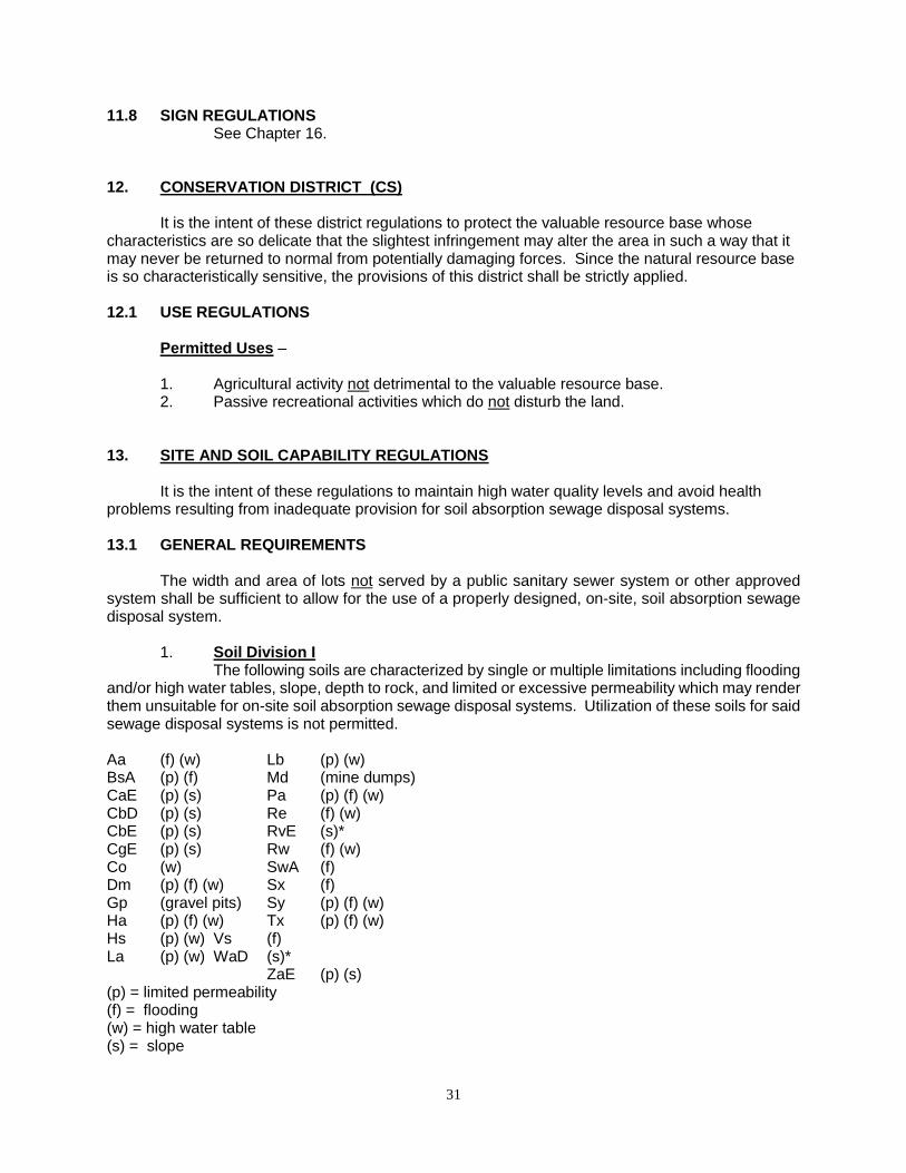
31
11.8 SIGN REGULATIONS See Chapter 16.
12. CONSERVATION DISTRICT (CS) It is the intent of these district regulations to protect the valuable resource base whose characteristics are so delicate that the slightest infringement may alter the area in such a way that it may never be returned to normal from potentially damaging forces. Since the natural resource base is so characteristically sensitive, the provisions of this district shall be strictly applied. 12.1 USE REGULATIONS
Permitted Uses – 1. Agricultural activity not detrimental to the valuable resource base. 2. Passive recreational activities which do not disturb the land.
13. SITE AND SOIL CAPABILITY REGULATIONS It is the intent of these regulations to maintain high water quality levels and avoid health problems resulting from inadequate provision for soil absorption sewage disposal systems. 13.1 GENERAL REQUIREMENTS The width and area of lots not served by a public sanitary sewer system or other approved system shall be sufficient to allow for the use of a properly designed, on-site, soil absorption sewage disposal system.
1. Soil Division I The following soils are characterized by single or multiple limitations including flooding
and/or high water tables, slope, depth to rock, and limited or excessive permeability which may render them unsuitable for on-site soil absorption sewage disposal systems. Utilization of these soils for said sewage disposal systems is not permitted. Aa (f) (w) Lb (p) (w) BsA (p) (f) Md (mine dumps) CaE (p) (s) Pa (p) (f) (w) CbD (p) (s) Re (f) (w) CbE (p) (s) RvE (s)* CgE (p) (s) Rw (f) (w) Co (w) SwA (f) Dm (p) (f) (w) Sx (f) Gp (gravel pits) Sy (p) (f) (w) Ha (p) (f) (w) Tx (p) (f) (w) Hs (p) (w) Vs (f) La (p) (w) WaD (s)*
ZaE (p) (s) (p) = limited permeability (f) = flooding (w) = high water table (s) = slope

32
2. Soil Division II The following soils are characterized by slight or moderate limitations. The width of all
lots shall not be less than one hundred (100) feet and the area of all lots shall not be less than twenty thousand (20,000) square feet.
A. Pollution Hazard Potential BaC MbB SuB BbA McB SuC BcA PbA TaB BcB PcA TbA LhA PcB TeD LkA PtC VkB MbA StA VIB
VIC
B. Restricted Permeability or Other ArA GnA Hm ArB GnB LIC ArC Hb LnB FaA Hc MaA FaB Hd MaB
3. Soil Division III The following soils are characterized by severe limitations due to low permeability.
The width of all lots shall not be less than one hundred fifty (150) feet and the area of all lots shall be not less than forty thousand (40,000) square feet. BdA LcB SmB BdB LeA SmC BeA Lo** SmD BeB MoA TmA BmA MoB TwB BmB MoC TwC BmC MoD TwD ChD MpA VaC FcB MpB VbD FIA MpC VhD FIB MsC WIA FIC NfB WIB FwA RgA WIC FwB RgB WmC FxB RgC WnC FxC RIA WzD FxD RIB ZaD GaA RIC GaB RoB GcA SaA GcB SeC GcC SmA LcA

33
* Falls in Soil Division III when slope is less than 15% ** Falls in Soil Division I if unprotected from flooding
4. Soil Absorption System - Soil absorption system shall not be located at a point lower than the grade of any
nearby water well or spring and shall not be within ten (10) feet of a dwelling, within fifty (50) feet of a private water supply, or within one hundred (100) feet of a public water supply, stream, river, lake, reservoir, or other water areas.
5. Modification - An applicant desiring to install said facilities on soils with limitations shall have the
opportunity to present evidence contesting said classification. The Planning Commission shall affirm, modify, or change the classification.
6. Shorelines - A minimum of one hundred (100) feet shall be maintained between all structures and
the natural shoreline of streams, rivers, lakes, reservoirs, or other water areas. 14. PARKING REGULATIONS No application for a building permit or certificate of occupancy shall be approved unless there is included within the plan for such building, improvement, or use, the required open space designated as being reserved for off-street motor vehicle parking purposes. No certificate of occupancy shall be issued unless the required facilities have been provided in accordance with those shown on the approved plan. Such off-street parking shall be provided on the basis of the minimum requirements set forth in this section. 14.1 USE REQUIREMENTS In the case of structures or uses not mentioned, the requirements for a similar use shall apply. Fractions over one-half (1/2) shall require one (1) parking space.
1. Dwellings - a. Single-family dwellings - one (1) space for each dwelling unit. b. Multiple-family dwellings - 1.5 spaces for each dwelling unit. 2. Schools - One (1) space for each two (2) staff members/employees plus one (1) space
for each classroom. 3. Hospitals - One (1) space for each two (2) patient beds, plus one (1) space for each
staff doctor plus one (1) space for each two (2) employees. 4. Places of Public Assembly - One (1) space for every five (5) seats, based on
maximum seating capacity. 5. Commercial Establishments - a. Dining and drinking establishments - One (1) space for each four (4) seats
planned for patron use. b. Hotels and rooming houses - One space for each two (2) guest rooms. c. Motels - One (1) space for each guest room or cabin. d. Theaters - One (1) space for each five (5) seats planned for patron use.
e. Retail establishments - One (1) space for each one hundred (100) square feet of floor area.
f. Office Buildings - One (1) space for each four hundred (400) square feet of floor area.

34
6. Manufacturing/Wholesale/Industrial Establishments - One (1) space for each two (2) employees, one (1) space for each piece of company-owned or leased rolling stock, and one (1) visitor parking space for each ten (10) employees.
14.2 GENERAL REQUIREMENTS
1. Location - Off-street parking required by this section shall be located on the same zone lot; but
because of practical difficulties, may be located upon another parcel of land under the same ownership within four hundred (400) feet of the premises to which they are appurtenant.
2. Size - Each parking space shall be not less than one hundred eighty (180) square feet
exclusive of the space required for ingress and egress. 3. Surfacing -
All off-street parking areas shall be graded and surfaced so as to be dust free and properly drained. 4. Continuing obligation -
Requirements for off-street parking shall be a continuing obligation so long as the structure is in existence and its use requiring vehicle parking continues. The off-street parking area shall not be encroached upon by buildings, storage, or any other use. A reduction in the number of spaces by reason of diminution of floor space, seating capacity, number of employees, or change in other factors controlling the regulation of the number of required parking spaces, by the Planning Commission must be both reasonable and consistent with the intent of this section.
5. Joint Cooperation - These requirements are not intended to prohibit joint off-street parking facilities but the
minimum number of spaces required for each use shall be measured separately.
6. Mixed Uses - Plans with mixed uses shall provide spaces equal to the sum of the requirements of
the various uses computed separately. 15. LOADING AND UNLOADING REGULATIONS No application for a building permit or certificate of occupancy for a commercial or industrial use shall be approved unless there is included within the plan for such building improvement or use the required space of structural design for off-street loading purposes to be provided in connection with such building, improvement, or use, in accordance with this section; and no certificate of occupancy shall be issued unless the required facilities have been provided in accordance with those shown on the approved plan. 15.1 GENERAL REQUIREMENTS
1. Number of Berths - Each department store, freight terminal, or railroad yard, hospital or sanitarium,
industrial plant, manufacturing establishment, retail establishment, storage warehouse or wholesale establishment, which has an aggregate gross floor area of twenty-five thousand (25,000) square feet or more, arranged, intended, or designed for such use, shall provide off-street loading or unloading berths in accordance with the following table: Square feet of Gross Floor Required Number of Area Devoted to Such Use Berths

35
25,000 but less than 40,000 1 40,000 but less than 80,000 2 80,000 but less than 120,000 3 120,000 but less than 160,000 4 160,000 but less than 240,000 5 For each additional 50,000 1 additional
2. Location - All loading and unloading operations shall be so located as to avoid undue interference
with public use of streets, alleys, and walkways. These spaces shall not be located in the front of the structure, nor shall they infringe on any side or rear yard requirements. 16. SIGN REGULATIONS No sign shall hereafter be located, erected, moved, reconstructed, extended, enlarged, converted, or structurally altered without an outdoor advertising permit except those signs subject to the regulations of Chapter 24-17, North Dakota Century Code, or the following sign types:
1. Signs required by law or authorized for a public purpose 2. Official traffic control, parking restriction, or informational signs 3. Danger or warning signs of a cautionary nature 4. Cornerstones and historical markers 5. Real estate for sale, rental, or lease signs 6. Building name signs, name plates and addresses 7. Window displays of actual merchandise
16.1 GENERAL REQUIREMENTS
1. Location - Signs shall be incidental to the permitted use and shall be located on the same zone
lot as the permitted use. 2. Maintenance -
Signs shall be maintained in good repair. Broken signs, deteriorated signs, or signs on vacant buildings may be ordered repaired or removed by the Planning Commission.
3. Safety Restrictions - Signs shall not resemble, imitate, or approximate shape, size, form, or color of railroad
or traffic signs, signals, or devices, nor shall they obstruct or interfere with effectiveness of railroad or traffic signs, signals, or devices.
4. Distance from Residential Districts - No sign except those falling outside the jurisdiction of this Ordinance shall be permitted
to face a residential district within one hundred (100) feet of such district boundary. 5. Non-Conformance -
Signs lawfully existing at the time of adoption of this Ordinance may be continued although the use, size, or location does not conform with the provisions of this Ordinance. However, they shall be deemed non-conforming uses or structures and the provisions of Section 2.6 shall apply.
6. Outdoor Advertising Permit - All signs regulated by this Ordinance must have an Outdoor Advertising Permit from
the Land Use Administrator. Said permit shall operate for a period of five (5) years, any portion of a year considered as a full year, and shall be renewed on or before December 31st of the expiration year, provided that such renewal will not adversely affect public health, safety, or welfare. The fee for said permit shall be established by the Board of County Commissioners.

36
16.2 DISTRICT REQUIREMENTS
1. Residential Districts - a. Home and professional occupations shall be permitted one non-illuminated
and non-animated sign of one (1) square foot. b. All permitted uses other than dwellings shall be allowed signs totaling forty
(40) square feet in area. Such signs may be illuminated but shall not be animated or flashing.
c. The maximum height of a sign located on a wall shall be twenty (20) feet. The maximum height of a free-standing sign shall be six (6) feet.
2. Commercial and industrial Districts-
a. All permitted uses shall be allowed signs totaling two hundred (200) square feet.
b. The maximum height of a sign located on a wall of any structure shall be forty (40) feet. The maximum height of a free-standing sign shall be twenty-five (25) feet.
17. ADMINISTRATION, PROCEDURES, AND PERMITS This section of the Ordinance establishes the duties of the duly authorized county bodies or authorities instrumental in the administration of said Ordinance and establishes the various procedures and permits necessary for its proper implementation. 17.1 ADMINISTRATION
Oliver County Planning and Zoning Commission
Authority The Oliver County Planning and Zoning Commission was established by the Oliver County Board of County Commissioners in accordance with the North Dakota Century Code, §11-33-04. Duties 1. Establish and administer rules and procedures for conducting the zoning affairs of
Oliver County. 2. Conduct hearings on zoning amendments and forward recommendations to the Board
of County Commissioners. 3. Conduct hearings on conditional uses and set conditions for certain uses. 4. Establish requirements and procedures necessary for submission of applications. 5. Establish bonding, fee schedules, and accounting thereof, said bonding, schedules,
and accounting subject to approval of the Board of County Commissioners. Board of Adjustment
Authority The Board of County Commissioners shall act as a Board of Adjustment in accordance with the North Dakota Century Code, §11-33-11. Duties 1. The Board shall hear appeals from any person, party, firm, or organization aggrieved
by the actions or decisions of the Planning Commission. 2. The Board may authorize a variance from the terms of this Ordinance.
37
Land Use Administrator
Authority The Planning and Zoning Commission shall appoint a Land Use Administrator to carry
out directives and duties as assigned by the Commission. Said administrator shall be responsible directly to the Planning and Zoning Commission.
Duties: 1. Attend all hearings. 2. Maintain updated copies of the Ordinance and District Zoning Map. 3. Keep copies of all records. 4. Make inspections of land and/or structures to determine compliance with the provisions
of this Ordinance. 5. Issue authorized permits in compliance with provisions of this Ordinance. 6. Carry out any other duties assigned by the Planning and Zoning Commission.
17.2 PROCEDURES
Amendments
The Oliver County Planning and Zoning Commission, the Board of County Commissioners, or any person may initiate an amendment to either the zoning ordinance or the zoning map in the manner herein set forth. Procedures
1. Applications for amendments shall be submitted to the Land Use Administrator. The application shall include:
a. Name and address of the applicant b. Date of application
c. The applicant's statement of interest and description of proposed amendment.
2. Upon receipt of such application the Land Use Administrator shall immediately file such application with the County Auditor, shall set a date for public hearing on the proposed amendment, and shall notify both the applicant and the Planning Commission of the date of such public hearing. 3. Notice of the hearing shall be the responsibility of the applicant. Notice of the hearing shall be published once a week for two consecutive weeks in the official newspaper of the County. Notice shall include the time, place, and purpose of the hearing. Notice shall also describe the nature, scope, and purpose of the amendment, and shall also state the times at which it shall be available to the public for inspection and copying in the office of the County Auditor. Proof of publication of the notice shall be filed with the County Auditor and a copy thereof shall be presented to the Land Use Administrator. 4. Following the public hearing, the Planning and Zoning Commission shall submit its recommendation concerning the proposed amendment to the Board of County Commissioners for a decision. 5. Upon the receipt of the recommendation of the Planning and Zoning Commission, the Board of County Commissioners may request such further information from the Planning and Zoning Commission as the Board of County Commissioners deems advisable, and upon receipt of such information, the Board of County Commissioners may either reject the amendment or adopt same with such changes as it deems advisable. Any amendment adopted shall be
38
published and shall take effect in the manner provided by Chapter 11-33 of the North Dakota Century Code.
Grievances
Any person aggrieved by the adoption of this Ordinance by the County Commissioners, or any amendment thereto or by any action of the Planning and Zoning Commission, may, within sixty days after the effective date of such adoption, amendment, or action, petition for a separate hearing before the Board of County Commissioners. Procedures:
1. The petition shall be in writing, shall specify in detail the grounds of the objection, and shall be filed with the Land Use Administrator. 2. A hearing thereon shall be held by the board no sooner than ten (10) days, nor longer than forty (40) days after the filing of the petition with the Land Use Administrator, who shall notify the petitioner of the time and place of the hearing. 3. The Board of County Commissioners shall consider the matter complained of and shall notify the petitioner, by registered or certified mail, what action, if any, it proposes to take thereon. 4. The provisions of this section shall not operate to curtail or exclude the exercise of any other rights or powers of the Board of County Commissioners or any citizen. Any person, or persons, jointly or severely aggrieved by a decision of the Board of County Commissioners may appeal to the district court in the manner provided in Chapter 11-11-39 of the North Dakota Century Code.
Variances
The Planning and Zoning Commission may recommend and the Board of County Commissioners may authorize a variance from the terms of this Ordinance. The Board of County Commissioners must find that the granting of such a variance will not merely serve as a convenience to the applicant, but alleviate some demonstrable or unusual hardship or difficulty. The following conditions must exist:
a. The property has exceptional, unique, or special characteristics different from other property, particularly adjacent property.
b. Enforcement of the Ordinance, with regard to properties having such characteristics, results in unnecessary and undue hardship.
c. Granting of the variance would have no adverse effect on the public interest, safety, health, and welfare.
d. Granting of a variance would have no adverse effect on neighboring property. Under no circumstances shall the Board grant a variance allowing a use within a district not permissible under the terms of this Ordinance, nor shall the Board use the variance for a change affecting a large number of properties.
Procedures: 1. Applications for a variance shall be submitted to the Land Use Administrator. The applications shall include: a. Name and address of applicant. b. Date of application. c. The special conditions or circumstances which are peculiar to the applicant's
land or structure or a result of applicant's actions.

39
2. A hearing shall be held by the Planning and Zoning Commission and the Land Use Administrator shall be notified, in writing, of the decision by the Planning and Zoning Commission and the Board of County Commissioners.
17.3 PERMITS Building Permit
1. A building permit shall be required for all new uses; remodeled, expanded, or otherwise altered permitted uses; and all conditional uses. No permit shall be required for normal agricultural uses.
2. Applications for a building permit shall be accompanied by a plat in duplicate, drawn to scale, showing the name of the applicant, the actual dimensions of the lot to be built upon as shown by a survey, the size, shape, and location of any structures to be erected, and such other information required or necessary for the enforcement of this Ordinance.
3. In case construction or exploration is not begun within six (6) months after the date of issuance of a Building Permit or an Outdoor Advertising Permit, said permit shall be cancelled, unless an extension is granted.
4. It shall be unlawful for any association, company, person, firm, cooperative, or corporation to supply electrical current or power to any building or structure within the zoned area of Oliver County, unless an Occupancy Permit has been issued by the Land Use Administrator, certifying that building or structure is in conformance with this Ordinance.
5. All building permits must be obtained from the Land Use Administrator before construction. Failure to obtain a building permit shall constitute a violation of this Ordinance.
Conditional Use Permit
A Conditional Use Permit shall be granted following compliance with, but not limited to, the
conditions set forth in the district regulations and the following procedure:
Procedures: 1. Applications for Conditional Use Permits shall be submitted to the Land Use Administrator. The applications shall include:
a. Name and address of applicant, with signature of the applicant. b. Date of application. c. Description of the site and its relationship to the surrounding area. d. Preliminary map showing boundary lines and location of structures to be
developed on the site. e. Topographic map in five (5) foot contours of the site. f. General soils of the site. g. Location of existing utilities and/or proposed utility extensions. h. Parking plan showing off-street parking areas and/or loading areas. i. A timing schedule indicating the anticipated starting and completion dates of
the development. j. Names and addresses of adjacent property owners. k. Any reasonable information the Planning Commission deems necessary.
2. The Planning and Zoning Commission shall hold a public hearing before any action is taken on the application. Notice of hearing is the responsibility of the applicant. 3. The applicant or applicant’s representative must appear before the Planning and Zoning Commission before action will be taken on the application. If the applicant or applicant’s representative does not attend the hearing, the application will be tabled until the next meeting of the Planning and Zoning Commission at which applicant or applicant’s representative is present.
40
4. Following the public hearing, the Planning and Zoning Commission shall submit its recommendations, executed by the appropriate office of the Commission, concerning the permit request to the Board of County Commissioners for their decision.
Temporary Permits
Applicants shall obtain a temporary permit from the Planning Commission for the following and all other additional uses determined by the Planning Commission:
1. Bazaars, carnivals, or fairs 2. Musical events 3. Racing events 4. Revivals 5. Rodeos 6. Parking lots for special events 7. Public gatherings for a single-purpose event 8. Temporary building or yard for construction materials and/or equipment incidental and necessary for current construction in the immediate surrounding area. 9. Temporary office incidental and necessary for the construction, sale, or rental of the property in the immediate surrounding area.
Procedure: 1. Applications for Temporary Use Permits shall be submitted to the Land Use Administrator. The applications shall include:
a. Name and address of applicant. b. Date of application. c. Written description of location of the site and/or event. d. Location of temporary structures incidental to operation of the event. e. Written statement of the hours of operation and duration of the event. f. Written evidence of approval of landowner of proposed site. g. Written evidence of approval by Oliver County Board of Health for sanitation
facilities. 2. Permits shall be valid for such period of time as determined by the Planning Commission and shall be renewable at the discretion of the Commission. A performance bond may be required by the Board of County Commissioners.
18. ENFORCEMENT
It shall be unlawful to construct, develop, or use any structure, or to develop or use any land, water, or air in violation of any of the provisions of this Ordinance.
1. Complaints - Whenever a violation of this Ordinance occurs, or is alleged to have occurred, any
person may file a written complaint. Such complaint, stating fully the causes and basis thereof, shall be filed with the Land Use Administrator, who shall record said complaint, notify the Planning Commission, and conduct an investigation.
2. Remedies -
If any structure is unlawfully constructed, developed, or used, or any land, water, or air is unlawfully developed or used in violation of the provisions of this Ordinance, the Board of County Commissioners or any affected citizen or property owner may institute any appropriate action or proceedings, in addition to other remedies, to:
41
a. Prevent such unlawful erection, construction, reconstruction, alteration, repair, conversion, maintenance, or use;
b. Restrain, correct, or abate such violations; c. Prevent the occupancy of the building, structure, or land; d. Prevent any illegal act, conduct, business, or use in or about such premises.
3. Penalties - A violation of any provision of this Ordinance, its regulations and restrictions, shall
constitute the maintenance of a public nuisance. Upon conviction there shall be a penalty of a fine of not more than two (2) percent of the assessed value or five hundred dollars ($500.00), whichever is greater, or imprisonment in the county jail for not more than thirty (30) days, or both such fine or imprisonment. Each day in violation of this Ordinance shall constitute a separate offense. 19. DEFINITIONS 19.1 GENERAL TERMS
Words used in the present tense include the future; the singular number includes the plural and the plural shall include the singular. The word person includes a firm, association, partnership, trust, company, or corporation as well as an individual. The word shall is mandatory; the word may is permissive. 19.2 SPECIFIC TERMS
Accessory Use - a use on the same lot with, and of a nature customarily incidental and subordinate to, the principle use.
Accessory Structure - a structure on the same lot with, and of a nature customarily incidental and subordinate to, the principle structure or use.
Alley - a minor street providing vehicular service access to the back or side of two or more properties.
Amendment - any change, revision, or modification of the text of this Ordinance or the District Zoning Map.
Animal Hospital or Clinic - an establishment where animals are admitted principally for examination, treatment, board, and care by a Doctor of Veterinary Medicine.
Board of Adjustment - the Board of County Commissioners, or a body authorized by them, which hears appeals on the enforcement of the provisions of this Ordinance and grants variances.
Buffer Strip - an area of the lot, usually along the perimeters, provided with trees, shrubbery, or fencing which serves as a sight and sound barrier.
Building - any structure designed, or intended for the enclosure, shelter, or protection of persons, animals, or property.
Camper Disposal Station - a facility for the disposal of camper or recreational vehicle solid and liquid waste holding tanks.

42
Clear Sight Triangle - an area of unobstructed vision at a street intersection defined by lines of sight between points at a given distance from the intersecting street right-of-way lines.
Coal Excavation and Mining - The stripping and stockpiling of suitable plant growth material, the removal and stockpiling of overburden, the excavation of the coal, and the reclamation of the area as required by State and/or Federal law.
Commercial Sand, Gravel, and Scoria Operations - the lease, sale, or rental of land for the purpose of opening a sand, gravel, and/or scoria pit and the processing of the material of said pit for sale or resale. The provisions of this Ordinance regarding commercial sand, gravel, and/or scoria operations do not apply to a farmer's incidental use of his private operation or to an operation by a political subdivision.
Conditional Use - any use to which the Planning Commission shall set specific conditions, all of which must be met prior to approval of said use in a district.
Districts - the areas of Oliver County for which the regulations governing the use of the land and the use, density, bulk, height, and location of structures and buildings are uniform.
District Zoning Map - the map showing the zoning districts of Oliver County officially adopted by the Board of County Commissioners.
Easement - a vested or acquired right to use land, other than as a tenant, for a specific purpose; such right being held by someone other than the owner who holds title to the land.
Farm - a tract of land devoted to agricultural activities.
Home and Professional Occupations - a gainful occupation conducted by members of the family only within the dwelling or on the premises, which is clearly incidental or secondary to the use of the dwelling for dwelling purposes and does not change the character thereof, provided that no display except a regulated sign will indicate from the exterior that the building or land is being utilized in part for any purpose other than that of a dwelling.
Intensity - a means of regulating density by restricting the percentage of a lot that may be occupied by a structure or use.
Land Use Administrator - the officer appointed by the Planning Commission to administer
the zoning affairs of Oliver County.
Livestock Auction Ring - an enclosure or structure designed or used for holding livestock for purpose of sale, or transfer by auction, consignment, or other means.
Living Unit - a residential unit providing complete, independent living facilities for one family including permanent provisions for living, sleeping, eating, cooking, and sanitation.
Local Roads - the remaining mileage not otherwise classified as major or minor collectors by the State Highway Department, shall be assigned to the rural local road system.
Lot - a tract of land of at least sufficient size to meet minimum zoning requirements for use, coverage, and area, and provide such yards and other open space as are herein required.
Lot Coverage - The total area of a lot covered by buildings, expressed as a percentage of the total lot.
43
Lot Depth - the mean horizontal distance between the front and rear lot lines.
Lot of Record - a lot which is part of a subdivision, the map of which has been recorded in
the office of the County Auditor and Register of Deeds of Oliver County, or a parcel of land, the deed of which was recorded in the office of the Register of Deeds, prior to the adoption of this Ordinance.
Lot Width - the distance between straight lines connecting front and rear lot lines at each side of the lot, measured at the rear of the required front yard.
Major Collector - serving the county seats, large towns, and other traffic generator or serving as important intra-county travel corridors and designated as such by the State Highway Department.
Mineral Exploration Operations - any operation involved in the search, exploration, or prospecting of any substance or mineral which involves the penetration of the land surface by digging, drilling, or excavating.
Minor Arterial - linking cities and larger towns, forming an integrated network for inter-county travel, and designated as such by the State Highway Department.
Minor Collector - collecting traffic from local roads, providing service to small communities and linking important traffic generators with their rural hinterland and designated as such by the State Highway Department.
Minor Structure - any small, movable accessory erection or construction such as tool houses, pet houses, play equipment, and arbors.
Mobile Home Dwelling - a structure, transportable in one or more sections, which is eight (8) body feet or more in width and is thirty-two (32) body feet or more in length, and which is built on a permanent chassis and is designed to be used as a dwelling with or without a permanent foundation when connected to the required utilities, and includes the plumbing, heating, air conditioning, and electrical systems contained herein. All mobile home dwellings are titled by the Motor Vehicle Division of the State Highway Department.
Mobile Home Park - a tract of land designed and developed to accommodate mobile homes, each occupying a portion of the site on a purchase, lease, or rental basis, and each provided with the necessary utilities and other amenities so that the total development serves as a suitable environment for long-term residential occupancy.
Motor Vehicle - any vehicle requiring a motor vehicle license from the State of North Dakota.
Multiple Family Dwelling - a residential building designed for occupancy of two or more families, with the number of families in residence not exceeding the number of dwelling units provided.
Non-Conforming Use - any building or tract of land lawfully occupied by a use, at the time of passage of this Ordinance or amendments thereto, which does not conform with the provisions of this Ordinance or amendments thereto.
Non-Farm Residence - a residential building designed for occupancy of one family; whose primary occupation is not devoted to an agricultural activity.
Parking Space - an area for the purpose of storing one parked automobile. For the purpose of this Ordinance, one parking space shall have a minimum width of nine (9) feet and a minimum

44
length of twenty (20) feet. In computing off-street parking, additional space shall be required off-street for access drives to each.
Permanent Type Construction - must be a wood frame, brick, stone, tile, or metal panel, painted, on concrete or concrete block foundation. This type of construction shall not have tar paper or similar exteriors and shall not be a shack, hut, Quonset, or old railroad car, bus, etc.
Permitted Use - any use which complies with the requirements of a zoning district.
Pipelines--Industrial, Municipal, and Commercial - any pipelines conveying material within the county.
Planned Unit Development (PUD) - an area of land, controlled by the landowner (s), to be developed as a single entity for a number of dwelling units, and commercial and industrial uses, if any, the plan for which does not correspond in lot size, bulk, or type of dwelling or commercial or industrial use, density, lot coverage, and required open space to the regulations established in any one or more districts created, from time to time, under the provisions of this Ordinance.
Planning Commission - The Oliver County Planning Commission.
Plat - any map, plan, or chart of a tract of land or subdivision indicating the location and boundaries of individual properties.
Plot - a parcel of land consisting of one or more lots or portions thereof which is described by reference to a recorded plat or metes and bounds.
Principle Structure - a structure housing the primary, permitted use, allowed as a matter of right within a particular zone.
Ranch - See Farm.
Rear Yard - a yard extending across the full width of the lot from side lot lines, the depth of which is the least distance between the rear lot line and the rear of the principle building.
Recreation Vehicle - a vacation trailer or other vehicular or portable unit which is either self-propelled or towed or is carried by a motor vehicle and which is intended for human occupancy and is designed for vacation or recreation purposes but not for residential use.
Recreation Vehicle Park - a tract of land designed, utilized, and operated on a fee or other basis as a place for the temporary parking of occupied recreation vehicles.
Right-of-Way - an area, either public or private, over which the right of passage exists. The right-of-way shall not be considered as land area when computing lot size.
Salvage Yard or Junk Yard - a tract of land, or structure, or part thereof, used primarily for the collecting, storage, and sale of scrap or discarded material or for the collecting, dismantling, or storing and salvaging of machinery or vehicles not in running order, or for the sale of parts thereof.
Setback - the line within a property defining the required minimum distances between any structure or use of right-of-ways, centerlines, section lines, or other designated points.
Side Yard - a yard extending from the rear line of the required front yard to the rear lot line, the depth of which is the least distance from the sides of the principle building and the side lot line.

45
Sight Line - see Clear Sight Triangle.
Sign - any outdoor advertising having a permanent location on the ground or attached to or
painted on a building, including bulletin boards, billboards, name plates, and poster boards.
Single-Family Dwelling - a detached residential unit designed for and occupied by one family. A mobile home with permanent foundation is considered a single-family dwelling.
Street - except for the section lines, a way for vehicular traffic whether designated as a street, highway, thoroughfare, parkway, throughway, road, avenue, boulevard, land place, or however else designated..
Structure - anything constructed or erected, the use of which requires permanent location on the ground or attached to something having a permanent location on the ground.
Subdivision - (2/26/82) any land, vacant or improved, which is divided or proposed to be divided onto two or more lots, parcels, sites, units, plots, or interests for the purpose of transfer of ownership or building development, whether immediate or future, or if a new street is involved, any division of a parcel of land. The term subdivision includes resubdivision and the term re-subdivision, as used herein, shall include any further subdivision of a lot or parcel of land previously subdivided, for sale, use or other purposes, which varies from the latest approved subdivision of the same. The division of agricultural land, for agricultural purposes, into parcels of more than 10 acres, not involving any new street, shall not constitute a subdivision.
Tract - a plot, piece, or parcel of land, other than a lot, which is recorded in the office of the Register of Deeds.
Transmission Line - overhead electrical line(s) larger than 115 kv.
Use - the specific purpose for which land or buildings are intended.
Variance - a relaxation of the terms of the Zoning Ordinance where such variance will not be contrary to the public interest and where, owing to conditions peculiar to the property and not the result of the actions of the applicant, a literal enforcement of the Ordinance would result in unnecessary and undue hardship. As used in this Ordinance, a variance is authorized only for height, area, and size of structure or size of yards and open space.
Yard - a space on the same lot with the principle building or structure, open, unoccupied, and unobstructed by buildings or structures from the ground upward. 20. SUBDIVISION REGULATIONS
Requirements to Meet Subdivision Regulations No person shall cause or create a subdivision or resubdivision of land unless having complied
with the provisions of this Section 20 and the other requirements of this Ordinance. Every new lot, plat, tract, or parcel of land created by subdivision for immediate or future transfer, sale, or lease for building development, shall be situated entirely within a district zoned other than as an Agricultural District.
46
20.1 FILING CHECKLIST
Step 1 - Prior to filing an application for conditional approval of the Preliminary Plat, the subdivider shall submit the necessary information to the Oliver County Planning Commission. (See Pre-Application Procedure for information required.)
Step 2 - If the Planning Commission determines that the plans and data submitted by the subdivider do meet the requirements and objectives of the Subdivision Regulations, the subdivider may begin the preparation of the Preliminary Plat. (See Procedure for Conditional approval of Preliminary Plat for information required.)
Step 3 - Submit twelve copies of the Preliminary Plat to the Planning Commission with a written application for conditional approval at least ten days prior to the meeting at which the Preliminary Plat is to be considered.
Step 4 - Obtain a copy of the conditionally approved Preliminary Plat after the Planning Commission has acted.
Step 5 - Application for approval of the Final Plat shall be submitted in writing to the Planning Commission at least ten days prior to the meeting at which it is to be considered. The Final Plat shall be submitted to the Planning Commission within two months after approval of the Preliminary Plat unless the Planning Commission grants a longer period. (See Approval of Final Plat.)
Step 6 - Post performance Bond with County Auditor. Step 7 - The signature of the County Engineer indicating his approval must appear on the Final
Plat prior to submission to the Board of County Commissioners for approval. Step 8 - The Planning Commission shall forward the approved Final Plat to the Board of County
Commissioners for final approval and signatures. Step 9 - After the Board of County Commissioners has approved the Final Plat, the developer
shall file with the Planning Commission for distribution to the appropriate agencies, a sufficient number of copies of the approved plat. The number of copies necessery shall be determined by the Planning Commission.
Step 10 - The subdivider shall file the Final Plat with the Oliver County Register of Deeds and shall file a certified copy of the Final Plat with the Oliver County Auditor. 20.2 FILING PROCEDURES AND DATE REQUIREMENTS
A. Pre-Application Procedure
1. Prior to filing an application for conditional approval of the Preliminary Plat, the subdivider shall submit the following plans and data to the Oliver County Planning Commission:
a. Location Map - shall show the relationship of the proposed subdivision to existing community facilities which serve or influence it. The location map shall include: the development name and location; main traffic arteries; public transportation lines; shopping centers; elementary and high schools; parks and playgrounds; principal places of employment; other community features such as railroad stations, airport, hospitals, churches; title; scale; north arrow; date and any other pertinent information. b. Sketch Plan in Topographic Survey - shall show in single sketch form the proposed layout of streets, lots, and other features in relation to existing conditions. The sketch plan may be a free-hand pencil sketch made directly on a print of the topographic survey. The sketch plan shall include either the existing topographic data and such other data as the Planning Commission determines is necessary for its consideration of the proposed sketch plan. c. General Subdivision Information- shall describe or outline the existing conditions of the site and proposed development as necessary to supplement the required drawings. This information may include, but is not limited to, data on

47
existing covenants, land characteristics, and available community facilities utilities, and information describing such subdivision proposals as number of residential lots, typical lot width and depth, business areas, playgrounds, park areas, and other public areas, proposed protective covenants and proposed utilities and street improvements. This step does not require a formal application, fee, or filing of plat with the Planning Commission.
2. Within 15 days after submittal, the Planning Commission shall inform the subdivider that the plans and data as submitted or as modified do or do not meet the objectives of these regulations. When the Planning Commission finds the plans and data do not meet the objectives of the subdivision regulations, it shall state the reasons for its rejection and what changes are required for approval.
B. Procedure for Conditional Approval of Preliminary Plat
1. Once it has been determined by the Planning Commission that the plans and data submitted by the subdivider do meet the requirements of these regulations, the subdivider shall prepare the preliminary plat. The following requirements are necessary for the conditional approval of the preliminary plat:
a. Topographic Data - shall include the following existing conditions except when otherwise specified by the Planning Commission:
(1) Boundary lines - bearings and distance (2) Easements - location, width, and purpose (3) Streets on and adjacent to the tract - name and right-of-way width and location; type, width, and elevation of surfacing; any legally established center-line elevations; walks, curbs, gutters, culverts, etc. (4) Utilities on and adjacent to the tract - location, size and invert elevation of sanitary and storm sewers; location and size of water mains; location of gas lines, fire hydrants, electric and telephone poles, and street lights. If water mains and sewers are not on or adjacent to the tract, indicate the direction and distance to, and size of nearest ones, show invert elevation of sewers. (5) Subsurface conditions on the tract - If required by the Planning Commission and the County Engineer location and results of tests made to ascertain: subsurface soil, rock, and ground water conditions; depth to ground water unless test pits are dry at a depth of 5 feet; location and results of soil percolation tests if individual sewage disposal systems are proposed. (6) Other conditions on the tract show: water courses, marshes, rock outcrops, wooded areas, isolated preservable trees one foot or more in diameter, houses, barns, shacks, and other significant features upon a topographic map in five (5) foot or less contours. (7) Other conditions on adjacent land show: approximate direction and gradient of ground slope, including any embankments, or retaining walls; character and location of buildings, railroads, power lines, towers, and other nearby non-residential land use or adverse influences; owners of adjacent unplatted land. For adjacent platted land refer to subdivision plat by name, recordation date, and number. Show approximate percent that is built up, typical lot size, and dwelling type. (8) Photographs, if required by the Planning Commission: camera locations, directions of views and key numbers. (9) Zoning on and adjacent to the tract, if any.

48
(10) Proposed public improvements: Highways or other major improvements planned by public authorities for future construction on or near the tract. (11) Key plan showing location of the tract. (12) Title and certificates: Submit tract designation according to official records, title under which proposed subdivision is to be recorded, names and addresses of owners, notation stating acreage, scale, north arrow, datum, benchmarcks, certification by a licensed land surveyor, date of survey. (13) Submit a plot prepared according to state law by a licensed land surveyor.
b. The preliminary plat shall be at a scale of one inch to two hundred feet (1:2400). It shall show all existing conditions required in Topographic Data and shall show all proposals including the following:
(1) Streets: Names; right-of way and roadway widths; approximate grades and gradients; similar data for alleys, if any. (2) Other rights-of-way or easements; locations, width and purpose. (3) Location of utilities, if not shown on other exhibits. (4) Lot lines, lot numbers, and block numbers. (5) Sites, if any, to be reserved or dedicated for parks, playgrounds, or other public uses. (6) Sites, if any for multi-family dwellings, shopping centers, churches, industry or other non-public uses exclusive of single-family dwellings. (7) Minimum building setback lines. (8) Site data, including number of residential lots, typical lot size, and acres in parks, etc. (9) Title, scale, north arrow, and date.
c. Other Preliminary plans - when required by the Planning Commission, the preliminary plat shall be accompanied by profiles showing existing ground surface and proposed street grades, including extensions for a reasonable distance beyond the limits of the proposed subdivision; typical cross sections of the proposed grading, roadway and sidewalk; and preliminary plan of proposed sanitary and storm water sewers with grades and sizes indicated. d. Protective Covenants - submit a draft of protective covenants whereby the subdivider proposes to regulate land use in the subdivision and otherwise protect the proposed development.
2. Twelve (12) copies of the preliminary plat and supplementary material specified
above shall be submitted to the Planning Commission with written application for conditional approval at least ten days prior to the meeting at which it is to be considered. The Planning Commission shall forward copies of the preliminary plat to the following agencies: County Engineer, County Water Management District Board, County Board of Health, State's Attorney, Land Use Administrator, Lewis and Clark 1805 RCD Council, local Soil Conservation District, affected rural fire district, and the local electric and telephone companies servicing the proposed area.
3. Following (a) review of the preliminary plat and other material submitted to conformity
to the subdivision regulations and (b) negotiations with the subdivider on changes deemed advisable and the kind and extent of improvements to be made by him, the Planning Commission shall, within forty days, act on the preliminary plat, as submitted, or modified, and, if approved, the Planning Commission shall express approval as Conditional Approval and state the conditions of such approval, if any, or if disapproved, shall express its disapproval and its reasons therefor.

49
4. The action of the Planning Commission shall be noted on two copies of the preliminary plat, referenced and attached to any conditions determined by the Commission. One copy shall be returned to the subdivider and the other retained by the Planning Commission.
5. Conditional Approval of the preliminary plat shall not constitute approval of the final
plat. Rather it shall be deemed an expression of approval to the layout submitted on the preliminary plat as a guide to the preparation of the final plat which shall be submitted for approval of the Planning Commission and for the recording upon fulfillment of the requirements of these regulations and the conditions of the Conditional Approval, if any.
C. Procedure for Approval of a Final Plat
1. The final plat shall be prepared by a Licensed Land Surveyor in accordance with State law and the requirements of the regulations.
2. A performance bond guaranteeing the construction of the improvements by the developer shall be posted with the County Auditor.
3. Application for approval of the Final Plat shall be submitted in writing to the Planning Commission at least ten days prior to the meeting at which it is to be considered.
4. The final plat shall show the following:
a. Primary control points, approved by the County Engineer, or description and "ties" to such control points, to which all dimensions, angles, bearings, and similar data on the plat shall be referred. b. Tract boundary lines, right-of-way lines of street, easements, and other rights-of-way, and property lines of residential lots and other sites; with accurate dimensions, bearings, or deflection angles, and radii, arcs, or central angles of all curves. c. Name and right-of-way width of each street or other right-of-way. d. Location, dimensions, and purpose of easement. e. Number to identify each lot or site. f. Purpose of which sites, other than residential lots, are dedicated or reserved. g. Minimum building setback line on all lots and other sites. h. Location and description of monuments. i. Names and record owners of adjoining unplatted land. j. Reference to recorded subdivision plats of adjoining platted land by record name, date, and number. k. Certification by a Licensed Land Surveyor. l. Certification of title. m. Statement by owner dedicating street, rights-of-way, and any sites for public use. n. Title, scale, north arrow, and date. o. Cross sections and profiles of streets showing grades approved by the County Engineer. The profiles shall be drawn to county scales and elevations and shall be based on a datum plane approved by the County Engineer. Attach to plat: p. A certificate by the County Engineer certifying that the subdivider has complied with applicable county rules and regulations relating to improvements not on plat attached thereto. q. Protective covenants in form for recording not on plat attached thereto. r. Other data: such other certificates, affidavits, endorsements, or deductions as may be required by the Planning Commission in the enforcement of these regulations not
50
on plat attached thereto. The final plat shall be submitted to the Planning Commission within two months after approval of the preliminary plat; otherwise such approval will become null and void unless an extension of time is applied for and granted by the Planning Commission.
5. The Planning Commission shall forward the approved final plat to the Board of County Commissioners for final approval and signatures. 6. The final plat shall not be approved by the Board of County Commissioners until the signature of the County Engineer of Oliver County appears on the final plat.
7. Upon approval of the final plat by the Board of County Commissioners, the developer shall file with the Planning Commission for distribution to the appropriate agencies a sufficient number of copies of the plat as approved by the Board of County Commissioners. The number of copies shall be in the amount determined by the Planning Commission to be necessary.
8. The developer shall file the final plat with the Oliver County Register of Deeds and
file a certified copy of the final plat with the Oliver County Auditor. 20.3 DESIGN STANDARDS
A. Streets
1. The arrangements, character, extent, width, grade and location of all streets shall conform to road standards of Oliver County. Design will consider relation to: existing and planned streets, topographic conditions, public convenience and safety, and relation to the proposed uses of the land to be served. 2. The arrangement of streets in the subdivision shall either:
a. Provide for the continuation of existing principle streets in surrounding areas; or b. Conform to a plan for the neighborhood approved or adopted by the Planning Commission to meet a particular situation where topographical or other conditions make continuance of existing streets impractical.
3. Minor streets shall be so laid out that their use by through traffic will be discouraged.
4. Where a subdivision abuts or contains an existing or proposed arterial street, the Planning Commission may require: marginal access streets, reverse frontage with screen planting contained in a nonaccess reservation along the rear property line, deep lots with rear service alleys, or such other treatment as may be necessary for adequate protection of residential properties and to afford separation of through and local traffic. 5. Where a subdivision borders on or contains a railroad right-of-way or limited access highway right-of-way, the Planning Commission may require a street approximately parallel to and on each side of such right-of-way. Said streets shall be located that the intervening land can be used for park purposes in residential districts, or commercial or industrial purposes in appropriate districts. The distance shall be determined with due consideration of requirements for approach grades and future grade separations.

51
6. Street centerline offsets of less than one hundred and twenty-five (125) feet should be avoided. 7. A tangent at least one hundred (100) feet long shall be introduced between reverse curves on arterial and collector streets. 8. When connecting street centerlines deflect from each other at any one point by more than ten degrees, they shall be connected by a curve with a radius adequate to insure a sight distance of not less than two hundred (200) feet for minor or collector streets, unless the Planning Commission shall determine a greater radii.
9. Streets shall be laid out to intersect as nearly as possible at right angles and no street shall intersect any other street at less than sixty degrees.
10. Street right-of-way widths shall be not less than as follows:
Street Type Right-of-way Arterial ` 80 feet Collector 80 feet Minor, for ROW 66 feet houses and apartments Minor, for other 66 feet residences Marginal Access 50 feet
11. Half street shall be prohibited, except where essential to the reasonable development of the subdivision in conformity with other requirements of the regulations; and where the Planning Commission finds it will be practicable to require the dedication of the other half when the adjoining property is subdivided, the other half of the street shall be platted within such tract. Both owners will have to sign the plat. 12. Permanent dead-end streets shall not be longer than six hundred (600) feet and shall be provided at the closed end with a turn-around having the outside roadway diameter of at least eighty (80) feet, and a street property line diameter of at least one hundred (100) feet. B. Alleys
1. Alleys or service drives shall be provided in commercial and industrial districts, except that the Planning Commission may waive this requirement where other definite and assured provision is made for service access, such as off-street loading, unloading, and parking consistent with and adequate for the uses proposed. 2. The width of an alley shall be a minimum of twenty (20) feet. 3. Alley intersections and sharp changes in alignment shall be avoided, but where necessary, corners shall be cut off sufficiently to permit safe vehicular movement. 4. Dead-end alleys shall be avoided where possible, but if unavoidable and approved by the Planning Commission, shall be provided with adequate turn-around facilities at the dead-end. C. Easements
1. Easements across lots or centered on rear or side lot lines shall be provided for utilities, such easements to be not less than ten (10) feet. The centerline of such easement may coincide with lot lines. 2. Where a subdivision is traversed by a water course, drainage way, channel or stream, there shall be provided a stormwater easement or drainage right-of-way conforming

52
substantially with the lines of such water course, and such further width or construction, or both, as will be adequate for the purpose. Parallel streets or parkways may be required in connections therewith. D. Blocks
1. The lengths, widths, and shapes of blocks shall be determined with due regard to:
a. Provision of adequate buildings sites suitable to the special needs of the type of use contemplated. b. Zoning requirements as to lot sizes and dimension. c. Needs for convenient access, circulation, control, and safety of street traffic. d. Limitations and opportunities of topography.
E. Lots
1. The lot size, width, depth, shape, and orientation, and the minimum building setback lines shall be appropriate for the location of the subdivision and for the type of development and use contemplated. 2. Lot dimensions shall conform to the requirements of the zoning ordinance, and a. Residential lots where not served by public sewer shall not be less than one hundred fifty (150) feet wide or less than forty-five thousand (45,000) square feet in area. b. Depth and width of properties reserved or laid out for commercial and industrial purposes shall be adequate to provide for the offset service and parking facilities required by the type of use and development contemplated. 3. Corner lots for residential use shall be of such width so as to allow any structure erected thereon to comply with setback regulations. 4. The subdividing of land shall provide each lot with satisfactory access to an existing public street. 5. Double frontage and reverse frontage lots are not desirable and should be avoided. If topography or other conditions require the use of double frontage lots, a planting screen easement of 10 feet or greater with no right of access will be required along the lots abutting traffic arteries. F. Public Sites and Open Spaces
1. Where a proposed park, playground, school, or other public use shown in the comprehensive plan of the county is located in whole or in part in a subdivision, the Planning Commission may require the dedication or reservation of such area within the subdivision. Such reservation shall be for a period not to exceed five years at which time the Planning Commission will reevaluate. 2. Where deemed essential by the Planning Commission and approved by the Board of County Commissioners, the subdivider may be required to dedicate or reserve to the public areas or sites of a character, extent, and location suitable to the needs for schools, parks, and other neighborhood purposes. Such reservation is to be for a period not to exceed three years. The purchase price shall not exceed fair market value of such land at time of purchase. It is hereby found and declared that it is reasonable to require an amount of land, equal in value to twelve (12) per cent of the land proposed to be subdivided be dedicated for parks and recreation. 3. The subdivider may contribute an amount of cash equal to the value of land required to be dedicated by the subdivision. The cash payment shall be used for the acquisition of land for parks and playgrounds.

53
21. CREW HOUSING FACILITIES
21.1 DEFINITIONS
a. “Temporary Crew Housing Facilities”, “Temporary Housing Facility”, “Construction Camp” or “Man Camp” means a facility designed and intended to be used for a temporary period of time to house a variety of field-related workers, including oil field, construction, etc., and is composed of one or more lodging units or skid units, ordinarily designed for human living quarters or a place of business, on a temporary or permanent basis, which are not real property, as defined in N.D.C.C. section 57-02-04, and are not mobile homes as defined in N.D.C.C. section 57-55-01. Such facilities are not intended to accommodate families with children. Recreation vehicles, campers and mobile homes are prohibited as units in a Temporary Crew Housing facility.
b. “Skid Unit” means a structure or group of structures, either single or multi-
sectional, which is not built on a permanent chassis and is ordinarily designed for human living quarters or a place of business, on a temporary or permanent basis.
21.2 TEMPORARY CREW HOUSING CONDITIONAL USE PERMIT A Temporary Crew Housing Permit authorizes the temporary use, the issuance of which is
subject to the procedures contained in the Oliver County Zoning Ordinance. It is allowable as a temporary use in Agricultural, Commercial and Industrial districts. The application shall be submitted to the Oliver County Planning and Zoning Commission. 21.3 CREW HOUSING FACILITY CONDITIONAL USE PERMIT A Conditional Use Permit may be issued in accordance with procedures stated herein and elsewhere in the Oliver County Zoning Ordinance, authorizing temporary use, upon review by the Oliver County Planning and Zoning Committee and approval of the Oliver County Commission. 21.4 APPLICANT BACKGROUND INFORMATION An applicant for a Crew Housing Facility Conditional Use Permit shall provide the following information or documents:
a. The name, address and contact information of the applicant; b. Consent to a background investigation of the owner of the Temporary Crew
Housing facility, including, officers, principal stockholders or partners, if applicable, and of the owner of the real estate upon which the Temporary Crew Housing facility will be located;
c. A list of vendors expected to provide services at or to the Temporary Crew Housing facility;
d. The applicant’s history of residency, employment and business ownership for the five (5) years preceding the date of application. If applicant is an entity, it shall provide a certificate of good standing from the state of origin. If applicant is a partnership, the required information and consents shall be furnished for all of the partners. If applicant is a corporation or limited liability company, information shall be provided as to applicant’s status as a subsidiary, if any, of any other corporation or limited liability company, the purposes for which applicant was organized, and the name and addresses of all officers, directors, managing agents, and all stockholders or interest holders owning more than five percent (5%) of the capital stock of such corporation;

54
e. Whether applicant has ever engaged in the business of owning or operating a Temporary Crew Housing facility or similar operation before, and if so, the dates and locations of such ownership or operations;
f. Whether during the five (5) years immediately preceding the date of the application, applicant, or any of applicant’s officers, directors, managing agents or partners have been convicted of a violation of the laws of the United States or any state or municipality; and if so, the dates, location and courts in which such convictions were obtained;
g. Whether applicant has any agreement, understanding or intention to have any agreement or understanding with any person or entity to obtain, for another person or entity or to transfer to another person or entity, the license obtained or to use the license for any other purpose other than the specific use described in the application, and, if so, the names and addresses of such persons and the terms and conditions of such agreement(s);
h. Attach a Certificate of Insurance with declaration.
21.5 APPLICATION PROCEDURE AND GENERAL REQUIREMENTS An application for Temporary Crew Housing Permit shall be signed by the applicant or authorized representative and shall include the following information and comply with the following requirements:
a. The legal description of the property upon which the Temporary Crew Housing facility will be located as well as a description of the surrounding land uses and ownership;
b. A description of the units together with a numbering system that clearly identified the occupied quarters for purposes of emergency responses;
c. A description of how the proposed units are set and/or anchored; d. Temporary housing shall be located adjacent to a maintained public or private
road. Applicant shall provide a description of existing roads and of proposed access ways within and adjacent to the site and acknowledgment by an engineer licensed in the state of North Dakota that such access will comply with local, state and federal regulations. Road development and maintenance is subject to execution of a road agreement with the County, through the Oliver County Board of Commissioners;
e. A description of expected maintenance at the site; f. The name, address and contact information of the onsite manager; g. A copy of any lease for real estate or personal property involved. If applicant
is not the owner of record, include a letter from the owner stating agreement with the proposal; h. Plot plans drawn to scale showing housing units, additional structures,
setbacks, utilities, drainage, ingress and egress, parking plans, screens, buffers and fencing. The units shall be subject to the following conditions:
1. Front setback: 24 feet minimum from front of property line. 2. Rear and side setbacks: 10 feet for a commercial or agricultural lot or 30
feet if adjoining a residential district. 3. Setbacks where property is adjacent to road: 200 feet from center of a
county road and 250 feet from center of any state or federal road. 4. There must be a minimum of 14 feet between units or other structures on
the property. No parking allowed between units. 5. Maximum building height: 45 feet. 6. Setbacks where property near residence: 300 feet from any residence
existing at the time of approval by the Planning and Zoning Board. i. In no event shall any temporary housing unit exceed occupancy of 10,000
persons. Occupancy list to be maintained and provided to the Oliver County 911 emergency coordinator. Applicant shall ensure the list is regularly updated and forwarded to the Oliver County 911 emergency coordinator.

55
j. Unit spacing and access, including but not limited to a snow removal plan, which is adequate to accommodate emergency services.
k. A list of “house rules” and regulations. l. On-site security plan, including plans for controlling access to the facility and a
minimum six-foot (6’) high chain link fence encompassing the facility. m. Fire and emergency evacuation plan and storm shelter plan. n. Information showing how, by whom and when the required services and
facilities will be provided. All services and facilities will be provided at applicant’s expense. Copies of the permit, agreement, or approval, issued by the North Dakota State Health Department, North Dakota Department of Commerce, North Dakota State electrical Board, North Dakota State Plumbing Board, Southwest Water Authority and Custer District Health Unit, including but not limited to, fresh water, refuse disposal plan and septic or sewer discharge plan. In the even laundry services will be present, attach a copy of an approved contract or approval of on-site facilities. In the event food services will be present, attach a copy of an approved contract for catering company or approval and licensure of on-site facilities.
o. Pay an annual Planning and Zoning fee in the amount of fifty cents ($0.50) per square foot of the area of the legal description. In the event there is multi-storied crew housing units, the annual fee shall include another fifty cents ($0.50) per square foot of the stories after the ground story.
p. A copy of plans for closing the Temporary Crew Housing facility, and cleaning up and reclaiming of the real property.
q. Written plan to dismantle the Temporary Crew Housing facility, and restoration of the area to its original condition. Applicant must secure a reclamation bond in the amount applicable below, which will be forfeited should the area not be restored to its original condition: 0-100 persons $100,000 101-300 persons $250,000 301 or more $350,000 r. At a minimum, off-street parking shall be provided on a one-to-one ratio, one parking space per bed and one parking space per employee. s. Applicant shall return the original signed Attachment A, to allow inspection of the premises as described therein. t. Applicant shall submit an application fee of $300.00 along with the application. u. Any additional information deemed necessary by the Land Use Administrator, the Oliver County Planning and Zoning Commission, or the Oliver County Board of Commissioners.
21.6 APPROVAL OR DENIAL OF PERMIT
Any application for a Temporary Crew Housing Permit as provided herein shall be denied to any applicant who, at the discretion of the Oliver County Board of Commissioners or the Oliver County Planning and Zoning Commission, is a person or entity of questionable character, or for any other cause which would, in the opinion of the Oliver County Board of Commissioners or the Oliver County Planning and Zoning Commission, render he applicant or the premises to be licensed, improper or unfit for a Temporary Crew Housing facility, or which would, in the judgment of the Oliver County Board of Commissioners or the Oliver County Planning and Zoning Commission, make the granting of the permit contrary to the best interests of the County or its citizens. 21.7 PERMIT NON-TRANSFERABLE Any permit issued pursuant to this Ordinance is excusive to the person or entity granted the permit and may not be transferred to another party without prior approval of the Oliver County Planning and Zoning Commission.

56
21.8 PROHIBITED ACTIVITIES No alcoholic beverages, firearms, illegal substances or animals are allowed on the premises of a Temporary Crew Housing facility. The site shall be maintained free of garbage and junk.
21.9 REVOCATION OF PERMIT The Oliver County Board of Commissioners may review the status of any permit issued pursuant to this Ordinance and take appropriate action to suspend or revoke the same, as provided herein. These remedies are in addition to the remedies provided for failure to comply with the applicable zoning ordinances of Oliver County.
1. Suspension or Revocation for Cause Any permit issued pursuant to this Ordinance may be revoked or suspended for cause by the Oliver County Board of County Commissioners, which cause may include, among other grounds, the following:
a. Applicant being adjudged bankrupt; b. Applicant’s falsifying of any statement or statements in the application process
described herein; c. Applicant’s conviction, or the conviction of any of applicant’s officers, directors
or agents, of any felony crime under the laws of the United States or any state or municipality;
d. Applicant’s violation of any health or sanitary regulations of Oliver County or the state of North Dakota;
e. Applicants conduct of business in a disorderly manner or in a manner deemed to be dangerous or detrimental to the public welfare, safety or morals;
f. A violation by applicant, or any agent or employee of applicant, of any term or condition of the permit or any provision of this Ordinance;
g. The Sheriff’s Department or other law enforcement agency receives or services 10 complaints related to noise, fighting, unruly behavior, or other acts prohibited by the north Dakota Century Code within a three month period of time at the location of the Temporary Crew Housing facility;
h. The Sheriff’s Department or other law enforcement agency receives or services 10 complaints related to noise, fighting, unruly behavior, or other acts prohibited by the north Dakota Century Code for any single individual at the Temporary Crew Housing facility, and said individual is permitted to remain at or in the Temporary Crew Housing facility by the applicant; or
i. The Temporary Crew Housing facility exceeds the number of individuals for which the permit was issued.
2. Notice – Public Hearing Sanctions or penalties under this Ordinance may not be invoked without a public hearing if requested by applicant. The Oliver County Auditor shall give written notification to the applicant that a penalty is being sought under this Ordinance. The applicant may notify the Auditor’s office within ten (10) days of such written notification and request a hearing on the alleged violation and proposed penalty. Failure to request a hearing within ten (10) days of the date of such written notification will be deemed to be acceptance of the penalty without hearing. A hearing shall be set before the Oliver County Board of Commissioners and notice specifying the time and place of hearing shall be mailed to applicant. The hearing shall be recorded electronically.
57
If after such hearing the majority of the Oliver County Commissioners agrees that sufficient cause exists for the penalty sanctions, the Board shall enter an order in accordance with the provisions of this ordinance. The Board shall issue written findings, conclusions and order, which will be mailed to applicant. 3. No Refunds on Revocation or Suspension When any permit is revoked or suspended for any reason, no portion of the permit fee shall be returned to the applicant.
21.10 EXPANSION OF TEMPORARY CREW HOUSING In the event an application is to expand an existing Temporary Crew Housing facility, the expansion shall be treated as a new application, and all conditions, terms and fees shall apply to the new application without consideration for the existing Temporary Crew Housing facility. 21.11 RENEWAL OF CONDITIONAL USE PERMIT Any Temporary Crew Housing facility permit granted in accordance with this Ordinance shall expire one year from the date of issuance. The permit may be extended by the Oliver County Planning and Zoning Commission upon written application of the owner of the property or authorized representative provided that the extension is for the same use as specified in the original permit and that the applicant is in compliance with the terms and conditions specified in the original permit. 21.12 CONDITIONS – REPORTING REQUIREMENTS The Oliver County Board of Commissioners or the Oliver County Planning and Zoning Commission may attach any necessary and prudent conditions or reporting requirements to the grand of the conditional use permit. 22 COMMERCIAL MOTOR VEHICLE PARKING
22.1 DEFINITIONS
1. “Commercial Motor Vehicle” shall be defined per N.D.C.C. § 39-06.2-02, which currently defines a commercial motor vehicle as a motor vehicle or combination of motor vehicles designed or used to transport passengers or property: a. If the gross combination weight rating is 26,001 pounds or more provided the towed unit has a gross weight rating of more than 10,000 pounds; b. If the vehicle has a gross vehicle weight rating of more than 26,000 pounds or
such lesser rating as determined by federal regulation; c. If the vehicle is designed to transport sixteen or more passengers, including
the driver; or d. If the vehicle is transporting hazardous materials and is required to be
placarded in accordance with 49 CFR part 172, subpart F. 2. “Commercial Motor Vehicle Parking Lot” shall be defined as an area designated for the temporary (i.e. less than 48 hours) parking of commercial motor vehicles, as defined above.

58
22.2 COMMERCIAL MOTOR VEHICLE PARKING LOT CONDITIONAL USE PERMIT A Commercial Motor Vehicle Parking Lot Conditional Use Permit authorizes a conditional use, the issuance of which is subject to the procedures contained in the Oliver County Zoning Ordinance. It is allowable as a conditional use in Agricultural, Commercial and Industrial Districts. The application shall be submitted to the Oliver County Planning and Zoning Commission. 22.3 APPLICANT BACKGROUND INFORMATION An applicant for a Permit shall provide the following information or documents:
a. The name, address and contact information of the applicant; b. Consent to background investigation of the owner of the proposed lot and of
the owner of the real estate upon which the parking lot will be located; c. A list of vendors expected to provide services at or to the lot; d. The applicant’s history of residency, employment and business ownership for
the five (5) years preceding the date of application. If applicant is an entity, it shall provide a certificate of good standing from the state of origin. If applicant is a partnership, the required information and consents shall be furnished for all of the partners. If applicant is a corporation or limited liability company, information shall be provided as to applicant’s status as a subsidiary, if any, of any other corporation or limited liability company, the purposes for which applicant was organized, and the name and addresses of all officers, directors, managing agents, and all stockholders or interest holders owning more than five percent (5%) of the capital stock of such corporation;
e. Whether applicant has ever engaged in the business of owning or operating a commercial motor vehicle parking lot or similar operations before, and if so, the dates and locations of such ownership or operations;
f. Whether during the five (5) years immediately preceding the date of the application, applicant, or any of applicant’s officers, directors, managing agents or partners have been convicted of a violation of the laws of the United States or any state or municipality; and if so, the dates, location and courts in which such convictions were obtained;
g. Whether applicant has any agreement, understanding or intention to have any agreement or understanding with any person or entity to obtain, for another person or entity or to transfer to another person or entity, the license obtained or to use the license for any other purpose other than the specific use described in the application, and, if so, the names and addresses of such persons and the terms and conditions of such agreement(s);
h. Attach a Certificate of Insurance with declaration.
22.4 APPLICATION PROCEDURE AND GENERAL REQUIREMENTS An application for a Permit shall be signed by the applicant or authorized representative and shall include the following information and comply with the following requirements:
a. The legal description of the property upon which the proposed lot will be located and a description of the surrounding land uses and ownership;
b. A description of the parking spaces together with a numbering system that clearly identified the spaces for purposes of emergency responses;
c. Commercial Motor Vehicle Parking Lots shall be located adjacent to a maintained public or private road. Applicant shall provide a description of existing roads and of proposed access ways within and adjacent to the site and acknowledgment by an engineer licensed in the state of North Dakota that such access will comply with local, state and federal regulations. Road development and maintenance is subject to execution of a road agreement with the County, through the Oliver County Board of Commissioners;
59
d. A description of expected maintenance at the site; e. The name, address and contact information of the onsite manager; f. A copy of any lease for real estate or personal property involved. If applicant
is not the owner of record, include a letter from the owner stating agreement with the proposal; g. Plot plans drawn to scale showing housing units, additional structures,
setbacks, utilities, drainage, ingress and egress, parking plans, screens, buffers and fencing. The units shall be subject to the following conditions:
1. Front setback: 24 feet minimum from front of property line. 2. Rear and side setbacks: 10 feet for a commercial or agricultural lot or 30
feet if adjoining a residential district. 3. Setbacks where property is adjacent to road: 200 feet from center of a
county road and 250 feet from center of any state or federal road. 4. There must be a minimum of 14 feet between units or other structures on
the property. No parking allowed between units. 5. Maximum building height: 45 feet. 6. Setbacks where property near residence: 300 feet from any residence
existing at the time of approval by the Planning and Zoning Board; h. Lot spacing and access shall be adequate to accommodate emergency
services; i. A list of parking lot rules and regulations, including but not limited to a
restriction of forty eight (48) hours as the maximum time allowed for a commercial motor vehicle to be parked;
j. On-site security plan, including plans for controlling access to the facility and a minimum six-foot (6’) high chain link fence encompassing the facility;
k. Fire and emergency evacuation plan and storm shelter plan; l. Information showing how, by whom and when the required services and
facilities will be provided. All services and facilities will be provided at applicant’s expense. Copies of the permit, agreement, or approval, issued by the North Dakota State Health Department, North Dakota Department of Commerce, North Dakota State electrical Board, North Dakota State Plumbing Board, Southwest Water Authority and Custer District Health Unit, including but not limited to, fresh water, refuse disposal plan and septic or sewer discharge plan;
m. Applicant shall return the original signed Attachment A, to allow inspection of the premises as described therein; n. Applicant shall submit an application fee of $300.00 along with the application; and o. Any additional information deemed necessary by the Land Use Administrator, the Oliver County Planning and Zoning Commission, or the Oliver County Board of Commissioners.
22.5 APPROVAL OR DENIAL OF PERMIT
Any application for a Permit as provided herein shall be denied to any applicant who, at the discretion of the Oliver County Board of Commissioners or the Oliver County Planning and Zoning Commission, is a person or entity of questionable character, or for any other cause which would, in the opinion of the Oliver County Board of Commissioners or the Oliver County Planning and Zoning Commission, render he applicant or the premises to be licensed, improper or unfit for a Temporary Crew Housing facility, or which would, in the judgment of the Oliver County Board of Commissioners or the Oliver County Planning and Zoning Commission, make the granting of the permit contrary to the best interests of the County or its citizens.

60
22.6 PERMIT NON-TRANSFERABLE Any permit issued pursuant to this Ordinance is excusive to the person or entity granted the permit and may not be transferred to another party without prior approval of the Oliver County Planning and Zoning Commission. 22.7 PROHIBITED ACTIVITIES No alcoholic beverages, firearms, illegal substances or animals are allowed on the premises of a Commercial Vehicle Parking Lot. The site shall be maintained free of garbage and junk.
22.8 REVOCATION OF PERMIT The Oliver County Board of Commissioners may review the status of any permit issued pursuant to this Ordinance and take appropriate action to suspend or revoke the same, as provided herein. These remedies are in addition to the remedies provided for failure to comply with the applicable zoning ordinances of Oliver County.
1. Suspension or Revocation for Cause Any permit issued pursuant to this Ordinance may be revoked or suspended for cause by the
Oliver County Board of County Commissioners, which cause may include, among other grounds, the following:
a. Applicant being adjudged bankrupt; b. Applicant’s falsifying of any statement or statements in the application process
described herein; c. Applicant’s conviction, or the conviction of any of applicant’s officers, directors
or agents, of any felony crime under the laws of the United States or any state or municipality; d. Applicant’s violation of any health or sanitary regulations of Oliver County or
the state of North Dakota; e. Applicants conduct of business in a disorderly manner or in a manner deemed
to be dangerous or detrimental to the public welfare, safety or morals; f. A violation by applicant, or any agent or employee of applicant, of any term or
condition of the permit or any provision of this Ordinance; g. The Sheriff’s Department or other law enforcement agency receives or
services 10 complaints related to noise, fighting, unruly behavior, or other acts prohibited by the north Dakota Century Code within a three month period of time at the location of the Commercial Motor Vehicle Parking Lot; or
h. The Sheriff’s Department or other law enforcement agency receives or services 10 complaints related to noise, fighting, unruly behavior, or other acts prohibited by the North Dakota Century Code for any single individual at the Commercial Motor Vehicle Parking Lot, and said individual is permitted to remain at or in the lot by applicant.
2. Notice – Public Hearing Sanctions or penalties under this Ordinance may not be invoked without a public hearing if
requested by applicant. The Oliver County Auditor shall give written notification to the applicant that a penalty is being sought under this Ordinance. The applicant may notify the Auditor’s office within ten (10) days of such written notification and request a hearing on the alleged violation and proposed penalty. Failure to request a hearing within ten (10) days of the date of such written notification will be deemed to be acceptance of the penalty without hearing.
61
A hearing shall be set before the Oliver County Board of Commissioners and notice specifying the time and place of hearing shall be mailed to applicant. The hearing shall be recorded electronically.
If after such hearing the majority of the Oliver County Commissioners agrees that sufficient
cause exists for the penalty sanctions, the Board shall enter an order in accordance with the provisions of this Ordinance. The Board shall issue written findings, conclusions and order, which will be mailed to applicant.
3. No Refunds on Revocation or Suspension When any permit is revoked or suspended for any reason, no portion of the permit fee shall
be returned to the applicant.
22.9 EXPANSION OF COMMERCIAL MOTOR VEHICLE PARKING LOT In the event an application is to expand an existing Commercial Motor Vehicle Parking Lot, the expansion shall be treated as a new application, and all conditions, terms and fees shall apply to the new application without consideration for the existing Commercial Motor Vehicle Parking Lot. 22.10 RENEWAL OF CONDITIONAL USE PERMIT Any permit granted in accordance with this Ordinance shall expire one year from the date of issuance if significant reasonably expected progress has not been toward completion of the underlying permitted use. The permit may be extended by the Oliver County Planning and Zoning Commission upon written application of the owner of the property or authorized representative provided that the extension is for the same use as specified in the original permit and that the applicant is in compliance with the terms and conditions specified in the original permit. 22.11 CONDITIONS – REPORTING REQUIREMENTS The Oliver County Board of Commissioners or the Oliver County Planning and Zoning Commission may attach any necessary and prudent conditions or reporting requirements to the grand of the conditional use permit. 23 FLOODPLAIN ORDINANCE 23.1 STATUTORY AUTHORIZATION AND PURPOSES
The legislature of the State of North Dakota has in North Dakota Century Code, Chapters 40-47, 11-33, and 58-30 delegated the responsibility to local governmental units to adopt regulations designed to promote public health, safety, and general welfare of its citizenry. Therefore, the Commission of Oliver County North Dakota does ordain as follows: 23.2 FINDINGS OF FACT
(1) The flood hazard areas of Oliver County are subject to periodic inundation which can endanger life, result in loss of property, create health and safety hazards, disrupt commerce and governmental services, cause extraordinary public expenditures for flood protection and relief, and impair the tax base, all of which adversely affect public health, safety, and general welfare.
62
(2) Flood losses caused by the cumulative effect of obstructions in the special flood hazard areas cause increases in flood heights and velocities. Inadequately floodproofed, elevated, or otherwise unprotected structures also contribute to the flood loss. 23.3 METHODS OF REDUCING FLOOD PLAIN LOSSES
In order to limit and prevent flood damages in Oliver County, this ordinance has provisions for
restricting, prohibiting, and guiding development activities that can be subject to flood damage. 23.4 DISCLAIMER
This ordinance shall not create liability on the part of Oliver County, any officer or employee thereof, or the Federal Emergency Management Agency, for any flood damage that results from reliance on this ordinance or any administrative decision lawfully made thereunder. 23.5 DEFINITIONS
"Area of special flood hazard" means the land in the floodplain within a community subject to one per cent or greater chance of flooding in any given year.
"Base flood" means the flood having a one per cent chance of being equaled or exceeded in any given year.
"Development" means any man-made change to improved or unimproved real estate, including but not limited to buildings or other structures, mining, dredging, filling, grading, paving, excavation or drilling operations located within the area of special flood hazard.
"Flood” or "flooding" means a general and temporary condition of partial or complete inundation of normally dry land areas from: 1) the overflow of waters and/or 2) the unusual and rapid accumulation of runoff of surface waters from any source.
"Flood Insurance Rate Map" (FIRM) means official map issued by the Federal Emergency Management Agency (FEMA) where areas of special flood hazard are designated as Zone A.
"Lowest floor" means the lowest floor of a structure including the basement.
"Manufactured home" means a structure that is transportable in one or more sections, built on a permanent chassis, and designed to be used with or without a permanent foundation when connected to the required utilities. It does not include recreational vehicles or travel trailers unless placed on a site for 180 consecutive days or more.
"Manufactured Home Park or Subdivision" means a parcel (or contiguous parcels) of land divided into two or more manufactured home lots for rent or sale.
"New construction" means structures for which the "start of construction" commenced on or after the effective date of this ordinance.
"Structure" means a walled and roofed building, including mobile homes and gas or liquid storage tanks above ground.
"Substantial improvement" means any repair, reconstruction, or improvement of a structure, the cost of which equals or exceeds 50 per cent of the market value of the structure either:

63
1) before the improvement or repair is started; or 2) if the structure has been damaged and is being restored, before the damage occurred.
For the purposes of this definition "substantial improvement" is considered to occur when the first alteration of any wall, ceiling, floor, or other structural part of the building commences, whether or not that alteration affects the external dimensions of the structure.
The term does not, however include either:
1) any project for improvement of a structure to comply with existing state or local health, sanitary, or safety code specifications which are solely necessary to assure safe living conditions; or
2) any alteration of a structure listed on the National Register of Historical Places or a State Inventory of Historic Places. 23.6 LANDS TO WHICH THIS ORDINANCE APPLIES
This ordinance shall apply to all areas of special flood hazard within the jurisdiction of Oliver County as identified by the Federal Emergency Management Agency in its latest Flood Insurance Rate Map (FIRM), dated September 30, 1987 and all subsequent revisions thereto. This map is adopted by reference and declared to be part of this ordinance. It is on file at the Planning and Zoning Office.
23.7 PERMITS
1. Permit Procedure
Before any construction or development begins within an area of special flood hazard, a permit shall be obtained from the Land Use Administrator, hereafter referred to as the responsible person. The permit shall include:
a. elevation in relation to mean sea level of the lowest floor (including basement) of all proposed structures; b. elevation in relation to mean sea level to which any structure will be floodproofed; c. certification by a registered professional engineer or architect the floodproofing methods for any non-residential structure meet the floodproofing criteria in Section 23.2(2)c; and d. description of the extent to which any watercourse will be altered or relocated as a result of proposed development.
2. Use of other Base Flood Data
When base flood elevation data has not been provided in accordance with Section 1.6 Lands to which this ordinance applies, the responsible person shall obtain, review, and utilize any base flood elevation and floodway data available from federal, state, or other sources, in order to administer this and Section 23.8 GENERAL STANDARDS.
3. Permit Review
All permit applications shall be reviewed (using the best available base flood elevation data from any federal, state, or local source) to: a) assure sites are reasonably safe from flooding; b) determine that all necessary permits have been obtained from those federal, state, or local agencies from which prior approval is required; and c) to determine if the proposed development adversely affects the flood carrying capacity of a flood-prone area. For the purposes of this ordinance, "adversely affects" means damage to adjacent properties because of rises in flood stages attributed to physical changes of the channel and the adjacent overbank areas.
4. Action of Commission on Permit Application

64
a. If it is determined that there is no adverse effect and the development is not a building, then the permit shall be granted without further considerations. b. If it is determined that there is an adverse effect, then technical justification (i.e., a registered professional engineer) for the proposed development shall be required. c. If the proposed development is a building, then the following provisions of this ordinance shall apply.
23.8 GENERAL STANDARDS
In all areas of special flood hazards, the following standards are required:
1) Anchoring a. All new construction and substantial improvements (including additions) shall be
anchored to prevent flotation, collapse, or lateral movement of the structure. b. All manufactured homes must be elevated and anchored to resist flotation, collapse,
or lateral movement. Methods of anchoring may include, but are not limited to, use of over-the-top frame ties to ground anchors. This requirement is in addition to applicable state and local anchoring requirements for resisting wind forces.
2) Construction Materials and Methods
a. All new construction and substantial improvements shall be constructed using methods and with materials and utility equipment that resist or minimize flood damage. b. All new construction and substantial improvements shall be constructed using methods and practices that minimize flood damage. c. All new construction and substantial improvements shall be constructed with electrical, heating, ventilation, plumbing, and air conditioning equipment and other service facilities that are designed and/or located so as to prevent water from entering or accumulating within the components during conditions of flooding.
3) Utilities
a. All new and replacement water supply systems and sanitary sewer systems shall be designed to minimize or eliminate infiltration of flood waters into the system. b. New and replacement sanitary sewage systems shall be designed to minimize or eliminate infiltration of flood waters into the systems and discharge from the systems into flood waters. c. On-site waste disposal systems shall be located to avoid impairment to them or contamination from them during flooding.
4) Subdivision Proposals
a. All subdivision proposals shall be consistent with the need to minimize flood damage. b. All subdivision proposals shall have public utilities and facilities such as sewer, gas, electrical, and water systems located and constructed to minimize flood damage. c. All subdivision proposals shall have adequate drainage provided to reduce exposure to flood damage. d. Base flood elevation data shall be provided for subdivision proposals and other proposed development which contain at least 50 lots or 5 acres (whichever is less).
5) Encroachments
Encroachments, including fill, new construction, substantial improvements, and other development shall be prohibited in any floodway unless a technical evaluation demonstrates that the encroachments will not result in any increase in flood levels during the occurrence of the base flood discharge.

65
23.9 SPECIFIC STANDARDS
Where base flood elevation data is available, the following provisions are required:
1) Residential Construction a. New construction and substantial improvement of any residential structure shall have the lowest floor, including basement, elevated to or above the base flood elevation. b. Manufactured homes shall be placed so that the lowest floor is elevated on fill to or above the base flood elevation.
2) Nonresidential Construction
New construction and substantial improvement of any commercial, industrial, or other nonresidential structure shall either have the lowest floor, including basement, elevated to the level of the base flood elevation or, together with attendant utility and sanitary facilities shall:
a. Be floodproofed so that below the base flood elevation the structure is watertight with walls substantially impermeable to the passage of water. A registered professional engineer or architect shall developed and/or review structural designs, specifications, and plans for the construction, and shall certify that the design methods of construction are in accordance with accepted standards of practice. b. Have structural components capable of resisting hydrostatic and hydrodynamic loads and effects of buoyancy. c. Be certified by a registered professional engineer or architect that the standards of this subsection are satisfied. Such certification shall be provided to the responsible person as set forth in Section 23.4.(1).
23.10 ADMINISTRATIVE REQUIREMENTS, INFORMATION TO BE MAINTAINED
The responsible person shall: 1) Obtain and record the actual elevation (in relation to mean sea level) of the lowest floor
(including basement) of all new or substantially improved structures, and whether or not the structure contains a basement.
2) For all new or substantially improved flood-proofed structures: a. Obtain and record the actual elevation (in relation to mean sea level) to which the
structure has been floodproofed. b. Maintain the floodproofing certifications required in Section 23.2(2) 3) Maintain for public inspection all records pertaining to the provisions of this ordinance.
23.11 ALTERATION OF WATERCOURSES
The responsible person shall: 1) Notify nearby communities, water resource districts and the North Dakota State Engineer,
as necessary, prior to any alteration or relocation of a watercourse, and submit evidence of such notification to the Federal Emergency Management Agency; and
2) Require that maintenance is provided within the altered or relocated portion of said watercourse so that the flood carrying capacity is not diminished.

INDEX
1. INTRODUCTION: PG.1 1.1 AUTHORITY PG. 1
1.2 TITLE PG. 1
1.3 EFFECTIVE DATE PG. 1
1.4 JURISDICTION PG. 1
1.5 PURPOSE PG. 1
1.6 ABROGATION & GREATER RESTRICTIONS PG. 2
1.7 INTERPRETATION PG. 2
1.8 SEVERABILITY PG. 2
1.9 REPEAL PG. 2
2. GENERAL PROVISIONS: PG.2 2.1 INTRODUCTION PG. 2
2.2 ZONE OF COORDINATION PG. 2
2.3 COMPLIANCE PG. 2
2.4 USES PG. 3
Permitted Uses PG. 3
Accessory Uses PG. 3
Conditional Uses PG. 3
Temporary Uses PG. 3
Uses Not Specified PG. 3
2.5 EXISTING LOTS OF RECORD PG. 3
2.6 NON-CONFORMING USES & STRUCTURES PG. 4
Extension PG. 4
Damage or Destruction PG. 4
Repairs or Alterations PG. 4
Discontinuance PG. 4
Moving Buildings PG. 4
Change PG. 4
Current File PG. 4
2.7 HEIGHT REGULATION EXCEPTIONS PG. 4
2.8 SETBACK & YARD REGULATION EXCEPTIONS PG. 4
2.9 EROSION & SEDIMENT CONTROL PG. 5
3. DISTRICTS & BOUNDARIES PG.5 3.1 DISTRICT CLASSIFICATIONS PG. 5
3.2 DISTRICT ZONING MAP PG. 5
4. AGRICULTURAL DISTRICT (A) PG.5 4.1 USE REGULATIONS PG. 6
Permitted Uses PG. 6
Accessory Uses PG. 6
Conditional Uses PG. 6

4.2 YARD REGULATIONS PG.14
4.3 FENCE REGULATIONS PG.14
4.4 HIGHWAY ACCESS REGULATIONS PG.14
4.5 PARKING REGULATIONS PG.14
4.6 SIGN REGUALATIONS PG.14
5. RESIDENTIAL DISTRICT 1 (R-1) PG.15 5.1 USE REGULATIONS PG.15
Permitted Uses PG.15
Accessory Uses PG.15
5.2 AREA REGULATIONS PG.15
5.3 YARD REGULATIONS PG.15
5.4 HEIGHT REGULATIONS PG.16
5.5 FENCE REGULATIONS PG.16
5.6 HIGHWAY ACCESS REGULATIONS PG.16
5.7 PARKING REGULATIONS PG.16
5.8 SIGN REGULATIONS PG.16
6. RESIDENTIAL DISTRICT 2 (R-2) PG.16 6.1 USE REGULATIONS PG.16
Permitted Uses PG.17
Accessory Uses PG.17
6.2 AREA REGULATIONS PG.17
6.3 YARD REGULATIONS PG.17
6.4 HEIGHT REGULATIONS PG.18
6.5 FENCE REGULATIONS PG.18
6.6 HIGHWAY ACCESS REGULATIONS PG.18
6.7 PARKING REGULATIONS PG.18
6.8 SIGN REGULATIONS PG.18
7. MOBILE HOME PARK DISTRICT (MH) PG.18 7.1 USE REGULATIONS PG.18
Permitted Uses PG.18
Accessory Uses PG.18
7.2 AREA REGULATIONS PG.19
7.3 YARD REGULATIONS PG.19
7.4 HEIGHT REGULATIONS PG.19
7.5 SPECIAL MOBILE HOME PARK REGULATIONS PG.20
Dedicated Streets PG.20
Private Streets PG.20
Entrances, Exits & Driveways PG.20
Walkways PG.20
Recreation Areas PG.20
Buffer Strip PG.20
Water & Sewer PG.20
Safety PG.20
Electrical Service PG.20
Park Office PG.20
Lawns PG.20
7.6 SPECIAL MOBILE HOME REGULATIONS PG.21
Foundation Skirts PG.21
Permanent Foundation Stand PG.21
7.7 FENCE REGULATIONS PG.21
7.8 HIGHWAY ACCESS REGULATIONS PG.21
7.9 PARKING REGULATIONS PG.21
7.10 SIGN REGULATIONS PG.21
8. COMMERCIAL DISTRICT (C) PG.21 8.1 USE REGULATIONS PG.21
Permitted Uses PG.21
Accessory Uses PG.21
8.2 AREA REGULATIONS PG.22
8.3 YARD REGULATIONS PG.22
8.4 HEIGHT REGULATIONS PG.22
8.5 FENCE REGULATIONS PG.23
8.6 HIGHWAY ACCESS REGULATIONS PG.23
8.7 PARKING REGULATIONS PG.23
8.8 LOADING & UNLOADING REGULATIONS PG.23
8.9 SIGN REGULATIONS PG.23
9. INDUSTRIAL DISTRICT (I) PG.23 9.1 USE REGULATIONS PG.24
Permitted Uses PG.24
Accessory Uses PG.24
Conditional Uses PG.24
9.2 AREA REGULATIONS PG.25
9.3 YARD REGULATIONS PG.26
9.4 HEIGHT REGULATIONS PG.26
9.5 SPECIAL INDUSTRIAL REGULATIONS PG.26
Rail Facilities PG.26
Outdoor Material Storage PG.26
Building Construction PG.26
Landscaping PG.26
9.6 FENCE REGULATIONS PG.27
9.7 HIGHWAY ACCESS REGULATIONS PG.27
9.8 PARKING REGULATIONS PG.27
9.9 LOADING & UNLOADING REGULATIONS PG.27
9.10 SIGN REGULATIONS PG.27
10. PLANNED UNIT DEVELOPEMENT DISTRICT (PUD) PG.27 10.1 SITE REGULATIONS PG.27
10.2 PROCEDURAL REGULATIONS PG.28
11. RECREATIONAL DISTRICT (RC) PG.28 11.1 USE REGULATIONS PG.28
Permitted Uses PG.28
Accessory Uses PG.28
Conditional Uses PG.28
11.2 AREA REGULATIONS PG.29
11.3 YARD REGULATIONS PG.30
11.5 FENCE REGULATIONS PG.30
11.6 HIGHWAY ACCESS REGULATIONS PG.30
11.7 PARKING REGULATIONS PG.30
11.8 SIGN REGULATIONS PG.31
12. CONSERVATION DISTRICT (CS) PG.31 12.1 USE REGULATIONS PG.31
13. SITE & SOIL CAPABILITY REGULATIONS PG.31 13.1 GENERAL REQUIREMENTS PG.31
Soil Division I PG.31
Soil Division II PG.32
Soil Division III PG.32
Soil Absorption System PG.33
Modification PG.33
Shoreline PG.33
14. PARKING REGULATIONS PG.33 14.1 USE REQUIREMENTS PG.33
Dwellings PG.33
Schools PG.33
Hospitals PG.33
Places of Public Safety PG.33
Commercial Establishments PG.33
Manufacturing/Wholesale/
Industrial Establishments PG.33
14.2 GENERAL REQUIREMENTS PG.34
Location PG.34
Size PG.34
Surfacing PG.34
Continuing Obligation PG.34
Joint Cooperation PG.34
Mixed Uses PG.34
15. LOADING & UNLOADING REGULATIONS PG.34 15.1 GENERAL REQUIREMENTS PG.34
Number of Berths PG.34
Location PG.35
16. SIGN REGULATIONS PG.35 16.1 GENERAL REQUIREMENTS PG.35
Location PG.35
Maintenance PG.35
Safety Restrictions` PG.35
Distance from Residental Districts PG.35
Outdoor Advertising Permit PG.35
16.2 DISTRICT REQUIREMENTS PG.36
Residential Districts PG.36
Commercial & Industrial Districts PG.36
17. ADMINISTRATION PROCEDURES & PERMITS PG.36 17.1 ADMINISTRATION PG.36
Oliver County Planning Commission PG.36
Board of Adjustment PG.36
Land Use Administrator PG.37
17.2 PROCEDURES PG.37
Amendments PG.37
Grievances PG.38
Variances PG.38
17.3 PERMITS PG.39
Building Permit PG.39
Conditional Use Permit PG.39
Temporary Permit PG.40
18. ENFORCEMENT PG.40 COMPLAINTS PG.40
REMEDIES PG.40
PENALTIES PG.41
19. DEFINITIONS PG.41 19.1 GENERAL TERMS PG.41
19.2 SPECIFIC TERMS PG.41
20. SUBDIVISION REGULATIONS PG.45 REQUIREMENTS ` PG.45
20.1 FILING CHECKLIST PG.46
20.2 FILING PROCEDURES & DATA REQUIREMENTS PG.46
20.3 DESIGN STANDARDS PG.50
21. CREW HOUSING FACILITIES PG.53 21.1 DEFINITIONS PG.53
21.2 TEMPORARY CREW HOUSING COINDITIONAL USE PERMIT PG.53
21.3 CREW HOUSING FACILITY CONDITIONAL USE PERMIT PG.53
21.4 APPLICANT BACKGROUND INFORMATION PG.53
21.5 APPLICATION PROCEDURE AND GENERAL REQUIREMENTS PG.54

21.6 APPROVAL OR DENIAL OF PERMIT PG.55
21.7 PERMIT NON-TRANSFERABLE PG.55
21.8 PROHIBITED ACTIVITIES PG.56
21.9 REVOCATION OF PERMIT PG.56
21.10 EXPANSION OF TEMPORARY CREW HOUSING PG.57
21.11 RENEWAL OF CONDITIONAL USE PERMIT PG.57
21.12 CONDITIONS – REPORTING REQUIREMENTS PG.57
22. COMMERCIAL MOTOR VEHICLE PARKING PG.57 22.1 DEFINITIONS PG.57
22.2 COM. VEH. PARKING LOT CONDITIONAL USE PERMIT PG.58
22.3 APPLICANT BACKGROUND INFORMATION PG.58
22.4 APPLICATION PROCEDURE AND GENERAL REQUIREMENTS PG.58
22.5 APPROVAL OR DENIAL OF PERMIT PG.59
22.6 PERMIT NON-TRANSFERABLE PG.60
22.7 PROHIBITED ACTIVITIES PG.60
22.8 REVOCATION OF PERMIT PG.60
22.9 EXPANSION OF COMMERCIAL MOTOR VEHICLE PARKING LOT PG.61
22.10 RENEWAL OF CONDITIONAL USE PERMIT PG.61
22.11 CONDITIONS – REPORTING REQUIREMENTS PG.61
23. FLOODPLAIN ORDINANCE PG.61 23.1 STATUTORY AUTHORIZATION AND PURPOSES PG.61
23.2 FINDINGS OF FACT PG.61
23.3 METHODS OF REDUCING FLOOD LOSSES PG.62
23.4 DISCLAIMER PG.62
23.5 DEFINITIONS PG.62
23.6 LANDS TO WHICH THIS ORDINANCE APPLIES PG.63
23.7 PERMITS PG.63
23.8 GENERAL STANDARDS PG.64
23.9 SPECIFIC STANDARDS PG.65
23.10 ADMIN. REQUIREMENTS, INFORMATION MAINTAINED PG.65
23.11 ALTERATION OF WATERCOURSE PG.65


![Chapter 64 ZONING - Sedalia, Missouri...chapter 64 zoning sedalia, missouri, code of ordinances page 1 chapter 64 zoning [1] article i. - in general article ii. - districts article](https://static.fdocuments.us/doc/165x107/5f782d085f83c30ce73e015f/chapter-64-zoning-sedalia-chapter-64-zoning-sedalia-missouri-code-of-ordinances.jpg)