Review of the data compiled in WP 05 WP 05 Lebanon Partner # 08 National Center for Remote Sensing...
51
Review of the data compiled i Review of the data compiled i WP 05 WP 05 Lebanon Partner # 08 Lebanon Partner # 08 National Center for Remote National Center for Remote Sensing Sensing M. Khawlie & C. Abdallah M. Khawlie & C. Abdallah OPTIMA: OPTIMA: Optimization for Sustainable Water Resources Management 3rd Management Board Meeting Gumpoldskirchen, Austria, May 2006
-
Upload
jade-deirdre-strickland -
Category
Documents
-
view
213 -
download
0
Transcript of Review of the data compiled in WP 05 WP 05 Lebanon Partner # 08 National Center for Remote Sensing...

Review of the data compiled inReview of the data compiled in
WP 05WP 05
Lebanon Partner # 08Lebanon Partner # 08National Center for Remote SensingNational Center for Remote Sensing
M. Khawlie & C. Abdallah M. Khawlie & C. Abdallah
OPTIMA:OPTIMA: Optimization for Sustainable Water Resources Management
3rd Management Board MeetingGumpoldskirchen, Austria, May 2006

Two main objectives:Two main objectives:
1. Compile all available remote sensing and GIS data for the case studies (i.e. building a database in relation to water ware requirements)
2. Compile the data with a common classification scheme (e.g., CORINE) to provide a coherent basis for the simulation models scenarios (i.e. in relation to Land use change which links to water ware requirements)
Tasks by partners (as coordinated by CNRS):Tasks by partners (as coordinated by CNRS):
•Identification of data sources and available data sets
•Compilation of available data
•Processing and analysis (classification) within a common framework
•Documentation (meta-data catalogues)
•Publication of the GIS and RS data on the project GIS server (web access)
Requirements Requirements
Vienna 5/2006
OPTIMA:OPTIMA: Optimization for Sustainable Water Resources Management
WP05WP05Rem
inder

I-The point feature data
a. Villagesb. Springsc. Wellsd. Pluviometric stationse. Gauging stationsf. Pollution sourcesg. Artificial water tanksh. Elevation points
II-The Line feature data
a. Drainge networksb. Road networksc. Contoursd. Fault lines
III-The Polygon feature data
a. Area locationb. Cadastral/municipality boundariesc. Hydrogeologyd. Geologye. Soilf. Pluviometryg. Settlement expansionh. LUC ( land cover/use)i. TIN
A-VectorA-Vector
Data requested Data requested
Part IPart I
Vienna 5/2006
OPTIMA:OPTIMA: Optimization for Sustainable Water Resources Management
WP05WP05Rem
inder

Spring-ID X-Coor Y-coor Cc-Spring Spr_Alt Spr_Tribut Spr_type Spr_Staus Spr-Mun
5 123657 231257 LB-Alma 100 Litani artisian P Zawtar
8 124545 213718 LB-8 128 Litani karstic P Chhour
Main FieldsAdditional fields
Geo-IDGeo_Area
Geo_Prm
Cc_Geo# Geo_Code Geo_Facies Geo_Age Geo_Thick
14 12 25 LB_Geo14 C1Sandstone with marl
intercalationCretaceous 200
25 35 41 LB_Geo25 qsm Silts and marls Quaternary 2
Attribute for point featureAttribute for point feature
Attribute for polygon featureAttribute for polygon feature
Data requestedData requested
PART IPART I
Vienna 5/2006
OPTIMA:OPTIMA: Optimization for Sustainable Water Resources Management
WP05WP05Rem
inder

B- RasterB- Raster
a)a) Satellite imageriesSatellite imageries (to establish the land cover\use map)
b)b) Scanned mapsScanned maps (all kind of maps that could be used in building the GIS database, example; geological maps, hydro maps, topographic maps, etc…)
c)c) DEM / grid featuresDEM / grid features (Digital Elevation Model )
N.B. 2 things should be taken into consideration while converting analog data into digital data:
•scanning resolution scanning resolution
•Registration parametersRegistration parameters i.e. resampling method & polynomial order
Data requested Data requested
PART IPART I
Vienna 5/2006
OPTIMA:OPTIMA: Optimization for Sustainable Water Resources Management
WP05WP05Rem
inder

1. IdentificationGeneral information about the data set (Title, area covered, themes and restriction)2. Data Quality Accuracy, Completeness, logical consistency, lineage3. Spatial DataOrganization Information about the data types contained in the data set (Vector, Raster, Type of elements, Number)4. Spatial ReferenceInformation about Coordinates used to describe locations in the data set (projection, grid system, datum, coordinate system)5. Entity & AttributeNames, definitions, and other information about the features and their attributes found in the data sets (Features, Attributes, Attribute Values)6. DistributionInformation about hoe the data is distributed (Distributor, Formats, Price, Online)7. Metadata ReferenceMetadata about the data (Author, Date)
ISO/TC211: International standards Organization, developed a family of standards ISO 19115ISO/TC211: International standards Organization, developed a family of standards ISO 19115
Data requestedData requested
PART II PART II
METADATAMETADATA
Vienna 5/2006
OPTIMA:OPTIMA: Optimization for Sustainable Water Resources Management
WP05WP05Rem
inder

Methodology
Preliminary work
Producing false-color images
Image interpretation
GIS work
Validation and quality checking
Updating Land Cover / Use
Standards to be used
LUC production
Data requestedData requested
PART III PART III
Land use changeLand use change
Vienna 5/2006
OPTIMA:OPTIMA: Optimization for Sustainable Water Resources Management
WP05WP05Rem
inder

Data requestedData requested
PART III PART III
Vienna 5/2006
OPTIMA:OPTIMA: Optimization for Sustainable Water Resources Management
WP05WP05Rem
inder
Draft 1 delivered in Turkey meeting April 05 (Part I & II)
Draft 2 delivered 9 Aug 05 (Part I, II, III)
Official dead lines
Part 1 & II is 15 September (email 9 Aug 05)
Part III is 22 Dec 05 (email 9 Aug 05)
? ? ? ? ? ? ? ? ? ? ? ? ? ? ? ? ? ? ? ? ? ? ? ? Reminders
29 Sep 2005
7 Oct 2005
1 Nov 2005
5 Nov 2005
10 December
10 Jan 2006
16 Feb 2006
Kurts
’ mai
l 16
Feb
2006
Kurts
’ mai
l 16
Feb
2006

Participant Participant Country Country Part IPart I Part IIPart II Part IIIPart III
ELARDELARD
NCRSNCRS
LEBANONLEBANON
SUMERSUMER TURKEYTURKEY
UJFAUJFA JORDANJORDAN
PCRIPCRI PALESTINEPALESTINE
ATLACYATLACY CYPRUSCYPRUS
CNTDCNTD TUNISIATUNISIA
UH2MUH2M MOROCCOMOROCCO
Completed Completed
Completed partially or In its final stageCompleted partially or In its final stage
Ongoing processOngoing process
Not started yetNot started yet
Status Status
Vienna 5/2006
OPTIMA:OPTIMA: Optimization for Sustainable Water Resources Management
WP05WP05
Have no infoHave no info

Vienna 5/2006
OPTIMA:OPTIMA: Optimization for Sustainable Water Resources Management
WP05WP05
**** Conforms fully to data requirements (Basic + all additional) as exposed in WP05 Draft2
*** Conforms partially to data requirements (Basic + some additional) as exposed in WP05 Draft2
** Only the basic is given
* No data given
Amount of info in the Attribute tableAmount of info in the Attribute table
CountryCountry Watershed nameWatershed name Area kmArea km22
CyprusCyprus Dhiarizos river 260
TurkeyTurkey Gediz river 18000
LebanonLebanon Litani river 600
JordanJordan Zarqa river 4120
PalestinePalestine Wadi Zeimar 500
TunisiaTunisia Melian river 553
MoroccoMorocco Martil river 1129

Vienna 5/2006
OPTIMA:OPTIMA: Optimization for Sustainable Water Resources Management
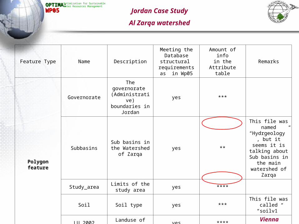
WP05WP05 Jordan Case Study
Al Zarqa watershed
Feature Type
Name Description
Meeting the Database structural
requirements as in Wp05
Amount of infoin the Attribute
tableRemarks
Point Feature
Villages Villages in the study area yes ***
Irrigation_P_Wells Private irrigation wells Yes ***Unit of measurement in the
Well_debit field is not understood
Irrigation_G_WellsIrrigation wells dug by the
governmentYes ***
Unit of measurement in the Well_debit field is not understood
Industrial_wells Wells for industrial purpose yes ***Unit of measurement in the
Well_debit field is not understood
Domestic_G_Wells
Wells dug by the Government for domestic
useyes ***
Unit of measurement in the Well_debit field is not understood
Domestic_P_WellsPrivate wells for Domestic
useyes ***
Unit of measurement in the Well_debit field is not understood
Gauging station Gauging station yes **This field was named rainfall by
the partners. Except for the name of the stations there is no other info
Line Feature
DrainageThe drainage system in the
study basin yes ***
This field was named streams by the partners. No topology was built
Roads Road networks No *No topology or other info on the
road networks
Contour20 The contour interval of 20m N0 *** No topology
Vienna 5/2006
OPTIMA:OPTIMA: Optimization for Sustainable Water Resources Management
WP05WP05
Feature Type Name Description
Meeting the Database structural requirements as in
Wp05
Amount of infoin the Attribute
tableRemarks
Polygon feature
Governorate
The governorate (Administrative)
boundaries in Jordan
yes ***
SubbasinsSub basins in the
Watershed of Zarqayes **
This file was named “Hydrgeology”, but it seems it is talking about Sub basins in the main watershed
of Zarqa
Study_areaLimits of the study
areayes ****
Soil Soil type yes ***This file was called
“soilv1”
LU_2002 Landuse of 2002 yes ****
TINTriangulated
Irregular Network
Raster DEMDigital Elevation
ModelThe resolution is
30m
Jordan Case Study
Al Zarqa watershed

Vienna 5/2006
OPTIMA:OPTIMA: Optimization for Sustainable Water Resources Management
WP05WP05
Road network ExampleRoad network Example
Jordan Case Study
Al Zarqa watershed

Vienna 5/2006
OPTIMA:OPTIMA: Optimization for Sustainable Water Resources Management
WP05WP05
Subbasin ExampleSubbasin Example
Jordan Case Study
Al Zarqa watershed

Vienna 5/2006
OPTIMA:OPTIMA: Optimization for Sustainable Water Resources Management
WP05WP05
Land cover ExampleLand cover Example
Jordan Case Study
Al Zarqa watershed

Vienna 5/2006
OPTIMA:OPTIMA: Optimization for Sustainable Water Resources Management
WP05WP05 Lebanon Case Study
Litani watershed
Feature Type Name DescriptionMeeting the Database
structural requirements as in Wp05
Amount of infoin the Attribute table
Remarks
Point Feature
VillagesVillages in the study
areayes ***
Springs Water sources yes ***
Gauging_station Gauging station yes ***
WellsArtesian wells in the
study areaYes ***
Line Feature
Drainage The drainage system in
the study basin yes ***
Roads Road networks yes ****
Fault Fault and fractures yes ***
ContoursThe contour interval of
50m yes ***
Polygon feature
GovernorateThe governorate
(Cadastral boundaries)yes ***
Pluviometry Rainfall data yes ***
Study_area Limits of the study area yes ****
Soil Soil type yes ***
Geology Geology yes ***
Lu_2005 Landuse of 2005 yes ****According to Corine Classification level 4
TINTriangulated Irregular
Network

Vienna 5/2006
OPTIMA:OPTIMA: Optimization for Sustainable Water Resources Management
WP05WP05 Lebanon Case Study
Litani watershed
Wells ExampleWells Example

Vienna 5/2006
OPTIMA:OPTIMA: Optimization for Sustainable Water Resources Management
WP05WP05 Lebanon Case Study
Litani watershed
Road network ExampleRoad network Example

Vienna 5/2006
OPTIMA:OPTIMA: Optimization for Sustainable Water Resources Management
WP05WP05 Lebanon Case Study
Litani watershed
Land Cover ExampleLand Cover Example

Vienna 5/2006
OPTIMA:OPTIMA: Optimization for Sustainable Water Resources Management
WP05WP05 Lebanon Case Study
Litani watershed
METADATA ExampleMETADATA Example
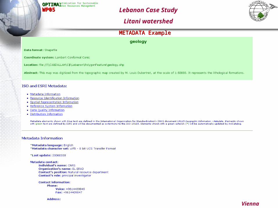
Vienna 5/2006
OPTIMA:OPTIMA: Optimization for Sustainable Water Resources Management
WP05WP05 Lebanon Case Study
Litani watershed
METADATA ExampleMETADATA Example

Vienna 5/2006
OPTIMA:OPTIMA: Optimization for Sustainable Water Resources Management
WP05WP05 Lebanon Case Study
Litani watershed
METADATA ExampleMETADATA Example

Vienna 5/2006
OPTIMA:OPTIMA: Optimization for Sustainable Water Resources Management
WP05WP05 Lebanon Case Study
Litani watershed
METADATA ExampleMETADATA Example
Vienna 5/2006
OPTIMA:OPTIMA: Optimization for Sustainable Water Resources Management
WP05WP05
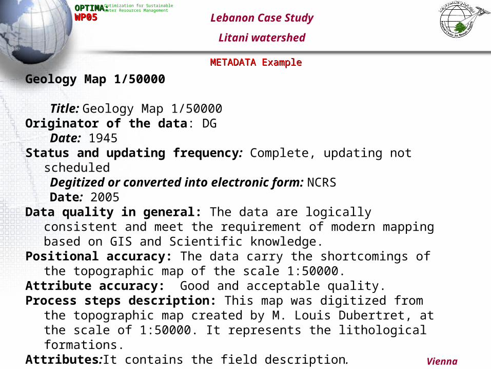
Geology Map 1/50000
Title: Geology Map 1/50000Originator of the data: DG
Date: 1945Status and updating frequency: Complete, updating not scheduled
Degitized or converted into electronic form: NCRSDate: 2005
Data quality in general: The data are logically consistent and meet the requirement of modern mapping based on GIS and Scientific knowledge.
Positional accuracy: The data carry the shortcomings of the topographic map of the scale 1:50000.
Attribute accuracy: Good and acceptable quality.Process steps description: This map was digitized from the topographic
map created by M. Louis Dubertret, at the scale of 1:50000. It represents the lithological formations.
Attributes:It contains the field description.
Lebanon Case Study
Litani watershed
METADATA ExampleMETADATA Example

Vienna 5/2006
OPTIMA:OPTIMA: Optimization for Sustainable Water Resources Management
WP05WP05
Feature Type Name DescriptionMeeting the Database
structural requirements as in Wp05
Amount of infoin the Attribute table
Remarks
Point Feature
Villages Villages in the study area yes ***
Elevation Mass points of elevation Yes ***
Pluv_station Pluviometric Station Yes ***
Wells Wells dug in watershed yes ***
Artificial Water tanks yes No ** AWT
Guaging_station Guaging stations yes ***
Line Feature
Drainage The drainage system in the study
basin yes ***
Road Road networks yes **Need the description of
the Symbols
Faults Faults on the geological map yes ***
Contours The contour interval of 100m yes ***
GovernorateThe governorate
(Cadastral,/municipality boundaries)yes ***
Pluviometry Rainfall data yes ***
Study_area Limits of the study area yes ****
Soil Soil type yes ***
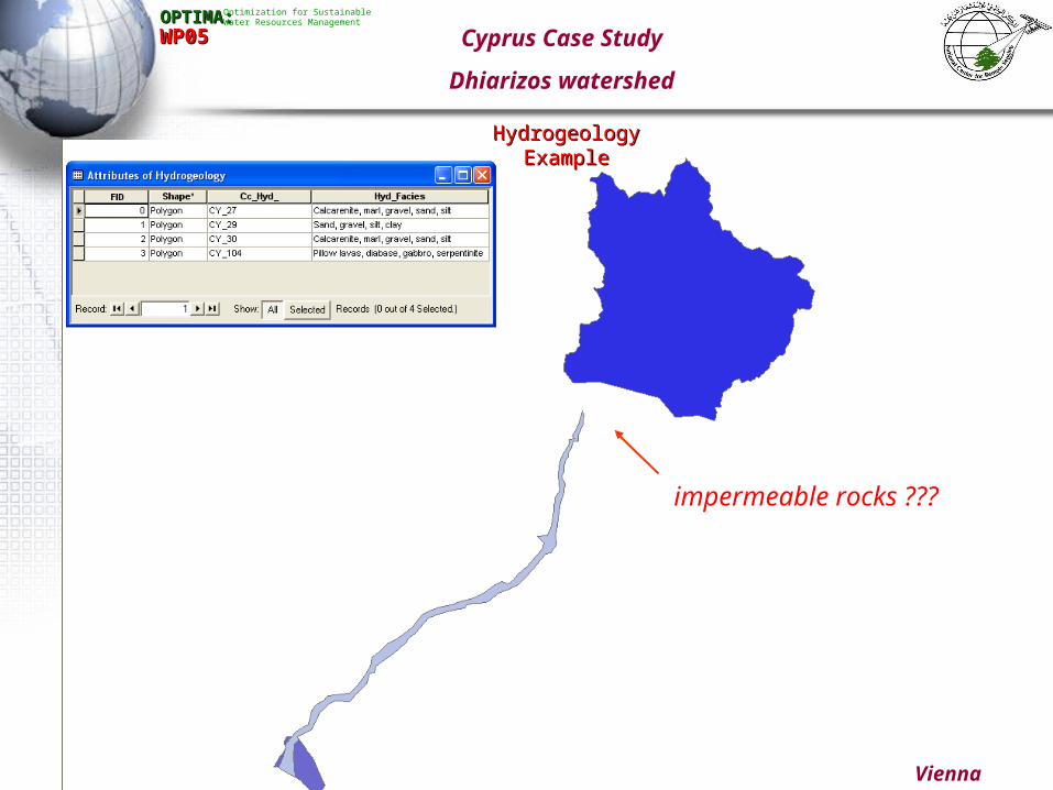
Hydrogeology Hydrogeological formation yes ***Need to complete the basin drwaings
Polygon featureGeology Geology yes ***
LUC-2000 Land use cover yes ***
Cyprus Case Study
Dhiarizos watershed

Vienna 5/2006
OPTIMA:OPTIMA: Optimization for Sustainable Water Resources Management
WP05WP05 Cyprus Case Study
Dhiarizos watershed
Wells ExampleWells Example
Vienna 5/2006
OPTIMA:OPTIMA: Optimization for Sustainable Water Resources Management
WP05WP05 Cyprus Case Study
Dhiarizos watershed
Hydrogeology ExampleHydrogeology Example
impermeable rocks ???

Vienna 5/2006
OPTIMA:OPTIMA: Optimization for Sustainable Water Resources Management
WP05WP05 Cyprus Case Study
Dhiarizos watershed
Land Cover ExampleLand Cover Example

Vienna 5/2006
OPTIMA:OPTIMA: Optimization for Sustainable Water Resources Management
WP05WP05Tunisia Case Study
Melian watershed
Feature Type Name DescriptionMeeting the Database
structural requirements as in Wp05
Amount of infoin the Attribute
tableRemarks
Point FeatureVillages Villages in the study area yes ***
Elevation points Mass points of elevation Yes ***
Line Feature
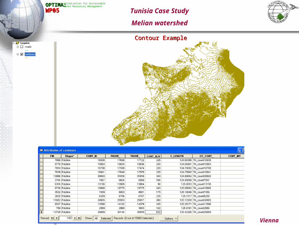
Drainage The drainage system in the study basin yes ***
Roads Road networks yes ***
Contours The contour interval of 5m yes ***
Polygon feature
GovernorateThe governorate
(Cadastral,/municipality boundaries)yes ***
Pluviometry Rainfall data yes ***
Study_area Limits of the study area yes ****
Soil Soil type yes ***
Geology Geology yes ***
Pheratic_WT Pheratic water table depth yes ***
LU_1988 Landcover of 1988 No ***
LU_2000 Landcover of 2002 No ***
TIN Triangulated Irregular Network
Raster
SPOT1988 Pan_Sharpened Resolution10
SPOT2000 Pan_Sharpened Resolution10
DEM Digital Elevation Model The resolution is 100m
Vienna 5/2006
OPTIMA:OPTIMA: Optimization for Sustainable Water Resources Management
WP05WP05 Tunisia Case Study
Melian watershed
Contour ExampleContour Example

Vienna 5/2006
OPTIMA:OPTIMA: Optimization for Sustainable Water Resources Management
WP05WP05 Tunisia Case Study
Melian watershed
Land Cover ExampleLand Cover Example

Vienna 5/2006
OPTIMA:OPTIMA: Optimization for Sustainable Water Resources Management
WP05WP05 Tunisia Case Study
Melian watershed
Meta Data ExampleMeta Data Example

Vienna 5/2006
OPTIMA:OPTIMA: Optimization for Sustainable Water Resources Management
WP05WP05
Feature Type Name Description
Meeting the Database structural requirements as in
Wp05
Amount of infoin the Attribute
tableRemarks
Point feature
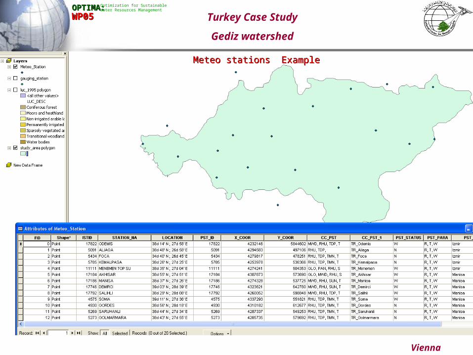
Meteo_StationMeteorological
stationsyes ****
Gauging_station Gauging station yes ***
Line Feature
Rivers Water courses yes **Only permanent
water courses
Roads Road networks yes **Principle road
network
Polygon feature
GovernorateThe governorate
(District boundaries)
yes ***
Study_areaLimits of the study
areayes **
LUC_95 Land cover of 1995 No **Many slivers and sharp polygons
Turkey Case Study
Gediz watershed
Vienna 5/2006
OPTIMA:OPTIMA: Optimization for Sustainable Water Resources Management
WP05WP05
Meteo stations ExampleMeteo stations Example
Turkey Case Study
Gediz watershed

Vienna 5/2006
OPTIMA:OPTIMA: Optimization for Sustainable Water Resources Management
WP05WP05 Turkey Case Study
Gediz watershed
Road network ExampleRoad network Example

Vienna 5/2006
OPTIMA:OPTIMA: Optimization for Sustainable Water Resources Management
WP05WP05
METADATA ExampleMETADATA Example
Turkey Case Study
Gediz watershed

Vienna 5/2006
OPTIMA:OPTIMA: Optimization for Sustainable Water Resources Management
WP05WP05
Land Cover ExampleLand Cover Example
Turkey Case Study
Gediz watershed

Vienna 5/2006
OPTIMA:OPTIMA: Optimization for Sustainable Water Resources Management
WP05WP05
Feature Type Name DescriptionMeeting the Database
structural requirements as in Wp05
Amount of infoin the Attribute table
Remarks
Line Feature
DrainageThe drainage system in
the study basin No ***
This field was named Drainage_Net by the partners. No topology
was built
Roads Road networks No ***No topology or other info
on the road networks
Polygon Feature
SubbasinsSub basins in the
Watershed yes ***
This file was named “Sous-bv” by the partners
Study_area Limits of the study area yes ****This field was named
watershed by the partners
TINTriangulated Irregular
Network
Raster
TM-1988_543LANDSAT satellite
imageryThe resolution is 34m
TM-2001_543LANDSAT satellite
imageryThe resolution is 34m
Landuse1988Landuse of the area of the
study in 1988No ** The resolution is 34m
Landuse2001Landuse of the area of the
study areain 2001No ** The resolution is 34m
Comb2001-1988 Landuse change ** The resolution is 34m
Urban-Var Not understood The resolution is 34m
Dense_forest Not understood The resolution is 34m
DEM Digital Elevation Model The resolution is 30m
Morocco Case Study
Martil watershed

Vienna 5/2006
OPTIMA:OPTIMA: Optimization for Sustainable Water Resources Management
WP05WP05
Road network ExampleRoad network Example
Morocco Case Study
Martil watershed

Vienna 5/2006
OPTIMA:OPTIMA: Optimization for Sustainable Water Resources Management
WP05WP05
Urban Variance ExampleUrban Variance Example
Morocco Case Study
Martil watershed

Vienna 5/2006
OPTIMA:OPTIMA: Optimization for Sustainable Water Resources Management
WP05WP05
Land Cover ExampleLand Cover Example
Morocco Case Study
Martil watershed

Vienna 5/2006
OPTIMA:OPTIMA: Optimization for Sustainable Water Resources Management
WP05WP05
Land cover ExampleLand cover Example
Morocco Case Study
Martil watershed

Vienna 5/2006
OPTIMA:OPTIMA: Optimization for Sustainable Water Resources Management
WP05WP05
Utilized Satellite imageriesUtilized Satellite imageries
Morocco Case Study
Martil watershed

Vienna 5/2006
OPTIMA:OPTIMA: Optimization for Sustainable Water Resources Management
WP05WP05 Morocco Case Study
Martil watershed
METADATA exampleMETADATA example

Vienna 5/2006
OPTIMA:OPTIMA: Optimization for Sustainable Water Resources Management
WP05WP05 Quality Control Table
PartnerPartner # of Line # of Line featuresfeatures
# of Point # of Point featuresfeatures
# of polygon# of polygon
FeaturesFeatures# of # of
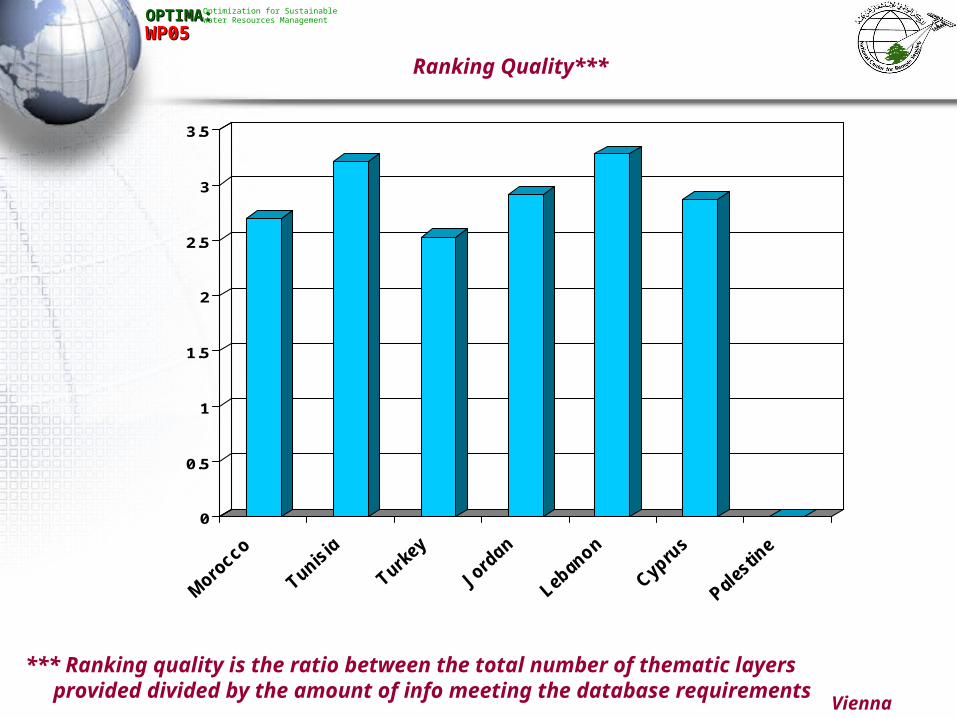
RastersRasters Meta Data*Meta Data* LUC**LUC** Ranking Ranking Quality***Quality***
MoroccoMorocco 22 00 33 88 55 33 2.70
TunisiaTunisia 33 22 99 33 55 55 3.21
TurkeyTurkey 22 22 33 00 33 11 2.53
JordanJordan 77 33 66 11 11 22 2.91
LebanonLebanon 44 44 77 22 55 55 3.28
CyprusCyprus 44 66 66 00 00 11 2.87
PalestinePalestine 00 00 00 00 00 00 0

Vienna 5/2006
OPTIMA:OPTIMA: Optimization for Sustainable Water Resources Management
WP05WP05
0
2
4
6
8
10
Line Point Polygon Raster
Morocco Tunisia Turkey Jordan Lebanon
Cyprus Palestine
Different digital data forms provided by the partners

0
2
4
6
8
10
12
14
16
18
Mo
roc
co
Tu
nis
ia
Tu
rke
y
Jo
rda
n
Le
ba
no
n
Cy
pru
s
Pa
les
tin
e
OPTIMA:OPTIMA: Optimization for Sustainable Water Resources Management
WP05WP05 Total number of thematic digital layers provided by
the partners
Vienna 5/2006

0
1
2
3
4
5
Mor
occo
Tunis
ia
Turke
y
Jord
an
Leban
on
Cypru
s
Pales
tine
Vienna 5/2006
OPTIMA:OPTIMA: Optimization for Sustainable Water Resources Management
WP05WP05 METADATA*
5 - Confirms fully to the ISO requirements
3- Confirms partially to the ISO requirements
1- On going procedure
0- Didn’t start yet
*Legend

0
1
2
3
4
5
Mor
occo
Tunis
ia
Turke
y
Jord
an
Leban
on
Cypru
s
Pales
tine
Vienna 5/2006
OPTIMA:OPTIMA: Optimization for Sustainable Water Resources Management
WP05WP05Land use Change Data **
5- Completed and confirms fully to data requirements in WP05
3- Completed but don’t totally confirm to data requirements in WP05
2- Two Land use cover have been completed and need to get the final LUC
1- Only one Land use cover data set have been completed
0- Nothing have been achieved
**Legend
0
0.5
1
1.5
2
2.5
3
3.5
Vienna 5/2006
OPTIMA:OPTIMA: Optimization for Sustainable Water Resources Management
WP05WP05
Ranking Quality***
*** Ranking quality is the ratio between the total number of thematic layers provided divided by the amount of info meeting the database requirements