Rethinking the Past
138
Transcript of Rethinking the Past


Rethinking the PastA Tribute to Professor V.N. Misra
Editors
Sushama G. DeoAndre Baptista
Jayendra Joglekar
Indian Society for Prehistoric and Quaternary Studies

ISPQS Monograph No. 7
TitleRethinking the Past: A Tribute to Professor V.N. Misra
EditorsSushama G. Deo, Andre Baptista and Jayendra Joglekar
PublisherIndian Society for Prehistoric and Quaternary Studiesc/o Department of ArchaeologyDeccan College, Pune 411006
Year of Publication2017
© Indian Society for Prehistoric and Quaternary Studies, Pune
All rights reserved. No part of this book may be reprinted or reproduced or utilized in any form or by any electronic, mechanical, or other means, now known or hereafter invented, including photocopying and recording, or in any information storage or retrieval system, without permission in writing from the publishers.
The editors and publisher are not responsible for any errors or omissions or for the results obtained from the use of such material as used by the authors. Also the editors and publisher are not responsible for the opinions and views expressed in the articles.
Typesetting, Layout and Cover Design Shri Narendra Achyut Kulkarni33 Ganeshbaug Society, Azadwadi,Gananjay Society, Kothrud, Pune 411038
ISBNISBN: 978-81-908330-6-6
Cover16R Dune at Didwana, Rajasthan (Courtesy: Claire Gaillard)
Not for SaleAvailable to Life members as e-issue from the official website www.manandenvironment.org

iii
CONTENTS
Preface v
1. TheAcheulianandBeginningsofCulturalification 1 K. Paddayya
2. Artefactual Evidence of Early Hominin Adaptability in the Deccan Trap Region of the 16 Upper Krishna Basin Jayendra Joglekar and Sushama G. Deo
3. Revisiting the Acheulian Site of Singi Talav at Didwana (Rajasthan) 35 years later 25 Claire Gaillard and S.N. Rajaguru
4. FunctionBasedClassificationoftheAcheulianToolsinIndianContext 40 Gargi Chaterjee
5. Pre-Microlithic/LateMiddlePalaeolithicLithicAssemblagesofRiverTawa,DistrictBetul, 50 Madhya Pradesh Soumi Sengupta and Sushama G. Deo
6. At the Forest Edge: General Observations on New Microlithic Occurrences in the 65 Central Narmada Basin, Madhya Pradesh
P.R. Chauhan, K. Krishnan, N. Tiwari, A. Mukherjee, A. Ambili, D.A. Sant and R. Patnaik
7. Recent Observations on the Microlithic Assemblages with Pebble-Cobble Tool Component 81 in Odisha, India Pradeep K. Behera, Neena Thakur, B. Chatterjee and S. Mendaly
8. The Late Pleistocene and Early Holocene Stone Age Culture of Odisha 96 Tosabanta Padhan
9. Reconstruction of the Indian Summer Monsoon Fluctuations since the Early Holocene 111 UsingLakeandOceanSedimentCoresfromSouthernIndia:ExtremeEventsand Palaeo-environment Rayees Ahmad Shah, Aasif Lone, Hema Achyuthan and Asif Ali
10. NewRevelationsabouttheStoneAgeintheNorthwesternSub-HimalayasofIndia 118 Vidwan Singh Soni and Anujot Singh Soni
11. Notes on Gulkera: A Newly Discovered Site in Jharkhand 132 Paromita Bose
12. Preliminary Observations on Two Human Skeletal Remains from Choskar, Kargil District, 139 Jammu and Kashmir Veena Mushrif-Tripathy, S.B. Ota, R.K. Ganjoo, R. Unkule and Aakanksha
13. Revisiting Human Skeletal Remains from Multicultural Site of Bagor, District Tilwara, 149 Rajasthan Tarang Gharpure and Veena Mushrif-Tripathy
14. Chronostratigraphy of Marine and Floral Fossils Underlying Ferricretes in Kerala, 167 South-West Coast of India P. Rajendran, C.S.P. Iyer, K.P. Thrivikramji, V. Natarajan and Y. Babu
15. A Fresh Appraisal of Faunal Remains from Ahar Culture Sites in Rajasthan 176 P.P. Joglekar and David Tetso

iv
Rethinking the Past: A Tribute to Professor V.N. Misra
16. Early Historic Livestock Herding, Hunting and Marine Fisheries: Evidence from Hathab 193 on the Bhavnagar Coast of Gujarat Arati Deshpande-Mukherjee, P.K Thomas (Late) and Shubra Pramanik
17. AnimalRemainsfromtheFormativeStageoftheSettlementatVadnagar,MehsanaDistrict, 202 Gujarat Pankaj Goyal, P.P. Joglekar and Y.S. Rawat
18. AncientCompositeMaterials:AnExperimentalApproachto“ArtificialLaterite”fromEarly 215 Historic Population Centers in Odisha Monica L. Smith and Rabindra Kumar Mohanty
19. An Appraisal of Black-and-Red Ware Culture of Indo-Gangetic Divide Region and Upper 223 Ganga-YamunaValleysinLightofExcavationsatAbhaipur,DistrictPilibhit,UttarPradesh Anup Mishra
20. HeadscratchersfromtheBalathalExcavations:EnigmaticIndicatorsoftheSecond 242 Urbanisation Kurush F. Dalal
21. FreshLightontheMaterialBackgroundofEarlyCulturesofGangaPlain 250 Vibha Tripathi
22. Roots of the Ganga Valley Civilization: An Archaeological Perspective 265 B.B. Lal
23. The Maram Megaliths and their Associated Rituals 269 P. Binodini Devi
24. An Investigation into the Dynamic Synergy between Early Iron Age Settlements and 278 Megalithism in Vidarbha R.K. Mohanty and Shantanu Vaidya
25. A New Perspective on the Early Iron Age Cultures of Vidarbha and South India 295 P.S. Joshi and Kanchana Bhaisare
26. RockartinChhattisgarh:AnOverview 307 Meenakshi Dubey-Pathak and Jean Clottes
27. Rock Art of Southern Bihar and Adjoining Jharkhand in Eastern India: 315 “When,WhyandToWhom?” Awadh Kishore Prasad
28. Xuanzang’s Route of Journey through Central India as Described by 326 AlexanderCunninghamin1871intheAncientGeographyofIndia,BuddhistPeriod Pallavee Gokhale
29. ThePastandthePresentoftheCraftofPotteryinAssam 330 Sukanya Sharma, Pankaj Singh and Momi Das
30. EarlyCulturalandHistoricalFormationsinSouthIndia:ThoughtsontheProcesses, 343 Deconstruction, and Models V. Selvakumar
List of Publications of Professor V.N. Misra 351

Virendra Nath Misra, founder of the Indian Society for Prehistoric and Quaternary Studies, and editor of Man and Environment since its inception was a senior and world-renowned archaeologist. Educated first at Lucknow and then in Pune, he achieved his Masters with a degree in anthropology in 1957 under the tutelage of one of his teachers, the eminent anthropologist D.N. Majumdar. He had a brilliant academic career topping merit lists of successful candidates at various examinations. He completed his Ph.D. degree in prehistoric archaeology in 1961 under the supervision of Professor H.D. Sankalia.
Professor Misra conducted extensive and prolonged field investigations in Central India and Rajasthan. He was interested in the reconstruction of the prehistoric past of these regions covering the Palaeolithic and Mesolithic, as well as the Chalcolithic cultures. In addition to the discovery of several key sites, his works also include excavations at the Bhimbetka group of caves near Bhopal, Samnapur in Madhya Pradesh, the Mesolithic sites of Tilwara and Bagor in Rajasthan, and the Palaeolithic and Mesolithic sites of southern Rajasthan. In collaboration with many colleagues and scientists he conducted pioneering research on palaeoclimate and prehistoric archaeology at the sites of Singi Talav, Indola-ki-Dhani and Dune 16R around the Didwana town in Nagaur District, Rajasthan. Later in his career, Professor Misra conducted excavations at Balathal in Udaipur District of Rajasthan from 1993 to 2000. He showed that this Chalcolithic settlement flourished for about two millennia and was contemporary to the early and mature phases of the Harappan culture in North India.
As a student of anthropology Professor Misra was interested in understanding lifestyles of simple social groups such as hunter-gatherers, and nomadic people like the Pardhis, Gonds and Van Vagris. Through a
prolonged association with M.L.K. Murty and Malti Nagar, he made seminal contributions to building a database for ethnoarchaeology in India.
Professor Misra’s writings continued to remain prolific despite being officially engaged in high administrative positions. He published eight books and over 120 research papers in Indian and foreign periodicals. The editors of this monograph have provided a list of his publications so that future scholars can benefit from the works of Professor Misra.
On the occasion of Professor V.N. Misra’s 80th birthday, a one-day seminar titled “New Perspectives on Pre and Protohistory in India” was organised on the 18th of August 2015. The few papers presented here were to be published as proceedings of this seminar. However, this could not be realised before Professor Misra’s unfortunate passing. Since then, his colleagues, students and friends have discussed the possibility of a special issue of Man and Environment as homage to his immense contribution to the fields of prehistory, protohistory, biological anthropology (palaeoanthropology), and ethnoarchaeology. The Executive Committee of the Society decided against publishinga special issue of the Journal, but rather a monograph in 2017. Accordingly I invited many scholars and colleagues to contribute to this volume in June 2016.
A sound work ethic and professional commitment were among the qualities that Professor Misra advocated all his life. He also insisted on the timely completion of projects. Hence, following his tradition the editors had to decline those who did not submit their articles on time. I am happy to note that many scholars promptly responded and sent their papers. I thank all the contributors for sending the papers and modifying the text as per suggestions of the referees. A couple of articles could not be included due to various reasons. I am
PREFACE

vi
Rethinking the Past: A Tribute to the late Professor V.N. Misra
sure those authors would take a positive note from the suggestions and contribute better articles in the future. As has been discussed and decided, the monograph does not talk about Professor Misra himself, but brings to light various issues related to Indian prehistoric archaeology, bioarchaeology, amongst various other topics.
On behalf of the Society I thank the editors for bringing out this monograph in a timely manner. I hope this monograph would serve as source material for future research on various topics in Indian pre and protohistory as well as palaeoenvironmental studies.
P.P. JoglekarGeneral Secretary

IntroductionEvolutionary thought envisages a continuous process of mutation among organisms. This mutation involves the operation and interplay of selection mechanisms of various kinds, leading to minor or major changes in their make-up as well as behavioural realms. Generally speaking, these changes are progressive in nature and take the form of improvements which allow the organisms to adapt to their given surroundings or environment in a more efficient way.
There is something special about the operation of this evolutionary process in the case of the human species. This process not only concerns bodily organs but also governs the various types of objects or features which he fabricates out of natural materials. The latter component – extracorporeal limbs, as aptly designated by Gordon Childe (1956) – is unique to the human organism. There are also non-material creations emanating from human minds. These two components together constitute human culture which is the pivot on which anthropological sciences including archaeology are built. While there is a definitions galore of culture (Kroeber and Kluckhohn 1952), each interesting and useful in its own way, as long ago as 1871 Edward Tylor, the founder of anthropology, gave a definition which is fairly comprehensive and usable. He defined it as that “complex whole which includes knowledge, belief, morals, law, art and custom and any other capabilities and habits acquired by man as a member of society” (Tylor 1891: 1). These material and non-material components – artefacts and mentifacts – serve functional
THE ACHEULIAN AND BEGINNINGS OF CULTURALIFICATIONK. Paddayya
Department of AIHC and Archaeology, Deccan College, Pune [email protected]
Abstract
In this paper I argue that the Acheulian phase – the longest known stage of prehistoric past covering well over a million and half years – is much more than a distinctive industrial tradition specializing in the production of bifacial artefacts of stone and that it did not suffer any stasis. Rather, it is held that this phase marks the true beginnings of human culture, and witnessed within itself significant developmental changes across time.
and symbolic purposes, and facilitate human adaptation.
In both cases a truly creative act is involved which in fact distinguishes man from other organisms. The famous American anthropologist Clifford Geertz coined the phrase culturalification to capture the meaning of this whole process of man’s creation of material and non-material items and operating with them in his life activities (Geertz 2005: 120). Meaning imputation is an essential part of this process in which not only do the items undergo transformation in their configurations, but the meanings also experience small or drastic changes. Geertz captures well the systemic character and ever-changing or dynamic aspect of human cultures when he asserts that “… the elements of a culture are not like a pile of sand and not like a spider’s web. It is more like an octopus, a rather badly integrated creature – what passes for a brain keeps it together, more or less in one ungainly whole” (as quoted in Sweder and Levine 1984).
In the light of the above observations of culture – its humanly created character and its tendency to evolve in time, I would like to briefly examine the nature and place of the Acheulian phase. For this purpose we will use Geertz’s concept of culturalification in its broadest sense. It is argued here that contrary to the long held common view, the Acheulian is much more than an improved stage in the technology and typology of stone tools. It marks the true and definite beginnings of culturalification of natural objects and shapes of objects by registering them as mental images and thereby
Paddayya 2017, in Rethinking the Past: A Tribute to Professor V.N. Misra(S.G. Deo, Andre Baptista and Jayendra Joglekar Eds.), pp. 1-15, Pune. ISPQS: www.manandenvironment.orgISBN: 978-81-908330-6-6
2
Rethinking the Past: A Tribute to Professor V.N. Misra
providing unlimited scope for their replication in the real world, with accompanying social ramifications.
Findings from East Africa tell us that stone flaking traditions have an antiquity of three million years (for a recent review, see Braun 2014). The earliest known artefacts are from the site of Gona in Ethiopia and are dated to 2.5 million years. Also there are sites from Omo valley and Hadar valley of the Afar region which have stone tools dated between 2.3 and 2.4 million years. From Ethiopia also comes the site of Dikika which has yielded skeletal remains of an Australopithecine child dated to 3.3 million years ago. This skeletal material was found along with animal bones showing cut-marks, which were probably made with stone artefacts. Future findings in Africa will surely push back the antiquity of tool-making traditions still further. My admittedly limited knowledge of the tool-using/making abilities of higher apes like the chimpanzee leads me to believe that the picture of the beginnings of artefact use was somewhat different. I guess that the earliest stage was one essentially of collecting and using naturally fractured stone pieces (flakes or blocks) with sharp edges for cutting/chopping purposes. I further believe that in future we may find spots or localities yielding a cluster of such natural pieces that were assembled and employed by the hominins. Once their usefulness is recognized, the hominins (as facilitated by brain size increase) would sooner or later take the next logical step of striking off flakes from stone nodules or cobbles; their flaked edges and/or the resultant flakes would be put to use. This marks the first attempts or incipient stage in the transformation of nature into culture. The next stage is represented by Mode 1 assemblages. What is involved here is subjecting nodules or cobbles to more elaborate uni- or bifacial flaking and converting a good portion of their periphery into a cutting edge with the unstruck portion serving as a hand-hold. This is the chopper-chopping tool stage and is best illustrated by the assemblages of Bed I at Olduvai Gorge in Tanzania. The Leakeys recognized two developmental stages in these assemblages – the Oldowan and Developed Oldowan stages dated between 1.8 and 1.9
million years. Then followed the Acheulian or Mode 2 assemblages which are dated between 1.7 and 1.8 million years at sites like Kokiselei and Konso in Ethiopia. More recently, another 1.7 million-year-old Acheulian site has been reported from FLK West (base of Bed II) in Olduvai Gorge (Diez-Martin et al. 2015). It was found in a fluvial setting and yielded fossil fauna.
Among these early tool-making traditions, the Acheulian occupies a special position for more than one reason. It is the longest in terms of temporal duration covering 1.5 million years. Secondly, it is also presumed that from an early stage of this cultural phase hominins started moving from Africa to various parts of Asia and Western Europe. This is the most extensive cultural tradition of the Old World. Thirdly, despite this wide geographical extent, the stone tool assemblages share a common feature, as represented by what are called large cutting tools comprising handaxes, knives, and cleavers.
The Acheulian as a Cultural TraditionEver since John Frere’s recognition well over 200 years ago of the flints, including a few pointed handaxes he had found at Hoxne in Surrey as true specimens of human workmanship (Frere 1800), comments have been made about the significance of bifacial tools in the development of human cultural traditions. These have for long been, and in many circles still are being treated as merely representative of an industrial tradition with no cultural implications. More intrigue was added to the literature in 1993 when Davidson and Noble challenged the view that handaxes were intentionally produced. On the contrary, they treat these artefacts as unintended products. While granting the element of regularity in the shapes and sizes of handaxes, they believe that “the regularity of handaxes can be seen, not as the result of design, but as the unintended by-product of a repertoire of flaking habits – that produce flakes – limited by the form of the raw material” (Davidson and Noble 1994: 372). In their view, the sameness of the handaxe shape over a wide geographical area can’t be considered as a cultural category. They attribute

3
The Acheulian and Beginnings of Culturalification
the minor variations in shape to differences in raw material and shape of the blank selected for working. Davidson and Noble are finally led to conclude that handaxes are unintended products. These are remnants of cores selected for the production of flake blanks of various sizes.
At the other end, we have the widely held view which treats handaxe shapes as clear products of hominid intentionality. Some workers even invoke the notion of mental templates. For example, in 1976 Glynn Isaac argued that the manufacture of bifaces implied execution of prior design into reality through the medium of stone. He further mentioned that successful accomplishment of these design targets was facilitated by cultural norms akin to rule-governed systems of communication characteristic of human language (Isaac 1976). A few years later Thomas Wynn put forward the view that handaxes in fact serve as indices of high level of hominid cognition, and developed it further in later publications (Wynn 1979, 1993). For this purpose he made use of principles of Jean Piaget’s genetic epistemology. He recognized that, unlike pebble tools, manufacture of bifaces already reflected the employment of operational thinking. Their preparation involved the use of operations of whole-part relations, reversibility, qualitative displacement, and symmetry. Wynn concluded that the level of intelligence of the Acheulian hominins closely approached that of modern humans. In 1995 Wynn published a comprehensive essay covering various views (Wynn 1995).
In 1991 Merlin Donald published his book The Origins of the Modern Mind in which he recognized three stages (episodic, mimetic, and mythic) in the evolution of mind. The second stage is that of mimesis, the mind and culture of Homo erectus (Donald 1991: Chapter 6). This mind/culture stage was non-linguistic and involved neither any grammars nor any true symbols. Communication was mimetic and based on iconic performance, ritual and prosody. Metarepresentation, intersubjectivity, and observational learning which mimesis involves are precisely the abilities required
for biface manufacture. Donald therefore felt persuaded to call the Acheulian a mimetic culture. In his own words: “Memetic culture had its pragmatic successes in tool-making and socially coordinated activities like hunting, maintaining a seasonal home base, and using fire. But its greatest importance would have been in collective modeling, and hence structuring of hominid society itself. Memetic culture was a successful and stable adaptation, a survival strategy for hominids that endured for over a million years…” (Donald 1991: 200).
Drawing upon evidence from comparative socioecology, primate social learning, and Palaeolithic data from England, Steven Mithen developed in 1994 a model postulating a relationship between tool technology and social behaviour of Homo erectus, mediated by social learning. He wrote that Homo erectus lacked capacity for visual symbolism and that the Acheulian hominins lived in open ecosystems and the group size was larger than that of the pebble-tool makers who lived as small groups in closed forests. Common knapping traditions followed from low degree of innovation and high degree of social learning (Mithen 1994). In a later publication Mithen attached deeper significance to handaxes (Mithen 1996). He says that, unlike the case of chopping tools, handaxe involves much more than producing a cutting edge. Here the knapper is imposing a pre-decided form on the nodule or flake by executing bi-directional flaking; primary flaking was sometimes followed by secondary or finer flaking with a soft hammer. The net effect is that handaxes often show a high degree of symmetry, which in many cases is three-dimensional.
In recent times, a minor stir has been created in the debate about handaxes by a joint paper published by McNabb, Binyon and Hazelwood (2004). This paper is based on the study of handaxe assemblages from Cave of Hearths, Cape Hangklip, Elandsfontein, Amanzi Springs and three other sites in South Africa dating to terminal part of Early Pleistocene and Middle Pleistocene. McNabb et al. have taken into consideration artefact attributes such as shape, extent of flaking, symmetry, and extent

4
Rethinking the Past: A Tribute to Professor V.N. Misra
of edge-working. In their view, these South African assemblages, far from representing products of socially transmitted group learning, merely constitute what they call “individualized memic constructs”.
These views put forward by McNabb et al. have led to an interesting debate among the workers seriously engaged in Early Man studies (for detailed comments, see McNabb, Binyon and Hazelwood 2004: 668-675). While welcoming this study as an important addition to Stone Age research, they feel that it suffers from an overall inadequate or under interpretation of the available data base on the Acheulian. To Machin and Mithen, McNabb et al.’s observations are only statements of belief rather than a workable hypothesis. They raise objections to McNabb et al.’s rigid notions of symmetry and social/cultural traditions. Machin and Mithen further state that the interpretations are narrowly grooved to stone tools and bypass palaeoenvironmental data and studies on non-human primate groups. Petraglia emphatically denies that the large cutting tools were mere “individualized memic constructs.” To him “Acheulian tool-making was learned and socially generated and transmitted strategy, entailing cooperative behaviour.” Rolland too sees connections between tool-making and social traditions but doubts that handaxe manufacture involved any symbolic indications. White also brings in the element of social contexts of tool-making and asserts that the recurrent production of large cutting tools ensued from socially learned and transmitted mental constructs, and repertoire of skills. While denying that bifaces were used to signal group affiliation, White does concede that individuals may have had their own preferred styles or “hands,” implying “Incipient symbolism” through material culture.
Against the background of these diverse views, Wynn has made some general observations about the Acheulian which are worth remembering (see Wynn 1995; 2004). 1. Wynn flatly rejects the view treating bifaces
as unintended by-products of manufacturing processes. On the contrary, he asserts that bifacial tools are intentionally made
implements “capable of performing non-specific tasks as opposed to ad hoc productions, tied to an immediate task… and were an integral part of hominids’ adaptation as indicated by their persistence, in the archaeological record, for well over a million years” (Wynn 2004: 672).
2. Wynn denies the role of any grammar-like rules or symbols in the manufacture of bifaces (for views about relationship between language and tools, see essays in Gibson and Ingold 1994: 337-472). He believes that their manufacture could be correlated with the stage of mimesis recognized by Donald in the evolution of the human mind. Coupling these theoretical observations with those arising from studies of simple technologies of modern times; Wynn proposes that handaxe preparation essentially involved observational learning.
3. While denying the role of any grammar-like rules, Wynn is nevertheless struck by the prominence of bilateral symmetry in these artefacts. He further admits that this symmetry (including three-dimensional symmetry) emerged as a definite feature 4,00,000 years ago. In other words, the shape is imposed on stone blanks. To elaborate this notion, Wynn (1995: 12) writes: “Indeed, this imposition of overall form on an artefact is perhaps the most striking difference between Homo erectus’ artefacts and those of his predecessors. The handaxe was an idea that was imposed on the natural world and also shared by many individuals. It was a true cultural category…” This is precisely the meaning of the process of culturalification designated by Clifford Geertz, and bifacial tools represent the first definite step in the transformation of nature-facts into culture-facts or artefacts, i.e. ascribing cultural meaning to products of nature.
4. Interestingly enough, while commenting upon the above-cited paper of McNabb et al., Wynn queries about the larger implications of imposition of shapes on stone blanks. He asks: “But if the imposed shapes were not
5
The Acheulian and Beginnings of Culturalification
mental templates and not cultural norms; what were they?” (Wynn 2004: 672). He says that McNabb et al.’s characterization of the biface forms as ‘individualized memic constructs’ is only descriptive but does not explain their significance from the point of view of hominin behavioural or evolutionary patterns. In other words, Wynn is answering his own query in a positive way by veering towards the understanding of imposed shapes in terms of mental templates and socio-cultural norms.
The Acheulian Record in IndiaLet us now briefly examine whether the archaeological record from India has anything to contribute to the overall debate about the place of Acheulian phase in the development of human culture. As is well known, research on the Indian Acheulian commenced with Robert Bruce Foote’s discovery of a bifacially worked and point-ended quartzite artefact at Pallavaram on 30th May 1863. Foote was quick enough to recognize the significance of the tang-like projection at the base and interpreted that the artefact was hafted to a wooden handle and used as a spearhead (Foote 1916: 173-4). In the following three decades he discovered Attirampakkam and a series of other sites in South India and Gujarat. Since then, scores of sites have been found in various parts of the country, encompassing arid, semi-arid, dry deciduous, and moist deciduous zones. These are mostly open air sites, but cave sites such as Bhimbetka and Adamgarh in Central India also exist. Since the mid-1970s there has been a conscious shift of emphasis from finding secondary, river-bed sites to the discovery and investigation of primary sites preserving in situ cultural horizons. Thanks to the use of various scientific dating techniques, we now have absolute dates to fix its temporal span (Paddayya 2014a: 329). Isampur and Attirampakkam have produced dates of 1.2 and 1.5 million years respectively (Paddayya et al. 2002; Pappu et al. 2011). This cultural phase lasted till about 1,50,000 years ago. The site of Hathnora on the Narmada has produced hominin skeletal remains belonging to an archaic form of Homo sapiens.
As part of this new phase of research, some of the interior regions have been selected and surveyed intensively with a view to reconstructing Acheulian settlement patterns. Special emphasis was laid on the identification of small and large sites preserving cultural material in situ. Wherever necessary, the sites were studied from the point of view of formation processes. Also several Acheulian sites have been excavated systematically and occupation levels have been exposed. Detailed plotting and contextual study of various exposed remains have been undertaken. In some cases a regional approach was adopted involving both intensive surveys and excavation of primary sites. This regional approach, coupled with an ecological orientation to the landscape, has made it possible to reconstruct land use and related behavioural patterns of the Acheulian hominins (for reviews, see Sankalia 1974: Chapter I); Misra 1987; Paddayya 2001, 2007, 2008a, 2014a; Paddayya and Deo 2017; Pappu 2001, 2013; Korisettar 2007; Petraglia 2001; 2006; Mishra 2008). It has also been possible to identify three developmental stages within the culture (Paddayya 2008b). In effect, it is now possible to look at the Indian Acheulian beyond stratigraphy and stone tool collections and consider hominins as something more than “stomach-led and brain-dead” individuals, to borrow Clive Gamble’s (1999: xx) words. (Gamble’s The Palaeolithic Societies of Europe is a major and forceful work which seeks to shift the emphasis from technological to social in Palaeolithic studies.) This larger data base permits us to make some inferences about the cognitive, social, and symbolic dimensions of the ancient groups. I would rely particularly on my own work in the Hunsgi and Baichbal valleys of southern Deccan.
Cognitive and other Non-material Attributes and their Manifestation It is commonly agreed that the brain size increased from 550 cubic centimeters in the early stage of Homo erectus to about 1300 cubic centimeters in the Homo heidelbergensis stage. What are the implications of this brain size development? One could presume that this allowed the hominins to have a better

6
Rethinking the Past: A Tribute to Professor V.N. Misra
grasp of their occupation area. This was hinted at by Gordon Childe nearly 70 years ago. He warned that the study of past environments “is not a question of determining what a twentieth century university professor would have observed four, forty, or four hundred centuries ago, but what the men whom he would have encountered could have observed” (Childe 1949: 8). A decade later he expressed the need to recognize ancient man’s perception of his environment in more explicit words: “Incidentally, I realized that the environment that affected a prehistoric society was not reconstructed by geologists and palaeontologists but that known or knowable by the society with its then existing material and conceptual equipment” (Childe 1958: 73). In other words, Childe was already foreshadowing the modern-day agency theory. Articulating this recent theoretical orientation with reference to simple societies, Ingold (1994a: 443) writes: “… it is through the deployment of technical skills that people act in the world, and in so doing constitute their environments. Thus environments never come ready-made, but are always in the process of creation… acting in the world is also the skilled practitioner’s way of knowing it. The perceptual knowledge so gained is… an integral part of personal identity. Hence, in the constitution of their environments, agents reciprocally constitute themselves as persons…” Elsewhere Ingold called man Homo faber and considered tool-making as part of his appropriation of nature (Ingold 1986: Chapter 3).
Habitat Selection and UseThe Hunsgi and Baichbal valleys constitute a good example from this point of view. These two adjacent valleys (separated by a narrow tableland strip) form a single erosional basin of Tertiary age and collectively cover an area of 500 km2. The Acheulian culture record is made up of about 200 small and large occurrences or sites. That the basin was occupied for a million years by the Acheulian groups is proved by both absolute dates and progressive changes in the technology and typology of lithic tools. There are sufficient clues to presume that the hominins had a firm grasp of the various aspects of the basin as their habitat. The selection of
the basin would have been influenced by the enclosing tablelands and hill ridges which not only define the periphery of the basin but also afford protection from stormy winds. The basin floor presents a gently undulating topography and facilitates smooth movement of hunting groups. Visibility of landscape features is another important aspect of hunter-gatherer mobility. In the case of Hunsgi and Baichbal valleys, one could have a commanding view of the entire basin from the uplands, and likewise of the uplands from any point on the valley floor. Vantage points from the valley floor or uplands would have facilitated observation of movement of game animals, and of the members of one’s own group.
In addition to the recognition of these favourable landscape features, the hominins’ choice would also have been influenced by the basin’s resources for existence. Despite their location 30 to 35 km. away from the right of the Krishna river, the two valleys have secure and perennial surface water sources. Seep-springs, formed at the junction of the Archaean formations (schists and granites) and Bhima Series (limestones and shales), are found at a number of places in the foothill zone of the uplands. The seep-springs at Devapur and Wajal in the Hunsgi valley feed the Hunsgi stream with a perennial flow of drinking water. Likewise, in the Baichbal valley seep-springs at Mudnur feed the Mudnur nullah with a perennial flow. Extensive travertine deposits resulting from ancient springs occur at Devapur and Kaldevanhalli in the Hunsgi valley and at Mudnur in the Baichbal valley; these measure 2 to 3 m. in thickness and 200 to 300 m. in length. Both at Devapur and Kaldevanhalli, Acheulian sites occur on this spring deposit and are overlain by a brown/black silt deposit. This clearly proves that spring activity in the basin predates Acheulian occupation and would have attracted the attention of hunter-gatherer communities.
In the course of our foot-surveys in the basin, a fairly large amount of fossil fauna (wild cattle, deer, horse, elephant) was found from Palaeolithic sites (Sathe and Paddayya 2014), which clearly shows that the basin’s savanna

7
The Acheulian and Beginnings of Culturalification
woodlands vegetation supported rich wild life. Our ethnographic survey likewise revealed that the underprivileged sections of the village society still make use of a variety of small fauna comprising hare, birds, monitor lizard, insects, fishes, and amphibians for food purposes (Paddayya 1982: 63-81). Unfortunately we do not have any plant remains from archaeological sites, but our ethnobotanical surveys in the area across different seasons brought to light as many as 55 wild plant food items comprising seeds, roots, pods, fruits, leafy greens, and honey. These are particularly abundant in the rainy season (July to October) and are widely exploited by the village groups. Considering the fact that the monsoonal climate had already set in over the South Asian landmass much before hominin occupation, there is little doubt that the Hunsgi and Baichbal valleys provided Palaeolithic groups a habitat which facilitated free movement and was rich in secure surface water sources as well as a wide spectrum of wild plant and animal foods.
Drawing together the archaeological data and ethnographic evidence, it was inferred that the Acheulian settlement system of the Hunsgi and Baichbal valleys rested or hinged upon two principal seasonal resource management strategies: a) dry season aggregation of the groups near perennial water pools as provided by seep-springs and reliance on large game hunting and/scavenging; and b) wet season dispersal of the groups across the valley floor and exploitation of small fauna and wild plant foods (Paddayya 1982: 83-91). It was further inferred that for general purposes of land use the hominins of the basin were probably organized in the form of eight or nine small bands, each with a home base or hub of its own and zone of resource exploitation (Paddayya 2014b: 100-101).
If by cognition we mean a series of mental skills and abilities which allow the hominins to observe the surroundings and situations, and deal with them by way of taking a series of suitable decisions or steps, our foregoing account of the landscape factors that probably influenced the selection and prolonged occupation of the Hunsgi and Baichabal
valleys by the Acheulian groups conforms to this definition. What is true of the Hunsgi and Baichbal valleys also holds good in the case of other intensively surveyed areas in the country such as the Kortallayar valley of Tamil Nadu (Pappu et al. 2011b), Tirupati Hills of Andhra Pradesh (Murty 2014), Kaladgi basin of Karnataka (Pappu and Deo 1994), Pravara valley of Maharashtra (Cornivus 1983), Raisen area of Madhya Pradesh (Jacobson 1985), Belan and Son valleys of the middle Ganga basin (Pal 2014) and Paisra valley of Bihar (Pant and Jayaswal 1991). These areas also yielded rich evidence of prolonged Acheulian occupation in the form of large clusters of primary sites.
Raw Material EclecticismA wide variety of igneous and sedimentary rocks occur in the Hunsgi and Baichbal valleys. In one sense the Acheulian assemblages of the two valleys are unique as the vast majority of them are based on the working of limestone. Here again preference was shown to silicified varieties of the rock. These are available either as weathered geological beds exposed to surface on the valley floor or as kankar conglomerates. The latter are 2 to 3 m. thick ancient slope deposits consisting of angular and sub-angular blocks and are found at various places in the foothill zone of the tablelands skirting the valleys on the western side. The hominids in some cases transported suitable blocks from these conglomerates over distances of several kilometres to serve as cores for working. In some cases occupation took place right on the surface of weathered geological beds exposed on the valley floor (as at Isampur) or kankar conglomerates (as at the Gulbal and Malnur localities) in the Hunsgi valley, and Arikera and Yedihalli in the Baichbal valley.
At the same time it is important to note that the Acheulian groups of the basin did not wholly depend on limestone use. Wherever it was not immediately available or accessible, they chose to employ rocks available in the site vicinity. This raw material eclecticism is particularly noticeable in the Baichbal valley. The entire group of over 25 localities on the Fatehpur nullah in this valley, including the

8
Rethinking the Past: A Tribute to Professor V.N. Misra
excavated locality VI at Yediyapur, is located on a pegmatite exposure (Paddayya 2010). Despite its coarse-grained texture, it was used as the main raw material for flaking. In this valley there are also sites where dolerite, schist, and even sandstone were used in the form of blocks procured from the nearby geological outcrops. These wide-ranging choices in raw material use testify both to the hominins’ full knowledge of the sources of various rocks occurring in the basin and recognition of their usefulness or otherwise as raw materials for working.
Lithic TechnologyThis is an important source which gives us insights into the cognitive abilities of the Acheulian hominins of the Hunsgi and Baichbal valleys. This theme has already been dealt with in a joint paper (Petraglia, Shipton and Paddayya 2005; see also Petraglia 2006). Shipton has completed a doctoral thesis on this topic at Cambridge University. It is now published as a monograph entitled A Million Years of Hominin Cognition and Sociality: Acheulean Bifaces in the Hunsgi-Baichabal Valley, India (Shipton 2013). So, a few brief observations would suffice here.
The Isampur site has a special place from this point of view (Paddayya, Jhaldiyal and Petraglia 2000, 2006). It is located in a narrow sub-valley of the Hunsgi valley. Two surface scatters of limestone artefacts were found in 1982-83 when the Irrigation Department quarried and carted away much of the 1.5 to 2 m. thick brown/black silt covering the area. Subsequent tillage activities by farmers exposed a regular cultural horizon on limestone surface. Five seasons of excavation and geoarchaeological surveys from 1997 to 2001 revealed an occupation site of high integrity covering an area of three-quarters of a hectare. An in situ cultural horizon was exposed in five excavated trenches; it yielded a rich lithic assemblage and also a small amount of fossil fauna. The stone tool assemblage from the excavation, and surface collections comprised over 15,000 specimens. Isampur ranks amongst the largest and best preserved Acheulian sites of the Old World.
The hominins’ selection of the site was influenced by several considerations. The spot, located as it is on the valley floor but very close to the edge of shale-limestone uplands, affords an excellent view of both the valley and surrounding tablelands on all sides. Secondly, the spot was part of a weathered bed of silicified limestone consisting of slab pieces of suitable shapes, sizes, and thickness. These served as ready nuclei for working, and were a decisive factor in site selection. Another influential factor was its location close to a palaeochannel which probably contained a perennial waterpool. The site witnessed a tremendous amount of chipping activity, which is attested by the occurrence of a variety of cores, chipping debris, and tools in different stages of manufacture. The site was much more than a quarry-cum-manufacturing centre. It was the home base of a small band, and it is likely that some of the larger limestone slabs were used for preparing ground-plans of simple huts with a superstructure of sticks and branches. Further, the recovery of a small quantity of fossil fauna (of cattle) and shell pieces of pond turtle clearly shows that some amount of food-preparation and consumption activities also took place. From here the finished tools were carried as part of daily foraging rounds. The Isampur site selection bespeaks both hominins’ close knowledge of the landscape and their group behaviour.
The lithic evidence from excavation gives important clues about the cognitive abilities and sociality of the site occupants. Five trenches covering a total area of 159 m2 were excavated. In one of the trenches, the cultural material was found in a slightly altered condition due to surface water flow and other disturbances of recent times. The other trenches preserved the occupation floor in an undisturbed context. All artefacts and stone blocks and pieces were point-plotted for understanding possible patterns in the use of floor space for tool manufacture and other activities. The assemblage from Trench 1 (70 m2 in extent) is particularly important; it represents the first developmental stage of the Acheulian in the Hunsgi and Baichbal valleys. Within the confines of this trench, nine chipping clusters

9
The Acheulian and Beginnings of Culturalification
were identified each measuring six or seven square metres in extent. Each had three or four large unworked limestone slab pieces which probably served as ‘seats’ for the knappers. All clusters yielded cores in different stages of working (elongated, squarish or oval in shape), hammerstones of different sizes and rocks, finished or unfinished tools, and flaking debris including chips measuring a centimeter or less across. The hammerstones are invariably of harder rocks such as chert, basalt, and quartzite; their weight varies from 500 to 2000 grams. These were obviously assembled from site vicinity after careful selection in respect of size, weight, and shape. The limestone slab pieces used for working are large and measure up to half a metre and more across, and 3 to 18 cm. in thickness. In some cases these were pried or dislodged from the limestone bed in an intelligent way, probably involving two or more individuals. Tool-making activities at the site were probably simultaneously with pedagogic sessions involving observational learning.
Trench 1 has additional features that also inform us about the cognitive abilities of the hominins (for details, see Shipton 2013: 44-63). These include instances of association of cores with a series of large flakes, thereby indicating flake production activity. There are also instances of concentrations of bifacial tools and second-order flakes and flakelets and these facilitate reconstruction of their flaking trajectories. Both flat-based limestone slab pieces of suitable thickness and primary flakes detached from cores with the help of large hammers served as the blanks. With the help of smaller hammerstones, the margins of these blanks were subjected to uni- or bidirectional flaking so as to bring the distal end to a sharp or blunt pointed end and turn the bulbar end into a butt. In some cases the entire periphery of the blank is chipped into a working edge. In the case of cleavers, end- or side-flakes struck from cores are used as blanks. The distal end of the flakes for this purpose already has a sharp cutting edge and rarely required further work. Knife is another type that deserves mention. Here one of the longitudinal margins of the flake is purposely blunted by means of
chipping, thereby transforming it into a suitable handhold. Perforator is another important type. In this case a thick flake or small limestone slab is subjected to steep-working around periphery and one of the ends is shaped into a zinken-like projection useful for making perforations on soft materials like animal hide.
Evolutionary StagesTwo general developmental stages have so far been identified in the Indian Acheulian (Shipton et al. 2014). However, this inference is based on the comparison of lithic assemblages found in widely separated geographical zones. The Acheulian record from the Hunsgi and Baichbal valleys has some additional features. This record clearly shows that the Acheulian phase, far from being one of stasis, not only spanned a vast stretch of time but underwent three developmental stages (Paddayya 2008b). The evidence is three-fold: sedimentary stratigraphy, typo-technological features, and absolute dates. The early and middle Acheulian sites occur on bedrock, travertine or kankar conglomerates, while the late Acheulian sites occur in the overlying brown silt. Trench I assemblage from Isampur belongs to the early phase and has an ESR date of 1.27 million years (Paddayya et al. 2002). [Dunnell (2009: 375) calls it a “rogue” date and assigns an age of 6,00,000 or 7,00,000 years to the site on typo-technological grounds.] Then there are three uranium-thorium series dates for Sadab and Teggihalli (both bedrock sites and representing the middle Acheulian) which are of the order of 3,00,000 years. The evolved Acheulian stage is represented by the assemblage from Mudnur X occurring in the upper part of 3 m. thick brown silt. This developed stage is tentatively dated between 2,00,000 and 70,000 years.
The assemblage from Trench I at Isampur is based on the use of stone hammer technique which produces implements with crude workmanship. Handaxes and other bifacial tools are thick with irregular cross-sections and sinuous edges. Their surfaces are uneven and still retain patches of cortex. The mid-Acheulian stage in the basin is best represented at Kolihal which lies about three kilometres west of Isampur (Paddayya and

10
Rethinking the Past: A Tribute to Professor V.N. Misra
Jhaldiyal 1999). It is also a foothill site and associated with a weathered bed of silicified limestone. Here, there is a distinct improvement in core preparation. The cores are now circular or discoidal in shape measuring up to 30 to 35 cm. in diameter. One of its flat surfaces is subjected to fine, convergent flaking from the periphery, and then a large, flattish flake is struck off from this prepared surface. Bifaces made on such flake blanks obviously are thinner and are more regular in form. At Mudnur – X, representing the third and fully developed stage, thin limestone slab pieces were transported from the vicinity and subjected to soft hammer flaking. Cleavers are smaller and thinner in size and have perfect V or U shapes. In some specimens the butt-end has a tang-like projection and it is probable that these were hafted to wooden handles to serve as axes or adzes. Ovates and discoidal implements become common among handaxes. The pointed ones are narrow and thin and were probably used as spearheads. All these bifacial implements have perfect three-dimensional symmetry and are vastly different from their earlier counterparts such that they deserve a separate cultural lable. Evolved assemblages comparable to Mudnur are known from other areas such as the Bhimbetka caves near Bhopal and Rallakalava area in Tirupati Hills.
Sociality and Group LivingWhile dealing with the occupation floor excavated at Isampur, it has been mentioned that limestone slab pieces were sometimes prized out from bedrock. This is a task which would normally require more than one individual. Also the flaking activity at the chipping clusters exposed in Trench I would require two or more individuals, particularly when large flakes are to be detached from limestone cores – one holding the core in correct position and the other delivering the hammer blow. These cases of group behavior fit in well with our interpretation of the site as the home base of a small band of hominins.Some of the other excavated Acheulian sites preserved another category of evidence which strengthens the notions of sociality and group living. This concerns construction
of rudimentary structure. Occupation floors have been identified in the Acheulian deposit at the rockshelter site of Bhimbetka (Misra 1978). At Chirki on the Pravara in Maharashtra and Hunsgi V locality in the Hunsgi valley the excavated floors containing stone tools and animal fossils also preserved roughly circular alignments of stone blocks which probably mark the ground outlines of simple shelters (Corvinus 1983: 19, Fig. 3; Paddayya 1982: 36, Pl. 22). It is inferred that a conical framework of wooden sticks covered with branches and leaves/reeds was raised over these stone rings. Such rudimentary structures could be raised within a matter of a few hours and are still being constructed and used by the nomadic groups and underprivileged classes of the rural population in different parts of India. From this point of view, the evidence from Paisra is more elaborate and deserves attention. Here the excavated Acheulian floors have preserved structural evidence in the form of stone alignments and post-holes (Pant and Jayaswal 1991: 119-128). The evidence from Locality G of this site is particularly noteworthy. It has preserved circular, square and rectangular alignments of stone blocks. The enclosed spaces measure up to 15 to 20 m2 in extent and occur together with post-holes. Using analogies provided by the dwelling structures of the local Kodas hunter-gatherers, the excavators rightly infer that these stone alignments supported rudimentary structures of wooden posts covered with reeds/branches and foliage. The construction of these structures, rudimentary though these are, testifies once again to the hominins’ inventive mental dispositions and their practical skills in the utilization of natural resources for an intended purpose. Simultaneously their construction reinforces the attribute of sociality and group living.
Art and Symbolic AttitudesThe Indian sites have three or four bits of evidence which give us clues about the hominins’ increasing curiosity about landscape features and their artistic/symbolic inclinations. Yediyapur IV has given a large cleaver-like artefact of pegmatite weighing 4.5 kg. and measuring 32 cm. in length. Its large size

11
The Acheulian and Beginnings of Culturalification
would preclude use as an implement in day-to-day activity. It was probably treated as a curio or special object to be used on some special occasions. The Acheulian floor at Yediyapur VI has produced a few small haematite pieces which were collected from the site’s vicinity and probably used for colouring purposes (Paddayya 2014b: 110, Fig. 17). Also of interest are the five quartz crystals found at the site of Singi Talav in Rajasthan. These too were collected from the surrounding area and brought to the site in appreciation of their aesthetic attributes (Gaillard, et al. 1983). In this connection one may also mention the large number of cupules or cup-like depressions found on stone blocks at Daraki Chattan and in Auditorium Cave at Bhimbetka in Madhya Pradesh. Such cupules also occur at many Iron Age megalithic sites of Vidarbha and South India. The examples from Madhya Pradesh are ascribed to the Acheulian and treated as expressions of Stone Age art (Kumar 2014: 312-16; see also Sonawane 2016: 60-61).
ConclusionBringing together the above observations, one may confidently say that the Indian record does enrich the ongoing debate about the Acheulian behavioural patterns. The lithic assemblages come from various ecological zones and are based on the working of various rocks such as quartzite, limestone, basalt, and granite. Noteworthy too are the regional differences in the technological and typological realms of artefacts. Notwithstanding this variability, which is only to be expected in view of the large size of the area of occupation and its geographical diversity, the assemblages share certain basic similarities in both techniques of manufacture and forms of implements. The Indian record also proves that the Acheulian phase was not one of stasis. The three-phase sequence identified in the Hunsgi and Baichbal valleys clearly shows evolutionary developments in both tool-manufacturing procedures and artefact forms. Overall (three-dimensional) symmetry of forms becomes a regular feature in the final phase.
What are the implications of this overall uniformity of assemblages, and forms of bifaces? One can straight away discount the
view treating bifaces as unintended products of manufacturing processes. There is little doubt about the intentionality behind their manufacture. Unlike chopping tools which we called half-tools, bifaces represent the first complete tools devised by man. As pointed out by Wynn, the shape was already there in the knapper’s mind and then transferred to the flake or nodule. The production processes of bifaces, as inferred from the excavated Acheulian floor at Isampur, substantiate this view. The clinching evidence is provided by three-dimensional symmetry noticed among the bifaces from Mudnur X and many other sites. The considerations that went into the selection of the Hunsgi and Baichbal valleys as the Lebensraum and its occupation for a prolonged period (despite minor landform changes resulting from deposition of silts on the valley floor) as well as the choice of sites like Isampur in the Hunsgi valley and Fatehpur V in the Baichbal valley as spots for home bases add further strength to the view attributing higher cognitive abilities to the Acheulian hominins.
Coming to the issue of sociality, McNabb et al.’s characterization of the production and use of handaxes as individualized memic constructs fails to explain their repetitive occurrence at both site and regional levels. Bifaces are an expression of the hominins’ sense of intersubjectivity. In other words, Wynn is fully justified in stating that the handaxe was not only an idea that was imposed on the natural world but was shared and adopted by others across time and space. In other words, bifaces are culturalified products with social stamping. Identification of Isampur and other places as home bases or hubs of small hominin bands, recognition of chipping clusters at Isampur involving two or more individuals in manufacturing activity, and inferred seasonal fusion and fission of the Acheulian groups in the Hunsgi and Baichbal valleys lend strength to the view that sociality or group behaviour was already an established feature in the area. The collection of coloured pieces of rock and rock crystals from site vicinity, and viewing some of the well-shaped bifaces as objects of extra-utilitarian interest, while they may not give us as yet a clean chit about the symbolic/

12
Rethinking the Past: A Tribute to Professor V.N. Misra
aesthetic aspects, already tell us something about the enhanced awareness of the hominins about the peculiar or unusual aspects of their habitats.
To sum up, the Acheulian cultural evidence from India comprises much more than what Wheeler (1959: 34) teasingly called “Stones” and permits us to understand the true meaning of hominization which commenced when our earliest ancestors started branching off from their ape-like cousins. It comprised the two complementary processes of encephalization and culturalification. The latter in turn involved not only the creation of extracorporeal limbs but also inscribing cultural meanings by the hominins as corporate members on their own creations and nature’s products. The present paper has emphasized that the Acheulian phase marks the first definite stage of culturalification. With these assured beginnings, culturalification continued into the later Palaeolithic phases, leading to elaborations in material culture, improvements in land use, and origins of personal ornaments, rock art, and simple religious beliefs. In subsequent periods it led to a vast and astounding array of creations in both the material and mental worlds. This is the fascinating journey of culture in which humans as agents played a pivotal role, and the story still continues. Ingold is therefore justified in pleading for a broader conception of evolution than the strictly Darwinian version adopted by most biologists. “Central to this broader conception is the Organism-person as an intentional and creative agent, coming into being and undergoing development within a context of environmental relations (including social relationships with conspecifics), and through its actions contributing to the context of development for others to which it relates…” (Ingold 1994b: 470).
ReferencesBraun, David R. 2014. Earliest Industries of Africa,
in The Cambridge World Prehistory (Volume I): Africa, South and Southeast Asia and the Pacific, C. Renfrew and Paul Bahn (Eds.), pp. 65-79. New York: Cambridge University Press.
Childe, V.G. 1949. Social Worlds of Knowledge (L.T. Hobhouse Memorial Trust Lecture delivered in London in 1948). London: Oxford University Press.
Childe, V.G. 1956. Piecing Together the Past: The Interpretation of Archaeological Data. London: Routledge and Kegan Paul.
Childe, V.G. 1958. Retrospect, Antiquity 32: 69-74.Corvinus, G. 1983. A Survey of the Pravara River
System in Western Maharashtra, India (Volume 2): The Excavations of the Acheulian Site of Chirki-on-Pravara, India. Tübingen: Institut für Urgeschichte.
Davidson, I. and Noble, W. 1993. Tools and Language in Human Evolution, in Tools, Language and Cognition in Human Evolution, K. Gibson and T. Ingold (Eds.), pp. 363-388. Cambridge: Cambridge University Press.
Dennell, R.W. 2009. The Palaeolithic Settlement of Asia. Cambridge: Cambridge University Press.
Diez-Martin, F., Sánchez Yustos, D. Uribelarrea, E. Baquedano, D. F. Mark, A. Mabulla, C. Fraile, J. Duque, I. Díaz, A. Pérez-González, J. Yravedra, C. P. Egeland, E. Organista and M. Domínguez-Rodrigo. 2015. The Origin of the Acheulian: The 1.7 Million-Year-Old Site of FLK West, Olduvai Gorge (Tanzania), Nature, Scientific Report 5, 17839; doi: 10.1038/srep 17839 (2015).
Donald, M. 1991. Origins of the Modern Mind: Three Stages in the Evolution of Culture and Cognition. Cambridge (Massachusetts): Harvard University Press.
Foote, R.B. 1916. The Foote Collection of Indian Prehistoric and Protohistoric Antiquities: Notes on their Ages and Distribution. Madras: Government Museum.
Frere, John 1800. Account of Flint Weapons Discovered at Hoxne, Suffolk, Archaeologia 13: 202-205.
Gaillard, C., D.R. Raju, V.N. Misra and S.N. Rajaguru 1983. Acheulian Occupation at Singi Talav in the Thar Desert: A Preliminary Report on 1982 Excavation, Man and Environment 7: 112-130.
Gamble, C. 1999. The Palaeolithic Societies of Europe. Cambridge: Cambridge University Press.
Geertz, C. 2005. Commentary, in Clifford Geertz by His Colleagues, R.A. Schweder and B. Good (Eds.), p. 120. Chicago: Chicago University Press.
Gibson, K.R. and T. Ingold (Eds.) 1994. Tools, Language and Cognition in Human

13
The Acheulian and Beginnings of Culturalification
Evolution. Cambridge: Cambridge University Press.
Ingold, Tim 1986. The Appropriation of Nature: Essays on Human Ecology and Social Relations. Manchester: Manchester University Press.
Ingold, T. 1994a. Tool-use, Sociality and Intelligence, in Tools, Language and Cognition in Human Evolution (K.R. Gibson and T. Ingold Eds.), pp. 429-445. Cambridge: Cambridge University Press.
Ingold, T. 1994b. Technology, Language, Intelligence: A Reconsideration of Basic Concepts, in Tools, Language and Cognition in Human Evolution, K.R. Gibson and T. Ingold (Eds.), pp. 449-472. Cambridge: Cambridge University Press.
Isaac, G. 1976. Stages of Cultural Elaboration in the Pleistocene: Possible Archaeological Indicators of the Development of Language Capabilities, in Origins and Evolution of Language and Speech, S. Harvad, H. Skeklis and J. Lancaster (Eds.), pp. 275-288. New York: Annals of the New York Academy of Sciences, Volume 280. As quoted by T. Wynn (1995).
Jacobson, J. 1985. Acheulian Surface Sites in Central India, in Recent Advances in Indo-Pacific Prehistory, V.N. Misra and P. Bellwood (Eds.), pp. 49-57. New Delhi: Oxford and I.B.H. Publishing Co.
Korisettar, R. 2007. Toward Developing a Basin Model for Palaeolithic Settlement of the Indian Subcontinent: Geo-Dynamics, Monsoon Dynamics, Routes, in The Evolution and History of Human Populations in South Asia, M.D. Petraglia and B. Allchin (Eds.), pp. 69-76. Dordrecht: Springer.
Kroeber, A. and C. Kluckhohn 1952. Culture: A Critical Review of Concepts and Definitions. Volume 47, Papers of Peabody Museum of American Archaeology and Ethnology. Cambridge (Massachusetts): Harvard University Press.
Kumar, G. 2014. Rock Art, in Prehistoric Roots (Volume I, History of India), D.K. Chakrabarti and M. Lal (Eds.), pp. 301-346. New Delhi: Vivekananda International Foundation and Aryan Books International.
McNabb, J., F. Binyon and L. Hazelwood 2004. Large Cutting Tools from the South African Acheulean and the Question of Social Traditions, Current Anthropology 45(5): 653-677.
Mishra, S. 2008. The Indian Lower Palaeolithic, Bulletin of the Deccan College Research Institute 66-67 (2006-2007): 47-94.
Misra, V.N. 1978. The Acheulian Industry of Rockshelter III F-23 at Bhimbetka, Central India: A Preliminary Study, Australian Archaeology 8: 63-106.
Misra, V.N. 1987. Middle Pleistocene Adaptations in India, in Pleistocene Old World: Regional Perspectives, Olga Soffer (Ed.), pp. 99-114. New York: Plenum Press.
Mithen, S. 1994. Technology and Society during the Middle Pleistocene: Hominid Group Size, Social Learning and Industrial Variability, Cambridge Archaeological Journal 4(1): 3-32.
Mithen, S. 1996. The Prehistory of the Mind: The Cognitive Origins of Art and Science. London: Thames and Hudson.
Murty, M.L.K. 2014. Renigunta, in Prehistoric Roots (Volume I, History of India), D.K. Chakrabarti and M. Lal (Eds.), pp. 472-484. New Delhi: Vivekananda International Foundation and Aryan Books International.
Paddayya, K. 1982. The Acheulian Culture of the Hunsgi Valley (Peninsular India): A Settlement System Perspective. Pune: Deccan College.
Paddayya, K. 2001. The Acheulian Culture Project of the Hunsgi and Baichbal Valleys, Peninsular India, in Human Roots: Africa and Asia in the Middle Pleistocene, L. Barham and K. Robson-Brown (Eds.), pp. 235-258. Bristol: Western Academic and Specialist Press.
Paddayya, K. 2007. The Acheulian of Peninsular India with Special Reference to the Hunsgi and Baichbal Valleys of the Lower Deccan, in The Evolution and History of Human Populations in South Asia (M.D. Petraglia and B. Allchin Eds.), pp. 97-119. Dordrecht: Springer.
Paddayya, K. 2008a. South Asia: Palaeolithic Cultures, in Encyclopaedia of Archaeology, Volume 1, D.M. Pearsall (Ed.), pp. 268-291. Oxford: Elsevier and Academic Press.
Paddayya, K. 2008b. Evolution within the Acheulian in India: A Case Study from the Hunsgi and Baichbal Valleys, Karnataka, Bulletin of the Deccan College Research Institute 66-67 (2006-2007): 95-111.
Paddayya, K. 2010. Excavation at the Acheulian Locality VI near Yediyapur in Baichbal Valley, Gulbarga District, Karnataka, Bulletin of the Deccan College Research Institute 68-69 (2008-2009): 31-69.

14
Rethinking the Past: A Tribute to Professor V.N. Misra
Paddayya, K. 2014a. The Palaeolithic of South Asia, in The Cambridge World Prehistory (Volume I): Africa, South and Southeast Asia and the Pacific, C. Renfrew and P. Bahn (Eds.) pp. 323-345. New York: Cambridge University Press.
Paddayya, K. 2014b. The Acheulian Culture Studies in India: A Long Story but Many Unfinished Tasks, in Recent Advances in Acheulian Culture Studies in India, K. Paddayya and S.G. Deo (Eds.), pp. 85-113. Pune: Indian Society for Prehistoric and Quaternary Studies.
Paddayya, K., B.A.B. Blackwell, R. Jhaldiyal, M.D. Petraglia, S. Fevrier, D.A. Chanderton, I.I.B. Blickstein and A.R. Skinner 2002. Recent Findings on the Acheulian of the Hunsgi and Baichbal Valleys, Karnataka with Special Reference to the Isampur Excavation and its Dating, Current Science 83(5): 641-657.
Paddayya, K. and S.G. Deo 2017. Prehistory of South Asia: The Formative Era of Hunting-Gathering. Bengaluru: The Mythic Society.
Paddayya, K. and R. Jhaldiyal 1999. A New Acheulian Site at Kolihal, Hunsgi Valley, Karnataka, Puratattva 29: 1-7.
Paddayya, K., R. Jhaldiyal and M.D. Petraglia 2000. The Significance of the Acheulian Site of Isampur, Karnataka, in the Lower Palaeolithic of India, Puratattva 30: 1-24.
Paddayya, K., R. Jhaldiyal and M.D. Petraglia 2006. The Acheulian Quarry at Isampur, Lower Deccan, in Axe Age: Acheulian Tool-Making from Quarry to Discard (N. Goren-Inbar and G. Sharon Eds.), pp. 45-73. London: Equinox Publishing.
Pal, J.N. 2014. Palaeolithic Cultures of the Belan and Son Valleys, in Prehistoric Roots (Volume II, History of India), D.K. Chakrabarti and M. Lal (Eds.) pp. 140-162. New Delhi: Vivekananda International Foundation and Aryan Books International.
Pant, P.C. and Jayaswal, V. 1991. Paisra: The Stone Age Settlement of Bihar. Delhi: Agam Kala Prakashan.
Pappu, R.S. 2001. Acheulian Culture in Peninsular India: An Ecological Perspective. New Delhi: D.K. Printworld.
Pappu, R.S. 2013. Early Hunter-Gatherers: The Lower Palaeolithic, in The Prehistory of India M.K. Dhavalikar (Ed.), pp. 29-75. New Delhi: Manohar Publishers.
Pappu, R.S. and S.G. Deo 1994. Man-Land Relationships during Palaeolithic Times in the Kaladgi Basin. Pune: Deccan College.
Pappu, Shanti, Yanni Gunnell, Akhilesh Kumar, Régis Braucher, Maurice Taieb, François Demory and Nicolas Thouveny. 2011a. Early Pleistocene Presence of Acheulian Hominins in South India, Science 331: 1596-1600.
Pappu, Shanti, Kumar Akhikesh, Sudha Ravidranath and Uday Raj 2011b. From Stone Tools to Satellites: Recent Research into the Prehistory of Tamil Nadu, Ancient India (New Series) 1: 87-110.
Pappu, Shanti. and Akhilesh 2014. Attirampakkam, in Prehistoric Roots (Volume I, History of India), D.K. Chakrabarti and M. Lal (Eds.), pp. 365-371. New Delhi: Vivekananda International Foundation and Aryan Books International.
Petraglia, M.D. 2001. The Lower Palaeolithic of India and its Behavioural Significance, in Human Roots: Africa and Asia in the Middle Pleistocene, L. Barham and K. Robson-Brown (Eds.), pp. 217-233. Bristol: Western Academic and Specialist Press.
Petraglia, M.D., C.B.K. Shipton and K. Paddayya 2005. Life and Mind in the Acheulian: A Case Study from India, in The Hominid Individual in Context: Archaeological Investigations of Lower and Middle Palaeolithic Landscapes, Locales and Artefacts, C. Gamble and Martin Porr (Eds.), pp. 197-218. London: Routledge.
Petraglia M.D. 2006. The Indian Acheulian in Global Perspective, in Axe Age: Acheulian Tool-making from Quarry to Discard, N. Goren-Inbar and G. Sharon (Eds.), pp. 389-414. London: Equinox Publishing.
Sankalia, H.D. 1974. Prehistory and Protohistory of India and Pakistan. Pune: Deccan College.
Sathe, V. and K. Paddayya 2014. The Faunal Background of the Stone Age Cultures of Hunsgi and Baichbal Valleys, Southern Deccan, Bulletin of the Deccan College Research Institute 72-73 (2012-2013): 79-97.
Sweder, R.A. and R.A. Levine 1984. Culture Theory: Essays in Mind, Self and Emotion. Cambridge: Cambridge University Press.
Shipton, C.B.K. 2013. A Million Years of Hominin Sociality and Cognition: Acheulian Bifaces in the Hunsgi-Baichbal Valley, India. Oxford: BAR International Series.
Shipton, C.B.K., S. Mishra, K. Paddayya, Sushama G. Deo, J.N. Pal, N. Roseboom, C. Gaillard, M.C. Gupta and Y. Hou 2014. Empirical Differences between the Earlier and Later

15
The Acheulian and Beginnings of Culturalification
Acheulian in India, in Recent Advances in Acheulian Culture Studies in India, K. Paddayya and S.G. Deo (Eds.), pp. 23-36. Pune: Indian Society for Prehistoric and Quaternary Studies.
Sonawane, V.S. 2016. Recent Trends in Rock Art Research in India, Jnana-Pravaha 18 (2014-2015): 59-75.
Tylor, E.B. 1891. Primitive Culture: Researches into the Development of Mythology, Philosophy, Religion, Language, Art and Custom, Volume I. London: John Murray. First Published in 1871.
Wheeler, R.E.M. 1959. Early India and Pakistan. London: Thames and Hudson.
Wynn, T. 1979. The Intelligence of Later Acheulian Hominids, Man 14: 171-191.
Wynn, T. 1995. Handaxe Enigmas, World Archaeology 27(1): 10-24.
Wynn, T. 2004. Comments on J. McNabb et al.’s paper on “Large Cutting Tools from the South African Acheulean and the Question of Social Tradition,” Current Anthropology 45(5): 672-673.

IntroductionStone-age cultures in India were first brought to light by the path-breaking discovery of a handaxe at Pallavaram, near Chennai (erstwhile Madras) by Robert Bruce Foote in 1863 (Foote 1866). Later, extensive explorations were carried out by various scholars, missions, institutes, and universities all over India. Early Stone Age sites have since been reported from almost every part of the country, save a few (see Paddayya 2014a for more reading). The Deccan Trap region was one of those dark zones from where no Early Stone Age sites were reported for a long time. In 1951, H.D. Sankalia accidentally discovered few artefacts made on basalt from the ditches dug for construction of a mud dam at Gangawadi (Sankalia 1952). Further studies in the Godavari river basin established early hominin presence in the Deccan Trap region with discovery of more sites in the Godavari river basin.
In the 1950’s, for the first time S.C. Malik made few futile attempts to locate Lower Palaeolithic artefacts in the source region of Krishna. He was however, able to locate only a few microlithic sites in the Satara district between Wai and Mahuli Sangam (Malik 1959). Subsequently, in the 1960’s R.S. Pappu, during his doctoral research located only three sites namely Pachwad, Songaon, and Limb bearing Lower Palaeolithic artefacts made on basalt in the Deccan Trap region of the upper Krishna basin. A total of only seven artefacts were discovered from these three sites (Pappu 1974). In 1986, Kale and others reported a fairly rich semi-primary Acheulian site at Yedurwadi in
ARTEFACTUAL EVIDENCE OF EARLY HOMININ ADAPTABILITY IN THE DECCAN TRAP REGION OF THE UPPER KRISHNA BASIN
Jayendra Joglekar and Sushama G. Deo
Department of AIHC and Archaeology, Deccan College, Pune [email protected]
Abstract
The present paper discusses Acheulian artefacts collected from various geomorphic contexts in the Deccan trap region of the upper Krishna basin. Primary data has been generated over the years and hence the focus of this paper is on some of the unique artefacts within the assemblage. These artefacts suggest early hominin adaptability in varied contexts. The use of large flakes has also been briefly dealt with in this paper.
the Belgavi district (erstwhile Belgaum district) of Karnataka, which is close to the quartzite rich Kaladgi basin (Kale et al. 1986). In 2008, Kulkarni and others reported one large flake of the Large Flake Acheulian tradition from the site of Pachwad (Kulkarni et al. 2008). In 2011, the present authors and their colleagues reported a site at Nisre on Koyna river, and also studied the lithic assemblage collected from Yedurwadi (Joglekar J. et al. 2011). Recently in 2015, the present authors discovered an Acheulian site at Atit on the Urmodi river (Joglekar J. and S.G. Deo 2015). The first author located a few more Acheulian sites on the Urmodi river during the 2015-16 season (Joglekar J. 2016). This paper is based on a few interesting artefacts within the assemblage from the present study area. These artefacts represent special early hominin adaptability. Despite facing many problems in production of artefacts, early hominins were able to survive by producing artefacts on basalt. This shows the adaptability of early hominins in a different terrain.
Study area, Krishna River and geomorphic contextThe study area of this paper is the Deccan Trap region of the upper Krishna basin with also sites from Urmodi river (tributary of Krishna river) (Figs. 1 and 2). The area is marked by pediments with inselbergs and tors, broad-boxed shaped valleys, autochthonous and allochthonous channels, ungraded bedrock channels, incised meanders, etc. Exposed thickness of colluvio-alluvial deposits rarely exceeds 20 m in the area (Rajaguru and Kale 1985). The bedrock
Joglekar and Deo 2017, in Rethinking the Past: A Tribute to Professor V.N. Misra(S.G. Deo, Andre Baptista and Jayendra Joglekar Eds.), pp. 16-24, Pune. ISPQS: www.manandenvironment.orgISBN: 978-81-908330-6-6

17
Artefactual Evidence of Early Hominin Adaptability in the Deccan Trap Region of the Upper Krishna Basin
17
in the area is Trappean rock i.e. basalt (igneous rock). Though the bedrock is predominantly basaltic, laterite is seen capping the bedrock at higher elevations as seen at Mahabaleshwar, Panchgani, Kas, etc.
The Krishna is one of the three major rivers of peninsular India. Like the Godavari, and the Kaveri, it flows from west to east into the Bay of Bengal, covering almost the entire breadth of the peninsula. Though its course is shorter than the Godavari, its drainage area including the drainage of its two main tributaries i.e., the Bhima, and the Tungabhadra, is larger than that of either the Godavari or the Kaveri. Its total length is about 1287 km. The Krishna originates from the eastern brow of the Mahabaleshwar Plateau about 6.5 km west of the village of Jor (18º 1’ N and 73º 41’ E) in the extreme west of Wai. The elevation of the source of the river is about 1371 m AMSL.
From its source it runs east for about 24 km till it reaches the town of Wai, and then it flows in the southern direction. In the source region, the catchment of this river is formed by six feeders joining its right side viz. the Kudali, Yenna, Urmodi, Tarli, Koyna, and Varna, and two from the left namely the Vasna, and the Yerla (Satara District Gazetteer 1999). Further it is joined by Dudhganga and Panchganga rivers in Sangli and Kolhapur districts respectively (Sangli District Gazetteer 1999 and Kolhapur District Gazetteer 1999).
This paper does not deal with the sites’ geomorphology and formation processes, but attempts to understand the provenance of artefacts. We have provided a list of different geomorphic contexts from where these Acheulian artefacts have been collected (Table 1).
Fig. 1: Map showing upper Krishna basin and Acheulian sites reported before 2015 (modified after Joglekar et al. 2011)

18
Rethinking the Past: A Tribute to Professor V.N. Misra
18
Lithic assemblageLithic assemblages in the Deccan Trap region of upper Krishna basin include artefacts from the sites in the Urmodi river, and artefacts from sites of Pachwad (Krishna river), Yedurwadi (link channel of the Krishna river), and Nisre (Koyna river). Sites of Pachwad and Nisre have yielded a negligible number of artefacts i.e. one and three
respectively, and are hence not considered for this paper due to their inconsequentiality. The Urmodi river assemblage consists of 162 artefacts amongst which are 69 cleaver flakes, while Yedurwadi assemblage consists of 92 artefacts dominated by the smaller flake component, and only a few finished artefacts. But overall the total assemblage from this
Fig. 2: Map showing Urmodi river and sites reported in 2015-16 (after Joglekar 2016)
Table 1: Geomorphic context of sites
Sites ContextShahapur, Vechale, Valse, Majgaon, Atit 2, Atit 3, Nisrale Coarse gravelAtit 1 Breccio-conglomerateAtit 2 Cobbly-rubbleNisre High level gravelYedurwadi Calcretised siltPachwad Cemented gravel

19
Artefactual Evidence of Early Hominin Adaptability in the Deccan Trap Region of the Upper Krishna Basin
19
region is large flake based (> 10 cm) and hence belongs to Large Flake Acheulian category. All the artefacts in the assemblage, except one quartzite hammerstone from Yedurwadi are made on basalt. This paper does not deal with metrical analysis of the artefacts, their preservation condition, and other attributes as it is not the main focus of the paper.
Few interesting Acheulian artefacts in the assemblageAmong the common artefacts in the assemblage, there are few unique artefacts which will be discussed here. These artefacts are testament of variable behavior in early hominins reflecting adaptability.
Quartzite hammerstone from Yedurwadi (Fig. 3)This is the only artefact from the site made on quartzite (Length- 7.87 cm, Breadth – 7.11 cm, Thickness – 6.47 cm, Weight – 417 gm, Flake scars – 4). The nearest source of quartzite is around 70 km away (geodesic distance) near Ajra in the Kolhapur district (long distance transportation). It has battering marks which certainly suggest that it was used as a hammerstone. Four small flake scars present on the surface are a result of it being used as a hammer and not through deliberate flaking. The artefact was perhaps brought to this site due to the non-availability of a good basalt hammerstones in the vicinity. It has been observed that the surrounding areas of Yedurwadi do not have an exposure
of exfoliating basalt, and an absence of core stones. Basalt core stones are spherical hard stones, used as hammerstones wherever they are easily available as observed at the Urmodi river sites (personal observation of the authors). Since basalt core stones are absent near Yedurwadi, early hominins selected a quartzite spherical stone which has been used as a hammer. Quartzite is harder than basalt and is extremely suitable for hammering. Apart from being used as a hammer this artefact must have also been used as a crusher (crushing or pounding seeds, nuts, etc). Such artefacts have also been recovered from the site of Yediyapur (Paddayya 2010). This reflects a preference among early hominins of the region to employ harder spherical rocks for hammering.
Bolas from Atit 2 (Fig. 4)Bolas are “… artefacts which are nearly spheres, and which have been pecked or battered to a nearly smooth surface over most or all their surface area” (Kleindienst 1962: 94). Only a single piece of this sort has been recovered from the entirety of the Deccan Trap region of upper Krishna basin. This bolas seems to be made out of basalt core stone. Basalt core stones are the innermost stones which are exposed due to exfoliation of the rock. Such exposures of core stones have been observed at Atit 2. This locally available core stone was exploited. With flakes removed from all over the surface, and edges blunted, this was probably used as a hammerstone or as a missile (Length – 7.27 cm, Breadth – 6.65 cm, Thickness – 6.47 cm, Weight – 441 gm, Flake scars – 14).
Fig. 3: Quartzite hammerstone collected from Yedurwadi Fig. 4: Bolas collected from Atit 2 (after Joglekar 2016)

20
Rethinking the Past: A Tribute to Professor V.N. Misra
20
These kinds of artefacts have been found in the Tikoda and Damdongri complex (Narmada river basin) in great numbers (personal observation of the authors). Round and blunt in shape, these are used as sling balls by present agricultural and hunting communities like the bhils. The artefact is projected from a sling made of natural fabrics.
Spearhead like artefact from Majgaon (Fig. 5)A spearhead like artefact collected from the site of Majgaon is also very unique. Crafted on a corner/oblique struck flake, with no reduction on the ventral surface, and with only one flake detached on the dorsal surface the artefact has a notch-like feature at one end making it suitable for hafting. The thickness at the tapered end is 0.95 cm. (Length – 10.85 cm, Breadth – 6.01 cm, Thickness – 3.16 cm, Weight – 163 gm) (Length of one flake on dorsal surface is 4.02 cm and breadth is 3.6 cm). Interestingly this artefact is quite similar to the first artefact collected by Robert Bruce Foote at Pallavaram in 1863. The artefact collected by Bruce Foote was made on quartzite (13.5 x 3.4 cm) (Foote
1866 and 1916) (see Figure 2 in Paddayya 2014b: 86).
Flake as primary sourceThese select artefacts indicate early hominin ability to adapt stone tool technologies to a variety of raw material available in the immediate environment. Different tasks performed by early hominin included cutting, scraping, chopping, cleaning, etc. All these tasks required different types of artefacts. Most common among the assemblage are cleaver flakes. The main feature of a standard bifacial cleaver is the sharp cutting edge that can sustain pressure after multiple uses. In this regard, work carried out by Hayden and Gargett (1988) is significant. They argued that “… for nomadic groups that have to transport tools and other equipment with them, the most desirable tool is a single, all-purpose tool that can perform all necessary tasks adequately, such as a simple primary flake. Any edge modification will only restrict the range of uses for which a primary flake will be suitable. Particularly for low frequency tasks, it makes most economical sense to use
Fig. 5: Spearhead like artefact collected from Majgaon

21
Artefactual Evidence of Early Hominin Adaptability in the Deccan Trap Region of the Upper Krishna Basin
21
an all-purpose tool, even if it is not of optimal efficiency. These tools are the lithic equivalent of the all-purpose French peasant’s pocket knife. The Lower Palaeolithic might be characterized in this fashion.” They further assert that “new activities” and “differential efficiency” lead to production of specialized tools. Based on this work we can assume that the basic tool kit of early hominins was dominated by cleaver flakes, with few exotic artefacts, though rare in occurance also present in the kit. With regard to Oldowan assemblages, Deborah Barsky states, “… It seems that the first step for tool-making hominin was simply that of producing flakes using opportunistic but well-mastered techniques and that their cognitive capacities (perhaps not yet transformed into traditions) did not initially include types. The production of “tools” in the sense of typologically definable elements may therefore be considered as a step towards growing complexity in hominin cognitive evolution.” (Barsky 2008: 45).
The upper Krishna basin assemblage is certainly a large flake based assemblage. Flakes appear to have been used as they were i.e., sans modification, or have been modified to make a tool. The cores from the assemblage have also been used to remove flakes. Smaller flakes were detached for the production of bifaces. The smaller flakes in the Acheulian assemblage are either a by-product (debitage) or a small sized (finger held) tool. The presence of such smaller flakes in the assemblage does not necessarily imply a culture distinguishable from the one in question. In fact, the presence of smaller flakes in the assemblage suggests a primary or semi-primary occupation of the site. Some of the small flakes with sharp edges were utilized, indicating opportunistic behavior of the Acheulian hominin especially at the site of Yedurwadi (Fig. 6). These small flakes were the by-products produced during production of bifaces. It seems apparent that producing small flake based tools was perhaps not the original intent, but smaller flakes (by-products) were indeed utilized.
The survival of early hominins without flakes would have been difficult, and so flakes are a primary base for the production of any
Acheulian artefact. Large flake based Acheulian culture is the earliest culture representing early hominins in this region.
Features observed on Artefacts in the assemblageVariations in features, certain errors, as well as impurities in the raw material used to produce these artifacts are observable. Some of the features observed include:1. Rounding and Striations on Ventral face2. Irregular surface/Steps on Ventral face3. Angular Profile of Ventral face4. E’ clat SiretThese features have been studied in detail by Joglekar Jayendra (2016). Despite encountering problems while producing these artefacts, early hominins were able to produce ‘classic’ artefacts which were useful to them for various functions. These features are present on a few of the artefacts and not on all.
RemarksAlthough few problems might have occurred during production of artefacts, but still tremendous uniformity has been observed.
Fig. 6: Some of the utilized small flakes in the assemblage from Yedurwadi

22
Rethinking the Past: A Tribute to Professor V.N. Misra
22
These artefacts also have very good utilitarian value. This can be seen through use marks in the form of smaller flake scars and edge damage observed on the bit end of cleaver flakes. This confirms that their modified form enhanced their utility. Uniformity in the assemblage suggests that these cultures had mastered the art of artefact production. Studies to understand intelligence of early hominins should draw from such artefactual approaches, the only available proxy for hominin behaviour.
Apart from a single quartzite hammerstone, all the artefacts are made on the locally available basalt rock. For the production of large flakes, boulders and large sized cobbles were exploited. No giant core has yet been reported, although it is quite clear from the large size of flakes that huge boulders have been exploited. Big boulders or big cobbles, placed on the ground or on an anvil had large flakes struck by using the hard hammer technique. There is a strong possibility of throwing technique i.e. block-on-block technique being used. Early hominins must have observed boulders or cobbles striking each other due to slope processes resulting into large flakes, or even breaking/ splitting of boulders or cobbles due them falling on the exposed bedrock. Judging by the artefacts in the assemblage, we can certainly suggest the absence of cylinder hammer and soft hammer technique. Small retouches are hardly present on the artefacts. Early hominins performed tasks which required bulky artefacts. Although river pebbles were available, artefacts made on pebbles are very rare in this assemblage. Pebbles are small in size and hence they do not serve the purpose of producing bulky artefacts. Early hominins exploited basalt blocks and cobbles for production of such bulky artefacts. Small flake tool component is almost absent in the assemblage from the Urmodi river sites, the reason for this is the secondary nature of these sites. Except Atit all the sites in the Urmodi river basin are channel gravel sites, with high probability of the smaller flake component being washed away. Thus the absence of the smaller flake component in the assemblage does not imply that these were not present in
the assemblage. At other sites like at Anagwadi (Pappu 1974) and Tikoda (personal observation of authors) early hominins utilized siliceous material like chert for the production of bifaces and other artefacts, which does not seem to be the case in the Deccan Trap region of upper Krishna basin.
The difference between the Urmodi assemblage and Yedurwadi assemblage is the occurance of cleaver flakes. While almost absent at Yedurwadi, they occupy a higher percentage of the assemblage at Urmodi. In the Urmodi assemblage, handaxes are absent while they are present in Yedurwadi. This regional variation could be a result of different subsistence patterns at different places due to a variation in environmental conditions. Urmodi River (higher relief than Yedurwadi) is in a heavy rainfall zone while Yedurwadi is in semi-arid zone. On the basis of typo-technology artefacts in the Urmodi river basin seem to be older than the artefacts from Yedurwadi. Artefacts from the site at Yedurwadi are intensively flaked while artefacts in the Urmodi river basin are minimally flaked.
The production of these artefacts seems to be a result of a collective effort vested in experimentation on the part of early hominins. Unfortunately, due to the lack of experimental knapping studies carried out on basalt rock in the Indian context, our understanding of the production process of these artefacts remains limited. Few experiments have been carried out in Africa (Jones 1994), Israel (Sharon 2000; 2007), (Madsen and Goren-Inbar 2004), etc. and such experimental approached need to be implemented in India.
Early hominins had ability to adjust to environmental conditions and available raw-material. The capacity to modify the stone and convert it into a weapon/tool for food procurement or self- defense was a unique ability which early hominins possessed. Abundant raw material in the desired size and shape, perennial water supply, and suitable physiographic setting with perhaps forest cover teemed with game, edible roots, and fruits must have made the Upper Krishna Basin an ideal habitat for early hominins. It has been observed

23
Artefactual Evidence of Early Hominin Adaptability in the Deccan Trap Region of the Upper Krishna Basin
23
that early hominins in this region occupied the main river i.e. Krishna river, its tributaries like Urmodi and Koyna, and also link channels like the one at Yedurwadi. Early hominins were able to manage available resources. Considering all these aspects, we can certainly conclude that early hominins adapted to this region during middle Pleistocene period.
SummaryFew points have been noted in this work are summarized as follows:1. Evidence of local raw-material
exploitation, long distance transport, hafting technology, group effort/teamwork, opportunistic usage, etc
2. High number of cleaver flakes suggest a utilitarian or multi-purpose implement
3. Large flakes with sharp edges were used without further modifications
All these artefacts provide us concrete evidence of early hominin presence in this region at least during middle Pleistocene period.
This paper is a representative model of how the artefacts in the assemblage could be studied with a different perspective to understand early hominin behaviour through the artefacts which they have left behind.
Acknowledgements We are thankful to the Deccan College authorities for providing us necessary facilities. We are grateful to our senior teachers especially Dr. R.S. Pappu, Dr. S.N. Rajaguru, and Dr. S. Mishra who have worked in this region previously and have supported our present study. We sincerely acknowledge numerous individuals who have helped us during our field visits and made our work easier.
ReferencesBarsky, Deborah 2008. An Overview of some
African and Eurasian Oldowan sites: Evaluation of Hominin Cognition Levels, Technological Advancement and Adaptive Skills, in Interdisciplinary Approaches to the Oldowan, edited by E. Hovers and D.R. Braun, pp. 39-47. DOI: 10.1007/978-1-4020-9059-2, Springer
Science + Business Media B.V.: Netherlands.
Foote, Robert Bruce 1866. On the Occurrence of Stone Implements in Lateritic Formations in Various Parts of Madras and North Arcot Districts, The Madras Journal of Literature and Science, Third Series – Part 2: 1-41. With an Appendix by William King on ‘Notes on the Occurrence of Stone Implements in North Arcot District.’
Foote, Robert Bruce 1916. The Foote Collection of Indian Prehistoric and Protohistoric Antiquities: Notes on their Ages and Distribution. Madras: Government Museum.
Gazetteer of District Satara 1999. (Revised Marathi Edition), Mumbai, Government of Maharashtra.
Gazetteer of District Sangli 1999. (Revised Marathi Edition), Mumbai, Government of Maharashtra.
Gazetteer of District Kolhapur 1999. (Revised Marathi Edition), Mumbai, Government of Maharashtra.
Hayden, Brian and Rob Gargett 1988. Specialization in the Palaeolithic, Lithic Technology, Vol. 17, No. 1, pp. 12-18.
Joglekar, Jayendra 2016. New light on Acheulian artefacts made on Basalt: a Case study of Urmodi River Assemblage, Man and Environment, Man and Environment 41(2): 18-31.
Joglekar, Jayendra, S.G. Deo, S.N. Rajaguru and S. Mishra 2011. Geoarchaeology of Acheulian Sites in the Deccan Trap Region of the Upper Krishna Basin with Special Reference to Acheulian Site at Yedurwadi, Karnataka, Puratattva 41: 71-80.
Joglekar, Jayendra and S.G. Deo 2015. Newly Discovered Acheulian Site at Atit on Urmodi River, Satara District, Maharashtra, Man and Environment 40(1): 14-18.
Jones P.R. 1994. Results of Experimental Work in Relation to the Stone Industries of Olduvai Gorge, in Olduvai Gorge 5, M.D. Leaky and D.A. Roe (Eds.), pp. 254-298. Cambridge: Cambridge University Press.
Kale,V.S., R.K. Ganjoo, S.N. Rajaguru and S. Salahuddin 1986. A Link-Channel, Occupational Site of Acheulian Man, Upper Krishna Valley, Karnataka, Current Science 55(21): 1073-75.
Kulkarni Charuta, Sushama Deo and S.N. Rajaguru 2008. Field Studies of Quaternary Sediments around Wai, Man and Environment 33(2): 32-36.
24
Rethinking the Past: A Tribute to Professor V.N. Misra
24
Madsen, B., and Goren-Inbar, N 2004. Acheulian giant core technology and beyond: an Archaeological and experimental case study, Eurasian Prehistory 2: 3-52.
Malik, S.C.1959. Stone Age Industries of Bombay and Satara Districts, M.S. University Baroda.
Paddayya, K. 2010. Excavation at Acheulian Locality VI near Yediyapur in Baichbal Valley, Gulbarga District, Karnataka, Bulletin of the Deccan College Research Institute 68-69 (2008-2009): 31-69.
Paddayya, K. 2014a. The Palaeolithic of South Asia, in The Cambridge world Prehistory. Volume 1: Africa, South and Southeast Asia and the Pacific, edited by Renfrew, Colin and Paul Bahn, pp. 323-345. Cambridge: Cambridge University Press.
Paddayya, K. 2014b. The Acheulian Culture Studies in India: A Long Story but Many Unfinished Tasks, in Recent Advances in Acheulian
Culture Studies in India, K.Paddayya and S.G. Deo (Eds.), pp. 85-112.
Pappu, R.S. 1974. Pleistocene Studies in the Upper Krishna Basin. Pune: Deccan College. Rajaguru, S.N. and V.S. Kale 1985. Changes in the Fluvial Regime of Western Maharashtra Upland Rivers during the Late Quaternary, Journal of the Geological Society of India 26: 16-27.
Sankalia, H.D. 1952. The Godavari Palaeolithic Industry. Poona: Deccan College: Pune
Sharon, Gonen 2000. Acheulian Basalt Tools of Gesher Benot Ya’aqov: Experimental and Technological Study. Unpublished M.A. Dissertation: Jerusalem, Hebrew University.
Sharon, Gonen 2007. Acheulian Large Flake Industries: Technology, Chronology, and Significance. Oxford: Archaeopress.

IntroductionAfter precursory work conducted by V.N. Misra (Misra 1962), research in prehistory of the Thar Desert developed in the 1970s along with studies of the Quaternary geology and palaeoclimate launched by the Geological Survey of India (Agrawal and Pande 1977, Allchin and Goudie 1974, Allchin et al. 1978, Krishnamurthy et al. 1981, Misra et al. 1980, Singh et al. 1974, Singhvi et al. 1982, Wasson et al. 1983). Since then, Quaternary studies in the Thar Desert went on to generate more accurate data on the palaeoenvironment and human adaptations within their chronological framework (Achyuthan 2003, Achyuthan and Rajaguru 1998, Achyuthan et al. 2007, Blinkhorn 2013, Blinkhorn et al. 2013, 2015, Dhir and Singhvi 2012, Dhir et al. 1994, 2004, Rajaguru et al. 2014, Singhvi and Kar 2004, Singhvi et al. 2010).
Focus on the region of Didwana started in the early 1980s after the discovery of handaxes as part of road metal during field work. Exploration of this region, especially in the area south of Didwana confirmed a wealth of Palaeolithic tools. Several localities were
REVISITING THE ACHEULIAN SITE OF SINGI TALAV AT DIDWANA (RAJASTHAN) 35 YEARS LATER
Gaillard, C. and Rajaguru, S.N.1
Département Homme et Environnement du Muséum national d’Histoire naturelle, IPH, 1 rue René Panhard, F-75013 Paris
[email protected] Department of AIHC and Archaeology, Deccan College, Pune 411006
thus excavated in the shallow depression of Singi Talav and its fringes including Indola-ki-Dhani, Singi Talav, Bangor Canal, 16R (Misra et al. 1982) between 1981 and 1985. Singi Talav was the richest and best preserved, and apparently is the earliest of these sites. Various studies, especially in geology provided rich information regarding the palaeoenvironment (Courty et al. 1987, Misra 1989,1995a, b, Misra and Rajaguru 1986, 1988, 1996, Misra et al. 1988, Raghavan and Courty 1987, Raghavan et al. 1991). Early peopling was also studied, at least from the techno-cultural view point as only lithic material was preserved (Gaillard 1993, Gaillard et al. 1985, 1986).
At the time of excavation and subsequent studies, Singi Talav was considered an Early Acheulian site though no radiometric date was available. Then a multidisciplinary project on calcretes of the Thar Desert brought to light the early age of some of these calcretes (Kailath 2000, Dhir et al. 2004); this allowed assessing the archaeological levels of Singi Talav to date back to the end of the Lower Pleistocene, around 800 ka (Gaillard et al. 2010). Such an early date for the Acheulian in
Abstract
The Acheulian site of Singi Talav, southwest of Didwana (Rajasthan) was excavated under the direction of V.N. Misra and S.N. Rajaguru from 1981 to 1985. It yielded two main archaeological layers composed of sandy silt where the good preservation of lithic artefacts attests minimal reworking. This type of deposit covering several tens of square kilometres was subsequently dated to 800 ka. Occurrence of fossil gastropods almost exclusively in the occupation layers at Singi Talav suggest that the Acheulian human groups settled on the shore of a pound, in a playa far away from any perennial river.
There was no raw material in the immediate surroundings to make stone tools. The closer sources were outcrops of metamorphic rocks in a hill 3 km away from the site; quartzite, schistose quartzite, and quartz were differently selected for, large cutting tool or globular core tool production. The archaeological assemblage is typically Acheulian, especially from layer 4 where handaxes account for 2.7% of the artefacts while cleavers are very few.
In the last few decades many more Acheulian sites have been documented in South and East Asia and their chronological frame gained accuracy. Compared to the Lower and Early Middle Pleistocene assemblages, Singi Talav stands apart and shows particularities like the low rate of flakes in support of the large cutting tools. These features may be related to the nature of raw materials, to the function of the site, the local environment, etc. It illustrates the variability of the Acheulian tool kit and the difficulty in defining what actually is the Acheulian.
C. Gaillard and S.N. Rajaguru 2017, in Rethinking the Past: A Tribute to Professor V.N. Misra(S.G. Deo, Andre Baptista and Jayendra Joglekar Eds.), pp. 25-39, Pune. ISPQS: www.manandenvironment.orgISBN: 978-81-908330-6-6

26
Rethinking the Past: A Tribute to Professor V.N. Misra
India was strongly questioned (Chauhan 2010) until the publication of the results obtained at Attirampakkam, 1.5 Ma (Pappu et al. 2011), despite the average date of 1.2 Ma already published for Isampur (Paddayya 2002) and despite a few Acheulian sites of peninsular India found to occur in deposits with reversal palaeomagnetism (Sangode et al. 2007) or in association with a tephra layer assigned to either the Old Toba Tephra, eruption D, around 800 ka or the Middle Toba Tephra, eruption C, around 530 ka (Westaway et al. 2011). Comparison of the lithic industry from Singi Talav with assemblages from sites of a similar age leads to interesting observations.
The Singi Talav depressionThe shallow depression of Singi Talav, south-west of Didwana is filled up with a clayey-silty-sandy deposit turned into nodular calcrete
due to pedogenic processes. This carbonate-rich formation was initially named ‘Amarpura Formation’ as it was especially well developed in the Amarpura quarry, some 1.5 km north of Singi Talav (Fig. 1) where nearly 10 m deep sections were exposed (Misra and Rajaguru 1986, 1988, Misra et al. 1982, 1988). Further interdisciplinary studies on the Thar Desert related this formation and the corresponding landform to sheet wash aggraded plains where deposits had accumulated through sheet flows or shifting channels of small streams (Dhir et al. 2004). These sheetwash deposits, like other types of deposits in the Thar Desert, have evolved into calcretes rich in calcareous nodules (locally named ‘kankars’) due to fluctuation of the ground water (Dhir et al. 2004). Such evolution of the sediments indicates that the Thar Desert was undergoing a semi-arid climate with seasonal rainfalls
Fig. 1: Map showing Didwana-Baliya

27
Revisiting the Acheulian Site of Singi Talav at Didwana 35 years later
during the Lower Pleistocene and most part of the Middle Pleistocene (Dhir and Singhvi 2012). Dryer conditions resulting in aeolian sand accumulations only started some 200 ka ago yet in alternation with wetter phases of stabilisation of the landscape (Singhvi et al. 2010).
At places, calcrete formations of the Thar Desert are more than 1 Ma old. In the Amarpura quarry, a date of 797 ka was obtained from a sample collected one meter below the sharp contact between the calcrete formation and the overlying sand cover (Kailath et al. 2000). Topographic measurements at the time when excavation was going on at Singi Talav along with sedimentological studies had allowed to correlate the archaeological layers with the middle part of the Amarpura quarry; therefore the archaeological layers of Singi Talav date back to more than 800 ka.
The depression of Singi Talav was, and still is a playa. Nowadays it hosts a shallow pound after the monsoon (Fig. 1) which gradually shrinks in the dry season. Sieving of sediment samples from the archaeological excavation as well as from several spots around the quarry (Fig. 2) allowed a detailed description of their
granulometric and chemical composition (Gaillard 1993, Raghavan et al. 1991). It showed that the proportion of fine sand started increasing from the layer 5 upwards, just before the deposition of the main Acheulian layers 4 and 3 (Fig. 3): input of windblown sand was more in these upper layers. The lower layers 11 to 6 were more silty and clayey suggesting that the environment was more humid, and the playa of Singi Talav might have been a permanent lake with minimal source of sand nearby.
Sieving of these sediment samples also showed that small gastropod shells (Fig. 4) occurred in the main archaeological layers, especially in layer 4, and only near the location of the site; these were almost absent at other spots of the quarry. These fossils belong to the Bithyniidae (shells and opercula) and Planorbidae (shells) families. Presently these molluscs live in shallow lakes, ponds, swamps or muddy rivers, and can survive in the mud during dry seasons (Petney et al. 2012). Bithyniidae, at least, still occur (in 1985) in the seasonal pound of Singi Talav. These gastropod fossils suggest that a shallow lake, possibly seasonal existed at Singi Talav at the time when prehistoric groups carrying the Acheulian technological tradition occupied the region. However, the environment was already semi-arid at the end of the Lower Pleistocene (Dhir and Singhvi 2012); and if there had been a drainage system in this region, it was already disorganised due to slow tectonic tilting (Bakliwal and Wadhawan 2004). The many lakes along the eastern margin of the Thar Desert, including the Didwana salt lake may be remnants of these ancient water courses. The human groups, of course nomadic at that time, knew of sources where they could get water. These groups used to settle on the banks of the Singi Talav Lake though no stones were readily available for making their tools: water mattered more than raw material.
TheexcavationatSingiTalavAs the calcretes at Singi Talav are geologically evolved, with well developed calcareous nodules, they are quarried by the local people for different purposes such as metalling the roads or preparing lime. Such exploitation Fig. 2: Map showing Quarry SGT
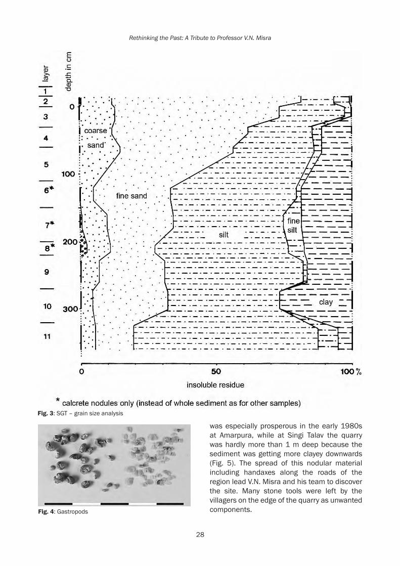
28
Rethinking the Past: A Tribute to Professor V.N. Misra
Fig. 3: SGT – grain size analysis
Fig. 4: Gastropods
was especially prosperous in the early 1980s at Amarpura, while at Singi Talav the quarry was hardly more than 1 m deep because the sediment was getting more clayey downwards (Fig. 5). The spread of this nodular material including handaxes along the roads of the region lead V.N. Misra and his team to discover the site. Many stone tools were left by the villagers on the edge of the quarry as unwanted components.

29
Revisiting the Acheulian Site of Singi Talav at Didwana 35 years later
Excavation was conducted on the southern margin of the quarry (Fig. 1) from 1981 to 1985 under the direction of V.N. Misra and S.N. Rajaguru. It extended on 72 m² to an average depth of nearly 1m as no significant archaeological material occurred below 80cm. Five layers were identified in the excavation (Fig. 6). In addition, a trial pit of 2 x 2m dug to a depth of 3.60 m, up to the water table allowed distinguishing 6 more layers. The entire stratigraphy of Singi Talav was described in detail before the pit was back-filled (Gaillard 1993, Raghavan et al. 1991). The main archaeological horizons were at the base of layers 3 and 4; they yielded a typical Acheulian assemblage of which most of the components were in mint condition save a few that were slightly abraded. Above them a rich level of extremely abraded lithic artefacts was observed at the top of the Amarpura Formation, at the interface with the overlying surface sand (layer 2). These artefacts were too abraded to be studied but included many elongated flakes and a few blades suspected to belong to a much
later technological stage than the Acheulian, probably the Middle Palaeolithic or even the early Upper Palaeolithic. Below layer 4, some slightly abraded artefacts were found in layer 5. In the trial pit, a few flakes in mint condition occurred at a depth of 2 m at the base of layer 7.
The Acheulian assemblage from Singi TalavA total of 1475 artefacts were excavated from the layers 3 to 5 at Singi Talav (Table 1). They included a large majority (85%) of flakes and fragments. Fragments are rock pieces not having any of the characteristic features of flakes like striking platform, striking point, and flaked surface. Their high proportion is related to the raw materials, mostly quartzites of various shades from dark grey to white, and quartz along with a few pieces of schist. For all these rocks including the local quartzite, flaking is difficult to control as it often has a schistose structure. Most of these raw materials originate from the metamorphic hills near Baliya (Fig. 1) about 3km from Singi Talav where they occur in plenty in the screes. A few artefacts (about 5%) are also made on river cobbles whose closest source known presently is near Jayal, about 20 km southwest of Singi Talav. Some of the flakes and fragments are retouched into small tools, mostly scrapers. Among the larger tools (significantly longer and especially thicker than the small tools) there is a significant proportion of large cutting tools, mainly handaxes with a few picks and cleavers. The core tools are diversified and often bifacial or multifacial rather than unifacial like the choppers are. Many of them may be proper cores meant to produce flakes, but as they have some cutting edge they have been classified as if they were tools.
Besides the small tools and large tools, it seemed relevant to distinguish a group of medium tools, having dimensions similar to those of the small tools but features of the large tools, like small chopping tools for instance (Tables 2 and 3).
FlakesOn the basis of their dimensions and especially their length, the flakes can be separated into
Fig. 5: SGT – excavation
Fig. 6: Section of SGT excavation

30
Rethinking the Past: A Tribute to Professor V.N. Misra
Table 2:
blank flakes
blank fragments
toolsonflakeorfragment
handaxes&picks
small cores
cores and core tools
total
n n n n n n layer 3 167 171 25 4 8 26 401layer 4 357 408 61 24 18 23 891layer 5 61 101 4 0 0 7 173 1465 % % % % % % layer 3 42 43 6 1 2 6 100%layer 4 40 45 7 3 2 3 100%layer 5 35 59 2 0 0 4 100%
Table 1:
depth in cm (from top of Amarpura formation)
archaeo-logical layer
unbroken opercula
broken opercula
shells (whole or fragments)
others
SamplingfromtheexcavtionSGT-10-12 3 2 26 7 123-36 4 10 51 9 035-65 4 8 38 25 143-53 4 21 136 13 265-85 5 2 17 2 080-97 5 2 9 0 185-110 5 8 51 0 0120-145 6 0 2 0 0125-130 6 0 3 1 0270-300 10 0 0 1 0Trial trench SGT-230-90 1 13 1 0Trial trench SGT-487-130 17 37 13 1Sampling around the quarrySpot 1, 56-65 4 94 2 1Spot 5, 0-25 1 7 0 1Spot 8, 0-20 0 2 0 1Spot 8, 20-40 4 8 1 0
two groups. The smaller ones, measuring less than 20 mm in length probably resulted from the final shaping or possibly re-sharpening of the large tools; and the longer flakes, with an average length of 32 mm would be proper debitage products. Only 3% of the flakes have a length twice that of the width (blade-shape). All the flakes usually show a plain striking platform forming an angle of 110° with the flaking surface. However, the flakes in schistose grey
quartzite have wider angles and frequent breaks at the distal end; they mainly result from the shaping of handaxes at the site itself that are mostly made from this schistose quartzite.
FragmentsThe fragments are more often on quartz than the flakes, especially in layer 3. This is probably related to the mechanical properties of this rock that shatters at the time of knapping. The

31
Revisiting the Acheulian Site of Singi Talav at Didwana 35 years later
31
Table 3: layer 3 layer 4
Total number of artefacts 401 891Small tools 25 61
6% 7%side scraper 2 7denticulated scraper 3 6denticulate 0 3notch 2 8beak 1 7end scraper 4 7burin 0 3convergent tool/point 5 5composite tool 8 15Medium tools/small core tools 8 18
2% 2%micro-chopper 2 0micro-chopping tool 2 7micro-discoid (bifacial) 0 4micro-spheroid with edge (bifacial) 1 0micro-spheroid without edge (multi-facial) 0 1micro-polyhedron (multi-facial) 2 3micro-core (multi-facial) 1 3Larger core tools: total 26 23
6% 3%chopper 0 0convergent chopper 1 0chopping tool 2 5double chopper / chopping tool 1 4atypical chopper 2 1atypical chopping tool 4 1discoid (bifacial) 1 3spheroid with edge (bifacial) 5 3polyhedron (multi-facial) 1 2core (multi-facial) 5 1single removal 3 2hammerstone 1 1Large cutting tools 4 24
1% 3%handaxe (bifacial) 3 18uniface 0 1pick 0 1proto-handaxe (atypical handaxe) 1 1cleaver 0 3
fragments have an average maximal length around 27 mm, with unimodal distribution. They are more abraded than the flakes. Less
than one third of them are fresh against more than 50% of the flakes, with about 30% from both groups being slightly abraded. The rest

32
Rethinking the Past: A Tribute to Professor V.N. Misra
32
are moderately or even highly abraded. Some fragments are highly abraded, therefore unidentifiable flakes. This abrasion indicates that the site is not strictly in a primary situation.
Small toolsSmall tools comprise side scrapers, side denticulated scrapers, convergent scrapers, atypical end scrapers, and notches (Table 3): their typology is diversified and not standardised. They were equally made on flakes or fragments, apart from the side scrapers that preferred flakes. Nonetheless, larger blanks were selected for manufacturing these tools, as their average length is around 43mm (against 32 and 27 mm for un-retouched flakes and fragments respectively). The raw materials used are preferably of good quality like fine grained quartzite and quartz. The schistose grey quartzite, so common among the blank flakes is rare among the small tools and this further supports the assumption that flakes of this rock mainly result from the shaping of large cutting tools.
Smaller core tools/medium toolsThe most common tool type of this group is the micro-chopping tool (Table 3) which may be understood as a thick bifacial scraper roughly shaped by small bifacial removals. The occurrence of polyhedrons and cores is also to be noted, and in layer 4, that of micro-discoids. A large majority of these tools were made from fragments, while only 15% of them are made from cobbles. They are hardly longer than the small tools (average length: 46 mm) but quite thicker (30 mm against 16mm for the small tools). They are mainly shaped by bifacial or multifacial removals; these removals reach an average number of 8. Some of these medium tools (1/4) bear percussion marks.
Larger core toolsChopping tools are the most frequently occurring type of the larger core tools (34%). Indeed the distribution of the tool types is comparable between the small core tools and the larger ones, except the higher frequency of the spheroids and cores among the larger variety (Table 3). Two third of these tools are
made from blocks while the rest are from cobbles. They have a mean length of 77 mm with a thickness of 50mm. Although they are bigger than those in the former tool group, their shaping only requires 9 removals on average. They often show percussion marks (1/3 of them), either on the ridges or on the faces. It is to be mentioned that the cores are quite few; they have been grouped with the core tools as both proper cores (flake production process) and core tools (shaping process), both have produced flakes. Both look similar and the cores have the same multi-directional flaking as the polyhedrons, but with less regular shapes. Correlatively, some of the core tools considered as tools rather than just cores may actually be cores but have a prominent edge assumed to be functional.
Large cutting toolsThe large cutting tools from Singi Talav excavation (and also from the quarry) are mostly handaxes and a large majority of them originate from layer 4 (Table 3). Cleavers are rare. All of them are usually made from blocks or slabs of schistose grey quartzite form the Baliya Hills; only a few specimens are made from large flakes of the same rock (4 handaxes and 2 cleavers) or from well silicified quartzite collected further away in the form of cobbles (one handaxe). The blocks or slabs were selected from the screes and split into suitable sizes. This operating process does not provide ready-made cutting edges since schistosity planes are parallel and not converging like the two faces of a flake. Thus it is not favourable for cleaver production but it results in pieces of geometric shapes easy to turn into pointed handaxes with minimal shaping. The large cutting tools sharply differ from the core tools by their dimensions which are higher for the length (113 mm on average) and lower for the thickness (38 mm). Moreover, their shaping, although minimal, implies much more investment: 18 removals on average for both faces, including the smaller removals less than 20mm long.
Quartz crystalsIt is interesting to note that six quartz crystals were found in layer 4 of Singi Talav. They

33
Revisiting the Acheulian Site of Singi Talav at Didwana 35 years later
33
were not utilised except one of them showing some micro-chipping at the point (D’errico et al. 1989). This is not the only one site where odd objects are found in the Acheulian context (Moncel et al. 2012), and this attests some non-utilitarian concern in the hunter-gatherer human groups as early as the end of the Lower Pleistocene.
Processing sequences and artefact movementsThe Acheulian assemblage found at Singi Talav did not move much after abandonment by prehistoric dwellers, as it was in the context of a low energy sedimentation process. Therefore, it can be considered as a reliable image of what people left after their departure from the site. This assemblage indicates that different raw materials were selected according to the type of artefact to be made. Flakes were produced from rather homogenous quartzites, mostly local (Baliya Hills) and sometimes from cobbly
gravel outcrops (at least 20 km away). None of these rocks allowed an easy production of large flakes (> 10 cm). The majority of large cutting tools were made from the schistose grey quartzite, locally available and easy to split into small geometric slabs requiring minimal work to be shaped into pointed handaxes. Cleavers are very rare, possibly due to the difficulty in obtaining large flakes from the local rocks. The core tools were made on various types of quartzites, preferably in the form of cobbles for the spheroids.
An interesting question to raise is whether the artefacts were produced at the site itself or were they imported from elsewhere (from the source of raw material or from another settlement). Considering the number of removals on the large tools according to their raw material, it appears that the flakes on coarse quartzite, with or without cortex, are much fewer than expected from the shaping of large tools. This rock was undoubtedly
Fig. 7: Cores and Cleavers

34
Rethinking the Past: A Tribute to Professor V.N. Misra
34
collected far away (20 km at least) in the form of cobbles. It was preferred for making larger core tools and was not suitable for debitage due to its coarseness. Obviously the larger tools were shaped before being brought to the site of Singi Talav. Similarly, flakes in schistose grey quartzite, the rock systematically preferred for handaxes and cleavers, are quite few in layer 4 when compared to the number of removals shaping these large tools. Therefore these were probably shaped, at least partially, at the spot of raw material collection, in the Baliya Hills.
On the contrary, in the layer 3 cortical flakes on fine grained quartzite are more than expected suggesting that this good quality rock was carried to the site in the form of whole cobbles and then knapped for flake production at the site until the cores were exhausted.
The Acheulian assemblage from Singi Talav in theSouthAsiancontextIn South Asia a few Acheulian sites belong to the Lower Pleistocene or beginning of the Middle Pleistocene. They yield assemblages in which
Fig. 8: Handaxes

35
Revisiting the Acheulian Site of Singi Talav at Didwana 35 years later
35
debitage products do not imply standardised core reduction methods, and where the large cutting tools, especially handaxes and cleavers result from minimal shaping, however prepared on well selected blanks, either large flakes or suitable cobbles or slabs. These large tools are bigger in size than in the later stages of the Acheulian and they characterise the early Acheulian (Paddayya 2007, Shipton et al. 2014).
AttirampakkamThe earliest of these sites is Attirampakkam (Tamil Nadu) where layers 8 to 6 in trench T8 yielded 3528 artefacts dated to around 1.5 Ma (Pappu et al. 2011). Sedimentological features of these layers indicate a local water body with regular flooding within the Kortallayar River valley (Pappu et al. 2003). Fine coarse-grained quartzite cobbles and boulders were available in the nearby hills not less than 3km for the site. The assemblage is mainly comprised of ‘waste flakes’ (70%), besides retouched flakes (15%), utilised flakes (10%), large flakes (4%) and a few tools on cobbles. Large flakes were produced off-site then brought to the site where all of them were modified mainly into handaxes, sometimes into cleavers and often minimally trimmed into ‘cleaver-flakes’. Shaping of these large flakes and of some cobbles resulted in the production of all the other flakes at the site; proper cores seem to be absent.
The situation and behaviour of prehistoric groups settled at Attirampakkam, layers 8 to 6, compares well with that of Singi Talav. The difference regarding the lithic assemblage mainly rests on the absence of large flakes in the latter site, which may be linked to the quality of the raw materials.
IsampurThe site of Isampur (Karnataka) belongs to a rich complex of Lower, Middle, and Upper Palaeolithic sites in the Hunsgi Valley. It yielded Acheulian remains of the earliest populations in the valley dated to around 1.2 Ma (Paddayya et al. 2002). These people had settled near a palaeo-channel, probably providing them water during their stay, and right on the weathering bedrock of silicified limestone. This rock was
an excellent raw material for their tools but was not exclusively used as nearly 20% of the assemblage was made from chert or quartzite collected elsewhere in the valley. This site is considered as a factory site and also a living site. Among five trenches, Tr. 1 was the richest; it yielded 13,043 artefacts, of which 92% are “incidental” products (small flakes and debris including products from sieving > 5 mm). The shaped tools comprise 48 handaxes, 15 cleavers, 18 knives, 3 discoids, 14 chopping-tools and 65 scrapers. Half of the handaxes are made from slabs or cobbles, while the other half are made on flakes. Cleavers and knives are mostly on flakes. These larger tools are mostly in silicified limestone, except the ones on quartzite cobbles, while the smaller tools like scrapers, usually on flakes (49/65) are on chert or quartzite (Paddayya 2004, 2007).
It is difficult to compare this assemblage composition with that from other sites as the systematic sieving of the dugout earth has resulted in an overwhelming amount of small chips and debris. In any case, the diversity of the large tools has to be noted. The small tools are well represented and they mostly consist of scrapers. Shaping of the large tools uses both kinds of supports: large flakes knapped from the local rock and selected cobbles or slabs.
Chirki on PravaraNear Nevasa (Maharashtra), several localities have yielded Acheulian assemblages, especially Chirki and Laxmi Nala. At the latter site, the clayey layer overlying the Acheulian-bearing cross-bedded sandy gravel has provided a reverse palaeomagnetic signal suggesting it was deposited during the Matuyama chronology before 780 ka (Sangode et al. 2007). At the site of Chirki, several trenches were excavated in the 1960s, attesting human occupation (Corvinus 1983). From the richest of these trenches, Tr. VII, 1455 artefacts referring to the Acheulian technical tradition were dug out of the lowest layer 3. They were imbedded in colluvial bouldery rubble deposited on a platform of the basaltic bedrock along the Pravara River and subsequently covered by cross-bedded sandy gravels, sands and clays. Prehistoric populations settled on this platform near the
36
Rethinking the Past: A Tribute to Professor V.N. Misra
36
river and produced their tool kit from the locally available rocks: basalt, either vesicular or red in colour, or compact and grey dolerite from a dyke located a few kilometres away but also occurring in the rubble, as well as different varieties of chert. Nearly half of the light-duty artefacts (< 80 mm) are on chert. They consist of flakes (about 50%) obtained from multi-directional cores without planned method of reduction, a few cores and retouched tools, and of a large amount of various fragments. The heavy-duty tools (> 80 mm) are mainly of basalt or dolerite. They represent 2/3 of the assemblage, which is exceptionally high even for excavated Acheulian material. Nearly two third of them are shaped, usually on flakes but also on cobbles. The cleavers are the most common tools and they result from different methods of production that appear quite smart; they usually derive from large flakes or very large flakes (Corvinus 1983). Handaxes are slightly less numerous than cleavers; some specimens are made from cobbles and others on flakes. Besides these classical types of large cutting tool, some picks, knives, and large scrapers also occur. Cobble tools represent about 12% of the heavy-duty artefacts. They mainly include chopping tools (bifacial), polyhedrons, spheroids, and cores. As in many early Palaeolithic assemblages it is difficult to distinguish the proper cores from the core tools. The remaining heavy-duty artefacts (30%) consist of unmodified flakes, flake fragments and chunks (Corvinus 1983).
This site stands apart due to the importance of the heavy-duty component and especially the handaxes and cleavers. It may be a specialised site. However, it is to be kept in mind that the vesicular basalt and even the compact basalt get weathered very fast and that any minor reworking would totally erase artefacts made from these rocks, especially the smaller ones, from the archaeological record (Mishra 1982). Nonetheless, the assemblage from Chirki may be qualitatively compared to that from Singi Talav due to the typological variety of heavy-duty tools, although knives are missing at Singi Talav. As for the methods of production, they are characterised by large flakes that provide blanks for the large tools; this is not the case at Singi Talav.
ConclusionThe site of Singi Talav represents the settlement of hunter-gatherers producing and using tools of the Acheulian industry, especially in layer 4. The lithic assemblage is well preserved as it was covered by fine silty-sandy sediments in a low energy environment. However, some artefacts are abraded, due to either wind or water, and these may not be in a primary position. Unlike the other early Acheulian sites in peninsular India, Singi Talav was located in a playa away from any river. Acheulian making people had settled here, near a lake or pound that was probably seasonal, given the type of gastropods living in it. They had no raw material available in the immediate surroundings of the site and they had to carry it from at least 3 km away. They preferred to settle near the water rather than near the source of raw material and therefore this was probably a living (habitation?) site. These nomadic people must have had a good knowledge of all the water holes of the region. The many lakes on the western margin of the present day Thar Desert might have been vital landmarks for them. The ancient drainage system of which these lakes are remnants might have been less disorganised than now and at least not covered with aeolian sands, thus making the water supply easier and the region more hospitable.At Singi Talav, the tool kit was mainly made from the semi-local rocks but some good quality quartzite was brought from at least 20 km away for the manufacture of smaller flakes and tools. The larger tools, especially the handaxes were not shaped at the site but elsewhere, probably near the source of raw materials. This Acheulian assemblage is not representative of the ‘Large Flake Acheulian’ (LFA; Sharon 2007), unlike most of the early Acheulian assemblages in South Asia usually produced from raw materials which are easier to master like homogenous quartzite or doleritic basalt, and if necessary collected slightly away from the living sites for their better quality. Originality of the large cutting tools from Singi Talav may be linked to the raw materials. At all the sites large cutting tools are associated with a variety of other tools probably related to the activities performed at the site. The assemblage composition,

37
Revisiting the Acheulian Site of Singi Talav at Didwana 35 years later
37
its technology and typology may depend on many factors, especially the type of site, its environment, and the available raw materials all together related to the routes followed by human groups when moving from site to site. Too many of these factors are unknown and a comparison between assemblages always leads to the conclusion that beyond some common tool types, the Acheulian assemblages are quite diversified.
ReferencesAchyuthan, H. 2003. Petrologic analysis and
geochemistry of the Late Neogene-Early Quaternary hardpan calcretes of Western Rajasthan, India, Quaternary International 106-107, 3-10.
Achyuthan, H., C. Gaillard, S.N. Rajaguru 1991. Geoarchaeology of Acheulian calc pan site, Singi Talav, Didwana, Nagaur District, Rajasthan, Geoarchaeology 6: 151–168
Achyuthan, H., J. Quade, L. Roe and C. Placzek 2007. Stable isotope composition of pedogenic carbonates from the eastern margin of the Thar Desert, Rajasthan, India. Quaternary International 162-163: 50-60.
Achyuthan H. and S.N. Rajaguru 1998. Micromorphology of Quaternary calcretes around Didwana in Thar Desert of Rajasthan, Journal of Arid Zones 37(1): 25-35.
Agrawal, D.P., P.S. Datta, Zahid Hussain, R.V. Krishnamurthy, V.N. Misra, S.N. Rajaguru and P.K. Thomas 1980. Palaeoclimate, Stratigraphy and Prehistory in North and West Rajasthan, Proceedings of the Indian Academy of Sciences 89(1): 51-66.
Agrawal D.P. and B.M. Pandeh (Eds.), 1977. Ecology and archaeology of Western India. Proceedings of a workshop held at the P.R.L., Ahmedabad, 1976, 255 p.
Allchin, B. and A. Goudie 1974. Pushkar, Prehistory and climate change in eastern India. World Archaeology 5(3): 248-265.
Allchin, B., A. Goudie, K.T.M. Hegde 1978. Prehistory and palaeogeography of the Great Indian Desert. Academic Press, London, 370 p.
Andrews, J.E., A.K. Singhvi, A.J. Kailath, R. Kuhn, P.F. Dennis, S.K. Tandon, R.P. Dhir 1998. Do Stable Isotope Data from Calcrete Record Late Pleistocene Monsoonal Climate Variation in the Thar Desert of India?, Quaternary Research 50(3): 240-251.
Bakliwal, P.C. and S.K. Wadhawan 2004. Geological evolution of Thar Desert in India – issues and prospects. Proceedings of the Indian National Science Academy 69: 151–165.
Blinkhorn, J., H. Achyuthan, M. D. Petraglia 2015. Ostrich expansion into India during the Late Pleistocene: Implications for continental dispersal corridors, Palaeogeography, Palaeoclimatology, Palaeoecology 417(1): 80-90.
Corvinus, G. 1983. A Survey of the Pravara River System in Western Maharashtra, India, Vol 2: The Excavations of the Acheulian Site of Chirki-on-Pravara, India. Verlag Archaeologica Venatoria, Institut für Urgeschichte der Universität Tübingen, 466 p.
Courty, M.A., R.P. Dhir, H. Raghavan 1987. Morphology, genesis and evolution of calcitic features in Rajasthan soils (India), in Proceedings VII Soil Micromorphology, N. Federoff, L.M. Bresson, M.A. Courty (Eds.), pp. 227-234. Association Francaise pour l’étude du Sol, Paris,
Deo, S., S. Mishra, S.N. Rajaguru, S. Ghate 2007. Antiquity of Acheulean culture in upland Maharashtra: a geoarchaeological approach, in Human origin, genome and people of India: genome, palaeontological and archaeological evidence, A.R. Sankhyan, V.R. Rao (Eds.), pp. 292-308. Anthropological Survey of India and Allied Publishers Pvt. Limited, Kolkata.
Dhir, R.P. 1976. Palaeo-climate inferences from Quaternary pedogenetic processes in arid zone.
Dhir, R.P. 1995. The genesis and distribution of arid zone calcretes, in Quaternary Environments and Geoarchaeology of India, S. Wadia, R. Korisettar, V.S. Kale (Eds.), pp. 191-209. Memoire 32. Geological Society of India, Bangalore.
Dhir, R.P., A. Kar, S.K. Wadhawan, S.N. Rajaguru, V.N. Misra, A.K. Singhvi, S.B. Sharma 1992. Soils, in Thar desert in Rajasthan: Land, Man and Environment, A.K. Singhvi and A. Kar (Eds.), pp. 51-54. Geological Society of India, Bangalore.
Dhir, R.P., S.N. Rajaguru and A.K. Singhvi 1994. Desert Quaternary formations and their Morphostratigraphy: Implications for the evolutionary history of the Thar, Journal of Geological Society of India 43: 435- 447.

38
Rethinking the Past: A Tribute to Professor V.N. Misra
38
Dhir, R.P. and A.K. Singhvi 2012. The Thar Desert and its Antiquity., Current Science 102(7): 1001-1008.
Dhir, R.P., S.K. Tandon, B.K. Sareen, R. Ramesh, T.K.G. Rao, A.J. Kailath and N. Sharma 2004. Calcretes in the Thar Desert: Genesis, chronology and palaeoenvironment, Proceedings of the Indian Academy of Sciences (Earth Planetary Science) 113: 473-515.
D’Errico, F., C. Gaillard and V.N. Misra 1989. Collection of Non-Utilitarian Objects by Homo erectus in India, in Hominidae: Proceedings of the Second International Congress of Human Palaeontology, Giacomo Giacobini (Ed.), pp. 237-239. Milan: Jaca Books.
Gaillard, C., V.N. Misra, S.N. Rajaguru, D.R. Raju and H. Raghavan 1985. Acheulian occupation at Singi-Talav in the Thar desert: a preliminary report on the 1981 excavation, Bull. of the Deccan College Research Institute 44: 141-152.
Gaillard, C., D.R. Raju V.N. Misra and S.N. Rajaguru 1983. Acheulian occupation at Singi-Talav in the Thar desert: a preliminary report on 1982 excavation, Man and Environment 7: 112-130.
Gaillard, C., D.R. Raju, V.N. Misra and S.N. Rajaguru 1986. Handaxe assemblages from Didwana region, Thar desert, India: a metrical analysis, Proceedings of the Prehistoric Society 52: 189-214.
Krishnamurthy, R.V., D.P. Agrawal, V.N. Misra and S.N. Rajaguru 1981. Palaeoclimatic Inferences from the Behaviour of Radiocarbon Dates of Carbonates from Sand Dunes of Rajasthan, Proceedings of the Indian Academy of Sciences 90(2): 155-160
Mishra, S., 1982. On the effects of basalt weathering on the distribution of Lower Palaeolithic sites in the Deccan, Bulletin of the Deccan College Postgraduate and Research Institute 41: 107-115.
Mishra, S., S. Deo, R. Abbas, S. Naik, G. Shete, N. Agarwal and S.N. Rajaguru 2009. Excavations at the Early Acheulean site of Morgaon, Maharashtra (2000-2007), in Recent Research Trends in South Asian Archaeology, K. Paddayya, P.P. Joglekar, K.K. Basa, R. Sawant (Eds.), pp. 121-137.Deccan College Postgraduate and Research Institute, Pune.
Misra, V.N. 1989. Human Adaptations to the Changing Landscape of the Indian Arid Zone During the Quaternary Period, in Old
Problems and New Perspectives in the Archaeology of South Asia, J.M. Kenoyer (Ed.), Wisconsin Archaeological Reports, Volume 2, pp. 3-20. Madison: University of Wisconsin-Madison.
Misra, V.N. 1995a. Evolution of Environment and Culture in the Rajasthan Desert during the Late Quaternary, in Ancient Peoples and Landscapes, Eileen Johnson (Ed.), pp. 77-103. Lubbock, Texas: Texas Tech University Press.
Misra, V.N. 1995b. Geoarchaeology of the Thar Desert, Northwest India, in Quaternary Environments and Geoarchaeology of India: Essays in Honour of Professor S.N. Rajaguru, S. Wadia, R. Korisettar and V.S. Kale (Eds.), pp. 210-230. Bangalore: Geological Society of India.
Misra, V.N. and S.N. Rajaguru 1986. Environnement et Culture de l’Homme Préhistorique dans le Désert du Thar, Rajasthan, Inde, L’Anthropologie 90(3): 407-437.
Misra, V.N. and S.N. Rajaguru 1988. History of Environment and Man in the Thar Desert, Journal of Ecological Society I: 7-16.
Misra, V.N. and Rajaguru S.N., 1989. Palaeoenvironment and Prehistory of the Thar Desert, Rajasthan, India, in South Asian Archaeology 1985, Karen Frifelt and Per Sorensen (Eds.), pp. 296-320. Copenhagen: Scandinavian Institute of Asian Studies.
Misra, V.N. and S.N. Rajaguru 1996. Palaeoenvironment and Prehistory of the Thar Desert, Rajasthan, India. In, Facets of a Marwar Historian: Aspects of India’s Social and Economic History (A Volume in Honour of Shri Govind Agarwal), B.L. Bhadani and Dwijendra Tripathi (Eds.), pp. 99-130. Jaipur: Publication Scheme.
Misra, V.N., S.N. Rajaguru, D.P. Agrawal, P.K. Thomas, Z. Husain and P.S. Datta 1980. Prehistory and Palaeoenvironment of Jayal, Western Rajasthan, Man and Environment 4: 19-31.
Misra, V.N., S.N. Rajaguru and H. Raghavan 1988. Late Middle Pleistocene Environment and Acheulian Culture around Didwana, Rajasthan, Proceedings of the Indian National Science Academy 54, A(3): 425-438.
Misra, V.N., S.N. Rajaguru, D.R. Raju, H. Raghavan and C. Gaillard, 1982. Acheulian occupation and evolving landscape around

39
Revisiting the Acheulian Site of Singi Talav at Didwana 35 years later
39
Didwana in the Thar Desert, India, Man and Environment 6: 72-86.
Moncel, M.H., L. Chiotti, C. Gaillard, G. Onoratini and D. Pleurdeau 2012. Non-utilitarian objects in the Palaeolithic: Emergence of the sense of precious? Archaeology, Ethnology and Anthropology of Eurasia 40(1): 24-40.
Paddayya, K. 2008. Evolution within the Acheulean in India: a case study from the Hunsgi and Baichbal Valleys, Karnataka. Bulletin of the Deccan College Research Institute 66-67: 95-111.
Paddayya, K., B.A.B. Blackwell, R. Jhaldiyal, M.D. Petraglia, S. Fevrier, D.A. Chanderton, I.I.B. Blickstein and A.R. Skinner 2002. Recent findings on the Acheulean of the Hunsgi and Baichbal Valleys, Karnataka, with Special Reference to the Isampur Excavation and its Dating, Current Science 83(5): 641-657.
Paddayya, K., R. Jhaldiyal and M.D. Petraglia 2006. The Acheulean Quarry at Isampur, Lower Deccan, India, in Axe age: Acheulean tool making from quarry to discard, N. Goren-Inbar and G. Sharon (Eds.), pp. 45-73. London: Equinox Publishing.
Pappu, S., Y. Gunnell, M. Taieb, J-P. Brugal, Y. Touchard 2003. Ongoing excavations at the Palaeolithic site of Attirampakkam, South India: preliminary findings, Current Anthropology 44: 591-597.
Pappu, S., Y. Gunnell, K. Akhilesh, R. Braucher, M. Taieb, F. Demory and N. Thouveny 2011. Early Pleistocene Presence of Acheulian Hominins in South India, Science 331: 1596-1600.
Petney, T., P. Sithithaworn, R. Andrews, N. Kiatsopit, S. Tesana, C. Grundy-Warr and A. Ziegler 2012. The ecology of the Bithynia first intermediate hosts of Opisthorchis viverrini, Parasitology International 61(1): 38-45.
Raghavan, H. and M.A. Courty 1987. Holocene pedosedimentary and Pleistocene pedo-sedimentary environments in the Thar desert (Didwana, India), in Proceedings VII Soil Micromorphology, N. Federoff, L.M. Bresson, M.A. Courty (Eds.), pp. 639-646. Association Francaise pour l’Etude du Sol, Paris.
Raghavan, H., C. Gaillard and S.N. Rajaguru 1991. Genesis of calcretes from the calc-pan site
of Singi Talav near Didwana, Rajasthan, India – A micromorphological approach. Geoarchaeology: An International Journal 6(2): 151-168.
Rajaguru S.N., S.G. Deo and C. Gaillard 2014. Pleistocene Geoarchaeology of Thar Desert, Annals of Arid Zone 53(2): 63-76.
Sangode, S., S. Mishra, S. Naik and S. Deo 2007. Magnetostratigraphy of the quaternary sediments associated with some Toba Tephra and Acheulian artefact bearing localities in the Western and Central India, Gondwana Magazine Special Volume 10: 111-121.
Sharon, G., 2007. Acheulian large flake industries: technology, chronology,and significance. BAR International Series 1701. Oxford: Archaeopress.
Singh, G., R.D. Joshi, S.K. Chopra and A.B. Singh 1974. Late Quaternary History and Climate of the Thar Desert, India, Philosophical Transactions of the Royal Society of London 276: 467-501.
Singhvi A.K. and A. Kar 2004. The aeolian sedimentation record of the Thar desert. Proc. Indian Acad. Sci. (Earth Planet. Sci.), 113(3): 371-401.
Singhvi, A.K., Y.P. Sharma, D.P. Agarwal 1982. Thermoluminescence dating of sand dunes in Rajasthan, India, Nature 295: 313–315.
Shipton C., S. Mishra, K. Paddayya, S.G. Deo, J.N. Pal, N. Roseboom, C. Gaillard, M.C. Gupta and Y. Hou 2014. Empirical Differences between the Earlier and Later Acheulian in India, in Recent Advances in Acheulian Culture Studies in India, K. Paddayya and S.G. Deo (Eds.), pp. 23-36. Pune: Indian Society for Prehistoric and Quaternary Studies.
Wasson, R.J., S.N. Rajaguru, V.N. Misra, D.P. Agarwal, R.P. Dhir, A.K. Singhvi and K.K. Rao 1983. Geomorphology, Late Quaternary stratigraphy and palaeoclimatology of the Thar dune field, Zeist für Geomorphologie Supplement 45: 117-151.
Westaway R., S. Mishra, S. Deo, D.R. Bridgland 2011. Methods for determination of the age of Pleistocene tephra, derived from eruption of Toba, in central India. Journal of Earth System Sciences 120(3): 503-530.

Gargi Chatterjee 2017, in Rethinking the Past: A Tribute to Professor V.N. Misra(S.G. Deo, Andre Baptista and Jayendra Joglekar Eds.), pp. 40-49, Pune. ISPQS: www.manandenvironment.orgISBN: 978-81-908330-6-6
IntroductionTypological study of the lithic assemblages in India has been chosen by several Pre-historians since Foote’s typological work (Foote 1914; 1916). Contributions of eminent scholars like Paterson (De Terra and Paterson 1939), Sankalia (Sankalia 1964), Jayaswal (Jayaswal 1978, 1979, 1982) built a strong foundation for Stone Age techno-typological studies in India. Previous studies suggest the classification and nomenclature of stone tools on the basis of their shapes, the medium on which they were made, and sometimes on the basis of preparation technique However, as the stone tools represent the daily activities of Early Man it is now pertinent to classify these tools on the basis of their functions to understand primitive life.
Considering the above discussed problem, the present essay attempts to classify the major Acheulian tools in the light of their functions. The tools picked up for the study are: Handaxe, Cleaver, Chopper & Chopping Tool, and Scraper, which are the representative types of the Indian Acheulian phase. This work is based on the collections of twelve excavated Acheulian sites in India namely: Didwana, Paisra, Sihawal-II, Nakjharkhurd, Adamgarh, Bhimbetka, Durkadi Nala, Chirki, Hunsgi, Anagawadi, Site-128 (Nagarjunakonda), Site-SXIII (Nagarjunakonda) (see Table 6). The Acheulian collection of Paisra has been handled, studied, and measured during work. The tools of the other eleven sites have been studied and measured through illustrations, line drawings, and descriptions reflected in reports, monographs or in other related articles. On the very onset of this work, the probable
FUNCTION BASED CLASSIFICATION OF THE ACHEULIAN TOOLS IN INDIAN CONTEXT
Gargi Chatterjee
Department of A.H.C. and Archaeology, University of [email protected]
Abstract
Typological study of the lithic assemblages in India has been carried out by several Pre-historians since Robert Bruce Foote’s typological work. To understand the functional aspect of Acheulian tools, the present work is focused on mainly on the bifaces, choppers and scrapers. The working edges of these tools are considered to recognize their probable functions. Based on this, an attempt is made to prepare function-based classification of these major Acheulian tools.
major actions of the Acheulian population will be discussed, following which the five aforesaid tools will be classified in the light of these major actions, which denote their functions.
The primitive subsistence as a whole stands for man’s more or less absolute dependence on nature for both food and shelter. Hunting-gathering was a means of food procurement for prehistoric man who was more or less dependent on nature directly for shelter (rock-shelter, tree-shade or tree-branch, open air). Ecologically adverse conditions prompted at times the making of huts as is revealed by the excavated remains at Paisra, India and Terra-Amata, France. Thus the major activities of Stone Age man, particularly may be narrowed down to hunting, gathering, and shelter making (Table 1).
Table 1: The Major Actions done by Acheulian Population
Hunting chase and kill animal/fishingSkinning/scalingcutting and chopping the meatbreaking bones to extract marrow
Gathering(plant food)
digging to gather tuber rootsbreaking nuts
Hut making digging (deep) to make post-holescutting branches to prepare posts
The presumed stages of hunting involve killing of animals by chasing and/or trapping- and piecing of the kill for food, then to acquire edible parts of the kill multiple operations like – skinning, chopping of meat (butchery), and breaking joints of bones and long bones to extract marrow appear logical. Similarly, to collect edible vegetable-digging roots and

41
Function Based Classification of the Acheulian Tools: in Indian Context
41
breaking nuts must be done. The actions performed during shelter making would involve acquisition of material such as post, leaves, branches, grass etc. for construction, and erection of wooden post and making shades. Cutting tree branches and creepers, and digging (deep and concentrated) holes would be the main actions done by Acheulian man. In the light of these daily activities the classifications have been done.
ClassificationofHandaxeThe proposed classification of handaxe is based on its working parts: tip and butt. Since both these parts govern activities to be performed by this tool. The tip or the upper end of this implement was used for various digging, scraping, skinning, cutting operations, while the tool was hafted or held from its butt. After determining these attributes, the categories have been identified. The tips of the handaxes are varied which may be differentiated by its angle. The following tip-based classification is based primarily on the angle in which the sides of this tool form the tip: Elongated tip (30°-45°), Pointed tip (above 45°-60°), Less pointed tip (above 60°-75°) and Point less tip or broad end (above 75°), and on the basis of the butt this tool can be grouped under two categories: thin and heavy butt.
By merging features of both the tip and the butt, the following eight categories of handaxes can be identified: Type A: elongated tip with thin butt, Type: B: elongated tip with heavy butt, Type: C: pointed tip with thin butt, Type: D: pointed tip with heavy butt, Type: E: less pointed tip with thin butt, Type: F: less pointed tip with heavy butt, Type: G: point less tip with thin butt, Type: H: point less tip with heavy butt.
Through the aforesaid classification of Handaxes, eight types could be identified (Type: A, B, C, D, E, F, G, H) and the physical characteristics of each type indicate some specific function which they could have performed. Type: A (elongated tip with thin butt) Handaxe would be effective for killing, chasing and/or trapping of the prey; Type: B (elongated tip with heavy butt) Handaxe could be useful for deep as well as shallow digging
purpose and could therefore be helpful to dig-out tuber roots, and for concentrated digging to make post holes; Type: C & D (pointed tip with thin and heavy butt) also could be convenient for shallow digging; Type: E & F (less pointed tip with thin and heavy butt) Handaxes must be effective for the purpose of breaking and crushing such as breaking bones to extract marrow, and crushing nuts, etc; and Type: G & H (point less tip or broad end with thin and heavy butt) Handaxe could be useful for skinning, chopping, and piecing operations (see Table 2 and Fig. 1).
Table 2: The probable functions of Handaxe
Types Description of the Type
Probable Functions
Type A Elongated tip with thin butt
Digging (deep) but in soft & loose soil, shal-low digging, Scraping and Skinning, killing animal after trapping.
Type B Elongated tip with heavy butt
Digging (deep) in both loose and hard soil & shallow digging
Type C & D
Pointed tip with thin and heavy butt respectively
Digging (shallow), Scraping
Type E & F
Less pointed tip with thin and heavy butt respectively
Breaking, Crushing
Type G & H
Point less tip with thin and heavy butt respectively
Scraping, Skinning, Cut-ting & chopping meat
ClassificationofCleaverThe function based classification of Cleaver is based on two of its parts, edge and butt as
Fig. 1: Types of Handaxes (Type A & G: Pant and Jayaswal 1991; Type B, C & E: Sharma and Clark 2000; Type D: Paddayya 1982)
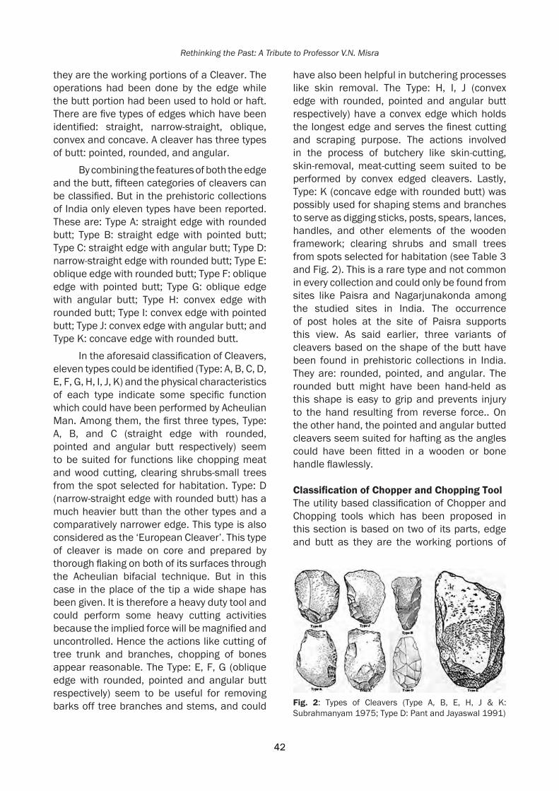
42
Rethinking the Past: A Tribute to Professor V.N. Misra
42
they are the working portions of a Cleaver. The operations had been done by the edge while the butt portion had been used to hold or haft. There are five types of edges which have been identified: straight, narrow-straight, oblique, convex and concave. A cleaver has three types of butt: pointed, rounded, and angular.
By combining the features of both the edge and the butt, fifteen categories of cleavers can be classified. But in the prehistoric collections of India only eleven types have been reported. These are: Type A: straight edge with rounded butt; Type B: straight edge with pointed butt; Type C: straight edge with angular butt; Type D: narrow-straight edge with rounded butt; Type E: oblique edge with rounded butt; Type F: oblique edge with pointed butt; Type G: oblique edge with angular butt; Type H: convex edge with rounded butt; Type I: convex edge with pointed butt; Type J: convex edge with angular butt; and Type K: concave edge with rounded butt.
In the aforesaid classification of Cleavers, eleven types could be identified (Type: A, B, C, D, E, F, G, H, I, J, K) and the physical characteristics of each type indicate some specific function which could have been performed by Acheulian Man. Among them, the first three types, Type: A, B, and C (straight edge with rounded, pointed and angular butt respectively) seem to be suited for functions like chopping meat and wood cutting, clearing shrubs-small trees from the spot selected for habitation. Type: D (narrow-straight edge with rounded butt) has a much heavier butt than the other types and a comparatively narrower edge. This type is also considered as the ‘European Cleaver’. This type of cleaver is made on core and prepared by thorough flaking on both of its surfaces through the Acheulian bifacial technique. But in this case in the place of the tip a wide shape has been given. It is therefore a heavy duty tool and could perform some heavy cutting activities because the implied force will be magnified and uncontrolled. Hence the actions like cutting of tree trunk and branches, chopping of bones appear reasonable. The Type: E, F, G (oblique edge with rounded, pointed and angular butt respectively) seem to be useful for removing barks off tree branches and stems, and could
have also been helpful in butchering processes like skin removal. The Type: H, I, J (convex edge with rounded, pointed and angular butt respectively) have a convex edge which holds the longest edge and serves the finest cutting and scraping purpose. The actions involved in the process of butchery like skin-cutting, skin-removal, meat-cutting seem suited to be performed by convex edged cleavers. Lastly, Type: K (concave edge with rounded butt) was possibly used for shaping stems and branches to serve as digging sticks, posts, spears, lances, handles, and other elements of the wooden framework; clearing shrubs and small trees from spots selected for habitation (see Table 3 and Fig. 2). This is a rare type and not common in every collection and could only be found from sites like Paisra and Nagarjunakonda among the studied sites in India. The occurrence of post holes at the site of Paisra supports this view. As said earlier, three variants of cleavers based on the shape of the butt have been found in prehistoric collections in India. They are: rounded, pointed, and angular. The rounded butt might have been hand-held as this shape is easy to grip and prevents injury to the hand resulting from reverse force.. On the other hand, the pointed and angular butted cleavers seem suited for hafting as the angles could have been fitted in a wooden or bone handle flawlessly.
ClassificationofChopperandChoppingToolThe utility based classification of Chopper and Chopping tools which has been proposed in this section is based on two of its parts, edge and butt as they are the working portions of
Fig. 2: Types of Cleavers (Type A, B, E, H, J & K: Subrahmanyam 1975; Type D: Pant and Jayaswal 1991)

43
Function Based Classification of the Acheulian Tools: in Indian Context
43
the tool. Actions had been performed using the edge, and the butt portion had been used to hold. There are three types of edges which have been identified: convex edge, concave edge, and pointed end; with three types of butts: globular, pointed and wide.
Through merging the features of both the edge and the butt, nine categories of Chopper and Chopping tools can be identified. But in the Indian Acheulian collections only seven types could be found. These are Type A: convex edge with globular butt; Type B: convex edge with pointed butt; Type C: convex edge with wide butt; Type D: concave edge with globular butt,; Type E: concave edge with wide butt; Type F: pointed end with globular butt; and Type G: pointed end with wide butt.
Usually the naturally obtained edge of a Chopper or Chopping tool during its manufacture is convex in shape. However to produce the other shapes: concave and pointed, additional and deliberate thought driven effort on the part of Acheulian man was warranted. Before justifying the probable functions of each shape of the tool it is important to say that the Chopper and Chopping tools are heavy duty tools. Therefore, the produced force during action is greater than the implied force. Types: A, B, and C (convex edge with globular, pointed and wide butt respectively) seem appropriate for the purpose of butchery, and the actions
carried out by these types are skin-cutting, skin-removal, meat-cutting etc.; Types: D & E (concave edge with globular and wide butt respectively) appear suited to serve the purpose of wood working like shaping wooden equipment, posts etc.; Type: F & G (pointed end with globular and wide butt respectively) could be useful for the purpose of breaking and crushing such as breaking bones to extract marrow, and crushing nuts, etc. (see Table 4 and Fig. 3). As mentioned earlier, three shapes of butt for Chopper and Chopping tool have been found in the Indian Acheulian collection. They are: globular, pointed, and wide. These shapes depend on the shape of the pebble, nodule, and block on which the tool had been made. All of these must been hand held as they are much heavier and inappropriate for hafting. Among them, the globular and pointed butt
Table 3: The probable functions of Cleaver
Types Name of the Types Probable FunctionsType: A straight edge with rounded butt chopping meat and wood, clearing shrubs-small trees
from the spot selected for habitationType: B straight edge with pointed buttType: C straight edge with angular butt Type: D narrow-straight edge with rounded butt cutting of tree trunk, brunch and boneType: E oblique edge with rounded butt removing barks from branch and stem, removing skin
during the process of butcheryType: F oblique edge with pointed buttType: G oblique edge with angular buttType: H convex edge with rounded butt skin-cutting, skin-removal, meat-cutting etc.Type: I convex edge with pointed buttType: J convex edge with angular buttType: K Concave edge with rounded butt shaping digging sticks, posts, spears, lances, handles and
other elements of the wooden framework; clearing shrubs from the places selected for habitation
Fig. 3: Types of Chopper & Chopping Tools (Type A, B & G: Pappu, R.S. 1974; Type C & F: Subrahmanyam 1975)

44
Rethinking the Past: A Tribute to Professor V.N. Misra
44
could be gripped well single handedly between the fingers and palm, but both hands might be required to hold the wide butt.
ClassificationofScraperScrapers have been classified on the basis of the shape of the cutting edge. Because the shape of cutting edge of a Scraper is directly related to its function, and according to it scrapers could be classified into five types and they are: Type A; straight; Type B: convex; Type C: concave; Type D: denticulate; and Type E: combination cutting edge (includes straight-convex, straight-concave, concavo-convex, denticulate-straight, denticulate-convex and denticulate-concave).
Scraper is a light duty tool having specific uses. The probable function of each variant shape of the cutting edge of the Scraper is discussed in this section. Type: A (having straight cutting edge) seems appropriate for simple and straight scraping purposes like skinning game or scraping stem or branch of tree; Type: B (having convex cutting edge) could act as a knife and serve curve cutting purpose
for small animals; Type: C (having concave cutting edge) seems suited for scraping something round since its cutting edge fits the shape; Type: D (having denticulate edge) is ideal for the act of serration, used against something hard; Type: E (having combination edge) could be used according to its shape: straight/convex/concave as stated above. Therefore the combination edge Scraper may show an attempt by early man to utilize more than one side of a single stone piece for different functions. This shows an advanced stage of human mind and probably explains the reason behind the rare occurance of this category of Scrapers in the Acheulian phase. However one point of mention is, sometimes two sides of a combination Scraper meet to form a sharp point This kind of Scraper is traditionally called ‘Convergent Scraper’ which could be useful for puncturing animal skin, etc. The possible functions according to the shapes of the cutting edges of a Scraper are given in Table 5 (also see Fig. 4).
Table 4: The probable functions of Chopper and Chopping toolTypes Name of the Types Probable FunctionsType: A convex edge with globular butt skin-cutting, skin-removal, meat-cutting etc.Type: B convex edge with pointed buttType: C convex edge with wide buttType: D concave edge with globular butt wood working like shaping the wooden equipments, posts etc.Type: E concave edge with wide buttType: F pointed end with globular butt breaking and crushing purpose such as breaking bones to extract
marrow and crushing nuts etc.Type: G pointed end with wide butt
Table 5: The probable functions of Scraper
Types Name of the Types Probable FunctionsType: A Straight Edged Scraper simple and straight scraping purpose like: skinning game or scraping stem
or branch of treeType: B Convex Edged Scraper curve cutting purpose for small animalType: C Concave Edged Scraper scraping purpose used on something of round shaped which could be fitted
in its edge Type: D Denticulate Edged Scraper act of serration, used against something hardType: E Combination Edged Scraper According to its shape: straight/convex/concave as stated above.
Sometimes two sides of a combination Scraper meet in a sharp point, this kind of tool could be useful for making hole on animal skin etc.

45
Function Based Classification of the Acheulian Tools: in Indian Context
45
Overall Classification of Major Acheulian ToolsIn the present essay, some generalizations have been made regarding the typological characteristics of the five major Acheulian tools (Handaxe, Cleaver, Chopper, Chopping and Scraper) and the ecology based activities of Acheulian man in India. To understand the relationship between the most used tool types and the daily activities of Acheulian man, the function based classifications for each aforesaid
Acheulian tool has been prepared. According to the classifications: 8 types of Handaxes (Type: A to H), 11 types of Cleavers (Type: A to K), 7 types of Chopper and Chopping tools (Type: A to G) and 5 types of Scrapers (Type: A to E) have been identified. Here, it is important to mention that these five tools are commonly present in almost every Indian Acheulian collection with very few exceptions. Therefore, these tools were used in an associated manner by Acheulian man. Hence one should focus on their uses as a whole.
In this course, on the very outset it is important to mention that among the five major Acheulian tools: Handaxe, Cleaver, Chopper and Chopping tool are heavy duty tools having heavy and multipurpose uses. On the other hand Scraper is a light duty tool with specific use.
A total of 10 types of major Acheulian tools can be identified considering the previously discussed tool types and their functions (Table 7). The elongated tipped heavy duty tools are useful for deep and concentrated digging
Fig. 4: Types of Scrapers (Type-A, B & E: Pant and Jayaswal 1991; Type-C: Misra 1978)
Table 6: The Dominant and Second-dominant Acheulian Tools Types in Indian Acheulian Collections
Names of the Sites Dominant Tool Type Second-dominant Tool Type Didwana (district Nagaur, Rajasthan) pointed tipped Handaxe (Type-D) convex edged Chopper and Chopping Tool
(Type-A, B & C ) Paisra (district Munger, Bihar) convex edged Scraper (Type-B) elongated tipped Handaxe (Type-A & B)Chirki (district Ahmednagar, Maharashtra)
pointed tipped Handaxe (Type-C & D)
straight edged Cleaver (Type-A, B & C)
Hunsgi (district Gulbarga, Karnataka) straight edged Cleaver (Type-A & B Cleavers)
pointed tipped Handaxe (Type-D)
Sihawal-II (district Sidhi, Madhya Pradesh)
convex edged light Scraper (Type-B & E)
straight and convex edged Cleaver (Type-A & J)
Nakjhar Khurd (district Sidhi, Madhya Pradesh)
elongated tipped handaxe (Type-A & B)
convex edged Cleaver (Type-J & H)
Adamgarh (district Hoshangabad, Madhya Pradesh)
point less broad tipped Handaxe (Type-G & H)
convex edged Chopping Tool (Type-A, B & C)
Bhimbetka (district Raisen, Madhya Pradesh)
convex edged Scraper (Type-B) -
Durkadi Nala (district West Nimad, Madhya Pradesh)
convex edged Scraper (Type-B) convex edged heavy Chopping Tool (Type-A, B & C)
Anagawadi (district Bijapur, Karnataka) point less tipped or broad end heavy duty Handaxe (Type-G)
straight edged Cleaver (Type-A & B)
Site-128 (Nagarjunakonda) (district Guntur, Andhra Pradesh)
convex edged Cleaver (Type-H, I & J)
point less tipped or broad end Handaxe (Type-G)
Site-SXIII (Nagarjunakonda) (district Guntur, Andhra Pradesh)
convex edged Chopping Tool (Type-A, B & C)
convex edged Scraper (Type-B)

46
Rethinking the Past: A Tribute to Professor V.N. Misra
46
purposes like digging post holes (which can be observed from the Acheulian floor at Paisra) as well as shallow digging purpose (to dig out tuber roots). The pointed tipped heavy duty tools are ideal for shallow digging purposes such as digging out tuber roots. The less pointed tipped heavy duty tools seems suited for breaking and crushing, like crushing bones to extract marrow. Broad ended or convex edged heavy duty tools seem appropriate for the actions related to butchery like: skin cutting, skin removal, and meet cutting. Straight edged heavy duty tools could have served the purpose of wood cutting and chopping, and lastly the concave edged heavy duty tools are ideal for wood working such as shaping wooden equipment like post,
stick, spear etc. It could have also been useful to clear shrubs from the place selected for habitation. Oblique edged heavy duty tools seem to be useful for removing barks off tree branches and stems, and could have also been helpful in butchering processes like skin removal.
Straight edged light duty tools are preferable for skinning and scraping purposes. Convex edged light duty tools could be used for curve-cutting actions. The concave edged light duty tools seem suited to be used to shape wooden equipment such as: posts, spears, sticks, etc. The denticulate light duty tools might be used to file something hard.
Table 7: The Overall Classification of Major Acheulian Tools and Their Probable Functions
Group Description IncludedTypesofHandaxe/Cleav-er/Chopper/Chopping tool/Scraper
Probable Functions
Hea
vy D
uty
Tool
elongated tipped heavy duty tools Type-A & B Handaxes deep and concentrated as well as shallow digging
pointed tipped heavy duty tools Type-C & D Handaxes only shallow diggingless pointed tipped or pointed end heavy duty tools
Type-E & F Handaxes and Type-F & G Chopper & Chopping tools
breaking and crushing actions
point less broad tipped or convex edged heavy duty tools
Type-G & H Handaxes, Type: H, I & J Cleavers and Type: A, B & C Chopper and Chopping tools
butchery actions (skin cutting, skin removal and meat cutting)
straight edged heavy duty tools Type-A, B & C Cleavers Chopping meat and wood, clear-ing shrubs-small trees from the spot selected for habitation
concave edged heavy duty tools Type- K Cleaver and Type-D & E Chop-per and Chopping tool
wood working such as: shaping the wooden equipments like post, stick, spear etc.
oblique edged heavy duty tools Type- E, F & G Cleavers for removing barks, also could helpful for skin removal process.
Ligh
t dut
y to
ols
straight edged light duty tool Type-A Scraper simple and straight scraping purpose like: skinning game or scraping stem or branch of tree
convex edged light duty tool Type-B Scraper curve cutting purpose for small animal
concave edged light duty tool Type-C Scraper for shaping wooden equipments such as: sticks, posts, spears etc.
denticulate edged light duty tool Type-D Scraper act of filing, used against some-thing hard
combination edged light duty tool Type-E Scraper According to its shape: straight/convex/concave. sometimes two sides of a combination Scraper meet in a sharp point, this kind of tool could be useful for making hole

47
Function Based Classification of the Acheulian Tools: in Indian Context
47
DiscussionThe present study focuses on the major Acheulian tools in the light of their functions, and to eventually attempt to classify these tools in an associated manner. The study has resulted in a total of 10 classified types of major Acheulian tools. However among these 10 types, the most common shapes dominating the Indian Acheulian collections are convex edged or broad end heavy duty tool, pointed heavy
duty tool, and convex edged light duty tool. These are ideal for acquiring and processing faunal and floral edibles. The convex edged and broad end heavy duty tools, and the convex edged light duty tools were useful for animal food processing (see Fig. 5 & 7). The pointed tipped heavy duty tools seem ideal for digging out tuber roots. On the other hand the shelter making activities form a different category. In the case of Paisra, for instance, Acheulian man
Fig. 5: Butchery Action by Convex Edged or Broad End Heavy Duty Tool (After: Subrahmanyam 1975, Pant and Jayaswal 1991; Howell 1969)
Fig. 6: Digging Actions by Elongated and Pointed End Heavy Duty Tool (After: Paddayya 1982; Subrahmanyam 1975; Howell 1969; Pant and Jayaswal 1991)

48
Rethinking the Past: A Tribute to Professor V.N. Misra
48
used to dig post holes 20-30cm deep with the help of elongated tipped heavy duty tools (see Fig. 6). At locality-D of the site, where a group of post-holes were un-earthed, a scatter of broken tipped elongated heavy duty tools were also found implying that during the process of digging post holes the tip of the tool was stuck against hard surface and broke.
The other shapes, like the straight, concave and oblique edged heavy duty tools, and straight & concave edged light duty tools have their specific uses. These tools are negligible in the Indian Acheulian collection. In this way the use of a specific tool in a specific space and time shows the relationship between man and the environment which can help in the interpretation of behavioural patterns.
However, the question left unanswered is, should complicated nomenclatures and categorizations which have been followed till date continue or not? Archaeological studies ultimately searches for Human behaviour and life. Therefore understanding ‘how the tools were used’ is a crucial issue to be solved. In this voyage, the present work is a preliminary attempt to look into major Acheulian tools types from a functional point of view.
AcknowledgementsI am extremely grateful to my Post Doctoral guide Professor Vidula Jayaswal (Fellow of Prof. R.C. Sharma Chair, Jñāna Pravāha, Varanasi) for her valuable guidance, scholarly inputs and consistent encouragement. I am
extremely thankful to Jñāna Pravāha (Centre for Cultural Studies and Research, Varanasi) for granting me the Post Doctoral Fellowship for my research work. I am immensely grateful to Prof. Kamal Giri (Honorable Director, Jñāna Pravāha) and Padmashree Mrs. Bimla Poddar (Managing Trustee, Jñāna Pravāha) for all their academic support, and facilities provided to carry out my work. I am also thankful to Prof. K. Paddayya, Prof. Sheila Mishra, Prof. Sushama G. Deo (Dept. of Archaeology, Deccan College Post Graduate and Research Institute, Pune); Dr. S.B. Ota (Regional Director, Archaeological Survey of India, Bhopal); Prof. Shanti Pappu and Dr. Kumar Akhilesh (Sharma Centre for Heritage Education, Chennai) for their kind supports and valuable advices.
ReferencesDe Terra and T.T. Peterson. 1939. Studies on the
Ice Age and Associated Human Cultures. Washington. Jayaswal, V. 1972-73. A Note on the Influence of Raw-Material on the Blank-detaching Techniques. Puratattva 6: 64-70.
Foote, Robert Bruce 1914. The Foote Collection of Indian Prehistoric and Protohistoric Antiquities: Catalogue Raisonne. Madras: Government Museum.
Foote, R.B. 1916. The Foote Collection of Indian Prehistoric and Protohistoric Antiquities: Notes on their Ages and Distribution. Madras: Government Museum.
Howell, F. Clark 1969. Early Man. Time-Life Books. Hong Kong.
Jayaswal, V. 1978. Palaeohistory of India: a Study of the Prepared Core Technique. Agam Kala Prakashan. Delhi.
Jayaswal, V. 1979. Old Stone Age of Central India: A Technological Study. Man and Environment 3: 19-26.
Jayaswal, V. 1982. Chopper-Chopping Component of Palaeolithic India. Agam Kala Prakashan. Delhi.
Jayaswal, V. and P.C. Pant 1973. ‘Statistical Studies with Reference to Technique of Manufacture of Palaeolithic Artefacts’. Radiocarbon and Indian Archaeology, Agrawal D.P. and A. Ghosh (Eds.). Tata Institute of Fundamental Research. Mumbai, pp: 38-53.
Jones, R. 1980. ‘Experimental Butchery with Modern Stone Tools and Its Relevance
Fig. 7: Butchery Action on Small Mammal by Convex Edged Light Duty Tool (After: Pant and Jayaswal 1991; Jones 1980)

49
Function Based Classification of the Acheulian Tools: in Indian Context
49
for Palaeolithic Archaeology’. World Archaeology, 12, No. 2: 153-165.
Misra, V.N. 1978. The Acheulian Industry of Rock Shelter III F-23 at Bhimbetka, Central India: a Preliminary Study. Puratattva 8: 13- 36.
Paddayya, K. 1982. The Acheulian Culture of the Hunsgi Valley (Peninsular India): A Settlement System Perspective. Deccan College Postgraduate and Research Institute, Poona.
Pant, P.C. and V. Jayaswal 1991. Paisra: the Stone Age Settlement of Bihar. Agam Kala Prakashan, Delhi.
Pappu, R.S. 1974. Pleistocene Studies in the Upper Krishna Basin. Deccan College Post-graduate and Research Institute, Poona.
Sankalia, H.D. 1964. Stone Age Tools – their techniques, names and probable functions. Deccan College Post-graduate and Research Institute, Poona.
Sharma, G.R. and J.D. Clark (Eds.) 2000 (Reprint). Palaeoenvironments and Prehistory in Middle Son Valley. Department of Ancient History Culture and Archaeology, University of Allahabad, Allahabad.
Subrahmanyam, R. 1975. Nagarjunakonda (1954-60). Memoirs of the Archaeological Survey of India. Archaeological Survey of India, New Delhi, 75 Vol. I.

Sengupta and Deo 2017, in Rethinking the Past: A Tribute to Professor V.N. Misra(S.G. Deo, Andre Baptista and Jayendra Joglekar Eds.), pp. 50-64, Pune. ISPQS: www.manandenvironment.orgISBN: 978-81-908330-6-6
IntroductionPrevious research in the Indian subcontinent has successfully built a continuous sequence of the Palaeolithic record from the Acheulian to the Upper Palaeolithic phase (Misra 1982, Misra 1985, Sharma and Clark 1983, Sali 1989, Clark and Willams 1990, Pappu 2001, Petraglia et al. 2003, Chauhan 2009, Blinkhorn 2013 Rajaguru et al. 2014).With the limitation of absolute dates, research mainly focused on the technological aspects of stone artefacts. The typo-technological differences in the lithic cultures are very specific and notable, whereas diversity increases during the Late Pleistocene period. This phase is characterized by Middle Palaeolithic and Upper Palaeolithic cultures in the Indian Subcontinent, and is marked by rapid typo-technological changes. Both, the Middle Palaeolithic and the Upper Palaeolithic phases are rarely discussed, while the transitional phases between them are scarcely recognized or studied.
The significant feature of the Middle Palaeolithic industries recorded in the region is that they are produced on flakes struck from prepared cores. The Middle Palaeolithic cultures in the Indian Subcontinent are marked by vast technological diversity (Jayaswal 1978, James and Petraglia 2005, Yogesh et al.
2012). Technological diversity is indicated by the presence of unprepared cores in Middle Palaeolithic cultures (James and Petraglia 2005) such as those recorded in Rajasthan (Misra 1967, 1968)where levallois and discoidal techniques are commonly used though the uses of other core types (e.g. Cylindrical) have also been reported. A wide range of core reduction techniques have been noticed at sites like Hajiakheri (Misra 1985) and Lahchura (Pant 1982) in the Kortallayar Basin (Pappu 2001). In the Kortallayar Basin, flakes were even derived from natural spalls and amorphous cores (Pappu 2001). In the river valleys of Uttar Pradesh (Pant 1982), and the Kortallayar Basin (Pappu 2001) the Levallois technique dominates, but in the Wagan and Kasmali river basin (Misra 1967, 1968) the use of the discoidal technique is far more common. The research in Kalandi basin suggests that the use of prepared core methods developed from the preceding late Acheulean (Petraglia et al. 2003). Paddayya (1984) stated that the diminutive handaxe is the feature of Early Middle Palaeolithic. In Kovalli (Yogesh et al. 2012) the Middle Palaeolithic is dominated by flake based artefacts though core-based artefacts have also been reported. In Kovalli, there is an absence of the levallois technique
PRE-MICROLITHIC/LATE MIDDLE PALAEOLITHIC LITHIC ASSEMBLAGES OF RIVER TAWA, DISTRICT BETUL, MADHYA PRADESH
Soumi Sengupta and Sushama G. Deo
[email protected] of AIHC and Archaeology, Deccan College, Pune 411006
Abstract
River Tawa, a major tributary of the Narmada was explored for 5 years between 2009 and 2013. These explorations brought to light a number of prehistoric sites with lithic assemblages encompassing Microlithic as well as Pre-Microlithic tool types. These two lithic traditions are found in two distinct geomorphic contexts separated by a distinct sedimentary unit. The Pre-microlithic assemblage (Stratigraphically Pre-microlithic assemblages are older than microlithic assemblages and are considered as late Middle Palaeolithic) is found in association with cobbly-pebbly gravel of colluvio-alluvial origin. On the other hand microliths are associated with sandy-pebbly gravel of alluvial origin.
The present paper is a brief introduction to the pre-microlithic assemblages of middle Tawa valley. The Pre-Microlithic assemblage comprises of artefacts made by the prepared core technique mostly employing the laminar pattern of flaking. In the present assemblage, the presence of knives and points which are typical features of the Middle Palaeolithic phase with blades represents the third phase of Pal’s (2001) classification ‘late Middle Palaeolithic’.

51
Pre-Microlithic/Late Middle Palaeolithic Lithic Assemblages of River Tawa
51
and the assemblage is dominated by scrapers. The general pattern throughout the Indian subcontinent shows scraper as the dominant tool type. Points on the other hand are far less common in the northwestern and north central regions than they are in the south East. Further they have claimed that tool types identified as knives and borers are rare in the Indian Middle Palaeolithic assemblage. Findings of these rare tools forms at some sites can be explained by chronological change (James and Petraglia 2005).
Pal (2001) in context to all this had divided Middle Palaeolithic into three development
phases i) The early Middle Palaeolithic with some artefacts of the Acheulian tradition. ii) Middle Middle Palaeolithic with artefacts made on flakes detached from prepared cores and discoidal cores. iii) Late Middle Palaeolithic with a blade element in the artefact assemblage. As per this classification, sites like Kovalli (Yogesh et al. 2012) have a mixture of Middle Middle Palaeolithic and Late Middle Palaeolithic. In Patne (Sali 1989), Upper Palaeolithic elements were also noticed with the Middle Palaeolithic artefacts and hence were referred to as Advanced Middle Palaeolithic.
Fig. 1: Geology of Middle Tawa Basin

52
Rethinking the Past: A Tribute to Professor V.N. Misra
52
This discrepancy in the Middle Palaeolithic industries suggests that not only was there regional diversity, but also rapid technological transitions occurring during the late Pleistocene period.
During the exploration of the area in the vicinity of the River Tawa, assemblages with the presence of Middle Palaeolithic features were discovered in association with cobbly-pebbly gravel of colluvio-alluvial origin. This layer was separated from the overlying sandy-pebbly gravel containing microliths by yellowish brown silt. The present paper discusses sites yielding these artefacts which are stratigraphically older than the Late Pleistocene microliths (Sengupta 2015), and can be typo-technologically classified as Late Middle Palaeolithic according to Pal’s (2001) and Yogesh et al.’s (2012) classification.
Geography and Geomorphology of Tawa BasinRiver Tawa is a southerly tributary of River Narmada. The Tawa originates at the height of 822.9 m ASML in the hilly regions of Chindwada district, Madhya Pradesh. The present research focuses on the middle reaches of the river. There are three main tributaries in the middle reaches of the river viz. the Machna, the Bharanga, and the Sukhi. Most part of the middle Tawa basin falls under the structural plain of the Gondwana rocks. This is surrounded by denudational surfaces and different levels of structural plateaus. The highest peak in the area is at Kilendeo in the East and Bhanwargarh in the West. The general slope of the valley is towards North.
Geologically the main course of the river covers three major formations (Fig. 1) viz. the Barakar (Sandstone shale and coal seams), the Mortur (Sandstone with pebbly interbands and variegated shale, Clay), and the Talchir (Tillite and felspathic sandstone). Some out crops of Deccan Trapp (‘Aa’ and Pahoehoe, to compound and simple basaltic lava flow) are s on the right bank of the Tawa near the village Khapa. River Machna in the area is the only river which flows from 5 different geological formations viz. Betul gneissic complex (Granitic gneiss, injected gneiss, banded gneiss, augen gneiss,
porphyroblastic gneiss, biotite gneiss, quartzo-felspathic gneiss), Satpura group (‘Aa’ and Pahoehoe, to compound and simple basaltic lava flow), Jabalpur formations (Sandstone and shale clay siltstone and Conglomerate), Motur formation, and Barakar formations where it joins River Tawa near village Deori. These formations are marked by the presence of different rock types present in the area (Gazetteer 1971).
The stream order analysis of River Tawa demonstrates that it is a 6th order stream. There are total of 2599 streams in the watershed. According to the Horton’s law (1945) of bifurcation ratio, mature surfaces tend to have values between 3 and 5, with a usual value around 4. The bifurcation ratio of the river Tawa is 4.76 which indicate a mature stage of the River Tawa basin.
Methods and techniquesIn order to understand the Palaeolithic cultures of River Tawa, five seasons of extensive explorations were carried out between 2009 and 2013 as part of the first author’s doctoral thesis. These explorations brought to light 11 sites yielding only Microliths and 3 sites yielding Pre-microlithic and Microlithic assemblages. The present paper focuses on those sites yielding both Pre-microlithic and Microlithic assemblages and aims to understand the Palaeolithic cultures of Tawa River, an important tributary of River Narmada. It has been noticed that the Central Narmada basin has tremendous potential for archaeological research. While research concentrated mainly on the Narmada, most of its tributaries were ignored. With this problem in mind, the River Tawa was explored to understand the role of tributaries in the Prehistoric cultures of Narmada valley.
The sites were recorded on the basis of their GPS coordinates, elevation, location, distance, and position in relation to the river, streams and from the nearest villages and highways which were later plotted on Google Maps. Further, detailed documentation of each site was made by using attributes such as approximate area of the site, distribution of the artefacts, local geomorphic settings,
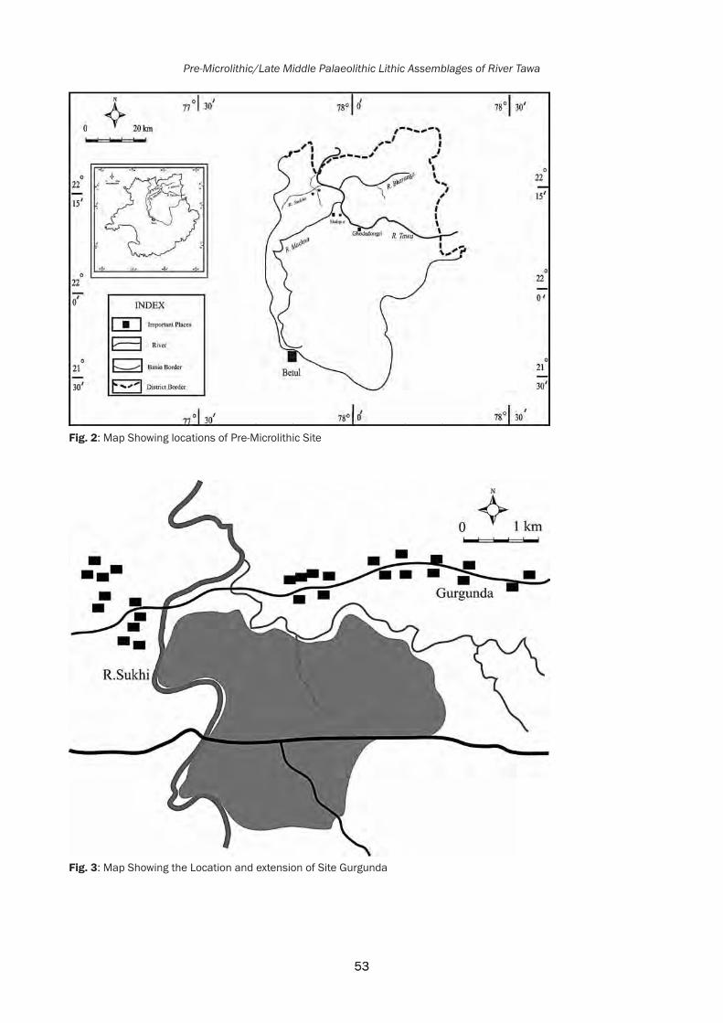
53
Pre-Microlithic/Late Middle Palaeolithic Lithic Assemblages of River Tawa
53
Fig. 2: Map Showing locations of Pre-Microlithic Site
Fig. 3: Map Showing the Location and extension of Site Gurgunda

54
Rethinking the Past: A Tribute to Professor V.N. Misra
54
artefact context, and modern disturbance, if any. Artefacts were subject to random sampling and collection of artefacts. Typo-technological analysis of the lithic assemblages was undertaken to understand the antiquity of these prehistoric sites.
ThesitesandsitecontextThe distribution of sites explored in the region is illustrated in Fig. 2. Sites were named after the nearest village. As mentioned earlier, there are three such sites where both Pre-microlithic and Microlithic artefacts have been found viz. Gurgunda, Tekripura, and Silpatti. All these sites are located in the Barakar formation. Artefacts of both types (Microlithic and Pre-microlithic) are found in different contexts. The Pre-microlithic artefacts are found in context to pebbly-cobbly yellowish brown gravel which is capped by yellowish brown sediment separating it from the younger unit. The Microlithic artefacts were found in context to pebbly sandy gravel which was capped by yellowish brown silty sediment. These two artefact bearing layers are separated by yellowish brown sediment.
Gurgunda (22˚16.301' N and 77˚ 53.428' E):The locality is 1.5 km from the railway station at Dhodramohar on the Betul Highway No. 69. This locality is situated on the left bank of River Sukhi, a seasonal nala of River Tawa. The spread of the locality is approximately 1sq.km. A total of 63 artefacts were collected from rain gullies and soil quarry areas.
At Gurgunda, the context of the Pre-microlithic artefacts is cobbly-pebbly capped by yellowish brown, while the Microlithic artefacts were found in the context of pebbly gravel. The thickness of the exposed section is 4.20 m which is cut by a seasonal nala Sukhi joining the Tawa (Fig. 3). The exposed section comprised mainly of colluvial deposit. The lower part of this section is made up of angular cobbly- pebbly size gravel of chert and chalcedony.
The lower litho unit mainly comprises altenate layering of cobbly-pebbly gravels and pebbly gravel lenses (Fig. 4). The bottom of the exposed section is a layer (30 cm thick) of boulder size sandstone and quartz mixed
with angular cobble size chert and chalcedony gravel. This layer is capped by 40 cm of yellowish silt. A lense cross-bedded fine sandy gravel (20 cm thick) overlies the yellow silt and is in turn capped by cobbly-pebbly gravel (70 cm thickness). A small lense of 20 cm thick is observed on top of the cobbly gravel.
This lower unit of ~2 m in thicknessis sepereted by a 50 to 60 cm thick dark brown compact silty layer. The upper unit of 2 m thickness is similar to the lower unit except for the cross-bedded fine gravel which is absent in the upper unit. The top surface is comprised of half a meter yellow silt.
Tekripura (22˚15.601' N and 77˚52.793' E):The locality is off highway no 69 (Itarsi-Betul Highway), a kilometre away from Bhawra village, on the bank of River Sukhi a tributary of the River Tawa. The expanse of the locality is approximately 2 sq.km. Some part of the locality is under cultivation while the rest forms part of a government wood depot. A large part of the site is naturally exposed in Tekripura due to weathering by the shallow bedrock channel.
At Tekripura the context of the Pre-microlithic artefacts is similar to that of Gurgunda i.e. yellowish brown pebbly-cobbly gravel and the Microlithic artefacts were found
Fig. 4: Stratigraphy Showing Various Sedimentary Units at Gurgunda

55
Pre-Microlithic/Late Middle Palaeolithic Lithic Assemblages of River Tawa
55
in pebbly gravel. The thickness of the exposed section cut by rain gullies is 2 m. The exposed section comprised mainly of alluvio-colluvial deposits. At certain places, the bedrock is exposed and is at a higher elevation (Fig. 5).
The composite section (Fig. 6) based on observations of few exposed sections around the site show that the bedrock topography is uneven. The sandstone bedrock is disconformably capped by cobbly-pebbly gravel of ~1 m in thickness yielding Pre-microlithic artefacts. This layer is capped by 1 m thick layer of yellowish brown silt which separates the Pre-microlithic-bearing gravel from that of the Microlithic-bearing gravel. The yellowish brown silty layer is overlain by 60 cm thick sandy-pebbly gravel. The top surface of the section is covered by yellowish brown silt of varied thicknesses (20 to 50 cm) (Fig. 6).
Fig. 5: Map Showing the Location and extension of the Site Tekripur
Fig. 6: Stratigraphy Showing Various Sedimentary Units at Tekripura

56
Rethinking the Past: A Tribute to Professor V.N. Misra
56
Silpatti (22˚ 12.598' N and 77˚ 57.202' E):The site is approximately 14 km away from the present village of Shahpur. This locality is on the left bank of river Tawa. The spread of the locality is approximately 2 sq.km. The biggest deposition in the study area, about 10 m in height, was observed as Silpatti, which is exposed as a result of recent sand quarrying activities.
At Silpatti the context of the Pre-microlithic artefacts is cobbly gravel and the Microlithic artefacts were found in the context of pebbly gravel capped by yellowish brown silt. The thickness of the exposed section is 10 m which is cut by a seasonal nala joining the Tawa (Fig. 7). The exposed section comprised mainly of alluvio-colluvial deposit (Fig. 8).
The lower litho unit is dominated by an alluvium deposition comprising of pebbly gravel
Fig. 7: Map Showing the Location and extension of the Site Silpatti
and cross bedded fine sandy gravel. The upper litho unit is mainly comprised of a colluvial deposition with alternate layering of differently sized gravel and yellow silt.
The bottom of the exposed section is a layer (25 cm thick) of boulder size sandstone and quartzite mixed with angular cobble size chert and chalcedony gravel. This layer is covered by a 20 cm thick cobble cemented calcreted gravel. A 60 cm thick yellowish sandy silt caps the cobble cemented calcreted gravel. A lense of cross-bedded fine sandy gravel (90 cm thick) overlies the yellow silt and is in turn capped by horizontally bedded fine gravel (90 cm thick). The horizontally bedded fine gravel is overlaid by a 50 cm thick deposit of pebbly gravel which is capped by a 500 cm thick yellow silt. A small 25 cm lense of fine gravel is observed on top of the yellow silt which is again

57
Pre-Microlithic/Late Middle Palaeolithic Lithic Assemblages of River Tawa
57
covered by a 1 m thick yellow silt deposit. The yellow silt is covered by two ensuing layers of sandy gravel (20 cm thick), and dark reddish brown clay (20 cm).
The artefacts of Pre-microlithic tradition were found at a depth of 975 cm from surface in a cemented cobbly-pebbly gravel layer which immediately overlies the bed rock (Fig. 8).
StratigraphyThe sandstone bedrock is disconformably capped by the moderately cemented cobbly-pebbly gravel (as observed at the sites at Silpatti and Tekripur). This gravel has also yielded the Late Middle Palaeolithic artefacts. However, at Gurgunda this artefact-bearing cobbly-gravel does not rest immediately bedrock, but overlies the gravel and yellowish silt which are devoid of artefacts. It is clear from this section that there is a lithological unit deposited before the arrival of Late Middle Palaeolithic hominines in the study area, indicating that the river Tawa was in aggradational mode during this period.
As mentioned earlier, the Middle Tawa basin is on a structural plain, surrounded by a
denudational plateau, denudational hills, and middle and low level structural plateaus. In this zone all the rivers are flowing on a steep gradient on sand stone bed rock which has created a fan type deposition.
The alternative layers of alluvial fan deposits and fluvial deposits suggest probable climatic change in the past. However, at present it is not possible to comment on this aspect. The fluvial deposits of the study area are characterized by cross-bedded pebbly gravel which yields microliths. The microlithic-bearing pebbly gravel caps the compact yellowish silt which is ubiquitous in nature.
At Silpatti, local variation in the form of cross-bedded gravel has been observed, where the microlithic-bearing pebbly gravel is capped by alternating layers of fine sandy gravel, yellow silt, sandy gravel with the top surface comprising dark brown clay.
The composite stratigraphy (Fig. 9) represents two types of depositional facies in Tawa basin i.e. the alluvial fan facies and fluvial deposits. Such types of deposits are common in continental environments (Gore 2014).
Fig. 8: Stratigraphy Showing Various Sedimentary Units at Silpatti
Fig. 9: Composite Stratigraphy of Middle Tawa Basin
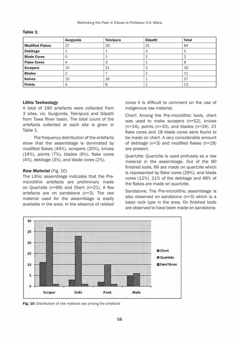
58
Rethinking the Past: A Tribute to Professor V.N. Misra
58
Lithic TechnologyA total of 190 artefacts were collected from 3 sites, viz. Gurgunda, Tekripura and Silpatti from Tawa River basin. The total count of the artefacts collected at each site is given in Table 1.
The frequency distribution of the artefacts show that the assemblage is dominated by modified flakes (44%), scrapers (20%), knives (14%), points (7%), blades (6%), flake cores (4%), debitage (3%), and blade cores (2%).
Raw Material (Fig. 10)The Lithic assemblage indicates that the Pre-microlithic artefacts are preliminary made on Quartzite (n=66) and Chert (n=21). A few artefacts are on sandstone (n=3). The raw material used for the assemblage is easily available in the area. In the absence of related
cores it is difficult to comment on the use of indigenous raw material.Chert: Among the Pre-microlithic tools, chert was used to make scrapers (n=52), knives (n=14), points (n=10), and blades (n=24). 21 flake cores and 18 blade cores were found to be made on chert. A very considerable amount of debitage (n=3) and modified flakes (n=18) are present.Quartzite: Quartzite is used profusely as a raw material in the assemblage. Out of the 90 finished tools, 66 are made on quartzite which is represented by flake cores (29%), and blade cores (12%). 11% of the debitage and 48% of the flakes are made on quartzite.Sandstone: The Pre-microlithic assemblage is also observed on sandstone (n=3) which is a basic rock type in the area. On finished tools are observed to have been made on sandstone.
Table 1:
Gurgunda Tekripura Silpatti TotalModifiedFlakes 27 26 31 84Debitage 1 1 3 5Blade Cores 0 1 2 3Flake Cores 4 3 1 8Scrapers 15 21 3 39Blades 2 7 2 11Knives 10 16 1 27Points 4 8 1 13
Fig.10: Distribution of raw material use among the artefacts

59
Pre-Microlithic/Late Middle Palaeolithic Lithic Assemblages of River Tawa
59
Core and Flake Technology (Figs. 11, 12 and 13)In the present assemblage, a large number (n=51) of cortical flakes are present, indicating that the initial trimming was done in the same area. On the other hand, 49 non-cortical flakes present are not represented by any type of core in the area.
The cores of the Pre-microlithic assemblage are represented by two types, flake core (n=17) and blade core (n=5). The cores are less than the flakes found in the area. The flake cores, with a maximum of 3 flakes scars have 45% to 65% of the cortex on them. These have multidirectional striking platform. Flake cores
are made on chert (n=2), quartzite (n=11), and sandstone (n=1). The flakes which would have been removed from these cores must have the cortex preserved.
The blade cores in the Pre-microlithic assemblage are represented by cores with single directional striking platform. The raw material used is chert (n=1) and quartzite (n=4).
It seems that the flake cores found in the area were discarded after initial use, and are therefore not useful to understand the reduction procedure. Cores of the Pre-microlithic phase do not represent the corresponding types of tool technologies found in the assemblage.
Fig. 11: Model of the Reduction Strategy of Pre-microlithic Artifacts

60
Rethinking the Past: A Tribute to Professor V.N. Misra
60
There are three types of flakes in the present assemblage: flakes removed from cores with bi-directional striking platform; flakes removed from cores with multidirectional striking platform; and flakes removed from blade cores. These flakes represent both hard and soft hammer techniques. Hard hammer technique was used to remove flakes from cores, and soft hammer was used for controlled retouches. The artefacts recovered so far show that they are made by using direct percussion method.
It is noticed that the flake obtained from the cores with multidirectional striking platforms have cortex. The flakes removed from cores with a bi-directional striking platform were basically of non-cortical and laminar type. This indicates preferences and predetermination of flakes for different tools. Hence it can be stated that the Pre-microlithic users in the area used a very controlled flaking system though there is ample availability of raw material in the area.
The most interesting feature of this assemblage is the flakes of blade technology. Unlike the microlithic blades, these are larger, broader, thicker, and quite crude in nature. The scars on the dorsal surface are also broader and deeper in comparison to Microliths thus suggesting the application of hard hammer. An irregularity is also noted in the shape of these flakes which is generally caused by hinge and step terminations.
It is significant to note that near the perennial source of water in the area i.e. near River Tawa and near the seasonal River Sukhi, blades dominate the assemblage.
The tools of the present assemblage represent prepared core technique and mostly laminar pattern of flaking. The laminar type of core from which scrapers and points were obtained is absent in the assemblage. The cortical knives in the area are mostly made by direct removal of a flake from the core having 20% to 80% cortex.
Tools (Figs. 14, 15, 16)There are four types of Pre-microlithic tools found in the area consisting of scrapers (n=39), knives (n=27), points (n=13), and
Fig. 12: Pre-microlithic Cores of Middle Tawa Basin: a) and b) Flake Cores; c) Blade Core
Fig. 13: Pre-microlithic Cores of Middle Tawa Basin: a) Blade Core; b) Flake Core

61
Pre-Microlithic/Late Middle Palaeolithic Lithic Assemblages of River Tawa
61
blades (n=11). The Pre-microlithic assemblage comprising 90 tools is dominated by scrapers 43% (n=39), followed by knives 30% (n=27), points 15% (n=13), and blades 12% (n=11). A detailed study of these tools is given below:Scrapers: (n=39) There are three types of scrapers present in the assemblage: a) Single sided scrapers (n=11) have two convex edges in which one lateral edge will be retouched. b) Double sided scraper (n=9) are those with two convex edges retouched on both the lateral edges. c) Discoidal scrapers (n=7) have retouches on all the edges which gives
it a round appearance. The dorsal face of a discoidal will always have a thick projection with a number of flake scars sometimes resembling a core.Knives: (n=27) Knives look very similar to a side scraper but the retouched edges of knives have a straight profile. The other lateral edge is thick and backed. This backing can be of two types, natural backing and intentional backing. With natural backed knives, one of the margins is cortical whereas with intentional backed knives, an intentional flake is removed in one of the margins. In the area, naturally backed
Fig. 14: Pre-microlithic Artifacts of Middle Tawa Basin: a) and b) Points; c), d) and e) Knives; f) Blade

62
Rethinking the Past: A Tribute to Professor V.N. Misra
62
knives (n=58) are dominant over intentionally backed knives (n=42).Points: (n=13) A flake with two marginal edges retouched and joining each other in a point forming an acute angle is called here a point. Only 4 points were noticed having 5% to 10% of the cortex near the striking platform.Blades: (n=11) A flake with two, almost parallel edges with retouching on either single or both marginal edges is a blade. A blade always has one or two parallel to semi parallel ridges on the dorsal phase.
The dimensions of the Pre-microlithic tools of the area don’t show much variation. Scrapers are 40×38.7 mm to 67.1×62 mm; knives range from 46×2.4 mm to 115.2×58.97 mm; points are 46.66×27.3 mm to 70.9×35.2 mm; blades range from 39.29×12.2 mm to 68.4×21.1 mm. The most variation in terms of size is seen in the knives of the assemblage. The size of the knives from the site of Tekripura is larger than the knives of Gurgunda or Silpatti. It has also been noticed that the thickness of the knives from Silpatti are more than its breadth.
The Pre-microlithic phase in the area is dominated by scrapers; the assemblage also contains knives, points, and blades.
Among the 3 Pre-microlithic sites, 2 (Tekripura and Gurgunda) are situated on the bank of a seasonal River Sukhi, a tributary of the Tawa. Silpatti is the only site situated near the banks of River Tawa on one of its nallas. At Tekripura and Gurgunda scrapers dominate the assemblage, followed by knives, points, and blades respectively. However, the assemblage from Silpatti shows blades are found in good number forming the 2nd largest type.
DiscussionIt is significant to note that near perennial source of water, blades are dominating. The tools of the present assemblage represent a prepared core technique and mostly laminar patterns of flaking. The laminar type of core from which scrapers and points were obtained is absent in the assemblage. The cortical knives in the area are mostly struck by direct removal
Fig. 15: Pre-microlithic Artifacts of Middle Tawa Basin: a) Knife b) Points
Fig. 16: Pre-microlithic Artifacts of Middle Tawa Basin: a) Discoid Scraper; b) and c) Single Sided Scrapers; d) Double Sided Scraper

63
Pre-Microlithic/Late Middle Palaeolithic Lithic Assemblages of River Tawa
63
of a flake from the core having 20% to 80% of the cortex.
The characteristics of the present assemblage i.e. the tool types, tool technology, the raw material used, blank type and cores are on par with the Middle Palaeolithic of India (Sankalia 1974, Paddayya 1984, Sali 1989, Pal 2001, Pappu 2001; Pappu et al. 2004; Clarkson et al. 2009, Haslam et al. 2010, Padhan 2013).
If regional variation is exempted there is a typo-technological similarity of these artefacts with many sites, for example the site of Kovalli (Yogesh et al. 2012) and Kuntasi (Rajaguru et al. 2014).
The assemblage of Tawa basin is characterized by the presence of different types of scrapers, NBK (Naturally backed knives), backed knives, borers, points and blades. All these are present at Kovalli and Kuntasi as well. This assemblage is a product of the laminar technology but in most of the tools the presence of cortex are also been noticed especially for NBK’s, borers, and points. The cortex here is mainly used for backing purposes. For other tools, viz. scraper backed knives, and some borers and points, backing is noticed at similar positions.
The Upper Palaeolithic artefacts noticed in the area prefer siliceous stones like chalcedony and chert (Sengupta 2015), while the assemblage from Tawa is mostly on chert and quartzite that are harder materials. Similar to the Tawa basin assemblage, it has been noted that sites like Kovalli and Kuntasi also prefer chert and quartzite, though at Kovalli, the use of sandstone is also very prominent.
Utilization of enormous cores and flake on pebbles are also noticed in Tawa basin as similar to the Middle Palaeolithic phase of the Kortallayar basin (Pappu 2001).
Thus, according to the observations of the assemblage of Tawa basin it is suggested that this assemblage is a transitional phase between Middle and Upper Palaeolithic industries. This is indicated through the presence of flake technology (Middle Palaeolithic) and blade
technology (Upper Palaeolithic) as well as raw material preference. A comparison with artefacts from other sites also suggests the same. Thus, drawing from claims made by Yogesh et al. (2012) and Rajaguru et al. (2014) regarding similar assemblages from sites like Kovalli and Kuntasi respectively, the presence of these assemblages can affirm an advanced Middle Palaeolithic.
In the Indian subcontinent, flake-based artefacts generally characterize the Middle Palaeolithic (Jayaswal 1978, Paddayya 1984, Yogesh et al. 2012), and blades are typical characteristics of the Upper Palaeolithic phase (Sali 1989). The presence of both these characteristic features in the present assemblage indicates that the assemblage is a transition period from Middle to Upper Palaeolithic. In the present assemblage, the presence of knives and points, which are typical features of the Middle Palaeolithic phase, along with blades represent the third or ‘late Middle Palaeolithic’ phase of Pal’s (2001) classification.
AcknowledgementsThe first author would like to acknowledge the Indian Council for Historical Research (ICHR), New Delhi for the financial support. We are thankful to the authorities of the Deccan College, Pune for providing necessary facilities.
ReferencesBlinkhorn, J., H. Achyuthan, M. Petraglia and
P. Ditchfield 2013. Middle Palaeolithic Occupation in the Thar Desert during the Upper Pleistocene: The signature of a modern human exit of Africa? Quaternary Science Reviews 30, https://doi.org/10.1016/j.quascirev.2013.06.012.
Chauhan, P.R. 2009. The South Asian Palaeolithic Record and its Potential for Transitions Studies, in Sourcebook of Palaeolithic Transitions: Methods, Theories and Interpretations, M. Camps and P. Chauhan (Eds.) Springer New York, Dordrecht Heidelberg London.
Clark, J.D and M.A.J. Williams 1990. Prehistoric ecology, resource strategies, and culture change in the Son Valley, northern

64
Rethinking the Past: A Tribute to Professor V.N. Misra
64
Madhya Pradesh, Central India. Man and Environment 15(1): 13-24.
Clarkson, Chris, Michael Petraglia, Ravi Korisettar, Michael Haslam, Nicole Boivin, Alison Crowther, Peter Ditchfield, Dorian Fuller, Miracle Preston and Clair Harris 2009. The oldest and longest enduring microlithic sequence in India: 35,000 years of modern human occupation and change at the Jwalapuram Locality 9 rock shelter, Antiquity 83(320): 326-348.
Haslam, Michael, Chris Clarkson, Michael Petraglia, Ravi Korisettar, Sacha Jones, Ceri Shipton, Peter Ditchfield and H. Stanley Ambrose 2010. The 74 ka Toba super-eruption and southern Indian hominins: archaeology, lithic technology and environments at Jwalapuram Locality 3, Journal of Archaeological Science 37: 3370-3384.
Horton. R.E. 1945. Erosional Development of Streams and Their Drainage Basins; Hydrophysical Approach to Quantitative Morphology. Bulletin of the Geological Society of America Vol: 56.
James, H.V.A. and M.D Petraglia 2005. Modern human origins and the evolution of behavior in the later Pleistocene record of South Asia. Current Anthropology 46: S3-S27.
Jayaswal, V. 1978. Palaeohistory of India: A study of the prepared core technique. Delhi: Agam Kala Prakashan.
Madhya Pradesh district Gazetteers, Betul, 1971.Misra, V.N. 1967. Pre- and Proto-history of the
Berach Basin (South Rajasthan), Poona: Deccan College Postgraduate and Research Institute.
Misra, V.N. 1968. Middle Stone Age in Rajasthan, in La préhistoire: Problémes et tendances, F. Bordes and D. de Sonneville Bordes (Eds.), pp. 295-305. Paris: Centre National de la Recherche Scientifique.
Misra. V.N. 1982, Evolution of the Element in the Stone Industries of Rockshelter-III, F-23, Bhimbetka in Indian Archaeology, in R.K. Sharma (Ed.) pp. 7-13, Delhi: Kala Prakashan.
Misra, V.N., 1985, The Acheulian succession at Bhimbetka, in Recent Advances in Indo-Pacific Prehistory, V.N. Misra and P. Bellwood (Eds.), pp. 35-47. Oxford & IBH Publishing Co., Delhi.
Paddayya, K. 1984. India, in Neue Forschungen Zur-Altsteinzeit, O. Bar-Yosef (Ed.), pp. 345-403. Munchen: Verlag C.H. Beck.
Padhan, T. 2013. Prehistoric Archaeology of the Jonk River in Odisha and Chhattisgarh, Unpublished Ph.D. Dissertation, Pune: Deccan College, Post-Graduate & Research Institute.
Pal, J.N. 2001. The Middle Palaeolithic Cultures of South Asia, in Restrospect Vol. I Prehistory Archaeology of South Asia, S. Settar and Ravi Korisettar (Eds). New Delhi, Indian Manohar in Association with Indian Council of Historical Research.
Pant, P.C. 1982. Prehistoric Uttar Pradesh (A study of Old Stone Age). Delhi: Agam Kala Prakashan.
Pappu, S. 2001. A Re-examination of the Palaeolithic Archaeological Record of Northern Tamil Nadu, South India. Oxford: BAR international series.
Pappu, S., Y. Gunnell, M. Taieb and A. Kumar 2004. Preliminary report on excavations at the Palaeolithic site of Attirampakkam, Tamil Nadu (1999-2004), Man and Environment 29(2): 1-17.
Petraglia, M.D., R. Korisettar, and J. Schuldenrein 2003. Landscapes, Activity, and the Acheulean to Middle Palaeolithic Transition in the Kaladgi Basin, India. Journal of Eurasian Prehistory 1(2): 3-24.
Rajaguru, S.N., S.G. Deo and S. Ghate 2014. Late Quaternary Geoarchaeological Studies of Coastal Site Kuntasi, Gujarat. Journal of Indian Ocean Archaeology No. 10.
Sankalia, H.D. 1974. Prehistory and Protohistoric In India and Pakistan. Poona: Deccan College.
Sali, S.A. 1989. The Upper Palaeolithic and Mesolithic Cultures of Maharashtra. Pune: Deccan College.
Sengupta, S. 2015. Geoarchaeology of Tawa Basin: District Betul, Madhya Pradesh. Unpublished Ph.D. Dissertation, Pune: Deccan College Post-Graduate and Research Institute.
Sharma, G.R., and J.D. Clark (Eds.) 1983. Paleoenvironments and Prehistory of the Middle Son Valley. Abinash Prakashan, Allahabad.
Yogesh, M., Sushama G. Deo and Sony Mathews 2012. The Lithic Assemblage from the Kovalli Site, Ghataprabha Basin, Karnataka. Purattatva 42: 74-82.

Chauhan et al. 2017, in Rethinking the Past: A Tribute to Professor V.N. Misra(S.G. Deo, Andre Baptista and Jayendra Joglekar Eds.), pp. 65-80, Pune. ISPQS: www.manandenvironment.orgISBN: 978-81-908330-6-6
IntroductionThe Indian Subcontinent is an important zone to understand the dispersals and evolution of modern humans in Asia (e.g. James and Petraglia 2005; Mellars 2006; Dennell and Petraglia 2012; Chauhan et al. 2015a). Recent work suggests that it may have been a viable corridor for multiple dispersals of modern humans with different technologies in different ecological contexts (e.g. Petraglia et al. 2007; Mishra et al. 2013). The current archaeological and genetic evidence provisionally suggests modern human arrival into South Asia prior to Europe. Despite the recent discoveries outside Africa in relation to these dispersals, many questions still remain for the South Asian evidence. The most significant issue confronting palaeoanthropologists is that the archaeological, genetic, and fossil datasets from this region, as currently known, are not congruent (see Chauhan et al. 2015a). Due to the lack of human fossil evidence older than ~40 Ka, archaeologists have been primarily divided on the timing of the initial arrival of modern humans based on lithic technology and
related symbolic behavior: Middle Palaeolithic prior to 74 Ka vs. microlithic at ~60 Ka. While it is not clear if modern humans are responsible for any of the Indian Middle Palaeolithic assemblages, all of the microlithic evidence has been attributed to them with general consensus.
The microlithic evidence is found throughout the Indian Subcontinent except for the Himalayan zone and parts of north-eastern India, and ranges from ~48 Ka to recent times (e.g. Mishra et al. 2013; Roy 2008). While the older microlithic assemblages overlap considerably with the Upper Palaeolithic phase, the younger assemblages have been generally used to identify the Mesolithic phase. Traditionally, they have been typologically divided into non-geometric and geometric shapes and the lithics are often found in spatial association with rock art sites, and in both rock shelter and open-air sites (Misra 2001). Microliths are known to be found in diverse ecozones including sand dunes, fluvial contexts, lake contexts, forested zones
AT THE FOREST EDGE: GENERAL OBSERVATIONS ON NEW MICROLITHIC OCCURRENCES IN THE CENTRAL NARMADA BASIN, MADHYA PRADESH
P.R. Chauhan1, K. Krishnan2, N. Tiwari1, A. Mukherjee2, A. Anoop3, D.A. Sant4, R. Patnaik5
1 Department of Humanities and Social Sciences, Indian Institute of Science Education and Research (Mohali, Punjab)
2 Department of Ancient History and Archaeology, The Maharaja Sayajirao University of Baroda (Vadodara, Gujarat)
3 Department of Earth and Environmental Sciences, Indian Institute of Science Education and Research (Mohali, Punjab)
4 Department of Geology, The Maharaja Sayajirao University of Baroda (Vadodara, Gujarat)5 Department of Geology, Panjab University (Chandigarh)
Abstract
This paper presents general descriptive and contextual information on newly discovered microlithic scatters in the Sehore and Hoshangabad districts in the central Narmada Basin, Madhya Pradesh. The discussed sites or site complexes include Pilikarar, Budni, Naganpur, Khusmeli Dam, Digamber and Chikli along the northern part of the basin (Vindhyan Hills), Morpani and Fatehpur along the southern part of basin (Gondwana Hills), and Pachmarhi beyond the southern boundary of the basin. The occurrences vary in terms of their artifact densities, site sizes, assemblage compositions and geological contexts. Compared to the prehistoric occurrences in the Narmada floodplain zone, the foothill sites have greater contextual and spatial integrity. From a broad perspective, all the lithic assemblages appear to be broadly similar in terms of raw material exploitation, and sedimentary and geographic contexts. The surveys also resulted in the discovery of an ostrich eggshell fragment at Morpani which was subsequently dated to ~49 Ka, having multiple palaeoanthropological implications for the study area.

66
Rethinking the Past: A Tribute to Professor V.N. Misra
and grasslands. During their longevity, they have been associated with ostrich eggshells (OES), faunal remains, human burials, pottery fragments, megaliths and so forth. In this paper, we deliberately avoid the use of the term ‘Mesolithic’ to classify these sites and simply refer to our reported sites as microlithic (regardless of their presumed age).
This paper reports new microlithic occurrences from the central part of the Narmada Basin, from where well-known sites such as Adamgarh, Joshipur, and others have been long known (e.g. Joshi 1978; IAR, 1974-75; IAR, 1975-76; Mohapatra and Karir 1983; also see Chauhan et al. 2015b). Further to the west, the Narmada Valley has yielded the oldest microlithic evidence at Mehtakheri (Mishra et al. 2013), and the entire central Indian region
is well known for its abundant record of rock shelters, with new rock art sites still being discovered (e.g. Shaikh and Chauhan 2013); Bhimbetka and other related sites are also close to the Narmada Valley. The only known pre-modern fossil hominin evidence in South Asia also comes from the central Narmada Basin (see Athreya 2007) which is historically long known for its vertebrate fossil record. Most importantly, this area probably acted as an important dispersal corridor (see Field et al. 2006) and as a result, a cultural and biological crossroads for diverse hominin populations including modern humans for a large part of the Quaternary. Despite its richness, the Central Indian microlithic evidence is poorly understood when compared to other regions of the Indian Subcontinent (see Misra, 2001; Misra and
Fig. 1: Distribution of known and new microlithic sites as discussed in the text. 1.Saru Maru; 2. Bandarjari; 3. Pilikarar; 4. Joshipur;5. Mou Kalan; 6. Budni; 7. Talpura; 8. Adamgarh (and Hoshangabad town); 9. Naganpur; 10. Khusmeli Dam; 11. Digamber; 12. Chikli; 13. Gurla; 14. Morpani15. Fatehpur;16. Pachmarhi

67
At the Forest Edge: General Observations on New Microlithic Occurrences in the Central Narmada Basin
Pal 2002; Clarkson et al. 2009; Petraglia et al.2009), primarily owing to the lack of adequate excavations and associated absolute dates. Recent field surveys have revealed new evidence from previously unknown zones (e.g. Sengupta, 2015) and reflect the potential and significance of the entire central Indian region.
Quaternary sediments in the Narmada Basin have been classified into the following geological formations from oldest to youngest: Pilikarar, Dhansi, Surajkund, Baneta, Hirdepur, Bauras and Ramnagar (Tiwari and Bhai 1997). Closer to the Narmada channel, microliths have been found with sediments belonging to all of these formations except Pilikarar and Dhansi. Along the northern and southern hills, the lithics are often found directly on the exposed bedrock as well as with associated fine-grained sediments. The concerned study area is located between the Vindhyan Hills to the north and the Gondwana Hills to the south, with sites mostly distributed adjacent to these hill ranges (Fig. 1). Additional systematic surveys are in progress and should reveal many more such occurrences, especially in the forested zones. The exposed bedrock in the study area generally includes Vindhyan rocks, Gondwana rocks and at some locations, exposures of Deccan Trap, which also yields the quartz (in the form of veins and nodules) on which a large number of the assemblages are made.The weathered Deccan Trap is exposed at several locations in the northern part of the study area, including Khusmeli Dam and Neemtone. Additional geological features in the vicinity of or in association with the sites include regoliths, cobble/boulder fans, laterite exposures and ferricrete nodules. The discussed sites or site complexes include Pilikarar, Budni, Naganpur, Khusmeli Dam, Digamber, Chikli, Morpani, Fatehpur and Pachmarhi area. This work is a result of preliminary random surveys on the landscape to understand and document the most archaeologically potential zones as the first phase of a long-term project. Thus, all discussed interpretations should be viewed as being preliminary. One of the co-authors (N. Tiwari) is working on a landscape geoarchaeological approach for the microlithic evidence in this region including comprehensive systematic
surveys, test-pits at the richest stratified sites, and associated luminescence dating. SitecontextsanddistributionpatternsMost of the observations described below come from open-air surface scatters and two excavated test-pits, all in diverse sedimentary contexts. Only the richest and most prominent lithic occurrences are described and isolated finds and find-spots are not included here. Refits have not yet been attempted, however it is evident from the presence of cores, finished tools and debitage that many of the scatters are primary and semi-primary in nature. The plains may have had different type of vegetation in the past, presumably with areas of forests, grasslands, and shrubs. More palaeoecological studies are required in the region by combining known archaeological, faunal, pollen, sedimentary, and geochronological data (e.g. Patnaik et al. 2009; Mishra et al. 2013). It is also possible that the slopes of these hill ranges contained greater vegetation in the past due to more substantial soil deposits that may have eroded and washed away over time. There are no evidences of substantial tectonic events which may have altered the archaeological landscape drastically since microlithic occupation.
Most of the scatters are located at base of the hills and invariably associated with fine-grained sediments or on exposed bedrock outcrops. The fine-grained sediments vary in color from reddish brown, to orangish brown and reddish gray, and comprise sandy silt or silty sand. Although no clayey contexts were noted thus far for these assemblages, some of the associated sediments may be aeolian in nature given their homogenous lithology without any bedding, visible strata or other fluvial/colluvial features. At some locations they may represent a combination of low-energy fluvial processes (from nearby seasonal streams) as evinced by the presence of gastropod shells, surface wash/run-off and aeolian processes. Deposits of such type are generally fine grained and do not preserve rounded or angular clasts within the matrix except when immediately adjoining the bedrock. These reddish sediments also do not contain any calcrete or related materials

68
Rethinking the Past: A Tribute to Professor V.N. Misra
thus indicating the lack of proper soil formation. These deposits are usually found overlying bedrock and are not more than a metre in vertical thickness. The Morpani area in the southern part of the basin is the only known exception where between two and three metres of accumulation of such sediments has been observed. A provisional site-formation model is envisioned where such sediments accumulated and buried archaeological evidence (regardless of age and the depositional processes involved), and then erode away or get washed away on a regular cyclical basis, thus exposing the lithics. In other words, Middle Palaeolithic artefacts may have been eroding out of similar sediments at similar locations during the earliest microlithic occupations. This may explain why such older lithic types (i.e. Palaeolithic) are not visibly associated with such sediments today and why such sediments do not preserve any evidence of pedogenesis. Of course, such an interpretation will not apply automatically to all such occurrences and future surveys may eventually reveal exceptions with more intact deposits associated with older artefacts. Very few surface occurrences along the hills are associated with sheet/slope wash gravels.
The scatters are also found on the slopes of the lower hills as well as on the top of the hills where the landscape ranges from flat to gentle grading depending on the location. Almost all reported sites are in relative proximity to rock shelters, many of which contain paintings of variable ages. Occasional microlithic occurrences were also noted in the agricultural fields between the two ranges of hills or in vertical sections along the main Narmada channel, but these are not discussed as they are not rich, mostly represent fluvial contexts and are presumably in disturbed or secondary contexts. All of the microlithic assemblages have been produced predominantly on quartz, although chert, chalcedony, and fine-grained quartzite have also been exploited. The raw material sources are represented by gravels in the river/stream beds, terraces, vertical sections, eroded horizontal exposures, bedrock outcrops, and associated veins (i.e. quartz in Deccan Trap exposures). Almost all observed occurrences are exclusively microlithic in
nature although the general locations and nearby landscapes have been utilized by older populations. At some sites the microlithic and Palaeolithic assemblages are separated by a few metres, and other locations there is some spatial overlap of the respective clusters. There is one observed example where a microlithic site yielded a ‘recycled’ Palaeolithic artefact (near Khusmeli Dam), as evident from the fresh flake scars on the rolled/abraded palaeolith. However, this specimen could have also been ‘recycled’ during either the Palaeolithic phase and may not necessarily be contemporary with the microliths. In some instances, broken quartz specimens were difficult to distinguish between naturally fractured and human made, especially isolated amorphous cores, primary flakes, and debitage due to the physical properties of the rock (see Tallavaara et al. 2010; Driscoll et al. 2016).
Modern vegetation densities are partially affecting the currently visible distribution patterns of microlithic occurrences. Although the dry summer months (or prior to the monsoon) offer the best time for prospection and mapping, the dead/fallen leaves and branches on the forest floor often partially cover lithic scatters in many locations as well as by broken bedrock fragments (caused by colluvial action from the cliffs above and exfoliation). In any case, the observed scatters range in size from single isolated specimens to several hundred square metres. It is difficult to discuss or hypothesize about initial numbers of artifacts and site sizes prior to their disturbances and complete exposures/excavation. Some locations such as Fatehpur appear to preserve discrete knapping and/or activity events (1 to 4 square metres in average size), whereas other sites such as Naganpur and Mou Kalan appear to represent accumulations through prolonged occupation or activity (specimens spread across several hundred square metres). Indeed, sites such as Mou Kalan (IAR 1974-75; IAR 1975-76) and Joshipur complex preserve thousands of lithic specimens clearly indicating long-term activities in front of the rock shelters there. Unfortunately, the microlithic evidence from these sites (including Adamgarh and Bhimbetka) is gradually disappearing due to

69
At the Forest Edge: General Observations on New Microlithic Occurrences in the Central Narmada Basin
construction, agriculture, sediment quarrying, erosion, trampling, and informal collection by visitors (intentional and unintentional) (e.g. Venditti et al. 2016). Modern disturbances at some of the rock shelters include sediment quarrying and religious activities including soot marks on top of rock paintings. Many shelters exist in the form of large isolated erosional blocks of bedrock or large boulders fallen off from shelter overhangs at the top of the hills. No faunal fragments were noted at any of the open-air sites except for Chikli. More faunal fragments were noted in the nearby rock shelters (e.g. Joshipur, Mandikho etc.) than the open air sites. Likewise, the rock shelters preserved non-diagnostic pottery fragments, many of which seemed modern and of recent origin or Early Historical at the oldest.
Pilikarar occurrencesThe Pilikarar site is better known for its rich Acheulian occurrences (see Chauhan and Patnaik, in press) and also reported as preserving the oldest Quaternary formation in the central Narmada Basin (Tiwari and Bhai 1997). Subsequent surveys and research (Patnaik et al. 2009; Morthekai et al., in press)
have suggested that the oldest Quaternary deposits may actually be the Dhansi Formation instead, although proper dating is required from both sites to confirm this provisional interpretation. The same surveys have yielded microliths occurring in association with two different sedimentary contexts. One of them is on the surface of the pale brown silty sediments with calcrete which Tiwari and Bhai (1997) have identified as the Baneta Formation. These deposits are found about several hundred metres south of the Vindhyan Hills near the Kaliadoh Nala, the stream which may be responsible for their deposition. The other context here is the abundant reddish brown and orangish brown sediments at the base of the hills, and from which microliths are clearly eroding out.
BudnicomplexNear Budni town, we discovered microliths eroding out of orangish brown silty sand deposits and as a part of surface gravel/rubble deposits in the middle of a railway cul-de-sac located at the base of the Vindhyan foothills (Fig. 2). It is situated near the protected Talpura site which preserves a densely painted rock
Fig. 2: Budni: Left images shows association of lithics with surface gravels/rubble and the other two images show association of lithics with orangish brown sediments

70
Rethinking the Past: A Tribute to Professor V.N. Misra
shelter, rich surface scatters of microliths and two Buddhist stupas (Simte 2015). Over 50 specimens were collected from an area of 900 m2 and from different heights as this area is erosionally disturbed.
NaganpursitecomplexThe site of Naganpur was discovered recently and is situated a few hundred metres northwest from Naganpur village in the northern part of the basin. During the surveys along the foothills, we noticed trenches dug by the forest department for irrigation and tree-planting purposes (approximately 2 x 0.5 m in dimension and about 0.5 m in maximum depth). At least 30 such trenches were noted, and more than two thirds of them had exposed buried microliths in an area of about 2000 m2. Like Chikli, this site is also a small ‘amphitheatre’ and represents one of the richest and one of the best preserved microlithic sites in the study area. As at some other sites, the associated sediments comprise orangish brown fine sandy silt, possibly representing a gentle slope-wash possibly combined with aeolian processes.
This interpretation should be viewed as being provisional and needs to be confirmed through detailed sedimentological analyses. Deposition was fast enough to preserve a homogenous fine grained accumulation without any clastic material such as Vindhyan sandstone/quartzite clasts, wood fragments and so forth. To confirm the primary context of the eroding microliths, we placed a small test-pit (1 x 1 m) within a 2 x 2 metre gridded area in an undisturbed area relatively in the center of the vast site. We excavated to a depth of approximately 30 cm from which we recovered >70 microliths in differing orientations and continuously throughout the vertical section (Fig. 3). In other words, they were not stratified in different horizontal layers but occurred as one continuous unit within the sandy silt deposit and possibly representing long term habitation and/or knapping activities. In addition, we have yet to reach the bedrock which is about 30-40 cm further down; artifact densities should increase in future excavations. Future test-pits combined with OSL dating (one sample was collected and is being processed) and
Fig. 3: Naganpur: Bottom left shows the overview of the site facing south towards the plains/valley’ top left image shows the excavated test-pit with in situ microliths; right side images are close-ups of the artefacts embedded in the fine sediments

71
At the Forest Edge: General Observations on New Microlithic Occurrences in the Central Narmada Basin
systematic plotting of artefacts should reveal further details regarding site-formation, age, and site function.
This site was a preferred location for different prehistoric populations over time, as reflected by the large amount of thickly buried microliths, nearby rock paintings as well as numerable Palaeolithic artefacts on nearby bedrock surfaces. The rock paintings are located in a cluster of rock shelters on top of the Vindhyan hills about one km west of Naganpur. This area – the top of the hills – gently dips down northwards and also preserves extensive scatters of microliths on bedrock and in association with thin (<20 cm) deposits of reddish brown sandy silts, which may have formed through a combination of bedrock erosion and surface wash during the monsoons. Many of the Palaeolithic artefacts here (mostly typologically Acheulian) are weathered/abraded and very few specimens are in fresh condition. They are not associated with any sediments and are situated on top of outcrops of Vindhyan bedrock and associated rubble. In the survey area, we have noticed that the majority of the artefacts which are found in buried context have a different degree of weathering than the exposed ones. Over a period of 4 to 5 years of survey, we have noticed that a great majority of lithics lying on the surface are prone to different degrees of weathering.
Khusmeli Dam localitiesKhusmeli Dam is another site which is known for its abundant typologically Early Acheulian
assemblages (Patnaik et al. 2009). These Palaeolithic artefacts are visible only when the artificial lake within the dam becomes dry (Fig. 4), although peripheral areas may yield additional scatters outside the lake boundary in the future. Both the western and eastern sides of Khusmeli Dam preserve abundant microlithic scatters in the edges of the forests. Two of these scatters (Scatters 1 and 2) are exceptionally rich and located between Naganpur and Khusmeli Dam (Fig. 5) and the other two occurrences (Scatters 3 and 4) are located closer to the dam. Scatter 1 is represented by over 100 microliths spread across an area of about 150 m2 on Vindhyan bedrock without any sediment cover. Due to erosion, the lithics are situated on an uneven slope varying in relative height by almost 2 metres. Scatter 2 (over 50 microliths) is located about 100 m further north from Scatter 1 and is also situated on Vindhyan rocks. Scatter 3 is located directly north and at the edge of the dam’s lake, and where about two dozen microliths are associated with a reddish brown sandy deposit. Scatter 4 (over 25 lithics) is located at the northeast corner of the lake slightly within the forest edge. All of these specimen totals are provisional and bound to increase as more finds are expected following repeated visits. Current counts are limited due to surface visibility on the forest floors. Future collection strategies may have to include complete removal of all leaves and other dead vegetation/branches and loose bedrock fragments within a specifically gridded area in order to make comprehensive collections. For example, some specimens at these scatters (and others in the study area) were found underneath eroded blocks/chunks of Vindhyan rocks.
Digamber rock shelterThe Digamber rock shelter is situated in a unique geographic location – inside a gorge formed by an erosional gully several hundred metres long within the Vindhyan Hills. The area currently has two small shrines at the top of the Vindhyan Hills facing the Narmada Valley to the south, and a holy man maintains the Digamber temple within the gorge. At the end of the gorge is a permanent water source Fig. 4: Overview of Khusmeli Dam lake when dry

72
Rethinking the Past: A Tribute to Professor V.N. Misra
in the form of a deep pool (depth unknown) within the bedrock, fed by a seasonal monsoon waterfall. We observed that this pool contains water throughout the year including the dry summer months and explains why this area was chosen for occupation by prehistoric populations. The rock shelter preserves only a few faded paintings, but from the bedrock slope (~200 m2) in front of it, over 100 microliths were collected. Such examples suggest that open-air sites played significant roles during lithic production and utilization, and that rock shelters weren’t always preferred by prehistoric populations for long-term activities.
ChiklicomplexandassociatedrockartThe site of Chikli is geographically unique as it is slightly isolated and represents the easternmost site in the Sehore District portion of our study area. Here, the microliths occur in pale brown sediments with calcrete nodules, a context very similar to that seen at Pilikarar and Gurla. The entire site is part of a wide U-shaped ‘amphitheatre’ and lithics are widely distributed
instead of eroding out in discrete clusters (Fig. 6). Based on the nature of their distribution and context, it is clear that the microliths are eroding out of the silty sediments, which are exposed in an area of at least 1500 m2. This area also appears to preserve faunal material, though found to be fragmentary and in surface context. However, it is not clear if this specimen represents a modern tooth or an older sub-fossil that has eroded out recently. Just to the north of this open-air site are at least four rock shelters with paintings, the lowest one being about ten metres above the valley floor and the highest one being about 50 metres higher. All are situated in a east-west alignment and the paintings are currently being studied and will be reported elsewhere. Above one of the rock shelters, there is a small cave or erosional cavity (<20 m2) within the Vindhyan rocks, and where a few microliths were also noticed inside but without any sediment accumulation. Between the Vindhyan foothills and the microlith bearing fine-grained sediments, we also documented an abandoned laterite quarry (similar ones
Fig. 5: Overview of one of lithic scatters between Naganpur and Khusmeli Dam and close-ups of some of the artefacts

73
At the Forest Edge: General Observations on New Microlithic Occurrences in the Central Narmada Basin
also exist at Pilikarar) surrounded by surface scatters of ferricrete and boulder conglomerate fan deposits, all of which contained Acheulian artefacts in variable conditions.
Morpani region: microliths, rock art and OESThe Morpani site complex was also discovered recently and the area comprises Palaeolithic, microlithic, and rock art evidence inside a valley within the hills of the Gondwana Formation and adjacent to the Tawa Reservoir. Here, the microlithic evidence is stratified within dark reddish brown silty sand on the top of a gentle hillock a few hundred metres south of a steep escarpment of the Gondwanas. To confirm their buried context, we placed a 1m2 trench up to a depth of 47 cm or up to a gravel bed on the Gondwana bedrock. We recovered approximately 25 microliths from the upper 28 cm of the sedimentary unit. The loose gravel bed (predominantly cobble matrix) around the microlithic site, where exposed, contains abundant Palaeolithic artefacts and is stratigraphically and chronologically separate
from the microlithic occurrence. Richer microlithic occurrences, albeit surface scatters are located several hundred metres to the south and also include loose gravel deposits with a predominant pebble content. These loose pebbles originate from a pebble-rich unit cemented within a sandy matrix in the nearby eroding Gondwana rocks. In the vicinity of the village of Mandikho nearby, at the edge of the reservoir, several rock shelters with paintings were observed and are currently under study and will be reported elsewhere. These rock shelters variably preserve limited cultural deposits containing a mixture of microliths, faunal fragments and pottery fragments. All of these microlithic assemblages in the region, both in open air and rock shelter contexts, are being treated as broadly contemporary until absolute dates are available. Surveys in the region have also yielded individual microlithic specimens on the landscape (especially along the foothills) as well as older lithic evidence loosely resembling Middle Palaeolithic and Upper Palaeolithic typologies.
Fig. 6: Chikli: Top right images shows the ‘amphitheatre’ looking north towards the Vindhyan Hills; bottom right images shows the exposed laterite and boulder fan deposit following modern quarrying; left side images shows one of the rock shelters with paintings
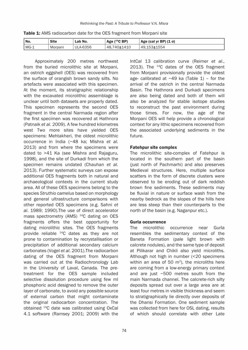
74
Rethinking the Past: A Tribute to Professor V.N. Misra
Approximately 200 metres northwest from the buried microlithic site at Morpani, an ostrich eggshell (OES) was recovered from the surface of orangish brown sandy silts. No artefacts were associated with this specimen. At the moment, its stratigraphic relationship with the excavated microlithic assemblage is unclear until both datasets are properly dated. This specimen represents the second OES fragment in the central Narmada region after the first specimen was recovered at Hathnora (Patnaik et al. 2009). A few hundred kilometres west Two more sites have yielded OES specimens: Mehtakheri, the oldest microlithic occurrence in India (~48 ka; Mishra et al. 2013) and from where the specimens were dated to >41 Ka (see Mishra and Rajaguru, 1998), and the site of Durkadi from which the specimen remains undated (Chauhan et al. 2013). Further systematic surveys can expose additional OES fragments both in natural and archaeological contexts in the current study area. All of these OES specimens belong to the species Struthio camelus based on morphology and general ultrastructure comparisons with other reported OES specimens (e.g. Sahni et al. 1989; 1990).The use of direct accelerator mass spectrometry (AMS) 14C dating on OES fragments offers the best opportunity for dating microlithic sites. The OES fragments provide reliable 14C dates as they are not prone to contamination by recrystallisation or precipitation of additional secondary calcium carbonates (Vogel et al. 2001).The radiocarbon dating of the OES fragment from Morpani was carried out at the Radiochronology Lab in the University of Laval, Canada. The pre-treatment for the OES sample included selective dissolution procedure using few ml phosphoric acid designed to remove the outer layer of carbonate, to avoid any possible source of external carbon that might contaminate the original radiocarbon concentration. The obtained 14C date was calibrated using OxCal 4.1 software (Ramsey 2001; 2009) with the
IntCal 13 calibration curve (Reimer et al., 2013). The 14C dates of the OES fragment from Morpani provisionally provide the oldest age- calibrated at ~49 ka (Table 1) – for the arrival of the ostrich in the central Narmada Basin. The Hathnora and Durkadi specimens are also being dated and both of them will also be analyzed for stable isotope studies to reconstruct the past environment during those times. For now, the age of the Morpani OES will help provide a chronological context for any lithic specimens recovered from the associated underlying sediments in the future.
FatehpursitecomplexThe microlithic site-complex of Fatehpur is located in the southern part of the basin (just north of Pachmarhi) and also preserves Medieval structures. Here, multiple surface scatters in the form of discrete clusters were observed to be eroding out of dark reddish brown fine sediments. These sediments may be fluvial in nature or surface wash from the nearby bedrock as the slopes of the hills here are less steep than their counterparts to the north of the basin (e.g. Naganpur etc.).
Gurla occurrenceThe microlithic occurrence near Gurla resembles the sedimentary context of the Baneta Formation (pale light brown with calcrete nodules), and the same type of deposit at Pilikarar and Chikli also yield microliths. Although not high in number (<20 specimens within an area of 50 m2), the microliths here are coming from a low-energy primary context and are just ~500 metres south from the main Narmada channel. The calcrete-rich silty deposits spread out over a large area are at least four metres in visible thickness and seem to stratigraphically lie directly over deposits of the Dhansi Formation. One sediment sample was collected from here for OSL dating, results of which should correlate with other Late
Table 1: AMS radiocarbon date for the OES fragment from Morpani site
No. Site Lab No. Age (14C BP) Age(calyrBP)(1σ)MG-1 Morpani ULA-6356 48,740±1410 49,153±1554

At the Forest Edge: General Observations on New Microlithic Occurrences in the Central Narmada Basin Quaternary palaeoanthropological sites in the region.
The Pachmarhi complex The Pachmarhi region is historically well known for yielding numerous rock shelters with diverse paintings, many depicted in a regional style (see Sharma and Misra 2003).We surveyed the foothills in the extreme southeastern part of Hoshangabad District in order to recover evidence of post-Acheulian occupation. Our efforts resulted in the discovery of at least five different localities, mostly clustered close to each other and occurring in agricultural plough zones as well as in natural fields at the foot of the hills (near Singanama village) (Fig. 7). Most of them were exposed through surface erosion of the associated sediments as well as seasonal stream activity which had dissected the landscape into gullies. The highest diversity of exploited raw materials was visible in this area compared to the rest of the study area where quartz dominates. The Pachmarhi assemblages were made on quartz, chert, and chalcedony and most interestingly,
many of the specimens typologically resemble Upper Palaeolithic technology. In other words, some localities yielded only microliths while others yielded large blades and bladish flakes (i.e. laminar technology) (Fig. 8). The scatters ranged greatly in size from 1 m2 to 100 m2 and the artefact densities varied from 5 to over 40 specimens. Most of these assemblages are eroding out of orangish brown and reddish brown sediments varying from silty sand to sandy silt. Future fieldwork will involve placing test pits at the richest scatters and also collecting sediment samples for OSL dating. Discussion and conclusions The general description and locational information of the microlithic sites above suggests intensive mobility within the central Narmada Valley. Based on general clustering patterns, it seems that smaller scatters were probably ‘satellite sites’ behaviorally and spatially linked with the more rich and dense occurrences (e.g. Naganpur as the main site and the Khusmeli Dam occurrences as its satellite sites). The best contextual integrity
Fig. 7: Pachmarhi area: Top images show an overview of one of the microlithic localities; bottom images shows an erosional gully in another locality and the artefacts which eroded out of it
75

Rethinking the Past: A Tribute to Professor V.N. Misra
Fig. 8: Pachmarhi area: Close-ups of artefacts documented and recovered including a microblade core, amorphous core fragment, flakes, blades/bladish flakes and debitage
appears to be preserved at the foothills north and south of the basin, rather than the vast floodplain deposits. This is probably due to the continuous fluvial processes taking place in the valley where regular cut-and-fill deposits get accumulated on a seasonal level. At the foothills, there is a clear geomorphological relationship between the fine-grained sediments and the nearby bedrock exposures (i.e. Vindhyan and Gondwana rocks). The sediments from which microliths are often associated with are largely confined to the foothill zones and may represent bedrock erosion, aeolian processes, low energy fluvial processes or a combination of these factors. Some downslope movement appears to have taken place over time, the patterns of which were subsequently affected by vegetation density, bioturbation, trampling (wild animals, domesticated livestock and people), soil erosion, seasonal pluvial and fluvial activity, and other post-depositional processes taking place on the landscape. These processes include anthropogenic activities as well, such as agricultural activities (e.g. some of
the Pachmarhi occurrences) and construction. No microlithic artefacts were observed in situ in exposed vertical geological sections, with the exception of Mou Kalan and Hathnora.
The provisional absence of exclusive and rich Middle and Upper Palaeolithic sites near/at the microlithic scatters is to be noted, although this pattern may change following future surveys. Microliths and types/assemblages loosely resembling the Upper Palaeolithic have been reported from a number of localities in the region such as Hathnora and so forth. However, many of these occurrences on the floodplain and along the banks of the Narmada River largely represent fluvial contexts and thus, are often in secondary context. In other words, the ‘typological exclusivity’ may actually be a phenomenon of fluvial sorting. Moreover, Holocene age sediments and associated microlithic assemblages have been increasingly affected by erosion and anthropogenic activities in the last few centuries. Population mobility or pre-depositional site formation on the landscape may represent short term transient
76

77
At the Forest Edge: General Observations on New Microlithic Occurrences in the Central Narmada Basin
activities such as hunting, fishing etc., all possibly reflected by disintegrated composite tools, utilized arrowheads and brief knapping sessions. The lithic specimens excavated from these fine grained contexts can be subject to use-wear analysis for more accurate interpretations. While it is obvious that intensive mobility occurred between the northern and southern foothills and the Narmada River, the precise locations of primary long-term habitation are not yet clear. The vast majority of the microlithic assemblages recovered and observed included non-geometric shapes; geometric shapes were very rare although this pattern may change following future fieldwork. Documented assemblages comprised cores (fluted as well as amorphous), bladelets or microblades, flakes, scrapers, points, blades and bladish flakes, and debitage. Virtually no heavy-duty implements were observed at any of the microlithic sites except for one of the scatters near Khusmeli Dam where a Palaeolithic artifact was recycled (however, its age being unknown).
Very few rock shelters in the study area appear to have perennial water sources. Digamber being one exception with a deep pool of water carved into the bedrock via erosion and a seasonal waterfall above it. During our surveys, we did not notice other rock shelters having similar perennial water sources and may suggest this as a factor for short-term seasonal occupation. Indeed, none of the observed rock shelters appear to preserve evidence of long-term continuous habitation such as thick cultural accumulations, extensive features such as hearths, burnt bone assemblages and so forth. The deposits in such rock shelters are very thin (i.e. < 0.5 m) and vary from fine silty/sandy sediments (originating from weathered bedrock and surface wash during the monsoons) and exfoliated rocky fragments and chips coming off of shelter walls and ‘ceilings’ or overhangs. It is possible that accumulations of once-lengthy occupations have not survived the geological record. That being said, more intensive fieldwork is required to locate all known open-air sites and rock shelter sites in the region to make more robust inferences regarding the duration of occupation. At some
sites, the chronological link between the open air microlithic scatters and the nearby rock shelters (with and without rock paintings) is clearly convincing (e.g. Chikli, Saru Maru, Talpura etc.). Indeed, some shelters just did not seem suitable or convenient for long term habitation. Many may have acted simply as temporary shelters from rain and heat instead of long-term daily habitation, which probably took place at nearby open-air locations (with or without structures). Hence, there may be no link between the locations of rock art and abandoned/utilized lithic scatters on the landscape. Although shelters in general may have indirectly governed the distance and locations of some of the activities, both datasets should be viewed as being mutually exclusive, especially until corresponding absolute dates are available. At the observed rock shelters (Joshipur complex, Mou Kalan, Saru Maru, Bandarjari, Digamber, Chikli etc.), most lithic evidence is usually found outside and in front of their entrances. Apart from rock art, no evidence of symbolic behavior was observed in the study area.
The dated OES specimen from Morpani forms a part of a growing number of such data from other parts of India (e.g. Kumar et al. 1990; Sahni et al. 1990; Bednarik 1993; Mishra 1995; Sonawane 2000; Badam 2005) which demonstrate the arrival of the ostrich into South Asia by at least 60 ka (Blinkhorn et al. 2015). Whilst too early to hypothesize due to the lack of adequate absolute dates from other OES specimens, it is possible that the arrival of the ostrich into South Asia ecologically coincides with the arrival of modern humans with microlithic technology (see Blinkhorn et al. 2015; Chauhan et al. 2015a). At the very least, the Morpani OES specimen highlights several important implications: i) that ostrich populations were present at ~49 Ka in this part of the Narmada Basin; ii) the sediments under which the specimens were found have now been provisionally dated, albeit indirectly and iii) there is a chance of recovering additional such specimens in the region, possibly in archaeological context (i.e. engraved specimens, beads made from OES, etc.) as found from other sites in South Asia

78
Rethinking the Past: A Tribute to Professor V.N. Misra
(see Chauhan 2009).1 The Pachmarhi hills populations and the valley populations may have respectively had slightly differing subsistence strategies: for instance, fishing, which not easily possible for the Pachmarhi hills populations as compared to the valley/floodplain populations. In other words, the current microlithic and Palaeolithic evidence from the entire Narmada Basin or Central India should not be viewed as preserving homogenous and static behavioral records.
AcknowledgementsWe thank the Archaeological Survey of India for issuing the permits to carry out the surveys. The fieldwork has been funded by the National Geographic Society, the Wenner-Gren Foundation for Anthropological Research and the Indian Institute of Science Education and Research, Mohali. We would like to thank our respective institutions for their continued support. Funds for dating the Morpani OES specimen came from an INSPIRE Fellowship awarded to A.A. A large number of people have been participating in the Narmada Basin Palaeoanthropology Project during the last few seasons. Their assistance during the recovery of these microlithic assemblages has been most welcome and they are all listed here alphabetically: Prateek Chakraborty, Sylee Deodhar, Ravindra Devra, Ketika Garg, Prachi Joshi, Kawaljit Kaur, Kushalpal Kaur, Manpreet Kaur, Navjot Kaur, Rajpinder Kaur, Mou Mukherjee, Shubham Pal, Jeiyendira Pradeep, Oishi Roy, Lamminthang Simte, Bahadur Singh, Bharti Singh, Vivek Singh, Prerana Srimaal, Prabhin Sukumaran, Jyoti Tanwar and Lakshmy Venkatesh.
References Athreya, S. 2007. Was Homo heidelbergensis in
South Asia? A test using the Narmada fossil from central India. In: Petraglia, M.D. and B. Allchin (Eds.), The Evolution and History
1 The Morpani OES specimen, along with the Hathnora OES specimen, are undergoing further investigation including stable isotope studies, absolute dating and SEM analyses. The results should collectively shed light on the history of ostrich occupation in the region and associated palaeoenvironmental conditions, which can ultimately complement pollen and vertebrate faunal data on this region.
of Human Populations in South Asia: Inter-disciplinary Studies in Archaeology, Biological Anthropology, Linguistics and Genetics. Springer, Dordrecht, pp. 137-170.
Badam, G.L. 2005. A note on the Ostrich in India since the Miocene. Man and Environment 30(1): 97-104.
Bednarik, R.G. 1993. About Palaeolithic ostrich eggshell in India. Indo-Pacific Prehistory Association Bulletin 13: 34-43.
Blinkhorn, J., H. Achyuthan and M.D. Petraglia 2015. Ostrich expansion into India during the Late Pleistocene: Implications for continental dispersal corridors. Palaeogeography, Palaeoclimatology, Palaeoecology 417: 80-90.
Chauhan, P.R. 2009.The South Asian Paleolithic record and its potential for transitions studies. In Source book of Paleolithic Transitions: Methods, Theories and Interpretations. M. Camps and P.R. Chauhan (Eds.) Springer Press, pp. 121-139.
Chauhan, P.R., V. Sathe and S. Shaik 2013. A short note on prehistoric reinvestigations at Durkadi, Central India. Indian Journal of Physical Anthropology and Human Genetics, D.K. Bhattacharya and P.R. Chauhan (Guest Eds.), 32(1): 185-193.
Chauhan, P.R., S. Ozarkar, and S. Kulkarni 2015a. Genes,stone tools and modern human dispersals in center of the Old World. In: Proceedings of the Symposium on the Emergence and Diversity of Modern Human Behavior in Palaeolithic Asia. November 29-December 1; Tokyo, Japan. Kaifu Y. and Goebel T., editors. Texas: A and M University Press, pp. 94-113.
Chauhan, P.R., K. Krishnan, K. Garg, S. Pal, B. Singh and A. Mukherjee 2015b. Revisiting the Joshipurrock shelter complex (Sehore Dist., Madhya Pradesh). Heritage: Journal of Multidisciplinary Studies in Archaeology 3: 105-127.
Chauhan, P.R. and R. Patnaik (in press). Pilikarar-An Early Acheulian site in the central Narmada Basin, India, in Prehistoric Research in the Subcontinent: A Reappraisal and New Directions, B. Basak and K. Paddayya (Eds.), Primus Books (Ratnasagar Publishers Ltd.).
Clarkson, C., M.D. Petraglia, R. Korisettar, M. Haslam, N. Boivin, A. Crowther, P. Ditchfield, D. Fuller, P. Miracle, C. Harris, K. Connell, H. James and J. Koshy 2009. The oldest

79
At the Forest Edge: General Observations on New Microlithic Occurrences in the Central Narmada Basin
and longest enduring microlithic sequence in India: 35,000 years of modern human occupation and change at the Jwalapuram Locality 9 rock shelter. Antiquity 83: 326-348.
Dennell, R.W. and M.D. Petraglia 2012. The dispersal of Homo sapiens across southern Asia: how early, how often, how complex? Quaternary Science Reviews 47: 15-22.
Driscoll, K., J. Alcaina, N. Égüez, X. Mangado, J.M. Fullola and J.M. Tejero 2016. Trampled underfoot: A quartz and chert human trampling experiment at the Cova del Parco rock shelter, Spain. Quaternary International 424: 130-142.
Field, J., M.D. Petraglia and M.M. Lahr 2006. The Southern Dispersal Hypothesis and the South Asian Archaeological Record: Examination of Dispersal Routes through GIS Analysis. Journal of Anthropological Archaeology 26: 88-108.
Indian Archaeology – A Review. New Delhi, Archaeological Survey of India.
James, H.V.A. and M.D. Petraglia 2005. Modern Human Origins and the Evolution of Behavior in the Later Pleistocene Record of South Asia. Current Anthropology 46: S3-S27.
Joshi, R.V. 1978. Stone Age cultures of Central India. Poona: Deccan College Post-graduate Research Institute.
Kumar, G., A. Sahni, R.K. Pancholi and G. Narvare 1990. Archaeological discoveries and a study of Late Pleistocene Ostrich egg shells and egg shell objects in India. Man and Environment 15(2): 29-40.
Mellars, P. 2006. Going east: new genetic and archaeological perspectives on the modern human colonization of Eurasia. Science 313: 796-800.
Mishra, S. 1995. Chronology of the Indian Stone Age: the impact of recent absolute and relative dating attempts. Man and Environment 20(1): 11-16.
Mishra, S., N. Chauhan and A.K. Singhvi 2013. Continuity of microblade technology in the Indian Subcontinent since 45 ka: implications for the dispersal of modern humans. PLoS One 8(7): 69280.
Mishra, S. and S.N. Rajaguru 1998. Progress in Chronology of Stone Age Cultures in Western India. Pp. 1-12 in Dating in Indian Archaeology: Problems and Perspectives, T.P. Verma and Ravindra Kumar (Eds.). Bharat Itihas Sankalan Samiti, Mysore.
Misra, V.N. 2001. Prehistoric human colonization of India. Journal of Bioscience 26: 491-531.
Misra, V.D. and J.N. Pal (Eds.) 2002. Mesolithic India. Department of Ancient History, Culture and Archaeology, University of Allahabad.
Mohapatra, G.C. and B.S. Karir 1983. Post-Pleistocene deposits and associated lithic industries in the Narmada Valley at Matiyari, Madhya Pradesh. Journal of Human Evolution 12(6): 523-533.
Morthekai, P., P.R. Chauhan, M. Jain, A.D. Shukla, H.M. Rajapara, K. Krishnan, D.A. Sant, R. Patnaik, D.V. Reddy and A.K. Singhvi (in press). Thermally re-distributed IRSL (RD-IRSL): A new possibility of dating sediments near B/M Boundary. Quaternary Geochronology.
Patnaik,R., P.R. Chauhan, M.R. Rao, B.A.B. Blackwell, A.R. Skinner, A. Sahni, M.S. Chauhan and H.S. Khan 2009. New geochronological, palaeo climatological and Palaeolithic data from the Narmada Valley hominin locality, Central India. Journal of Human Evolution 56: 114-133.
Petraglia, M.D., R. Korisettar, N. Boivin, C. Clarkson, P. Ditchfield, S. Jones, Koshy, M.M. Lahr, S. Oppenheimer, D. Pyle, R. Roberts, J.L. Schwenninger, L. Arnold and K. White 2007. Middle Paleolithic assemblages from the Indian subcontinent before and after the Toba super-eruption. Science 317: 114-116.
Petraglia, M., C. Clarkson, N. Boivin, M. Haslam, R. Korisettar, G. Chaubey, P. Ditchfield, D. Fuller, H. James, S. Jones, T. Kisivild, J. Koshy, M.M. Lahr, M. Metspalu, R. Roberts and L. Arnold 2009. Population increase and environmental deterioration correspond with microlithic innovations in South Asia ca35,000 years ago. Proceedings of the National Academy of Sciences USA 106: 12261-12267.
Ramsey, C.B. 2001. Development of the radiocarbon calibration program. Radiocarbon 43: 355-364.
Ramsey, C.B. 2009. Bayesian analysis of radiocarbon dates. Radiocarbon 51: 337-360.
Reimer, P.J., E. Bard, A. Bayliss, J.W. Beck, P.G. Blackwell, C. Bronk Ramsey, C.E. Buck, H. Cheng, R.L. Edwards, M. Friedrich and P.M. Grootes 2013. IntCal13 and Marine13 radiocarbon age calibration curves 0-50,000 years cal BP. Radiocarbon 55: 1869-1887.

80
Rethinking the Past: A Tribute to Professor V.N. Misra
Roy, B. 2008. Modern microlith makers in Mandla, Madhya Pradesh (India): continuity or re-invention? Antiquity 82(318).
Sahni, A., S. Bajpai, G. Kumar and V. Pruthvi 1989. Ultra structure and taxonomy of ostrich eggshells from Upper Palaeolithic sites of India. Journal of the Palaeontological Society of India 34: 91-98.
Sahni, A., G. Kumar, S. Bajpai and S. Srinivasan 1990. A review of Late Pleistocene Ostriches Struthio sp. in India. Man and Environment 15: 41-47.
Sengupta, S. 2015. Geoarchaeology of Tawa Basin, District Betul, Madhya Pradesh. Unpublished Ph.D. Dissertation. Department of Archaeology, Deccan College Postgraduate and Research Institute, Pune.
Shaik,S. and P.R. Chauhan 2013. Bandarjari: A new rock art site near Hoshangabad, Madhya Pradesh. Heritage and Us 2(2): 32-37.
Sharma, R.K. and O.P. Misra (Eds.) 2003. Archaeological Excavations in Central India: Madhya Pradesh and Chhattisgarh. Mittal Publication, New Delhi.
Simte, L.L. 2015. Rocks, relics and paths: Tracing places in the Early Historic landscapes of the southern Vindhyas. Unpublished Ph.D. Thesis. Jawaharlal Nehru University, New Delhi.
Sonawane, V.H. 2000. Recently Discovered Ostrich Egg Shells from Nagwada, Gujarat, in Gleanings of Indian Archaeology, History and Culture (Professor R.N. Mehta Commemoration Volume), K.D. Bajpai, Rasesh Jamindar and P.K. Trivedi (Eds.), pp. 14-17, Jaipur: Publication Scheme.
Tallavaara, M., M.A. Manninen, E. Hertell, and T. Rankama 2010. How flakes shatter: a critical evaluation of quartz fracture analysis. Journal of Archaeological Science 37(10): 2442-2448.
Tiwari, M.P. and H.Y. Bhai 1997. Quaternary Stratigraphy of the Narmada Valley, in (S.G. Udhoji and M.P. Tiwari (Eds.), Quaternary Geology of the Narmada Valley: A Multidisciplinary Approach (Special Publication 46 of the Geological Survey of India): 33-63. Calcutta: Geological Survey of India.
Venditti, F., J. A.A. Tirillò and E. Garcea 2016. Identification and evaluation of post-depositional mechanical traces on quartz assemblages: An experimental investigation. Quaternary International 424: 143-153.
Vogel, J.C., E. Visser and A. Fuls 2001. Suitability of Ostrich eggshell for radiocarbon dating. Radiocarbon 43: 133-137.

Behera et al. 2017, in Rethinking the Past: A Tribute to Professor V.N. Misra(S.G. Deo, Andre Baptista and Jayendra Joglekar Eds.), pp. 81-95, Pune. ISPQS: www.manandenvironment.orgISBN: 978-81-908330-6-6
IntroductionMicrolithic technologies are characterised by systematic microblade and/or backed artefact production, associated with the emergence of modern human behaviour and dispersals, refined cognitive abilities, developed language, and symbolism (Stringer and Mc Kie 1996, Foley and Lahr 1997, Ambrose 1998, Ambrose 2002, McBrearty and Brooks 2000, Klein 2000, Wadley 2001, d’Errico et al. 2001, Elston and Kuhn 2002, Templeton 2002, Watts 2002, Henshilwood and Marean 2004, Marean and Assefa 2004, Marean et al. 2007, Wurz 2013). The technological shift represents varied environmental adaptive strategies of hunter-gatherers/foragers over much of the globe from the late-middle Pleistocene through the early Holocene and beyond. The earliest date of about 71 ka comes from the Pinnacle Point Site on the south coast of Southern Africa (Brown et al. 2012).
In South Asia, microlithic industries are fairly widespread in Holocene contexts and have been reported from a wide variety of
RECENT OBSERVATIONS ON THE MICROLITHIC ASSEMBLAGES WITH PEBBLE-COBBLE TOOL COMPONENT IN ODISHA, INDIA
Pradeep K. Behera1, Neena Thakur1, B. Chatterjee2 and S. Mendaly1
1 P.G. Department of History, Sambalpur University, Burla 768019, Odisha2 Petrology Division, Geological Survey of India, Kolkata
ABSTRACTLithic assemblages associated with microliths and heavy duty pebble-cobble tools viz., choppers, horse-hoop scrapers, etc., have been reported from several localities in the major river valleys and their tributaries of the Odisha Highlands, viz. the Baitarani, the Brahmani and the Mahanadi. Till recently, due to the presence of geometrics and various other backed tools, most of these industries have been considered by investigators as belonging to the Mesolithic culture. Our recent investigation in the upper segment of the Middle Mahanadi Valley and its adjoining areas in the western part of Odisha have also brought to light several primary context sites of the above category. Excavations conducted at one of these sites, located on the right bank of the river Mahanadi at Burla, district Sambalpur, revealed that the assemblage in question, stratigraphically, underlies a thick deposit of compact and hard silty-clayey deposit, which is overlained by a very thin (1-2 cm) layer of volcanic ash. The excavated lithic assemblage, represented by a few blade-bladelet cores, flakes, blades, and bladelets of siliceous materials, besides two choppers of argillite and a worked quartzite cobble, all in mint fresh condition, was found embedded in the uppermost level of a hard and compact silty-sandy-clayey layer with dense concentration of ferricrete pellets. Significantly, localities bearing similar lithic assemblages have been reported earlier from the middle segment of the Middle Mahanadi Valley, particularly in the Boudh-Phulbani region, wherein extensive deposits of Younger Toba Tephra were also recorded by the Geological Survey of India. Across South Asia and beyond, the YTT is considered as a late Pleistocene marker event and is dated to about 74ky old. Clearly, at the site of Burla the microlithic assemblage predates the volcanic ash deposit (YTT?). While a detailed investigation from multidisciplinary perspectives, of the volcanic ash and the underlying lithic assemblage at Burla, is underway, the evidence at present appears significant in understanding the Pleistocene microlithic succession and related issues pertaining to the appearance of behaviourally modern human in this region.
geo-ecological habitats (Misra and Pal 2002, Sosnowska 2011). However, recent studies at Mehtakheri in the Nimar region of Madhya Pradesh (Mishra et al. 2013), Jurreru river valley in Andhra Pradesh (Petraglia et al. 2009, Clarkson et al. 2009), and at Mahadebbera and Kana in Purulia district of West Bengal (Basak et al. 2014) have pushed back the antiquity of microlithic tradition in India to the MIS-3 of late Pleistocene period. By about the same time period (c. 38 k BP) microlithic technologies also appeared in Sri Lanka associated with earliest Homo sapience fossils, osseous technologies, besides evidence for symbolic behaviour and long-distance contact (Deraniyagala 2007, Patrick et al. 2015). The occurrence of microlithic technologies in diverse spatio-temporal settings clearly suggests its versatility and significance, which had an earlier beginning in the sub-continent, hitherto not expected.
Recent field investigations carried out in the upper part of the middle Mahanadi valley in the Sambalpur district of Odisha have brought to light a large number of open-air

82
Rethinking the Past: A Tribute to Professor V.N. Misra
sites with evidence for microliths and heavy-duty pebble-cobble tools in primary/semi-primary sedimentary contexts. Excavations conducted at one of these sites, located near the town of Burla not only confirmed that both the lithic components formed part of the same cultural and sedimentary context, but also indicated an older chronological position of these assemblages. Stratigraphically, the lithic assemblage at Burla underlies a thick deposit of compact and hard silty-clayey deposit, which is overlained by a very thin layer of volcanic ash. The present paper reports the results of our investigation carried out in the area and discusses its implications in understanding microlithic succession in this part of eastern India.
The Area and its Environmental SettingsThe present study investigates the area located in the upper part of the middle Mahanadi valley,
which lies between the northern uplands and the south-western hilly region of the Eastern Ghats and stretches from the Hirakud Dam Reservoir to about the Tikaraparha gorge (Singh 2004). The valley tract is demarcated by 110 m-150 m contour elevation above mean sea level (Fig. 1). Geographically, the middle Mahanadi valley is a transitional zone lying between the Chhattisgarh plains and the coastal plains of Odisha. The area of investigation is bounded on the north by the north-western rolling upland of Rajgangpur-Jharsuguda basin, and on the west, east, and south by the Bargarh upland and Garhjat hills, respectively. Four distinct geomorphic units can be seen in the area, viz., i) denudational hills - hilly terrain with rocky mounds and deep vegetation cover on the north-western and south-eastern parts, ii) upland plains- the rugged terrain with rocky knobs on the north-eastern part, iii) pediplain and the gentle-undulating plains on the
Fig. 1: Map showing the middle Mahanadi valley and sites mentioned in the text

83
Recent Observations on the Microlithic Assemblages with Pebble-Cobble Tool Component in Odisha
north-western and western parts and iv) the Mahanadi floodplain. The drainage pattern is dendritic to sub-dendritic with moderate drainage density and is mainly controlled by the river Mahanadi and its major/minor tributaries, viz., Ib and Bheden to the north, Jira to the west, and Harad, Malati, Jhul, etc., to the east. The geological formations of different types and ages responsible for the present topography of this area are from the Archaean to the Quaternary periods, and are represented by the rocks of Eastern Ghat Supergroup, Bonai Group, Gangpur Group, Chhattisgarh Group, intrusive nepheline syenite, Gondwana Supergroup, and Quaternary sediments (GSI 2012). The area is characterized by sub- tropical climate with medium to high annual rainfall (average 1500 mm). The natural vegetation of the area is characterised by a dry mixed deciduous type of forest, closely resembling that of semi-arid and sub-tropical zones, and stands in a variety of landforms ranging from low lying riverine tracts to a chain of hills, mostly confined to the high lands lying towards north-west, north-east and south-eastern parts. As a result of many generations of anthropogenic interference, large-scale depletion of natural vegetation cover in the area has been observed which led to massive erosion of the top soil and formation of deep and wide gullies along the courses of the Mahanadi and its tributaries. Patches of open grass and intermediate dwarf shrubs abound on the pediplain and lateritic soil of this area. Small game wild fauna like hare, monitor lizards, civet cats, wild boars etc., are noticed in the pediplain and foothills of isolated inselbergs. Large game animals like, wild buffalo, bison, spotted deers, four-horned antelopes, etc., are abundantly represented in the Reserved Forests lying towards the north-west, south-east and north-eastern parts. The area is a self contained geographical entity which probably had sufficient range of ecological variability providing year-round subsistence and other requirements of the hunter-gatherers and foraging communities of the Quaternary era.
The Sites and Lithic Assemblage CompositionAs stated earlier, a systematic field investigation undertaken in the upper part of the middle Mahanadi valley (between Hirakud and the confluence of the Jira river with the Mahanadi) for over four seasons had led to the discovery of a large number of open air sites in primary/semi-primary contexts associated with lithic artefact scatters of varying concentration and dimension, mainly represented by microliths and heavy-duty pebble-cobble tools. These assemblages have been found on the eroded cliff surface of the river Mahanadi not very far from nearby hills and also on the gentle slopes of the foothills. The artefacts have been found in mint-fresh condition with hardly any patination or edge damage. This may indicate that the artefact scatters at most of these sites, though exposed through natural/anthropogenic agencies, viz., frequent inundation during the monsoon season in the Mahanadi and deforestation have not undergone significant post-depositional disturbances and are in primary/semi-primary context. The fact that several blanks can still be conjoined with cores and fragments at some of the loci provides additional support to the above observation. With a view to understanding the nature and composition of the lithic assemblages, exposed artefact scatters from seven major localities in the study area (Fig. 1: Site No. 1-7) were systematically documented and subjected to a preliminary techno-typological analysis (Behera 2006). Of the seven localities, the site of Burla is quite extensive and still preserves a habitation deposit. As noted earlier, trial excavations were conducted at this site to determine the stratigraphic context of the surface assemblage. The following pages give an account of the results of the field investigation conducted at Burla.
Surface Assemblage at BurlaThe extensive site of Burla (21º 30' 44.63" N; 83º 51' 53.8" E) is located on the right bank of the river Mahanadi and spreads over an approximate area of about two square kilometers (Fig. 2). The site is situated little less than half a kilometre south-east of the Hirakud Dam, and about three kilometres north-west of

84
Rethinking the Past: A Tribute to Professor V.N. Misra
the nearest Burla town. An elongated hill range, locally called Lamaidungri, running northwest-southeast, lies 0.6 kilometer west of the site. The gentle foothill slope of this hill also yielded microliths and heavy-duty pebble-cobble tools. The site of Burla appears to be a factory-cum-base camp, littered with thousands of artefacts lying on the undulating erosional surface of a compact reddish-brown sandy-silty-clayey soil mixed with loose ferricrete pellets (Fig. 3).
The artefact scatters occur in the form of small to large clusters (Fig. 4), most of which contain varying number of cores, core-dressing flakes, blades, bladelets, finished and semi-finished tools, hammers, anvils, heavy-duty pebble-cobble tools and their waste products, lumps of raw material with or without modifications, and knapping waste. Almost all the exposed artefacts are in mint condition, which appears to indicate that the
Fig. 2: DEM map of Burla and surrounding area, with the location of the excavated site shown in red-filled triangle
Fig. 3: Showing the artefact-bearing erosional surface at Burla
Fig. 4: Scatter of microliths and cobble-pebble tools on the exposed surface at Burla

85
Recent Observations on the Microlithic Assemblages with Pebble-Cobble Tool Component in Odisha
artefacts were recently exposed, obviously due to seasonal inundation in the Mahanadi and sparse vegetation cover. In some of the localities artefacts were found in situ on the exposed sections (Fig. 5).
With a view to understanding the nature of lithic reduction technology adopted at the site, artefacts were systematically collected from a randomly sampled area of the site, measuring 150 m x 150 m. A total of 7653 specimens were collected from the surface of the sampled area, of which 259 artefacts belong to the heavy-duty pebble-cobble tool category while the rest fall in the group of microlithics. The techno-typological features of both components are presented separately below.
The Microlithic ComponentAs noted above, the sampled area at the site yielded 7394 artefacts belonging to this component, which comprised cores showing different stages of reduction, primary elements (blanks with 100% cortical cover), flakes, blades, bladelets (Fig. 6), finished and semi-finished tools, hammers with knapping marks, unmodified lumps of raw materials, and chips/manufacturing waste. The vast majority of the artefacts were produced on different types of rocks belonging to the crypto-crystalline silica group, viz., chert, chalcedony, agate, milky quartz, and fine-grained quartzite. All these raw materials are readily available in the form of pebbles and cobbles in the gravel spread of the river Mahanadi. It seems that there was no constraint on the part of the knappers in
procuring raw materials for tool fabrication. Raw material abundance at the site is also noticed through core samples, which are rarely found fully exploited and very often they were discarded with slight or without any discernible defects on their blank removal surface. The maximum dimension of unmodified raw materials brought to the site hardly exceeds 80mm. The macro-assemblage composition shown in Table 1 clearly reveals that almost all the stages of lithic reduction sequence from raw material selection to the tool production were carried out at the site itself.
The blank detaching techniques adopted at the site are amply demonstrated by the presence of a large number of blanks and cores, showing different stages of manufacture. The lithic production at the site mainly focused on bladelets, though flakes predominate (50.23%)
Fig. 5: Exposed Quaternary section at Burla showing in situ artefacts and ash layer
Fig. 6: Microlithic component from Burla 1-7 bladelets, 8-12 blades, 13-17 blade-bladelet cores, and 18 Levallois core

86
Rethinking the Past: A Tribute to Professor V.N. Misra
the blank group. A large majority of the flakes appear to have been produced during the process of core preparation and subsequent reduction. This is evident from the study of core types, in which bladelet cores form an overwhelming majority. There are only a few cores meant for true flake and blade production. The former types also included typical Levallois cores. Cores are mostly represented by single-plat formed blade/bladelet types with prepared unfaceted platforms, though there are also cores with opposed platforms. The low incidence of core tablets in the assemblage is important in this context since most of these unfaceted platforms were prepared by the removal of a simple flake, with the resulting platforms forming an acute angle with the blank removal surface and not requiring any platform rejuvenation. The angle ranges mostly between 50º and 80º (mean 72º). A majority of the cores retained stepped or hinged terminations on their blank removal surface probably due to the application of stone hammer techniques or error in blow delivery.
Metric observations were made on the complete cores and blanks of this assemblage, which show that while general length varies between 15 mm and 85 mm, the mean length is microlithic (35.50 mm), and 92.7% measure less than 50 mm in length.
Majority of the retouched tools (Figs. 7 and 8) were produced on bladelet blanks, followed
by flakes, blades, primary elements, and cores. The most striking typological feature is the predominance of non-geometric tools, such as burins, notches, scrapers, and denticulates (Table 2). Among the backed tool variants, backed points are fairly well represented. The typical microlithic forms comprise lunates, triangles, and a few atypical trapezes.
Table 1: Macro-Assemblage composition of the Microlithic component from sampled surface at Burla
S. No. Artefact Category Total Tool Percentage Utilised*n % n %
1 Cores 318 7.29 4 0.85 1.26%2 Primary elements 445 10.21 35 7.48 7.86%3 Flakes 2190 50.23 127 27.14 5.80%4 Blades 394 9.04 67 14.32 17.00%5 Bladelets 1013 23.23 235 50.21 23.20%Total 4360 100.00 468 100.006 Hammers 97 Anvil 18 Unmodified raw materials 799 Chips/wastes 2945Grand Total 7394
*This has been calculated against the total of each artefact category.
Table 2: Frequency of various types of retouched tools in the sampled surface assemblage at Burla
S. No. Tool Types n %1 Denticulate 49 10.472 Retouched notch 44 9.403 Burin 59 12.614 End Scraper 24 5.135 Side Scraper 13 2.786 Transverse Scraper 11 2.357 Borer/Awl 11 2.358 Bilaterally retouched point 3 0.649 Bilaterally retouched margins 30 6.4110 Unilaterally retouched margin 28 5.9811 Partially retouched margin 50 10.6812 Truncated top/butt 25 5.3413 Backed point 41 8.7614 Other backed tool 18 3.8515 Lunate 17 3.6316 Triangle 11 2.3517 Trapeze 06 1.2818 Partially backed 28 5.98G. Total 468 99.99

87
Recent Observations on the Microlithic Assemblages with Pebble-Cobble Tool Component in Odisha
Fig. 7: Microlithic and other tools from Burla 1-8 arch-backed points, 9-14 lunates, 15-18 triangles, 19-25 burins, 26-28 end scrapers, 29 and 30 awl-borer

88
Rethinking the Past: A Tribute to Professor V.N. Misra
Pebble-Cobble Tool Component This component comprises pebble-cobble choppers, retouched thin pebbles, hammers with battered ends, and an anvil (Fig. 9 and 10). Among these, unifacially flaked choppers made on water worn pebbles (size 4-64 mm) and cobbles (size 64-256 mm) constitute a significant class of tool. Occurrence of a large number of struck-off debitage on the exposed surface at the site clearly testifies to the on-site production of these tools. Interestingly, the present collection does not include even a single specimen of a chopping tool (or bifacially flaked chopper). A total of 231 choppers were collected from the sampled surface, of which 78.65% are made on argillite, while 18.18% are made on quartzite and only 2.16% on quartz. This shows that argillite was preferred against other raw materials for manufacturing choppers. Similarly, from the point of view of size, cobbles (89.61%) were preferred over pebbles (10.39%) in tool fabrication. There is also particular preference for the flat based cobbles and pebbles (70.13%). It appears that
Fig. 8: Flake tools and cores from Burla 1-5 side scrapers, 6-7 denticulates, 8-11 notches, 12-17 blade-bladelet cores
Fig. 9: Pebble-cobble choppers from Burla
Fig.10: Various tools on thin pebbles 1-11 hammers with percussion marks 12-13, 14 anvil showing use marks on both the surfaces

89
Recent Observations on the Microlithic Assemblages with Pebble-Cobble Tool Component in Odisha
in the selection of blank forms for manufacturing choppers due consideration was given to the type, form, size, and suitability of raw materials.
With regard to the technique of manufacture, the available choppers demonstrate extensive use of hard hammer percussion technique and clever manipulation of the raw materials. Our study reveals variation in the size, shape, weight, cutting edge-angle, plan form, and butt-end shape among the choppers (Fig. 12). However, on the basis of breadth/length ratio the choppers of this site may be categorized into four broad groups. A preliminary study of these groups was conducted by incorporating metrical and other observations presented in Table 3. The choppers of Group-A are generally narrow-
elongated in shape, while those of Group-B vary from ovaloid to sub-rounded, rectangular, and sub-triangular, and those of Group-C and D are short-broad type. Apart from a few whose weight exceeds 700 gm, the large majority of the choppers weigh less than 500 gm and their working-edge angle measures less than 70º. Based on present knowledge, it cannot be stated to a certainty if these groups of choppers were purportedly designed to perform specific tasks. However future studies backed by experimental, ethnographic and use-wear analyses will definitely address the functional and contextual aspects of such tools in microlithic industries.
The above component also comprised a sizeable number of tools, viz., notches,
Table 3: Metrical and other observations on the pebble-cobble choppers from the sampled surface assemblage at Burla
S. No. Variables Pebble-Cobble Chopper CategoryGroup-A(n-56)
Group-B(n-147)
Group-C(n-21)
Group-D(n-7)
1 B/L Ratio 0.29-0.70 0.71-1.30 1.31-1.70 1.71-2.84LENGTH (mm)
2 Maximum 173 160 79 933 Minimum 86 40 55 414 Mean 121.91 90.23 67.50 -
WIDTH (mm)5 Maximum 109 163 118 1736 Minimum 43 42 72 807 Mean 70.02 86.31 97.00 -
THICKNESS (mm)8 Maximum 76 91 57 619 Minimum 18 17 26 3210 Mean 39.93 41.50 41.05 -
WEIGHT (gm)11 Maximum 1930 2005 1030 88512 Minimum 80 72 200 13513 Mean 509.23 471.33 388.33 -
WORKING EDGE-ANGLE14 Maximum 85 90 85 7815 Minimum 30 34 43 3516 Mean 60.14 65.95 69.86 -
RAW MATERIAL17 Argillite 94.64% 78.23% 66.67% 42.86%18 Quartzite 1.79% 19.73% 33.33% 57.14%19 Quartz 3.57% 2.04% - -

90
Rethinking the Past: A Tribute to Professor V.N. Misra
Fig. 11: Choppers from Burla 1-6 Group-A, 7-13 Group-B and 14-17 Group-C and D
Fig. 12: Retouched tools on thin pebbles-cobbles 1-3 notches, 4-7 scrapers, 8-11 awls/borers, 12 denticulate
Fig. 13: Excavated Trench at Burla showing exposed sedimentary units
Fig. 14: Quaternary section of the excavated Trench at Burla
scrapers, and borers/awls, made on thin water worn pebbles-cobbles (Fig. 11: 1-11 and Fig. 12). With minimum extent of edge modifications, these tools were probably intended for heavy-duty tasks. The available nine hammers are made on quartz (4), argillite (3), and quartzite (2) and exhibit almost fresh marks (unpatinated) of percussion on their projected surface (Fig. 11: 12 and 13). Their length, width and thickness range from 135-62

91
Recent Observations on the Microlithic Assemblages with Pebble-Cobble Tool Component in Odisha
mm (mean 89.44), 119-47 mm (mean 77.33) and 73-34 mm (mean 51.89), respectively. They vary in weight from 1655-140 gm (mean 560.00). Besides the above, there is one roughly plano-convex cross-section anvil of with a sub-rounded shape and broken tip made on a quartzite cobble (Fig. 11: 14). The specimen measures 236 mm in length, 215 mm in width and 55 mm in thickness, and retains battering marks on the central part of both the surfaces, probably resulting from block-on-anvil technique used for manufacturing large-sized choppers. The anvil might have also been used as a cushion for the reduction of bipolar cores.
Sedimentary Sequence at BurlaIn order to assess the sedimentary context of the surface assemblage, two seasons of excavations during 2009, and 2013 were conducted at the site of Burla. The 2009 seasons’ excavation, conducted on the undisturbed surface of the site (Fig. 14) provided a complete sequence with nine macro-sedimentary units (Fig. 15). The earliest sedimentary unit is represented by a 40-50 cm thick locally derived deposit of weathered granite This is overlain by a 20-40 cm thick deposit of channel-derived unconsolidated, rounded to sub-rounded pebbly-cobbly gravel in a lateritic matrix, associated with Late Acheulian/Middle Palaeolithic artefacts at other localities. This unit is overlained by a 120-150 cm thick deposit of pedogenically altered compact brownish-red ferruginous sandy-silty-clay, with a distribution of calcrete nodules. The sedimentary unit is archaeologically sterile. It is overlain by a 20-40 cm thick hard and compact deposit of reddish-brown sandy-silty-clay, with a dense concentration of residual
lateritic pellets. The uppermost level of this deposit yielded lithic artefacts comprising microliths (21) and pebble-cobble tools (2) in mint condition. The excavated microlithic component is represented by blade-bladelet cores (4), cortical and non-cortical flakes (9), blades (2), bladelets (5), and a fragment/chunk, all made on crypto-crystalline group of rocks. The pebble-cobble tools comprise one hammer with battering marks and an elongated chopper of argillite. The artefacts were found embedded on the surface of this deposit, which is topped by a 35cm thick deposit of compact and hard, dark-brownish coloured sandy-silty-clay with sparse distribution of lateritic pellets.
Significantly, the fifth layer is overlain by a very thin veneer (<0.5-1 cm thick) of buffish-white coloured, unconsolidated, porous, and highly fragile deposit of finer particles. Petrological analysis of sediment sample collected from this layer was conducted by the last author in the Petrology Division of the Geological Survey of India, Kolkata. The BSE image of the assorted sand grains of the sample revealed lithic fragmentary character of the grains which can be divided into clastic and non-clastic parts. The clastic grains are angular to sub-angular and set in a glassy matrix (Fig. 16: A, B, C). The glassy composition is found to be rich in SiO2 (72%) and Na2O (13%), but very low in Al2O3 (1.75%). CaO and MgO contents are around 8.0% and 4.2%, respectively. The grains analysed show an overall vitroclastic character and very similar to lithic ash. While the percentage concentration of SiO2 in the analysed sample falls within the range detected in the pumices of the youngest Toba eruption (Chesner 1985) dated to 74,000 ± 2000 B.P. (Chesner et al. 1991), the concentration
Fig. 15: BSE images of the clastic grains recovered from excavated ash bed at Burla

92
Rethinking the Past: A Tribute to Professor V.N. Misra
of other elements does not correlate with the chemical compositions of YTT reported from different parts of the Indian sub-continent (Acharya and Basu 1993).
The three successive layers overlying the ash bed at Burla did not yield any archaeological remains within the excavated unit, but a few microliths unassociated with pebble-cobble tool have been found embedded in the lower level of Layer-2, exposed in other locality of the site.
Earlier, in the lower part of the middle Mahanadi valley (Fig. 1: Site No. 8-11) Devdas and Meshram (1991) reported 1-2 m thick well developed deposits of a Quaternary ash bed (YTT) containing calcareous cement, rhizoconcretionary, and nodular calcretes. Whether the ash bed of Burla has spatio-temporal contemporaneity with those reported by Devdas and Meshram in the middle Mahanadi valley region, is too early to presume in the absence of comprehensive scientific data base from multidisciplinary perspectives. However, the ash bed of Burla appears to be in its primary sedimentary context and stratigraphically, the lithic assemblage recovered from the excavation clearly predates the formation of ash bed in the area of present investigation.
Concluding RemarksAlthough microliths have been reported from the state of Odisha since the 1930s (Gordon 1938), no concerted effort has yet been made to determine their chrono-stratigraphic and palaeoenvironmental contexts, techno-morphological variability, and other attendant features. However, systematic investigations conducted during the last few decades in different parts of Odisha have brought to light hundreds of open-air and rock shelter sites bearing microlithic assemblages from varied geo-ecological habitats, notable among these being the discoveries by Nanda in the upper Indravati river valley in Koraput district (Nanda 1985, Nanda and Ota 2007); by Ota in the southern tributaries of the Mahanadi valley in Phulbani district (Ota 1982-83, 1986), by Mohanty in Keonjhar district (Mohanty 1989,
1993); by Behera in the upper Brahmani river valley (Behera 1989); by S.K. Mishra (1982-83), K. Seth (1995), S. Mishra (1998), S. Deep (2016) in the Jira river in Bargarh district; by Panda in the Ong river (1996-97), and by Padhan in the Jonk river in Chhattisgarh-Odisha region (Padhan 2013). Besides, microlithic industries have also been reported from several rock shelter sites bearing paintings and engravings of prehistoric and later periods (Behera 1992-93, 2001, Pradhan 2001). Despite their widespread occurrence, only a few sites have been excavated, which too were limited in scope.
It was Ota, who for the first time reported microlithic assemblages associated with pebble-cobble tools in Boudh-Phulbani districts of Odisha during his comprehensive prehistoric investigation conducted between 1981 and 1984 in the southern tributaries of the middle Mahanadi valley, viz., the Bagh, the Meherani, and the Gudguda (Ota 1982-83, I.A.R. 1983-84; 1986). He also carried out trial excavations at Khomananta near the village Kalarajhuli in district Phulbani (I.A.R. 1982-83) which revealed a 55 cm thick cultural deposit of reddish soil overlying a lateritic deposit. The excavated assemblage comprised microliths of cryptocrystalline silica and was represented by geometrics and backed tool variants, besides pebble-cobble choppers, anvils, ring stones, hammers, and retouchers. In view of the presence of microliths, particularly the geometric forms, the excavated assemblage has been assigned to the Mesolithic cultural stage. All the surface assemblages located in this area, showing the above techno-typological features, have also been labeled Mesolithic. Though this area lies in the same geographical belt which also yielded thick deposits of YTT (Devdas and Meshram 1991), the same could not be traced in the limited excavations conducted by Ota. Techno-typologically, the lithic assemblages reported by Behera in the upper Brahmani river valley in the Bonaigarh subdivision (1989), and by Mohanty in the upper catchment of the river Baitarani in Keonjhar district (Mohanty 1989, 1993) bear close similarities with those brought to light by Ota in the Boudh-Phulbani region of Odisha.

93
Recent Observations on the Microlithic Assemblages with Pebble-Cobble Tool Component in Odisha
The group of assemblages located by us in the upper part of the middle Mahanadi valley also closely resembles those reported in the above regions.
The foregoing accounts of sites, associated with microliths and heavy-duty pebble-cobble tools clearly demonstrate that assemblages of this category are fairly widespread in the highland regions of Odisha and seem to represent a distinct cultural phenomenon in the region. Although dense concentration of microlith bearing open-air sites have been recently reported from the Jira and the Ong river valleys in the Bargarh upland (Fig. 1), none of these sites were reported to be associated with heavy-duty pebble-cobble tools.
Though preliminary in nature, the investigation conducted by us at Burla and its adjoining areas in the upper part of the middle Mahanadi valley brought to light some very significant evidence pertaining to the microlithic succession in the region. Stratigraphically, the microlithic assemblage clearly predates the formation of the ash bed and appears to indicate a late Pleistocene chronological context. Does it indicate an early appearance of behaviourally modern human in this region? Future investigation from multidisciplinary perspectives will definitely shed light on various issues relating to the appearance and adaptation of behaviourally modern human in the region.
AcknowledgmentsWe are thankful to the Archaeological Survey of India for giving permission to conduct field work in the middle Mahanadi region of Odisha, and the Geological Survey of India, Kolkata for providing the facility to analyse the ash sediment recovered from the site of Burla. We are thankful to the authorities of the Sambalpur University for granting funds to carry out different seasons of field work in the region. We also owe sincere thanks to the postgraduate and research scholars at the P.G. Department of History, Sambalpur University for assisting in the field work.
ReferencesAcharya, S.K. and P.K. Basu 1993. Toba Ash on the
Indian Subcontinent And its Implications for Correlation of Late Pleistocene Alluvium, Quaternary Research 40: 10-19.
Ambrose, S. H. 1998. Late Pleistocene Human Population Bottlenecks, Volcanic Winter, and Differentiation of Modern Humans, Journal of Human Evolution 34: 623-651.
Basak, B., P. Srivastava, S. Dasgupta, A. Kumar and S.N. Rajaguru 2014. Earliest Dates and Implications of Microlithic Industries of Late Pleistocene from Mahadebbera and Kana, Purulia District, West Bengal, Current Science 107(7): 1167-1171.
Behera, P.K. 1989. Archaeology of Sundargarh District with Special Reference to the Brahmani Valley, Orissa. Ph.D. Dissertation. Varanasi: Banaras Hindu University.
Behera, P.K. 1992-93. Prehistoric Rock Art Painting to Fertility Cult and other Subject of Orissa, Pragdhara 2: 7-18.
Behera, P.K. 2000-2001. Investigation into the Newly Discovered Rock Art Sites of Deulga Hills, Orissa, Pragdhara 11: 1-12.
Behera, P.K. 2006. Investigations into the Mesolithic and Post-Mesolithic Settlements in the Middle Mahanadi Valley Orissa, in Art and archaeology of Orissa: Recent Perspectives, S. Pradhan (Ed.), pp. 1-21. New Delhi: Aryan Books International.
Brown, K.S., C.W. Marean, Z. Jacobs, B.J. Schoville, S. Oestmo, E.C. Fisher, J. Bernatchez, P. Karkanas and T. Matthews 2012. An Early and Enduring Advanced Technology Originating 71,000 Years Ago in South Africa, Nature 491: 590-593.
Chesner, C.A. 1985. Geochemistry of the Toba Ignimbrites: Implications on Silicic Magma Bodies, Outflow Patterns, and Caldera Collapse, EOS (American Geophysical Union Transactions) 66: 1141.
Chesner, C.A., W.I. Rose, A. Deino, R. Drake and J.A. Westgate 1991. Eruptive History of Earth’s Largest Quaternary Caldera (Toba, Indonesia) Clarified, Geology 19: 200-203.
Clarkson, C., M. Petraglia, R. Korisettar, M. Haslam, N. Boivin, A. Crowther, P. Ditchfield, D. Fuller, P. Miracle, C. Harris, K. Connell, H. James and J. Koshy 2009. The Oldest and Longest Enduring Microlithic Sequence in India: 35 000 Years of Modern Human Occupation and Change at the Jwalapuram Locality 9 Rock Shelter, Antiquity 83: 326–348.

94
Rethinking the Past: A Tribute to Professor V.N. Misra
Deep, S. 2016. A Study of Microlithic Industries in the Bargarh Upland, District Bargarh, Orissa: with Special Reference to River Jira. Ph.D. Dissertation. Sambalpur: Sambalpur University.
Deraniyagala, S.U. 2007. The Prehistory and Protohistory of Sri Lanka. in The Art and Archaeology of Sri Lanka, P.L. Prematilleke, S. Bandaranayake, S.U. Deraniyagala and R. Silva (Eds.) Central Cultural Fund 1: 1-96, Colombo.
d’Errico, F., C.S. Henshilwood and P. Nilssen 2001. An Engraved Bone Fragment from ca. 75 kya Middle Stone Age Levels at Blombos Cave, South Africa: Implications for the Origin of Symbolism and Language, Antiquity 75: 309-318.
Devdas, V. and S.N. Meshram 1991. Search for Quaternary Ash Bed in the Quaternary Basins of Orissa, Records of Geological Survey of India 124(3): 40-42.
Elston, R. and S. Kuhn (Eds.) 2002. Thinking Small: Global Perspectives on Microlithization, American Anthropological Association, Arlington.
Foley, R.A. and M.M. Lahr 1997. Mode 3 Technologies and the Evolution of Modern Humans, Cambridge Archaeological Journal 7: 3-36.
Geology and Mineral Resources of Odisha. 2012. Geological Survey of India, Kolkata: Miscellaneous Publication No. 30, Part III- Odisha, pp. 3-30.
Gordon, D. H. 1938. The Microlithic Industries of India, Man 38: 21-24.
Henshilwood, C.S., F. d’Errico, R. Yates, Z. Jacobs, C. Tribolo, G.A.T. Duller, N. Mercier, J.C. Sealy, H. Valladas, I. Watts and A. Wintle 2002. Emergence of Modern Human Behavior: Middle Stone Age Engravings from South Africa, Science 295: 1278-1280.
IAR: Indian Archaeology- A Review. New Delhi: Archaeological Survey of India.
Klein, R. G. 2000. Archaeology and the Evolution of Human Behavior, Evolutionary Anthropology 9: 17-36.
Marean, C.W. and Z. Assefa 2004. The Middle and Upper Pleistocene African Record for the Biological and Behavioral Origins of Modern Humans, in African Archaeology: A critical Introduction, A. Stahl (Ed.) Blackwell: 93-129, Malden.
Marean, C.W., M. Bar-Matthews, J. Bernatchez, E. Fisher, P. Goldberg, A.I.R. Herries, Z. Jacobs, A. Jerardino, P. Karkanas, T. Minichillo, P.J.
Nilssen, E. Thompson, I. Watts and H.M. Williams. 2007. Early Human Use of Marine Resources and Pigment in South Africa During the Middle Pleistocene, Nature 449: 905-909.
McBrearty, S. and A.S. Brooks 2000. The Revolution That Wasn’t: A New Interpretation of the Origin of Modern Human Behavior, Journal of Human Evolution 39: 453-563.
Misra, V.D. and J.N. Pal (Ed.) 2002. The Mesolithic India. Allahabad: University of Allahabad.
Mishra, S., N. Chouhan and A.K. Singhvi 2013. Continuity of Microblade Technology in the Indian Subcontinent Since 45 ka: Implications for the Dispersal of Modern Humans, Plos One 8(7): 1-14.
Mishra, S.K. 1982-83. Stone Age Antiquities of Sarsara and other Sites in the Jira River Basin of Orissa: A Reappraisal, Manav 1(1): 31-42
Mishra, S. 1998. Archaeological Investigation in the Upper Jira Valley, Orissa: with Special Reference to the Mesolithic Industries. M.Phil. Dissertation. Sambalpur: Sambalpur University.
Mohanty, P. 1989. Mesolithic Settlement System of Keonjhar District, Orissa. Ph.D. Dissertation. Pune: University of Poona.
Mohanty, P. 1993. Mesolithic Hunter-Gatherers of Keonjhar District Orissa, India, Asian Perspectives 32(1): 85-104.
Nanda, S.C. 1985. The Mesolithic Culture of the Indravati Valley, District Koraput, Orissa, in Recent Advances in Indo-Pacific Prehistory (V.N. Misra and P. Bellwood Eds.), pp. 159-163. New Delhi: Oxford & IBH Publishing Co.
Nanda, S.C. and S.B. Ota 2007. Stone Age Cultures of Indravati Basin, District Koraput, Orissa, in Gurudakshina: Facets of Indian Archaeology, A.K. Kanungo (Ed.) pp. 1-27. Oxford: BAR International Series 1665.
Ota, S.B. 1982-83. New Research Designs in the Prehistoric Research in Orissa: with Special Reference to Pebble Industry of Boudh-Khondmal District, Manav 1(1): 166-80.
Ota, S.B. 1986. Mesolithic Culture of Phulbani District (Orissa): with Special Reference to the Heavy-Duty Tool Implements, Bulletin of the Deccan College Research Institute 45: 79-85.
Padhan, T. 2013. Prehistoric Archaeology of the Jonk River in Odisha and Chhattisgarh. Ph.D. Dissertation. Pune: Deccan College Post-Graduate and Research Institute (Deemed University).

95
Recent Observations on the Microlithic Assemblages with Pebble-Cobble Tool Component in Odisha
Panda, S. 1996-97. A Survey of Archaeological Sites in the Ong valley, Orissa: with Special Reference to the Mesolithic Industries. M.Phil. Dissertation. Sambalpur: Sambalpur University.
Patrick, R., N. Boivin, and M. Petraglia 2015. The Sri Lankan ‘Microlithic’ Tradition c. 38,000 to 3,000 Years Ago: Tropical Technologies and Adaptations of Homo Sapiens at the Southern Edge of Asia, Journal of World Prehistory 28: 69-112.
Petraglia, M., C. Christopher, N. Boivin, M. Haslam, R. Korisettar, G. Chaubeye, P. Ditchfield, D. Fuller, H. James, S. Jones, T. Kivisil, J. Koshy, M.M. Lahr, M. Metspalu, R. Roberts and J. Arnold 2009. Population Increase and Environmental Deterioration Correspond with Microlithic Innovations in South Asia ca. 35,000 Years Ago, PNAS 106(30): 12261–12266.
Pradhan, S. 2001. Rock Art of Orissa. New Delhi: Aryan International.
Seth, K. 1995-96. A Study of Mesolithic Sites of Highland Orissa: with Particular Reference to the Lower Jira Valley. M.Phil. Dissertation. Sambalpur: Sambalpur University.
Singh, H.H. 2004. Orissa a Highland Region, in India A Regional Geography, R.L. Singh (Ed.), pp. 754-74. Varanasi: N.G.S.I.
Sosnowska, H. 2011. Outline of Mesolithic and Beginnings of Neolithic in India, Analecta Archaeologica Ressoviensia 5: 95-139.
Stringer, C.B. and R. McKie 1996. African Exodus: The Origins of Modern Humanity. New York: Henry Holt.
Templeton, A.R. 2002. Out of Africa, Again and Again, Nature 416: 45-51.
Wadley, L. 2001. What is Cultural Modernity? A General View and a South African Perspective from Rose Cottage Cave, Cambridge Archaeological Journal 11: 201-221.
Watts, I. 2002. Ochre in the Middle Stone Age of Southern Africa: Ritualized Display or Hide Preservative? South African Archaeological Bulletin 57: 64-74.
Wurz, S. 2013. Technological Trends in the Middle Stone Age of South Africa between MIS 7 and MIS 3, Current Anthropology 54(8): 305-319.

Padhan 2017, in Rethinking the Past: A Tribute to Professor V.N. Misra(S.G. Deo, Andre Baptista and Jayendra Joglekar Eds.), pp. 96-110, Pune. ISPQS: www.manandenvironment.orgISBN: 978-81-908330-6-6
IntroductionDuring the Late Pleistocene and Early Holocene period the Indian Subcontinent was marked by semi-arid climatic conditions and was comparatively drier. This time period is marked by the innovation and appearance of a new generation of stone tools and technology popularly known as Microliths. This new type of stone tool technology was necessitated by their subsistence pattern and growing needs of tools that were tiny, with an effective sharp cutting edge, durable, easy to carry, and multipurpose. This technology survived for more than 50,000 years covering the Upper Palaeolithic and Mesolithic periods. The recent dates from Mehtakheri in Madhya Pradesh (Mishra et al. 2009, 2013) and Jwalapuram in Andhra Pradesh (Clarkson et al. 2009) established the antiquity of Microliths in the Indian subcontinent. This culture brought dramatic changes to the demography of human societies, and helped in the inhabitation of previously uncolonized corners of the country (Misra 2002).
However, the present paper focuses on the eastern state of Odisha by looking at various adaptive strategy, tool types, technology and archaeological contexts of the Microlithic assemblages. Explorations in different river valleys have resulted in the discovery of more than 400 sites across Odisha (Fig. 1). These sites occur in different geological formations and ecological habitats. The microliths in the state has been reported from various
THE LATE PLEISTOCENE AND EARLY HOLOCENE STONE AGE CULTURE OF ODISHA
Tosabanta Padhan
Department of Humanities and Social Sciences, Indian Institute of Science Education and Research, Mohali, Punjab
Abstract
The paper is based on the late Stone Age hunter-gatherers of Odisha, and attempts to comprehensively discuss the Late Pleistocene and Early Holocene lithic culture of Odisha. Explorations in different river valleys over the years have resulted in the discovery of more than 400 microlithic sites across Odisha. These sites occur in different geological formations and ecological habitats such as hill slopes, foothills, river banks, river sections, rock shelters, pedimented land surfaces, and waste lands. The data from various sources i.e. published and unpublished thesis, papers, intensive field work, and analysis of microliths collectively present a regional synthesis of the Late Stone Age culture of Odisha. The principal objective of this paper is to present an updated overview of current knowledge about the Microlithic period of Odisha.
geomorphological settings, like hill slopes, foothills, river banks, river sections, rock shelters, pedimented land surfaces, and waste lands. On techno-typological considerations there are generally two types of industries are found. They are geometric microlithic and non-geometric microlithic industries, and, sometimes, in association with heavy duty tool components. However Microlithic sites in Odisha are devoid of ceramics. Except Kuchai (IAR 1961-62: 35-36) in the Mayurbhanj district, no primary sites have had large scale excavations conducted thus far.
Terminologies: Upper Paleolithic or MesolithicSince the artefacts under consideration were surface finds, this paper avoids using terms like ‘Upper Palaeolithic’ and ‘Mesolithic’ to classify them. Microlithic technology spanned more than 50,000 years, and it was observed that several sites are successively occupied by later Stone Age hunter-gatherers using microliths across the Pleistocene and Holocene period.
Traditionally, most academic publications report sites in Odisha having microliths as Mesolithic and rarely consider them Upper Palaeolithic. These studies do not mention geological context, study typo-technological features nor provide precise dates. With evidence of the micro-blade and backed blade technology occurring in both the Upper Palaeolithic and Mesolithic industries, there is yet no differentiating criteria between these cultures. It is observed that sites belonging

97
The Late Pleistocene and Early Holocene Stone Age Culture of Odisha
to the Late Pleistocene (>10,000) are Upper Palaeolithic while those belonging to the Holocene (<10,000) are Mesolithic. Therefore, the broader term Microlithic is used here. Similar issues have already been raised by various scholars like P. Ajith Prasad (Ajith Prasad 2002: 156) who stated that “The use of the term Mesolithic in the Indian context retains considerable confusion regarding the relevance and even in the parameters used for identifying Mesolithic sites. There is a need for fresh theoretical and methodological approaches”. The present paper therefore
addresses all reported Upper Palaeolithic and Mesolithic sites as Microlithic sites.
Environmental SettingsThe state of Odisha covers an area of 155,707 sq. km and is situated between 17˚49’ N and 22˚34’N latitude and 81˚29’E longitude. It is bound by Chhattisgarh in the West, Andhra Pradesh in the South, Jharkhand in the North, West Bengal in the North-East, and the Bay of Bengal in the East.
The state has a large number of mountains, rivers, and valleys with places
Fig. 1: Map of Odisha showing distribution of Microlithic sites in different river valley
98
Rethinking the Past: A Tribute to Professor V.N. Misra
having thick vegetation cover. However, some part of the region is covered with mixed and dense forests. The Mahanadi is the biggest river with the Brahmani, Baitarani, Budhabalanga, Subarnarekha, Tel, and Indravati being the other major rivers fed by numerous tributaries. In general, the state may be broadly divided into five geographical regions, namely the coastal plains, the hill tracts, the subdued plateau, the rolling upland or erosional plains, and alluvial plains of the major and minor tributaries of Mahanadi, and the delta created towards the coast (Sinha 1971; Mahalik 2000).The Mahanadi and its major tributaries have a well developed broad flood alluvial plain along their river bank. Larger areas of Odisha are covered by meta-sediment and granites of the Archaean age, followed by the Cuddappa series and overlain by the Gondwana formation. The coastal plains of Odisha are filled with tertiary and recent alluvium. The vegetation is of tropical deciduous type and the climate is characterized by hot summers with high humidity. The state gets 1300-1600 mm of rainfall. The diverse geography and geology of Odisha was conducive for early human settlers. So far Palaeolithic sites have only been discovered in the upland area of Odisha while Mesolithic sites are reported from the coastal area.
Research History The history of prehistoric research in Odisha has previously been reviewed by Mohanty (1992); Mohanty and Tripathy (1998), Basa (1994; 2000; 2005). However a review of the Microlithic period can be seen in details in (Padhan 2007; 2013). The following section presents a comprehensive and critical review of microlithic research in the state.
Though the first Palaeolithic artefact in Odisha was found by Ball (1876) 25 Microlithic sites from Muyurbhanj, Keonjhar, Sundargarh, Sambalpur, and Dhenkanal districts of Odisha were first reported by Mohapatra (1962). Of these, Kuchai is the only known microlithic site being excavated in Odisha (IAR 1961-62: 35-36).
The beginning of systematic explorations to discover microlithic sites was laid by Tripathy
(1970; 1972; 1973, 1977, 1980) in the Tel basin covering the undivided district of Bolangir, Kalahandi, and Sambalpur resulting in the discovery of 27 microlithic sites. The total collection of the artefacts from all these sites numbered 1,781.
Until the 1970s, the microlithic industry of Odisha was considered to be purely non- geometric. It was S.C. Nanda first reported the presence of geometric microlith assemblages in the Indravati river valley. Nanda had reported 85 sites and attempted to explain the adaptive strategies from his findings at these sites with the help of ecological and ethnographic explanations (Nanda 1984). The Microlithic industries of the Indravati valley are characterized by the occurrences of micro-blades in high proportions and the predominance of the backed bladelets, and geometric, as well as non-geometric forms. Crescents are the most common shaped tool in the excavated material while backed blades dominate the surface assemblages. Also, the proportions of flake tools are much higher in the surface collection (Nanda1985: 163).
Ota (1982-83; 1986) began a survey of Microlithic sites in the Phulbani district of Central Odisha. He emphasized the role of heavy duty implements in the microlithic assemblages (Fig. 3.2). This was confirmed after the trial digging at Khomnata. Over three years of explorations, Ota found 30 open air Microlithic sites, most of them on the bank of the Bagh and Mahanadi rivers, and on the foothills of the adjoining hills. The Microlithic assemblages occurred along with heavy duty tools, such as hammer stones, anvils, ring stones, and choppers, which are all a part of the pebble tool tradition (Ota 1986: 54). Mohanty’s (1989) intensive explorations in different areas of Keonjhar district resulted in the discovery of 58 Microlithic sites. Most of these are associated with granitic outcrops while a few are found on the foothills close to the streams flowing into the Baitarani river. Out of the 58 sites in the Keonjhar district, 39 open air camp sites contain heavy duty implements in association with Microlithic tools (Mohanty 1988-89; 1989; 1993; 2000). Behera (1989) has brought to light several

99
The Late Pleistocene and Early Holocene Stone Age Culture of Odisha
Microlithic sites in the Brahmani valley and its tributaries in Sundergarh district. To ascertain the stratigrapahical context of the Stone Age cultures, he undertook two trial trenches in the Bramhani valley. Typical Upper Palaeolithic tools such as burins, borers, points, knives, scrapers, and notches were reported by Chakrabarti (1990, 2000) from Mayurbhanj district. The microlithic evidence, especially backed bladelets of various forms and debitage represented the Mesolithic industry of this assemblage.
Pradhan (1994, 1995-96, 2000, 2001) along with his students, explored highlands in the districts of Jharsuguda, Bolangir, Bargarh, Subarnapur, Sundergarh, Mayurbhanj, Sundargarh, Sambalpur, Kalahandi, and Koraput and brought to light more than 105 new rock art sites in different parts of Odisha. Most of these rock shelter sites were reported with microliths (Fig. 2).
Microlithic tools were also recovered from the rock shelter in the Deulga hills, to the west of the Landimal reserved forest in the
Rairakhol subdivision, and on the right side of the Khalbala Nalla that perennially feeds the river Tikra, a major tributary of Brahmani river (Behera 2000-2001a).
Later, he conducted an intensive survey in the middle Mahanadi valley which brought to light many localities yielding Microliths with heavy duty tools. A trial test pit at Burla confirmed the association of the microliths with the pebble tool component in stratigraphic context (Behera 2006).
The author’s recent explorations in the Rusikulya valley have resulted in the discovery of few Microlithic sites within the Rajapada reserved forest in Ganjam district. At both sites, locally available meta-basalt was used in the production of microlithic tools. Exploration conducted by A. Pradhan in the valleys of San Karandi Jor and Ghosar Jor (tributaries of river Mahanadi), revealed microlithic sites in the Athamallik Tehsil of Angul district and the Redhakhol Tehesil of Sambalpur district.
Fig. 2: Rock art of Odisha showing pictures from Lekhamoda rock shelters, Jharsuguda District

100
Rethinking the Past: A Tribute to Professor V.N. Misra
Singh (1988, 2000) carried out explorations in the Denkanal district and reported 6 Microlithic sites. Tripathy (2000, 2001) carried out systematic explorations during 1995-1997 and 2000-2002 in the Mahanadi and Salunki river valleys and discovered 15 Microlithic sites. Each of these sites had both geometric and non-geometric tools, devoid of any heavy-duty implements but was associated with a large number of ring stones. The occurrence of a microlithic industry has also been reported by Panda (1996) and Padhan (2016) from the Ong valley. Similar sites were also reported from Suktel river by Gadtia (2000); the Lower Jira valley by Seth (1995); the Upper Jira valley by Mishra (1998); the Middle Mahanadi valley by Sethi (1995-96); the Lower Bheden valley by Naik (2002; 2004); the Raul valley by Patel (2002); the Girsul river by Mendaly (2012); the Saipai river by Mendaly and Hussain (2015) and in Ranj river by Deep (2015). Mahapatra (1985) and Das (1999) have worked in Subarnapur district. Similarly Ratha (1998) and Sahu (1998) have also reported few microlithic sites in Baud district. Dehuri (2011) carried out explorations in the Kakharua river valley in Keonjhar district which resulted in the discovery of 19 microlithic sites. These sites are similar to the sites reported from the Baitarani river valley by Mohanty (1989). Sites on the coast of Odisha have been reported by Sahoo (2000) in the Darpankhas area of Jajpur district. Mahanta (1993) and Mishra (1987-88) have also reported some microlithic sites. However the lithic assemblages from these sites are devoid of any heavy duty component. The author carried out field investigations in the Jonk valley yielded 39 microlithic sites and recent work in Ong river valley with 15 sites (Padhan 2012, 2013, 2016). These intensive explorations conducted by various researchers clearly show that the highlands, uplands, and the lowlands of Odisha were favorable areas for occupation by Microlithic populations (Padhan 2013: 320-327). The Microlithic culture of Odisha may be divided into three different types of microlithic industries i.e. early microlithic industry, mid phase/transitional microlithic industry, and late microlithic industry. These microliths were
classified on the basis of typo-technological variation, stratigraphy, and association with calcrete nodules.
Several academic works (Ph.D. and M.Phil. dissertations, site reports, and notes) have been carried out on the Microlithic culture of Odisha providing a roadmap for present and future research. Some of the research however lacks a broader view or understanding by failing to mention the metrical details of tools, technological aspects, proper sedimentary context, types of raw material used. They have neither clear pictures nor drawings of the artefacts, nor site distribution maps. The geoarchaeology in terms of prehistoric cultural sequence and its role in site formation process of reported sites from various ecozones in Odisha is also very poorly understood. As a result we often find an incomplete database which limits our understanding to tools types and their total numbers. This makes it impossible to venture into more specific questions about settlement patterns, and the nature and characteristics of the site.
Distribution of Sites and Settlement PatternThere are more than 400 Microlithic sites which have been discovered in different parts of Odisha (Table 1). These Microlithic sites in Odisha are found in different geomorphological contexts and ecological habitats. Sites have been reported from the districts of Angul, Bargarh, Bhadrak, Bolangir, Boud, Denkanal, Ganjam, Jajpur, Jharsuguda, Mayurbhanj, Nuapada, Keonjhar, Koraput, Kalahandi, Kandhamal, Khordha, Puri, Phulbani, Sambalpur, Sonepur, and Sundargarh. Among the reported sites, most are on the Mahanadi, Bramhani, and Baitarani rivers along with their major tributaries like Tel, Suktel, Ong, Indrabati, Jira, Jonk, Chipat, Bagh, Salunki, Raul, Bheden, and Maharani.
The microlithic sites found in different contexts, such as river banks, river sections, hill slopes, foothills, and sometimes on the top of small hills, granitic outcrops. Piedmont sites are mostly on waste lands, found near the rocky hills. While sites belonging to the alluvial plains are located in the major river valleys.

101
The Late Pleistocene and Early Holocene Stone Age Culture of Odisha
Most reported Microlithic sites in Odisha are surface sites. Microliths with the Acheulian and Middle Palaeolithic occurring on the same surface are marked with separate episodes of regolith transport, which can be clearly seen. The presence of microliths in Odisha has also been reported form the Neolithic-Chalcolithic sites of Kuchai, Golbai Sasan, Khameswaripali, and the recently excavated site of Harirajpur in Puri district of Odisha.
During the author’s field investigations in the Jonk river basin, a total of 39 microlithic factory sites were encountered. Many of these sites were situated in the vicinity of hill slopes, rivers, streams or rivulets flowing nearby, or on erosional surfaces of the river bank or within the river section. Some of the sites are also located away from the river. Though microliths are found mostly on the surface, a number of sites
have also been located in the river section. In the Jonk river valley, the occupational deposits range between 2-20 cm. whereas, in the Baitarani river valley, the occupational deposits vary from 20-50 cm (Mohanty 1989).
The zone in the foothill ranges, at an altitude of 150 m above mean sea level, with an environment similar to that of today’s, consisting of dry deciduous woodlands, woodland savannahs, shrub savannahs, and water bodies, was a most congenial prehistoric “habitat” in the Eastern Ghats (Murty 1966).
Compared to the open-air sites and river valley sites, rock shelter sites are fewer in number. River valley sites are generally traced on the recently exposed sediment close to the river, with either perennial or non-perennial water sources. The open air sites are located on the top of the hills or on its slopes, or at the foot of hills, or on the plains, elevated lands or waste lands. The elevated places were probably occupied to obtain better commanding positions over the given area (Nanda 1985; Mohanty 1993; Mohanty et al. 1997).
The people inhabited caves and rock shelters as the forests provided an abundant supply of plant and animal foods. Recent archaeological discoveries have revealed 106 rock art sites with habitation deposits, bearing microliths in most of the caves and rock shelters of the hilly region in western Odisha (Pradhan 1994, 1995-96; 2000, 2001).
Most of the Microlith bearing sites in Keonjhar district have been reported from the granitic outcrops, along the foothills, and close to perennial streams. In Boud district, Microlith sites occur in the following three-contexts: river bank deposits, foothill regions, and raised land/upland deposits (Tripathy 2000, 2001).
In Bargarh, Sambalpur, and Nuwapada districts of western Odisha, the microlithic assemblage is well represented. Almost all sites are located on the erosional, sloppy, pedimented surface on the foothill region. Sites have also been reported from cliff surfaces on the banks of the river, or within the river section above the gravel horizon. The microliths are found associated with the upper, most brownish
Table 1: Distribution of Microlithic sites reported from different districts of Odisha
District No. of Sites
References
Sundergarh 1 Behera 1989Ganjam 2 Unpublished Exploration ReportKhurda 3 IAR 1993-94:89Jajpur 6 Sahu 2000Mayurbhanj 11 Mohapatra 1962, Mohanty et al.
1997Sonepur 11 Tripathy 1972; 1974Kalahandi 13 Sahoo 1987-88, IAR 2000-2001Jharsuguda 14 Naik. 2002Dhenkanal 16 IAR 1999-2000, Khillar 2006Baud 17 Tripathy, 1999-2002Phulabani 20 IAR 1982-83; 1983-84Nuwapada 24 Padhan 2013Sambalpur 24 IAR 1996-97, Sethi 1998Bargarh 37 Mishra 1998, Seth 1995,
Padhan 2013, Mendaly 2012, Padhan and Barik 2017 (in Press)
Angul 42 IAR 1996-97, 1999-2000, Kara 2008
Balangir 45 IAR 1996-97, Seth 1995, Panda 1996, Gadtia 2000, Padhan 2016
Keonjhar 72 Mohanty 1989, Mohpatra 1962, Dehuri 2011
Koraput 80 Nanda 1983Total 438

102
Rethinking the Past: A Tribute to Professor V.N. Misra
colored, sandy-silty deposit or associated with yellow silts occurring with the calcretic gravels. Similarly, a majority of the sites in Sundargarh district often occur in a similar context, covering large areas, and having huge cultural debris (Behera 1989). Any elevated piece of ground, whether it maybe a hillock, or a high bank, seems to have been the ideal choice for the location of a site.
Nanda (1985) and Mohanty (1989) have used an ethnographic approach in the Koraput district, and the Keonjhar district respectively to understand the prehistoric population and settlement pattern. Present day tribal communities settled on the foothills and hills still practice mixed farming and hunting-gathering forms of subsistence economy, and are perhaps the direct decedents of the Stone Age hunter-gatherers.
Reported tool typesThe most common tool types are a variety of blades such as truncated blades, single sided blades parallel sided blades, penknife blades, backed blades, blunted backed blades, micro blades, notched blades, and penknife blades. Geometric microliths such as lunates, trapezes, points, tanged points, borers, burins, and a variety of scrapers like single sided and double sided scrapers, side scrapers, end scrapers, side-end scrapers, notched scrapers, thumbnail scrapers, core scrapers, round scrapers, and hollow scrapers are common. The numbers of borers, borer-points, burins, and burin spall bearing cores are very few. Different shapes of cores found include pyramidal cores, conical cores, cylindrical cores, sub-rectangular cores etc.
Points, both simple and tanged are common occurrences in all the river basins. These are generally made on blades, and occasionally on flakes. Other microlithic technologies like straight-backed blades, borers, and bruins are sporadically found across Odisha. The number of utilized or edge damaged flakes are high at many sites. Among the backed tools, backed blade, backed knife, backed point, and lunates are the most
common and a dominating tool type at many of the sites in south-western Odisha.
The numbers of broken finished blades are generally high in number, and many times the distal part of the blade appears broken. Micro-blades, parallel sided blades, truncated blade, and notched blades are few in numbers.The occurrence of heavy-duty tools with the microlithic assemblage is an interesting feature of the Microlithic culture of Odisha. The heavy duty tools are always made on pebbles. The sites reported by Ota (1982-83, 1986) from Phulbani, by Mohanty (1988-89, 1989, 1992, 1993) from Keonjhar, by Mohanty and Tripathy (1997-98) from Mayurbhanj, by Mohanty and Mishra (2001) from Kalahandi and in the Middle Mahanadi valley by Behera (2006) and Seth (1998) comprised heavy duty implements such as choppers, chopping tools, knives, large flakes, cores, scrapers, and horse hoof cores. Out of the total of 438 microlithic sites reported from Odisha, 81 of them have been reported with heavy duty tools. Microliths with heavy duty tools have been found in Mahanadi, Sambalpur district, Ong- and Tel river basin in Balangir and Sonpur districts of Western Odisha, Baitarani-Keonjhar district, and Bag river from Phulbani district, as well as from Bramhani river basin in Angul and Dhenkanal districts in Central Odisha (Fig. 3).
Raw Material DistributionThe raw material used to fashion Microlithic artifacts in Odisha are silica-based crypto-crystalline rocks such as chert, chalcedony, quartz, agate, carnelian, and occasionally quartzite, opal, and jasper. Chert, in various shades of brown, red, green, yellow, black, and white is the most common raw material. In the Bargarh uplands, greenish chert is abundantly utilized in industries dominated by microliths. In Jonk, brown and grey chert is preferred to manufacture microliths. Quartz has been used profusely in most of the river valley sites of Odisha. A significant increase in quartz can be observed in the lithic assemblages of the late phase of the Mesolithic. The Microlithic people preferred chert, as the stone easily yielded the desired shape and provided sharp

103
The Late Pleistocene and Early Holocene Stone Age Culture of Odisha
Fig. 3: Heavy duty tools: 1. General view of Bula site with a heavy duty tool, on the bank of Mahanadi, 2. Heavy duty tools from Phulbani district (After Ota 1982-83), 3, 4, 5, Heavy duty tools from Ong river basin

104
Rethinking the Past: A Tribute to Professor V.N. Misra
edges for retouching. All these rocks are found abundantly in the form of Chert beds, outcrops, dykes, and vein angular fragments, or as rolled nodules pebbles or cobbles in the hilly tracts, foot hills, along the river beds. It is important to note that the use of chalcedony in the microlithic industries of Odisha is geographically restricted to certain areas, and rivers that particularly flow through basaltic zones. At the Keonjhar Microlithic sites, the so called heavy-duty tools are manufactured on dolerite and quartz whereas in the Sambalpur, Bolangir, and Boud regions quartzite was the preferred material for fashioning heavy-duty tools.
Microlithic Technology Observed in the Sites of OdishaThe development of stone tool technology from large flake tools to tiny blade composite tools of the Microlithic period is a long story of evolution. With the selection of finer quality raw materials, and the use of a variety of improved hard or soft hammers, and the invention of the indirect percussion and pressure techniques, brought a drastic change in stone tool technology. A better control over the raw material, and manufacturing techniques resulted in finer quality tools, which led to a reduction in its size. The commonly employed technique for lithic flaking in the Odishan Microlithic tradition was direct percussion used to dress cores or nodules as well as removing initial flakes. Indirect percussion techniques are rarely observed in the microlithic sites of Odisha However, pressure techniques on crypto-crystalline stones belonging to quartz, and the cherty groups were extensively used for making the microblade and blade tools. We do find evidence of the different stage of manufacturing at almost every microlithic site in Odisha. The heavy-duty tools found in Odisha were manufactured on quartzite and basalt using direct percussion with hard hammer resulting in the removal of large (4-10 cm) flakes.
The Microlithic culture of Jonk is characterized by different kinds of core patterns such as single and multiple platform blade cores, and cores of different shapes,
like pyramidal, sub-pyramidal, rectangular, sub rectangular, cylindrical, and sub-cylindrical. In most cases the core striking platform is prepared, but in exceptional cases a few blades are detached from the cortical platforms utilizing the advantageous natural shape of the raw material (Padhan 2013). The cortex is preserved on most of the cores, with flat cores maintaining 30-40% of the cortex. The large number nodules and medium to small sized hammer stones are a common find at many sites.
Many flakes have also been used as tools as evidenced by some use-ware marks on the flakes. At sites of the Jonk, Jira, and a few sites of the Mahanadi river, the number of retouched flakes is less while the assemblage is dominated by backed blades, backed points, and backed lunates (Fig. 5). The backing must have been prepared for hafting on wood, bone, or on antler. Blunting is done in one of three ways: steep blunting, vertical blunting, and bifacial blunting. In the Indravati valley, lunates occur frequently and are unbacked, indicating primitive technology (Nanda 1985).
The lithic industry as revealed from various explored, and some excavated sites representing the Microlithic culture of Odisha seem to be more or less homogenous in nature, based on mass production of parallel sided blades, bladelets, and flakes, and their conversion into various diagnostic tool types (Figs. 4 and 5). The industry is both geometric and non-geometric in character. The basic raw material employed is fine-grained stone, depending on availability of suitable nodules.
Discussion and ConclusionAs discussed, explorations throughout Odisha have confirmed a large number of microlithic sites. This might be because of high mobility strategy over a broader geographical area.
A detailed study of the microlithic assemblages is, however, still neglected. More needs to be done with respect to its technological variability and its development in the different parts of the state. Many of the tributaries of the major rivers have only barely been touched upon, but when explored would

105
The Late Pleistocene and Early Holocene Stone Age Culture of Odisha
Fig. 4: Showing microliths from different areas of Odisha, 1. Microliths from Bramhani river basin (after IAR 1999-2000), 2. Microliths from Singda river basin (After Kar 2008), 3. microliths from Baitarani river basin (After Mohanty 1989), 4. Microliths from Saipai river basin (After Mendaly and Hussain 2015), 5. Microliths from Bag river basin, Phulbani district (After Ota 1982-83)

106
Rethinking the Past: A Tribute to Professor V.N. Misra
Fig. 5: Microliths from South and Western Odisha: 7. Microliths from Indravati river valley (After Nanda 1985), 8.Microliths from Jonk river basin (After Padhan 2013), 9. Microliths from Mahanadi river basin (After Behera 2006), 10. Microliths from Ong river basin

107
The Late Pleistocene and Early Holocene Stone Age Culture of Odisha
certainly yield rich evidences for a Microlithic culture.
On account of the acidic soil of the region, no biological remains have so far been recovered nor has there been any evidence from which a precise date could be obtained. This unfortunate lack of faunal remains is also a serious disadvantage with regard to the reconstruction of the economic and social systems operating in the past (Cooper 1983: 81).
No radio carbon dates are available to corroborate the antiquity of any phase of the Microlithic culture of Odisha. Different types of microlithic industries and technological changes suggest chronological variability. However the relative dating for the Microlithic culture in Odisha can be suggested on the basis of stratigraphical data observed from river sections. The association of the microliths with the calcretic soil formation suggest arid climate, and these microlithic sites may thus be relatively dated to the terminal phase of the last Ice Age, around 26000-18000 BP. The second phase of the Microlithic sequence, associated with brownish coloured sandy-silty deposits, might have had its beginnings in the early Holocene to the mid Holocene period, in parts of Odisha (Personal communication with Dr. S.N. Rajaguru).
The question regarding the association of heavy duty implements with microliths remains unresolved. The heavy duty tools partly represent the hohibanian assemblages of South East Asia. However, these artefacts are not associated with all parts of Odisha, the attestation of which can be addressed through further investigations.
Recent work carried out by Dr. Behera in the Middle Mahanadi, at the site of Burla yielded evidence of Toba Tephra (YTT), underlain by heavy duty tools. If the context in which these heavy duty tools are found is primary, these artefacts can be dated back to beyond 70,000 BP, implying that they are not truly a part of the Mesolithic culture of Odisha. A large number of microlithic sites have been reported with heavy duty tools, however, further attempts should
be made to understand their occurrence in the stratigraphic sequence. Specific uses for heavy duty tools might be associated with either manipulating a special type of plant or animal food (Padhan 2013).
In coastal Odisha, this cultural phase is not adequately represented. This may be because of the non-availability of raw materials, or the lack of a systematic and integrated survey of the region. In addition, the coastal region is subject to rapid alluviation from deltas of various rivers. But, the presence of a few Microlithic sites in the coastal regions and adjoining areas implies exploitation of marine and aquatic resources.
A select number of sites need to be subject to scientific excavations, aided by a meticulous analysis of the lithic assemblages which will help understand cultural systems, chronology, functionality and/or seasonality of sites. Even use-wear analysis, trace element analysis, and experimental archaeology can be undertaken to understand subsistence patterns and food habits. Besides this, a reconstruction of the process of manufacturing the lithic artifacts can be made possible by understanding the reduction sequence of the Microlithic technology. This in turn will provide a full fledged understanding of cultural systems in terms of typo-technology, functionality, and chronology of the Microlithic culture of Odisha. Our increasing archaeological knowledge about late hunter-gathers revealed a drastic change in stone tool technology, settlement and subsistence patterns which laid the foundation for the rise of large scale agricultural communities in the form of Neolithic-chalcolithic cultures in the fertile plain of Odisha.
AcknowledgementsThis paper would not have been completed without the constant support, encouragement, and suggestions of my supervisors Prof. Sheila Mishra and Dr. P.K. Behera. I would like to thank Prof. S.N. Rajaguru who helped me understand the Geoarchaeology and Microlithic chronology of Odisha. I convey my heartfelt thanks to all my friends at Deccan College. I would especially like to convey my thanks to my friends, Pankaj Goyal, Manzil Hazarika, Neetu Agrawal, Akash

108
Rethinking the Past: A Tribute to Professor V.N. Misra
Srinivas, Garima Khansili for going through the initial draft and suggesting some necessary changes.
ReferencesBall, V. 1876. On Stone Implements Found in the
Tributary States of Orissa, Proceedings of Asiatic Society Bengal 1876: 120-121.
Behera, P.K. 1989. Archaeology of Sundergarh District with Special Reference to Brahmani Valley; Orissa Unpublished PhD thesis, Banaras Hindu University: Banaras.
Behera, P.K. 2000-2001. Investigation into the Newly Discovered Rock Art Sites of Deulga Hills, Orissa, Pragdhara 11: 1-11.
Behera, P.K. 2006. Investigations into the Mesolithic and Post Mesolithic Settlements in the Middle Mahanadi Valley Orissa in Art and Archaeology of Orissa Recent Perspectives, S. Pradhan (Ed.), pp. 1-62, New Delhi: Aryan Book International.
Chakravarty, S. 2000. Recent Advances in Prehistory of Mayurbhanj, in Archaeology of Orissa, Basa and P. Mohanty (Eds.) New Delhi: Pratibha Prakashan.
Clarkson, C., M.D. Petraglia, R. Korisettar, M. Haslam, N.L. Boivin, A. Crowther, P.W. DitchField, D. Fuller, Q.P. Miracle, C. Harris, K. Connell, H.V.A. James and J. Koshy. 2009. The Oldest and Longest Enduring Microlithic Sequence in India: 35,000 years of Modern Human Occupation and Change at the Jwalapuram Locality 9 Rock Shelter. Antiquity 83: 326-348.
Cooper, Z.M. 1983. Prehistoric Habitation Pattern around Chitracot Falls, Bastar District, M.P., Ph.D. Dissertation University of Poona.
Das, A.K. 1999. Archaeological Remains of Subarnapur, Unpublished M.Phil. Dissertation, Sambalpur: University of Sambalpur.
Deep, S. 2015 Prehistoric Investigations in the Ranj Stream: Dist-Bargarh, Odisha International Journal of Physical and Social Sciences 5(10).
Dehuri, R. 2011. Microlithic Culture around Kakharua Valley, North Central Orissa, Kosala, Vol. 4. pp. 100-107. Raipur: Directorate of Culture and archaeology government of Chhattisgarh.
Gadtia, S. 2000. A Study of Archaeological Remains in the Lower Ong and Suktel Valleys Orissa, Unpublished M.Phil Dissertation, Sambalpur: Sambalpur University.
Indian Archaeological: A Review, Archaeological Survey of India, New Delhi.
Kar, S.K. 2008. Archaeology of the Singida Valley, Central Orissa, India. Unpublished Ph.D. Dissertation. Bhubaneswar: Utkal University.
Khilar, B.K. 2006. Lithic Culture of Parjang Orissa, Unpublished Phd thesis, Department of Anthropology, Utkal University, Bhubaneswar: Utkal University.
Mahalik, N.K. 2000. Geomorphology of Orissa in Stone Age Culture of Central Orissa, in Archaeology of Orissa. K.K. Basa and P. Mohanty (Eds.), 1-15. New Delhi: Pratibha Prakashan.
Mohapatra, G. 1985. Archaeological Remains of Sambalpur, Unpublished M.Phil. Dissertation Sambalpur University: University of Sambalpur.
Mohapatra, G.C. 1962. The Stone Age Culture of Orissa. Poona: Deccan College.
Mendaly, S. 2012. A Study of Microlithic Assemblages in the Bargarh Upland: With Particular Reference to the Girisul River, Orissa, Unpublished M.Phil. Dissertation P.G. Department of History, Sambalpur: Sambalpur University.
Mendaly, S. and S. Hussain 2015. Microlithic Industry of Odisha with Particular Reference to Bhalugarh, District Jharsuguda, Odisha: A Preliminary Report. Heritage: Journal of Multidisciplinary Studies in Archaeology, 3: 346-369.
Mishra, S., N. Chauhan and A. Singvi 2009. Earliest Dated Microlithic site of Mehetakheri, District West Nimar, Madhya Pradesh, India: Implication for the archaeology of modern human Dispersals. In second Asia Pacific Conference on Luminescence and Electron Spin Resonance Dating (abstracts), 12-15 November 2009, Murai, M.K. Morthekai, N. Chahuan, R.H. Biswas, D.P. Shinde, K. Nag and P.R. Chauhan (Eds.) Physical Research Laboratory, Ahmedabad.
Mishra, S, N. Chauhan and A.K. Singhvi 2013.Continuity of Microblade Technology in the Indian Subcontinent Since45 ka: Implications for the Dispersal of Modern Humans. PLoS ONE 8(7): 1-14.
Mishra, S. 1998. Archaeological Investigation in the Upper Jira valley, Orissa with Particular Reference to the Mesolithic Industries, Unpublished M.Phil. Dissertation Sambalpur: University of Sambalpur.

109
The Late Pleistocene and Early Holocene Stone Age Culture of Odisha
Misra, S.K. 1987-88. Stone Age Antiquities of Jashipur, Orissa: A Resurvey, Man in Society 4: 21-23.
Mohanta, B.K. 1993. Lithic Cultural Sequence around Manda, Orissa, Unpublished M.A. Dissertation, Department of Anthropology: Rairangpur College.
Mohanty, P. 1988-89. The Mesolithic Culture of Keonjhar District, Orissa with Special Reference to heavy-duty tool Component Functional Interpretation, Bulletin of the Deccan College Post Graduate & Research Institute 47-48: 227-237.
Mohanty, P. 1989. Mesolithic Settlement System of Keonjhar District Orissa, unpublished Ph.D. Dissertation, Poona: University of Poona.
Mohanty, P. 1992. Stone Age Research in Orissa; an Overview, Man in India 72: 207-232.
Mohanty, P. and B. Tripathy 1998. The Prehistoric, Proto-historic and the Early Historic Cultures of Orissa, Man in India 77(2-3): 159-177.
Mohanty, P.K., K.K. Basa and B. Tripathy 1997. Stone Age Culture of Mayurbhanj District, Orissa, Man in India 77(2-3): 159-177
Mohanty, P., and B. Mishra 2001. Environment and Stone Age Culture of Kalahandi, Orissa, in People and Environment in India, K.K. Mishra and M.L.K. Murty (Eds), pp: 45-45.New Delhi.
Mohanty, P. 1993. Mesolithic Hunter-gathers of Keonjhar District, Orissa, in Asian Perspectives, 32: 85-104.
Mohanty, P.K. 2000. Mesolithic Culture and Ethnography of Keonjhar District, Orissa, in Archaeology of Orissa, Basa and P. Mohanty (Eds.), 114-152. New Delhi: Pratibha Prakashan.
Naik, J. 2002. The Mesolithic Industries of lower Bheden valley, Orissa a Study of Site Distribution and Assemblage Composition, Unpublished M.Phil. Dissertation Sambalpur : University of Sambalpur.
Naik, J. 2004. New Discovery of Mesolithic Site in Bheden Valley, Orissa. Puratattva (26): 164-165.
Nanda, S.C. 1984. Stone Age Culture of Indravati Basin, Koraput District, Orissa, Ph.D. Dissertation, University of Poona.
Nanda, S.C. 1985. The Mesolithic Culture of the Indravati Valley, district Koraput, Orissa, in Recent Advances in Indo-Pacific Prehistory, Misra, V.N. and Peter Bellwood, (Eds.) pp, 159-163; New Delhi: Oxford and IBH.
Ota, S.B. 1982-83. New Research Design of the Prehistoric Research in Orissa with Special Reference to Pebble Industry of North Boud-Kondhamal District, Orissa, Manav 1: 160-180.
Ota, S.B. 1986. Mesolithic Culture of the Phulbani District (Orissa) with Special Reference to the Heavy Tool Implements, Pune: Bulletin of the Deccan College Research Institute 45: 47-56.
Prasad, P. Ajith 2002. The Mesolithic Culture in the Orsang Valley, Gujarat, in Mesolithic India, V.D. Misra and J.N. Pal (eds.) Allahabad: Department of Ancient History, Culture and Archaeology, University of Allahabad pp: 154-189.
Padhan, T. 2007. Mesolithic in Orissa: A Review, Unpublished P.G. Diploma Dissertation, Pune: Deccan College Post- Graduate and Research Institute.
Padhan, T. 2012. Prehistoric Investigation in Jonk river Basin Odisha and Chhattisgarh, in Proceedings of the National Seminar on the River Valley Civilisations of Chhattisgarh & New Researches in Indian Archaeology, N.K. Sukla (Ed.), pp. 304-313.
Padhan, T. 2013. Prehistoric Archaeology of the Jonk River in Odisha and Chhattisgarh, Unpublished Ph.D. Dissertation, Pune: Deccan College, Post-Graduate and Research Institute.
Padhan, T. 2016. Archaeological Explorations in Ong River Basin, Western Odisha, Puratattava, 46: 69-75.
Padhan, T. and K. Barik, 2017. Unpublished, Preliminary Report on Explorations in Utali and Ghensali Jhor Ong River Basin, Odisha.
Panda, S. 1996. A Study of Archaeological Remains of the Ong Valley Orissa, Particular Reference to Microlithic Industries, Unpublished M.Phil. Dissertation, Sambalpur: University of Sambalpur.
Patel, B. 2002. Archaeological Sites and Remains of the Raul Valley, Orissa.M. Phil Dissertation P.G. Department of History, Unpublished Sambalpur University.
Pradhan, S. 1994. Painted Rock Shelters of Orissa a Case Study of Manikmoda, Orissa Historical Research Journal 39(1-4): 40-45.
Pradhan, S. 1995-96. Rock Engraving of the Rock shelter of Upland Orissa, Puratattva 26: 32-42.
Pradhan, S. 2000. Rock Art of Orissa, in Reference Orissa, A.N. Tiwari (Ed.), pp. 182-87. Bhubeneswer: Enterprising Publisher.

110
Rethinking the Past: A Tribute to Professor V.N. Misra
Pradhan, S. 2001. Rock Art of Orissa. New Delhi: Aryan publication.
Ratha, P.K. 1998: Archaeological Remains of Boud district Orissa, Unpublished M.Phil. Dissertation Unpublished M.A. Dissertation, Department of Anthropology, Utkal University, Bhubaneswar.
Sahoo, D. 2000. Prehistory of Darpankhas (District Jajpur), Coastal Orissa, in Archaeology of Orissa, K.K. Basa and P.K. Mohanty (Eds.), pp. 173-200. New Delhi: Pratibha Prakashan.
Sahu, P.K. 1995. Archaeological Remains of Baud District Orissa, Unpublished M. Phil dissertation, Sambalpur: University of Sambalpur.
Seth, K. 1998. A Study of Pebble Cobble Choppers form Mahanadi Valley, Orissa, Unpublished M.Phil. Dissertation, Sambalpur: University of Sambalpur.
Sethi, A.K. 1995-1996. An Archaeological Survey in the Middle Mahanadi Valley, Orissa, Unpublished M. Phil Dissertation, Sambalpur: University of Sambalpur.
Singh, P.K. 1988. Cultural Succession of Prehistoric Culture in Central Orissa, in Culture of Past, K.L. Bhowmick (Ed.), pp. 87-92, New Delhi: Munshiram Manoharlal.
Singh, P.K. 2000. Stone Age Culture of Central Orissa, in Archaeology of Orissa. (K.K. Basa and P. Mohanty Eds.), 102-113. New Delhi: Pratibha Prakashan.
Sinha, B.N. 1971. Geography of Orissa, New Delhi: National Book Trust.
Thapar, B.K. 1961-62. Indian Archaeology: A Review, pp: 35-36.
Tripathy, B. 1996-97. Archaeological Exploration around Boud District, Orissa a Preliminary Report, Bulletin of Deccan College Research Institute 56-57: 41-54.
Tripathy, B. 2000. Archaeology of Boud District: Central Orissa, in Archaeology of Orissa K.K. Basa and P. Mohanty (Eds.) 397-416.New Delhi: Pratibha Prakashan.
Tripathy. B. 2001. Archaeology of Boud District with Special Reference to Early Historic Settlement Pattern. Ph.D. Dissertation, Pune: Deccan College Post-Graduate and Research Institute.
Tripathy, K.C. 1970. Microlithic Industry of Southern Orissa. Prakruti Utkal University Journal of Science 7: 77-92.
Tripathy, K.C. 1972. Lithic Industries of South-Western Orissa. Unpublished Ph.D. Dissertation, Bhubaneswar: Utkal University.
Tripathy, K.C. 1973. South Orissa Prehistory-the First Record of Stone Age Tools, Asian Prospective 4: 47-59.
Tripathy, K.C. 1977. Prehistoric Studies in Orissa. In, Sidelights on History and Culture of Orissa, M.N. Das (Ed.). Cuttack: Vidyapuri.
Tripathy, K.C. 1980. Lithic Industries in India: A Study of South-Western Orissa, New Delhi: Inter India Publication.

Shah et al. 2017, in Rethinking the Past: A Tribute to Professor V.N. Misra(S.G. Deo, Andre Baptista and Jayendra Joglekar Eds.), pp. 111-117, Pune. ISPQS: www.manandenvironment.orgISBN: 978-81-908330-6-6
IntroductionDuring summer, the Asian mainland develops a low atmospheric pressure due to which moisture laden winds from the Indian Ocean blow over India known as the southwest monsoon winds. During the winter solstice, the cooling effect of the Himalayas causes the development of atmospheric high pressure over the Asian mainland, which causes winds to blow from the mainland towards the ocean. This effect is known as the northeast monsoon (Trujillo and Thurman 2011). The southwestern monsoon is usually associated with heavy rainfall mainly over southern India, while a little precipitation is experienced during the northeastern monsoon. However, the amount and intensity of both the monsoonal rains have fluctuated since the late Quaternary period (Gupta et al. 2006; Clift and Plumb 2008; Singhvi et al. 2010; Singhvi et al. 2012). This alternate cycle of wind change does not only affect the land, but also changes the surface current circulation in the Indian Ocean.
Strengthening of the Asian monsoon has been linked to the uplift of the Tibetan Plateau after the collision of the Indian sub-continent and Asia around 50 million years ago (Royden et al. 2006). The intensity of the monsoon has varied significantly with time and is mainly affected by global climate change, especially
since the Pleistocene Ice Ages (Gupta et al. 2003). The south west monsoon and east Asian monsoon subsystems are the two major components linked to one another in terms of varying strong, sensible heating (Indo-Asian landmass), and strong latent heat export (the Western Pacific Warm Pool and the southern subtropical Indian Ocean) (Wang et al. 2005) Fig. 1, i.e. both monsoon systems respond to the strength of the continental rising and lowering of pressure, which develops and decays seasonally over the Asian continent (Veena et al. 2014). It is also observed that both the monsoon systems have significant differences in the context of land mass and sea surface distributions (Wang et al. 2005).
The Indian monsoon is one of the most important and well studied components of earth’s climate system. It has an immense socio-economic impact in India and the South Asian region due to its effect on agriculture, flora, and fauna and also feeds large rivers of India such as the Ganga, Brahmaputra, and peninsular rivers. The monsoon system of the Indian sub-continent is characterized by land mass in the north, and ocean in the south. In contrast, in the East Asian systems, the land masses are in the north and south, a maritime continent in the west, and open ocean to the east. These geographic terrestrial boundary conditions
RECONSTRUCTION OF THE INDIAN SUMMER MONSOON FLUCTUATIONS SINCE THE EARLY HOLOCENE USING LAKE AND OCEAN SEDIMENT CORES FROM SOUTHERN INDIA:
EXTREME EVENTS AND PALAEOENVIRONMENT
Rayees Ahmad Shah, Aasif Lone, Hema Achyuthan and Asif Ali
Department of Geology, Anna University, Chennai [email protected]
Abstract
Despite a strong link between climate and society, our knowledge of the intensity and timing of past Indian summer monsoon (ISM) variations coupled with environmental shifts and short extreme events is limited. Here we review the Holocene summer monsoon fluctuations using retrieved lake and ocean sediment cores from southern India. The results suggest strengthened southwest monsoons during the early Holocene period with expanded lake margins resulting in short periods of high lake bathymetry. The available proxy records from lakes and ocean sediments provide an integrated and regionally extensive record of the past environmental changes and short extreme events such as 4.2 ka, 2.0 ka, and 0.6 ka during the early to late Holocene period. The decline in monsoon precipitation around such events lead to weakened river dynamics, and played a critical role in the collapse of several civilizations, which relied on monsoon rains to fuel their agricultural surpluses. The results indicate that the lakes continued to shrink and started desiccating significantly due largely to the climate and anthropogenic influences.

112
Rethinking the Past: A Tribute to Professor V.N. Misra
are responsible for the significant differences in the relative strengths of the summer and winter monsoon regimes, as well as in their sensitivity to internal feedback mechanisms (Wang et al. 2005; Veena et al. 2014). The ISM has changed under the global climate scenario but the magnitude and regional consequences of these fluctuations are uncertain.
Selection of lake sediment recordsLakes and oceans are major depocentres for sediment accumulation, and due to their exceptional preservation of sediments hold signatures for past environments at different time scales that can be correlated with monsoonal fluctuations. Holocene climate is important because of human settlements along major river basins and rainfed agriculture establishments. Historical records and reconstruction spanning the Holocene period (12 ka BP) reveal that fluctuation in Indian summer monsoon precipitation led to droughts, some associated with widespread famine and migration of civilizations (Ponton et al. 2012).
The southern Indian lake sediments are excellent proxies and these freshwater bodies are important natural systems to reconstruct palaeomonsoon fluctuations due to their geographical positions, relationship with the
El Niño Southern Oscillation (ENSO), and due to the interaction between the regional precipitation of the area and the Intertropical Convergence Zone. Lake and ocean sediments from the southern Indian subcontinent hold a variety of potential past environments and natural short term extreme event proxy records (physical and chemical) involving isotopic, magnetic, biogenic, and others. These records are directly linked and influenced by the changes in the Indian summer monsoon and hence, a slight shift in the normal behaviour of ISM brings changes in a variety of internal processes.
Considering the above, the present study has been undertaken to review the Holocene environment and extreme events in response to the changing climate from the southern Indian subcontinent, which is the gateway for the Asian Summer Monsoon (SW monsoon) to the Indian subcontinent. The present study deals with Holocene climate changes based on a comparison of five important lakes from southern Peninsular India (Fig. 2): The Lonar, Pookode, Berijam, Kukkal, and Sasthamkotta Lakes with one sediment core each from the Arabian Sea and the Bay of Bengal.
Fig. 1: The movement of SW monsoon wind direction (summer) and (b) NE monsoon wind direction (winter) across India

113
Indian Summer Monsoon Fluctuations since the Early Holocene Using Lake and Ocean Sediment Cores
Discussion Lake Sediment Core records The Holocene period started approximately 11500 years BP and this period is marked by the evolution and decline of human cultures and establishment of agriculture practices (Possehl 1994). This period is characterized by relatively warm and cooler climatic conditions accompanied by marine transgression and regression that resulted in the shifting of coastlines worldwide, impacting human settlements/migrations (Fig. 3). Such shifts resulted in geomorphological changes, sedimentation patterns in coastal plains and
inland areas, forming of back waters and estuaries, formation of marine-terraces, spits, sand barriers, beaches, ridges, and shifting of river courses (Wolf et al. 2008).
The Kookal lake is situated 1887 m ASL in Tamil Nadu, near the Kerala border and is one of the freshwater lakes yielding best signatures of the southwest monsoon. The sediment core used for southwest monsoon reconstruction by Rajmanickam et al. (2016) has yielded an age up to 9 ka BP, showing efficient signatures for palaeoclimate reconstruction. The Kookal lake has recorded strengthened southwest monsoon between 9 ka and 5 ka as inferred
Fig. 2: Location map of the certain lakes and the ocean sediment cores selected for the present study for comparison

114
Rethinking the Past: A Tribute to Professor V.N. Misra
from geochemical and pollen study. The lake sediments suggest an extreme dry event around 4.1 ka BP. The lake sediment records also display warm and dry Roman warm period (RWP), Medieval warm period (MWP) events, and a mild wetter Little Ice Age (LIA) event. Rapid instability in the southwest monsoon precipitation is observed in lake sediment records between 2.2 ka and 1.8 ka BP. Pollen studies of the lake show an evolution of savanna vegetation prior to about 8ka BP, followed by grassland with palms (Achyuthan et al. 2016) and appearance of spore-bearing plants just prior to 3.2 ka BP, and the reestablishment of ‘Shola’ forest between 3200 and about 1800 BP (Rajmanickam et al. 2016). Pollen records supported by high rate of organic accumulation from the Sasthamkotta lake in Kerala reveals high precipitation records since the Holocene climate optimum. This suggests a strengthened southwest monsoon since 10 ka–6 ka supported by marine transgression at around 6 ka BP (Nair et al. 2010).
Pookode lake situated in Kerala close to the Arabian sea is highly influenced by the southwest monsoon. The lake is situated at an elevation of 770 meters ASL and has experienced continuous sedimentation during the past 6.2 ka. The lake and the surrounding area experienced dry conditions during 6.2 ka–3.9 ka, 1.9 ka–1.4 ka, and 0.76 ka–0.42 ka as inferred by a decline in chemical weathering
index (CWI), pollen records, and textural analysis which suggest the predominance of weak southwest monsoon during these time periods. However, based on the integration of chemical and pollen records, a strengthened southwest monsoon is observed between 0.42 ka–0.140 ka BP, and warm humid conditions during 3.9 ka–1.9 ka and 1.4 ka–0.76 ka years BP respectively. Extensive work carried out by Veena et al. (2014) suggests that the lake sediments have preserved the evidences of the Medieval Warm period (MWP) and the Little Ice Age (LIA).
Lonar lake, the third largest saline lake in the world is formed in a basaltic terrain in Maharashtra by a meteoritic impact. Extended work carried out by Prasad et al. (2014) and Sarkar et al (2015) on the lonar lake core sediments suggests the occurrence of an extended dry period prior to 11.4 ka that lasted for almost 300 years resulting in the shallow lake levels demarcated by high detritus inputs and aquatic productivity (Prasad et al. 2014). Lonar lake observed humid climate from 11 ka to 6 ka (Prasad et al. 2014; Sarkar et al. 2015) as observed from highly depleted δ13C values suggesting woody vegetation of the lake catchment area. The lake observed peak dry conditions between 4.6 ka and 3.9 ka (Prasad et al. 2014), 4.8 ka–4 ka (Sarkar et al. 2015) and another prolonged dry spell from 2.03 ka–0.56 ka (Prasad et al. 2014).
Fig. 3: A comparison of monsoon shifts as observed in the selected lake and ocean sediment cores
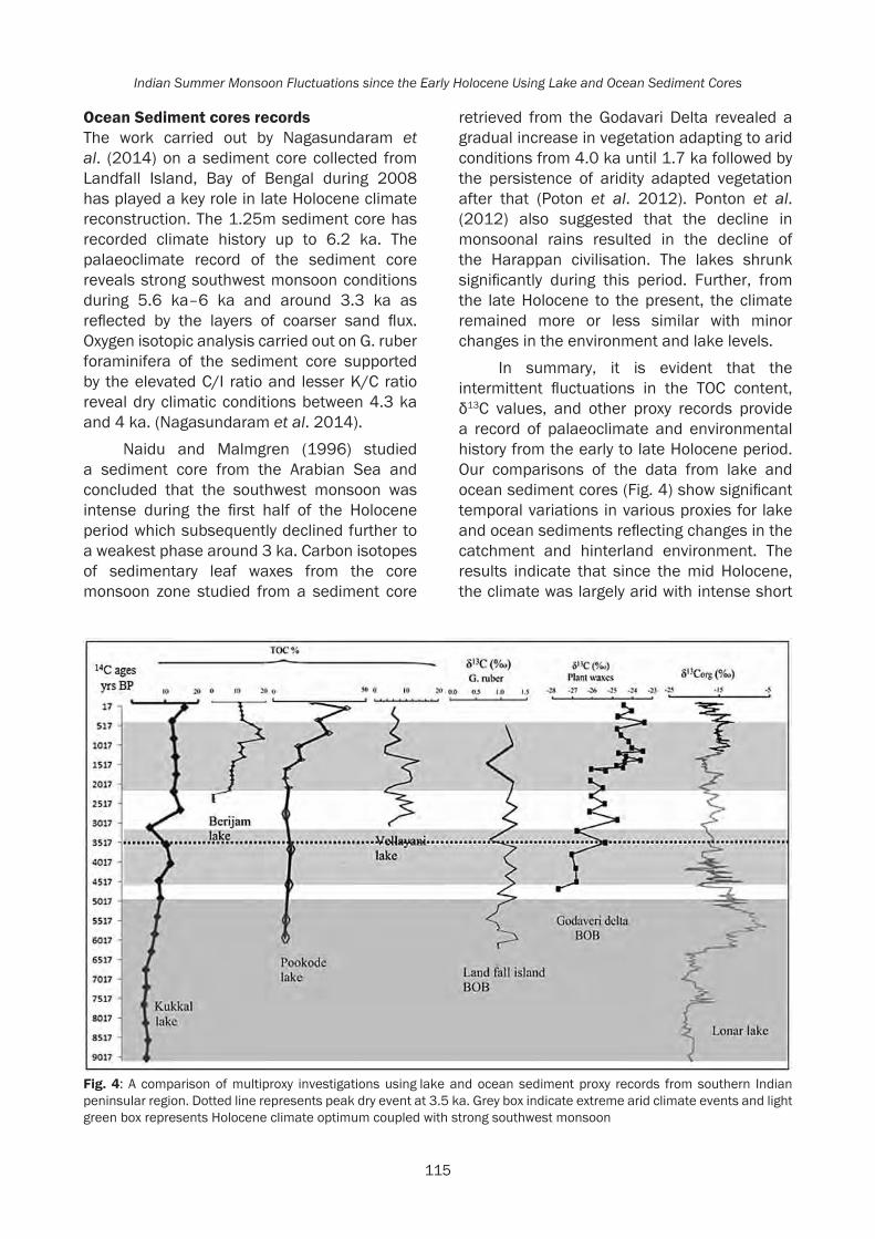
115
Indian Summer Monsoon Fluctuations since the Early Holocene Using Lake and Ocean Sediment Cores
Ocean Sediment cores recordsThe work carried out by Nagasundaram et al. (2014) on a sediment core collected from Landfall Island, Bay of Bengal during 2008 has played a key role in late Holocene climate reconstruction. The 1.25m sediment core has recorded climate history up to 6.2 ka. The palaeoclimate record of the sediment core reveals strong southwest monsoon conditions during 5.6 ka–6 ka and around 3.3 ka as reflected by the layers of coarser sand flux. Oxygen isotopic analysis carried out on G. ruber foraminifera of the sediment core supported by the elevated C/I ratio and lesser K/C ratio reveal dry climatic conditions between 4.3 ka and 4 ka. (Nagasundaram et al. 2014).
Naidu and Malmgren (1996) studied a sediment core from the Arabian Sea and concluded that the southwest monsoon was intense during the first half of the Holocene period which subsequently declined further to a weakest phase around 3 ka. Carbon isotopes of sedimentary leaf waxes from the core monsoon zone studied from a sediment core
retrieved from the Godavari Delta revealed a gradual increase in vegetation adapting to arid conditions from 4.0 ka until 1.7 ka followed by the persistence of aridity adapted vegetation after that (Poton et al. 2012). Ponton et al. (2012) also suggested that the decline in monsoonal rains resulted in the decline of the Harappan civilisation. The lakes shrunk significantly during this period. Further, from the late Holocene to the present, the climate remained more or less similar with minor changes in the environment and lake levels.
In summary, it is evident that the intermittent fluctuations in the TOC content, δ13C values, and other proxy records provide a record of palaeoclimate and environmental history from the early to late Holocene period. Our comparisons of the data from lake and ocean sediment cores (Fig. 4) show significant temporal variations in various proxies for lake and ocean sediments reflecting changes in the catchment and hinterland environment. The results indicate that since the mid Holocene, the climate was largely arid with intense short
Fig. 4: A comparison of multiproxy investigations using lake and ocean sediment proxy records from southern Indian peninsular region. Dotted line represents peak dry event at 3.5 ka. Grey box indicate extreme arid climate events and light green box represents Holocene climate optimum coupled with strong southwest monsoon

116
Rethinking the Past: A Tribute to Professor V.N. Misra
drier conditions during 3.9–4.6 ka, 4.2 ka, 2.0, and 0.6 ka followed by intermittent short periods of strengthened monsoonal conditions. This caused water bodies on land to extend their margins for a short period. When the margins shrank, human activity occupied the dry lake margins for agricultural purposes further deteriorating the hydrology around the lake. Further, since the mid Holocene period the lakes have never occupied their original basin capacity area and original bathymetry. The changes and intensity fluctuations in the precipitation pattern at such lake sites changed the lake bathymetry since the early Holocene period. The results indicate that the lakes continued to shrink and started desiccating significantly due to anthropogenic influences.
However, the changes in the proxy records are not commonly observed in all the lake and ocean sediment cores (Fig. 4) This is probably due to the timing and magnitude of local influences and responses to climate change such as the response to micro-climate, local hydrology, sedimentation rate and processes, atmospheric-temperature and wind pattern, stratification and nutrient availability.
ConclusionThe integration of all records generated from this detailed review based on lake and ocean core proxy records suggest the strengthened southwest monsoon during the early phase of Holocene period as supported by the study of Lonar, Kookal, Sasthamkotta, and Arabian Sea sediment cores. However, during the mid-Holocene period the intensity of the southwest monsoon fluctuated several times and the environment was drier for longer periods with short periods of intense wetter conditions. The peak dry periods around 4.2 ka, 2 ka and 0.6 ka occurred during this time period. The first abrupt weakening of the southwest monsoon around 4.2 ka is believed to have triggered a major drought in the Indian subcontinent that led to the decline of the Indus Valley Civilization (Staubwasser et al. 2003; Dixit et al. 2014a, b) and migration of population to the east towards the Ganga plains (Gupta et al. 2003) as well as adoption of new agricultural practices (Leipe
et al. 2013). However, the timing and intensity of the Holocene extreme events together with environmental changes in the Indian subcontinent warrants further investigation.
AcknowledgementThis manuscript is dedicated to Prof. V.N. Mishra. Hema Achyuthan learnt the fundamentals of geoarchaeology during research project work carried out around Didwana, Rajasthan. Rayees Ahmad Shah is grateful to DST, New Delhi, for the DST-PURSE JRF fellowship. Aasif Lone and Asif Ali are thankful to Anna University, Chennai, for the Anna Centenary Research Fellowship.
ReferencesAchyuthan, H., A. Farooqui, V. Gopal, B. Phartiyal and
A. Lone 2016. Late Quaternary to Holocene Southwest Monsoon Reconstruction: A Review Based on Lake and Wetland Systems (Studies Carried Out During 2011-2016), Proceedings of the Indian National Science Academy 82(3): 847-868.
Clift, P.D. and A.R. Plumb 2008. The Asian Monsoon: Causes, History and Effects. London: Cambridge University Press.
Dixit, Y., D.A. Hodell and C.A. Petrie 2014a. Abrupt weakening of the Summer Monsoon in northwest India~4100 yrs ago, Geology DOI: 10.1130/G35236.1.
Dixit, Y., D.A. Hodell, R. Sinha and C.A. Petrie 2014b. Abrupt weakening of the Indian summer monsoon at 8.2 ka B.P., Earth and Planetary Science Letters 391: 16-23.
Gupta, A.K., D.M. Anderson and J.T. Overpeck 2003. Abrupt changes in the Asian southwest monsoon during the Holocene and their links to the North Atlantic Ocean, Nature 421: 354-357.
Gupta, A.K., D.M. Anderson, D.N. Pandey and A.K. Singhvi 2006. Adaptation and human migration, and evidence of agriculture coincident with changes in the Indian summer monsoon during the Holocene, Current Science 90: 1082-1090.
Leipe, C., D. Demske and P.E. Tarasov 2013. A Holocene pollen record from the northwestern imalayan lake Tso Moriri and its implication for paleoclimatic and archeological research, Quaternary International doi.1016/j.quaint.2013.05.005.

117
Indian Summer Monsoon Fluctuations since the Early Holocene Using Lake and Ocean Sediment Cores
Nagasundaram, M.H. Achyuthan and S.M. Ahmad 2014. Monsoonal changes inferred from the Middle to late-Holocene sediments off Landfall Island, North Andaman, Arabian Journal of Geosciences 7: 3513-3523.
Naidu, P.D. and B.A. Malmgren 1996. A high-resolution record of late Quaternary upwelling along the Oman Margin, Arabian Sea based on planktonic foraminifera, Paleoceanography 11: 129-140.
Nair, K.M., D. Padmalal, K.P.N. Kumaran, R. Sreeja, R.B. Limaye and R. Srinivas 2010. Late Quaternary evolution of Ashtamudi-Sasthamkotta Lake systems of Kerala, Southwest India, Journal of Asian Earth Science 37: 361-372.
Ponton, C., L. Giosan, T.I. Eglinton, D.Q. Fuller, J.E. Johnson, P. Kumar and T.S. Collett 2012. Holocene aridification of India, Geophysical Research letters doi: 10.1029/2011GL050722, 2012.
Possehl, G.L. 1994. The Indus Civilization, Man and Environment 19: 103-113.
Prasad, S., A. Anoop, N. Riedel, S. Sarkar, P. Menzel, N. Basavaiah, R. Krishnan, D.Q. Fuller, B. Plessen, B. Gaye, U. Rohl, H. Wilkes, D. Sachse, R. Sawant, M.G. Wiesner and M. Stebich 2014. Prolonged monsoon droughts and links to Indo-Pacific warm pool: A Holocene record from Lonar Lake, Central India, Earth and Planetary Science Letters 391: 171-182.
Rajmanickam, V., H. Achyuthan, C. Eastoe and A. Farooqui 2016. Early-Holocene to present palaeoenvironmental shifts and short climate events from the tropical wetland and lake sediments, Kukkal Lake, Southern India: Geochemistry and palynology, The Holocene: 1-14. DOI: 10.1177/0959683616660162.
Royden, L.H., B.C. Burchfiel, R.V.D. Hilst, K.X. Whipple, K.V. Hodges, R.W. King and Z. Chen 2006. Uplift and evolution of the eastern Tibetan plateau. Presented in the Geological Society of America Philadelphia Annual Meeting 2006, session 109-1.
Sarkar, S., S. Prasad, H. Wilkes, N. Riedel, M. Stebich, N. Basavaiah and D. Sachse 2015. Monsoon source shifts during the
drying mid-Holocene: Biomarker isotope based evidence from the core ‘monsoon zone’ (CMZ) of India, Quaternary Science Reviews 123: 144-157.
Singhvi, A.K., K. Rupakumar, M. Thamban, A.K. Gupta, V.S. Kale, R.R. Yadav, A. Bhattacharyya, N.R. Phadtare, P.D. Roy, M.S. Chauhan, O.S. Chauhan, S. Chakravorty, M.M. Sheikh, N. Manzoor, M. Adnan, J. Ashraf, A.M. Khan, D.A. Quadir, L.P. Devkota and A.B. Shrestha 2010. Instrumental, terrestrial and marine records of the climate of South Asia during the Holocene: Present status, unresolved problem and societal aspects, in Global Environmental Change in South Asia: A Regional Perspective (A.P. Mitra and C. Sharma Eds), pp. 54-124, New Delhi: Capital Publications.
Singhvi, A.K., N. Bhatt, K.W. Glennie and P. Srivastava 2012. India, Arabia and adjacent regions, in Quaternary Environmental Change in the Tropics (S.E. Metcalfe and D.J. Nash Eds.), pp. 151-206, New York: Wiley.
Staubwasser, M., F. Sirocko, P.M. Grootes and M. Segl 2003. Climate change at the 4.2 ka BP termination of the Indus valley civilization and Holocene south Asian monsoon variability, Geophysical Research Letters 30: 1425.
Trujillo, A.P. and H.V. Thurman 2011. Essentials of Oceanography. Upper Saddle River, p. 551. New Jersey, Pearson Prentice Hall.
Veena, M.P., H. Achyuthan, C. Eastoe and A. Farooqui 2014. A multi-proxy reconstruction of monsoon variability in the late Holocene, South India, Quaternary International 325: 63-73.
Wang, Y., H. Cheng, R.L. Edwards, Y. He, X. Kong, Z. An, J. Wu, M.J. Kelly, C.A. Dykoski and X. Li 2005. The Holocene Asian monsoon: Links to solar changes and North Atlantic climate, Science 308: 854-857.
Wolf, S.A., I.J. Walker and D.J. Huntley 2008. Holocene coastal reconstruction, Naikoon peninsula Charlotte Islands, British Columbia, Geological Survey of Canada Current Research 2008-2012: 1-16.

Soni and Soni 2017, in Rethinking the Past: A Tribute to Professor V.N. Misra(S.G. Deo, Andre Baptista and Jayendra Joglekar Eds.), pp. 118-131, Pune. ISPQS: www.manandenvironment.orgISBN: 978-81-908330-6-6
IntroductionThe northwestern sub-Himalayas comprise mudstones, sandstones, and coarsely bedded conglomerates laid down when the region was a vast basin during middle Miocene to Upper Pleistocene (Valdiya 1993, 2001). The sediments were deposited by rivers flowing southwards from the Greater Himalayas resulting in a multi-ordered drainage system. Following this deposition, the sediments were uplifted through intense tectonic regimes resulting in the Siwaliks’ unique topography. The Siwaliks are located within the political boundaries of Pakistan, India, Nepal, and Bhutan and are between 6 to 90 km in width (Acharya 1994). These hills are stratigraphically divided into three major subgroups – Lower, Middle, and Upper. Intermittently located between the Siwaliks are ‘duns’, which are flat-bottomed longitudinal structural valleys (Nakata 1972). These duns essentially comprise several large Himalayan piedmont alluvial fans and terraces, which formed as a result of tectonic episodes in the flanking Siwaliks. Ongoing erosion and tectonic activity has greatly affected the topography of the Siwaliks and their present-day morphology is
NEW REVELATIONS ABOUT THE STONE AGE IN THE NORTHWESTERN SUB-HIMALAYAS OF INDIA
Vidwan Singh Soni1 and Anujot Singh Soni2
1 Fellow, Punjabi University Patiala2 Department of Punjab Historical Studies, Punjabi University Patiala
Abstract
Sub-Himalayas are the foothills of the Himalayas situated along its southern margin which house the Soanian lithic industries. However, these industries have since been known to occur only during the Pleistocene. Almost all earlier workers in this field determined the chronology of these industries using the now defunct criteria of Alpine glacial/interglacial stages. In the Siwalik formations, most of the cusp terraces of the streams cutting through the Siwaliks and joining the perennial Himalayan Rivers, as well as the alluvial fan surfaces in the duns were laid down during the terminal Pleistocene to mid-Holocene. Researchers on the Indian side of the sub-Himalayas, who collected lithic artefacts from Siwalik surfaces, stream terraces, and alluvial fan surfaces, usually continued to accept the Soanian industries in accordance with de Terra and Paterson’s typo-chronology. We recently made surface collections from almost forty localities spread over an area of 800 km2 on the stream-terraces and alluvial fan surfaces in the Indian sub-Himalayas, and excavated two sites. Based on the dates obtained for some sites, it is observed that the Soanian type stone implements are found to have existed in the sub-Himalayas even up to the late to mid-Holocene. This inference is confirmed by the discovery of such tools from the post-urban Harappan sites, and from the existence of such tools in association with the late-Harappan potsherds on young terrace surfaces. The discovery of many new tool-types, especially pitted cobbles and edge-ground lithic specimens, which are known from mid-Holocene sites elsewhere in the world, also hint at the influence of those lithic industries in this region. We briefly present here the lithic assemblages from some dated sites and show that the Soanian and many new tool-types were also in use in the Northwestern sub-Himalayas until late mid-Holocene. This fact was not realized by the earlier workers.
comprised of hogback ridges, valleys of various orders, gullies, choes (seasonal streams), semicircular choe-divides, water-gaps, and choe terraces (Mukerji 1976). To the south of the Siwaliks are the Indo-Gangetic plains, and in north are the Lesser Himalayas.
All previously known Palaeolithic sites in this region were in virtually un-datable surface contexts, and the resulting collections are often inadequate for accurate techno-typological or typo-chronological analyses. An attempt to understand the geological contexts of the stone tools recovered from these sites was first made by de Terra and Paterson (1939), and this British-American team was responsible for assigning cultural labels to some of these lithic assemblages such as ‘Soan’ or ‘Soanian’ (Hawkes et al. 1934; Movius 1948) and ‘Soan Flake Tradition’ (Sankalia 1957). De Terra and Paterson (1939) broadly placed the origin of these Soanian tools in the Middle Pleistocene (see Dennell and Rendell 1991; Dennell and Hurcombe 1993). The research involving this region made by de Terra and Paterson (1939) was supplemented by Paterson and Drummond (1962); Graziosi (1964); and Krantz (1973) which resulted in various cultural stages of the

119
New Revelations about the Stone Age in the Northwestern Sub-Himalayas of India
Soanian viz. Pre-Soan, Early Soan, Late-Soan etc., with further sub-stages and were thought to be a result of the glacial and interglacial periods. In Pakistan, subsequent Paleolithic investigations took place in the Soan valley, the Potwar Plateau, the Pabbi Hills, and the Rohri Hills in the Sind region (Stiles 1978; Rendell et al. 1989). In India, most investigations took place in the river valleys of Sutlej, Ravi (Saroj 1974), Markanda (Joshi et al. 1975), Beas-Ban Ganga (Lal 1956; Bhattacharya and Chakrabarti 1981), Sirsa, and Soan (‘Swan’ of Indian Punjab), and in the inter-montane dun valleys (Mohapatra and Singh 1979; Karir 1985: 56-60; Singh et al. 1998). Most scholars in India (Lal 1956; Mohapatra 1981, 2007; Karir 1985; Singh et al. 1998) relied heavily on de Terra and Paterson’s work (1939), ultimately resulting in oversimplified and confusing cultural interpretations (see Misra and Mate 1995: 1-14). The general view presented was that the Early-Soan consisted of heavy duty tools with the dominance of choppers; and in the Late-Soan, the occurrence of flakes/flake-tools increased and the tools became smaller in size (de Terra and Paterson 1939; Mohapatra 1974, 2007). The Late-Soan of the Soan Valley of North Pakistan is also considered to belong to the South Asian Middle Palaeolithic tradition in terms of typology (Allchin and Allcnin 1996; Lycett 2006). The typo-chronological distinction between Early and Late-Soan is still not clear because both mixed assemblages have only been reported from un-datable surface contexts. Doubts about de Terra and Paterson’s observations first surfaced only through the works of Gill (1951) and Sankalia (1957). The stratigraphical context of the Soanian industries as first specified by de Terra and Paterson (1939) was severely questioned by later field studies (Rendell et al. 1989). The Soan River ‘terraces’ as observed by de Terra and Paterson were proven to be erosional features rather than true river terraces (Rendell et al. 1989). As a result, an evolution of Soanian technology (de Terra and Paterson 1939) is no longer considered to be valid (Rendell et al. 1989; Chauhan 2007, 2008). There is no evidence of discrete ‘Early’ or ‘Late’ Soan entities since the Soanian tools including both large and
small types with varying flake contents have also been found recently from very young sites (Soni et al. 2008; Soni and Soni 2009, 2010, 2011, 2016). In addition, the ‘Early Soan’ tools (as conventionally defined) have only been found in very small quantities both in India and Pakistan (Mohapatra 1966; Jayaswal 1978) and no factory site with an exclusive Early Soan assemblage has ever been reported in stratified context from anywhere.
However, it may be noted that Soanian type tools have been found to exist abundantly in very young sites. Early researchers collected stone tools from lower terraces also but had no provision for dating the terraces and their chronology was based merely on speculations. Their arguments that ‘the material collected from higher terraces is older’ cannot be accepted since recent people can also go to higher terraces and work there. In the past few years, the present authors explored an area of nearly 800 km2 in the NW sub-Himalayas up to an elevation of 420 m ASL and found several prehistoric sites yielding stone tools in association with potsherds in surface context. Three terraces of River Satluj adjoining the Siwaliks (two were laid down during the mid-Holocene) provided us with a large number of Soanian and other stone tool-types along with plain Red Ware and BRW ceramics. Pottery found in association with stone tools was generally ignored by earlier scholars suspecting it to be a job of later people, but assigned the stone tools to the second glacial/interglacial stage of Alpine glaciations (Mohapatra and Singh 1979). A limited excavation of a site Jandori-6 belonging to the mid-Holocene in Dist Bilaspur (Himachal Pradesh) yielded a large assemblage of Soanian, and new types of stone tools mixed with pottery in situ (Soni and Soni 2009). Several other young stream terraces and two late-Harappan mounds had evidence of Soanian type tools on them (Soni and Soni 2008) and in this paper. Following is a brief description of some of these sites; and a new interpretation is given to earlier findings as well as our recent ones.

120
Rethinking the Past: A Tribute to Professor V.N. Misra
Migration of a large number of late-Harappans towards the NW sub-HimalayasThe Harappan culture evolved during an Early Phase between 5.2 and 4.5 ka from antecedent agricultural communities of the hills bordering the Indus alluvial plain to the west, and reached its Mature Phase approximately between 4.5 and 3.9 ka. De-urbanization ensued after approximately 3.9 ka and was characterized by the development of increasingly regional artefact styles, and the disappearance of the distinctive Harappan script (Possehl 1997; Giosan et al. 2012). Although this phase is generally referred to as “collapse”, many settlements exhibit continuity, albeit with reduced size, whereas many other riverine sites
are abandoned (Lal and Gupta 1984; Possehl 1997). Between 3.9 and 3.0 ka, there was a proliferation of smaller, village-type settlements (Possehl 1997; Kumar 2009; Wright et al. 2005; Giosan et al. 2012: Fig. 3), especially in the Himalayan foothills and the western part of the Ganges. During the late phase, long-distance trade almost ceased due to increased aridity in NW India while the production of a wide range of materials were curtailed (Possehl 1997). It is thus highly possible that during long spells of drought (3.2 ka was the highest aridity in this region; Kotlia 2016), the procurement of metal for day to day work could have also become difficult for the late-Harappans; particularly for those who shifted to remote places in the sub-
Fig. 1: Google map showing places of our exploration/excavation of mid-Holocene sites

121
New Revelations about the Stone Age in the Northwestern Sub-Himalayas of India
Himalayas. The use of stone tools was their only alternative. Here we present sites in the NW sub-Himalayas and some places close to the foothills with evidences of late-Harappans using Soanian type stone tools in addition to some other, hitherto unreported types. In all cases, some expedient technology was used to fabricate tools. Choppers being simple to make are variously found. Some tools made on large flakes (having sharp edges) were also used without retouch, while other fine tools are present in some sites, but in small quantities.
Late Harappan site Bara yielded Soanian toolsThe site at Bara (30.920° N; 76.553° E) in Dist. Ropar (Punjab-India) consists of an archaeological mound which is known for a typical ‘late-Harappan Bara-Ware’ (Allchin and Allchin 1996). It is the pottery of this site which is most distinctive and diagnostic (Sharma 1981). This 4m high mound is situated on the Punjab plains about 8 km southwest of the Siwalik frontal-range (Fig. 1). The site was previously situated on the left bank of a stream ‘Budki-Nadi’ which has since shifted northwards by about 1 km. In 2007, we visited an excavation to be conducted at this site by K.C. Nauriyal (the then Superintending Archaeologist, Simla, India). We found some stone tools on the surface of that archaeological mound (Soni and Soni 2008) which included a few choppers, scrapers, a point (Fig. 2), and many utilized flakes resembling the Soanian artefacts made on coarse-grained quartzite which are known to exist in the neighboring Siwaliks. The excavators later informed us (see also Nauriyal et al. 2012) that they recovered more of such stone tools from just a small depth excavated so far. Though the Bara mound has been excavated twice (1955 and 1971) by Y.D. Sharma (A.S.I. 2011), the presence of any stone tool is not mentioned (or was ignored if found) in the material excavated from this site dated to late mid-Holocene (from 3.49 to 3.69 ka: Agrawal and Kusumgar 1973). The scarcity of metal in this site is supported by the fact that only 2 pieces of copper, a fishing hook, and a fragmentary bangle were recovered from the excavated material (Sharma 1981). Obviously
for day-to-day work stone tools were used by Barans; mostly of the Soanian type and some hastily made tools.
Soanian tools from late-Harappan site Dher Majra (31.029° N; 76.616° E)Harappan potsherds along with Soanian tools were found by Olaf Prufer (1956) at Dher Majra (Fig. 1) from the top of a 4m high late-Harappan mound. Prufer (1956) speculated that these tools could have rolled down from a higher surface (terrace T-2 as he called it, following de-Terra and Paterson, 1939), but as per our recent survey, there could be no contiguity between the mound-top and higher terrace as the later is about 600m away from the bottom of that mound. Also, no stone tool rolling down from the higher terrace (T-2) can be expected on the top of a mound 4m above its bottom level (terrace T-3). He termed the stone tools found from Dher Majra and other sites in Sirsa valley as belonging to Early-Soan (Prufer 1956).
Fig. 2: Stone tools from Bara: (a) Side chopper procured from the a gullies on the mound; (b) end chopper from the mound surface; (c) end scrapers on unifacial flake; (d) side chopper; (e) end choppers with abraded edge; (f) backed knife; (g) thick triangular type-4 flake; (h) pointed thick blade-flake with a keel on ventral side; (i) enlarged view of a point with serrated edges and a dorsal keel

122
Rethinking the Past: A Tribute to Professor V.N. Misra
The Dher Majra site is situated on the left bank of an unnamed short-run ephemeral tributary of Kanhan Nadi, both of which emanate from the Siwalik Frontal-Range and join Sirsa Nadi originating from the foothills of the Himalayas (Fig. 1). At present the mound at that site has almost been leveled but its remnants are still higher than the surface of the lower terrace. Fresh looking unrolled Soanian type stone tools (Fig. 3) as well as potsherds eroded out of the mound are seen littered all over. Similar tools were collected by Prufer from the mound-top. Therefore, the only possibility is that Prufer’s findings (Prufer 1956) were a part of the culture of that mound and thus we see that the late-Harappans were using Soanian type stone tools.
Soanian tools from late-Harappan site Mehranwala (31.029° N; 76.822° E)Olaf Prufer mentioned (Prufer 1956) that the centre of the Mehranwala site was crowned by a mound belonging to Harappan culture. This site is situated on the left bank of Sirsa Nadi and during our recent visit to that site we found Soanian stone tools mixed with potsherds from the top of that almost destroyed mound. The peak of the remnant Harappan mound was about 2 to 3m higher than the alluvial
Fig. 3: Stone tools from Dher Majra: (a, b) Chopping tools with abraded a edges; (c, d, e) choppers; (f) bi-ended cutting tool; (g) tanged small core tool with cortical platform; (h) unifacial end scraper; (i) pointed unifacial core with a keel; (j) ventral face of a type-1 flake showing point of percussion
Fig. 4: Stone tools from Mehran Wala: (a) a borer with cortical platform; (b) unifacial scraper on a flat core; (c) a tabular core; (d) small end-chopper; (e) dorsal face of a cortical flake; (f) a blade-flake with a keel on a type-3 flake; (g, i) both faces of a converging flake on small type-3 flake; (h) small burin on a type-3 flake; (j) small type-3 blade-flake
Fig. 5: (A) A dense layer of artefacts appears during the excavation at Jandori-6; (B) Anujot Singh notices a chopper and a late-Harappan potsherd in situ

123
New Revelations about the Stone Age in the Northwestern Sub-Himalayas of India
fan surface. Fresh looking stone tools (Fig. 4) akin to those found from other sites in the neighborhood were found spread all over its raised surface, or rolled down from it. The evidence from this site also shows that late-Harappans were using the Soanian type stone tools.
Flake rich assemblage with ceramics found in buried state in the site jandori-6 (31.3382° N; 76.4574° E)Site Jandori-6 is situated in the middle-Siwaliks and lies on the left bank of a stream Jandori-Di-Khad in Dist Bilaspur of Himachal Pradesh (Fig. 1, 9A). This site provided us with an almost in-situ assemblage of archeological specimens. It is situated on a slope which has a somewhat planar portion near the edge of the stream; most of which has been swept away by the flooding stream during heavy rains. At first, a large number of stone tools were noticed within a small area of the site; and a limited
excavation of a selected portion (Fig. 5A) yielded a huge flake-rich assemblage (Soni and Soni 2009) mixed with weathered potsherds. In a total assemblage of over five thousand surface/excavated lithic specimens there were choppers, discoids, simple and projectile points, borers, knives (see Fig. 6) and many (~15%) edge-ground artefacts (Fig. 6 c, d, h, i, j). Site Jandori-6 appears to have experienced a phase of aridity in the past since all the lithic specimens and the potsherds below a depth of 30 cm in the trial trench (when a denser layer of the artefacts appears) were laden with CaCO3. This indicates that the artefacts in the lower layers had collected there as a creep wash during aridity (which causes deposition of CaCO3 on them) and hints at the fact that the site could have been occupied by people during a mid-Holocene arid phase. The occurrence of Harappan pottery (Fig. 6 s-u) along with stone tools in-situ (Fig. 5B) points to the presence of Harappans using stone tools at the site. A date
Fig. 6: Artefacts from Jandoi-6: (a, b, f) Large side choppers; (c) edge-ground axe; (d) unifacial discoid with a portion of edge well ground; ( e) converging backed knife; (g) simple chopper; (h) edge-ground type-1 flake; (i) edge-ground flake with a prominent bulb of percussion; (j) thick type-3 siret having a well ground convex working edge; (k) backed type-3 flake with a tang; (l) Levallois point; (m) stemmed point with dorsal keel; (n) bi-ended borer; (o) tanged projectile point; (p) backed knife with utilized edge; (q) leaf shaped point on type-3 flake; (r) point with keel on type-3 flake; (s, t, u) late-Harappan potsherds

124
Rethinking the Past: A Tribute to Professor V.N. Misra
of a potsherd obtained by OSL method (Table 1) also falls in the mid-Holocene. Jandori-6 is as such a first mid-Holocene site which was excavated and in which edge-ground tools were found in association with Soanian tools and Harappan potsherds. In southeast Asia, mostly core tools and occasionally flakes with an edge-gloss are reported from upper stages of the Hoabinhian (Ha van Tan 1997; Bellwood 2007; Marwick 2007), but in the Jandori-6 assemblage, the edge-ground tools are abundantly on flakes (> 95%) and flake tools (Soni and Soni 2009). This place was a factory site which is evidenced by the presence of a large quantity of lithic shatter in the excavated material.
Lithic Assemblage from young-terrace sites of River Satluj near Nangal (Punjab)Three terraces are visible on the left bank of River Satluj above its flood plain near Nangal township (Fig. 1). Site NGT-1 is on the first terrace and the sites NGT-2 and NGT-3 are respectively on the next two higher terraces (see Soni and Soni 2016: Fig. 3). The riverside edge of first terrace (site NGT-1) is about 8m above the present river bed; terrace NGT-2 is nearly 10 m above the south end of terrace NGT-1; and the edge of NGT-3 is about 8m above the left end of site NGT-2. Initially the sediment of all the three terraces was deposited by River Satluj in the form of pebble-boulder gravel and subsequently three incision events gave the
terraces their present morphology. The first incision event started well before 11.3 ka and ended around 11.3 ka giving rise to remnant terraces NGT-3 and NGT-2. The terrace NGT-2 is a cut-in-fill terrace whose topmost layer is muddy sediment drawn from the background hill. The muddy sediment continued to be deposited on the gravel-bottom during Holocene until a little after 4.8ka. Two soil samples taken at different depths of NGT-2 gave OSL dates; 4.79±0.6 ka at 55 cm depth, and 11.31±1.8 ka at a depth of 1.35m (see Table 2).
Further incision of NGT-2 gravel deposit went on up to around 6ka, and subsequently the terrace NGT-1 was formed. The incision of the terrace NGT-1 up to present bed level took place from mid-Holocene to the present rimes. A sample taken at 80cm below the top of the silt/sand deposit on NGT-1 gave an OSL date of the terrace as 6.25 + 0.84 (Soni et al. 2008). Most parts of the above mentioned terrace-sites being subject to present day agricultural activity, it is not expected that the stone tools as well as the potsherds associated with them are at their original positions. However, even due to continuous plowing their shifting cannot be beyond 2-3 meters. Some representative stone tools collected from the three surfaces are shown in figures 7 & 8. The assemblages from all three surfaces possess similar typo-technology and are at a similar stage of patination (all are fresh and unrolled).
Table 1: OSL dating of a Potsherd excavated from the site Jandori-6. Material-Pottery: Mineral used-Quartz: Size: 90-125 micrometer: SAR protocol (Murray and Wintle, Rad. Mea. 2000)
Lab No.
Sample depth from surface
U (ppm) Th (ppm) Potassium K %
Moisture Content (%)
Equivalent Dose (De)Gy
Dose rate(Gy/ka) Age (ka)
LD637 60 cm 4.35±0.44 19.02±1.9 1.98±0.2 1 21.41±1.52 4.51±0.27 4.744± 0.43
Table 2: OSL dating of Soil Samples of mud deposition on the upper terrace of Satluj at Nangal. Material-Sediment sample: Mineral used -Quartz Size: 90-125 micrometer SAR protocol (Murray and Wintle, Rad. Mea. 2000)
Lab No.
Sample depth from surface (cm)
U (ppm) Th (ppm) K (%) Moisture Content (%)
Equivalent Dose (De)Gy
Dose rate (Gy/ka)
Age (ka)
LD874 55 2.64±0.3 14±1.4 1.64±0.2 7.06 14.84±1.6 3.10±0.2 4.79±0.6LD873 135 2.12±0 .2 20±2 1.55±0.2 1.41 39.25±5.8 3.47±0.2 11.31±1.8
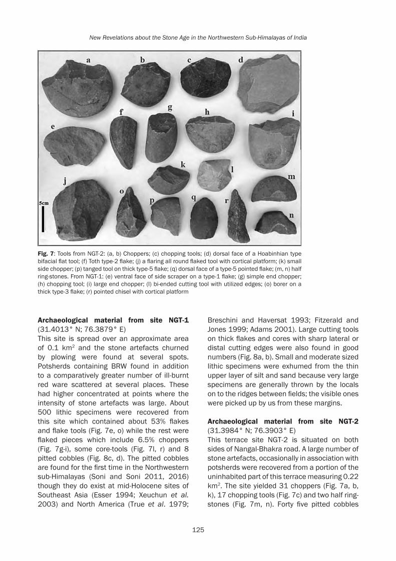
125
New Revelations about the Stone Age in the Northwestern Sub-Himalayas of India
Archaeological material from site NGT-1 (31.4013° N; 76.3879° E)This site is spread over an approximate area of 0.1 km2 and the stone artefacts churned by plowing were found at several spots. Potsherds containing BRW found in addition to a comparatively greater number of ill-burnt red ware scattered at several places. These had higher concentrated at points where the intensity of stone artefacts was large. About 500 lithic specimens were recovered from this site which contained about 53% flakes and flake tools (Fig. 7e, o) while the rest were flaked pieces which include 6.5% choppers (Fig. 7g-i), some core-tools (Fig. 7l, r) and 8 pitted cobbles (Fig. 8c, d). The pitted cobbles are found for the first time in the Northwestern sub-Himalayas (Soni and Soni 2011, 2016) though they do exist at mid-Holocene sites of Southeast Asia (Esser 1994; Xeuchun et al. 2003) and North America (True et al. 1979;
Breschini and Haversat 1993; Fitzerald and Jones 1999; Adams 2001). Large cutting tools on thick flakes and cores with sharp lateral or distal cutting edges were also found in good numbers (Fig. 8a, b). Small and moderate sized lithic specimens were exhumed from the thin upper layer of silt and sand because very large specimens are generally thrown by the locals on to the ridges between fields; the visible ones were picked up by us from these margins.
Archaeological material from site NGT-2 (31.3984° N; 76.3903° E)This terrace site NGT-2 is situated on both sides of Nangal-Bhakra road. A large number of stone artefacts, occasionally in association with potsherds were recovered from a portion of the uninhabited part of this terrace measuring 0.22 km2. The site yielded 31 choppers (Fig. 7a, b, k), 17 chopping tools (Fig. 7c) and two half ring-stones (Fig. 7m, n). Forty five pitted cobbles
Fig. 7: Tools from NGT-2: (a, b) Choppers; (c) chopping tools; (d) dorsal face of a Hoabinhian type bifacial flat tool; (f) Toth type-2 flake; (j) a flaring all round flaked tool with cortical platform; (k) small side chopper; (p) tanged tool on thick type-5 flake; (q) dorsal face of a type-5 pointed flake; (m, n) half ring-stones. From NGT-1: (e) ventral face of side scraper on a type-1 flake; (g) simple end chopper; (h) chopping tool; (i) large end chopper; (l) bi-ended cutting tool with utilized edges; (o) borer on a thick type-3 flake; (r) pointed chisel with cortical platform

126
Rethinking the Past: A Tribute to Professor V.N. Misra
Fig. 8: (a) Cutting tool on large type-1 flake with utilized working edge; (b) backed knife on a large type-4 flake and (c, d) pitted cobbles; all from NGT-1; (e-h) pitted cobbles from NGT-2; (i) pitted cobble from NGT-3 (j) late-Harappan potsherds
(Fig. 8e-h) were also found in addition to a good number of typical core tools (Fig. 7j, l) and Hoabinhian type tools (Fig. 7d). Recently, an experiment conducted on a fresh cobble (Soni and Soni 2016) suggests that the pits on the cobbles were artificially made for some utility purpose and did not result from utilization.
Out of a total of 645 lithic specimens collected from this site, nearly 42% were detached pieces including flake tools (Fig. 7f) in which a small number of borers, scrapers, and points were also present while most of them were broken pieces or waste flakes. BRW and some Harappan type potsherds were also collected from this site.
Archaeological material from site NGT-3 (31.3975° N; 76.3880° E)This ovalish, small (~100 x 120m) remnant terrace site is situated on the left side of NGT-2 and is raised above its left-end margin by 9-10 meters. Its central portion is somewhat
raised higher and the lithic artefacts were found spread all over. Agricultural activity is also conducted at this site and stone tools (n = 48) similar to those collected from NGT-2 and NGT-1 sites were found from here which also included 3 pitted cobbles (Fig. 8i). In all there were about 3 chopper/chopping tools, 14 core tools and 28 were flakes or flake tools. Few weathered potsherds were also recovered from this site indicating that human activity ran simultaneously in all the three sites.
Mid-Holocene lithic assemblage from an interfluves Siwalik surface Jandori-1(31.32836° N; 76.447238° E)It is situated near Jandori village (and close to the site Jandori-6) on an interfluves Siwalik surface on the left bank of ‘Sakrun Di Khad’ (Fig. 9A), a right bank tributary of the Jandori Di Khad (stream). This is an isolated muddy surface nearly 400 m2 (underlain by Pinjaur sand-stone) which possesses a gentle slope

127
New Revelations about the Stone Age in the Northwestern Sub-Himalayas of India
towards its distal end (Fig. 9B). A large number of stone artefacts were recovered from this site. A few centimeters to a one meter deep pathway appears to have been dug out on this surface by the local people, which uncovered the stone artefacts from the surface deposit of clayey sand. Numerous stone artefacts might have swept down the pathway and deposited near the distal half portion of this surface which were now exposed. A few artefacts were found spread on its right side and some weathered potsherds were also seen embedded here and
there. The concentration of the artefacts was most near the distal end of the pathway and thinned out as we moved towards the proximal end. It appears that when people abandoned the site, the artefacts mixed with soil drifted down the slope due to pluvial action and were deposited near the southeast corner of the planar surface before the recent digging of the pathway.
The lithic specimens recovered from this site contained Soanian type choppers (Fig. 10b, c, g), chopping tools (Fig. 10f), flakes/blades
Fig. 9: (A) Google picture of Jandori-1 set on an interfluves surface between Sakrunh Di Khad and Jandori Di Khad, Jandori-6 is also visible; (B) view of Jandori-1 site
Fig.10: Tools from Jandori-1: (a) Toth type-1 flake having utilized working edge; (b, c, g) side choppers; (d) dorsal face of a bifacial Hoabinhian tool; (e) blade-flake on a type-3 flake; (f) side chopping tool; (h) converging unifacial (Hoabinhian type); (i) backed blade; (j) type-6 blade-flake; (k) edge-ground flake; (l, m) half ring-stones

128
Rethinking the Past: A Tribute to Professor V.N. Misra
(Fig. 10a, e, i), Hoabinhian type tools (Fig. 10d, h), half ring stones (Fig. 10l, m) and some edge-ground flakes (Fig. 10j, k). The assemblage from this site contains 35.5% flaked and 64.5% detached pieces. Among the flaked pieces, there were some 29% choppers and 7.5% chopping tools. The flake category possessed 10.3% Levalloisian element and there were scrapers (12.3%), borers (5%), chisels (2.4%), blade-flakes (2.7%), backed knives (1.7%), and many cutting-tools fabricated on flakes as well as edge-ground flakes (Fig. 10k). This assemblage can also be assigned a mid-Holocene context because of the presence of ring-stones (type tool of Neolithic to Harappan times), edge-ground flakes and the Hoabinhian elements, also known from mid-Holocene sites elsewhere in the world (see Gorman 1969, 1972; Higham 2002; Bellwood 2007).
Soanian tools from other sites on Young Alluvial fansAll the other Soanian-tool sites which are mentioned by Prufer as Palaeolithic sites (Prufer 1956) are actually situated on the surfaces of alluvial fans (Qf2) or their next lower terraces which formed around 20 ka or 16 ka (Suresh et al. 2002; 2007; Kumar et al. 2007). Thus the tools shown by Prufer (1956) as collected from Dhang, Rampur, Mehranwala, Khokra-Ka-Choa, Manakpura, Malpur-Da-Choa, etc. (Prufer 1956) are young and are not as old as speculated by him in line with de Terra and Paterson (1939). Prufer’s statement that the tools found from some sites (Prufer 1956) are fresh and unrolled, also points to the fact that they are young. Soanian tools found by Prufer from Dhang (Qf2 fan surface) were in close proximity to a Harappan site (Prufer 1956) though he did not co-relate the two.
Some Harappan potsherds were also noticed by Mohapatra and Singh (1979) to be occurring in association with the pebble-tools at various sites on the top of fans Qf2 (Suresh et al. 2007) and on the next lower terraces of the streams incising these fans. They did not suspect any temporal nearness among the different type of the surface archeological material collected by them and speculated a ‘Late Soan’ date corresponding to the 3rd
interglacial and 4th glacial stages in accordance with de Terra and Paterson (1939), as also did the later scholars (Karir 1985; Singh et al. 1998; Mohapatra 2007).
Discussion and ConclusionThe co-existence of pottery with lithic artefacts may not be a new thing, but that occurred only with Meso-Neolithic artefacts (Possehl and Kennedy 1979). In the present case, the tools of Soanian tradition have been discovered in association with ceramics in numerous sites in the NW sub-Himalayas. It is for the first time that Soanian tools have been found at Harappan sites in the riverine plains neighboring the Siwaliks and are being inferred as contemporaneous with the Harappans. Though Prufer (1956) had first noticed such tools on the Dher-Majra late-Harappan mound, he simpy related them to de Terra and Paterson’s terrace chronology and in a way assigned them a mid-Pleistocene age. The occurrence of Soanian tools at Bara, a late-Harappan site went unnoticed by the early excavators (Sharma 1981). Furthermore, many new tool-types (like pitted cobbles, edge-ground tools, large core, and flake cutting-tools, etc.) known from lithic sites elsewhere in the world conforming to mid-Holocene times and recovered from mid-Holocene sites of NW sub-Himalayas (Soni et al. 2008; Soni and Soni 2009; 2011) were also per chance not encountered or ignored by the earlier scholars in this region because of their meager and selective collections. All types of stone tools earlier classified merely on typological basis as ‘Early’, ‘Late’ or ‘Evolved’ Soan (Paterson and Drummond 1962; Karir 1985; Mohapatra 2007; Singh et al. 1998) have been found by us at mid-Holocene sites. Even the ‘simple choppers’ which Gaillard et al. (2016) have associated only with the so-called late-Pliocene ‘anthropic activity’, are variously found by us at mid-Holocene sites (see Figs. 6g, 7g). The discovery of such tools in association with the Harappan ceramics on young tool-bearing terraces of River Satluj near Nangal dated from mid to late mid-Holocene (Soni et al. 2008; Soni and Soni, 2016), indicates the adoption of some expedient stone-technology by people who had gathered in this region in those times.

129
New Revelations about the Stone Age in the Northwestern Sub-Himalayas of India
One can also suspect that most of the Soanian tools found at various places in the Northwestern Indian sub-Himalayas, and their much older assigned ages than the onset of the Holocene on mere speculations, weren’t all that old. It is so because the earlier dates of this industry in this region as unknown. However, young dates are confirmed at several places with sure mid-Holocene occurrence of these tool-types (our recent findings). Taking into account the typology of the newly discovered tools and new dates assigned to them, one is also made to rethink the typological classification and chronological setup of the lithic industries of the sub-Himalayas. More observant research is needed to describe the true typo-chronology of the sub-Himalayan ‘Stone Age’ rather than relying on earlier bizarre and scanty descriptions.
AcknowledgementsWe are thankful to Prof. K.C. Nauriyal for inviting us to visit the site Bara, to Prof. V. Shinde for identifying the pottery types and to thankful to Archeological Survey of India for giving us permissions for excavation of the site Jandori and for explorations of Punjab and Himachal regions at various times.
ReferencesAcharya, S.K. 1994. The Cenozoic Foreland basin
and tectonics of the Eastern Sub- Himalaya: problems and prospects, in Siwalik Foreland Basin of Himalaya, Himalayan Geology, R. Kumar and S.K. Ghosh (Eds.), pp. 3-21. New Delhi, Oxford and IBH.
Adams, B. 2001. The Stemler Bluff site: lithic analysis at late Woodland to Mississippian occupation overlooking the American Bottom, Illinois Antiquity 36(3): 11-17.
Agrawal, D.P. and S. Kusumgar 1973. Tata Institute Radiocarbon date list X, Radiocarbon 15(3): 574-85.
Allchin, B. and R. Allchin 1996. The rise of civilization in India and Pakistan. Cambridge: Cambridge University Press (South Asian Edition).
A.S.I. 2011. Excavated Sites in Punjab. Delhi: Archaeological Survey of India.
Bellwood, P. 2007. Prehistory of Indo-Malaysian Archipelago. Canberra: Australian National University Press.
Bhattacharya, D.K. and D.K. Chakrabarti 1981. Three Soanian implements from Dehra Gopipur, Kangra. Indian Anthropologist 11(2): 163-164.
Breschini, G.S. and T. Haversat 1993. Pitted stones from CA-SLO-697 and CA-SLO-762, Cambria, San Luis Obispo County, California: CaliforniaPrehistory.com. Available at http://www.californiaprehistory.com/reports01/rep0015.html (accessed 5 April 2011).
Chauhan, P.R. 2007. Soanian cores and core-tools from Toka, Northern India: Towards a new typo-technological organization. Journal of Anthropological Archaeology 26(3): 412- 441.
Chauhan, P.R. 2008. Soanian lithic occurrences and raw material exploitation in the Siwalik Frontal Zone, northern India: a geo-archaeological perspective, Journal of Human Evolution 54: 591-614.
De-Terra, H. and T.T. Paterson 1939. Studies on the Ice Age in India and Associated Human Cultures. Washington D.C.: Carnegie Institute.
Dennell, R.W. and H.M. Rendell 1991. De Terra and Paterson and the Soan Flake industry: a new perspective from the Soan Valley, Northern Pakistan. Man and Environment 16(2): 90-99.
Dennell, R.W. and L. Hurcombe 1993. Paterson, the British Clactonian and the Soan Flake Industry: a re-evaluation of the Early Palaeolithic of Northern Pakistan, in South Asian Archaeology, C. Jarrige (Ed.) pp: 69-72. Madison: Prehistory Press.
Esser, R. 1994. Analysis of the Middle Neolithic stone tool assemblage from Chek Lap Kok, in Archeological Investigations on Chek Lao Kok Island-Journal Monograph IV, W. Meachan (Ed). pp: 253-262. Hong Kong: Hong Kong Archeological Society.
Fitzgerald, R.T. and T.L. Jones 1999. The Milling Stone Horizon revisited: new perspectives from northern and central California. Journal of California and Great Basin Anthropology 21(1): 67-93.
Gaillard, C., M. Singh, A.D. Malassé, V. Bhardwaj, B. Karir, A. Kaur, S. Pal, A.M. Moigne, C.C. Sao, S. Abdessadok, J. Gargani and A. Tudryn 2016. The lithic industries on the fossiliferous outcrops of the Late Pliocene Masol Formation, Siwalik Frontal Range, northwestern India (Punjab), C.R. Palevol

130
Rethinking the Past: A Tribute to Professor V.N. Misra
(2016), http://dx.doi.org/10.1016/j.crpv.2015.09.017
Giosan, L., P.D. Clift, M.G. Macklin, D.Q. Fuller, S. Constantinescu, J.A. Durcan, T. Stevens, G.A.T. Duller, A.R. Tabrez, K. Gangal, R. Adhikari, A. Alizai, F. Filip, S.V. Laninghamj, and J.P.M. Syvitsk 2012. Fluvial landscapes of the Harappan civilization. PNAS, www.pnas.org/cgi/doi/10.1073/pnas.1112743109
Gill, W.D. 1951. The stratigraphy of the Siwalik Series in the Northern Potwar, Pakistan. Quaternary Journal of the Geological Society 107: 375-94.
Gorman, C. 1969. Hoabinhian: A pebble tool complex with early plant associations in Southeast Asia. Science 163: 671-73.
Gorman, C. 1972. Excavations at Spirit Cave, North Thailand: Some interim interpretations. Asian Perspectives 13: 79-107.
Graziosi, P. 1964. Prehistoric Research in North-Western Punjab Scientific Reports of the Italian Expeditions to the Karakorum (K2) and Hindukush. Leiden: E.J. Brill, (part 5).
Ha Van Tan 1997. The Hoabinhian and before. IPPA Bulletin 16: 36-41.
Hawkes, J., C. Hawkes and de Terra, H. 1934. Palaeolithic human industries in the Northwest Punjab and Kashmir and their geological significance: Memoirs of the Connecticut Academy of Arts and Sciences III: 1-13. New Haven: Connecticut Academy of Arts and Sciences.
Higham, C.F.W. 2002. Early cultures of Mainland Southeast Asia. Bangkok: River Books.
Jayaswal, V. 1978. Palaeohistory of India. New Delhi: Agam Kala Prakashan.
Joshi, R.V., S.N. Rajaguru, G.L. Badam, and P.C. Khanna 1975. Early and Middle Palaeolithic tools from river terraces in the Saketi Area, Markanda Valley, H.P. Current Science 44(13): 464-465.
Karir, B.S. 1985. Geomorphology and Stone Age Culture of Northwestern India. Delhi: Sundeep Prakashan.
Kotlia, B. 2016. Multi-decadal scale climatic changes in the last 4000 years as reconstructed by the speleothem studies in the Central Himalayas: Significance of Western Disturbances. Paper presented in International Conference on Emergence and Evolution of the Indian Foreland Basin, Chandigarh, Nov 18-19, 2016.
Krantz, G. 1973. Soan tool types from Ghila Khan. Asian Perspectives 15: 66-82.
Kumar M. 2009. In Linguistics, Archaeology and the Human Past, Occasional Paper 7, T Osada and A Uesugi (Eds.) Kyoto: Nakanishi Printing Co. Ltd.
Lal, B.B. 1956. Palaeoliths from the Beas and Banganga Valleys, Panjab. Ancient India 12: 58-92.
Lal, B.B. and S.P. Gupta 1984. Frontiers of the Indus civilization: Sir Mortimer Wheeler commemoration volume. New Delhi: Books and Books.
Lycett, S.J. 2006. Is the Soanian techno-complex a Mode 1 or Mode 3 phenomenon? A morphometric assessment. Journal of Archaeological Science 34: 1434-1440.
Marwick, B. 2007. Approaches to Flaked Stone Artefact Archaeology in Thailand: A Historical Review. Silpakorn University International Journal 7: 49-88.
Misra, V.N. and M.S. Mate 1995. Indian Prehistory: 1964. Pune: Deccan College Post-graduate and Research Institute.
Mohapatra, G.C. 1966. Preliminary report of the exploration and excavation of Stone Age sites in Eastern Punjab. Bull. Deccan College Research Institute 25: 221-237.
Mohapatra, G.C. 1974. Lithic industries of Himachal Pradesh. in Perspective in Palaeoanthropology, A.K. Ghosh (Ed.), pp. 199-212. Calcutta: K.L. Mukhopadyay.
Mohapatra, G.C. 1981. Acheulian discoveries in the Siwalik frontal range. Current Anthropology 22: 433-435.
Mohapatra, G.C. 2007. Lithic cultures of the sub-Himalayas. In Human Origins, Genome and People of India, A.R. Sankhyan and V.R. Rao (Eds.) pp.138-143.New Delhi: Allied Publishers.
Mohapatra, G.C. and M. Singh 1979. Prehistoric Investigations in a Sub-Himalayan Valley, Himachal Pradesh, India. Current Anthropology 20: 600-602.
Movius, H.L. 1948. The Lower Palaeolithic cultures of Southern and Eastern Asia. Transactions of the American Philosophical Society 38(4): 329-420.
Mukerji, A.B. 1976. Geomorphological study of Choe terraces of the Chandigarh Siwalik hills, India. Himalayan Geology 5: 302- 326.
Nakata, T. 1972. Geomorphic history and crustal movements of the foot-hills of the Himalayas. Tohoku: Institute of Geography, Faculty of Science, Tohoku University, Japan.

131
New Revelations about the Stone Age in the Northwestern Sub-Himalayas of India
Nauriyal, K.C., V.C. Sharma, S.B. Ota, Z. Ali, J. Singh, V.S. Soni and A.S. Soni 2012. Significance and implications of Large Lithic Artefacts from Bara in Late Harappan Context. Paper presented in International Conference on Harappan Archeology, Chandigarh.
Paterson, T.T., and H.J.H. Drummond 1962. Soan the Palaeolithic of Pakistan. Karachi: Department of Archaeology, Government of Pakistan.
Possehl, G.L. 1997. The Transformation of the Indus civilization. Journal of World Prehistory 11: 425-472.
Possehl, G.L. and K.A.R. Kennedy 1979. Hunter-Gatherer/Agriculturist Exchange in Prehistory: An Indian Example. Current Anthropology 20: 591-93.
Prufer, O. 1956. The Prehistory of the Sirsa Valley, Punjab, India. Quartar 7/8: 91-123.
Rendell, H.M., R.W. Dennell, and M.A. Halim 1989. Pleistocene and Palaeolithic Investigations in the Soan Valley, Northern Pakistan. British Archaeological Mission to Pakistan Series 2. B.A.R. International Series 544, Oxford.
Sankalia, H.D. 1957. Is the Soan a flake industry? Journal of Asiatic Society 22: 161-162.
Saroj, H.M. 1974. Lithic Industry of Jammu: Unpublished Ph.D. Thesis. Chandigarh: Punjab University Library, Chandigarh.
Sharma, Y.D. 1981. Cultural Contours of India. in Dr. Satya Prakash Felicitation Volume V.S. Srivastva (Ed.) pp. 17-20. New Delhi: Abhinav Publications.
Singh, M., B.S. Karir and S.N. Chopra 1998. Prehistoric and Quaternary Studies of the Roop Nagar District of Punjab Chandigarh: Department of Cultural Affairs, Archaeology and Museums (unpublished report).
Soni, A.S., V.S. Soni and D.S. Dhillon 2008. Large assemblages of flakes and cores found on dated young terraces of River Satluj and its tributaries. Current Science 94: 577-580.
Soni, A.S. and V.S. Soni 2005. Palaeolithic tools from the surface of optically stimulated luminescence dated alluvial fan deposits of Pinjaur Dun in NW sub-Himalayas. Current Science 88: 867-871.
Soni, A.S. and V.S. Soni 2009. A flake-rich assemblage in buried state and in primary context in the NW sub-Himalayas. Current Science 96: 1130-1133.
Soni, A.S. and V.S. Soni 2011. Pitted cobbles in the Northwestern Indian sub-Himalayas. Antiquity 085 Issue 328: Project Gallery.
Soni, A.S. and V.S. Soni 2016. Pitted cobbles from mid-Holocene sites of NW sub-Himalayas of India. Journal of Archeological Science: Reports 6: 557-573.
Soni, V.S. and A.S. Soni 2010. Large size cleaver-like flakes and Hoabinhoidal elements from terminal Pleistocene to mid-Holocene epoch sites. Quaternary International 223-224: 242-244.
Stiles, D. 1978. Palaeolithic artifacts in Siwalik and post-Siwalik deposits. Kroeber Anthropology Society Papers: 129-148.
Suresh, N., T.N. Bagati, V.C. Thakur, R. Kumar and S.J. Sangode 2002. Optically stimulated luminescence dating of alluvial fan deposits of Pinjaur Dun, NW sub-Himalayas. Current Science 82: 1267-1274.
Suresh, N., T.N. Bagati, R. Kumar and V.C. Thakur 2007. Evolution of Quaternary alluvial fans and terraces in the intramontane Pinjaur Dun, Sub-Himalaya, NW India: interaction between tectonics and climate change. Sedimentology 34: 809-833.
True, D.L., M.A. Baumhoff, and J.E. Hellen 1979. Milling Stone Cultures in Northern California: Berryessa I. Journal of California and Great Basin Anthropology 1(1): 124-154.
Valdiya, K.S. 1993. Uplift and geomorphic rejuvenation of the Himalaya in the Quaternary period. Current Science 64: 873-885.
Valdiya, K.S. 2001. Himalaya: Emergence and Evolution. Hyderabad: Jawaharlal Nehru Centre for Advanced Scientific Research. Universities Press, Ltd.
Wright R.P., J. Schuldenrein, and M.R. Mughal 2005. In South Asian Archaeology 2001, C. Jarrige and V. Lefèvre (Eds.) pp. 327-336. Paris: CNRS.
Xeuchun, F., L. Gongwu, and J. Tianlong 2003. An Archeological Investigation of the Damaoshan Site, Fujian Province. Kaogu. 12: 19-31. (English translation: Jiao Tianlong in Chinese Archaeology, pp. 76-81).