RESERVOIR MANAGEMENT IN THE INTERIOR WEST The …€¦ · 1 Chapter 15 RESERVOIR MANAGEMENT IN THE...
25
1 Chapter 15 RESERVOIR MANAGEMENT IN THE INTERIOR WEST The Influence of Climate Variability and Functional Linkages of Water Andrea J. Ray NOAA Climate Diagnostics Center, Boulder, Colorado, U.S.A. Abstract Two trends in the Gunnison Basin of western Colorado are increasing the sensitivity of reservoir systems to climate variability. These trends are increasing water utilization within the basin, especially for environmental purposes, and the increasing importance of functional linkages of the basin’s water to other places in the U.S. West. There is a potential for seasonal climate forecasts to provide advance guidance of wet or dry years, which could allow managers to better plan for dry conditions, or to take advantage of wet conditions. Trends in this basin mirror similar trends across the interior West, and thus it is valuable to examine the Gunnison Basin to understand how climate variability interacts with criti- cal water issues facing the larger region, and how this information might be incorporated into decision making for reservoir management. 1. INTRODUCTION The Gunnison River Basin in western Colorado is a microcosm of water issues in the interior West, where water use is intensifying to meet uses that were unforeseen in original water resources planning. Intensifica- tion of water management refers to increasing (or changing) the purposes for which the same water is used rather than developing new water resources (White 1961; MacDonnell 1999). As intensity of use increases, sensitivity to
Transcript of RESERVOIR MANAGEMENT IN THE INTERIOR WEST The …€¦ · 1 Chapter 15 RESERVOIR MANAGEMENT IN THE...
1
Chapter 15 RESERVOIR MANAGEMENT IN THE INTERIOR WEST The Influence of Climate Variability and Functional Linkages of Water Andrea J. Ray NOAA Climate Diagnostics Center, Boulder, Colorado, U.S.A. Abstract Two trends in the Gunnison Basin of western Colorado are increasing the
sensitivity of reservoir systems to climate variability. These trends are increasing water utilization within the basin, especially for environmental purposes, and the increasing importance of functional linkages of the basin’s water to other places in the U.S. West. There is a potential for seasonal climate forecasts to provide advance guidance of wet or dry years, which could allow managers to better plan for dry conditions, or to take advantage of wet conditions. Trends in this basin mirror similar trends across the interior West, and thus it is valuable to examine the Gunnison Basin to understand how climate variability interacts with criti-cal water issues facing the larger region, and how this information might be incorporated into decision making for reservoir management.
1. INTRODUCTION
The Gunnison River Basin in western Colorado is a microcosm of water issues in the interior West, where water use is intensifying to meet uses that were unforeseen in original water resources planning. Intensifica-tion of water management refers to increasing (or changing) the purposes for which the same water is used rather than developing new water resources (White 1961; MacDonnell 1999). As intensity of use increases, sensitivity to
2 Climate and Water
climate variability may also increase, because there is less capacity to ab-sorb shortages in the system (Riebsame 1990) compared to the water availa-ble. As an externality, beyond the control of water resources managers, cli-mate variability may create or exacerbate water issues within the basin.
Two societal trends are intensifying water management. The first is a move towards using water for environmental sustainability purposes, in-cluding recovery of endangered species, another is greater use of instream water for recreational and other purposes. Another factor is that the Gun-nison Basin is being increasingly linked to human activities in other places far outside its hydrologic boundaries. Water originating in the Gunnison Basin is a source of salinity that contributes to water quality problems downstream. It is in demand for municipal use in the Front Range of Colo-rado, it is used for the production of hydropower marketed elsewhere, and it makes a significant contribution to some downstream ecosystems. Reservoir management in the Gunnison Basin is evolving in response to policies that promote uses of water both within the basin as well as areas outside its hy-drologic boundaries.
Use of water beyond the physical boundaries of a basin is called a functional linkage by White (1961), who suggested that functional linkages between internal and external resource use are a key aspect of water plan-ning. To the extent that functional linkages increase the demands on the Gunnison Basin’s water, these linkages are another aspect of the intensifica-tion of water management. This intensification requires that water managers acknowledge that there are actions and consequences transcending many temporal and spatial scales, referred to as “cross-scale issues” by Pulwarty and Melis (2001).
Climate is an overarching physical process that can be thought of as a functional linkage: Climate affects the basin directly, as well as affecting places to which the Gunnison’s water is linked. Thus, the basin’s water management may be sensitive to climate variability due to climate anoma-lies that could be either internal to, or external to, the basin. Within the ba-sin, climate variability increases competition for water, and may jeopardize implementation of environmental policies and lead to increased conflict over implementation. External to the basin, a hot summer in a distant place, for example, may create demands for hydropower created here.
The influence of climate variability on this basin, as well as on areas to which it is functionally linked, has been overlooked with respect to how that variability interacts with evolving reservoir management practices. This chapter focuses on reservoir management as a subset of water management, the climate impacts on the use of water stored in reservoirs, and the func-tional linkages of that water. Reservoir management is sensitive to climate variability both temporally (i.e., the wet and dry periods affecting the Gun-
Reservoir Management in the Interior West 3
nison Basin itself) and spatially (in any year climate may have different ef-fects on the hydrology and reservoir capacity of the basin, as well as in other areas to which it is linked via water uses). Seasonal forecasts of climate var-iability may provide information on increased risks of wet or dry conditions up to a year in advance. Thus, there is a potential to use these forecasts to plan for water allocation during dry periods or to take advantage of wet pe-riods to satisfy more uses. A critical water problems approach (Wescoat, 1991) was used to identify water management problems confronting the re-gion, which are sensitive to climate variability. Key water and reservoir management issues that are sensitive to climate variability and that might benefit from improved climate information and products include:
• interstate and international water obligations (the Colorado Compacts, and treaties with Mexico) by allowing for better long-range planning for use of water in the Colorado Basin as a whole
• hydropower generation planning • management of salinity and other water quality problems, by
anticipating periods of low flow in which water quality prob-lems are exacerbated
• environmental sustainability: ecosystem restoration and endan-gered species recovery programs. These policies require careful management of water so that both traditional and environmental uses of water can be met.
This study analyzes how climate variability affects these critical wa-
ter issues and what climate information can be used in the reservoir man-agement decision process to meet multiple and expanding water uses in the basin. Potential uses of climate information in the reservoir management decision process are presented as they relate to the evolution of reservoir management to meet environmental sustainability goals. Use of this climate information may lower the vulnerability of reservoir management to climate variability. 2. GEOGRAPHIC CONTEXT OF THE GUNNISON BASIN
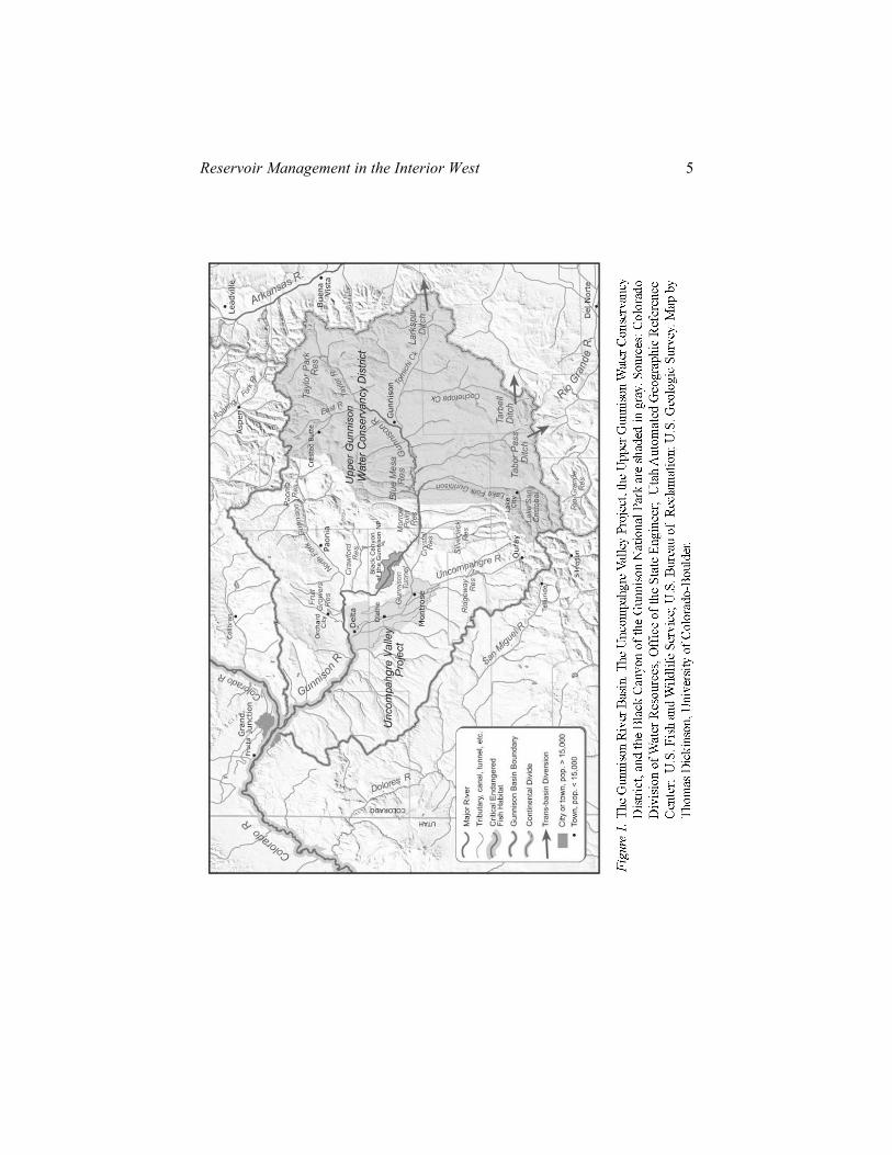
The Gunnison River is formed by the confluence of the Taylor and East Rivers, with their headwaters in the Elk Mountains and Sawatch Range on the Continental Divide in central Colorado (Fig. 1). The two major tribu-taries, the North Fork of the Gunnison and the Uncompahgre River, drain

4 Climate and Water
the Elk and San Juan Mountains. Elevations range from over 14,000 ft (4,260 m) to 4,550 ft (1,387 m) at its confluence with the Colorado River near Grand Junction, Colorado. The Gunnison River contributes about 40% of the flow of the Colorado River at the Colorado-Utah border, an average annual discharge of 2.016 million acre-feet (maf) per year (1977–96), rang-ing from 0.061 to 3.460 maf (U.S. Fish and Wildlife Service [USFWS] 2001). Most of the runoff is due to snowmelt: Over 70% of the annual flow occurs between April and July (USBR Western Colorado Area Office, 1999). Three U.S. Bureau of Reclamation (USBR) reservoirs, collectively known as the Aspinall Unit, inundate about 40 miles of the river, and control about one-third of the total discharge of the river. The largest, Blue Mesa Reservoir, begins about 10 miles west of the town of Gunnison and has a capacity of approximately 940,000 acre-feet (af); Morrow Point and Crystal Reservoirs together have a live storage capacity of about 130,000 af (http://www.dataweb.usbr.gov).
About 71% of the 7,928-square-mile basin (20,530 km2) is federal land (Knapp 1993). The largest areas are the Grand Mesa, Uncompahgre, and Gunnison National Forests, and Bureau of Land Management (BLM) areas. The National Park Service manages the land around the Aspinall Unit, known as the Curecanti National Recreation Area, and also the Black Can-yon of the Gunnison National Park (BCNP). Downstream of the BCNP, the Gunnison Gorge National Conservation area is managed by the BLM. Ranching, agriculture, and recreation form the economic base of the basin. Recreation has increased in the basin, especially in the Upper Gunnison, where the annual value of water-based recreational uses is approximately $35 million (excluding skiing) and represents the primary source of revenue for Gunnison County (Curry and McClow 2001). Wildlife-related recrea-tional activities include trout fishing on some rivers and reservoirs, as well as elk and deer hunting. Boating on the reservoirs and river rafting are also economically important recreational activities.
Reservoir Management in the Interior West 5
6 Climate and Water
Large-scale water development in the Gunnison Basin was motivat-ed by settlement of the land for ranching and agriculture. In 1903, The Un-compahgre Valley Project (UVP) was among the earliest projects of the newly established federal Reclamation Service (later the USBR). The UVP serves over 76,000 acres of project land in that valley; other USBR projects serve 52,000 acres in the Upper Gunnison Valley, and about 30,000 acres in the North Fork drainage (USBR, 2001). Federal funds were used to con-struct the Gunnison Tunnel, which diverts water from the Gunnison River just upstream from the Black Canyon to UVP canals near Montrose. In the 1930s, the USBR constructed Taylor Park Reservoir in the Upper Gunnison Basin to provide more water for the project. Water stored in the reservoir flows through the Taylor and Gunnison Rivers, and is diverted to the Un-compahgre Valley via the existing Gunnison Tunnel. Water is also diverted from the Upper Gunnison Basin to the east side of the Rocky Mountains: Three transmountain diversions transfer about 2,500 af/year to the Arkansas and Rio Grande Basins (USGS 1985).
The USBR Aspinall Unit was the next step in large-scale water de-velopment, authorized in 1956 as part of the Colorado River Storage Project (CRSP). The CRSP was intended to furnish long-term regulatory storage needed to permit states in the Upper Basin to meet their flow obligation to the Lower Basin, as defined in the Colorado River Compact, while still uti-lizing their allotment of water under the compact. The dams were construct-ed between 1962 and 1976. Benefits of the Aspinall Unit within the basin are control of flooding, development of recreation opportunities, production of electricity, and conservation of fish and wildlife. Revenues from hydro-power generation fund repayment to the government for the costs of irriga-tion project development.
Virtually all of the water in the Gunnison River is now allocated. In 1991, in a case related to a proposed transmountain diversion from the Up-per Gunnison Basin, a Colorado water court found that less than 20,000 af of water was available from the Upper Gunnison Basin for future appropria-tion (Board of Commisioners of Arapahoe County vs. Crystal Creek Home-owners Assn, 2000). 2.1 Critical Water Problems for the Gunnison Basin
Water issues in the Gunnison Basin are a microcosm of those in the state of Colorado and the Colorado Basin. Major themes in the state of Col-orado include trans-basin diversions, environmental protection, water quali-ty, and interstate obligations, including the Colorado Compact (Nichols et
Reservoir Management in the Interior West 7
al. 2001). Major issues for the larger Colorado Basin include the potential for the Upper Basin states to fully develop their compact allotments; salinity control; Indian water rights; and ecosystem sustainability, including endan-gered fish recovery programs, Colorado River Delta ecosystem restoration, and the Grand Canyon Adaptive Management Program (Pontius 1997). Many of these problems are manifested in the Gunnison Basin: Its naturally saline soils are a source for salinity; it is a source of small trans-basin diver-sions and a potential source for more diversions; and it is important for management of interstate obligations due to its position close to the Colora-do-Utah border. Ongoing environmental sustainability efforts include the Upper Colorado Recovery Implementation Plan for endangered fish, and an effort to restore the natural resources of the Black Canyon of the Gunnison. The Gunnison Basin also plays a role in these and other critical water prob-lems at the larger scale of the Colorado Basin and interior West as a whole, via functional linkages of water.
3. CLIMATE AND CRITICAL WATER PROBLEMS 3.1 Climate of the Region
Stream flows supplying the Aspinall Unit are highly variable (Fig. 2). Since Blue Mesa was completed in 1966, the average annual April–July inflow has been about 700,000 af, but inflows vary from about 167,000 af (1977) to over 1,400,000 af with a standard deviation of about 280Kaf (USBR Western Colorado Area Office 1999). April through July inflows, fed by melting snowpack, represent over 70% of the inflows for the year. There are significant relationships between snowpack for the Gunnison re-gion and large-scale circulation patterns such as the El Niño/Southern Oscil-lation (ENSO) (McCabe 1994). The ENSO phenomenon describes anoma-lous sea surface temperature (SST) conditions in the tropical Pacific, which in turn impact temperature and precipitation across the United States. This phenomenon has significant but subtle effects on the Gunnison region: The risk of warm anomalies is suppressed during La Niña winters (December–February), and the risk of warm anomalies is increased during El Niño win-ters (December–February) (Wolter et al., 1999). Clark et al. (2001) evaluat-ed how extremes of the ENSO phenomenon influence the snowpack for sites in these river basins. For the Lower Colorado Basin, they found a strong correlation between El Niño and anomalously high snow accumulation (as indicated by snow water equivalent, SWE) and also annual streamflow at

8 Climate and Water
selected gages. The opposite was found for La Niña, which is associated with anomalously low SWE and low annual runoff. The presence or absence of ENSO conditions is also associated with shifts in the probabilities of ex-treme precipitation and streamflow across a large region including the Gun-nison Basin (Serreze et al. 2001).
0.00
0.25
0.50
0.75
1.00
1.25
1.50
1900 1925 1950 1975 2000Yea r
Figure 2. Variability of unregulated flows into Blue Mesa Reservoir, the main reservoir of
the Aspinall Unit. Unregulated inflows are calculated by adjusting for upstream storage and diversions. Prior to the construction of reservoirs, the flows are calcu-lated as those that would have entered the reservoir. Data from U.S. Bureau of Rec-lamation Western Colorado Area Office.
The impacts of ENSO on the Gunnison Basin represent only part of
the spectrum of climate impacts on the larger scale Colorado Basin and the West. Spatially, the influence of ENSO varies, and the northern parts of the Colorado Basin are affected differently than the southern parts of the basin. Within the northern part of the Colorado Basin, the Upper Green River Ba-sin typically experiences anomalously dry conditions during an El Niño and wetter conditions during a La Niña (Clark et al. 2001).. Downstream, the Lower Colorado Basin typically has stronger and opposite relationships with ENSO (Wolter et al. 1999), and higher risks of low/high snowpack and streamflows during cold/warm phases of ENSO (La Niña/El Niño) (Cayan et al. 1999). The Gunnison Basin has a similar response to the Lower Basin,
Reservoir Management in the Interior West 9
with higher snowpack and reservoir inflows during strong warm phases of ENSO, and lower snowpack during cool phases (Ray 2002).
Climate variability, both temporal and spatial, is the physical pro-cess that links the basin to other places. Water shortages related to climate variability may intensify critical water issues, both within and outside the Colorado and Gunnison Basins. Four types of interactions related to climate are possible: (1) in-basin shortages limit the ability of water managers to meet all demands, thus intensifying the competition among in-basin water uses; (2) dry climate conditions and related water shortages within the Gun-nison Basin stress external linkages, limiting flows for ecosystems in and downstream of the basin, dilution of salinity, and generation and export of hydropower; (3) dry conditions and shortages in one or more of the func-tionally linked, external regions create higher export demands on the Gun-nison Basin, such as demands for hydropower; (4) shortages in both the area receiving water or benefits of the water intensify demands on the Gunnison Basin as well as within it. On the other hand, wet conditions in the basin can create opportunities; for example, in-basin surpluses may allow managers to supply flows for environmental purposes both within and downstream of the basin, or for hydropower export. In both wet and dry cases, as water man-agement becomes more intensive in order to meet additional uses, the sensi-tivity of water management to climate variability within the basin also is likely to increase. These cross-scale interactions are likely to increase in in-tensity as demands for each use increase within the Gunnison Basin and in the other places linked to the basin’s water. 3.2 Climate and Water Development
Temporal and spatial climate variability has influenced development
of water in the Colorado Basin. Climate variability was ignored when the Upper Basin and Lower Basin divided the river’s water in the 1922 Colora-do River Compact. The compact assumed 7.5 maf would be available for the Upper Basin in addition to 7.5 maf allocated to the Lower Basin (Hundley 1975). However, this amount was not available in most years—the com-pact’s authors had miscalculated the long-term average flows of the Colora-do River, based on an anomalously wet period in the early twentieth centu-ry. The Colorado River Storage Project (CSRP) was conceived to remedy this, and authorized in 1956 to allow the Upper Colorado Basin states to de-velop their water while still meeting their Colorado Compact obligations during dry years (Hundley 1975). The CSRP reservoirs, including Lake Powell, Flaming Gorge, Navajo Reservoir, and the Aspinall Unit, store wa-ter, which can be released during periods of low streamflow to meet the
10 Climate and Water
Lower Basin obligation. Dry years in series result in lowering of water lev-els in these reservoirs to meet the downstream obligation. Wet years allow more water to be stored in the reservoirs.
The 1948 Upper Colorado Compact, an agreement among the Upper Basin states, does address variable streamflows associated with climate var-iability by allocating water among the states by percentages of the flows available. Colorado was granted 51.75% of the Upper Basin’s share, recog-nizing the large contribution of the state of Colorado to the Colorado River. 3.3 Transmountain Diversions and Climate
Transmountain diversions are based both on climate differences and compact allocations. Rain shadow effects of the Rocky Mountains are a re-gional feature of climate, which creates differences in river runoff. This spa-tial variation in climate results in much higher river runoff from the com-bined Colorado River tributaries in the state of Colorado, more than 10 maf/year, compared to the east slope river basins, where the population and demand are higher. The annual runoff of the South Platte River is about 1.44 maf, and that of the Arkansas River is about 875,000 af. Transmountain di-versions are also driven by the Colorado Compact because the state has not been able to use most of its compact allocation (3.079 to 3.855 maf in any year; Colorado Water Conservation Board 2000) on the west slope where it arises. Transmountain diversions, a functional linkage of water, were devel-oped in order to use the water within the state on its more populous east slope. These included a diversion of 110,000 af from the Colorado Basin to the Arkansas, and nearly a half million acre feet from the Colorado to the Platte (USGS 1985).
The Gunnison River’s water has long been coveted for transmoun-tain diversions, although only three small diversions exist, transferring a total of about 2,500 af/year from the Upper Gunnison Basin to the Arkansas and Rio Grande Basins, a small amount compared to diversions from other tributaries. In recent years, there has been increasing interest in moving wa-ter from the Upper Gunnison to the Front Range, including a proposal for a 900,000 af reservoir in Union Park, and 110,000 af average annual diver-sions out of the upper basin (Curry and McClow 2001). The proposers planned to fill the reservoir during wet years only, taking advantage of cli-mate variability. The implication of taking water only in wet years is that it reduces the “buffer” in the system, and thus limits Aspinall Unit reservoir inflowsin those years. Higher inflows in wet years often replenish the reser-voir after dry periods. This buffer is now important for ensuring ecosystem sustainability, but it is also important for the generation of hydropower and

Reservoir Management in the Interior West 11
the dilution of salinity, which will be discussed below. Although the Union Park Project proposes to take advantage of climate variability, that ad-vantage is likely to have negative effects on other parts of the system by minimizing the buffer provided by wet years. 3.4 Hydropower
Hydropower links the Gunnison Basin to other areas through the power exported, not the water itself. Power is generated in response to out-of-basin demands and is sold to power companies that are often far away from the generating area. This demand is related to the weather and climate in the regions where the power is used, but the supply—reservoir storage—is related to climate in the basin where it is generated. The Aspinall Unit dams have a combined hydropower generation capacity of 248,000 kilo-watts (kW), marketed by the Western Area Power Administration (WAPA) to wholesale power companies in the desert Southwest, intermountain West, and upper Great Plains service areas (WAPA 2001). Hydropower often sup-plies “peaking power,” or the extra power above base power from other generation methods that is needed when demands peak in the late afternoon or during hot or cold periods. Other kinds of power generation cannot ramp up and down quickly and in a cost-effective manner to meet these needs, so hydropower is particularly valuable for this purpose. WAPA is particularly concerned about maintaining the flexibility in the Aspinall Unit for peak power production because its flexibility at Glen Canyon and Flaming Gorge has been limited by changes in operations to sustain ecosystems below those dams (USBR Western Colorado Area Office, August 1994 and January 1996).
Hydropower is related to climate variability in two important ways: Temperature extremes in regions using the power drive the demand for hy-dropower, but seasonal precipitation variability affects the supply. If reser-voirs are low during dry years, power production capacity decreases linearly with the reservoir head, but during wet years, there may be extra capacity. 3.5 Salinity
Salinity is an important water issue between the United States and Mexico, where it causes damage to crops south of the U.S.-Mexico border, more than a thousand miles downstream. Salinity is related to climate varia-bility in that salinity is inversely related to streamflows: When flows are
12 Climate and Water
high, salinity is diluted, but during dry years not only is there less dilution, but increased irrigation may leach more minerals from soils. During low-flow periods, salinity negatively impacts crops in the Lower Gunnison Val-ley and Grand Valley orchards. The Colorado River is naturally somewhat saline, but the problem is exacerbated by irrigation and by evaporation from reservoirs. Irrigation return flows contribute up to 37% of the salinity in the river. In the 1960s, Mexico recognized a growing problem of salinity in the water flowing from the United States as specified in agreements in the 1944 Mexican Water Treaty. Mexico protested to the United States that high salt concentrations were a major problem for crops in the Mexicali Valley. In 1974, the United States and Mexico signed the Minute No. 242 amendment to the treaty, which established salinity standards for water upstream of Mexico’s Morelos Dam (Pontius 1997). The U.S. response to this treaty is salinity control efforts. Early salinity control efforts focused on the Grand and Uncompahgre Valleys; these efforts are ongoing today (MacDonnell 1999).
Although the Gunnison River supplies a relatively small proportion of the water in the Colorado River as a whole (average about 2 maf vs 14 maf for the Colorado River), it supplies a disproportionate amount of the salinity related to USBR projects. Due to their naturally saline soils, the Un-compahgre Valley and the Grand Valley immediately downstream contrib-ute almost one-third of the salinity contributed by USBR projects, and about 10% of the salt load at Hoover Dam (Pontius 1997). 3.6 Ecosystem Sustainability
As noted, two critical water problems in the basin relate to the changes in the natural hydrograph that have occurred in part because of dams: the decline of native fishes and environmental changes to the Black Canyon of the Gunnison National Park. Ironically, the dams were built to minimize effects of climate variability, and in doing so they affect ecosys-tems dependent on that variability. The dams minimize flows and dampen the natural hydrograph in the BCNP, negatively impacting the downstream critical habitat for endangered fish. Historically, high spring flows, especial-ly those associated with wet years, have been important to maintaining the habitat of these fish. The National Park Service (NPS) and the U.S. Fish and Wildlife Service now are both seeking to take advantage of wet years to achieve spring peak flows to help recover the fish, and to improve habitat in the Black Canyon.
Native fish have declined in the Gunnison Basin, as well as the Col-orado Basin as a whole. The Gunnison River from the city of Delta to its
Reservoir Management in the Interior West 13
confluence with the Colorado (Fig. 1) is designated as critical habitat under the Recovery Implementation Plan (RIP) for Endangered Fish of the Upper Colorado (known as the RIP; USFWS 1999), which was formalized in 1987 (MacDonnell 1996). This reach of the river receives water from other tribu-taries, but is still subject to the dampening of the natural hydrograph by the Aspinall Unit. The RIP recommends modifying the water management prac-tices in the basin in order to improve these critical reaches as habitat. The reservoirs are viewed as an asset to assist in the effort (USFWS 1999). The Endangered Species Act (ESA) requires that federal agencies such as the USBR operate projects “consistent with its responsibilities under Section 7 of ESA” and requires agencies to consult with the Fish and Wildlife Service and “utilize their authorities in furtherance of the purposes of the ESA, by carrying out programs for the conservation of threatened or endangered spe-cies.”
Before the Blue Mesa Reservoir was completed in 1967, spring peak flows of the Gunnison River at Grand Junction averaged over 8,000 cubic feet per second (cfs) and flows of 15,000 cfs were common; the dams have reduced the magnitude of spring runoff, and only 4 years between 1965 and 1996 reached this magnitude (USFWS 2000). The higher flows move sediment, scour spawning bars, and reshape the channel to improve and maintain desirable habitat for endangered fish (Smith and Wilson 1999; Pit-lick et al. 1999). Flows of this magnitude, known as ”habitat restoring and building flows,” are therefore focus of the recovery effort. Reservoirs and diversions have also changed instream flows at other times of the year; in particular, minimizing late summer flows. Changes in both the spring flows and those during other times of the year affect the survival of native fish as juveniles and adults, which had adapted to the unregulated hydrograph.
The second ecosystem sustainability issue is maintaining the eco-system of the Black Canyon of the Gunnison National Park. The National Park Service claims a federal reserve right for water (Getches 1997) to attain and preserve the “recreational, scenic, and aesthetic conditions” existing when the monument was founded, as well as ensure the continued existence of fish inhabiting the waters or introduced thereafter (U.S. Department of Justice 2001). The federal reserve right was decreed in 1983, after a long court battle (Sheildt 1999). This decree has a priority date of 1933, when the national park was originally created as a national monument. The federal reserve right is junior to (later than) UVP rights in the Uncompahgre Basin, but senior to many other water rights in the basin, so many water users are concerned about how it will be implemented.
The implementation of the RIP and flows for the Black Canyon both depend on water in the reservoirs and on changes in reservoir operations. Both programs have flow recommendations that are based on releases from
14 Climate and Water
the Aspinall Unit. The RIP’s flow recommendations, released in draft form in 2000, are based on mimicking the natural hydrograph, including spring peak flows for habitat restoration, late summer minimum in streamflows to provide enough water for the fish to live, and avoidance of sudden increases in flows in the winter that trigger migration and spawning responses (USFWS 2001). Because the natural hydrograph historically has varied with wet and dry years, the flow recommendations are for six hydrologic catego-ries. During a year categorized as dry, recommended flows would provide a small peak to be used as a spawning cue by fish, although it would not con-tribute to habitat building. Larger peaks and base flows during the rest of the year are recommended for average to wet hydrologic conditions (USFWS 2001). The hydrologic category of a year is defined by the late spring runoff volume forecast. Water releases from the Aspinall Unit will be timed to augment the natural peak in the critical reach.
The BCNP water right application requests minimum base flows year-round of 300 cfs or more to ensure survival of aquatic life in the can-yon; an annual peak between May 15 and June 15 of 3–14 days in duration, flows of 3,500–12,000+ cfs, and ramping rates of 250–500 cfs per day or 10% per day; and shoulder flows on each side of peak. The flows are also expected to vary, based on the availability of water in a given year (U.S. Department of Justice 2001). Peak flows are calculated as a function of the forecasted inflows on May 1.
Both activities acknowledge that there is natural variability of in-flows, although the BCNP proposal accounts for continuous variability based on forecasted inflow rather than the six hydrologic categories used in the flow recommendations for endangered fish. Both activities determine annual flow requests based on river forecasts made by the NOAA Colorado Basin River Forecast Center, which are based on accumulated snowpack. However, these forecasts do not currently use forecasts of climate variability to anticipate wet or dry conditions.
The Aspinall Unit dams influence ecosystems outside the basin as well. Habitats for endangered species and other fish and wildlife extend far downstream in the Upper Colorado Basin, the Grand Canyon, and finally, the Colorado Delta ecosystem in Mexico (Fig. 3). All of these systems are influenced by the volume of water flowing out of the Gunnison Basin. The Gunnison River supplies a large proportion of the available flow to critical habitat between the Gunnison-Colorado confluence and the Green River. The Colorado Delta ecosystem has been starved for water by upstream de-velopment, but supporters of restoration efforts calculate that supplying as little as a total of 40,000 af/year could improve the ecosystem (Getches 2002). Getches suggests that this amount is within the operational “impreci-sion” of the USBR system, and that small amounts of water might be found

Reservoir Management in the Interior West 15
in other parts of the system. Thus, increasing the instream flows leaving the Gunnison Basin may benefit the Colorado River Delta ecosystem far down-stream. 4. CLIMATE VARIABILITY AND WATER
MANAGEMENT
Climate variability both directly and indirectly impacts multi-purpose water management and reservoir operations. There is significant variability of the inflows to the reservoirs (Fig. 2), and both the endangered fish and Black Canyon water right policy issues described depend on water from the Aspinall Unit reservoirs. Therefore, the potential for these policies to meet their goals is sensitive to climate variability. However, forecasts of reservoir inflows are not considered sufficiently reliable for operational use until late spring. As was described above, the USBR must begin planning reservoir releases in the winter (or even the previous fall) before late-spring inflows are well known. Given the uncertainty, reservoir managers plan op-erations conservatively. In the past, there has been just enough “slack” or buffer in the system to meet operational requirements. However, the addi-tion of new uses and expanding operational objectives requires more inten-sive planning and management. The additional pressure of new uses is lead-ing the USBR to consider how climate variability intersects with the com-bined reservoir management–environmental sustainability issue.
Therefore it is valuable to consider what climate products would be useful and useable in the reservoir operations decision process. Below, this planning and decision process is analyzed from the standpoint of incorporat-ing the new ecosystem sustainability uses, in order to identify needed cli-mate products. 4.1 Reservoir Operations Planning
Current operations of the USBR Aspinall Unit reservoirs follow a hierarchical planning and decision framework (Zagona et al. 2001). Plan-ning over 1–2 years involves a reservoir operations model based on known reservoir contents and expected inflows. Scenarios are generated from this model for operations based on operational requirements, including contracts, maintenance plans, and operating requirements, some of which are set by the Law of the River. This plan, known as the “24-month study,” is updated at least monthly to determine daily operations. At each time step, plans may
16 Climate and Water
be revised iteratively based on new information, such as updated streamflow forecasts or other changes in conditions. For example, if outflows must be reduced to accommodate repairs, the reservoir operations model can be used to calculate how that period of low flows affects reservoir levels and releas-es to downstream users. Similarly, the reservoir operations model is used to calculate operations based on inflow forecasts. These midterm models pro-vide operational targets for short-term scheduling models run on a daily time step over 4–6 weeks, which provide information for systems control. Long-er-term planning models are run on a monthly time step over a time span of decades.
To illustrate the multipurpose reservoir management problems that managers face, the annual cycle of key reservoir operations decisions made by the USBR can be integrated with environmental restoration goals. This cycle begins in October, the beginning of the water year. Reservoir opera-tions models are run using information on current reservoir levels and opera-tions requirements. Operations plans at this point in the year are considered preliminary because the only information available on potential April–July reservoir inflows is in the historical records of annual snowpack and result-ing inflows. River levels are low in the late summer and early fall, and irri-gation withdrawals may still be occurring. Reservoir releases are limited in order to retain water in the event of a dry winter. However, some reaches of the river can be too low for the survival of aquatic species, so maintaining minimum instream flows is a management concern.
In January, early observations of snowpack and the first water sup-ply outlook are used to update the operating planThe key issue in January is estimating the “start of fill” elevation, or reservoir level, for Blue Mesa This elevation target is set to balance the goal of filling the reservoir with that of the goal of flood control; i.e., capturing a large peak. Reservoir managers plan to lower the reservoirs to the target elevation by April 1. If this level is set too low, reservoir managers risk not filling the reservoir in the spring. If it is set too high, they risk spilling water (spilling refers to water that is re-leased without passing through power turbines). The start of fill target must be determined a month or more in advance: Evacuation of a large amount of water is limited by the size of the turbine outlets and can take a number of weeks. Ecosystems concerns in the January–March period relate to avoiding sudden increases in flows, which may give a false cue to fish to migrate or spawn. In late February–March the “start of fill” target elevation is refined based on new water supply outlooks, and the reservoir elevation is adjusted to the revised target.
In early April, most of the snowpack has accumulated, but the in-flows are still low. Based on streamflow forecasts by the NOAA Colorado Basin River Forecast Center (CBRFC), detailed plans are made for manag-
Reservoir Management in the Interior West 17
ing the spring runoff, which usually peaks in the Gunnison River between mid-May and mid-June. The recommended peak for endangered fish, based on the anticipated hydrologic category for that year, is incorporated into the operating plans. Streamflow forecasts are updated through the runoff period based on observed changes in snowpack, but not on seasonal climate fore-casts. During the April–July runoff period, snowpack and runoff observa-tions are tracked daily. Operational plans can be adjusted daily based on these outlooks and conditions and on short-term weather forecasts. For ex-ample, spring storms may increase the anticipated total runoff, or a warm (cool) spring may correspond with an early (late) peak runoff. Releases are made from the Aspinall Unit for a peak in the Gunnison River critical reach based on the hydrologic category in May.
By the end of July, the spring runoff has tapered off, and the opera-tional issue is releasing water for high summer irrigation demands. Hydro-power releases are also highest in the mid- to late summer. Maintaining min-imum flows in the BCNP and the critical reach downstream is the ecosystem concern, because much of the water released may be diverted through the Gunnison Tunnel. Instead, flows occur in the Black Canyon only if power releases are larger than the diversion through the Gunnison Tunnel. The USBR has a contract with USFWS to provide water to augment late summer flows to maintain minimum instream flows in the Gunnison River critical habitat. In the fall, the operations and decision cycle begins again: After each year’s runoff, managers plan conservatively to manage the water avail-able until the next year, with only climatological information to guide the range of possible conditions for the next year. In fact, reservoir managers say that they must assume in their planning that a multiyear drought is be-ginning. 4.2 Potential Uses of Forecasts
This reservoir management decision process is stepwise and itera-tive: Plans are updated monthly or more often from January until the end of high runoff, based on snowpack observations and updated runoff volume forecasts. The iterative nature of this decision process provides an oppor-tunity for incorporating other new information, such as information on cli-mate forecasts. The decision process for the Aspinall Unit reservoirs is simi-lar to that for other large Upper Colorado Basin reservoirs, although there are somewhat different operating criteria and policy issues for other reser-voirs. Reservoirs across the Colorado Basin are facing similar challenges of new demands and expanding operational objectives. Climate variability is a factor that influences not only the Gunnison Basin, but other basins and
18 Climate and Water
places to which the Gunnison Basin is linked. However, climate forecasts are not currently utilized in reservoir operations planning. Climate and weather forecasts may be useful at several points in the decision process to improve the efficiency of reservoir operations. Seasonal and subseasonal forecasts are potentially useful for runoff season planning.
Seasonal climate forecasts could be used to improve runoff and in-flow forecasts, based on better estimates of seasonal snowpack. If available in mid-March or earlier, the “start of fill” target could be improved. A sea-sonal forecast of spring (April–June) temperatures is important: Whether the spring is warm or cool influences whether the runoff is more likely to be early or late. If this forecast were available in March–early April, managers could improve the detailed planning to manage the runoff, including wheth-er there is enough water to augment peak flow, but still have enough water to meet other contracts later in the year. A seasonal forecast in March or April of summer conditions could also indicate a hot, dry (cool, wet) sum-mer in which irrigation demands are likely to be high (low). The 2000 USFWS flow recommendations and the Black Canyon water right applica-tion both request that varying peak flows and base flows be calculated ac-cording to spring forecasts of April–July reservoir inflow volumes (USFWS 2000; Department of Justice 2001). The flows requested for the Black Can-yon of the Gunnison also are based on the forecasted inflows on May 1.
Subseasonal forecasts could improve the ability to forecast the tim-ing of peak flow periods, which would be useful in augmenting the natural peak. Temperature and precipitation forecasts with 10 days’ through 2 weeks’ lead time could assist in predicting the timing and magnitude of the natural spring peak. These forecasts could improve the CBRFC short-term forecast product of river conditions, which is intended to provide a general outlook for significant flooding events, including peak flows in the spring. This product incorporates NOAA National Weather Service forecasts of up to 8 days. A longer lead time forecast of river conditions could allow better planning to meet USFWS peak flow recommendations in three ways: First, several days’ lead time is needed to “ramp up” the flows (a gradual increase is desired by both USFWS and NPS); second, the travel time is 2–3 days from the reservoir to the critical reach; and third, the USBR also prefers to give several days’ notice to anglers and boaters of significant changes in river volume.
A third potential use of climate information relates to how climate forecasts might influence perceptions of water availability in the basin, and thus the potential to manage reservoirs for multiple uses. The USBR must operate its reservoirs in a complex arena of stakeholders. Although they have the final authority to manage the reservoirs, they often need the coop-eration of other organizations, as they seek to balance multiple objectives.
Reservoir Management in the Interior West 19
Water users in the Uncompahgre and Gunnison Valleys are thus concerned about how the RIP 2000 flow recommendations and Black Canyon water right will be implemented, because their water rights and water use practices may be affected. In particular, they fear that releases for peak augmentation in May or June may limit the water available later in the summer and fall. However, they are more likely to agree to spring peak flows if they feel as-sured that their late-summer water needs will be met as well. Seasonal or subseasonal forecasts of summer precipitation and temperatures might help convince USBR stakeholders that all water needs are likely to be met. Thus, the climate perceptions of these stakeholders in the basin are critical to the ability of reservoir managers to meet environmental sustainability goals.
4.3 Climate and Managing Functional Linkages The Gunnison Basin is linked to other areas of the West via its wa-
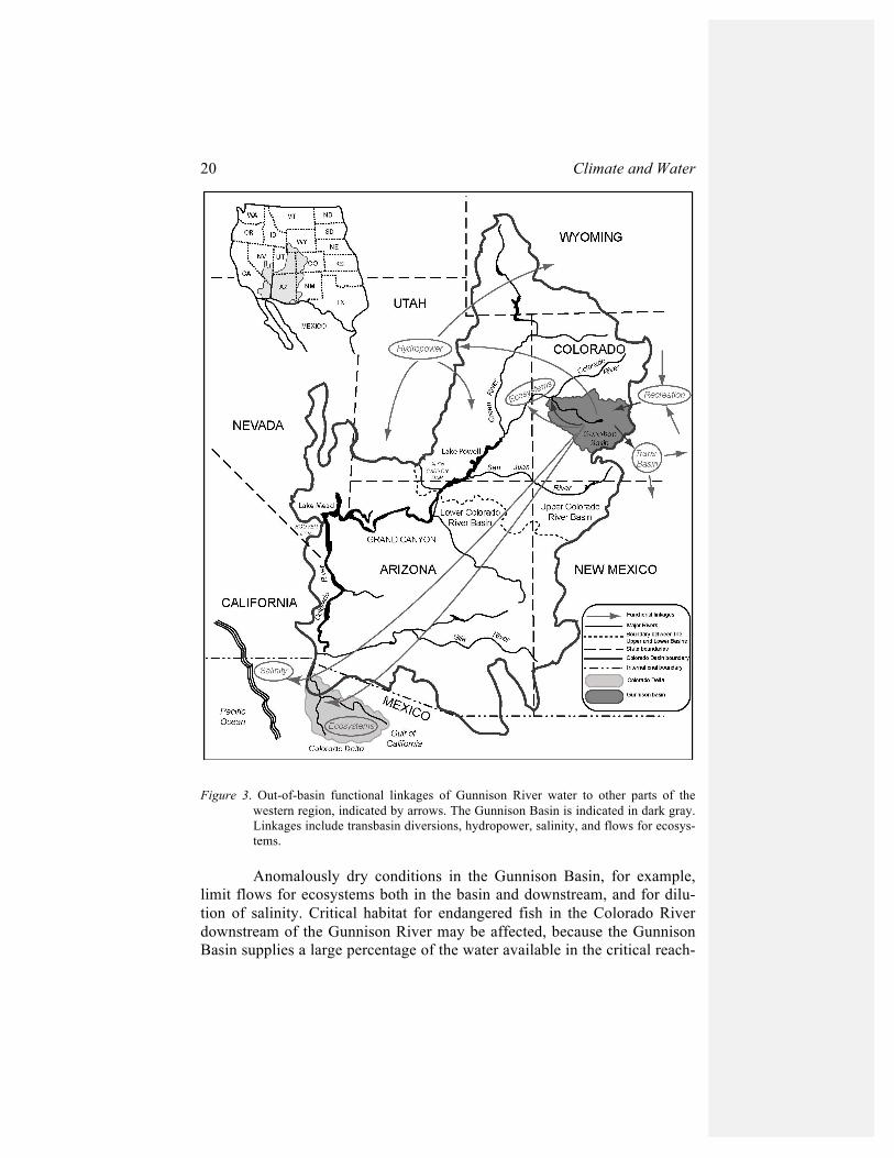
ter, and climate variability may intensify and exacerbate these functional linkages. Linkages (Fig. 3) include transbasin diversions to the Arkansas and Rio Grande Basins; hydropower that is primarily exported elsewhere in the intermountain West and to the desert Southwest and upper Great Plains; and salinity in Mexico. Ecosystem sustainability linkages include flows for critical habitats in the Lower Gunnison Basin and the Colorado River above Lake Powell, and flows for the Colorado Delta in Mexico. There is a poten-tial to use climate forecasts in the management of these functional linkages.
20 Climate and Water
Figure 3. Out-of-basin functional linkages of Gunnison River water to other parts of the
western region, indicated by arrows. The Gunnison Basin is indicated in dark gray. Linkages include transbasin diversions, hydropower, salinity, and flows for ecosys-tems.
Anomalously dry conditions in the Gunnison Basin, for example,
limit flows for ecosystems both in the basin and downstream, and for dilu-tion of salinity. Critical habitat for endangered fish in the Colorado River downstream of the Gunnison River may be affected, because the Gunnison Basin supplies a large percentage of the water available in the critical reach-
Reservoir Management in the Interior West 21
es of the Colorado River upstream of the confluence of the Colorado and the Green Rivers. The Aspinall Unit also accounts for most of the storage above this confluence, and the only storage, that can provide flows to the Black Canyon. With respect to salinity, there is less dilution of dissolved minerals during low-flow periods, and the salinity problem is exacerbated by in-creased irrigation in response to drier conditions, which flushes more miner-als from the soils. The potential to generate hydropower also is limited in dry periods. Advance warning, one to three seasons in advance, of a dry winter or a hot, high water demand summer, could enable reservoir man-agement decisions to maximize the potential flows for ecosystems, in par-ticular to save water for late summer flows. WAPA might also optimize its plans for hydropower generation, including the use of other power genera-tion methods. On the other hand, anomalously wet conditions in the Gun-nison Basin create an opportunity to meet wet year flow recommendations for downstream ecosystems, as well as the Black Canyon and critical habitat reaches. Efficiencies in water management here also could provide water for the Colorado Delta ecosystem in Mexico, if it is protected as it flows down-stream (Getches 2002). Forecasts of anomalously wet conditions in the basin could facilitate planning and agreements to take advantage of this opportuni-ty.
Dry conditions and shortages in one or more of the places receiving benefits of the water create higher demands on the Gunnison Basin. Dry conditions in the Southwest are associated with La Niña, and may increase the Lower Basin demand for water and hydropower, especially when reser-voirs are low in other parts of the West. This situation occurred in the sum-mer of 2000 (USBR Western Colorado Area Office, April 2001). Again, advance warning of anomalous conditions could allow for coordinated water resource planning across the Gunnison and Colorado Basins and the West, in order to optimize use of water for ecosystems and hydropower while still meeting contracts and obligations.
Shortages in both external areas receiving benefits of Gunnison Ba-sin water and in the Gunnison Basin itself will intensify demands for the basin’s water. This situation is less likely than situations in which the Gun-nison Basin has an anomaly of opposite sign from other areas, such as the Lower Colorado Basin, because the ENSO signal varies across the basin. Transbasin diversions may also interact with climate variability: A specific diversion volume represents a larger proportion of natural flows during a dry year, exacerbating downstream effects of shortages. The Union Park pro-posal planned to store water for diversion only in wet years. This strategy would lower flows in the Gunnison Basin in wet years, creating higher salin-ity, less water for hydropower, and less water for ecosystems in wet years.
22 Climate and Water
5. CONCLUSIONS
Two trends in water management in the Gunnison Basin are increas-ing the sensitivity of water resources management in the basin, and reservoir management in particular, to climate variability. These trends are intensifi-cation of water use within the basin, in particular for environmental purpos-es, and the increasing importance of functional linkages of the basin’s water to other places. Both trends affect sensitivity to climate variability because there is less capacity to absorb shortages.
Two critical water problems within the Gunnison Basin require changes in operation of the reservoirs: the RIP 2000 flow recommendations and the federal reserved right for water for the Black Canyon of the Gun-nison. Reservoir operations rules can be a constraint to the use of climate information (Pulwarty and Redmond 1997), but a change in operations can become an opportunity to try new tools and procedures. Analysis of the res-ervoir operations decision calendar reveals points at which climate infor-mation, if available, might improve the efficiency of reservoir management as well as mitigate sensitivity to variability. The NPS and the USFWS might ultimately benefit from climate information if it assists them in meeting their environmental restoration goals; the USBR and its stakeholders may benefit if reservoir management is improved with less conflict among stakeholders.
Several water issues functionally link the Gunnison Basin to other areas in the West. These include production of hydropower marketed around the West; export of salinity that is a water quality problem downstream; de-mand for transmountain diversion of water by users in the Front Range of Colorado; and water for downstream ecosystems. These issues all interact with climate variability. In addition to the effects of in-basin climate anoma-lies on water management within the basin, three types of external climate interactions are possible: (1) Dry climate conditions and related water short-ages within the Gunnison Basin limit export of hydropower, water dilution of salinity, and downstream flows for ecosystems; (2) dry conditions and shortages in one or more of the places receiving the benefits of the Gunnison Basin’s water create higher demands on the basin, such as demands for res-ervoir releases to produce hydropower; and (3) shortages in both the Gun-nison Basin and the areas receiving benefits of its water intensifies demands on the Gunnison Basin.
Climate information and forecasts have the potential to minimize the negative impacts of these anomalies. Because the influence of ENSO varies across the Colorado Basin, and other regions that receive the flows that arise in this basin, there are likely to be many years in which there are opposite anomalies in the Upper and Lower Colorado Basins, and between
Reservoir Management in the Interior West 23
these areas and other parts of the West. The differences in the anomalies provide opportunities to plan to use water for its maximum benefit across the basin. Forecasts of climate conditions one or more seasons in advance have the potential to improve reservoir management within the basin and also to reduce conflicts as uses of water increase across the West. Seasonal forecasts, and the spatial variability of climate impacts, might be taken into account in order to better manage water across the Colorado Basin as a whole, taking advantage of advance warning of wet or dry conditions in dif-ferent parts of the basin. By recognizing how water resource management in this basin is linked to resource use in other areas, it may be possible to de-velop strategies that maximize the benefits across a larger scale.
Climate variability, in its temporal and spatial dimensions, affects reservoir management, and thus affects the environmental sustainability goals related to that management. This analysis illustrates that there is po-tential for reservoir management to take advantage of climate information to intensively manage water to meet expanding operational goals.
Acknowledgements: Support for this project was provided by
NOAA-OAR funding to the Climate Diagnostics Center. Thanks to Coll Stanton of the U.S. Bureau of Reclamation Western Colorado Area Office for data on the Aspinall Unit. This paper benefited greatly from discussions with James L. Wescoat, Jr. Robert Webb, Douglas Kenney, Barbara More-house, and Henry Diaz provided helpful comments on the manuscript. Bar-bara Deluisi of CDC created Figure 3 and provided other technical assis-tance with the manuscript. 6. REFERENCES Board of County Commissioners of County of Arapahoe v. Crystal Creek Homeowners' As-
sociation, 14 P.3d 325-352 (Colo. 2000). Cayan, D.R., K.T. Redmond, and L.G. Riddle. 1999. ENSO and hydrologic extremes in the
western United States. Journal of Climate. 12: 2881–2893. Clark, M.P., M.C. Serreze, and G.J. McCabe. 2001. Historical effects of El Niño and La Niña
events on the seasonal evolution of the montane snowpack in the Columbia and Colorado River basins. Water Resources Research 37: 741–757.Colorado Water Conservation Board 2000. Interstate water allocation. Available at: www.cwcb.state.co.us
Curry, K.E., and J.H. McClow. 2001. Transbasin diversions: A view from the basin of origin: Proceedings of the Conference on Transbasin Water Transfers, U.S. Committee on Drainage and Irrigation, Denver, Colorado, June 27–30, 2001.
Getches, D.H. 1997. Water Law in a Nutshell. St. Paul, Minnesota: West Publishing Co., 456 pp.

24 Climate and Water
Getches, D.H. 2002. Impacts in Mexico of Colorado River management in the United States: A history of neglect, a future of uncertainty. In, Diaz, H.F., and B.J. Morehouse (eds.), Climate and Water: Transboundary Challenges in the Americas. (This vol-ume.)
Hundley, N., 1975. Water and the West: the Colorado River Compact and the politics of water in the American West. University of California Press, Berkeley. 375 pp.
, L.K., 1994. A task analysis approach to the visualization of geographic data. Dissertation,
University of Colorado, Boulder, CO, 376 pp. MacDonnell, L.J. 1999. From Reclamation to Sustainability: Water, Agriculture, and the
Environment in the American West. Niwot, Colorado: University Press of Colora-do, 385 pp.
MacDonnell, L., 1996. The Upper Colorado Basin, Colorado. In: Natural Resources Law Center (Editor), Restoring the West's waters: Opportunities for the Bureau of Rec-lamation. Univ. of Colorado School of Law, Boulder, CO, pp. 5-1 to 5-55.
McCabe, G.J.Jr. 1994. Relationships between atmospheric circulation and snowpack in the Gunnison River basin, Colorado. Journal of Hydrology 157: 157–175.
Nichols, P.D., M.K. Murphy, and D.S. Kenney. 2001. Water and growth in Colorado: A re-view of legal and policy issues. Boulder, Colorado: University of Colorado School of Law, Natural Resources Law Center, 191 pp.
Pitlick, J. and VanSteeter, M.M., 1998. Geomorphology and endangered fish habitats of the upper Colorado River, 2, Linking sediment transport to habitat maintenance. Water Resources Research, 34(2): 303-316.
Pontius, D. 1997. Colorado River Basin Study: Report to the Western Water Policy Review Advisory Commission, Tucson, Arizona, SWCA, Inc, Environmental Consultants, p. 127.
Pulwarty, R.S., and T.S. Melis. 2001. Climate extremes and adaptive management on the Colorado River: Lessons from the 1997–98 ENSO event. Journal of Environmental Management 63: 304–324.
Pulwarty, R.S. and Redmond, K.T., 1997. Climate and Salmon Restoration in the Columbia River Basin: the role and useability of seasonal forecasts. Bulletin of the American Meterological Society, 78(3): 381-397.
Ray, A.J., 2002. Climate, institutions, and resources: The new story of multi-purpose reser-voir management in the Gunnison Basin, Colorado. Dissertation, University of Colorado, Boulder, CO, in preparation.
Ray, A.J. 2000. Climate and water management in the Interior West: A critical water prob-lems approach. Proceedings of the 16th Annual Pacific Climate Workshop on Cli-mate Variability of the Eastern North Pacific and Western North America (PACLIM), pp. 171–182.
Riebsame, W.E., 1990. Anthropogenic climate change and a new paradigm of natural re-source planning. Professional Geographer 42: 1-12.
Schieldt, W. 1999. U.S. Park Service Proposal for Quantification of Federal Reserved Rights in Black Canyon National Monument, Colorado Stream Lines, accessed online, August 21, 2001, water.state.co.us./streamlines/parkservice991.htm.
Serreze, M.C., M.P. Clark, and A. Frei. 2001. Characteristics of large snowfall events in the montane western United States as examined using snowpack telemetry (SNOTEL) data. Water Resources Research 37: 675–688.
Smith, G.R. and M. Wilson, 1999. Upper Colorado River Recovery Implementation Program Coordinated Reservoir Operations Program, Proceedings of the American Water Resources Association Annual Meeting, Seattle WA.
U.S. Bureau of Reclamation (USBR). 2001. Project Dataweb. Dataweb.usbr.gov.

Reservoir Management in the Interior West 25
U.S. Bureau of Reclamation (USBR), Western Colorado Area Office. 1993–2002. Minutes of the Aspinall Unit Coordination Meeting, 1993–2002. Available from the USBR Western Colorado Area Office, Grand Junction, Colorado
U.S. Bureau of Reclamation (USBR), Western Colorado Area Office. 1999. Data on Aspinall Unit inflows, personal communication.
U.S. Department of Justice. 2001. Concerning the Application of the United States of Amer-ica to make Absolute a Conditional Water Right, Case No. 01CW005
U.S. Fish and Wildlife Service (USFWS). 1999. Recovery implementation program for en-dangered species in the Upper Colorado River basin. Denver, Colorado: U.S. Fish and Wildlife Service, 52 pp.
U.S. Fish and Wildlife Service (USFWS). 2000. Flow recommendations to benefit endan-gered fish species in the Colorado and Gunnison Rivers. Draft Final Report. Grand Junction, Colorado: U.S. Fish and Wildlife Service.
U.S. Geological Survey (USGS). 1985. Estimated Use of Water in Colorado, 1985, Water-Resources Investigation Report 88-4101.
Upper Gunnison River Water Conservancy District. 2001. The Upper Gunnison River Water Conservancy District: Its historical perspective, accomplishments, the future., 18 pp.
Wescoat, J.L.J. 1991. Managing the Indus River basin in light of climate change: Four con-ceptual approaches. Global Environmental Change, December 1991: 381–395.
Western Area Power Administration (WAPA). 2001. Annual Operations Report, 2000. (Available on www.wapa.gov)
White, G.F. 1961. The choice of use in resource management. Natural Resources Journal 1: 23–40. Reprinted in Kates, R., and I. Burton (eds.). 1986. Geography, Resources and Environment. Chicago, Illinois: University of Chicago Press, pp. 143–165.
Wolter, K., R.M. Dole, and C.A. Smith. 1999. Short-term climate extremes over the conti-nental United States and ENSO: Part I: Seasonal temperatures. Journal of Climate 12: 3255–3272.
Zagona, E.A., T.J. Fulp, R. Shane, T. Magee, and H.M. Goranflo. 2001. RiverWare: A gener-alized tool for complex reservoir system modeling. Journal of the American Water Resources Association, 37: 913-929.