RESEARCH Open Access Natural-focal diseases: mapping ...
9
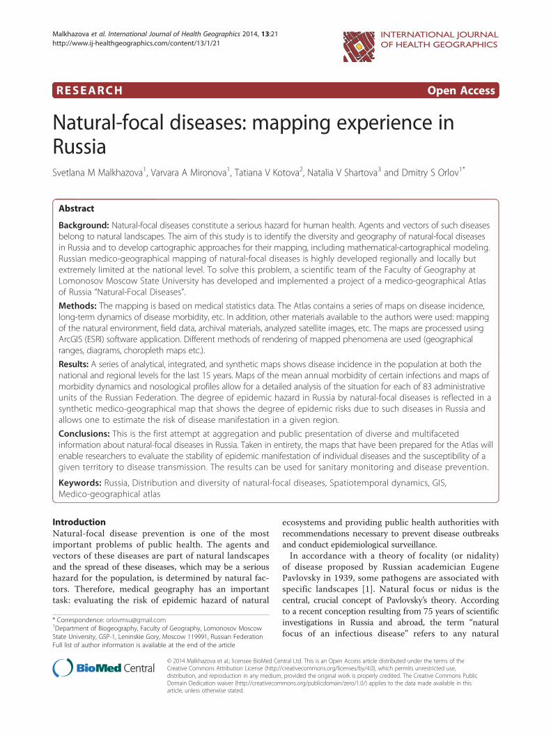
RESEARCH Open Access Natural-focal diseases: mapping experience in Russia Svetlana M Malkhazova 1 , Varvara A Mironova 1 , Tatiana V Kotova 2 , Natalia V Shartova 3 and Dmitry S Orlov 1* Abstract Background: Natural-focal diseases constitute a serious hazard for human health. Agents and vectors of such diseases belong to natural landscapes. The aim of this study is to identify the diversity and geography of natural-focal diseases in Russia and to develop cartographic approaches for their mapping, including mathematical-cartographical modeling. Russian medico-geographical mapping of natural-focal diseases is highly developed regionally and locally but extremely limited at the national level. To solve this problem, a scientific team of the Faculty of Geography at Lomonosov Moscow State University has developed and implemented a project of a medico-geographical Atlas of Russia “Natural-Focal Diseases”. Methods: The mapping is based on medical statistics data. The Atlas contains a series of maps on disease incidence, long-term dynamics of disease morbidity, etc. In addition, other materials available to the authors were used: mapping of the natural environment, field data, archival materials, analyzed satellite images, etc. The maps are processed using ArcGIS (ESRI) software application. Different methods of rendering of mapped phenomena are used (geographical ranges, diagrams, choropleth maps etc.). Results: A series of analytical, integrated, and synthetic maps shows disease incidence in the population at both the national and regional levels for the last 15 years. Maps of the mean annual morbidity of certain infections and maps of morbidity dynamics and nosological profiles allow for a detailed analysis of the situation for each of 83 administrative units of the Russian Federation. The degree of epidemic hazard in Russia by natural-focal diseases is reflected in a synthetic medico-geographical map that shows the degree of epidemic risks due to such diseases in Russia and allows one to estimate the risk of disease manifestation in a given region. Conclusions: This is the first attempt at aggregation and public presentation of diverse and multifaceted information about natural-focal diseases in Russia. Taken in entirety, the maps that have been prepared for the Atlas will enable researchers to evaluate the stability of epidemic manifestation of individual diseases and the susceptibility of a given territory to disease transmission. The results can be used for sanitary monitoring and disease prevention. Keywords: Russia, Distribution and diversity of natural-focal diseases, Spatiotemporal dynamics, GIS, Medico-geographical atlas Introduction Natural-focal disease prevention is one of the most important problems of public health. The agents and vectors of these diseases are part of natural landscapes and the spread of these diseases, which may be a serious hazard for the population, is determined by natural fac- tors. Therefore, medical geography has an important task: evaluating the risk of epidemic hazard of natural ecosystems and providing public health authorities with recommendations necessary to prevent disease outbreaks and conduct epidemiological surveillance. In accordance with a theory of focality (or nidality) of disease proposed by Russian academician Eugene Pavlovsky in 1939, some pathogens are associated with specific landscapes [1]. Natural focus or nidus is the central, crucial concept of Pavlovsky’ s theory. According to a recent conception resulting from 75 years of scientific investigations in Russia and abroad, the term “natural focus of an infectious disease” refers to any natural * Correspondence: [email protected] 1 Department of Biogeography, Faculty of Geography, Lomonosov Moscow State University, GSP-1, Leninskie Gory, Moscow 119991, Russian Federation Full list of author information is available at the end of the article INTERNATIONAL JOURNAL OF HEALTH GEOGRAPHICS © 2014 Malkhazova et al.; licensee BioMed Central Ltd. This is an Open Access article distributed under the terms of the Creative Commons Attribution License (http://creativecommons.org/licenses/by/4.0), which permits unrestricted use, distribution, and reproduction in any medium, provided the original work is properly credited. The Creative Commons Public Domain Dedication waiver (http://creativecommons.org/publicdomain/zero/1.0/) applies to the data made available in this article, unless otherwise stated. Malkhazova et al. International Journal of Health Geographics 2014, 13:21 http://www.ij-healthgeographics.com/content/13/1/21
Transcript of RESEARCH Open Access Natural-focal diseases: mapping ...
INTERNATIONAL JOURNAL OF HEALTH GEOGRAPHICS
Malkhazova et al. International Journal of Health Geographics 2014, 13:21http://www.ij-healthgeographics.com/content/13/1/21
RESEARCH Open Access
Natural-focal diseases: mapping experience inRussiaSvetlana M Malkhazova1, Varvara A Mironova1, Tatiana V Kotova2, Natalia V Shartova3 and Dmitry S Orlov1*
Abstract
Background: Natural-focal diseases constitute a serious hazard for human health. Agents and vectors of such diseasesbelong to natural landscapes. The aim of this study is to identify the diversity and geography of natural-focal diseasesin Russia and to develop cartographic approaches for their mapping, including mathematical-cartographical modeling.Russian medico-geographical mapping of natural-focal diseases is highly developed regionally and locally butextremely limited at the national level. To solve this problem, a scientific team of the Faculty of Geography atLomonosov Moscow State University has developed and implemented a project of a medico-geographical Atlasof Russia “Natural-Focal Diseases”.
Methods: The mapping is based on medical statistics data. The Atlas contains a series of maps on disease incidence,long-term dynamics of disease morbidity, etc. In addition, other materials available to the authors were used: mappingof the natural environment, field data, archival materials, analyzed satellite images, etc. The maps are processed usingArcGIS (ESRI) software application. Different methods of rendering of mapped phenomena are used (geographicalranges, diagrams, choropleth maps etc.).
Results: A series of analytical, integrated, and synthetic maps shows disease incidence in the population at both thenational and regional levels for the last 15 years. Maps of the mean annual morbidity of certain infections and maps ofmorbidity dynamics and nosological profiles allow for a detailed analysis of the situation for each of 83 administrativeunits of the Russian Federation. The degree of epidemic hazard in Russia by natural-focal diseases is reflected in asynthetic medico-geographical map that shows the degree of epidemic risks due to such diseases in Russia andallows one to estimate the risk of disease manifestation in a given region.
Conclusions: This is the first attempt at aggregation and public presentation of diverse and multifacetedinformation about natural-focal diseases in Russia. Taken in entirety, the maps that have been prepared for the Atlas willenable researchers to evaluate the stability of epidemic manifestation of individual diseases and the susceptibility of agiven territory to disease transmission. The results can be used for sanitary monitoring and disease prevention.
Keywords: Russia, Distribution and diversity of natural-focal diseases, Spatiotemporal dynamics, GIS,Medico-geographical atlas
IntroductionNatural-focal disease prevention is one of the mostimportant problems of public health. The agents andvectors of these diseases are part of natural landscapesand the spread of these diseases, which may be a serioushazard for the population, is determined by natural fac-tors. Therefore, medical geography has an importanttask: evaluating the risk of epidemic hazard of natural
* Correspondence: [email protected] of Biogeography, Faculty of Geography, Lomonosov MoscowState University, GSP-1, Leninskie Gory, Moscow 119991, Russian FederationFull list of author information is available at the end of the article
© 2014 Malkhazova et al.; licensee BioMed CeCreative Commons Attribution License (http:/distribution, and reproduction in any mediumDomain Dedication waiver (http://creativecomarticle, unless otherwise stated.
ecosystems and providing public health authorities withrecommendations necessary to prevent disease outbreaksand conduct epidemiological surveillance.In accordance with a theory of focality (or nidality)
of disease proposed by Russian academician EugenePavlovsky in 1939, some pathogens are associated withspecific landscapes [1]. Natural focus or nidus is thecentral, crucial concept of Pavlovsky’s theory. Accordingto a recent conception resulting from 75 years of scientificinvestigations in Russia and abroad, the term “naturalfocus of an infectious disease” refers to any natural
ntral Ltd. This is an Open Access article distributed under the terms of the/creativecommons.org/licenses/by/4.0), which permits unrestricted use,, provided the original work is properly credited. The Creative Commons Publicmons.org/publicdomain/zero/1.0/) applies to the data made available in this

Malkhazova et al. International Journal of Health Geographics 2014, 13:21 Page 2 of 9http://www.ij-healthgeographics.com/content/13/1/21
ecosystem in which a pathogen population is an essentialcomponent [2]. The determinant feature of natural-focaldisease is that the pathogen of such a disease circulates inthe nature independently of human presence. As a rule,the humans became infected when they get into the focusand contact the infectious vector or, in some cases, thereservoir host [3].In Pavlovsky’s original theory, based on tick-borne
pathogens in Russia, the focus of infection containsthree critical elements: vectors, vertebrate hosts, andsusceptible recipient hosts such as humans or animals.Nowadays, the natural focality has been proved also fornon-vector-borne zoonoses such as hemorrhagic feverwith renal syndrome, leptospirosis, etc. Finally, naturalfocality for a large group of sapronotic infections, whoseagents live in soil or aquatic ecosystems, has also beensubstantiated. For some vector-borne anthroponoses theconcept of a focus (nidus) may be implemented as well.So, the phenomenon of natural focality is widespread,and there are a lot of natural-focal diseases with differ-ent types of transmission.In the past two decades views on the diversity, spread,
and epidemic significance of infections with naturalfocality have changed substantially all over the world.Some new pathogens have been discovered and periodicepizootic and epidemic manifestations of natural foci havebecome a matter of great concern. Morbidity due to somenatural-focal diseases such as tick-borne encephalitis andixodid tick-borne borreliosis (the Palaearctic analog ofLyme disease that is widespread in the North America), aswell as some helminthoses with natural focality, such asopisthorchiasis, remains high in the Russian Federation.Therefore, we deal with a broad range of natural-focal
diseases that may harm the population and visitors ofdifferent regions of Russia.In recent decades, increasing human activities (e.g.,
intensive suburban construction around big cities, expan-sion and growth of recreational pressure) have led to asignificant increase in contact between the populationand the natural foci and in favorable epidemiologicalconditions for the spread of natural-focal diseases [4,5].This paper examines the experience of medico-geo-
graphical research in the area of natural-focal diseasesin Russia and presents the opportunities given by themapping method for the assessment and monitoring ofthe epidemiological situation with respect to a numberof dangerous diseases.Despite the increased attention to this issue in the past
decade [6-13], many research questions pertaining to nat-ural-focal diseases remain unanswered. Development of theprinciples and methods of synthesizing medico-geographicalinformation and obtaining new knowledge about thespatial distribution patterns of natural-focal diseases usingnew approaches remain primary research interests.
One important aspect of such studies is atlas mapping,which combines general scientific methods (integrated,historical, etc.) and specific (statistical, landscape, medico-geographical, etc.) approaches with geographical informa-tion technologies [14-18].Currently, a considerable amount of different medico-
geographical atlases have been published around the world.Some of them exist in a print version, others are availableonline, and they cover a vast range of topics – from generalcharacteristics of the current distribution and determinantsof major human infectious diseases [7,19] to regional atlases[20,21] or atlases that focus on particular diseases (malaria,plague, helminth diseases etc.) [6,22,23]. These publicationsaim to disseminate up-to-date information on some ofthe most important diseases all over the world. Someatlases reflect the epidemiological situation in contextof environmental factors (e.g., WHO/WMO “The Atlas ofhealth and climate” [24], which is a product of collaborationbetween meteorological and public health communities,provides sound scientific information on the connectionsbetween weather, climate and major health challenges).The experience of Soviet and Russian medico-geo-
graphical mapping is also rather extensive. The scientificand methodological basis of medico-geographical mappingthat uses the landscape approach, methods of mathematicalstatistics, multivariable analysis, interconnected mappingstudies, and synthesis of the information is well developed[25-27]. However, the scientific-methodological and prac-tical experience of the national medico-geographical map-ping, in particular, mapping of natural-focal diseases issignificant in the field of regional and local mapping onlybut is extremely limited in the mapping at the nationallevel. Differences in quality and incompleteness of initial in-formation and the use of different methodological mappingapproaches make it difficult to obtain a complete picture ofthe distribution of natural-focal diseases within the territoryof the Russian Federation. A cartographic summary show-ing the geography of natural-focal diseases for Russia as awhole is still lacking.The first and the only general map of natural-focal dis-
eases for the territory of the former Soviet Union at a1:25,000,000 scale was published in 1964 [25]. That mapwas very informative for its time and eminently reflectedthe existing situation, although the geography of natural-focal diseases was under-explored, and some natural-focalinfections hadn’t been discovered. At present, accountingfor availability of information about new diseases andsignificant changes of the environment that occurredduring the last fifty years, this map doesn’t reflect theactual situation. Thus, it is currently necessary to con-duct a new cartographic study on natural-focal diseasesin Russia. Without development of maps that reflectthe situation for the entire Russian territory, it is im-possible to provide informational support for sound

Malkhazova et al. International Journal of Health Geographics 2014, 13:21 Page 3 of 9http://www.ij-healthgeographics.com/content/13/1/21
monitoring of the epidemiological situation in the countryand its regions.The results of such a study can be presented as an
atlas information system both in print and in GIS. Forsuch a vast country as Russia, which contains a wide rangeof natural zones, from tundras in the north to deserts inthe south, this sort of a multilevel system may provide anidea of the current situation and serve as a useful modelfor the development of similar geoinformation systems forother areas.Considering the importance of the problem, a team of
researchers at the Faculty of Geography of LomonosovMoscow State University (Russia) has developed a med-ico-geographical Atlas of Russia “Natural-Focal Diseases”[28-30].
The conceptual design and structure of the AtlasThe Atlas was developed in accordance with the followingprinciples of medico-geographical research:
� each natural ecosystem has its own specific “set” ofnatural preconditions of human diseases, i.e., eachlandscape has its own typical parasitogenic systemsformed in specific environmental conditions;
� the incidence natural-focal diseases are closelyconnected with the existing natural, socioeconomic,and demographic characteristics of the territory;
� identification of causal relationships between thenosological situation (potential risk) of theenvironment and public health and their appropriaterepresentation is possible only with a systematicapproach;
� natural-focal diseases and geographicalpreconditions of diseases are dynamic structuresgoverned by the laws of geosystem evolutionarydevelopment and the characteristics of economicdevelopment of territories; adequacy of theirmapping can be achieved only when consideringdynamic changes of the studied phenomena;
� the general character of cartographic data assumesthe use of extrapolation and analogy methods inanalysis and synthesis of spatial information at thenational level.
The Atlas structure is a combination of cartographic,textual, and graphic information, photographs, and analyt-ical data. The spatial distribution of natural-focal diseasesis considered at different hierarchic levels. The Atlas hasseven thematic blocks and more than 100 maps.The Introductory section covers the theory of natural-
focal infections and invasions as a complex set of inter-dependent populations of pathogens, animal hosts andarthropod vectors that represent a biological componentorganically bound with natural territorial complexes.
The Natural conditions block comprehensively describesthe characteristics and current conditions of the naturalenvironment that influence the formation and functioningof the parasitogenic disease systems (agent–vector–host)in the territory of the Russian Federation.The Demographic and socioeconomic conditions block
includes maps on the patterns of the population distri-bution within the Russian territory and on its demographicindices and is intended to identify specific territorialfeatures of the population structure and to treat thepopulation as a component associated with the epidemio-logical risk of the territory.The Natural hosts and vectors of natural-focal dis-
eases block contains the maps of geographic ranges ofanimals - potential hosts of infections.The Geographic ranges of natural-focal diseases block
contains important maps of the distribution ranges ofnatural-focal infections and with synthetic maps ofmedico-geographical assessment of the risk associatedwith natural-focal diseases in the territory of Russia.The Disease morbidity block contains maps based on
the official statistics that can be easily updated as newinformation becomes available, showing the average long-term incidence of certain natural-focal infections and itsmultiannual dynamics.The Organization of public health system block reflects
the spatial structure of public health service in Russia.
Data and methodsThe background data for the Atlas included FederalState Statistics Service statistics on socioeconomic indi-cators and the data of the Federal Service on Customers’Rights Protection and Human Well-Being Surveillance;these sources contain statistical data on disease incidencein the population (for infectious and parasitic diseases).In addition, the Atlas used other materials available tothe authors: natural environment mapping; previouslycompiled maps of the federal and regional atlases; fielddata and archival material; and the results of satelliteimage interpretation.The scope of work included the following steps: 1)
preparation, update, and analysis of the database on infec-tious and parasitic natural-focal diseases; 2) developmentof a series of maps, including the compilation of analytical(inventory) maps and of integrated and synthetic (assess-ment) maps; 3) a detailed cartographical study of selectedkey regions; and 4) medico-geographical analysis based onthe compiled maps.Taking into account the significance of particular diseases
and availability of statistical data, 22 nosological units wereselected for mapping: anthrax, brucellosis, hemorrhagicfever with renal syndrome (HFRS), legionellosis, leptospir-osis, ornithosis, pseudotuberculosis, Q fever, rabies, tetanus,tick-borne borreliosis, tick-borne encephalitis, tick-borne
Malkhazova et al. International Journal of Health Geographics 2014, 13:21 Page 4 of 9http://www.ij-healthgeographics.com/content/13/1/21
rickettsiosis of North Asia, tularemia, beef tapeworm infec-tion, diphyllobothriasis, echinococcosis, opisthorchiasis,taeniasis, toxocariasis, trichinosis, and trichuriasis.Based on statistical data from 1997–2012, a database
containing the information for all 83 administrative unitsof Russia was created. The level of detail of the input dataallowed the researcher to use the administrative divisionsof the Russian Federation (republics, autonomous districts,territories, districts, and cities of federal significance) asthe basic mapping units. The structure of the thematicdatabase was designed to allow for a timely update of theexisting tables with the data on new research objects atdifferent administrative-territorial levels. The developedspatial database (including map compilation, rendering,editing, analysis, etc.) utilizes ArcGIS (ESRI) software.The Atlas uses different methods of mapped phenomenarendering: geographical ranges, diagrams (for absoluteindices), choropleth maps (for relative indices – numberof cases per 100.000 populations), etc.The inventory maps on the long-time average annual
morbidity utilize choropleth and diagram methods torepresent relative and absolute indices for each adminis-trative unit for a specific period of time. These mapsshow the level of disease incidence for a given period Anexample is shown in Figure 1. With their help, one canevaluate the general characteristics of a specific diseasein a particular area, identify the most affected regions,and improve the understanding of the natural confined-ness of the endemic territories. These maps can also beeasily updated with new temporal data. A graded scalewas applied to all the inventory maps, the grades beingthe same for each represented parameter within theanalyzed period of time. Almost all maps of the Atlasintegrate different representations of several parameters.This technique of data presentation allows for an analysisof the acuity of sanitary-epidemiological situation withinthe territory under study.A typological classification of disease dynamics was
conducted based on the analysis of morbidity indicatorsfor 1997–2010. The results of this analysis are reflectedin a map of the typological classification of dynamicsof population morbidity in the Russian Federation.The map shows different types of taxons obtainedfrom calculated indices; each type has its standardpattern of population morbidity dynamics for a givenperiod (decrease, increase, fluctuations with high orlow amplitudes - five taxons in total). The diseasedynamics graphics are given in the legend. The mapallows for an assessment of the level of stability ofepidemiological manifestations of natural foci for thefive most important natural-focal diseases of Russia:tick-borne encephalitis, tick-borne borreliosis, hemor-rhagic fever with renal syndrome, tick-borne diphyllo-bothriasis, and opisthorchiasis.
A new ring cartogram method was used to show thelevels of disease morbidity in different federal adminis-trative units. On the basis of cartographic modeling, alladministrative units were divided into 4 estimate groups(low, medium, high and very high) in accordance with anaverage disease morbidity level from 1997 to 2012. Thesegroups were arranged in the form of a ring cartogram thatallows one to assess the role of a certain infection in agiven region and identify vulnerable territories. Anexample is shown in Figure 2.On the basis of the inventory maps, the map “Noso-
logical Profiles” was prepared (Figure 3). The map showsthe combinations of specific natural-focal diseases in theadministrative divisions, which are presented in the formof a matrix that shows the presence or absence of a diseasein the population for each year in a given period. Thematrices are arranged vertically and horizontally bynosological units (diseases) and year, respectively. Themap provides a composite picture of the spatial-temporarydistribution of natural-focal disease in administrative unitswithout an indication of incidence levels.The Atlas contains medico-geographical maps for key
regions related to several diseases, which were preparedusing original data by the authors. Thus, the maps forthe Moscow Region were built on the formal territorialclassification with reference of the information to adegree-grid (5 × 5 km). This method was used for otherregions to represent disease incidence, occurrence ofpathogens, and distribution of potentially dangeroussites, such as anthrax animal burial sites. The authorsalso compiled regional maps on the nosological rangesof HFRS, leptospirosis and tularemia.The primary scales of the maps for the territory of
Russia are 1:20,000,000 and 1:30,000,000, and 1:4,000,000and 1:10,000,000 for the maps of individual regions.
Results and discussionTo illustrate the opportunities of the atlas let us considerixodid tick-borne borrelosis as one of the most importantnatural-focal diseases in Russia. A considerable part ofworld’s areal of this disease lies within the Russain ter-ritory. Accounting for the number of cases tick-borneborrelosis constitutes one of the major natural-focalinfections.A series of maps of disease morbidity that was developed
allows us to comprehensively analyze of the epidemiologicalsituation.The inventory map of mean annual morbidity encom-
passes 73 administrative units where this disease wasregistered (Figure 1). Autochtonous cases were not reg-istered in nine, mostly southern, administrative units:Northern Caucasus, Saratov, Astrakhan and Rostovregions, as well as in one north-eastern unit, namely

Figure 1 Morbidity of tick-borne borreliosis (a map fragment of Russian Federation). The map of the mean annual tick-borne borreliosismorbidity were compiled using the cartogram method and reflect the relative and absolute values for each administrative unit.
Malkhazova et al. International Journal of Health Geographics 2014, 13:21 Page 5 of 9http://www.ij-healthgeographics.com/content/13/1/21
Chukotka district. The map shows that morbidity variesfrom 0,02 (Krasnodar krai) to 42,0 (Tomsk oblast) per100 000 population.
In general, from 1997 to 2010 the morbidity index hasan undulating character with minimums in 1997 and2004 (approximately 4,5 cases per 100 000 population)

Figure 2 Dynamics of tick-borne borreliosis morbidity (1997–2010). The bars attributed to the particular administrative unit (marked by figuresfrom 1 to 83) reflect the dynamics of tick-borne borreliosis morbidity for a time span of 14years. Coloring of bar divisions reflect relative morbidity levels.
Malkhazova et al. International Journal of Health Geographics 2014, 13:21 Page 6 of 9http://www.ij-healthgeographics.com/content/13/1/21
and peaks in 2003 and 2009 (upward of 6,0 cases per100 000 population).The map of types of dynamics of tick-borne borreliosis
which was created on the basis of an original method oftipology classification, allows us to combine all regionsinto five major categories. The most regions are of thetype with a low morbidity level (less than 1,0 per 100.000)and with a steady mode with virtually constant levelsof annual morbidity. The worst situation is associatedwith latitudes between 52° and 61° N (Udmurt republic,Kostroma, Yaroslavl, Vologda, Kirov and Tomsk regions),where the foci are connected with landscapes of temperatebroadleaf and mixed forests and southern taiga. Thoseregions are marked with a high level of morbidity withdistinctive peaks in several year.
The map of disease dynamics, made as ring cartogram,further defines the dynamics of morbidity for each regionper year (Figure 2).The role of tick-borne borreliosis, or of any other infec-
tion, in the overall natural-focal disease morbidity can beassessed with the help of the “Nosological profiles” map.(Figure 3). Along with that, the “Nosological Profiles” mappresents the characteristics of the distribution of the mostimportant natural-focal diseases at the national level andcan be used to assess the representativeness of the noso-logical units and frequency of the manifestation of certaininfections in different regions. It reflects the most com-mon natural-focal infections in Russia, among which, asthe map’s analysis has shown, the leading role is played bytick-borne borreliosis, leptospirosis, and HFRS, which

Figure 3 (See legend on next page.)
Malkhazova et al. International Journal of Health Geographics 2014, 13:21 Page 7 of 9http://www.ij-healthgeographics.com/content/13/1/21

(See figure on previous page.)Figure 3 Nosological profiles of administrative units (a map fragment of Russian Federation). The map shows the sets of specific natural-focaldiseases inherent in particular administrative units of Russia. The data is presented in the form of a matrix showing the presence or absenceof a disease in the population for each year for a time span of 11years. The matrices are arranged vertically by nosological units (diseases) andhorizontally - by years and they reflect the annual changes in the range of nosoforms in the Russian administrative units.
Malkhazova et al. International Journal of Health Geographics 2014, 13:21 Page 8 of 9http://www.ij-healthgeographics.com/content/13/1/21
occur in most parts of Russia, as well as by tick-borneencephalitis and opisthorchiasis. The map is also remark-able because it reflects the annual changes of the range ofnatural-focal diseases observed on the Russian territory.Mapping the morbidity for such large territorial units as
the federal administrative units of the Russian Federationis a necessary but not sufficient element in the assessmentof natural-focal disease spread. This representation is anepidemiological characterization of the population ratherthan that of specific diseases, whose ranges are deter-mined primarily by the parameters of the environment.The nature of the information on disease incidence in thepopulation at a small scale (i.e., covering a large area) doesnot allow for use of the natural boundaries. In order toovercome this limitation, the maps at the federal levelare supplemented with regional and more detailed mapsthat contain an in depth assessment of the character ofdistribution of the foci and spread of the natural-focal dis-eases in the federal administrative units of the RussianFederation.The maps created for key regions, based on case
localization, allow for a detailed look at the situation.For example, local foci of leptospirosis and tularemiahave been discovered in Moscow region.
ConclusionsThe Atlas of Russia “Natural-Focal Diseases” sums up alarge volume of information on natural-focal diseases inthe Russian Federation as a whole; it is assembled in aformat open to the public. It can be used to assess thelevel of knowledge on some natural-focal diseases inRussia and to identify the regions that require additionaltargeted research efforts.The compiled series of maps in the Atlas allows for:
� a systematization and analysis of the role of naturaland socioeconomic factors in the spread ofnatural-focal infections;
� an identification of the spectrum of the mostdiagnosed natural-focal diseases observed over thepast 15years at the level of the administrative units ofthe Russian Federation and the country as a whole;
� an identification of the most active foci andassessment of their potential danger to humans;
� a quantification of disease morbidity in bothabsolute and relative terms in general and in somemodel regions;
� a forecast of disease incidence based on the types ofdynamics of disease incidence using mathematical-cartographic modeling for the current natural-focaldiseases;
� an identification the most visual ways of cartographicrepresentation of the dynamics of disease incidence;
� carrying out medico-geographical analysis of theterritory of the spread of the basic nosoforms ofnatural-focal diseases in the regions of the RussianFederation and in the territory of Russia as a whole.
Taken together, the maps allow for an assessment ofthe persistence in disease manifestation and the degreeof specific disease spread risk in the territories. Theresults of analysis can be used for health monitoring andfor the development of targeted preventive measures,especially in areas of new economic expansion andareas affected by the recreational load.The ultimate goal of the Atlas is to promote an objective
assessment of the medico-geographical situation in rela-tion to a complex of natural-focal diseases, its control, andscience-based response activities of health authorities inemergency situations in Russia and outside its nationalborders.
Competing interestsThe authors declare that they have no competing interests.
Authors’ contributionsAll authors conceived of the study and participated in the design. All authorscontributed to the writing of, reviewed and approved the final manuscript.
AcknowledgementsThis work was supported by the grants of the Russian Geographical Societyand Russian Foundation for Basic Research (RFBR).
Author details1Department of Biogeography, Faculty of Geography, Lomonosov MoscowState University, GSP-1, Leninskie Gory, Moscow 119991, Russian Federation.2Scientific Laboratory of Complex Mapping, Faculty of Geography,Lomonosov Moscow State University, GSP-1, Leninskie Gory, Moscow 119991,Russian Federation. 3Department of Landscape Geochemistry and SoilGeography, Faculty of Geography, Lomonosov Moscow State University,GSP-1, Leninskie Gory, Moscow 119991, Russian Federation.
Received: 31 March 2014 Accepted: 3 June 2014Published: 14 June 2014
References1. Pavlovsky EN: Fundamentals of the theory of natural focality of
transmissible human diseases. Zh Obshch Biol 1946, 7(1):3–33 (in Russian).2. Korenberg EI: Natural focality of infections: current problems and
prospects of research. Biol Bull 2010, 37(7):665–676.3. Reisen WK: Landscape epidemiology of vector-borne diseases. Annu Rev
Entomol 2010, 55:461–483.
Malkhazova et al. International Journal of Health Geographics 2014, 13:21 Page 9 of 9http://www.ij-healthgeographics.com/content/13/1/21
4. Jaenson TG, Jaenson DG, Eisen L, Petersson E, Lindgren E: Changes in thegeographical distribution and abundance of the tick Ixodes ricinusduring the past 30 years in Sweden. Parasit Vectors 2012, 5:8.
5. Wu XB, Na RH, Wei SS, Zhu JS, Peng HJ: Distribution of tick-borne diseasesin China. Parasit Vectors 2013, 6:119.
6. Sanbao W: The Atlas of Plague and its Environment in the People’s Republic ofChina. Beijing: Science Press; 2000.
7. Cliff A, Hagget P, Rayonor MS: The Atlas of Epidemic Diseases. London:Hodder Arnold; 2004.
8. Gassner F, van Vliet AJ, Burgers SL, Jacobs F, Verbaarschot P, Hovius EK,Mulder S, Verhulst NO, van Overbeek LS, Takken W: Geographic and temporalvariations in population dynamics of Ixodes ricinus and associated Borreliainfectionsin The Netherlands. Vector Borne Zoonotic Dis 2011, 11(5):523–532.
9. Lobato E, Pearce-Duvet J, Staszewski V, Gómez-Díaz E, González-Solís J, Kitaysky A,McCoy KD, Boulinier T: Seabirds and the circulation of Lyme borreliosisbacteria in the North Pacific. Vector Borne Zoonotic Dis 2011, 11:12.
10. Ng V, Sargeant JM: A quantitative and novel approach to theprioritization of zoonotic diseases in North America: a publicperspective. PLoS One 2012, 7:11.
11. Ogden NH, Mechai S, Margos G: Changing geographic ranges of ticksand tick-borne pathogens: drivers, mechanisms and consequences forpathogen diversity. Front Cell Infect Microbiol 2013, 3:46.
12. Mihalca AD, Sandor AD: The role of rodents in the ecology of Ixodesricinus and associated pathogens in Central and Eastern Europe.Front Cell Infect Microbiol 2013, 3:56.
13. Oliveira SV, Escobar LE, Peterson AT, Gurgel-Goncalves R: Potential geographicdistribution of hantavirus reservoirs in Brazil. PLoS One 2013, 8:12.
14. Koch T: Cartographies of Diseases: Maps, Mapping, and Medicine. Redlands:ESRI Press; 2005.
15. Brown T, McLafferty S, Moon G: A companion to health and medicalgeography. Oxford: Wiley-Blackwell Publishing Ltd; 2010.
16. Rais A, Nilofar I: Global Medical Geography: Essays in Honour of Prof. YolaVerhasselt: Rawat Publications; 2010.
17. Barrios JM, Verstraeten WW, Maes P, Aerts JM, Farifteh J, Coppin P: Using thegravity model to estimate the spatial spread of vector-borne diseases.Int J Environ Res Public Health 2012, 9:12.
18. Hay SI, Battle KE, Pigott DM, Smith DL, Moyes CL, Bhatt S, Brownstein JS,Collier N, Myers MF, George DB, Gething PW: Global mapping of infectiousdisease. Philos Trans of Royal Soc 2013, 368:1614.
19. Wertheim HFL, Horby P, Woodall JP: Atlas of Human Infectious Diseases.Oxford: Wiley-Blackwell; 2012.
20. Smallman-Raynor M, Cliff AD: Atlas of epidemic Britain: a twentieth centurypicture. New York: Oxford University Press; 2012.
21. Canadian Environmental Health Atlas. http://www.ehatlas.ca/.22. Malaria Atlas Project. http://www.map.ox.ac.uk/.23. Global atlas of helminth infections. http://www.thiswormyworld.org/maps.24. The Atlas of health and climate. http://www.who.int/globalchange/
publications/atlas/report/en/.25. Vershinsky BV: Mapping of natural-focal diseases in the study of geography
in the USSR. Medical geography Results Prospects 1964, 62–98. in Russian.26. Malkhazova SM: Medical and geographical analysis of areas: mapping,
assessment, forecast. Nauchnyi Myr: Moscow; 2001 (in Russian).27. Malkhazova SM, Alexeev BA: Diversity in the Geography of Natural Endemic
Diseases. In Global Medical Geography. Jaipur: Rawat Publications; 2010:184–198.28. Malkhazova SM, Kotova TV, Mironova VA, Shartova NV, Ryabova NV: Medical-
geographic atlas of Russia “Natural-focal diseases”: the concept and theinitial results. Bulletin of Moscow University Series 5, Geography 2011, 4:16–23.
29. Kotova TV, Malkhazova SM, Orlov DS, Shartova NV: Atlas of natural-focaldiseases: Mapping study for the territory of Russia. Proceedings of the RGS2012, 144(1):16–26 (in Russian).
30. Malkhazova SM, Kotova TV, Mironova VA, Orlov DS, Shartova NV, Kisileva NM:Natural endemic disease incidence: methodological aspects of atlasmapping. In Proceedings of the Intercarta scientific conference. Sustainabledevelopment: GIS theory and practice. Smolensk, Saint-Dié-des-Vosges 26 June - 4July. Smolensk: Saint-Dié-des-Vosges; 2012:486–489.
doi:10.1186/1476-072X-13-21Cite this article as: Malkhazova et al.: Natural-focal diseases: mappingexperience in Russia. International Journal of Health Geographics 2014 13:21.
Submit your next manuscript to BioMed Centraland take full advantage of:
• Convenient online submission
• Thorough peer review
• No space constraints or color figure charges
• Immediate publication on acceptance
• Inclusion in PubMed, CAS, Scopus and Google Scholar
• Research which is freely available for redistribution
Submit your manuscript at www.biomedcentral.com/submit