Research on Rural Resource Management and the Rural Economy: Addressing the Local and Regional...
26
Research on Rural Resource Management and the Rural Research on Rural Resource Management and the Rural Economy: Economy: Addressing the Local and Regional Dimension Addressing the Local and Regional Dimension Royal Society of Edinburgh, Wednesday 16th May 2007 Royal Society of Edinburgh, Wednesday 16th May 2007 Better Floodplain Management Joe Morris, Cranfield University supported by colleagues from Cranfield and the Open Universities Research Team Cranfield University: Joe Morris, Tim Hess, Peter Leeds-Harrison, Paul Trawick, Quentin Dawson, Helena Posthumus, Open University: David Gowing, Jim Rouquette, Andy Blowers, River Restoration Centre: Jenny Mant Environmental Solutions: Graham Tucker
-
Upload
eli-chesson -
Category
Documents
-
view
212 -
download
0
Transcript of Research on Rural Resource Management and the Rural Economy: Addressing the Local and Regional...

Research on Rural Resource Management and the Rural Research on Rural Resource Management and the Rural Economy: Economy:
Addressing the Local and Regional DimensionAddressing the Local and Regional DimensionRoyal Society of Edinburgh, Wednesday 16th May 2007Royal Society of Edinburgh, Wednesday 16th May 2007
Better Floodplain Management
Joe Morris,
Cranfield University
supported by colleagues from Cranfield and the Open Universities
Research Team Cranfield University: Joe Morris, Tim Hess, Peter Leeds-Harrison, Paul Trawick, Quentin Dawson, Helena Posthumus, Open University: David Gowing, Jim Rouquette, Andy Blowers, River Restoration Centre: Jenny MantEnvironmental Solutions: Graham Tucker
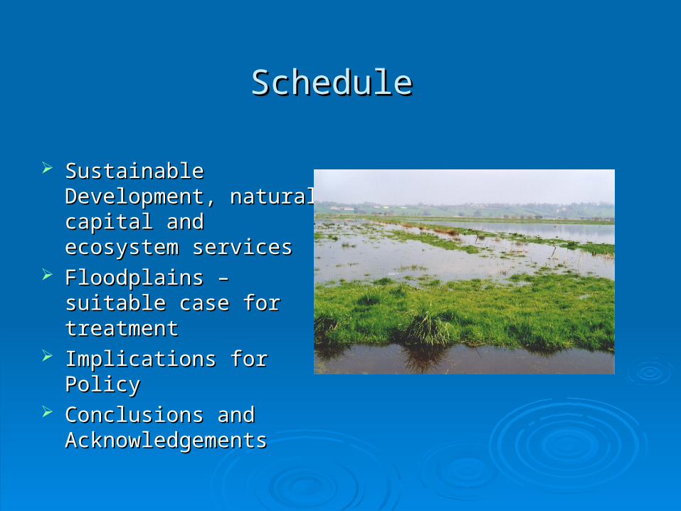
Schedule Schedule
Sustainable Sustainable Development, natural Development, natural capital and ecosystem capital and ecosystem services services
Floodplains – suitable Floodplains – suitable case for treatment case for treatment
Implications for PolicyImplications for Policy Conclusions and Conclusions and
AcknowledgementsAcknowledgements

Objectives:
social, economic, environmental
Resources and limits:naturalphysical financialhuman social
Development options:
policies programmes projects
Governance, Scale
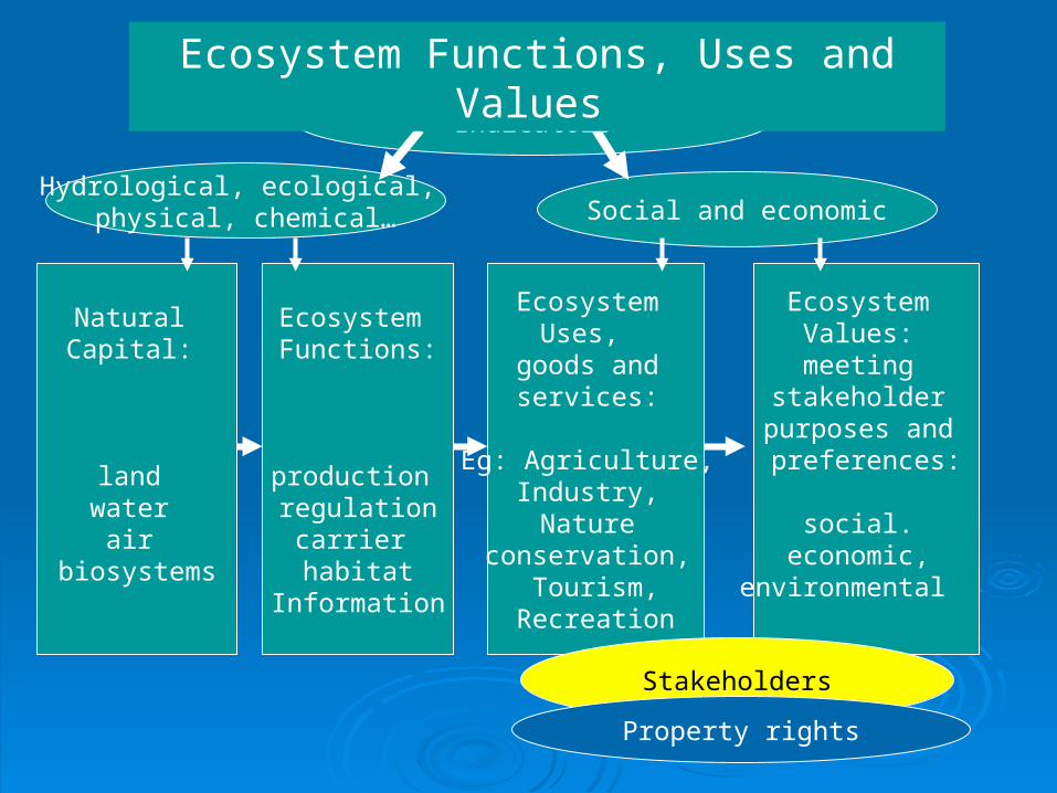
Natural Capital:
land water
air biosystems
Ecosystem Functions:
production regulation
carrier habitat
Information
Ecosystem Uses,
goods and services:
Eg: Agriculture, Industry, Nature
conservation, Tourism,
Recreation
Ecosystem Values: meeting
stakeholder purposes and preferences:
social.
economic, environmental
Stakeholders
Property rights
Indicators
Hydrological, ecological, physical, chemical… Social and economic
Ecosystem Functions, Uses and Values

Millennium Ecosystem Assessment Millennium Ecosystem Assessment
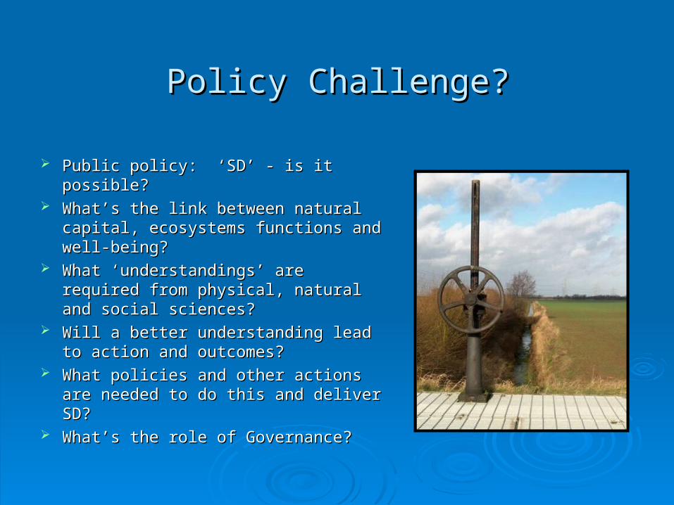
Policy Challenge?Policy Challenge?
Public policy: ‘SD’ - is it possible? Public policy: ‘SD’ - is it possible? What’s the link between natural What’s the link between natural
capital, ecosystems functions and capital, ecosystems functions and well-being?well-being?
What ‘understandings’ are required What ‘understandings’ are required from physical, natural and social from physical, natural and social sciences?sciences?
Will a better understanding lead to Will a better understanding lead to action and outcomes? action and outcomes?
What policies and other actions are What policies and other actions are needed to do this and deliver SD? needed to do this and deliver SD?
What’s the role of Governance?What’s the role of Governance?

The Case of Flood Plains: The Case of Flood Plains: Flood Plains: level tracts of land liable Flood Plains: level tracts of land liable
to inundation by river water to inundation by river water Regional and local Regional and local
significancesignificance Changing priorities and Changing priorities and
concerns ?concerns ? Reappraisal of land and Reappraisal of land and
water managementwater management ? ? Policy realignment and Policy realignment and
integration ? integration ?

RELU Project: Integrated land and water RELU Project: Integrated land and water management in flood plains management in flood plains
Research Questions :Research Questions : is it possible to achieve multiple is it possible to achieve multiple
objectives in ways which are objectives in ways which are appealing to major stakeholders, appealing to major stakeholders, especially farmers? especially farmers?
what data bases and appraisal what data bases and appraisal methods are needed to support methods are needed to support decision making?decision making?
what are the best ways of achieving what are the best ways of achieving the widespread adoption of the widespread adoption of integrated management solutions?integrated management solutions?

Approach Approach
historical analysis of historical analysis of the dynamics of change the dynamics of change on selected on selected Agricultural Flood Agricultural Flood Defence Schemes Defence Schemes implemented during implemented during period 1960-1980.period 1960-1980.
40 year historical 40 year historical perspective in order to perspective in order to look forwardlook forward
building on integrationbuilding on integration
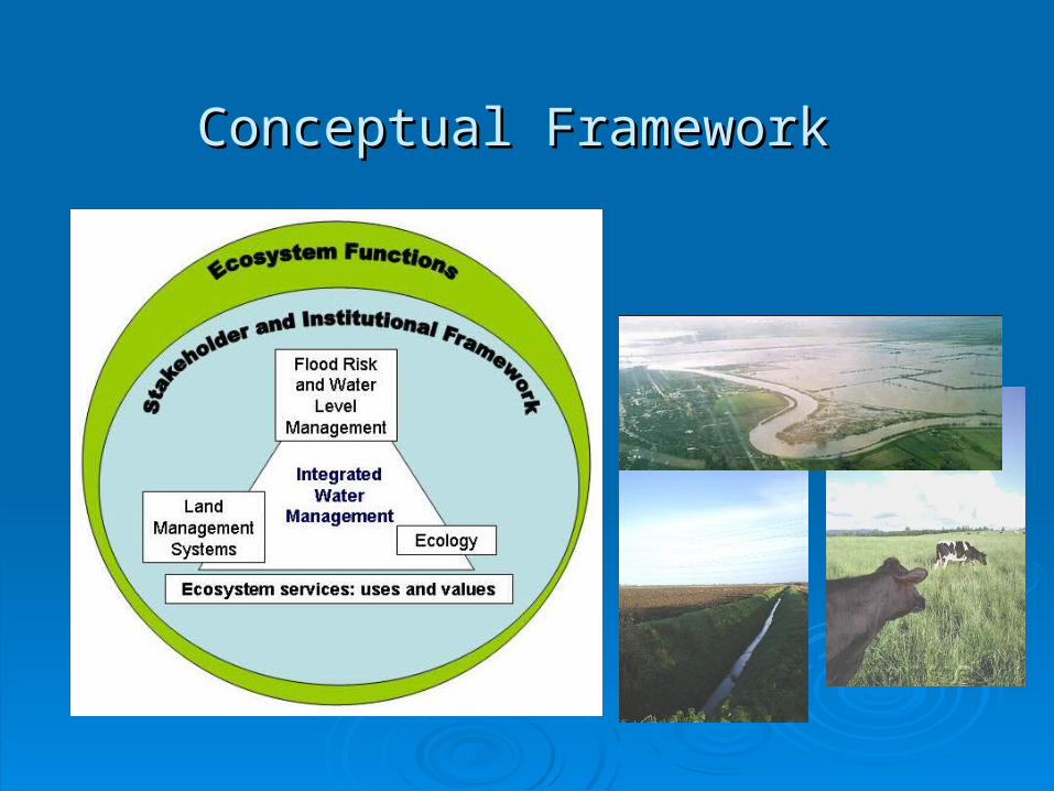
Conceptual Framework Conceptual Framework

A Case Example: Beckingham Marshes
History:
• prior WWII: grassland & marsh, willow production
• 1960-70: improved drainage, pumps, emergency flood storage
• 1970-2000: arable production
• 2005: RSPB plan re-conversion to grassland for lapwings, increase water table levels

Hydrological Component
Classification of floodplain by degree of hydraulic controlClassification of floodplain by degree of hydraulic control
OutflowOutflow
InflowInflow
Uncontrolled Uncontrolled inflowinflow
Fixed controlled Fixed controlled inflowinflow
Variable Variable controlled inflowcontrolled inflow
Uncontrolled Uncontrolled gravity returngravity return
Fixed controlled Fixed controlled gravity returngravity return
Controlled return Controlled return (sluices / pumps)(sluices / pumps)
Beckingham Beckingham MarshesMarshes
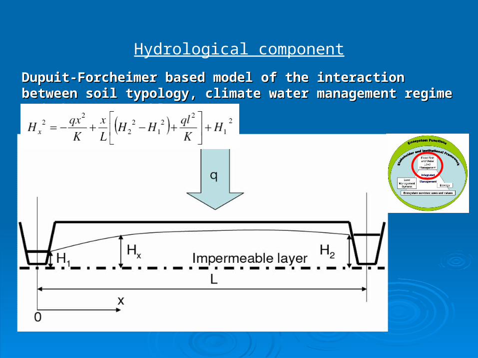
Hydrological component
Dupuit-Forcheimer based model of the interaction between soil Dupuit-Forcheimer based model of the interaction between soil typology, climate water management regime and the water table:typology, climate water management regime and the water table:

Land Management Component - AgricultureLand Management Component - Agriculture
Water regimes: Water regimes: FloodingFlooding WaterloggingWaterlogging
Frequency
Seasonality
Duration
Depth
Standards of Agricultural Drainage
Low HighRelative profitability of farming systems???

Beckingham Marshes
Wetness of soils Land use
GIS for mapping natural capital and ecosystems functions uses and values

Ecological component
• Scale Scale • International – Ramsar Convention, Habitats Directive International – Ramsar Convention, Habitats Directive • National – BAP priorities, SSSIsNational – BAP priorities, SSSIs• Regional / County – County BAPs, SINCsRegional / County – County BAPs, SINCs• Local / Parish – species-rich hedgerowsLocal / Parish – species-rich hedgerows
• Significance of the population \ habitatSignificance of the population \ habitat• ThreatThreat
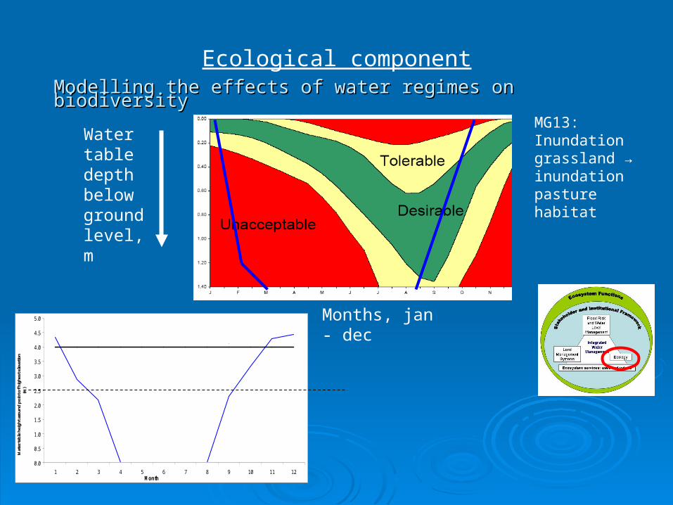
Ecological component
Modelling the effects of water regimes on biodiversityModelling the effects of water regimes on biodiversity
MG13: Inundation grassland → inundation pasture habitat
0.0
0.5
1.0
1.5
2.0
2.5
3.0
3.5
4.0
4.5
5.0
1 2 3 4 5 6 7 8 9 10 11 12Month
Wat
er ta
ble
heig
ht a
roun
d po
int o
f hig
hest
ele
vatio
n (m
)
Ground level
Water table depth below ground level, m
Months, jan - dec
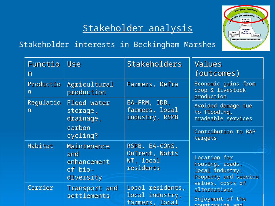
Stakeholder analysis
Stakeholder interests in Beckingham Marshes
FunctionFunction UseUse StakeholdersStakeholders
ProductionProduction Agricultural Agricultural productionproduction
Farmers, DefraFarmers, Defra
RegulationRegulation Flood water Flood water storage, drainage,storage, drainage,
carbon cycling?carbon cycling?
EA-FRM, IDB, EA-FRM, IDB, farmers, local farmers, local industry, RSPBindustry, RSPB
HabitatHabitat Maintenance and Maintenance and enhancement of enhancement of bio-diversitybio-diversity
RSPB, EA-CONS, RSPB, EA-CONS, OnTrent, Notts WT, OnTrent, Notts WT, local residentslocal residents
CarrierCarrier Transport and Transport and settlementssettlements
Local residents, local Local residents, local industry, farmers, industry, farmers, local authoritylocal authority
InformationInformation Amenity, Amenity, landscape, landscape, recreation, historyrecreation, history
RSPB, local RSPB, local residents, local residents, local authority, authority,
Values (outcomes)Values (outcomes)Economic gains from crop Economic gains from crop & livestock production& livestock production
Avoided damage due to Avoided damage due to flooding, tradeable servicesflooding, tradeable services
Contribution to BAP targetsContribution to BAP targets
Location for housing, Location for housing, roads, local industry: roads, local industry: Property and service Property and service values, costs of values, costs of alternativesalternatives
Enjoyment of the Enjoyment of the countryside and related countryside and related benefits: willingness to paybenefits: willingness to pay

Beckingham Marshes:
Stakeholder analysis: water level management

Integration : Land use and habitat matrix
Land use and habitat classification by flood and soil water regimes
Winter flooding onlyWinter flooding only Flooding at any time of yearFlooding at any time of year
DrainageDrainage::
RapidRapid Moderate Moderate SlowSlow RapidRapid ModerateModerate SlowSlow
Short Short duration duration floodingflooding
Arable, Arable, pasture, pasture,
hay hay meadow, meadow, woodlandwoodland
Pasture, Pasture, hay hay
meadow, meadow, woodlandwoodland
Pasture, Pasture, woodlandwoodland
Hay Hay meadow, meadow, pasture, pasture,
woodlandwoodland
Woodlan, Woodlan, pasturepasture
Swamp, Swamp, pasture, pasture,
woodlandwoodland
Medium Medium duration duration floodingflooding
Hay Hay meadow, meadow, pasture, pasture,
woodlandwoodland
Pasture, Pasture, woodlandwoodland
Pasture, Pasture, swamp, swamp,
woodlandwoodland
Pasture, Pasture, woodlandwoodland
Pasture, Pasture, woodland, woodland,
swampswamp
Swamp, Swamp, pasturepasture
Long Long duration duration floodingflooding
Pasture, Pasture, woodlandwoodland
Pasture, Pasture, woodlandwoodland
Swamp, Swamp, pasture, pasture,
woodlandwoodland
Swamp, Swamp, woodlandwoodland
SwampSwamp SwampSwamp

Modelling land and water scenarios*: Modelling land and water scenarios*: BeckinghamBeckingham
:
Scenarios
Dominant land use >Arable
farmingFlood
storageWetlands
Water management regime >Rapid
drainage, low flood frequency
Rapid drainage, high flood frequency
Slow drainage, high
flood frequency
Function Use
ProductionAgricultural production H M L
Bio-fuel crops H L M
Regulation Flood water storage M H L
Habitat Biodiversity target L M H
CarrierRoad network/industry H M L
InformationRecreation L L H
Education L L H
*Based on monetary values
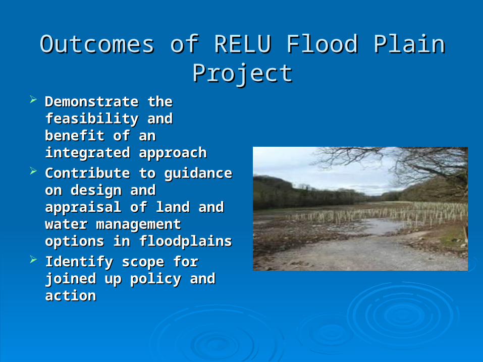
Outcomes of RELU Flood Plain ProjectOutcomes of RELU Flood Plain Project
Demonstrate the Demonstrate the feasibility and benefit of feasibility and benefit of an integrated approach an integrated approach
Contribute to guidance Contribute to guidance on design and appraisal on design and appraisal of land and water of land and water management options in management options in floodplainsfloodplains
Identify scope for Identify scope for joined up policy and joined up policy and actionaction

Research Based Policy : informing choicesResearch Based Policy : informing choices
Develop understanding Develop understanding amongst stakeholders amongst stakeholders of ecosystem services of ecosystem services and limitsand limits
Derive preferences and Derive preferences and values for ecosystem values for ecosystem services using a range services using a range of methods of methods
Use ‘what if’ Use ‘what if’ interactions supported interactions supported by ‘modelling’ by ‘modelling’
Develop for different Develop for different scales of governance scales of governance
Key elements:
Knowledge exchange
Multi-criteria, limits/thresholds
Collective choice
Low
High
High
Low
Expert based modelling
Anecdotal elitism
Participatorydiscussion
Participatory modelling
Participation
Un
derstan
din
g

General Conclusions – drawn from the General Conclusions – drawn from the floodplain floodplain
Policies for SD must be set within an ecosystems framework of capital, functions, uses and values
Multiple ‘sciences’ are needed to understand the trade- offs, synergies and limits involved
Diverse collaborations and long term commitment are needed
Scale, temporal and spatial, is critical Need a practical framework for a spatially
differentiated ecosystems based approach to joined- up policy management and development planning
Need regional and local ‘experiments’ to show it can make a difference
Credits Credits Research Team Research Team
Cranfield University: Joe Morris, Tim Hess, Peter Leeds-Harrison, Paul Cranfield University: Joe Morris, Tim Hess, Peter Leeds-Harrison, Paul Trawick, Quentin Dawson, Helena Posthumus, Trawick, Quentin Dawson, Helena Posthumus,
Open University: David Gowing, Jim Rouquette, Andy Blowers, Open University: David Gowing, Jim Rouquette, Andy Blowers,
River Restoration Centre: Jenny MantRiver Restoration Centre: Jenny Mant
Environmental Solutions: Graham TuckerEnvironmental Solutions: Graham Tucker
Thanks to: Thanks to:
various participating stakeholders, especially farmersvarious participating stakeholders, especially farmers
RELU Programme TeamRELU Programme Team
UK Research Councils, and Defra and SEERADUK Research Councils, and Defra and SEERAD

Reference materialReference material
Contact email: [email protected] Project website: http://www.silsoe.cranfield.ac.uk/iwe/expertise/relu.htm: Selected references: Defra (2004) Making Space for Water. Developing a new government strategy for flood and
coastal erosion risk management in England. London: Department for Environment, Food and Rural Affairs
Millennium Ecosystem Assessment (2005). Reports on http://www.maweb.org/en/index.aspx Morris, J, Bannister, N., Hess, T.M., Gowing, D. J.G., Leeds-Harrison, P. B., Vivash, R.,
Wade, M. (2004) Integrated Washlands for Flood Defence and Biodiversity, Report to English Nature and Defra. English Nature Research Report Series No. 598. Peterborough: English Nature
Penning-Rowsell E, Johnson C, Tunstall S, Tapsell S, Morris J, Chatterton J, and Green C, (2006) The Benefits of Flood and Coastal Risk Management. (i) A Manual of Techniques , (ii) . A Handbook. Produced for Defra and Environment Agency. Enfield: Flood Hazard Research Centre, Middlesex University.
Thorne, C., Evans, E. and Penning-Rowsell, E . (eds) (2006). Future Flooding and Coastal Erosion Risks. London: Thomas Telford