Research on optimization of the ship routeing system in ...
67
World Maritime University World Maritime University The Maritime Commons: Digital Repository of the World Maritime The Maritime Commons: Digital Repository of the World Maritime University University Maritime Safety & Environment Management Dissertations Maritime Safety & Environment Management 8-25-2019 Research on optimization of the ship routeing system in Research on optimization of the ship routeing system in Qiongzhou Strait Qiongzhou Strait Qifu Wang Follow this and additional works at: https://commons.wmu.se/msem_dissertations Part of the Transportation Commons, and the Transportation Engineering Commons This Dissertation is brought to you courtesy of Maritime Commons. Open Access items may be downloaded for non-commercial, fair use academic purposes. No items may be hosted on another server or web site without express written permission from the World Maritime University. For more information, please contact [email protected].
Transcript of Research on optimization of the ship routeing system in ...

World Maritime University World Maritime University
The Maritime Commons: Digital Repository of the World Maritime The Maritime Commons: Digital Repository of the World Maritime
University University
Maritime Safety & Environment Management Dissertations Maritime Safety & Environment Management
8-25-2019
Research on optimization of the ship routeing system in Research on optimization of the ship routeing system in
Qiongzhou Strait Qiongzhou Strait
Qifu Wang
Follow this and additional works at: https://commons.wmu.se/msem_dissertations
Part of the Transportation Commons, and the Transportation Engineering Commons
This Dissertation is brought to you courtesy of Maritime Commons. Open Access items may be downloaded for non-commercial, fair use academic purposes. No items may be hosted on another server or web site without express written permission from the World Maritime University. For more information, please contact [email protected].
WORLD MARITIME UNIVERSITY
Dalian, China
RESEARCH ON OPTIMIZATION OF THE SHIP
ROUTEING SYSTEM IN QIONGZHOU STRAIT
By
WANG QIFU
The People’s Republic of China
A research paper submitted to the World Maritime University in partial
Fulfillment of the requirements for the award of the degree of
MASTER OF SCIENCE
In
Maritime Safety Environmental Management
2019
© Copyright Wang Qifu, 2019

i
DECLARATION
I certify that all the material in this dissertation that is not
my own work has been identified, and that no material is
included for which a degree has previously been conferred
on me.
The contents of this dissertation reflect my own personal
views, and are not necessarily endorsed by the University.
Signature:
Date: June 28, 2019
Supervised by: DR. FAN ZHONGZHOU
Professor
Captain
Dalian Maritime University

ii
ACKNOWLEDGEMENT
I am very grateful to Dalian Maritime University for supporting my study of MSEM
2019, which give me the opportunity to learn from the experts from DMU and WMU.
Through more than one year's study, I have a relatively systematic understanding of
relevant knowledge in the maritime field, and have structured the previously
fragmented knowledge.
Many thanks to MSEM programe for providing us with the opportunity to conduct
field study in Hainan MSA. In this field sudy, I have developed a strong interest in
the ship routeing system in Qiongzhou Strait. I would like to thank Professor Fan
Zhongzhou of DMU, who is a well-known expert in ship routeing system in China,
for guiding my paper writing. I would also like to express my deep gratitude to the
leaders and staff of Hainan MSA for their help in the research process of this paper.
Thank you very much to my other 15 classmates, who made me feel happy in the
learning process. We built a deep friendship with each other and spent a happy time.
I will always remember them.
Thanks to my family, they supported me to complete my study in MSEM programe,
enabling me to devote myself to my study. Thanks to all my colleagues, they share a
lot of work for me and let me have more time to study in MSEM.

iii
ABSTRACT
Title of Dissertation: Research on Optimization of the Ship Routeing System
in Qiongzhou Strait
Degree: Master of Science
Qiongzhou Strait is an important channel for maritime traffic between Guangdong
sea area and Beibu Gulf, and a maritime corridor connecting Beibu Gulf with the
middle and east of South China Sea. The ship routeing system can greatly improve
the safety of maritime traffic. Due to the change of vessel traffic flow in Qiongzhou
Strait, the existing ship routeing system cannot guarantee the safe navigation of ships
in this area, so it should be modified.
The optimization of ship routing system should consider several factors. The first is
the characteristics of the water area of the ship routeing system, including the
geographical environment, weather and other natural conditions of the water area.
The second is the traffic flow of the ship, and the third is the rules of the ship
routeing system. On the basis of analyzing the current ship routing system and
combining the above factors, this paper puts forward an optimization scheme of ship
routeing system in Qiongzhou Strait.
The proposed optimization scheme is divided into the overall modification scheme
and the modification scheme of key water areas. There are three schemes for the
revision of key water areas, each focusing on solving different key problems.
Through the questionnaire survey of relevant ship captains and ship traffic
management officers, their opinions and choices on different schemes are obtained.
Through the feedback of the survey results, the optimization scheme is modified to
make it more suitable for safe navigation of ships in Qiongzhou Strait.
KEY WORDS: ship routeing, optijization scheme, traffic flow, questionnaire survey
iv
TABLE OF CONTENTS
DECLARATION ........................................................................................................... i
ACKNOWLEDGEMENT ........................................................................................... ii
ABSTRACT ................................................................................................................ iii
TABLE OF CONTENTS ............................................................................................ iv
LIST OF TABLES ....................................................................................................... vi
LIST OF FIGURES ................................................................................................... vii
LIST OF ABBREVIATIONS ..................................................................................... ix
Charpter 1: Introduciton............................................................................................. 1
1.1 Background information about Qiongzhou Strait ............................................ 1
1.2 Significance of setting up and adjusting ship routeing system ........................ 4
1.3 Rresearch status of the ship routeing system ................................................... 5
1.4 Main research contents .................................................................................... 5
Chapter 2: Theoretical basis of ship routeing system ............................................... 7
2.1 Introdution of ship routeing system ................................................................. 7
2.2 Implementation of ship routeing system worldwide ........................................ 8
2.2.1 Location of the waters in which the ship routeing system adopted ...... 8
2.2.2 Nature of the waters in which the ship routeing system adopted ......... 9
2.3 Traffic separation scheme design dimensions ................................................ 10
2.3.1 Length of traffic separation scheme .................................................... 10
2.3.2 Traffic lane width ................................................................................ 11
2.3.3 Separation zone width ........................................................................ 13
2.3.4 Traffic capacity of traffic lane ............................................................. 13
2.3.5 Calculation of ship encounter rate ...................................................... 14
Chapter 3: Natural conditions and navigation conditions of Qiongzhou Strait... 17
3.1 Status of ship routeing system in Qiongzhou Strait ....................................... 17
3.1.1 Separation zones ................................................................................. 17
3.1.2 Traffic lanes ........................................................................................ 18
3.1.3 Precautinary area ................................................................................. 18
3.1.4 Area to be avoided .............................................................................. 19
v
3.1.5 Inshore traffic zone ............................................................................. 19
3.2 Comprehensive natural conditions ................................................................. 19
3.2.1 Natural conditions of Qiongzhou Strait .............................................. 19
3.2.2 Fishery situation .................................................................................. 20
3.2.3 Navigational AIDS in Qiongzhou Strait ............................................. 20
3.3 Traffic flow in Qiongzhou Strait .................................................................... 21
3.3.1 Ship traffic flow statistics through Line 1 ........................................... 22
3.3.2 Ship traffic flow statistics through Line 2 ........................................... 24
3.3.3 Ship traffic flow statistics through Line 3 and Line 4......................... 25
3.3.4 Ship traffic flow statistics through Line 5 and Line 6......................... 26
3.4 Traffic accident in Qiongzhou Strait .............................................................. 27
3.4.1 Maritime traffic accidents from 2001 to 2006 .................................... 28
3.4.2 Maritime traffic accidents from 2007 to 2018 .................................... 28
3.4.3 Analysis of accidents in ship routeing system from 2007 to 2018 ..... 28
Chapter 4: Optimization scheme of ship routeing system in Qiongzhou Strait ... 30
4.1 Adjustment scheme of ship routeing system in Qiongzhou strait .................. 30
4.1.1 Scheme A ............................................................................................ 31
4.1.2 Scheme B ............................................................................................ 32
4.1.3 Scheme C ............................................................................................ 33
4.2 Questionnaire and results analysis ................................................................. 34
4.2.1 Survey of factors affecting navigation safety ..................................... 34
4.2.2 Survey result of three scehemes of NO.3 precautionary area ............. 37
4.3 Optimization of the recommend scheme ....................................................... 38
Chapter 5: Conclusions ............................................................................................. 42
Reference .................................................................................................................... 44
Appendix:Questionnaire on optimization scheme of ship routeing system in
Qiongzhou Strait ........................................................................................................ 47

vi
LIST OF TABLES
Table 2-1 Basic traffic capacity of ships of different tonnage (channel
width 1 nm)
14
Table 2-2 Number of ship encounters 16
Table 3-1 Position of 6 lines 22
Table 3-2 Statistical of ship traffic flow through Line 1 northbound 22
Table 3-3 Statistical of ship traffic flow through Line 1 southbound 22
Table 3-4 Statistical of ship traffic flow through Line 2 southbound 24
Table 3-5 Statistical of ship traffic flow through Line 2 northbound 24
Table 3-6 Maritime traffic accident statistics for 2001-2006 28
Table 3-7 Maritime traffic accident statistics for 2007-2018 28
vii
LIST OF FIGURES
Figure 1-1 Diagram of maritime traffic in Qiongzhou Strait 1
Figure 1-2 Diagram of Qiongzhou Strait passenger ship route 3
Figure 2-1 Statistics of water areas implemented ship routeing system 8
Figure 2-2 Statistics of ship routeing location (jurisdiction) 9
Figure 2-3 Statistics of ship routeing location (water nature) 10
Figure 2-4 MSOD curve 12
Figure 2-5 Ship crossing traffic flow (theoretical model) 14
Figure 2-6 A meeting of ships crossing traffic 15
Figure 3-1 Diagram of ship routeing system in Qiongzhou Strait 17
Figure 3-2 Location of 6 lines in Qiongzhou Strait 21
Figure 3-3 number and track distribution of ships passing through
Line 1
23
Figure 3-4 Number and track distribution of southbound ships passing
through Line 2
25
Figure 3-5 statistics of traffic flow in the westbound traffic lane 26
Figure 3-6 statistics of traffic flow in the eastbound traffic lane 26
Figure 3-7 statistics of traffic flow in the northern inshore traffic zone 27
Figure 3-8 statistics of traffic flow in the southern inshore traffic zone 27
Figure 4-1 New ship routeing adjustment scheme in Qiongzhou Strait 31
Figure 4-2 Diagram of scheme A 32
Figure 4-3 Diagram of scheme B 33
Figure 4-4 Diagram of scheme C 34
Figure 4-5 Traffic impact of ships in Qiongzhou Strait waters 35
Figure 4-6 The influence of ship traffic condition on navigation safety 36
Figure 4-7 The influence of geographical conditions on navigation
safety
36
Figure 4-8 The influence of meteorological and hydrological
conditions on navigation safety
37
Figure 4-9 survey result of three adjustment schemes in the NO.3
precautionary area
38
viii
Figure 4-10 Diagram of optimization of Qiongzhou Strart ship routeing
system
39
Figure 4-11 Contrast diagram of optimized scheme C with present
traffic flow
40
Figure 4-12 Contrast diagram of optimized scheme C with future traffic
flow
41

ix
LIST OF ABBREVIATIONS
AIS Automatic Identification System
DCPA Distance to the Closest Point of Approach
EEZ Exclusive Economic Zone
GPS Global Positioning System
IMO International Maritime Organization
MSA Maritime Safety Administration
MSOD Minimum Safe Overtaking Distance
nm nautical mile(s)
P.R.C People's Republic of China
SOLAS International Convention for Safety of Life at Sea
UNCLOS United Nations Convention on the Law of the Sea
VTS Vessel Traffic Service
1
Charpter 1: Introduciton
1.1 Background information about Qiongzhou Strait
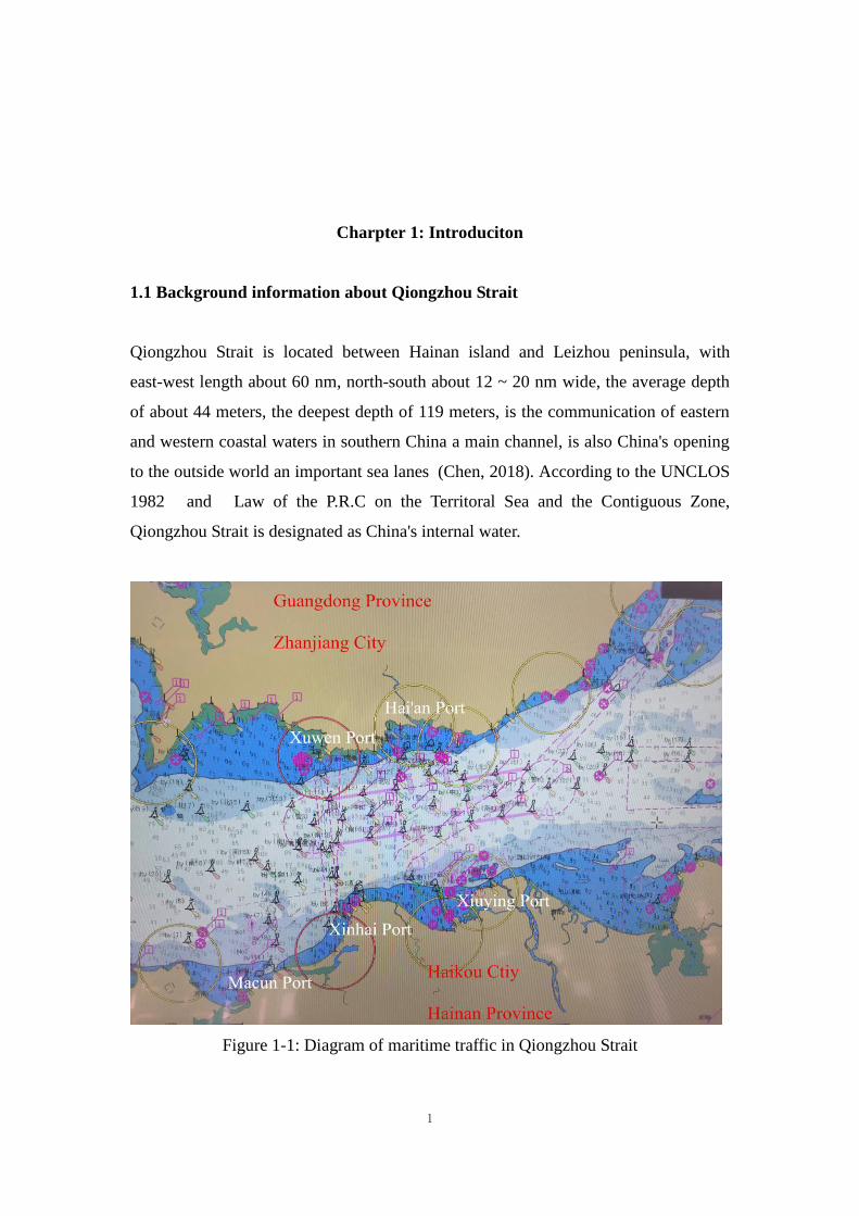
Qiongzhou Strait is located between Hainan island and Leizhou peninsula, with
east-west length about 60 nm, north-south about 12 ~ 20 nm wide, the average depth
of about 44 meters, the deepest depth of 119 meters, is the communication of eastern
and western coastal waters in southern China a main channel, is also China's opening
to the outside world an important sea lanes (Chen, 2018). According to the UNCLOS
1982 and Law of the P.R.C on the Territoral Sea and the Contiguous Zone,
Qiongzhou Strait is designated as China's internal water.
Figure 1-1: Diagram of maritime traffic in Qiongzhou Strait
2
In order to effectively strengthen the traffic safety management of the waters and
ensure the safety of navigation of ships, the VTS has been established in the
Qiongzhou Strait. The implementation of the Qiongzhou Strait ship routeing system
effectively standardizes the navigation order of ships passing through the Qiongzhou
Strait and effectively ensures the navigation safety of ships (Ministry of Transport of
the P.R.C, 2011). However, with the adjustments of port function and the change of
ship traffic flow in recent years, the existing ship routeing system in Qiongzhou Strait
cannot meet the need of safe navigation in the strait.
1.1.1 Adjustment of ports functions
At present, Xiuying port in Haikou, Hainan province is the main port, providing
berthing services for passenger ships, container ships and bulk cargo ships. Haikou
city will build Xinhai port as a passenger ship and ro-ro ship terminal, and plan to
move the container, bulk cargo, ro-ro ship transport function to the west to Makun
port and the Xinhai port. The existing Xiuying port will be transformed into a cruise
and yacht terminal, the Makun port will be built as a bulk cargo and container transfer
center, and the Xinhai port will be built as a large passenger terminal (Wang, Xu &
Chen, 2018).
In order to adapt to the adjustment of the function layout of Haikou port, Zhanjiang
city of Guangdong province plans to transfer the passenger ship business from Hai'an
port to Xuwen port to form docking with the new Haikou port. According to the plan,
after the relocation of passenger ships in Hai'an port, Hai'an port will be built into a
tourism terminal and docked with Haikou Xiuying port to open up a luxury ro-ro ship,
hydrofoil ship, seaplane and other tourism transport express passenger terminal (Chen,
2016).
1.1.2 Traffic flow changes
By March 2019, there were more than 50 passenger ships sailing between Xiuying
port in Haikou city and Hai'an port in Zhanjiang city, with an average traffic flow of
120 times per day. According to the new planning of port functions of Xiuying port
and Hai'an port, the current busy passenger ship traffic flow between Xiuying port and

3
Hai'an port will move to the west between the Xinhai port and Xuwen port. At the
same time, the traffic flow in and out of Macun port in Haikou will increase greatly.
According to the current construction progress forecast of ports on both sides of the
Qiongzhou strait, the traffic flow of passenger ships on both sides of the Qiongzhou
strait will have the following two new situations:
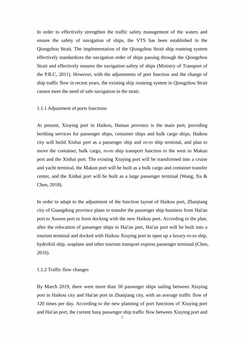
(a) When the port function adjustment of Haikou port is completed and the
corresponding adjustment of Zhanjiang port area is not completed, passenger ships
form the traffic flow from the Xinhai port to Hai'an port, as shown in the figure 1-2.
According to the current Qiongzhou Strait ship routeing system, the traffic flow of
ships in the east and west direction will be greatly increased.
Figure 1-2: Diagram of Qiongzhou Strait passenger ship route
(b) When the port functions of Haikou and Zhanjiang are adjusted, the passenger
ships will form the traffic flow from the Xinhai port to Xuwen port. At the same time,
the railway ferry route from Guangdong to Hainan will be merged into this route. The
Guangdong-Hainan cross-straits railway ferry project plans to build 9-13 new ships
which will increase the traffic flow of this route.
The Qiongzhou Strait ship routeing system, therefore, difficult to adapt to in order to

4
ensure the security of Qiongzhou Strait shipping navigation, in order to satisfy the
function of Haikou city and Zhanjiang port adjusted ship flow needs, great changes
have taken place to ensure the safety of navigation of ships and navigation order,
Qiongzhou Strait ship routeing system for the corresponding adjustment is imminent.
1.2 Significance of setting up and adjusting ship routeing system
The implementation of ship routeing system is the main means of effective
management in the area with heavy traffic, and an important method of rational
planning and effective utilization of navigation routes. It represents the development
direction of navigation management of ship traffic (Fan, 2013). The traffic of ships in
Qiongzhou Strait is dense and the situation of ships is complicated.
The ship routeing system reduces the risk of collision and improves the safety of
maritime navigation by standardizing the traffic behavior of ships within specific
waters. With the rapid development of economy, the traffic flow of ships in the
Qiongzhou Strait is increasing, and ships are developing in large scale. The navigation
environment in the Qiongzhou Strait is becoming more and more complex.
Meanwhile, Qiongzhou Strait is one of the important fishing grounds along the
southern coast of China. The number of fishing boats in the strait has been increasing
rapidly. These urgent requests the competent authority strengthens the traffic
management, the standard vessel traffic behavior, in order to avoid because of the
traffic chaos to cause the maritime traffic accident the occurrence.
In accordance with SOLAS Convention (IMO, 2016) and SHIPS' ROUTEING, the
governments of each contracting state shall be responsible for the initial planning and
establishment of SHIPS' ROUTEING. According to the provisions of China's
maritime traffic safety law, it is a statutory duty of China's maritime administrative
authorities to make scientific and reasonable plans for navigation routes in coastal
navigable waters. The establishment of reasonable and efficient ship routeing system
is conducive to displaying a good image of China's maritime management agency.
5
1.3 Rresearch status of the ship routeing system
Ship traffic separation system originated in western countries, and many scholars have
made great contributions to the development and maturity of traffic separation system.
Spanish Rear Admiral Garcia-frias, captain Maury of the United States, Robichon and
Oudet of France, Poll of Belgium and captain Wepster of the Netherlands all made
great contributions to the establishment, development and implementation of the
seperation system. The earliest guiding document of Ship traffic separation system,
general provisions of ship routeing system, was produced in 1977. This document put
forward many guiding suggestions for the establishment and implementation of ship
routeing system, making the role of ship routeing system in ensuring navigation safety
and standardizing traffic more prominent. At the same time, the design practice of
various countries tends to be unified. The document has been revised many times
since its release in 1979, the last time being IMO resolution A.572 (14) in 1988.
China's Chengshanjiao ship traffic separation system is the first ship routeing system
which registered in the IMO (Fan, Hong & Zhang, 2012). The ship routeing system
consists of traffic separation scheme, inshore traffic zone and precautionary area, and
was revised in 2014 to add the external traffic separation scheme and precautionary
area. On June 1, 2004, the ship routeing system of the Pearl River estuary began trial
operation. It was officially implemented on July 1, 2015 and registered in IMO in
May 2018. It is the second ship routeing system registered in IMO in China.
<National coastal ships routeing system overall planning> and <The national overall
plan of the coastal rout> which promulgated by the China have important significance
for China's coastal route, it clearly describes China routeing system design and
implementation of the direction and goals, which will optimize the distribution of
ships routeing system in China's coastal and Settings, make the ships routeing system
play a more important role on navigation safety.
1.4 Main research contents
Intends to through a lot of traffic investigation and analysis, this paper applied the
theory and methods of Marine traffic engineering, the Qiongzhou Strait waters

6
navigation environment of the combination of qualitative and quantitative analysis
reveals the Qiongzhou Strait waters main traffic flow patterns and traffic environment.
According to the international maritime organization, international law and the
Qiongzhou Strait ship traffic status quo, this paper will put forward the best scheme of
ship routeing system in Qiongzhou Strait
1.4.1 Investigation and research on ship traffic in Qiongzhou Strait
The investigation contents mainly include hydrometeorology, traffic conditions, ship
traffic conditions, customary route, fishing grounds and ship traffic accidents in
Qiongzhou Strait. On the basis of investigation and data analysis and processing, the
application of the theory and methods of Marine traffic engineering, the research of
traffic flow model and obtain the Qiongzhou Strait waters and the way of
transportation, ship rules and influence factors of traffic accidents, as well as the
status quo and characteristics of the navigation environment, etc., for the waters of the
Qiongzhou Strait shipping routeing system adjustment to lay a solid foundation.
The method of traffic survey is to obtain traffic volume, traffic density, traffic form
and other data by using the data provided by Hainan MSA, AIS center and other units.
The survey method of navigation condition is to obtain the original data and data of
navigation environment of Qiongzhou Strait by means of research group survey, field
navigation observation and issuing questionnaire if possible.
1.4.2 Research on ship routeing system adjustment in Qiongzhou Strait
Based on the IMO’s General provisions on ships’ routeing (IMO, 1985) and the
current navigation situation of Qiongzhou Strait, this paper studies the basic principles
and design standards of route planning for Qiongzhou Strait waters, analyzes and
studies the technical factors of Qiongzhou Strait waters, and studies and recommends
the best scheme of ship routeing system adjustment for Qiongzhou Strait.

7
Chapter 2: Theoretical basis of ship routeing system
2.1 Introdution of ship routeing system
In order to improve the safety of ship traffic, standardize the order of ship traffic,
reduce the risk of collision, the adoption and development of ship routeing system,
which is mainly in the form of traffic separation system, has played an important role
in the safety of ship navigation. General Provisions on Ship's Routeing (IMO,1985),
which was put forward by IMO in 1977 and adopted in 1985 and subsequently
amended several times, provide specific Provisions on the establishment and use of
Ship's Routeing. The Ship routeing system in IMO waters around the world (mainly
traffic separation scheme and its combination with other routeing measures) is
published in the IMO publication <Ship's Routeing>.
Ship routeing system is any system or routeing measure of one or more routes
designed to reduce the risk of maritime accidents. Ships’ routeing systems contribute
to safety of life at sea, safety and efficiency of navigation and/or protection of the
marine environment (IMO, 2017). It includes traffic separation scheme, roundabout,
inshore traffic zone, two-way route, recommended route, recommended track, deep
water route, area to be avoided, no anchoring area, controlled and/or prohibited area
and other routeing measures, which can be used alone or in combination according to
actual needs (IMO, 1985). In general, an actually adopted ship routeing system is
usually composed of separation zone or line, traffic lane, established direction of
traffic flow and recommended direction of traffic flow.
Ships routeing system aims to enhance the dense regions of ship convergence zone
and traffic, and due to the limited waters, there is obstruction and restricted water

8
depth or poor weather conditions so that the ship's freedom of movement restricted
waters of navigation safety, and prevent or decrease due to the ship in
environmentally sensitive areas or near the collision, stranding or anchor, or other
damage to the Marine environment pollution caused by the risk.
2.2 Implementation of ship routeing system worldwide
In view of the huge economic benefits and safety benefits brought by the ship
routeing system, the ship routeing system has been developed rapidly in the world. By
December 2017, there were 163 ship routeing systems which adopted by IMO. All
163 are located in areas where ships meet or where conditions are complex. In these
waters, the ship routeing system can well dredge the traffic flow, help the ship avoid
obstruction, improve the safety factor and traffic efficiency of the ship.
2.2.1 Location of the waters in which the ship routeing system adopted
According to the statistics of the ship routeing system adopted by IMO before
December 2017, there is a significant difference in the number of ships in different
waters (Cao, 2015). Europe has the longest shipping history and a very developed
shipping industry. Therefore, the number of ship routeing systems adopted by IMO in
European waters is the largest, while the number of ship routeing systems adopted by
IMO in Asian waters is the smallest. See figure 2-1 for details.
25
34
2318
92
8
16 18
62
Bal
tic S
ea and
Vic
inity
Wes
tern
Eur
opea
n w
ater
s
Med
iterran
ean
and
Bla
ck S
ea
Indi
an O
cean
and
Vic
inity
South
east A
sian
wat
ers
Aus
tralia
n w
ater
s
Nor
th A
mer
ica an
d its
Pac
ific c...
South
Am
eric
a an
d its
Pac
ific c...
Wes
t Coa
st o
f Nor
th A
tlant
ic a..
East A
sia an
d its
Pac
ific co
ast
Easte
rn N
orth
Atla
ntic
and
Sou
...
Figure 2-1: Statistics of water areas implemented ship routeing system

9
2.2.2 Nature of the waters in which the ship routeing system adopted
The establishment of the ship routeing system is influenced by many factors, among
which the distance between the ship routeing system and the countries under its
jurisdiction and the nature of the water area are particularly important. According to
the definition of internal water, territorial sea, contiguous zone, EEZ and high seas of
the UNCLOS 1982 (UN, 1982) and the provisions on the rights and limitations of
coastal states, this paper adopts internal water, territorial sea, contiguous zone, EEZ
and high seas as the measurement standards to indicate the distance between ship
routeing system and the country to which it belongs. Figures 2-2 show the distribution
of ships in the waters, some entirely within a jurisdiction, and others between two
different waters. Relevant data ends in December 2017.
28
3
56
39
7 8 71
0102030405060
Inte
rnal
Wat
er-Int
erna
l Wat
e
Inte
rnal
Wat
e-Ter
ritor
ial S
ea
Territ
oria
l Sea
-Ter
ritor
ial S
ea
Territ
oria
l Sea
-Con
tiguo
us Z
one
Territ
oria
l Sea
-EEZ
Con
tiguo
us Z
one-
Con
tiguo
u...
Con
tiguo
us Z
one-
EEZ
EEZ-EEZ
Figure 2-2: Statistics of ship routeing location (jurisdiction)
In addition to the distance from islands or land, the nature of the water area in which
the ship routeing system is located also greatly affects the components of the ship
routeing system. In this paper, the waters in which ships are located are divided into
five categories, namely, reef areas, capes, narrow channels, coastal waters and open
seas. A reef area is a body of water with multiple reefs or islets near the ship routeing.
A cape is an angular coastal area. A narrow channel is one in which the navigation of
a ship is very narrow and the movement and handling of a ship is greatly restricted.
Coastal waters refer to the waters that are close to the land and less obstructing to
navigation. In this paper, the nearest offshore waters not more than 10 nm are taken as
10
coastal waters, but excluding reef areas, cape waters and narrow channels. Open seas
means a body of water without visible obstructions surrounding it and excluding reef
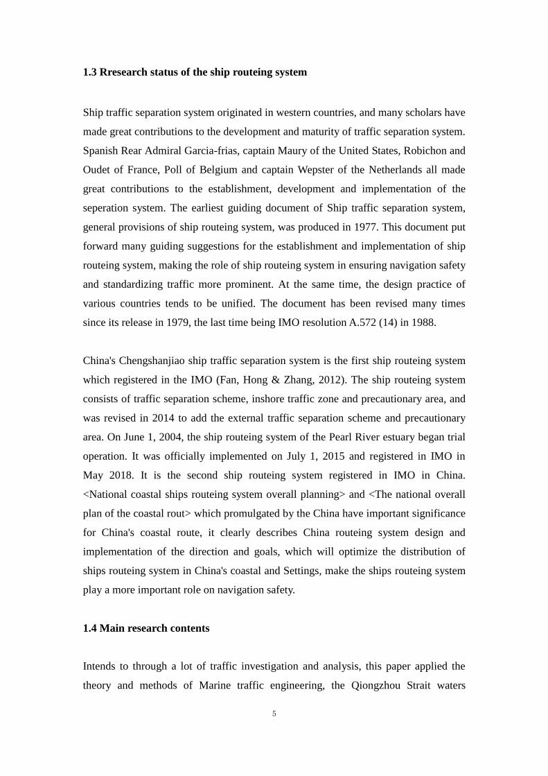
areas, capes, narrow channels and coastal waters. Figure 2-3 shows the current
distribution of the waters where the ship routeing systems are located. (Yuan, Liu &
Xin, 2018)
28
34
22
12
67
0
10
20
30
40
50
60
70
80
Reef Areas Capes Open Seas Narrow Channels Coastal Waters
Figure 2-3: Statistics of ship routeing location (water nature)
2.3 Traffic separation scheme design dimensions
Traffic separation scheme is a form of ship routeing system, but it is the most
important form. The main content of ship routeing system in Qiongzhou Strait is
traffic separation scheme.
2.3.1 Length of traffic separation scheme
IMO experts pointed out that the length of segregations should be considered for
navigation safety and long continuous separation should be avoided (Xiao & Zhang,
2010). It is appropriate and effective to design the traffic separation scheme in
Qiongzhou Strait by using the intermittent separation system to maintain the
whole-course traffic separation, which not only avoids the excessive length of
separating system, but also maintains the long-distance traffic separation. The length

11
of traffic separation scheme shall be designed in accordance with the basic principle
that it should be short rather than long, and the following factors shall be considered
comprehensively:
a. The traffic separation scheme is basically located in areas with dense fishing
boats, and the appropriate length is conducive to effectively organizing ships to
pass through areas with dense fishing boats;
b. An appropriate length is conducive to maintaining the stability of the course of
a ship traveling in a traffic lane for a certain period of time and meeting the
requirements of collision avoidance;
c. The appropriate length is conducive to the convenience of positioning and
judgment for the ships entering and leaving the end of the traffic lane from the
design point of view. In particular, from the perspective of ship control, the
object mark is used as the opportunity for the ships entering and leaving the end
of the traffic lane as far as possible.
According to the statistics of traffic separation scheme of 30 similar waters (such as
strait and cape) adopted by IMO, the average length of the traffic separation scheme is
13.3 nm, which is less than 12 nm, accounting for 43%. The longest Suez is 100 nm,
and the shortest is 6 nm. Therefore, the length of each section of the traffic separation
scheme is determined to be: 10 to 12 nm for the direct section and the steering section
is 21 nm.
2.3.2 Traffic lane width
The width of traffic lanes involves traffic density, traffic volume, positioning accuracy
and geographical conditions. According to IMO requirements (IMO, 2017), traffic
density and total utilization of the area and available sea areas should be taken into
account. The width should correspond to the positioning accuracy of the available
positioning method and be sufficient to enable the ship to catch up with the minimum
safe overtake distance.

12
Japanese scholar Mihei Fujii proposed that in the less crowded coastal waters (L2
conversion ship density of 0.01 ~ 0.1/km2), ship density and positioning accuracy are
the main factors to determine the width of navigable lanes, and suggested that the
width of traffic lanes and separation zones is generally 3'--2'--3' to 1'--0.5'--1'
(Szlapczynski & Rafal, 2013).
British scholar Robert G. Curtis put forward the idea of minimum safe overtaking
distance (MSOD) on the basis of mathematical research and experimental research of
radar simulator (Curtis & Robert, 1986). The establishment and use of traffic
separation scheme has greatly reduced the collision risk in Head-on Situation and
Crossing Situation, but increased the Overtakeing Situation in the traffic lane. Curtis
proposed the MSOD in poor visibility based on the research on chasing problem in
traffic lane, which is in direct proportion to the reaction time of overtaking ship and
the speed of overtaken ship, but has nothing to do with the speed of overtaking ship.
Figure 2-4 shows the MSOD curves of the overtaken ship with a length of 325 meters,
a turning radius of 0.4 nm, and a reaction time of 3, 5 and 7 minutes respectively.
Typical reaction time data proposed by Curtis are: response time of super-large ships
is 7 minutes in poor visibility; General cargo ship for 5 minutes; 3 minutes for a ship
with good maneuverability. It is suggested that the width of the traffic lane should
reach the MSOD.
Figure 2-4: MSOD curve
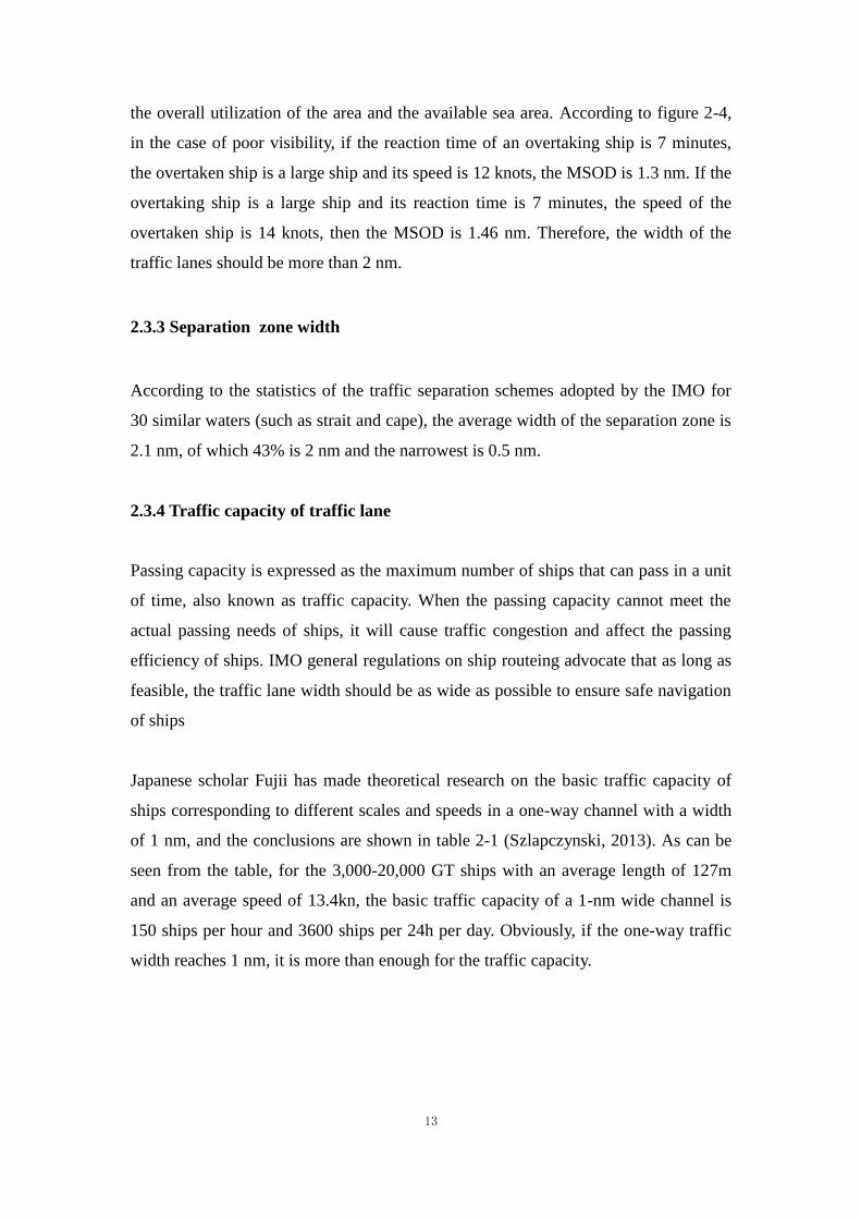
According to the provisions 6.10 of the IMO’s General Provisions on Ships' Routeing
(IMO, 1985), the width of the traffic lanes should take into account the traffic density,
13
the overall utilization of the area and the available sea area. According to figure 2-4,
in the case of poor visibility, if the reaction time of an overtaking ship is 7 minutes,
the overtaken ship is a large ship and its speed is 12 knots, the MSOD is 1.3 nm. If the
overtaking ship is a large ship and its reaction time is 7 minutes, the speed of the
overtaken ship is 14 knots, then the MSOD is 1.46 nm. Therefore, the width of the
traffic lanes should be more than 2 nm.
2.3.3 Separation zone width
According to the statistics of the traffic separation schemes adopted by the IMO for
30 similar waters (such as strait and cape), the average width of the separation zone is
2.1 nm, of which 43% is 2 nm and the narrowest is 0.5 nm.
2.3.4 Traffic capacity of traffic lane
Passing capacity is expressed as the maximum number of ships that can pass in a unit
of time, also known as traffic capacity. When the passing capacity cannot meet the
actual passing needs of ships, it will cause traffic congestion and affect the passing
efficiency of ships. IMO general regulations on ship routeing advocate that as long as
feasible, the traffic lane width should be as wide as possible to ensure safe navigation
of ships
Japanese scholar Fujii has made theoretical research on the basic traffic capacity of
ships corresponding to different scales and speeds in a one-way channel with a width
of 1 nm, and the conclusions are shown in table 2-1 (Szlapczynski, 2013). As can be
seen from the table, for the 3,000-20,000 GT ships with an average length of 127m
and an average speed of 13.4kn, the basic traffic capacity of a 1-nm wide channel is
150 ships per hour and 3600 ships per 24h per day. Obviously, if the one-way traffic
width reaches 1 nm, it is more than enough for the traffic capacity.
14
Table 2-1: Basic traffic capacity of ships of different tonnage (channel width 1 nm)
ship tonnage
(GT)
average length
(meter)
average speed
(knot)
measured
average speed
(knots)
traffic capacity
per hour (ship)
100000~20000 235 16.2 14 53
20000~3000 127 13.4 14 150
3000~500 67 11.1 12 440
500~100 33 9.1 9 1500
100~20 18 7.7 8 4500
2.3.5 Calculation of ship encounter rate
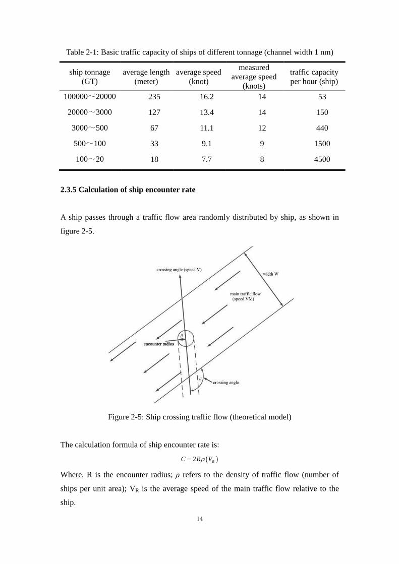
A ship passes through a traffic flow area randomly distributed by ship, as shown in
figure 2-5.
Figure 2-5: Ship crossing traffic flow (theoretical model)
The calculation formula of ship encounter rate is:
2 RC R V
Where, R is the encounter radius; ρ refers to the density of traffic flow (number of
ships per unit area); VR is the average speed of the main traffic flow relative to the
ship.

15
Assuming all ships in the traffic flow travel at the same speed, the relative speed is:
1
2 2 22 cosR M MV V V VV
Where, V is the speed of a single ship; VM main traffic speed; Theta is the Angle
between the boat and the main direction.
The total number of one ship encounters is::
1
2 22 1 2 cosM MR L V V V V
Where, L is the length of a ship.
When a ship has to pass through a traffic flow, it is not necessary to have uniform
density across its width, but a constant density distribution along its length.
Encounter number = ldVVVVRL
MM 0
2
12
cos/2/12
= N
MM dwecVVVVR0
2
12
coscos/2/12
= ecVVVVRn MM coscos/2/12 2
12
Where, w is the width of traffic flow; N is the number of ships per unit length (linear
density).
Encounter number = linear density * encounter width
= ecVVVV MM coscos/2/1 2
12
Figure 2-6: A meeting of ships crossing traffic

16
The function is given in figure 2-6, and the selection of crossing Angle is shown in
figure 2-6, which shows how to minimize the DCPA under the condition of given
velocity ratio. However, the handling of this encounter situation is still based on the
assumption that all ships in the main traffic flow travel at the same speed, but the
calculation of the assumed velocity distribution shows that the intersection Angle
should be accurate within 10%. When passing through the main traffic flow, the
crossing Angle should be as close as possible to 60°-90°. (Li, Ma & Wang, 2015).
Table 2-2 gives the results of the numbers of encounters between ships and traffic
flow according to the calculation process provided.
Table 2-2: Number of ship encounters
(VM)
V 8 9 10 11 12 13 14
8 0.28 0.3 0.33 0.36 0.39 0.43 0.47
9 0.27 0.28 0.3 0.33 0.36 0.38 0.41
10 0.26 0.27 0.28 0.3 0.33 0.36 0.38
11 0.26 0.26 0.27 0.28 0.3 0.33 0.36
12 0.26 0.26 0.26 0.27 0.28 0.3 0.33
13 0.26 0.26 0.26 0.26 0.27 0.28 0.3
14 0.26 0.26 0.26 0.26 0.26 0.27 0.28

17
Chapter 3: Natural conditions and navigation conditions of Qiongzhou Strait
This chapter mainly studies the Qiongzhou Strait water area, the ship flow distribution
and traffic accidents in the Qiongzhou Strait.
3.1 Status of ship routeing system in Qiongzhou Strait
On January 1, 2007, the ministry of transport of P.R.C implemented ship routeing
system in Qiongzhou Strait. Qiongzhou strait ship routeing system consists of traffic
separation system, precautionary area, area to be avoided and inshore traffic zone. As
shown in the figure 3-1.
Figure 3-1: Diagram of ship routeing system in Qiongzhou Strait
3.1.1 Separation zones
As shown in the figure 3-1, the compartments of this ship routeing system’s
separation zones are composed of 8 zones from no. 1 to no. 8. Four separation zones
(NO.1, NO.2, NO.4 and NO.7) with a width of 0.4nm are set in the middle of
east-west separation zones and north-south separation zones. Four boundary

18
separation zones (NO.3, NO.5, NO.6 and NO.8) with a width of 0.2 nm are set
between the boundary of east-west traffic lanes and the inshore traffic zones in the
north and south.
3.1.2 Traffic lanes
In the ship routeing system of Qiongzhou Strait, the east-west traffic lanes and
north-south traffic lanes are set up respectively.
The east-west traffic lanes are divided into eastbound traffic lanes and westbound
traffic lanes. The eastbound traffic lane is 13.8nm long and 1.3nm wide, and the main
traffic flow direction is 081°. The westbound traffic lane is 13.8nm long and 1.3nm
wide, and the main traffic flow direction is 261°. Eastbound and westbound traffic
lanes are separated by a 0.4nm width separation zone (NO.1 and NO.2).
The north-south traffic lanes are divided into southbound traffic lanes and northbound
traffic lanes. The southbound traffic lane is 4.4nm long and 2.2nm wide, and the main
traffic flow direction is 170°. The northbound traffic lane is 4.4nm long and 2.2nm
wide, and the main traffic flow direction is 350°. Southbound and northbound traffic
lanes are separated by a 0.4-nm width separation zone (NO.4 and NO.7).
3.1.3 Precautinary area
Qiongzhou Strait ship routeing system has set up three precautionary areas, which are
the NO.2 precautionary area in the middle and NO.1 and NO.3 precautionary areas at
both ends. The precautionary area is set up to remind all kinds of ships, including
those engaged in fishing boats, to pay special attention, and to warn ships to steer
carefully and properly handle evasive relations when passing through these waters.
The NO.1 and NO.3 precautionary areas are to regulate the navigation of ships
entering and leaving the traffic lane, and the NO.2 precautionary area is to regulate
the navigation between Guangdong and Hainan and the navigation of ships on and off
the two sides.

19
3.1.4 Area to be avoided
In order to normalize the navigation of ships in the NO.2 precautionary area, avoid the
direct passage of ships through the center of the precautionary area, make the
navigation intersection of ships in the precautionary area as right as possible, and
ensure the safety of ships, avoid navigation area is set in the center of the NO.2
precautionary area. Its geographical position is: water area with 20°10 '34 "N, 110°15'
04" E as the center of the circle and 0.2 nm as the radius.
3.1.5 Inshore traffic zone
In order to facilitate the navigation of small ships, the north inshore traffic zone and
the south inshore traffic zone are respectively set up on the north and south sides of
the routeing waters. The water area between the northern boundary of traffic
separation scheme and Leizhou Peninsula coastline is the northern inshore traffic zone.
The water between the southern boundary of traffic separation scheme and Hainan
Island coastline is the southern inshore traffic zone.
3.2 Comprehensive natural conditions
3.2.1 Natural conditions of Qiongzhou Strait
Climate. Qiongzhou Strait year-round warm climate, abundant rainfall, frequent
typhoons. The average annual temperature of the strait is about 24℃, the highest
extreme temperature is 38℃ ~ 40℃, the lowest temperature is 28℃. The average
annual precipitation is more than 1500 mm. May to October for the rainy season,
many thunderstorms showers; November to April is the dry season, with no snow all
year round. The prevailing wind is southwest in summer and the prevailing northeast
wind in winter. From November to March of the next year, it is a strong wind season
with a long and frequent northeast wind. The annual northeast wind is the largest,
accounting for about 18% of the frequency. The strait is mainly affected by typhoons
from May to October, with the largest number from August to October, and the
average number of typhoons affected is 3-4 times per year. Typhoons are one of the

20
major natural disasters in the region.
Wind and Waves. From November to March every year, the wind direction is mostly
from north to northeast, with an average wind force of 3~4 and light to medium waves.
When the strong cold air influences, it is cloudy and rainy, with wind force of 5~6, big
waves and big waves. From June to September, the wind direction is mostly southeast;
with an average wind force of 3, small to light waves. When tropical storms strike,
gusts of 8 and above reach a maximum of 12, and there are large waves and wild
waves, with the wave height reaching more than 8 meters. January to April, morning
and evening or night foggy, the average foggy days 5 to 7 days, the highest up to 17
days, the continuous foggy days generally 2-3 days, the longest 8 days.
Hydrology. Qiongzhou Strait tidal is irregular diurnal mixed tidal type; tidal range is
small, usually about 1 meter. Under the influence of typhoon, the tidal range increases,
and the difference of the maximum spring tide along the coast can reach 3~4 meters.
Current in Qiongzhou Strait belongs to regular daily current and is reciprocating
current. The middle current velocity is generally 4~5 knots, theend of channel at east
and west is 3~4 knots. The middle surface velocity is more than 6 knots, and the
bottom velocity is more than 4 knots.
3.2.2 Fishery situation
Qiongzhou Strait is one of the most important fishing grounds in southern China,
more than ten thousand of fishing boats in the strait waters every year. After the end
of May to August in Hainan fishing moratorium, there will be a large number of
fishing boats lined up to occupy the Qiongzhou Strait ship routeing of the westbound
route from the west to the east across the strait into the sea fishing.At the same time,
there are a large number of fixed nets in the strait. In foggy days, poor visibility or at
night, collisions between large ships and fishing boats or damage of fishing nets by
large ships are very likely to occur (Dong & Ye, 2013).
3.2.3 Navigational AIDS in Qiongzhou Strait

21
At present, the navigational aids in Qiongzhou Strait is quite complete, has the
Zhuzhailing, Baohushan and so on the natural navigational aid mark, and has various
lighthouse, the light beacon. The MSA on both sides of the strait also set many buoy
light in the harbor water area and the ship routeing system water area. There are 9
lighthouses in Qiongzhou Strait and 8 special marks for traffic separation, 11 side
marks for starboard side and 11 marks for port side, and 4 special marks for safe
waters.
3.3 Traffic flow in Qiongzhou Strait
Routes should follow as closely as possible the existing patterns of traffic flow in
areas as determined by traffic surveys. In order to grasp the traffic flow status of
Qiongzhou strait, this paper sets up 9 position lines to collect the traffic flow status of
ships in different waters, as shown in figure 3-2 and table 3-1. Line 1 collects the
traffic flow of ships northbound through the NO.2 precautionary area, Line 2 collects
the traffic flow of ships southbound through the NO.2 precautionary area, Line 3
collects the traffic flow of ships in north (westbound) traffic lane, Line 4 collects
south (eastbound) traffic lane of traffic flow situation, Line 5 collects traffic flow
status in north inshore traffic zone, Line 6 collects traffic flow status in south inshore
traffic zone. The AIS data is from the Hainan MSA, which covers the period from
April 1th
(second quarter) in 2018 to March 31st
(first quarter) in 2019.
Figure 3-2: Location of 6 lines in Qiongzhou Strait

22
Table 3-1: Position of 6 lines
Line
NO. Location
GPS position
Point 1 Point 2
Line 1 Northbound in NO.2 precautionary eara 110°15 5́.4" 110°17 3́7"
20°10 3́2" 20°10 5́8"
Line 2 Southbound in NO.2 precautionary eara 110°12 3́4" 110°15 5́.4"
20°10 1́1" 20°10 3́2"
Line 3 Westbound traffic lane 110°10 2́6" 110°10 1́2"
20°9 5́2" 20°11 3́4"
Line 4 Eastbound traffic lane 110°10 2́6" 110°10 5́0"
20°9 5́2" 20°8 1́3"
Line 5 North inshore traffic zone 110°8 0́" 110°7 5́1"
20°11-13 20°13-8
Line 6 South inshort traffic zone 110°9-39 110°9-54
20°8-6 20°4-36
3.3.1 Ship traffic flow statistics through Line 1
The statistical of ship AIS flow through Line 1 is shown in the following tables:
Table 3-2: Statistical of ship traffic flow through Line 1 northbound
Time
Ship types
Second
quarter
Third
quarter
Fourth
quarter
First
quarter Total
Passage ship 3806 5071 6237 6014 21128
Cargo carrier 195 194 104 134 627
Non-transport Ship 140 138 270 221 769
Oil tanker 7 3 13 7 30
Dangerous goods ship 84 24 7 42 157
Total 4232 5430 6631 6418 22711
Table 3-3: Statistical of ship traffic flow through Line 1 southbound
Time
Ship types
Second
quarter
Third
quarter
Fourth
quarter
First
quarter Total
Passage ship 6 7 45 102 160
Cargo carrier 37 55 40 34 166
Non-transport Ship 188 121 130 99 538
Oil tanker 5 0 4 1 10
Dangerous goods ship 2 1 1 00 4
Total 238 184 220 236 878
AIS statistics show that the number of northbound ships which passing the Line 1
increased gradually from the second quarter of 2018 to the first quarter of 2019, and
the number of backward southbound ships remained basically stable. Due to the end
23
of the year and the beginning of the year is Hainan tourism season. For the
northbound ships, 93% are passenger ships, passing through 1,761 ships every month
on average, while the other ships only account for 6.97%. Through the four quarters
of AIS ship traffic flow statistics analysis, and recommend the direction of traffic flow
in the opposite direction of ships, the non-transport ship account for most (61.28%),
while in the NO.2 precautionary area the northbound direction is recommend, but
there are still a small amount of southbound ships in order to cut corners, or to avoid
the urgent situation between ships.
677
2570
391538353025
22801782
1191 905 658 496 333 221 193 118 920
1000
2000
3000
4000
5000
0-20
0
200-
400
400-
600
600-
800
800-
1000
1000
-120
0
1200
-140
0
1400
-160
0
1600
-180
0
1800
-200
0
2000
-220
0
2200
-240
0
2400
-260
0
2600
-280
0
2800
-300
0
3000
-320
0
distance of ship track from center buoy light(meters)
numbers of ships
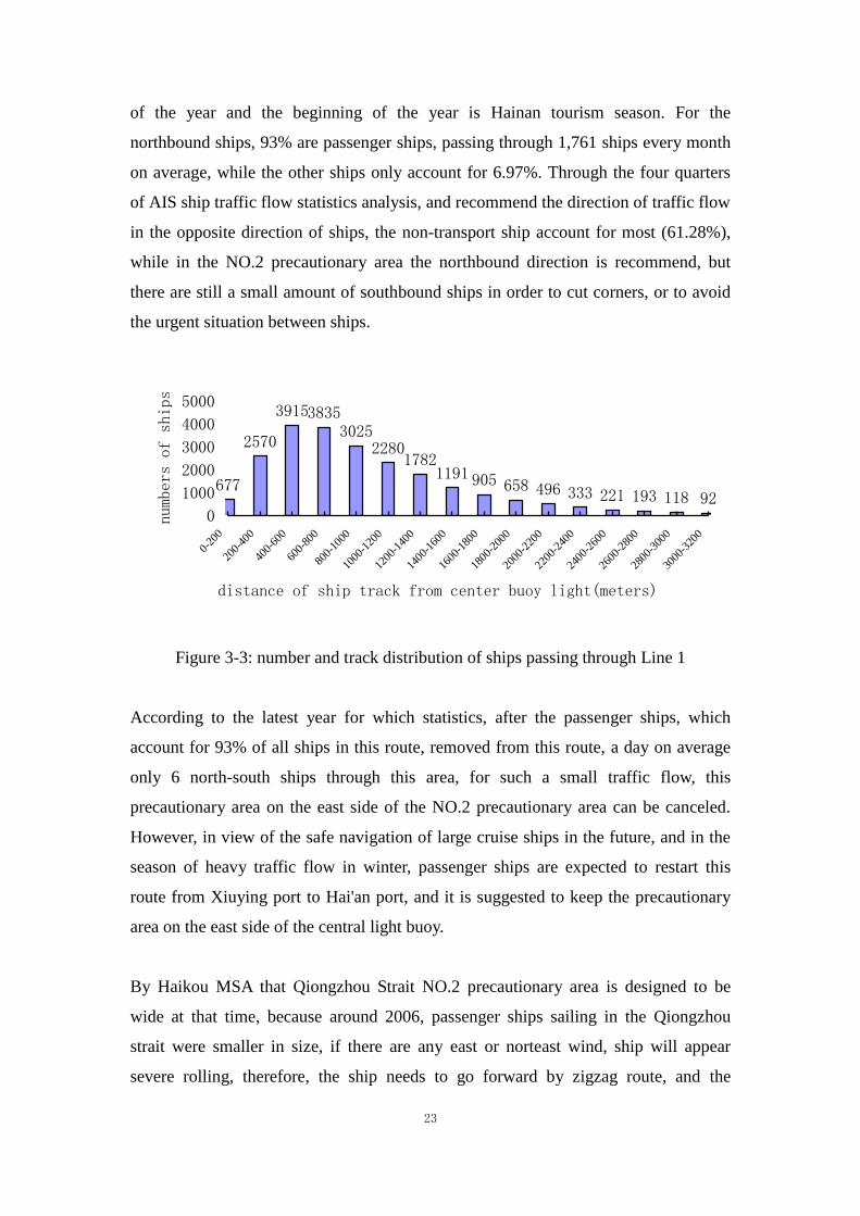
Figure 3-3: number and track distribution of ships passing through Line 1
According to the latest year for which statistics, after the passenger ships, which
account for 93% of all ships in this route, removed from this route, a day on average
only 6 north-south ships through this area, for such a small traffic flow, this
precautionary area on the east side of the NO.2 precautionary area can be canceled.
However, in view of the safe navigation of large cruise ships in the future, and in the
season of heavy traffic flow in winter, passenger ships are expected to restart this
route from Xiuying port to Hai'an port, and it is suggested to keep the precautionary
area on the east side of the central light buoy.
By Haikou MSA that Qiongzhou Strait NO.2 precautionary area is designed to be
wide at that time, because around 2006, passenger ships sailing in the Qiongzhou
strait were smaller in size, if there are any east or norteast wind, ship will appear
severe rolling, therefore, the ship needs to go forward by zigzag route, and the
24
required water area is relatively large. However, at present, the size of passenger ship
has been larger than before, and it is not required to follow the old zigzag route, so the
width of the NO.2 precautionay area can be narrowed appropriately. According to the
figure 3-3, about 98.2% of the northbound ships passed within 0-3200 meters from
the central light buoy, while only 1.8 percent (basically non-transport ships) passed
beyond 3200 meters from the central light buoy. Therefore, it is feasible to shift the
eastern boundary of the NO.2 precautionay area 0.7 nm to the west.
3.3.2 Ship traffic flow statistics through Line 2
The statistical of ship AIS flow through Line 2 is shown in the following tables.
Table 3-4: Statistical of ship traffic flow through Line 2 southbound
Time
Ship types
Second
quarter
Third
quarter
Fourth
quarter
First
quarter Total
Passage ship 1440 1441 2235 1608 6724
Cargo carrier 506 548 410 391 1855
Non-transport Ship 217 214 346 192 969
Oil tanker 18 20 28 27 93
Dangerous goods ship 21 6 5 23 55
Total 2202 2229 3024 2241 9696
Table 3-5: Statistical of ship traffic flow through Line 2 northbound
Time
Ship types
Second
quarter
Third
quarter
Fourth
quarter
First
quarter Total
Passage ship 276 301 388 108 1073
Cargo carrier 55 58 42 24 179
Non-transport Ship 91 121 192 88 492
Oil tanker 1 1 1 3 6
Dangerous goods ship 9 4 0 0 13
Total 432 485 623 223 1763
As shown in table 3-4, the number of southbound ships through the NO.2
precautionay area is basically kept at 2200 ships per quarter, and about 69% of the
southbound ships passing through Line 2 are passenger ships, with an average of 560
ships per month. According to the AIS statistical analysis, 61% of the ships sailing in
the opposite direction of the recommended traffic flow are non-transport ships.

25
8871111
1380147015161327
614357
186 130 76 83 55 530
500
1000
1500
2000
0-30
0
300-
600
600-
900
900-
1200
1200
-150
0
1500
-180
0
1800
-210
0
2100
-240
0
2400
-270
0
2700
-300
0
3000
-330
0
3300
-360
0
3600
-390
0
3900
-420
0
4200
-450
0
distance of ship track from center buoy light(meters)
numbers of ships
Figure 3-4: Number and track distribution of southbound ships passing through Line 2
Similar with the west side of NO.2 precautionay area, after the passenger ships, which
account for 69% of all ships in this route, removed from this route, only 10 ships of
all types pass through this area on average every day. However, considering the safety
of navigation and the future major cruise traffic flow is busy, it is suggested to reserve
this area. According to figure 3-4, more than 96% of the southbound ships passed
within 0-3300 meters from the central light buoy, and only about 4% (mostly
non-transport ships) passed over 3300 meters from the central light buoy. Therefore,
the eastern boundary of the NO.2 precautionay area can be shifted 0.7 nm to the west.
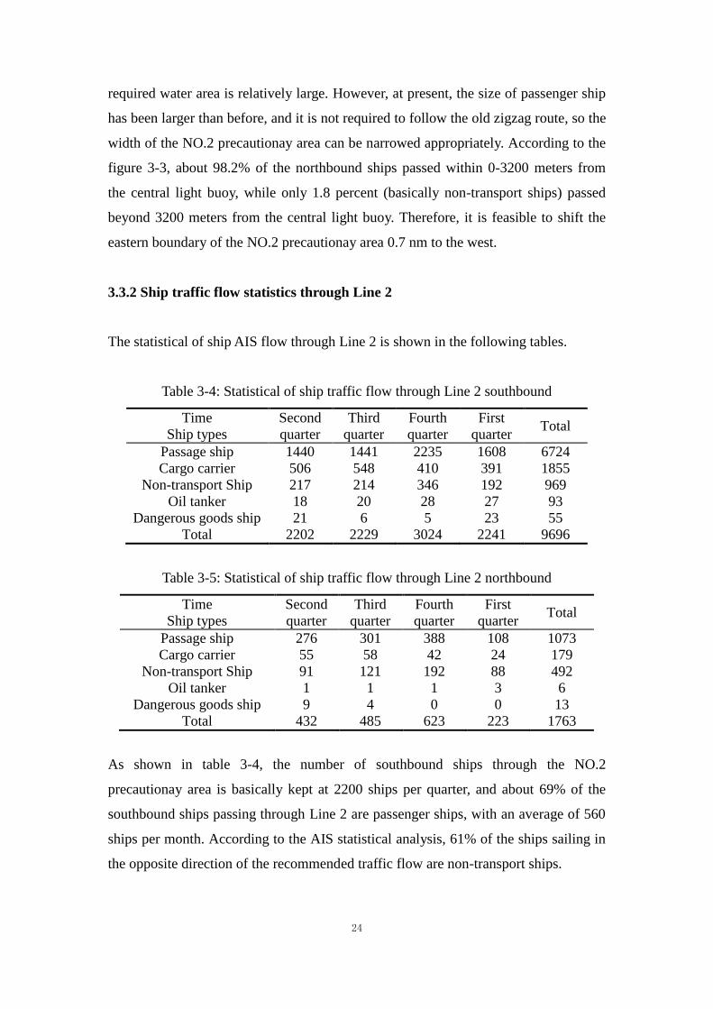
3.3.3 Ship traffic flow statistics through Line 3 and Line 4
The statistical of westbound ships which passing the Line 3 is shown in the figure 3-5.
From April 2018 to March 2019, the number of westbound ships through the
Qiongzhou Strait is 33693, with an average of 90 ships per day. Adding the 3517
retrograde means approximately 102 times per day. Retrograde ships are mainly
non-transport ships, accounting for 87% of the total retrograde ships. In addition,
according to the statistical AIS data, passenger ships account for about 42% of the
ships passing through Line 3, cargo ships, oil ships and dangerous goods ships
account for about 37%, and non-transport ships account for 21%.
The statistical of eastbound ships which passing the Line 4 is shown in the figure 3-5.
From April 2018 to March 2019, there are more than 32,800 ships passing through the
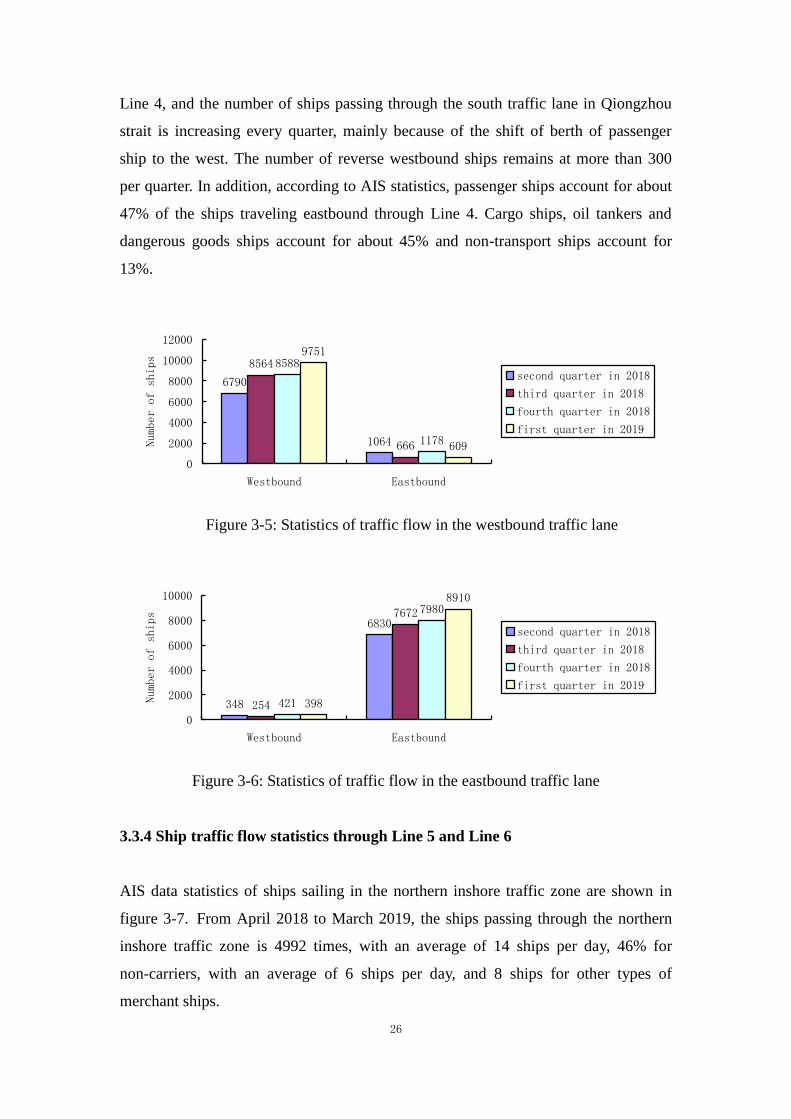
26
Line 4, and the number of ships passing through the south traffic lane in Qiongzhou
strait is increasing every quarter, mainly because of the shift of berth of passenger
ship to the west. The number of reverse westbound ships remains at more than 300
per quarter. In addition, according to AIS statistics, passenger ships account for about
47% of the ships traveling eastbound through Line 4. Cargo ships, oil tankers and
dangerous goods ships account for about 45% and non-transport ships account for
13%.
6790
1064
8564
666
8588
1178
9751
609
0
2000
4000
6000
8000
10000
12000
Westbound Eastbound
Number of ships
second quarter in 2018
third quarter in 2018
fourth quarter in 2018
first quarter in 2019
Figure 3-5: Statistics of traffic flow in the westbound traffic lane
348
6830
254
7672
421
7980
398
8910
0
2000
4000
6000
8000
10000
Westbound Eastbound
Number of ships
second quarter in 2018
third quarter in 2018
fourth quarter in 2018
first quarter in 2019
Figure 3-6: Statistics of traffic flow in the eastbound traffic lane
3.3.4 Ship traffic flow statistics through Line 5 and Line 6
AIS data statistics of ships sailing in the northern inshore traffic zone are shown in
figure 3-7. From April 2018 to March 2019, the ships passing through the northern
inshore traffic zone is 4992 times, with an average of 14 ships per day, 46% for
non-carriers, with an average of 6 ships per day, and 8 ships for other types of
merchant ships.

27
622
393
793
452
830
657726
519
0
200
400
600
800
1000
Westbound Eastbound
Number of ships
second quarter in 2018
third quarter in 2018
fourth quarter in 2018
first quarter in 2019
Figure 3-7: Statistics of traffic flow in the northern inshore traffic zone
AIS data statistics of ships sailing in the southern inshore traffic zone are shown in
figure 3-8. From April 2018 to March 2019, the number of ships in the southern
inshore traffic zone in the Qiongzhou Strait is obviously higher than that in the
northern. The average daily ship is 14 times in the east, around 11 times in the west, a
total of 25 times a day, 13 times a day for non-transport ships and 12 times a day for
other cargo ships.
12061348
890
1390
1040
1262
745
1223
0
200
400
600
800
1000
1200
1400
1600
Westbound Eastbound
Number of ships
second quarter in 2018
third quarter in 2018
fourth quarter in 2018
first quarter in 2019
Figure 3-8: Statistics of traffic flow in the southern inshore traffic zone
3.4 Traffic accident in Qiongzhou Strait
The ship traffic accident is directly related to the actual situation of maritime traffic
(traffic flow density and ship handle behavior), ship routeing and maritime traffic
management. This chapter first reviews the statistics of traffic accidents in Qiongzhou
Strait before the implementation of ship routeing system from 2001 to 2006, and then
analyzes the traffic accidents in Qiongzhou Strait after the implementation of ship
routeing system from 2007 to 2018.

28
3.4.1 Maritime traffic accidents from 2001 to 2006
From 2001 to 2006, a total of 53 maritime accidents occurred in the jurisdiction of
Haikou MSA, and one person was killed, as shown in table 3-6. There were 13
accidents in the waters covered by the current ship routeing system, all of which were
collisions, accounting for 25% of the total.
Table 3-6: Maritime traffic accident statistics for 2001-2006
collision grounding touch damages fire and explosion others total
2001-2006 26 10 14 0 3 53
Proportion 49% 19% 26% 0 6% -
3.4.2 Maritime traffic accidents from 2007 to 2018
From 2007 to 2018, a total of 104 maritime accidents occurred in the jurisdiction of
Haikou MSA, and 10 people were killed and missing, as shown in table 3-7. There
were 7 accidents in the ship routeing system, all of which were collision accidents, 1
major accident, 1 major accident, 5 minor accidents, and 3 people dead and missing.
Table 3-7: Maritime traffic accident statistics for 2007-2018
collision grounding touch damages fire and explosion others total
2007-2018 58 20 13 5 8 104
Proportion 56% 19% 13% 5% 7% -
3.4.3 Analysis of accidents in ship routeing system from 2007 to 2018
From 2007 to 2018, there were 7 ship collision accidents in the Qiongzhou Strait ship
Times
Type of accidents
Year
Times
Type of accidents
Year
29
routeing system, among which 4 were merchant ships and fishing boats, accounting
for 57% of all; 2 cases involving merchant and passenger ships, accounting for 29%
of the collision accidents within the ship routeing system; 1 accident occurred
between merchant ships, accounting for 14%. 3 people were missing and 3 injured in
the cases.
From 2007 to 2018, there were two collision accidents in the Qiongzhou Strait in
January and February, accounting for 29% of the collision accidents in the ship
routeing system, and one in April, May and November, accounting for 42% of the
collision accidents.
From 2007 to 2018, according to the time period of the duty officer on watch, two
collision accidents occurred during 0-4 hours and 12-16 hours respectively in the ship
routeing system in Qiongzhou Strait, accounting for 29% of the collision accidents
respectively. 4-8, 8-12, 16-20 each happened 1time of collision accident.
30
Chapter 4: Optimization scheme of ship routeing system in Qiongzhou Strait
4.1 Adjustment scheme of ship routeing system in Qiongzhou strait
Combined with the questionnaire in the appendix, the adjustment scheme of ship
routeing system in Qiongzhou Strait is made as shown in figure 4-1. The adjustment
contents are mainly as follows:
a) The definition of the NO.1 precautionary area changed from a circle to an arc;
b) The east-west length of the NO.2 precautionary area decreased from 4.8 nm to
3.4 nm;
c) The shape of the NO.3 precautionary area changed from circle to rectangle;
d) Add the NO.4 arc precautionary area (Luo, 2017);
e) The length of the first (easternmost) traffic separation scheme increased from 4.6
nm to 5.2 nm;
f) The length of the second traffic separation scheme reduced from 4.5 nm to 3.1
nm;
g) Add a third (westernmost) traffic separation scheme of 0.9 nm.

31
Figure 4-1: New ship routeing adjustment scheme in Qiongzhou Strait
Considering that the design scheme of the NO.3 precautionary area is the key content
of the ship routeing system adjustment in Qiongzhou Strait (Fan, Wu & Zhang, 2013),
this paper sorts out the traffic flow inside the NO.3 precautionary area and forms the
following several detailed schemes.
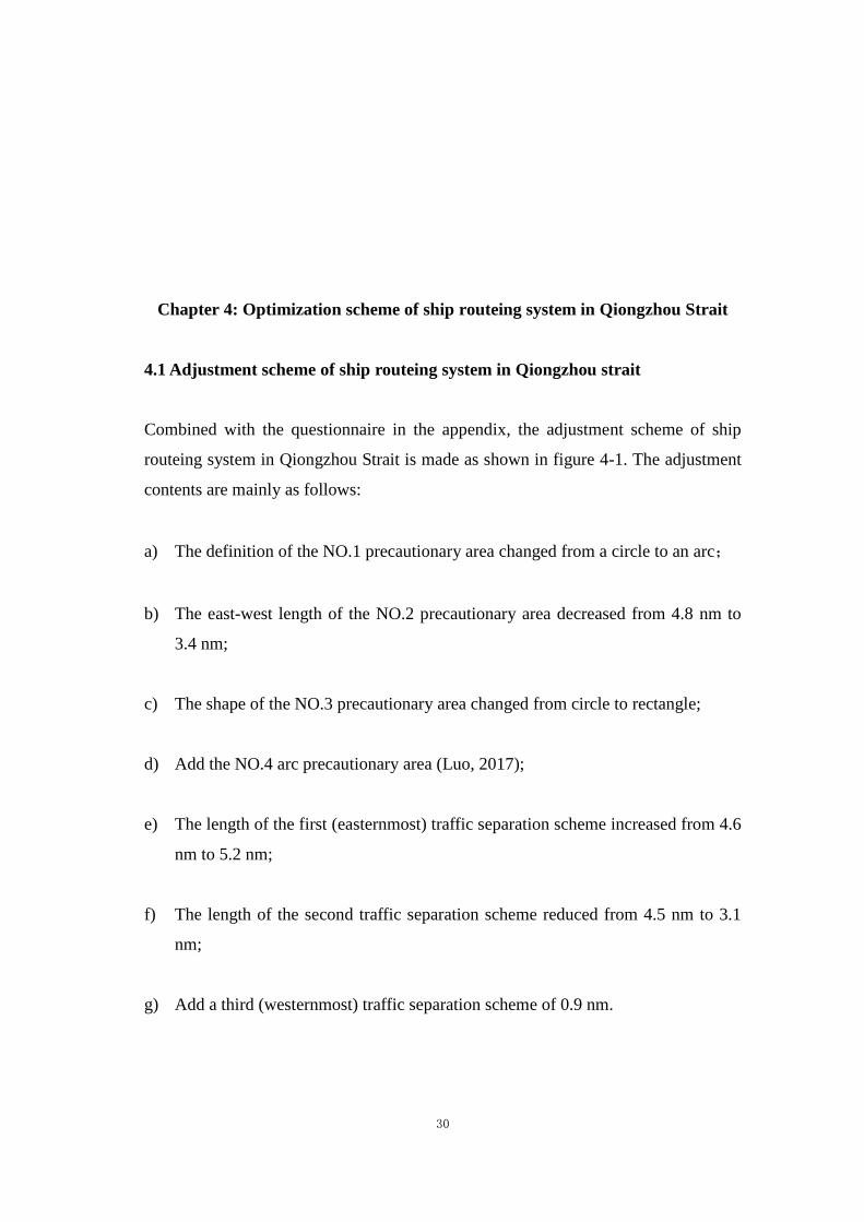
4.1.1 Scheme A
Diagram of scheme A is shown in figure 4-2, which includes the following points:
a) The Guangdong-Hainan railway ferry has no change in the existing 800-meter
channel. Two light buoys are set up in the center of the precautionary area, with
an interval of 1500 meters. The light buoys in the west separate the traffic flow
between Guangdong-Hainan railway ferry and the passenger ship. The light
buoys in the east are the circular area to be avoided center with a diameter of 0.2
nm, to separate the southbound and northbound traffic flow of passenger ships;
b) The passenger ship follows the recommended traffic flow direction (green line in
figure 4-2). In the center of the NO.3 precautionary area, the maximum distance
32
of southbound and northbound traffic flow is 1150 meters, and the distance of
southbound and northbound traffic flow of the sideline on the north side of the
precautionary area is 800 meters (Pietrzykowski, Zbigniew & Magaj, 2017);
c) In the north and south direction of the NO.3 precautionary area, recommended
routes are set for the Guangdong-Hainan railway ferry. (Note: the side lines of
both sides of the 1500m channel of the Guangdong-Hainan railway ferry are not
drawn in the ship routeing system, and they are not erased in the scheme for the
reference of the conventional route);
d) In order to avoid both avoiding collision and turning in the south of the NO.3
precautionary area, the north route of the deep green line in the figure 4-2 is
preferred, so as to avoid the intersection or setting of the turning point of the
passenger ship in and around NO.3 precautionary.
Figure 4-2: Diagram of scheme A
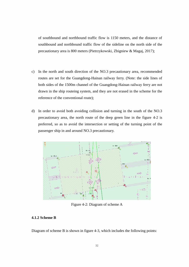
4.1.2 Scheme B
Diagram of scheme B is shown in figure 4-3, which includes the following points:
33
a) Scheme B makes full use of the existing 1500-meter channel, set up a light buoy
in the center, and 0.2 nm diameter area to be avoided is set around the buoy. The
east side of the light buoy is the northbound traffic flow, while the west side is
the southbound traffic flow (Fan, Wu & Zhang, 2014).
b) In the NO.3 precautionary area near the north and south ends of the traffic flow
have crossed, due to the close distance of ports, in order to avoid the
Guangdong-Hainan railway ferry and passenger ship of cross, also in order to
ensure the railway ferry on time, the Xuwen port need to control the time of
departure of the passenger ship, the Xinhai port also need to control the
arrivaling time of the passenger ship, to thoroughly solve crossing problem of
the Guangdong-Hainan railway ferries and passenger ships.
Figure 4-3: Diagram of scheme B
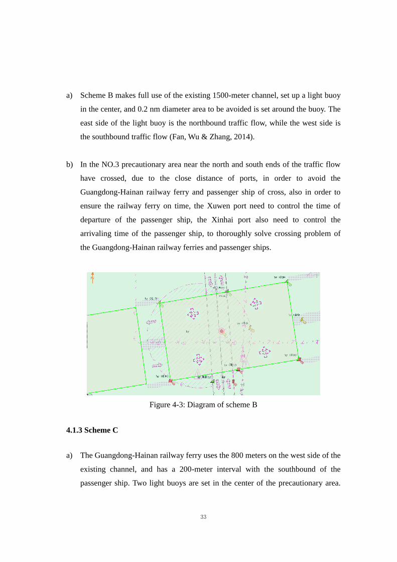
4.1.3 Scheme C
a) The Guangdong-Hainan railway ferry uses the 800 meters on the west side of the
existing channel, and has a 200-meter interval with the southbound of the
passenger ship. Two light buoys are set in the center of the precautionary area.
34
The light buoys in the west separate the traffic flow between Guangdong-Hainan
railway ferry and the passenger ship. The light buoys in the east are the circular
area to be avoided center with a diameter of 0.2 nm.
b) In the north and south direction of the precautionary area, recommended routes
are set for the Guangdong-Hainan railway ferry;
c) The deep green line in the figure is the preferred northbound route for passenger
ships (as in scheme A).
Figure 4-4: Diagram of scheme C
4.2 Questionnaire and results analysis
4.2.1 Survey of factors affecting navigation safety
On April 20, 2019 to 2019 on May 28, this paper conducted a questionnaire survey of
relevant personnel through Hainan MSA. The respondents of the questionnaire
include passenger ship captains, Haikou VTS officers, shipping company
management officers, and merchant ship captains berthing at Yangpu port. A total of
50, 16, 7 and 71 valid questionnaires were collected. Appendix 1 is the contents of
35
the questionnaire. The specific feedback and analysis results of the questionnaires are
as follows.
In terms of analyzing the factors affecting ship traffic in Qiongzhou Strait, this paper
conducts a questionnaire survey from the influence of ship traffic conditions,
geographical conditions of water area and meteorological and hydrological
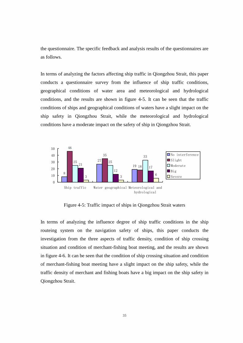
conditions, and the results are shown in figure 4-5. It can be seen that the traffic
conditions of ships and geographical conditions of waters have a slight impact on the
ship safety in Qiongzhou Strait, while the meteorological and hydrological
conditions have a moderate impact on the safety of ship in Qiongzhou Strait.
8
27
19
46
35
18
25 25
33
21
1217
3 36
0
10
20
30
40
50
Ship traffic Water geographical Meteorological and
hydrological
No interference
Slight
Moderate
Big
Severe
Figure 4-5: Traffic impact of ships in Qiongzhou Strait waters
In terms of analyzing the influence degree of ship traffic conditions in the ship
routeing system on the navigation safety of ships, this paper conducts the
investigation from the three aspects of traffic density, condition of ship crossing
situation and condition of merchant-fishing boat meeting, and the results are shown
in figure 4-6. It can be seen that the condition of ship crossing situation and condition
of merchant-fishing boat meeting have a slight impact on the ship safety, while the
traffic density of merchant and fishing boats have a big impact on the ship safety in
Qiongzhou Strait.

36
13
6 4
25
34
18
2823
2630 29 31
710
22
05
10152025303540
Ship concentration Meeting situation Fishing boat
No interference
Slight
Moderate
Big
Severe
Figure 4-6: The influence of ship traffic condition on navigation safety
In terms of analyzing the influence degree of various factors of geographical
conditions on navigation safety, this paper conducts the investigation from four
aspects: underwater obstacles (sunken ships, submerged reefs, etc.), water depth,
fishingnets and aquaculture, other factors, and the results are shown in figure 4-7. It
can be seen that in the geographical conditions of water areas, underwater obstacles
and water depth have slight impact on the navigation safety of ships, while
fishingnets and aquaculture have a big impact on the navigation safety of ships.
44
60
8 12
35
2010 9
15 13
38
85 5
228
1 0
26
3
0
20
40
60
80
Obstruction Water depth Fishingnet and
aquaculture
Other
No interference Slight Moderate Big Severe
Figure 4-7: The influence of geographical conditions on navigation safety
In terms of analyzing the influence degree of various factors of meteorological and
hydrological conditions on navigation safety, this paper conducts the investigation
from current, winds, visibility (fog, etc.), tides and others (fishing boats, sailing boats,
37
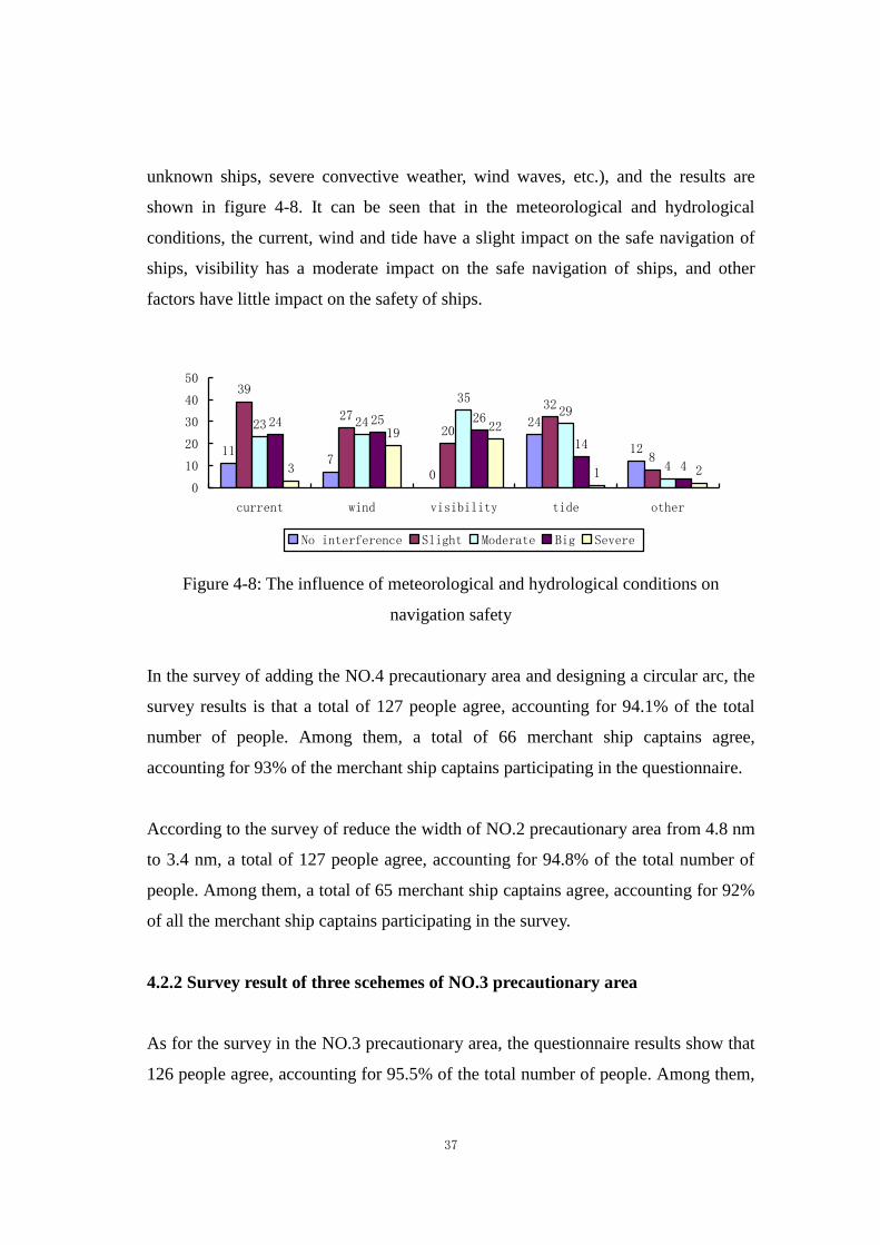
unknown ships, severe convective weather, wind waves, etc.), and the results are
shown in figure 4-8. It can be seen that in the meteorological and hydrological
conditions, the current, wind and tide have a slight impact on the safe navigation of
ships, visibility has a moderate impact on the safe navigation of ships, and other
factors have little impact on the safety of ships.
117
0
24
12
39
2720
32
8
23 24
3529
4
24 25 26
14
43
19 22
1 2
0
10
20
30
40
50
current wind visibility tide other
No interference Slight Moderate Big Severe
Figure 4-8: The influence of meteorological and hydrological conditions on
navigation safety
In the survey of adding the NO.4 precautionary area and designing a circular arc, the
survey results is that a total of 127 people agree, accounting for 94.1% of the total
number of people. Among them, a total of 66 merchant ship captains agree,
accounting for 93% of the merchant ship captains participating in the questionnaire.
According to the survey of reduce the width of NO.2 precautionary area from 4.8 nm
to 3.4 nm, a total of 127 people agree, accounting for 94.8% of the total number of
people. Among them, a total of 65 merchant ship captains agree, accounting for 92%
of all the merchant ship captains participating in the survey.
4.2.2 Survey result of three scehemes of NO.3 precautionary area
As for the survey in the NO.3 precautionary area, the questionnaire results show that
126 people agree, accounting for 95.5% of the total number of people. Among them,
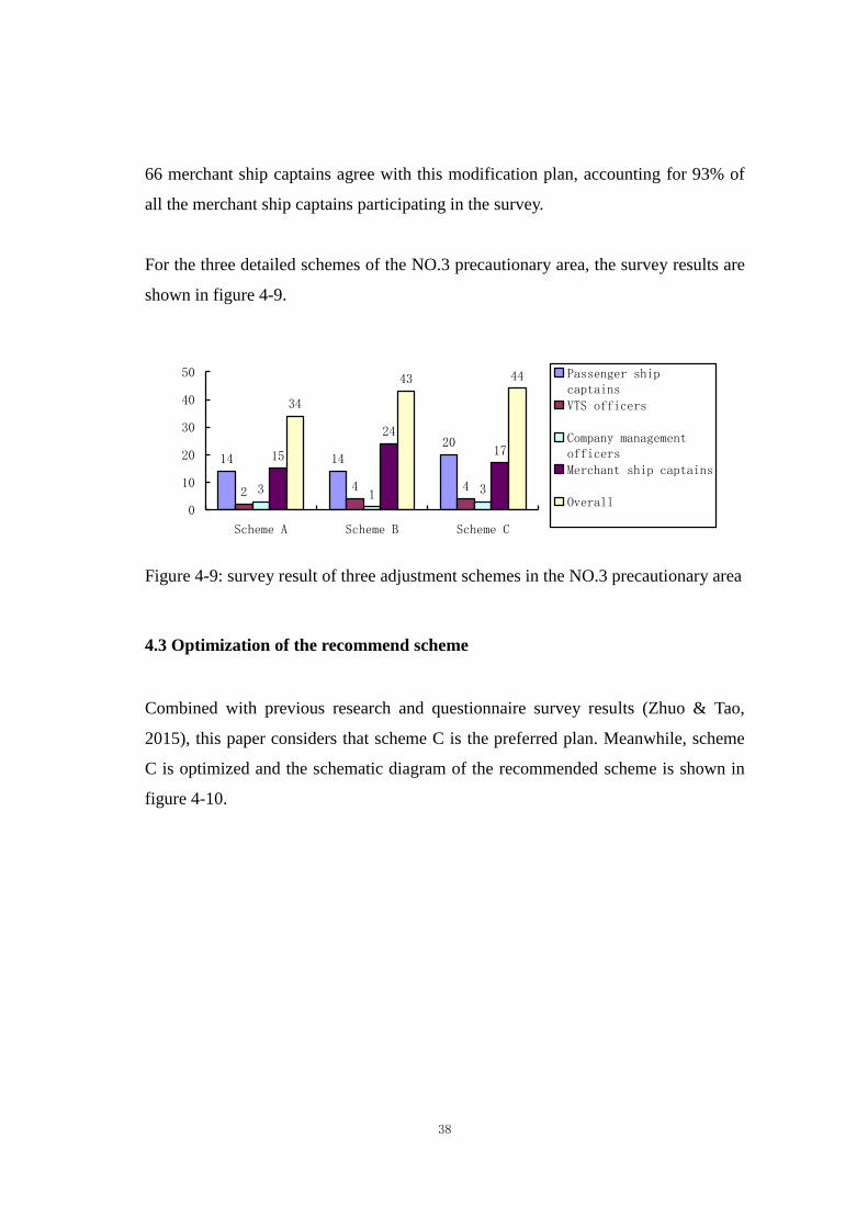
38
66 merchant ship captains agree with this modification plan, accounting for 93% of
all the merchant ship captains participating in the survey.
For the three detailed schemes of the NO.3 precautionary area, the survey results are
shown in figure 4-9.
14 14
20
2 4 43 1 3
15
24
17
34
43 44
0
10
20
30
40
50
Scheme A Scheme B Scheme C
Passenger shipcaptains
VTS officers
Company managementofficers
Merchant ship captains
Overall
Figure 4-9: survey result of three adjustment schemes in the NO.3 precautionary area
4.3 Optimization of the recommend scheme
Combined with previous research and questionnaire survey results (Zhuo & Tao,
2015), this paper considers that scheme C is the preferred plan. Meanwhile, scheme
C is optimized and the schematic diagram of the recommended scheme is shown in
figure 4-10.

39
Figure 4-10: Diagram of optimization of Qiongzhou Strart ship routeing system
The optimization contents of scheme C for ship routeing system in Qiongzhou Strait
are as follows:
a) Increase the distance between two central light buoys in the NO.3 precautionary
area. The center between the two light buoys in the NO.3 precautionary area of
scheme C is 1500 meters, which is not wide enough for the southbound
passenger ship (Ren, 2018). When the southbound passenger ship and the
eastbound ship, the westbound ship and the northbound Guangdong-Hainan
railway ferry appear at the same time near the central light boy, the meeting
situation of multiple ships will be formed (Yu, 2018). The distance between the
two light buoys should be increased to 2100 meters to provide more open water
for multiple ships to avoid collision (Sun, 2016).
b) Move the western boundary of the NO.3 precautionary area eastward. The west
boundary of scheme C is 2.1 nm away from the west side of the center of the
NO.3 precautionary area. The west boundary of the NO.3 precautionary area can
be moved 0.4 nm to the east, so that the west boundary is 1.7 nm away from the
center of the precautionary area, which is the same as the east boundary of the
precautionary area is 1.7 nm away from the east side of the center.

40
c) Shift south 12 and north 11 light buoys. Move the south 12 and north 11 light
buoys to the east to the equal distance of the north and south sides of the central
light buoys on the east side (1.7 nm from the boundary line on the east side of
the NO.3 precautionary area), and serve as the reference point for passenger
ships entering and leaving the NO.2 precautionary area.
d) The recommended route on the north and south sides of the NO.3 precautionary
area moves westward. In order to increase the distance between current
Guangdong-Hainan railway ferry routeing and the routeing for passenger ships
which calling the Xinhai port and Xuwen port, the recommended route on both
sides of the NO.3 precautionary area should be shifted to the west by 200 meters,
so that the horizontal distance between the recommended route in the NO.3
precautionary area and the light buoy on the west side of the precautionary area
should be 1000 meters. Given that the turning circle of ordinary passenger ships
is 3-6 times of ship length, the spacing of 1000 meters can ensure that even if the
passenger ship is fully loaded, it will not turn to the southbound route of the
Xinhai port and Xuwen port. The optimized scheme C and the present and future
traffic flow diagram are shown in figure 4-11 and 4-12.
Figure 4-11: Contrast diagram of optimized scheme C with present traffic flow
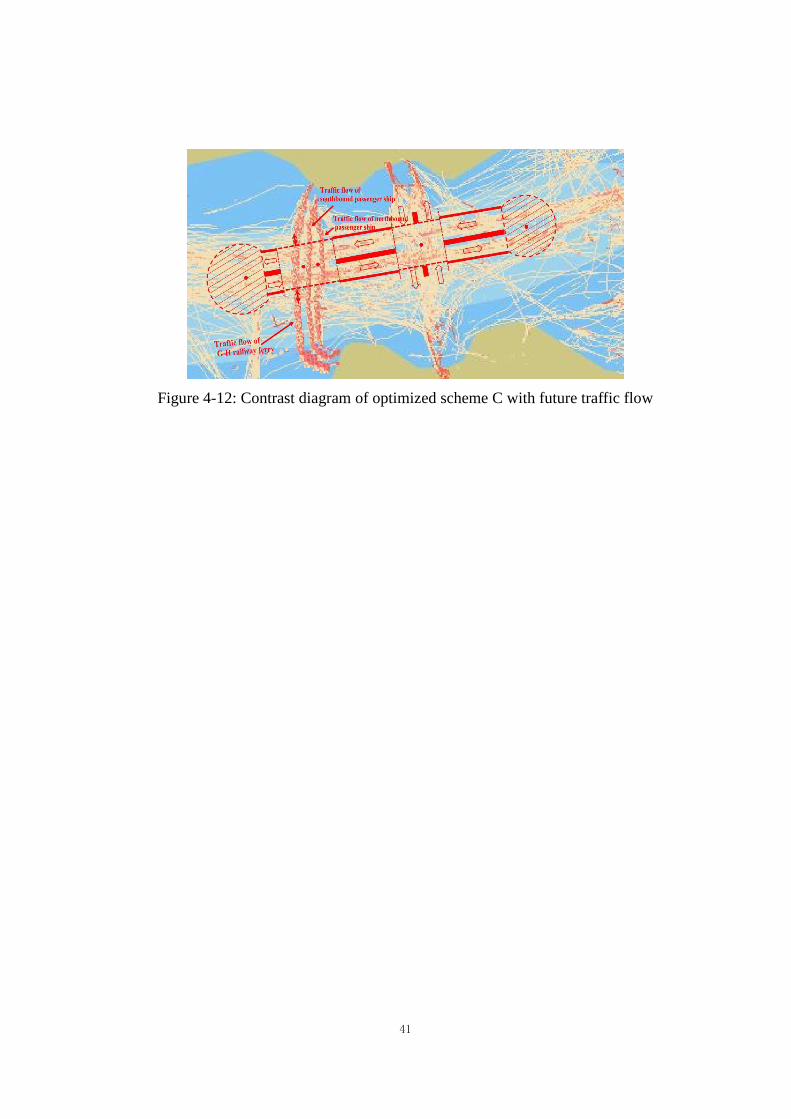
41
Figure 4-12: Contrast diagram of optimized scheme C with future traffic flow
42
Chapter 5: Conclusions
Ship routeing or managing the shipping traffic can be easily called the most
important aspect of entire maritime industry. Managing shipping traffic, especially in
regions of high traffic load or congested areas, ship routeing comes as even more
important task.
The optimization scheme of ship routeing system proposed in this paper is based on
international conventions and China's domestic laws and regulations, and guided by
the relevant international standards. This scheme is based on the relevant influence
factors in the comprehensive evaluation and demonstration on the basis of making,
conform to the IMO’s General Provisions on Ships Routeing, also give full
consideration to the traffic conditions over the waters of the traffic flow and the
adjacent waters, and the waters coincided basically with the existing form of traffic
flow, and give full consideration to the development trend of the nearby port.
More precisely, based on the research on the related theory of ships routeing system,
this paper analyzes the problems existing in the current shipping routeing system, has
a detailed understanding of the distribution and characteristics of ship traffic flow in
Qiongzhou Strait. After considering the characteristics of ship accidents in
Qiongzhou Strait waters, according to the adjustment of ports function on both sides
of Qiongzhou Strait, this paper puts forward an optimization scheme of ship routeing
system for Qiongzhou Strait. After formulating the optimization scheme of ship
routeing system in Qiongzhou Strait, this paper makes the selection of the
optimization scheme by the way of questionnaire survey for ship drivers and marine
traffic managers, and puts forward the modification suggestions. After screening and

43
modifying the optimization scheme, the final optimization scheme of Qiongzhou
Strait ship routeing system is determined.
The relevant measures proposed in this optimization scheme are in line with the safe
navigation of ships in Qiongzhou Strait, but some aspects require the relevant
competent authorities to take some measures to ensure the safe navigation of ships in
this area. In order to separate the reverse passenger ship traffic flow as early as
possible, to eliminate the passenger ship may turnning and avoiding collision at the
same time in the NO.2 precautionary area, and to reduce the collision of ships in the
southern part of the waterway due to the narrow waters, it is suggested that relevant
competent authorities clear fishing nets in the southern waters of the NO.3
precautionary area. At the same time, it is suggested that the relevant competent
authorities move and add some of the navigation marks and light buoys in
Qiongzhou strait to meet the new requirements of ship routeing system.
44
Reference
Cao Guangdong. (2015). Evaluation of the impact of ship routing system and
reporting system on ship navigation environment. Pearl River Water Transport,
(10):50-52.
Chen Shaoyong. (2016). Study on the safety management of Ro-Ro passenger ship in
Qiongzhou Strait, Master dissertation. Dalian: Dalian Maritime University.
Chen Weimin. (2018). Risk analysis and countermeasures of safe navigation in
Qiongzhou Strait. Navigation, 238(06):47-50.
Curtis, & Robert, G. . (1986). A ship collision model for overtaking. Journal of the
Operational Research Society, 37(4): 397-406.
Dong Haihui, Ye Jin. (2013). Research on navigation safety in qiongzhou strait.
Pearl River Water Transport, (23): 64-65.
Fan Zhongzhou, Hong Biguang & Zhang Chuang. (2012). Study on the ship routeing
and reporting system of large ships in the waters of Chengshanjiao. Marine
Technology,196(2):1-4.
Fan Zhogzhou. (2013). Research on the optimized method of ship routing schemes,
Doctoral dissertation. Dalian: Dalian Maritime University.
Fan Zhongzhou, Wu Zhaolin & Zhang Chuang, etc. (2013). Application research of
extension set theory in ship’s routing. Journal of Dalian Maritime University,
39(1):43-46.
45
Fan Zhongzhou, Wu Zhaolin & Zhang Chuang. (2014). Assessment methods of
ship's routeing based on grey theory. Journal of Dalian Maritime University,
40(1):37-40.
IMO. (1985). Resolution.572(14): General provisions on ships’ routeing. Retrieved
from https://puc.overheid.nl/nsi/doc/PUC_1369_14/5/
IMO. (2017). SOLAS Convention (2016 EDITION). Regulation V/10. Retrieved
from
https://mcanet.mcga.gov.uk/public/c4/solas/solas_v/Regulations/regulation10.htm
Li Weifeng, Ma Wenyao & Wang Qingwu, etc. (2015). Simulation model of ship
traffic based on cellular automata and its application. Navigation of China,
38(2):43-47.
Luo Guangbing. (2017). Research on the safety of ship routing in Qiongzhou Strait.
China Water Transport, 17(06):76-77.
Ministry of Transport of the People's Republic of China.(2011). The overall plan of
coastal ship routing system in China.
Pietrzykowski, Zbigniew & Magaj, etc. (2017). Ship Domain as a Safety Criterion in
a Precautionary Area of Traffic Separation Scheme. TransNav, the International
Journal on Marine Navigation and Safety of Sea Transportation, (11):93-98.
Ren Mingxing. (2018). Countermeasures of pilotage risk in Ningbo-Zhoushan port
No. 2 precautionary area. Marine Technology, 232(04):15-18.
Sun Hao. (2016). Research on post-evaluation on the amendment schemes to
Dan’gan traffic separation scheme, Master dissertation. Dalian: Dalian Maritime
University.
46
Szlapczynski, & Rafal. (2013). Evolutionary sets of safe ship trajectories within
traffic separation schemes. Journal of Navigation, 66(01):65-81.
Szlapczynski, R. (2013). Evolutionary ship track planning within traffic separation
schemes –&59; evaluation of individuals. Transnav International Journal on Marine
Navigation & Safety of Sea Transportation, 7(2):301-308.
UN. (1982). United Nations Convention on the Law of the Sea. Retrieved from
https://www.un.org/Depts/los/convention_agreements/texts/unclos/unclos_e.pdf
Wang Yaxin, Xu Chaojun & Chen Zhen, etc. (2018). Situation, Problems and
countermeasures of ferry service for Qiongzhou Strait. Journal of Lingnan Normal
University, 39(04): 87-96.
Xiaoyingjie, Zhanghao. (2010). Simulation of Ships' Routing System. Second
International Conference on Computer & Network Technology. IEEE Computer
Society.
Yu Yang. (2018). Research on the collision risk of vessels in Chengshanjiao
promontory water area based on Support vector machine, Master dissertation.
Dalian: Dalian Maritime University.
Yuan Zhitao, Liu Kezhog & Xin Xuri, etc. (2018).Design method of ships’routeing
in bay waters. Journal of Shanghai Maritime University, 39(04): 17-22&46.
Zhuo Yongqiang, Tao Jun. (2015). Effectiveness analysis and evaluation of
Qiongzhou Strait ship routeing scheme. Navigation of China, 38(1): 80-84.

47
Appendix:Questionnaire on optimization scheme of ship routeing system in Qiongzhou Strait
Date: April 15, 2019
Purpose of survey: With the adjustment of ports function on both sides of Qiongzhou Strait, the traffic condition of ships in Qiongzhou Strait will change. In
order to ensure the orderly, smooth and efficient navigation of ships and protect the navigation environment, this paper optimizes the
ship routeing system. As a user of Qiongzhou Strait, you are familiar with the ship traffic in this area. This paper would like to hear your
opinions and suggestions, so that the ship routeing system optimization scheme formulated in this paper can meet the interests of most
crew members, ship companies and relevant departments. Your answer is very important, thank you very much for your cooperation!
Content of survey: Opinions and Suggestions on optimization scheme of ship routeing system in Qiongzhou Strait
Questionnaire filling method: Tick "√" in the box after the option you agree with. If there is no option you agree with and you want to make necessary
supplement, please write in the "other" column
A. Your basic information
Role (a)passenger ship captains □ (b)Haikou VTS officers □ (c)shipping company management officers □
(d)merchant ship captains □ (e) others □
Years of current role (a)less than 1 year □ (b)1year to 5years □ (c)5years to 10years □ (d)10years to 20years □ (e) more than 20years □
B. Information of your ship
Type of your ship (a)passenger ship □ (b)container ship □ (c)oil tanker □ (d)LNG or LPG tanker □ (e)dangerous cargo carrier □ (f)bulk carrier □
(g)others □
GT of your ship (a)500 GT~3,000GT □ (b)3,000 GT ~10,000 GT □ (c)10,000 GT ~50,000 GT □ (d)50,000 GT ~100,000 GT □
(e)More than 100,000 GT
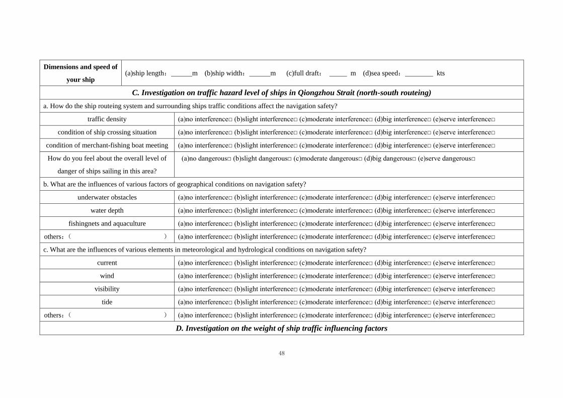
48
Dimensions and speed of
your ship (a)ship length: m (b)ship width: m (c)full draft: m (d)sea speed: kts
C. Investigation on traffic hazard level of ships in Qiongzhou Strait (north-south routeing)
a. How do the ship routeing system and surrounding ships traffic conditions affect the navigation safety?
traffic density (a)no interference□ (b)slight interference□ (c)moderate interference□ (d)big interference□ (e)serve interference□
condition of ship crossing situation (a)no interference□ (b)slight interference□ (c)moderate interference□ (d)big interference□ (e)serve interference□
condition of merchant-fishing boat meeting (a)no interference□ (b)slight interference□ (c)moderate interference□ (d)big interference□ (e)serve interference□
How do you feel about the overall level of
danger of ships sailing in this area?
(a)no dangerous□ (b)slight dangerous□ (c)moderate dangerous□ (d)big dangerous□ (e)serve dangerous□
b. What are the influences of various factors of geographical conditions on navigation safety?
underwater obstacles (a)no interference□ (b)slight interference□ (c)moderate interference□ (d)big interference□ (e)serve interference□
water depth (a)no interference□ (b)slight interference□ (c)moderate interference□ (d)big interference□ (e)serve interference□
fishingnets and aquaculture (a)no interference□ (b)slight interference□ (c)moderate interference□ (d)big interference□ (e)serve interference□
others:( ) (a)no interference□ (b)slight interference□ (c)moderate interference□ (d)big interference□ (e)serve interference□
c. What are the influences of various elements in meteorological and hydrological conditions on navigation safety?
current (a)no interference□ (b)slight interference□ (c)moderate interference□ (d)big interference□ (e)serve interference□
wind (a)no interference□ (b)slight interference□ (c)moderate interference□ (d)big interference□ (e)serve interference□
visibility (a)no interference□ (b)slight interference□ (c)moderate interference□ (d)big interference□ (e)serve interference□
tide (a)no interference□ (b)slight interference□ (c)moderate interference□ (d)big interference□ (e)serve interference□
others:( ) (a)no interference□ (b)slight interference□ (c)moderate interference□ (d)big interference□ (e)serve interference□
D. Investigation on the weight of ship traffic influencing factors

49
How do you think the following factors affect navigation safety in Qiongzhou Strait?
Traffic separation scheme and surrounding
ships (a)no interference□ (b)slight interference□ (c)moderate interference□ (d)big interference□ (e)serve interference□
Geographical conditions of the waters (a)no interference□ (b)slight interference□ (c)moderate interference□ (d)big interference□ (e)serve interference□
Meteorological and hydrological conditions (a)no interference□ (b)slight interference□ (c)moderate interference□ (d)big interference□ (e)serve interference□
E. Investigation on optimization scheme of ship routeing system in Qiongzhou Strait
a. Diagram of ship routeing system in
Qiongzhou strait after adjustment

50
b. Add the NO.4 precautionary area. The
shape of the newly added NO.4
precautionary area is circular arc (the
shape of the NO.1 precautionary area and
the NO.4 precautionary area should be the
same as far as possible). The
precautionary area is connected with the
inbound and outbound channel of Makun
port. NO.4 precautionary area
(a). Agree□ (b). Do not agree□
If not, please state your reasons:
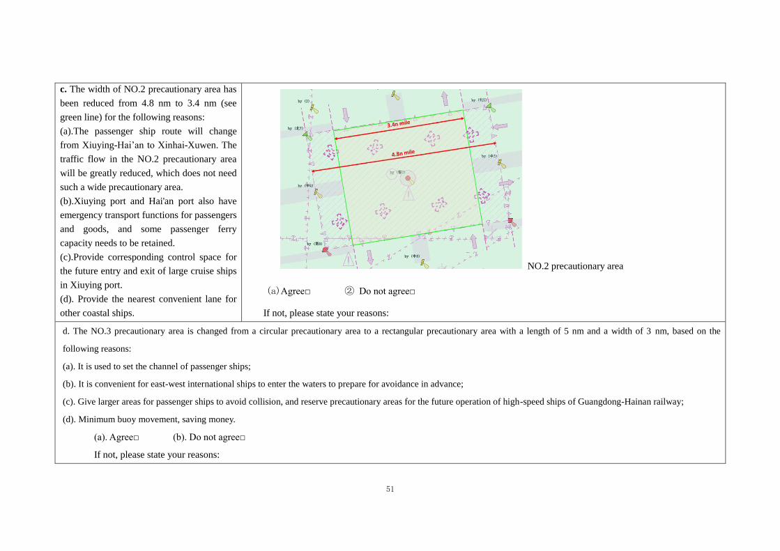
51
c. The width of NO.2 precautionary area has
been reduced from 4.8 nm to 3.4 nm (see
green line) for the following reasons:
(a).The passenger ship route will change
from Xiuying-Hai’an to Xinhai-Xuwen. The
traffic flow in the NO.2 precautionary area
will be greatly reduced, which does not need
such a wide precautionary area.
(b).Xiuying port and Hai'an port also have
emergency transport functions for passengers
and goods, and some passenger ferry
capacity needs to be retained.
(c).Provide corresponding control space for
the future entry and exit of large cruise ships
in Xiuying port.
(d). Provide the nearest convenient lane for
other coastal ships.
NO.2 precautionary area
(a)Agree□ ② Do not agree□
If not, please state your reasons:
d. The NO.3 precautionary area is changed from a circular precautionary area to a rectangular precautionary area with a length of 5 nm and a width of 3 nm, based on the
following reasons:
(a). It is used to set the channel of passenger ships;
(b). It is convenient for east-west international ships to enter the waters to prepare for avoidance in advance;
(c). Give larger areas for passenger ships to avoid collision, and reserve precautionary areas for the future operation of high-speed ships of Guangdong-Hainan railway;
(d). Minimum buoy movement, saving money.
(a). Agree□ (b). Do not agree□
If not, please state your reasons:

52
e. The following three pictures show three optimization schemes of the NO.3 precautionary area of ship routeing system in Qiongzhou Strait. According to your
navigation experience in this water, which ship routeing system should be adopted, please sort it or or choose any of the three diagrams to draw the routeing you
recommend.
Scheme A: (a). The route of Guangdong-Hainan railway ferry has no change in the existing 800-meter channel. Two light buoys are set up in the center of the precautionary area.
The light buoy in the west separate the traffic flow between Guangdong-Hainan railway ferry and passenger ships, and the light buoy in the east set up a circular 0.2 nm
area to be avoided to separate the traffic flow of passenger ships in the south and north.
(b). The passenger ships shall sail in the recommended direction of traffic flow (green line). In the center of the NO.3 precautionary area, the maximum distance of
southbound and northbound traffic flow is 1150 meters, and the distance of southbound and northbound traffic flow of the sideline on the north side of the precautionary
area is 800 meters.
(c). The north-south direction of the NO.3 precautionary area is the recommend routes for Guangdong-Hainan railway ferries.
(d). The deep green line in the figure is the preferred northbound route for passenger ships. It is suggested that the passenger ship should not meet or set the turning point
in the NO.3 precautionary area.

53
Scheme B:
(a). Scheme B makes full use of the existing 1500-meter channel, with a light buoy in the center and a 0.2 nm area to be avoided around the light buoy. The east side of
the light buoy is the northbound traffic flow, while the west side is the southbound traffic flow.
(b). In the NO.3 precautionary area near the north and south ends of the traffic flow have crossed, due to the close distance of ports, in order to avoid the
Guangdong-Hainan railway ferry and passenger ship of cross, also in order to ensure the railway ferry on time, the Xuwen port need to control the time of departure of
the passenger ship, the Xinhai port also need to control the arrivaling time of the passenger ship, to thoroughly solve crossing problem of the Guangdong-Hainan railway
ferries and passenger ships.

54
Scheme C:
(a). The Guangdong-Hainan railway ferry uses the 800 meters on the west side of the existing channel, and has a 200-meter interval with the southbound of the
passenger ship. Two light buoys are set in the center of the precautionary area. The light buoys in the west separate the traffic flow between Guangdong-Hainan railway
ferry and the passenger ship. The light buoys in the east are the circular area to be avoided center with a diameter of 0.2 nm.
(b). In the north and south direction of the precautionary area, recommended routes are set for the Guangdong-Hainan railway ferry.
(c). The deep green line in the figure is the preferred northbound route for passenger ships (as in scheme A).
55
According to your comparative analysis of the above three schemes, your first choice is scheme ( ), the second is scheme ( ), and the last is
scheme ( ). Why are you sorting this way?
Your answer:
Do you have any comments and Suggestions on the optimization of ship routeing sysytem?
Your answer:
Thank you again for your cooperation !

- 56 -