Research on Geothermal Energy Potential of Damavand Volcano
9
Proceedings World Geothermal Congress 2010 Bali, Indonesia, 25-29 April 2010 1 Reevaluation of Geothermal Energy Potential in Damavand Region Javad Nouraliee 1 ,S. Porkhial 2,3 , Amir Tamjidi 1 1-Niroo Research Institute, P.O.Box 14665-517, Tehran-Iran 2- Islamic Azad University, Karaj Branch, Iran 3-Department of Renewable energy, ministry of energy, Tehran, Iran [email protected] , [email protected] ,[email protected] Keywords: Iran, Damavand, Hot Springs, Remote Sensing ABSTRACT Damavand region including an elevated stratovolcano and many hot springs surrounding, is one of the most promising areas in Iran for geothermal energy potential. About 31 years ago, the Italian corporation ENEL (Ente Nazionale per l'Energia Elettrica) performed some geological, geochemical and geophysical exploration studies to identify the Damavand region geothermal reservoirs. Studies indicated that the Triassic-Paleozoic sequence constitutes promising geothermal reservoirs and that the Shemshak formation is a good cover (with thickness of about 1000 m). Also the reservoir fluid temperature was estimated at about 150ºC. Finally, upon the results of geophysical surveys (magnetotelluric and thermal survey), an area of about 200 km 2 was selected for detailed exploration studies. To perform complementary and updated explorations in the geothermal region of Damavand, this paper considered available information and reevaluated data after the passing of three decades since the studies mentioned above. For this reason, first all available maps were digitized and corrected using satellite data of the region. Then physicochemical characteristics (pH, temperature, flowrate, etc.) of the region hot springs such as Ab-ask, Baidjan and Larijan were reexamined. With the aid of Damavand region satellite images, the distribution condition of altered zones and also the distribution of thermal anomalies were considered and their results compared with the available data. Present evaluations confirmed that the Damavand region weather conditions (especially average annual rainfall) particularly in Ab-ali weather station, had not changed during the time period. Also physicochemical characteristics had not changed noticeably. Examination of thermal infrared images and alteration zones indicated that as suggested by the results of the ENEL experts, Damavand geothermal reservoir is generally and suitably capped by the Shemshak formation in the region. Based upon this evidence, we conclude that the dominant conditions of Damavand geothermal reservoir had not been changed considerably after the passing of three decades. So it is possible to plan and perform detailed exploration studies in the potentially favorable area of the Damavand geothermal region. 1. INTRODUCTION Damavand region is potentially one of the most favorable geothermal regions in Iran, because of its great and unique volcano. Furthermore, the presence of hot springs in Larijan, Baidjan and Ab-ask confirms the geothermal energy potential in this region. About 30 years ago, the Italian corporation ENEL performed extensive geothermal exploration studies in an area of about 5500 km 2 to identify potentially favorable Damavand geothermal areas. Geothermal explorations performed in this region included geological (photogeology and joints study), geochemical and geophysical studies. Finally a relevant area of about 200 km 2 located in the north and the east of Damavand Volcano Mountain were selected for detailed exploration studies. Figure 1 shows the limit of the Damavand geothermal region that was studied and the selected relevant area. Because of probability of geological events occurring in this period of about 30 years, we tried to reevaluate some of the available information and data in addition to gathering more. So in this study, first all the reports prepared by ENEL were completely reviewed and then examining thermal survey boreholes, hot springs and also remote sensing studies, the results of reevaluating exploration studies and geothermal energy potential in Damavand region will be presenedt. 2. EXPLORATION STUDIES OF ENEL CORPORATION 2.1 Geology Geological exploration in Damavand region has been concentrated on studying aerial photos and other available geological data. The experts inspected important areas of the region many times. They indicated that Damavand volcano is very young since there is no mark of glacial age erosion in the summit, representing the point of highest relief (5670 m) throughout Iran. It is situated in the highly uplifted belt of the Alborz Mts., and lies over a substratum of Mesozoic rocks. Presently the volcano is in an active fumarolic stage. The Precambrian to Eocene sediments are outcropping in the Damavand region. One of the most important factors in geothermal resources exploration is the permeability characteristics of the rocks. In other words, the target in geothermal geological exploration is recognizing reservoir (high permeability) and cap (low permeability) rocks. In this way Damavand region formations are classified by their permeability characteristics as following: - Precambrian and Cambrian sediments are composed of dolomite, sandstone and shale with low to moderate permeability - Permian–Triassic Formations are made up of limestone and dolomite with high permeability - Shemshak formation (lower Jurassic) is made up of shale, siltstone and sandstone with low permeability - Lar and Tizkuh formations (upper Jurassic and Cretaceous) are generally limestone with high permeability - Karaj formation is composed of volcanic rocks and limestone and gypsum beds with moderate permeability - Quaternary volcanites with numerous fractures and high permeability Hydrogeological studies indicate more suitable condition for occurrence of the geothermal reservoir rock in
Transcript of Research on Geothermal Energy Potential of Damavand Volcano
Proceedings World Geothermal Congress 2010 Bali, Indonesia, 25-29 April 2010
1
Reevaluation of Geothermal Energy Potential in Damavand Region
Javad Nouraliee1,S. Porkhial2,3, Amir Tamjidi1
1-Niroo Research Institute, P.O.Box 14665-517, Tehran-Iran
2- Islamic Azad University, Karaj Branch, Iran 3-Department of Renewable energy, ministry of energy, Tehran, Iran [email protected], [email protected] ,[email protected]
Keywords: Iran, Damavand, Hot Springs, Remote Sensing
ABSTRACT
Damavand region including an elevated stratovolcano and many hot springs surrounding, is one of the most promising areas in Iran for geothermal energy potential. About 31 years ago, the Italian corporation ENEL (Ente Nazionale per l'Energia Elettrica) performed some geological, geochemical and geophysical exploration studies to identify the Damavand region geothermal reservoirs. Studies indicated that the Triassic-Paleozoic sequence constitutes promising geothermal reservoirs and that the Shemshak formation is a good cover (with thickness of about 1000 m). Also the reservoir fluid temperature was estimated at about 150ºC. Finally, upon the results of geophysical surveys (magnetotelluric and thermal survey), an area of about 200 km2 was selected for detailed exploration studies. To perform complementary and updated explorations in the geothermal region of Damavand, this paper considered available information and reevaluated data after the passing of three decades since the studies mentioned above. For this reason, first all available maps were digitized and corrected using satellite data of the region. Then physicochemical characteristics (pH, temperature, flowrate, etc.) of the region hot springs such as Ab-ask, Baidjan and Larijan were reexamined. With the aid of Damavand region satellite images, the distribution condition of altered zones and also the distribution of thermal anomalies were considered and their results compared with the available data. Present evaluations confirmed that the Damavand region weather conditions (especially average annual rainfall) particularly in Ab-ali weather station, had not changed during the time period. Also physicochemical characteristics had not changed noticeably. Examination of thermal infrared images and alteration zones indicated that as suggested by the results of the ENEL experts, Damavand geothermal reservoir is generally and suitably capped by the Shemshak formation in the region. Based upon this evidence, we conclude that the dominant conditions of Damavand geothermal reservoir had not been changed considerably after the passing of three decades. So it is possible to plan and perform detailed exploration studies in the potentially favorable area of the Damavand geothermal region.
1. INTRODUCTION
Damavand region is potentially one of the most favorable geothermal regions in Iran, because of its great and unique volcano. Furthermore, the presence of hot springs in Larijan, Baidjan and Ab-ask confirms the geothermal energy potential in this region. About 30 years ago, the Italian corporation ENEL performed extensive geothermal exploration studies in an area of about 5500 km2 to identify potentially favorable Damavand geothermal areas. Geothermal explorations performed in this region included
geological (photogeology and joints study), geochemical and geophysical studies. Finally a relevant area of about 200 km2 located in the north and the east of Damavand Volcano Mountain were selected for detailed exploration studies. Figure 1 shows the limit of the Damavand geothermal region that was studied and the selected relevant area. Because of probability of geological events occurring in this period of about 30 years, we tried to reevaluate some of the available information and data in addition to gathering more. So in this study, first all the reports prepared by ENEL were completely reviewed and then examining thermal survey boreholes, hot springs and also remote sensing studies, the results of reevaluating exploration studies and geothermal energy potential in Damavand region will be presenedt.
2. EXPLORATION STUDIES OF ENEL CORPORATION
2.1 Geology
Geological exploration in Damavand region has been concentrated on studying aerial photos and other available geological data. The experts inspected important areas of the region many times. They indicated that Damavand volcano is very young since there is no mark of glacial age erosion in the summit, representing the point of highest relief (5670 m) throughout Iran. It is situated in the highly uplifted belt of the Alborz Mts., and lies over a substratum of Mesozoic rocks. Presently the volcano is in an active fumarolic stage. The Precambrian to Eocene sediments are outcropping in the Damavand region. One of the most important factors in geothermal resources exploration is the permeability characteristics of the rocks. In other words, the target in geothermal geological exploration is recognizing reservoir (high permeability) and cap (low permeability) rocks. In this way Damavand region formations are classified by their permeability characteristics as following:
- Precambrian and Cambrian sediments are composed of dolomite, sandstone and shale with low to moderate permeability
- Permian–Triassic Formations are made up of limestone and dolomite with high permeability
- Shemshak formation (lower Jurassic) is made up of shale, siltstone and sandstone with low permeability
- Lar and Tizkuh formations (upper Jurassic and Cretaceous) are generally limestone with high permeability
- Karaj formation is composed of volcanic rocks and limestone and gypsum beds with moderate permeability
- Quaternary volcanites with numerous fractures and high permeability
Hydrogeological studies indicate more suitable condition for occurrence of the geothermal reservoir rock in
Nouraliee, Porkhial and Tamjidi
2
Permotrias sediments. They are overlain by the Shemshak formation which can be considered as impermeable cap rock. From the viewpoint of geographical position, the best hydrogeological condition to form geothermal reservoirs is in the north and east of Damavand volcano mountain, that is in Nandal and Larijan terrains. Tectonic condition of these terrains indicates an uplifted structure. Furthermore, Shemshak formation in these terrains accounts for a thick cover which forms a suitable cap rock for geothermal reservoirs in the region and absence of hot springs also confirms it. On the other hand Delichai, Lar and Tizkuh formations (Jurassic–Cretaceous) and younger cap rocks are capable of forming other geothermal reservoirs in the region. Figure 2 shows the distribution pattern of Shemshak formation in the Damavand geothermal region.
2.2. Geochemistry
The geochemical study of Damavand consists of collection and analysis of 25 spring, 8 gas, 13 alteration deposits and 323 runoff water samples. Chemical and physical parameters measured in these analyses consist of flowrate, temperature, TDS, pH, Na, K, Mg, HCO3, Cl, SO42-, Li, B, Cs, NH4, Si, Ba, Mn, Hg, Fe, F, S and CO2. The concentration of Cs+, B, Cl- elements were measured in 323 runoff water samples and were drawn as isoconcentration curves in Damavand region. Concentration anomalies of these elements are observed across Lar, Haraz and Badaleh-Barzan valleys, indicating much importance of these limits for exploration of geothermal resources. Figure 3 shows distribution pattern of B element (as isoconcentration curves and by mg/l) in Damavand geothermal region.
The hot springs of Damavand region are mainly found along the valleys cuts, tied to important tectonic features like faults and thrusts. Their flowrate has been relatively high and did not change a lot throughout a year. It means that the springs are fed by huge water resources. The results of spring water chemical analysis indicated that the anions are mainly carbonate and sulfate, and most cations are Mg2+ and Ca2+. Water outflow locations of hot springs with high salinity are generally connected with tectonic elements or they are located in the contact between Shemshak and other Paleozoic formations. Springs with lower water temperature and salinity are located in carbonate formations (Delichai & Lar) covering Shemshak formation and also in volcanic rocks. Springs with the highest temperature and salinity are found near Larijan, Ab-ask, Baidjan, Badaleh and Barzan areas.
The pH values of spring water vary over a wide range because they come from different aquifers and are mixing with the cold low-salinity gound water (shallow aquifers). Deposits around the springs of Damavand region are made up of travertine, silica and also aluminum oxide in some cases.
The approximate temperatures of Damavand geothermal reservoir fluid were measured by different geothermometers such as quartz, chalcedony, cristobalite, Na-K-Ca, Na-K. Different results indicate mixing of reservoir fluid with shallow cold water aquifers. Among these, the quartz geothermometer is more reliable. It estimates Damavand geothermal reservoir fluid temperature between 130 to 150°C.
2.3. Geophysics
Geophysical studies in Damavand geothermal region are as follows:
2.3.1. Telluric and Magnetotelluric
The number of telluric stations was 1073, of which 437 stations read simultaneously with reference station in Firoozkuh and 636 stations read simultaneously with reference station in Lar valley. The information of 834 stations was used for interpretation of data. The stations had E-W and N-S trend where the sections were 350 meters long. The recording time in each station was 35-40 minutes, using 20-30 Hz frequencies in calculations.
On the other hand, magnetotelluric stations were 26, of which 21 stations were usable. The sections were 150-350 meters long and 0.3-135 Hz frequencies were used. The recording time in each station was 3.5 minutes for high-frequencies, 18 minutes for medium-frequencies and 40 minutes for low-frequencies.
Damavand region divides into two areas by processing the results of telluric and magnetotelluric surveys; east-southern area corresponds with high telluric values and central-northern area corresponds with low telluric values and consequently very thick sediments. Telluric maximal corresponds with some parallel anticlines, with Cambrian and Triassic sediments in their cores. Telluric minimal in a wide range indicates presence of a tectonic depression and consequently very thick sediments and resistant layers of basement in deep zones of the region. Some of magnetotelluric values indicate a conductive massif in resistant basement. This low resistivity limit is located at 5-10 km depth and the reason is probably its high temperature. Lowest depth zone of this low resistivity massif is located in Damavand volcanic cone limits.
2.3.2. Thermal Survey
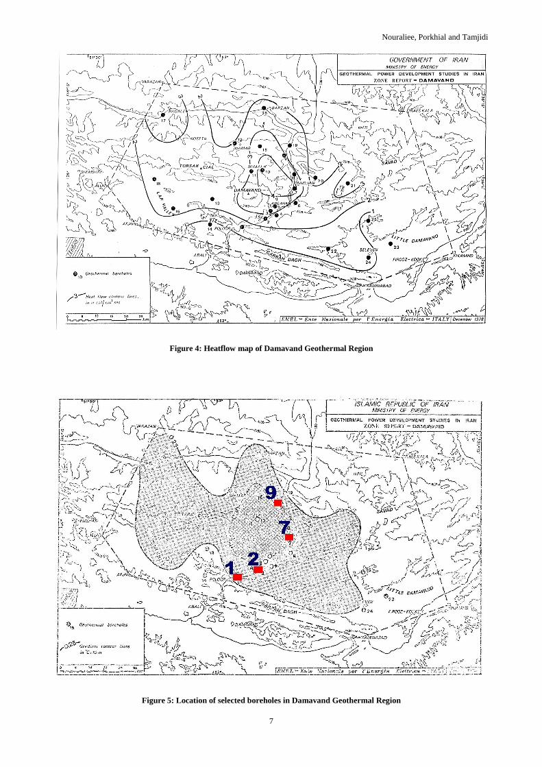
Thermal survey studies were performed in deep zones of Damavand exploration region to measure both thermal gradient and heat flow changes (anomalies). For this purpose, 26 shallow boreholes (each 83-120 meters deep) were drilled in the region. Most of the boreholes were located in Shemshak formation and fewer (4 boreholes) were located in Karaj formation. Temperature measurements in these boreholes revealed thermal gradient and heat flow anomalies in Damavand region, with SE–NW trend and coincided with volcanic rock outcrops in the region. These thermal anomalies correspond with volcanic activity of the region. The nighest thermal gradient anomaly reached value of 0.6-0.7°C/10 m, and the most heat flow anomaly reached value of 4-5 µCal/cm2.s measuring in Nandal and Baidjan areas located in Damavand North Slope. Figure 4 shows distribution pattern of heat flow in Damavand geothermal region.
2.4. Integrated Interpretation of All Data
The results of geological, geochemical and geophysical exploration studies in Damavand geothermal region revealed that the most relevant area from the point of geothermal energy potential is located in the north and east slopes of Damavand Mountain. They are in order, around Nandal and Baidjan villages.
The most important factors for selection of the mentioned geothermal relevant area in Damavand exploration region were stratigraphic situation and heat flow distribution. Figure 1 shows the limit of the selected geothermal area in Damavand region.
Nouraliee, Porkhial and Tamjidi
3
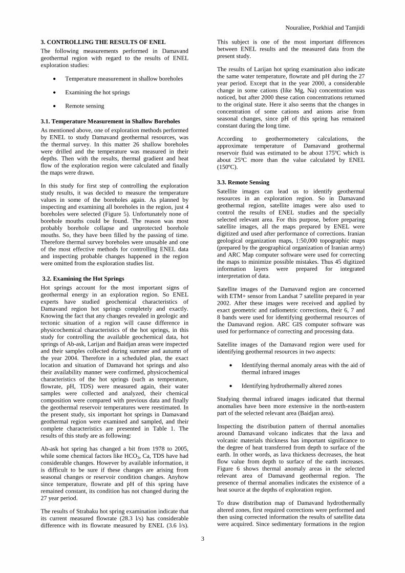
3. CONTROLLING THE RESULTS OF ENEL
The following measurements performed in Damavand geothermal region with regard to the results of ENEL exploration studies:
• Temperature measurement in shallow boreholes
• Examining the hot springs
• Remote sensing
3.1. Temperature Measurement in Shallow Boreholes
As mentioned above, one of exploration methods performed by ENEL to study Damavand geothermal resources, was the thermal survey. In this matter 26 shallow boreholes were drilled and the temperature was measured in their depths. Then with the results, thermal gradient and heat flow of the exploration region were calculated and finally the maps were drawn.
In this study for first step of controlling the exploration study results, it was decided to measure the temperature values in some of the boreholes again. As planned by inspecting and examining all boreholes in the region, just 4 boreholes were selected (Figure 5). Unfortunately none of borehole mouths could be found. The reason was most probably borehole collapse and unprotected borehole mouths. So, they have been filled by the passing of time. Therefore thermal survey boreholes were unusable and one of the most effective methods for controlling ENEL data and inspecting probable changes happened in the region were omitted from the exploration studies list.
3.2. Examining the Hot Springs
Hot springs account for the most important signs of geothermal energy in an exploration region. So ENEL experts have studied geochemical characteristics of Damavand region hot springs completely and exactly. Knowing the fact that any changes revealed in geologic and tectonic situation of a region will cause difference in physicochemical characteristics of the hot springs, in this study for controlling the available geochemical data, hot springs of Ab-ask, Larijan and Baidjan areas were inspected and their samples collected during summer and autumn of the year 2004. Therefore in a scheduled plan, the exact location and situation of Damavand hot springs and also their availability manner were confirmed, physicochemical characteristics of the hot springs (such as temperature, flowrate, pH, TDS) were measured again, their water samples were collected and analyzed, their chemical composition were compared with previous data and finally the geothermal reservoir temperatures were reestimated. In the present study, six important hot springs in Damavand geothermal region were examined and sampled, and their complete characteristics are presented in Table 1. The results of this study are as following:
Ab-ask hot spring has changed a bit from 1978 to 2005, while some chemical factors like HCO3, Ca, TDS have had considerable changes. However by available information, it is difficult to be sure if these changes are arising from seasonal changes or reservoir condition changes. Anyhow since temperature, flowrate and pH of this spring have remained constant, its condition has not changed during the 27 year period.
The results of Strabaku hot spring examination indicate that its current measured flowrate (28.3 l/s) has considerable difference with its flowrate measured by ENEL (3.6 l/s).
This subject is one of the most important differences between ENEL results and the measured data from the present study.
The results of Larijan hot spring examination also indicate the same water temperature, flowrate and pH during the 27 year period. Except that in the year 2000, a considerable change in some cations (like Mg, Na) concentration was noticed, but after 2000 these cation concentrations returned to the original state. Here it also seems that the changes in concentration of some cations and anions arise from seasonal changes, since pH of this spring has remained constant during the long time.
According to geothermometery calculations, the approximate temperature of Damavand geothermal reservoir fluid was estimated to be about 175ºC which is about 25ºC more than the value calculated by ENEL (150ºC).
3.3. Remote Sensing
Satellite images can lead us to identify geothermal resources in an exploration region. So in Damavand geothermal region, satellite images were also used to control the results of ENEL studies and the specially selected relevant area. For this purpose, before preparing satellite images, all the maps prepared by ENEL were digitized and used after performance of corrections. Iranian geological organization maps, 1:50,000 topographic maps (prepared by the geographical organization of Iranian army) and ARC Map computer software were used for correcting the maps to minimize possible mistakes. Thus 45 digitized information layers were prepared for integrated interpretation of data.
Satellite images of the Damavand region are concerned with ETM+ sensor from Landsat 7 satellite prepared in year 2002. After these images were received and applied by exact geometric and radiometric corrections, their 6, 7 and 8 bands were used for identifying geothermal resources of the Damavand region. ARC GIS computer software was used for performance of correcting and processing data.
Satellite images of the Damavand region were used for identifying geothermal resources in two aspects:
• Identifying thermal anomaly areas with the aid of thermal infrared images
• Identifying hydrothermally altered zones
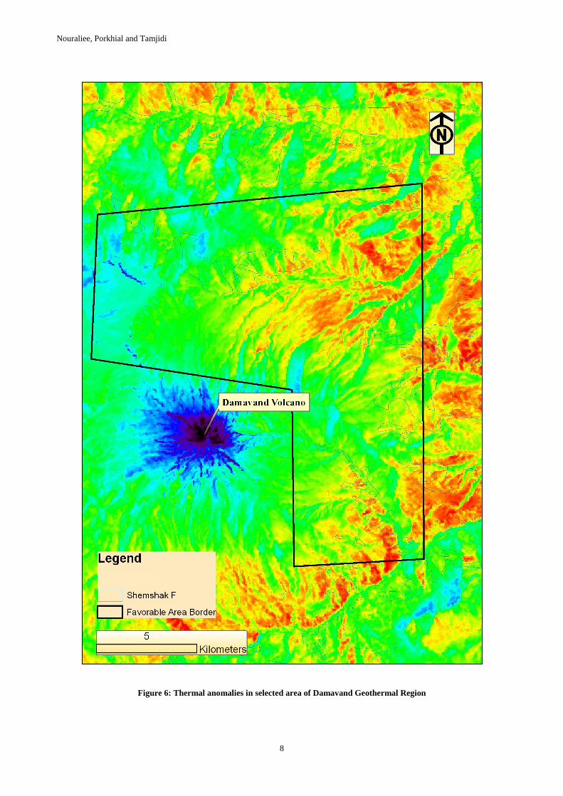
Studying thermal infrared images indicated that thermal anomalies have been more extensive in the north-eastern part of the selected relevant area (Baidjan area).
Inspecting the distribution pattern of thermal anomalies around Damavand volcano indicates that the lava and volcanic materials thickness has important significance to the degree of heat transferred from depth to surface of the earth. In other words, as lava thickness decreases, the heat flow value from depth to surface of the earth increases. Figure 6 shows thermal anomaly areas in the selected relevant area of Damavand geothermal region. The presence of thermal anomalies indicates the existence of a heat source at the depths of exploration region.
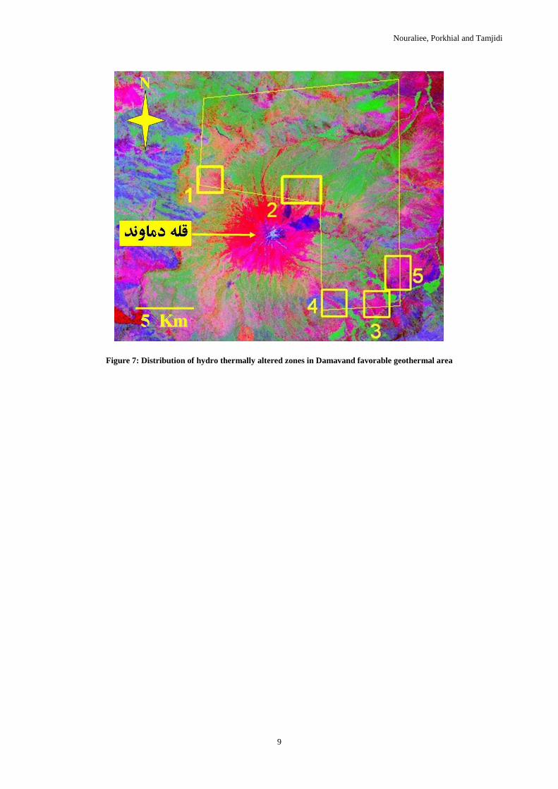
To draw distribution map of Damavand hydrothermally altered zones, first required corrections were performed and then using corrected information the results of satellite data were acquired. Since sedimentary formations in the region
Nouraliee, Porkhial and Tamjidi
4
include clay, first it was necessary to confirm acquired data on the Damavand geologic map and second to select altered zones which have no clay. So in this study, altered zones located in exposures of Shemshak and Delichai formations and the quaternary alluvium were omitted from other zones. Also for identifying altered zones, other factors such as faults, fold axes, seismic focuses and satellite linear trends, hot springs, circular structures and available thrusts were used. Figure 7 shows the altered zones (pink color) in selected relevant area of Damavand geothermal region. Finally by integrated interpretation of such data, the following results were acquired:
In Damavand volcanites limit which is located in north-western part of the selected area (rectangle 1 in figure 7), an altered zone is found that is also located in distance between two adjacent circular structures. This zone is also expanded outside of the selected area.
There are effects of alteration in the north slopes of Damavand Mountain which is located in central parts of the selected area (rectangle 2 in figure 7) and are all in the limit of Damavand volcanites. These altered zones have N-S trend and the extent gradually decrease towards north. There are also two faults with almost N-S trend adjacent to these alteration anomalies.
There is an altered zone in the southern part of the selected area which is located in the limit of Damavand volcano agglomerates (rectangle 3 in figure 7) with NW-SE trend along with a fault and an fold axis close to it. The fold axis in the altered zone has been hidden by agglomerates and breccia materials and this fold may have been the reason for creation of the altered zone.
There is another altered zone in the extreme south-western part of the selected area (rectangle 4 in figure 7) with a trend parallel to an anticline axis and also a fault. This alteration anomaly has been located in Quaternary volcanites.
There is a small altered zone in the south-eastern part of the selected area (rectangle 5 in figure 7) with no particular trend but it is massive. There is no important tectonic feature around the alteration mass. This alteration anomaly is in agglomerates and other Damavand volcanites.
In addition to these studies, meteorological data of the Damavand region were also updated, so that comparison of rainfall statistics in Ab-ali meteorological station indicated that the measure of average annual rainfall at the station has not changed at all during the 27 year period.
4. CONCLUSION
According to the abovementioned measurements performed in Damavand geothermal region with regard to the results of ENEL exploration studies, the following results were concluded:
1. Controlling thermal survey data of Damavand region was impossible, because of lack in casing pipes and maintenance operations of the boreholes. For this purpose, only the boreholes with casing pipes are usable because of the absence of subsurface water flow between their different parts.
2. Examining the hot springs of Damavand geothermal region proved that there is no notable change in Damavand geothermal reservoir
condition during the 27 year period. It is particularly obvious in the case of Larijan hot spring with its high flowrate and temperature value, having important role in examining the present condition of Damavand geothermal reservoir.
3. Investigating digitized maps of Damavand geothermal region revealed that:
• The selected relevant area includes the highest thermal gradient and heat flow in the exploration region.
• Three of nine available circular structures in Damavand exploration region are located in the selected relevant area.
• Shemshak formation, which performs the role of cap rock to the Damavand geothermal reservoir, has been exposed at northern, north-eastern, central and southern parts of the selected relevant area.
• A part of Baidjan overthrusted fault, which is one of the most important tectonic features of the region, is observed in the central parts of the selected relevant area. Furthermore, there are considerable numbers of faults in the selected area with almost N-S trend which are spreading at different angles to the north direction. Appearance of these tectonic features causes permeability increase in the selected area.
• Identifying thermal anomaly zones in the selected relevant area indicates the existence of a heat source at its depths.
• Presence of altered zones in the selected relevant area is indicator of hot fluid convectional currents at depth in the area. But as expected, the area of altered zones was very small in comparison with the whole area, because of the presence of thick Shemshak formation in the selected area and lack of influenc of geothermal fluid at surface of the earth, which is also the reason for suitable function of the formation in protection of Damavand geothermal reservoir.
• Investigation of changes in meteorological condition and particularly in rainfall during the 27 year period, indicate that the measurements in Ab-ali station which is closest meteorological station to the selected area, have not changed at all. It provided the result that the volume of input fluid to Damavand geothermal reservoir has not changed from the time of the ENEL studies up to now.
4. Finally the present study indicates that the selected relevant area in Damavand exploration region has suitable potential of geothermal energy, so that we can plan and perform more detailed exploration studies in the near future.
REFERENCES
Tamjidi A. and Khosrawi Kh., Geothermal Exploration in Damavand, Iran, Proceedings of 13th International Power System Conference (in Persian), Tehran, Iran, Nov. 1998, pp. 655-668.
Nouraliee, Porkhial and Tamjidi
5
Hydrogeological Investigations in Earth's Crust Study of Central Alborz Mountains (in Persian), Environment and Engineering Geology Bureau, Engineering Geology Group, Geological Survey of Iran, 2004.
Geothermal Power Development Studies, Damavand Zone, General Report, ENEL, 1978.
Arnorsson Stefan, Isotopic and Chemical Techniques in Geothermal Exploration, Development and Use, Sampling Methods, Data Handling, Interpretation, International Atomic Energy Agency, 2000.
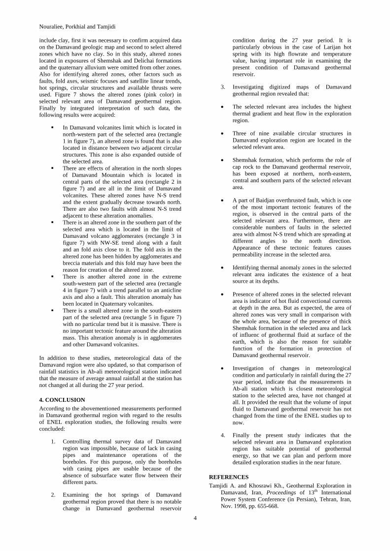
Figure 1: Satellite image of Damavand Geothermal Region and its favorable area

Nouraliee, Porkhial and Tamjidi
6
Figure 2: Distribution of Shemshak formation and other tectonic features in favorable area of Damavand Geothermal Region
Figure 3: Boron distribution in Damavand Geothermal Region (in mg/l)
Nouraliee, Porkhial and Tamjidi
7
Figure 4: Heatflow map of Damavand Geothermal Region
Figure 5: Location of selected boreholes in Damavand Geothermal Region
Nouraliee, Porkhial and Tamjidi
8
Figure 6: Thermal anomalies in selected area of Damavand Geothermal Region
Nouraliee, Porkhial and Tamjidi
9
Figure 7: Distribution of hydro thermally altered zones in Damavand favorable geothermal area