Research on Beijing’s Public - Home | ESMAP · PDF fileResearch on Beijing’s...
49
Research on Beijing’s Public Transportation Commuting Transit Network July, 2009 Beijing Municipal Committee of Communications Beijing Transportation Research Center World Bank
Transcript of Research on Beijing’s Public - Home | ESMAP · PDF fileResearch on Beijing’s...
Research on Beijing’s Public
Transportation Commuting Transit
Network
July, 2009
Beijing Municipal Committee of Communications
Beijing Transportation Research Center
World Bank

I. Background of Beijing PT Development
II. Problems & Challenges in PT Development
III. Proposals & Goals
IV. A Tentative Plan for BCTN
V. A Tentative Plan for BCTN Model Corridor
VI. Working Review and Plan for Next Stage
Outline

Population: In recent 5 years, the population
has grown by half a million every year, and till
2007, the total population stood at 16.33
million;
Economy: GDP per capita has reached
58,204 yuan, 10% higher than that of 2006.
Motor vehicles: 1,000 new motor vehicles are
being purchased every day, and the total
number of motor vehicles is 3.5 million.
I. Background on Beijing PT Development
Facts & Figures
The Increase of Beijing’s Motor Vehicles
1633
1581
1251 1259
12401246
1257
1364
1383
1423
1456
1493
1538
1150
1200
1250
1300
1350
1400
1450
1500
1550
1600
1650
1700
1995年
1996年
1997年
1998年
1999年
2000年
2001年
2002年
2003年
2004年
2005年
2006年
2007年
Regular
Residents
(10,000)
Beijing’s population
Motor Vehicles’ Volume(Unit:10,000)
Vehicles’ Volume
Private cars

Beijing’s investment on traffic infrastructure during
the past ten years had kept rising, and PT investment
has seen a rapid development. In 2007, municipal
investment on track communication reach 13.2 billion
yuan, 56% higher than the same period last year. The
portion of investment on PT infrastructure accounted
for 43.6% of the total investment on communication
construction.
I. Background on Beijing PT Development
Investment on infrastructure from the 8th to the
11th 5-year plan
How did passengers travel
Investment on PT development kept rising
Public Transportation is the major means
for commuters
In 2007, 34.5% of residents chose PT when going out,
almost the same as those who chose cars.
car PT bicycle Taxi others
Current situation of Public Transportation (PT)
development
Investment on Communication

I. Background on Beijing PT Development
Notable achievements were made on priority
of PT development
By the end of 2008, there are 8 track
communication lines, and the total length is 200 km,
in which 86 km is newly built;
Ground PT was optimized. By the end of 2008,
there were 644 bus lines, 19,395 vehicles, 4 PT
junctions, 24 center stations, and 377 origin stations
and terminals.
3 BRT lines with great capacity, and the total
length is 50 km.
From 2003 to 2008, 14,891 new environmentally-
friendly vehicles were purchased and 430 PT lines
were adjusted.

In 2008, the total ridership was 6.549 billion travels, in which 4.644 billion travels were carried by bus, 9.9% up compared to the same period of last year; 1.215 billion travels were by metro, 85.5% up compared to the same period of last year; and 0.69 billion by taxies, 7.6% up compared to the same period of last year.
I. Background on Beijing PT Development
PT ridership increases
PT ridership in Beijing’s (Unit: 100 million travels)
37.143.91 44.98
39.79 42.26 46.44
4.72
6.07 6.87.7 6.55
12.15
5.18
5.886.5
6.4 6.41
6.9
0
10
20
30
40
50
60
70
2003年 2004年 2005年 2006年 2007年 2008年
出租车 轨道交通 公共电汽车busmetroTaxi
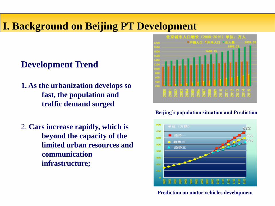
Development Trend
1. As the urbanization develops so
fast, the population and
traffic demand surged
2. Cars increase rapidly, which is
beyond the capacity of the
limited urban resources and
communication
infrastructure;
Beijing’s population situation and Prediction
Prediction on motor vehicles development
I. Background on Beijing PT Development

I. Background on Beijing PT Development
3. The variety of citizens’ travel demand requires fast development of
Public Transportation (PT);
A lot of changes occurred in residents' travel volume, travel distance and
space & time. Citizens’ various travel demand requires the establishment
of a multi-layer service system.
5000
4500
4000
3500
3000
2500
2000
1500
1000
500
0
2003 2005 2008 2015
Total travels (Unit:10,000 travels/day)
0
2
4
6
8
10
12
Travel distance (Unit: km)
2003 2005 2008 2015

II. Problems & Challenges in PT Development
Beijing’s priority of PT development policy is obviously effective, but the gap between the policy and urban
development and social expectation is still huge:
• Slow and time-consuming: currently, the average distance of PT travel is 9.5 kilometers at an
average speed of 14 kilometers per hour, which takes 66 minutes to travel at the rush hours;
while the average distance of car travel is 14 kilometers at an average speed of 22 kilometers per
hour, which takes 39 minutes at the peak hours.
• Inconvenient to transfer: now the average distance between two PT transfer stops is 355 meters,
taking commuters 6 minutes on foot, which is farer than original design (Code on Urban road
traffic planning and designing sets the maximum transfer distance at 200 meters)
• Unpunctual and unreliable: the punctual rate of PT is only 50%

II. Problems & Challenges in PT Development
A survey shows that 80% of the passengers' complaint is related to the problems mentioned
above. These problems have greatly affected the running efficiency of the public transport,
and reduced the attraction of the PT. The major causes of the problems are:
• Networks' optimization and adjustment are not completed: the three-level PT
networks system is not perfect, especially for the express lines; there are many
overlapped PT lines in the central areas, while PT networks haven’t reached some
areas in the outskirts of Beijing.
• PT transfer system is not perfect: there are inadequate transfer stops.
• PT road priority is not enough in busy areas: there’s no breakthrough in the heavy-
traffic areas, and the overall PT running speed has not been elevated.

III. Proposals & goals
Targetting on the peak-hour commuting & traveling
Aiming at increasing the ratio of PT for commuting & traveling
Focusing on increasing bus speed and improving transfer conditions
Also paying attention to the city’s development in a long run, and emphasizing solving the problems in a short run
Building the public transportation commuting transit network on the base of metro and BRT system.
Building an express Public Transportation Network (known as BCTN), which integrates bus, subway, and BRT that
covers both the urban and the rural areas.
Attracting commuters who drive cars to take public transportation, in order to increase the traffic efficiency.
Outlines:
III. Proposals & goals
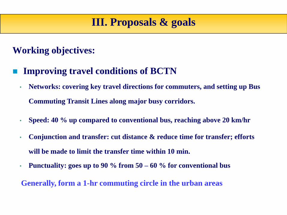
Working objectives:
Improving travel conditions of BCTN
• Networks: covering key travel directions for commuters, and setting up Bus
Commuting Transit Lines along major busy corridors.
• Speed: 40 % up compared to conventional bus, reaching above 20 km/hr
• Conjunction and transfer: cut distance & reduce time for transfer; efforts
will be made to limit the transfer time within 10 min.
• Punctuality: goes up to 90 % from 50 – 60 % for conventional bus
Generally, form a 1-hr commuting circle in the urban areas
III. Proposals & goals
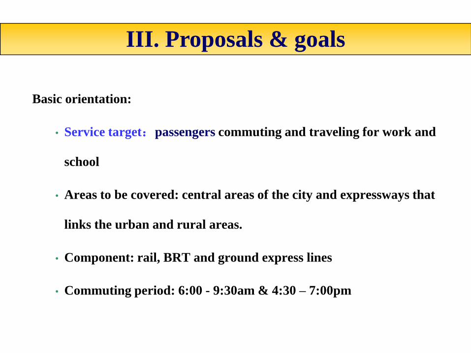
Basic orientation:
• Service target:passengers commuting and traveling for work and
school
• Areas to be covered: central areas of the city and expressways that
links the urban and rural areas.
• Component: rail, BRT and ground express lines
• Commuting period: 6:00 - 9:30am & 4:30 – 7:00pm
III. Proposals & goals
The design for the BCTN
• Vehicles:18 meters articulated buses in urban areas, and single buses in the suburbs.
• Logo system: well-marked logo should be seen on the platform and the buses, and the buses
should be painted with bright colors that can be distinguished from conventional buses.
• Departure interval: 1-3 minutes
• Speed: 20 km/hr
• Road conditions: set continuous physically or traffic-marking separated special lanes for the
Public Transportation only; buses to the suburbs will run on the express ways.
• Daily transportation capacity: 50-80 thousand travels.

IV. A Tentative Plan for BCTN
An analysis on the BCTN plan based on the following four aspects:
1.The PT passengers actual routes and the ideal routes demand
2. PT travel OD distribution
3. Major places of PT passenger flow
4. Roads and bus lane network

A selection of passenger corridors that the actual two-way PT passenger flow surpasses 10,000 travels/hr at the peak hours.
1. Analysis on PT passengers flow
IV. A Tentative Plan for BCTN

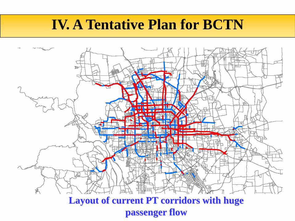
A selection of passenger corridors that two-way PT passenger flow surpasses
10,000 travels/hr at the peak hours under the ideal passenger flow distribution.
IV. A Tentative Plan for BCTN
1. Analysis on PT passengers flow
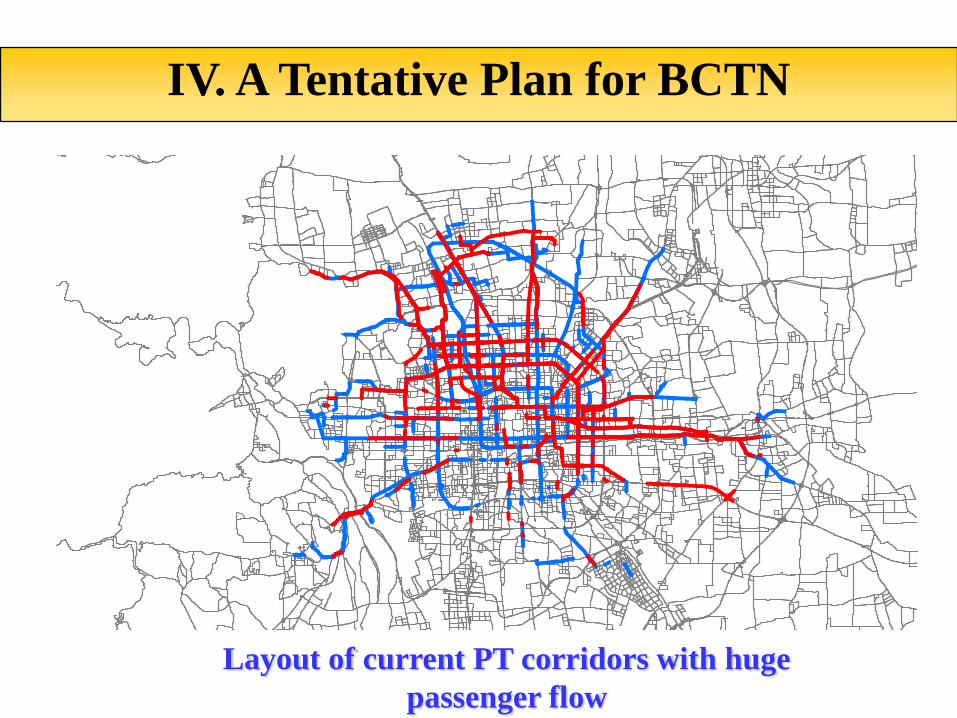
第一张网:公交客流需求分布高峰小时双向客流>10000人次/小时(快线满载60%)——虚实叠加
Layout of current PT corridors with huge
passenger flow
IV. A Tentative Plan for BCTN
第一张网:公交客流需求分布高峰小时双向客流>10000人次/小时(快线满载60%)——虚实叠加
Layout of current PT corridors with huge
passenger flow
IV. A Tentative Plan for BCTN
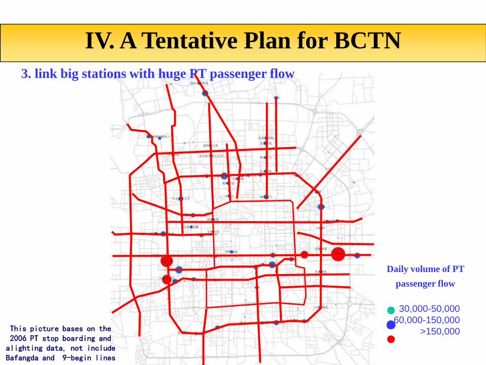
第三张网:公交客流主要节点分布
覆盖主要客流节点
30,000-50,000
60,000-150,000
>150,000
3. link big stations with huge PT passenger flow
Daily volume of PT
passenger flow
IV. A Tentative Plan for BCTN
This picture bases on the 2006 PT stop boarding and alighting data, not include Bafangda and 9-begin lines
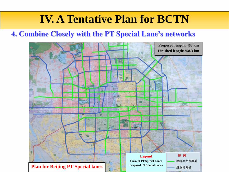
4. Combine Closely with the PT Special Lane’s networks
IV. A Tentative Plan for BCTN
Proposed length: 460 km
Finished length:258.3 km
Legend
Current PT Special Lanes
Proposed PT Special LanesPlan for Beijing PT Special lanes

Wangjing
Shunyi, PingguHuairou, Miyun Tiantongyuan, BeiyuanHuilongguan,Changping
Shijingshan
Fangshan Daxing Demaozhuang
Tongzhou
Yizhuang
Songjiazhuang
Fatou
Xiangshan
Mentougou
Shangdi
A Tentative Plane for BCTN
IV. A Tentative Plan for BCTN
9
Horizontal
Lines
9 Vertical
Lines
3 Rings
8
Radiation
Lines

ShangdiWangjing
Shunyi, PingguHuairou, MiyunTiantongyuan,BeiyuanHuilongguan,Changping
Shijingshan
房山 大兴 德茂庄
Tongzhou
亦庄
宋家庄
Fatou
Xiangshan
Mentougou
上地
1
7
2S1
Airport
10
4
5
Combine the planned Track Transportation networks, exclude the roads that have and are going to build track
transportation lines:
Roads that have built track transportation lines:Chang’an Street, road section from Chongwenmen to
Songjianzhuang, 2nd Ring Road, road section from Bagou to Jingcheng Express Way, Airport Express line, East
3rd Ring Road, etc. Roads that is going to build track transportation lines: Ping’an Street, Liangguang Road,
Road section from Xizhimen to Zhongguancun
Short term plan
Track Transportation
networks in 2015
Wangjing
Shunyi, PingguoHuairou,MiyunTiantongyuan, BeiyuanHuilongguan,Changping
Shijingshan
Fangshan Daxing Demaozhuang
Tongzhou
Yizhuang
Songjiazhuang
Fatou
Xiangshan
Mentougou
Shangdi
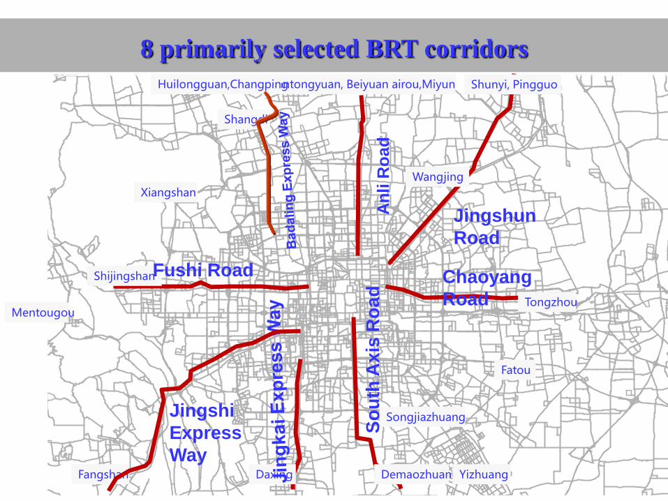
8 primarily selected BRT corridors
An
li R
oad
Jingshun
Road
Chaoyang
Road
So
uth
Ax
is R
oa
d
Jingshi
Express
Way
Fushi Road
Wangjing
Shunyi, PingguHuairou, MiyunTiantongyuan, BeiyuanHuilongguan, Changping
Shijingshan
Fangshan 大兴 Demaozhuang
Tongzhou
Yizhuang
Songjiazhuang
Fatou
Xiangshan
mentougou
Shangdi
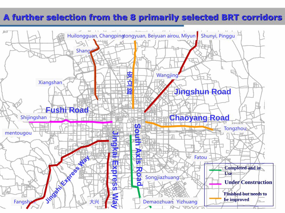
A further selection from the 8 primarily selected BRT corridors
安立路 Jingshun Road
Chaoyang Road
Jin
gk
ai E
xp
res
s W
ay
Fushi Road
Completed and in
Use
Under Construction
Finished but needs to
be improved

Wangjing
Shunyi, PingguHuairou, MiyunTiantongyuan, BeiyuanHuilongguan, Changping
Shijingshan
Fangshan Daxing Demaozhuang
Tongzhou
Yizhuang
Songjiazhuang
Fatou
Xiangshan
Mentougou
Shangdi
5 recently-built BRT corridors
Chaoyang
Road
Jin
gk
ai E
xp
res
s W
ay
Fushi Road
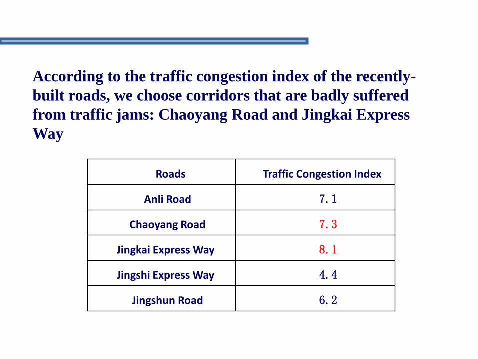
According to the traffic congestion index of the recently-
built roads, we choose corridors that are badly suffered
from traffic jams: Chaoyang Road and Jingkai Express
Way
Roads Traffic Congestion Index
Anli Road 7.1
Chaoyang Road 7.3
Jingkai Express Way 8.1
Jingshi Express Way 4.4
Jingshun Road 6.2
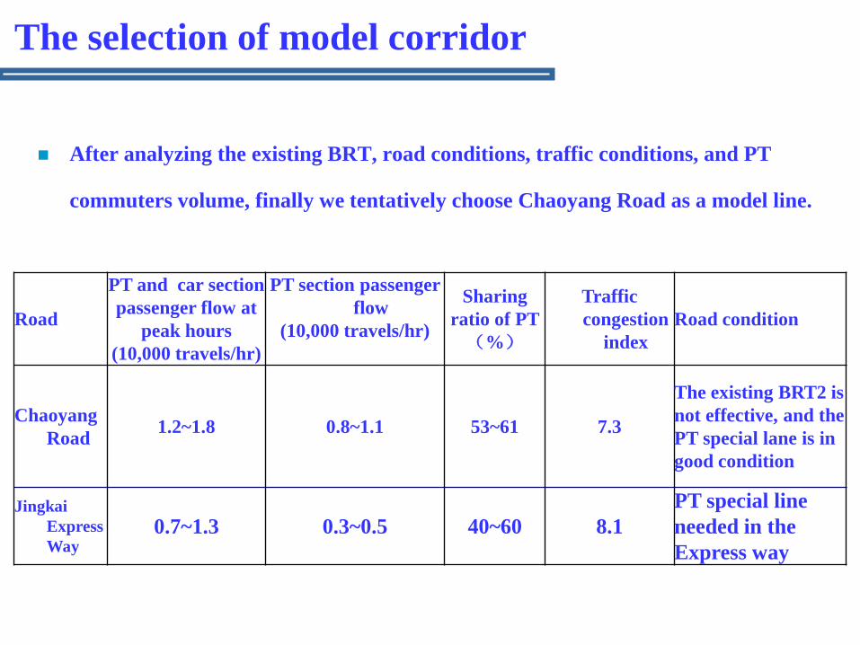
After analyzing the existing BRT, road conditions, traffic conditions, and PT
commuters volume, finally we tentatively choose Chaoyang Road as a model line.
Road
PT and car section
passenger flow at
peak hours
(10,000 travels/hr)
PT section passenger
flow
(10,000 travels/hr)
Sharing
ratio of PT
(%)
Traffic
congestion
index
Road condition
Chaoyang
Road1.2~1.8 0.8~1.1 53~61 7.3
The existing BRT2 is
not effective, and the
PT special lane is in
good condition
Jingkai
Express
Way0.7~1.3 0.3~0.5 40~60 8.1
PT special line
needed in the
Express way
The selection of model corridor

No. Road Completed/being built 建设时序
1 Chaoyang RoadAn Example Project
2 Fushi RoadUnder
construction3 Jingkai Express Way near future4 Anli Road BRT3 near future
5
Badaling-the Old Summer Palace East Road(shangdi-
Zhongguancun Need to build a main Roadnear future
6 Jingshun Road future
7 Jingshi Express Way future8 Badaling Main line future
9Road section from
Xizhimen to XiangshanPartly Planned M4 future
10 Ping’an Street Partly Planned S1 future
11 Chaoyang North Road
12Road section from Fengbei
Bridge to Fatoufuture
13Road section from
Jianguomen to mentougouPartly existing M2 future
14 Jingcheng Express Way future
15 Jingjintao Express Way future
16Road section from
Huilongguan to the Old Summer Palace East
future
17 Xueyuan Road future18 Xidan-Gongyi Bridge future
19Road section from
Huilongguan to Suzhou Bridge
future
20 Fangzhuang East Road future
Suggestions on construction schedule
According to the
analysis above,
we suggest the
construction
schedule as
below:
Recent
construction: 5
lines
Future
construction: 16
lines
Suggestions on construction schedule
Wangjing
Shunyi, PingguHuairou, MiyunTiantongyuan, BeiyuanHuilongguan, Changping
Shijingshan
Fangshan Daxing Demaozhuang
Tongzhou
Yizhuang
Songjiazhuang
Fatou
Xiangshan
Mentougou
Shangdi
1
7
2S1
Airport
10
4
BRT3
BRT1
Legend
Near future
construction
Future
construction
Existing and planned track
Existing and planned BRT
An analysis of the current situation of the corridor
The major problems of the corridor
Tentative solution
A Tentative Plan for BCTN Model corridor
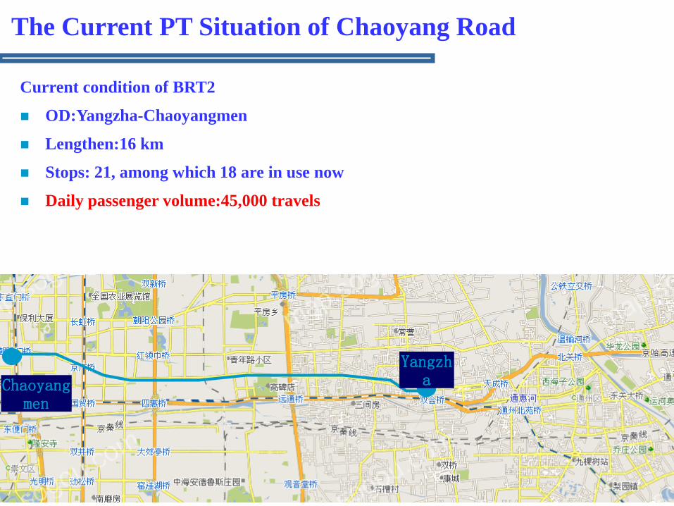
The Current PT Situation of Chaoyang Road
Current condition of BRT2
OD:Yangzha-Chaoyangmen
Lengthen:16 km
Stops: 21, among which 18 are in use now
Daily passenger volume:45,000 travels
Chaoyangmen
Yangzha

There are 25 crossing roads with traffic
lights, 9 traffic lights for pedestrian and 3
crosswalks without traffic lights from
Chaoyangmen to Yangzhahuandao.There
is a traffic light every 450 meters.
朝阳路BRT沿线道路状况
Tielu
bridgeThe 5th
ring road
The 4th
ring road
The 3rd
ring road
The 2nd
ring road
Dongda
Bridge
Legend
Special lane
Mixed-traffic road
Roadside special
lane
One-way mixed-
traffic road
One-way roadside special
lane
Yangzhahua
ndao
Heavily traffic
congested area
Two way 6-lane road
(The special lane is on
the right side)
Main road:3 lanes in outbound direction
(The right one is the special lane)
One lane in inbound direction (special
lane)
Side road:Two-way 6 lanes
Main road:two-way 4 lanes (The
right one is the special lane)
Side road:two-way 6 lanes
Main road:two-way 4 lanes (The
special lane is on the right side)
Side road:two-way 6 lanes
Two-way 6
lanes
Main road:two-way 4 lanes (The
right one is the special lane)
Side road:two-way 4 lanes
Two-way 4 lanes
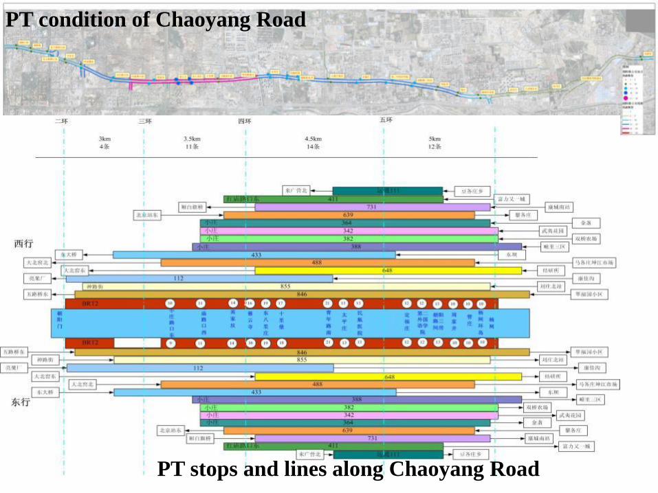
PT condition of Chaoyang Road
PT stops and lines along Chaoyang Road

1. The PT special lane hasn’t showed its advantages. BRT2 speed is as slow as the
conventional buses, with its speed at 15-16 km/hr at peak hours and 18-20
km/hr at level hours.
PT running conditions along Chaoyang Road
We compared the running time between BRT2 and its overlapped
line(conventional Bus No.846)at morning peak hours, level hours and evening
peak hours.The compared road section is from Chaoyangmen to
Yangzhahuandao(some 15 km). The comparison shows that BRT2 is more
time-saving than conventional buses, but the advantages are not obvious,
especially at the level and evening peak hours.
Morning peak hours
Level hours Evening peak hours
BRT2 59′45″ 48′43″ 55′16″
Bus No.846 76′44″ 56′44″ 60′25″

54%
7%
21%
17%
1%
BRT2 running time structure
at morning peak hours Driving time
Time spending at
stops
Time waiting for
traffic lights
Delay caused by
traffic congestion
Delay caused by
other factors
Bus No.846 running time structure
at morning peak hours
6%
23%
18%
3%
Time spending at
stops 6%
Time waiting for
traffic lights 23%
Delay caused by
traffic congestion
18%
Delay caused by
other factors 3%
BRT2 outbound running time structure
at evening peak hours
58%
10%
30%
2% 0%
Driving time
Time spending at
stops
Time waiting for
traffic lights
Delay caused by
traffic congestion
Delay caused by
other factors
Bus No.846 outbound running time structure
at evening peak hours
55%
9%
34%
1%
1%Driving time
Time spending at
stops
Time waiting for
traffic lights
Delay caused by
traffic congestion
Delay caused by
other factors

Analysis on Travel time structure– take morning
peak hours as an example
BRT2 is roughly the same as conventional buses in travel time structure,
Waiting time of the traffic lights is long, accounting for 21% and 23% of the total running time.
One of the major causes that delays the buses is traffic congestion, accounting for 17% and 18% respectively.
Time spending at stops is short, accounting for 7% and 6% respectively

Major causes that affect BRT’s speed
Distance between traffic lights is short(450 meters),
and there’s no PT priority traffic signal, and the
special lane’s advantages cannot be seen.
There is no PT special lane at the entrance of the main
road at the crossings below the bridges in peak-hour
traffic congested areas such as Ciyunsi and Hujialou.
The PT special lane is occupied by cars, which affects
the PT speed.
The road construction between the 4th and 5th ring
roads makes the special lane discontinuous.
Major ProblemsHujialou bridge
Ciyunsi bridge

杨闸环岛Wuyi Garden
Beiguanhuandao
There is large commuting demand in Tongzhou North area:
1. Large-area communities have been built around Wuyi Garden.
2. After a survey of Wuyi Garden, Jieyansuo, and Wuzi University stops, ..inbound
passengers volume of the three stops exceeds 10,000 travels, among which 70% cross
over Yangzha.
Wuyi
Garden
2. PT commuting demand is high along the line, and BRT2 hasn’t covered OD.

Optimization goals:
Enlarge service scale and passenger flow the PT system
serves
Optimize the PT lines
Quicken the running speed
Improve service quality
Preliminary plan for Chaoyang Road PT lines’ adjustment

Enlarge service scale and passenger flow the PT system serves
Extend BRT2 to Tongzhou’s Wuyi Garden, and cover major passenger
flow areas in Tongzhou. The lengthen of the extended section is 26 km.
Chaoyangmen
Yangzha Wuyi
Garden
Preliminary plan for Chaoyang Road PT lines’ adjustment
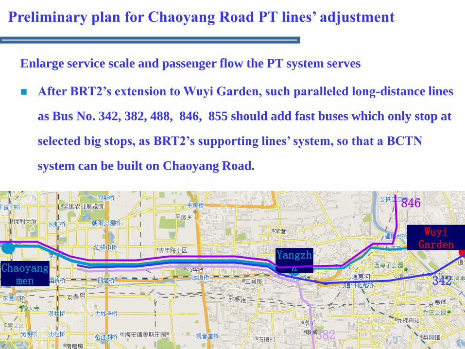
Enlarge service scale and passenger flow the PT system serves
After BRT2’s extension to Wuyi Garden, such paralleled long-distance lines
as Bus No. 342, 382, 488, 846, 855 should add fast buses which only stop at
selected big stops, as BRT2’s supporting lines’ system, so that a BCTN
system can be built on Chaoyang Road.
Preliminary plan for Chaoyang Road PT lines’ adjustment
Chaoyangmen
Yangzha
Wuyi Garden
342
382
846

Preliminary plan for Chaoyang Road PT lines’ adjustment
Quicken the running speed
The fast buses should stop at major passenger flow collector-distributor
points such as Tongzhoubeiguan, Yangzha, Gaojing, Hongmiaolukou,
Hujialou and Chaoyangmen.
The fast buses should enter BRT2’s special lane to share same platforms
for transfer.
Analyze the passengers of Bus No.855 and 846, who get on in the east of
Yangzha and get off in the west of Yangzha, and make reference to the
setting of stops for the fast buses in the east of Yangzha.
Chaoyangmen
Yangzha Wuyi
Garden
488855

Bus 855: Statistics on which stops passengers getting on in the east of Yangzha will get off
Bus 846: Statistics on which stops passengers getting on in the east of Yangzha will get off

Preliminary plan for Chaoyang Road PT lines’ adjustment
Quicken the running speed
Take further PT priority measures
Extend the BRT special lane to the crossing under Ciyunsi and Hujialou Bridges.
At crossings with traffic lights, BRT priority control plan or green wave coordination
control should be implemented.
Pedestrian traffic lights close to the BRT stops should be under coordinated control
with the stops.
Strengthen supervision of the PT special lane and avoid cars’ entrance to the lane to
slow down the PT running speed.
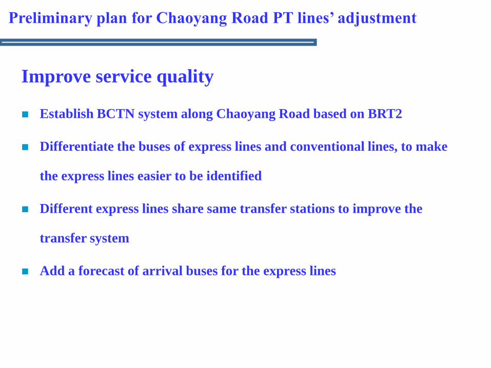
Improve service quality
Establish BCTN system along Chaoyang Road based on BRT2
Differentiate the buses of express lines and conventional lines, to make
the express lines easier to be identified
Different express lines share same transfer stations to improve the
transfer system
Add a forecast of arrival buses for the express lines
Preliminary plan for Chaoyang Road PT lines’ adjustment

Expectations:
Build a Chaoyang Road’s BCTN system with BRT2 supported by several
other express lines.
Form a BCTN corridor between Tongzhou district and the city center by
the links between BRT2, subway Line 1, Batong Line and subway’s Loop
Line & Line 10.
Chaoyangmen
Yangzha Wuyi
Garden
Preliminary plan for Chaoyang Road PT lines’ adjustment
Subway loop line
Subway line 10
Subway line 1
Batong line
BRT2
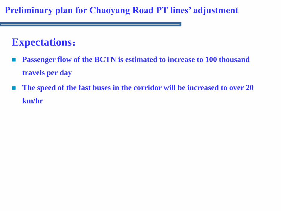
Expectations:
Passenger flow of the BCTN is estimated to increase to 100 thousand
travels per day
The speed of the fast buses in the corridor will be increased to over 20
km/hr
Preliminary plan for Chaoyang Road PT lines’ adjustment

THANKS!