Reprinted reference About Reprinted Reference materials ... · About Reprinted Reference materials...
6
Looking after all our water needs Reprinted reference Water Note WN11 Identifying the riparian zone See back cover for information on reprinted reference materials and contact details
Transcript of Reprinted reference About Reprinted Reference materials ... · About Reprinted Reference materials...
Looking after all our water needs
About Reprinted Reference materialsIn 2006, the Department of Water was established to replace the Water and Rivers Commission.
Proclamation on 31 January 2008 of the Water Resources Legislation Amendment Act 2007 formally abolished the Water and Rivers Commission and transferred all functions to the Minister for Water Resources and the Department of Water.
This has consolidated all water-related functions performed by the commission and some other agencies under one agency to ensure a central focus for planning and managing the states water resources.
As a result some valuable water related reference materials are now not easily identified under the new management structure and contain contact details that are out of date.
The Reprinted Reference ‘wrap around’ cover provides identity with the new management structure and provides up to date contact information.
This allows us to continue to make many of these reference materials available without the expense to the public sector of costly reproduction.
Contacting the Department of WaterHead OfficeThe Atrium168 St George's Terrace Perth Western AustraliaP O Box K822 Perth Western Australia 6942Phone: 08 6364 7600Fax: 08 6364 7601
You can find details for our other offices around the state with office directory found under Contact Us on our website.
www.water.wa.gov.au
The relevant area within the Department of Water for this topic is:
Ask reception for this area when contacting us with any queries.
Reprinted reference
Water Note WN11Identifying the riparian zone
See back cover for information on reprinted reference materials and contact details
Water and Rivers Commission W N 11 J a n u a ry 2000
Identifying theriparian zoneThe first step in managing a river is toidentify the riparian zone. The riparianzone can generally be described as theland that directly influences or isinfluenced by, a watercourse. That is, thecorridor of land in which a streamfunctions.
The riparian zone includes the immediate vicinity of the
stream, which consists of the bed, banks and adjacent land,
as well as the floodplain, which carries large floods.
The width of the riparian zone can vary greatly depending
on the type of river or stream and the catchment. Therefore
the area of the riparian zone that requires
special management will also vary. Upland
streams with narrow valley widths
generally have smaller riparian
zones, but they are usually higher
energy
streams, and this can require more intensive management.
Lowland streams generally have broader valley widths and
are more prone to meandering, therefore usually have larger
riparian zones. However, they are generally lower energy
streams and can require less intensive management. Each
watercourse is unique and it is best to assess the area of the
riparian zone that requires active management on a case-
by-case basis.
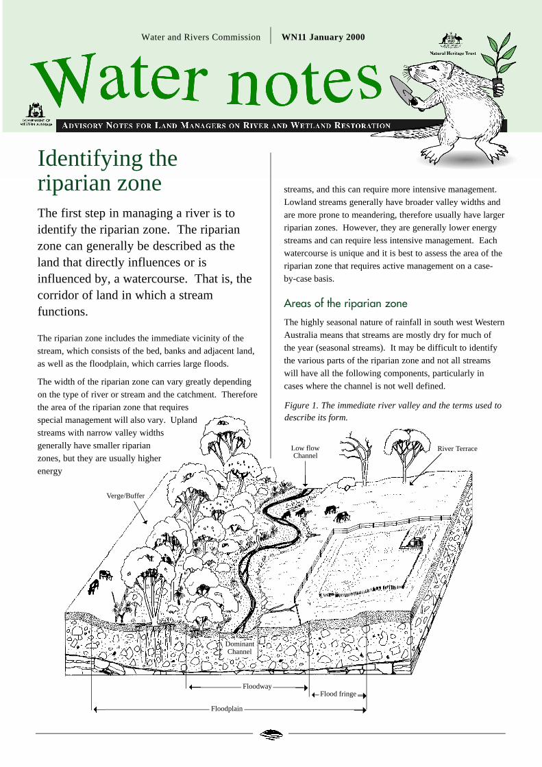
Areas of the riparian zone
The highly seasonal nature of rainfall in south west Western
Australia means that streams are mostly dry for much of
the year (seasonal streams). It may be difficult to identify
the various parts of the riparian zone and not all streams
will have all the following components, particularly in
cases where the channel is not well defined.
Verge/Buffer
Low flowChannel
➝➝
Floodplain
Flood fringe➝Floodway
DominantChannel
River Terrace
Figure 1. The immediate river valley and the terms used todescribe its form.
Wetland or riverine vegetation, or areas of green when
surrounding pastures have “browned off”, may
be good indicators during times of low to no flow, while
viewing the stream during higher flows may also help you
to identify the different areas of the riparian zone. The
main areas of the riparian zone are described below.
Low flow channel
Within the bed of a channel there may be a ‘low flow
channel’. This is the channel in which the water is
contained during periods of low flow or base flow, when the
stream is not in flood. The actual location of the low flow
channel within the bed of the stream will vary over time.
Main channel
This is also known as the ‘dominant’or ‘bankfull’channel.
It is generally what is recognisable as ‘the watercourse’.
However defining the main channel can be difficult in dry
inland areas.
The main channel carries flood flows following heavy
rainfall and is the one where ‘channel forming flows’occur,
that is when the stream has the most power to do work and
to transport sediment. Sometimes this is measured by a
flow frequency, most often given as the flood flow which
occurs on average once every 1-2 years. However, research
done on Australian streams has found that due to our
extremely variable rainfall, sometimes the main channel is
determined by flows that occur once every 7, 10 or even 20
years and that defining the main channel on a recurrence
interval will not represent the actual dominant (bankfull)
discharge in a large majority of cases.
On a biological basis, the main channel contains wetland or
riparian species, however, these are often found on the
floodplain as well, and can prove difficult to use to
distinguish the channel from floodplain.
Floodplain
In terms of flood management the floodplain is the area
that includes the floodway and the flood fringe (see
opposite), and includes all typically floodprone land. It is
the portion of the river valley that is covered with water
when the main channel ‘overflows’in time of flood.
Floodway
The floodway forms the main flow path during floods. The
floodway is where the flooded stream has the capacity to
transport material and is therefore an area of main interest
for management. In the South West, because floodways are
mostly dry or only moist throughout the year, they are often
colonised by dense wetland or riparian vegetation which
stabilises the soil and largely prevents erosion.
Flood fringe
The area of the floodplain that is not flooded as frequently
and where the water is merely spilling over from the
floodway or is moving slowly over adjacent land, is known
as the flood fringe. This often tends to be an area of
deposition, where sediment and debris carried by
floodwaters is deposited.
Terrace
Over time streams carve their way deeper into the
landscape. In so doing they leave behind sections of old
floodplain which are no longer inundated by floodwaters.
These are known as terraces and they may or may not be
considered part of the riparian zone.
Using biophysical criteria for management ofthe riparian zone
While the riparian zone can generally be broken down into
the areas mentioned above it is often very difficult to
delineate between them. It is important to remember that
defining the width of a riparian zone is largely a
management decision and is dependent on its required
functions. For example, the width of riparian zone needed
to act as a sediment trap may be a fraction of that required
for the provision of fauna habitat. Using biophysical
criteria can help to identify the riparian zone, and the
important management areas.
Start with a base map, using any information that you may
have available. This may be a cadastral (shows property
lines), or topographic map obtained from Department of
Land Administration or your local government office, or it
may be a simple sketch map of the section of stream you
are interested in. Once you have some points of reference
on your map you can begin to add further information.
Aerial photographs can also be very helpful.
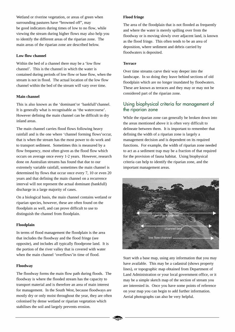
dominant channel
channel bed
low flow channel
Mapping the above elements of the riparian zone provides
you with a good basis for making management decisions.
Ongoing monitoring of the foreshores is also important and
there are locally relevant, easy to use foreshore assessment
techniques for both urban and rural environmentsi.
Once you have mapped the extent and features of the
riparian zone it may also be useful to define a foreshoreprotection area ii. This is the area that you have defined as
being critical to the ecological functioning of the waterway.
It is not necessarily an area of exclusion but one in which
careful management of the stream is required.
The following criteria are useful in helping to determine the
various areas of the riparian zone listed above.
Landform/Morphology
The contour lines on a topographic map will help to define
the riparian areas. Where possible, you should also identify
the sort of channel and floodplain you have overall (e.g:
channel enlarging, migrating, aggrading etc) and any
particular trouble spots (e.g. bank erosion, wash-outs,
overgrown vegetation, slumping etc). Other management
issues such as trampled areas from livestock access and
stream crossings should also be noted.
Soil and sediment types
The various areas of the riparian zone may be distinguished
by changes in soil type due to the varying flow patterns in
each area and the resulting differences in erosion and
deposition of sediment. Changes in soil type will usually be
reflected in the vegetation cover. For example, the red
loamy soils of the Swan-Canning floodplains support
flooded gums and, today, old orchards and vineyards.
Knowing the soil types is important for making
management decisions. For example, iron and calcium rich
soils can bind nutrients that would otherwise enter the
waterway, while loose sands and gravelly loams are
typically prone to erosion.
Flood prone land
Identifying flood prone land is important for riparian
management. The Water and Rivers Commission has
mapped the floodways and floodplains for some areas,
including 1 in 100 year flood levels. This information is
important for landuse planning, but identifying flood prone
land on a physical basis is usually more useful for riparian
management. Talk to older people who have lived in the
area for some time, they will probably remember past
floods and the most frequent flood levels. Look out for
flood debris in trees and left at the high water mark on
paddocks. Also, vegetation that grows in seasonally
inundated wet areas can often be used to identify the
flood prone area, although this can be disturbed by some
farming practices.
Vegetation
Vegetated foreshores act as sediment and nutrient traps,
habitat corridors and anchor banks to minimise erosion.
Identifying areas of remnant riparian vegetation is useful as
it can provide information about the sorts of riparian
species that should be used in an area, and also those areas
which are in need of protection and those which are in need
of rehabilitation. The species and structure of vegetation
occurring in the riparian zone will reflect the catchment
geology, the location within the catchment and the physical
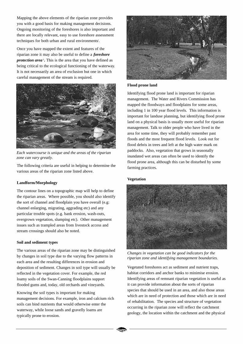
Each watercourse is unique and the areas of the riparianzone can vary greatly.
Changes in vegetation can be good indicators for theriparian zone and identifying management boundaries.
For more information contact
Level 2, Hyatt Centre
3 Plain Street
East Perth Western Australia 6004
Telephone: (08) 9278 0300
Facsimile: (08) 9278 0301
or your regional office
Website: http://www.wrc.wa.gov.au
This water note is produced as part of the Waterways WA Program. Managing and enhancing our waterways for the future.
Text by Jodie Oates. Photos by Dr luke Pen. Illustrations by Dickinson Art.
Water note project coordination by Jodie Oates and Heidi Oswald.
Printed on recycled paper January 2000
ISSN 1442-6900 This Water Note is intended to be a general guide only and is not a comprehensive document.
For further information on any particular issue please contact the Restoration & Management Section at the Water and Rivers Commission.
and biological processes occurring in the riparian zone.
Initially, aerial photographs can be used for mapping of the
extent of the vegetation, however ground observations are
also needed to confirm the mapping and to provide details
of the species, structure and also any weed problems that
might exist and need to be managed.
Land use
Although landuse may not help you to define the physical
areas described above, it is important to map landuse. By
identifying the surrounding land uses, and the potential
problems or pressures that result from these, you will be
able to manage your foreshore more effectively. This will
assist you in determining the most appropriate landuse that
balances both the effective and efficient use of land and the
protection and rehabilitation of the riparian zone. Include
details such as type (e.g: grazing, farming, etc), existing
and potential fencing, stream crossings and stock watering
points, and location of infrastructure.
Further reading
Available from the Water and Rivers Commission
Byrne, J. (1999) Foreshore Policy. Water and Rivers
Commission Policy Update 2.
i Water and Rivers Commission (1999) Planning and
Management: Foreshore condition assessment in urban and
semi-rural areas of south-west Western Australia. Water
and Rivers Commission River Restoration Report No. RR 2.
Water and Rivers Commission (1999) Planning and
Management: Foreshore condition assessment in farming
areas of south-west Western Australia. Water and Rivers
Commission River Restoration Report No. RR 3.
ii Waterways Commission (1994) Guidelines for determining
a protection precinct. Waterways guidelines (3) June 1994.
Water note WN6 Livestock management: Construction of
livestock crossings.
Water note WN7 Livestock management: Watering points
and pumps.
Water note WN8 Habitat of rivers and creeks.
Water note WN9 The value of Large Woody Debris (Snags).
Water note WN10 Protecting riparian vegetation.
Water note WN12 The values of the riparian zone.
Water note WN13 The management and replacement of
Large Woody Debris in waterways.
Water note WN15 Weeds in waterways.
Available from other sources
Land and Water Resources Research and Development
Corporation (1996) Managing riparian land. Riparian
Management Series (1) September 1996.
Looking after all our water needs
About Reprinted Reference materialsIn 2006, the Department of Water was established to replace the Water and Rivers Commission.
Proclamation on 31 January 2008 of the Water Resources Legislation Amendment Act 2007 formally abolished the Water and Rivers Commission and transferred all functions to the Minister for Water Resources and the Department of Water.
This has consolidated all water-related functions performed by the commission and some other agencies under one agency to ensure a central focus for planning and managing the states water resources.
As a result some valuable water related reference materials are now not easily identified under the new management structure and contain contact details that are out of date.
The Reprinted Reference ‘wrap around’ cover provides identity with the new management structure and provides up to date contact information.
This allows us to continue to make many of these reference materials available without the expense to the public sector of costly reproduction.
Contacting the Department of WaterHead OfficeThe Atrium168 St George's Terrace Perth Western AustraliaP O Box K822 Perth Western Australia 6942Phone: 08 6364 7600Fax: 08 6364 7601
You can find details for our other offices around the state, together with an office directory, under Contact Us on our website.
www.water.wa.gov.au