Reprint 975 Impact of Radar Retrieval Winds on Data ...
7
Reprint 975 Impact of Radar Retrieval Winds on Data Assimilation and Forecast of a Mesoscale Convective Storm using Non-Hydrostatic Model W.K. Wong, M.K. Or, P.W. Chan & C.M. Cheng 14th Conference on Mesoscale Process, American Meteorological Society, Los Angeles, USA, 1-4 August 2011
Transcript of Reprint 975 Impact of Radar Retrieval Winds on Data ...

Reprint 975
Impact of Radar Retrieval Winds on Data Assimilation and
Forecast of a Mesoscale Convective Storm
using Non-Hydrostatic Model
W.K. Wong, M.K. Or, P.W. Chan & C.M. Cheng
14th Conference on Mesoscale Process, American Meteorological Society, Los Angeles, USA,
1-4 August 2011

IMPACT OF RADAR RETRIEVAL WINDS ON DATA ASSIMILATION AND
FORECAST OF A MESOSCALE CONVECTIVE STORM USING NON-HYDROSTATIC MODEL
Wai-Kin WONG*, M.K. Or, P.W. Chan and C.M. Cheng
Hong Kong Observatory, Hong Kong, China
1. INTRODUCTION
The Doppler radial velocity and reflectivity from weather radars provide high-density observations for the analysis and forecast of convective storms. Moreover, the radar observations are useful for high resolution or cloud-resolving numerical weather prediction (NWP) models to analyse and predict the mesoscale features. Data assimilation of Doppler radial velocity and reflectivity helps to improve model analysis and forecast of severe convections, through a better representation of storm dynamics and physical properties in the model initial condition.
In this paper, we discuss a variational wind retrieval algorithm applied to weather radar data to obtain 3-dimensional wind field for investigating mesoscale features and dynamics of the development of a severe convective storm affecting Hong Kong on 28 July 2010, in which there were more than 100 mm of rainfall and 4000 lightning strikes over the territory recorded between 14 and 18 HKT (HKT = UTC + 8 hours). To investigate the mesoscale features of the rainstorm, the Non-Hydrostatic Model (NHM) (Saito et al. 2006) with horizontal resolution of 2 km is used to analyse and simulate the dynamical environment and cloud microphysical processes. Positive impacts on the use of radar retrieval winds are found in the analysis and forecasts of the wind flow over low to mid-tropospheric levels using NHM. In the following sections, descriptions of NHM and the radar wind retrieval algorithm will be introduced. Discussions on the severe convective storm on 28 July 2010 and the use of radar retrieval winds to analyse the mesoscale features of the storms will be made. The numerical experiments of data assimilation and forecasting using NHM will then be discussed and followed by a summary. * Corresponding author address: Wai-Kin WONG, Hong Kong Observatory, 134A, Nathan Road, Kowloon, Hong Kong, China; email: [email protected].
2. NON-HYDROSTATIC MODEL (NHM)
In June 2010, Hong Kong Observatory (HKO) started to operate a new generation of mesoscale NWP model suite called the Atmospheric Integrated Rapid-cycle (AIR) Forecast Model System based on NHM. In brief, the whole system contains two domains called Meso-NHM and RAPIDS-NHM with horizontal resolution of 10 km and 2 km respectively. Description and some aviation applications of AIR/NHM are given in Wong et al. (2011).
RAPIDS-NHM is executed every hour to provide storm-scale prediction over Hong Kong and its nearby Guangdong region (Fig. 1) up to 15 hours ahead, using boundary conditions from Meso-NHM forecast in one-way nesting configuration. 3DVAR analysis at full model resolutions and vertical levels is used. With the use of hourly-update analysis, observations ingested in 3DVAR are mostly from mesoscale observation networks in Hong Kong (HK) and the Guangdong Province, including data from automatic weather stations, wind profilers, total precipitable water vapour from the Global Positioning System (GPS), radar Doppler velocity and radar wind retrieval products. Conventional observations from synoptic surface and upper-air stations, ships, buoys and aircrafts (AMDAR - Aircraft Meteorological Data Relay) can also be ingested depending on availability in real-time.
Fig. 1 Domain coverage and terrain height (color) of RAPIDS-NHM.
8.4

3. RADAR RETRIEVAL WIND
The retrieval of 3-dimensional wind components (u,v and w) from the observed radial velocity is obtained via the minimization of the following cost function (Shimizu et al. 2008):
SDBO JJJJJ (1)
where (a) JO is proportional to the square of difference between the observed radial velocity and the radial velocity derived from retrieved 3D wind field; (b) JB is proportional to the square of difference between the retrieved 3D wind field and the background; (c) JD is the anelastic mass constraint term; and (d) JS is the smoothness constraint of retrieved wind field using Laplacian of wind components.
Fig. 2 Domain of 3D wind retrieval computation and locations of radars in Shenzhen and Hong Kong.
In this study, weather radar data from Hong Kong and Shenzhen (Fig. 2) are used to retrieve the 3D wind with number of grid points of 90 in both x- and y-directions and 21 vertical levels, corresponding to the horizontal and vertical resolutions at 1 km and 0.5 km respectively. Both radars are S-band type and complete one volume scan in every 6 minutes. Before the wind retrieval, the Doppler radial velocity data are first de-aliased via a simple scheme by comparing the adjacent velocity data pair starting from near range to far range of the radar. If the adjacent data pair is found to have large discrepancy in magnitude, the velocity data at the farther range bin would be de-aliased based on the corresponding data at the nearer bin. This method appears to be simple, but it turns out to be quite effective in de-aliasing the radial velocity in many circumstances including the rainstorm case in
this study. After de-aliasing, the velocity data are passed to a median filter with a spatial window of 3x3 grid points to remove speckles or noises and improve the quality of input data for minimization. The size of spatial window is determined through several trials. After the above pre-processing steps, the radar data are interpolated to a 3D grid for minimization procedure. 4. RAINSTORM ON 28 JULY 2010
The case of intense convective weather
under study occurred in the afternoon of 28 July 2010 over Hong Kong. Between 14 and 18 HKT on that day, there were more than 100 mm of rainfall and 4000 lightning strikes over the territory. In fact, in the morning on that day, bands of thunderstorms already affected the coastal areas of Guangdong. The ascent data at 0000 UTC (0800 HKT) showed that the thermodynamic condition over HK was highly unstable with K index reaching 40 and CAPE of around 3000J/kg. The troposphere was basically saturated between 900 and 500 hPa (not shown), conducive to the development of intense convection in the vicinity of HK. Shortly after the noon time, convective activity became more frequent at the northeastern part of HK (Label A in Fig. 3a) and spread towards south gradually. At the same time, the thunderstorms over western Guangdong moved east and started to affect HK (Label B in Fig. 3a). Thunderstorms also developed over the seas south of the territory and drifted northeast (Label C). These three areas of intense convection eventually merged over HK (Fig. 3b-c) and formed a “X” shape area of intense convection during 15 HKT, namely, the intersection of a basically east-west oriented band of heavy rain, and another band with north to south-southwest orientation. In the following hour or so, the former band remained nearly stationary over HK, and the latter area moved eastwards gradually. The quasi-stationary nature of the east-west oriented rain band brought about heavy rain over the territory. During 17-18 HKT, it moved south and rain over the territory weakened gradually.
From the radar retrieval winds, frequently occurring short waves in the westerly airflow from low to mid-troposphere was seen in connection to development of intense convection. Figure 4a-b show retrieved winds at a height of 2 km and 5km above mean sea level. Between 15 HKT and 17 HKT when the rain was the heaviest over HK, the east-west oriented rain band was found to have a number of short waves in the westerly at 2 km level

over the Pearl River Estuary. These waves were expected to trigger and sustain the occurrence of intense convection over HK. To the south of the westerly waves, there was active southwesterly flow advecting moisture from the South China Sea towards the coast of Guandong. Similar wavy activity could also be observed from the radar-retrieved winds at 5 km of altitude. As such, the westerly waves in the middle and lower troposphere were conducive to those intense convective developments over HK.
(a)
(b)
(c)
(d)
Fig. 3. Radar CAPPI reflectivity imagery at 1230, 1330, 1430 and 1530 HKT. Area of HK is marked in red dashed box.
During 17 HKT, the winds over the Pearl River Estuary changed from southwesterly to west-northwesterly. There was a deeper short-wave passing along the coastal areas of Guangdong. As a result, the areas of convective developments were “pushed” to the south over the coastal waters of Guangdong (Fig. 4c), moving away from Hong Kong and leading to gradual weakening of rain over the territory.
(a)
(b)
(c)
Fig. 4. Radar retrieved winds on (a) 2 km and (b) 5 km levels overlaid on the radar reflectivity at 1500 HKT. (c) Similar to (b) but at 1700 HKT. 5. DATA ASSIMILATION OF RADAR
RETRIEVAL WINDS AND FORECASTS USING NHM
Numerical experiments on the data
assimilation and forecast using radar retrieval winds in RAPIDS-NHM are conducted in 0300 UTC run. As the vertical velocity is not a control

variable in the 3DVAR system of RAPIDS-NHM, only the horizontal components of radar retrieval winds are ingested. Data thinning is applied to the retrieved wind data in horizontal direction with a separation of about 4 km. Quality control procedure is then used to remove those suspicious radar retrieval wind data that are opposite in direction to the wind vectors in model first guess of 3DVAR. Control experiments (CNTL) are used to show the impact of the retrieval winds, all observations except radar retrieval winds are ingested in 3DVAR of CNTL.
Fig. 5 shows the analyzed wind and relative humidity (WIND+RH) on 500 hPa and 700 hPa levels using the radar retrieval wind (upper panel) and CNTL (lower). Radar retrieval winds and reflectivity at 5 km and 3 km of altitude are shown in Fig. 6. It can be seen that the retrieval winds are effectively assimilated in the 3DVAR, resulting in enhancement in southwesterly flow over the coastal waters of Guangdong and generate a short-wave westerly disturbance on 500 hPa level. In CNTL, only moist westerly flow is found in the analysis field. Convergence in lower troposphere also becomes more prominent as the southwesterly winds are analyzed over the coastal waters using the radar retrieval winds data.
Fig.5. RAPIDS-NHM WIND+RH analysis at 0300 UTC (1100 HKT) on 500 hPa and 700 hPa using radar retrieval winds (upper) and the analysis in the control experiment (CNTL, lower).
Fig. 6. Radar retrieved winds and reflectivity on 5 km and 3 km at 1100 HKT.
With improved dynamical condition in RAPIDS-NHM analysis using radar retrieval winds, forecast cyclonic shear on 850 hPa is shifted to the vicinity of HK and Pearl River Estuary (Fig. 7a) from a more northern location in CNTL (Fig. 7b). The main cyclonic shear is located over the northern part of HK corresponding to the intense convection development areas labelled as A and B in Fig. 3. In CNTL, the low-level cyclonic vorticity is forecast over the northeastern part of HK only, in accordance with actual active development area (Label A in Fig. 3). Fig. 8 shows the 5 hour forecast equivalent reflectivity (derived from RAPIDS-NHM forecasts of specific humidity of cloud hydrometeors) and the actual radar imagery. An east-west oriented reflectivity band is better predicted in the radar wind retrieval experiment, whereas the intensity of simulated reflectivity is appreciably weaker in CNTL. Compared with the actual radar image, the development of the intense convection in the model is found to lag behind by about 1 hour. In both experiments, there is no sign on the development of significant convection over the coastal sea areas.
(a)
(b)
Fig. 7. T+2 hour forecast relative vorticity on 850 hPa level (positive/cyclonic vorticity in red and vice versa for blue) using (a) radar retrieval winds and (b) CNTL.
Fig. 8. (a) T+5 hour forecast of equivalent reflectivity at 1600 HKT using radar retrieval winds, (b) CNTL, and (c) radar CAPPI reflectivity at 1500 HKT.
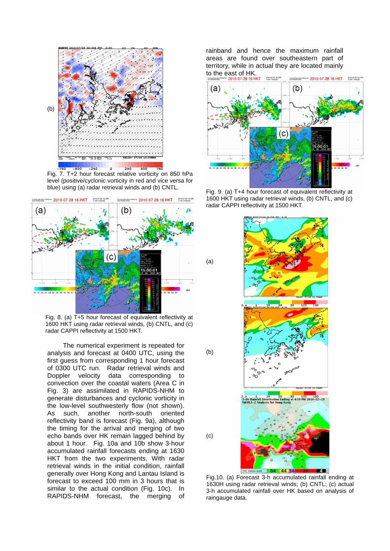
The numerical experiment is repeated for analysis and forecast at 0400 UTC, using the first guess from corresponding 1 hour forecast of 0300 UTC run. Radar retrieval winds and Doppler velocity data corresponding to convection over the coastal waters (Area C in Fig. 3) are assimilated in RAPIDS-NHM to generate disturbances and cyclonic vorticity in the low-level southwesterly flow (not shown). As such, another north-south oriented reflectivity band is forecast (Fig. 9a), although the timing for the arrival and merging of two echo bands over HK remain lagged behind by about 1 hour. Fig. 10a and 10b show 3-hour accumulated rainfall forecasts ending at 1630 HKT from the two experiments. With radar retrieval winds in the initial condition, rainfall generally over Hong Kong and Lantau Island is forecast to exceed 100 mm in 3 hours that is similar to the actual condition (Fig. 10c). In RAPIDS-NHM forecast, the merging of
rainband and hence the maximum rainfall areas are found over southeastern part of territory, while in actual they are located mainly to the east of HK.
Fig. 9. (a) T+4 hour forecast of equivalent reflectivity at 1600 HKT using radar retrieval winds, (b) CNTL, and (c) radar CAPPI reflectivity at 1500 HKT.
(a)
(b)
(c)
Fig.10. (a) Forecast 3-h accumulated rainfall ending at 1630H using radar retrieval winds; (b) CNTL; (c) actual 3-h accumulated rainfall over HK based on analysis of raingauge data.

6. SUMMARY
In this paper, the radar retrieval winds show benefits in the analysis of dynamical condition conducive to intense development of convective storms using RAPIDS-NHM. Positive impacts are seen on resolving the wind flow over low to mid-tropospheric levels in the initial condition of the model. This results in the improvements in the simulation on the mesoscale features and dynamics of a severe convective storm affecting HK.
In operational forecasting application, the improved model analysis not only benefits the initial condition of the RAPIDS-NHM, but also can be useful to derive analysis or diagnostic guidance on the mesoscale features of storm environment. Using whole 3-dimensional fields of wind, temperature and moisture, analysis products like stability indices, and moisture convergence can be generated to facilitate the monitoring and diagnosis of potential development areas of severe convection. Acknowledgement AIR/NHM is developed on the basis of the operational Non-Hydrostatic Model of the Japan Meteorological Agency (JMA). Reference Saito, K., T. Fujita, Y. Yamada, J. Ishida, Y. Kumagai, K. Aranami, S. Ohmori, R. Nagasawa, S. Kumagai, C. Muroi, T. Kato, H. Eito, and Y. Yamazaki, 2006: The Operational JMA Nonhydrostatic Mesoscale Model. Mon. Wea. Rev., 134, 1266-1298. Shimizu, S., H. Uyeda, Q. Moteki, T. Maesaka, Y. Takaya, K. Akaeda, T. Kato, and M. Yoshizaka, 2008: Structure and formation mechanism on the 24 May 2000 supercell-like storm developing in a moist environment over the Kanto Plain, Japan. Mon. Wea. Rev., 136, 2389–2407. Wong, W.K., P.W. Chan and C.K. Ng., 2011: Aviation Applications of a New Generation of Mesoscale Numerical Weather Prediction System of the Hong Kong Observatory. 24th Conference on Weather and Forecasting/20th Conference on Numerical Weather Prediction, American Meteorological Society, Seattle, USA, 24-27 Jan 2011.