
REPORT · queen’s baton relay and festival of sails - regional committee recommendation closure....
79
REPORT Coordination Committee Meeting Tuesday 10 April 2018 commencing at 10.34am Redcliffe Chambers Irene Street, Redcliffe CHAIRPERSON’S REPORT The recommendations contained within this report of the Coordination Committee meeting held 10 April 2018 are recommended to the Council for adoption. COUNCILLOR ALLAN SUTHERLAND (MAYOR) CHAIRPERSON COORDINATION COMMITTEE ENDORSED GM20180410
Transcript of REPORT · queen’s baton relay and festival of sails - regional committee recommendation closure....

REPORT
Coordination Committee Meeting
Tuesday 10 April 2018 commencing at 10.34am
Redcliffe Chambers Irene Street, Redcliffe
CHAIRPERSON’S REPORT The recommendations contained within this report of the Coordination Committee meeting held 10 April 2018 are recommended to the Council for adoption. COUNCILLOR ALLAN SUTHERLAND (MAYOR) CHAIRPERSON COORDINATION COMMITTEE
ENDORSED GM20180410

Adoption Extract from General Meeting – 10 April 2018 (Page 18/694) 12.1. Coordination Committee Meeting - 10 April 2018
(Pages 18/696 - 18/770) RESOLUTION
Moved by Cr Adrian Raedel Seconded by Cr Peter Flannery CARRIED 13/0
That the report and recommendations of the Coordination Committee meeting held 10 April 2018 be adopted.

Moreton Bay Regional Council COORDINATION COMMITTEE MEETING PAGE a 10 April 2018 Report
COORDINATION COMMITTEE MEETING PAGE a 10 April 2018 Report
LIST OF ITEMS
1 GOVERNANCE SESSION (Cr A Sutherland, Mayor)
ITEM 1.1 697 122ND ANNUAL LOCAL GOVERNMENT ASSOCIATION OF QUEENSLAND CONFERENCE - REGIONAL
COMMITTEE RECOMMENDATION
REPORT DETAIL
ITEM 1.2 699 LGAQ ELECTED MEMBER TRAINING - REGIONAL
COMMITTEE RECOMMENDATION
REPORT DETAIL
2 PLANNING & DEVELOPMENT SESSION (Cr M Gillam)
ITEM 2.1 701 DA/35188/2017/V2C - MATERIAL CHANGE OF USE - DEVELOPMENT PERMIT FOR OFFICE AND FOOD AND DRINK OUTLET AND OPERATIONAL WORK - DEVELOPMENT PERMIT FOR FILLING AND EXCAVATION AT 7-13 LEARMONTH STREET, STRATHPINE- DIVISION 8
COMMITTEE RECOMMENDATION
REPORT DETAIL
3 CORPORATE SERVICES SESSION (Cr M Constance)
ITEM 3.1 750 CONTENT MANAGEMENT SYSTEM (CMS) REPLACEMENT - REGIONAL
COMMITTEE RECOMMENDATION
REPORT DETAIL
4 ASSET CONSTRUCTION & MAINTENANCE SESSION (Cr A Hain)
ITEM 4.1 754 BURPENGARY - OLD BAY ROAD COMMUNITY FACILITY - BUILDING UPGRADE - DIVISION 2
COMMITTEE RECOMMENDATION
REPORT DETAIL
ITEM 4.2 758 CABOOLTURE - CABOOLTURE TO WAMURAN RAIL TRAIL - SHARED PATHWAY CONSTRUCTION STAGE 1 (LANDSCAPE PORTION OF WORKS) - DIVISIONS 3 AND 12
COMMITTEE RECOMMENDATION
REPORT DETAIL
ITEM 4.3 763 MORETON BAY REGION LOCAL DISASTER MANAGEMENT GROUP - MEETING MINUTES 21 MARCH 2018 - REGIONAL
COMMITTEE RECOMMENDATION
REPORT DETAIL

Moreton Bay Regional Council COORDINATION COMMITTEE MEETING PAGE b 10 April 2018 Report
COORDINATION COMMITTEE MEETING PAGE b 10 April 2018 Report
5 PARKS, RECREATION & SPORT SESSION (Cr K Winchester)
ITEM 5.1 766 JAMES DRYSDALE RESERVE MASTER PLAN - AMENDMENT - DIVISION 10
COMMITTEE RECOMMENDATION
REPORT DETAIL
6 LIFESTYLE & AMENITY SESSION (Cr D Sims)
7 ECONOMIC DEVELOPMENT, EVENTS & TOURISM SESSION (Cr P Flannery)
8 REGIONAL INNOVATION (Cr D Grimwade)
9 GENERAL BUSINESS
ITEM 9.1 770 REDCLIFFE JETTY MARKETS
ITEM 9.2 770 2018 AUSTRALIAN COASTAL COUNCIL CONFERENCE
ITEM 9.3 770 QUEEN’S BATON RELAY AND FESTIVAL OF SAILS - REGIONAL
COMMITTEE RECOMMENDATION
CLOSURE
Moreton Bay Regional Council COORDINATION COMMITTEE MEETING PAGE 18/696 10 April 2018 Report
COORDINATION COMMITTEE MEETING PAGE 18/696 10 April 2018 Report
ATTENDANCE & APOLOGIES Attendance: Committee Members: Cr Allan Sutherland (Mayor) (Chairperson) Cr Brooke Savige Cr Peter Flannery Cr Adam Hain Cr Julie Greer Cr James Houghton Cr Koliana Winchester Cr Denise Sims Cr Mick Gillam Cr Mike Charlton (Deputy Mayor) Cr Matthew Constance Cr Darren Grimwade Cr Adrian Raedel Officers: Chief Executive Officer (Mr Daryl Hitzman) Director Community & Environmental Services (Mr Bill Halpin) Director Planning & Economic Development (Mr Stewart Pentland) Director Engineering, Construction & Maintenance (Mr Tony Martini) Manager Financial & Project Services (Mr Keith Pattinson) Manager Development Services (Ms Kate Isles) Planner (Mr Scott Hambleton) Coordinator Digital Business Systems (Ms Janet Kirkwood) Meeting Support (Ms Judy Henry) Apologies: Nil The Mayor is the Chairperson of the Coordination Committee. Coordination Committee meetings comprise of Sessions chaired by Council’s nominated Spokesperson for that portfolio, as follows:
Session Spokesperson 1 Governance Cr Allan Sutherland (Mayor) 2 Planning & Development Cr Mick Gillam 3 Corporate Services Cr Matt Constance 4 Asset Construction & Maintenance Cr Adam Hain 5 Parks, Recreation & Sport Cr Koliana Winchester 6 Lifestyle & Amenity Cr Denise Sims 7 Economic Development, Events & Tourism Cr Peter Flannery 8 Regional Innovation Cr Darren Grimwade 9 General Business Cr Allan Sutherland (Mayor)
Moreton Bay Regional Council COORDINATION COMMITTEE MEETING PAGE 18/697 10 April 2018 Report
COORDINATION COMMITTEE MEETING PAGE 18/697 10 April 2018 Report
1 GOVERNANCE SESSION (Cr A Sutherland, Mayor) ITEM 1.1 122ND ANNUAL LOCAL GOVERNMENT ASSOCIATION OF QUEENSLAND CONFERENCE - REGIONAL Meeting / Session: 1 GOVERNANCE Reference: A16763802 : 3 April 2018 Responsible Officer: LK, Executive Support Officer (EPS Executive Services) Executive Summary This report seeks consideration of Councillor attendance to the Local Government Association of Queensland (LGAQ) 122nd Annual Conference to be held at the Brisbane Convention and Exhibition Centre from 29-31 October 2018. COMMITTEE RECOMMENDATION
Moved by Cr Peter Flannery Seconded by Cr Mike Charlton (Deputy Mayor) CARRIED 13/0
1. That Councillors Mike Charlton (Deputy Mayor), James Houghton, Adam Hain, Denise Sims, Darren Grimwade, Matt Constance and Adrian Raedel be appointed to attend the 122nd Annual Local Government Association of Queensland Conference.
2. That the Chief Executive Officer arrange for officer attendance at this conference as
appropriate.

Moreton Bay Regional Council COORDINATION COMMITTEE MEETING PAGE 18/698 10 April 2018 Report ITEM 1.1 122ND ANNUAL LOCAL GOVERNMENT ASSOCIATION OF QUEENSLAND CONFERENCE - REGIONAL - A16763802 (Cont.)
COORDINATION COMMITTEE MEETING PAGE 18/698 10 April 2018 Report
OFFICER’S RECOMMENDATION 1. That Councillors Mike Charlton (Deputy Mayor), James Houghton, Adam Hain, Denise Sims, Darren
Grimwade and Adrian Raedel be appointed to attend the 122nd Annual Local Government Association of Queensland Conference.
2. That the Chief Executive Officer arrange for officer attendance at this conference as appropriate. REPORT DETAIL 1. Background Advice has been received that the 122nd Annual LGAQ Conference will be held at the Brisbane Convention and Exhibition Centre from 29-31 October 2018. 2. Explanation of Item The LGAQ Conference provides an important opportunity for Councils to network and learn, and debate and vote on new policy. The Annual Conference consists of two and a half days of full plenary, split plenary and workshop sessions where participants address the challenges facing local government and their communities. The event also serves as the Association's Annual General Meeting. 3. Strategic Implications 3.1 Legislative/Legal Implications
There are no legislation/legal implications directly arising from this report.
3.2 Corporate Plan / Operational Plan Strengthening Communities: Strong local governance - strong leadership and governance.
3.3 Policy Implications Arrangements will be made in accordance with Council’s Professional Development Policy 2150-089.
3.4 Risk Management Implications There are no direct risk management implications arising from this report.
3.5 Delegated Authority Implications There are no delegated authority implications arising from this report.
3.6 Financial Implications Funds have been provided in the Budget.
3.7 Economic Benefit Topics and motions associated with the conference will address a range of economic factors in local government.
3.8 Environmental Implications Topics and motions associated with the conference will address a range of environmental challenges facing local government.
3.9 Social Implications
Topics and motions associated with the conference will address a range of social challenges facing local government.
3.10 Consultation / Communication
Consultation undertaken with all Councillors, the Chief Executive Officer and Directors.

Moreton Bay Regional Council COORDINATION COMMITTEE MEETING PAGE 18/699 10 April 2018 Report
COORDINATION COMMITTEE MEETING PAGE 18/699 10 April 2018 Report
ITEM 1.2 LGAQ ELECTED MEMBER TRAINING - REGIONAL Meeting / Session: 1 GOVERNANCE Reference: A16763013 : 3 April 2018 Responsible Officer: LK, Executive Support Officer (EPS, Executive Services) Executive Summary This report seeks consideration of Councillor attendance to selected Local Government Association of Queensland (LGAQ) Elected Member Training courses held from March - June 2018 in Brisbane. COMMITTEE RECOMMENDATION
Moved by Cr Mike Charlton (Deputy Mayor) Seconded by Cr Mick Gillam CARRIED 13/0
1. That Cr Adam Hain be authorised to attend the Local Government Association of Queensland’s Land Use Planning course on 20 April 2018 and the Strategic Planning course on 22 June 2018.
2. That Cr Matt Constance be authorised to attend the Local Government Association of Queensland’s Strategic Planning course on 22 June 2018.
Moreton Bay Regional Council COORDINATION COMMITTEE MEETING PAGE 18/700 10 April 2018 Report ITEM 1.2 LGAQ ELECTED MEMBER TRAINING - REGIONAL - A16763013 (Cont.)
COORDINATION COMMITTEE MEETING PAGE 18/700 10 April 2018 Report
OFFICER’S RECOMMENDATION 1. That Cr Adam Hain be appointed to attend the Local Government Association of Queensland’s Land
Use Planning course on 20 April 2018 and the Strategic Planning course on 22 June 2018. 2. That Cr Matt Constance be appointed to attend the Local Government Association of Queensland’s
Strategic Planning course on 22 June 2018. REPORT DETAIL 1. Background Advice has been received that LGAQ Elected Member Training courses which form part of the Diploma of Local Government (Elected Members) are to be held at the LGAQ Offices, Brisbane. Cr Adam Hain and Cr Matt Constance have advised their interest in attending selected courses. 2. Explanation of Item The Diploma of Local Government (Elected Members) has been designed specifically for Queensland elected members wanting a deeper understanding of the roles and responsibilities of the job with the option to gain a nationally recognised qualification. There are 12 individual training attendance days in order to complete the 14 units required to achieve a Diploma, however Elected Members can attend particular course dates of topics for their interest only. 3. Strategic Implications 3.1 Legislative/Legal Implications
There are no legislation/legal implications directly arising from this report.
3.2 Corporate Plan / Operational Plan Strengthening Communities: Strong local governance - strong leadership and governance.
3.3 Policy Implications In accordance with Council’s Professional Development Policy 2150-089.
3.4 Risk Management Implications There are no risk management implication directly arising from this report.
3.5 Delegated Authority Implications There are no delegated authority implications directly arising from this report.
3.6 Financial Implications Appropriate funds have been provided in the 2017/18 budget.
3.7 Economic Benefit The conference program will feature topics of relevance to the Moreton Bay Region community.
3.8 Environmental Implications There are no Environmental implications arising as a direct result of this report.
3.9 Social Implications
The selected courses will feature topics of relevance to the Moreton Bay Region community.
3.10 Consultation / Communication Consultation undertaken with all Councillors.
ATTENDANCE Ms Kate Isles and Mr Scott Hambleton attended the meeting at 10.42am for discussion on Item 2.1.

Moreton Bay Regional Council COORDINATION COMMITTEE MEETING PAGE 18/701 10 April 2018 Report
COORDINATION COMMITTEE MEETING PAGE 18/701 10 April 2018 Report
2 PLANNING & DEVELOPMENT SESSION (Cr M Gillam) ITEM 2.1 DA/35188/2017/V2C - MATERIAL CHANGE OF USE - DEVELOPMENT PERMIT FOR OFFICE AND FOOD AND DRINK OUTLET AND OPERATIONAL WORK - DEVELOPMENT PERMIT FOR FILLING AND EXCAVATION AT 7-13 LEARMONTH STREET, STRATHPINE- DIVISION 8 APPLICANT: Primewest Funds Ltd T/A Primewest Strathpine Trust OWNER: Lycus Pty Ltd & RE1 Limited Meeting / Session: 2 PLANNING & DEVELOPMENT Reference: A16750018: 28 March 2018 – Refer Supporting Information A16750034,
A16751709 & A16752355 Responsible Officer: SH, Divisional Project Coordinator (PED Development Services) Executive Summary
APPLICATION DETAILS Applicant: Primewest Funds Ltd T/A Primewest Strathpine Trust Lodgement Date: 25 October 2017 Properly Made Date: 6 November 2017 Confirmation Notice Date: 8 November 2017 Information Request Date: 21 November 2017 Info Response Received Date: 6 February 2018 Public Notification Dates: 9 February 2018 - 2 March 2018 No. of Submissions: Properly Made: Two (2)
Not Properly Made: One (1) Decision Due Date: 23 April 2018 Prelodgement Meeting Held: Yes (PRE/3930) PROPERTY DETAILS Division: Division 8 Property Address: 7 - 13 Learmonth Street, Strathpine RP Description Lot 3 RP838585 Land Area: 31,230m2 Property Owner Lycus Pty Ltd & RE1 Limited STATUTORY DETAILS Planning Legislation: Planning Act 2016 Planning Scheme: MBC Planning Scheme Planning Locality / Zone Centre Zone, Strathpine Centre Precinct
Limited Development Zone (building footprint outside) Level of Assessment: Impact Appropriate
The applicant proposes a Material Change of Use - Development Permit for Office and Food and Drink Outlet and Operational Work - Development Permit for Filling and Excavation at 7-13 Learmonth Street, Strathpine. The proposal is for a Material Change of Use for Office (7,462m2) and Food & Drink Outlet (a 300m2 ground level café for staff and visitors to the office). The building is a large three storey structure situated centrally within the subject site.

Moreton Bay Regional Council COORDINATION COMMITTEE MEETING PAGE 18/702 10 April 2018 Report ITEM 2.1 DA/35188/2017/V2C - MATERIAL CHANGE OF USE - DEVELOPMENT PERMIT FOR OFFICE AND FOOD AND DRINK OUTLET AND OPERATIONAL WORK - DEVELOPMENT PERMIT FOR FILLING AND EXCAVATION AT 7-13 LEARMONTH STREET, STRATHPINE- DIVISION 8 - A16750018 (Cont.)
COORDINATION COMMITTEE MEETING PAGE 18/702 10 April 2018 Report
The application was publicly advertised with three (3) submissions received, including two (2) properly made submissions. The proposed development is generally consistent with the intent of the MBRC Planning Scheme having demonstrated there is sufficient grounds to warrant approval and is recommended to be approved, subject to conditions. COMMITTEE RECOMMENDATION
Moved by Cr Mike Charlton (Deputy Mayor) Seconded by Cr Matt Constance CARRIED 13/0
That the Officer’s Recommendation be adopted as detailed in the report.

Moreton Bay Regional Council COORDINATION COMMITTEE MEETING PAGE 18/703 10 April 2018 Report ITEM 2.1 DA/35188/2017/V2C - MATERIAL CHANGE OF USE - DEVELOPMENT PERMIT FOR OFFICE AND FOOD AND DRINK OUTLET AND OPERATIONAL WORK - DEVELOPMENT PERMIT FOR FILLING AND EXCAVATION AT 7-13 LEARMONTH STREET, STRATHPINE- DIVISION 8 - A16750018 (Cont.)
COORDINATION COMMITTEE MEETING PAGE 18/703 10 April 2018 Report
OFFICER’S RECOMMENDATION A. That Council, in accordance with the Planning Act 2016, approves the development application for a
Material Change of Use - Development Permit for Office and Food and Drink Outlet and Operational Work - Development Permit for Filling and Excavation at 7-13 Learmonth Street, Strathpine, described as Lot 3 RP838585, subject to the following plans/documents and conditions: Material Change of Use
Approved Plans and Documents Plan / Document Name Reference Number Prepared By Dated Site Plan SD1002 Issue M Cottee Parker Architects
Pty Ltd 31/1/2018
Floor Plan - Ground SD2001 Issue K Cottee Parker Architects Pty Ltd 31/1/2018
Floor Plan - Level 1 SD2002 Issue K Cottee Parker Architects Pty Ltd 31/1/2018
Floor Plan - Level 2 SD2003 Issue E Cottee Parker Architects Pty Ltd 31/1/2018
Roof Plan SD2004 Issue G Cottee Parker Architects Pty Ltd 31/1/2018
Area Schedule SD2801 Issue G Cottee Parker Architects Pty Ltd 31/1/2018
Elevations SD3001 Issue D Cottee Parker Architects Pty Ltd 31/1/2018
Elevations SD3002 Issue D Cottee Parker Architects Pty Ltd 31/1/2018
Sections 1 SD3101 Issue F Cottee Parker Architects Pty Ltd 31/1/2018
Sections 2 SD3102 Issue B Cottee Parker Architects Pty Ltd 31/1/2018
Transformer Context SD3003 Issue B Cottee Parker Architects Pty Ltd 23/3/2018
Transformer Context 2 SD3004 Issue A Cottee Parker Architects Pty Ltd 23/3/2018
3D Drawings SD0202 Issue F Cottee Parker Architects Pty Ltd 02/03/18
3D Drawings SD0203 Issue D Cottee Parker Architects Pty Ltd 02/03/18
Flood Impact Assessment Report 17-001874-FIA-01B Calibre Consulting (Qld)
Pty Ltd 1 Feb 2018
Site Based Stormwater Management Plan 17376 Rev B Bornhorst & Ward Pty Ltd Feb 2018
Functional Layout Sheet 1 17376 RL-0001 Rev E Bornhorst & Ward Pty Ltd 29/11/2017 Attachment I: Waste Management Program/Planning Scheme Policy Response
058STR LDP 11/10/17

Moreton Bay Regional Council COORDINATION COMMITTEE MEETING PAGE 18/704 10 April 2018 Report ITEM 2.1 DA/35188/2017/V2C - MATERIAL CHANGE OF USE - DEVELOPMENT PERMIT FOR OFFICE AND FOOD AND DRINK OUTLET AND OPERATIONAL WORK - DEVELOPMENT PERMIT FOR FILLING AND EXCAVATION AT 7-13 LEARMONTH STREET, STRATHPINE- DIVISION 8 - A16750018 (Cont.)
COORDINATION COMMITTEE MEETING PAGE 18/704 10 April 2018 Report
Operational Works
Approved Plans and Documents Plan / Document Name
Reference Number Prepared By Dated
Overall Layout Plan 17-001847-101 Rev A Calibre Consulting (Qld) Pty Ltd
6/2/2018
Conceptual Erosion and Sediment Control Plan - Phase 1
17-001847-102 Rev A Calibre Consulting (Qld) Pty Ltd
6/2/2018
Conceptual Erosion and Sediment Control Notes
17-001847-103 Rev A Calibre Consulting (Qld) Pty Ltd
6/2/2018
Conceptual Erosion and Sediment Control Details
17-001847-104 Rev A Calibre Consulting (Qld) Pty Ltd
6/2/2018
Bulk Earthworks Detail Plan
17-001847-105 Rev A Calibre Consulting (Qld) Pty Ltd
6/2/2018
Bulk Earthworks Cross Sections
17-001847-106 Rev A Calibre Consulting (Qld) Pty Ltd
6/2/2018
Maintenance Access Plan
17-001847-107 Rev A Calibre Consulting (Qld) Pty Ltd
6/2/2018
Conditions
CONDITION TIMING
MATERIAL CHANGE OF USE - DEVELOPMENT PERMIT
DEVELOPMENT PLANNING
1 Approved Plans and/or Documents
A Undertake development generally in accordance with the approved plans and/or documents. These plans and/or documents will form part of the approval, unless otherwise amended by conditions of this approval.
Prior to commencement of use and to be maintained at all times.
B Submit to the Council for its records a 3D digital copy of the final development approval plans in .SKP or .DAE file format. Note. Refer to https://www.moretonbay.qld.gov.au/town-planning/3dmodel- submission/ for more details.
Prior to commencement of use.
2 On-Site Car Spaces
A Provide at least 104 vehicle spaces on site. Prior to commencement of use and to be maintained at all times.
B Provide for the manoeuvring of vehicles on site, generally in accordance with the approved plan. Car spaces, access lanes and driveways shown on the approved plan must not be used for any other purpose.
3 Bicycle Parking Facilities
Moreton Bay Regional Council COORDINATION COMMITTEE MEETING PAGE 18/705 10 April 2018 Report ITEM 2.1 DA/35188/2017/V2C - MATERIAL CHANGE OF USE - DEVELOPMENT PERMIT FOR OFFICE AND FOOD AND DRINK OUTLET AND OPERATIONAL WORK - DEVELOPMENT PERMIT FOR FILLING AND EXCAVATION AT 7-13 LEARMONTH STREET, STRATHPINE- DIVISION 8 - A16750018 (Cont.)
COORDINATION COMMITTEE MEETING PAGE 18/705 10 April 2018 Report
CONDITION TIMING
Install secure bicycle parking facilities for a minimum of 39 bicycles generally as shown on the approved plans. Bicycle parking is to be provided in accordance with Austroads (2008), Guide to Traffic management - Part 11: Parking.
Prior to commencement of use and to be maintained.
4 Bicycle End of Trip Facilities
A Provide for 60 storage lockers having dimensions of 900mm (height) x 300mm (width) x 450mm (depth). The spaces are to be protected from the weather and located either within the buildings or in a dedicated secure structure for users of the development.
Prior to commencement of use and to be maintained.
B Provide a minimum of 4 change room facilities including at least 2 male and 2 female change rooms fitted with a lockable door or otherwise screened from public view and provided with 1 shower, 1 sanitary compartment and 1 wash basin generally as shown on the approved plans.
5 Electrical Transformer
A Ensure that the “future transformer” identified on the approved plans is appropriately screened from any road frontage and achieves the following: (a) The use of an earth mound around the transformer to screen
it from view; (b) A combination of screening device and landscaping; (c) The screening device is architecturally designed,
constructed of durable, weather resistant materials; and (d) Is integrated with the design of the development and
positively contributes to the streetscape. (e) Has at least one (1) street tree located in the new road in
front of the transformer to assist in blocking view of it. Note: The use of barbed wire or metal prongs is not permitted
Prior to the commencement of the use and to be maintained at all times.
B Ensure that the “transformer” identified on the approved plans is screened generally in accordance with the approved plans, as amended, and includes a densely planted landscape buffer between the edge of transformer and the property boundary including at least one (1) feature tree directly in front of the transformer.
6 Street Numbering and Building Names
Install street numbering conveniently located at the road frontage of the site. Ensure street numbers and any building names are prominently displayed at the road frontage of the site, to enable identification by emergency services.
Prior to commencement of use and to be maintained at all times.
7 Car Park Fencing
Ensure no fencing or gates or the like are installed around the perimeter of areas used for car parking and it remains open at all times.
Prior to commencement of use and to be maintained at all times.

Moreton Bay Regional Council COORDINATION COMMITTEE MEETING PAGE 18/706 10 April 2018 Report ITEM 2.1 DA/35188/2017/V2C - MATERIAL CHANGE OF USE - DEVELOPMENT PERMIT FOR OFFICE AND FOOD AND DRINK OUTLET AND OPERATIONAL WORK - DEVELOPMENT PERMIT FOR FILLING AND EXCAVATION AT 7-13 LEARMONTH STREET, STRATHPINE- DIVISION 8 - A16750018 (Cont.)
COORDINATION COMMITTEE MEETING PAGE 18/706 10 April 2018 Report
CONDITION TIMING
Note: to remove any doubt, internal boom gates that do not cause queuing issues are permitted.
8 Landscaping
A Provide landscaping on site generally in accordance with the approved plans and Planning Scheme Policy - Integrated Design Appendix D - Landscaping. The landscaping must also include the following: (a) Landscaping within the rear car park including a tree
provision at a rate of 1 tree for every 6 car parking spaces; and
(b) A raised planter with a concrete barrier type kerb or otherwise that restricts vehicle intrusion within the landscape strip in front of car parking spaces that adjoin Lot 2 RP838585 and Lot 4 RP838585. The landscape strip is then to be panted with hedge species to screen vehicle lights.
Prior to commencement of use and to be maintained at all times.
B Provide certification, from a suitably qualified person, that landscaping has been implemented in accordance with (A) above.
Prior to the commencement of use.
C Maintain the landscaping. At all times
9 Vehicle Encroachment
Protect all landscaped areas and pedestrian paths adjoining any car parking areas from vehicular encroachment by wheel stops, kerbing or similar barrier approved by the Council.
Prior to commencement of use.
10 Screening of Loading Facilities / Plant Areas
Screen Loading/Unloading Facilities, Plant Areas, Refuse Storage and Other Outdoor Storage Facilities on the site from direct view from any adjoining road or public space.
Prior to commencement of use.
11 Street Trees
Provide street trees within the development (limited to along the new trunk road) in accordance with Planning scheme policy - Integrated design Appendix D - Landscaping. Specifically, the (a) species choices are set out in section 1.2.2; (b) pot size is set out in section 1.2.3; and (c) number to be provided is set out in section 1.2.4.
Prior to submitting to the Council any request for approval of a plan of subdivision (i.e. survey plan).
12 Reticulated Gas
Provide evidence demonstrating that: (a) a reticulated gas supply is unavailable to the site; or (b) a reticulated gas connection has been, or is capable of being
provided to each tenancy.
Prior to commencement of use.
13 Water and/or Sewerage
Submit to Council a Certificate of Completion or Provisional Certificate of Completion for the development from the Northern SEQ Distributor–Retailer Authority (Unitywater) confirming:
Prior to commencement of use.

Moreton Bay Regional Council COORDINATION COMMITTEE MEETING PAGE 18/707 10 April 2018 Report ITEM 2.1 DA/35188/2017/V2C - MATERIAL CHANGE OF USE - DEVELOPMENT PERMIT FOR OFFICE AND FOOD AND DRINK OUTLET AND OPERATIONAL WORK - DEVELOPMENT PERMIT FOR FILLING AND EXCAVATION AT 7-13 LEARMONTH STREET, STRATHPINE- DIVISION 8 - A16750018 (Cont.)
COORDINATION COMMITTEE MEETING PAGE 18/707 10 April 2018 Report
CONDITION TIMING
(a) a reticulated water supply network connection is available to the land; and
(b) a sewerage network connection is available to the land; and (c) all the requirements of Unitywater have been satisfied.
14 New Telecommunications Infrastructure
A Provide Fibre-Ready telecommunications infrastructure (pit and pipe) throughout the development in accordance with the Communication Alliance specifications contained within Industry Guideline G645:2011 Fibre Ready Pit and Pipe Specifications for Real Estate Development Projects or in accordance with the NBN Co. specifications contained within New Developments: Deployment of the NBN Co Conduit and Pit Network – Guidelines for Developers NBN-TE-CTO-194 and Creating Pit and Pipe Designs for New Developments (Job Aid for Developers) NBN-TE-CTO-586, as amended and current at the date of installation.
Prior to commencement of use.
B Provide certification from a RPEQ electrical engineer that the works specified in (A) above have been installed and evidence that a telecommunications carrier licensed under the Telecommunications Act 1997 has agreed to take ownership of the infrastructure. OR Provide written confirmation from NBN Co that the works specified in (A) above have been accepted by it. OR Provide a ‘Telecommunications Infrastructure Provisioning Confirmation’ or a ‘Telecommunications Network Infrastructure Notification’ letter from a telecommunications carrier licensed under the Telecommunications Act 1997 (e.g. Telstra) confirming that telecommunications carrier has been engaged to install telecommunications infrastructure within the proposed development. Note: Council policies are available on Council’s website.
Prior to commencement of use.
15 Fibre Ready Telecommunications – Single
A Provide Fibre-Ready telecommunications infrastructure (Internal and External conduit paths) in accordance with NBN Co Guideline New Developments or NBN Co. Preparation and Installation Guide for SDUs and MDUs as amended, that: (a) Extends the service drop conduit from the property boundary
to the external Premises Connection Device (PCD) or the likely location of the PCD; and
(b) Extends a communications conduit with drawstring from the external PCD or the likely location of the PCD to the internal Fibre Wall Outlet (FWO) or the likely location of the FWO.
Prior to commencement of use.

Moreton Bay Regional Council COORDINATION COMMITTEE MEETING PAGE 18/708 10 April 2018 Report ITEM 2.1 DA/35188/2017/V2C - MATERIAL CHANGE OF USE - DEVELOPMENT PERMIT FOR OFFICE AND FOOD AND DRINK OUTLET AND OPERATIONAL WORK - DEVELOPMENT PERMIT FOR FILLING AND EXCAVATION AT 7-13 LEARMONTH STREET, STRATHPINE- DIVISION 8 - A16750018 (Cont.)
COORDINATION COMMITTEE MEETING PAGE 18/708 10 April 2018 Report
CONDITION TIMING
B Provide certification to Council from the installer or an RPEQ engineer (electrical engineer) that the works and infrastructure required in (A) above has been done. Note: A template for certification is available from council for the purpose of this condition.
Prior to commencement of use.
16 Telecommunications Internal Wiring
A Install internal wiring (Category 6 or better) within each tenancy from the expected location of any future Network Termination Device (NTD) for High Speed Broadband (based on the recommended locational criteria in the NBN Co Guideline (MDU Building Design Guide for New Developments or NBN Co. Preparation and Installation Guide for SDUs and MDUs) to the same connection points in the tenancy that would have been or have been installed for telephone and television connections; including but not limited to reception areas, meeting rooms, lunch rooms and the like.
Prior to commencement of use.
B Provide certification from the installer or an RPEQ engineer (electrical engineering) that the wiring required in (A) above has been done. Note: A template for certification is available from Council for the purpose of this condition. Installers are recommended to be a registered cabler.
Prior to commencement of use.
17 Electricity
Provide an underground electricity connection to the building. Prior to the commencement of the use and to be maintained at all times.
18 Street Names
A Submit requests for the names of new street/s in accordance with Council’s Policy 11-2150-038 Allocation of Road Names and Street Address Numbers or as amended;
Prior to submitting to the Council any request for approval of a plan of subdivision (i.e. survey plan).
B Obtain approval from Council for the names of new streets in accordance with (A) above;
Prior to submitting to the Council any request for approval of a plan of subdivision (i.e. survey plan).
C Erect approved street name boards on all new roads in accordance (A) and (B); and
Prior to submitting to the Council any request for approval of a plan of subdivision (i.e. survey plan).
D Mark all street names on the survey plans. Prior to submitting to the Council any request for approval of a plan of subdivision (i.e. survey plan).
19 Provision of Trunk Infrastructure – Land
Transfer land shown on the approved functional layout plan as “new road reserve” having a minimum area of 6,230m2 to the crown as road reserve.
Prior to commencement of use.

Moreton Bay Regional Council COORDINATION COMMITTEE MEETING PAGE 18/709 10 April 2018 Report ITEM 2.1 DA/35188/2017/V2C - MATERIAL CHANGE OF USE - DEVELOPMENT PERMIT FOR OFFICE AND FOOD AND DRINK OUTLET AND OPERATIONAL WORK - DEVELOPMENT PERMIT FOR FILLING AND EXCAVATION AT 7-13 LEARMONTH STREET, STRATHPINE- DIVISION 8 - A16750018 (Cont.)
COORDINATION COMMITTEE MEETING PAGE 18/709 10 April 2018 Report
CONDITION TIMING
Note: The land is identified in the Council’s Local Government Infrastructure Plan (LGIP) as item RD 33. This condition has been imposed under section 128 of the Planning Act 2016.
20 External Lighting
A Install external lighting in accordance with AS4282-1997 - (Control of the Obtrusive Effects of Outdoor Lighting) or as amended.
Prior to commencement of use and to be maintained at all times.
B Provide certification from a suitably qualified person that external lighting has been installed in accordance with AS4282-1997 - (Control of the Obtrusive Effects of Outdoor Lighting).
Prior to commencement of use.
21 Pedestrian Lighting
A Install lighting in any pedestrian areas that require illumination in accordance with AS 1158.3.1 Pedestrian Area (Category P) Lighting – Performance and installation design requirements or as amended.
Prior to commencement of use and to be maintained at all times.
B Provide certification from a suitably qualified person that lighting for pedestrian areas satisfies the intent of AS 1158.3.1 Pedestrian Area (Category P) Lighting – Performance and installation design requirements or as amended.
Prior to commencement of use.
22 Waste Management Program
A Implement the approved waste management program;
Prior to commencement of use.
B Manage waste in accordance with SC 6.20 Planning Scheme Policy - Waste.
Prior to commencement of use and to be maintained at all times.
C Provide a bin wash down facility connected to sewer as per SC 6.20 Planning Scheme Policy - Waste.
Prior to commencement of use and to be maintained at all times.
23 No Net Loss of Fauna Habitat
Development does not result in the net loss of fauna habitat. Where development does result in the loss of a Habitat Tree, development will provide replacement fauna nesting boxes at the following rate: (a) One (1) nest box for every hollow removed; or (b) Where hollows have not yet formed in trees greater than
80cm in diameter at 1.3m height, three (3) nest boxes are required for every habitat tree removed.
Note: If nest box installation is proposed within a Council park, provide written confirmation from Council’s Coordinator Parks and Recreation Planning that Council agrees to the installation of the nest boxes within the Council park. Prior to any contractors performing the work within a Council park, provide a copy of written permission to enter from Council’s Operations Technical Services team, refer form: Permission to carry out work on a road reserve or council owned land application.
Prior to the commencement of use.

Moreton Bay Regional Council COORDINATION COMMITTEE MEETING PAGE 18/710 10 April 2018 Report ITEM 2.1 DA/35188/2017/V2C - MATERIAL CHANGE OF USE - DEVELOPMENT PERMIT FOR OFFICE AND FOOD AND DRINK OUTLET AND OPERATIONAL WORK - DEVELOPMENT PERMIT FOR FILLING AND EXCAVATION AT 7-13 LEARMONTH STREET, STRATHPINE- DIVISION 8 - A16750018 (Cont.)
COORDINATION COMMITTEE MEETING PAGE 18/710 10 April 2018 Report
CONDITION TIMING
24 Management of Wildlife
A Carry out approved vegetation clearing under the supervision of a Fauna Spotter Catcher holding a valid Rehabilitation Permit from the relevant State Government Agency.
Prior to and during site works.
B Provide an activity report, to be completed by the supervising Fauna Spotter Catcher, including: (a) The number and species of any animals observed during
clearing; (b) The actions taken to deal with observed animals; (c) The number of any animals that were required to be
relocated; (d) The release site for any relocated animals; (e) The number (if any) of animals injured during clearing; (f) The treatment provided; (g) The outcome of any treatment; and (h) The location of the treatment.
Within fourteen (14) days of completion of clearing.
25 Extent of Vegetation Clearing
A Clearing of native vegetation must be limited to that which is necessary for approved earthworks; and
Prior to and during site works and to be maintained.
B Clearing of native vegetation must not occur within the Coulthards Creek corridor.
Prior to and during site works and to be maintained.
26 Disposal of Cleared Vegetation
Chip, shred or tub grind cleared native vegetation and spread as mulch or dispose of at an authorised waste facility. Any hollows observed in cleared vegetation must be salvaged and installed as nest boxes in trees within the property.
At all times.
27 Stockpiles of Construction and Landscaping Materials
Locate any stockpiles of construction and landscaping materials and other site debris clear of drainage lines and clear of any position from which it could be washed onto any footpath, nature strip, roadway or into any drain, wetland or watercourse.
During site works.
28 Temporary Exclusion Fencing
Delineate areas where vegetation is proposed to be retained with exclusion fencing to prevent accidental felling. Clearing is to be undertaken in accordance with AS 4970-2009 Protection of Trees on Development Sites.
During site works.

Moreton Bay Regional Council COORDINATION COMMITTEE MEETING PAGE 18/711 10 April 2018 Report ITEM 2.1 DA/35188/2017/V2C - MATERIAL CHANGE OF USE - DEVELOPMENT PERMIT FOR OFFICE AND FOOD AND DRINK OUTLET AND OPERATIONAL WORK - DEVELOPMENT PERMIT FOR FILLING AND EXCAVATION AT 7-13 LEARMONTH STREET, STRATHPINE- DIVISION 8 - A16750018 (Cont.)
COORDINATION COMMITTEE MEETING PAGE 18/711 10 April 2018 Report
DEVELOPMENT ENGINEERING
29 Replace Existing Council Infrastructure
Replace existing Council infrastructure (including but not limited to street trees and footpaths) that is damaged as part of construction works, to a standard which is consistent with Council’s standards.
Prior to commencement of use.
30 Alterations and Relocation of Existing Services
Any alteration or relocation in connection with or arising from the development to any service, installation, plant, equipment or other item belonging to or under the control of the telecommunications authority, electricity authorities, the Council or other person engaged in the provision of public utility services is to be carried with the development and at no cost to Council.
Prior to commencement of use.
31 Construction Management Plan
A Submit a Construction Management Plan (CMP) prepared by a suitably qualified person. The CMP is required to ensure the development works (including all construction, demolition and excavation) do not adversely affect the health, safety, amenity, traffic or environment in the surrounding area. The plan is to include (but is not limited to) at least the following: (a) Proposed construction program; (b) Public safety, amenity and site security; (c) Operating Hours, Noise and Vibration Controls; (d) Air & dust management; (e) Stormwater runoff, erosion & sediment control; (f) Waste & materials refuse management; (g) Traffic management; (h) Construction materials delivery & storage; (i) Construction office accommodation; (j) Contractors vehicle parking arrangements; and (k) Extent of earthworks exposed on the site at any time.
Not less than two (2) weeks prior to any works commencing on site.
B Obtain approval from Council for the Construction Management Plan.
Prior to works commencing on site.
C Implement the approved Construction Management Plan and keep a copy of the CMP on site at all times during construction.
At all times during construction of the development.
Notes: (a) The CMP should be based on the following: (b) Dewatering directly into Council’s stormwater system (pipes
or overland flow) without appropriate water quality treatment/improvement is not acceptable.
(c) Materials unloading and loading must occur on-site unless prior written approval is given by Council.
(d) All construction office accommodation and associated temporary buildings is to be contained within the site or on a nearby site.
32 Earth Retaining Structures
A Design and construct all earth retaining structures within private land in accordance with:
Prior to commencement of use.

Moreton Bay Regional Council COORDINATION COMMITTEE MEETING PAGE 18/712 10 April 2018 Report ITEM 2.1 DA/35188/2017/V2C - MATERIAL CHANGE OF USE - DEVELOPMENT PERMIT FOR OFFICE AND FOOD AND DRINK OUTLET AND OPERATIONAL WORK - DEVELOPMENT PERMIT FOR FILLING AND EXCAVATION AT 7-13 LEARMONTH STREET, STRATHPINE- DIVISION 8 - A16750018 (Cont.)
COORDINATION COMMITTEE MEETING PAGE 18/712 10 April 2018 Report
DEVELOPMENT ENGINEERING
(a) Council’s planning scheme and relevant planning scheme policies, Works Code and Site Earthworks Code;
(b) Relevant Australian Standards; and (c) Relevant Building code requirements. The minimum Design Life (the period assumed in design for which a structure or structural element is required to perform its intended purpose without replacement or major structural repairs) for the earth retaining structure is that specified in Table 3.1 of Australian Standard AS4678-2002. Note: Timber retaining structures and boulder retaining walls are not acceptable unless specifically approved in writing by Council.
B Earth retaining structures within the land and around areas of cut on or near the boundaries of the site must be designed to allow for live and dead loads associated with the land/premise’s current occupancy and use.
Prior to commencement of use.
C Provide written certification from a suitably qualified and experienced RPEQ that the works comply with this permit condition.
Prior to commencement of use.
33 Provision of Trunk Infrastructure – Trunk Road Construction
A Provide the following necessary trunk infrastructure: RD33 - The works involve the construction of the new road from Learmonth Street to the second access driveway, associated stormwater infrastructure and streetscaping. This is to be generally in accordance with the approved functional layout plan. To remove any doubt, private driveway connections into the development and the like is excluded and any streetscape works are to be at a standard approved by Council.
Prior to commencement of use.
B Design and construct the works in accordance with Council’s standards to meet the required standard of service nominated in the Local Government Infrastructure Plan (LGIP). Notes: (a) The road design must include allowance for the design
consultants to complete the following: i. DTM survey including:
A. Search relevant authorities for services locations;
B. Obtain relevant information from DNRM; C. Field survey; D. Generate DTM; E. Prepare contour & detailed survey plan;
prepare 3D AutoCAD drawing file; F. Survey documentation; and G. QA checks.
ii. Sourcing relevant documents from Council by design consultant;
iii. Inspection of the site; iv. Attend one pre-design meeting (per consultancy) with
the client & Council;
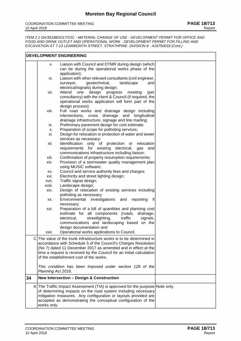
Moreton Bay Regional Council COORDINATION COMMITTEE MEETING PAGE 18/713 10 April 2018 Report ITEM 2.1 DA/35188/2017/V2C - MATERIAL CHANGE OF USE - DEVELOPMENT PERMIT FOR OFFICE AND FOOD AND DRINK OUTLET AND OPERATIONAL WORK - DEVELOPMENT PERMIT FOR FILLING AND EXCAVATION AT 7-13 LEARMONTH STREET, STRATHPINE- DIVISION 8 - A16750018 (Cont.)
COORDINATION COMMITTEE MEETING PAGE 18/713 10 April 2018 Report
DEVELOPMENT ENGINEERING
v. Liaison with Council and DTMR during design (which can be during the operational works phase of the application);
vi. Liaison with other relevant consultants (civil engineer, surveyor, geotechnical, landscape and electrical/signals) during design;
vii. Attend one design progress meeting (per consultancy) with the client & Council (if required, the operational works application will form part of the design process);
viii. Full road works and drainage design including intersections, cross drainage and longitudinal drainage infrastructure, signage and line marling;
ix. Preliminary pavement design for cost estimate; x. Preparation of scope for potholing services; xi. Design for relocation or protection of water and sewer
services as necessary; xii. Identification only of protection or relocation
requirements for existing electrical, gas and communications infrastructure including liaison;
xiii. Confirmation of property resumption requirements; xiv. Provision of a stormwater quality management plan
using MUSIC software; xv. Council and service authority fees and charges; xvi. Electricity and street lighting design; xvii. Traffic signal design; xviii. Landscape design; xix. Design of relocation of existing services including
potholing as necessary; xx. Environmental investigations and reporting if
necessary; xxi. Preparation of a bill of quantities and planning cost
estimate for all components (roads, drainage, electrical, streetlighting, traffic signals, communications and landscaping based on the design documentation and
xxii. Operational works applications to Council. C The value of the trunk infrastructure works is to be determined in
accordance with Schedule 5 of the Council’s Charges Resolution (No 7) dated 11 December 2017 as amended and in effect at the time a request is received by the Council for an initial calculation of the establishment cost of the works. This condition has been imposed under section 128 of the Planning Act 2016.
34 New Intersection – Design & Construction
A The Traffic Impact Assessment (TIA) is approved for the purpose of determining impacts on the road system including necessary mitigation measures. Any configuration or layouts provided are accepted as demonstrating the conceptual configuration of the works only.
Note only.
Moreton Bay Regional Council COORDINATION COMMITTEE MEETING PAGE 18/714 10 April 2018 Report ITEM 2.1 DA/35188/2017/V2C - MATERIAL CHANGE OF USE - DEVELOPMENT PERMIT FOR OFFICE AND FOOD AND DRINK OUTLET AND OPERATIONAL WORK - DEVELOPMENT PERMIT FOR FILLING AND EXCAVATION AT 7-13 LEARMONTH STREET, STRATHPINE- DIVISION 8 - A16750018 (Cont.)
COORDINATION COMMITTEE MEETING PAGE 18/714 10 April 2018 Report
DEVELOPMENT ENGINEERING
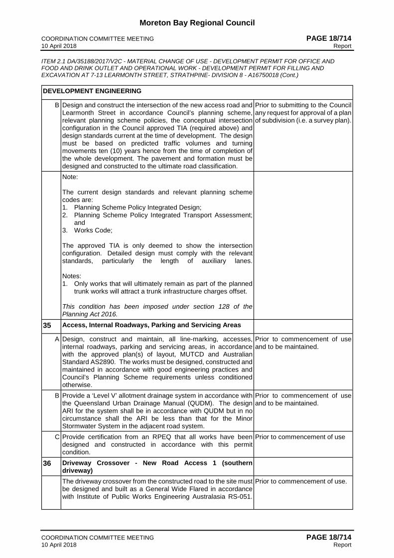
B Design and construct the intersection of the new access road and Learmonth Street in accordance Council’s planning scheme, relevant planning scheme policies, the conceptual intersection configuration in the Council approved TIA (required above) and design standards current at the time of development. The design must be based on predicted traffic volumes and turning movements ten (10) years hence from the time of completion of the whole development. The pavement and formation must be designed and constructed to the ultimate road classification.
Prior to submitting to the Council any request for approval of a plan of subdivision (i.e. a survey plan).
Note: The current design standards and relevant planning scheme codes are: 1. Planning Scheme Policy Integrated Design; 2. Planning Scheme Policy Integrated Transport Assessment;
and 3. Works Code; The approved TIA is only deemed to show the intersection configuration. Detailed design must comply with the relevant standards, particularly the length of auxiliary lanes. Notes: 1. Only works that will ultimately remain as part of the planned
trunk works will attract a trunk infrastructure charges offset. This condition has been imposed under section 128 of the Planning Act 2016.
35 Access, Internal Roadways, Parking and Servicing Areas
A Design, construct and maintain, all line-marking, accesses, internal roadways, parking and servicing areas, in accordance with the approved plan(s) of layout, MUTCD and Australian Standard AS2890. The works must be designed, constructed and maintained in accordance with good engineering practices and Council’s Planning Scheme requirements unless conditioned otherwise.
Prior to commencement of use and to be maintained.
B Provide a ‘Level V’ allotment drainage system in accordance with the Queensland Urban Drainage Manual (QUDM). The design ARI for the system shall be in accordance with QUDM but in no circumstance shall the ARI be less than that for the Minor Stormwater System in the adjacent road system.
Prior to commencement of use and to be maintained.
C Provide certification from an RPEQ that all works have been designed and constructed in accordance with this permit condition.
Prior to commencement of use
36 Driveway Crossover - New Road Access 1 (southern driveway)
The driveway crossover from the constructed road to the site must be designed and built as a General Wide Flared in accordance with Institute of Public Works Engineering Australasia RS-051.
Prior to commencement of use.

Moreton Bay Regional Council COORDINATION COMMITTEE MEETING PAGE 18/715 10 April 2018 Report ITEM 2.1 DA/35188/2017/V2C - MATERIAL CHANGE OF USE - DEVELOPMENT PERMIT FOR OFFICE AND FOOD AND DRINK OUTLET AND OPERATIONAL WORK - DEVELOPMENT PERMIT FOR FILLING AND EXCAVATION AT 7-13 LEARMONTH STREET, STRATHPINE- DIVISION 8 - A16750018 (Cont.)
COORDINATION COMMITTEE MEETING PAGE 18/715 10 April 2018 Report
DEVELOPMENT ENGINEERING
Provide certification from an RPEQ that all works have been designed and constructed in accordance with this permit condition. Notes: 1. The internal access works must be designed to ensure the
correct line, level and layout is achieved for the driveway crossover.
2. Council will not accept driveway crossovers that do not conform to the above requirements.
37 Driveway Crossover - New Road Access 2 (northern driveway)
The driveway crossover from the constructed road to the site must be designed and built as a General Wide Flared in accordance with Institute of Public Works Engineering Australasia RS-051. Provide certification from an RPEQ that all works have been designed and constructed in accordance with this permit condition. Notes: 1. The internal access works must be designed to ensure the
correct line, level and layout is achieved for the driveway crossover.
2. Council will not accept driveway crossovers that do not conform to the above requirements.
Prior to commencement of use.
38 Driveway Crossover - Learmonth Street (eastern boundary)
The driveway crossover from the constructed road to the site must be designed and built as a General Wide vehicle crossing in accordance with Institute of Public Works Engineering Australasia Standard Drawing RS-051. Provide signage and line marking in accordance with MUTCD that clearly denotes that this driveway is an entry only. Provide certification from an RPEQ that all works have been designed and constructed in accordance with this permit condition. Notes: 1. The internal access works must be designed to ensure the
correct line, level and layout is achieved for the driveway crossover.
2. Council will not accept driveway crossovers that do not conform to the above requirements.
Prior to commencement of use.
39 Construction Affecting Existing Roads
Provide and maintain control measures for any works in or affecting roads (including verges) to ensure that the works will not injure, endanger, obstruct or unduly inconvenience any person or user of the road.
At all times.

Moreton Bay Regional Council COORDINATION COMMITTEE MEETING PAGE 18/716 10 April 2018 Report ITEM 2.1 DA/35188/2017/V2C - MATERIAL CHANGE OF USE - DEVELOPMENT PERMIT FOR OFFICE AND FOOD AND DRINK OUTLET AND OPERATIONAL WORK - DEVELOPMENT PERMIT FOR FILLING AND EXCAVATION AT 7-13 LEARMONTH STREET, STRATHPINE- DIVISION 8 - A16750018 (Cont.)
COORDINATION COMMITTEE MEETING PAGE 18/716 10 April 2018 Report
DEVELOPMENT ENGINEERING
Note: All traffic control devices must be installed and maintained in accordance with the Manual of Traffic Control Devices (Queensland).
40 Overland Flow Management
(a) Provide measures to properly manage overland flows draining to and through the land to ensure no nuisance or annoyance is created to any person or premises as a result of the development. The development must not result in ponding on adjacent land, redirection of overland flows to other premises and blockage of an overland flow relief path for flows exceeding the design flows for any underground system within the development.
(b) Provide drainage easements, free of cost and compensation in Council's favour, over any Council drainage paths and drainage infrastructure located within the private lot.
Note: The current design standards and relevant planning scheme codes are: 1. Planning Scheme Policy Integrated Design; 2. Works Code. This condition has been imposed under section 145 of the Planning Act 2016.
All prior to commencement of use.
41 Stormwater Management & Drainage Infrastructure – Design & Construction
Design and construct at no cost to Council all necessary stormwater management and drainage works (internal and external to the site) in accordance with Council’s design standard current at the time of development. The design must consider “Water Sensitive Urban Design” principles, integrating the stormwater infrastructure into the urban design wherever possible. Note: The current design standards and relevant planning scheme codes are: 1. Planning Scheme Policy Integrated Design; 2. Works Code. This condition has been imposed under section 145 of the Planning Act 2016.
Prior to submitting to the Council any request for approval of a plan of subdivision (i.e. a survey plan) for each stage or prior to commencement of use.
42 Stormwater Drainage - Lawful Discharge
Ensure that stormwater from the proposed development is lawfully discharged from the subject land without causing nuisance and annoyance to any person.
At all times.

Moreton Bay Regional Council COORDINATION COMMITTEE MEETING PAGE 18/717 10 April 2018 Report ITEM 2.1 DA/35188/2017/V2C - MATERIAL CHANGE OF USE - DEVELOPMENT PERMIT FOR OFFICE AND FOOD AND DRINK OUTLET AND OPERATIONAL WORK - DEVELOPMENT PERMIT FOR FILLING AND EXCAVATION AT 7-13 LEARMONTH STREET, STRATHPINE- DIVISION 8 - A16750018 (Cont.)
COORDINATION COMMITTEE MEETING PAGE 18/717 10 April 2018 Report
DEVELOPMENT ENGINEERING
43 Stormwater Management Plan (Quantity & Quality) – Plan Approved
A The approved Stormwater Management Plan is accepted as demonstrating that stormwater from the proposed development can be managed in accordance with Council’s planning scheme requirements and design standards, the “Healthy Waterways Water Sensitive Urban Design Technical Guidelines for South East Queensland” and other relevant legislative requirements. The detailed design must consider “Water Sensitive Urban Design” principles, integrating the stormwater infrastructure into the urban design wherever possible.
Note.
B Implement the works identified in the approved Stormwater Management Plan and provide certification from an RPEQ that all works have been designed and constructed in accordance with this permit condition. Provide Council with “As Built” drawings and specifications of the stormwater management devices certified by an RPEQ including the following for private infrastructure: (a) Photographic evidence and inspection date of the installation
of approved underdrainage.
Prior to commencement of use.
C Maintain and repair the completed private infrastructure works to ensure its ongoing effectiveness. The approved works shall not be altered in any way without the prior written approval of Council. This condition has been imposed under section 145 of the Planning Act 2016.
At all times.
44 Pedestrian Pathways
Construct a reinforced concrete pathway in accordance with Council’s standards at the following locations (a) New Road - Both verges of the new road for the full verge
width from Learmonth Street to the second access driveway, generally in accordance with the approved plan which are to be a coloured concrete finish or a lightly exposed aggregate treatment with coloured concrete nodes unless otherwise approved by the Council in writing prior to any Operational Works application. The finishes are to be agreed to with Council prior to installation.
This condition has been imposed under section 128 of the Planning Act 2016.
Prior to commencement of use.
45 Minimum Finished Floor Level
Design and construct the finished floor level for the proposed building at a minimum of 8.1m AHD. Notes: 1. The defined flood level at the location of the building has been
determined in the approved Flood Impact Assessment, this level is 7.6m AHD
Prior to commencement of use.

Moreton Bay Regional Council COORDINATION COMMITTEE MEETING PAGE 18/718 10 April 2018 Report ITEM 2.1 DA/35188/2017/V2C - MATERIAL CHANGE OF USE - DEVELOPMENT PERMIT FOR OFFICE AND FOOD AND DRINK OUTLET AND OPERATIONAL WORK - DEVELOPMENT PERMIT FOR FILLING AND EXCAVATION AT 7-13 LEARMONTH STREET, STRATHPINE- DIVISION 8 - A16750018 (Cont.)
COORDINATION COMMITTEE MEETING PAGE 18/718 10 April 2018 Report
DEVELOPMENT ENGINEERING
2. The freeboard has been determined in the approved Flood Impact Assessment, the freeboard for the proposed building is 500mm.
46 Pedestrian Crossing
Design and fully construct at no cost to Council, a minimum 2.5m wide raised pedestrian crossing (described in Austroads as a Pedestrian Wombat Crossing) at the location generally shown on the approved plans, linking the plaza space to the public lobby building entry. This condition has been imposed under section 145 of the Planning Act 2016.
Prior to commencement of use.
47 Earthworks
Ensure the earthworks associated with the carpark have been undertaken in accordance with the Operational Works - Development Permit for Filling and Excavation.
Prior to the commencement of use.
CONDITION TIMING
OPERATIONAL WORKS
DEVELOPMENT ENGINEERING
48 Management Plans
A Undertake an Acid Sulfate Soil Investigation, to be prepared by a qualified person. Soil sampling and analysis must be undertaken in accordance with procedures specified in Planning Scheme Policy - Acid Sulfate Soils. The investigation must provide information on the depth and extent of any acid sulfate soils on site within this stage of development, as well as the severity of acid sulfate soils relevant to the proposed disturbance.
Prior to the commencement of site works.
B Prepare an Acid Sulfate Soil Management Plan for Council approval. All waters, including stormwater runoff, groundwater seepage and leachate from acid sulfate soils, must achieve the following quality prior to release from the site: (a) A pH range of 6.5-8.5 pH units. (b) 50mg/L maximum TSS concentration (c) 0.3mg/L maximum total iron concentration (d) 0.2mg/L maximum total aluminium concentration (e) No visible plume at either the point of release from the site
or within a waterway.
Prior to the commencement of site works.
C Implement the requirements and recommendations of any Council approved Acid Sulfate Soil Management Plan required by (B) above.
At all times during construction.
D Submit a Validation Report to Council at the completion of the site works. The validation report is to demonstrate compliance with the approved Acid Sulfate Soils Management Plan.
Prior to finalisation of works where On Maintenance acceptance is not required.

Moreton Bay Regional Council COORDINATION COMMITTEE MEETING PAGE 18/719 10 April 2018 Report ITEM 2.1 DA/35188/2017/V2C - MATERIAL CHANGE OF USE - DEVELOPMENT PERMIT FOR OFFICE AND FOOD AND DRINK OUTLET AND OPERATIONAL WORK - DEVELOPMENT PERMIT FOR FILLING AND EXCAVATION AT 7-13 LEARMONTH STREET, STRATHPINE- DIVISION 8 - A16750018 (Cont.)
COORDINATION COMMITTEE MEETING PAGE 18/719 10 April 2018 Report
CONDITION TIMING
49 Non-Conforming Designs
Only non-conforming designs listed in this approval have been accepted. All other discrepancies with Council standards shall be redesigned and / or reconstructed as necessary to conform with Council standards at no cost to Council, unless otherwise approved in writing by Council or its delegate.
At all times during construction and prior to finalisation of works.
50 Errors and Omissions
Where errors or omissions occur in the design or works do not conform to or meet Council standards then these works shall be rectified to comply with Council standards at no cost to Council. Where drawings contain insufficient detail or do not contain details of works that are either necessary or associated with the development then these works shall be designed and constructed to Council standards. Only the approved plans shall be used for construction. Note: Council reserves the right to amend the approved drawings or request further information should this become necessary.
At all times during construction and prior to finalisation of works.
51 Works – Applicant’s Expense
All works, services, facilities and/or public utility alterations required by or as a consequence of this approval or stated condition/s, whether carried out by the Council or otherwise, shall be at the developer’s expense unless otherwise specified or agreed in writing. Replace existing Council infrastructure (including but not limited to street trees and footpaths) to Council’s standards.
At all times during construction and prior to finalisation of works.
52 Notification of Finalisation of Works
Notify Council in writing that the development works on site have been finalised.
At the time of completion of construction.
53 Works Through Land not owned by the Developer
Where any works are proposed to be undertaken on or extend into any property not owned by the developer then the other property owner’s written consent must be lodged with Council. The written consent from the land owner must identify the correct drawing title and number (including revision number) for the works within or through their land.
Prior to any works commencing within those properties.
54 Notification to Affected Premises
A Provide Council with a copy of an information kit for ‘Notification to Affected Premises’ which includes the following: (a) A layout plan of the proposed development showing
adjoining lot boundaries, new and existing roads, park and open space, drainage reserves and community purposes lots as applicable;
Prior to distribution of information kit to residents.

Moreton Bay Regional Council COORDINATION COMMITTEE MEETING PAGE 18/720 10 April 2018 Report ITEM 2.1 DA/35188/2017/V2C - MATERIAL CHANGE OF USE - DEVELOPMENT PERMIT FOR OFFICE AND FOOD AND DRINK OUTLET AND OPERATIONAL WORK - DEVELOPMENT PERMIT FOR FILLING AND EXCAVATION AT 7-13 LEARMONTH STREET, STRATHPINE- DIVISION 8 - A16750018 (Cont.)
COORDINATION COMMITTEE MEETING PAGE 18/720 10 April 2018 Report
CONDITION TIMING
(b) Details of any external works with any changes to existing works highlighted for easy identification;
(c) Scheduled start and completion dates; (d) Contact names and phone numbers for the Developer,
Supervising Engineer, Consulting Engineer, the Contractor and who to contact in an emergency; and
(e) The site working hours authorised for the site works. B Provide all occupiers of premises adjoining the site, directly
opposite the frontage of the site, adjacent to and directly opposite external works and residents/occupiers likely to be directly affected by the works with a copy of the ‘Notification to Affected Premises’ information kit. Provide Council’s delegated officer with a list of premises which the information kit has been delivered to.
Not less than 14 days prior to commencing any construction works.
55 Prestart Meeting
Arrange a prestart meeting with Council officers from Development Engineering section (contact Wayne Goss on 5433 2750). The following people will be required to attend the prestart meeting: (a) Developer’s Supervising Engineer (b) Contractor’s Engineer / Project Manager (c) Contractor’s Site Supervisor (d) Fauna Manager (where required).
Not less than 7 days prior to commencing any construction works.
56 Testing Frequency – General
A All testing of the works shall be carried to comply with the minimum testing frequencies given in MBRC Planning Scheme Policy - Operational Works inspection, maintenance and bonding procedures. Note: Council’s delegated officer may vary the frequency of testing to suit site conditions but must provide written advice to the supervising engineer prior to commencement of the relevant works.
At all times during construction.
B Provide a plan identifying locations where testing has occurred. Prior to finalisation of works where On Maintenance acceptance is not required.
57 Construction Hours Restrictions
Ensure hours of construction are limited to 0630 to 1830 Monday to Saturday and not at all on Sundays and public holidays. Note: Council’s engineer may approve (in writing) work outside the above hours where it can be demonstrated to the satisfaction of Council that the work will not cause unreasonable interference with the amenity of adjoining premise and any person.
At all times.
58 Construction Nuisance and Annoyance

Moreton Bay Regional Council COORDINATION COMMITTEE MEETING PAGE 18/721 10 April 2018 Report ITEM 2.1 DA/35188/2017/V2C - MATERIAL CHANGE OF USE - DEVELOPMENT PERMIT FOR OFFICE AND FOOD AND DRINK OUTLET AND OPERATIONAL WORK - DEVELOPMENT PERMIT FOR FILLING AND EXCAVATION AT 7-13 LEARMONTH STREET, STRATHPINE- DIVISION 8 - A16750018 (Cont.)
COORDINATION COMMITTEE MEETING PAGE 18/721 10 April 2018 Report
CONDITION TIMING
Ensure construction works do not cause unreasonable interference with the amenity of adjoining premise and any person by reason of noise, vibration, electrical interference, smell, fumes, vapour, steam, soot, ash, dust, silt, wastewater, waste products, grit, oil or otherwise.
At all times.
59 Temporary Sedimentation, Erosion and Runoff Control
A All temporary sedimentation, erosion and runoff controls must be installed in accordance with Council’s planning scheme requirements and Council’s design standards, the State Government’s standards and other relevant legislative requirements (e.g. Environmental Protection (Water) Policy).
Prior to commencement of any clearing or earthworks on site.
B The temporary erosion and sediment control measures shall be maintained and be functional until the end of the Maintenance Period for the works or earlier if Council’s delegated officer considers they are no longer required. Note: Council’s delegated officer may order additional measures to control silt on site at no cost to Council.
At all times during construction.
60 Haul Routes
Submit and have approved by Council’s delegated officer all haul routes for the transport of imported or spoil material and gravel pavement material along Council roads below sub-arterial standard. Note: Refer to MBRC Planning Scheme Values and Constraints Mapping - Road Hierarchy for details on sub-arterial and arterial roads.
Prior to a prestart meeting being held.
61 Spillage onto Existing Roads
Clean those parts of the access route to the site that are affected by any material dropped, deposited or spilled on the roads as a result of construction processes associated with the site. Note: 1. All materials must be swept up and removed from the roads
and not directed into Council’s stormwater drainage system. 2. All care must be taken to prevent sediments being deposited
on roads.
At all times during construction.
62 Dust Control – Nuisance and Annoyance
Implement suitable dust control measures. If airborne particles are observed leaving the site, any work is to cease immediately and satisfactory dust suppression is to be implemented. Note: Dust suppression measures must be in place at all times including weekends and public holidays.
Prior to finalisation of works.
63 Earthworks Batters

Moreton Bay Regional Council COORDINATION COMMITTEE MEETING PAGE 18/722 10 April 2018 Report ITEM 2.1 DA/35188/2017/V2C - MATERIAL CHANGE OF USE - DEVELOPMENT PERMIT FOR OFFICE AND FOOD AND DRINK OUTLET AND OPERATIONAL WORK - DEVELOPMENT PERMIT FOR FILLING AND EXCAVATION AT 7-13 LEARMONTH STREET, STRATHPINE- DIVISION 8 - A16750018 (Cont.)
COORDINATION COMMITTEE MEETING PAGE 18/722 10 April 2018 Report
CONDITION TIMING
Where approved drawings do not include specifications for scour and erosion protection apply the following treatments to batter slopes: (a) Slopes of 1:6 or flatter – topsoil and seed (b) Slopes between 1:6 and 1:4 – topsoil and turf (c) Slopes of 1:4 or greater – provide treatment
recommendation from a qualified geotechnical engineer (R.P.E.Q.) for Council approval prior to undertaking batter works
(d) Or as directed by Council. Note: Batters within Open and Civic Spaces are to be treated in accordance with MBRC Planning Scheme Policy Integrated Design - Open and Civil Space Design.
At all times during construction.
64 Site works – Stormwater Runoff Quality
Carry out earthworks in accordance with the Single State Planning Policy - Water Quality and Urban Stormwater Quality Planning Guidelines Section 5/15 & 6/33. Note: 1. Soil disturbances of greater than 1.0 hectares will require a
site specific Erosion & Sediment Control Plan (ESCP). 2. Earthworks are to be undertaken to ensure that soil
disturbances are stage into manageable areas of not greater than 3.5 hectares.
At all times during construction and until the site is suitably stabilised.
65 Unsuitable Fill Materials
Ensure that all fill material used on the development site is free of unsuitable materials, identified in AS3798 and the following: (a) actual acid sulfate soils and potential acid sulfate soils; (b) organic or putrescible matter; (c) material imported from land which is, or has been, listed on
the “Environmental Management Register” under the Environmental Protection Act 1994; and
(d) building demolition material.
At all times.
66 Compaction Requirements
All fill material which is intended to be load bearing, or the finished surface level of which is required to remain approximately constant, is selected, placed and compacted to the standard prescribed in Australian Standard AS3798 Guidelines on Earthworks for Commercial and Residential developments.
At all times during construction.
67 Stormwater Runoff Control – Batters and Retaining Walls
Provide cut-off drains at the top of the batter with turf or rock lined batter drains for all batters and/or retaining walls generally higher than 600mm in height and with a catchment greater than 1000m2.
Prior to finalisation of works.

Moreton Bay Regional Council COORDINATION COMMITTEE MEETING PAGE 18/723 10 April 2018 Report ITEM 2.1 DA/35188/2017/V2C - MATERIAL CHANGE OF USE - DEVELOPMENT PERMIT FOR OFFICE AND FOOD AND DRINK OUTLET AND OPERATIONAL WORK - DEVELOPMENT PERMIT FOR FILLING AND EXCAVATION AT 7-13 LEARMONTH STREET, STRATHPINE- DIVISION 8 - A16750018 (Cont.)
COORDINATION COMMITTEE MEETING PAGE 18/723 10 April 2018 Report
CONDITION TIMING
Note: Where these are not detailed on the approved drawings then these works shall be in accordance with Council’s current standards.
68 Stormwater Runoff Control – Open Drains
Provide lining with appropriate scour protection to all open drains and bunds in accordance with Council’s Planning Scheme, Planning Scheme Policies and standard drawings current at the time of development. Note: Dumped rock is generally not considered as an appropriate solution.
Prior to finalisation of works where On Maintenance acceptance is not required.
69 Stormwater Overland Flow – Site Earthworks
Earthworks must be undertaken on the site so as not to cause nuisance and annoyance to any person or premises. The development must: (a) Allow stormwater overland flow which entered the land prior
to the commencement of the earthworks to continue to enter the land; and
(b) Ensure stormwater overland flow from the development site is not discharged or diverted onto land (other than a road) adjacent to the site in a manner which: (i) concentrates the rate of flow at any point along the
property boundary; or (ii) increases the peak flow rates of stormwater discharged
at any point along the property boundary; beyond that which existed prior to commencement of these earthworks.
Note: To remove any doubt, this condition has taken the future roadworks and stormwater drainage works into account and it is recognised that the drainage strategy will be altered subject to the Material Change of Use application over the site.
At all times during construction.
70 Stabilisation of Disturbed Areas
Ensure that a grass strike rate of at least 80% cover has been attained on all disturbed areas or other approved means of stabilisation of grassed areas have been provided. Note: For residential and rural residential subdivisions, the road reserve between kerb and property line shall be turfed as a condition of completion.
Prior to finalisation of works where On Maintenance acceptance is not required.
ADVICES
1 Aboriginal Cultural Heritage Act 2003
The Aboriginal Cultural Heritage Act 2003 commenced in Queensland on April 16, 2004. Under the Act, indigenous parties are key in assessing cultural heritage significance. The Aboriginal Cultural Heritage Act 2003 establishes a Duty of Care for indigenous cultural heritage. This applies on all land and water, including freehold land. The Cultural Heritage Duty of

Moreton Bay Regional Council COORDINATION COMMITTEE MEETING PAGE 18/724 10 April 2018 Report ITEM 2.1 DA/35188/2017/V2C - MATERIAL CHANGE OF USE - DEVELOPMENT PERMIT FOR OFFICE AND FOOD AND DRINK OUTLET AND OPERATIONAL WORK - DEVELOPMENT PERMIT FOR FILLING AND EXCAVATION AT 7-13 LEARMONTH STREET, STRATHPINE- DIVISION 8 - A16750018 (Cont.)
COORDINATION COMMITTEE MEETING PAGE 18/724 10 April 2018 Report
Care lies with the person or entity conducting the activity. Penalty provisions apply for failing to fulfil the Cultural Heritage Duty of Care. Those proposing an activity that involves additional surface disturbance beyond that which has already occurred on the proposed site need to be mindful of the Duty of Care requirement. Details of how to fulfill the Duty of Care are outlined in the Duty of Care Guidelines gazetted with the Act. Council strongly advises that you contact the relevant state agency to obtain a copy of the Duty of Care Guidelines and further information on the responsibilities of developer under the terms of the Aboriginal Cultural Heritage Act 2003.
2 Adopted Charges
Payment of an Adopted Infrastructure Charge in accordance with Council’s Infrastructure Charges Resolution (No. 7) dated 11 December 2017 or as amended apply to this development approval. From 1 July 2014, Moreton Bay Regional Council no longer issues an Infrastructure Charges Notice on behalf of Unitywater for water supply and sewerage networks and therefore a separate Infrastructure Charges Notice may be issued directly to the applicant by Unitywater in respect to this development approval. Payment of Infrastructure Charges is to be in accordance with the Infrastructure Charges Notice issued with this development approval and any Infrastructure Charges Notice issued by Unitywater. From 1 July 2014, all Infrastructure Charges for infrastructure networks controlled by Unitywater (eg. water and/or sewerage) regardless of when the Infrastructure Charges Notice was issued are to be paid directly to Unitywater while Infrastructure Charges for networks controlled by Moreton Bay Regional Council will continue to be paid directly to Moreton Bay Regional Council.
3 Food Premises - Food Business Licence Advice
In accordance with the Food Act 2006 the following must be submitted to Council prior to the commencement of construction or fit out of any licensable food business: 1. An application for food business licence. 2. Plans and elevations (refer to note below). 3. Supporting documentation. 4. Relevant fee. Note: The application is assessed against the provisions of the Food Act 2006, Australia and New Zealand Food Standards Code and AS 4674 – Design, construction and fit-out of food premises (or equivalent).
4 Extent of Checking by Council (OPW)
This approval shall not be taken to mean that the drawings have been checked in detail and Council accepts no responsibility whatsoever for the survey information, the design, or for the accuracy of any information or detail contained in the approved drawings and specifications.
B. That the Council report for this application be published to the website as Council’s statement of
reasons in accordance with Section 63 (5) of the Planning Act 2016. C. That the following information be included in the Decision Notice:

Moreton Bay Regional Council COORDINATION COMMITTEE MEETING PAGE 18/725 10 April 2018 Report ITEM 2.1 DA/35188/2017/V2C - MATERIAL CHANGE OF USE - DEVELOPMENT PERMIT FOR OFFICE AND FOOD AND DRINK OUTLET AND OPERATIONAL WORK - DEVELOPMENT PERMIT FOR FILLING AND EXCAVATION AT 7-13 LEARMONTH STREET, STRATHPINE- DIVISION 8 - A16750018 (Cont.)
COORDINATION COMMITTEE MEETING PAGE 18/725 10 April 2018 Report
Decision Notice information
Details to Insert Application Type
Material Change of Use - Development Permit for Office and Food and Drink Outlet
AND Operational Works - Development Permit for Filling and Excavation
Relevant Period of Approval
• Material Change of Use – 6 years • Operational Works - 2 years
Section 64(5) Deemed Approval
Not applicable
Superseded Planning Scheme
Not applicable
Variation approval affecting the Planning Scheme
Not applicable
Other Necessary Permits
• Operational Works – Development Permit (Roadworks and Drainage Works)
• Building Works – Development Permit Codes for Accepted Development
Not applicable
Referral Agencies There are no Referral Agencies Submissions
There were two (2) properly made submissions about this application.
REPORT DETAIL 1. Background On 5 April 2017, Prelodgement written minutes were issued to the applicant regarding the proposal. Since this time, Council and the applicant have met on several occasions to discuss and refine the proposal prior to lodgement. The site otherwise has no history other than being part of the same land holdings of the owner of the Shopping centre at Strathpine formerly owned by Westfields, who dedicated land as road reserve through the site in 1991 between Learmonth Street and Flynn’s Lane. 2. Explanation of Item 2.1 Proposal Details
The applicant proposes a Material Change of Use - Development Permit for Office and Food and Drink Outlet and Operational Work - Development Permit for Filling and Excavation at 7-13 Learmonth Street, Strathpine. The proposal is the first stage of the site’s development as a key site for the Strathpine Centre Precinct. The proposal is for a Material Change of Use for Office (7,462m2) and Food & Drink Outlet (a 300m2 ground level café for staff and visitors to the office). The building is a large three storey structure situated centrally within the subject site to allow for a future mixed use development immediately south to front Learmonth Street (herein referred to as Stage 2).

Moreton Bay Regional Council COORDINATION COMMITTEE MEETING PAGE 18/726 10 April 2018 Report ITEM 2.1 DA/35188/2017/V2C - MATERIAL CHANGE OF USE - DEVELOPMENT PERMIT FOR OFFICE AND FOOD AND DRINK OUTLET AND OPERATIONAL WORK - DEVELOPMENT PERMIT FOR FILLING AND EXCAVATION AT 7-13 LEARMONTH STREET, STRATHPINE- DIVISION 8 - A16750018 (Cont.)
COORDINATION COMMITTEE MEETING PAGE 18/726 10 April 2018 Report
The proposed ground floor consists of: • Office and meeting spaces at the southwestern corner • End of trip cycle facilities and staff entry from the west • A loading dock, angled away from the future street and flanked by landscape zones, in the
northwestern corner, which is as far away as possible from any sensitive uses. The loading dock area also accommodates mechanical plant and refuse storage designed for 1.1m3 bins and accessible by rear loading HRV
• A ‘merchandise zone’ is located adjacent to the loading dock. This area is not for the sale of items. Rather, it is a space where new stock is assembled and display configurations worked through for external shop staff to be trained on how to display in their stores.
• The café is centrally located • Amenities lifts and stairs are situated centrally along the building frontage • The main entry is prominently located at the southern frontage, at the bend in the building • An undercroft car park is located in the part of the ground floor The first and second floors above comprise of similar floor plates and are entirely for office space. Key features of the floor plates are: • Large centrally located atrium spaces are situated beneath a skylight and provides better
access to natural light for all floors • Both office floors feature large external balconies that are oriented to the north and centrally
located • The central lift and stair corridor on the southern wall and fire stairs at each end • These floors are open plan for a single national retailing tenant to occupy and fit out once taken
possession of the lease A privately-owned loop drive will run parallel to Learmonth Street to directly service the office building described above and the future Stage 2 site to the south. Access is to be gained from a left in entry at the south-eastern corner of the site via an existing road reserve which is to be closed and exit via proposed new road that is to be dedicated along the western boundary. The proposed new road intersects with Learmonth Street at a set of new traffic signals with all movements access. The signals will be required in the long term when the new road is constructed all the way to Flynns Lane. Road construction is proposed up to the rear of the building adjacent to the above-mentioned loading dock area and rear car park. The road is a 20.8m road reserve including all necessary road attributes. The land and road works are identified as trunk infrastructure. It is also noted that a road closure is proposed to close part of the existing road reserve along the eastern boundary of the site. This road closure is being managed by the Department of Natural Resources and Mines and Council’s Property Services section through the regular road closure processes. A plaza space is proposed adjacent to the new road, between the loop drive and Learmonth Street. It is an angular shape featuring a prominent footpath directing pedestrians to the main entry of the office. The western edge will intersect with the 4m paved verge of the proposed new road. A series of berms and grass hills will provide topographic interest within the plaza and breakout space for staff. A large car park is proposed to the rear of the building and contains 615 spaces (including those beneath). Landscaping and mature shade trees (1 per 6 spaces) are proposed along planting rows between spaces, which also forms part of the stormwater treatment train. The car park extends up to the line of Easement F, which is a pre-existing easement in favor of Council for drainage and infrastructure purposes. Some minor compensatory works are proposed north of the car park in order to provide the northern most spaces with the appropriate flood immunity. While the proposed land uses are code assessable, because associated operational (excavation) work extends into the Limited Development Zone, this application triggers impact assessment.

Moreton Bay Regional Council COORDINATION COMMITTEE MEETING PAGE 18/727 10 April 2018 Report ITEM 2.1 DA/35188/2017/V2C - MATERIAL CHANGE OF USE - DEVELOPMENT PERMIT FOR OFFICE AND FOOD AND DRINK OUTLET AND OPERATIONAL WORK - DEVELOPMENT PERMIT FOR FILLING AND EXCAVATION AT 7-13 LEARMONTH STREET, STRATHPINE- DIVISION 8 - A16750018 (Cont.)
COORDINATION COMMITTEE MEETING PAGE 18/727 10 April 2018 Report
It is also noted that a section of the High Hazard Flood Overlay category extends from the west into a small portion of the proposed car park. While, the proposed new road and associated drainage works will remove that hazard and the draft major amendment to the planning scheme overlay mapping has also removed that high hazard, this remains an impact assessment trigger under the current Planning Scheme.
2.2 Description of the Site and Surrounds
Directions Planning Scheme Zone Current Land Use North General Residential Zone
– Urban Neighbourhood Precinct
Unconstructed road reserve, vacant land residential dwelling houses
South Centre Zone – Strathpine Centre Precinct
Strathpine Shopping Centre
East Recreation and Open Space Zone; and Further east: General Residential Zone – Suburban Neighbourhood Precinct
Current 10m park buffer and residential dwelling houses further east, fronting Ulmarra Crescent.
West Centre Zone – Strathpine Centre Precinct
Commercial properties fronting Gympie Road
2.3 Assessment Benchmarks related to the Planning Regulation 2017
The Planning Regulation 2017 (the Regulation) prescribes Assessment Benchmarks that the application must be carried out against, which are additional or alternative to the Assessment Benchmarks contained in Council’s Planning Scheme.
These Assessment Benchmarks are prescribed as being contained in: • the South-East Queensland Regional Plan and Part E of the State Planning Policy; and • Schedule 10 of the Regulation.
Applicable Assessment Benchmarks:
State Planning Policy • State Planning Policy, Part E
Regional Plan
• South East Queensland Regional Plan From Schedule 10 of the Regulation:
• Part 10: Koala Habitat Area – Schedule 11 of the Planning Regulation 2017
SEQ Regional Plan Designation:
• Urban Footprint
Koala Habitat Designation:
• Priority Koala Assessable Development Area
2.3.1 State Planning Policy
A new State Planning Policy came into effect on 3 July 2017, and is not currently integrated into the MBRC Planning Scheme. The following assessment benchmarks are to be applied to the assessment of development applications until the State interests have been appropriately integrated into Council’s planning scheme. Assessment against the SPP assessment benchmarks is as follows:
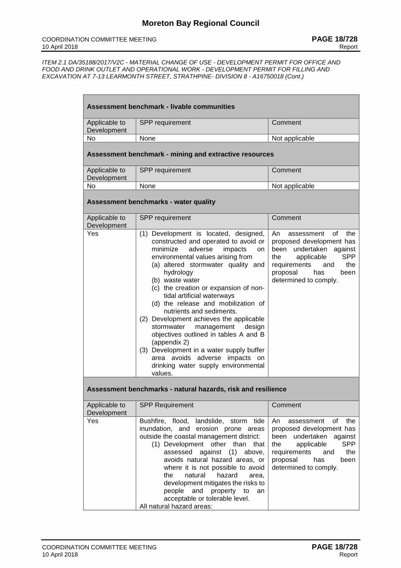
Moreton Bay Regional Council COORDINATION COMMITTEE MEETING PAGE 18/728 10 April 2018 Report ITEM 2.1 DA/35188/2017/V2C - MATERIAL CHANGE OF USE - DEVELOPMENT PERMIT FOR OFFICE AND FOOD AND DRINK OUTLET AND OPERATIONAL WORK - DEVELOPMENT PERMIT FOR FILLING AND EXCAVATION AT 7-13 LEARMONTH STREET, STRATHPINE- DIVISION 8 - A16750018 (Cont.)
COORDINATION COMMITTEE MEETING PAGE 18/728 10 April 2018 Report
Assessment benchmark - livable communities Applicable to Development
SPP requirement Comment
No None Not applicable Assessment benchmark - mining and extractive resources Applicable to Development
SPP requirement Comment
No None Not applicable Assessment benchmarks - water quality Applicable to Development
SPP requirement Comment
Yes (1) Development is located, designed, constructed and operated to avoid or minimize adverse impacts on environmental values arising from (a) altered stormwater quality and
hydrology (b) waste water (c) the creation or expansion of non-
tidal artificial waterways (d) the release and mobilization of
nutrients and sediments. (2) Development achieves the applicable
stormwater management design objectives outlined in tables A and B (appendix 2)
(3) Development in a water supply buffer area avoids adverse impacts on drinking water supply environmental values.
An assessment of the proposed development has been undertaken against the applicable SPP requirements and the proposal has been determined to comply.
Assessment benchmarks - natural hazards, risk and resilience Applicable to Development
SPP Requirement Comment
Yes Bushfire, flood, landslide, storm tide inundation, and erosion prone areas outside the coastal management district:
(1) Development other than that assessed against (1) above, avoids natural hazard areas, or where it is not possible to avoid the natural hazard area, development mitigates the risks to people and property to an acceptable or tolerable level.
All natural hazard areas:
An assessment of the proposed development has been undertaken against the applicable SPP requirements and the proposal has been determined to comply.

Moreton Bay Regional Council COORDINATION COMMITTEE MEETING PAGE 18/729 10 April 2018 Report ITEM 2.1 DA/35188/2017/V2C - MATERIAL CHANGE OF USE - DEVELOPMENT PERMIT FOR OFFICE AND FOOD AND DRINK OUTLET AND OPERATIONAL WORK - DEVELOPMENT PERMIT FOR FILLING AND EXCAVATION AT 7-13 LEARMONTH STREET, STRATHPINE- DIVISION 8 - A16750018 (Cont.)
COORDINATION COMMITTEE MEETING PAGE 18/729 10 April 2018 Report
(2) Development supports and does not hinder disaster management response or recovery capacity and capabilities.
(3) Development directly, indirectly and cumulatively avoids an increase in the severity of the natural hazard and the potential for damage on the site or to other properties.
(4) Risks to public safety and the environment from the location of hazardous materials and the release of these materials as a result of a natural hazard are avoided.
(5) The natural processes and the protective function of landforms and the vegetation that can mitigate risks associated with the natural hazard are maintained or enhanced.
Assessment benchmarks - strategic airports and aviation facilities Applicable to Development
SPP Requirement Comment
No None Not applicable
2.3.2 South East Queensland Regional Plan The site is located in the Urban Footprint. The development proposal is for an urban activity in the Urban Footprint, and there are no requirements in the State Planning Regulatory Provisions applicable to the development proposal.
2.3.3 Schedule 10, Part 10 of the Regulation - Koala Habitat Area
Discuss where necessary. Koala Habitat Area The site is located in a Priority Koala Assessable Development Area. An assessment as to how the development satisfies the provisions in the Regulation has been undertaken, and the proposal is consistent.
2.4 Assessment Against Local Categorising Instrument - Moreton Bay Regional Council Planning Scheme
An assessment against the relevant parts of the planning scheme is set out below. 2.4.1 Strategic Framework
In accordance with section 1.7.2 of the planning scheme, the development proposal requires assessment against the Strategic Outcomes within the Strategic Framework. The applicable Strategic Outcomes under the Themes for the planning scheme are discussed as follows:

Moreton Bay Regional Council COORDINATION COMMITTEE MEETING PAGE 18/730 10 April 2018 Report ITEM 2.1 DA/35188/2017/V2C - MATERIAL CHANGE OF USE - DEVELOPMENT PERMIT FOR OFFICE AND FOOD AND DRINK OUTLET AND OPERATIONAL WORK - DEVELOPMENT PERMIT FOR FILLING AND EXCAVATION AT 7-13 LEARMONTH STREET, STRATHPINE- DIVISION 8 - A16750018 (Cont.)
COORDINATION COMMITTEE MEETING PAGE 18/730 10 April 2018 Report
Strategic Outcome Complies Assessment
Theme - Water Management 3.12.4 Strategic Outcome - Floodplain Management - Floodplains in the region will be managed for the long-term benefit of the community such that hazards to people and damages to property and infrastructure are minimised and the intrinsic environmental values of the floodplain are protected. 1. The natural function of the
Region’s floodplains are preserved and enhanced;
Yes
The applicant provided an extensive Flood Impact Assessment Report interrogating a range of regional and local flood models with projected changes in weather. The modelling shows the floodplain will be protected by the proposed works with no adverse impacts to the community. The modelling has been endorsed by Council’s Drainage & Coastal Waterways team. The proposal achieves this outcome.
2. The different flood behaviour that occurs across the region in a variety of events, up to and including the probable maximum flood, are recognised and planned for; and
Yes
The applicant provided an extensive Flood Impact Assessment Report interrogating a range of regional and local flood models with projected changes in weather for a range of possible weather events. The modelling identifies likely future risks to allow planning accordingly for these within the proposal. The modelling has been endorsed by Council’s Drainage & Coastal Waterways team. The proposal achieves this outcome.
3. Land use planning and development controls minimise both the exposure of people to flood hazard and the potential damages to property and infrastructure. Yes
The applicant provided an extensive Flood Impact Assessment Report interrogating a range of regional and local flood models with projected changes in weather. The modelling has identified the likely flood extent for unlikely events and adopted a large freeboard to minimise the exposure of people to the identified flood hazard. The modelling has been endorsed by Council’s Drainage & Coastal Waterways team. The proposal achieves this outcome.
Theme - Sustainability and Resilience 3.3.3 Strategic Outcome - Natural hazards and adaptation - The resilience of communities, development, essential infrastructure, natural environments and economic sectors to natural hazards including projected changes in weather is increased. 1. Respond to the risk from natural
hazards, including projected changes in weather, by avoiding areas with high exposure and establishing adaptation strategies to minimise vulnerability to riverine flooding, storm tide, coastal erosion, bushfires and landslides;
Yes
The applicant provided an extensive Flood Impact Assessment Report interrogating a range of regional and local flood models with projected changes in weather. The modelling has demonstrated the proposal provides a resilience based approach for the proposal, including freeboard in the unlikely event of minor inundation. The modelling has been endorsed by Council’s Drainage & Coastal Waterways team. The proposal achieves this outcome.

Moreton Bay Regional Council COORDINATION COMMITTEE MEETING PAGE 18/731 10 April 2018 Report ITEM 2.1 DA/35188/2017/V2C - MATERIAL CHANGE OF USE - DEVELOPMENT PERMIT FOR OFFICE AND FOOD AND DRINK OUTLET AND OPERATIONAL WORK - DEVELOPMENT PERMIT FOR FILLING AND EXCAVATION AT 7-13 LEARMONTH STREET, STRATHPINE- DIVISION 8 - A16750018 (Cont.)
COORDINATION COMMITTEE MEETING PAGE 18/731 10 April 2018 Report
Strategic Outcome Complies Assessment
2. Respond to the risk from natural hazards, including projected changes in weather, by establishing adaptation strategies to minimise vulnerability to heatwaves and high temperatures, reduced and more variable rainfall, cyclones and severe winds, and severe storms and hail; and
Yes
The applicant provided an extensive Flood Impact Assessment Report interrogating a range of regional and local flood models with projected changes in weather (including increased rainfall). The modelling has demonstrated the proposal provides a resilience based approach for the proposal, including freeboard in the unlikely event of minor inundation. The modelling has been endorsed by Council’s Drainage & Coastal Waterways team. The proposal achieves this outcome.
3. Recognise and respond to changes in urban climates due to land use conversion and urban heat island effect from increased development intensity. Yes
The development responds to its heat island effect by proposing external street trees, internal car parking shade trees, and a public plaza that could otherwise be developed land area. The range of measures is suitable in the Activity Centre place type. The location in an existing urbanised area also does not increase the size of the heat island as urban fringe expansion does.
Theme - MBRC Place Model
3.14.11.1 MBRC Place Model - Activity Centre Place Type - Specific Outcomes
3.14.11.1 Specific Outcomes - Sustainability and resilience 3. Activity centres are designed to
minimise exposure to riverine and coastal flood events.
Yes
The applicant provided an extensive Flood Impact Assessment Report interrogating a range of regional and local flood models. The modelling has demonstrated the proposal minimises exposure to riverine flood events. The modelling has been endorsed by Council’s Drainage & Coastal Waterways team. The proposal achieves this outcome.
3.14.11.14 MBRC Place Model - Coast and Riverlands Place Type - Specific Outcomes
3.14.14.2 Specific Outcomes - Natural Environment and Landscape 1. The integrity, condition and
function of biodiversity and ecological processes within these areas are protected in perpetuity from the adverse impacts of development and land use activities;
Yes
The applicant provided an extensive Flood Impact Assessment Report interrogating a range of regional and local flood models. The modelling has demonstrated the development does not promote adverse impacts of development on the integrity, condition and function of biodiversity and ecological processes. The modelling has been endorsed by Council’s Drainage & Coastal Waterways team. The proposal achieves this outcome.
2.4.2 Assessment of Applicable Codes
Code Compliance Summary The assessment below identifies how the development proposal achieves the assessment benchmarks and where the development proposal;

Moreton Bay Regional Council COORDINATION COMMITTEE MEETING PAGE 18/732 10 April 2018 Report ITEM 2.1 DA/35188/2017/V2C - MATERIAL CHANGE OF USE - DEVELOPMENT PERMIT FOR OFFICE AND FOOD AND DRINK OUTLET AND OPERATIONAL WORK - DEVELOPMENT PERMIT FOR FILLING AND EXCAVATION AT 7-13 LEARMONTH STREET, STRATHPINE- DIVISION 8 - A16750018 (Cont.)
COORDINATION COMMITTEE MEETING PAGE 18/732 10 April 2018 Report
(a) proposes an alternative ‘Example’ satisfying or not satisfying the corresponding
Performance Outcome; and (b) proposes an outcome where no ‘Example’ is stated in the code and the proposed outcome
does not satisfy the corresponding Performance Outcome.
Assessment Benchmarks
Compliance with Overall
Outcomes Performance Outcomes assessment is
required
Zone/ Local Plan Code Centre Zone Code - Strathpine Centre precinct
Yes No
PO2, PO12, PO59, PO84
Overlay Codes Flood hazard overlay code
Yes No
PO11, PO13, PO22
Development Codes Works code Yes
No
The assessment of the development proposal against the Performance Outcomes of the applicable code(s) is discussed below in section 2.4.3.
2.4.3 Performance Outcome Assessment
Performance Outcome Example
Centre Zone Code PO2 Development maximises the efficient use of land and provides for future growth within the precinct by maintaining or increasing the GFA and land use intensity within the precinct boundaries to promote economic development.
E2 Development within the precinct achieves a minimum plot ratio of 1:1.
Performance Outcome Assessment
The applicant proposes a performance solution to PO2 as the plot ratio is 1: 0.25 (7,762m2 GFA for 31,230m2 site area) in lieu of 1:1. This application is for Stage 1 of the site’s development only and is expected to generate more than 600 new direct employees. The proposed development leaves a 5,192m2 future development site for Stage 2, which is to be submitted. This leaves scope for the ultimate development of the site to achieve E2. It is appropriate to consider the timing and staging of the site’s development (given the size of the site) in assessing this alternative solution. As such, the development maximises the efficient use of this part of the land and provides for future growth within the precinct by increasing the GFA and land use intensity within the precinct boundaries to promote economic development. The proposal achieves the Performance Outcome. PO12 The provision of car parking spaces is:
a. appropriate to the use; b. avoids an oversupply of car parking spaces.
E12 Car parking is provided in accordance with the table below.

Moreton Bay Regional Council COORDINATION COMMITTEE MEETING PAGE 18/733 10 April 2018 Report ITEM 2.1 DA/35188/2017/V2C - MATERIAL CHANGE OF USE - DEVELOPMENT PERMIT FOR OFFICE AND FOOD AND DRINK OUTLET AND OPERATIONAL WORK - DEVELOPMENT PERMIT FOR FILLING AND EXCAVATION AT 7-13 LEARMONTH STREET, STRATHPINE- DIVISION 8 - A16750018 (Cont.)
COORDINATION COMMITTEE MEETING PAGE 18/733 10 April 2018 Report
Performance Outcome Example
Land use Maximum number of Car Spaces to be Provided
Minimum Number of Car Spaces to be Provided
Non-residential
1 per 50m2 of GFA
1 per 75m2 of GFA
Performance Outcome Assessment
The applicant proposes a performance solution with 615 car parking spaces. The nominated maximum is 155 spaces with the nominated minimum of 104. The amount of car parks is a result of the tenant’s independent staff trip analysis from other national office buildings. Because of this, it has been determined that the car parking provision is appropriate for the specific office use in this instance. To remove any doubt, the car park does not stagnate the long-term usability of the site. In the very long term, some of the car parking area could be re-used as part of a future development footprint in keeping with the planning scheme of the day. Therefore, the car parking is appropriate to the use and avoids an oversupply in this instance. The proposal accords with the Performance Outcome. PO59 Filling or excavation is undertaken in a manner that: a. does not adversely impact on a Council or
public sector entity maintained infrastructure or any drainage feature on, or adjacent to the land;
b. does not preclude reasonable access to a Council or public sector entity maintained infrastructure or any drainage feature on, or adjacent to the land for monitoring, maintenance or replacement purposes.
E59.1 No filling or excavation is undertaken in an easement issued in favour of Council or a public sector entity.
Performance Outcome Assessment
The applicant proposes a performance solution by proposing excavation within Easement F at the northern end of the site. The easement was established for drainage purposes and the proposed works are designed to improve flood storage within the easement (and adjacent to Coultards Creek). Maintenance access to this segment of the creek will also improve because of the proposed works. Given that: • the easement is for drainage purposes; • the proposed works are to enhance flood storage/conveyance and not impact on other
infrastructure; and • improves maintenance access the excavation will be undertaken in a manner that does not adversely impact on the Council’s drainage easement and does not preclude reasonable access to the drainage easement. The proposal accords with the Performance Outcome. PO84 Development on Key site B (north of Westfield shopping centre), shown on ‘Figure 6.2.1.4.1 - Strathpine’ includes:
a. active retail and commercial uses adjoining Learmonth Street;
b. medium density residential uses addressing Raynbird Park (linear park).
No example provided.

Moreton Bay Regional Council COORDINATION COMMITTEE MEETING PAGE 18/734 10 April 2018 Report ITEM 2.1 DA/35188/2017/V2C - MATERIAL CHANGE OF USE - DEVELOPMENT PERMIT FOR OFFICE AND FOOD AND DRINK OUTLET AND OPERATIONAL WORK - DEVELOPMENT PERMIT FOR FILLING AND EXCAVATION AT 7-13 LEARMONTH STREET, STRATHPINE- DIVISION 8 - A16750018 (Cont.)
COORDINATION COMMITTEE MEETING PAGE 18/734 10 April 2018 Report
Performance Outcome Example
Performance Outcome Assessment
The application is not in conflict but discussion is necessary for thoroughness. The site is identified on Key Site B but the location of the office building is central to the site. A future development area is provided to front Learmonth Street and provide active retail and commercial uses adjoining this street. Further, and as discussed previously, the site provides a large car park which will adjoin Raynbird Park. The car park does not stagnate the long-term usability of the site and if the office user ever vacates the site, some of the car parking area could be re-used as part of a future residential development scheme in keeping with the planning scheme of the day. The proposal does not compromise the ultimate achievement of the Performance Outcome.
Flood Hazard Code
PO11 Development is resilient to a flood hazard event by ensuring design and built form account for the potential risks of the flood hazard event.
E11.2 Development ensures that the finished floor level is located, designed and constructed to at least the flood planning level in Table 8.2.2.3.
Performance Outcome Assessment
The applicant proposes a performance solution with a proposed flood planning level of 8.1m AHD (7.6m revised DFE + 500mm freeboard) in lieu of the nominated finished floor level of 8.5m AHD based on Council’s current flood check development report (7.75m DFE + 750mm freeboard). A Flood Impact Assessment Report has been prepared in support of the application. This report has outlined the strategy being implemented over the proposed development site to cater for the flood hazard events, and includes modelling for the following events - 5%, 2% and 1% AEP. As a result of this reporting the majority of the development site which was previously mapped as medium risk has been demonstrated to be equivalent to balance flood planning area. The proposed strategy over the site has also reduced the defined flood level relevant to the proposed building area, and the defined flood level to be adopted is recommended at 7.6m AHD. The report also has undertaken a detailed analysis on the freeboard requirements for the development site. This report reviewed events from 1% AEP up to and including a 0.05% AEP that shows the depth of flooding across the site and it is unlikely to exceed 500mm, therefore it has demonstrated that the proposed freeboard of 500mm will be suitable for this development site and is demonstrated to be resilient to the flood hazard. It has been determined that the proposed Flood Planning Level (defined flood level + freeboard) of 8.1m AHD is an acceptable outcome in this instance, subject to the detailed regional and localised flood modelling undertaken. The revised flood planning level accords with the Performance Outcome. PO13 Development ensures that earthworks complies with the requirements of Table 8.2.2.4 ‘Fill Requirements’ and does not: a. directly, indirectly and cumulatively cause any
increase in water flow velocity or level; b. increase the potential for erosion, scour or
flood damage either on the premises or on other premises, public land, watercourses, roads or infrastructure or elsewhere in the floodplain;
c. change the timing of the flood wave or impact on flood warning times.
No example provided.

Moreton Bay Regional Council COORDINATION COMMITTEE MEETING PAGE 18/735 10 April 2018 Report ITEM 2.1 DA/35188/2017/V2C - MATERIAL CHANGE OF USE - DEVELOPMENT PERMIT FOR OFFICE AND FOOD AND DRINK OUTLET AND OPERATIONAL WORK - DEVELOPMENT PERMIT FOR FILLING AND EXCAVATION AT 7-13 LEARMONTH STREET, STRATHPINE- DIVISION 8 - A16750018 (Cont.)
COORDINATION COMMITTEE MEETING PAGE 18/735 10 April 2018 Report
Performance Outcome Example
Performance Outcome Assessment
The applicant proposes earthworks for the northern extent of the car park within the medium and high risk flood areas where Table 8.2.2.4 outlines no filling is to occur. The Flood Impact Assessment Report provided has demonstrated compliance with (a) to (c) of PO13. However, in accordance with Table 8.2.2.4 ‘Fill Requirements’, no filling is permitted in any of these areas. As the proposal does not comply with this Performance Outcome, an assessment against the Overall Outcomes is required and discussed in the following section of this report. PO22 Development ensures that works complies with the requirements of Table 8.2.2.4 ‘Fill Requirements’ and does not: a. directly, indirectly and cumulatively cause any
increase in water flow velocity or level; b. increase the potential for erosion, scour or
flood damage either on the premises or other premises, public land, watercourses, roads or infrastructure or elsewhere in the floodplain;
c. change the timing of the flood wave or impact on flood warning times;
d. adverse impacts on the local drainage and the flood conveyance of a waterway;
e. increased flood inundation of surrounding properties;
f. any reduction in the flood storage capacity of the floodplain and any clearing of native vegetation.
No example provided.
Performance Outcome Assessment
The applicant proposes earthworks for the northern extent of the car park within the medium and high risk flood areas where Table 8.2.2.4 outlines no filling is to occur. The Flood Impact Assessment Report provided has demonstrated compliance with (a) to (f) of PO22. However, in accordance with Table 8.2.2.4 ‘Fill Requirements’, no filling is permitted in any of these areas. As the proposal does not comply with this Performance Outcome, an assessment against the Overall Outcomes is required and discussed in the following section of this report.
2.4.4 Overall Outcome Assessment
The development proposal does not comply with Performance Outcome PO13 and PO22 of the Flood hazard overlay code. Therefore, the proposal is required to be assessed against the applicable Overall Outcomes of the code as follows;
8.2.2.2 Purpose - Flood hazard overlay Overall Outcomes Complies
Y/N Comments a. Development in the High risk flood hazard
area included in the Limited development zone, avoids the extremely unacceptable intolerable risk of the flood hazard by ensuring that:
i. a material change of use is only for the following uses if the intolerable risk of flood hazard to people, property and
NA

Moreton Bay Regional Council COORDINATION COMMITTEE MEETING PAGE 18/736 10 April 2018 Report ITEM 2.1 DA/35188/2017/V2C - MATERIAL CHANGE OF USE - DEVELOPMENT PERMIT FOR OFFICE AND FOOD AND DRINK OUTLET AND OPERATIONAL WORK - DEVELOPMENT PERMIT FOR FILLING AND EXCAVATION AT 7-13 LEARMONTH STREET, STRATHPINE- DIVISION 8 - A16750018 (Cont.)
COORDINATION COMMITTEE MEETING PAGE 18/736 10 April 2018 Report
8.2.2.2 Purpose - Flood hazard overlay Overall Outcomes Complies
Y/N Comments infrastructure located on the premises and other premises is avoided:
A. Outdoor sport and recreation(; or B. Park; or C. Permanent plantation; or D. Cropping (where involving
forestry for wood production); ii. reconfiguring a lot for boundary
realignment only occurs if the intolerable risk of flood hazard to people, property and infrastructure located on the premises and other premises is not increased and where practicable the intolerable risk of flood hazard for future occupants is mitigated;
iii. reconfiguring a lot for creating lots by subdividing another lot only occurs for the purposes of Park or Permanent plantation or ensures that lots have sufficient area outside of the zone for development consistent in the adjoining zone and precinct;
iv. building work is less than 50m2 in area and associated with a use in paragraph (i).
v. earthworks do not occur except where associated with a previous approval.
NA
NA
NA
NO
The applicant has proposed to undertake earthworks across the site in particular compensatory earthworks within the High risk hazard area in the limited development zone. The proposed earthworks is to provide the required immunities to the proposed car parks in that location. The compensatory earthworks have been demonstrated to not have an adverse impact. The proposed earthworks are not associated with a previous approval and will require an assessment against the strategic framework.
b. Development in the High risk area not included in the Limited development zone, manages and mitigates the unacceptable intolerable risk of the flood hazard by ensuring that:
i. a material change of use is only for the following uses if consistent with the overall outcomes of the applicable zone and precinct and the intolerable risk of flood hazard to people, property and
NO
The proposed location of the Office, in particular the car park associated with the Office, is partially within the extent of the current mapped high risk area but not included in the Limited

Moreton Bay Regional Council COORDINATION COMMITTEE MEETING PAGE 18/737 10 April 2018 Report ITEM 2.1 DA/35188/2017/V2C - MATERIAL CHANGE OF USE - DEVELOPMENT PERMIT FOR OFFICE AND FOOD AND DRINK OUTLET AND OPERATIONAL WORK - DEVELOPMENT PERMIT FOR FILLING AND EXCAVATION AT 7-13 LEARMONTH STREET, STRATHPINE- DIVISION 8 - A16750018 (Cont.)
COORDINATION COMMITTEE MEETING PAGE 18/737 10 April 2018 Report
8.2.2.2 Purpose - Flood hazard overlay Overall Outcomes Complies
Y/N Comments infrastructure located on the premises and other premises is avoided:
A. Dwelling house; or B. Outdoor sport and recreation; or C. Park; or D. Permanent plantation; or E. Cropping (where involving
forestry for wood production); or F. Tourist park; or G. Home based business;
ii. reconfiguring a lot for boundary realignment only occurs if the intolerable risk of flood hazard to people, property and infrastructure located on the premises and other premises is not increased and where practicable the intolerable risk of flood hazard for future occupants is mitigated;
iii. reconfiguring a lot for creating lots by subdividing another lot is only for the following:
A. reconfiguring a lot for creating lots by subdividing another lot is only for the following: in the Rural zone, where consistent with the overall outcomes of the applicable zone and precinct; or
B. in the Rural residential zone, residential lots provide the required minimum lot size outside the High or Medium risk area of the Flood planning area; or
C. in any other zone, for the purposes of Park or Permanent plantation;
iv. building work complies with the flood planning level, engineering design and resilient materials requirements;
v. earthworks do not occur except where associated with a previous approval.
NA
NA
NA
NO
Development Zone. This use is not listed in section (i), and as such the proposal does not accord with this Overall Outcome. Assessment against the Strategic Framework is required. The applicant has proposed to undertake earthworks across the site in particular compensatory earthworks within the High risk hazard area outside of the limited development zone. The proposed earthworks is to provide the required immunities to the proposed car parks in that location. The compensatory earthworks have been demonstrated to not have an adverse impact. The proposed

Moreton Bay Regional Council COORDINATION COMMITTEE MEETING PAGE 18/738 10 April 2018 Report ITEM 2.1 DA/35188/2017/V2C - MATERIAL CHANGE OF USE - DEVELOPMENT PERMIT FOR OFFICE AND FOOD AND DRINK OUTLET AND OPERATIONAL WORK - DEVELOPMENT PERMIT FOR FILLING AND EXCAVATION AT 7-13 LEARMONTH STREET, STRATHPINE- DIVISION 8 - A16750018 (Cont.)
COORDINATION COMMITTEE MEETING PAGE 18/738 10 April 2018 Report
8.2.2.2 Purpose - Flood hazard overlay Overall Outcomes Complies
Y/N Comments earthworks are not associated with a previous approval and will require an assessment against the strategic framework.
c. Development in the Medium risk area manages and mitigates the tolerable risk of flood hazard by ensuring that:
i. a material change of use is only for the following uses if consistent with the overall outcomes of the applicable zone and precinct and the risk to people, property and infrastructure located on the premises and other premises is avoided or mitigated:
A. Dwelling house; or B. Outdoor sport and recreation; or C. Park; or D. Permanent plantation; or E. Cropping (where involving
forestry for wood production); or F. Tourist park; or G. Home based business; or H. Non-residential uses where not
involving a vulnerable land use (flood and coastal).
ii. reconfiguring a lot for boundary realignment only occurs if the risk of flood hazard to people, property and infrastructure located on the premises and other premises is not increased and where practicable the risk of flood hazard for future occupants is mitigated;
iii. reconfiguring a lot for creating lots by subdividing another lot is only for the following:
A. in the Rural zone, Centre zone, Industry zone, Recreation and open space zone, or Township zone, where not for a residential purpose or vulnerable use (flood and coastal) and consistent with the overall outcomes of the existing zone and precinct;
B. in the Rural residential zone, where the minimum lot size for each rural residential lot is provided outside the High risk or Medium risk area;
C. in any other zone, where all resultant lots are located outside the High risk or Medium risk area other than those for the purposes of Park or Permanent plantation.
Y
NA
NA
The proposed location of the Office is partially within the extent of the current mapped medium risk area. An Office is a non-residential use not involving a vulnerable land use (flood and coastal). Importantly, a Food and drink outlet is also. The proposal is consistent with the overall outcomes of the Centre zone code and the risk to people, property and infrastructure in this location of the site is avoided as demonstrated through the significant flood modelling. Therefore, the proposal accords with this outcome.
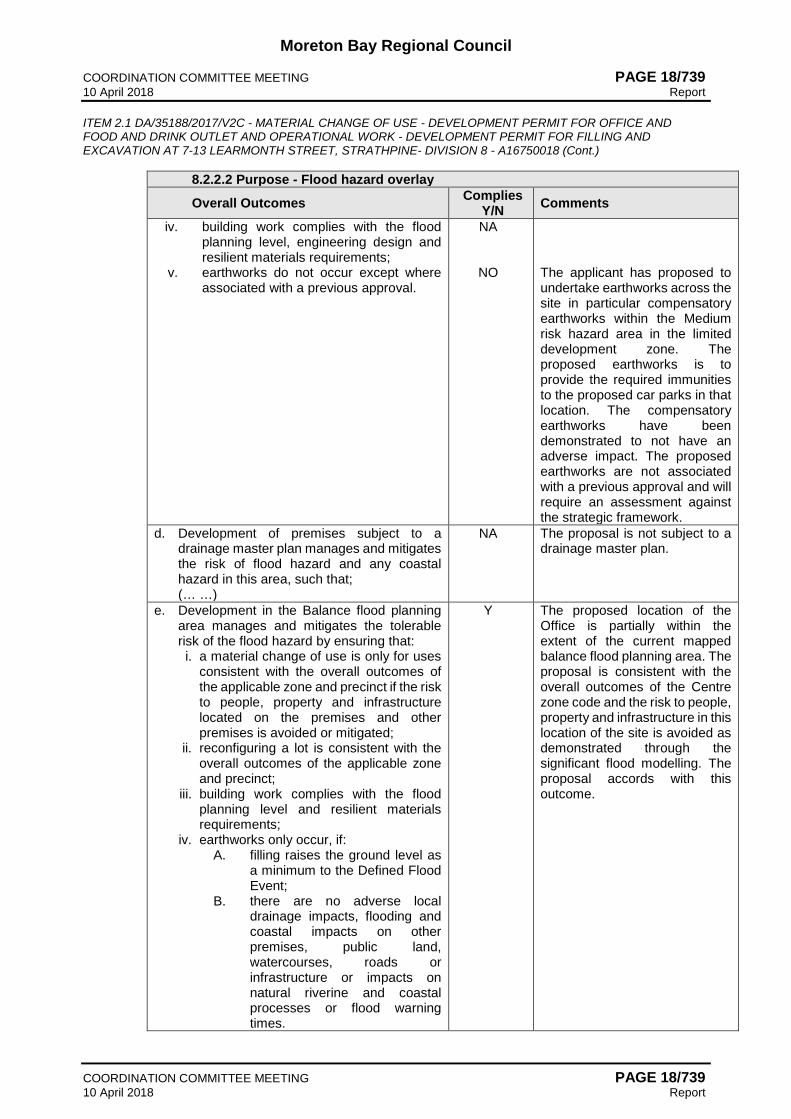
Moreton Bay Regional Council COORDINATION COMMITTEE MEETING PAGE 18/739 10 April 2018 Report ITEM 2.1 DA/35188/2017/V2C - MATERIAL CHANGE OF USE - DEVELOPMENT PERMIT FOR OFFICE AND FOOD AND DRINK OUTLET AND OPERATIONAL WORK - DEVELOPMENT PERMIT FOR FILLING AND EXCAVATION AT 7-13 LEARMONTH STREET, STRATHPINE- DIVISION 8 - A16750018 (Cont.)
COORDINATION COMMITTEE MEETING PAGE 18/739 10 April 2018 Report
8.2.2.2 Purpose - Flood hazard overlay Overall Outcomes Complies
Y/N Comments iv. building work complies with the flood
planning level, engineering design and resilient materials requirements;
v. earthworks do not occur except where associated with a previous approval.
NA
NO
The applicant has proposed to undertake earthworks across the site in particular compensatory earthworks within the Medium risk hazard area in the limited development zone. The proposed earthworks is to provide the required immunities to the proposed car parks in that location. The compensatory earthworks have been demonstrated to not have an adverse impact. The proposed earthworks are not associated with a previous approval and will require an assessment against the strategic framework.
d. Development of premises subject to a drainage master plan manages and mitigates the risk of flood hazard and any coastal hazard in this area, such that; (… …)
NA The proposal is not subject to a drainage master plan.
e. Development in the Balance flood planning area manages and mitigates the tolerable risk of the flood hazard by ensuring that: i. a material change of use is only for uses
consistent with the overall outcomes of the applicable zone and precinct if the risk to people, property and infrastructure located on the premises and other premises is avoided or mitigated;
ii. reconfiguring a lot is consistent with the overall outcomes of the applicable zone and precinct;
iii. building work complies with the flood planning level and resilient materials requirements;
iv. earthworks only occur, if: A. filling raises the ground level as
a minimum to the Defined Flood Event;
B. there are no adverse local drainage impacts, flooding and coastal impacts on other premises, public land, watercourses, roads or infrastructure or impacts on natural riverine and coastal processes or flood warning times.
Y The proposed location of the Office is partially within the extent of the current mapped balance flood planning area. The proposal is consistent with the overall outcomes of the Centre zone code and the risk to people, property and infrastructure in this location of the site is avoided as demonstrated through the significant flood modelling. The proposal accords with this outcome.

Moreton Bay Regional Council COORDINATION COMMITTEE MEETING PAGE 18/740 10 April 2018 Report ITEM 2.1 DA/35188/2017/V2C - MATERIAL CHANGE OF USE - DEVELOPMENT PERMIT FOR OFFICE AND FOOD AND DRINK OUTLET AND OPERATIONAL WORK - DEVELOPMENT PERMIT FOR FILLING AND EXCAVATION AT 7-13 LEARMONTH STREET, STRATHPINE- DIVISION 8 - A16750018 (Cont.)
COORDINATION COMMITTEE MEETING PAGE 18/740 10 April 2018 Report
8.2.2.2 Purpose - Flood hazard overlay Overall Outcomes Complies
Y/N Comments f. Development in the Flood planning area:
i. supports, and does not unduly burden the disaster management response and recovery capacity and capabilities during and after significant flood events;
ii. provides for efficient evacuation of on-site persons and facilitates direct and simple access for evacuation personnel and resources during flood events, while ensuring development does not hinder or place additional complexities upon evacuation activities for other premises;
iii. avoids isolation of persons for flood events up to and including the Defined Flood Event;
iv. provides for siting, built form, layout, and access (including evacuation access) which responds to the risk of the flood hazard and minimises risk to personal safety in all flood hazard events up to and including the Defined Flood Event;
v. is resilient to flood events by ensuring the siting and design of development accounts for the potential risks to property associated with flood hazards;
vi. directly, indirectly and cumulatively avoids an increase in the severity of flood hazards and potential for damage on the premises or to other premises or elsewhere in the floodplain;
vii. involving essential community infrastructure remains functional during and immediately after a flood event up to and including the Defined Flood Event;
viii. avoids the accidental release of hazardous materials as a result of a flood event;
ix. maintains natural processes and the protective function of landforms and vegetation;
x. does not impact adversely on the ability for future flood hazard mitigation measures to be implemented on other premises.
Y The proposed location of the Office is within the extent of the Flood Planning Area. The extensive flood modelling has demonstrated the development supports disaster management response and recovery, provides evacuation routes, avoids isolating persons, provides a proposal which responds to the flood risk and is resilient to the risk, avoids an increase in flood hazard and does not impact on future flood hazard mitigation measures. The proposal accords with this outcome.
Based on the assessment above, the proposal is inconsistent with four (4) of the Overall Outcomes of the code(s). Therefore, in accordance with section 1.7.2 of the MBRC Planning Scheme, an assessment against the Strategic Framework is set out in section 2.4.1 of this report.

Moreton Bay Regional Council COORDINATION COMMITTEE MEETING PAGE 18/741 10 April 2018 Report ITEM 2.1 DA/35188/2017/V2C - MATERIAL CHANGE OF USE - DEVELOPMENT PERMIT FOR OFFICE AND FOOD AND DRINK OUTLET AND OPERATIONAL WORK - DEVELOPMENT PERMIT FOR FILLING AND EXCAVATION AT 7-13 LEARMONTH STREET, STRATHPINE- DIVISION 8 - A16750018 (Cont.)
COORDINATION COMMITTEE MEETING PAGE 18/741 10 April 2018 Report
2.5 Trunk Infrastructure
In accordance with section 4 of the Moreton Bay Regional Council Planning Scheme, the subject site is located in the identified Priority Infrastructure Area. Infrastructure charges applying to the land, where applicable, are to be applied in accordance the Council’s Charges Resolution No. 7 commencing on 11 December 2017 (CR).
2.5.1 Levied Charge
In accordance with section 10 of the CR, a Levied Charge is applicable to the development proposal and has been calculated as shown in the Infrastructure Charges Notice attached to this report taking into consideration any applicable credits or offsets.
2.5.2 Levied Charge Credit
In accordance with section 14 of the CR, a credit exists for the development based on the credit being the greater of the following amounts:
(a) Payment of previous charges or contributions There is no record of a previous charge or contribution having been made in relation to the land in accordance with section 14 of the CR. Accordingly, the credit available under this option is $0.00
(b) Lawful use of land There is no current existing lawful use of the land or record of a previous lawful use of the land that is no longer taking place. Accordingly, the credit available under this option is $0.00.
(c) Other development able to occur without a development permit There is no other development able to be lawfully carried out without a development permit (including a development permit for Building Works). Accordingly, the credit available under this option is $0.00.
(d) The adopted charge for a residential lot (applied equally to non-residential development) The credit available under this option is $17,001.54 based on the proportional split stated in Table 3 of the CR.
2.5.3 Levied Charge Offset or Refund
The site is affected by a Trunk Infrastructure requirement and it is recommended to include a condition in the development approval requiring the trunk infrastructure item to be delivered by the development. The Trunk Infrastructure item is RD33 - Eastern Collector Road, Strathpine. It is recommended to include a condition requiring the land dedication and a condition requiring the road construction. In accordance with section 17 of the CR, it has been calculated that the trunk infrastructure item has an Establishment Cost of: • Land Dedication - $75,600.00 • Works - $ To be Advised (TBA) upon Operational Works approval. and will result in an offset against the levied charge only with the balance of the levied charge payable by the development. It is important to note that under the Council’s Charges Resolution Implementation Policy, it had been determined that no offset for the land dedication was required, with the value of the land to be closed as road having a higher value than the land being dedicated as road despite that a greater area of land is being dedicated than is being closed. This was due to the areas of land classified as ‘constrained’.

Moreton Bay Regional Council COORDINATION COMMITTEE MEETING PAGE 18/742 10 April 2018 Report ITEM 2.1 DA/35188/2017/V2C - MATERIAL CHANGE OF USE - DEVELOPMENT PERMIT FOR OFFICE AND FOOD AND DRINK OUTLET AND OPERATIONAL WORK - DEVELOPMENT PERMIT FOR FILLING AND EXCAVATION AT 7-13 LEARMONTH STREET, STRATHPINE- DIVISION 8 - A16750018 (Cont.)
COORDINATION COMMITTEE MEETING PAGE 18/742 10 April 2018 Report
In accordance with the Charges Resolution, the applicant submitted their own valuation of the land and proposed the value of the trunk land offset was instead $500,000, that when combined with the anticipated costs of the trunk road would probably result in a refund being paid to the applicant at the completion of the development. In accordance with the Charges Resolution, an independent land valuation report was commissioned by the Council that valued the Establishment Cost of the land as instead $75,600.00. This amount was calculated as follows: • Land affected by easement and constrained by flood: $10/m2 • Other constrained land (below 1% AEP): $113/m2 • Unconstrained land: $250/m2 and based on these values adopted a before and after method in relation to: • Existing Lot 3 prior to any land exchange is worth: $5,998,479 • Lot 3 after inclusion of road closed and exclusion of trunk road is worth: $5,922,892 • Difference in value being the trunk offset: $75,587 and reasonably rounded to
$75,600.00. To progress the determination of the development application it is recommended the $75,600.00 Establishment Cost be applied however it is relevant for the Council to note that the applicant has not agreed to this value at this time and it is quite possible the value of the Establishment Cost might be determined by another valuer jointly appointed by the Council and the applicant through a Negotiated Charges Notice process under the Charges Resolution.
2.5.4 Additional Trunk Infrastructure Costs In accordance with section 130 of the Planning Act 2016, an additional payment condition may be imposed if the proposed development;
(a) generates infrastructure demand of more than what is required to service the type or
scale of future development assumed in the LGIP; or (b) requires new trunk infrastructure earlier than when identified in the LGIP; or (c) is for premises located completely or partly outside the Priority Infrastructure Area; and The development will impose additional trunk infrastructure costs on Council after taking into account the levied charge and any trunk infrastructure provided, or to be provided by the development. In this instance, having assessed the proposed development, it does not warrant the imposition of an additional payment condition.
2.6 Recording of particular approvals on the MBRC Planning Scheme
Not applicable in this instance on the basis that the proposal has been determined to be consistent with the Strategic Framework, despite the non-compliance with the planning scheme code.
2.7 Referrals 2.7.1 Council Referrals
2.7.1.1 Development Engineering
Managing Impacts during Construction To ensure that construction impacts are minimised on the surrounding properties prior to development construction starting a Construction Management Plan will be required. As a consequence, it is a recommendation of this report that a condition be included requiring a construction management plan.

Moreton Bay Regional Council COORDINATION COMMITTEE MEETING PAGE 18/743 10 April 2018 Report ITEM 2.1 DA/35188/2017/V2C - MATERIAL CHANGE OF USE - DEVELOPMENT PERMIT FOR OFFICE AND FOOD AND DRINK OUTLET AND OPERATIONAL WORK - DEVELOPMENT PERMIT FOR FILLING AND EXCAVATION AT 7-13 LEARMONTH STREET, STRATHPINE- DIVISION 8 - A16750018 (Cont.)
COORDINATION COMMITTEE MEETING PAGE 18/743 10 April 2018 Report
Earthworks As part of the development proposal, earthworks have been proposed to be undertaken towards the northern boundary of the subject site. The earthworks are to provide the car parking in that location with the required immunities to the defined flood event. As the area identified for earthworks is located within the Medium risk flood hazard area and High risk flood hazard area, earthworks is not supported. However, the applicant has undertaken extensive flood modelling in accordance with Planning Scheme Policy - Flood hazard, Coastal hazard and Overland flow and in consultation with Council’s Drainage, Waterways and Coastal Planning section. As a result of this, a Flood Impact Assessment report has demonstrated that the proposed compensatory earthworks does not; (a) directly, indirectly and cumulatively cause any increase in water flow velocity or level; (b) increase the potential for erosion, scour or flood damage either on the premises or
other premises, public land, watercourses, roads or infrastructure or elsewhere in the floodplain;
(c) change the timing of the flood wave or impact on flood warning times. As a consequence, it is a recommendation of this report that the operational works earthworks conditions be imposed on the development. Traffic and Transport A Traffic Impact Assessment (TIA) has been prepared in support of the application. The TIA provided has undertaken a review of the developments impact to the adjacent road network, including the intersection of Learmonth Street/Gympie Road and the proposed new road/Learmonth Street intersection. As a result of the development, the proposed new road/Learmonth Street intersection will be required to be signalised, to ensure it operates within the acceptable thresholds. It is a recommendation of this report that a condition be included requiring the construction of the signalised intersection. It is proposed that a new road will be designed and constructed along the western boundary of the development generally in accordance with the Urban typology. A functional layout has been prepared in support of the proposed development. It has generally adopted the typology from Council’s Planning Scheme Policy - Integrated Design, there are some slight modifications which results in a reduction to the road reserve width, with the relaxations in the verge to ensure that the pavement width remain as per the typology. The relaxations are as follows; • On street parking lanes reduced from 2.6m to 2.4m; • Verge widths reduced from 5m to 4m; and • Removal of cycle lanes but an increase to the traffic lanes from 3.3m to 4.0m. This will result in a road reserve width of 20.8m instead of the preferred typology width of 25.8m identified in the Planning Scheme Policy - Integrated Design. As a consequence, it is a recommendation of this report that a condition be included requiring the construction of the new road generally in accordance with the Functional Layout plans. Site Access and Parking The site will have access from three separate driveway crossovers. Two from the new road and a left in only arrangement on the eastern boundary from Learmonth Street. The internal access driveways and car parks have been designed in accordance with MBRC Planning Scheme and AS2890. The loading bay for the proposed development has a floor to ceiling height of 4.3m which is less than the AS2890.2 requirement of 4.5m. A technical statement has been provided which identify the services vehicles that the long-term tenant will utilise for the site and it has established that no vehicle greater than 4.3m will service the site from the loading bay. Therefore, the non-standard 4.3m high loading bay is supported in this instance.
Moreton Bay Regional Council COORDINATION COMMITTEE MEETING PAGE 18/744 10 April 2018 Report ITEM 2.1 DA/35188/2017/V2C - MATERIAL CHANGE OF USE - DEVELOPMENT PERMIT FOR OFFICE AND FOOD AND DRINK OUTLET AND OPERATIONAL WORK - DEVELOPMENT PERMIT FOR FILLING AND EXCAVATION AT 7-13 LEARMONTH STREET, STRATHPINE- DIVISION 8 - A16750018 (Cont.)
COORDINATION COMMITTEE MEETING PAGE 18/744 10 April 2018 Report
As a consequence, it is a recommendation of this report that conditions be included requiring the access driveways, driveway crossover and car parking areas be constructed generally in accordance with the approved plans, Council standards and the Australian Standards. Stormwater Management and Drainage Discharge A Stormwater Management Plans has been prepared in support of the proposed development. The report has demonstrated compliance with the stormwater quantity and quality objectives of the MBRC Planning Scheme and the State Planning Policy. The Stormwater quality objectives for the site will be achieved through a combination of bio-retention swales and a proprietary device which includes SPEL filtration tank and SPEL stormsacks (or equivalent). The maintenance regime of the bio-retention swales and devices are subject to the development owners. The site will lawfully discharge to Coulthards creek, with no detention to be provided. The Flood Impact Assessment has demonstrated that the works proposed to the waterway and the development site will result in minimal impact on the creek and river system both upstream and downstream of the property. As a consequence, it is a recommendation of this report that a condition be included approving the stormwater management plan and requiring the development stormwater to be constructed in accordance with it. Flood Hazard Overlay and Flood Impact Assessment The subject site is covered by both the High-risk flood hazard area and the Medium risk flood hazard area. A Flood Impact Assessment Report has been prepared in support of the development. The applicant has proposed a strategy to be implemented for the development site which will result an improvement to the subject site in respect to flood levels and the risks and hazards associated with the flood events. The works involve road and stormwater drainage along the western boundary of the property, which is identified as trunk road works in accordance with Council’s LGIP and compensatory earthworks to the north. The road and stormwater drainage are works that Council had identified and regardless of the development the road and associated stormwater drainage would have been constructed within that location. The road captures and diverts 1% AEP flows, which are directed to Coultards Creek. Upon completion of these works it will effectively change the flood hazard area for a portion of the site to balance flood hazard area. This has been supported by the extensive flood modelling undertaken within that catchment, which has utilised Council’s flood models and been done in accordance with the Planning Scheme Policy - Flood hazard, Coastal hazard and Overland flow. As part of the Flood Impact Assessment report detailed assessment was undertaken in regard to the Flood Planning Level for the proposed development. The proposed works to be undertaken on the site as a part of this development will reduce the defined flood event (or level) to 7.6m AHD. As agreed with Council officers the developer modelled an additional range of design events with a 20% increase rainfall intensity and 0.8m rise in tail water level for design event 1% AEP up to and include a 0.05% AEP. These results demonstrated that the maximum water surface level for the site adjacent to the proposed building wouldn’t exceed 8.1m AHD and that is even in a low probability storm event (0.05% AEP). As a result of this reporting the applicant has demonstrated that a 500mm freeboard for the proposed development would be acceptable. Therefore, resulting in the Flood Planning level being set for the proposed building at 8.1m AHD.

Moreton Bay Regional Council COORDINATION COMMITTEE MEETING PAGE 18/745 10 April 2018 Report ITEM 2.1 DA/35188/2017/V2C - MATERIAL CHANGE OF USE - DEVELOPMENT PERMIT FOR OFFICE AND FOOD AND DRINK OUTLET AND OPERATIONAL WORK - DEVELOPMENT PERMIT FOR FILLING AND EXCAVATION AT 7-13 LEARMONTH STREET, STRATHPINE- DIVISION 8 - A16750018 (Cont.)
COORDINATION COMMITTEE MEETING PAGE 18/745 10 April 2018 Report
As a consequence, it is a recommendation of this report that a condition be included requiring the recommendations of the Flood Impact Assessment report be incorporated into the final design and that a condition be include the flood planning level for the proposed building be set at 8.1m AHD
2.7.1.2 Environmental Health
Lighting It is recommended that conditions are included to ensure suitable lighting is installed. Waste Management A waste management program has been provided and is acceptable for the proposed use. This development will use a total of 12 x 1.1m3 bins (6 x 1.1m3 general waste bins and 6 x 1.1m3 recyclable waste bins) stored in bin storage areas adjacent to the loading dock. Bins will be serviced on site from the loading dock. Provision has been made for a 12.5m HRV to service the bins. A bin wash facility will also be provided. As a consequence, the recommendations of this report include a condition that the development be undertaken in accordance with the waste management program. Food Premises - Food Business Licence The development may incorporate a licensable food business under the Food Act 2006 that will have specific structural requirements. As a consequence, the recommendations of this report include an advice for a Food Business Licence.
2.7.1.3 Environmental Planning
Environmental Areas Overlay The northern portion of the site is traversed by Coulthards Creek. The creek corridor is mapped as MLES waterways buffer under the Environmental Areas Overlay. The proposed earthworks plans show that a sediment basin is to be located within the overlay area. The Environmental areas assessment criteria for the code states that for development in the MLES area, the unavoidable loss of native vegetation must be compensated with an environmental offset. The required earthworks are proposed in an existing grassed area of the site and will not require clearing of vegetation. In this instance an environmental offset will not be required. Specific water quality objectives will be managed through a Site Based Stormwater Quality Management Plan. The proposed development will have limited impact on the Coulthards Creek corridor. The proposed development complies with the Environmental areas assessment criteria. Riparian and Wetland Setback Overlay The northern portion of the site traversed by Coulthards Creek is mapped within the Riparian and wetland setbacks overlay. The proposed development is required to demonstrate that it provides and maintains a suitable setback from the waterway. Although the proposed northern car park is set back the required 20m from the waterway, the development proposed earthworks within the overlay. It is noted that the earthworks are proposed in an existing grassed area along the embankment and will not require clearing of vegetation. Mitigation of erosion and sediment during site works can be managed through an appropriate site management plan to be assessed by engineering. Despite the encroachment of works within the overlay, the proposed development complies with the performance outcome of the code.

Moreton Bay Regional Council COORDINATION COMMITTEE MEETING PAGE 18/746 10 April 2018 Report ITEM 2.1 DA/35188/2017/V2C - MATERIAL CHANGE OF USE - DEVELOPMENT PERMIT FOR OFFICE AND FOOD AND DRINK OUTLET AND OPERATIONAL WORK - DEVELOPMENT PERMIT FOR FILLING AND EXCAVATION AT 7-13 LEARMONTH STREET, STRATHPINE- DIVISION 8 - A16750018 (Cont.)
COORDINATION COMMITTEE MEETING PAGE 18/746 10 April 2018 Report
Clearing of habitat trees where not located within the Environmental areas overlay map The applicant has identified one native habitat tree having an 80cm dbh (diameter at breast height) that will require removal. The code requires no net loss of fauna habitat. Where development does result in the loss of a habitat tree, development must provide replacement fauna nesting boxes at a rate of 3 nest boxes for every habitat tree removed. A condition of approval will be required for the development to comply with this performance outcome. Planning Regulation 2017 Schedule 11 The site is located within a Priority Koala Assessable Development Area. The site is mapped as low value rehabilitation area. The applicant has provided a response to demonstrate how the proposed development complies with the koala habitat provisions of Schedule 11 of the Planning Regulation 2017. Four koala food trees are to be removed as a result of the proposed development (two from the road reserve and two on site). Being in a low value rehabilitation area, no offsets are necessary. However the applicant states that the development will achieve a net benefit to koala habitat through addition koala tree planting as part of the landscaping plan. The proposed development complies with the benchmarks of Schedule 11.
2.7.2 Referral Agencies
2.7.2.1 Concurrence Agencies - Department of Infrastructure, Local Government and
Planning There were no Concurrence Agencies involved in assessing this development application.
2.7.2.2 Advice Agencies
There were no Advice Agencies involved in assessing this application.
2.7.2.3 Third Party Agencies There were no Third-Party Agencies involved in assessing this application.
2.8 Public Consultation
2.8.1 Public Notification Requirements under the Development Assessment Rules
(a) Public Notification was served on all adjoining landowners on 7 February 2018. (b) The development application was advertised in the Pine Rivers Press on 8 February
2018. (c) A notice in the prescribed form was posted on the relevant land on 9 February 2018 and
maintained for a period of 15 business days until 2 March 2018.
2.8.2 Submissions Received
Council received the following types of submissions in respect to this development application.
Type Number of Signatures
Number of Submissions
Properly Made Letter, Email, Fax 2 Petition 0 0 Not Properly Made Letter, Email, Fax 1 Petition 0 0
Total 3

Moreton Bay Regional Council COORDINATION COMMITTEE MEETING PAGE 18/747 10 April 2018 Report ITEM 2.1 DA/35188/2017/V2C - MATERIAL CHANGE OF USE - DEVELOPMENT PERMIT FOR OFFICE AND FOOD AND DRINK OUTLET AND OPERATIONAL WORK - DEVELOPMENT PERMIT FOR FILLING AND EXCAVATION AT 7-13 LEARMONTH STREET, STRATHPINE- DIVISION 8 - A16750018 (Cont.)
COORDINATION COMMITTEE MEETING PAGE 18/747 10 April 2018 Report
The matters raised within the submission(s) are outlined below:
Assessment of Submissions Issue - All submitters provided their overall support for the proposal and the new road location but identified some concerns which are discussed in further below. Discussion The support is noted. This is not sufficient grounds for refusal of the application. Issue - Submitters supported the new proposed road location on the western boundary but submitted the footpath and street trees would prohibit future access to the adjoining western allotments fronting Gympie Road. Discussion The applicant, through discussions with Council, is proposing to construct a full road width of 20.8m including all necessary street attributes (eg. 4m full width pathways in verge, street trees, parking lanes and vehicle lanes). The provision of the full width pathway, parking lanes and street trees adjoining the western boundary will not prohibit future access. At the time the owner of the adjoining western lots wants to access the new road they will be able to do so through an Operational Works application to Council where it will be possible to consider the removal of some on-street parks and/or street trees on the western side to provide new crossovers and driveways and overcome any level differences between finished road level and existing property levels. Until this occurs, it is pertinent that Council plan for the ultimate road typology as timing for western lots to access the new road is unknown. This is not sufficient grounds for refusal of the application. Issue - Submitters requested crossovers and driveway entrances be constructed to the properties adjoining the new proposed road to the west. Discussion Imposing such a condition requiring the developer to construct potentially 8 new crossovers and driveways to properties adjoining the new proposed road is unreasonable as it relates to works beyond the extent of the development site. As such, this is not a condition that Council can reasonably impose. Further, it is preferable from a planning perspective to consolidate driveway and crossover entrances for those lots adjoining to the west. Such an arrangement would have to be considered on a site by site basis and where reasonable. Future planning and development applications would determine appropriate crossover and driveway locations. At the time property owners of adjoining lots to the west want to access the new road an Operational Works for Access and Parking would be required to be lodged. This is not sufficient grounds for refusal of the application. Issue - Submitters requested that fencing not be placed adjoining the new road and western properties. Discussion Council officers agree with this outcome. As such, it is recommended that no conditions relating to fencing be included in any conditions package. This is not sufficient grounds for refusal of the application. Issue - Submitters requested the full road be constructed to completely join Learmonth Street to Flynn Lane. Discussion The applicant, through discussions with Council, is proposing to construct the new road on the western boundary for a length of approximately 140m to their second driveway entrance. The road is trunk infrastructure and offsets will apply. Beyond this point, a bridge is required

Moreton Bay Regional Council COORDINATION COMMITTEE MEETING PAGE 18/748 10 April 2018 Report ITEM 2.1 DA/35188/2017/V2C - MATERIAL CHANGE OF USE - DEVELOPMENT PERMIT FOR OFFICE AND FOOD AND DRINK OUTLET AND OPERATIONAL WORK - DEVELOPMENT PERMIT FOR FILLING AND EXCAVATION AT 7-13 LEARMONTH STREET, STRATHPINE- DIVISION 8 - A16750018 (Cont.)
COORDINATION COMMITTEE MEETING PAGE 18/748 10 April 2018 Report
to traverse Coulthards Creek. The extent of development does not, in this instance, warrant the further construction of the road. As development continues to occur from Flynn Lane south down Gympie Road Council will seek infrastructure charges for the completion of the remainder of the road or seek for developers to construct the remaining portion where reasonable. It is likely however that the bridge across the creek will be an infrastructure item that the Council will need to deliver.
This is not sufficient grounds for refusal of the application.
2.8.3 Notice of Compliance
The Notice of Compliance was received by Council on 6 March 2018. The Notice of Compliance identifies that the public notification requirements for the development application were correctly undertaken in accordance with the requirements of Part 4, of the Development Assessment Rules.
2.9 Other Matters
None identified.
3. Strategic Implications 3.1 Legislative/Legal Implications
The applicant (and submitter/s) has appeal rights in accordance with the Planning Act 2016. 3.2 Corporate Plan / Operational Plan
Creating Opportunities: Well-planned growth - a sustainable and well-planned community.
3.3 Policy Implications The proposal is consistent with the existing Moreton Bay Region planning provisions and relevant policies.
3.4 Risk Management Implications
Development occurs efficiently and effectively in the region in a manner that reduces the potential risk implications to Council and the community.
3.5 Delegated Authority Implications
There are no delegated authority implications arising as a direct result of this report. 3.6 Financial Implications
a) In the event that an appeal is made to the Planning & Environment court against Council’s decision, the Council will incur additional costs in defending its position.
b) Permit conditions require infrastructure contributions to Council.
3.7 Economic Benefit The proposal will generate employment opportunities within the Strathpine Centre.
3.8 Environmental Implications
There are no environmental implications arising from this development application. 3.9 Social Implications
There are no environmental implications arising from this development application.
3.10 Consultation / Communication Refer to clause 2.8.

Moreton Bay Regional Council COORDINATION COMMITTEE MEETING PAGE 18/749 10 April 2018 Report ITEM 2.1 DA/35188/2017/V2C - MATERIAL CHANGE OF USE - DEVELOPMENT PERMIT FOR OFFICE AND FOOD AND DRINK OUTLET AND OPERATIONAL WORK - DEVELOPMENT PERMIT FOR FILLING AND EXCAVATION AT 7-13 LEARMONTH STREET, STRATHPINE- DIVISION 8 - A16750018 (Cont.)
COORDINATION COMMITTEE MEETING PAGE 18/749 10 April 2018 Report
ATTENDANCE Ms Kate Isles and Mr Scott Hambleton left the meeting at 10.57am after Item 2.1. Mr Keith Pattinson and Ms Janet Kirkwood attended the meeting at 10.57am for discussion on Item 3.1.
Moreton Bay Regional Council COORDINATION COMMITTEE MEETING PAGE 18/750 10 April 2018 Report
COORDINATION COMMITTEE MEETING PAGE 18/750 10 April 2018 Report
3 CORPORATE SERVICES SESSION (Cr M Constance) ITEM 3.1 CONTENT MANAGEMENT SYSTEM (CMS) REPLACEMENT - REGIONAL Meeting / Session: 3 CORPORATE SERVICES Reference: A16741575 : 26 March 2018 - Refer Confidential Supporting Information
A16775600, A16775601, A16743194 Responsible Officer: JK, Coordinator Digital Business Systems (CEO Financial & Project Services) Executive Summary Tenders were invited for the ‘Content Management System (CMS) Replacement (MBRC007138)’ project. The tender closed on 13 February 2018 with a total of ten conforming tenders received for the CMS, some of which included accessibility tools/monitoring and three for accessibility tools/monitoring only. It is recommended that Council award the contract to SeamlessCMS Pty Ltd (T/A OpenCities) for the sum of $186,200 per annum (excluding GST) for an initial period of three years with three optional one-year extensions as this tender was evaluated as representing the best overall value to Council. COMMITTEE RECOMMENDATION
Moved by Cr Adrian Raedel Seconded by Cr Julie Greer CARRIED 13/0
That the tender for the ‘Content Management System (CMS) Replacement (MBRC007138)’ project be awarded to SeamlessCMS Pty Ltd (T/A OpenCities) for an initial period of three years with three optional one-year extensions for the sum of $186,200 per annum excluding GST.
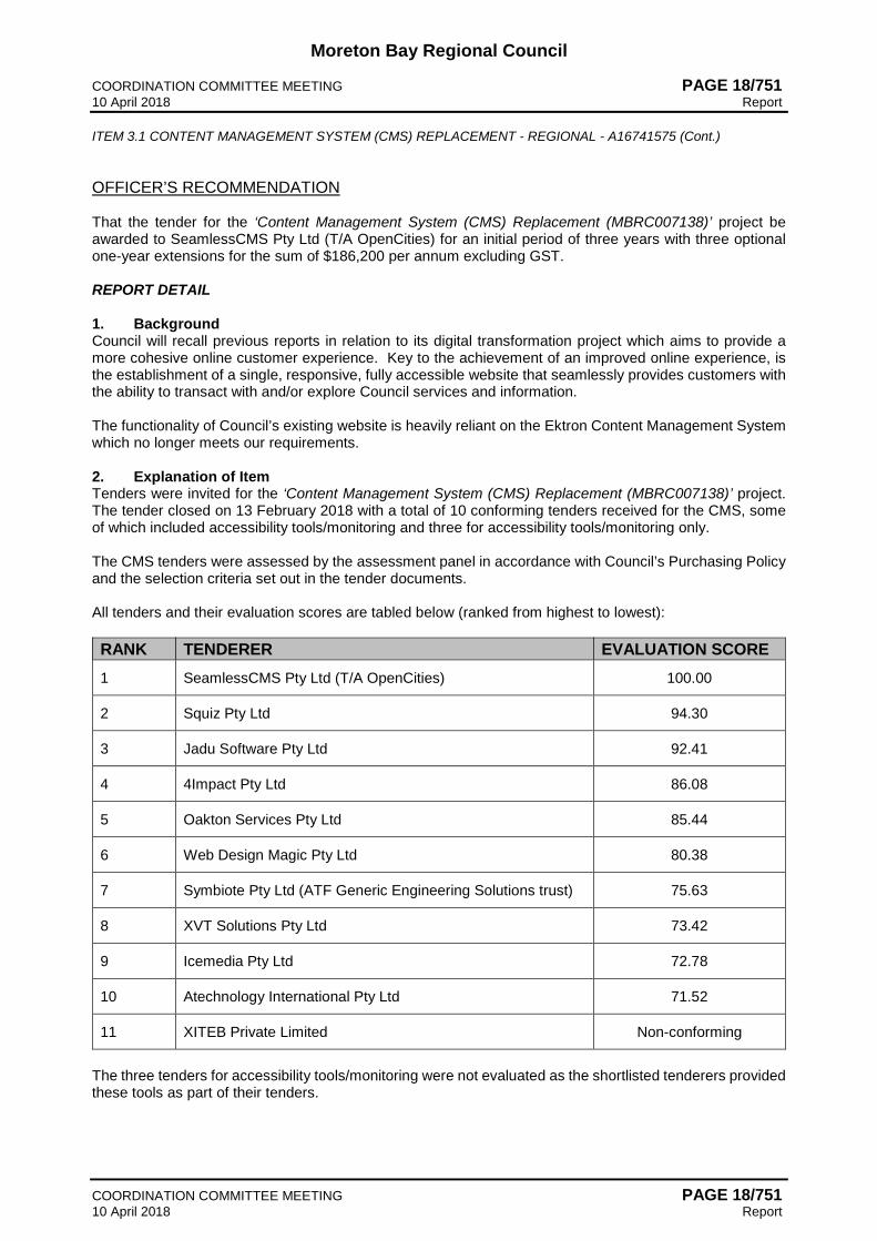
Moreton Bay Regional Council COORDINATION COMMITTEE MEETING PAGE 18/751 10 April 2018 Report ITEM 3.1 CONTENT MANAGEMENT SYSTEM (CMS) REPLACEMENT - REGIONAL - A16741575 (Cont.)
COORDINATION COMMITTEE MEETING PAGE 18/751 10 April 2018 Report
OFFICER’S RECOMMENDATION That the tender for the ‘Content Management System (CMS) Replacement (MBRC007138)’ project be awarded to SeamlessCMS Pty Ltd (T/A OpenCities) for an initial period of three years with three optional one-year extensions for the sum of $186,200 per annum excluding GST. REPORT DETAIL 1. Background Council will recall previous reports in relation to its digital transformation project which aims to provide a more cohesive online customer experience. Key to the achievement of an improved online experience, is the establishment of a single, responsive, fully accessible website that seamlessly provides customers with the ability to transact with and/or explore Council services and information. The functionality of Council’s existing website is heavily reliant on the Ektron Content Management System which no longer meets our requirements. 2. Explanation of Item Tenders were invited for the ‘Content Management System (CMS) Replacement (MBRC007138)’ project. The tender closed on 13 February 2018 with a total of 10 conforming tenders received for the CMS, some of which included accessibility tools/monitoring and three for accessibility tools/monitoring only. The CMS tenders were assessed by the assessment panel in accordance with Council’s Purchasing Policy and the selection criteria set out in the tender documents. All tenders and their evaluation scores are tabled below (ranked from highest to lowest): RANK TENDERER EVALUATION SCORE 1 SeamlessCMS Pty Ltd (T/A OpenCities) 100.00
2 Squiz Pty Ltd 94.30
3 Jadu Software Pty Ltd 92.41
4 4Impact Pty Ltd 86.08
5 Oakton Services Pty Ltd 85.44
6 Web Design Magic Pty Ltd 80.38
7 Symbiote Pty Ltd (ATF Generic Engineering Solutions trust) 75.63
8 XVT Solutions Pty Ltd 73.42
9 Icemedia Pty Ltd 72.78
10 Atechnology International Pty Ltd 71.52
11 XITEB Private Limited Non-conforming
The three tenders for accessibility tools/monitoring were not evaluated as the shortlisted tenderers provided these tools as part of their tenders.

Moreton Bay Regional Council COORDINATION COMMITTEE MEETING PAGE 18/752 10 April 2018 Report ITEM 3.1 CONTENT MANAGEMENT SYSTEM (CMS) REPLACEMENT - REGIONAL - A16741575 (Cont.)
COORDINATION COMMITTEE MEETING PAGE 18/752 10 April 2018 Report
RANK TENDERER EVALUATION SCORE 1 Monsido Pty Ltd Not assessed
2 ReadSpeaker Pty Ltd Not assessed
3 Siteimprove Australia Pty Ltd Not assessed
SeamlessCMS Pty Ltd (T/A OpenCities) submitted a conforming tender and demonstrated their experience on projects of similar scale and complexity. At an internal stakeholder demonstration and clarification meeting on 19 March 2018, SeamlessCMS Pty Ltd (T/A OpenCities) provided detail of their digital first experience for customers and council focussed implementation. OpenCities engaged Vision Australia to conduct an end-to-end WCAG 2.0 AA site audit and certify the entire digital experience is fully compliant. As accessibility standards evolve, OpenCities commits to update their technology to ensure ongoing compliance. The OpenCities platform has been built specifically for local government, covering key capabilities of digital communication, community engagement and service delivery. It will enable Council to transform paper and offline processes into easy to complete online forms featuring two-way web services and APIs which can be fully integrated with Council’s internal systems or pushed out via our Open Data platform. Jadu Software Pty Ltd submitted a conforming tender and demonstrated their experience on similar projects. At an internal stakeholder demonstration and clarification meeting on 15 March 2018, Jadu Software Pty Ltd provided detail of their proposed solution. It was determined that Jadu Software Pty Ltd would not suit our needs as it provided less functionality and flexibility than we have currently. Squiz Pty Ltd submitted a conforming tender and demonstrated their capability and experience on projects of a similar scale and complexity. There were no additional benefits for the higher price. Web Design Magic Pty Ltd submitted a conforming tender and demonstrated capability and experience to deliver a website. However, additional costs would need to be considered for server infrastructure and ongoing management. 3. Strategic Implications 3.1 Legislative/Legal Implications
As this is a large-sized contract in accordance with s224(2) of the Local Government Regulation 2012 (the Regulation), Council invited written tenders in accordance with s228 of the Regulation.
3.2 Corporate Plan / Operational Plan Creating Opportunities: Digital literacy and commerce - a digital region.
3.3 Policy Implications Council has adhered to its Procurement Policy 10-2150-006 when procuring this contract.
3.4 Risk Management Implications
The digital transformation project has identified the risks associated with the project and is following Council’s ICT project management framework to mitigate the risks involved.
A third-party review of financial status has been carried out and the successful tenderer was rated Satisfactory.
3.5 Delegated Authority Implications There are no delegated authority implications arising as a direct result of this report.

Moreton Bay Regional Council COORDINATION COMMITTEE MEETING PAGE 18/753 10 April 2018 Report ITEM 3.1 CONTENT MANAGEMENT SYSTEM (CMS) REPLACEMENT - REGIONAL - A16741575 (Cont.)
COORDINATION COMMITTEE MEETING PAGE 18/753 10 April 2018 Report
3.6 Financial Implications
Council allocated $350,000 in the 2017/18 budget for the digital transformation project. The project’s budget number is 33106.
3.7 Economic Benefit
Implementation of a digital first and customer-focussed website will enable Council to continue its online transformation journey.
3.8 Environmental Implications
There are no environmental impacts arising as a direct result of this report. 3.9 Social Implications
A user-friendly website will drive online engagement with Council’s wider community and allow Council to present a digital first philosophy.
3.10 Consultation / Communication
Representatives from key Council areas were invited to participate in product demonstrations and provide feedback on the CMSs short-listed. A referee check with another large Australian Council has been completed and was deemed satisfactory.
ATTENDANCE Mr Keith Pattinson and Ms Janet Kirkwood left the meeting at 10.59am after Item 3.1.

Moreton Bay Regional Council COORDINATION COMMITTEE MEETING PAGE 18/754 10 April 2018 Report
COORDINATION COMMITTEE MEETING PAGE 18/754 10 April 2018 Report
Perceived Conflict of Interest - Declaration Pursuant to s173(4) of the Local Government Act 2009, Cr Denise Sims declared a perceived conflict of interest could exist in the following matter as the Councillor has a relative that leases a building from Cornerstone, and retired from the meeting at 11.00am, taking no part in the debate or recommendation regarding same.
4 ASSET CONSTRUCTION & MAINTENANCE SESSION (Cr A Hain) ITEM 4.1 BURPENGARY - OLD BAY ROAD COMMUNITY FACILITY - BUILDING UPGRADE - DIVISION 2 Meeting / Session: 4 ASSET CONSTRUCTION & MAINTENANCE Reference: A16497898 : 24 January 2018 - Refer Confidential Supporting Information
A16617566 Responsible Officer: JB, Project Manager (ECM Project Management & Construction) Executive Summary Tenders were invited for the ‘Burpengary - Old Bay Road Community Facility – Building Upgrade (MBRC007199)’ project. The tender closed on 13 March 2018 with a total of five conforming tenders received. It is recommended that Council award the contract to Chapcon Building Services Pty Ltd for the sum of $486,282.23 (excluding GST) as this tender was evaluated as representing the best overall value to Council. COMMITTEE RECOMMENDATION
Moved by Cr Peter Flannery Seconded by Cr Julie Greer CARRIED 12/0 Cr Denise Sims had declared a conflict of interest and had left the meeting.
That the tender for the ‘Burpengary - Old Bay Road Community Facility – Building Upgrade (MBRC007199)’ project be awarded to Chapcon Building Services Pty Ltd for the sum of $486,282.23 excluding GST.

Moreton Bay Regional Council COORDINATION COMMITTEE MEETING PAGE 18/755 10 April 2018 Report ITEM 4.1 BURPENGARY - OLD BAY ROAD COMMUNITY FACILITY - BUILDING UPGRADE - DIVISION 2 - A16497898 (Cont.)
COORDINATION COMMITTEE MEETING PAGE 18/755 10 April 2018 Report
OFFICER’S RECOMMENDATION That the tender for the ‘Burpengary - Old Bay Road Community Facility – Building Upgrade (MBRC007199)’ project be awarded to Chapcon Building Services Pty Ltd for the sum of $486,282.23 excluding GST. REPORT DETAIL 1. Background The project is located at the Old Bay Road Community Facility, on the corner of Old Bay and Maitland Roads, Burpengary. The project scope includes the extension of the building that houses the Caboolture Artisans’ Guild. Specifically, works will include a large extension (approximately 160m2) of the building to accommodate workshop space, a new kitchen, storerooms and amenities. The objective of the project is to increase the capacity of the facility to better accommodate the Artisans’ Guild’s large membership and their workshop and exhibition program. Works are expected to commence in June/July 2018 and will take approximately 19 weeks to complete, weather permitting.
Figure 1 – Location plan – Old Bay Road Community Facility – Building Upgrade

Moreton Bay Regional Council COORDINATION COMMITTEE MEETING PAGE 18/756 10 April 2018 Report ITEM 4.1 BURPENGARY - OLD BAY ROAD COMMUNITY FACILITY - BUILDING UPGRADE - DIVISION 2 - A16497898 (Cont.)
COORDINATION COMMITTEE MEETING PAGE 18/756 10 April 2018 Report
2. Explanation of Item Tenders for the ‘Burpengary - Old Bay Road Community Facility – Building Upgrade (MBRC007199)’ project closed on 13 March 2018 with a total of five conforming tenders received. The tenders were assessed by the assessment panel in accordance with Council’s Purchasing Policy and the selection criteria set out in the tender documents. All tenders and their evaluation scores are tabled below (ranked from highest to lowest): RANK TENDERER EVALUATION SCORE 1 Chapcon Building Services Pty Ltd 96.19
2 MAW t/a Oasis Construction (Aust) 95.67
3 NF Corbett Pty Ltd 84.43
4 Cornerstone Building Development 83.67
5 Zorv Group Pty Ltd t/a Build 4 U 76.79
Chapcon Building Services Pty Ltd submitted a conforming tender and demonstrated their experience on projects of similar scale and complexity. At a tender clarification meeting held on 21 March 2018, Chapcon Building Services Pty Ltd provided detail of their construction methodology, and demonstrated a strong understanding of all the project requirements. The construction program of 19 weeks (including an allowance of three weeks for wet weather) was confirmed. MAW t/a Oasis Construction (Aust) submitted a comprehensive tender and demonstrated their capability and experience. At a tender clarification meeting held on 22 March 2018, Oasis Construction (Aust) provided additional information to demonstrate their experience on projects of similar scale, and confirmed an overall project duration of 16 weeks (including an allowance of 2 weeks for wet weather). There were no additional benefits for the higher price. NF Corbett Pty Ltd submitted a comprehensive tender and demonstrated their construction methodology and experience on projects of a similar scale and complexity. The tendered construction program of works was of 22 weeks’ duration, inclusive of rain days. There were no additional benefits for the higher price. 3. Strategic Implications 3.1 Legislative/Legal Implications
Due to value of work being greater than $200,000, Council called a public tender for the work through the LG Tender system in accordance with the Local Government Act 2009.
3.2 Corporate Plan / Operational Plan This project is consistent with the Corporate Plan outcome - Strengthening Communities: Healthy and supportive communities - a healthy and inclusive community.
3.3 Policy Implications This project has been sourced in accordance with the provisions of the following documents:
• Council’s Procurement Policy 10-2150-006 • Local Government Act 2009 • Local Government Regulation 2012 Chapter 6.
3.4 Risk Management Implications
The project risk has been assessed and the following issues identified. The manner in which the possible impact of these risks are minimised is detailed below.

Moreton Bay Regional Council COORDINATION COMMITTEE MEETING PAGE 18/757 10 April 2018 Report ITEM 4.1 BURPENGARY - OLD BAY ROAD COMMUNITY FACILITY - BUILDING UPGRADE - DIVISION 2 - A16497898 (Cont.)
COORDINATION COMMITTEE MEETING PAGE 18/757 10 April 2018 Report
Financial: A third party review of financial status has been carried out and the successful tenderer was rated ’sound’. Construction: The work site is adjacent to other buildings and the contractor will be required to provide safety fencing for the enclosed work site during the construction period. The contractor has confirmed an appropriate pedestrian management plan will be implemented around the site in line with the traffic management and safety plans.
3.5 Delegated Authority Implications No delegated authority implications arising as a direct result of this report.
3.6 Financial Implications Council allocated $38,000 in the 2017/18 Capital projects program for design and has identified $560,000 (excluding GST) in the draft 2018/19 Capital projects program for the project construction. The project’s budget number is 102140. Design 2017/18 $ 38,145.00 Tender Price (construction 2018/19) $ 486,282.23 Contingency (10%) $ 48,628.22 QLeave $ 2,309.00 Consultants site involvement $ 5,000.00 ------------------ Total Project Cost $ 580,364.45 ========== Estimated ongoing operational/maintenance costs $5,570.00 per F/Y The budget amount for this project is sufficient.
3.7 Economic Benefit The increased capacity of the facility will better accommodate the Artisans’ Guild’s large membership and their workshop and exhibition program.
3.8 Environmental Implications An Environmental Management Plan will be provided to Council by the successful tenderer, detailing the management of environmental matters affecting the project during construction.
3.9 Social Implications
The increased capacity of the facility will better accommodate the Artisans’ Guild’s large membership and their workshop and exhibition program.
3.10 Consultation / Communication The Caboolture Artisans’ Guild has been consulted throughout the design process and will be notified of the works and expected construction timeframe prior to commencement of works to ensure the vacating of the building for construction. Communication with the group during construction will continue through MBRC’s Community Infrastructure Support Officer. Adjacent residential neighbours and users and visitors of the facility will be notified of the pending works via a project notice and project signs. The Divisional Councillor has been consulted and is supportive of the project.
ATTENDANCE Cr Denise Sims returned to the meeting at 11.02am after consideration on Item 4.1.

Moreton Bay Regional Council COORDINATION COMMITTEE MEETING PAGE 18/758 10 April 2018 Report
COORDINATION COMMITTEE MEETING PAGE 18/758 10 April 2018 Report
ITEM 4.2 CABOOLTURE - CABOOLTURE TO WAMURAN RAIL TRAIL - SHARED PATHWAY CONSTRUCTION STAGE 1 (LANDSCAPE PORTION OF WORKS) - DIVISIONS 3 AND 12 Meeting / Session: 4 ASSET CONSTRUCTION & MAINTENANCE Reference: A16728051 : 22 March 2018 - Refer Confidential Supporting Information
A16622643 Responsible Officer: HM, Project Manager (ECM Project Management & Construction) Executive Summary Tenders were invited for the 'Caboolture – Caboolture to Wamuran Rail Trail – Shared Pathway Construction (Landscape Portion of Works) (VP100118)’ project from Council’s prequalified Landscape Construction panel arrangement (MBRC005992) with all seven prequalified suppliers invited to tender. The tender closed on 22 March 2018 with four conforming tenders received. It is recommended that Council award the contract to The Landscape Construction Company Pty Ltd for the sum of $1,430,327.08 (excluding GST) as this tender was evaluated as representing the best overall value to Council. COMMITTEE RECOMMENDATION
Moved by Cr Adrian Raedel Seconded by Cr Mick Gillam CARRIED 13/0
That the tender for ‘Caboolture – Caboolture to Wamuran Rail Trail – Shared Pathway Construction (Landscape Portion of Works) (VP100118)’ project be awarded to The Landscape Construction Company Pty Ltd for the sum of $ 1,430,327.08 (excluding GST).

Moreton Bay Regional Council COORDINATION COMMITTEE MEETING PAGE 18/759 10 April 2018 Report ITEM 4.2 CABOOLTURE - CABOOLTURE TO WAMURAN RAIL TRAIL - SHARED PATHWAY CONSTRUCTION STAGE 1 (LANDSCAPE PORTION OF WORKS) - DIVISIONS 3 AND 12 - A16728051 (Cont.)
COORDINATION COMMITTEE MEETING PAGE 18/759 10 April 2018 Report
OFFICER’S RECOMMENDATION That the tender for ‘Caboolture – Caboolture to Wamuran Rail Trail – Shared Pathway Construction (Landscape Portion of Works) (VP100118)’ project be awarded to The Landscape Construction Company Pty Ltd for the sum of $ 1,430,327.08 (excluding GST). REPORT DETAIL 1. Background The ‘Caboolture – Caboolture to Wamuran Rail Trail – Shared Pathway Construction (Landscape Portion of Works)’ project is located along the disused rail corridor from Beerburrum Road, Caboolture to Atwood Street, Wamuran, and includes construction of approximately 10.5 kilometres of 3 to 3.5-metre-wide shared constructed asphalt pathway and entry statements at the Caboolture and Wamuran trail heads. The project scope includes shelters, seating, drinking fountains, wayfinding signage, security cameras, pavement surface treatments, bicycle repair station, echo counter (counting people, analysing data) and associated landscaping. The overall project is scheduled to be delivered in three stages over three consecutive financial years commencing in 2017-18 and concluding in 2019-20. The works are planned to commence in April 2018 and take a total of 19 weeks to complete, including an allowance for wet weather.
Figure 1 Location of works - Stage 1
2. Explanation of Item Tenders for the ‘Caboolture – Caboolture to Wamuran Rail Trail - Shared Pathway Construction – (Landscape Portion of Works) (VP100118)’ project closed on 22 March 2018. Tenders were sought from all seven contractors listed on Council’s prequalified Landscape Construction panel (MBRC005992) with four conforming tenders received.

Moreton Bay Regional Council COORDINATION COMMITTEE MEETING PAGE 18/760 10 April 2018 Report ITEM 4.2 CABOOLTURE - CABOOLTURE TO WAMURAN RAIL TRAIL - SHARED PATHWAY CONSTRUCTION STAGE 1 (LANDSCAPE PORTION OF WORKS) - DIVISIONS 3 AND 12 - A16728051 (Cont.)
COORDINATION COMMITTEE MEETING PAGE 18/760 10 April 2018 Report
The tenders were assessed by the assessment panel in accordance with Council’s Purchasing Policy and the selection criteria set out in the tender documents.
RANK TENDERER EVALUATION SCORE
1 The Landscape Construction Company Pty Ltd (Alternative Tender) 100.00
2 The Landscape Construction Company Pty Ltd 98.75
3 Trelville Pty Ltd t/a Aspect Contractors 93.83
4 Dig-It Landscapes Pty Ltd 80.68 The Landscape Construction Company Pty Ltd (Alternative Tender) submitted a comprehensive and well-presented tender, and demonstrated their relevant experience, methodology, understanding of the project and capability in delivering the project. In preparing their tender submission, The Landscape Construction Company Pty Ltd proposed alternative equivalent seating furniture options that provide Council with a cost saving benefit. The Landscape Construction Company Pty Ltd submitted a comprehensive and well-presented tender, and demonstrated their relevant experience, methodology, understanding of the project and capability in delivering the project; however, there were no additional benefits for the higher price. Trelville Pty Ltd t/a Aspect Contractors submitted a comprehensive and well-presented tender, demonstrating relevant similar project experience; however, there were no additional benefits for the higher price. Dig-It Landscapes Pty Ltd submitted a well-presented tender; however, there were no additional benefits for the higher price. 3. Strategic Implications 3.1 Legislative/Legal Implications
Due to the value of work being greater than $200,000, Council called a public tender for the work through Vendor Panel in accordance with the Local Government Act 2009.
3.2 Corporate Plan / Operational Plan This Project is consistent with the Corporate Plan outcome - Valuing Lifestyle: Diverse transport options - an integrated regional transport network.
3.3 Policy Implications This project has been procured in accordance with the provisions of the following documents: • Council’s Procurement Policy 10-2150-006 • Local Government Act 2009 • Local Government Regulation 2012 Chapter 6
3.4 Risk Management Implications The project risk has been assessed and the following issues identified. The manner in which the possible impact of these risks are minimised is detailed below. Financial Risks: a. The contractor is listed on the Council pre-qualified Landscape Construction Panel
(MBRC005992).

Moreton Bay Regional Council COORDINATION COMMITTEE MEETING PAGE 18/761 10 April 2018 Report ITEM 4.2 CABOOLTURE - CABOOLTURE TO WAMURAN RAIL TRAIL - SHARED PATHWAY CONSTRUCTION STAGE 1 (LANDSCAPE PORTION OF WORKS) - DIVISIONS 3 AND 12 - A16728051 (Cont.)
COORDINATION COMMITTEE MEETING PAGE 18/761 10 April 2018 Report
Construction Risks: a. The contractor will provide a program of works, traffic management plan, and safety plan and will
be required to fence off and manage the areas where construction is being undertaken to meet relevant workplace health and safety requirements as part of the contract.
b. The contractor has also demonstrated their understanding of the project and the need to manage
the impact of the works on pedestrians and vehicles. The contractor has programmed the works and allowed for appropriate resources to be available to complete the works in the required timeframe
c. The tendered methodology has been assessed to ensure construction risks associated with the works are understood. A site-specific construction and environmental management plan will be in place to manage any risks.
3.5 Delegated Authority Implications
There are no delegated authority implications arising as a direct result of this report.
3.6 Financial Implications Council has allocated a total of $3.345M (excluding GST) in Council’s 2017/18 Capital projects budget, with the Department of Transport and Main Roads (DTMR) contributing $1.125M to stage 1 of the project.
Works in progress: Tender bridge works (previously awarded) $ 236,169.04 Tender Smiths Road works (previously awarded A16135216) $ 872,981.72 Energex $ 5,000.00 Unitywater $ 2,400.00 Council Internal Construction Crews (asphalt pathway/civil) $ 590,000.00 Tender price (Landscape Construction) $ 1,430,327.08 Contingency (10%) $ 143,023.70 Q Leave (0.475%) $ 7,166.35 ---------------------- Total Project Cost $ 3,287,067.89 ============= Estimated ongoing operational/maintenance costs $13,800.00 per F/Y The budget amount for this project is sufficient.
3.7 Economic Benefit This project will create a shared pathway of regional significance that will promote active travel and provide opportunities to develop cycle tourism.
3.8 Environmental Implications
The contractor is required to submit an Environmental Management Plan and comply with relevant State Government Environmental Policies. The contractor will be required to manage sediment and erosion controls during construction and these measures will also be monitored by Council.
3.9 Social Implications
The project will provide a transport commuter pathway that integrates with adjacent assets and facilities including local parks, schools and links to the existing pathway network.

Moreton Bay Regional Council COORDINATION COMMITTEE MEETING PAGE 18/762 10 April 2018 Report ITEM 4.2 CABOOLTURE - CABOOLTURE TO WAMURAN RAIL TRAIL - SHARED PATHWAY CONSTRUCTION STAGE 1 (LANDSCAPE PORTION OF WORKS) - DIVISIONS 3 AND 12 - A16728051 (Cont.)
COORDINATION COMMITTEE MEETING PAGE 18/762 10 April 2018 Report
3.10 Consultation / Communication
A communication plan will be implemented with the successful contractor prior to works commencing on site. Public communication will include utilising MBRC’s project notice and project signage which will be displayed prior to and throughout the works to notify road users. Council has undertaken consultation with the adjacent schools and consultation will be ongoing prior to and during construction. The Divisional Councillors have been consulted and are supportive of the project and the consultation plan.

Moreton Bay Regional Council COORDINATION COMMITTEE MEETING PAGE 18/763 10 April 2018 Report
COORDINATION COMMITTEE MEETING PAGE 18/763 10 April 2018 Report
ITEM 4.3 MORETON BAY REGION LOCAL DISASTER MANAGEMENT GROUP - MEETING MINUTES 21 MARCH 2018 - REGIONAL Meeting / Session: 4 ASSET CONSTRUCTION & MAINTENANCE Reference: A16744206 : 26 March 2018 - Refer Supporting Information A16649991 Responsible Officer: CP, Coordinator Disaster Management (ECM Directorate) Executive Summary The Moreton Bay Region Local Disaster Management Group (MBR LDMG) held its regular Ordinary meeting on 21 March 2018. COMMITTEE RECOMMENDATION
Moved by Cr Peter Flannery Seconded by Cr Koliana Winchester CARRIED 13/0
That the Moreton Bay Region Local Disaster Management Group meeting minutes of 21 March 2018 be adopted.

Moreton Bay Regional Council COORDINATION COMMITTEE MEETING PAGE 18/764 10 April 2018 Report ITEM 4.3 MORETON BAY REGION LOCAL DISASTER MANAGEMENT GROUP - MEETING MINUTES 21 MARCH 2018 - REGIONAL - A16744206 (Cont.)
COORDINATION COMMITTEE MEETING PAGE 18/764 10 April 2018 Report
OFFICER’S RECOMMENDATION That the Moreton Bay Region Local Disaster Management Group meeting minutes of 21 March 2018 be adopted. REPORT DETAIL 1. Background In accordance with section 29 of the Disaster Management Act 2003, a local government is required to establish a Local Disaster Management Group for its local government area. Section 12 of the Disaster Management Regulation 2014 states that ‘disaster management group meetings must be held at least once in every six months at the times and places decided by the chairperson of the group’. To meet these minimum requirements, the MBR LDMG conducts Ordinary meetings every four months, generally during the months of March, July and November. Extraordinary meetings of the MBR LDMG, before, during or after disaster events, are held as required. The MBR LDMG held its regular Ordinary meeting on 21 March 2018, the minutes for which are attached. 2. Explanation of Item This report is provided for the purpose of advising Council as to the issues discussed and any meeting outcomes/action items. The meeting minutes are contained within the supporting information to this report. 3. Strategic Implications 3.1 Legislative/Legal Implications
It is a requirement under section 18 of the Disaster Management Regulation 2014 that a disaster management group must keep minutes of its meetings.
3.2 Corporate Plan / Operational Plan
Strengthening Communities: Safe neighbourhoods - a safe and resilient community.
3.3 Policy Implications There are no policy implications arising as a direct result of this report.
3.4 Risk Management Implications Queensland Fire and Emergency Services (QFES) provided an update on a new QFES video explaining the three levels of bushfire warnings used in Queensland/Australia - Advice, Watch & Act and Emergency Warning. The video explaining this can be found at https://psbamediacontent.wistia.com/medias/z3uv4fr4po. QFES is requesting partner agencies to not reproduce, edit or share data on official warnings, rather to advise the community that a bushfire has occurred and point residents to the location (social media, website) where the official warning messages can be located. This is to ensure QFES remains the official point of truth for community bushfire warnings. As a result of this request, Council officers acknowledged changes would need to be made to its standard operating procedure for the issuing of bushfire warnings to the community through the MoretonAlert service. Council is currently undertaking the development of the North Pine Dam Emergency Sub-Plan. This project is being undertaken to assist the management of any emergency event involving a failure of the North Pine Dam as well as addressing some learnings generated from Exercise Aggeris. The group acknowledged that the risk of a significant event affecting the North Pine Dam is highly unlikely, (1 in 600,000-year event), however the consequences for communities downstream from the dam would be catastrophic. The Sub-Plan will align with and complement the Seqwater North Pine Dam Emergency Action Plan (EAP).

Moreton Bay Regional Council COORDINATION COMMITTEE MEETING PAGE 18/765 10 April 2018 Report ITEM 4.3 MORETON BAY REGION LOCAL DISASTER MANAGEMENT GROUP - MEETING MINUTES 21 MARCH 2018 - REGIONAL - A16744206 (Cont.)
COORDINATION COMMITTEE MEETING PAGE 18/765 10 April 2018 Report
3.5 Delegated Authority Implications
There are no delegated authority implications arising as a direct result of this report.
3.6 Financial Implications There are no financial implications arising as a direct result of this report.
3.7 Economic Benefit There are no economic benefit implications arising as a direct result of this report.
3.8 Environmental Implications
There are no environmental implications arising as a direct result of this report. 3.9 Social Implications
The LDMG received an update on the Get Ready Toorbul initiative. Moreton Bay Regional Council received State Government funding to June 2018 through the Get Ready Program and a pilot emergency planning project has commenced in Toorbul. Council is building on existing relationships with the community to encourage residents to participate in planning opportunities, such as community conversations, forums and formation of a local disaster management committee. This project will form the template for similar initiatives in other vulnerable locations throughout the region.
3.10 Consultation / Communication Regular ongoing consultation/communication takes place between all members and advisors of the MBR LDMG, Redcliffe DDMG and various State government entities such as the Queensland Police Service, Queensland Fire and Emergency Services, the Office of the Inspector-General Emergency Management and the Queensland Reconstruction Authority.

Moreton Bay Regional Council COORDINATION COMMITTEE MEETING PAGE 18/766 10 April 2018 Report
COORDINATION COMMITTEE MEETING PAGE 18/766 10 April 2018 Report
5 PARKS, RECREATION & SPORT SESSION (Cr K Winchester) ITEM 5.1 JAMES DRYSDALE RESERVE MASTER PLAN - AMENDMENT - DIVISION 10 Meeting / Session: 5 PARKS, RECREATION & SPORT Reference: A16760793 : 29 March 2018 - Refer Supporting Information A16765966 Responsible Officer: WM, Coordinator Parks and Recreation Planning (ECM Infrastructure Planning) Executive Summary The James Drysdale Reserve (JDR) Master Plan was endorsed by Council on 19 January 2016. A minor amendment to the JDR Master Plan is now required due to the proposed relocation of the State Emergency Service (SES) Facility to an alternate location within the site. The former SES facility is to be reused for community purposes. COMMITTEE RECOMMENDATION
Moved by Cr Matt Constance Seconded by Cr Denise Sims CARRIED 13/0
That the James Drysdale Reserve Master Plan dated April 2018 be adopted as tabled.

Moreton Bay Regional Council COORDINATION COMMITTEE MEETING PAGE 18/767 10 April 2018 Report ITEM 5.1 JAMES DRYSDALE RESERVE MASTER PLAN - AMENDMENT - DIVISION 10 - A16760793 (Cont.)
COORDINATION COMMITTEE MEETING PAGE 18/767 10 April 2018 Report
OFFICER’S RECOMMENDATION That the James Drysdale Reserve Master Plan dated April 2018 be adopted as tabled. REPORT DETAIL 1. Background The James Drysdale Reserve Master Plan received Council endorsement at its meeting on 19 January 2016. The Master Plan covers the entire James Drysdale Reserve site, which includes approximately 24 hectares of existing sports facilities and approximately 46 hectares which are currently used for landfill activities. Council’s new planning scheme commenced on 1 February 2016 and gave effect to all previously endorsed master plans through the adoption of a Council policy 2150-088 Preparation of Master Plans for Council-Controlled or Owned Sites. Accordingly, all previously endorsed master plans are now defined through the MBRC Planning Scheme as an Approved Master Plan. This ensures that through the planning scheme, any proposed uses on Council-owned or controlled sites are carried out in accordance with the approved master plan. Amendments to approved master plans are required to be considered in accordance with Council’s Policy. In the case of the JDR Master Plan, a minor amendment to the approved Master Plan is proposed to enable relocation of the SES facility to an alternate location on site. 2. Explanation of Item James Drysdale Reserve is located at the Jinker Track, Bunya. The entire JDR site comprises approximately 70 hectares over several parcels of land. Development of sports and community facilities is currently constrained to approximately 24 hectares of the site. Amendment to the approved master plan is required to reflect the proposed relocation of the SES facility to an alternate location within the site. Within the approved master plan, location No. 10 is identified as “existing SES building” and location No. 12 is identified as “future development site’. It is proposed to amend location No. 12 to “SES building” and amend location No. 10 to “multipurpose community use facilities including meeting spaces and men’s shed” as noted in Figure 1 below. The balance of the master plan remains unchanged.
Figure 1: Proposed amendments to JDR Master Plan - SES Facility (No.12) and multipurpose
community use facilities including meeting spaces and men’s shed (No 10)

Moreton Bay Regional Council COORDINATION COMMITTEE MEETING PAGE 18/768 10 April 2018 Report ITEM 5.1 JAMES DRYSDALE RESERVE MASTER PLAN - AMENDMENT - DIVISION 10 - A16760793 (Cont.)
COORDINATION COMMITTEE MEETING PAGE 18/768 10 April 2018 Report
3. Strategic Implications 3.1 Legislative/Legal Implications
The proposed amendment is provided for in accordance with the MBRC Planning Scheme and Council’s Policy 2150-088 Preparation of Master Plans for Council-Controlled or Owned Site.
3.2 Corporate Plan / Operational Plan Valuing Lifestyle: Quality recreation and cultural opportunities - celebrating local arts, culture and community.
3.3 Policy Implications The amendment is provided in accordance with Council policy 2150-088 Preparation of Master Plans for Council-Controlled or Owned Site.
3.4 Risk Management Implications Development approval has been secured for the relocation of the SES facility.
3.5 Delegated Authority Implications There are no delegated authority implications arising as a direct result of this report.
3.6 Financial Implications No financial implications have been identified in relation to amendment of the master plan. The cost of works associated with the proposed new SES facility and reuse of the current SES facility will be subject to future deliberations by Council.
3.7 Economic Benefit Reuse of existing Council infrastructure, where appropriate, represents value for money and reduces the cost of providing new purpose-built community facilities.
3.8 Environmental Implications
There are no environmental implications arising as a direct result of this report. 3.9 Social Implications
There are several potential community groups that could benefit from reuse of the current SES facility.
3.10 Consultation / Communication The minor and temporary nature of the amendment does not require the master plan to be consulted with the community. The Divisional Councillor is supportive of the proposed amendment to the master plan. Consultation across Council departments has been undertaken and considered.

Moreton Bay Regional Council COORDINATION COMMITTEE MEETING PAGE 18/769 10 April 2018 Report
COORDINATION COMMITTEE MEETING PAGE 18/769 10 April 2018 Report
6 LIFESTYLE & AMENITY SESSION (Cr D Sims) No items for consideration.
7 ECONOMIC DEVELOPMENT, EVENTS & TOURISM SESSION (Cr P Flannery) No items for consideration.
8 REGIONAL INNOVATION (Cr D Grimwade) No items for consideration.
Moreton Bay Regional Council COORDINATION COMMITTEE MEETING PAGE 18/770 10 April 2018 Report
COORDINATION COMMITTEE MEETING PAGE 18/770 10 April 2018 Report
9 GENERAL BUSINESS ITEM 9.1 REDCLIFFE JETTY MARKETS (KW) Cr Koliana Winchester advised of her attendance at the opening of the Redcliffe Jetty Markets extension over the preceding weekend. Cr Winchester made special mention of Petero Civoniceva’s attendance at the event as ambassador of the markets, saying that it had been a great success. ITEM 9.2 2018 AUSTRALIAN COASTAL COUNCIL CONFERENCE (PF) Cr Peter Flannery reported on his attendance at the 2018 Australian Coastal Council’s Association conference held at the Geelong Library and Heritage Centre from 21-23 March 2018. Cr Flannery advised that the conference topics were of relevance to all coastal stakeholders, however the topic on extreme coastal erosion intensified by storm wave direction was of particular interest. ITEM 9.3 QUEEN’S BATON RELAY AND FESTIVAL OF SAILS - REGIONAL (AS) Cr Allan Sutherland (Mayor) commented on the ‘great turnout’ and success of the Queen’s Baton Relay and Festival of Sails events held on Good Friday, 30 March 2018. Cr Sutherland made special mention of Mr Ian Skippen for his outstanding role as Master of Ceremonies at the Queen’s Baton Relay. COMMITTEE RECOMMENDATION
Moved by Cr Allan Sutherland (Mayor) Seconded by Cr Koliana Winchester CARRIED 13/0
1. That a letter of congratulation be forwarded to Moreton Bay Region Industry and Tourism for the organisation of the Queen’s Baton Relay and Festival of Sails events.
2. That a letter of appreciation be sent to Mr Ian Skippen for his outstanding role as Master of
Ceremonies at the Queen’s Baton Relay. CLOSURE There being no further business the Chairperson closed the meeting at 11.24am.


![Solar Sails[1]](https://static.fdocuments.us/doc/165x107/577d22ae1a28ab4e1e97fcd0/solar-sails1.jpg)


![Andy Sails[1]](https://static.fdocuments.us/doc/165x107/577d275c1a28ab4e1ea3bb31/andy-sails1.jpg)


