REPORT ON THE WRECK OF THE SS RICHARD … 2 THE 2000 SURVEY OF THE WRECK OF THE SS RICHARD...
27
REPORT ON THE WRECK OF THE SS RICHARD MONTGOMERY Maritime and Coastguard Agency Spring Place 105 Commercial Road Southampton SO15 1EG November 2000
-
Upload
truongkhue -
Category
Documents
-
view
215 -
download
2
Transcript of REPORT ON THE WRECK OF THE SS RICHARD … 2 THE 2000 SURVEY OF THE WRECK OF THE SS RICHARD...

REPORT
ON THE WRECK OF THE SS RICHARD MONTGOMERY
Maritime and Coastguard Agency Spring Place
105 Commercial Road Southampton
SO15 1EG
November 2000

2
CONTENTS EXECUTIVE SUMMARY............................................................………..........……................Page 3 PART 1 HISTORY OF THE WRECK Background........................................................................................................................ Page 5 Responsibility for the Wreck ............................................................................................. Page 5 The Committee on Hazardous Wrecks ............................................................................. Page 5 The Explosives On Board .................................................................................................. Page 6 Condition of the Explosives ............................................................................................... Page 6 Risk of an Explosion........................................................................................................... Page 6 The KEILCE Explosion ....................................................................................................... Page 7 Measures taken to Contain the Danger ............................................................................. Page 7 PART 2 THE 2000 SURVEY OF THE WRECK OF THE SS RICHARD MONTGOMERY Introduction........................................................................................................................ Page 8 Conduct of the Survey ....................................................................................................... Page 8 Scope of Work................................................................................................................... Page 8 Technical Details of the Survey......................................................................................... Page 8 ROV Survey………………………………………...................................................................…Page 9 Analysis of the Survey Data............................................................................................... Page 9 Comparison with Previous Sonar Data ............................................................................ Page 10 Survey Conclusions ......................................................................................................... Page 11 PART 3 CONSIDERATIONS FOR THE FUTURE Introduction…. Page 12 Risks.........…... ................................................................................................................. Page 12 Effects......………............................................................................................................... Page 14 Conclusions for the Way Forward ................................................................................... Page 15 PART 4 RECOMMENDATIONS Masts and Derricks .......................................................................................................... Page 16 Continual observation of the Wreck ................................................................................ Page 16 Survey of the Wreck........................................................................................................ Page 16 Assessment of Risk .......................................................................................................... Page 16 Policy of Openness.......................................................................................................... Page 17 APPENDIX 1 MUNITIONS REMAINING ABOARD SS RICHARD MONTGOMERY Page 18 APPENDIX 2 THE KIELCE EXPLOSION....................................................................... Page 19 APPENDIX 3 ROV SPECIFICATION ............................................................................ Page 21 APPENDIX 3 MONOCHROMATIC GRADIENT PLOTS ............................................ Page 22
1999 ................................................................................................................. Page 22 2000 ................................................................................................................. Page 23
3
APPENDIX 4 IDENTIFICATION OF COMPONENT PARTS OF THE WRECK…………….Page 24 APPENDIX 5 COLOUR CONTOUR PLOT 2000........................................... ………….Page 26
4
EXECUTIVE SUMMARY 1. The SS RICHARD MONTGOMERY grounded and split in two off Sheerness in 1944
whilst carrying a cargo of bombs. A large part of the cargo was successfully recovered at the time. No explosions occurred when the ship grounded or during the subsequent salvage operation, and none have occurred since.
2. It is probable that some of the munitions remaining on board are still capable of
detonation but the likelihood of a major explosion is remote. Experts have consistently advised that the best way to keep the risk to an absolute minimum is to leave the wreck alone. The site is therefore designated a prohibited area under the Protection of Wrecks Act 1973.
3. Whilst the risk of a major explosion is remote, it is considered prudent to monitor
regularly the condition of the wreck. Therefore routine surveys have been undertaken to assess the condition of the wreck and to check for any new signs of possible danger.
4. Until 1984, surveys were carried out by Ministry of Defence (MOD) salvage divers.
More recently the surveys have been undertaken by commercial diving contractors, working under MOD supervision. Following the 1993 survey, in view of the limitations placed on such methods by the poor visibility underwater at the site, and on the recommendation of the MOD Salvage & Mooring Organisation, it was decided that full advantage should be taken of the major advances in sonar technology, in preference to the use of diving surveys. This policy has been followed for the last 7 years.
5. The survey in 2000 was conducted on behalf of the Maritime and Coastguard Agency
(an executive agency of the Department of Environment, Transport and the Regions) by Sonar Research and Development (SRD) Ltd of Beverley. It was completed in June 2000 under the supervision of the MOD’s Salvage & Mooring Organisation.
6. The survey of the wreck shows that there have been some changes to the main body
of the wreck. There have also been minor changes in the surrounding seabed topography, and seabed support for the wreck.
7. The future of the wreck is also considered, pulling together the available knowledge
from several reports. The risks associated with the wreck are identified as; collision by another vessel, capsize or significant movement of the wreck and the wreck breaking up. The effects of these risks are judged to be either a mass detonation of the remaining munitions or the distribution of munitions, with the possibility of some washing ashore.
8. A feasibility study is currently being undertaken by BMT Reliability Consultants (BMT)
under contract to the MCA, to further assess the risks involved in the future management of this wreck.
9. The methods considered for the management of the wreck in the immediate future are
detailed below. (These recommendations will be reviewed on the completion of the risk assessment commissioned by the MCA, which is due in Autumn 2000.)
a) Masts and Derricks
5
That the masts, derricks and warning notices remain in situ, subject to ongoing
inspection. b) Continual Observation of the Wreck That the continual close observation of the wreck is maintained in the foreseeable
future.
c) Survey of the Wreck
That annual surveys should continue to be undertaken, subject to the recommendations of the risk assessment study.
d) Assessment of Risk A risk assessment study is currently being undertaken to consider the following points: • The effects of a mass detonation of the remaining munitions under a variety of wind
and tide conditions • The conditions required for a mass detonation to occur • The likelihood of those conditions occurring • The possibility of the wreck breaking up • The likely distribution of any escaped munitions • Feasibility of a containment or entombment solution • Feasibility of removing ordnance • Feasibility of totally sanitising the wreck site • Designed to aid the decision making process on the future management of the SS
Richard Montgomery
e) Policy of Openness
That information about the wreck be placed in the public domain, and that the results of the risk assessment are published to form part of a consultation exercise regarding the way forward in the long term. The 2000 annual survey report will form part of the risk assessment study, which is due to be completed in Autumn 2000.

6
PART 1
THE HISTORY OF THE WRECK
Background 1. The SS RICHARD MONTGOMERY was a Liberty ship, 441' 6" long and 7146 gross
tons, of a mass-produced design not necessarily intended for more than a single voyage. She was built in 1943 by St John’s River Ship Building Company, Jacksonville, Florida. The ship sailed from the USA to the UK as part of the convoy HX-301 in summer 1944 with a cargo of some 7000 tons of munitions. On arrival in the Thames Estuary the vessel was directed to anchor in the Great Nore Anchorage, off Sheerness. On almost the next tide, however, the ship's anchor dragged and it drifted on to a bank running east from the Isle of Grain (at 51°78'57"N 00°47'12"E) about 250 metres north of the Medway Approach Channel. The ship grounded amidships on the crest of the bank and - this being a weak spot in this design - shortly afterwards broke its back. The wreck now lies in some 15 metres of water, with the masts protruding at all states of the tide.
2. The wreck lies about one and a half miles from Sheerness and the Isle of Grain and
five miles from Southend. It lies on a bank across the tide. 3. The wreck is not an obstruction to navigation - indeed, it serves to mark, for other
shipping, the bank on which it grounded. 4. Intensive efforts were made after the grounding to unload the cargo and about half was
removed. The two stern holds were probably emptied. The other holds were less accessible. When the wreck flooded, the salvage operation had to be abandoned. An investigation by the Southend Chamber of Trade1 concluded that all of the fused bombs (situated in number 2 hold, tween deck) had been cleared during the salvage operation. This information is considered inconclusive. The remaining cargo represents some 1400 tonnes of explosive material; the balance being the heavy bomb casings etc. The table at appendix 1 shows the best estimate of the disposition of the remaining explosives.
Responsibility for the wreck 5. The UK Government has assumed de facto responsibility for monitoring the wreck -
firstly through the Board of Trade and, since 1983, through the Department of Transport (now DETR). It has relied upon expert advice provided by a Committee on hazardous wrecks comprising various experts from the Ministry of Defence, the
1 E G WHITEBREAD, SS Richard Montgomery, 23 March 1973

7
Home Office and the Health & Safety Executive, together with the Port of London Authority and the Medway Ports. The Committee sought advice from US experts on the contents of the wreck, the design of the munitions carried, and the nature of the hazards they posed. The Committee is now formally disbanded, but the Department still has access to the experts if needed.
The Committee on Hazardous Wrecks 6. The Committee's consistently firm advice was that no attempt should be made to
disturb the site. In the Committee's opinion, any such action would increase the likelihood of the very explosion that must be avoided if at all possible.
The Explosives on Board2 7. The Committee's advice was based on the most exhaustive information available
about the types of explosives involved, and the likely effect upon them of age and/or contact with sea water. The bombs thought to be on board are of three types. The bulk are standard, un-fused TNT bombs. In addition, some 800 fused cluster bombs are believed to remain. These bombs were loaded with TNT. They could be transported fused because the design included a propeller mechanism at the front which only screwed the fuse into position as the bombs fell from an aircraft. These two types of bombs could therefore be handled - with care - when the accident occurred. There are also some smoke bombs on board (paragraph 10 below).
Condition of the explosives 8. TNT does not react with water and is extremely stable, particularly if stored at a steady,
low temperature. As it has been contained in metal bomb cases there has probably been little change in its chemical or explosive properties as a result of the long period of immersion.
9. When the condition of the munitions was first assessed there was considerable concern
over the possibility of the formation of very sensitive copper compounds from reaction between the lead azide in the detonators with the brass components of the fuses of the cluster bombs. This would have been a possibility whilst the fuses contained significant amounts of air, however, as the fuses will probably all have been flooded for many years, and the sensitive compounds referred to are all soluble in water, this is no longer considered to be a significant hazard.
10. Following the 1996 survey a review was made by the Defence Evaluation and
Research Agency, based on the information available, as to the probable condition of the munitions still remaining in the wreck. The review concluded that the munitions would retain their explosive power but would be no more sensitive than in their normal state. Any fuses present in the wreck would have deteriorated to the extent that they were no longer functional. The white phosphorus filling of the smoke bombs is stable under water but is capable of spontaneous ignition if exposed to the air.
Risk of an explosion
2 See Appendix 1

8
11. The break in the ship has already exposed the contents of No 3 hold/tween deck, without an explosion occurring. There are two reasons why a cluster bomb fuse in an unstable condition could explode without even setting off the cluster bomb to which it is attached. i) The fuse is not screwed into the main charge. ii) The main charge might now be wet or non-explosive. The same reasons make it still less likely that such a fuse could detonate the main cargo.
12. It is believed that, left to itself, the wreck will break up gradually. There is a good
prospect that all the ordnance will get wet in this process and will become neutralised. Even if the water has not already rendered them inert, a small explosion at any distance from the wreck will not set off the bulk of the cargo. The risk would significantly increase, however, if the wreck were to be disturbed by moving it or attempting to unload it. It is hoped that the feasibility study will quantify this probability.
13. The risk of a major explosion is believed to be remote and is probably becoming even
less likely with the passage of time. It may eventually pass altogether, but this is not likely to be for some considerable time. It would probably be very dangerous to try to find out the true situation within the wreck, particularly if this involved significant interference.
KEILCE explosion3 14. The explosion of the munitions aboard the wreck of the KEILCE in 1967, reinforced the
decision of the Committee on Hazardous Wrecks to recommend a policy of non-interference. The mass detonation of the cargo occurred after explosive cutting charges were fired during an attempt to clear the wreck. Appendix 2 gives fuller details of the incident.
Measures taken to contain the danger 15. The site is designated as dangerous by virtue of its contents, under the Protection of
Wrecks Act 1973. It is an offence to interfere with it in any way. This augments measures taken in the 1960s which included additional buoys and a Notice to Mariners designating the site as a "foul area" where trespassers would be liable to prosecution. Medway Ports at the Port of Sheerness keep a close watch on the site by sight and by Radar, and maintain the buoys and warning notices under contract to the Maritime and Coastguard Agency.
3 See Appendix 2

9
PART 2
THE 2000 SURVEY OF THE WRECK OF THE SS RICHARD MONTGOMERY INTRODUCTION 1. From time to time over some 25 years, and on the recommendation of the Committee
on Hazardous Wrecks4, surveys of the wreck have been arranged in order to monitor conditions. The most recent survey was conducted in June 2000 by Sonar Research and Development (SRD) Limited under contract to the Secretary of State for the Environment, Transport and the Regions (DETR). The survey was organised by the Maritime and Coastguard Agency (MCA)5 and was supervised by the Chief Salvage Officer to the Ministry of Defence (Navy). The survey made use of a high resolution electronic scanning sonar system developed by the contractor and linked to a microprocessor system to produce a detailed survey of the seabed, over a wide area in the vicinity of the wreck. In addition, a test survey was carried out using a Remote Operated Vehicle (ROV), to establish the feasibility of using this type of technology to complement sonar techniques in the future. Both the MOD and MCA were satisfied that the survey was properly and competently carried out in compliance with the contract.
CONDUCT OF THE SURVEY 2. A vessel owned by Associated British Ports (ABP) was used for the survey, which was
conducted on 2 June 2000. The survey was carried out during a period of good weather. The survey area was in the lee of the Isle of Sheppey and sea conditions remained calm throughout the duration of the survey.
3. The survey area lies at the eastern extremity of Sheerness Middle Sand and is to the
south of the Great Nore Anchorage and north of the Medway Approach Channel. SCOPE OF WORK 4. SRD was contracted to survey the wreck of SS RICHARD MONTGOMERY and an
area of 400 metres around the wreck. The company was required to locate, identify and map any loose wreckage and munitions on the seabed. The full work scope was completed.
TECHNICAL DETAILS OF THE 2000 SURVEY Methodology of sonar survey 5. The 2000 survey was undertaken on 2nd June 2000, using SRD’s Seabed Visualisation System. This system provides a continuous electronic scan of the seabed, fitted with 3 transducers using high and standard resolution. A sound velocity of 1519 ms-1 was used. Data positions were established at 10 cm accuracy
4 The Committee on Hazardous Wrecks comprised experts from the Ministry of Defence, the Home Office and the Health & Safety Executive, together with the Port of London Authority and the Medway Ports 5 MCA was formed on 1/4/98 by the merger of The Coastguard Agency and Marine Safety Agency

10
for high resolution data, and at 20 cm accuracy for standard resolution. Vertical positioning was to a resolution of 1 cm. 6. The survey was conducted using pre-set north/south run lines. Lines were run at 15
metre intervals, generating a total of 56 lines to cover the whole survey area. Reference points 7. The Kinematic GPS base station was established at Sheerness, and primary positioning was provided by an Ashtech Z-Sensor RTK DGPS system, consisting of 1 base station and 1 rover station, with a VHF radio link. The base station was positioned at Sheerness Signal Tower. 8. Chart datum at Sheerness, 2.90 metres below Ordnance datum Newlyn was used as the sounding datum. 9. Tide readings were obtained using a portable SRD tide gauge with datum referenced to Sheerness. The data was compared with the permanent tide gauge at Sheerness, and a good agreement was obtained. The tidal direction was not measured, but was observed to be running strongly approximately east/west. Data processing 10. The data, once obtained using the Seabed Visualisation System, was processed using computer technology. The data was filtered to cut out ‘noise’, tides added, and a model was created by aligning adjacent swathes. Plans based on this information can be found amongst the graphics included here. ROV SURVEY 11. A Remote Operated Vehicle (ROV) survey was undertaken in conjunction with the
main sonar survey, to attempt to gain an understanding of the state of the hull of the wreck. The ROV used was a Seaclops 500, the specifications of which are attached in appendix 3. The maximum operational speed of the ROV was 2 knots. Visibility underwater was approximately 20-30 cm.
12. A total of three dives were made using the ROV, over both low and high water slack
periods. The ROV was successfully positioned at the port bow, however, fairly low visibility meant that no significant information was gained regarding the state of the hull.
13. The survey did show that it is possible to put an ROV on the vessel, and showed that it
would be more productive to use a higher specification ROV, and to undertake the surveys on high neap tides.
ANALYSIS OF THE SURVEY DATA 14. The presence of the wreck on Sheerness Middle Sand has caused localised changes in
the seabed topography. The wreck was examined in detail and appears stable although it showed some minor, but possibly significant changes to the structure and surrounding seabed. Slight changes in the scouring, the further development of the 2 holes in the seabed nearby and a hole in the side of the wreck were also noticed. The

11
most noticeable change was a hole which has developed in the port bow section of the wreck.
15. Hydrographic surveys have shown, in general, that sand banks are at their shallowest
over neap tide periods. This survey took place over the spring tide period to ensure that the survey vessel could pass over the wreck in safety at high water. Therefore the depths obtained over the shallowest parts of the banks might not necessarily be the least depths.
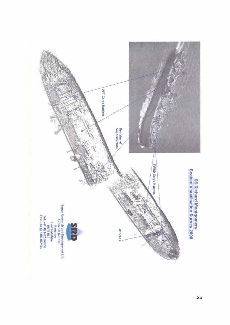
16. The monochromatic gradient plots in Appendix 4 reveal details of the ship's structure.
These plots also reveal details of small seabed topographical features such as sand ripples over the area.
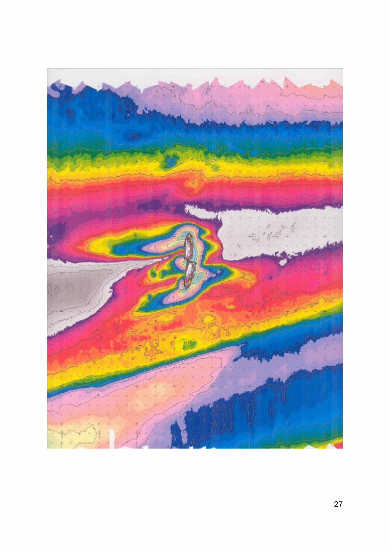
17. The following features within the survey area might be observed from the solid
contour plot at Appendix 5: • The Wreck Site
The wreck site occupies the central part of the survey area. It is the area enclosed by the 9-metre contour and may be considered to be the area of seabed topography most influenced by the presence of the wreck.
• The Medway Dredged Channel
The Medway dredged channel occupies the southern part of the survey area, which is orientated in the region of 072°/252° and is bounded by the southernmost 9-metre contour in the survey area.
• The Sheerness Middle Sand The Sheerness Middle Sand occupies the central part of the survey area. This sand bank is most extensive in the western part of the survey area. It is broken by the wreck site and continues to the east of the wreck site. The 6-metre contour of this feature is continuous to the north, and to the south this feature is continuous along the 8-metre contour.
• The Great Nore Anchorage The Great Nore Anchorage forms a north eastern boundary to the survey area. 18. The survey shows that the 15-metre contour is more extensive than shown on the
published chart. This contour extends some 10 to 30 metres from the east side of the wreck into two elongations to the west side of the wreck. On the east side, the contour is at its maximum distance from the wreck opposite the centre part of each section. The elongation at the bow of the vessel extends some 80 metres on a bearing of 238°and at the stern, the elongation is shorter at only 25 metres to the south west. From the colour contour plot at Appendix 4 it can be seen that the shallowest parts of the wreck are at a similar depth to the shallow parts of the Sheerness Middle Sand.
COMPARISON WITH PREVIOUS SONAR DATA Seabed Terrain 19. The detailed differences between this survey and those conducted in previous years
are as follows:

12
• The average depth for the survey area has remained almost constant between the 1999
and 2000 surveys. The majority of differences of depth of the seabed were within 0.20 metres. In the area around the wreck the average depth of the seabed has increased slightly.
• Material has continued to deposit on the west face of the sand bar to the east of the
wreck. Material has also continued to be removed from the east face of the sand bar to the west of the wreck. In general there is also an area of erosion spreading out from the wreck on a heading of 250º.
• The two holes in the seabed to the west side of the aft section, observed in last year's
survey have extended approximately 10 metres further west. The maximum change in depth is 2 metres, and the area covered is c. 30 x 10 metres. The area between the holes is flat. The cause of this anomaly is unknown.
• All of the features visible in previous surveys have been found again during the 1998
survey. • The object, 2 metres across, situated 190 metres from the wreck at a bearing of 347°
has been identified as an artefact of the wreck but is not clearly identifiable. This object is exposed but does not give rise to concern. It is too large to be an item of ordnance and appears to be a part of the vessel’s structure, probably from the above decks superstructure.
Differences at the Wreck 20. The orientation and position of the wreck were observed. The following points were
noted: • The crack observed in the starboard side of the forward section in last year's survey
was not detected in the 2000 survey. • A hole has been observed in the port side of the forward section. The dimensions of
the hole are approximately 1 m wide x 2.5 metres high. It is approximately 1.5 metres below deck level. This suggests significant deterioration of the hull plates.
• Eight items of overhanging debris have again been detected. These have been
provisionally identified as derricks from forward and aft masts, and 4 life-boat davits. • The debris between the two pieces of wreck is generally unchanged from the previous
survey. SURVEY CONCLUSIONS 21. The inspection of the wreck shows that there has been some changes to the structure
below surface. In last year's survey, an object was observed to have fallen from the superstructure onto the seabed, and 2 large holes have been observed on the seabed to the west of the aft section of the wreck. This year a hole has appeared in the side of the port bow.

13
22. Regular monitoring of the wreck has shown a degree of scouring of the seabed in the vicinity of the wreck since the wreck occurred in 1944. This latest survey has indicated that a further slight scouring has occurred in the immediate vicinity of the wreck
23. As a result of recent surveys, the following findings can be stated: • The changes listed in 19. above, may indicate the continuing deterioration of the
structure. The localised changes in the seabed from scouring and the development of further development of depressions show that the wreck remains a significant influence on the seabed topography in the survey area.
PART 3
CONSIDERATIONS FOR THE FUTURE
INTRODUCTION 1. This part of the report considers the future. It pulls together the available knowledge
from several reports. The underlying problem lies with the munitions which remain aboard the wreck, their present condition, and what may happen to them in the future. It is fortunate in many ways that the SS RICHARD MONTGOMERY is a unique problem - a wreck containing a quantity of munitions close to a populated area. However, this uniqueness means there is no direct comparison to judge the possible effects of a mass explosion.
2. The MCA has commissioned a risk assessment on the long term future of the Richard
Montgomery from BMT Reliability Consultants Ltd (BMT). This is in progress and will clarify the following scenarios when it is completed. The study is due for completion in Autumn 2000.
RISKS 3. The risks associated with the wreck of the SS RICHARD MONTGOMERY can be
divided into three broad areas, associated with collision, capsize and breaking up of the wreck. The effects of these three potentially hazardous situations will be taken into account in the risk assessment. It will also consider options for future management which will minimise or prevent any danger to the public, to the environment, and to the surrounding area.
Collision 4. Another vessel colliding with the wreck could sufficiently disturb the munitions aboard
to produce the conditions necessary for a mass explosion. The wreck is situated in two parts in a “hollow” in a sand spit and does not obstruct normal navigation. The cargo from the after part of the wreck, situated nearest the Medway Channel, is believed to have been salvaged in 1944. There are no records of near misses since the wreck occurred in 1944.

14
5. The Medway Approach Channel runs approximately 200 metres to the south of the wreck. During 1998 the Port of Sheerness logged 5,173 vessels inwards, excluding pleasure craft.
6. There are 5 designated anchorage positions in the Great Nore Anchorage. The centre
of the closest anchorage "N1" is approximately 650 metres from the wreck and has a depth below chart datum of 13 metres variable. Anchorages ‘N1’ and ‘N2’ are virtually unused.
7. The Thames Estuary is a popular area for pleasure craft, with many small vessels using
the Medway. Although small, those vessels with a shallow draft could pass over the wreck at high water, at low water there is the possibility of collision.
8. The present arrangements to avoid collisions include: • designating the wreck as dangerous under the Protection of Wrecks Act 1973 and
placing an exclusion zone around the wreck. • marking this area by four navigational buoys with lights, with additional smaller buoys
in between. • publicising the condition of the wreck by notices on charts and in Pilot books; • The masts are visible at all states of the tide; they form a vivid visual indication of the
wreck’s position and give a distinctive radar return. Loose debris and cargo blocks were removed by Medway Ports under contract to the MCA in October 1999, with the aim of extending the life-span of the masts.
• Medway Ports have a Vessel Traffic Service (VTS) which uses radar to monitor vessel
traffic in the Medway Approach Channel. It is under contract to MCA to provide radar coverage of the wreck site and warn vessels approaching the exclusion zone. Vessels requiring to use one of the Great Nore designated anchorages would do so as directed by the Medway Navigation Service (MNS).
Capsize or Significant Movement of the Wreck 9. The erosion of the seabed around the wreck could cause the capsize or significant
movement of the vessel. This could have two effects; a mass detonation of the munitions, or the munitions could escape and be swept away by the tide.
10. The scouring in the vicinity of the wreck continues as it has for the past 56 years. In the
last few years there has been some scouring at the bow, the break, and at the stern of the wreck with accumulation in other areas. The insignificant changes in depth between previous surveys indicates that the seabed surrounding the wreck is stable. It is probable the wreck is sitting on London clay which is the underlying bottom of the Thames Estuary. The 2000 survey reveals a 20% decrease in seabed support for the aft section which is very close to 1997 levels. A reduction in seabed support increases the risk of the wreck moving. There appears to be fluctuation in levels and areas of erosion, which is ongoing over a number years.
15
11. During the last 56 years there has been little change in the angle at which the vessel is lying on the sea bed, although scouring has resulted in the apparent sinking of the vessel.
12. There are no physical measures presently taken to reduce the risk of capsize or
movement of the wreck. Break Up 13. The wreck has been subject to 56 years of deterioration. This has resulted in the loss of
the vessel’s superstructure. The results of the deterioration increase the risk that at some stage the wreck will loose its structural integrity and start to break up.
14. The structural failings which may occur are: • loss of masts/derricks • large crack in the hull • the loss of individual hull plates • the failure or collapse of a deck 15. There have been no studies into the forces being exerted on the vessel by the
remaining cargo and the surrounding seabed. This is because there is insufficient knowledge of the disposition of the remaining cargo. The condition of the interior of the wreck does not allow for an internal investigation.
16. Should the vessel start to break up there is a risk that some, or all of, the munitions
contained within the hull would be swept away by the tides. This could result in individual munitions being washed ashore on beaches. This reduces the effect of a mass explosion from the remaining munitions, however, a new risk of individual munitions exploding or burning on beaches is created.
17. What munitions are free to move, depends on what part of the wreck has broken up.
There are two basic types of munitions which raise the most concern. The fused fragmentation bombs, which are the most likely to spontaneously detonate, are believed to be stowed in number 2 hold / tween deck. The 100 lb. phosphorous bombs are stowed in the deep tanks in number 1 hold.
18. Number 2 hold is situated in the centre of the forward section of the wreck and will be
prone to the greatest bending moments should the wreck move. There is a crack in the starboard side of number 2 lower hold and a similar crack in the port side.
19. The deep tanks situated in number 1 hold are constructionally some of the strongest
parts of the vessel. It is probable that this part of the vessel will be the last to break up. 20. There are no physical measures presently taken to reduce the risks caused by the
wreck breaking up apart from the recent trimming of the cargo blocks from the masts. EFFECTS

16
21. There are two effects which could result from disturbance of the wreck; a mass explosion of the munitions aboard, or the explosion or burning of isolated munitions. These are discussed below.
Mass Explosion 22. The Defence Evaluation and Research Agency (DERA) have reviewed the information6
available on the wreck and found that there have been a number of studies of the likely effects of a mass detonation of the munitions remaining in the wreck (equivalent to 1500 tonnes of TNT) either as the consequence of an accident or as the result of a planned disposal operation7.
23. The reports which estimated the effects of a mass explosion of the remaining cargo
were both written some time ago. As there have been significant developments in computer programmes capable of modelling events of this type, it may now be possible to obtain a better risk assessment of the effect of a mass explosion under a variety of wind and tidal conditions than was previously available. This is currently being undertaken by BMT under contract to the MCA.
24. Whilst there is little data available that can be directly related to the particular situation
with the SS Richard Montgomery, it has always been accepted that a mass explosion would put property and the local population at risk.
Distribution of Munitions 25. The River Medway and approaches contain a great number of munitions from many
sources. Recent dredging operations have produced a wide range of ordnance of both age and type, from cannon balls to a variety of shells, both real and practice. No ordnance which could be definitely identified as originating from the SS Richard Montgomery has been recovered. No modelling of the effects of the free movement of escaped munitions has been undertaken.
26. If escaped munitions wash ashore they will be prone to drying out. For the TNT or
RDX explosives in the majority of the bombs the drying out of the explosives after a long period of immersion may render them more unstable. When phosphorus dries out it will spontaneously combust.
CONCLUSIONS FOR THE WAY FORWARD 27. There are three broad areas of risk associated with the wreck; another vessel colliding
with the wreck, the wreck capsizing or moving significantly, and the breaking up of the wreck.
28. The risk of collision varies with the number of vessels passing close to the wreck. This will fluctuate with the success of the operations associated with the 6 DERA, WSS/WX4/CR97625/1.0, July 1997 7 SLADE A C T, Effects of detonation in the wreck SS Richard Montgomery, WAE/121/06, 15 May 1970 TATE F E G, The Richard Montgomery, XB 243/1/3. 4 December 1975.

17
Medway Ports and with the number of pleasure craft. The various measures which have been in place for the past 56 years have contained this risk. 29. Erosion of the seabed around the wreck could cause capsize or significant movement. During the past 56 years there has been little change in the angle at which the wreck is lying, although scouring has resulted in the apparent sinking of the wreck. No physical measures have, or are, being taken to reduce this risk. 30. The wreck has been subject to 56 years of deterioration. At some stage structural failure will occur. This may consist of large cracks in the hull, the loss of individual plates, the failure or collapse of a deck. This risk will increase with time. Apart from the recent remedial work to trim the cargo blocks from the masts no measures have been taken to prevent the break-up of the wreck. 31. DERA have concluded it is probable that some of the munitions remaining on board are still capable of detonation but the likelihood of a major explosion is remote. Experts have consistently advised that the best way to keep the risk to an absolute minimum is to leave the wreck alone. However, the balance of risk between a mass detonation and between individual munitions becoming free is slowly shifting with the latter becoming the more likely due to break up. 32. Five basic scenarios to solve the problem of the wreck ranging from “do nothing” through to the sanitising of the wreck site have been identified. 33. The feasibility study currently being undertaken by BMT on behalf of the MCA will consider all these options and possible associated effects, to ensure that all information is available before any intervention options are seriously considered.
PART 4
RECOMMENDATIONS 1. The recommendations outlined below are for use in the immediate future, and will be
reviewed on the completion of the risk assessment report by BMT. MASTS AND DERRICKS 2. The 1993 survey stated that the condition of the masts and derricks was such that
serious consideration should be given to removing them in an attempt to stabilise the surrounding deck areas. Recent inspections of the masts found, however, that they remained sufficiently robust to leave largely undisturbed. As a consequence it was clear that the existing warning notices placed on the wreck should also remain in place. In 1999, remedial work was undertaken to trim the cargo blocks, and to renew the warning signs on the masts.
RECOMMENDATION 1 That the masts, derricks and warning notices remain in situ, subject to ongoing
inspection. CONTINUAL OBSERVATION OF THE WRECK
18
3. The wreck remains under close observation under a contract let by the Secretary of State for the Environment, Transport and the Regions to Medway Ports to provide for the continual 24-hour guarding of the wreck. The Company are well placed and equipped to undertake this role and the contract has been operating to the satisfaction of the Secretary of State.
RECOMMENDATION 2 That the continual close observation of the wreck is maintained in the foreseeable
future. SURVEY OF THE WRECK 4. The sonar surveys of recent years have produced repeatable data. They have identified
some movement in the debris overhanging the vessel’s sides. This indicates that any survey requiring manual intervention would be extremely dangerous. Although the seabed surrounding the wreck appears to be in a stable condition, some scouring and other structural changes do occur.
RECOMMENDATION 3 To monitor the seabed around the wreck, an annual survey should continue for the
foreseeable future. ASSESSMENT OF RISK 5. There has been no up-to-date assessment either of the risks associated with the present
policy of not disturbing the wreck, or what effects a long term intervention may have. Without a quantified risk assessment it has not been possible to recommend a way forward that is based on sound principles. A risk assessment commissioned by the MCA, and undertaken by BMT Reliability Consultant is currently underway, and is due for completion in Autumn 2000.
RECOMMENDATION 4 The findings of the risk assessment will be used as a basis for deciding on the long- term management of the wreck. POLICY OF OPENNESS 6. In the past there has been a veil of secrecy surrounding the wreck and the risks
involved. The public has not always been aware of the true facts and this led to scare articles appearing in the media. The MCA (and The Coastguard Agency before) have made available the results of the annual surveys, with copies being placed in the libraries of both Houses of Parliament and copies sent to Local Authorities.
RECOMMENDATION 5
19
That information about the wreck be placed in the public domain, and that the results of the risk assessment are published to form part of a consultation exercise regarding the way forward in the long term.
20
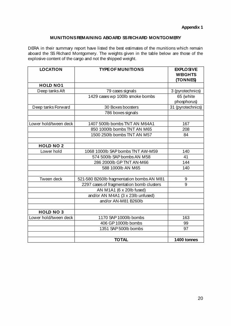
Appendix 1
MUNITIONS REMAINING ABOARD SS RICHARD MONTGOMERY DERA in their summary report have listed the best estimates of the munitions which remain aboard the SS Richard Montgomery. The weights given in the table below are those of the explosive content of the cargo and not the shipped weight.
LOCATION TYPE OF MUNITIONS EXPLOSIVE WEIGHTS (TONNES)
HOLD NO1 Deep tanks Aft 79 cases signals 3 (pyrotechnics)
1429 cases wp 100lb smoke bombs 65 (white phosphorus)
Deep tanks Forward 30 Boxes boosters 31 (pyrotechnics) 786 boxes signals
Lower hold/tween deck 1407 500lb bombs TNT AN M64A1 167 850 1000lb bombs TNT AN M65 208 1500 250lb bombs TNT AN M57 84
HOLD NO 2 Lower hold 1068 1000lb SAP bombs TNT AW-M59 140
574 500lb SAP bombs AN M58 41 286 2000lb GP TNT AN-M66 144 588 1000lb AN M65 140
Tween deck 521-580 B260lb fragmentation bombs AN M81 9 2297 cases of fragmentation bomb clusters 9 AN M1A1 (6 x 20lb fused) and/or AN M4A1 (3 x 23lb unfused) and/or AN-M81 B260lb
HOLD NO 3 Lower hold/tween deck 1170 SAP 1000lb bombs 163
406 GP 1000lb bombs 99 1351 SAP 500lb bombs 97 TOTAL 1400 tonnes

21
Appendix 2 THE KIELCE EXPLOSION
BACKGROUND 1. In 1946 the Kielce, a ship of Polish origin, built in 1944, was on charter to the US
forces, sailing from Southampton to Bremerhaven, when it was in collision and sank in the English Channel off Folkestone. The ship was of 1896 gross tonnage, 250 ft long, 41 ft berth and drawing just over 20 ft. It had a “full cargo of bombs and ammunition” although no cargo manifest has ever been traced.
2. In the early 1950s an unknown wreck was chartered at 51o02’20” N, 01o 13’33” E,
and it was not until ten years later, when Trinity House awarded several contracts for the removal of wrecks in the Channel, that this was identified as the Kielce and confirmed to contain ammunition.
3. In 1966 the Folkestone Salvage Company was given a contract to clear the wreck, to
give 50 ft clearance at MLWST, and part of the contract called for the dispersal of the explosive stores. During their preliminary work to clear collapsed hull plating, the Salvage Company fired two cutting charges on the hull without serious effect. On firing the third, however, at 1159 hours BST on 22 July 1967, a large explosion occurred which “brought panic to Folkestone’s town and chaos to the beaches “.
THE EFFECTS OF THE EXPLOSION 4. At the time the Press and the local Police, were made aware of significant damage to
various properties. Chimneys were damaged, slates dislodged and ceilings were cracked, but no case of personal injury was reported.
5. Meanwhile, the seismic effects of the explosion had been recorded by at least 25
observatories, throughout Europe and America, out to a distance of nearly 5000 miles from Folkestone, and from these records, using techniques which were developed for cataloguing the severity of earthquakes and other seismic disturbances, a magnitude of 4½ ± ½ was allocated to the explosion.
6. By subsequent survey, the sea-bed crater formed by the explosion was found to be
roughly elliptical with major and minor axes 153 and 67 ft respectively, the maximum depth 20 ft and with the “lips” rising to between 5 and 11 ft proud of the general level of the sea bed8.
7. The wreck had been lying in approximately 90 ft of water, on a sea bed of silt, when
the explosion occurred. An acoustic signal was received at one station in the UK, whose amplitude was approximately one-thirtieth of that which would have been expected from a surface explosion of the magnitude from the seismic records. In other words, by far the larger proportion of the energy released was transmitted seismically
8 The size of this crater is consistent with the figures predicted, as a result of US experience, for sea-bed craters formed by explosions with a yield of 2 kton.

22
(this was confirmed by the general absence of shattered windows, except those which were broken by the movement of the frames).
8. Two members of the staff of the Folkestone Salvage Company were in a small boat
some 400 yds from the wreck when the explosion occurred, and they reported “a small ripple and some spray” - certainly not a large plume of water. However, there were a few reports of a “tidal wave” hitting the Folkestone beaches, resulting in a small number of successful claims for property damage on these beaches, although it has been computed that the amplitude of the resulting sea wave caused by the explosion would not have been greater than about 2 ft.
THE YIELD 9. A magnitude of 4½ indicates a yield of 2000 tons of TNT, when fully contained in
water or in a dense rock. The Kielce explosion was not fully contained although, as indicated above, a small proportion of the total energy release was propagated acoustically. Hence, although the total energy released may have been higher than expected from 2000 tons of TNT, the proportion of the energy propagated through the water and the sea-bed will have been equivalent to that released by that weight of explosive “fully contained”.

23
Appendix 4 MONOCHROMATIC GRADIENT PLOT 1999

24
MONOCHROMATIC GRADIENT PLOT 2000

25
26
27